Abandoned & Little-Known Airfields:
Alabama: Birmingham area
© 2002, © 2026 by Paul Freeman. Revised 1/2/26.
____________________________________________________
Please consider a financial contribution to support the continued growth & operation of this site.
Anniston AAF / Talladega Airport (revised 1/18/23) - Boynton Field (revised 5/2/24) - Camp Hill Tallapoosa County (revised 1/18/23) - Center Airport / Centre Airport (revised 5/2/24)
Centre Municipal Airport (revised 5/2/24) - Coosa County Airport (revised 3/12/17) - Durham Airport / (Original) Bessemer Airport (revised 6/25/22)
Lee Brothers Airfield (revised 1/2/26) - Messer Field / Central Park Field (revised 1/18/23) - Roberts Field (revised 3/12/20)
____________________________________________________
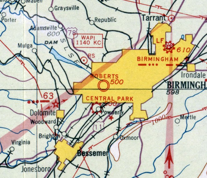
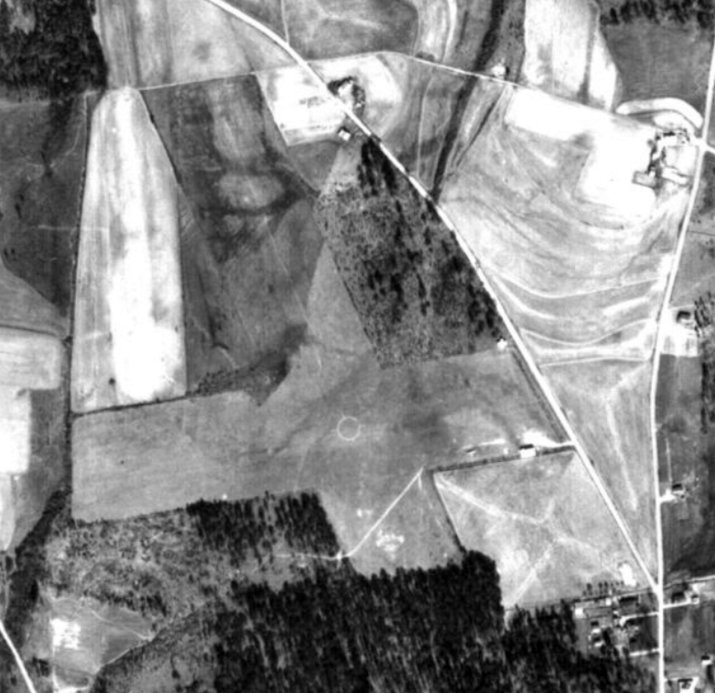
33.43, -86.11 (East of Birmingham, AL)
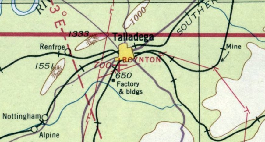
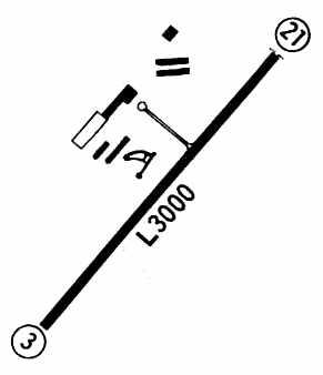
Boynton Field, as depicted on the March 1937 Birmingham Sectional Chart (courtesy of Rob Grant).
Talladega's first airport was located adjacent to the southwest side of the town.
Boynton Field was evidently established at some point between 1936-37,
as it was not yet depicted on the September 1936 Birmingham Sectional Chart.
The earliest depiction which has been located of Boynton Field was on the March 1937 Birmingham Sectional Chart (courtesy of Rob Grant),
which depicted Boynton as an auxiliary airfield.
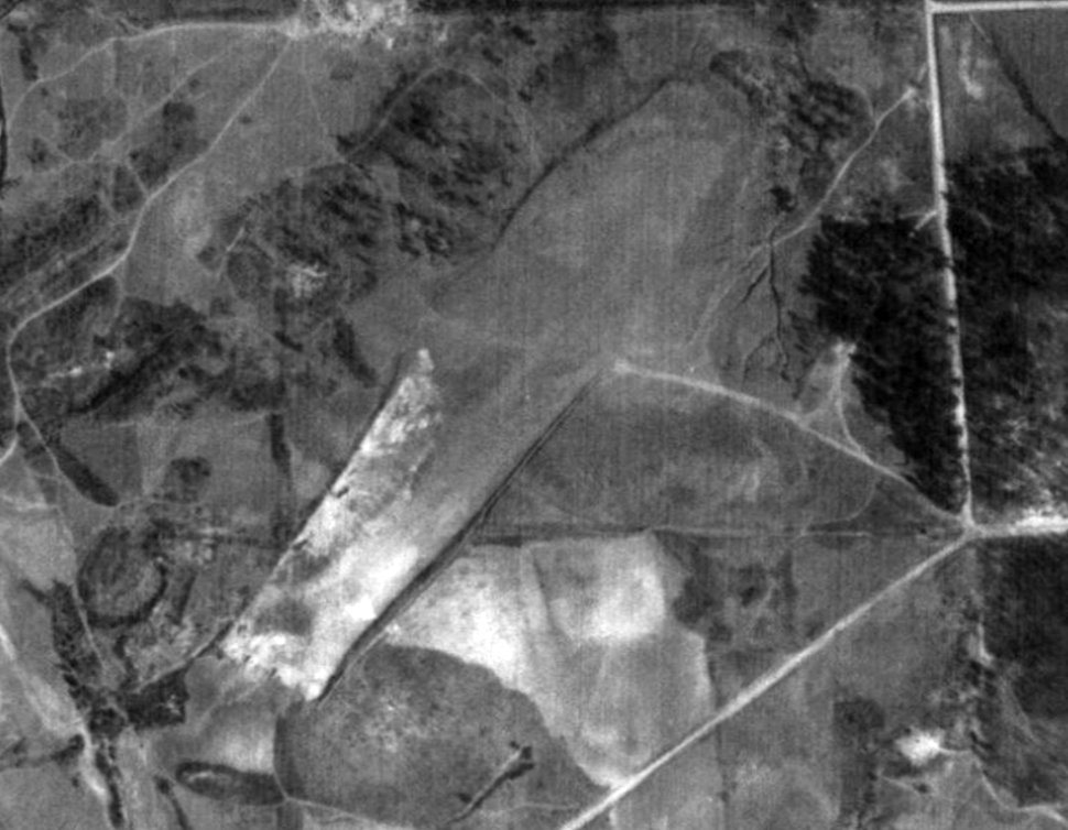
The earliest photo which has been located of Boynton Field was a 1938 aerial view (courtesy of Rob Grant),
which depicted it as an unpaved northeast/southwest runway.
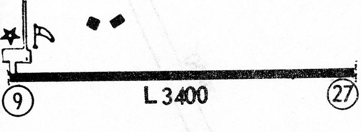
A 1938 airfield directory described Boynton Field as an auxiliary airfield located ¼ mile southwest of the center of Talladega.
It was said to be a square sod field having one 1,340' runway.

The last depiction which has been located of Boynton Field was on the October 1942 Birmingham Sectional Chart (according to Rob Grant).
Boynton Field was evidently closed (for reasons unknown) at some between 1942-44,
as it was no longer depicted on the March 1944 Birmingham Sectional Chart or the 1946 USGS topo map.
A 1949 aerial view (courtesy of Rob Grant) showed that a road had been cut across the center of the former Boynton Field runway at some point between 1938-49.
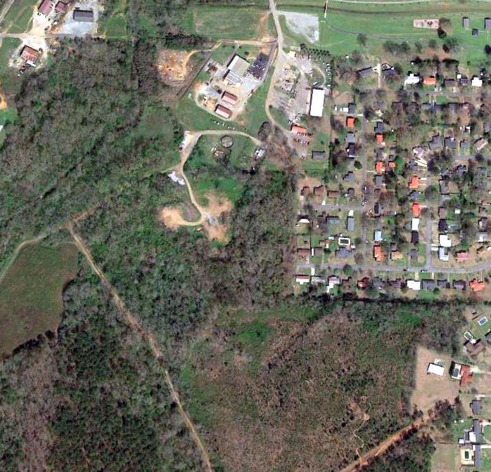
A 2019 aerial view showed no recognizable trace remaining of Boynton Field.
Thanks to Rob Grant for pointing out this airfield.
____________________________________________________
Messer Field / Central Park Field, Birmingham, AL
33.48, -86.89 (Southwest of Downtown Birmingham, AL)
An undated map depicting early airfields in Birmingham, including Messer Field at the bottom-left.
Messer Field was constructed by pioneering aviator Glenn Messer in 1926-27.
According to Walter Wells, “Phoebe Fairgrave Omlie operated a flying circus with Glenn Messer out of this airfield; she was friends with Amelia Earhart.”
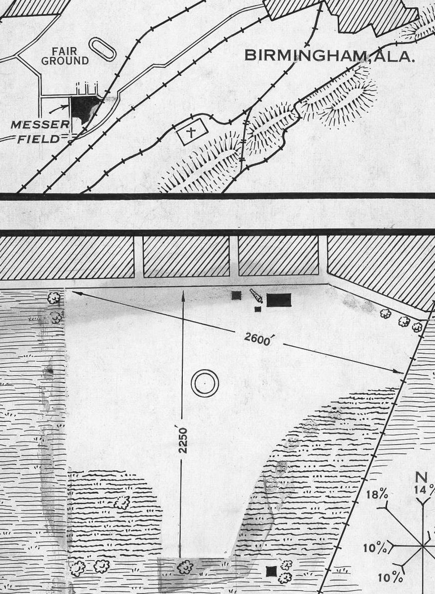
A circa 1927-31 Commerce Department Airway Bulletin showing the location & layout of Messer Field (courtesy of Rob Grant).
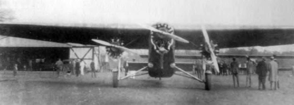
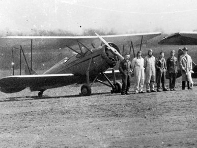
A 1929 photo of a Ford Tri-Motor visiting Messer Field.
The earliest aeronautical chart depiction which has been located of Messer Field was on the April 1933 Birmingham Sectional Chart,
which depicted Messer as a commercial/municipal airport.
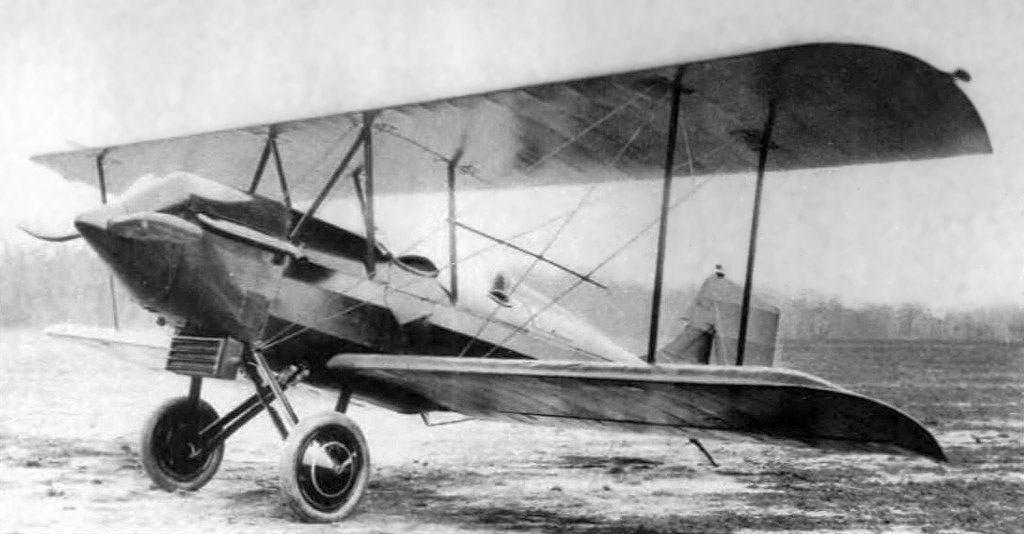
A 1933 photo (restored by Bill Grasha) of a Waco 10 biplane at Messer Field.
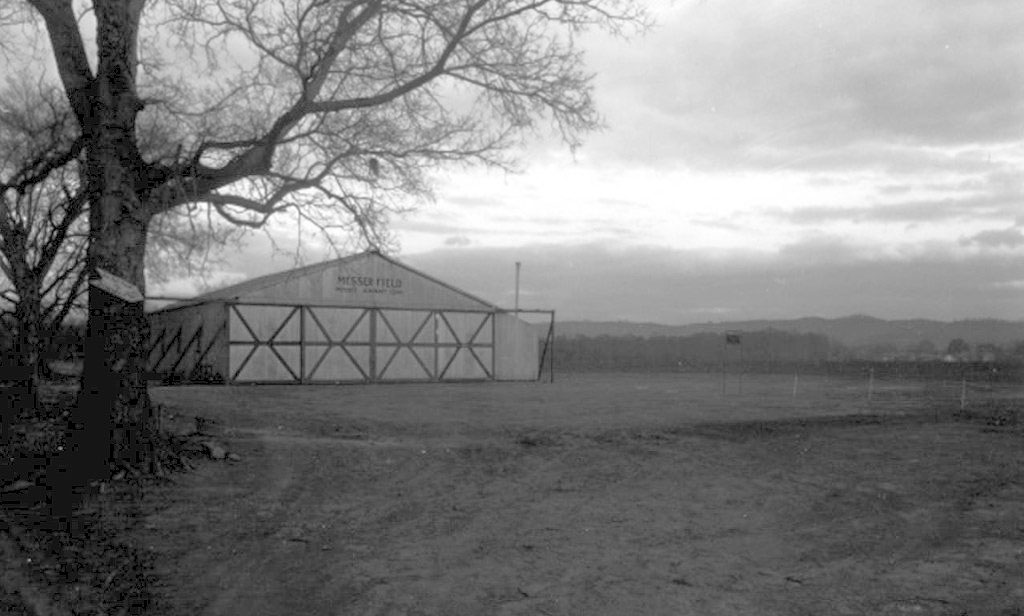
An undated photo (restored by Bill Grasha) of a Messer Field hangar.
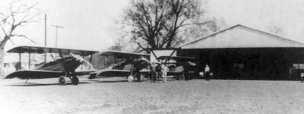
An undated photo (restored by Bill Grasha) of 3 biplanes in front of a hangar at Messer Field.
Glenn Messer continued to operate Messer Field until 1935, when it became Central Park Field.
The October 1935 Birmingham Sectional Chart depicted Central Park as a commercial/municipal airport.
A 1947 USGS aerial view depicted 3 light single-engine aircraft parked near the hangars on Central Park Airport's northeast side.
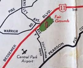
Central Park Airport, as depicted on a 1947 street map (courtesy of Kevin Walsh).
The last depiction which has been located of Central Park Airport was on the February 1950 Birmingham Sectional Chart.
It depicted Central Park Airport as having a 1,700' unpaved runway.
The last photo which has been located of Central Park Airport was a 1951 aerial view (courtesy of Rob Grant).
It depicted 5 light single-engine aircraft parked near the hangars on the northeast side.
Central Park Field evidently closed at some point between 1951-52,
as it was no longer depicted on the August 1952 Birmingham Sectional Chart.
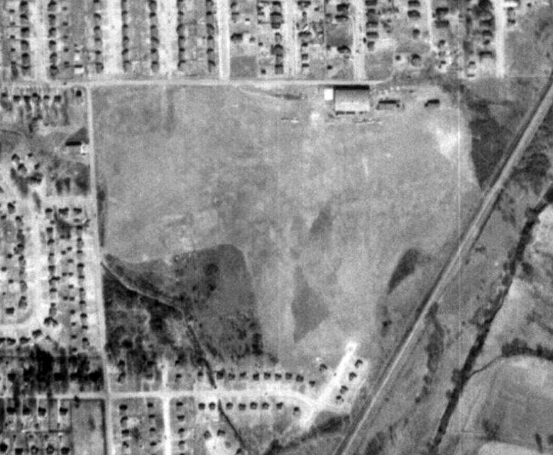
A 1970 aerial view showed dense houses covering the site of Central Park Airport,
but ironically one hangar remained standing among the many houses.
A 1997 aerial photo showed that the hangar had been replaced by more houses at some point between 1970-97,
erasing the last trace of Central Park Field.
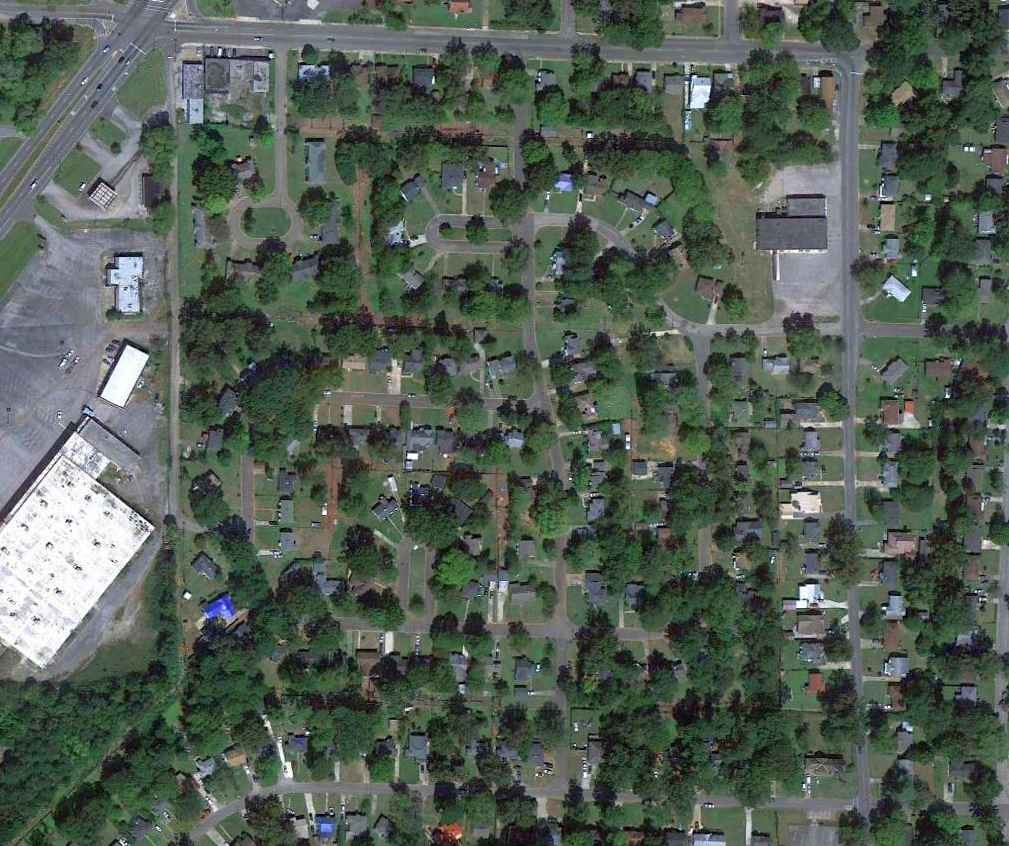
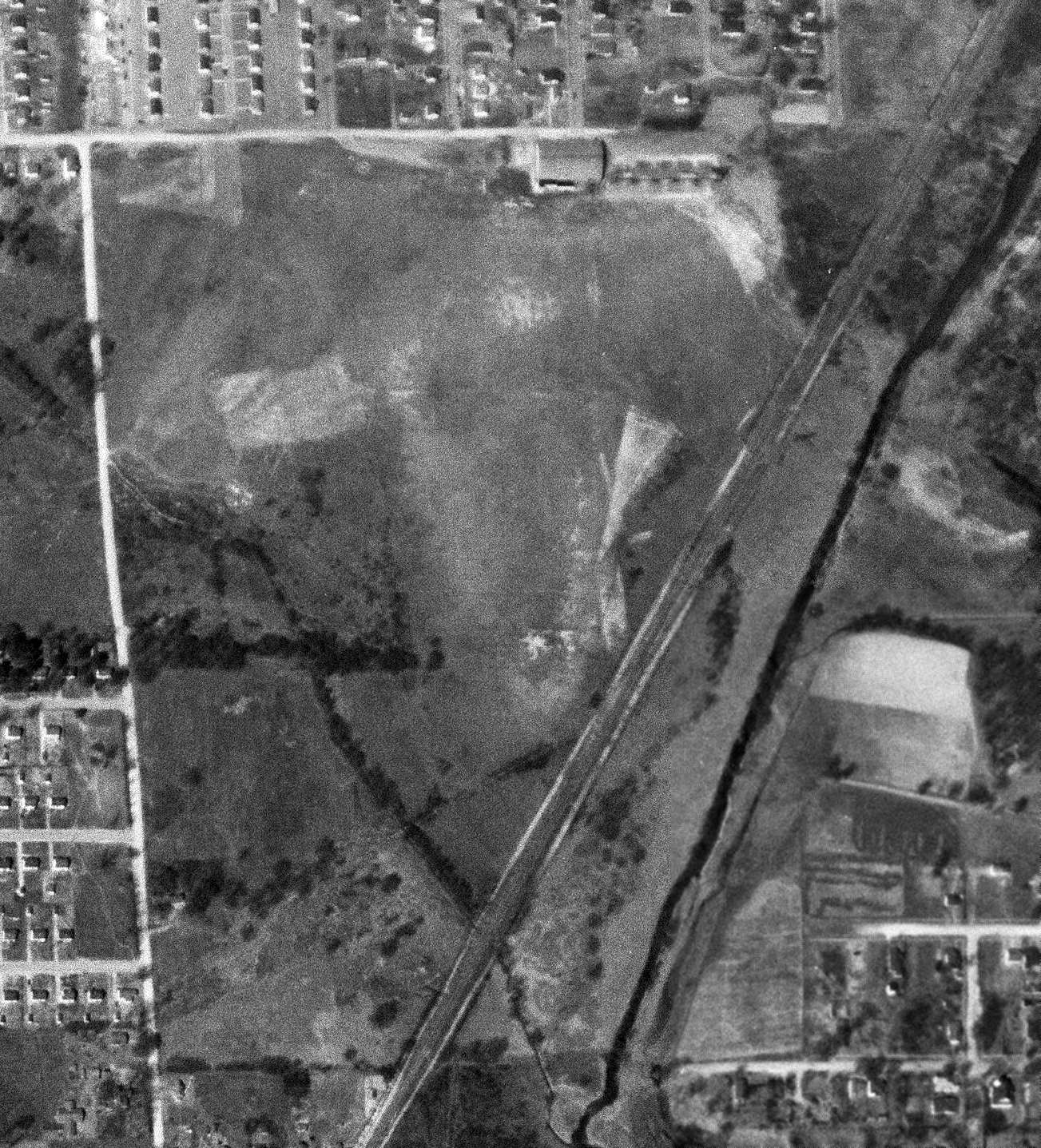
A 9/22/12 aerial view did not show any remaining trace of Messer Field.
The site of Messer Airport lies within Avenue O, 57th Street, Pineview Road, and Valley Creek.
____________________________________________________
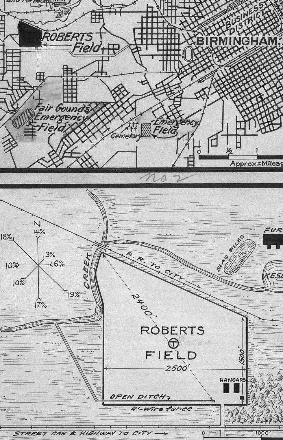
33.518, -86.874 (West of Downtown Birmingham, AL)
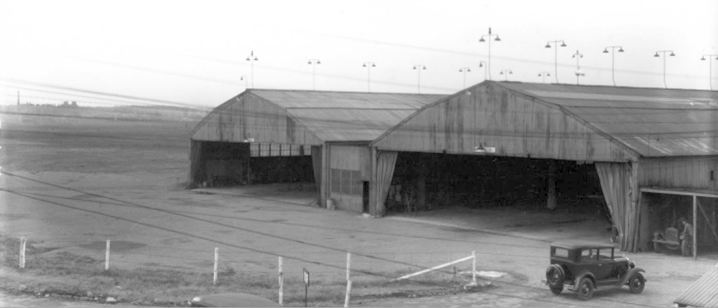
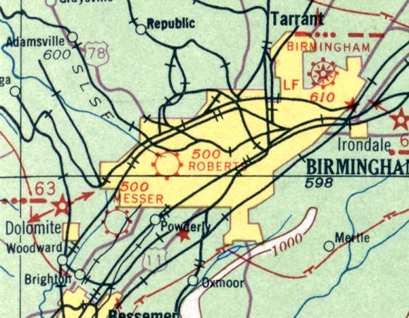
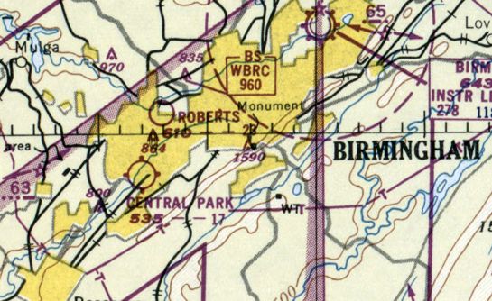
A circa 1922-30 photo of 2 hangars at Roberts Field.
Roberts Field was built in 1922, and initially served as Birmingham's municipal airport.
It was named after Lieutenant Arthur Roberts, a Birmingham native that was killed in France during WWI.
The earliest depiction which has been located of Roberts Field was a circa 1922-30 photo of 2 wooden hangars next to a grass field.
The 90-acre site was bounded by Village Creek & the Frisco Railroad to the north, and by 13th Street & Ensley to the south.
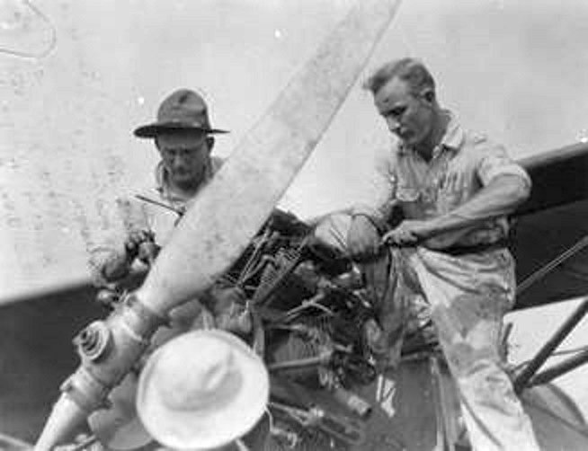
A circa 1922-29 photo of 2 men working on an airplane engine at the Air Corps Base at Roberts Field (courtesy of Rob Grant).
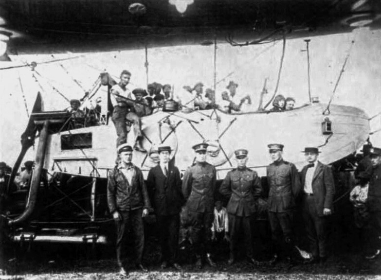
A 1924 photo (restored by Bill Grasha) of Navy non-rigid airship E-1, Navy s/n A-4109 (A-249) & its crew at Roberts Field.
A circa 1927-31 Commerce Department Airway Bulletin showing the location & layout of Roberts Field (courtesy of Rob Grant).
It depicted Roberts Field as an irregularly-shaped area measuring 2,400' northwest/southeast, with 2 hangars & a smaller building on the southeast corner.
The first commercial air service to Birmingham began in 1928 by St. Tammany - Gulf Coast Airways,
operating through Roberts Field on a route from Atlanta to New Orleans.
Delta Air Service began service to Birmingham in late 1929 with 6-seat Travel Air airplanes along a route stretching from Dallas to Birmingham.
When American Airways began their Atlanta to Fort Worth route,
Birmingham was not included in the route because their Ford Tri-Motor aircraft could not land at Roberts Field.
As a result of this development, Birmingham began construction of a new airport, Birmingham Municipal Airport,
which opened in 1931, but Roberts Field continued in operation at a reduced level for several more years.
A circa 1930s photo of an unidentified biplane & crew at Roberts Field (courtesy of Rob Grant).
According to Rob Grant, “The 106th Observation Squadron of the AL National Guard was housed at Roberts Field until 1931, when it moved to the new municipal airport.”
The earliest aeronautical chart depiction which has been located of Roberts Field was on the April 1933 Birmingham Sectional Chart,
which depicted Roberts as a commercial/municipal airport.
The October 1935 Birmingham Sectional Chart depicted Roberts as a military airfield.
The earliest aerial photo which has been located of Roberts Field was a 1937 aerial view.
It depicted Roberts Field as an irregularly-shaped grass field measuring 3,200' northeast/southwest,
with one checkerboard-roofed hangar on the southeast side.
The last photo which has been located of Roberts Field was a 2/22/47 aerial view.
The main hangar on the southeast side had evidently been removed at some point between 1937-47 (with only its foundation remaining),
but over a dozen individual T-hangars had been added along the southeast edge of the airfield,
near which were also parked a dozen light aircraft.
The last depiction which has been located of Roberts Field was on the February 1950 Birmingham Sectional Chart.
It depicted Roberts as having a 2,300' unpaved runway.
David Henderson recalled, “I was born in 1950 & grew up [with] Roberts Field was across the alley to the north of our house.
My parents remembered Lindbergh's visit. I remember a plane landing there when I was very young.”
Roberts Field was presumably closed at some point between 1950-52,
as it was no longer depicted on the August 1952 Birmingham Sectional Chart.
Walter recalled, “My dad said there was an old hangar still present in 1958 with airplane parts still hanging on the wall.”
Roberts Field was no longer depicted on the 1959 USGS topo map.
The 1967 USGS topo map depicted an open area at the site of Roberts Field.
David Henderson recalled, “As late as 1967 the hangar was still existing. Looking at aerial shots show nothing but I wonder what is under the tree canopy.
I-29/59 runs through the middle of what was the airfield which was open land when the interstate construction began.
Later people used the open space for flying tethered & radio-controlled airplanes.”
The 1971 USGS topo map showed several large industrial buildings had covered the site of Roberts Field.
A 9/22/12 aerial view shows that the overall property outline is the only recognizable remaining trace of Roberts Field.
The site of Roberts Field is located north of the intersection of 13th Street & Roberts Industrial Drive, appropriately enough.
____________________________________________________
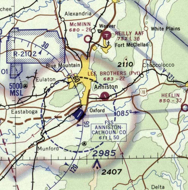
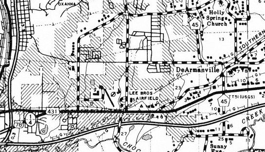
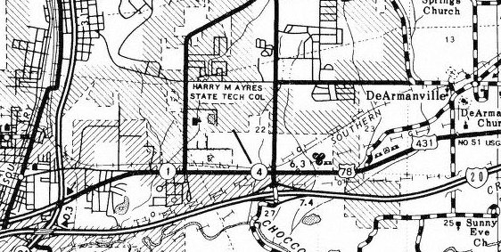
Lee Brothers Airfield, Anniston, AL
33.619, -85.793 (Northeast of Birmingham, AL)
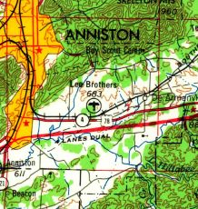
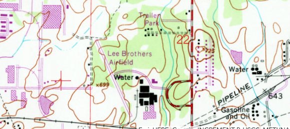
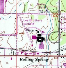
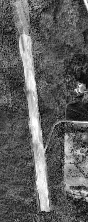
Lee Brothers Airfield, as depicted on the 1953 USGS topo map (courtesy of Dallam Oliver-Lee).
This airfield adjacent to an industrial facility was evidently established at some point between 1951-53,
as it was not yet depicted on a 3/31/51 USGS aerial photo (courtesy of Dallam Oliver-Lee).
The earliest depiction which has been located of Lee Brothers Airfield was on the 1953 USGS topo map (courtesy of Dallam Oliver-Lee).
Lee Brothers Airfield was not yet depicted on the August 1957 Birmingham Sectional Chart.
The earliest aeronautical chart depiction which has been located of Lee Brothers Airfield was on the February 1960 Birmingham Sectional Chart,
which depicted Lee Brothers as having a single paved northwest/southeast 2,200' runway.
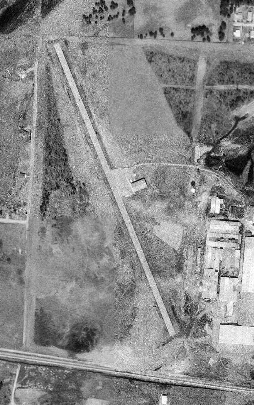
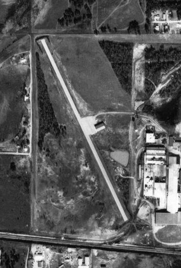
The earliest photo which has been located of Lee Brothers Airfield was a 3/16/65 USGS aerial view (courtesy of Dallam Oliver-Lee).
It showed the field as having a single paved northwest/southeast runway, with a ramp & a hangar on the east side.
A road led to an adjacent industrial facility, which the airfield was presumably built to support.
The last aeronautical chart depiction which has been located of Lee Brothers Airfield was on the August 1968 Birmingham Sectional Chart,
which depicted Lee Brothers as a private airfield having a single paved northwest/southeast 2,200' runway.
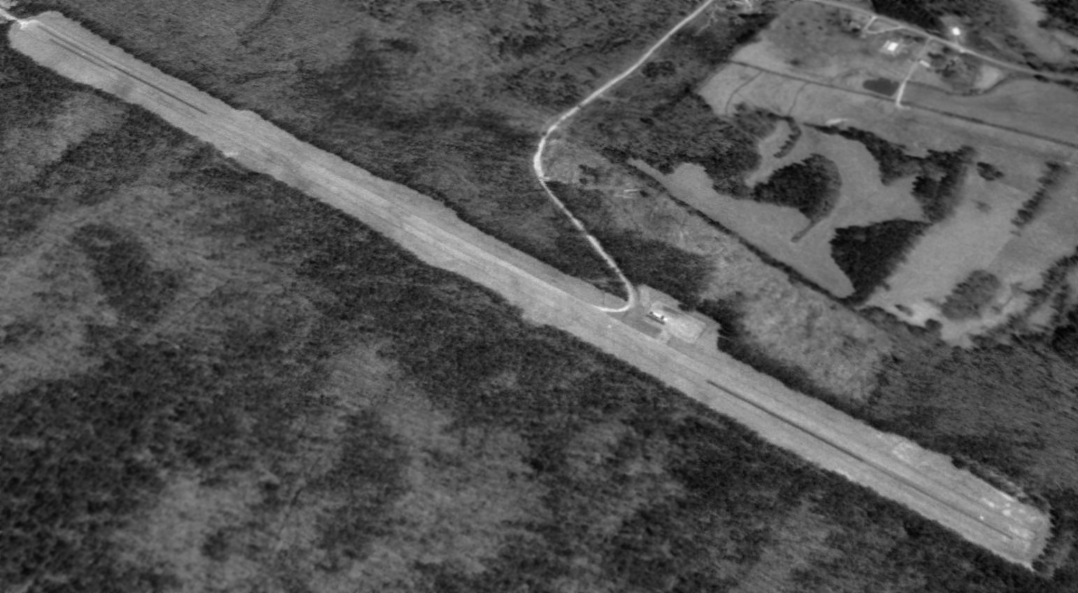
A 1969 aerial view (courtesy of Rob Grant) depicted the Lee Brothers Airfield as remaining intact, but without any sign of recent aviation use.
The 1972 USGS topo map (courtesy of Rob Grant) depicted Lee Brothers Airfield as having a single paved northwest/southeast runway.
A 1/7/72 USGS aerial view (courtesy of Dallam Oliver-Lee) still showed the Lee Brothers Airfield intact.
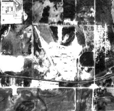
A 1975 USGS aerial view (courtesy of Rob Grant) showed that several small buildings had been built over the southeastern end of the runway,
presumably spelling the end of aviation use of Lee Brothers Airfield.
A 1977 county highway map (courtesy of Rob Grant) depicted Lee Brothers Airfield as having a single paved northwest/southeast runway.
The 1983 USGS topo map (courtesy of Dallam Oliver-Lee) depicted Lee Brothers Airfield as having a single paved northwest/southeast runway.
A 1988 county highway map (courtesy of Rob Grant) still depicted the Lee Brothers runway, but no longer labeled the airfield.
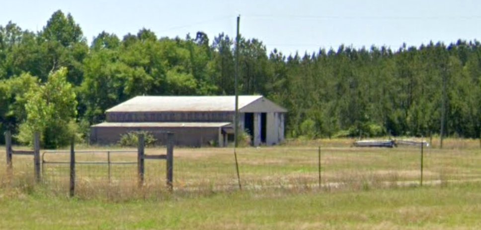
A 7/31/11 USDA aerial view (courtesy of Dallam Oliver-Lee) still showed the Lee Brothers Airfield hangar remained standing.
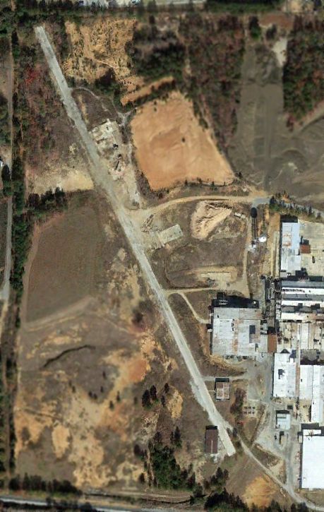
An 11/28/12 aerial view shows that the Lee Brothers hangar had been removed at some point between 2011-2012.
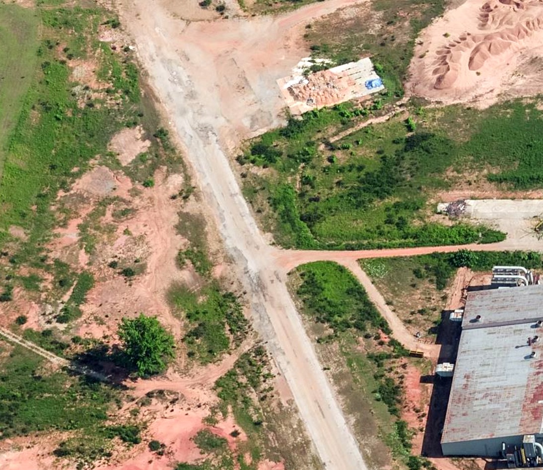
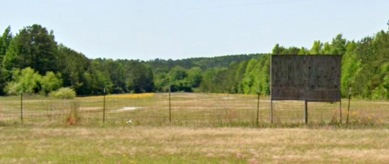
A pre-2022 aerial view looking north at the foundation of the Lee Brothers Airfield hangar & remains of the runway.
A 2024 aerial view looking northeast showed the Lee Brothers runway remained intact.
Lee Brothers Airfield is located northwest of the intersection of Golden Springs Road & Route 78.
Thanks to Dallam Oliver-Lee for pointing out this airport.
____________________________________________________
Center Airport / Centre Airport, Centre, AL
34.161, -85.682 (Northeast of Birmingham, AL)
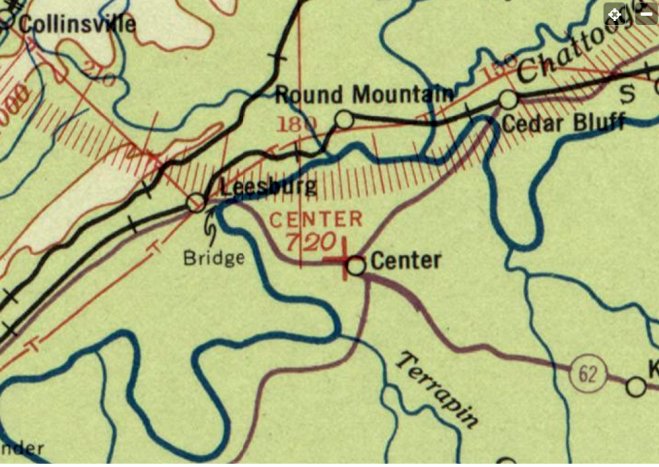
Center Airport, as depicted on the September 1935 Chattanooga Sectional Chart (courtesy of Rob Grant).
The original airport for the town of Center was located adjacent to the northwest side of the town.
The date of establishment of Center Airport has not been determined.
The earliest depiction which has been located of Center Airport was on the September 1935 Chattanooga Sectional Chart (courtesy of Rob Grant).
It depicted Center Airport as an auxiliary airfield.
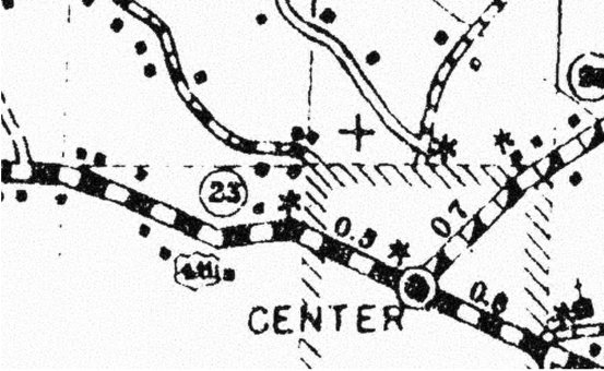
A 1937 county highway map (courtesy of Rob Grant) depicted Center Airport as an auxiliary airfield on the northwest side of the town.
A 1949 county highway map (courtesy of Rob Grant) depicted Centre Airport as having a single east/west runway.
Note that the spelling of the town (& its airport) had been changed at some point between 1937-49 to “Centre”.
The January 1950 Chattanooga Sectional Chart described Centre Airport as a commercial airport having a single 2,000' runway.
The earliest photo which has been located of Centre Airport was a 1950 aerial view (courtesy of Rob Grant).
It depicted Centre Airport as having 2 grass runways with a segmented circle at the intersection,
and a small building & possibly 1 light single-engine aircraft on the southeast side.
A 1957 aerial view (courtesy of Rob Grant) showed Centre Airport in an unchanged configuration.
A 1965 aerial view showed Centre Airport remained intact, but there were no aircraft visible on the field.

The last aeronautical chart depiction which has been located of the original Centre Airport was on the August 1968 Chattanooga Sectional Chart.
It depicted Centre Airport as having a 2,300' unpaved runway.
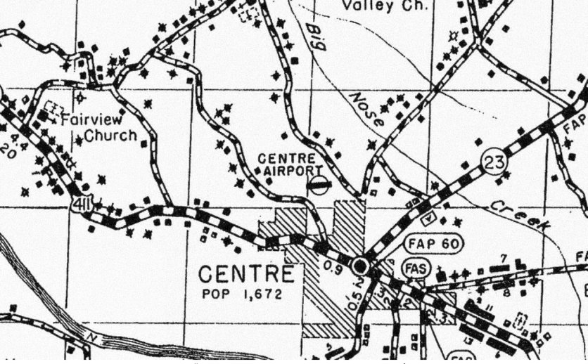
Note that the chart depicted the larger paved Centre Municipal Airport which had been built to the east, which would soon replace the original Centre Airport.
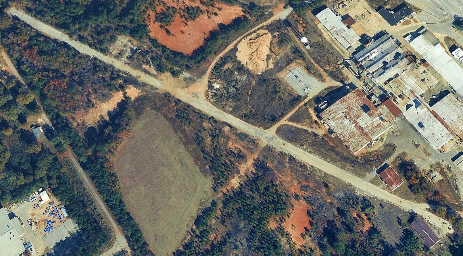
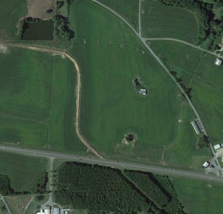
A 1969 aerial view (courtesy of Rob Grant) showed Centre Airport after its closure, with a road having been built through the center of the airport.
The 2 grass runways were otherwise intact, including the segmented circle, and the small building (a hangar?) remained on the southeast side.
A 1981 aerial view showed the Route 411 bypass had been built through the middle of Centre Airport,
but amazingly the small airport building (a hangar?) remained standing adjacent to the south side of the new highway.
A May 2008 photo looking south showed the former Centre Airport hangar remained standing adjacent to the south side of the highway, the last remnant of the little airport.
A 2009 aerial view showed former Centre Airport hangar remained standing adjacent to the south side of the highway, the last remnant of the little airport.
A 2011 aerial view showed the former Centre Airport hangar had been removed at some point between 2009-2011,
erasing the last trace of this little airport.
A 2019 aerial view showed no trace remaining of Centre Airport.
Thanks to Rob Grant for pointing out the closure of this airport.
____________________________________________________
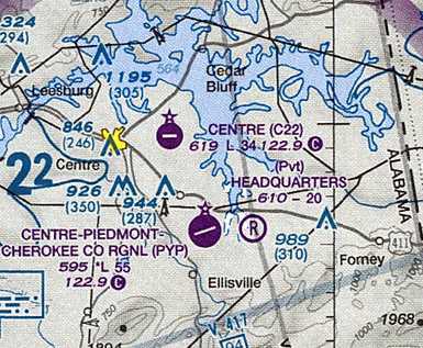
Centre Municipal Airport, Centre, AL
34.16, -85.635 (Northeast of Birmingham, AL)
Centre Municipal Airport, as depicted on a 3/15/65 USGS aerial photo.
Centre Municipal Airport was not yet depicted on the January 1961 Chattanooga Sectional Chart.
According to its FAA Airport/Facility Directory data, Centre Municipal Airport was activated in August 1962.
The earliest depiction of Centre Municipal Airport which has been located was a 3/15/65 USGS aerial photo.
It depicted Centre Municipal as having a single asphalt Runway 9/27, with a ramp & a small building on the northwest side.
The earliest aeronautical chart depiction of Centre Municipal Airport which has been located was on the August 1965 Chattanooga Sectional Chart.
It depicted Centre Municipal as having a single east/west 3,400' paved runway.
Note that it also depicted the predecessor Centre Airport just northwest of the town.
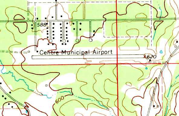
The 1967 USGS topo map depicted Centre Municipal as having a single paved east/west runway,
with 2 small buildings on the northwest side & a single small building on the southeast side.
The 1968 Flight Guide (courtesy of Bob Levittan) depicted Centre Municipal as having a single paved 3,400' Runway 9/27,
with 2 small buildings & a ramp on the northwest side.

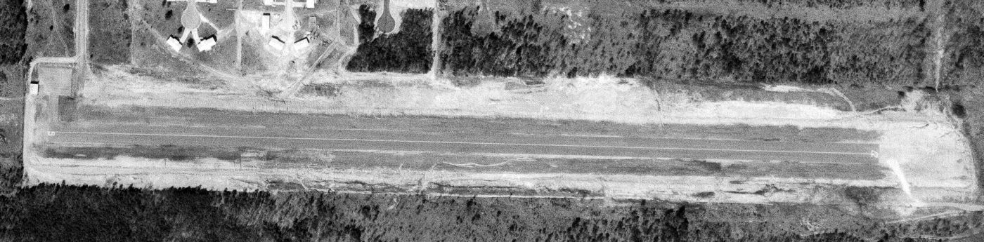
A 2/18/97 USGS aerial view looking southeast depicted Centre Municipal Airport as having a single paved Runway 9/27, with some small buildings on the northwest & southeast sides.
A total of 10 light aircraft were visible parked on the northwest side of the field.
A total of 5 single-engine aircraft were visible at Centre Municipal Airport in a 6/15/06 aerial photo.
In September 2007, a larger & less-constrained Centre-Piedmont-Cherokee County Regional Airport opened only 5 miles to the southeast.
It would eventually replace Centre Municipal Airport.
Centre Municipal Airport was evidently closed at some point between 2007-2011,
as a 2011 aerial view showed the runway marked with 4 yellow closed-runway “X” symbols,
yet 1 light single-engine aircraft remained parked on the northwest side of the field, apparently stranded at a closed airport.

A 2012 aerial view looking southeast showed Centre Municipal Airport remained intact.
The runway was marked with 4 yellow closed-runway “X” symbols, but 1 light single-engine aircraft remained parked on the northwest side of the field.
As of 2012, the FAA Airport/Facility Directory described Centre Municipal Airport as having a single 3,401' asphalt Runway 9/27, “in fair condition”, with “no centerline markings”.
The field was said to have a total of 8 single-engine based aircraft, and to conduct an average of 83 takeoffs or landings / week.
The 2012 Sectional Chart depicted Centre Municipal Airport as having a single paved east/west 3,400' runway.
It also depicted the nearby Centre-Piedmont Cherokee County Regional Airport which replaced Centre Municipal.
As of November 2012, although the FAA Airport/Facility Directory still listed Centre Municipal Airport as an active airport,
it described its sole Runway 9/27 as “closed indefinitely”.
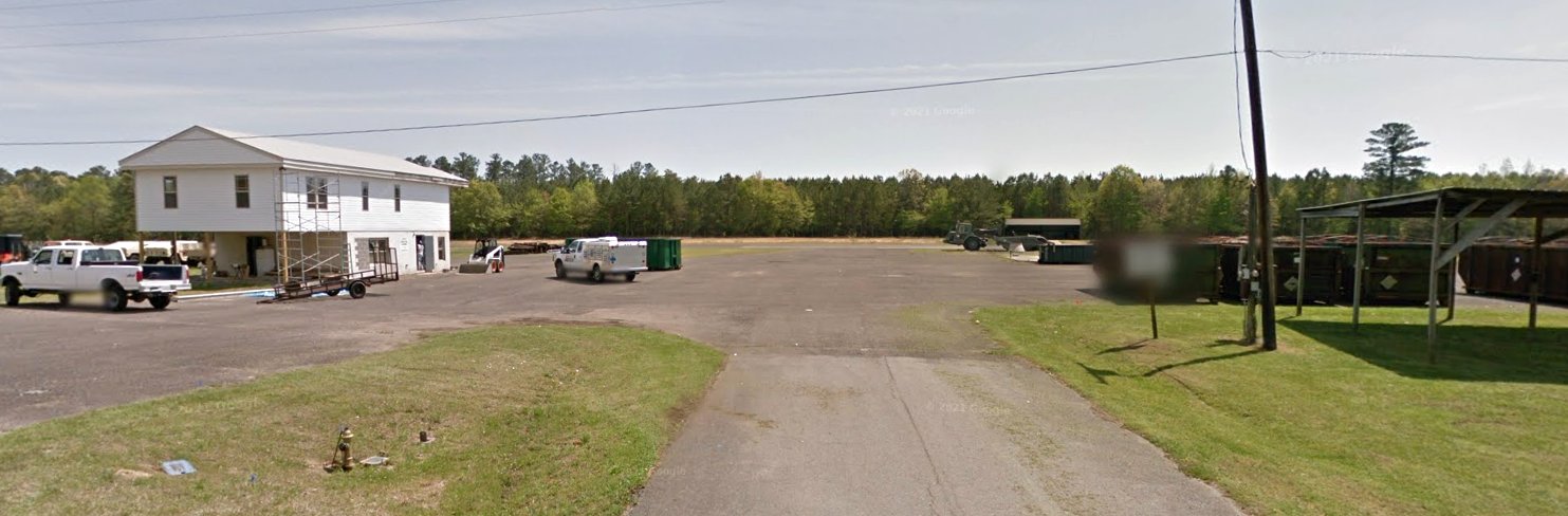
A 2014 photo looking south from the entrance to Centre Municipal Airport, looking toward the runway.

A 2023 aerial view looking southeast shows the Centre Municipal Airport runway & several hangars remained intact.
Centre Municipal Airport is located south of the terminus of Woodland Drive.
Thanks to Gullopix for pointing out the closure of this airport.
____________________________________________________
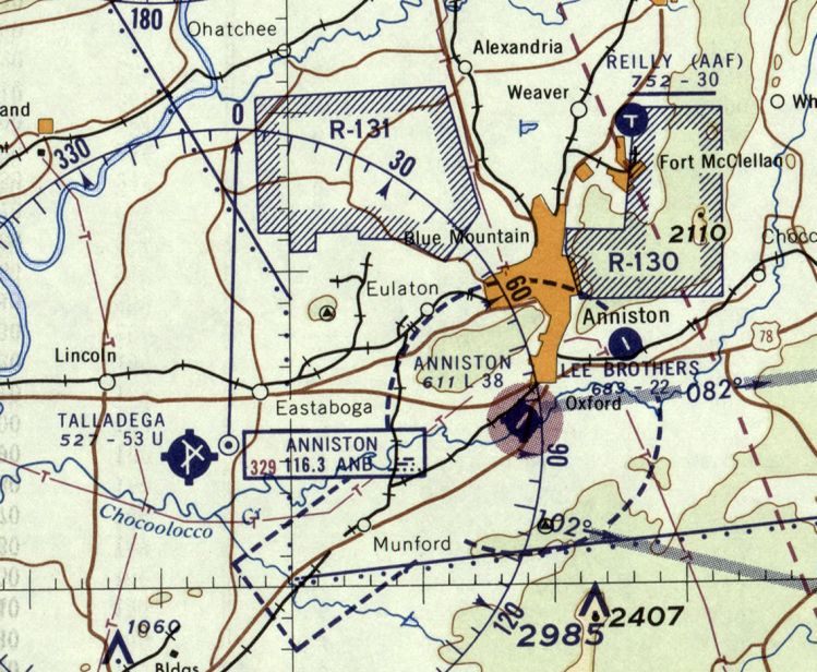
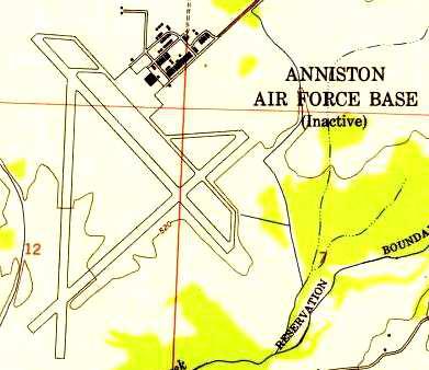
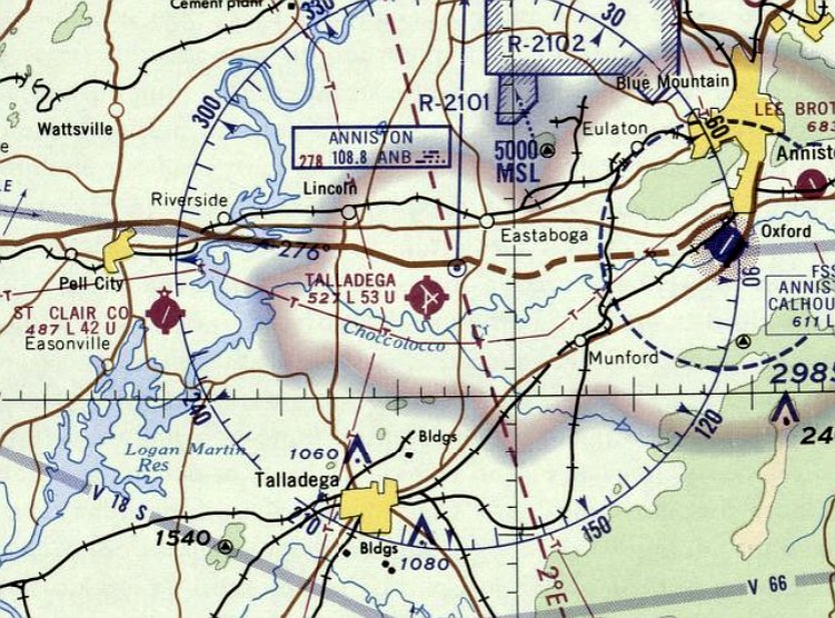
33.57, -86.06 (East of Birmingham, AL)
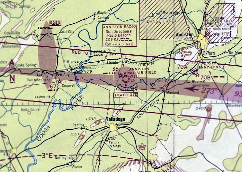
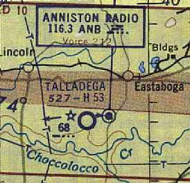
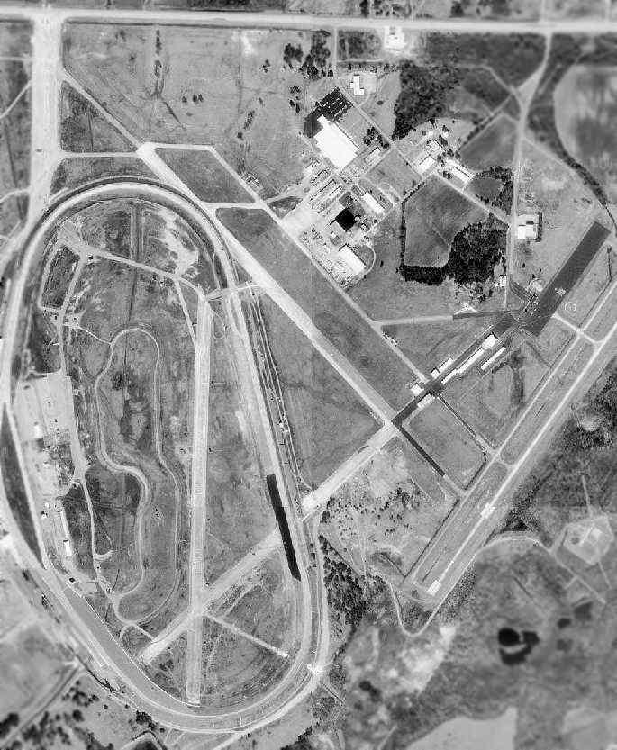
Anniston AAF, as depicted on the March 1944 Birmingham Sectional Chart.
How many auto racing fans know that the Talladega Superspeedway was built on the remains of an abandoned WW2-era Army Airfield?
Anniston was opened on 10/19/42 as a sub-field of Courtland AAF, with a 5,300' hard-surfaced runway.
Anniston Army Airfield was not yet depicted on the October 1942 Birmingham Sectional Chart.
Anniston was used as part of the Basic Flying School headquartered at Courtland which utilized Vultee BT-13s for the Air Cadets
as well as a specialized 4-engine flying school that flew B-24s,
and a school for transition from B-24s to B-29s school opened up in early 1945.
The airfield was also used by the Army Airways Communication System with the 108th AACS Squadron being assigned to the airfield.
The earliest depiction of Anniston AAF which has been located was on the March 1944 Birmingham Sectional Chart.
The March 1944 US Army/Navy Directory of Airfields (courtesy of Ken Mercer) described Anniston AAF as having a 5,300' hard-surfaced runway.
The earliest photo of Anniston AAF which has been located
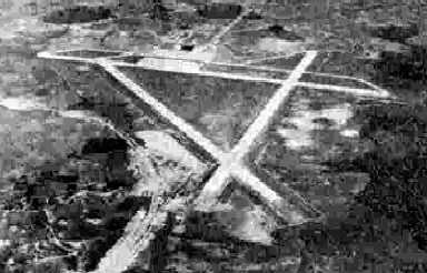
was a circa 1943-45 aerial view looking northeast from the 1945 AAF Airfield Directory (courtesy of Scott Murdock).
It depicted “Maxwell Field Auxiliary #3 (Anniston AAF)” as having 3 concrete runways with a concrete ramp on the east side.
Anniston AAF was still depicted as an active military airfield on the 1945 Birmingham Sectional Chart (courtesy of Chris Kennedy).
Anniston AAF was closed on 8/16/45 & was placed on standby status.
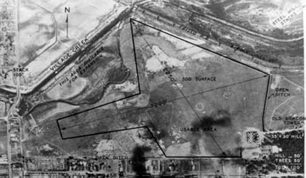
The 1945 AAF Airfield Directory (courtesy of Scott Murdock) described “Maxwell Field Auxiliary #3 (Anniston AAF)”
as a 1,863 acre irregularly-shaped property having 3 concrete 5,300' runways, and a single 160' x 120' steel hangar.
The field was said to be owned by the U.S. Government, and operated by the Army Air Forces, but to be “Inactive”.
At some point between 1945-47, Anniston was apparently closed by the military.
as it was labeled "Anniston Air Force Base (Inactive)" on a 1947 USGS topo map
(courtesy of Thomas Kallsen of the University of Alabama Map Library).
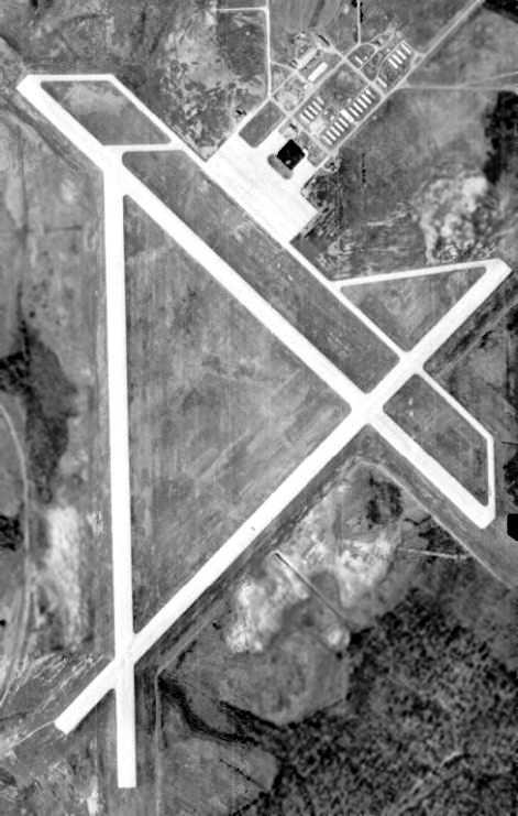
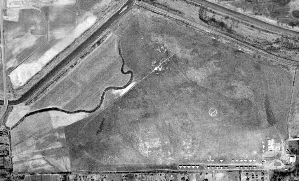
A February 1949 USGS aerial photo (courtesy of John Cross) depicted Anniston AFB as having three 5,300' concrete runways, taxiways,
and a ramp & building complex on the northeast side of the field.
Anniston was reopened by the Air Force Air Training Command on 7/1/49 as Anniston AFB
and conducted contract flying training until 8/1/50 when it was transferred to Air Materiel Command as a support airfield to support the Anniston Army Depot.
Anniston AFB was closed for the final time on 6/30/52.
The former Anniston AFB was eventually reused as the Talladega Airport.
It was described on the Aerodromes table of the August 1954 Birmingham Sectional Chart (courtesy of Chris Kennedy)
as a jointly operated (civil & Air Force) airfield.
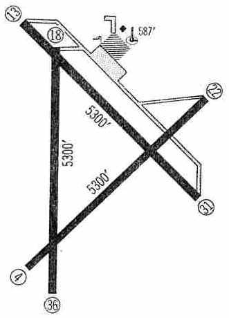
The 1959 Jeppesen Airway Manual (courtesy of Chris Kennedy) depicted Talladega Airport as having three 5,300' paved runways.
Taxiways led to a ramp on the north side of the field. Only a single building was depicted.
The February 1960 Birmingham Sectional Chart depicted Talladega Airport as having 3 paved runways, with the longest being 5,300'.
The 1961 Great Smoky Mountains World Aeronautical Chart (courtesy of Chris Kennedy) depicted Talladega Airport as having a 5,300' paved runway.
The 1962 AOPA Airport Directory described Talladega Municipal Airport as having three 5,300' concrete runways,
and listed the operator as Vinson Flying Service.
The last photo which has been located showing the original Talladega Airport (before the construction of Talladega Speedway) was a 3/24/67 USGS aerial view.
The north/south runway was marked as closed, but 2 other runways were still marked as active,
and at least 2 light aircraft were visible on the ramp.
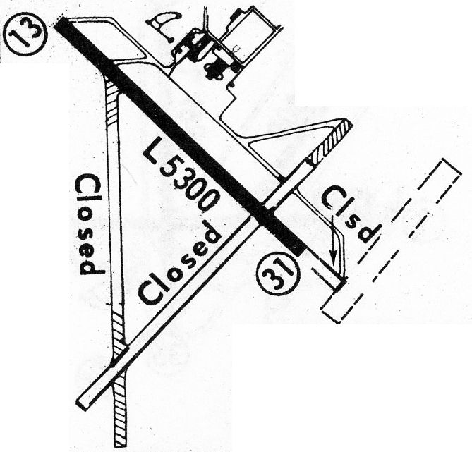
The last depiction which has been located showing the original Talladega Airport (before the construction of Talladega Speedway)
was in the 1968 Flight Guide (courtesy of Bob Levittan).
Only the 5,300' Runway 13/31 was still active, with 2 other runways marked as closed.
Also note the indication of the replacement runway eventually to be constructed to the southeast.
The last aeronautical chart depiction which has been located of Talladega Airport was on the September 1968 Birmingham Sectional Chart.
It depicted Talladega Airport as having 3 paved runways, with the longest being 5,300'.
The former Anniston AAF was selected as the site for a new auto racing track by NASCAR founder Bill France & Bill Ward.
They broke ground on the former airfield property on 5/23/68 for what was initially named "Alabama International Motor Speedway".
The track opened on 9/13/69 at a cost of $4 million. It "was built to be the biggest, fastest, and most competitive speedway in the world."
At some point between 1967-71, a new airport, the Talladega Municipal Airport, was built to the east of the Speedway & former military airfield.
A new 6,000' paved runway was constructed for the new airport - it did not reuse any runways from the former military airfield.
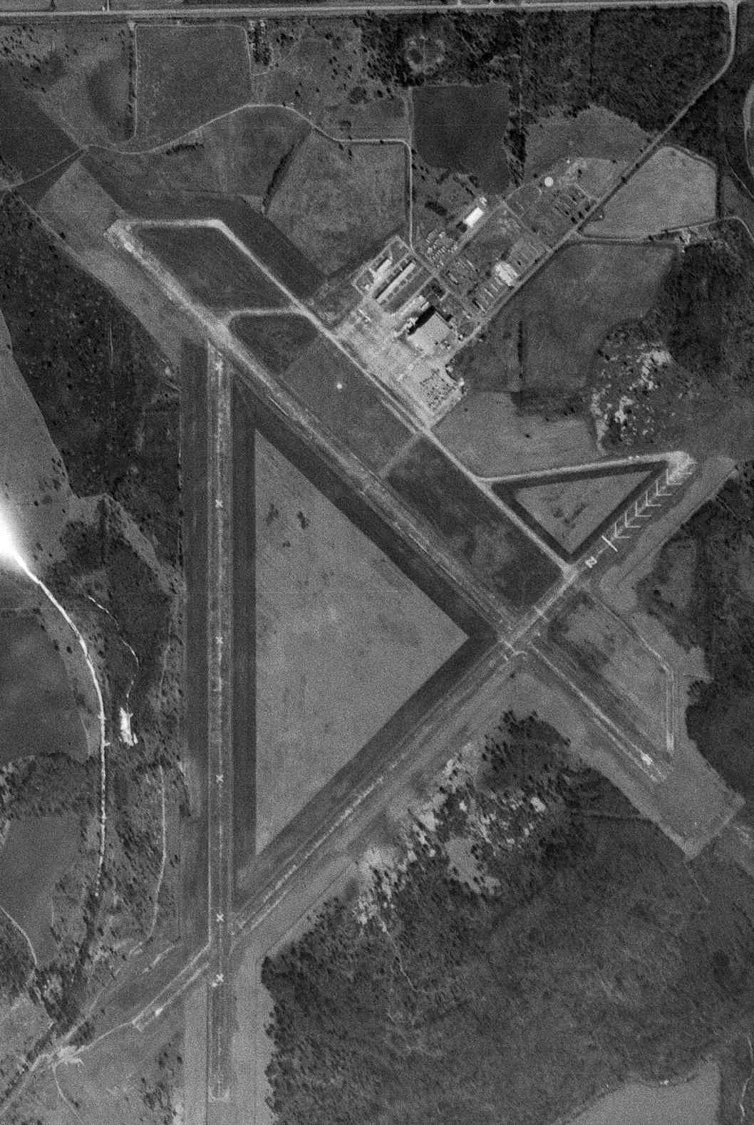
The majority of the length of the 3 runways of the former Anniston AFB were still clearly recognizable in the 1997 aerial photo.
Most of the former military building area also still existed, northeast of the former airfield.
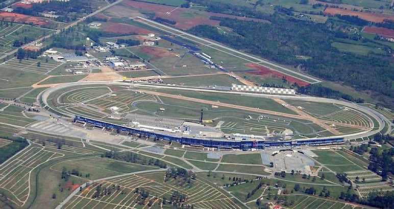
A 2006 aerial view by Robert Morris looking northeast at the Talladega Superspeedway,
with the former military airfield just behind it, and the current Talladega Regional Airport at the top.
Robert observed, “The old runways are used as roadways & RV/camper parking at the Talladega Superspeedway.”
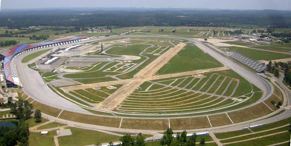
A 5/31/09 aerial view looking north at the remains of 2 former runways within the Talladega Superspeedway.
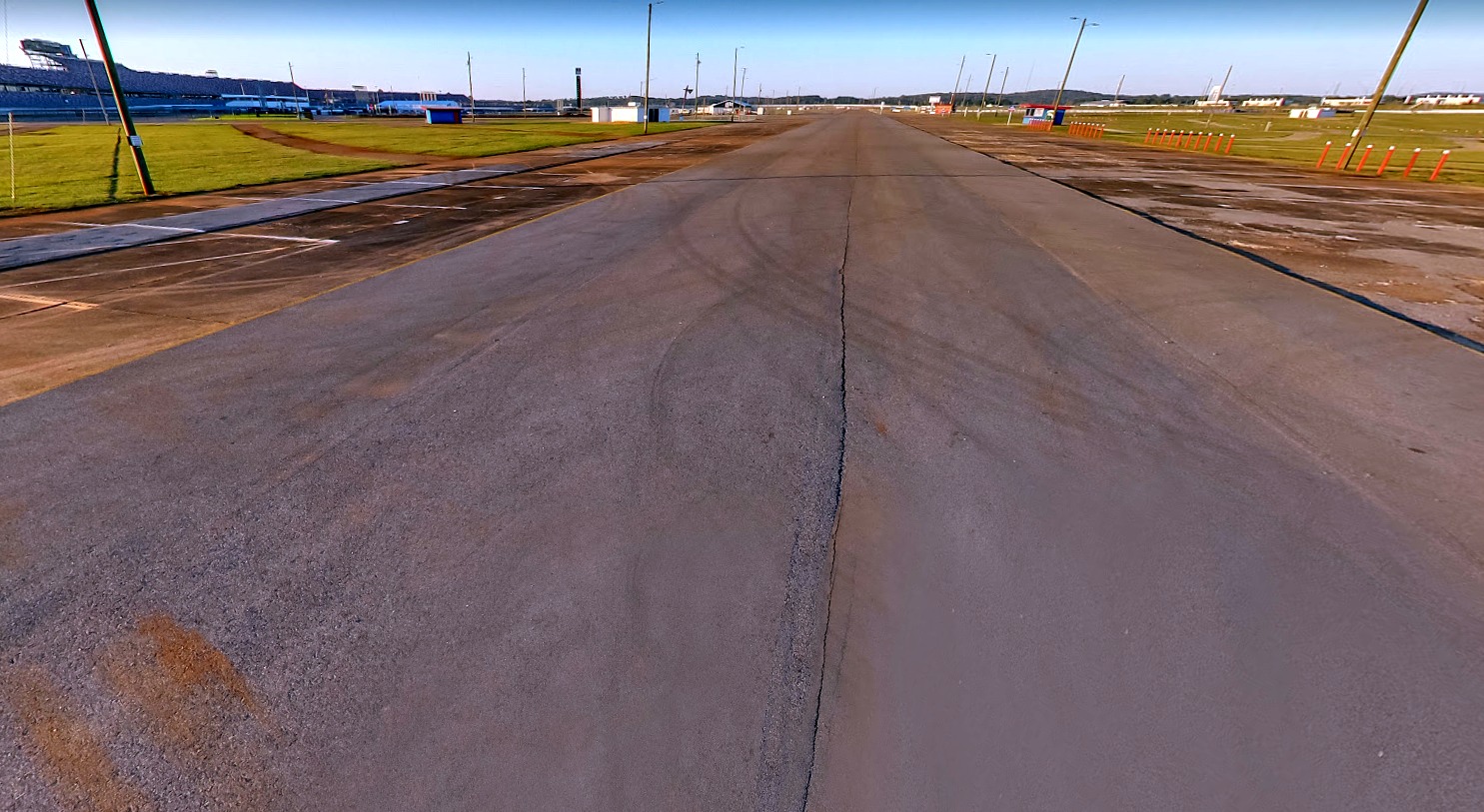
A February 2020 photo looking north along the former Anniston AFB Runway 36, now reused as Talladega Boulevard within the Superspeedway.
The site of Talladega AAF is located southeast of the intersection of Superspeedway Boulevard & Jackson Trace Road.
Thanks to Peter Kodis for pointing out this airfield.
____________________________________________________
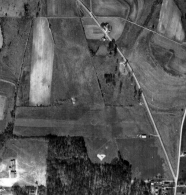
Coosa County Airport (69A), Goodwater, AL
33.095, -86.064 (North of Montgomery, AL)
Coosa County Airport, as depicted on a 2/19/66 USGS aerial photo (courtesy of Dallam Oliver-Lee).
Coosa County Airport was evidently built at some point between 1945-66,
as it was not yet listed among active airfields in the 1945 AAF Airfield Directory (courtesy of Scott Murdock).
The earliest depiction which has been located of Coosa County Airport was a 2/19/66 USGS aerial photo (courtesy of Dallam Oliver-Lee),
in which it appeared to still be an unpaved runway.
A 3/23/67 USGS aerial photo (courtesy of Dallam Oliver-Lee) still showed Coosa County to have an unpaved runway.
Nothing at the site of the Coosa County Airport was depicted on the 1969 USGS topo map
(even though the above 1966 aerial photo showed that the airfield already existed by that point).
According to Jim Hamil (a native & son of a City Councilman of Goodwater),
"The runway was built in the 1960s with Federal grant monies.
Goodwater is sandwiched in between what was at that time 2 larger & growing cities (Sylacauga & Alexander City)
which both had limited small runways / airports that were unable to expand because of land issues.
Goodwater's growth had leveled off & started to show signs of remission.
The county applied for the grant monies hoping that a longer airstrip would move growth towards Goodwater,
especially since it would be the only airstrip in the rural area that would be able to handle jets."
An 11/17/75 USGS aerial photo (courtesy of Dallam Oliver-Lee) appeared to show that the runway had been paved at some point between 1967-75.
According to Jim Hamil, "The strip had no bearings on Goodwater's growth & couldn't save the town.
During the 1970s, over half of the retail stores closed.
During the 1980s, Wal-Marts in Sylacauga & Alexander City killed all but 3 retail stores.
Even though the strip was never used,
the city was held responsible for maintaining the runway lights, which was rather expensive.
Even when the strip was open & operational, the gate portion of the fence around it was padlocked
(I remember climbing over it many times as a kid).
Also, I-65 (which connects Birmingham to Montgomery) didn't exist when the strip was built."
Coosa County Airport was depicted on the October 1975 Atlanta Sectional Chart (courtesy of Chris Kennedy)
as having a single 4,600' paved runway.
The airfield was depicted (labeled simply "Landing Strip") on the 1981 USGS topo map.
Coosa County Airport was listed among active airfields in the 1982 AOPA Airport Directory (courtesy of Ed Drury),
which described the field as having a single 4,600' asphalt Runway 18/36.
According to Jim Hamil, "The Airport was actually closed to normal traffic circa 1988,
but remained available for daytime emergency landings of planes & small jets because of its fairly long runway.
Any attempts to land were met with a deputy or Goodwater Policeman.
The reasons for closing the runway were primarily monetary & lack of use:
Resurfacing Costs - Costs & upkeep of the runway Lights
(which apparently were continually being destroyed by the city's mowers & by hunters who didn't like them burning).
Security - The police would patrol occasionally, but because of its remote & secluded location it needed a full-time watchman.
Lack of use - No planes were kept on the premises.
Madix & other local plane owners used the Alexander City Airport (15 minutes driving time)
which had hangers, was a manned airport, and was actually easier to access by car.
The Goodwater / Coosa County Airport is literally in a remote, very rural area with a difficult drive.
Someone would occasionally land on the strip when it was open, but rarely."
A 1997 USGS aerial view looking northeast showed the Coosa County Airport still consisted of a single 4,600' runway,
along with a small parking apron (possibly with a trailer) on the east side of the runway.
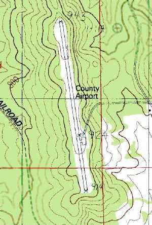
Coosa County Airport was still labeled "County Airport" on the 1997 USGS topo map.
Coosa County Airport was completely closed at some point between 1997-2002,
as it was depicted as an abandoned airfield on 2002 aeronautical charts.
Jim Hamil recalled, "I remember one of my friends trying to land on it after they painted the big "X" [closed runway symbol] on the runway.
He was probably 19 or so at the time. He was met by a Deputy who threatened to jail him & impound his plane!
After they closed it, the city began to use the area North of the runway
for the City Dump allowing the garbage & trash trucks to use the strip as a road
along with private & commercial vehicles who would bring trash to be dumped."
According to George Jones, the abandoned Coosa County Airport is used by Harley Davidson to test motorcycles.
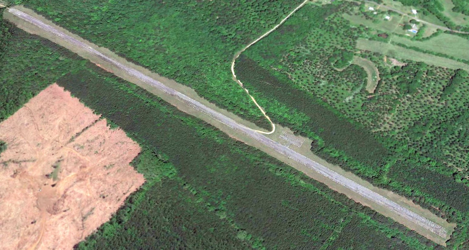
A 2016 aerial view looking northeast showed Coosa County Airport's pavement to be seriously deteriorated.
The site of Coosa County Airport is located west of Route 11, two miles north-northwest of Goodwater.
____________________________________________________
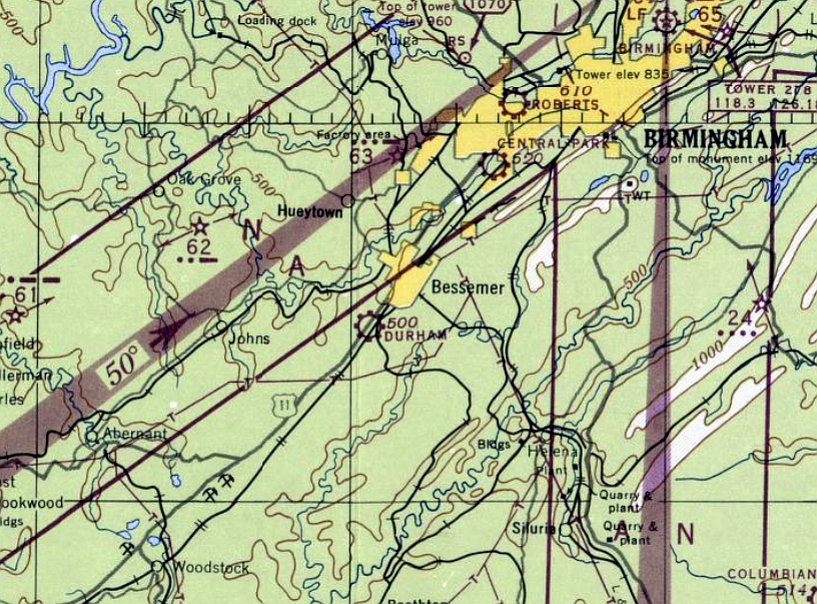
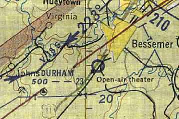
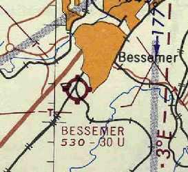
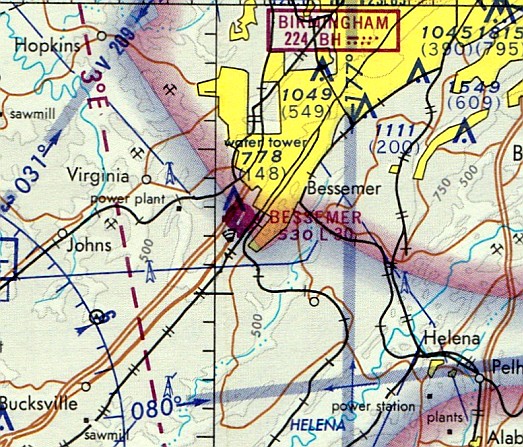
Durham Airport / (Original) Bessemer Airport, Bessemer, AL
33.365, -86.981 (Southwest of Birmingham, AL)

Durham Airport, as depicted on a 3/26/47 USGS aerial photo (courtesy of Dallam Oliver-Lee).
This airport was apparently built at some point between 1946-47 (like hundreds of other American general aviation airports in the post-WW2 boom),
as it was not yet depicted on the April 1946 Birmingham Sectional Chart.
The earliest depiction which has been located of Durham Airport was on a 3/26/47 USGS aerial photo (courtesy of Dallam Oliver-Lee).
It depicted Durham as having a single unpaved northeast/southwest runway, with 2 buildings on the northwest side.
The earliest aeronautical chart depiction which has been located of Durham Airport was on the October 1947 Birmingham Sectional Chart.
It depicted Durham as a commercial/municipal airport.
The August 1954 Birmingham USAF Sectional Chart (courtesy of Chris Kennedy) depicted Durham Airport as having a 2,300' unpaved runway.
A 1956 Soil Conservation Service aerial photo (courtesy of Thomas Kallsen of the University of Alabama Map Library)
depicted Durham Airport as having a single northeast/southwest runway, with 3 small buildings (hangars?) along the northwest side.
A total of 5 light aircraft were visible on the field.
At some point between 1954-59, the field was apparently renamed "Bessemer Airport"
as that is how it was labeled on the 1959 USGS topo map (courtesy of Chris Kennedy).
The August 1962 Birmingham Sectional Chart (courtesy of Chris Kennedy)
depicted the original Bessemer Airport as having a 3,000' unpaved runway.
Robert Boutwell recalled, “The 'old' Bessemer Airport... the airfield was paved around 1962.
At that time the airport was purchased by L. R. Clark who also owned Clark Bros Truck Lines in Birmingham.
The paving was done by 'Red' Stewart of Stewart Construction, also located in Birmingham.
The paving was done at Clark’s expense as a measure to bring in more traffic.
Both L.R. & Red kept their personal planes there.
L.R.’s wife was the manager & ran the operation along with a resident instructor pilot, Ronnie Little.”
Robert continued, “The airport had 2 completely enclosed hangars.
One was directly next to the operations building directly north of the gas island
and the other was in the northeast corner of the airfield.
The latter belonged to a fellow named 'Shorty' who was an A&P&I.
Folks from all over the south brought their airplanes to Shorty for annuals & repair.
In the 1960s Shorty employed 2-3 A&P mechanics there.
The remainder of the hangars were wooden T-hangars.
Basically pole construction with tin roofs, no sides. They did keep the sun off the fabric aircraft.
I recall that they stayed occupied most of the time along with the 15 or so open tie-down spots.”
The 1963 Birmingham Sectional Chart continued to depict Bessemer Airport as having a 3,000' unpaved runway.
Robert Boutwell recalled, “I did my first solo flight there in August of 1963 & subsequently went to work for Mrs. Clark as a line boy.
During my last year & a half of high school, I worked there every afternoon & all day on Saturday & Sunday.
She paid me $25 & 2 hours of flight time in a Piper Colt every week.
Between that & flying with all the guys who used to hang out there on weekends, I amassed enough time to get my Commercial License in 1965.
I worked there until 1966.”
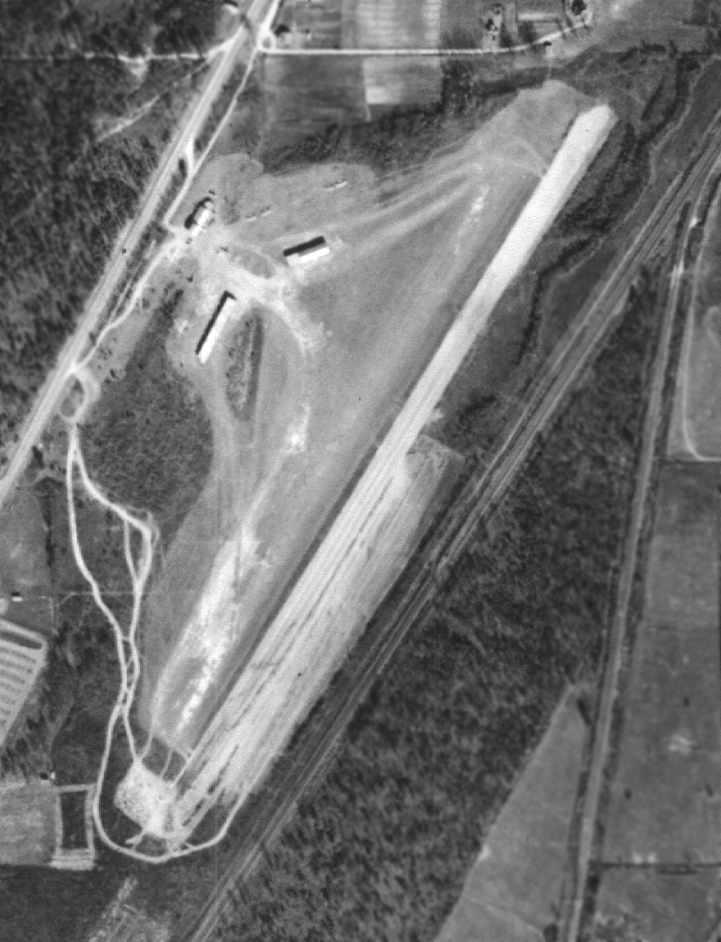
A 1967 Soil Conservation Service aerial photo of the original Bessemer Airport
(courtesy of Thomas Kallsen of the University of Alabama Map Library) depicted a paved runway
along with a few more hangars had been added to the field compared to the 1956 aerial photo.
A total of about a dozen light aircraft were visible on the field.
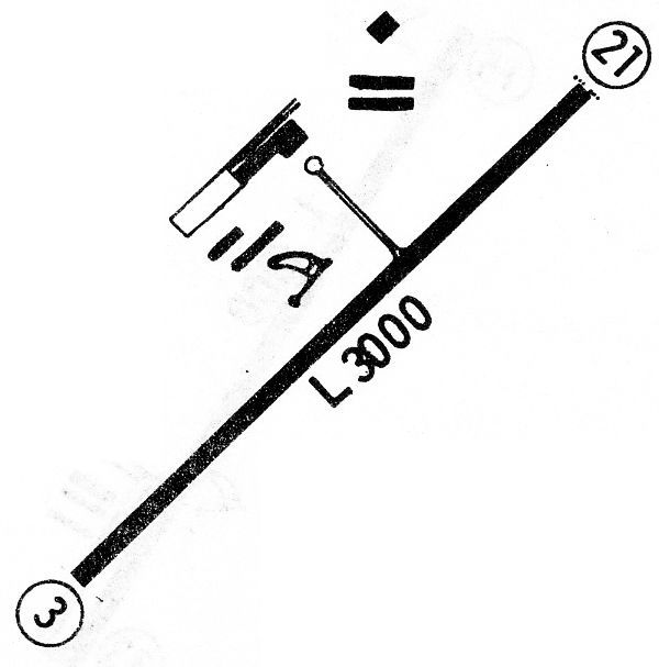
The 1968 Flight Guide (courtesy of Bob Levittan)
depicted Bessemer Airport as having a 3,000' paved Runway 3/21, with 6 buildings (hangars?) & a ramp on the northwest side.
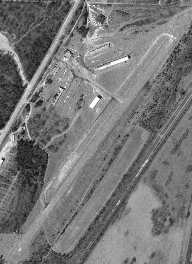
The last photo which has been located showing Bessemer Airport still open was a 2/21/70 USGS aerial photo (courtesy of Dallam Oliver-Lee).
It depicted over 20 aircraft on the field.
The last aeronautical chart depiction which has been located of the original Bessemer Airport
was on the October 1970 Atlanta Sectional Chart (courtesy of Ron Plante).
It depicted the original Bessemer Airport as having a 3,000' paved runway.
The 1971 Flight Guide (courtesy of Chris Kennedy) depicted Bessemer Airport as having a single 3,000' paved Runway 3/21.
A taxiway led to a total of 6 buildings (hangars?) along the northwest side of the runway.
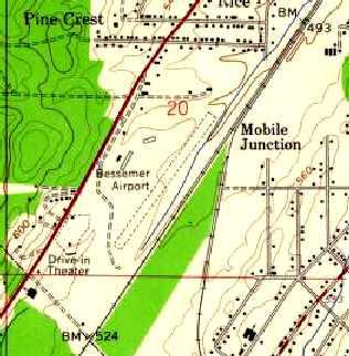
The original Bessemer Airport was apparently closed at some point between 1971-74,
as a 2/12/74 aerial photo (courtesy of Dallam Oliver-Lee) showed all of the airfield buildings except one had been removed,
and no aircraft were visible on the field.
It had evidently been replaced by a new airport to the southeast.
A 1975 aerial photo (courtesy of Dallam Oliver-Lee) still showed the airport property remaining without redevelopment.
By the time of the August 1976 Word Aeronautical Chart (according to Chris Kennedy),
the original Bessemer Airport was depicted as abandoned.
The Bessemer Airport was no longer depicted at all on the 1981 USGS topo map.
A 1981 USGS aerial photo showed several commercial buildings had been constructed over the site of the original Bessemer Airport,
with all of the airport buildings having been removed.
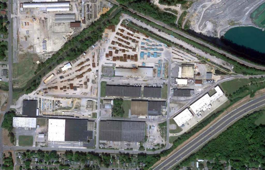
A 9/12/12 aerial photo (courtesy of Dallam Oliver-Lee) showed commercial buildings covering the site of the original Bessemer Airport.
Curiously, most of the runway lives on, reused as a street named Industrial Park Circle, which is anything but a circle.
The site of the original Bessemer Airport is located northeast of the intersection of Grant Street & Airport Lane Southwest.
____________________________________________________
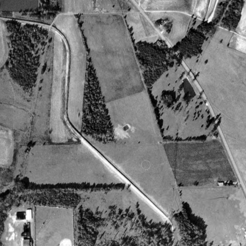
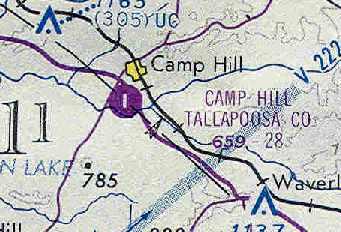
Camp Hill Tallapoosa County Airport (62A), Camp Hill, AL
32.782, -85.658 (Southwest of Atlanta, GA)
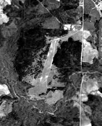
Camp Hill Airport, as depicted on a 4/4/51 USGS aerial photo (courtesy of Dallam Oliver-Lee).
Camp Hill Airport was evidently built at some point between 1945-51,
as it was not yet listed among active airfields in the 1945 AAF Airfield Directory (courtesy of Scott Murdock).
The earliest depiction which has been located of Camp Hill Airport was a 4/4/51 USGS aerial photo (courtesy of Dallam Oliver-Lee),
in which the field consisted of apparently not much more than a clearing, oriented north-northwest/south-southeast.
However, Camp Hill Airport was not listed among active airfields in the 1962 AOPA Airport Directory
A 10/10/67 USGS aerial photo (courtesy of Dallam Oliver-Lee) showed a larger clearing having been made for the Camp Hill runway
along a somewhat different orientation (due north/south) compared to as depicted in the earlier photo,
Camp Hill Airport was still not depicted on the October 1968 Birmingham Sectional Chart
nor listed among active airfields or the 1971 Flight Guide (according to Chris Kennedy).
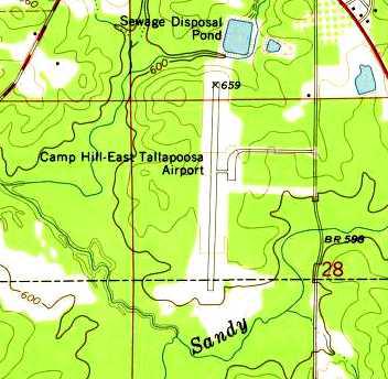
The earliest labeled depiction of Camp Hill Airport which has been located was on the 1971 USGS topo map.
It depicted Camp Hill East Tallapoosa County Airport as having a single north/south runway, with a ramp on the east side.
The February 1976 Atlanta Sectional Chart (courtesy of Chris Kennedy)
depicted Camp Hill Tallapoosa County Airport as having a single 2,800' paved runway.
Camp Hill Tallapoosa County Airport was described in the 1982 AOPA Airport Directory (courtesy of Ed Drury)
as having a single 2,780' asphalt Runway 18/36,
along with the comment "Use at own risk", which is kind of unusual for a "County Airport".
Camp Hill Airport was still listed (although in the "Low Use" section) of the 1986 Flight Guide (according to Chris Kennedy).
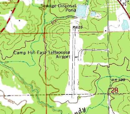
The 1986 USGS topo map depicted the Camp Hill East Tallaposa Airport as having a single north/south paved runway.
Ted Dasher recalled, “Camp Hill... was definitely open as of 1989
as the Auburn University Skydiving Club used it occasionally during that year.”
Brian Bostick reported, “Camp Hill was definitely open as late as 1991.
I landed there on 5/30/91 in a Cessna 172 & saw another aircraft parked there.
I was told at the time I landed that the airport was scheduled to be closed.
It was a short runway completely surrounded by a wall of tall trees on all sides.
Even in a Cessna 172, all those trees were enough to make any pilot sweat during landing or takeoff.”
Coosa County Airport was apparently closed at some point between 1991-98,
as it was not longer depicted at all (even as an abandoned airfield) on 1998 World Aeronautical Charts.
According to Glen Boyd (manager of LaGrange-Callaway Airport),
"It was closed due to a lack of funds to keep it properly paved & safe.
I understand that it is now used for drag racing & the hangar is a city equipment barn."
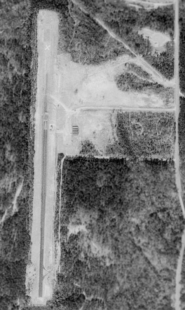
In the 1998 USGS aerial photo, the runway still existed, but with a closed runway "X" symbol on the north end,
and evidence of being reused for drag racing on the south end.
Ted Dasher observed, “One thing the photo does not capture is the way in which this airport was literally cut out of a pine forest,
almost like a runway with walls on each side (and each end).”
A 6/14/06 aerial photo (courtesy of Dallam Oliver-Lee) showed that a new divided highway (Route 280)
was built at some point between 1998-2006 right through the northern portion of the runway.
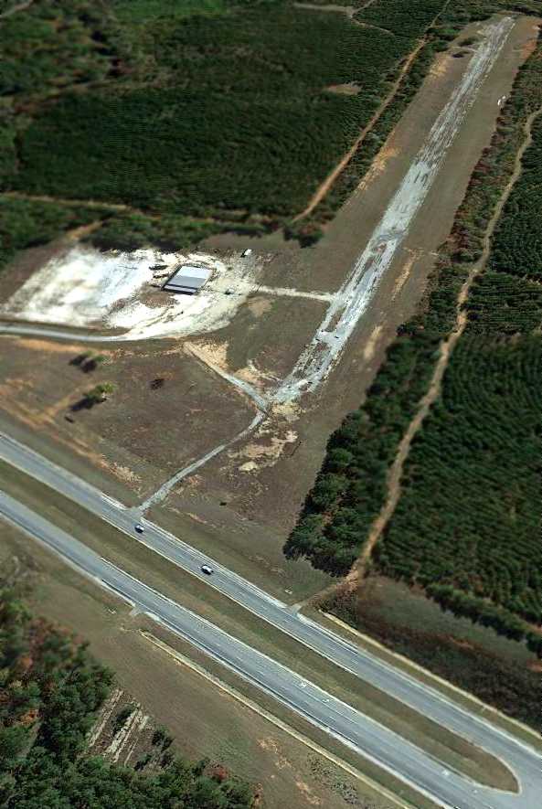
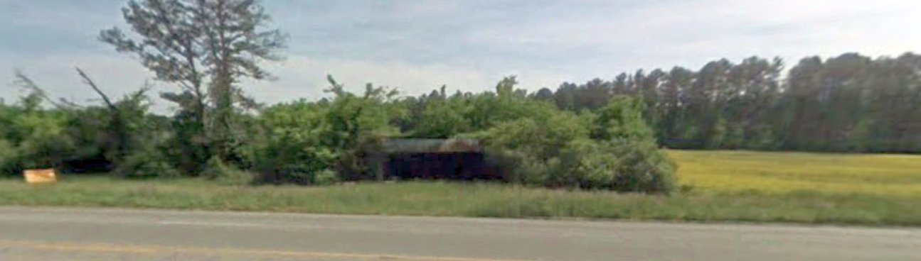
A 11/9/12 aerial view looking southeast showed the remains of the Camp Hill runway & the hangar.
A May 2022 photo looking southeast at the former Camp Hill Airport hangar.
A May 2022 photo looking south along the former Camp Hill Airport runway.
The Camp Hill Airport is located on the west side of Route 89 at Airport Road, one mile south of Camp Hill, AL.
____________________________________________________
____________________________________________________
This site covers airfields in all 50 states.