Abandoned & Little-Known Airfields:
Southwestern Arkansas
© 2002, © 2025 by Paul Freeman. Revised 11/24/25.
This site covers airfields in all 50 states: Click here for the site's main menu.
____________________________________________________
Please consider a financial contribution to support the continued growth & operation of this site.
Chaffee Army Airfield (revised 10/15/16) - Hames Airport / Benton Airport / (Original) Saline County Airport (revised 11/24/25)
____________________________________________________
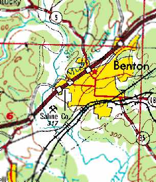
Hames Airport / Benton Airport / (Original) Saline County Airport, Benton, AR
34.56, -92.61 (Southwest of Little Rock, AR)
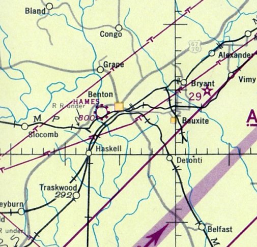
Hames Airport, as depicted on the March 1944 Little Rock Sectional Chart.
Hames Airport was evidently established at some point between 1942-44,
as it was not yet depicted on the July 1942 Little Rock Sectional Chart.
The earliest depiction of which has been located of Hames Airport was on the 1944 Little Rock Sectional Chart.
It depicted Saline County Airport as having a single paved 3,370' Runway 18/36, with a ramp & 2 buildings on the west side.
Hames Airport was evidently renamed Benton Airport at some point between 1944-45,
as that it how it was labeled on the March 1945 Little Rock Sectional Chart.
It was still depicted as Benton Airport on the August 1954 Little Rock Sectional Chart.
Benton Airport was evidently renamed Saline County Airport at some point between 1954-60,
as that it how it was labeled on the February 1960 Little Rock Sectional Chart.
It had also gained a 3,200' paved runway.
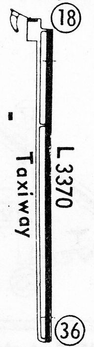
The 1968 Flight Guide (courtesy of Bob Levittan) depicted Saline County Airport as having a single paved 3,370' Runway 18/36, with a ramp & 2 buildings on the west side.
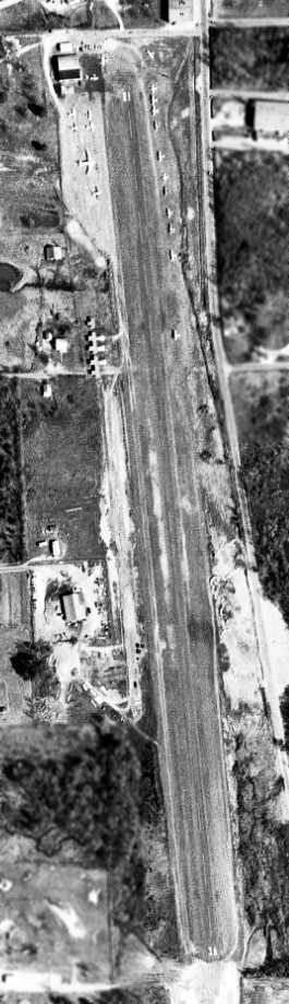
The earliest photo which has been located of Saline County Airport was a 3/9/70 USGS aerial photo.
It depicted the field as having a single asphalt Runway 18/36, with several hangars on the northwest side,
and a variety of aircraft parked on the northwest & northeast, including a Douglas DC-3.
The November 1974 Memphis Sectional Chart depicted Saline County Airport as having a single 4,200' paved north/south runway.
The 1977 USGS topo map depicted the Saline County Airport as having a single north/south runway.
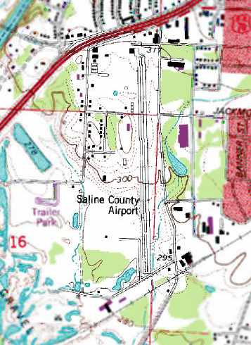
The 1988 USGS topo map (courtesy of Devan Mayer) depicted Saline County Airport as having a single paved north/south runway.
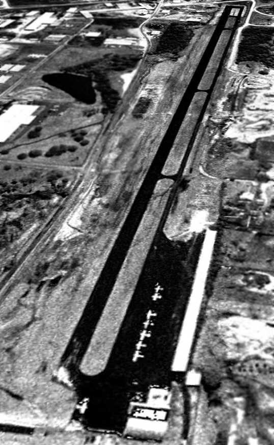
A 2/23/94 USGS aerial view looking southeast depicted 8 single-engine aircraft parked at Saline County Airport.

The last photo which has been located showing the original Saline County Airport still in operation was a 7/28/06 aerial view looking southeast (enhanced by Bill Grasha).
It depicted 8 single-engine aircraft parked on the northwest ramp.
According to Wikipedia, the original Saline County Airport consisted of 72 acres containing a single 3,980' asphalt Runway 17/35.
“For the 12-month period ending 8/31/06, the airport had 39,000 aircraft operations, an average of 106 per day.
At that time there were 44 aircraft based at this airport: 95% single-engine & 5% helicopter.”
According to Wikipedia, “The new Saline County Regional Airport opened on 3/12/07.
The existing [airport] was closed after the new airport opened.”

A 2007 photo looking south at the runway & hangars of the original Saline County Airport after its closure.
A 9/28/09 aerial photo showed the runway of the original Saline County Airport to be marked with closed-runway “X” markings, and no aircraft on the field.
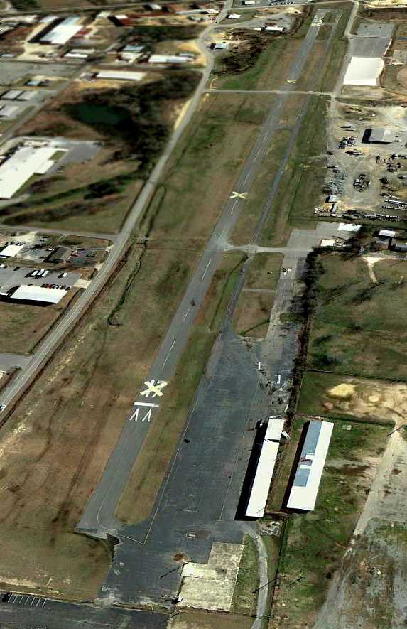
A 2/20/12 aerial view looking southeast showed the original Saline County Airport to remain intact, though abandoned.

A 2013 photo looking north along the original Saline County Airport's former Runway 36.
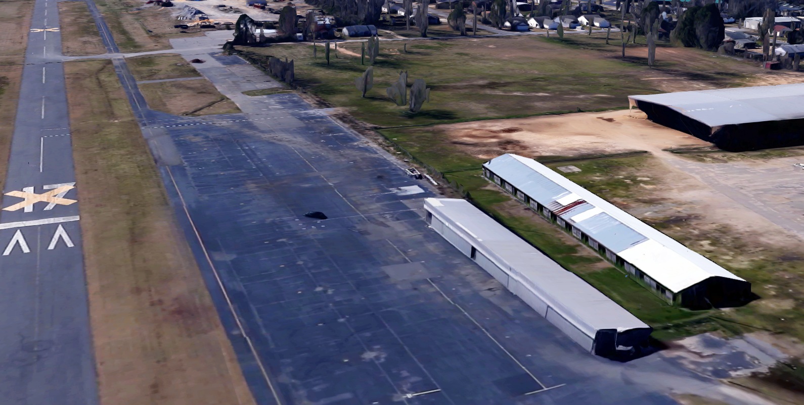
A circa 2022 3-D aerial view looking southwest showed the original Saline County Airport to remain intact, though abandoned.
A 2023 photo showed that Riverside Park had covered the site of the original Saline County Airport at some point between 2022-2023.
The site of the original location of Saline County Airport is located southwest of the intersection of Route 67 & Airlane Drive, appropriately enough.
Thanks to Devan Mayer for pointing out this airfield.
____________________________________________________
Chaffee Army Airfield, Fort Chaffee, AR
35.304, -94.322 (Northwest of Little Rock, AR)
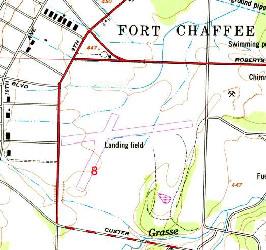
The 1947 USGS topo map depicted Ft. Chafee as having 2 runways, labeled simply as “Landing Field”.
Photo of the airfield while open has not been located.
Construction began on the Army's Fort Chaffee in September 1941.
From 1942-46, the base was used to train the 6th, 14th, and 16th Armored Divisions.
According to Al Fragola, “The post included a pair of sod runways for liaison-type aircraft used by the divisions,
however no formal airfield was established other than the runways.
The field on which the runways were made was adjacent to a vast tank & motor vehicle maintenance park.”
No airfield was yet listed among active airfields in the 1945 AAF Airfield Directory (courtesy of Scott Murdock)
The earliest depiction which has been located of Chaffee Army Airfield was on the 1947 USGS topo map,
which a pair of runways labeled simply as “Landing Field”.
No airfield at Ft. Chafee was yet depicted on the February 1950 Little Rock Sectional Chart.
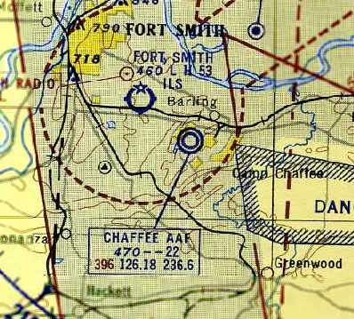
The earliest aeronautical chart depiction which has been located of Chaffee Army Airfield
was on the August 1953 Little Rock Sectional Chart (courtesy of Chris Kennedy).
It depicted “Chaffee AAF” as having a 2,200' unpaved runway.
According to Al Fragola, “It is thought that the sod strips on Ft. Chaffee
were originally charted as a cautionary measure due to their close proximity (3 miles) to Ft. Smith Regional Airport,
and Ft. Smith's establishment of an Air Traffic Control tower & commercial airline service.
Use of the sod strips by the Army was only occasional.”
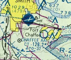
For reasons that cannot be determined, the February 1959 Little Rock Sectional Chart (courtesy of David Brooks)
erroneously described Chaffee AAF as having 3 concrete runways, with the longest being 2,640'.
Chaffee AAF continued to be depicted on the February 1960 Little Rock Sectional Chart (according to Chris Kennedy).
Chaffee AAF was no longer depicted on the July 1964 Little Rock Sectional Chart (according to Chris Kennedy).
Chaffee AAF was labeled “Abandoned Airfield” on the January 1965 Little Rock Sectional Chart (courtesy of David Brooks).
The earliest photo which has been located of Chaffee Army Airfield was a 1971 aerial view.
It depicted a pair of unpaved runways, with no buildings or aircraft.
Chaffee AAF was no longer depicted at all on the 1972 Memphis Sectional Chart (according to David Brooks).
According to Al Fragola, “A review of records by the Army & FAA in 1982
determined that the appearance & disappearance of Chaffee AAF on aeronautical charts through to the 1970s
seemed to be at the discretion of FAA officials at Ft. Smith Regional Airport,
depending upon perceived needs to depict its presence to civil aviation.
Prior to 1972, the Army never considered the facility more than an informal airstrip or helicopter landing area,
and never formally submitted airdrome data until the 1970s.
Chaffee AAF began being used for Army Reserve & National Guard helicopter unit summer training in the late 1960s.
By 1972, the intensity of these operations was considerable during the June–August timeframe,
and in 1975 the Army established a temporary ATC tower which operated under a letter of agreement with the FAA facility at FSM.”
Chaffee AAF was once again depicted on the 1977 Memphis Sectional Chart (according to David Brooks).
The May 1979 Memphis Sectional Chart (courtesy of David Brooks)
depicted Chafee AAF as having only a 2,200' unpaved runway.
Al Fragola reported, “From 1982-85, I was the Airfield Commander for Chaffee Army Airfield.
Arrowhead Assault Strip was constructed & opened on my watch, and fell under my command as well.
During my tenure there, we had, on numerous occasions,
over 100 helicopters operating out of the airfield, all from units from everywhere.
Also regularly hosted teams doing doctrinal & equipment testing,
and operated a National Guard Air Traffic Control unit training program for 2 years.
Until my arrival, oversight of aviation activities was an additional duty for an officer at Ft. Sill, OK, some 200 miles away!
It was a great assignment for me, as we were upgrading the AAF facilities,
working with Army ATC in the development of tactical ATC doctrine, doing a tremendous amount of training support,
building AZU (which was also an active military parachute drop zone)
and working on the development of what would become the JRTC.”
Chaffee AAF continued to be depicted on Memphis Sectional Charts through the 1980s (according to David Brooks).
According to Al Fragola, “In 1983, Chaffee AAF was redesignated Chaffee Army Heliport,
and the sod runways were formally closed to fixed-wing traffic.
Heliport facilities were improved to provide reinforced concrete parking pads for 85 helicopters,
helipad lighting, a simple crash/rescue facility and improved ATC Tower.
No hangar facilities were ever built at the airfield.
The facility continued to be operated on an 'as-needed' basis, supporting Reserve/Guard units in the summer,
and an ever-increasing number of active-force units deploying to Ft Chaffee to use the excellent maneuver areas on the post.”
According to William Leeper, “The single concrete strip... is actually a road that widened out where it was an airstrip.
They simply set pipe bollards in the road to block it off when they were using it.”
According to David Brooks, in the mid-1980s the Army constructed another airfield 5 miles to the southeast, called Arrowhead Assult Strip (AZU).
According to Al Fragola, “In 1987, Ft Chaffee became the site of the Army’s Joint Readiness Training Center (JRTC),
to which infantry units would deploy & train year-round.
Chaffee AHP was used by supporting helicopter units, and AZU was used as the 'tactical insertion airfield'.”
Chaffee AAF was no longer depicted on the 1991 Memphis Sectional Chart (according to David Brooks).
According to Al Fragola, “In 1993, the JRTC was moved to Ft Polk, LA, and Ft Chaffee ceased serving as an active Army post.
The land including Chaffee AHP has been turned over to commercial developers,
while the land including AZU was transferred to the Arkansas National Guard & continues as a military training site.”
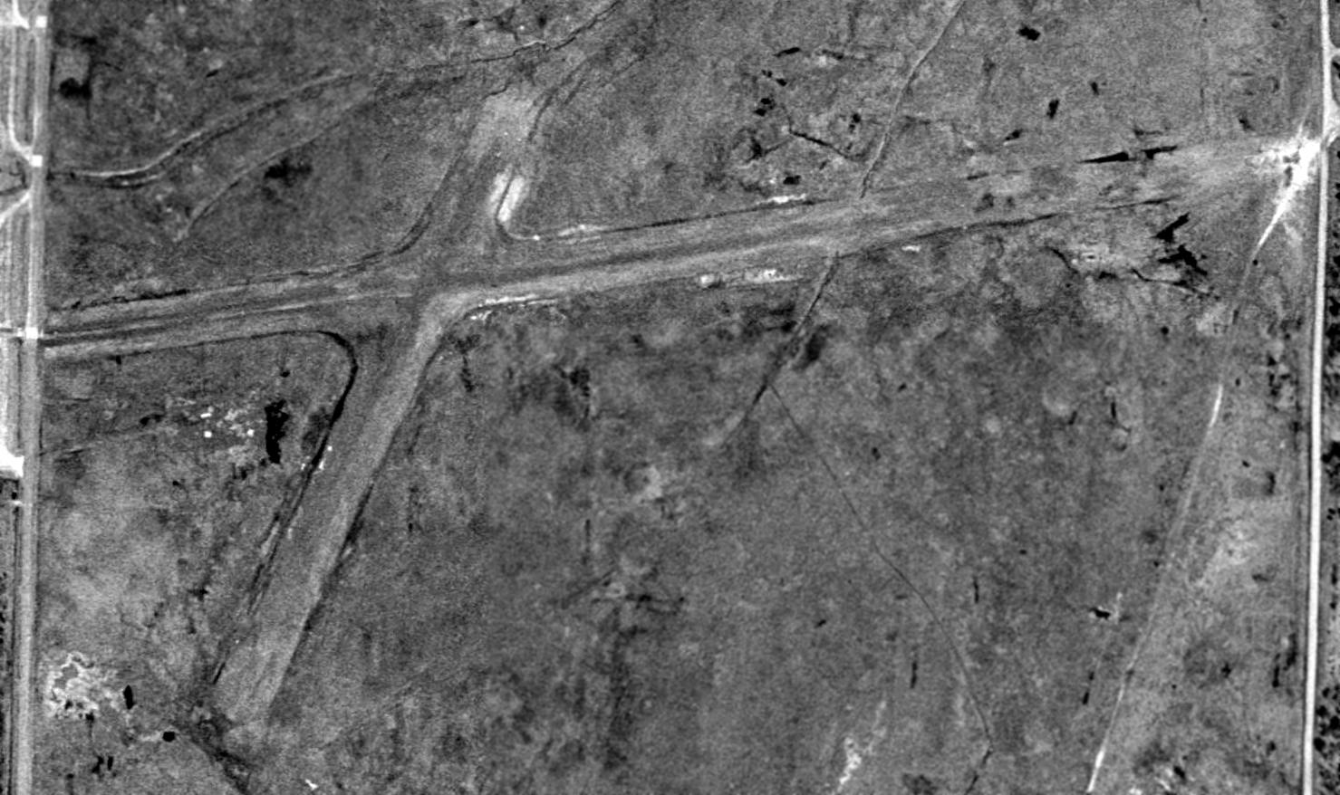
The earliest photo which has been located of the Ft. Chafee Airfield was a March 1994 USGS aerial photo (courtesy of Dallam Oliver-Lee, enhanced by Bill Grasha).
It showed that the remains of 2 unpaved runways were still recognizable.
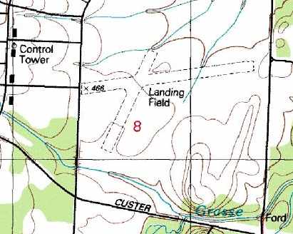
The 1995 USGS topo map depicted the Ft. Chafee Airfield as having 2 unpaved runways, labeled simply as “Landing Field”.
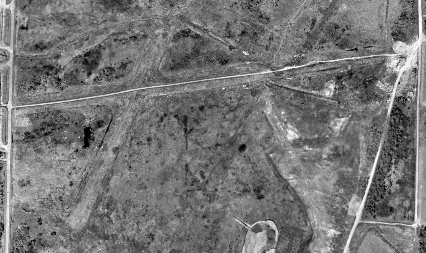
A 2003 USGS aerial photo of the site of Ft. Chafee Airfield showed that the remains of 2 unpaved runways were still recognizable.
But roads had been constructed across some of the former airfield, and some of the land had been plowed up along the southeast side.
A January 2006 aerial view (courtesy of Dallam Oliver-Lee) showed that a large building had been constructed over the northern portion of the airifeld site,
but the remains of 2 runways were still visible on the southern half.
William Leeper reported in 2014, “The structures that are located along the former runways are Mars Petcare, Umerex USA INC/ Walther Firearms, and Graphic Packaging.
I am VERY familiar with this area, and recall these air strips before they were built over.
The report of a single concrete strip is also accurate. It is actually a road that widened out where it was an airstrip.
They simply set pipe bollards in the road to block it off when they were using it.”
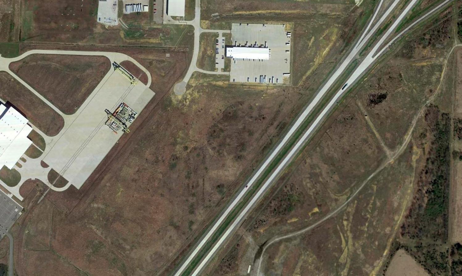
A 2016 aerial view showed the site of Chafee AAF was unrecognizable as ever having been an airfield,
with large buildings covering the northwestern portion, and a new highway having been built over the southeastern portion.
The site of Chaffee AAF is located southwest of the intersection of Route 253 & Route 255.
____________________________________________________
____________________________________________________
This site covers airfields in all 50 states.