Abandoned & Little-Known Airfields:
Northwestern Arizona
© 2002, © 2025 by Paul Freeman. Revised 7/11/25.
____________________________________________________
Please consider a financial contribution to support the continued growth & operation of this site.
(Original) Bullhead City Airport / Bullhead Laughlin Aorport (revised 11/10/23) - Kingman Aux AAF #1 / Cyclopic Field (revised 9/15/19) – Kingman Aux AAF #3 / Hackberry Field (revised 7/11/25)
Lake Mohave Ranchos Airport (revised 11/10/23) - Searchlight Ferry Airport (1st location) (revised 5/1/21)
Searchlight Ferry (2nd location) / Cottonwood Landing Airport (revised 7/11/25) - Wallapai Field / Hualapai Field (revised 1/19/17)
____________________________________________________
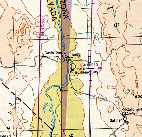
(Original) Bullhead City Airport, Bullhead City, AZ
35.168, -114.565 (West of Phoenix, AZ)
The original Bullhead City Airport, as depicted on the September 1950 Los Angeles Sectional Chart.
The original Bullhead City Airport was evidently established at some point between 1948-50,
as it was not yet depicted on the February 1948 Los Angeles Sectional Chart.
The earliest depiction which has been located of Bullhead City Airport was on the September 1950 Los Angeles Sectional Chart.
It depicted Bullhead City Airport as having a 3,000' unpaved runway.
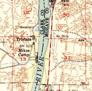
The 1952 USGS topo map depicted the original Bullhead City Airport as a north/south runway, labeled generically as “Air Strip”.
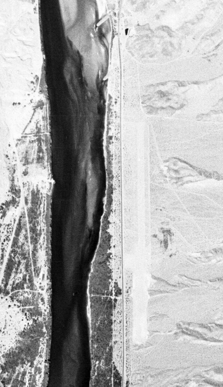
The earliest photo which has been located of the original Bullhead City Airport was a 4/1/54 USGS aerial view.
It depicted Bullhead City Airport as a single north/south unpaved runway, without any buildings.
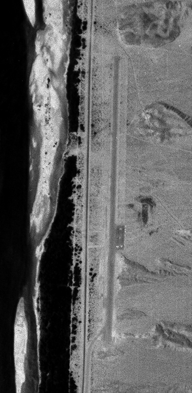
A 5/2/64 USGS aerial view depicted Bullhead City Airport as a single north/south runway, with a ramp with several small aircraft on the east side.
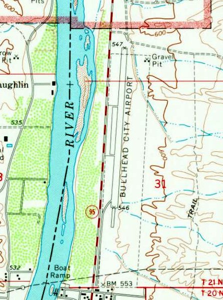
Bullhead City Airport evidently gained a paved runway by 1970, as the 1970 USGS topo map depicted it has having a north/south paved runway, with a paved ramp on the west side.
The 1978 Phoenix Sectional Chart (courtesy of Jonathan Westerling) depicted Bullhead City Airport as having a 4,000' paved north/south runway.
At some point between 1987-85, Bullhead City Airport was evidently renamed Bullhead Laughlin Airport,
as that is how it was labeled on the 1985 Phoenix Sectional Chart (courtesy of John Voss).
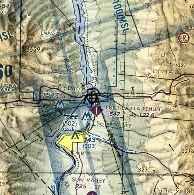
The last depiction which has been located of Bullhead Laughlin Airport was on the 1988 Phoenix Sectional Chart (courtesy of Jonathan Westerling).
It depicted Bullhead Laughlin Airport as having a 4,600' paved north/south runway.
A 1990 aerial photo showed that construction had started on a replacement Bullhead City Airport, a half-mile to the east, with a much longer runway.
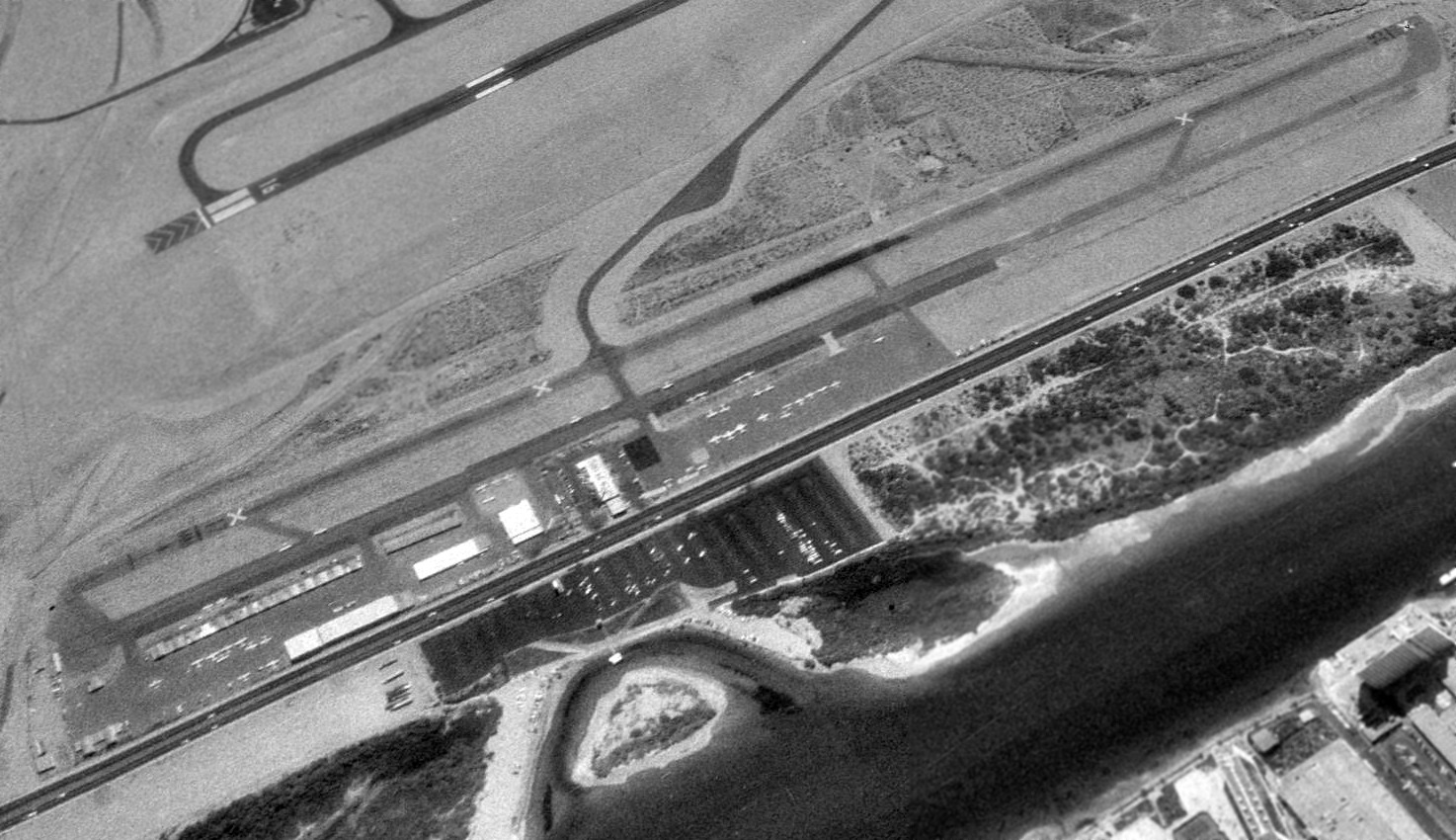
A 1992 aerial view looking southeast showed that aircraft were still parked on the ramp of the original Bullhead City Airport, but its runway had been marked as closed,
and a taxiway led toward the runway of the new Bullhead City Airport to the east, visible in the background.
The 1998 Phoenix Sectional Chart (courtesy of Jonathan Westerling) no longer depicted the original Bullhead City Airport, but instead the larger Laughlin Bullhead International Airport.
A 2005 aerial photo showed that the hangars of the original Bullhead City Airport had been removed,
and a Home Depot built over the center of the former airport.
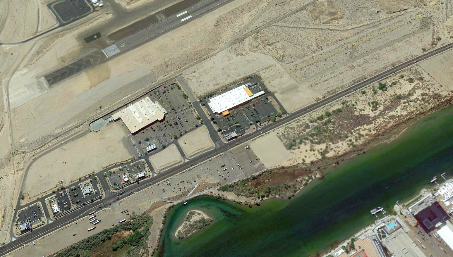
A 2018 aerial view looking southeast showed that a Sam's Club & Home Depot situated over the center of the site of the original Bullhead City Airport,
but the southern portion of its runway & paralle taxiway was still visible, complete with 2 yellow closed-runway “X” symbols.
The site of the original Bullhead City Airport is located east of the intersection of Mojave Valley Parkway & Airport Center Drive.
Thanks to Kim Taylor for pointing out this airfield.
____________________________________________________
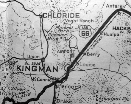
Wallapai Field / Hualapai Field, Kingman, AZ
35.198, -114.036 (Northwest of Phoenix, AZ)
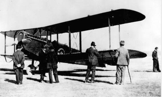
A 2/22/19 photo of an Army De Havilland DH-4 refueling at Wallapai Field (courtesy of Mohave Museum of History & Arts, used by permission, via Curtis Carroll).
Curtis Carroll reported, “Wallapai Field, occasionally spelled Hualapai Field, was the earliest landing field established in northwest Arizona.
The first mention of the field in the local newspaper (Mohave County Miner) was December, 1918.
Surface & wind conditions of the 1,000’ x 1,800' field were deemed suitable by early aviators
and on 1/18/1919, it was chosen by the U.S. Aerial Mail Service as a stop on the Chicago-LA route
but seldom was used as the service favored the New York – San Francisco & Salt Lake – Los Angeles routes.”
The earliest depiction of Wallapai Field which has been located
was a 2/22/19 photo of an Army De Havilland DH-4 being refueled at Wallapai Field (courtesy of Mohave Museum of History & Arts, used by permission, via Curtis Carroll).
The Army aviators had been enroute from March Field in Riverside, CA to their home in Houston,
and made a stop in Kingman to refuel & fly over the Grand Canyon.
An 1924 aerial view looking southeast shows Wallapai Field's small northwest/southeast dirt runway in the left-center
(courtesy of Mohave Museum of History & Arts, used by permission, via Curtis Carroll).
It showed the Mountain View Cemetery north of the airfield,
and the National Old Trails Highway (what would eventually be Route 66) & the Santa Fe Railroad traversed the landscape in the upper third of the frame.
A 10/19/28 photo of a Sikorsky S38-10 amphibian on its delivery flight, refueling at Wallapai Field (courtesy of Curtis Carroll).
Piloted by famed aviator Art Goebel, this unusual plane, nicknamed “Flying Fish”, would eventually carry passengers from Mines Field & Long Beach Harbor to & from Santa Catalina Island.
Its sudden appearance caused quite a stir among the townspeople. The Hualapai Mountains are visible below the left wing.
A 1928 photo looking southwest at Charles Lindbergh standing on the wing of his Ford Tri-Motor #NC 9606, overseeing its refueling at Wallapai Field
(courtesy of Mohave Museum of History & Arts, used by permission, via Curtis Carroll).
It shows the southern tip of the Cerbat Mountains.
Lindbergh's visit was laying the groundwork for a new airfield for Transcontinental Air Transport’s NY-LA route.
But Wallapai Field was too small & poorly situated (next to a cemetery) to service the larger, heavier aircraft & the terminal demands of the new route,
The last depiction of Wallapai Field was on a 1929 road map (collection of Curtis Carroll), which depicted it as a rectangular property outline labeled simply as “Airport”.
According to Curtis Carroll, Wallapai Field was sporadically active until 1929 when it was replaced by Berry Field & Port Kingman.
Once Port Kingman & Berry Field were operational, Wallapai was no longer used.
Wallapai Field was no longer depicted on the February 1932 Prescott Sectional Chart.
A 1965 aerial view showed no trace remaining of Wallapai Field.
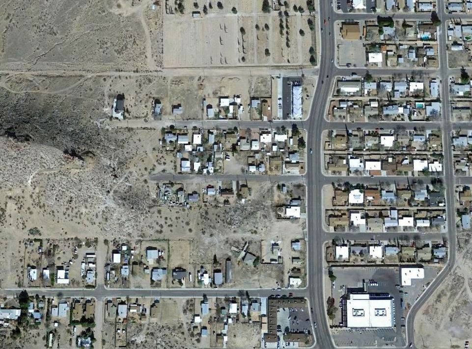
A 2015 aerial view showed houses covering the site of Wallapai Field.
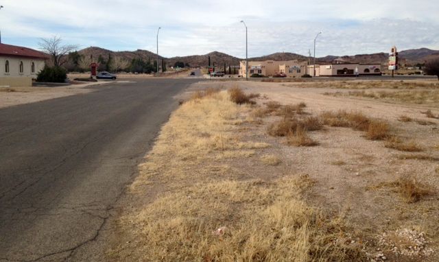
A January 2017 photo by Rob Chilcoat (courtesy of Curtis Carroll) looking southwest at the approximate east end of the site of Wallapai Field's dirt strip, with the Cerbat Mountains in the background.
Curtis Carroll noted, “This closely matches the [1928] Lindbergh photo.”
The site of Wallapai Field is between Jefferson Street & the cemetery, west of Stockton Hill Road.
Thanks to Curtis Carroll for pointing out this airfield,
and for additional information from Rob Chilcoat & Cathy Kreis (research librarian at the Mohave Museum).
____________________________________________________
Lake Mohave Ranchos Airport, Dolan Springs, AZ
35.57, -114.3 (Northwest of Phoenix, AZ)
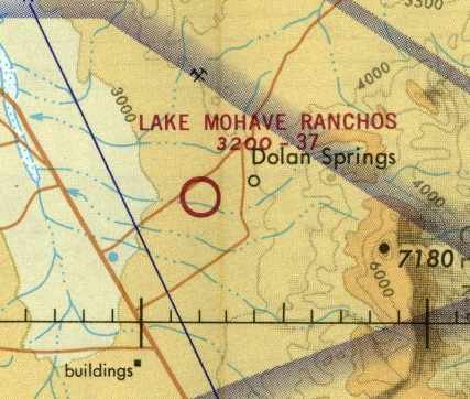
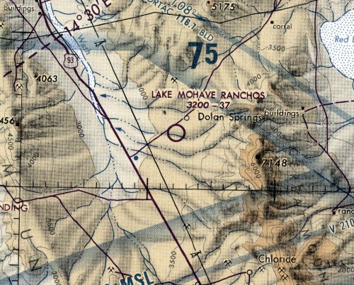
Lake Mohave Ranchos Airport, as depicted on the December 1970 Phoenix Sectional Chart (courtesy of David Brooks).
The Lake Mohave Ranchos Airport was evidently established at some point during 1970,
as it was not yet depicted on the June 1970 Phoenix Sectional Chart (according to David Brooks).
The earliest depiction of the field which has been located
was on the December 1970 Phoenix Sectional Chart (courtesy of David Brooks).
It depicted Lake Mohave Ranchos as a public-use airport, with a 3,700' unpaved runway.
The 1970 AOPA Airport Directory (according to David Brooks) described Lake Mohave Ranchos as offering tie-downs & fuel.
Its purpose was stated to serve the Lake Mead Recreational Area.
The earliest photo which has been located of the Lake Mojave Rancho Airport was a 11/13/78 USGS aerial photo.
It showed the field as having a single northeast/southwest runway, with a ramp on the northeast side.
There did not appear to be any sign of any buildings related to the airfield.
The last depiction which is available of Lake Mohave Ranchos Airfield was on the 1978 Phoenix Sectional Chart (courtesy of Jonathan Westerling).
It depicted Lake Mohave Ranchos as a public-use airport having a 3,700' unpaved runway.
The last depiction which has been located of Lake Mohave Ranchos as an active airfield
was on the June 1980 Phoenix Sectional Chart (according to David Brooks).
Lake Mohave Ranchos was evidently closed (for reasons unknown) at some point in 1980,
as it was no longer depicted on the December 1980 Phoenix Sectional Chart (according to David Brooks) or the 1980 USGS topo map.
Thus, this small general aviation airport apparently only lasted about 9-10 years.
The 1989 USGS topo map still depicted a single unpaved northwest/southeast runway, labeled simply as “Landing Strip”.
A 1997 USGS aerial view depicted Lake Mojave Rancho Airport as having several closed-runway “X” symbols still recognizable on the former runway.
An 11/8/11 aerial view looking south showed the Lake Mojave Rancho runway still remained intact although overgrown.
Lake Mohave Ranchos Airport is located south of the intersection of Pierce Ferry Road & Gila Drive.
____________________________________________________
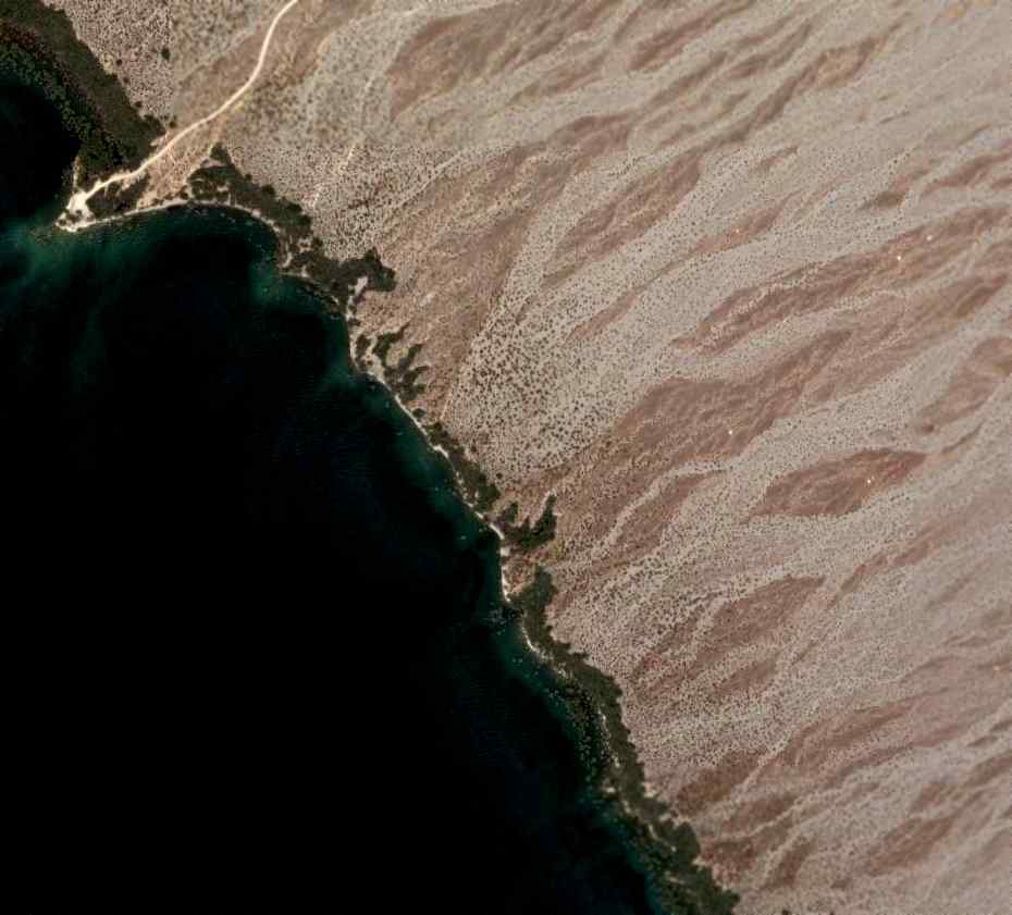
Searchlight Ferry Airport (1st location), Dolan Springs, AZ
35.46, -114.63 (Northwest of Phoenix, AZ)
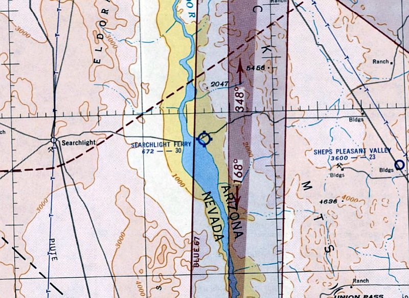
The original Searchlight Ferry Airfield, as September 1952 LA Sectional Chart.
Photo of the airport while in operation has not been located.
This small general aviation airport was located along the eastern shore of Lake Mojave, along the western border of Arizona.
The original Searchlight Ferry Airfield was evidently established at some point in 1952,
as it was not yet depicted on the March 1952 LA Sectional Chart.
The earliest depiction which has been located of the Searchlight Ferry Airfield was on the September 1952 LA Sectional Chart.
It depicted the field as having a 3,000' unpaved runway.
The March 1955 LA Sectional Chart (courtesy of David Brooks) depicted Searchlight Ferry in the same fashion.
The last chart depiction which has been located of the original Searchlight Ferry Airfield
was on the March 1958 LA Sectional Chart (courtesy of Chris Kennedy).
The field was labeled as “Emergency only”, and the Aerodromes table on the chart described the field as having a single 1,200' bare runway.
The comment said "Caution: Short field. Fuel avail."
Note that the field had evidently lost more than half its length between 1955-58.
In the words of Chris Kennedy, “I guess the lake must have swallowed most of the runway by then.”
The original Searchlight Ferry Airfield was evidently abandoned at some point between 1958-60,
as no airfield was depicted in this area on the 1959 USGS topo map
nor on the September 1960 LA Sectional Chart (according to Chris Kennedy).
By 1963, a new Searchlight Ferry Airfield had been established, a mile further north along the shore of the Lake.
According to David Brooks, it appears as if the original Searchlight Ferry Airfield was flooded out by rising waters of Lake Mojave.
A 1992 USGS aerial photo did not appear to show any trace of the original Searchlight Ferry Airfield.
A 2006 aerial photo did not appear to show any trace of the original Searchlight Ferry Airfield.
The Searchlight Ferry Airfield is located south of where Cottonwood Road ends at the shore of Lake Mojave,
inside the Lake Mead National Recreational Area.
____________________________________________________
Searchlight Ferry Airport (2nd location) / Cottonwood Landing Airport (P53), Dolan Springs, AZ
35.486, -114.666 (Northwest of Phoenix, AZ)
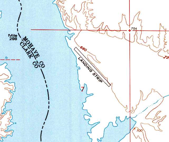
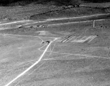
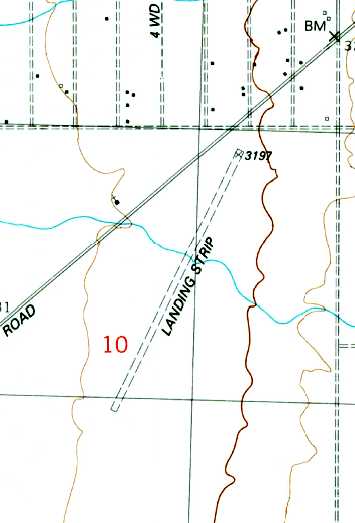
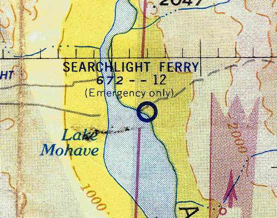
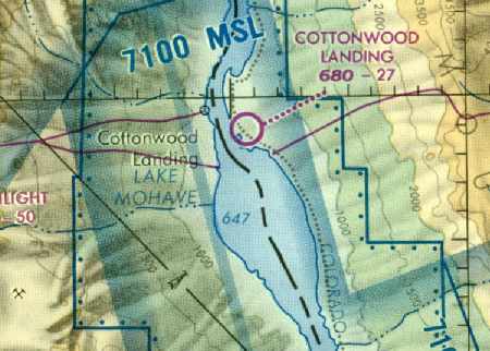
The second location of the Searchlight Ferry Airfield, as depicted on the 1959 USGS topo map.
Photo of the airport while in operation has not been located.
To replace the original Searchlight Ferry Airfield which was flooded by rising lake waters,
a new airfield was established along the shore of Lake Mojave,
one mile to the north of where the original Searchlight Ferry Airfield had been located.
The earliest chart depiction of the second airfield which has been located was on the 1959 USGS topo map.
It depicted a single northwest/southeast runway, labeled simply as “Landing Strip”.
No airfield was depicted in this area on the March 1961 LA Sectional Chart (according to Chris Kennedy).
The earliest aeronautical chart depiction of the second airfield which has been located
was on the July 1963 Gila River USAF World Aeronautical Chart (courtesy of David Brooks).
It depicted Searchlight Ferry as a public-use airport.
The second location of the Searchlight Ferry Airfield was listed in the 1963 AOPA Airport Directory (according to Chris Kennedy).
It was described as having a single 3,000' dirt Runway 18/36, and the note "Last report 1961."
The August 1965 & August 1966 LA Sectional Charts (courtesy of Chris Kennedy)
depicted Searchlight Ferry as having a 3,000' unpaved runway.
At some point between 1966-67 the field was evidently renamed “Cottonwood”,
as that is how it was labeled on the March 1967 LA Sectional Chart (courtesy of Chris Kennedy).
“Cottonwood Cove” was described in the 1967 AOPA Airport Directory (according to Chris Kennedy)
as having a single 3,000' dirt Runway 18/36.
However, the runway configuration was apparently changed at some point in 1967,
as a November 1967 Flight Guide (according to Chris Kennedy) described the field as having a single 3,000' Runway 13/31.
“Cottonwood” was described on the August 1968 LA Section al Chart (courtesy of David Brooks) as having a 3,000' unpaved runway.

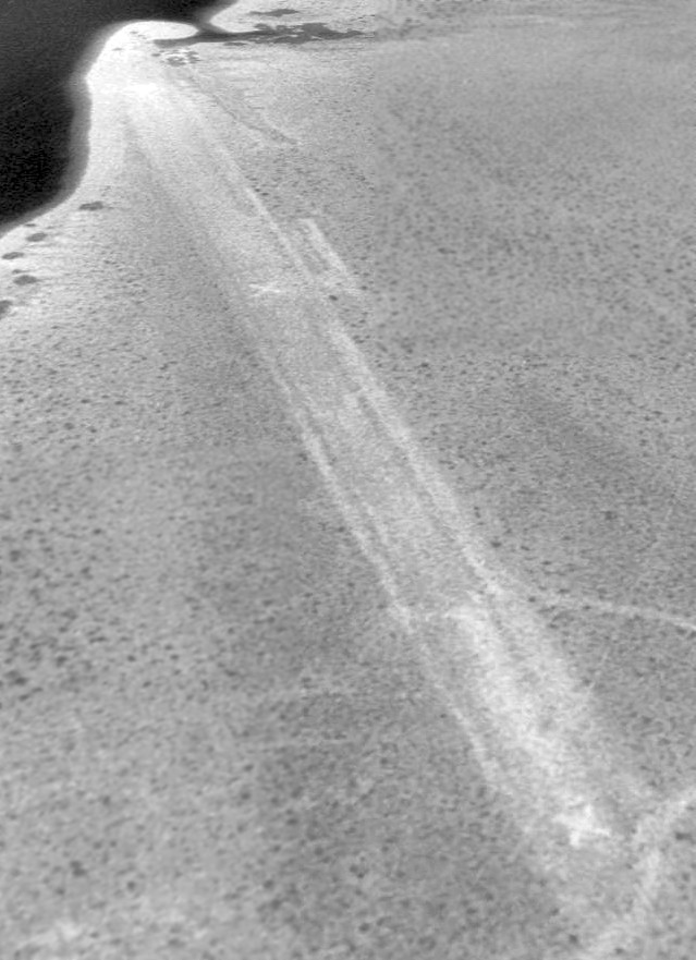
The earliest photo which has been located of the Cottonwood Landing runway was a 1/20/72 USGS aerial view,
which depicted a single northwest/southeast runway, with an asphalt pad at each end.
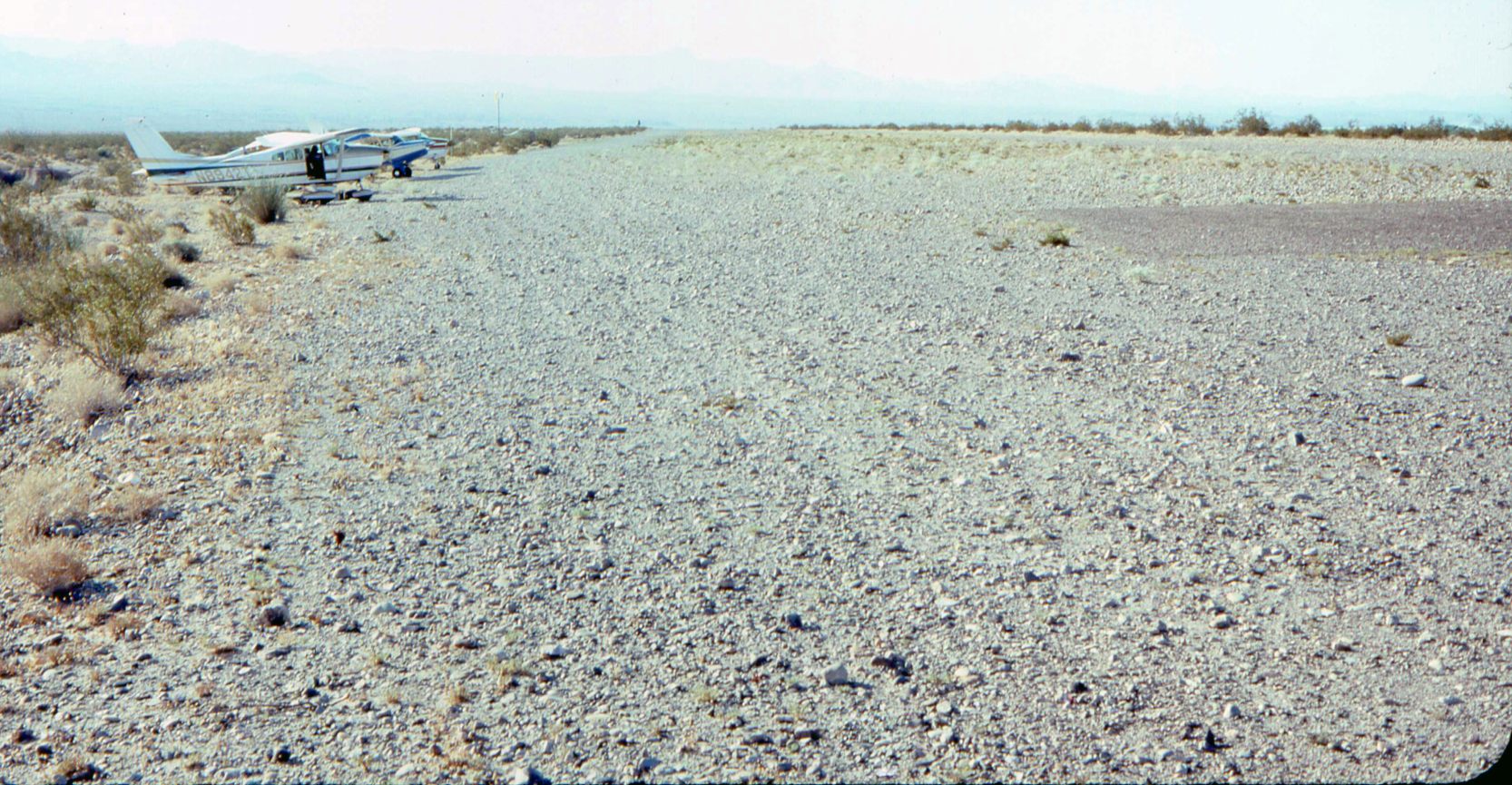
A circa mid-1970s photo by Dave Stevens looking south along the Cottonwood Landing runway, with 3 light single-engine aircraft parked on the east side.
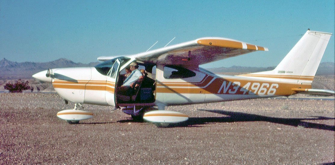
A circa mid-1970s photo by Dave Stevens of “Friends departing southbound early morning from Cottonwood Landing” in a Cessna 177 Cardinal.
“Cottonwood Landing” was described in the 1982 AOPA Airports USA Directory (according to Chris Kennedy)
as having a single 2,600' dirt/gravel Runway 13/31.
The last chart depiction of the Cottonwood Landing Airport which has been located
was on the 1987 Phoenix Sectional Chart (courtesy of David Brooks).
It depicted Cottonwood Landing as having a 2,700' unpaved runway.
Cottonwood Landing Airfield was evidently closed at some point between 1987-88,
as it was no longer depicted on the 1988 Phoenix Sectional Chart (courtesy of Jonathan Westerling).
According to Mike Lerner, “The runway was never paved nor are their any buildings there.
I had wonderful camping & fishing there before Park Service closed it.
I used the strip in the 1980s before the Park Service told me it had been closed.
Even in the 1980s the main strip was overgrown; we landed on the roadway along it's Northern edge which led to a tie-down area by the lake.
The airstrip was closed by the Park Service when Lake Mead Recreational Area was established.
This airstrip was one of the most beautiful lakeside landing strips & camping areas in the West.”
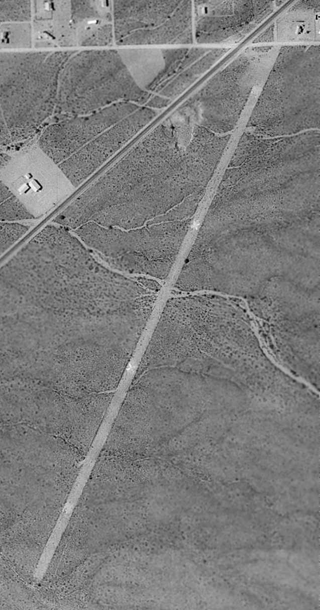
An 8/25/92 USGS aerial view looking northwest clearly showed the runway as being marked with closed "X" symbols.
The runway otherwise appeared to be in fine condition.
There did not appear to have been any hangars or other buildings directly associated with the airfield.
The 2003 Phoenix Sectional Chart (according to David Brooks) depicted an airfield at this location, but simply labeled “U”.
As of 2005, the FAA Airport/Facility Directory did not list any active airfield at this location.
The 2007 Phoenix Sectional Chart (courtesy of Mike Lerner) continued to depict Cottonwood Landing simply with a “U” (unidentified).
Mike Lerner reported, “The 'U' symbol, meaning unverified, adds to the current confusion.”
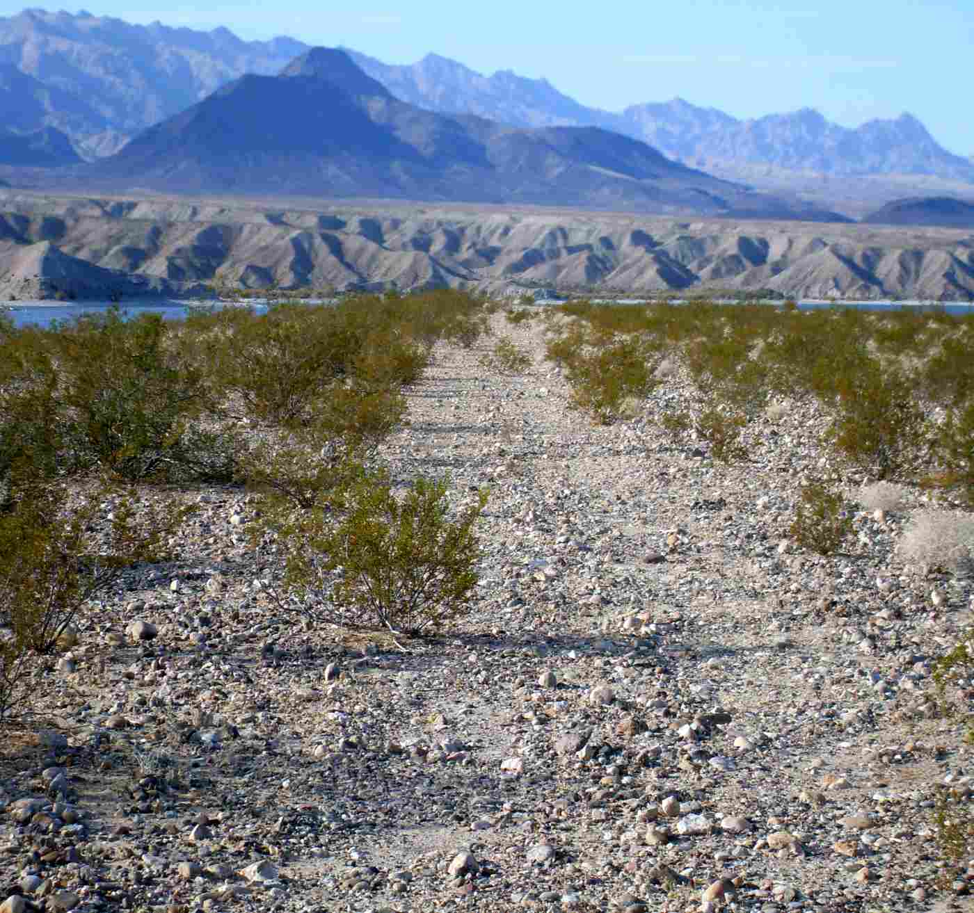
A 2008 photo by John Bacon looking north along the site of Cottonwood Landing's former Runway 31.
John reported, “Driving to the location was actually pretty easy and could be done in a regular 2-wheel-drive sedan.
It was a dirt road but wide & graded most of the way.
The runway was barely discernible. It was only 8-10' wide with several boulders averaging between 4-8 inches.
You can also see where several creosote bushes have grown in.
The Lake Mead park authorities have fenced off the access roads around the perimeter of the field.
A sign reads 'Restoration Project.' I soon learned that they were restoring the field to raw land & not restoring the airstrip.
They are allowing it to be filled in with natural vegetation.”
A 2008 photo by John Bacon at “the faint white X designating a closed runway” at the site of Cottonwood Landing Airfield.
John reported, “The area surrounding the airstrip was truly quiet, serene, and beautiful.
The water [is] just 30-40' from the edge of the runway.
It's a shame that this airstrip was not preserved. It would be a great place to fly into & camp.”
A 6/24/13 aerial view looking northwest showed the runway to remain intact, still marked with closed "X" symbols.
Mike Lerner reported in 2014, “Looking at a current Code of Federal Regulations, it is still today listed as a designated landing strip number (4).
Myself along with the Recreational Aviation Foundation are waiting for an answer from the National Park Service, Lake Mojave National Recreational Area,
about this seemingly contradictory situation.
I had a reply from one local Arizona aviator who stated the strip had been sewn with rocks besides the 'X's.”
The Cottonwood Landing Airfield is located north of where Cottonwood Road ends at the shore of Lake Mojave,
inside the Lake Mead National Recreational Area.
In the word of David Brooks, “Getting there would be a challenge by road!”
____________________________________________________
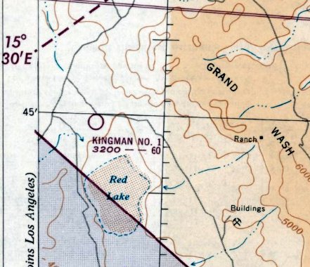
Kingman Auxiliary Airfield #1 / Cyclopic Field, Cyclopic, AZ
35.74, -114.09 (Northwest of Phoenix, AZ)
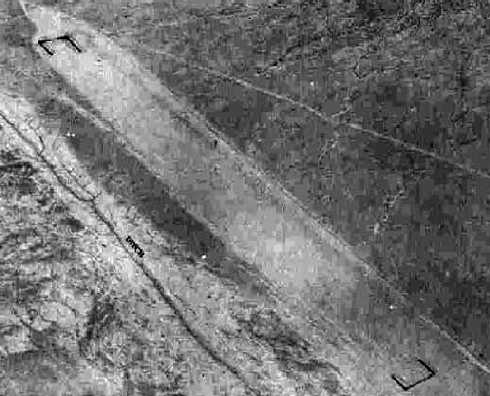
A 6/22/43 aerial view looking north at "Kingman Army Airfield Auxiliary (Cyclopic Field)”
from the 1945 AAF Airfield Directory (courtesy of Scott Murdock).
Cyclopic Field was evidently built during WW2 as one of several satellite airfields for Kingman AAF (33 miles to the southeast),
which conducted training for the 70,000 Pilot Training Program.
The date of construction of Cyclopic Field has not been determined,
but most of the other Kingman Auxiliary Airfields were established in 1942-43.
The only photo which has been located showing Cyclopic Field while it was in operation
was a 6/22/43 aerial view looking north at "Kingman Army Airfield Auxiliary (Cyclopic Field)” from the 1945 AAF Airfield Directory (courtesy of Scott Murdock).
The directory described Cyclopic Field as a 40 acre rectangular property having a single graded 6,000' NNW/SSE runway.
Cyclopic Field was described as being owned by the U.S. Government, and operated by the Army Air Forces.
Cyclopic Field was located in an extremely remote & barren area.
Cyclopic Field was not depicted on the August 1944 Prescott Sectional Chart.
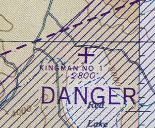
The earliest aeronautical chart depiction which has been located of Cyclopic Field was on the August 1945 Prescott Sectional Chart (courtesy of Chris Kennedy).
It depicted "Kingman #1" as an auxiliary airfield.
It is unlikely that the Cyclopic Airfield was ever reused for civilian aviation, due to its extremely remote location.
The last aeronautical chart depiction which has been located of Cyclopic Field was on the August 1951 Prescott Sectional Chart.
It depicted "Kingman #1" as having a 6,000' runway.
Cyclopic Field was evidently closed at some point between 1951-52, as it was no longer depicted on the March 1952 Prescott Sectional Chart.
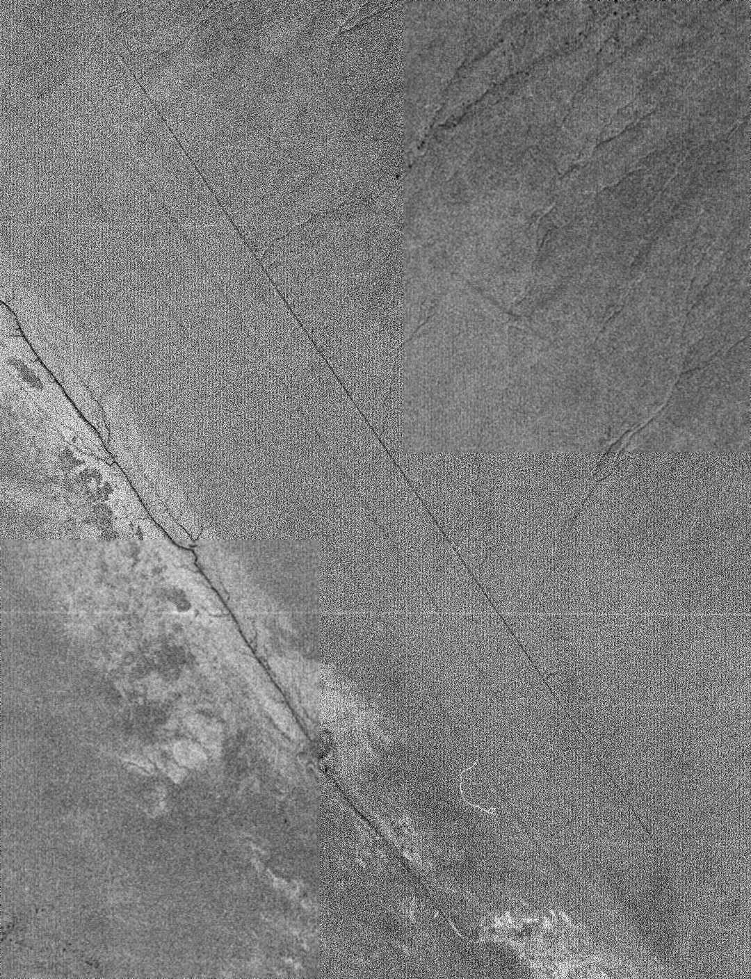
A 4/1/54 USGS aerial photo showed the outline of Cyclopic Field's 6,000' runway to remain distinct.
Nothing at all was depicted at this location on USGS topo maps from 1968, 1969, 1980, or 1991.
The 1997 USGS aerial photo showed the outline of Cyclopic Field's 6,000' runway to remain very intact.
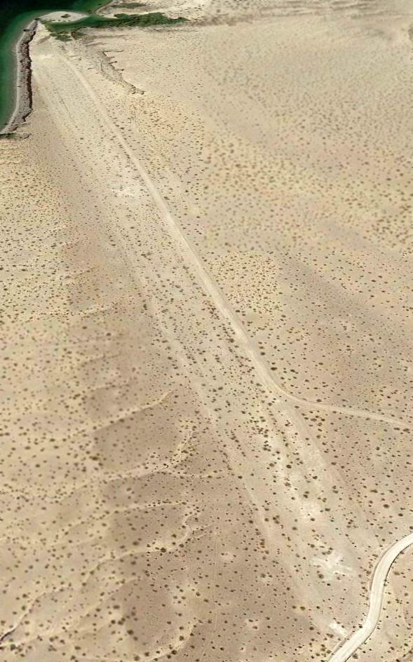
A 6/8/07 aerial view looking northwest along the remains of the Cyclopic Aux AAF #1 runway, remaining remarkably intact after 64 years.
The site of Cyclopic Aux AAF #1 is located 2 miles southeast of the intersection of Routes 25 & 149.
Thanks to Chris Kennedy for locating this airfield.
____________________________________________________
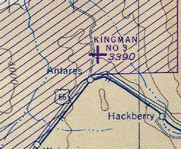
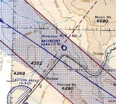
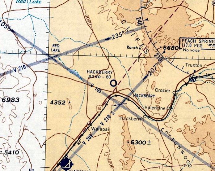
Kingman Army Auxiliary Airfield #3 / Hackberry Field, Antares, AZ
35.42, -113.8 (West of Phoenix, AZ)
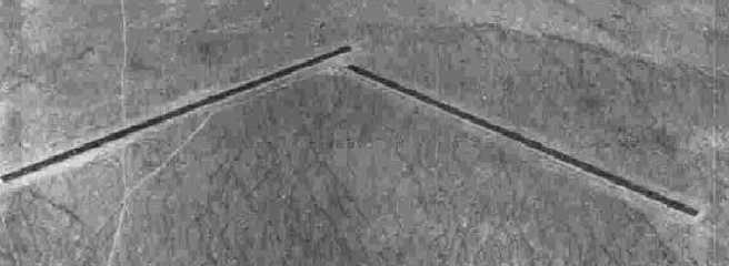
A 6/22/43 aerial view looking north at "Kingman Army Airfield Auxiliary (Hackberry Field)”
from the 1945 AAF Airfield Directory (courtesy of Scott Murdock).
Hackberry Field was built as a WW2-era satellite field for Kingman AAF (a few miles west),
which conducted training for the 70,000 Pilot Training Program.
The War Department acquired the property by transfer & lease in 1943.
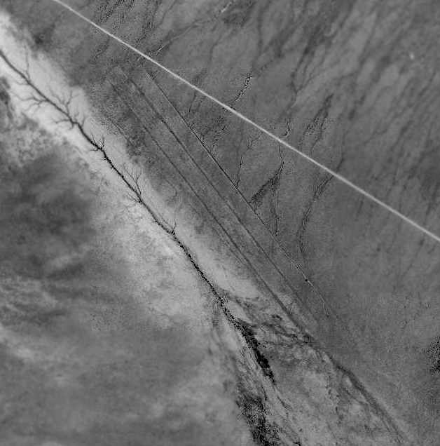
Two 6,000' earthen airstrips were constructed on the property, in addition to 3 sheds, a tower, and a latrine.
The landing field was used in conjunction with the Kingman Air to Air Gunnery range
as an emergency landing field & as a target dropping ground.
The only photo which has been located showing Hackberry Field while it was in operation
was a 6/22/43 aerial view looking north at "Kingman Army Airfield Auxiliary (Hackberry Field)” from the 1945 AAF Airfield Directory (courtesy of Scott Murdock).
The directory described Hackberry Field as an irregularly-shaped property having 2 bituminous 6,000' runways, oriented northeast/southeast & northwest/southeast.
Hackberry Field was described as being owned by the U.S. Government, and operated by the Army Air Forces.
Hackberry Field was not yet depicted on the August 1944 Prescott Sectional Chart.
The earliest aeronautical chart depiction which has been located of Hackberry Field was on the March 1945 Prescott Sectional Chart (courtesy of Chris Kennedy).
It depicted "Kingman #3" as an auxiliary airfield.
Hackberry Field was classified surplus in 1945.
A directory of AZ Airports in the 5/47 issue of Arizona Highways (courtesy of George Miller) described Kingman Aux AAF #3's longest runway as 6,500'.
At some point between 1947-49, Hackberry was apparently reused as a civil airport.
"Hackberry" airfield was depicted on the 1949 Prescott Sectional Chart (according to Chris Kennedy),
and was described as having a 6,000' hard-surface runway.

A 4/1/54 USGS aerial view depicted Hackberry as having 2 deteriorated runways.
"Hackberry" Airport was depicted on the 1956 Prescott Sectional Chart (courtesy of John Voss)
as having 2 runways, with the longest being a 6,000' paved runway.
The last aeronautical chart depiction which has been located of Hackberry Airport was on the March 1960 Prescott Sectional Chart.
It depicted Hackberry Airport as having a 6,000' unpaved runway.
Hackberry Airport was apparently abandoned at some point between 1960-61,
as it was no longer depicted on the March 1961 Prescott Sectional Chart.
The 1967 AOPA Airport Directory (courtesy of Chris Kennedy) described Hackberry Airport as having two 6,000' hard-surface runways: Runway 4/22 & Runway 13/31.
The remarks said, "Caution: Abandoned military strip reported usable but not maintained. Cattle sometimes on field. Caution required."
Hackberry Airport's listing in this directory may have been obsolete,
as it was still not depicted on the September 1967 Prescott Sectional Chart.
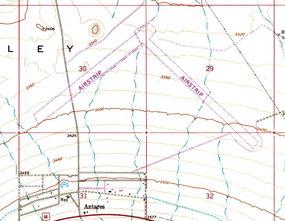
Hackberry's 2 runways were still depicted on the 1968 USGS topo map, but it was labeled simply as "Airstrip".
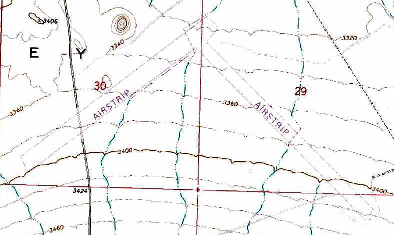
The 2 Hackberry runways were still depicted on the 1980 USGS topo map, labeled simply as "Airstrip".
Hackberry Field was labeled simply as "Landing Field" on the 1991 USGS topo map.
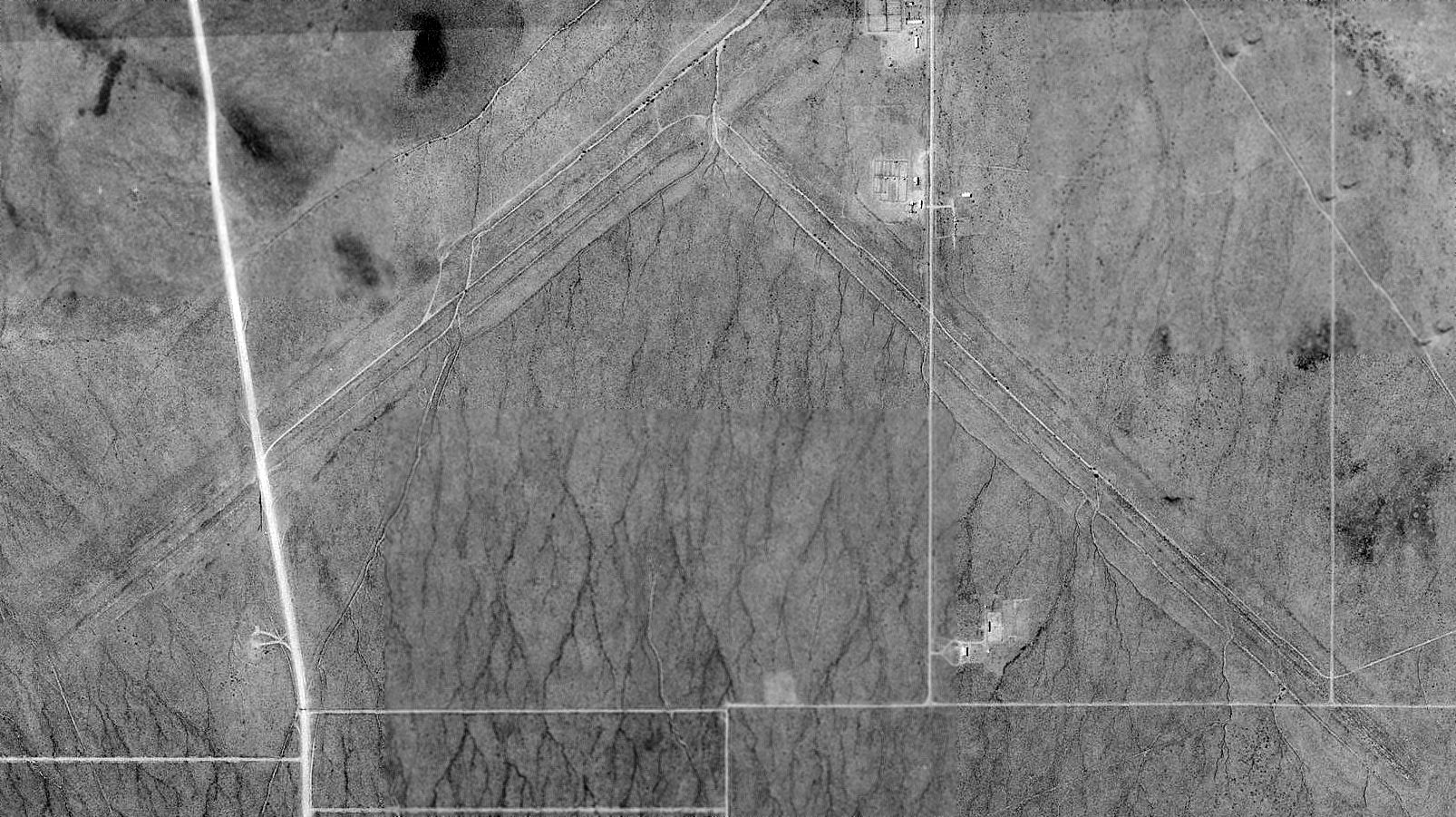
The 2 Hackberry runways were still recognizable on a 1993 USGS aerial view.
According to a late-1990s Army Corps of Engineers report,
as of that date the Hackberry airfield property was partly private land, and part-owned by the Department of Interior.
The property remained as undeveloped desert land, except for what was left of the airstrips,
which were barely discernible through the vegetative overgrowth.
Several unpaved roads crossed over the runway remains.
Chris Kennedy visited the site of Kingman #3 in September 2004.
He reported: "Although I knew exactly where the runway should have intersected
the county road that goes through the site on the west end,
I could not find any evidence of a runway except possibly an area
that appeared to be at a slightly higher grade than the surrounding dirt.
The runways must have been dirt & are completely overgrown with desert bushes of some kind, just like the surrounding area."
Tim Tyler visited the site of Hackberry #3 in October 2004, and found "a few mobile homes scattered about the area,
and some high tension power lines crossing the site.
We didn’t get any closer than about half a mile to the area, but didn’t see the signature of anything airfield-related."
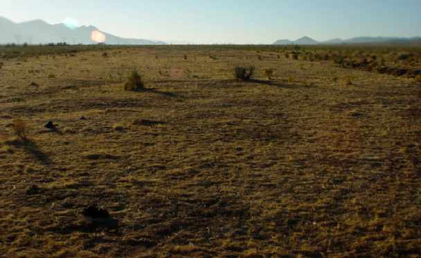
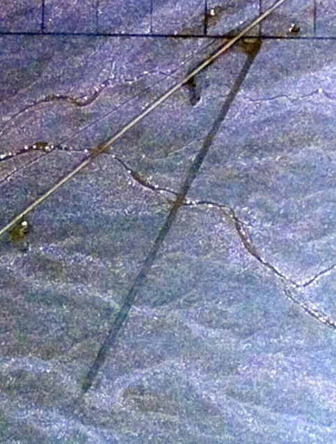
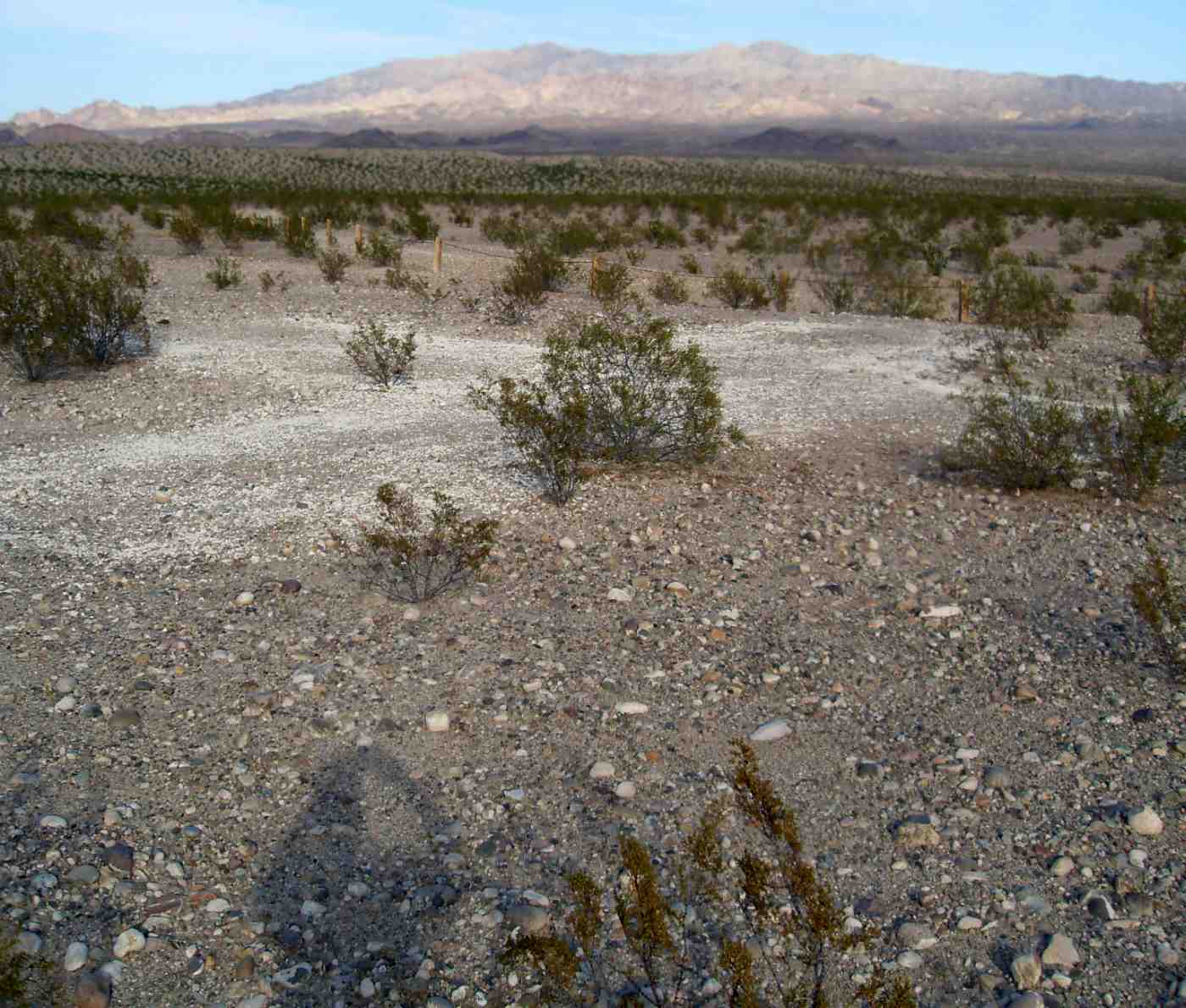
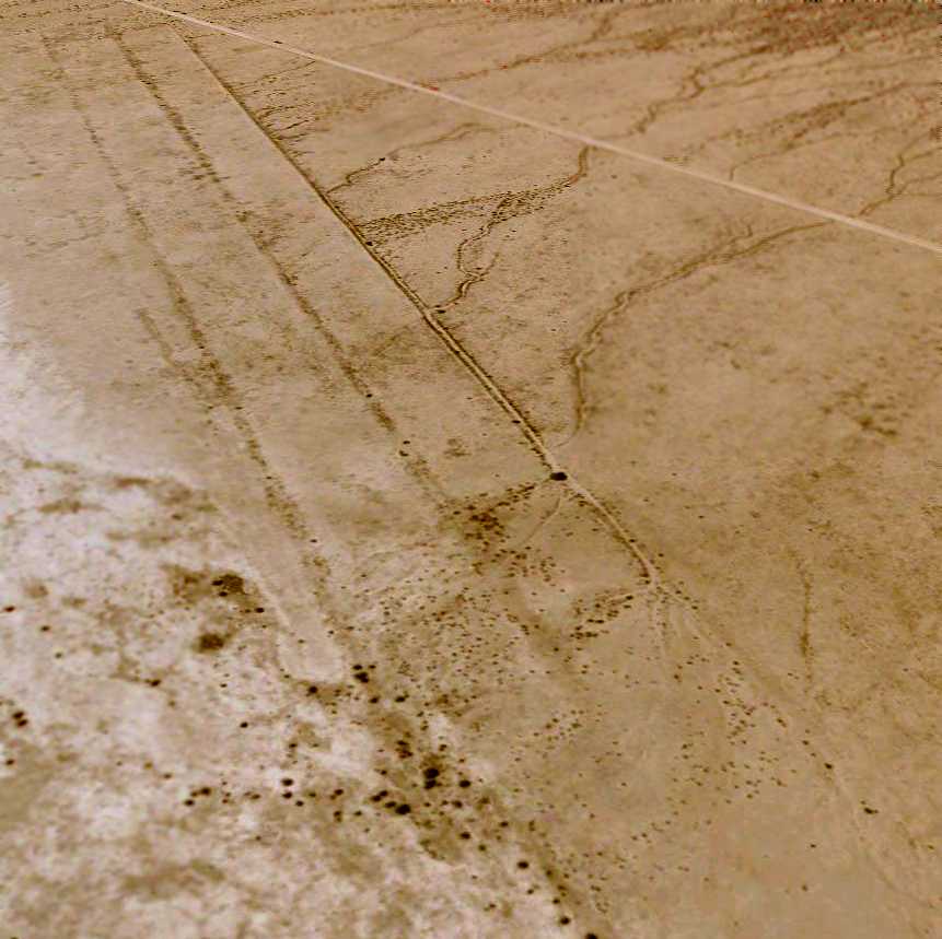
An October 2005 photo by Keith Wood, looking southeast from the road that crosses the former northwest/southeast runway at Hackberry AAF.
Keith reported, “The overhead [photo] is still pretty accurate.
There is a new barn/garage being built in the home site just south of where I shot the pictures, but otherwise there was no change.
I found no evidence that the runways had ever been paved,
but what I could see was in good condition & could be used again after a weekend of clearing up growth.”
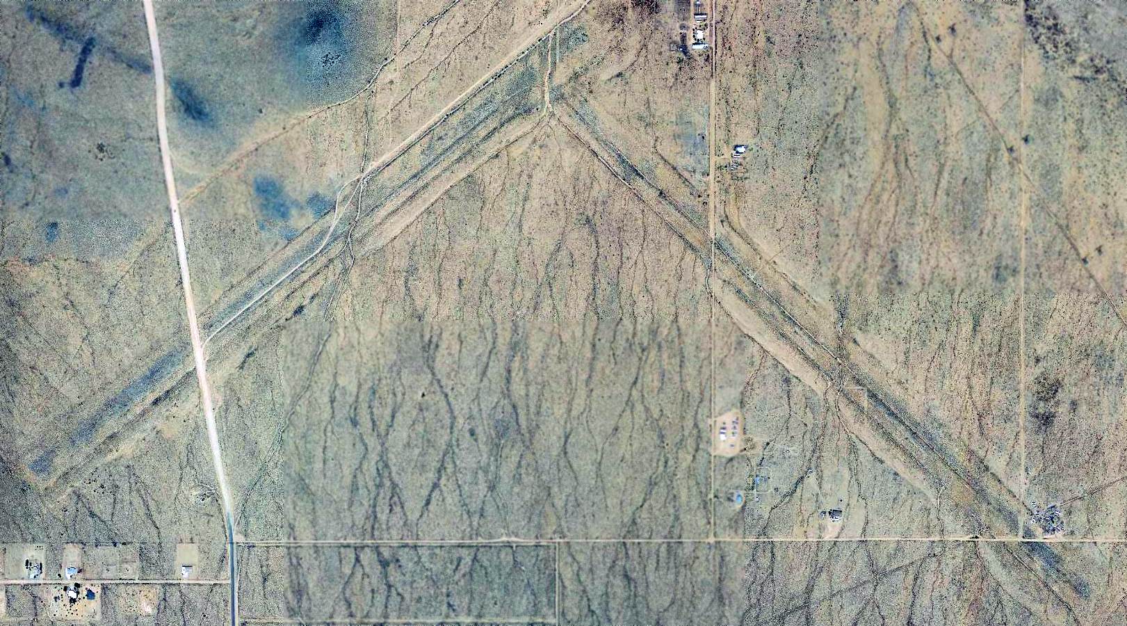
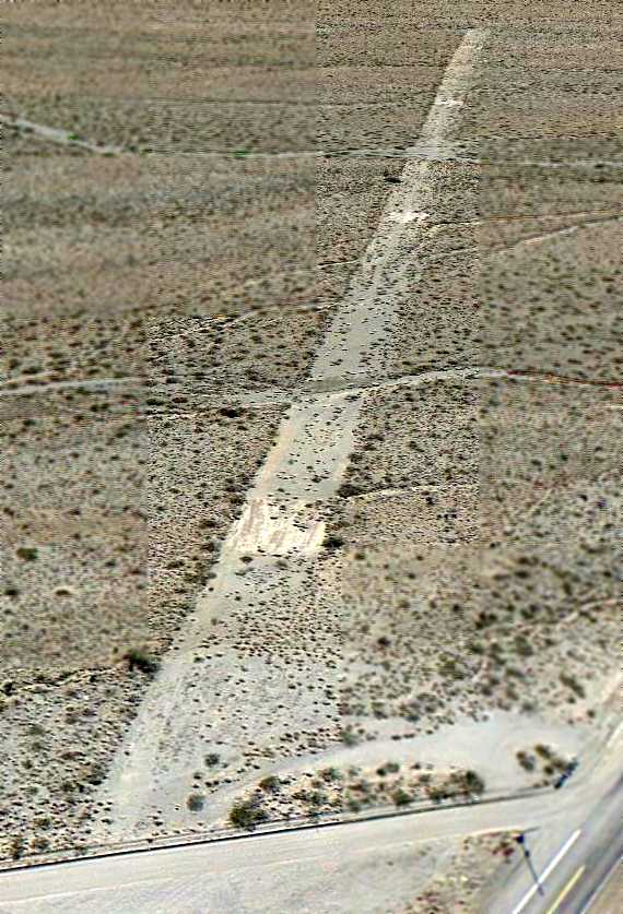
The 2 Hackberry runways were still recognizable on a 2018 aerial view.
The Hackberry airfield is located just northeast of the tiny town of Antares.
____________________________________________________
____________________________________________________
This site covers airfields in all 50 states.