
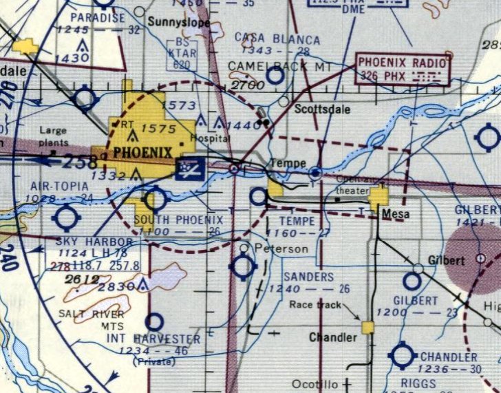
Abandoned & Little-Known Airfields:
Arizona: Southeastern Phoenix area
© 2002, © 2025 by Paul Freeman. Revised 12/11/25.
This site covers airfields in all 50 states: Click here for the site's main menu.
____________________________________________________
Please consider a financial contribution to support the continued growth & operation of this site.
Coolidge Airpark (added 2/20/23) - Coolidge Flying Field / Coolidge Airport (original location) (revised 11/10/23) - Florence Junction Airport (1st location) (revised 12/13/21)
Florence Junction Airport (2nd location) (revised 11/12/22) - Francisco Grande Airfield (revised 5/15/23) - Gilbert Airport (revised 2/7/25) - Gilbert Aux AAF #1 (revised 2/7/25)
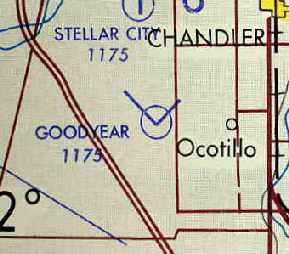
Goodyear AF Aux / Chandler Memorial Airfield / Gila River Memorial Airport (revised 10/16/22) - Mesa Airpark (revised 10/10/19) - Mesa Airport (revised 10/10/19) - Midland Airport (added 11/12/22)
Oasis Airport (added 7/7/25) - Queen Creek Airfield (added 12/2/25) - Rittenhouse Aux AAF #2 (revised 12/11/25) - Tempe Airport (revised 9/13/25) - Three Point Airport (revised 1/1/21)
____________________________________________________
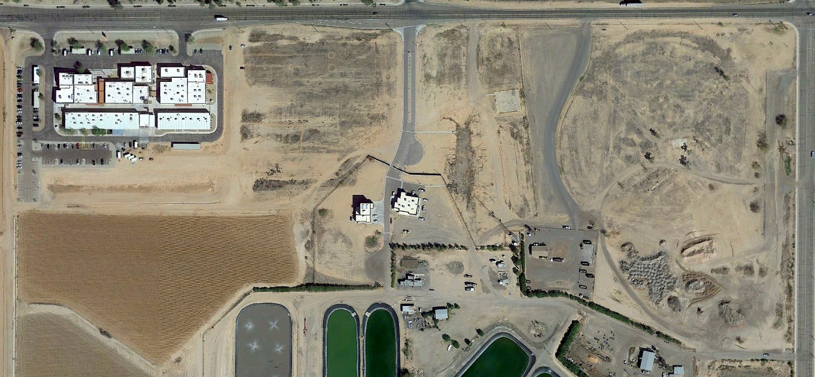
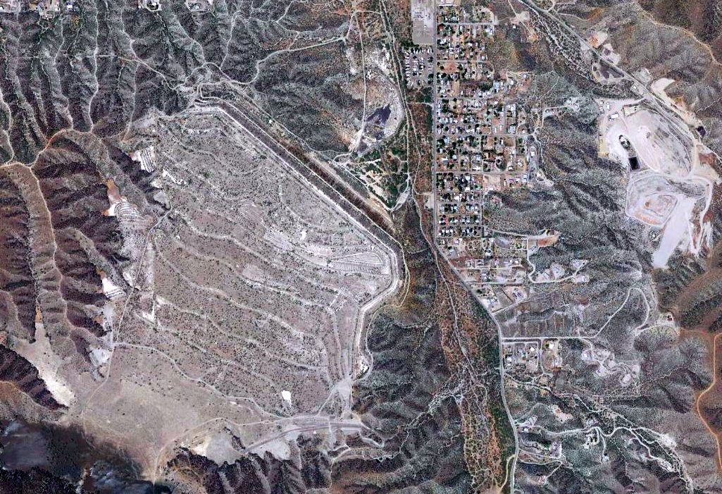
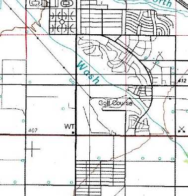
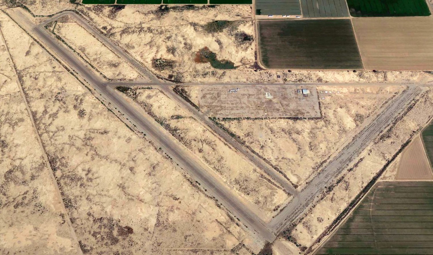
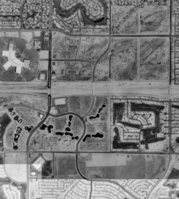
Queen Creek Airfield, Queen Creek, AZ
33.256, -111.631 (Southeast of Phoenix, AZ)
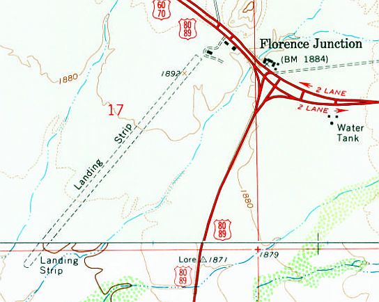
Queen Creek Airfield, as depicted on the 1959 USGS topo map.
Not much is known about this small airfield, including its name.
The Queen Creek Airfield was apparently established at some point between 1953-57,
as it was not yet depicted on a 1953 aerial photo.
The earliest depiction which has been located of this airfield was on a 1957 aerial photo.
It depicted a single east/west runway, with a ramp & a few small buildings on the west side, along with 4 single-engine aircraft (biplane cropdusters?).
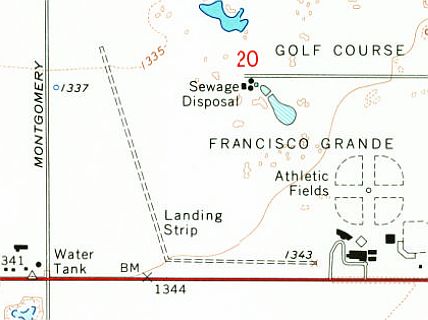
The earliest depiction which is available of the Queen Creek Airfield was on the 1959 USGS topo map.
It depicted a single east/west runway, labeled generically as “Landing Field”, with a ramp & 1 small building on the west side.

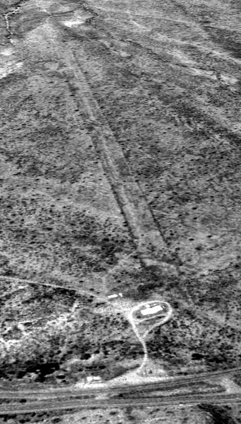
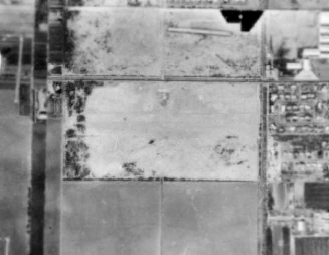
The earliest photo which is available the Queen Creek Airfield was a 1/30/62 USGS aerial view.
It depicted a single east/west runway, with a ramp & a few small buildings on the west side, along with 5 single-engine aircraft (biplane cropdusters?).
The Queen Creek Airfield was not depicted on aeronautical charts from the 1960s-90s.
The 1982 USGS topo map continued to depict the Queen Creek Airfield in an unchanged fashion.

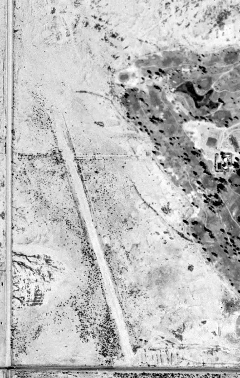
The last photo which has been located showing an aircraft at the Queen Creek Airfield was a 1997 aerial view looking northeast, which showed 1 single-engine aircraft on the west ramp.
Note the surrounding area was still completely devoid of development.
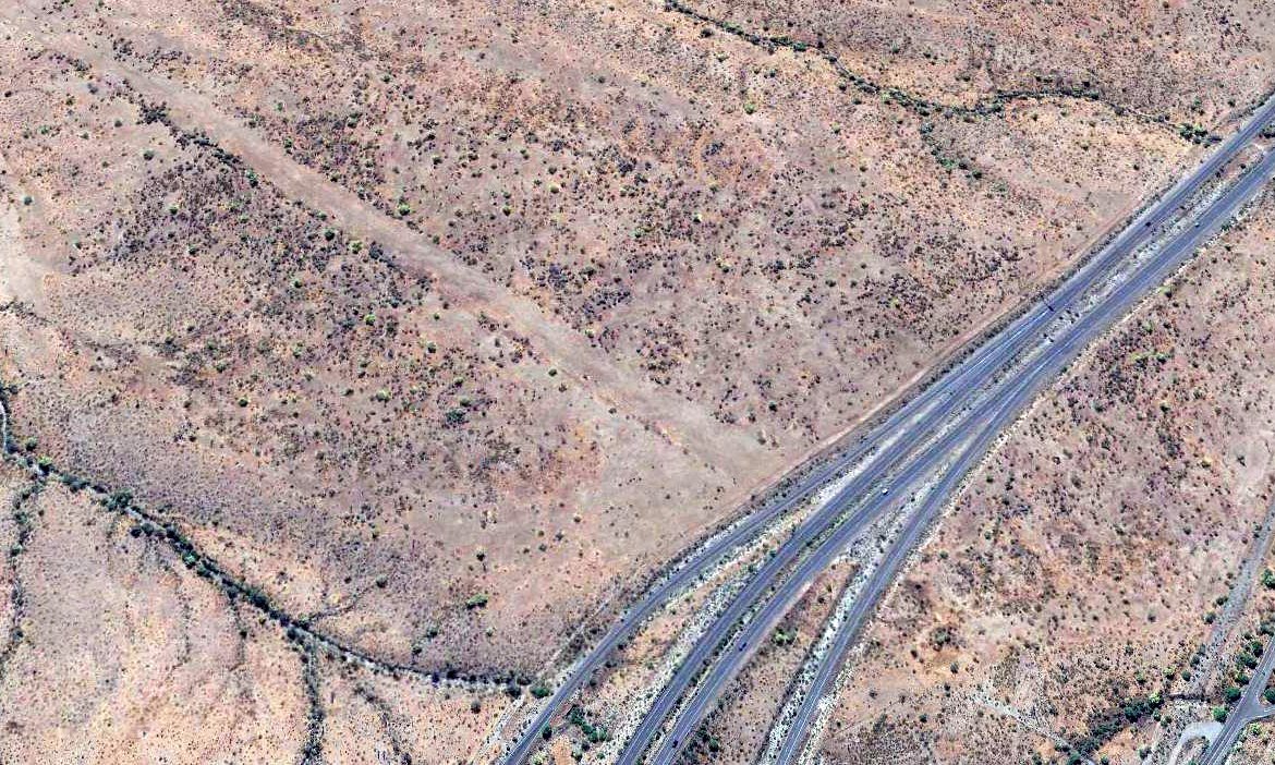
The Queen Creek Airfield was no longer depicted on the 2014 USGS topo map.

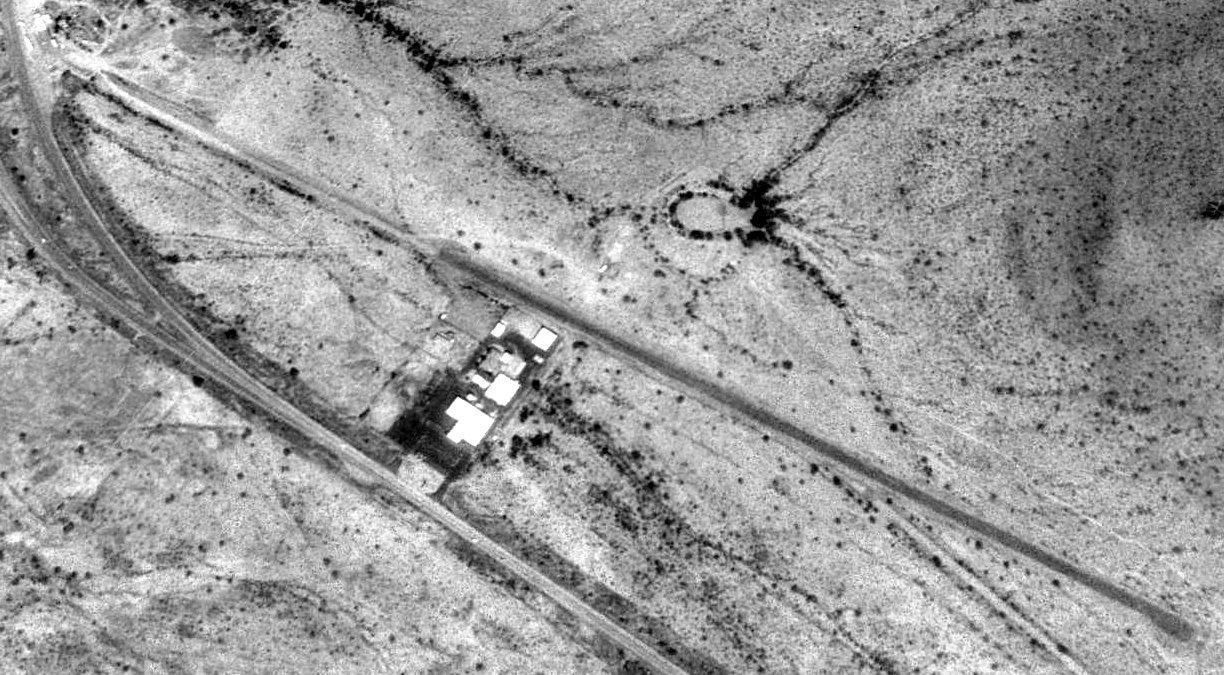
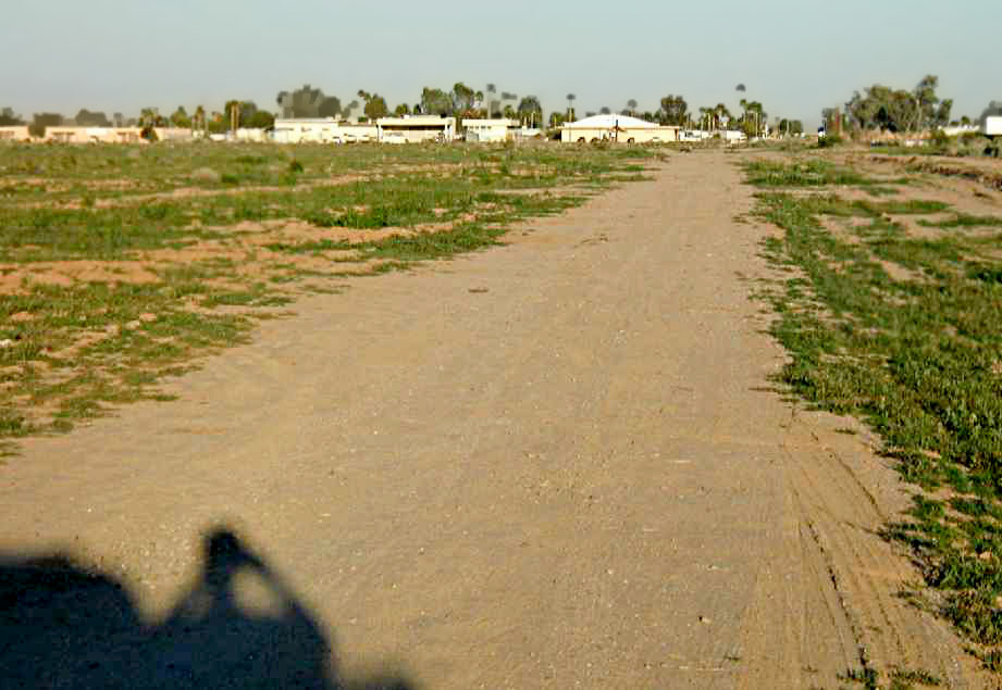
A 2024 photo looking east showed the hangar which remained at the west side of the Queen Creek Airfield site.

A 2024 photo looking west showed the Queen Creek Airfield runway remained intact, though with houses directly adjacent to both sides.

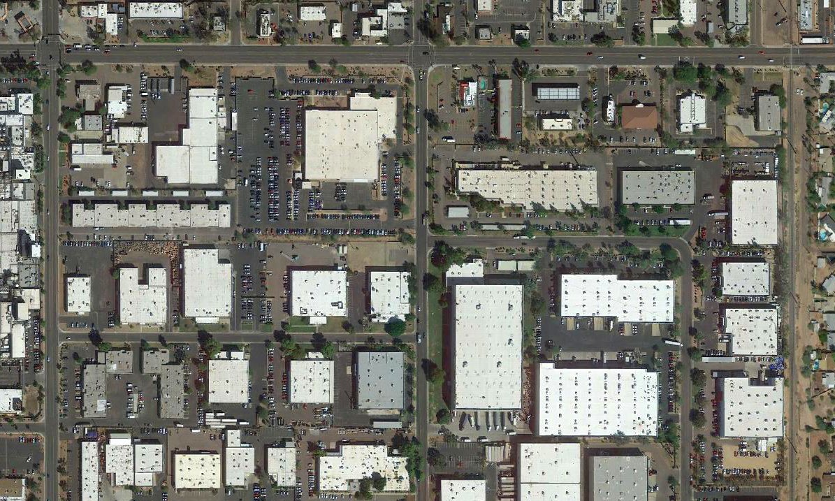
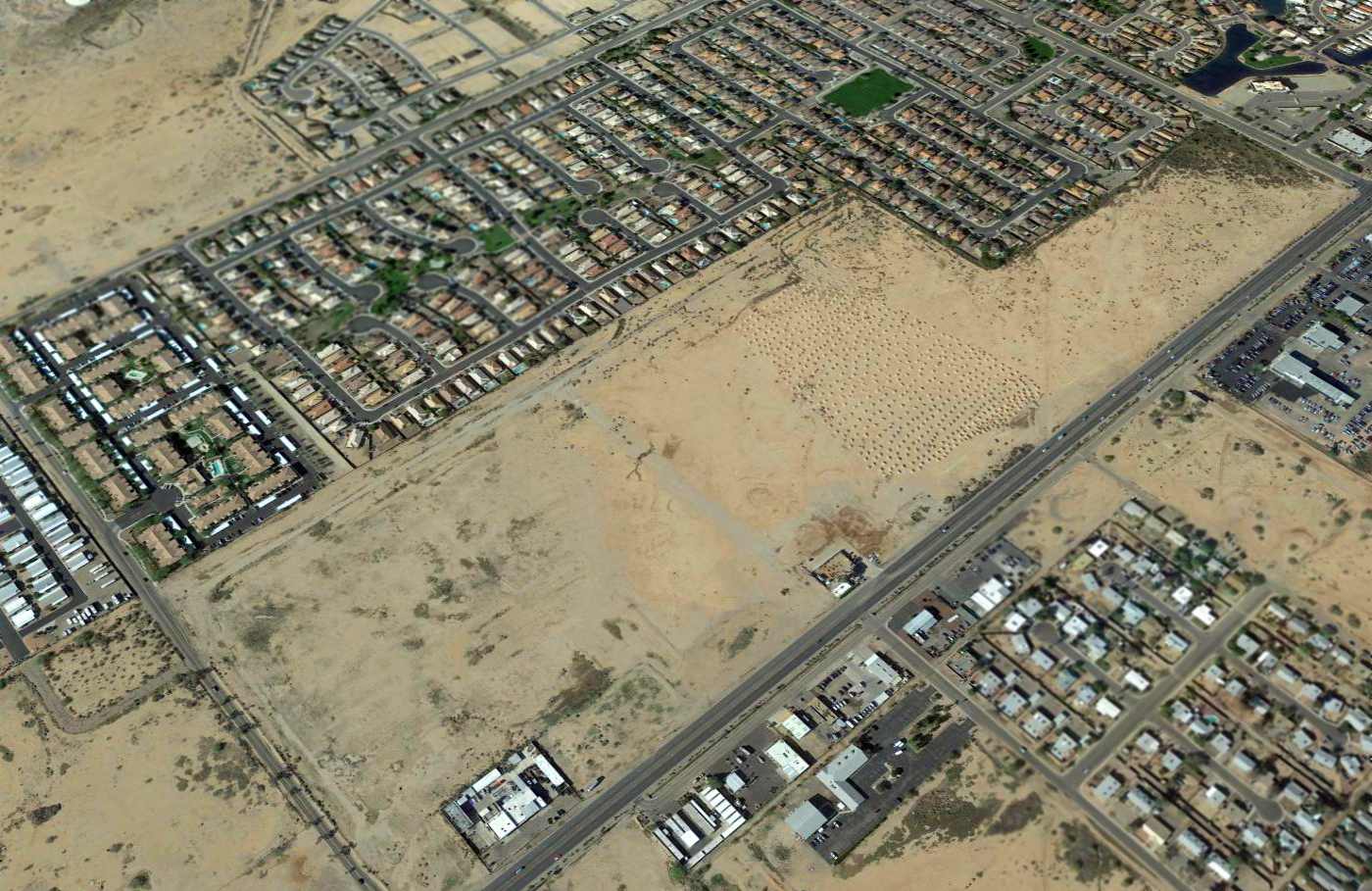
A 2025 aerial view looking northeast at the Queen Creek Airfield showed a dramatic transformation compared to the 1997 photo, with dense housing having filled the landscape, but the runway & hangar remained intact.
Thanks to James Cotharn for pointing out this airfield.
____________________________________________________
33.414, -111.64 (Southeast of Phoenix, AZ)

Oasis Airport, as depicted on the September 1947 Phoenix Sectional Chart.
This small general aviation airport was apparently established at some point in 1947,
as it was not yet depicted on the March 1947 Phoenix Sectional Chart.
The earliest depiction which has been located of Oasis Airport was on the September 1947 Phoenix Sectional Chart.
It depicted Oasis as a commercial/auxiliary airfield.
According to an article in the 7/6/25 Mesa Tribune (courtesy of Kevin Walsh),
Ned Cross operated a gas station & fruit stand which he named The Oasis, to which he added a landing strip “where aviators flew in daily.”

The only topo map depiction which has been located of Oasis Airport was on the 1956 USGS topo map (courtesy of Kevin Walsh).
It depicted Oasis Airport as having 2 runways & a few small buildings on the north side.
The earliest photo which has been located of Oasis Airport was a 1957 aerial view.
It depicted 2 unpaved runways, and a few small buildings & 2 light aircraft on the north side.

The earliest photo which is available of Oasis Airport was a 9/16/61 USGS aerial view.
The 2 unpaved runways seen in the 1957 aerial view had been replaced by an asphalt (or oiled) northeast/southwest runway to the south.
Two light single-engine aircraft were parked on the north side.
A 1962 aerial view depicted 4 light aircraft at Oasis Airport.

The last aeronautical chart depiction which has been located of Oasis Airport was on the January 1969 Phoenix Sectional Chart.
It depicted Oasis as having a 3,000' unpaved runway.
A 1969 aerial view depicted Oasis Airport considerably differently from the 1962 photo,
with the northeast/southwest runway no longer appearing very distinct, and no aircraft visible on the field.
Oasis Airport was evidently closed in an official capacity (for reasons unknown) at some point between 1969-71,
as it was no longer depicted on the 1971 Phoenix Sectional Chart.
The last photo which has been located showing aircraft at Oasis Airport was a 1973 aerial view, which showed 2 aircraft on the field.

The last depiction which has been located of Oasis Airport was on a 1975 Tonto National Forrest map (courtesy of Kevin Walsh).
It depicted Oasis as having 2 runways & a building on the west side.
A 1975 aerial view no longer showed any aircraft at Oasis Airport, but at least 1 T-hangar remained on the north side.
Oasis Airport was no longer depicted on the 1975 USGS topo map.
The last T-hangar remained at the Oasis Airport site in a 1980 aerial view.
A 1981 aerial view showed the last Oasis Airport T-hangar had been removed at some point between 1980-81.
A 1988 aerial view showed the Oasis Airport site had been scraped away at some point between 1986-88, replaced by a rectangular parking area for trailers.
A 2007 aerial view showed the Oasis Airport site had been covered by the Red Mountain Freeway at some point between 2003-2007.

A 2023 aerial view showed no trace of Oasis Airport.
Thanks to Kevin Walsh for pointing out this airfield.
____________________________________________________
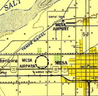
Mesa Airport, Mesa, AZ
33.438, -111.843 (East of Phoenix, AZ)
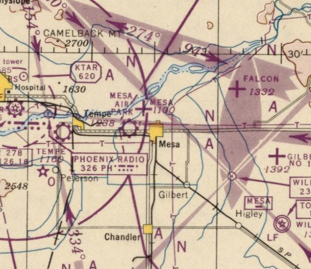
Mesa Airport (along with the nearby & similarly named Mesa Airpark) as depicted on the August 1946 Phoenix Sectional Chart.
Mesa Airport was not to be confused with the similarly-named Mesa Airpark, which was located only 1 NM to the southwest.
Mesa Airpark was not depicted on 1941/43/44/45 Phoenix Sectional Charts.
According to Ron Chavez's book “The Valley's Airports of the Past”,
“This dirt airstrip was located on the northwest corner of Brown Road & Country Club Drive.
It was oriented in an east/west direction & was 1,200' in length.
The airfield was constructed in 1943 as an auxiliary field for Falcon Field.
After the war, the airfield became a public-use airport for the City of Mesa.
Some services were available but the airport's main use was for tie-down space & use as a crop-dusting field.”
The earliest depiction which has been located of Mesa Airport was on the August 1946 Phoenix Sectional Chart.
It depicted Mesa Airport, along with the nearby & similarly named Mesa Airpark.
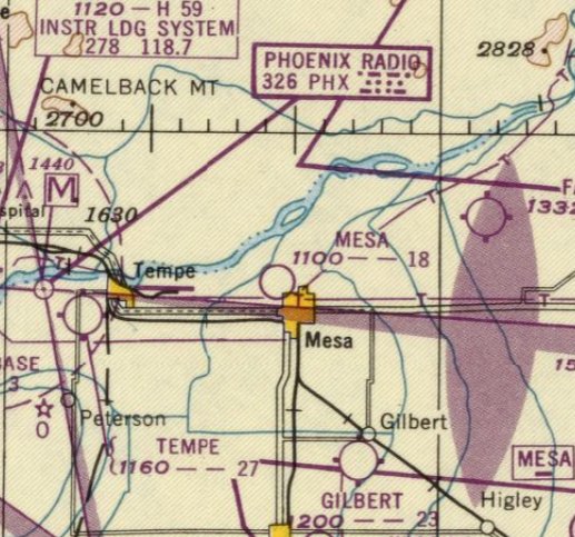
Mesa Airport (along with the nearby & similarly named Mesa Airpark),
as depicted on the 1948 USAF Phoenix Urban Area Chart (courtesy of Scott O'Donnell).
It depicted Mesa Airpark as having a single east/west runway.
The last aeronautical chart depiction which has been located of Mesa Airport was on the March 1949 Phoenix Sectional Chart.
It depicted Mesa Airport as having a mere 1,800' unpaved runway.
The only photo which has been located of Mesa Airport was on a 1949 aerial view.
It depicted Mesa Airpark as having a single east/west unpaved runway, with a few small buildings on the northeast side.
There were no aircraft visible on the field, which may have already ceased operation by that point.
Mesa Airport was no longer depicted on the September 1949 Phoenix Sectional Chart.
According to Ron Chavez's book “The Valley's Airports of the Past”,
“The airport was taken over by a local developer in 1949, with the intentions of developing the Mesa Country Club.
By 1950 the Mesa Airport had ceased operations.”
A 1951 aerial view showed no trace remaining of Mesa Airport, with the site covered by a golf course.
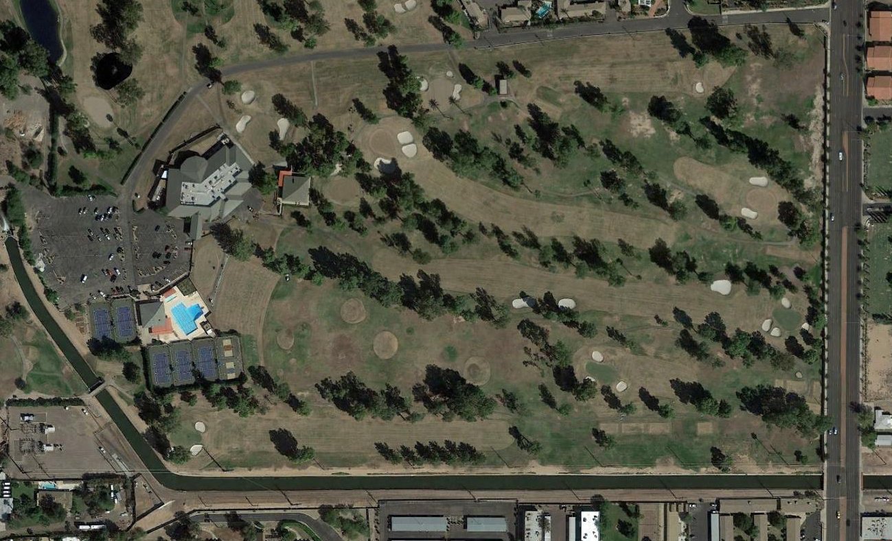
A 2016 aerial view showed no trace remaining of Mesa Airport, with the site covered by a golf course.
The site of Mesa Airport is located southwest of the intersection of North Country Club Drive & West Fairway Drive.
____________________________________________________
33.42, -111.86 (East of Phoenix, AZ)
Mesa Airpark (along with the nearby & similarly named Mesa Airport) as depicted on the August 1946 Phoenix Sectional Chart.
Mesa Airpark was not to be confused with the similarly-named Mesa Airport, which was located only 1 NM to the northeast.
Mesa Airpark was not depicted on Phoenix Sectional Charts from 1940 – March 46.
However, according to Ron Chavez's book “The Valley's Airports of the Past”,
“The Mesa Airpark was constructed in the early 1940s, near Alma School Road & University Drive,
as an auxiliary airfield for the air cadets training at nearby Falcon Field.
Mesa Airpark had a 2,700' east/west dirt runway with a small hangar at the east end.
After WWII came to a close in 1945, the airfield property was rendered as surplus by the War Assets Administration & was sold to G. Tayrien & R. Curtis in 1946.
Tayrien & Curtis taught flight instruction & operated an aircraft sales & service & repair business under their new company.
A full-time mechanic was hired to handle any airframe & engine repairs that were needed & a cafe was also added for clients while they waited for their aircraft.”
The earliest depiction which has been located of Mesa Airpark was on the August 1946 Phoenix Sectional Chart.
It depicted Mesa Airpark, along with the nearby & similarly named Mesa Airport.
Mesa Airpark (along with the nearby & similarly named Mesa Airport), as depicted on the 1948 USAF Phoenix Urban Area Chart (courtesy of Scott O'Donnell).
It depicted Mesa Airpark in an unusual fashion, with a circular dashed line around the location, without depicting any runway orientation.
The last aeronautical chart depiction which has been located of Mesa Airpark was on the September 1948 Phoenix Sectional Chart.
It depicted Mesa Airpark as having an 2,700' unpaved runway.
Mesa Airpark was evidently closed at some point between 1948-49,
as it was no longer depicted on the March 1949 Phoenix Sectional Chart (or subsequent Sectionals).
According to Ron Chavez's book “The Valley's Airports of the Past”, “In 1953 an aerial crop-dusting & seeding business [opened] at this airport.
Tayrien & Curtis successfully operated [their company] at the Mesa Airpark until 1956, when the company went out of business for unknown reasons.
Mesa Airpark itself would remain operational.
C. Stalling, the one-time owner of the old Tempe Airport, began operating an aerial crop-dusting service from the Mesa Airpark
but that would only last for 2 years, from 1957-59.
In 1961, as new development was starting to appear around the Mesa Airpark,
this airfield like most of the other airports around the valley, fell victim to this new development that was popping up all over the whole valley.
As a result the Mesa Airpark closed down permanently in 1962.”
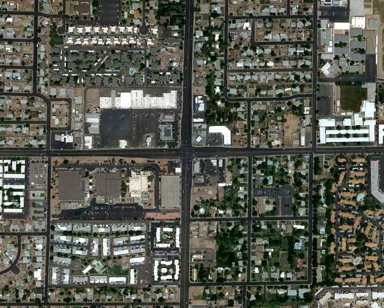
As seen in a 6/9/12 aerial view, the site of Mesa Airpark has been densely redeveloped, leaving no trace of the former airfield.
____________________________________________________
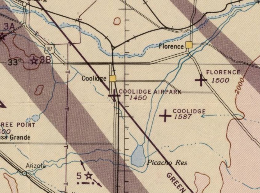
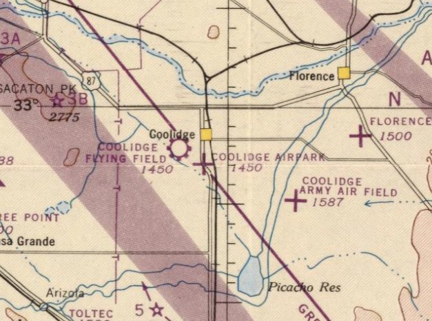
Coolidge Airpark, Coolidge, AZ
32.954, -111.518 (Southeast of Phoenix, AZ)
Coolidge Airpark, as depicted on the March 1946 Phoenix Sectional Chart.
Photo of the airport while open has not been located.
This small general aviation airport to the south of Coolidge was apparently established at some point between 1945-46,
like hundreds of other small airports in America's post-WW2 aviation boom,
as it was not yet depicted on the September 1945 Phoenix Sectional Chart.
The earliest depiction which has been located of Coolidge Airpark was on the March 1946 Phoenix Sectional Chart.
It depicted Coolidge Airpark as an auxiliary airfield.
Jay Moyer recalled, “There was an airport right by Coolidge (south side, ran east/west) with a rounded runway (not flat, not so good).
A head-on collision between two N3Ns occurred there: one taking off, one landing. Both survived with a lot of burns.
My dad threw me into the hopper of an N3N there one year. I had gotten the pickup truck stuck in the mud & I had the gas they needed.
He blew his top & flew us back to another airport for fuel. I remember looking at the 2 fuel gauges reading empty all the way over. Of course no seat belt.”
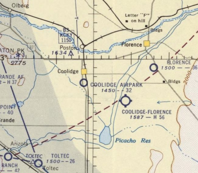
The last depiction which has been located of Coolidge Airpark was on the March 1956 Phoenix Sectional Chart.
It depicted Coolidge Airpark as having a 3,200' unpaved runway.
Coolidge Airpark was evidently closed at some point between 1956-57,
as it was no longer depicted on the 1957 Phoenix Sectional Chart.
It had presumably been replaced by the much-larger Coolidge-Florence Airport to the southeast,
which reused the former Coolidge Army Airfield after its closure.
Coolidge Airpark was not depicted on the 1959 USGS topo map.
The earliest photo which has been located of the site of Coolidge Airpark was a 1961 aerial view.
It depicted the site as having returned to agriculture, with no recognizable trace of a former airfield.
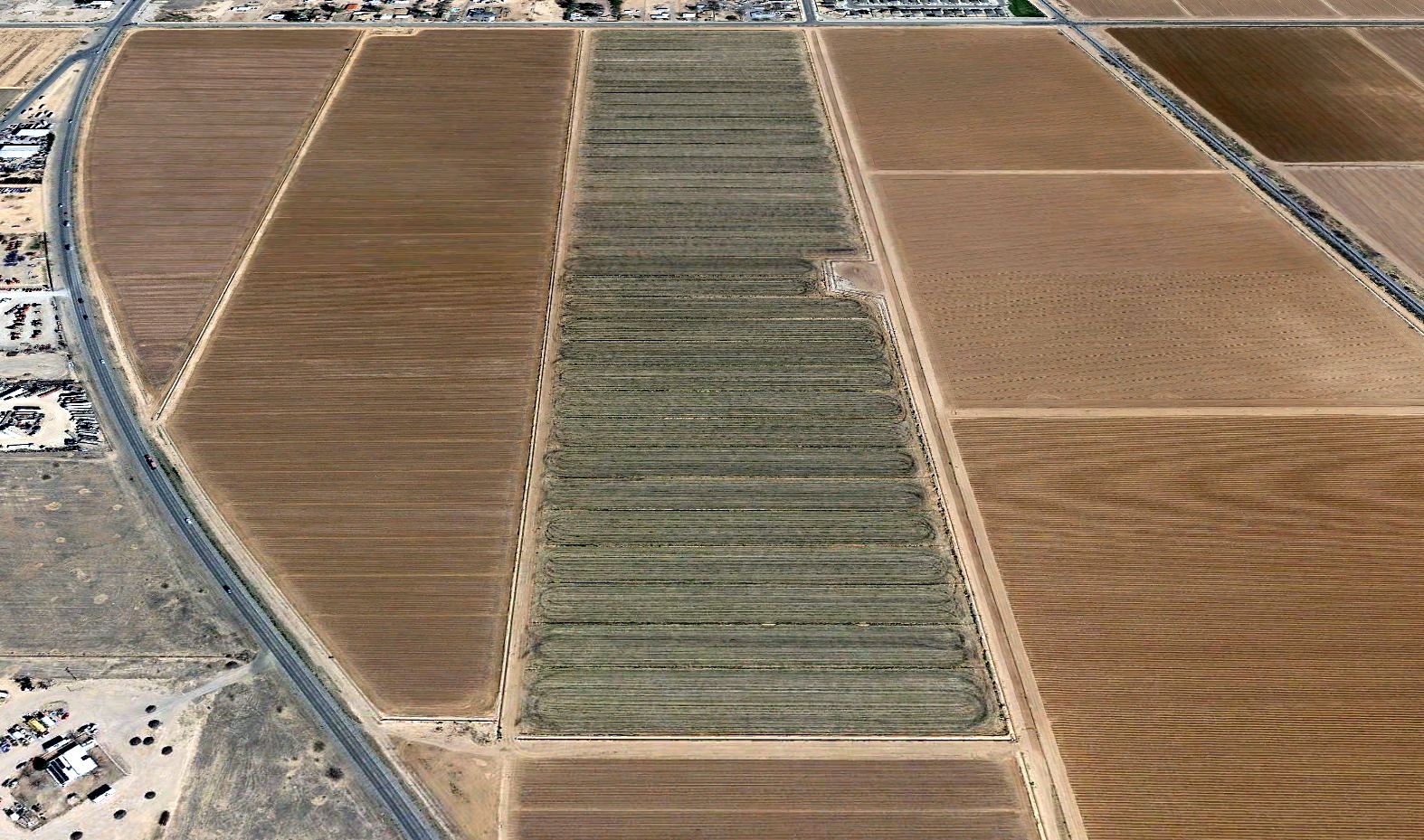
A 2022 aerial view looking north showed no recognizable trace of Coolidge Airpark.
____________________________________________________
Coolidge Flying Field / Coolidge Airport (original location), Coolidge, AZ
32.971, -111.547 (Southeast of Phoenix, AZ)
Coolidge Flying Field, as depicted on the August 1946 Phoenix Sectional Chart.
Photo of the airport while open has not been located.
This small general aviation airport to the west of Coolidge was apparently established at some point in 1946,
like hundreds of other small airports in America's post-WW2 aviation boom,
as it was not yet depicted on the March 1946 Phoenix Sectional Chart.
The earliest depiction which has been located of “Coolidge Flying Field” was on the August 1946 Phoenix Sectional Chart.
It depicted “Coolidge Flying Field” as a commercial/municipal airport.
Note that it also depicted the Coolidge Airpark in very close proximity, less than 2 miles to the southeast.
Why did the tiny town of Coolidge need 2 airports in such close proximity?
It was still depicted as “Coolidge Flying Field” on the September 1947 Phoenix Sectional Chart.
It was simply labeled “Coolidge” Airport on the March 1948 Phoenix Sectional Chart, with a 2,700' unpaved runway.

The earliest topo map depiction which has been located of the original Coolidge Airport was on the 1965 USGS topo map.
It depicted Coolidge Airport as having a single east/west unpaved runway, with 1 small building on the northeast side.
The earliest photo which has been located of the original Coolidge Airport was a 1961 aerial view.
It depicted Coolidge as having a single oiled east/west runway, with a few small buildings & possibly 2 light aircraft on the northeast side.
A 1963 aerial view depicted Coolidge Airport in the same configuration.
Rob Espinosa remembered the original Coolidge Airport as “a dirt strip we landed at frequently in the 1970s, near an old Little League field.”
The last depiction which has been located of the original Coolidge Airport was on the 1978 Phoenix Sectional Chart (courtesy of Jonathan Westerling).
It depicted Coolidge Airport as having a single 2,100' paved east/west runway.
The original Coolidge Airport was evidently closed at some point between 1977-80,
as a 1980 aerial view depicted 3 closed-runway “X” symbols on the runway.
Coolidge Airport was no longer depicted on the June 1981 Phoenix Sectional Chart.
A 1981 aerial view showed baseball fields under construction on the east end of the original Coolidge Airport site.
A 2022 aerial view showed traces were still recognizable of the western portion of the original Coolidge Airport runway.
Thanks to Rob Espinosa for pointing out this airfield.
____________________________________________________
33.4, -110.83 (East of Phoenix, AZ)
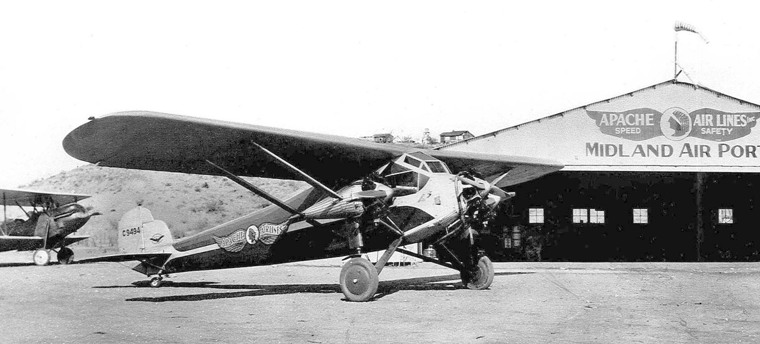
A 1930 photo (from the AZ Historical Society) of Apache Air Lines Kreutzer K-5 Air Coach NC9494 C/n 105 in front of the Midland Air Port Apache Air Lines hangar.
Ralph & Ruth Vaughan came to AZ in 1929 to open an air service from Globe to Phoenix.
They established Midland Field between Globe & Miami, AZ.
An article entitled “Midland City will be Globe, Miami Airport” in the 9/21/29 AZ Republic (courtesy of Peter Vercruijsse) said,
“Midland City Field has been established as the public airport for this district with the acceptance of the Gila County Board of Supervisors of a lease on the property,
given by the Miami Copper Company.”
The earliest photo which has been located of Globe Airport was a 1930 photo (from the AZ Historical Society)
of Apache Air Lines Kreutzer K-5 Air Coach NC9494 C/n 105 in front of the Midland Air Port Apache Air Lines hangar.
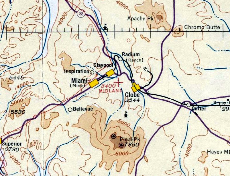
The earliest aeronautical chart depiction which has been located of Midland Airport was on the October 1935 Phoenix Sectional Chart.
It depicted Midland Airport as an auxiliary airfield.
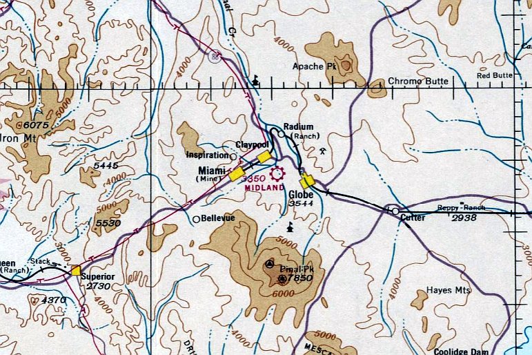
The last depiction which has been located of Midland Airport was on the July 1937 Phoenix Sectional Chart.
It depicted Midland Airport as a commercial/municipal airport.
Apache Air Lines' business was killed by the Depression.
Midland Airport was evidently closed at some point between 1937-39,
as it was no longer depicted on the May 1939 Phoenix Sectional Chart or the 1940 USGS topo map.
No trace was visible of Midland Airport on a 1943 aerial photo.
Although the precise location of Midland Airport has not been determined, a 2019 aerial view shows no recognizable trace of the airport, roughly between Globe & Miami.
Thanks to Peter de Jong for pointing out this airfield.
____________________________________________________
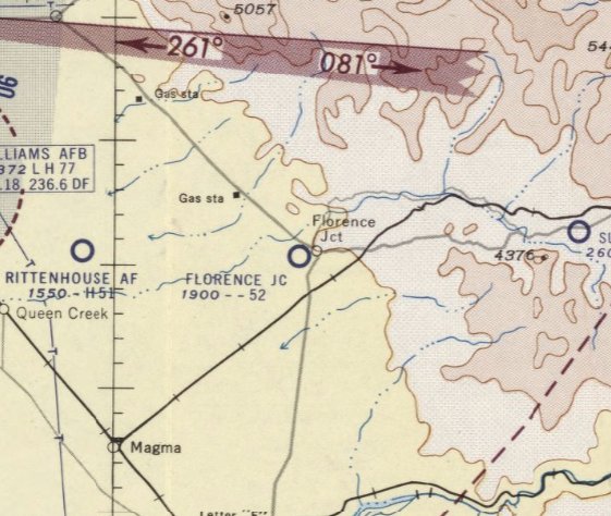
Florence Junction Airport (1st location), Florence Junction, AZ
33.255, -111.347 (Southeast of Phoenix, AZ)
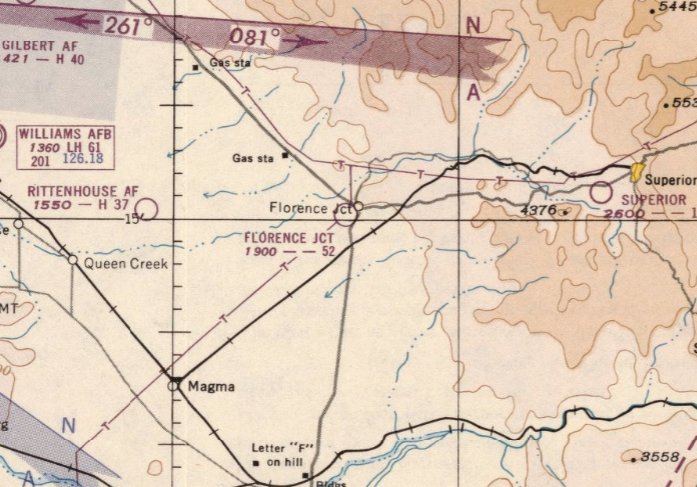
The original location of Florence Junction Airport, as depicted on the March 1951 Phoenix Sectional Chart.
The original Florence Junction Airport was evidently established at some point between 1950-51,
as it was not yet depicted on the August 1950 Phoenix Sectional Chart.
The earliest depiction which has been located of the Florence Junction Airport was on the March 1951 Phoenix Sectional Chart,
which described the field as having a 5,200' unpaved runway.
The 1955 Phoenix Sectional Chart (according to David Brooks)
described the Florence Junction Airport as having a 3,200' “turf” runway (probably not much “turf”).
The last aeronautical chart depiction which has been located of the Florence Junction Airport was on the March 1956 Phoenix Sectional Chart,
which described the field as having a 5,200' unpaved runway.
The original Florence Junction Airport was evidently closed at some point between 1956-57,
as it was no longer depicted on the May 1957 Phoenix Sectional Chart (according to David Brooks).
It was eventually replaced by a paved runway on the northeast side of the crossroads.
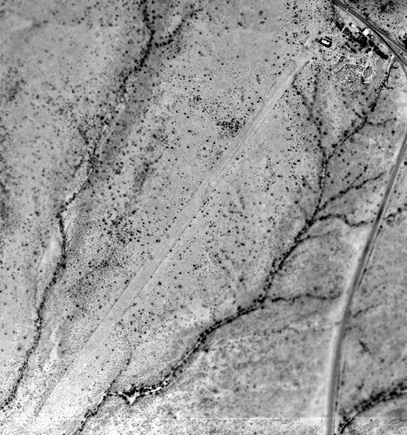
The earliest photo which has been located of the Florence Junction Airport was an 8/1/61 USGS aerial view.
It depicted the field as having a single unpaved northeast/southwest runway,
along with a few small buildings along the road on the northeast side of the field.
There did not appear to be any signs of recent aviation usage.
The 1966 USGS topo map depicted the original Florence Junction Airport as having a single unpaved northeast/southwest runway,
labeled simply as “Landing Strip”, with a few small buildings on the northeast side next to the road.
The 5/16/92 USGS aerial view looking southwest showed the remains of the Florence Junction runway,
along with a few small buildings along the road on the northeast side of the field.
A 2003 aerial photo showed that at some point between 1992-2003
the northeast end of the Florence Junction runway was covered by a rerouted portion of Route 60.
A 2007 aerial view showed that the buildings at the northeast end of the Florence Junction Airport site had been removed at some point between 2003-2007.
A 2019 aerial view looking west showed that the northeast end of the Florence Junction runway was covered by a rerouted portion of Route 60,
but the outline remained recognizable of the majority of the runway length.
The site of the original Florence Junction Airport is located southwest of the intersection of Route 60 & Route 79.
____________________________________________________
Florence Junction Airport (2nd location), Florence Junction, AZ
33.261, -111.331 (Southeast of Phoenix, AZ)
The 2nd location of the Florence Junction Airport, as depicted on a 5/16/92 USGS aerial view looking northwest.
At some point between 1963-80, the original Florence Junction Airport was evidently replaced by another runway on the northeast side of the crossroads.
This 2nd location of the Florence Junction Airport was not depicted on a 1963 aerial photo.
The 2nd location of the Florence Junction Airport was not depicted on 1957/69/78/88/93 Phoenix Sectional Charts,
or the 1966 USGS topo map, or later topo maps.
The 1968 AOPA Airport Directory (according to David Brooks) described the Florence Junction Airport as having a 5,000' dirt runway.
The earliest depiction which has been located of the 2nd location of Florence Junction Airport was a 1980 aerial photo,
which depicted a single paved northeast/southwest runway, which had been built over the alignment of the former US Route 60.
Some small buildings sat along the south side.
Jason Johnson recalled a landing at this location of the Florence Junction Airport:
“I landed there some 15 years ago [1986], and it was in OK shape then.
We were in a 1946 Luscombe, breaking in a new engine, and the oil temperature started to run away,
so we decided to land there & walk to a nearby Circle K for a soda while the engine cooled down.”
A 5/16/92 USGS aerial view depicted the 2nd location of the Florence Junction Airport as having a single east/west 3,400' paved runway,
with a complex of buildings along the south side.
A 2003 aerial photo showed a closed-runway “X” symbol on the east end of the Florence Junction runway.

A 2019 aerial view looking northwest showed that the paved runway of the 2nd location of the Florence Junction Airport remained intact.
The site of the 2nd location of the Florence Junction Airport is located northeast of the intersection of Route 60 & Route 79.
____________________________________________________
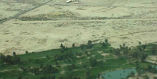
Francisco Grande Airfield, Casa Grande, AZ
32.884, -111.858 (Southeast of Phoenix, AZ)
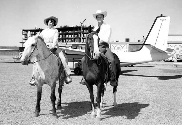
A circa late 1950s / early 1960s photo of an unidentified woman & Pat Boone on horseback in front of a Twin Commander at Francisco Grande,
with the resort tower under construction in the background.
In 1959 the San Francisco Giants' owner Horace Stoneham developed Francisco Grande
as a spring training camp for his popular Major League Baseball team.
The name of the property was taken from the San "Francisco" Giants and Casa "Grande".
During its early years, the hotel was popular with celebrities like John Wayne and Pat Boone.
Kurt Bob recalled, “This resort was rather extravagant when it was opened, in about 1959,
an 8-story high-rise hotel with a penthouse comprising the 9th floor - mainly as the San Francisco Giants spring training camp,
with a championship golf course - the longest in AZ - for the Giants baseball team to let loose on.”
The 1965 USGS topo map depicted a single unpaved northwest/southeast “Landing Strip” with a taxiway leading to the Francisco Grande property.
The Francisco Grande Airfield was not yet depicted on the July 1966 Phoenix Sectional Chart.
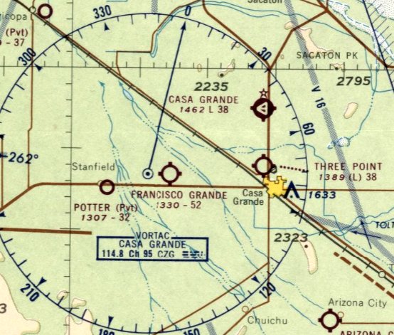
The earliest aeronautical chart depiction which has been located of the Francisco Grande Airfield was on the January 1967 Phoenix Sectional Chart.
It depicted Francisco Grande Airfield as having a 5,200' unpaved runway.
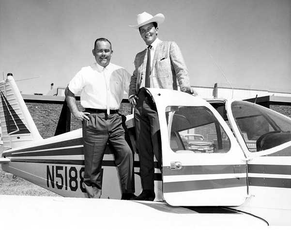
A circa 1960s photo of an unidentified man & Pat Boone on a Piper at Francisco Grande.
The last aeronautical chart depiction which has been located of the Francisco Grande Airfield was on the January 1971 Phoenix Sectional Chart.
It depicted Francisco Grande Airfield as having a 5,200' unpaved runway.
The earliest aerial photo which has been located of Francisco Grande Airfield was a 1971 USGS aerial view.
It depicted both the WNW/ESE runway on the west side of North Montgomery Road & the NNW/SSE runway on the east side.
Kurt Bob recalled, “Flying westbound from Tucson early mornings, in the early 1970s I would often stop at Francisco Grande Airport,
landing on Runway 27 and gassing up at the self-service Chevron pump, which was on the honor system, rather an oddity even back then.
You would put your money in an envelope & put it in the slot; the owners apparently assuming nobody knew it was there, or every pilot was a gentleman, or simply not caring about a few bucks.
Properly fueled-up, we would continue the C170's rather leisurely desert flight on to Yuma, then San Diego.”
A 1973 photo by Brian Baker of Snow S-2A N9458R cn 10934 at Francisco Grande, with a DC-7 in the background.
Brian recalled, “I recall that it was near some kind of resort hotel.
There wasn't much there, but it had to have been enough to get that DC-6 or DC-7 in there.
That's a rare early Snow. I shot 3 different views of the airplane, and none shows any building in the background, only some lightplanes & the DC-7.
I don't think there were any hangars there.
There is, however, a Chevron self serve gas pump visible in one photo, so there had to have been an operator there of some kind.
There is a second DC-7B in the background, but I don't have any photos of it.”
The 1976 AOPA Airport Directory (according to Chris Kennedy)
described Francisco Grande Airfield as having a single 5,000' dirt Runway 9/27.
The Francisco Grande Airfield was evidently closed (for reasons unknown) at some point in 1976,
as it was no longer depicted on the December 1976 Phoenix Sectional Chart (according to Chris Kennedy).
The 1977 USGS topo map depicted Francisco Grande as having a single WNW/ESE runway
on the west side of North Montgomery Road.
Evidently the airfield was not reused by subsequent owners of the facility.
After the Giants moved their Spring Training operations to Scottsdale, the California Angels used Francisco Grande from 1982-84.
From 1984-86, the baseball fields were transformed into football fields,
which were used as the training camp headquarters for the USFL's Arizona Wranglers & the Denver Gold.
In 1984 the Francisco Grande reopened as a destination golf resort.
The 1994 USGS topo map once again depicted a shorter runway oriented NNW/SSE on the opposite side of North Montgomery Road, closer to the resort.
The 1996 USGS aerial view showed the remains of a single unpaved northwest/southeast runway on the west side of the Francisco Grande property.
In 2003, the Francisco Grande resort was closed for an $8.5 million renovation, reopening in 2005.
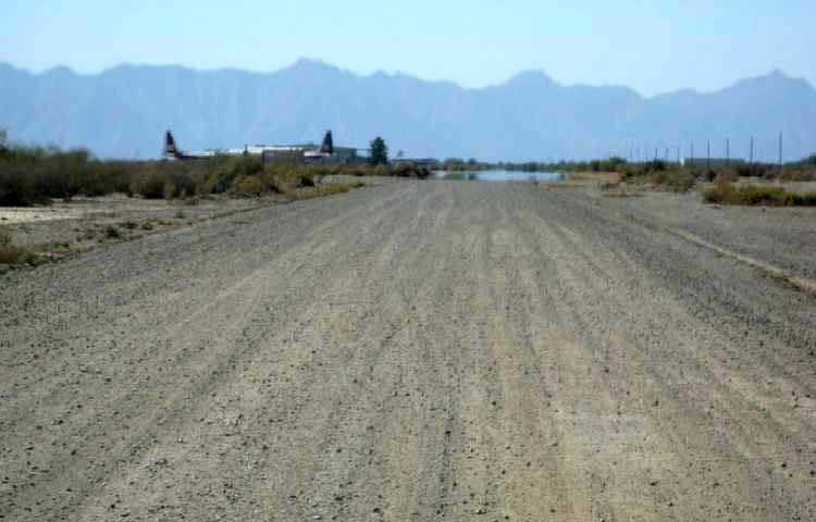
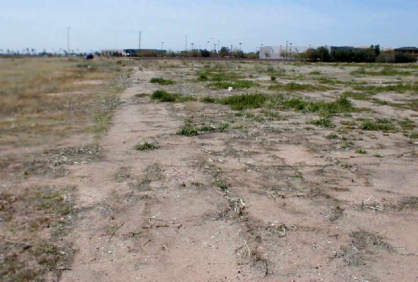
A pre-2010 aerial view looking west at the Francisco Grande runway.
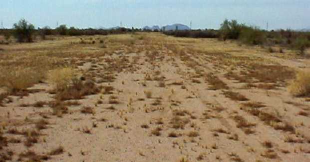
A pre-2010 photo looking southeast along the remains of Francisco Grande's Runway 15.
A 2018 aerial view looking northeast showed the remains of a single unpaved northwest/southeast runway on the west side of the Francisco Grande property.
A 2022 photo looking northwest along the remains of the Francisco Grande runway.
Kurt Bob reported in 2023 of the Francisco Grande Resort, “It's now been refurbished a couple times over the years
and is again a fancy resort, sometimes just for people to play golf, enjoy fine dining & relax, and then leave.”
The site of Francisco Grande Airfield is located northwest of the intersection of Gila Bend Highway & North Candlestick Drive.
Thanks to Gary Alexander for pointing out this airfield.
____________________________________________________
33.406, -111.95 (Southeast of Phoenix, AZ)
A 1940s aerial view looking northwest at Tempe Airport (courtesy of Kevin Rutherford).
Tempe Airport was not yet depicted at all on a 1937 aerial photo nor on the September 1945 Phoenix Sectional Chart.
According to Ron Chavez's book “The Valley's Airports of the Past”,
“Tempe Airport started its operations in 1946 by founders C. Stallings & J. Wigley.
Tempe Airport was located on the southwest corner of Broadway Road & Mill Avenue, and had a single 2,700' east/west dirt runway.
After having a hangar constructed, Stallings & Wigley would manage the airport as its owner/operators.
Besides running the airport, Stallings & Wigley also started a flight school with both men operating as flight instructors.”
A 1940s aerial view (courtesy of Kevin Rutherford) depicted Tempe Airport as having an east/west unpaved runway,
with a dozen light single-engine planes parked near a few small hangars on the north side of the field, along the south side of Broadway.
The earliest aeronautical chart depiction which has been located of Tempe Airport was on the March 1946 Phoenix Sectional Chart.
It depicted Tempe Airport as a commercial/municipal airport.
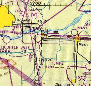
The 1949 Phoenix Sectional Chart (courtesy of Chris Kennedy) depicted Tempe as having a 2,700' unpaved runway.
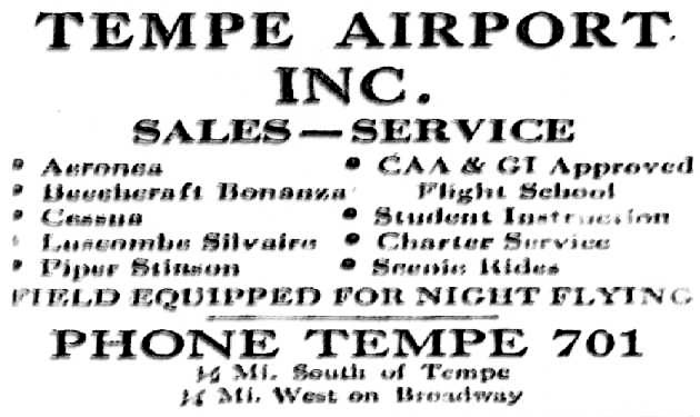
A circa 1946 – 1950s advertisement for Tempe Airport Inc. (from Ron Chavez's book “The Valley's Airports of the Past”, enhanced by Bill Grasha).
According to Doug Duncan, Tempe Airport “was located just south of Broadway (west of Tempe High School)
between the railroad tracks & the wires. I think it was never paved.”

A 2/17/49 aerial view of Tempe Airport (from the Maricopa County Flood Control District, enhanced by Bill Grasha)
depicted the field as having a single unpaved east/west runway with a parallel taxiway,
along with what appeared to be traces of 2 former crosswind runways.
A total of 16 single-engine aircraft were parked around a few small buildings on the north side of the field, one of which had “Tempe” painted on its roof.

The last photo which has been located of Tempe Airport in operation was a 1951 aerial view,
which showed a large number of light aircraft parked on the northeast side.
Tempe Airport, as depicted on a 1952 street map.
The 1952 USGS topo map (courtesy of John Arthur)
depicted Tempe Airport as having a as having a single east/west runway, with one building (a hangar?) on the north side of the field.
According to Ron Chavez's book “The Valley's Airports of the Past”,
“Stalling & Wigley would continue to operate the Tempe Airport until 1954,
when they sold the airport business & the property to the City of Tempe.”
The last aeronautical chart depiction which has been located of Tempe Airport was on the March 1956 Phoenix Sectional Chart.
It depicted Tempe Airport as having a 2,700' unpaved runway.
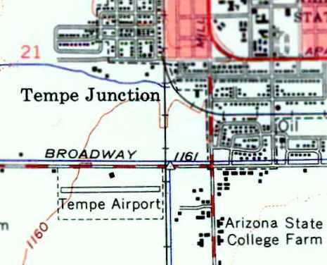
John Arthur placed the location of Tempe Airport as “On Broadway, west of Mill Avenue & the railroad tracks,
next to Date Palm Manor, across from the High School.
I remember the area as a big empty field in the mid & late 1950s.
I remember Date Palm Manor even better because of all the scorpions in the bark of the palms.”
According to Ron Chavez's book “The Valley's Airports of the Past”,
“The City of Tempe continued to run the airport until 1957,
then closed it down to make room for new development that was being planned in the area.”
According to Doug Duncan, Tempe Airport “was razed in 1957.”
Tempe Airport was no longer depicted on the March 1957 Phoenix Sectional Chart.
A 1958 aerial view (courtesy of John Arthur) depicted the site of the Tempe Airport.
Traces of the former east/west runway were still perceptible, but overall the property appeared to have been razed.
Tempe Airport was no longer depicted on the July 1965 Phoenix Sectional Chart (courtesy of Ron Kunse).
Doug Duncan reported in 2007, of the Tempe Airport, “Even the Tempe Historical Museum people knew nothing about it!
I've looked at aerial photos & have driven around the area, but there appears to be no visible trace remaining.”
A 2016 aerial view shows the site of Tempe Airport has been heavily redeveloped, and not a trace of the former airport appears to remain.
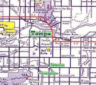
The site of Tempe Airport is located on the south side of Broadway Road between the railroad tracks & Hardy Drive.
____________________________________________________
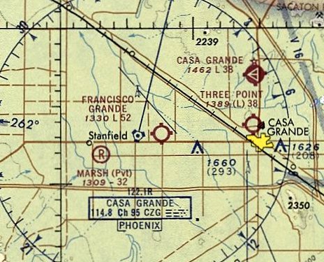
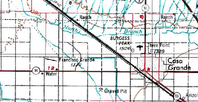
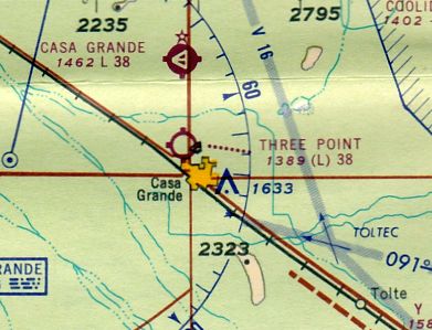
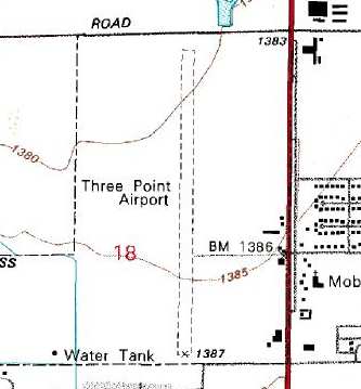
Three Point Airport (E58), Casa Grande, AZ
32.9, -111.76 (Southeast of Phoenix, AZ)
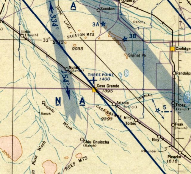
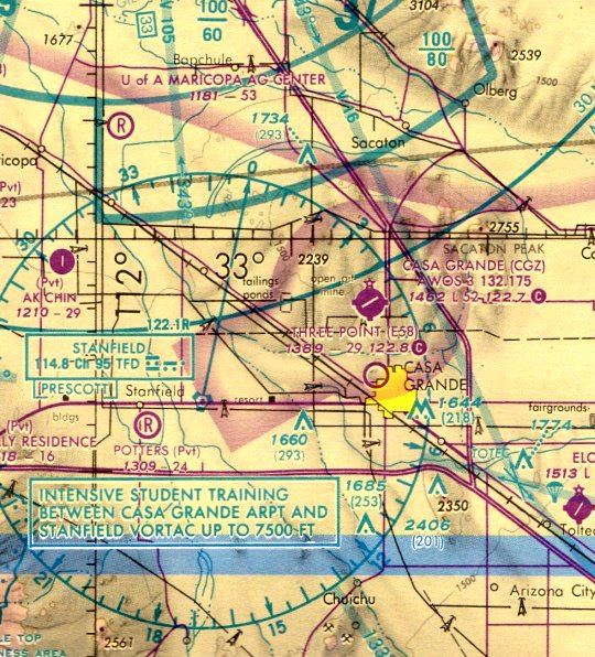
Three Point Airport, as depicted on the September 1942 Phoenix Sectional Chart.
This small privately-owned public-use airport was apparently built at some point between 1941-43,
as it was not depicted on the January 1941 Phoenix Sectional Chart.
The earliest depiction of Three Point Airport which has been located was on the September 1942 Phoenix Sectional Chart,
which depicted Three Point as an auxiliary airfield.
The 1944 US Army/Navy Directory of Airfields (courtesy of Ken Mercer)
described Three Point Airport as having a 3,500' unpaved runway.
Three Point Airport was still depicted as an auxiliary airfield on the 1945 Phoenix Sectional Chart (courtesy of John Voss).
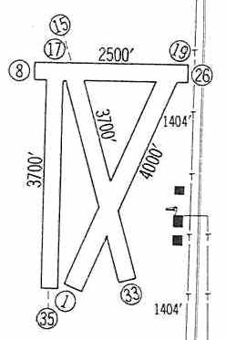
The 1960 Jeppesen Airway Manual (courtesy of Chris Kennedy) depicted Three Point Airport as having a total of 4 unpaved runways,
with the longest being the 4,000' Runway 1/19.
Three buildings (hangars?) were depicted along the east side of the field.
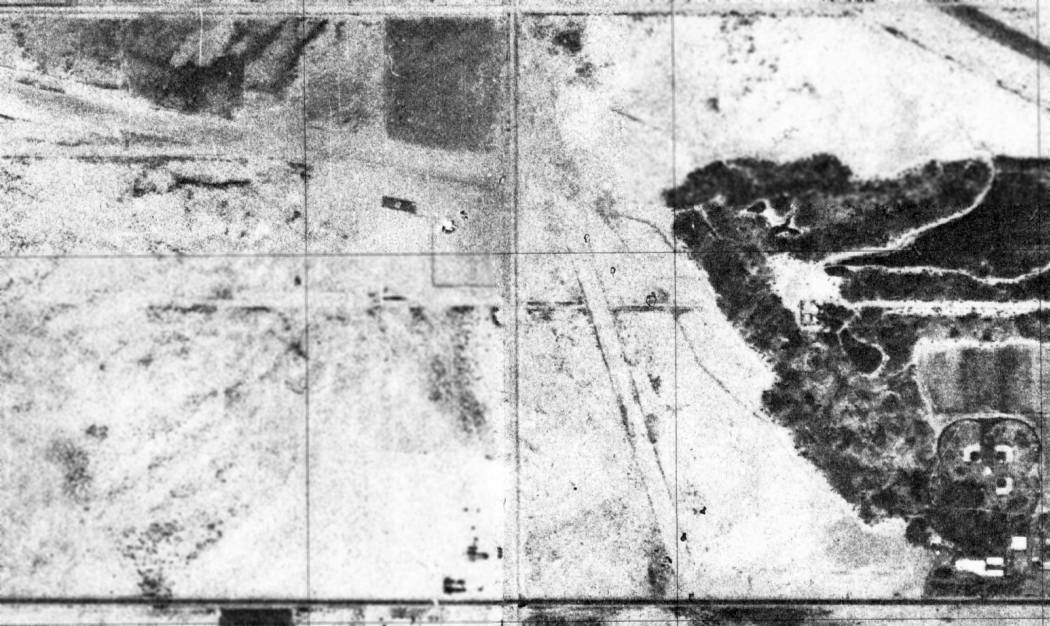
The earliest photo which has been located of Three Point Airport was a 5/25/61 USGS aerial photo.
It depicted Three Point as having a single unpaved north/south runway,
with several small buildings & 7 light aircraft along the east side of the field.
The 1962 AOPA Airport Directory described Three Point as having a 4,000' sod Runway 18/36
(a 'sod' runway - in the Arizona desert??).
The operator was listed as George Gomez.
The July 1965 Phoenix Sectional Chart (courtesy of Ron Kunse)
depicted Three Point Airport as having a 3,800' unpaved runway.
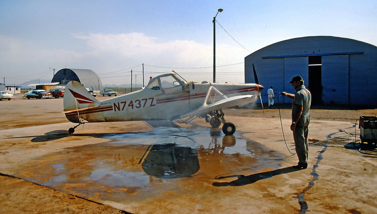
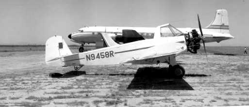
A 9/9/68 photo of Piper PA-25 Pawnee N7437Z (25-3423) getting a token wash down at Three Point Airport.
The 1982 AOPA Airport Directory (courtesy of Ed Drury)
more realistically described the runway configuration at Three Point as being a single 3,850' "dirt, oiled" Runway 17/35.
According to Dan Rhinehart, Three Point "was never paved & had 2 dirt runways.
Three Point airport was owned & operated by George Gomez & family
until the death of Mrs. Gomez, who ran the airport restaurant until she died.
Three Point was typical of the duster strips / privately-owned public-use airports in Arizona,
however it was the last one to go."
In a 1991 meeting of the Casa Grande City Council,
George White stated he represented the Estate of Marlene White & Adele Gomez, the owners of Three Point Airport.
They did not want to be annexed into the City because of the increase in taxes.
They also did not want to be required to make any improvements other than what the County required.
The May 1993 Phoenix Sectional Chart (courtesy of Ron Plante) depicted Three Point as having a 3,800' unpaved runway.
The 1995 USGS topo map depicted Three Point Airport as having a single north/south unpaved runway,
with a few small buildings along the east side of the field.
The last aeronautical chart depiction which is available of Three Point Airport was on the November 1995 Phoenix Sectional Chart.
It depicted Three Point as having a 2,900' unpaved runway.
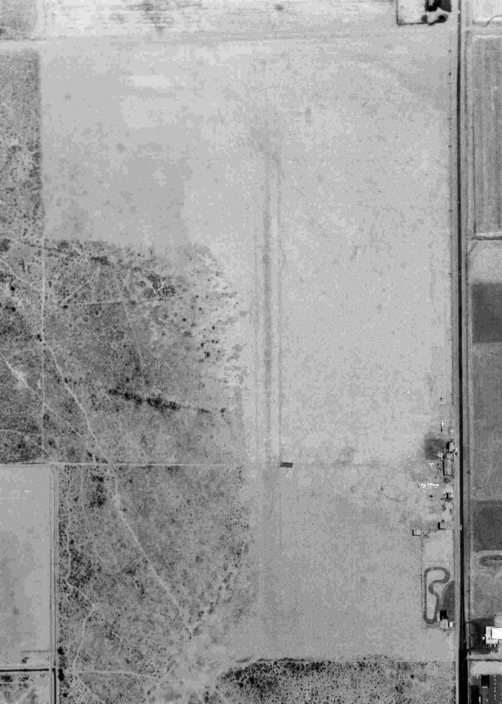
A 10/1/96 USGS aerial view looking northwest at Three Point Airport showed a single north/south dirt runway,
with a few small hangars along the east side of the field.
There did not appear to be any aircraft visible on the field.
A 1997 aerial photo showed the Three Point Airport property still remaining clear.
The last aeronautical chart depiction which has been located of Three Point Airport was on the 1998 World Aeronautical Chart.
Three Point Airport was evidently closed (for reasons unknown) at some point between 1998-2000,
as it was no longer listed among active airfields in the 2000 AOPA Airport Directory.
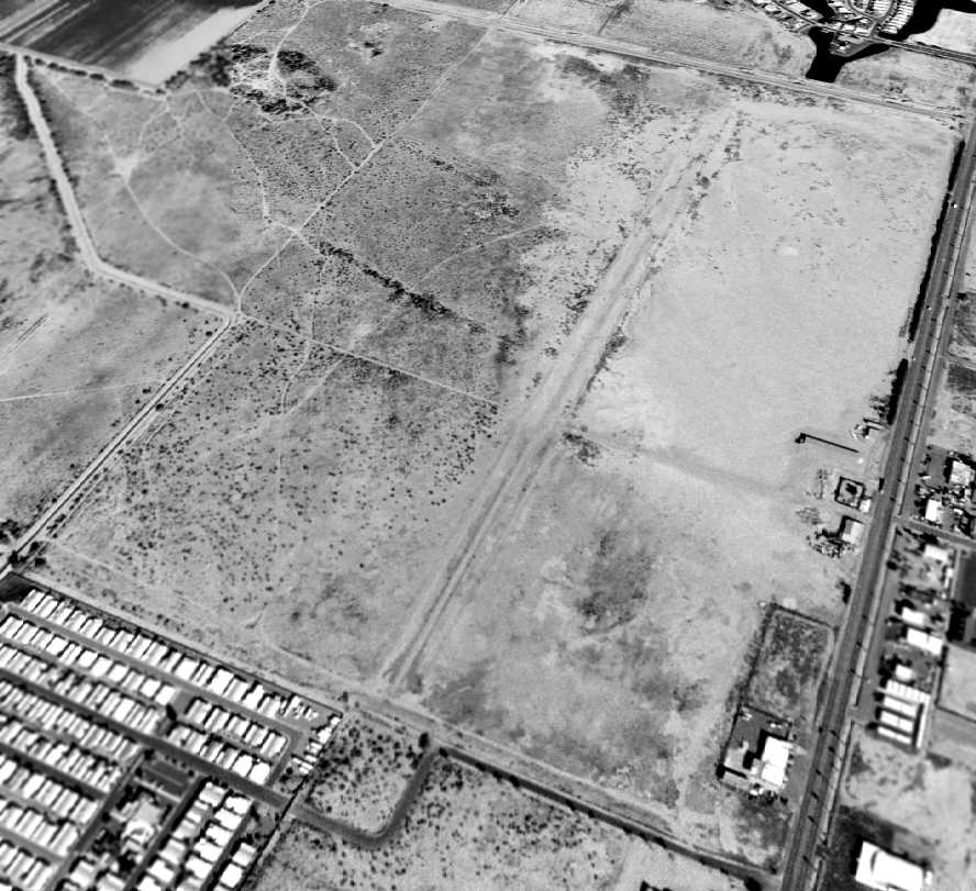
A 2003 aerial photo showed the west & north sides of the Three Point Airport property had begin to be covered by housing.
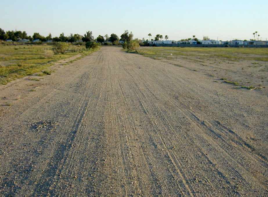
A 2003 photo by Dan Rhinehart, looking south along the former runway at Three Point Airport.
Dan reported, “The hangar & covered tie-downs are gone but the rest of the airport is pretty much there.”
A 2003 photo by Dan Rhinehart (enhanced by Bill Grasha), looking east along the former runway at Three Point Airport.
The last photo which has been located of an aircraft at Three Point Airport was a 2003 photo by Dan Rhinehart of an Aerospatiale Alouette III & Aerospatiale Llama
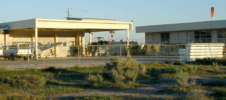
at the helicopter firm which still operated at the former Three Point Airport.
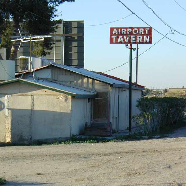
A 2003 photo by Dan Rhinehart of the Airport Tavern, adjacent to the former Three Point Airport.
Dan reported, “Even though Three Point is no longer listed as an airport (closed or otherwise)
the current owner of the airport restaurant said 'If you want to land & come in for lunch that it was fine with me!'"
A 2014 aerial view looking northwest showed the western half of Three Point Airport had been covered with housing,
but a southern portion of the north/south runway remained recognizable, and a few airport buildings remained along along the east side of the field.
The site of Three Point Airport is located southwest of the intersection of Route 387 & West Kortsen Road.
____________________________________________________
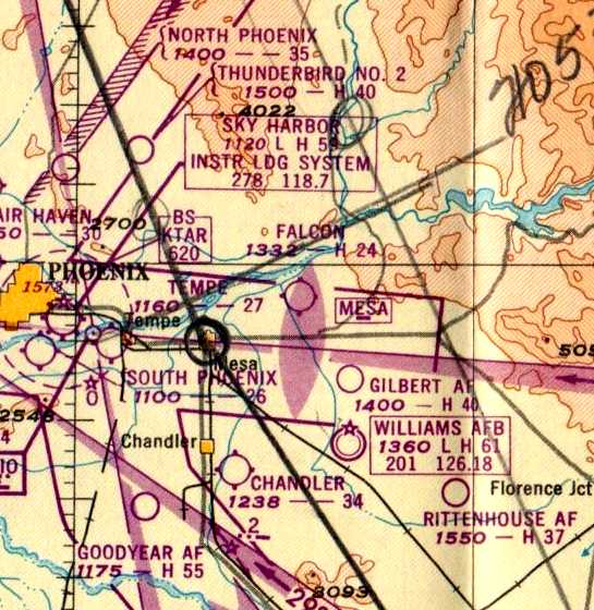
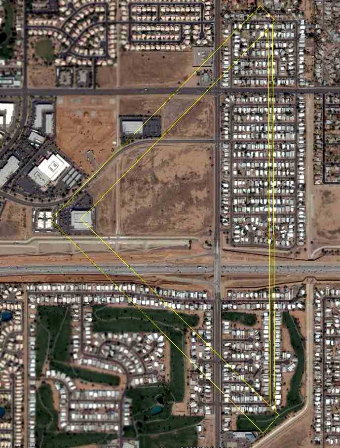
Williams Auxiliary Army Airfield #5 / Goodyear AF Auxiliary / Chandler Memorial Airfield (L07) /
Gila River Memorial Airport (34AZ), Chandler, AZ
33.24, -111.91 (Southeast of Phoenix, AZ)

A circa 1943-45 aerial view looking northeast at Williams Auxiliary Army Airfield #5 from the 1945 AAF Airport Directory.
This field was built during WW2 as Williams Auxiliary Army Airfield #5,
one of several satellite airfields for Williams AAF,
which conducted training in twin & 4 engine bombers & single engine fighters.
Williams Auxiliary Army Airfield #5 was evidently built at some point between 1943-45,
as it was not depicted at all on a 1937 aerial photo nor on the August 1943 Phoenix AAF Sectional Chart (courtesy of Kevin Walsh).
The earliest photo which has been located of Williams Auxiliary Army Airfield #5
was a circa 1943-45 aerial view from the 1945 AAF Airport Directory.
The 1945 AAF Airfield Directory (courtesy of Scott Murdock) described “Williams Field Auxiliary #5 (Goodyear Field)”
as a rectangular property having 2 paved 5,500' runways,
oriented northeast/southwest & northwest/southeast,
along with an oiled “All-way area” measuring 2,675' east/west by 1,000' north/south.
The field was described as not having any hangars,
and to be operated by the Army Air Forces.
The 1947 Gila River World Aeronautical Chart depicted Goodyear AF as having a 5,500' paved runway.
A directory of AZ Airports in the 5/47 issue of Arizona Highways (courtesy of George Miller)
described Williams Aux AAF #5 as being unattended, and the longest runway as being 4,000'.
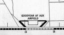
Goodyear AF Aux Airfield, as (partially) depicted on the southern edge
of the 1948 USAF Phoenix Urban Area Chart (courtesy of Scott O'Donnell).
It depicted “Goodyear AF Aux Airfield” as having 2 paved runways with a taxiway & a ramp on the north side of the field.
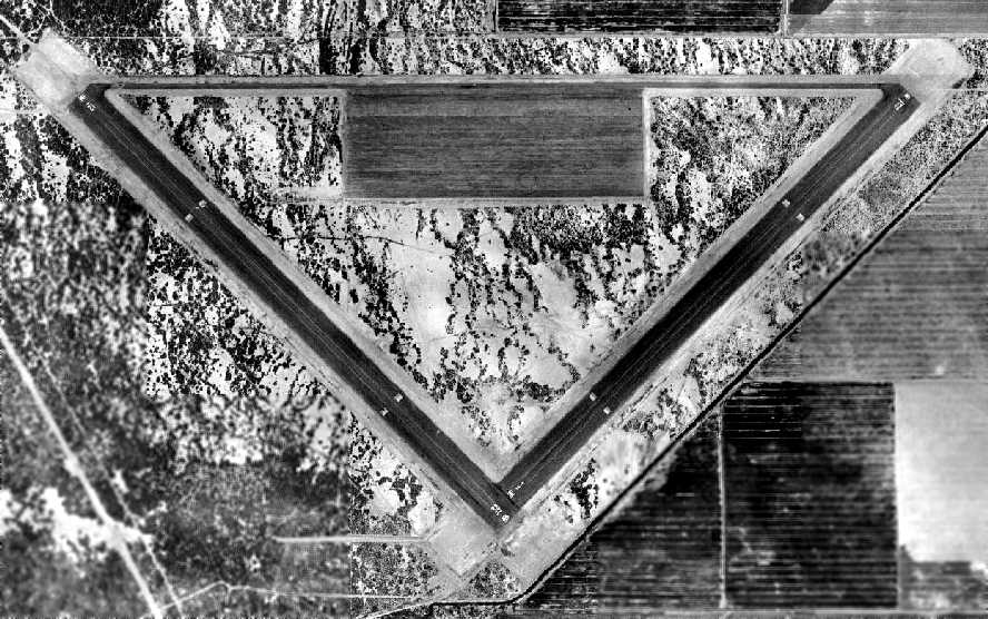
A 2/17/49 aerial view (from the Maricopa County Flood Control District).
depicted Goodyear Auxiliary Airfield in its original (triangular) configuration, with 2 paved runways & a ramp on the north side of the field.
No aircraft or buildings were present on the field.
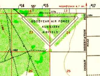
The 1952 USGS topo map still depicted “Goodyear Air Force Auxiliary Airfield” in its original WW2 configuration.
The primary runway was apparently lengthened at some point between 1952-56,
as the 1956 Phoenix Sectional chart (courtesy of John Voss) described the field as having a 8,000' runway.
The lengthening was presumably to support jet aircraft training operations from nearby Williams AFB.
A 1958 aerial view (courtesy of John Arthur) depicted the Goodyear Auxiliary Airfield with its lengthened northwest/southeast runway.
It was still depicted as "Goodyear AF" on the 1966 Phoenix Local aeronautical chart (courtesy of John Voss).
The Air Force apparently relinquished the airfield at some point between 1966-71 & it became a civilian airfield.
That is how "Goodyear" was depicted on the August 1971 USAF Tactical Pilotage Chart (courtesy of Chris Kennedy).
Eventually, the field became a private civil airport, Memorial Airfield.
This airfield was supposedly used during Vietnam War to modify C-130s & other aircraft used by Air America & other companies.

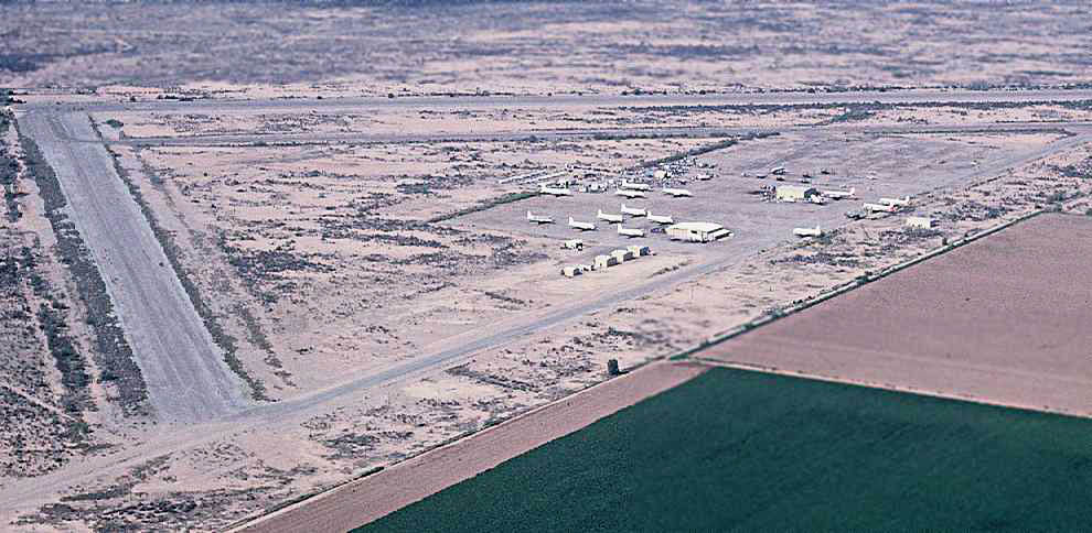
A pre-1970 aerial view looking west at Memorial Airfield by Chris Kennedy (enhanced by Bill Grasha).
The airfield appears completely unused, with no buildings at all, and no aircraft on the ramp.
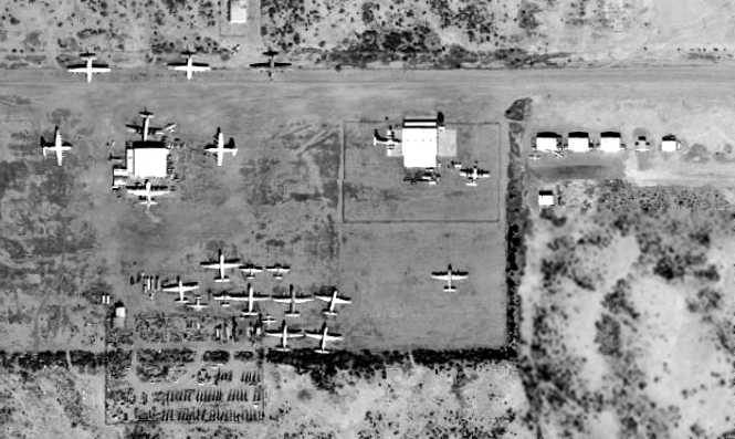
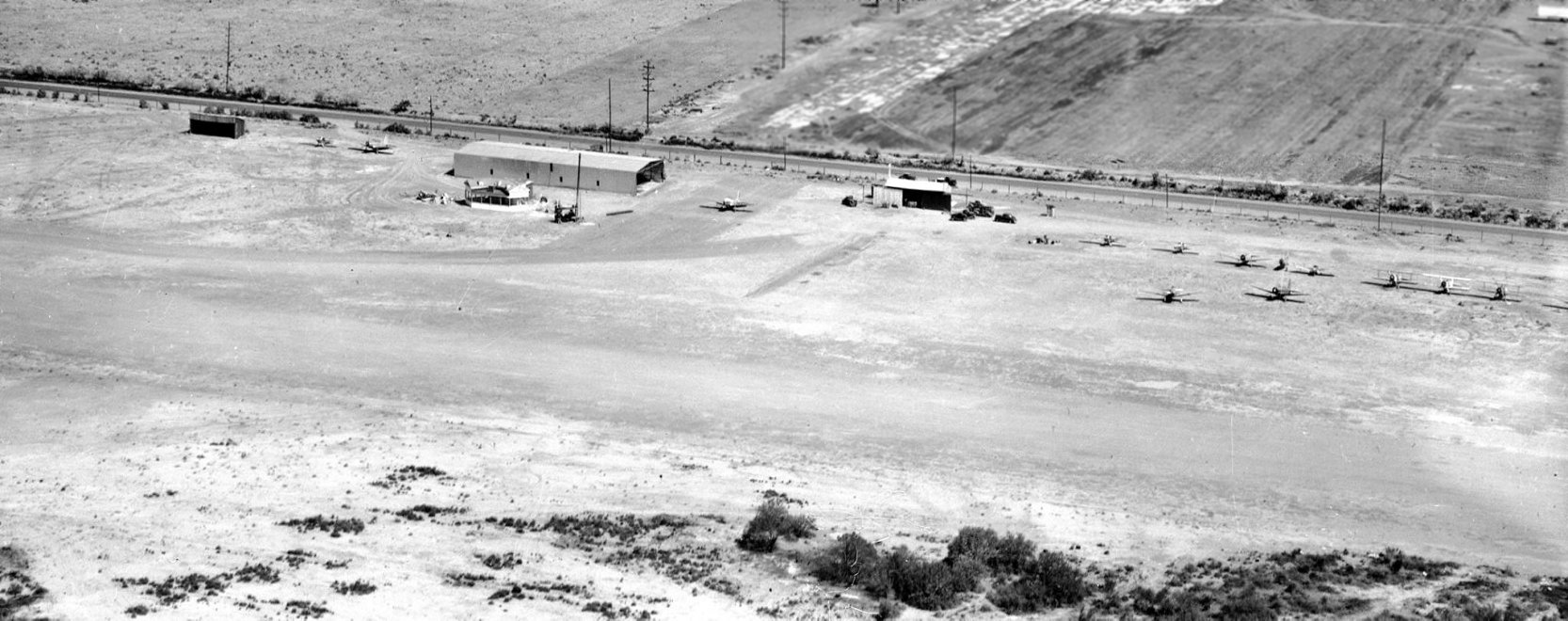
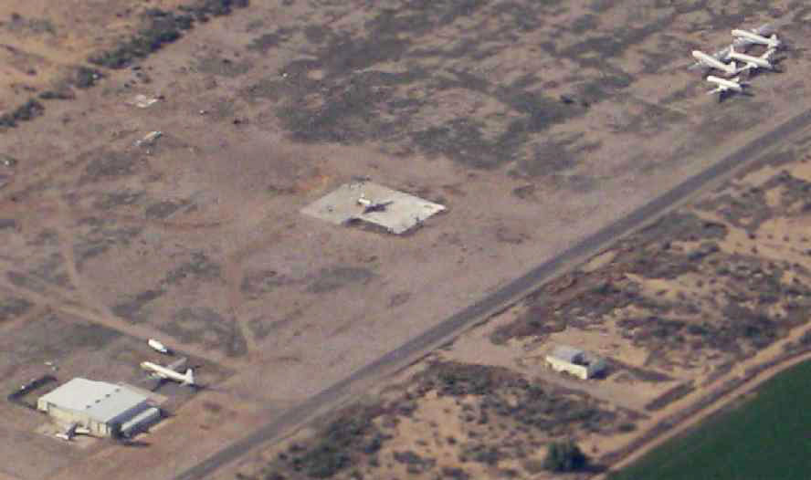
A 1970 aerial view showed a large number of twin-engine & 4-engine transport aircraft at Memorial Airfield.
Two large hangars had been added on the ramp on the north side of the field, along with a row of smaller hangars.
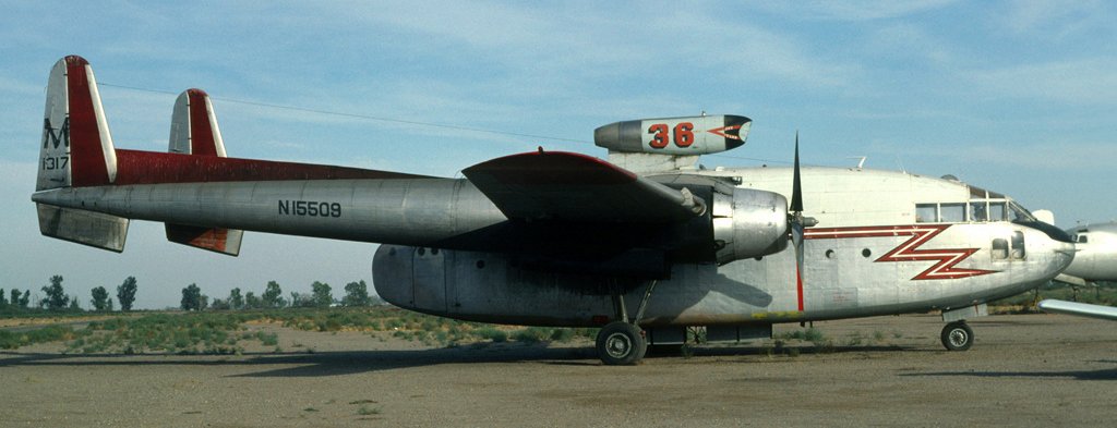
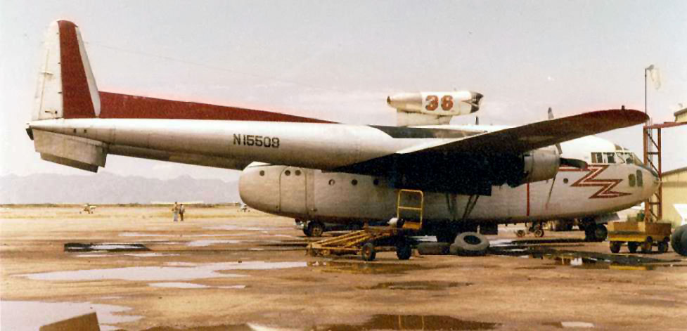
A September 1979 photo by Richard Vandervord of a former Royal Canadian Air Force Fairchild C-119F Flying Boxcar, N15509 C/n 10775, at Memorial Airfield.
A 12/15/79 aerial view (from the Maricopa County Flood Control District)
showed 3 hangars on the ramp on the north side of Memoria Airfield.
A total of 13 aircraft were visible on the field, including 6 large twin & 4-engine piston-engine transports.
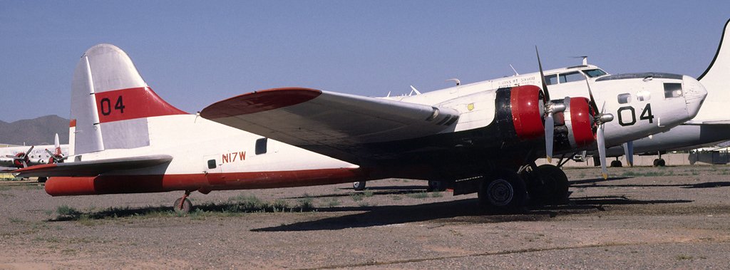
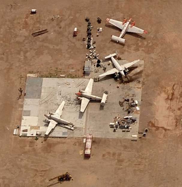
A May 1981 photo by Richard Vandervord of Boeing B-17F Flying Fortress N17W C/n 4896 at Memorial Airfield. It was world's only remaining flyable B-17F.
The only photo that has been located of an aircraft operating from Memorial Airport was a 5/5/82 photo of Lockheed L1649A-98 Starliner, N8083H (enhanced by Bill Grasha).
At the time it was one of only 4 airworthy Starliners in the world.
An October 1982 photo by Micheal Zoeller (enhanced by Bill Grasha) of a ex- Royal Canadian Air Force Fairchild C-119F Flying Boxcar seen at Chandler Memorial Airfield.
According to Tom Story, Tanker 36 “was operated by T&G Aviation & Chandler Memorial was their home base at the time.
The C-119 was named 'Miss Piggy'.”
A 9/10/88 aerial view by Brian Baker (enhanced by Bill Grasha) looking southwest at Memorial Airport,
showing more than a dozen large piston-engine airliners on the ramp along with several hangars.
Paul Freeman flew into Memorial in an MD-500 helicopter in 1990
on a training flight for the McDonnell Douglas Helicopter Company (located nearby in Mesa).
The company used Memorial Airfield for helicopter pilot training flights.
The airfield consisted of 2 paved runways (the longest, 12/30, was 8,500'), ramps & hangars.
The runways were very deteriorated, with weeds growing up through cracks.
A 2/6/92 aerial view (from the Maricopa County Flood Control District)
showed the number of aircraft on the Memorial ramp had increased to over 2 dozen.
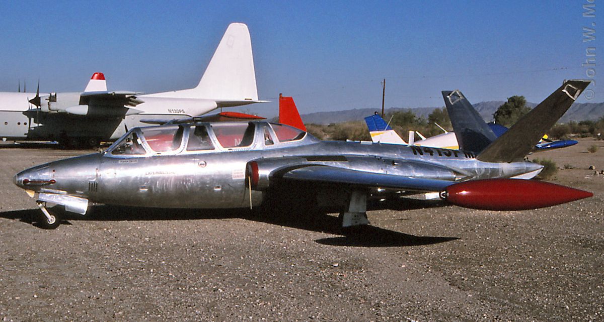
An October 1997 photo of N415FM, a beautiful 1963 Fouga CM-170 Magister, serial #415, at Chandler Memorial Airport.
A 2002 aerial view by Ralph Pettersen looking west at C-130s, DC-7s, and other aircraft on the Memorial ramp.
A beautiful 2002 shot by Nils Alegren of DC-7s, some of the many old transports baking in the sun at Memorial.
As of 2002, several air tanker companies based a variety of aircraft (C-130, DC-7) at Memorial.
However, as a local AZ pilot pointed out in 2002, "Now with the FAA ban on using C-130As for aerial firefighting,
most of those old C-130s at Memorial will probably go into being Budweiser cans!"
A 2003 aerial view looking north at Memorial Airfield by James Covington.
Sam Brunetto reported in 2005 that “ABVA Trust International
has asked me to do a cost evaluation of a complete development project to bring Memorial into the 21st century.
After doing a cost evaluation , I presented it to ABVA.
I have obtained an agreement with them for funds in $100 million blocks up to $1 Billion.”
A 2005 photo looking southeast along Memorial's Runway 12 (courtesy of Luke Graven of North America Building & Development).

A 2005 photo looking south at Memorial's ramp (courtesy of Luke Graven of North America Building & Development).
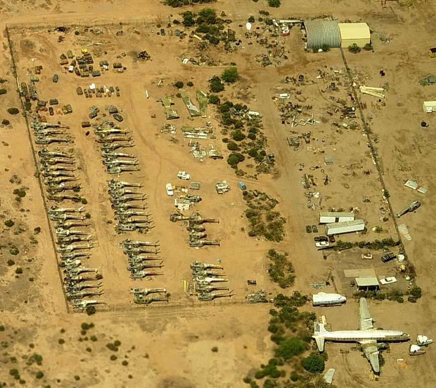
A circa 2006 aerial view looking west at a fenced-in boneyard containing dozens of Sikorsky helicopter fuselages at Chandler Memorial,
a Douglas DC-7, and 3 DC-7 nose sections.
A circa 2006 aerial view looking west at a group of 4 Lockheed Venturas at Chandler Memorial,
one of which was missing its tail.
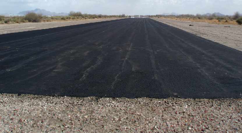
A 2006 photo (courtesy of Luke Graven of North America Building & Development) of the newly repaved Runway 12/30 at Memorial.
Luke reported in 2006, “We have resurfaced the main runway & taxiway with some slurry-seal 8,600' x 75’.
We're flying our Lear 35 out of here... it's great having an 8,600' runway all to yourself.”
A 2006 plan (courtesy of Luke Graven of North America Building & Development) looking west at the plan for the redevelopment of Memorial.
Luke reported in 2006, “We will hopefully soon reach a deal with the Gila River Airport Authority & develop the airpark.”
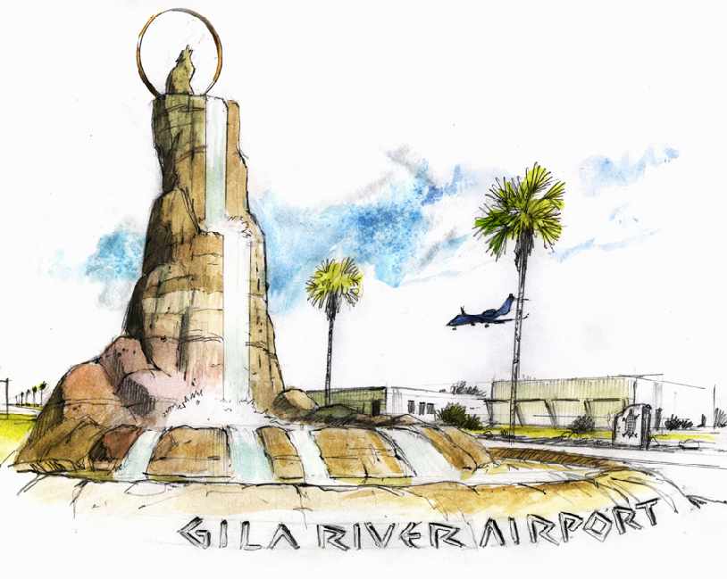
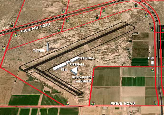
A 2006 artist's conception (courtesy of Luke Graven of North America Building & Development)
of the entrance to the planned “Gila River Airport” (to be developed on the site of the Memorial Airfield).
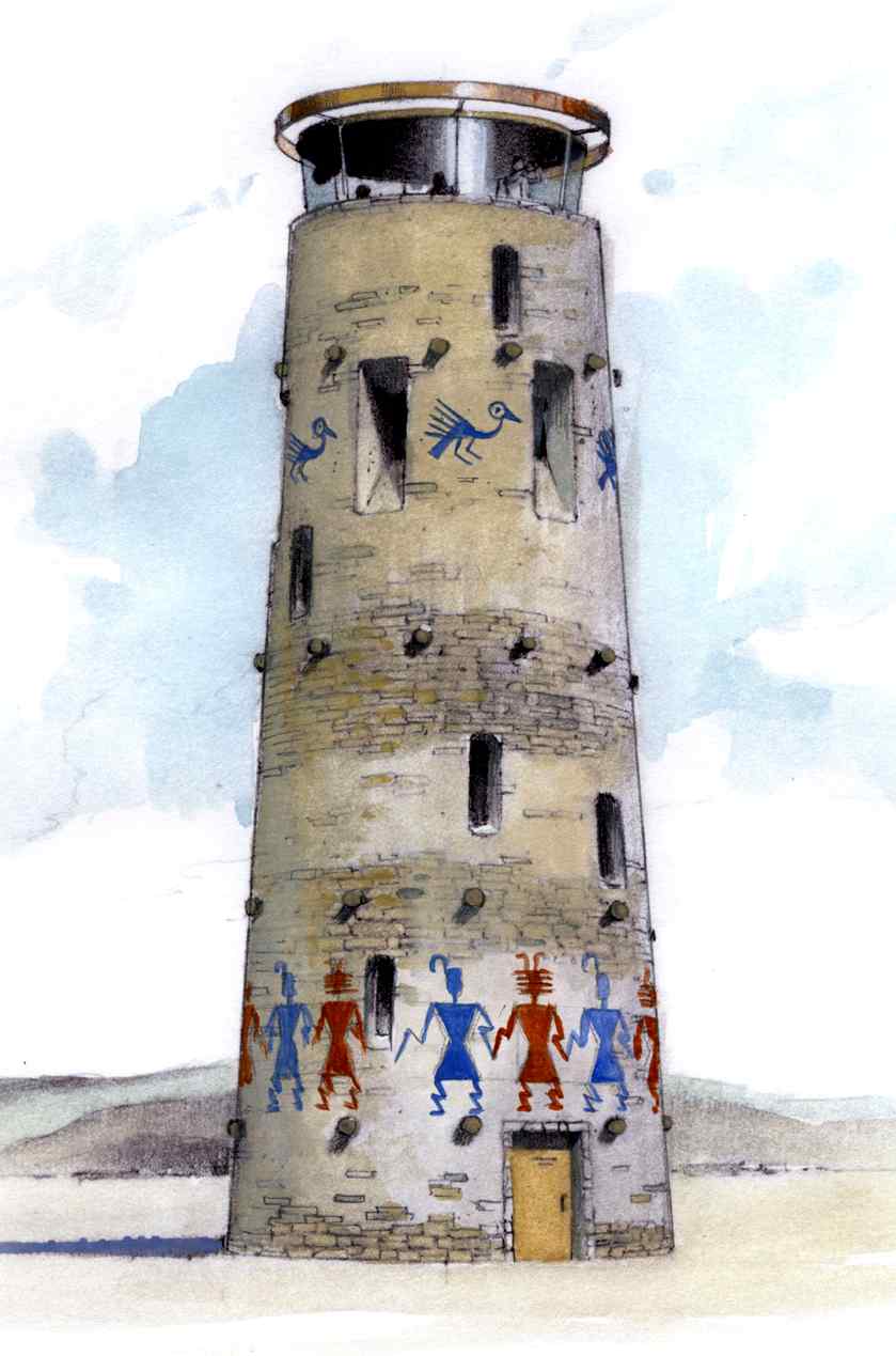
A 2006 artist's conception (courtesy of Luke Graven of North America Building & Development) of the planned tower.
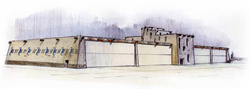
A 2006 artist's conception (courtesy of Luke Graven of North America Building & Development) of the stunning native-style hangars.
A 2007 photo by Ryan Keough looking along a runway (or taxiway?) at Gila River Memorial (enhanced by Bill Grasha),
with several C-130s visible in the background.
Ryan Keough reported in 2007, “Most of the aircraft are being either trucked away
from Chandler Memorial (now known as Gila River Memorial Airport)
as the Gila River Reservation determines what the fate or the airfield will be.
Many of the DC-6s were cut up & scrapped.
The 4 PV-2 Harpoon/Howard 500s that are there are being disassembled or prepped for ferry flights.
The 4 former Biegert Aviation C-54s are in limbo & no one is sure if they will be scrapped or not. They are far from flyable.
A huge collection of H-19 Chicksaw helicopter airframes have been trucked away.
The 2 C-130s owned by International Air Response have been flown to Coolidge to join the others already there.”
A January 2009 aerial view by Doug Wilson looking southwest at Chandler Memorial Airport (enhanced by Bill Grasha).
Doug reported, “It appears there are still at least 5 DC-4 through DC-7 series aircraft, and it looks like maybe 2 Lockheed Lodestars.
Four of the DC series are together, not having moved for some years, and the 5th is near the main hangar.
Three smaller hangars have since been dismantled (lower left in the shot), and it appears all the helicopter remains have been trucked away.
Only the large, main hangar & 2 smaller outbuildings remain.”
A January 2009 aerial view by Doug Wilson looking southwest at the aircraft on the Chandler Memorial Airport ramp (enhanced by Bill Grasha).
Evidently the grandiose “Gila River Airport” redevelopment plans from 3 years ago have not yet come to pass, for reasons unknown.
Frank Gazzano reported in December 2009, “I drove out to the field to see what was going on, it always was an interesting place to scout out.
Almost all the stored / boneyard aircraft are gone & all the hangars except the main one have been demolished.
There is now security on site that politely asks you to leave, they say that no one is flying in or out of Memorial anymore.
It will come back up again in 10–20 years when Phoenix goes through its next boom cycle.
It is in close proximity to several Indian gaming casinos, two of which are trying to cater to high rollers, which of course means jet aircraft.”
The 2014 Phoenix Terminal Aeronautical Chart depicted Gila River Memorial as a private airfield with 2 paved runways.
An 8/19/15 photo by Kevin Rutherford of one of the Lockheed Venturas abandoned at Chandler Memorial Airport.
An 8/19/15 photo by Kevin Rutherford of 2 Lockheed Venturas & a Douglas DC-7 abandoned at Chandler Memorial Airport.
An 8/19/15 photo by Kevin Rutherford of an abandoned hangar at Chandler Memorial Airport.
An 8/19/15 photo by Kevin Rutherford of a collapsed hangar at Chandler Memorial Airport.
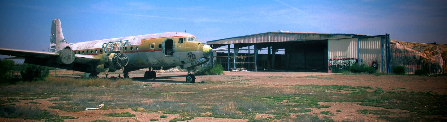
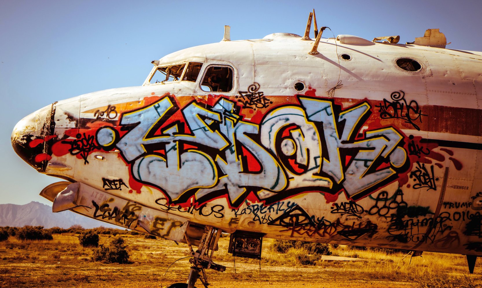
A 4/9/17 photo by Bud Stratford of one of the forlorn Douglas DC-7s sitting in front of a partially collapsed hangar at Chandler Memorial Airport.
Bud reported, “The airfield looks much the same as it has for the last couple of years, minus some recent arson damage that leveled part of a hangar.
The planes are covered in all kinds of graffiti, but continue to decay into the desert landscape.
I found a piece of doped fabric from a DC-4 elevator/rudder/aileron about a quarter mile from the planes, blown far away by the frequent sandstorms that plague the area.
It was a fascinating excursion.”
John Adkins reported of this DC-7, “The aircraft has the remnants (not colors, necessarily) of the DC-7 color scheme used by Delta Air Lines.
It is likely either N4887C or N4889C, which spent a long time sitting at Memorial.”

A 4/9/17 photo by Bud Stratford of a sad sight for anyone who appreciates vintage aircraft:
one of the Douglas DC-7s at Chandler Memorial Airport which Bud reported suffered “recent arson damage that melted the nose off.”
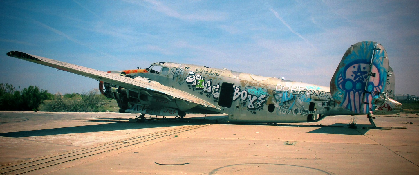
A 4/9/17 photo by Bud Stratford of one of the Lockheed Venturas abandoned at Chandler Memorial Airport.
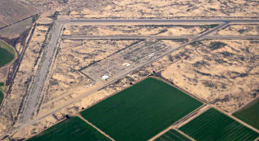
A 2016 aerial view looking north at Chandler Memorial Airport showed 8 vintage 1940s transports still decaying on the ramp.
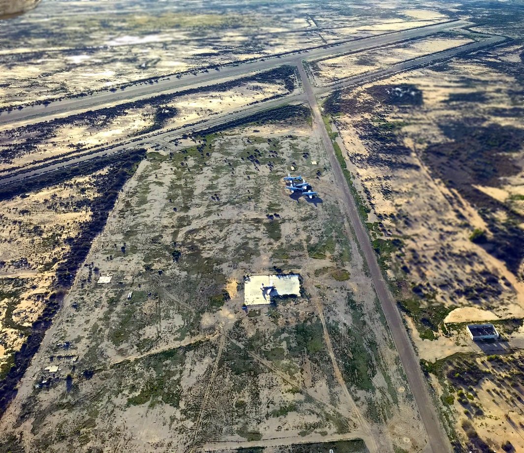
A 3/2/19 aerial view by Tim Gagnon looking west at Chandler Memorial Airport showed 5 vintage 1940s transports still decaying on the ramp.
Tim reported, “The airport is owned by the Gila River Indians…and they are not sure what to do with it.
You have to get a permit to get on the property or pay a fine if caught. I have no idea what they will use it for but the runway looks totally usable”
A 1/27/20 photo by Barret Robinson of a Douglas DC-7 abandoned at Chandler Memorial Airport.

A 1/27/20 photo by Barret Robinson of a forlorn Lockheed Ventura abandoned at Chandler Memorial Airport.
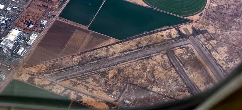
A 12/10/21 aerial view by Kevin Walsh looking southeast at Chandler Memorial Airport showed several 1940s transports still decaying on the ramp.
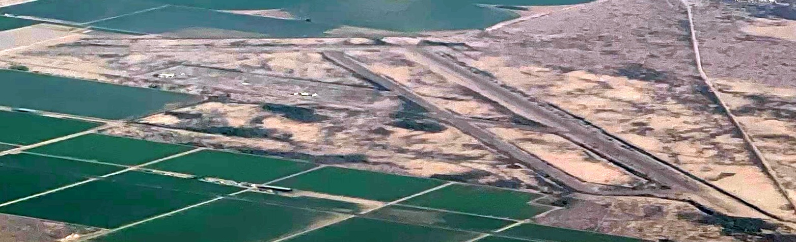
A 7/31/22 aerial view by Kevin Walsh looking southeast at Chandler Memorial Airport.
____________________________________________________
33.345, -111.795 (Southeast of Phoenix, AZ)
Gilbert Airport, as depicted on the March 1947 Phoenix Sectional Chart.
Gilbert Airport was not yet depicted on the August 1946 Phoenix Sectional Chart.
According to an article by Kelly Mixer in the Apache Junction Independent (courtesy of Chris Root),
Gilbert Airport was built in 1946 by Bill Mastin & his brother-in-law, Joseph Wilbur.
It was established “on Everett Wilbur's property, which ran an eighth of a mile west of Gilbert Road to Neely Street,
south to Mesquite Street, and north to Palo Verde Street.
The duo started the Wilbur Flying Service that same year with one training plane. They later purchased more.
Gilbert Airport had a hangar, repair shop, office, pilot lounge & hard-packed dirt runway.”
"We had a 100' wide landing strip that ran east/west because the winds recorded easterly back then," Mastin said.
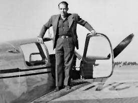
An undated photo (enhanced by Bill Grasha) of Bill Mastin, on top of a Beech Bonanza, possibly at Gilbert Airport.
According to the article in the Independent, “The airport was equipped with a Unicom transceiver
and floodlights were installed to make night operations possible.
When they first opened the airport, the duo taught World War II veterans how to fly
because the Wilbur Flying Service was approved by the state & Veterans Administration for G.I. flight training.
Eventually, they added a charter plane service.”
"A lot of people from Williams AFB also took lessons when they were not serving in active duty," Mastin said.
According to the article in the Independent, “A partial roster of pilots & students who flew at Gilbert Airport
is on display at the Gilbert Historical Museum on the southwest corner of Gilbert & Elliot roads.
Among the notable aviators who learned to fly in Gilbert was Darrel Sawyer, owner & founder of Sawyer Aviation.
In 1947, Sawyer served as vice-president of the newly formed Gilbert Model Airplane Club, called the Gilbert Flying Tigers.
The group regularly met at the Gilbert Airport to fly their homebuilt model airplanes & compete against other model-airplane clubs.”
The depiction which has been located of Gilbert Airport was on the March 1947 Phoenix Sectional Chart.
It depicted Gilbert as a commercial/municipal airport.
According to the article in the Independent, “In 1948, Mastin purchased Joe Wilbur's interest in the business & became sole owner of the Gilbert Airport.
He kept the Wilbur Flying Service name & continued to work there as the airport's flight instructor.
At its peak in the late 1940s, as many as 20 airplanes were based at the field.
Mastin trained hundreds of local pilots.
A lot of people would fly for awhile & then quit because they couldn't afford to buy their own plane," he said.
According to the article in the Independent, “As VA flight training came to an end after the 1940s,
Mastin began to look at other ways to increase his revenue at the airport.
He had worked as a photographer so he added aerial photography to the list of services at the airport.”
The 1949 Phoenix Sectional Chart depicted Gilbert Airport as having a 2,300' unpaved runway.
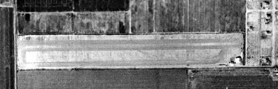
The earliest photo which has been located of the Gilbert Airport was a 2/17/49 aerial view (from the Maricopa County Flood Control District).
It depicted the field as having a single unpaved east/west runway with a parallel taxiway.
A total of 5 single-engine aircraft were parked around a few small buildings on the southeast side of the field.
![]()
A 1952 Chevron road map depicted Gilbert Airport as having an east/west oriented property outline.
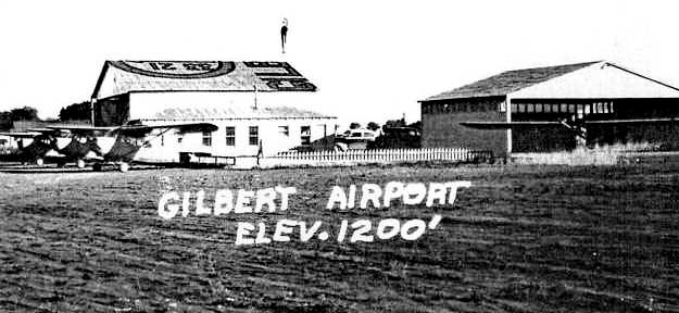
A circa 1950s photo (enhanced by Bill Grasha) showing 4 taildraggers & 2 hangars at Gilbert Airport.
According to the article in the Independent, “By the mid-1950s, crop-dusting had become the principal business at the airfield.”
"That was my main source of income until farmers realized they could do it cheaper themselves by using their tractors," Mastin said.
According to the article in the Independent, “Eventually, the parallel taxiway was widened & used as the runway,
leaving most of the airport property available for cultivation.”
"I farmed the property for awhile but after a lot of hard work, I only managed to break even," Mastin said.

The last aeronautical chart depiction which has been located of Gilbert Airport was on the March 1958 Phoenix Sectional Chart.
It depicted Gilbert as a private airifeld having a 2,300' unpaved runway.
Gilbert Airport was evidently closed at some point in 1958, as it was no longer depicted on the September 1958 Phoenix Sectional Chart.
According to the article in the Independent, “In 1959, the Gilbert Unified School District
announced plans to acquire some of the property for a new high school.
The purchase was completed following approval by the district's voters.
Mastin held on to 2 airport buildings & the runway so he could continue his crop-dusting business.”
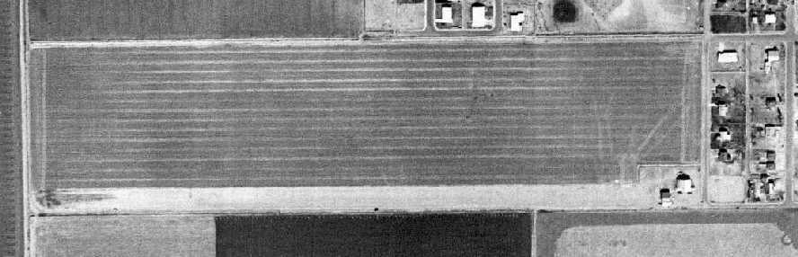
A 2/19/59 aerial view (from the Maricopa County Flood Control District) depicted Gilbert Airport after the majority of the field had been converted back to farmland,
with the former parallel taxiway now being used as the runway.
The decline of the airport was noticeable in contrast to the 1949 photo, with no aircraft were visible on the field.
According to the article in the Independent, Mastin continued his use of the airfield for “his crop-dusting business until around 1962 or 1963.
The main hangar was sold to a cabinet-making business, while the repair shop was sold to the owner of the local Union service station.”
A 12/15/79 aerial view (from the Maricopa County Flood Control District) showed the 2 former hangars still standing on the east side of the property,
which had otherwise been covered with houses & a school.
According to the article in the Independent, “In the early 1990s, the 2 buildings were also purchased by Gilbert Public Schools.
Following an environmental inspection, both were razed.”
A 1993 aerial view (from the Maricopa County Flood Control District) showed the 2 former hangars were indeed gone, erasing the last trace of the former Gilbert Airport.
As can be seen in the 2004 USGS aerial photo, the site of Gilbert Airport is occupied by Mesquite Junior High & other school district facilities, and not a trace appears to remain of the airport.
Chris Root visited the site of Gilbert Airport in 2005, and confirmed that it is occupied by a middle school, with no remaining trace of the airport.
____________________________________________________
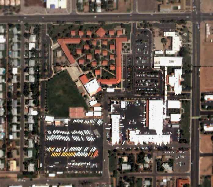
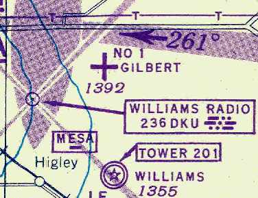
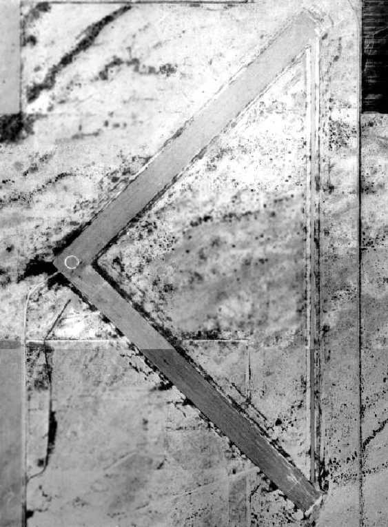
Gilbert Auxiliary Army Airfield #1, Buckhorn, AZ
33.39, -111.67 (North of Williams Gateway Airport, AZ)
The earliest photo which has been located of the Gilbert Aux #1 airfield
was a 6/17/43 aerial view looking west, from the 1945 AAF Airport Directory.
Gilbert Aux #1 was built during WW2 as one of at least 4 satellite airfields for Williams AAF,
which conducted training in twin- & four-engine bombers & single-engine fighters.
Gilbert Aux #1 was evidently constructed at some point between 1942-43,
as it was not yet depicted on a 1937 aerial photo or the September 1942 Phoenix Sectional Chart.
The earliest photo which has been located of the Gilbert Aux #1 airfield
was a 6/17/43 aerial view from the 1945 AAF Airport Directory.
It depicted the field as having 2 paved runways connected by a taxiway.

The earliest aeronautical chart depiction which has been located of the Gilbert Aux #1 airfield
was on the February 1943 Phoenix Sectional Chart (courtesy of Chris Kennedy).
It depicted Gilbert Aux #1 as an unlabeled auxiliary airfield (the cross in the center)
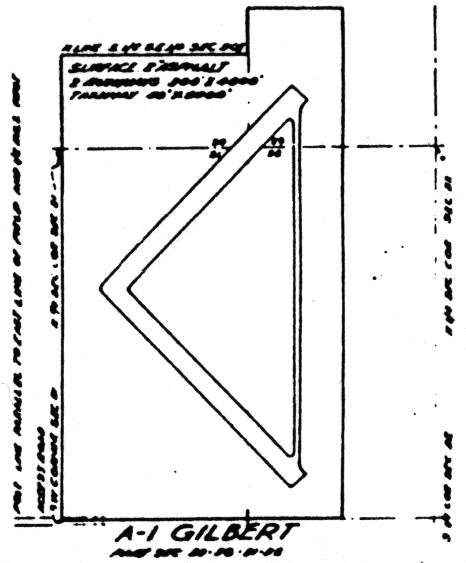
According to the 1944 airfield layout (from a 1944 USAAF map of Williams AAF & its satellite airfields, courtesy of John Voss),
“Gilbert A-1” had two 4,000' paved runways & a connecting taxiway on the east side.
"#1 Gilbert" was depicted as an auxiliary airfield on the March 1945 Phoenix Sectional Chart (courtesy of Chris Kennedy).
The 1945 AAF Airfield Directory (courtesy of Scott Murdock) described “Williams Field Auxiliary #1 (Gilbert Field)”
as having 2 paved 4,000' runways, oriented northeast/southwest & northwest/southeast.
The field was described as not having any hangars, and to be operated by the Army Air Forces.
The 1947 Gila River World Aeronautical Chart depicted Gilbert AF as having a 4,000' paved runway.
A directory of AZ Airports in the 5/47 issue of Arizona Highways (courtesy of George Miller) described Gilbert AF as being unattended, and the longest runway as being 4,000'.
A 2/18/49 aerial view (from the Maricopa County Flood Control District) depicted Williams Aux #1 as having 2 paved runway connected by a taxiway on the east side.
A circular marking was present at the runway intersection. There did not appear to have been any ramps or buildings associated with the airfield.

The last aeronautical chart depiction which has been located of Gilbert Aux #1 was on the March 1956 Phoenix Sectional Chart.
It depicted Gilbert AF as having a 4,000' paved runway.
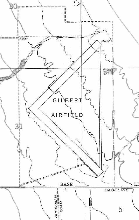
The 1956 USGS topo map (from the ASU Library, courtesy of Adam DeLand) depicted the “Gilbert Airfield” as having 2 paved runways & a connecting taxiway.
No structures appeared to be associated with the airfield.
Gilbert Aux #1 was evidently closed at some point between 1956-57,
as it was no longer depicted on the May 1957 Phoenix Sectional Chart.
In a 1958 aerial view (courtesy of John Arthur), the Williams Aux #1 airfield was still depicted as completely intact,
with the surrounding area still devoid of development.
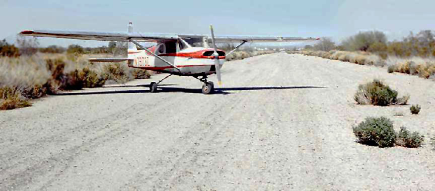
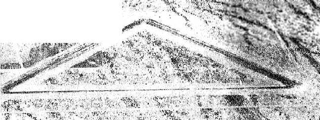
A photo by Dan Lawler (enhanced by Bill Grasha) of Cessna 150 N7973Z on the Gilbert Aux strip in the Summer of 1966.
Dan recalled, “I routinely took student pilots there from Falcon Field or Sky Harbor Airport to practice landings.
The northeast/southwest runway was the best preserved, though they were both usable then.
I think this picture was taken looking north on the connecting taxiway,
which I occasionally used for touch & goes as a challenge to more advanced students.
What was great for the student was the absence of other air traffic at the strip.
While the picture does not show the strip itself to very good advantage,
it does show vegetation beginning to get a foothold through the deteriorating asphalt.”
A 1970 aerial view (courtesy of John Arthur) showed that most of the former Williams Aux #1 airfield had been covered by development,
with only the western halves of the 2 runways still remaining recognizable.
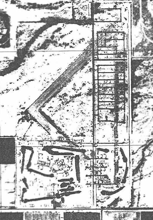
A 1971 aerial photo (from the ASU Library, courtesy of Adam DeLand)
showed that the southernmost part of the airfield had fallen victim to redevelopment by a trailer park & golf course.
A network of streets from a trailer park development covered the taxiway & the eastern edge of both runways.
However, a majority of the northeast/southwest runway remained intact,
along with a smaller portion of the northwest/southeast runway.
The 1982 USGS topo map did not depict any trace of Gilbert Airfield,
but rather showed a trailer park & golf course occupying the southern part of the property.
A 1992 USGS aerial view showed the outline of a Gilbert Aux #1 northeast/southwest runway was still barely perceptible in the northeastern portion.
An 11/5/05 aerial view annotated by Chris Kennedy to show the outline of the former Gilbert Aux #1 runways.
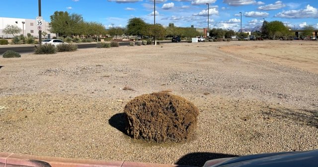
A 2006 photo by Derek Hofmann looking southwest along the remains of the former runway of Gilbert Aux AAF #1.
Derek reported, “The runway is covered by half an inch of dirt,
no doubt from the many dust storms that have blown through the area over the years.
The only way you can tell from sight alone that there was ever a runway is by inspecting the plant growth pattern.
Only weeds seem to grow in the dirt over the runway, and in patterns indicative of cracks in the asphalt.
The area isn't yet completely developed.”
An 11/17/07 aerial view (from the Maricopa County Flood Control District)
showed that only a very short section of the former northeast/southwest runway remained faintly recognizable,
with the remainder of the property having been built over.
A 12/31/20 photo by Kevin Walsh looking northeast at the last vestige of the Gilbert Aux AAF #1 airfield pavement, along the curve of Hampton east of Power Road.
The site of Gilbert Aux AAF #1 is located southwest of the intersection of East Southern Avenue & South Sossaman Road.
____________________________________________________
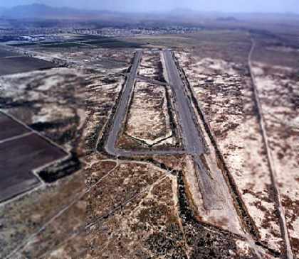
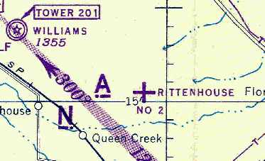
Rittenhouse Field / Williams Field Auxiliary #2 / Rittenhouse Air Force Auxiliary Field /
Rittenhouse Army Heliport (AZ38), Queen Creek, AZ
33.255, -111.523 (E of Williams AFB, AZ)
The earliest photo which has been located of the Rittenhouse airfield was a 6/17/43 aerial view looking west
from the 1945 AAF Airfield Directory (courtesy of Scott Murdock).
Nothing was depicted at this location on a 1937 aerial photo.
Rittenhouse Field was built during WW2 as one of 5 satellite airfields for Williams AAF,
which conducted training in twin & four engine bombers & single engine fighters.
Rittenhouse Field was named for land developer Charles Rittenhouse.
The earliest photo which has been located of Rittenhouse Field was a 6/17/43 aerial view from the 1945 AAF Airfield Directory (courtesy of Scott Murdock).
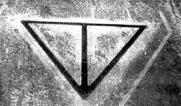
It depicted the field as having a set of 4 paved runways arranged in a triangle.
Rittenhouse Field was not yet depicted on the March 1944 Pheonix Sectional Chart.
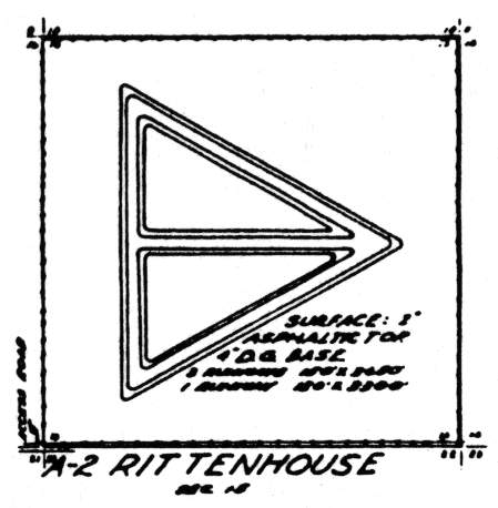
The WW2-era airfield layout of Rittenhouse Field
from a 1944 USAAF map of Williams AAF & its satellite airfields (courtesy of John Voss).
The earliest aeronautical chart depiction which has been located of Rittenhouse Field
was on the March 1945 Phoenix Sectional Chart (courtesy of Chris Kennedy).
The 1945 AAF Airfield Directory (courtesy of Scott Murdock) described “Williams Field Auxiliary #2 (Rittenhouse Field)”
as having four asphalt' runways, the longest being the 3,650' north/south, northeast/southwest, and northwest/southeast strips.
The field was described as not having any hangars, and to be operated by the Army Air Forces.
The 1947 Gila River World Aeronautical Chart depicted Rittenhouse AF as having a 3,700' paved runway.
Rittenhouse was listed in a directory of AZ Airports in the 5/47 issue of Arizona Highways (courtesy of George Miller),
which described it as being unattended, and the longest runway as being 4,000'.
"Rittenhouse AF" was depicted as an active airfield on the 1956 Phoenix Sectional chart (courtesy of John Voss),
by which point the primary runway had been lengthened to 5,100'.
Rittenhouse was still depicted as an active airfield on the 1966 Phoenix Local aeronautical chart (courtesy of John Voss).
Apparently, at some point after 1966 the northwest/southeast runway was further lengthened to 6,200'.
This may indicate that Rittenhouse was used after WW2 to operate bombers or jet aircraft.
The Rittenhouse airfield was apparently abandoned at some point between 1966-69.
Wesley Stephens recalled, “I used to live in Chandler & graduated from Chandler High School in 1969.
I had several jobs from 1969-71. During that time, like so many other young men, I was into hot-rodding.
Rittenhouse was where we would go & race on Friday & Saturday nights.
There would be drinking & the occasional scuffle but it was pretty good fun.
The local Sherrifs would usually let it go until about 11:00 pm then they would send in 2 or 3 patrols with lights & sirens to run us out.
I guess they figured it was better for us to be out there than on the public streets endangering others than ourselves.”
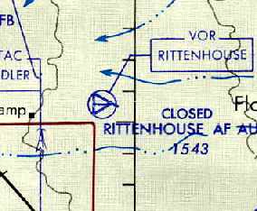
Rittenhouse was labeled "closed" on the August 1971 USAF Tactical Pilotage Chart (courtesy of Chris Kennedy).
However the VOR navigational transmitter on the field continued to be depicted as operational.

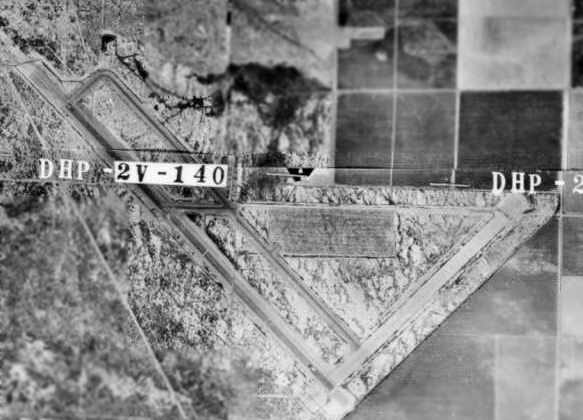
A 1971 USGS aerial photo of "Rittenhouse Air Force Auxiliary Field" (courtesy of Jonathan Westerling),
depicted the field as having 4 paved runways, one of which had been extended.
Note also the series of dirt runways adjacent to the north side of the paved runways.
Don Davis recalled, “They stopped landings & touch & goes at Rittenhouse in 1971.
I arrived at Williams AFB in March of 1976 as a ground radio repairman.
They were in the process of beginning the shutdown of the RapCon at Rittenhouse when I arrived.
They continued to use the airfield for low-approach / navaids training well into 1976.”
John Greland recalled, “I was stationed at Williams AFB from 1974-77 as an Air Traffic Controller assigned to the 1922nd Communications Squadron.
One week out of every month we would be assigned to Rittenhouse & run Ground Controlled Approaches for the student pilots flying T-38s.
We’d drive out from Williams AFB & work a day shift there.
I remember an abandoned building there that was probably an operations building that had curtains on the windows
and on the curtains was written dates that were probably when someone soloed.”
Glenn Annis recalled, “I was stationed at Williams AFB from 1980-84, first as a student then as an instructor & life support officer.
The crossing series of runways at Rittenhouse Field north of the main complex were utilized for parasail training for the incoming undergraduate pilot training students.
They were aligned this way so that the parasails could always be launched into the wind.”
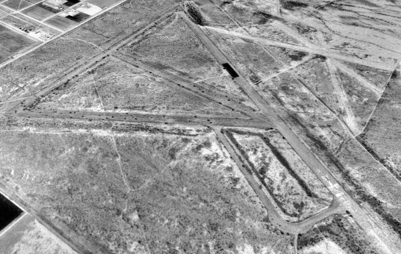
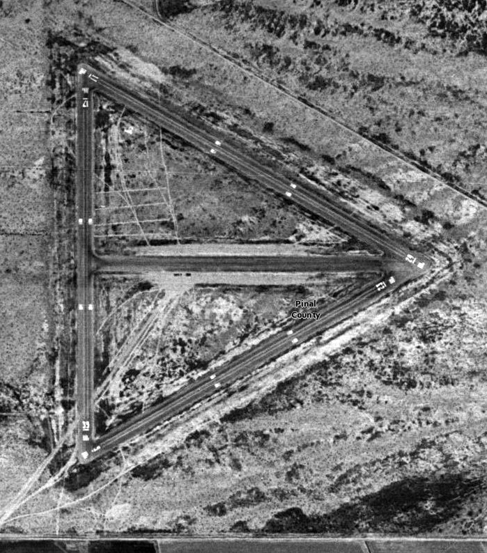
A 1994 USGS aerial view looking northwest at Rittenhouse Field showed the outline of the former paved runways remained quite distinctive, along with the shorter unpaved runways on the north side of the airfield.
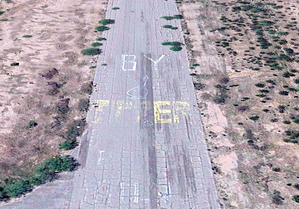
Note the Playboy bunny which had been painted on the southeast end of the primary runway.

A 1997 street atlas (courtesy of Kevin Walsh) depicted “Rittenhouse Auxiliary Airfield” as having 4 paved runways.
The old Rittenhouse airfield got a new lease on life in 1999, when the Rittenhouse Army Heliport (AZ38) was once again listed with the FAA as an active military facility,
under the control of the Arizona Army National Guard.
The only listed runway was a 1,500' asphalt section of Runway 12/30, which is described as having "potholes & loose gravel on runway".
As of 2003, the Rittenhouse airfield was occasionally still used for training
by the Arizona Army National Guard helicopter crews from Papago Army Airfield in Phoenix.

A 3/24/09 photo of external load operations of a Sikorsky UH-60 Blackhawk
of the Arizona Army National Guard's C Co, 1/189th CSB at Rittenhouse Field.
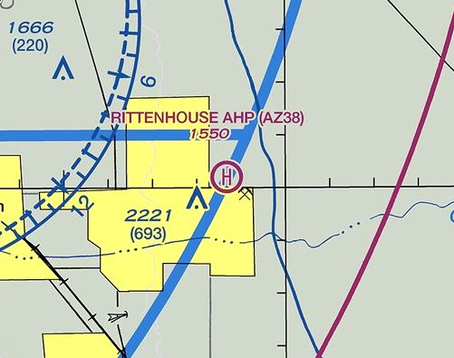
The 2014 Phoenix Terminal Aeronautical Chart depicted Rittenhouse Army Heliport.
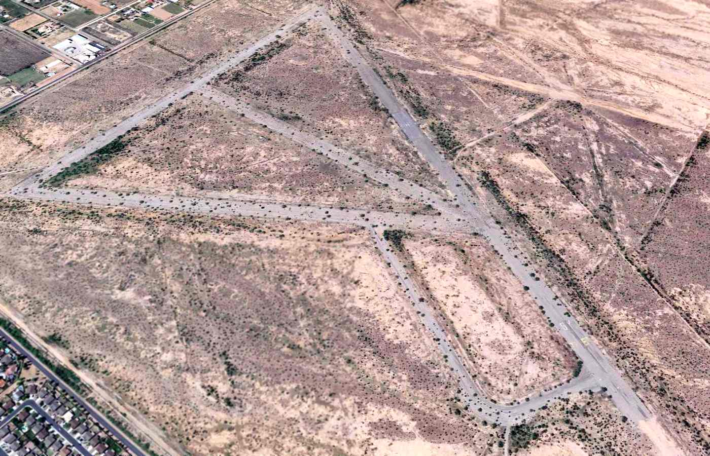
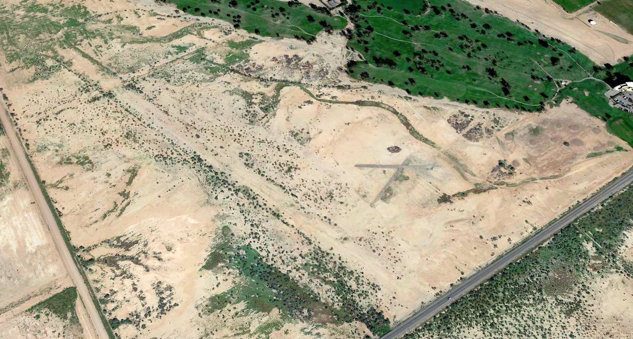
A 2015 aerial view looking northwest at Rittenhouse Field showed the outline of the former paved runways remained quite distinctive,
along with the shorter unpaved runways on the north side of the airfield.
A 2015 aerial view looking northwest along the remains of Rittenhouse's primary runway,
showing the Playboy bunny which had been painted on the southeast end of the primary runway.
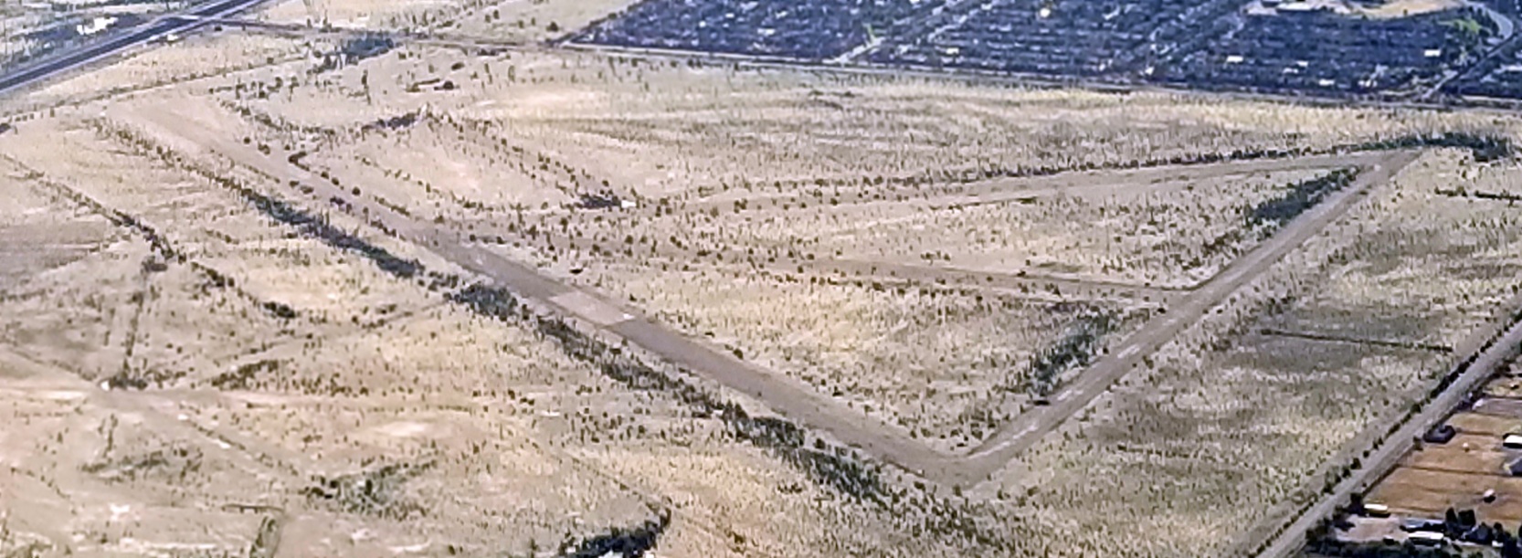
A 12/26/19 aerial view by Doug Landers looking southeast at Rittenhouse Field showed the outline of the former paved runways remained quite distinctive,
along with the shorter unpaved runways on the north side of the airfield.
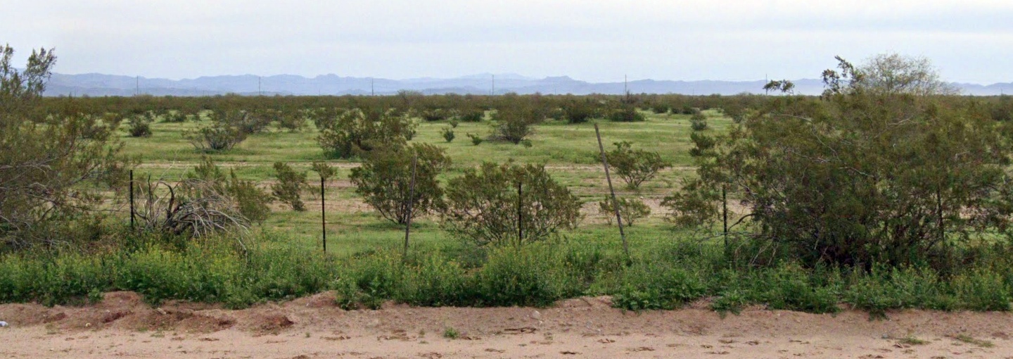
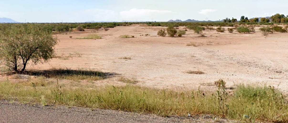
A 2023 photo looking east at Rittenhouse Field showed no trace of the runways from ground-level.
____________________________________________________
____________________________________________________
This site covers airfields in all 50 states.