Abandoned & Little-Known Airfields:
Western Arizona
© 2002, © 2025 by Paul Freeman. Revised 9/5/25.
This site covers airfields in all 50 states: Click here for the site's main menu.
____________________________________________________
Please consider a financial contribution to support the continued growth & operation of this site.
American Airways Field / Salome CAA Site 27B (revised 2/28/25) - Conner Field / Quartzsite Airport (revised 2/28/25) - Echeverria Field / Wickenburg Airport / Forepaugh Airport (revised 9/5/25)
Lake Havasu Aux AAF #6 (revised 11/11/23) - Salome Airport (revised 2/28/25) - Signal Aux AAF #7 (revised 2/28/25) - Tonopah Intermediate Field (revised 5/10/24)
Topock Aux AAF #5 (revised 5/10/24) - Yucca AAF / Ford Motor Proving Ground Airfield (revised 2/28/25)
____________________________________________________
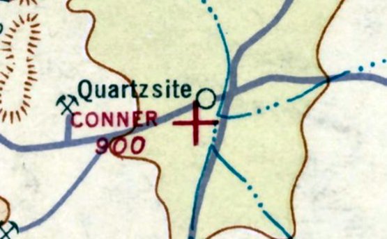
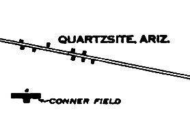
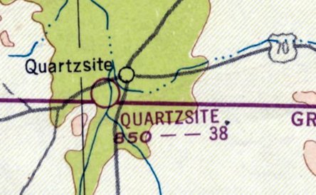
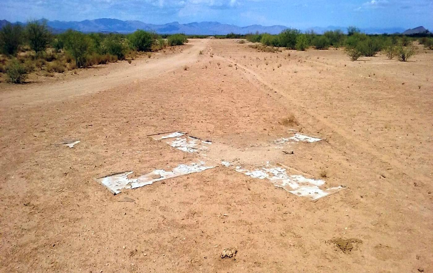
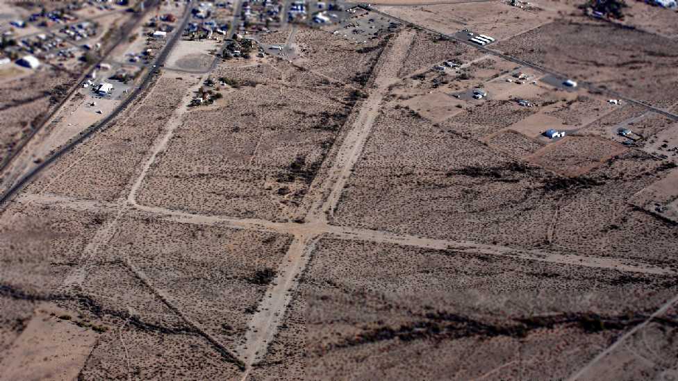
Conner Field / Quartzsite Airport, Quartzsite, AZ
33.659, -114.236 (West of Phoenix, AZ)
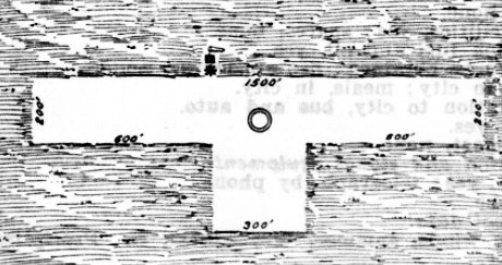
Conner Field, as depicted on the 1/31/28 Commerce Department Airway Bulletin (courtesy of Rick Jackson).
Rick Jackson reported, “Buck Conner was an early film actor who built a home in Quartzsite prior to WW1.
An article said he was one of the first people in the area (or possibly AZ) to get a pilot’s license & needed somewhere to fly out of, so he built himself an airfield & named it Conner Field.”
The earliest depiction which has been located of Conner Field was on the 1/31/28 Commerce Department Airway Bulletin (courtesy of Rick Jackson).
It described Conner Field as an auxiliary airfield owned & operated by George Conner.
It was said to consist of an 18 acre T-shaped sand/gravel/loam field having a 1,500' east/west runway.
The earliest aeronautical chart depiction which has been located of Conner Field was on the November 1934 Sectional Chart (courtesy of Rick Jackson).,
which depicted Conner Field as an auxiliary airfield.
The November 1934 Sectional Chart (courtesy of Rick Jackson) depicted Conner Field as having a single east/west runway.
Conner Field was listed in the 1938 & 1939 "Descriptions of Airports and Landing Fields in the U.S" (according to Rick Jackson).
The February 1939 Sectional Chart (according to Rick Jackson) continued to depict Conner Field as an auxiliary airfield.
The August 1940 Sectional Chart (according to Rick Jackson) depicted Conner Field as a commercial/municipal airport.
Rick Jackson reported, “At the outbreak of WW2, general aviation flying was restricted to 150 miles inland of the West Coast.
Because of this, Conner Field was now one of the places you were still able to fly.
Flying & pilot training increased at the airfield with pilots keeping up their hours & students looking to get their licenses.
Later, the Army contracted with Buck to use his airfield in training women to get their pilot’s license to become future Women Air Force Service Pilots.
The WASP program gave some 1,100 civilian women noncombat military flight duties during World War 2, such as transporting military aircraft, towing targets & cargo transport.”
David S. reported, “I spent a few weeks visiting Quartzsite. I was able to get ahold of Mayor Oldham, the first Mayor of Quartzsite, and he talked about his childhood memories of his mom doing the hair of the women at the field.
Oldham's mom wrote a book in which she talks about this & claims the women were WASPs.
It turns out the WASPs never trained at that field in 1942 as claimed. The WASPs didn't even form until 1943.
It was determined the women who trained at Connor were looking to meet the requirements to volunteer for training with Nancy Loves' girls.
At the time civilian flight was restricted 125 miles from the coast, so Snook & others relocated to Connor Field to train the women looking to join Loves' Ferry Group & pilots for the Army.”
Bill Pinney reported, in the book “Fly Fast...Sin Boldly”, Bill Lear Jr described “learning to fly at Conners Field in Quartzsite. He described it as being owned by 'Pop' Conners.”
The earliest photo which has been located of Conner Field was a circa 1940s aerial view looking south from a Buck Conner Christmas card (courtesy of Rick Jackson).
It depicted Conner Field as having 3 unpaved runways.
Conner Field continued to be depicted as a commercial/municipal airport through the August 1945 Sectional Chart (according to Rick Jackson) .
Rick Jackson reported, “After the war, flying from Conner dropped off & the airfield was downgraded.”
The February 1946 through February 1947 Sectional Charts (according to Rick Jackson) once again depicted Conner Field as an auxiliary airfield.
Conner Field was evidently renamed Quartzsite Airport in 1947, as is how it was depicted on the August 1947 Sectional Chart (according to Rick Jackson),
with a 3,800' unpaved runway.
Quartzsite Airport continued to be depicted through the March 1958 Sectional Chart (according to Rick Jackson).
Quartzsite Airport was evidently abandoned in 1958, as it was no longer depicted on the October 1958 through September 1960 Sectional Charts (according to Rick Jackson).
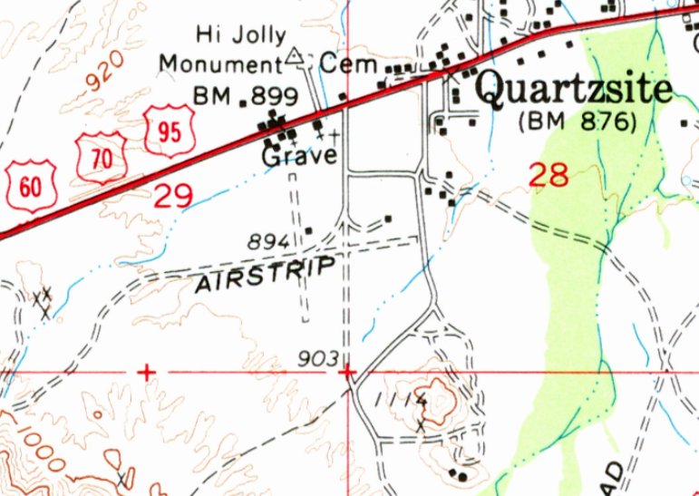
The 1962 USGS topo map depicted Quartzsite Airport as a generically labeled “Airstrip” having 2 unpaved runways.
Quartzsite Airport was evidently reopened at some point between 1960-65,
as it was once again depicted on the March 1965 Sectional Chart (according to Rick Jackson) with a 3,800' unpaved runway.
Quartzsite Airport continued to be depicted through the March 1969 Sectional Chart (according to Rick Jackson).
Quartzsite Airport was evidently abandoned (again) at some point between 1969-71, as it was no longer depicted on the June 1971 Phoenix Sectional Chart (courtesy of Ron Plante).
Quartzsite Airport was no longer depicted on the 1990 USGS topo map.
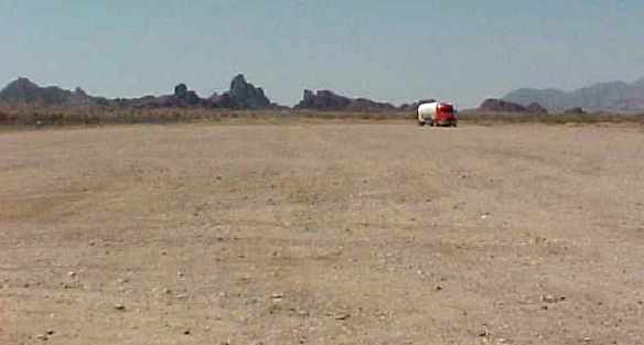
Michael Pfleger recalled, “Conner Airfield... I remember seeing airplanes at that site when I would drive by in approximately 1999.”
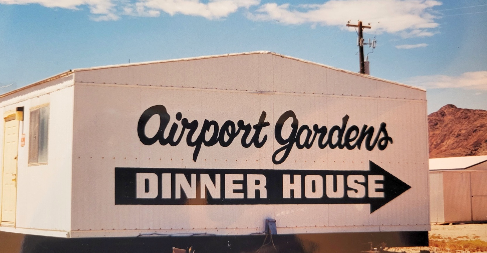
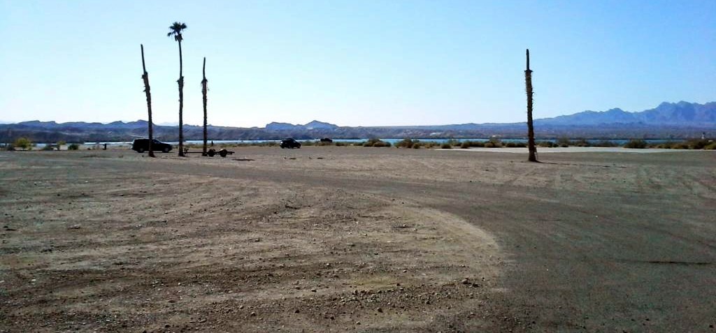
A 1999 photo by Rick Jackson of a sign for the Airport Gardens Dinner House at the site of Quartzsite Airport.
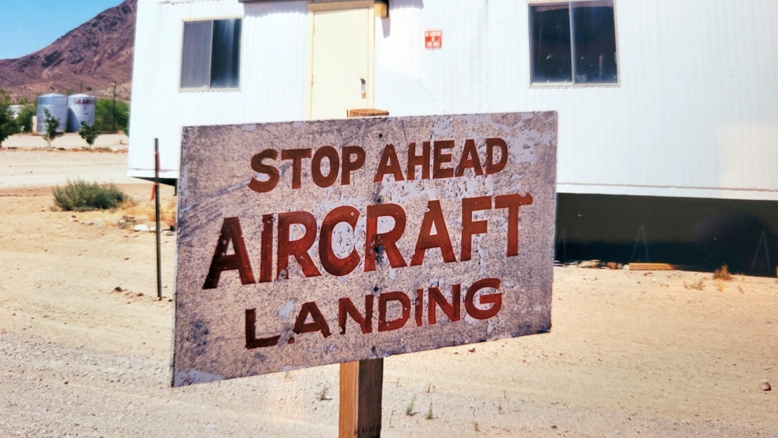
A 1999 photo by Rick Jackson of a sign in front of one of the former Quartzsite Airport runways.
A 1999 photo by Rick Jackson of the Airport Gardens Dinner House at the site of Quartzsite Airport.
Rick reported, “I'm not sure if this was Conner's home or a building built on the field, but it was turned into a restaurant.”
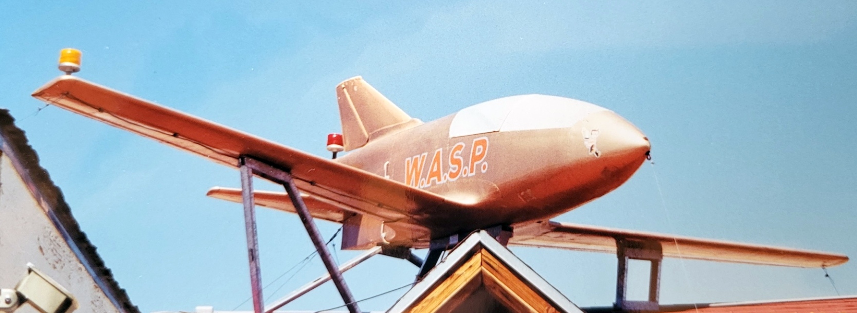
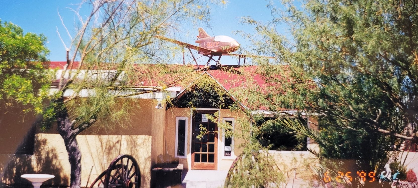
A 1999 photo by Rick Jackson of a Bede BD-5 mounted on top of the Airport Gardens Dinner House at the site of Quartzsite Airport.
The BD-5 was marked commemorating the WASPs who had trained at Conner Field / Quartzsite Airport in WW2.
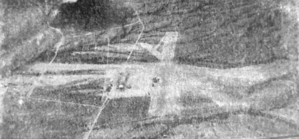
A June 2005 aerial view (courtesy of Rick Jackson) showing at least 3 aircraft on the site of Quartzsite Airport, including the Bede BD-5 mounted on top of the Airport Gardens Dinner House.
Rick Jackson reported, “There was always a lot of aircraft & parts laying around there.”
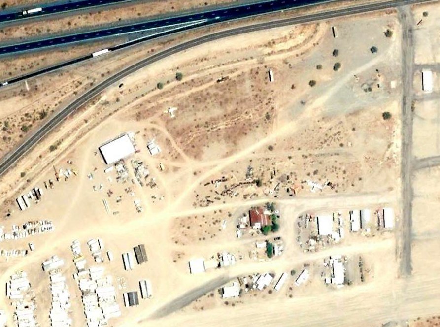
A June 2007 aerial photo appears to show all the aircraft removed from the Quartzsite Airport site, but the former Airport Gardens Dinner House remained standing.
Rick Jackson noted that the former Airport Gardens Dinner House at the site of Quartzsite Airport was removed at some point between 9/2010 – 6/2012.
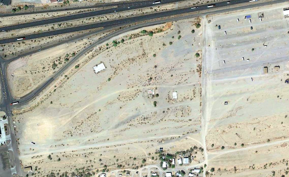
A 2020 aerial view showed the foundation of the former Airport Gardens Dinner House is all that remains at the site of Quartzsite Airport.

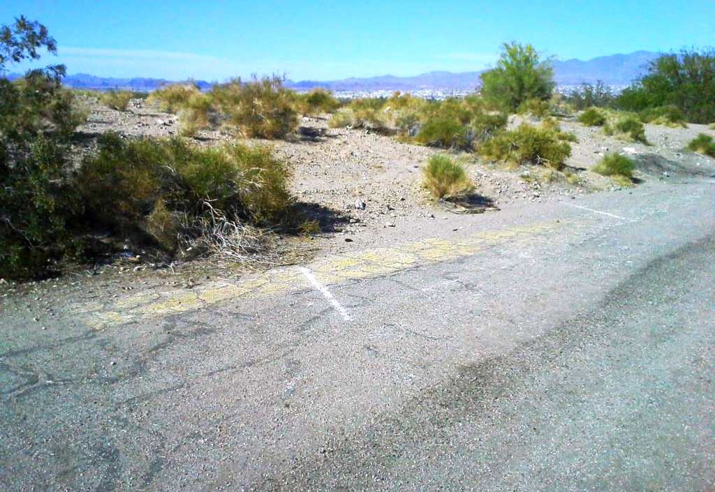
A 12/25/24 photo by David S. at the Conner Field site. David reported, “That large concrete slab was the location of the restaurant. Oldham still has the little 'WASP' jet at his compound across the street.”

A 12/30/24 photo by David S. of the Conner Field site.
…...................................................................................................
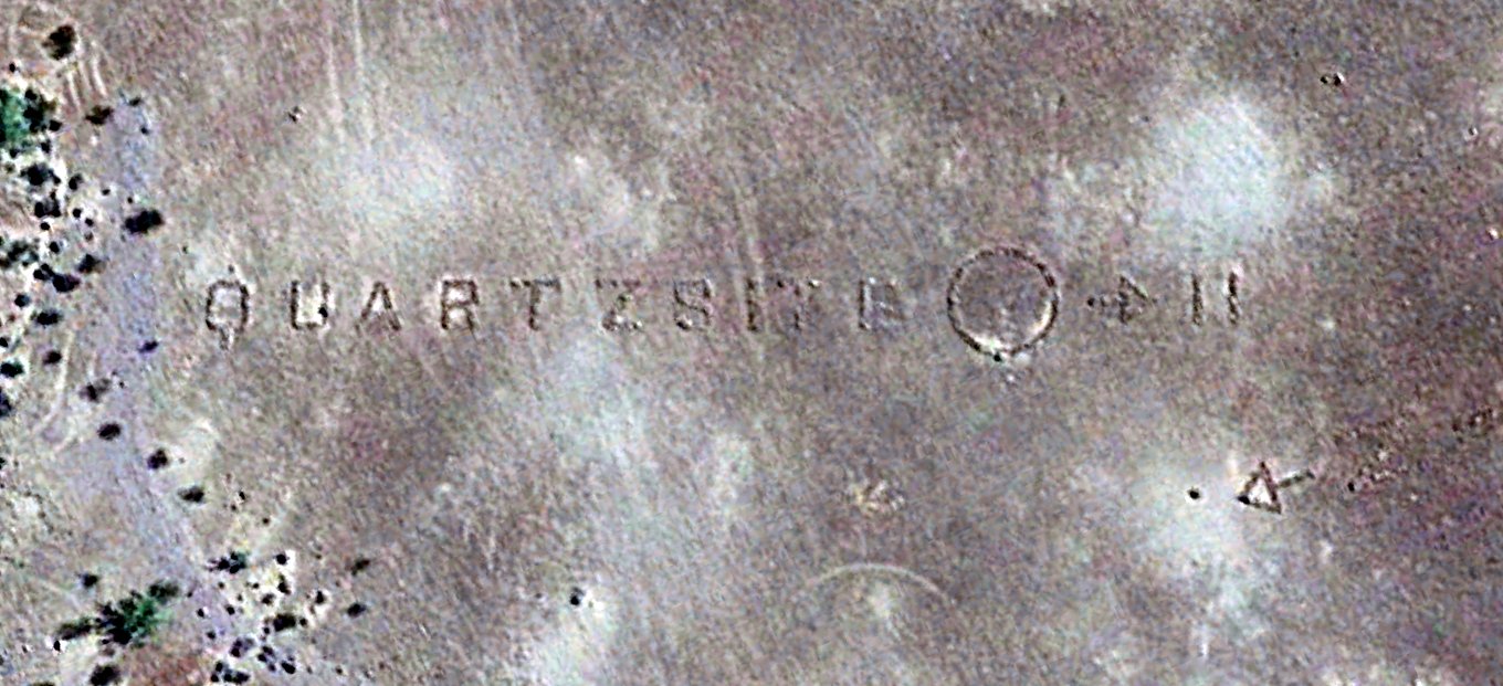
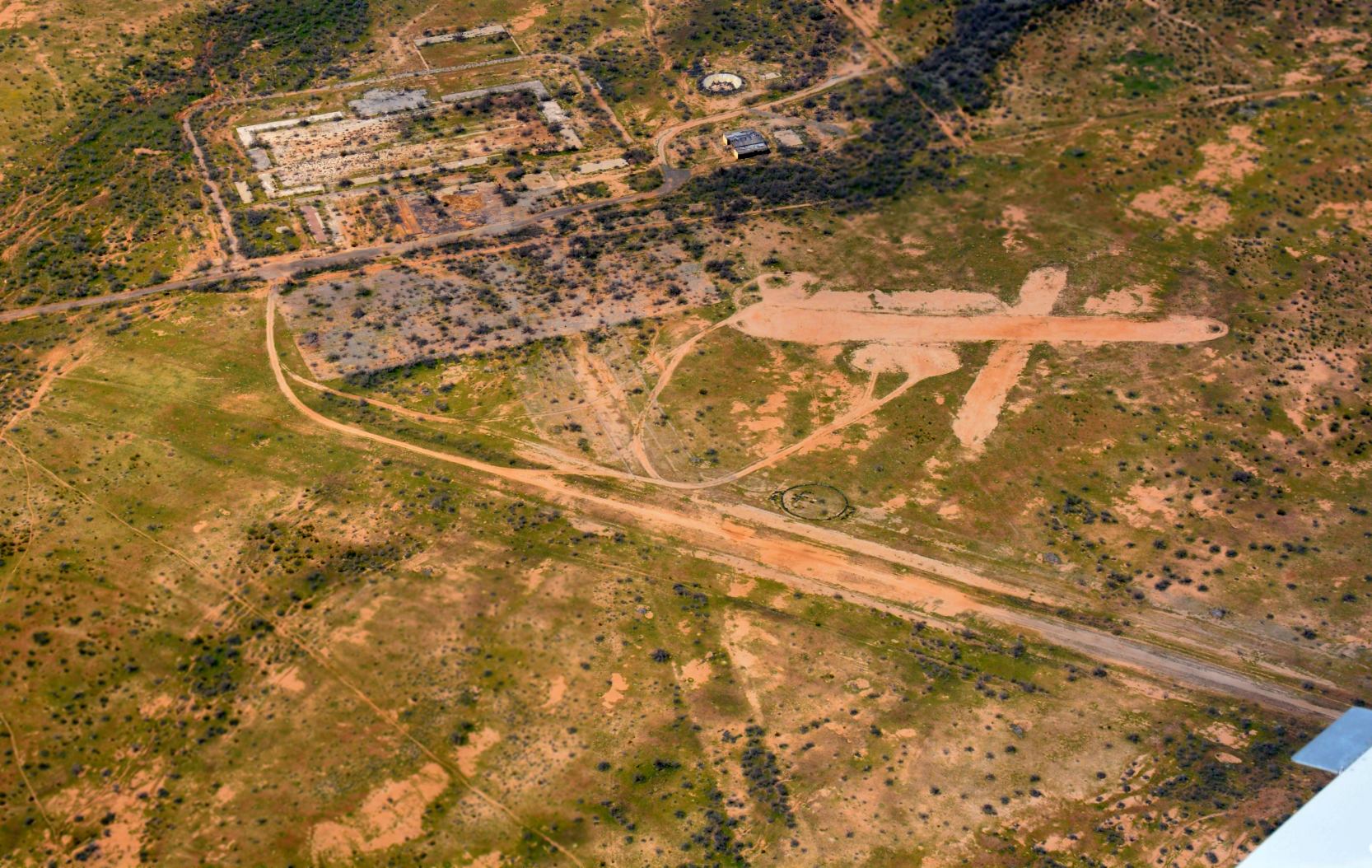
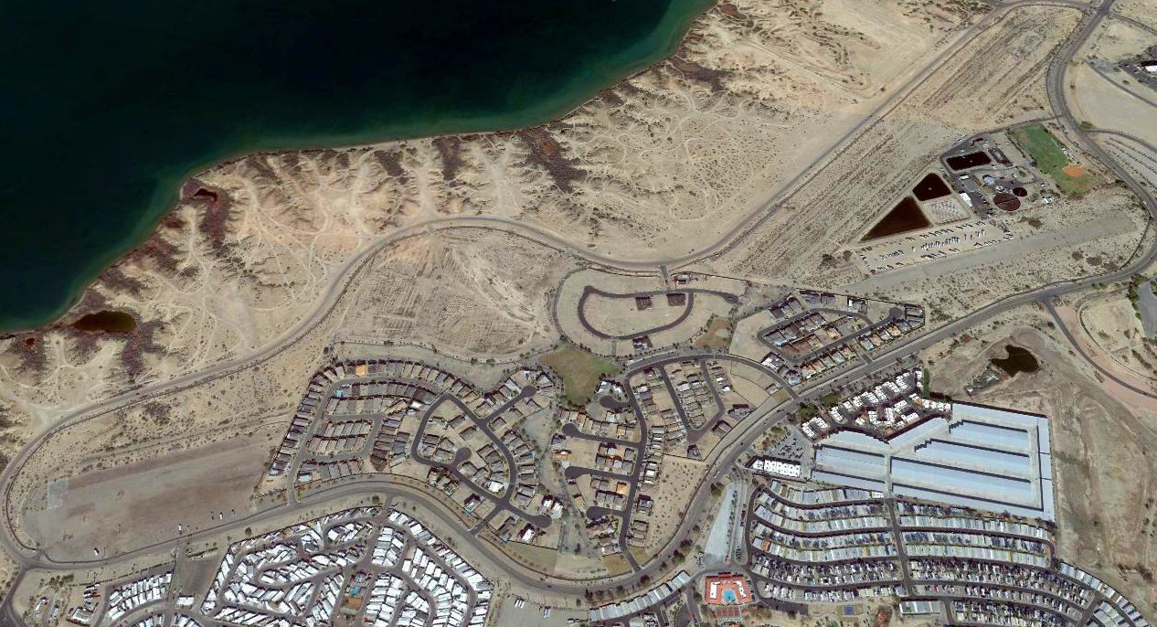
A 2015 aerial view of the “Quartzsite” compass rose which is carved into the desert 11 NM northeast of the Quartzsite Airport site, at 33.78, -114.114.
Michael Pfleger reported, “I was told it was to help the WASPs practicing in that area find their way back to Conner.”
On current road maps it is labeled as “Quartzsite Rock Alignment."
____________________________________________________
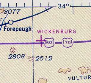
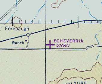
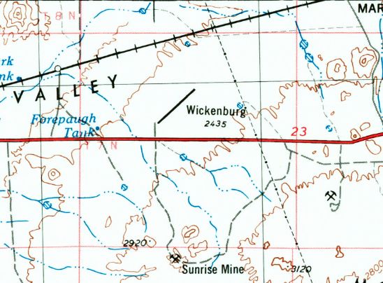
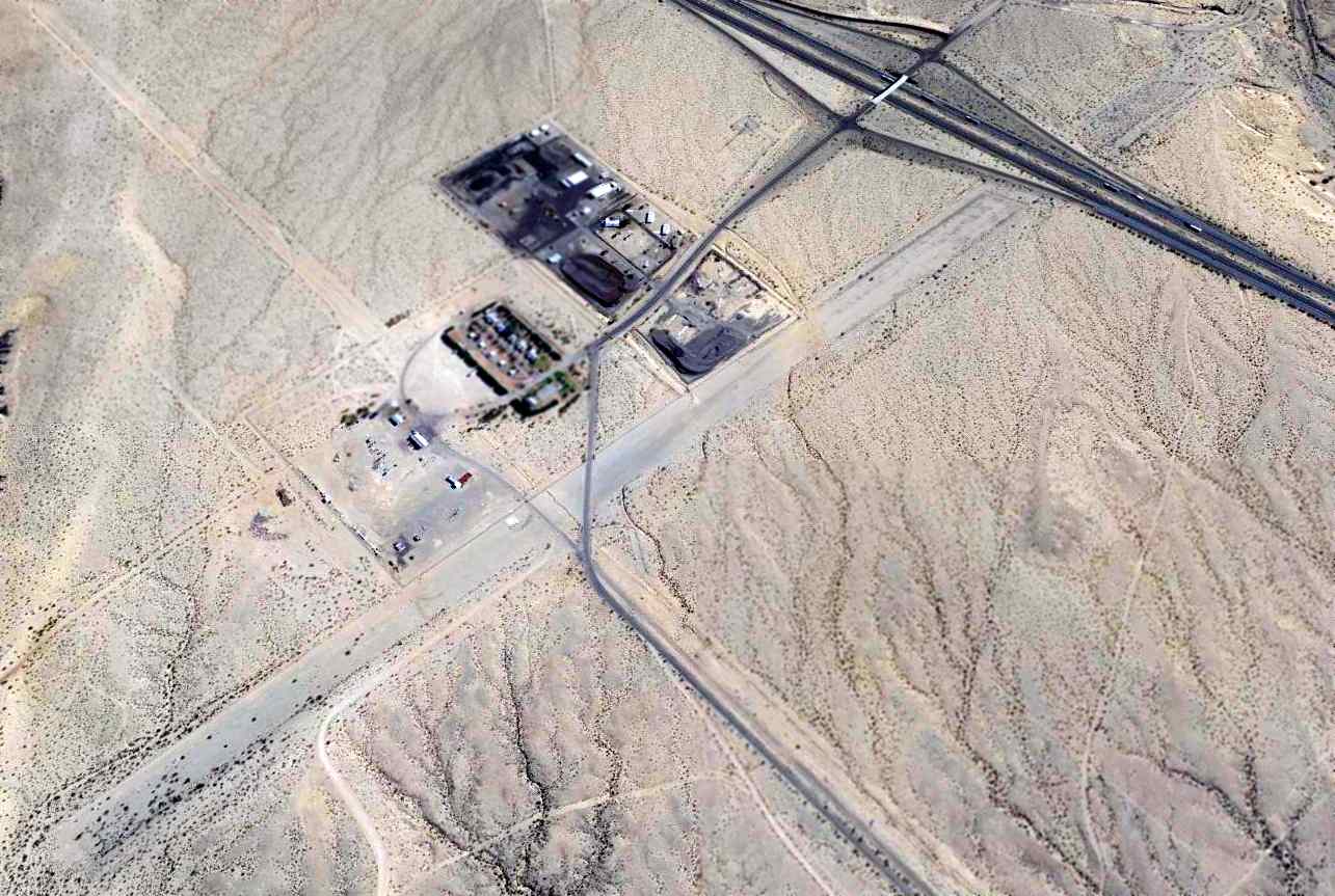
Echeverria Field / Wickenburg Airport / Forepaugh Airport (44E), Wickenburg, AZ
33.95, -113 (Northwest of Phoenix, AZ)

A 9/15/42 photo of USAAF CTD Class 42-21B Flight C-2 at Wickenburg Field (courtesy of Richard Warner).
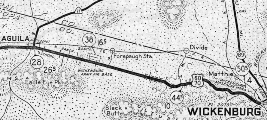
This small airfield between the towns of Forepaugh & Wickenburg has gone through a somewhat confusing succession of names through the years.
Wickenburg Airfield was not yet depicted on the September 1942 Phoenix Sectional Chart.
Echeverria Field started out in 1940 as a AAF contract glider pilot school during WW2,
operated by the Arizona Gliding Academy & the Claiborne Flight Academy.
According to the book "Best Place in the Country" by Mike Hoza & Steve Hoza,
the Claiborne Flight Academy was owned by Harry Claiborne, and began training pilots in 1942.
According to Brian Rehwinkel, the Claiborne Flight Academy had an auxiliary field used for to support flight training operations,
located approximately 10 miles west of the parent field, near Aguila, AZ [of which no trace apparently remains].
The earliest photo which has been located of Wickenburg Field was a 9/15/42 photo of USAAF CTD Class 42-21B Flight C-2 (courtesy of Richard Warner).
Richard Warner reported that the photo showed his “uncle, Homer Andrews, [who] eventually served as a B-17 copilot in the 388th Bomb Group Knettishall England on 35 combat bombing missions.”
The earliest aeronautical chart depiction which has been located of Wickenburg was on the February 1943 Phoenix Sectional Chart (courtesy of Chris Kennedy), which depicted "Wickenburg" as an auxiliary airfield.
To confuse matters somewhat, the separate "(Municipal) Wickenburg" Airport was also depicted several miles to the east, adjacent to the northwest side of the town of Wickenburg.
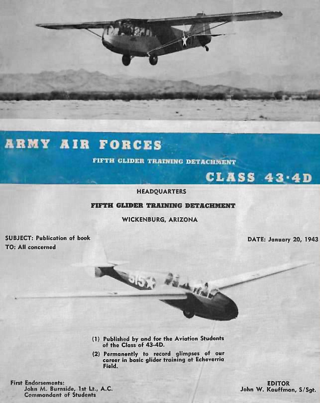
The cover & 1st page from the 1/20/43 Class 43-4D yearbook from Wickenburg's Fifth Glider Training Detachment (courtesy of Mike Parkin, enhanced by Bill Grasha).
According to Mike Parkin, “My father (Alfred Parkin) was in the glider training program at Echiverria Field.”
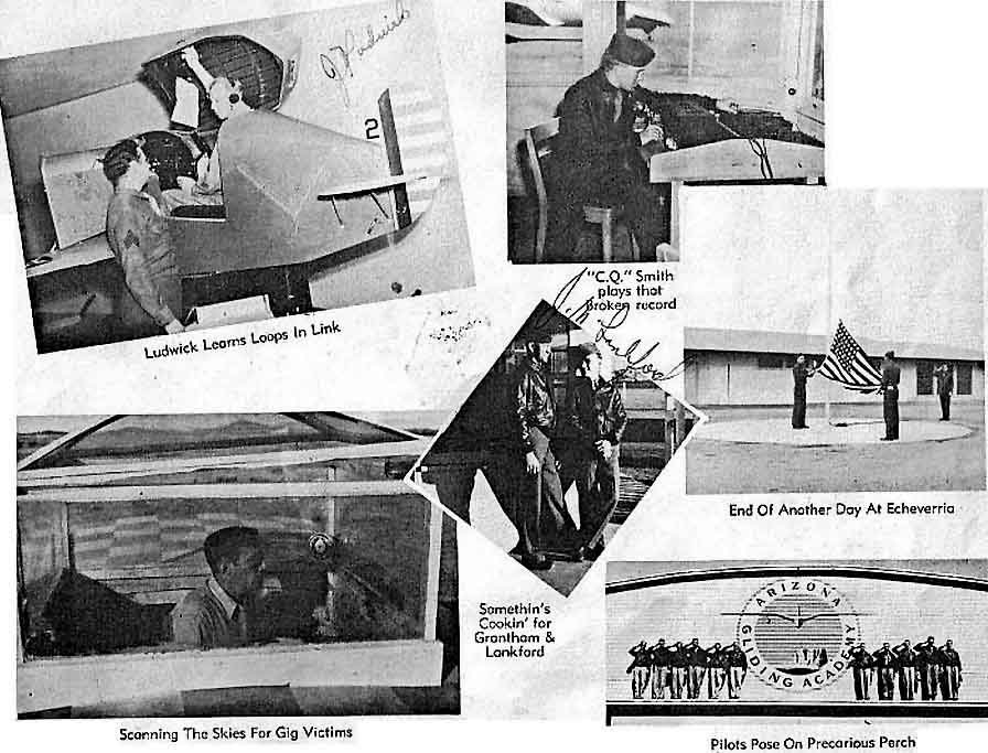
Page 15 of the 1/20/43 Class 43-4D yearbook from Wickenburg's Fifth Glider Training Detachment (courtesy of Mike Parkin, enhanced by Bill Grasha)
showed a link trainer, an observation tower, the flagpole, and other scenes.
Bud Stratford reported, “Wikipedia states that the base used Taylorcraft TG-6 training gliders, with Douglas C-47 tow aircraft.
But by examining accident data, I found that the most likely tow craft were Vultee BT-13 Valiants... not C-47s.”
In 1943, glider training ended at the Claiborne Flight Academy, and a primary flight training school began operation, for powered aircraft.
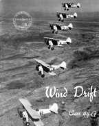
A circa 1940s aerial view of a formation of PT-17s on the cover of “Wind Drift”, the Class Book of Claiborne Flight Academy's Class 44D.
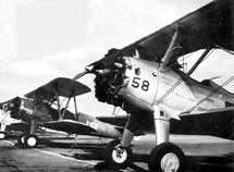
A circa 1940s photo of PT-17s at the Claiborne Flight Academy.
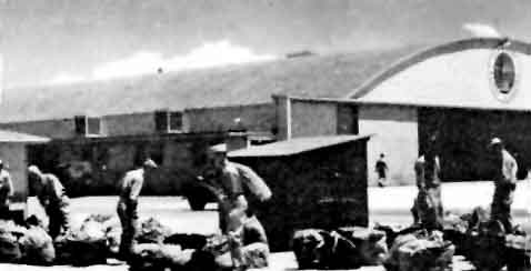
A circa 1940s photo of men in front of a hangar at the Claiborne Flight Academy (enhanced by Bill Grasha).
According to Gary Anderson, “My father (Tom Anderson) was the chief flight instructor at this field before he went overseas.”
The name of the field was changed to "Echeverria" on the March 1945 Phoenix Sectional Chart (courtesy of Chris Kennedy).
The 1945 AAF Airfield Directory (courtesy of Scott Murdock) described Echeverria Field
as a 1,440 acre square property having 2 asphalt runways (4,000' northeast./southwest & 3,200' northwest/southeast)
and a 2,300' square landing mat at the runway intersection.
The field was said to not have any hangars,
to be owned by the State of Arizona, and to be operated by the Defense Plant Corporation.
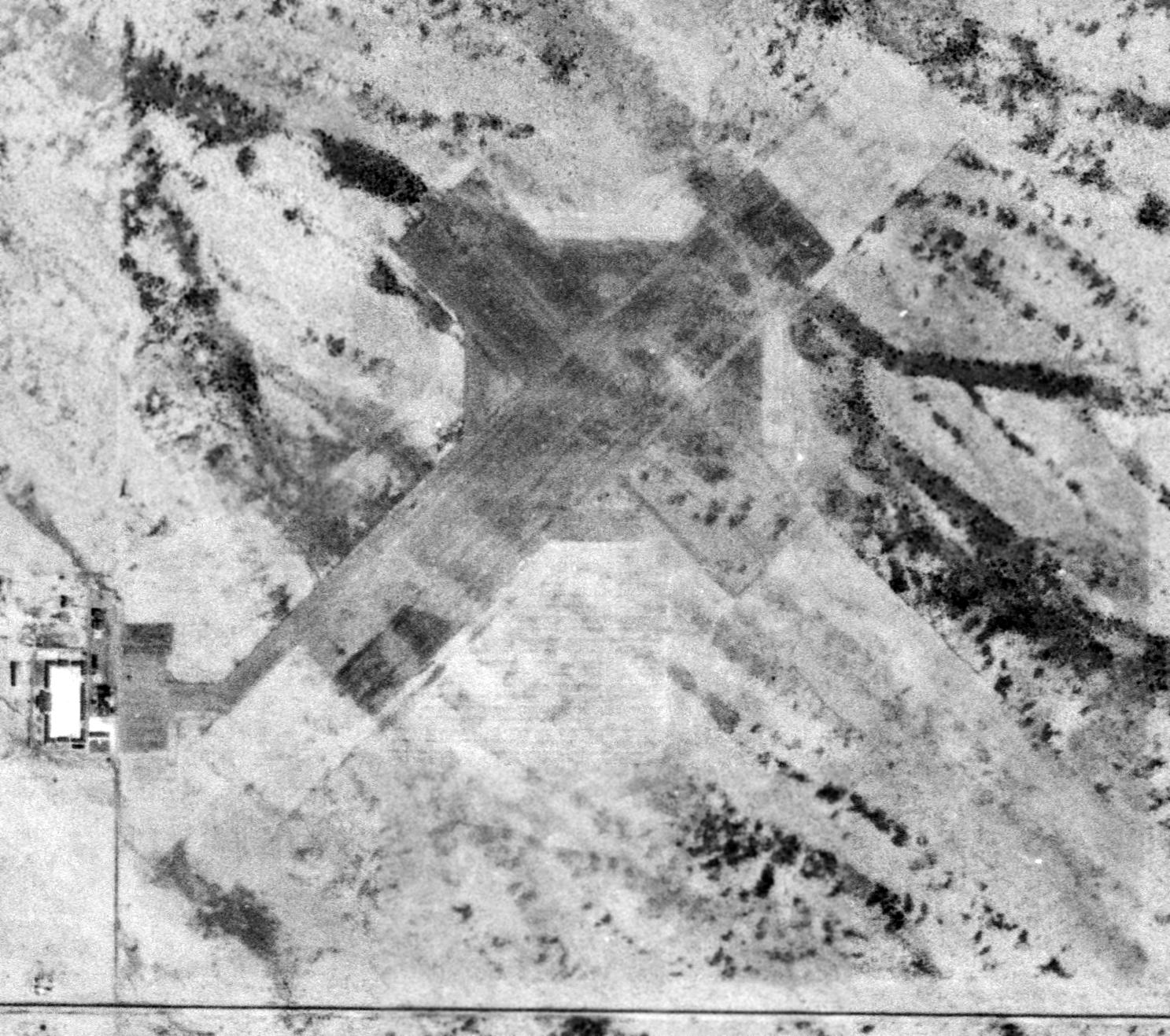
The earliest aerial view which has been located of Echeverria Field is a 1948 USGS aerial view (courtesy of Erina Gruner).
It depicted Echeverria as having a square asphalt landing mat, from which extended 2 asphalt runways.
A ramp & several buildings were located on the southwest corner.
Erina observed, it “looks like the barracks & most other buildings were already constructed. ”
Brian Rehwinkel reported, “I found an article in a 1948 Prescott Evening Courier that indicated the 'large hangar' at the field
(which I believe to be the same Echeverria Field) burned on 2/10/48.
There is yet another name used for the airport - The Hassayampa Flying Service Airport.”
A 1948 ACSC map (courtesy of Kevin Walsh) depicted "Wickenburg Army Air Base" as a rectangular property outline.
It was labeled "Wickenburg" Airport once again on the 1949 Gila River World Aeronautical Chart (courtesy of Donald Felton),
and described as having a 4,500' hard-surface runway.
Military use of the airfield ended in 1950.
In the post-WW2 era it went on to a number of uses including being a prison & housing migrant workers.
A 1951 US Government aerial view Echeverria Field (courtesy of Brian Rehwinkel).
Brian observed, it “shows the field after the war… when if was probably not used very much.
However, you can see the pavement very well – and I am not sure if the runway outlines were postwar markings, or if they were left over from the field’s training days.
You can also see the buildings in the cantonment/administration area.
If you notice, there is a dark rectangular spot on the aircraft parking apron next to the buildings (on the north side of the apron).
That spot is apparently the location of a former aircraft hangar.”
The 1954 USGS topo map depicted Wickenburg Airport as having a single northeast/southwest runway.
Echeverria Field was not depicted at all on the 1956 Prescott Sectional Chart (courtesy of John Voss)
or the 1958 Phoenix Sectional Chart (according to Chris Kennedy).
A 1960 USGS aerial view of Echeverria Field (courtesy of Erina Gruner) showed the name “Wickenburg” painted on the south edge of the asphalt landing mat,
which probably indicates that the airfield had started to be used as Wickenburg's Municipal Airport by that point, until a new field was built closer to town.
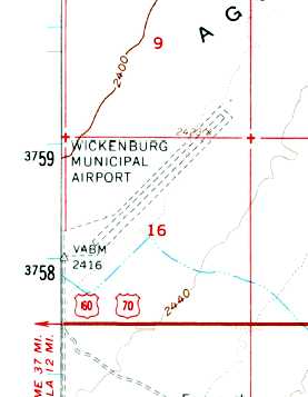
Echeverrria was labeled on the 1961 USGS topo map as “Wickenburg Municipal Airport”,
and depicted as having a single unpaved northeast/southwest runway with a parallel taxiway.
The 1962 AOPA Airport Directory described Wickenburg Airport as having a single clay runway.
Bud Stratford reported, “Interestingly, Echeverria appears to have spent some time being used as an approach simulation field for Luke AFB.”
There’s documentation of an F-100F crashing at the northeast end of the runway, which says: “After WWII the field was used for jet training.
On 5/7/63 an F-100F from Luke AFB crashed at Echeverria while practicing simulated flame-out patterns.
Both the pilot, William McCord & a student, William Curley were killed in the accident.
We had a look at the original main hangar & then went to the crash site for the F-100F which was beyond the east end of the main runway.”
The field was depicted as "Wickenburg" Airport on the 1969 USGS topo map,
but only as "Landing Strip" on the 1980 USGS topo map.
No public-use airfield at the location was listed in the 1989 Airport/Facility Directory (courtesy of Chris Kennedy).
The field was depicted only as "Landing Strip" on the 1990 USGS topo map.
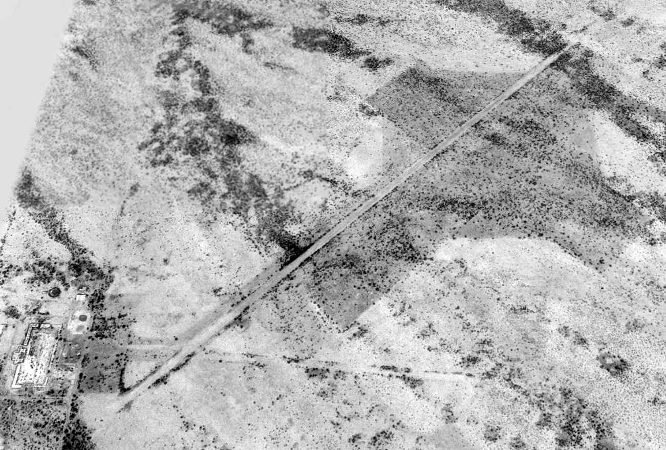
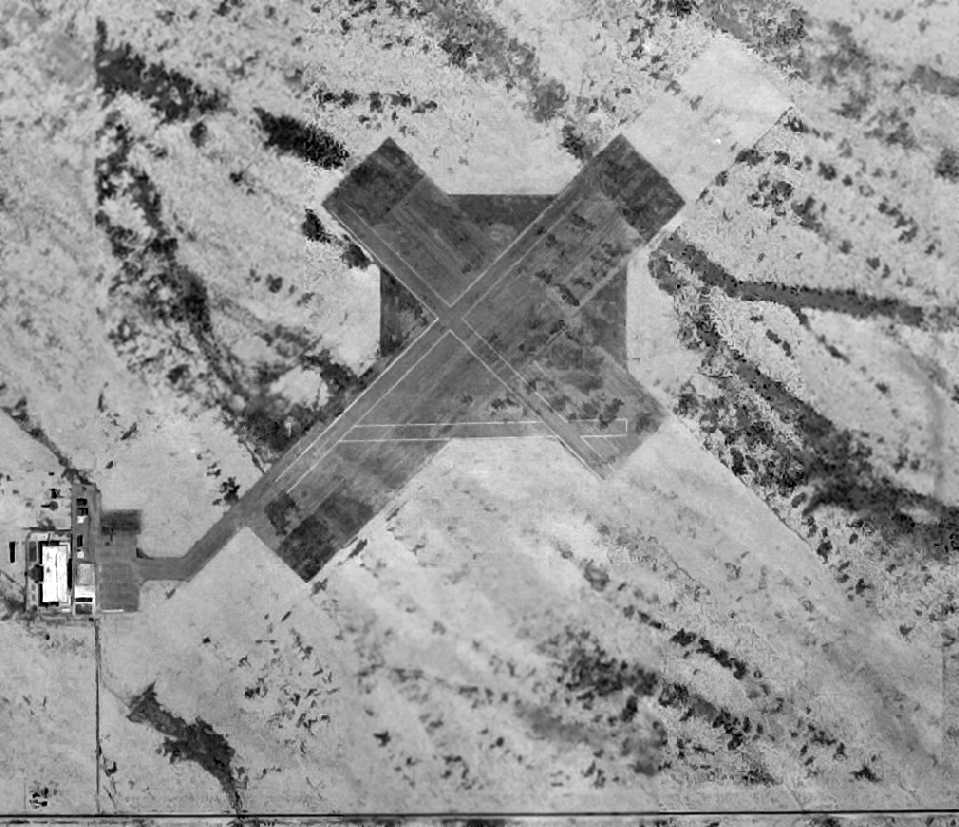
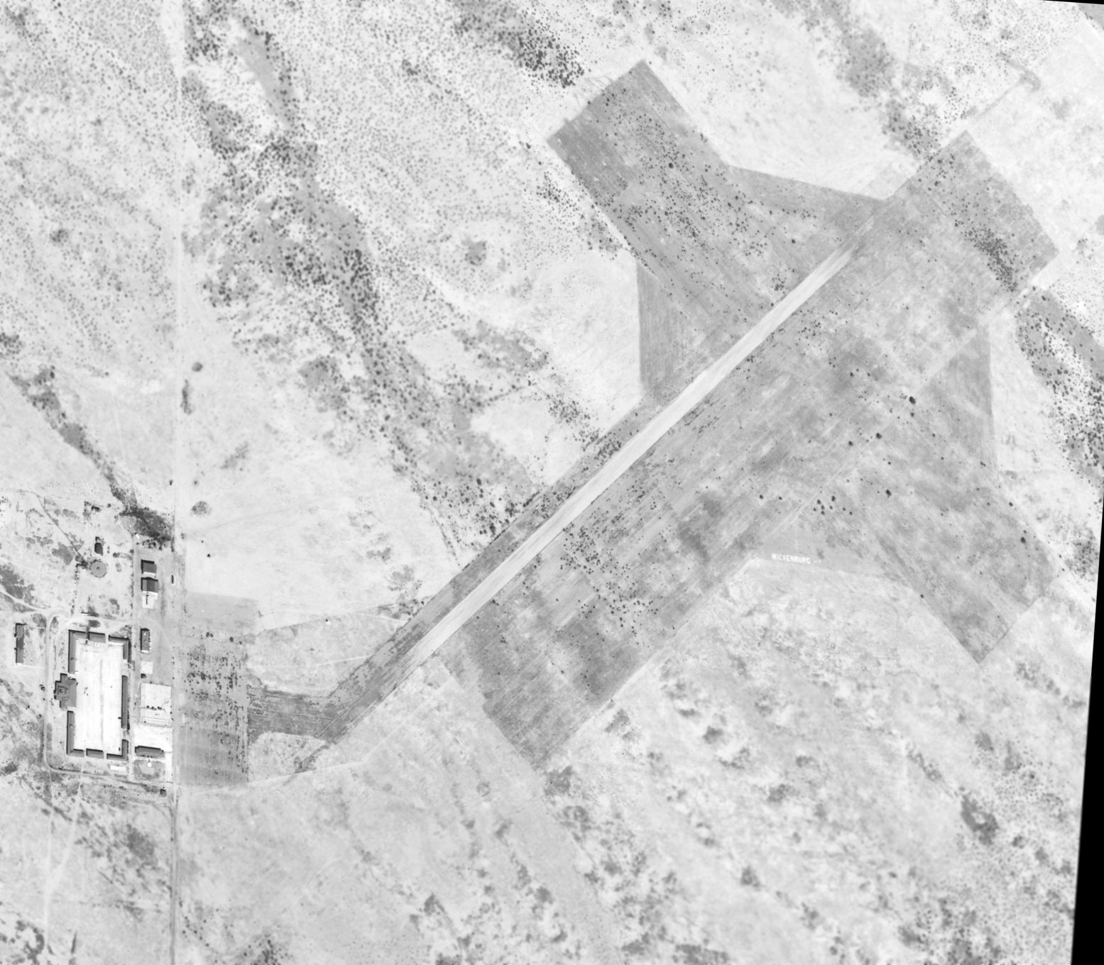
A 1997 USGS aerial view looking north showed Wickenburg's 6,000' unpaved Runway 3/21,
along with the shorter east/west runway, the remains of which are barely perceptible,
extending into the desert to the east from the southern end of the main runway.
There can also be seen the evidence of the original 2,500' square landing mat area situated underneath the northeast portion of the main runway,
along with shorter perpendicular runways extending off.
A recent photo of the main hangar & the pump house as they exist today (enhanced by Bill Grasha).
As of the mid-1990s, one of the original barracks buildings was still standing, but it has since been torn down.
Since then, the only remaining buildings are the main hangar & 2 outlying buildings.
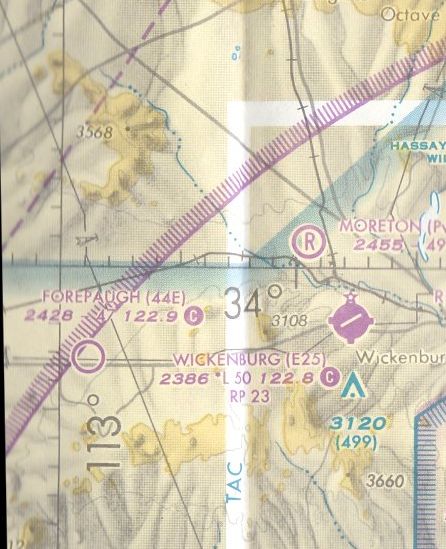
The 2002 Phoenix Sectional Chart depicted Forepaugh Airport as having a 4,700' unpaved runway.
A 2004 aerial view showed that a short unpaved runway had been cleared on the western side of the field for model aircraft operations.
As of 2006, Forepaugh Airport was described as a public-use airport having a 4,700' Runway 3/21.
The Civil Air Patrol proposed building a training facility at Forepaugh Airport,
plans which would include restoration of some of the airfield's historic buildings.
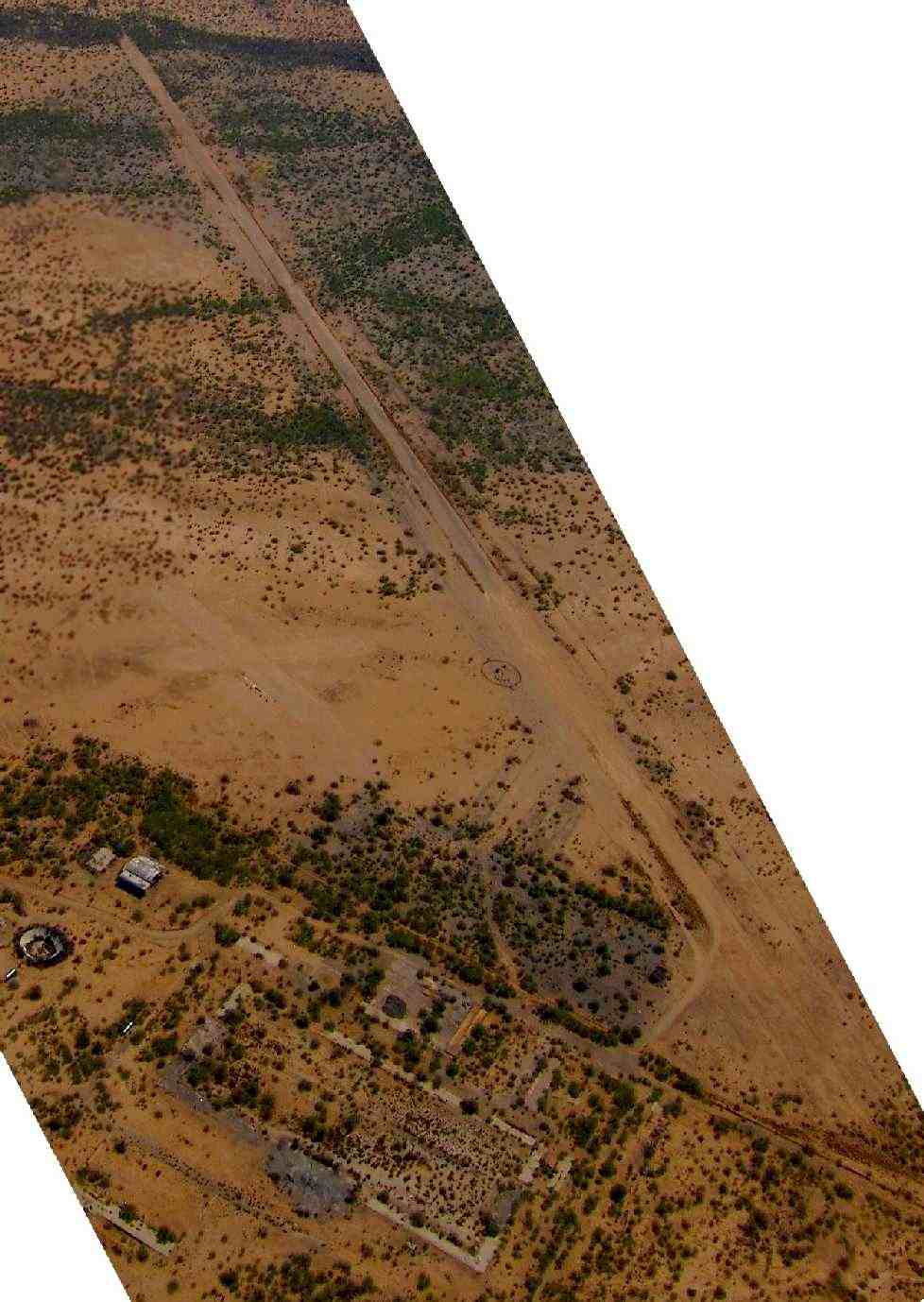
A July 2011 aerial view looking east at Forepaugh Airport by Tim Gagnon,
showing the runway, the remaining hangar, and other building foundations.
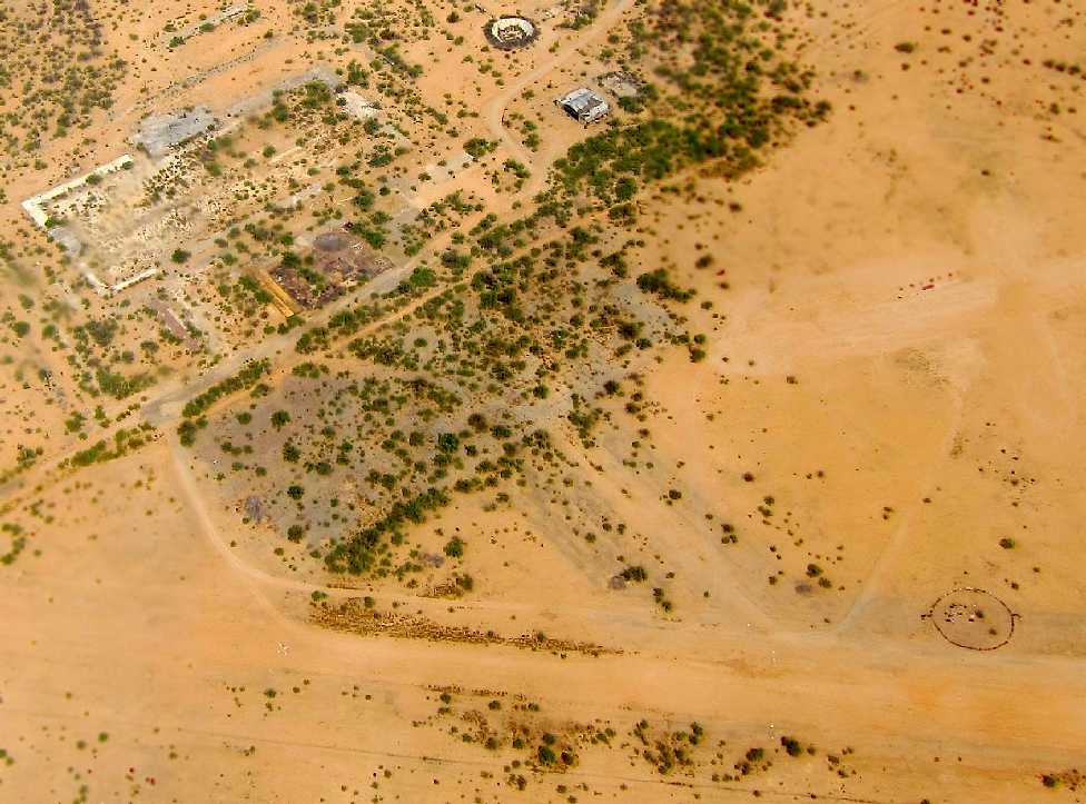
A July 2011 aerial view looking west at Forepaugh Airport by Tim Gagnon,
showing the ramp, airport circle, the remaining hangar, and other building foundations.
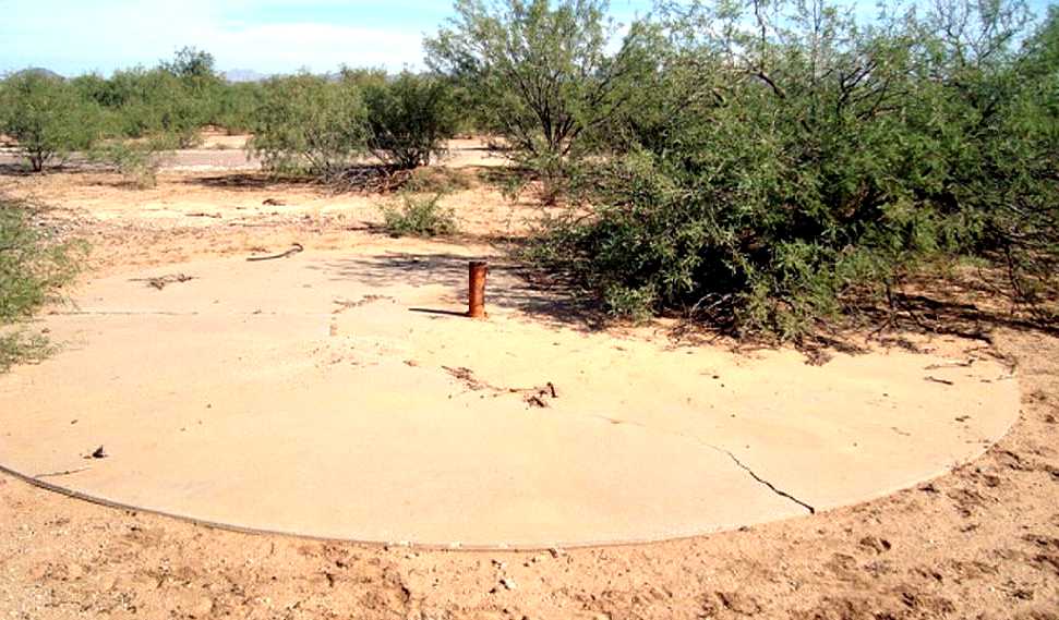
An October 2012 photo by Mike Parkin of the remains of the concrete pad surrounding Echeverria's flagpole, and the foundation of a building in the background.
The flagpole is the same one seen above in the 1943 yearbook.
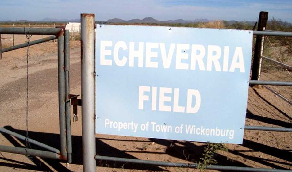
An October 2012 photo by Mike Parkin of the sign for Echeverria Field.
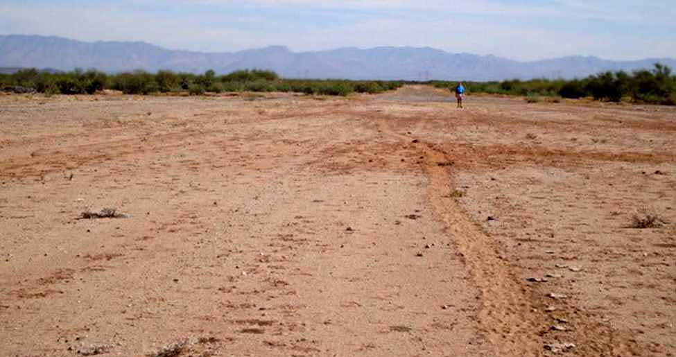
An October 2012 photo by Mike Parkin (enhanced by Bill Grasha) looking along the remains of Echeverria's runway.
Mike reported, “A local resident said that radio-controlled [model aircraft] flyers go there.
They have a tattered old windsock and a ring of tires near the runway. You can see it on [aerial pictures] if you zoom in.
There are many horse tracks & it looks like a sheep path right down the runway. No sign of full-scale aircraft using the strip.”
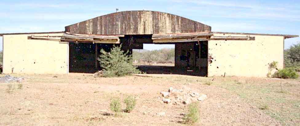
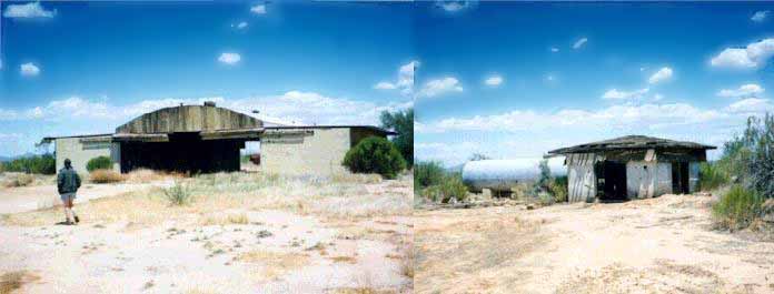
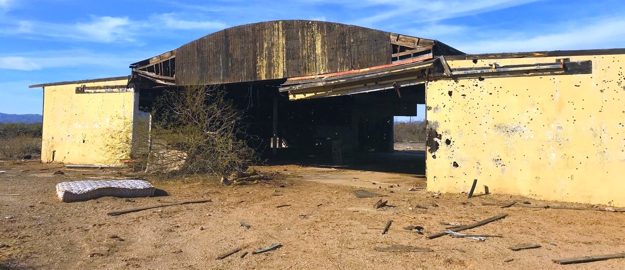
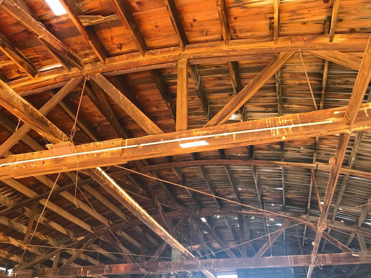
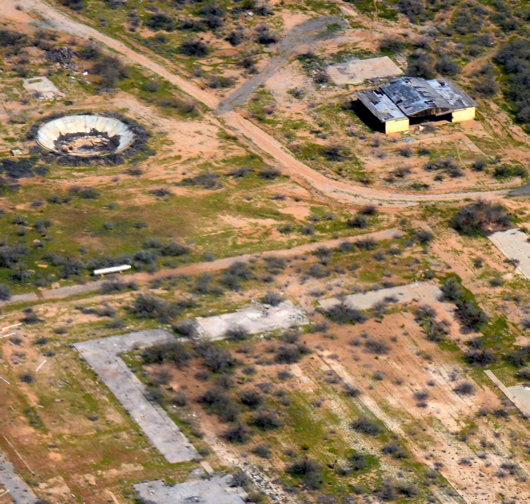
An October 2012 photo by Mike Parkin (enhanced by Bill Grasha) of Echeverria's abandoned WW2 hangar, still standing after 70 years.
Mike reported, “The hangar is full of bullet holes, so I think a lot of target practice happens on the site.”
A 2014 aerial view looking north showed the remains of Wickenburg's Runway 3/21, along with the evidence of the original 2,500' square landing mat & its 2 runways.
One WW2-era hangar remains standing on the west side of the field.
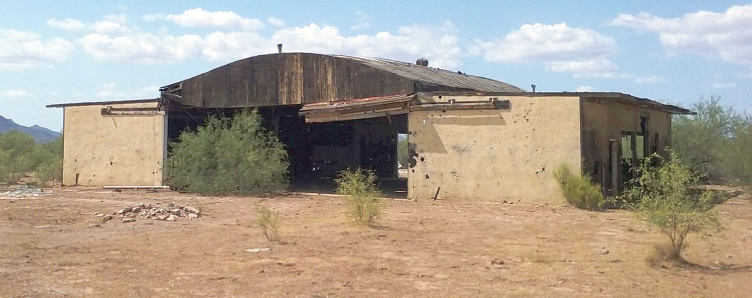
A 7/31/16 photo by Bud Stratford of Echeverria Field's hangar.
Bud reported, “There’s a padlocked gate just east of a residential horse farm on the north side of the road; it’s very easy to find, once you know what you’re looking for.
The property is still owned by the town of Wickenburg, and by the looks of the sign on the gate, is slated for imminent reuse as some sort of transfer facility.
All of the structures have been either knocked down, or have fallen on their own, the sole remaining remnants being the hangar at the northeast corner of the complex;
two large, silver storage tanks; a large concrete underground structure that looks to be a huge water-collection cistern, due west of the hangar;
and the remnants of the main runway, still bearing the closed-runway 'X' at the southwest terminus.”
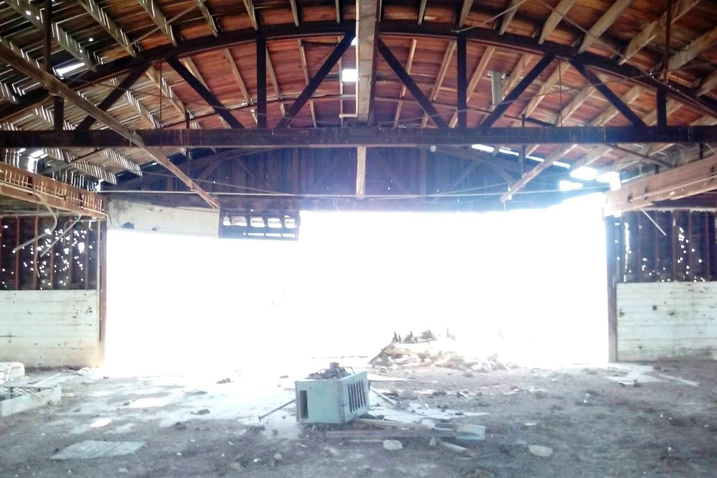
A 7/31/16 photo by Bud Stratford of the interior of Echeverria Field's hangar.
Bud reported, “The hangar is in very bad shape; it looks like it might not survive much longer, with the arch supports already showing early signs of collapsing (sagging beams, rotten joints).
Large parts of the roof & walls are gone, exposing even more of the [already compromised] structure to the elements.”
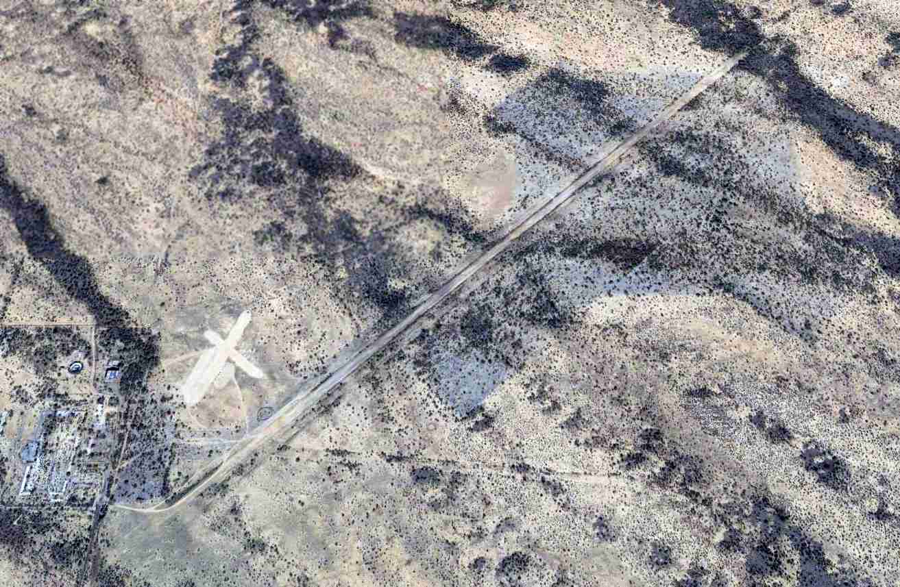
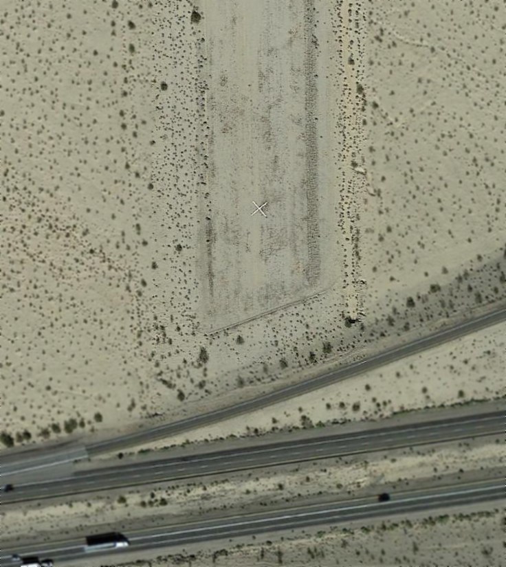
A 7/31/16 photo by Bud Stratford of the closed-runway “X” symbol on Echeverria Field's former runway.
Bud reported, “Strangely, this 'X' is made out of gray asphalt roofing shingle, nailed to the ground with 1” x 2” wood strips… very obscure, very interesting.”
Erina Gruner observed, “The lathe & shingle 'X' is probably a reference point from USGS or some other aerial photographic survey.”
Echeverria Field was depicted as an Unverified airfield on the 2017 Phoenix Sectional Chart.
A 1/27/18 photo by Tim Gagnon of the Echeverria Field hangar.
Tim Gagnon observed, “Only one structure remains…the hangar & it is in really rough shape. The walls look like walls I saw in Iraq and Afghanistan… bullet ridden.
The gate is locked & a sign says it will become an industrial park. Too bad.”
A 1/27/18 photo by Tim Gagnon of the roof of the Echeverria Field hangar.
What a shame to see such remarkable construction wasting away.
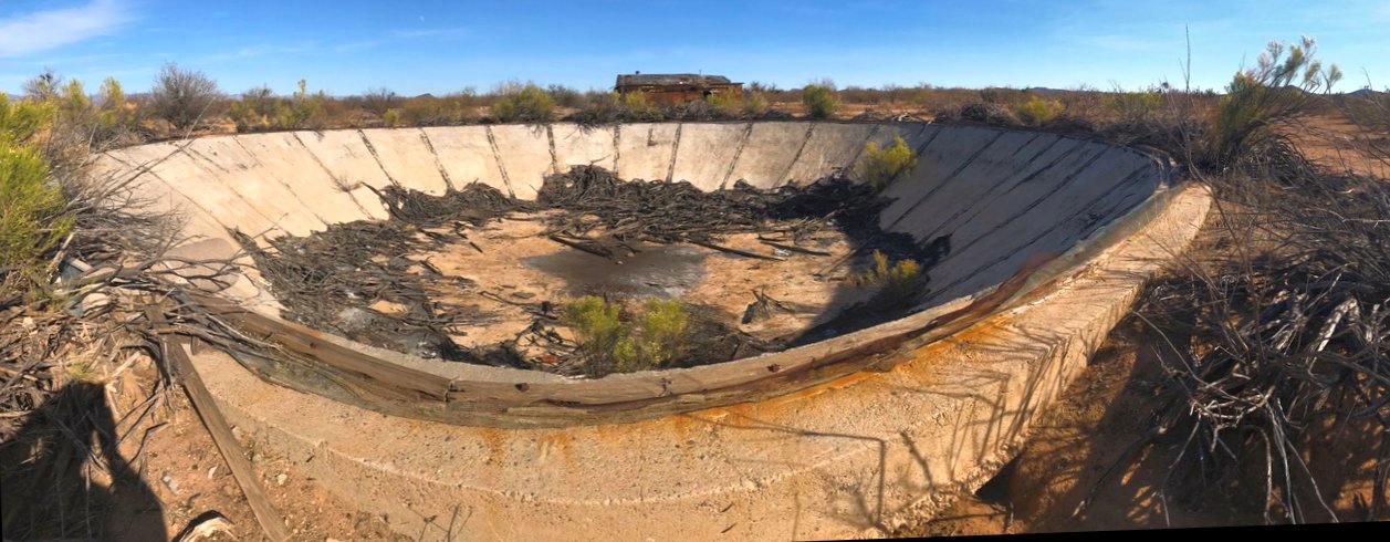
A 1/27/18 photo by Tim Gagnon of the remains of a concrete basin at the site of Echeverria Field.
Tim Gagnon observed, “The pool is at the end of a storage tank that at one time was connected to a pump house. I can only assume it is some sort of holding tank.
It is made of concrete. I would be willing to be during the blistering days of summer here in AZ, that it ended up with people in it!”
A 3/10/19 aerial view looking north at Forepaugh Airport by Tim Gagnon, showing the hangar, concrete tank, and other building foundations.
A 3/10/19 aerial view looking west at Forepaugh Airport by Tim Gagnon, showing the runways, hangar, concrete tank, and other building foundations.
Echeverria Field continued to be depicted as an Unverified airfield on the 2024 Phoenix Sectional Chart.
Matt Franklin reported in 2024, “I attempted to visit Echeverria Field today - a nice gentleman, a former F-5 instructor pilot as luck would have it,
lives nearby & informed me the hangar has been demolished as of about 2 months ago. The party is over.
The owner of the land tore it down & recycled some of the wood, but the asphalt was also torn up & put into a big pile for reuse per the neighbor.”
See also:
http://www.sonic.net/azfuller/WWIIfld.htm
http://www.airforcebase.net/aaf/cfs_list.html
____________________________________________________
Smith Airfield / Tonopah Intermediate Field, Tonopah, AZ
33.5, -112.85 (Northwest of Phoenix, AZ)

Smith Airfield, as depicted on the April 1936 Phoenix Sectional Chart.
This remote desert airfield was evidently established at some point between 1935-36,
as it was not yet depicted on the 1935 Phoenix Sectional Chart.
The earliest depiction which has been located of Smith Airfield was on the April 1935 Phoenix Sectional Chart.
It depicted Smith as having an airfield beacon, and being located along the airway route between Blythe & Phoenix.
Smith Airfield was still depicted on the July 1937 Phoenix Sectional Chart.
Smith Airfield was evidently closed at some point between 1937-39,
as it was no longer depicted on the May 1939 Phoenix Sectional Chart,
which instead only depicted Airway Beacon 32 at the location.
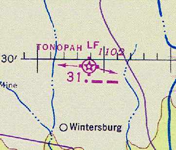
At some point between 1940-43, this airfield was reopened as Tonopah Intermediate Field,
as that is how it was depicted on the February 1943 LA Sectional Chart (courtesy of Chris Kennedy), with Airway Beacon 31.
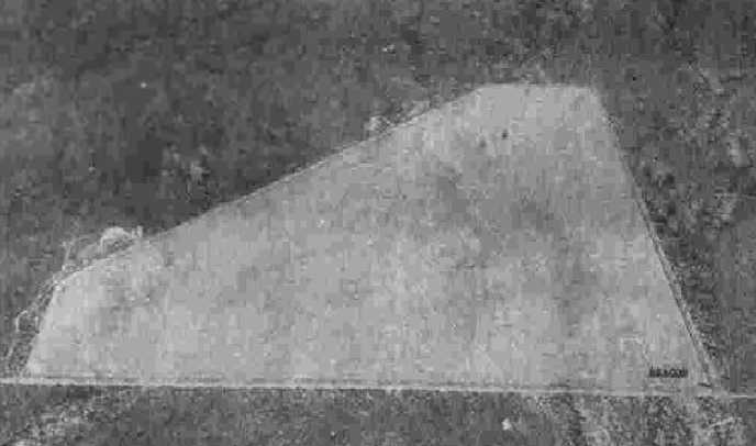
The earliest photo which has been located of the Tonopah Intermediate Field
was a 6/21/43 aerial view looking north from the 1945 AAF Airfield Directory (courtesy of Scott Murdock).
It depicted Tonopah as an unpaved triangular landing area.
The 1945 AAF Airfield Directory (courtesy of Scott Murdock)
described Tonopah Intermediate Field as a 109 acre triangular property having 3 caliche runways,
with the longest being a 3,350' northeast/southwest strip.
The field was said to not have any hangars,
to be owned by private interests, and to be operated by the Civil Aeronautics Administration.

The last aeronautical chart depiction which has been located of Tonopah Intermediate Field was on the August 1946 Phoenix Sectional Chart.
It depicted Tonopah as CAA Site 31.
Tonopah Intermediate Field was apparently abandoned at some point between 1945-47,
as it was not depicted at all on the September 1947 Phoenix Sectional Chart.
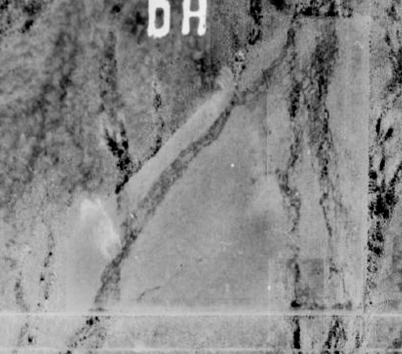
A 2/24/1949 aerial view (from the Maricopa County Flood Control District)
depicted Tonopah Intermediate Field as having a fairly common configuration for a CAA Intermediate Field -
an unpaved triangular clearing, which was fairly deteriorated by this point.
Although the airfield itself was not depicted, the 1956 Phoenix Sectional Chart (courtesy of John Voss)
still depicted a rotating airway beacon with course lights at the site of Tonopah Intermediate Field.
Nothing at all was depicted at the site of Tonopah Intermediate Field on the 1961, 1979, or 1990 USGS topo maps.
An 11/13/07 aerial view (from the Maricopa County Flood Control District)
still showed a recognizable triangular outline of Tonopah Intermediate Field.
The site of Tonopah Intermediate Field is located northwest of the intersection of West Indian School Road & North 371st Avenue.
____________________________________________________
33.77, -113.62 (Northwest of Phoenix, AZ)
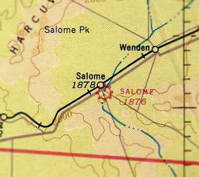
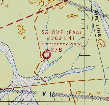
The Salome Airport, as depicted on the September 1941 Phoenix Sectional Chart (courtesy of Chris Kennedy).
The Salome Airport was a small general aviation field located immediately adjacent to the south side of the town of Salome.
Note that the Salome Airport was a separate & distinct field from the earlier Salome Intermediate Field,
which was located several miles to the south.
The Salome Airport was evidently established at some point in 1941-42,
as it was not yet depicted on the January 1941 Phoenix Sectional Chart,
nor listed among active airfields in The Airport Directory Company's 1941 Airport Directory (according to Chris Kennedy).
The earliest depiction of the Salome Airport which has been located was on the September 1941 Phoenix Sectional Chart (courtesy of Chris Kennedy).
It depicted Salome as a commercial/municipal field.
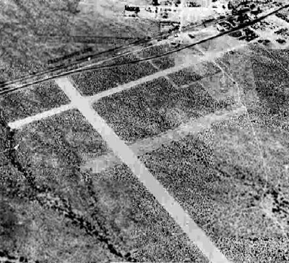
The earliest photo which has been located of the Salome Airport was a 6/17/43 aerial view looking north from the 1945 AAF Airfield Directory (courtesy of Scott Murdock).
It depicted Salome as having 3 unpaved runways.
The 1945 AAF Airfield Directory (courtesy of Scott Murdock) described Salome as a 260 acre square property having 3 sand & gravel runways, the longest being a 5,000' northeast/southwest strip.
The field was said to not have any hangars, to be owned by private interests, but not to be currently in operation.
The 1945 Haire Publishing Airport Directory (according to Chris Kennedy) listed Salome Airport as having 3 “turf” runways [doubtful there was much “turf” there],
and described the field as privately owned & operated.
The 1949 Gila River World Aeronautical Chart (courtesy of Donald Felton) depicted Salome as a public-use airfield having a 4,500' unpaved runway.

The March 1958 Phoenix Sectional Chart (courtesy of Chris Kennedy) depicted Salome as a public-use airfield having a 4,500' unpaved runway.
The Salome Airport may have been closed (for reasons unknown) at some point in 1958,
as it was no longer depicted on the September 1958 Phoenix Sectional Chart.
The 1961 USGS topo map still depicted the Salome Airport as having a total of 3 unpaved runways.
The Salome Airport continued to be depicted on the 1969 & 1980 USGS topo maps,
but this does not necessarily prove the airport was still open at that point.

A total of 3 unpaved runways were still depicted on the 1990 USGS topo map,
but it was labeled simply as “Landing Strips”, which most likely indicates the field was closed by that point.

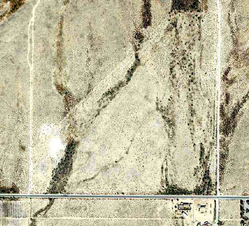
A 1997 USGS aerial view looking southeast showed Salome Airport's 3 unpaved runways remained clear & distinct.
It is not known if any of the buildings adjacent to the northeast side of the field were related to the former airfield.
A 1/2/12 aerial view by Paul Anton looking northeast along the remains of Salome Airport.
A 2/2116 photo by Mike Jamison of a sign at Salome Airport's former north runway's east end.
A 2/2116 photo by Mike Jamison looking south along the remains of Salome's north/south runway, where the north/south runway intersects with the southernmost east/west runway.
A 2/2116 photo by Mike Jamison from where Salome's north/south runway intersects with the southernmost east/west runway, looking west toward the southernmost east/west runway's west end.

A 2023 aerial view looking southeast showed Salome Airport's 3 unpaved runways remained clear & distinct.
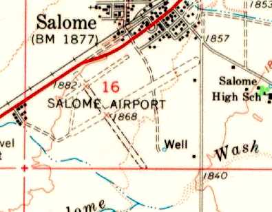
The Salome Airport is located south of the intersection of Route 60 & Center Street.
____________________________________________________
American Airways Field / Salome CAA Site 27B Airfield, Salome, AZ
33.58, -113.59 (Northwest of Phoenix, AZ)
Salome Site 28B, as depicted on the 1935 Phoenix Sectional Chart.
This airfield was evidently established at some point between 1931-34,
as it was not yet listed among active airfields in the 1931 Commerce Department Descriptions of Airports & Landing Fields in U.S. (according to David Brooks).
The earliest reference to this airfield which has been located was in the 1934 Department of Commerce Airport Directory (according to Chris Kennedy).
It described the "American Airways Field" as being located 18 miles south of the town of Salome.
The field was said to be in a "T" shape, with two 2,500' runways, oriented north/south & east/west.
It was also listed as “American Airlines Field” in The Airport Directory Company's 1934 Airport Directory (according to David Brooks).
The 1935 Phoenix Sectional Chart depicted the Salome Landing Field as Site 28B.
This would indicate that it was being used as one of the Civil Aeronautic Administration's network of emergency landing fields,
built across the country to provide alternate landing sites for airmail & airline flights.
However, the Salome field continued to be listed as “American Airways Field”
in the 1936 & 1938 Department of Commerce Airport Directories (according to David Brooks)
and in the The Airport Directory Company's 1939 Airport Directory (according to David Brooks).
The designation of the Salome field had apparently changed somewhat by the time of the 1941 12M Regional Aeronautical Chart (according to David Brooks),
as it was depicted as "Salome Site 27B".
The earliest photo which has been located of the Salome Intermediate Field
was a 6/17/43 aerial view looking north from the 1945 AAF Airfield Directory (courtesy of Scott Murdock).
It depicted Salome Intermediate as having 2 unpaved runways.
The April 1944 US Army/Navy Directory of Airfields (courtesy of Ken Mercer) listed the field as "Salome Site 27B".
It was described as an intermediate field along the Los Angeles - Phoenix airway, having a 4,100' runway.
The 1945 AAF Airfield Directory (courtesy of Scott Murdock) described Salome Intermediate Field as an 88 acre cross-shaped property
having 2 soil runways, measuring 4,140' east/west & 3,980' north/south.
The field was said to not have any hangars, to be owned by the U.S. Government, and operated by the Civil Aeronautics Administration.
The 1949 Gila River World Aeronautical Chart (courtesy of Donald Felton) described "Salome (CAA)" Site 27B as having a 4,100' unpaved runway.
The Aerodromes table on the 1956 Phoenix Sectional Chart (courtesy of John Voss)
described "Salome CAA Site 27B" as having 2 bare runways, with the longest being 4,140',
along with the note, "Closed until further notice unsafe".
It was also described as "Closed" on the 1958 Phoenix Sectional Chart (according to Chris Kennedy).
The 1958 USGS topo map labeled the airfield as “27 B Lax Phoenix”.
However, the Salome airfield may have reopened at some point between 1958-60,
as it was listed among active airfields in the 1960 Jeppesen Manual (according to Chris Kennedy).
The 1961 USGS topo map depicted the “Salome Emergency Airfield”
as having 2 unpaved runways, with a beacon on the south side of the field.
“Salome (FAA)” was depicted on the March 1962 Phoenix Sectional Chart (courtesy of Chris Kennedy) as being Site 27B, but being suitable for “Emergency only”.
The field was depicted as having a 4,100' unpaved runway.
The Aerodromes table on the January 1964 Phoenix Sectional Chart (according to Chris Kennedy)
described Salome as having two runways, with the longest being a 4,140' bare strip.
It also said "Unsafe for small aircraft. Emergency only."
The Salome airfield was evidently abandoned (again) at some point in 1964,
as it was no longer depicted at all on the July 1964 Phoenix Sectional Chart (according to Chris Kennedy).
Both runways of the airfield were still depicted on the 1980 USGS topo map, labeled "Landing Field",
while the 1990 USGS topo map labeled the site as "Salome Field".
Jim Hackman recalled, “In 1994 I was managing a large Part 141 flight school at Phoenix Sky Harbor Airport.
Two students were on the long solo cross-country flight. On the return leg from Parker AZ to PHX one of them had alternator failure.
Unsure of his position he chose to land at Salome. His friend heard him declare his intentions & came to help.
He landed, found alternator off, they plotted the rest of the trip. Number 1 took off & Number 2 discovered the 152 wouldn't start.
Number 1 lands to find out why Number 2 isn't following. Now it gets good.
Number 1 takes off, climbs to altitude & calls our base. While relaying the situation he leans over & his glasses are sucked out the window.
He lands in the blind. Meanwhile we launch a rescue Cessna 303, full of Certified Flight Instructors.
Soon American Airways Field looks like a real airport: two 152s & a 303.
Short version, I prop the 152 & send it home with a CFI. We give the other student the running 152 & he launches for PHX.
Finally I depart in the 303 with the blind student. I caution them that nobody logs ANYTHING until the next day.
Number 1 didn't finish the cross-country flight but turns out did cover the distance requirement.
Number did finish the cross-country flight but not in the same airplane.
A Part 141 Chief's nightmare. I got it resolved & both graduated. Just another day in flight training.”
The Salome Site 27B Airfield was still depicted as an abandoned airfield on the 1998 Sectional Chart.

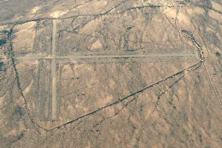
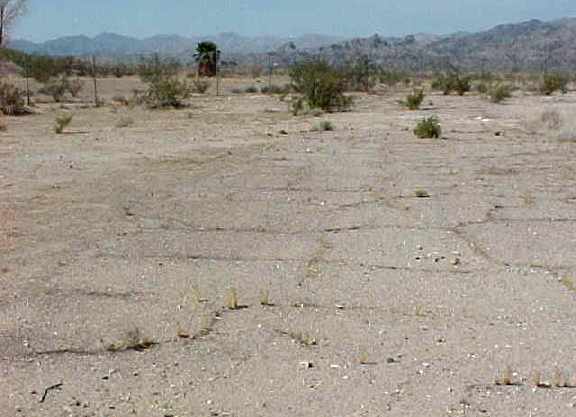
A 1997 USGS aerial view looking west showed the Salome Intermediate Field consisted of a 4,000' east/west runway & a shorter north/south runway.
It was not apparent whether the field was ever paved, or merely well-graded dirt strips. There did not appear to be any signs of there having been any hangars or other structures at the airfield.
A September 2006 aerial view by Ken Calman looking south at the former Salome Intermediate Field.
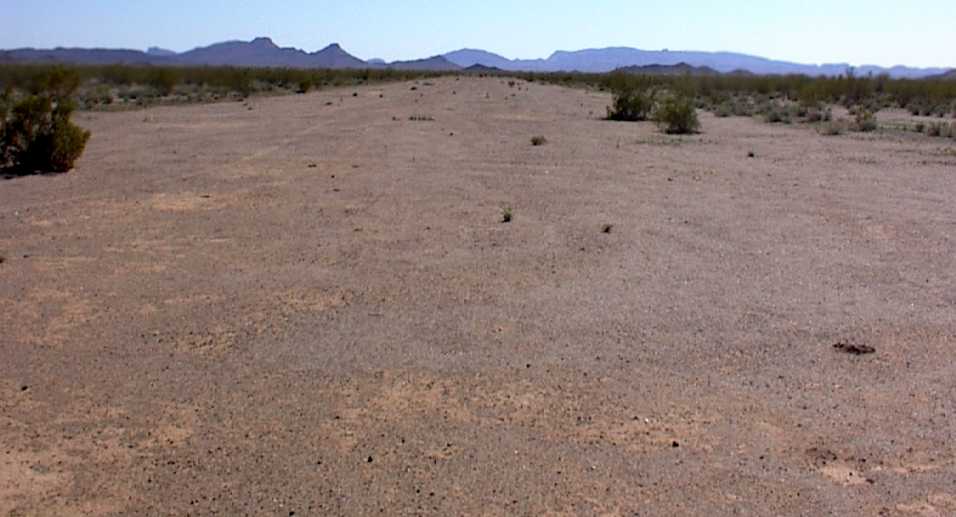
A 2008 photo by Rick Tejera looking south along the former Salome Intermediate Field north/south runway.
Rick reported, “The field itself looks like it could still be used by small aircraft in an emergency.
You’d have to dodge a few big creosote bushes & small palo verdes, but there is plenty of room.”
![]()
A 2008 photo by Rick Tejera of the remains of the beacon power house at the site of the Salome Intermediate Field.
Rick reported, “I did locate what I believe to be the remnant of a shed that most likely housed whatever powered the beacon, be it batteries or some kind of generator.
I also found several broken pieces of concrete that look to be the foundations of the tower that held the beacon.
Near the spot marked DV19767 & DV1965 are several Survey Markers.
DV1965 was actually reference by the Airway beacon that existed here.
The Beacon Itself was a survey marker (DV1966), but it no longer exits in the NGS (National Geographic Survey) database.”
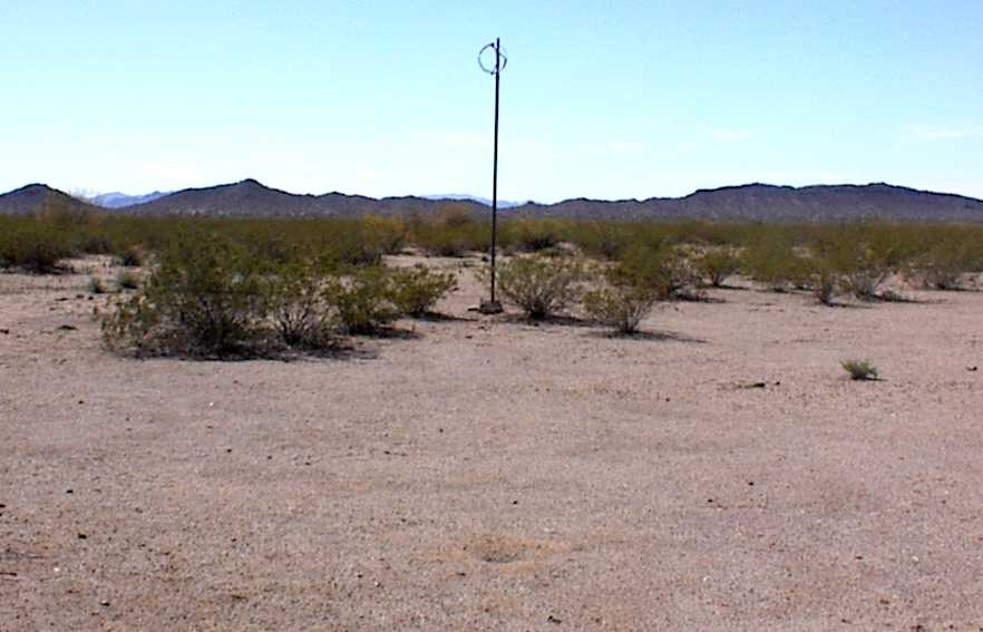
A 2008 photo of the Salome Intermediate Field windsock by Rick Tejera.
Rick reported, “Near the [runway] intersection the remains of the windsock are still there.
The pole & the ring with a few tattered pieces of fabric are all that’s left.”
A 2008 photo by Rick Tejera at the site of Salome Intermediate Field,
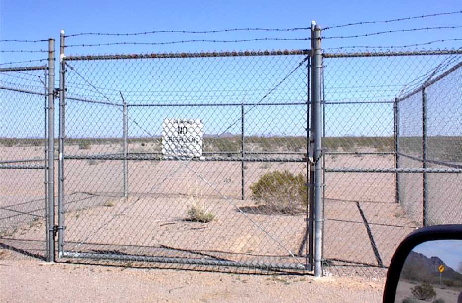
of “The most curious thing I saw... It’s just a fenced in area about 20’ square with a sign on that reads 'US Government Property, No Trespassing, Violators will be prosecuted.'
The only thing in there is 2 creosote bushes.
There were 2 steel plates on the ground about the same area just north of the caged area.
No idea what this is for, although the fencing looks pretty recent.”
Paul Anton reported in January 2012, “We drove out to the [Salome] auxiliary field & except for a couple of young Palo Verde it’s in pretty good shape.
The field itself looks pretty much like it is pictured [above].”
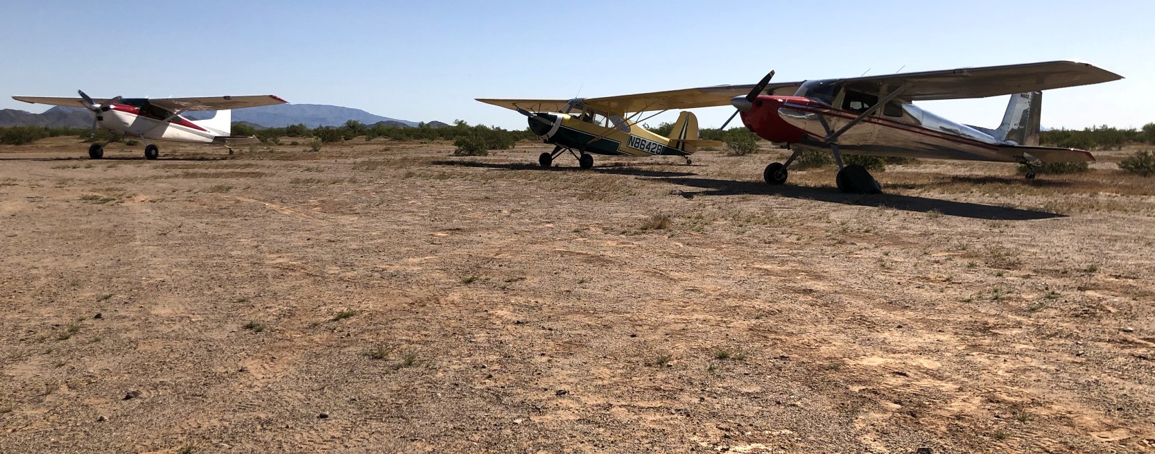
An April 2020 photo by Mike McGarry of a Cessna 185, a Champ, and a Cessna 150 tailwheel conversion at the site of Salome Intermediate Field,
Mike reported, “My brother, sister-in-law & a couple of friends were camping out there & my wife & I flew out there for the morning.
My friends did some work clearing bushes on the runways & plan to go back to do more work to make it accessible to more planes.
We were able to get in & out with little trouble but with a little more work there should be more runway area available.”

A 2023 aerial view looking west showed the remains of Salome Intermediate Field's 2 runways remained recognizable.
Salome Intermediate Field is located 2 miles south of Interstate 10, ten miles west of Centennial, AZ.
____________________________________________________
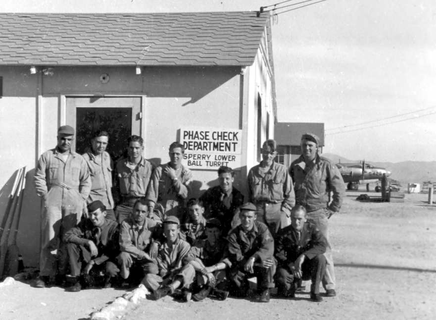
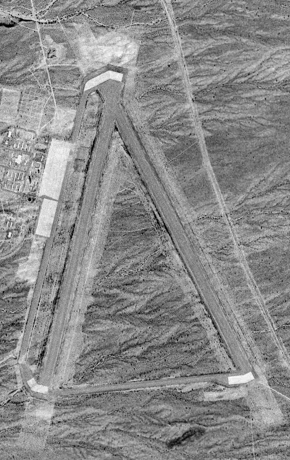
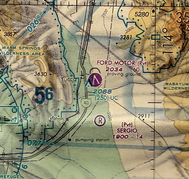
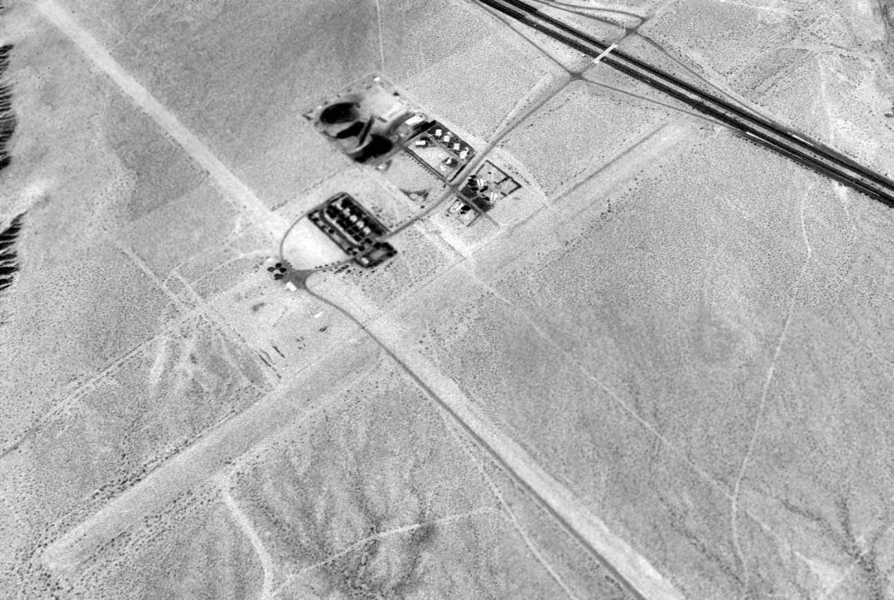
Yucca Army Airfield / Ford Motor Proving Ground Airfield (58AZ), Yucca, AZ
34.88, -114.12 (Southeast of Las Vegas, NV)
A 6/22/43 aerial view looking west at north at Yucca Army Airfield from the 1945 AAF Airfield Directory (courtesy of Scott Murdock).
Yucca Army Airfield was not yet depicted on the April 1942 LA Sectional Chart.
In 1943-44, the US Army Air Forces acquired 2,284 acres to build a satellite airfield for the use of Kingman AAF & its Gunnery School.
The facility consisted of two 6,000' asphalt runways, taxiways, control tower, a total of 45 buildings,
roads, a railroad spur, electrical utilities, water utilities, and a sewage disposal plant.
The adjoining Yucca Air to Air Gunnery Range was located to the southwest of Yucca AAF.
It consisted of a total of 550,000 acres, and the range had 4 airfields, including Topock Aux #5, Lake Havasu Aux #6, and Signal Aux #7.
The earliest photo which has been located of Yucca AAF was a 6/22/43 aerial view from the 1945 AAF Airfield Directory (courtesy of Scott Murdock).
It depicted Yucca as having 2 asphalt runways with a paved ramp on the west side.
Bell P-39 & P-63 fighters were used as gunnery targets at Yucca Aux AAF.
A rare 1944 photo of P-39 Supercobras & P-63 Kingcobras at Yucca AAF (courtesy of Steve Hoza, from the book "Best Place in the Country" by Mike & Steve Hoza).
A 1944 photo of a group of gunnery instructors at Yucca AAF (courtesy of Steve Hoza, from the book "Best Place in the Country" by Mike & Steve Hoza).
A B-26 Marauder, used to tow target sleeves, is in the background.

"Yucca AAF (Aux)", as depicted on the February 1944 LA Sectional Chart.
Yucca AAF was already described as “Inactive” in the 1945 AAF Airfield Directory (courtesy of Scott Murdock).
It described Yucca as a 5,585 acre irregularly-shaped property having 2 asphalt 6,000' runways, oriented north/south & NNW/SSE.
The field was said to not have any hangars, to be owned by the U.S. Government, and to be operated by the Army Air Forces.
The Yucca AAF property was declared surplus in 1946 & responsibility for it was given to the War Assets Administration.
"Yucca" airfield was depicted on the 1949 Los Angeles Sectional Chart (according to Chris Kennedy), and described as having a 6,000' hard-surface runway.
A 2/17/54 USGS aerial pic depicted Yucca AAF as being abandoned but remaining intact.
In 1954 the Ford Motor Company acquired the Yucca airfield facility.
They began using the runways for automobile testing in 1955, and eventually built an extensive automotive proving ground surrounding the airfield.
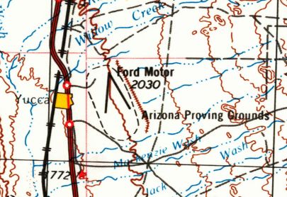
The 1956 USGS topo map depicted 2 runways, labeled Ford Motor.
The May 1993 Phoenix Sectional Chart (courtesy of Ron Plante) depicted the Ford Motor Airfield as having 2 paved runways, with the longest being 6,000'.
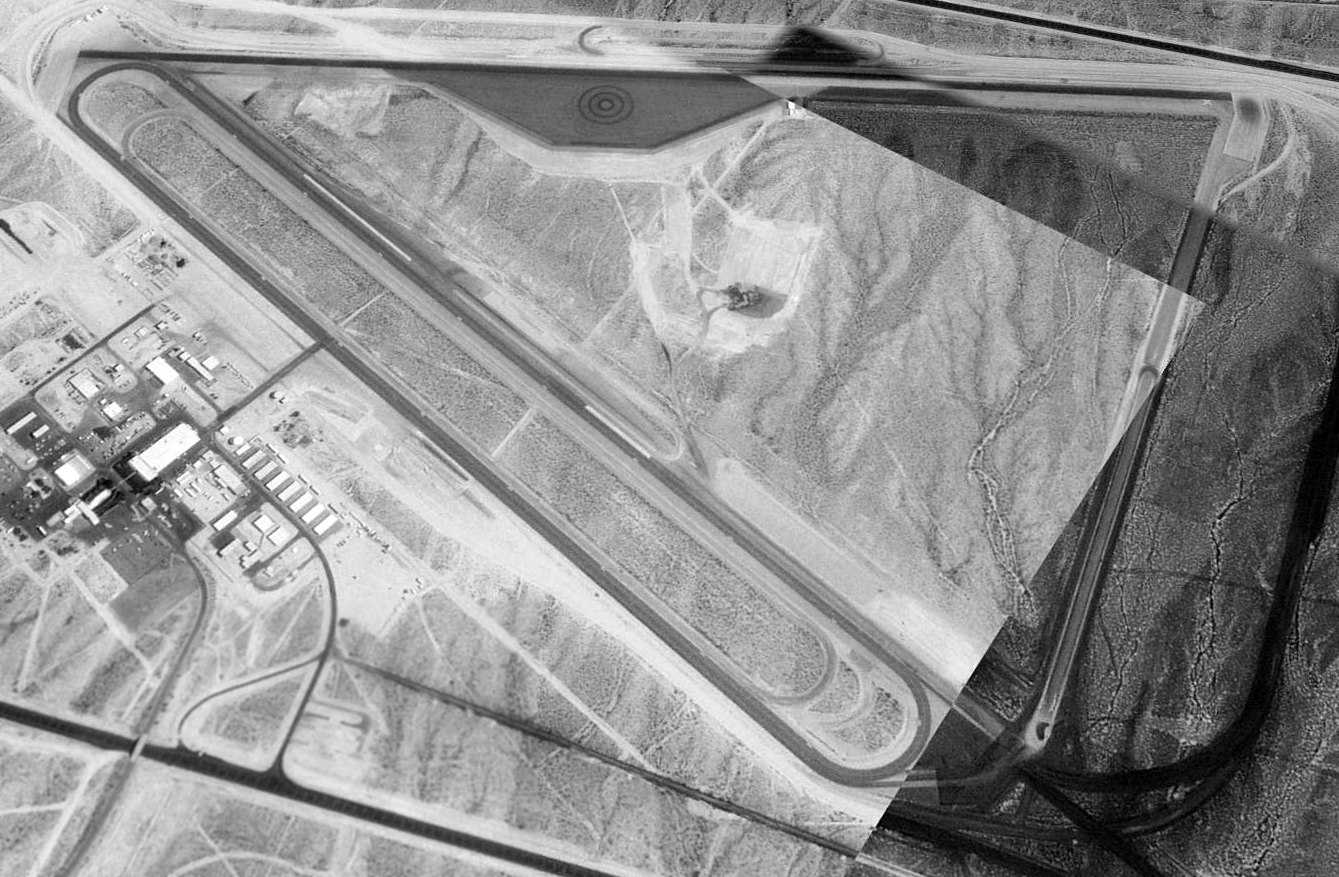
A 1997 USGS aerial view looking northeast at the Ford Motor Proving Ground Airfield.
The last aeronautical chart depiction which has been located of the Ford Motor Proving Ground Airfield
was on the May 1999 Phoenix Sectional Chart (courtesy of Ron Plante).
It depicted Ford Motor as having 2 paved runways, with the longest being 6,000'.
As of 2002, the airfield was still operated by Ford as a private airfield, known as the Arizona Proving Ground Airport.
As described in the FAA Airport/Facility Directory data, Ford maintained two 6,000' asphalt runways (14/32 & 18/36).
The remarks said, “Vehicle testing operations on both runway, prior arrangement needed for airport use.”
Ford continued to use some of the original military facilities,
including the control tower, runways, taxiways, parking aprons,
but all of the other riginal military buildings (except for the control tower) had been removed.
Dan Falkerson reported in 2006, “I used to work as a service electrician & have done some work at the Proving Grounds at Yucca.
The main garage/repair facility apparently sits on an old hangar foundation.
The concrete is incredibly hard, and anyone who has ever had to cut/jackhammer through it for repairs or renovations learns to hate it.
There appears to be a high metal content in the concrete, perhaps contributing to its toughness.
There are many places on the shop floor where a magnet will stick to it pretty good.”
The Yucca airfield was evidently closed by Ford (for reasons unknown) at some point between 2002-2006,
as it was depicted as an abandoned airfield on the 2006 Sectional Chart (according to Chris Kennedy).
In November 2007, Chrysler bought the Yucca Proving Grounds from Ford.
They paid $35 million for the 3,840 acre site, including 50 miles of test roads & 109,000 square feet of building space.
Chrysler planned to put in another $10 million including a 70' high test grade.
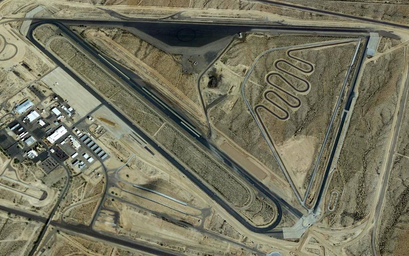
A 2015 aerial view looking northeast at the former Ford Motor Proving Ground Airfield.
The Yucca Airfield is located on the east side of Interstate 40, 25 miles south of Kingman.
A 1993 Army Corps of Engineers report gave more details about Yucca AAF.
____________________________________________________
Kingman Auxiliary Army Airfield #5 / Topock Field, Topock, AZ
34.72, -114.44 (West of Phoenix, AZ)

"Kingman #5", as depicted on the March 1944 LA Sectional Chart.
Photo of the airfield while in use has not been located.
Kingman #5 was not yet depicted on the February 1944 LA Sectional Chart.
This field was built as a WW2-era satellite field for Kingman AAF (several miles northeast),
which conducted training for the 70,000 Pilot Training Program.
According to Jeff Johnson (an archaeologist with EcoPlan Associates, Inc., charged with the task of documenting the history of Topock AAAF #5
pursuant to an ADOT project to construct a new rest area & visitor's center at the Needles Mountain Traffic Interchange on I-40),
"Topock AAF was constructed in late 1942 or early 1943.
The Kingman AAF Museum in has a photo of 'Kingman Airfield S5, Ariz.' taken sometime between 1943-47.
They also have a 'Location Map, Auxiliary Landing Fields & Gunnery Ranges, KAAF-YAAF', dated October 1943,
showing 'Topock Field #5', among others.
The single runway was 6,000' of oil-hardened pavement & 300' wide."
"Kingman #5" was depicted as an auxiliary airfield on the March 1944 LA Sectional Chart.
Topock was listed in a directory of AZ Airports in the 5/47 issue of Arizona Highways (courtesy of George Miller),
which described the field as being unattended, and the longest runway as being 6,000'.
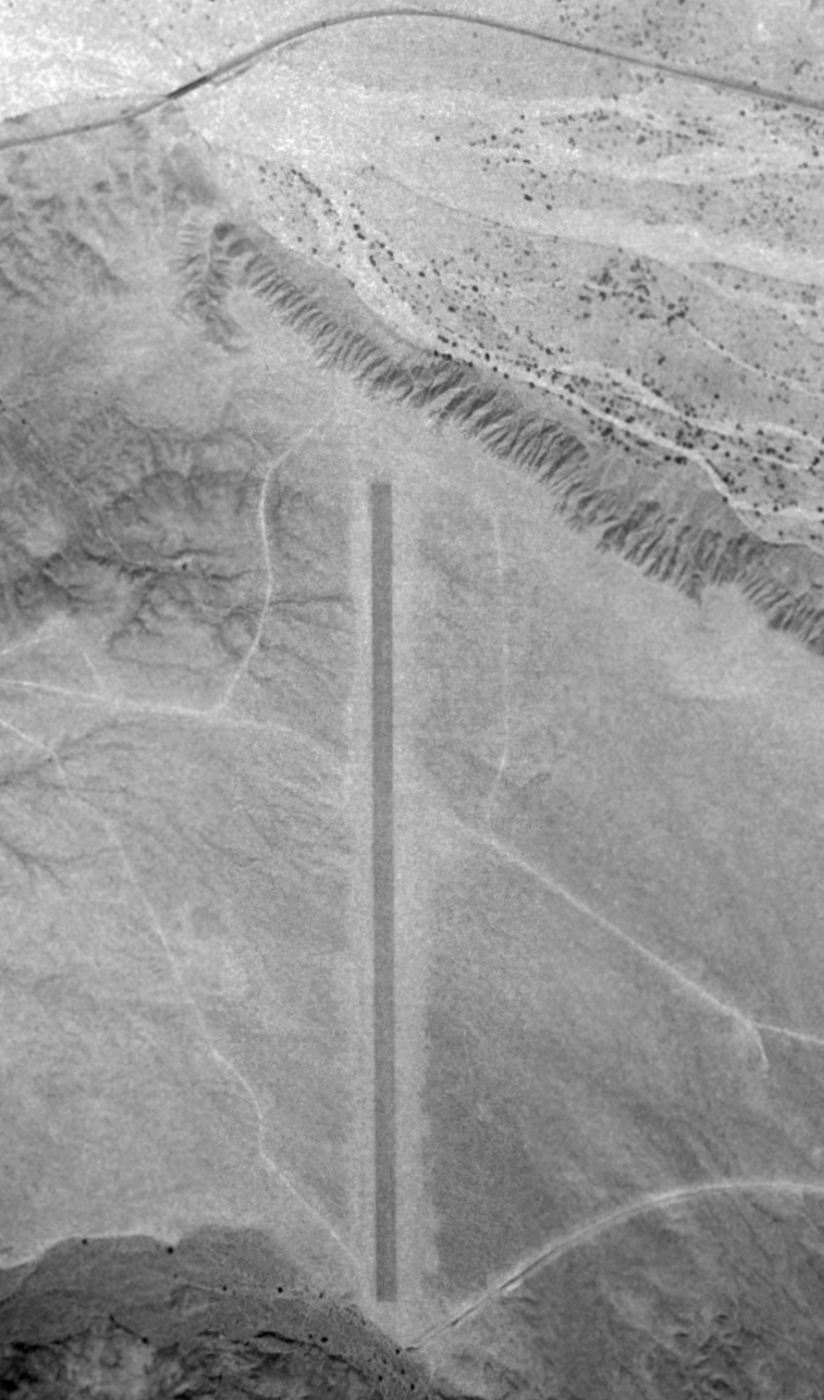
The earliest photo which has been located of Topock Field was a 10/31/47 USGS aerial view.
It depicted a single paved north/south runway, with no ramp, buildings, or any other improvements.
It was labeled "Kingman #5" on the 1949 Los Angeles Sectional Chart (according to Chris Kennedy),
and described as having a 6,000' hard-surface runway.
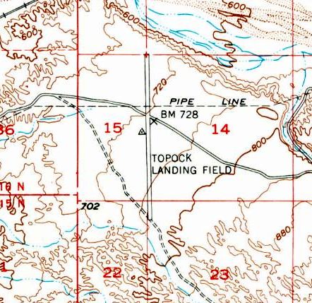
The 1950 USGS topo map depicted the “Topock Landing Field”
as having a single paved north/south runway, bisected by an east/west road.

The last aeronautical chart depiction which has been located of "Kingman #5" was on the September 1952 LA Sectional Chart.
It was depicted as having a 4,500' unpaved runway.
"Kingman #5" was evidently closed at some point between 1952-53,
as it was no longer depicted on the March 1953 LA Sectional Chart.
At some point between 1954-56, Interstate 40 was built right through the former Topock AAF runway,
leaving portions of the runway extending away from the Interstate to the north & south.
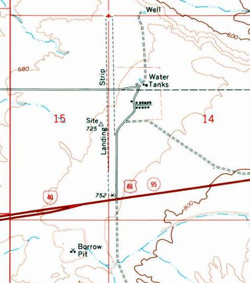
The 1970 USGS topo map depicted Interstate 40 having bisected the former Topock AAF.
The portion to the north of the Interstate was still depicted as an unpaved “Landing Strip”.
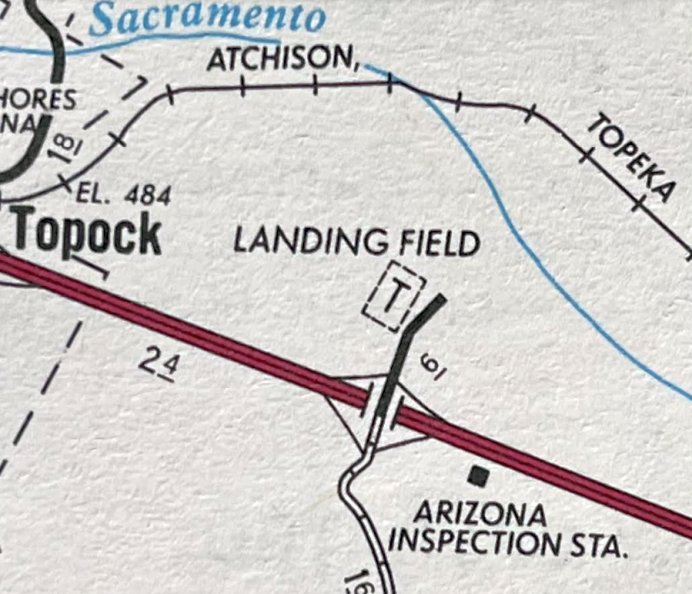
A 1987 ACSC map (courtesy of Kevin Walsh) depicted the Topock “Landing Field” as a rectangular property outline.
A 1994 USGS aerial view looking southeast at the site of Topock Field showed the remains of a single north/south 6,00' runway, bisected by Interstate 40.
According to Jeff Johnson, "There are portions of the runway that still exhibit the original pavement.
There are 2 concrete slabs near the southern end of the runway. One is just to the west of the end of the runway, roughly square & unlevel.
The second concrete slab is located just to the east of the runway. It is rectangular, level and was constructed with a form.
It may have been associated with a small shed."
Jeff continued, "The 1994 aerial photo also shows two rectangular compounds enclosing various buildings & structures.
The smaller & northern-most compound is the Topock Service Camp built in 1950 for El Paso Natural Gas.
The larger & southern-most compound is the Topock ADOT Maintenance Yard built about 1991.
The Topock AAAF is almost totally on BLM and Arizona State Trust Lands.
The remainder (about 120 acres) is owned by El Paso Natural Gas.
This 120-acre parcel includes the Topock Service Camp and a portion of the WW2 Topock runway."
Jeff continued, "The southern portion of the Topock runway was bisected by construction of I-40 years ago.
That portion of the runway south of I-40 & two associated concrete slabs
may be destroyed during their project [the construction of a new rest area].
I am documenting this AAAF to determine if it is significant enough to warrant government protection.
It seems that Topock is one of only two AAFs in Arizona that serviced B-17 bombers exclusively & still survives today in an almost unaltered condition.
The other seems to be Signal AAAF #7.
The remainder of the AAFs seem to have been altered for other uses, destroyed by development or originally built for non-bombers,
i.e. multiple runways measuring approximately 4,000' or less for attack aircraft
versus single or double runways measuring 6,000' or greater for heavy bombers.
Although Signal AAAF seems to be in more pristine condition than Topock AAAF,
it is more remote & does not lend itself well to historical interpretation.
In contrast, the Topock AAAF has had a limited amount of impact.
The runway has been impacted by two small paved service roads across the northern portion & I-40 across the southern portion.
The portion of the runway between these 2 areas is untouched.
The portion north of the 2 service roads is also untouched,
while the area south of I-40 seems to have lost some integrity.
The fact that that a large portion of the untouched runway is visible from I-40 & Needles Mountain Road
may indicate a unique opportunity for the interpretation of this AAAF, the associated Kingman AAF
and the 70,000 Gunner Training Program."
The Topock airfield was not depicted at all (even as an abandoned airfield) on 1998 World Aeronautical Chart.
A 2004 photo by John Saunders, looking north across I-40 along the remains of Topock's former runway.
A 2004 photo by John Saunders, looking south along the remains of Topock's former runway.
A 2004 photo by John Saunders of remaining tarmac along Topock's former runway.
Charles Irvin reported in 2008, “This one's interesting, because as of present-day,
the remains of the north/south runway are more or less completely clear of debris!
I mean, it's as if somebody has been keeping the remains of the runway clear.
There are 5 or 6 tractor-trailers parked at the northernmost end, on either sides of the runway,
and if you take a close look on [aerial photos], you can still clearly see a closed 'X' symbol at the end of the runway nearest I-40,
and you can see that the pavement is still there on the entire runway length - even south of I-40.
Also, I'm not sure, but I'm assuming that there were originally 2 runways at this site -
the other running east/west at the northern end of the field, which is now used as a road,
though it appears that the pavement has been removed from this one.
I could be wrong, but if you look closely at it, it does look kind of like a runway to a point in each direction, then it seems to narrow out.
On the other hand, it's odd that there are no taxiways whatsoever.”
A 2015 aerial view looking southeast at the site of Topock Field showed the paved runway remained remarkably intact, 70 years after being abandoned.
A 2015 aerial view of the remains of the Topock Field runway just north of Interstate 40, showing a closed-runway “X” symbol.
Louis Worthy reported in 2015, “The I-40 freeway runs thru the site however the runway closure X is still visible today,
in addition to a few areas of asphalt along with a few small areas of concrete slabs left over from the old AAF.”
____________________________________________________
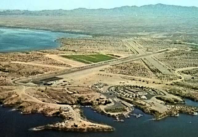
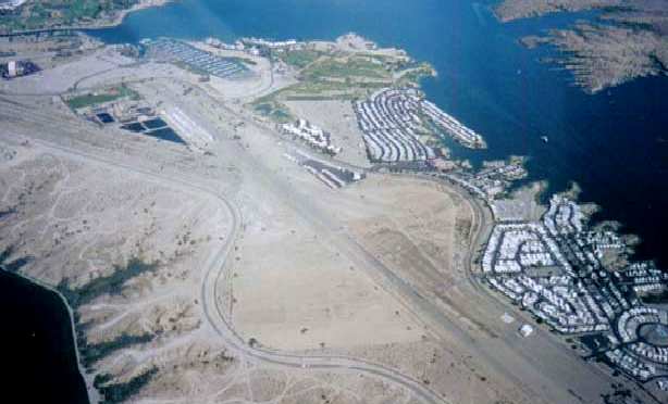
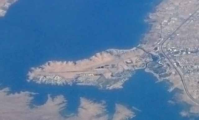
Lake Havasu Auxiliary Army Airfield #6 (LHU) / Havasu Airpark, Lake Havasu City, AZ
34.46, -114.36 (West of Phoenix, AZ)
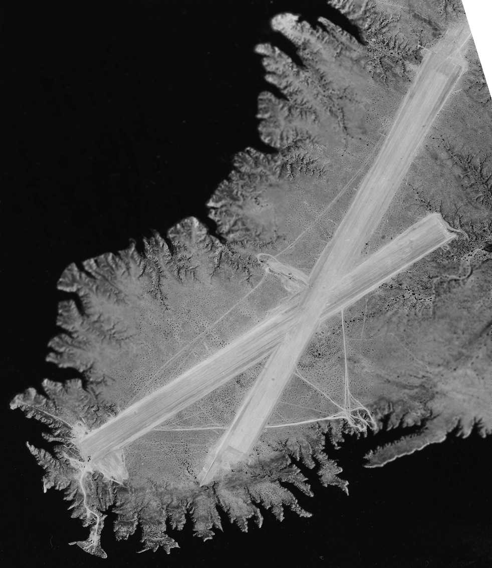
A 4/20/43 National Archives aerial view (courtesy of Brian Rehwinkel) of “Kingman Emergency Field, S6”.
The original airfield for the town of Lake Havasu is located on a peninsula
which protrudes from the east bank of the Colorado River.
The military acquired a 1,030 acre site
to build an emergency landing field for Kingman AAF's Yucca Aerial Gunnery Range.
The emergency field was established in 1943 & consisted of 2 runways.
No facilities were associated with the landing field other than the runways,
there were no lighting, hangars, shops, gasoline, oil, communications, or radio facilities.
An auxiliary radio station was originally proposed for this field,
but historical information indicates that radio facilities were not installed.
According to the book "Best Place in the Country" by Steve Hoza & Mike Hoza,
the Lake Havasu base was also known as the Site 6 Rest Camp,
as it served as a rest & recreation center for AAF personnel.
The earliest depiction which has been located of the Lake Havasu airfield
was a 4/20/43 National Archives aerial view (courtesy of Brian Rehwinkel).
It depicted “Kingman Emergency Field, S6” as having 2 runways, but no buildings or ramps were depicted,
and Brian Rehwinkel observed, “I can’t even tell if the field has been completed yet.”
In 1944, the site was remodeled & improved for use as a rest & convalescent camp for Kingman AAF.
The structures installed were temporary in nature,
and provisions were made for swimming, fishing, skeet shooting, motor boating, & hiking activities.
The earliest aeronautical chart depiction which has been located of the Lake Havasu field
was on the August 1945 LA Sectional Chart (courtesy of Chris Kennedy).
It depicted “Kingman #6” as an auxiliary airfield.
The installation was declared surplus in 1945, and the field was reused as a civil airport.
According to Arizona100, “When the war ended, the entire facility was declared surplus
and Vic & Corinne Spratt moved from Needles to manage Site Six as a fishing resort.
But their attorney had to prove to the military prior ownership of the land.
Fortunately, war surplus aircraft were cheap in the 1950s,
so guests could fly into what was now called Havasu Airpark, with former army barracks turned into living quarters, grocery, restaurant and bar.
There were no roads into the entire area in Arizona except rough jeep trails, but access to the California side had already brought powerboat racing to the lake.”
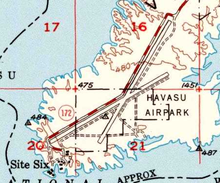
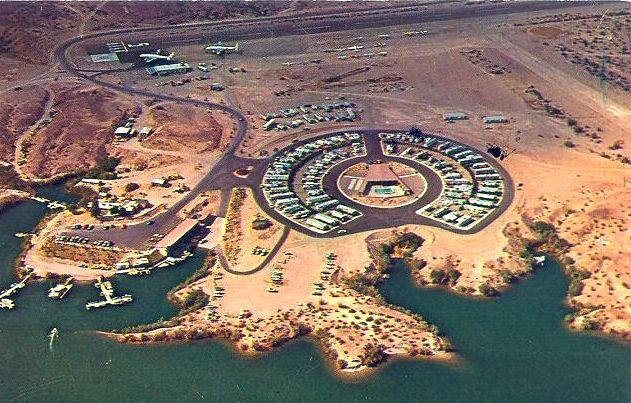
The 1950 USGS topo map depicted the “Havasu Airpark” as having 2 paved runways.
“Site 6” was depicted on the southwest side of the airfield.
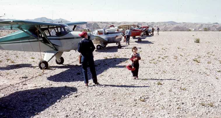
A circa early 1950s photo of several Pipers & Ercoupes in the tie-down are at Lake Havasu Site 6 (courtesy of Bob Bertram).
According to Arizona100, “One day in 1958, Robert McCulloch suddenly flew in & purchased Site Six on the spot.
Before the war, he had worked in the aircraft industry.
Now he was a wealthy owner of an oil company in Los Angeles that encouraged use of its gas & oil by also manufacturing chain saws & outboard boat motors.
He told the Spratts and other landowners that he needed a test facility for McCullough outboards.
But when he talked about plans for a fabulous city on Lake Havasu, with private airplanes in every garage & world-class resorts on every beach a lot of people thought he was crazy.
Even his business partner, C. V. Wood, Jr., who designed fantastic recreational landscapes at Disneyland
thought the idea of an economically sustainable city in the remote desert was naïve, perhaps even risky.”
It was listed as "Kingman Site 6" Airport in the 1962 AOPA Airport Directory,
with two 6,000' oiled & gravel runways,
and the operator listed as Site 6 Resort.
By 1964, it had been renamed Lake Havasu Airport & the primary runway was paved.
The Aerodromes table on the 1964 LA Sectional Chart (courtesy of John Voss)
described Lake Havasu as having 3 runways, with the longest being a 4,300' bituminous strip.
A mid-1960s aerial view by Bob Petley (enhanced by Bill Grasha) looking northeast at Lake Havasu Airpark,
showing the 2 paved runways, along with the newer dirt 3rd runway.
According to Arizona100, “In 1964, two Lockheed L-049 Constellations began free flights for prospective buyers who would spend 2 days touring the town site.
McCulloch purchased a total of 6 Lockheed L-049 Constellations between 1964-66 so that at least 2 could be flying at any given time.
Flights left numerous cities like Cleveland, Chicago, Seattle, Los Angeles & Dallas.”
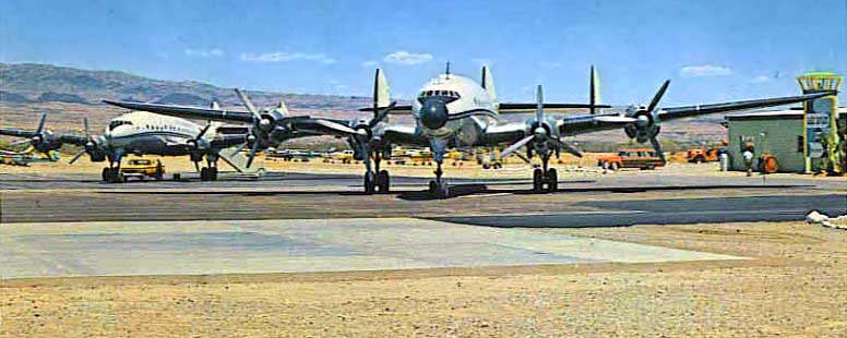
A circa 1965 photo (courtesy of Cameron Shepherd, enhanced by Bill Grasha) of 2 beautiful Lockheed L-049 Constellation airliners parked on the Lake Havasu ramp,
with the control tower & terminal at right.
A circa 1965 aerial view looking north at the west end of Lake Havasu Airport,
showing the Site Six resort in the foreground, and 2 Lockheed Constellation airliners parked at the terminal.
An amazing 1968 aerial view (courtesy of Cameron Shepherd) looking southeast showing no less than 4 Lockheed L-1049 Constellation airliners parked on the Lake Havasu ramp,
with the control tower & terminal at right.
Cameron Shepherd observed in 2014, “The light-colored concrete runup area at the base of main Runway 5/23 still exists.
It is a popular spot for donuts & burnouts these days, judging by the tire streaks all over it. I like it much better in the photo.”
According to Arizona100, “Lockheed L-188 turboprop Electra airliners replaced the Connies in April 1968.
From 1963-78 a total of more than 2,700 flights brought 137,000 prospective buyers to Lake Havasu City.”
Wayne Peters recalled that his father Ron Peters “took a job in 1975 at Lake Havasu City Airport.
Dad worked at the original site on the island & worked through the ranks becoming Airport Manager.”
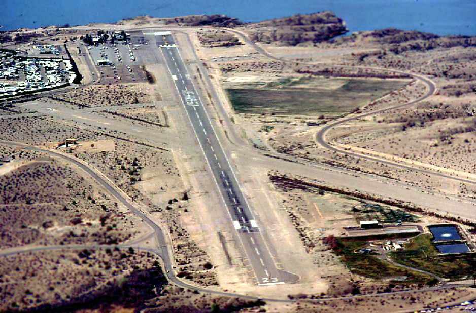
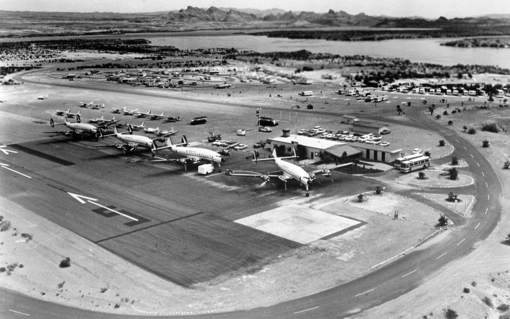
A circa 1978 aerial view by Chris Kennedy looking west at Lake Havasu City Airport while it was still open.
According to Craig Foster, this “photo was taken in about 1978.
The key in the photo is the FBO under construction on the south side (left in the photo) of the runway.
That's Executive Aviation where I started taking flying lessons in 1979.”
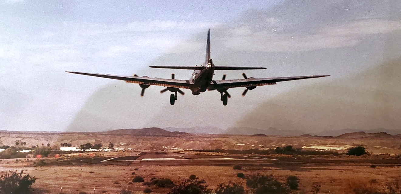
A 1987 photo by Vlad (courtesy of Les John) of a Boeing B-17 bomber landing at the original Lake Havasu Airport.
The last aeronautical chart depiction which has been located of the original Lake Havasu Airport was on the 1988 Phoenix Sectional Chart (courtesy of Jonathan Westerling).
It depicted Lake Havasu Airport as having a single 6,100' paved northeast/southwest runway.
The Lake Havasu City Airport was described in the 1989 Airport/Facility Directory (courtesy of Chris Kennedy)
as having a 6,167' asphalt Runway 5/23 & a 5,504' gravel Runway 2/20.
Wayne Peters recalled that his father Ron Peters worked as the Airport Manager “until the move was announced in 1990.
He decided to retire then.”
The original Lake Havasu Airport closed in 1991 when it was replaced by a more modern airport on higher ground just North of the town.
The original Lake Havasu Airport was depicted as an abandoned airfield on the 1993 Phoenix Sectional Chart (courtesy of Ron Plante).
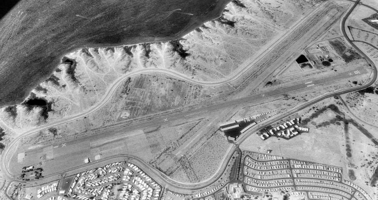
A 1994 USGS aerial view looking north at the site of the original Lake Havasu Airport, after the field's closure.
Two paved 5,500' runways still existed, along with the slightest trace of the former north/south runway.
Other portions of the property have been reused as a trailer park, an RV resort, condominiums, a hotel & golf course, and a sewage disposal facility.
A 2003 aerial view of the former Lake Havasu Airport by Eric James.
A 2004 aerial view looking north at the former Lake Havasu Airport by Paul Freeman (enhanced by Bill Grasha).
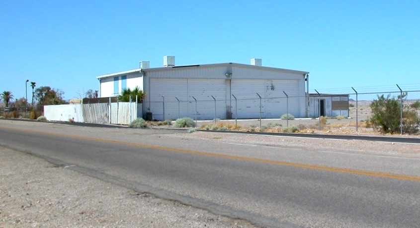
A September 2004 photo by Chris Kennedy of a hangar which remains at the site of the old Lake Havasu Airport.
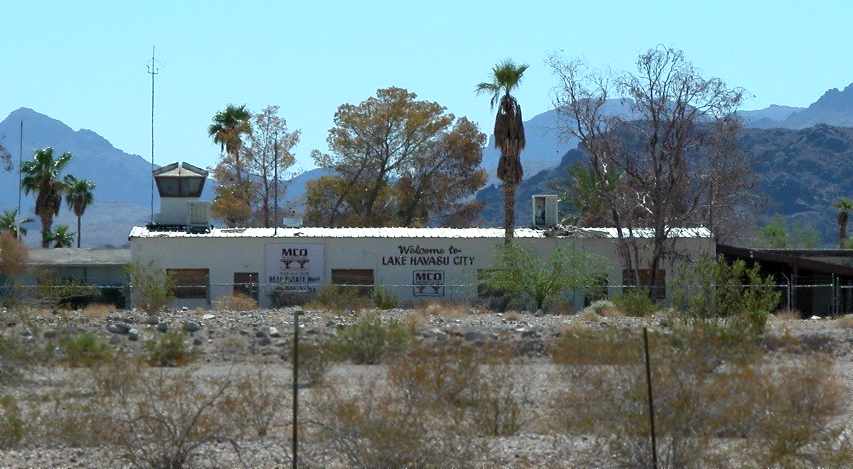
A September 2004 photo by Chris Kennedy of what appears to be a control tower cab
on top of one of the buildings at the former Lake Havasu Airport.
Chris Kennedy visited the site of the old Lake Havasu Airport in September 2004.
His report: "The buildings at the Lake Havasu site are obviously from its days as the city airport, not from WW2.
I wasn't able to see the runway because the road around the airport is lower than runway level."
Dan Falkerson reported in 2006, “The bunker for the skeet range still exists on the island - I stumbled upon it several years ago.
Nothing else remains of the other [former military] facilities,
and it's likely that even the remaining buildings & runway will soon vanish as they occupy prime resort real estate.”
A 3/31/14 photo by Cameron Shepherd at the site of Lake Havasu Airpark.
Cameron reported, “The palm trees would have been planted near the building with the little control tower, which I guess was the terminal.
Everything else is gone except the curved drive, barely visible in the old photo. The palms are all but gone, by the look of them.”
A 3/31/14 photo by Cameron Shepherd at the site of Lake Havasu Airpark, of “a yellow arrow that I'm pretty certain was a pointer for the [Runway] 5/23 displaced threshold.
It is difficult to make out the head of the arrow unless you're standing right on top of it, but it's definitely there & you can barely see it in this photo.
You can see these yellow markings on [aerial photos].
On the ground, I missed the threshold stripe & the remains of the runway number that also show in [aerial photos].
Stuff fades quickly out there - the parking lot markings that pop out on [aerial photos] are quite faint in real life now.”
Cameron Shepherd reported in 2014, “It looks like the old field was much more welcoming than the new airport, but of course that was a different era.
The new place is gorgeous, but fenced off in a very aggressive manner - which I think has a little something to do with keeping the unrich out.
I'm a Part 121 aircraft dispatcher (although not a pilot) and I don't feel welcome there at all. Mojave is a lot more fun, and it has more need to be uber-secure.”
A 2020 aerial view looking northwest at the site of the original Lake Havasu Airport,
showing portions remain of the 2 runways, but housing has progressively covered the middle portion of the airport site.
____________________________________________________
Signal Auxiliary AAF #7, Signal, AZ
34.37, -113.91 (Northwest of Phoenix, AZ)
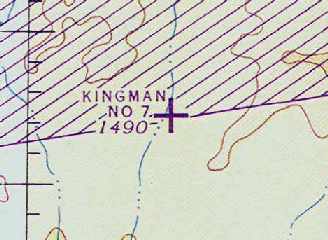
"Kingman #7", as depicted on the March 1945 Prescott Sectional Chart (courtesy of Chris Kennedy).
Photo of the airfield while in use has not been located.
This airfield was also known as Kingman Auxiliary AAF #7.
The military acquired a total of 800 acres in 1942, to construct an emergency landing strip to be used as a satellite field by Kingman AAF,
in connection with the Yucca Air to Air Gunnery Range.
According to Jeff Johnson (an archaeologist with EcoPlan Associates, Inc., charged with the task of documenting the history of Topock AAAF #5),
Topock AAAF & Signal AAAF were "two AAFs in Arizona that serviced B-17 bombers exclusively & still survives today in an almost unaltered condition."
No airfield was depicted at all on the site on the August 1944 Prescott Sectional Chart.
The earliest depiction of the airfield which has been located was on the March 1945 Prescott Sectional Chart (courtesy of Chris Kennedy).
It depicted "Kingman #7" as an auxiliary airfield.
The field was declared surplus in 1945, and the property was transferred to the Department of Interior in 1946.
It was apparently reused at least for some period as a civil airfield,
as Kingman Aux #7 was listed in a directory of AZ Airports in the 5/47 issue of Arizona Highways (courtesy of George Miller),
which described it as having a 6,000' runway, and being unattended.

The last aeronautical chart depiction which has been located of Kingman #7 was on the March 1952 Prescott Sectional Chart (according to Chris Kennedy) as having a 6,000' unpaved runway.
It depicted "Kingman #7" as having a 6,000' unpaved runway.
Kingman #7 was apparently closed at some point in 1952, as it was no longer depicted on the September 1952 Prescott Sectional Chart.
The 1966 USGS topo map depicted the Kingman #7 airfield as a single unpaved northeast/southwest runway, labeled simply as “Landing Strip”.
The "Landing Strip" continued to be depicted on the 1990 USGS topo map.
According to a 1992 Army Corps of Engineers report, the former Signal Aux #7 property is currently under the control of the Bureau of Land Management,
but is not used by the BLM.
A 1997 USGS aerial photo showed the Kingman #7 airfield to consist of a single 6,000' graded earth runway, which paralleled the east side of an unnamed eroded dirt road.
There did not appear to have been any buildings at the site.
A 6/8/07 aerial view looking southwest showed the remains of the Kingman #7 airfield runway.
____________________________________________________
____________________________________________________
This site covers airfields in all 50 states.