
Abandoned & Little-Known Airfields:
Colorado: Colorado Springs area
© 2002, © 2024 by Paul Freeman. Revised 8/30/24.
For a 9th year, the CO pages of this website are sponsored by the Colorado Pilots Association:
____________________________________________________
Please consider a financial contribution to support the continued growth & operation of this site.
Aardvark Field (revised 8/30/24) - Alexander Airport / Nichols Field (revised 8/30/24)
Black Forest Gliderport (revised 11/9/23) - Pikes Peak Airport (revised 8/30/24) - (Original) Pueblo Municipal Airport (revised 11/22/23)
____________________________________________________
Pikes Peak Airport, Colorado Springs, CO
38.726, -104.705 (South of Denver, CO)

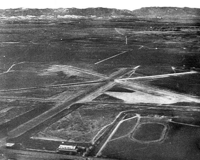
Pikes Peak Airport, as depicted on a 10/24/60 USGS aerial view.
This general aviation airport was evidently established at some point between 1955-60,
as it was not yet depicted on a 1955 aerial photo nor on the 1960 Denver Sectional Chart.
The earliest depiction which has been located of Pikes Peak Airport was a 10/24/60 USGS aerial photo.
It depicted Pikes Peak Airport as having a north/south unpaved runway & parallel taxiway,
along with possibly a predecessor unpaved north/south runway just to the east.
A ramp with a small building sat to the southwest, along with 7 light single-engine aircraft.
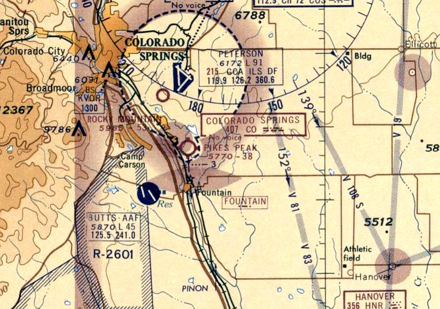
The earliest aeronautical chart depiction which has been located of Pikes Peak Airport was on the June 1963 Denver Sectional Chart.
It depicted Pikes Peak Airport as having a 3,800' unpaved runway.
A 1969 aerial photo depicted Pikes Peak Airport at perhaps its zenith of popularity, with 2-dozen light aircraft on the southwest side.
The runway had possibly been paved at some point between 1960-69,
along with 2 other buildings which had been added.
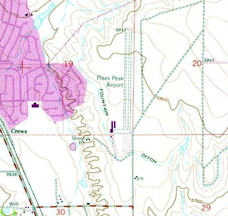
The only topo map depiction which has been located of Pikes Peak Airport was on the 1970 USGS topo map.
It depicted Pikes Peak Airport as having a north/south unpaved runway & parallel taxiway, and a ramp with 3 buildings on the southwest side.
The last aeronautical chart depiction which has been located showing Pikes Peak Airport in operation was on the 1971 Denver Sectional Chart.
It depicted Pikes Peak Airport as having a single 4,600' paved north/south runway.
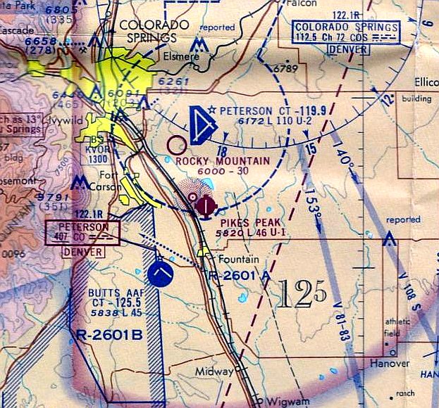
Pikes Peak Airport was evidently closed at some point between 1971-74, undoubtedly a victim of suburban sprawl,
as it was depicted as an abandoned airfield on the 1974 Denver Sectional Chart (courtesy of Jonathan Westerling).
A 1983 aerial photo showed the majority of the Pikes Peak Airport site had been covered by suburban housing,
but the southern portion of the runway & taxiway remained, along with the former hangars & airport buildings.
A 1999 aerial photo showed the southern portion of the Pikes Peak Airport runway & taxiway remained, along with the former hangars & airport buildings.
A 2005 aerial photo showed the remains of the southern portion of the Pikes Peak Airport had been removed by new construction.
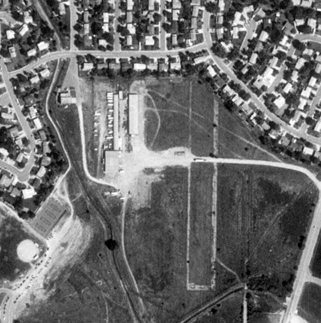
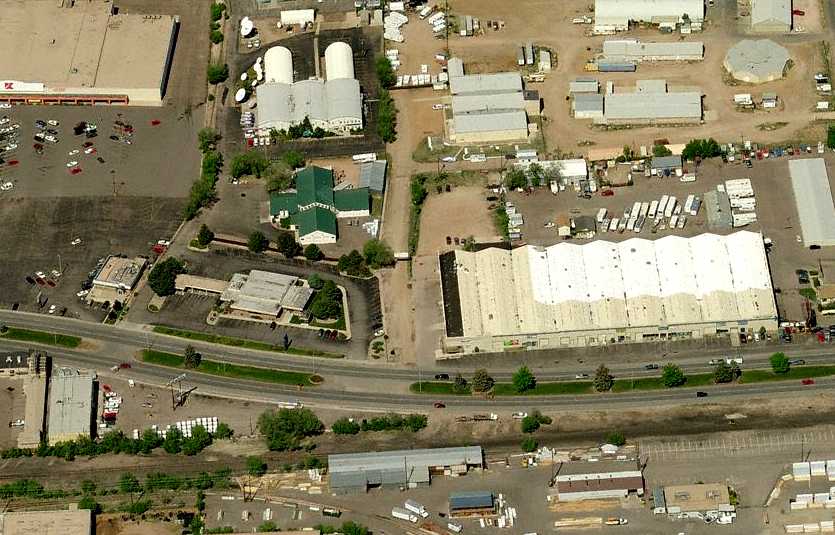
A 2009 aerial photo showed a Lowe's Home Improvement store at the southern portion of the Pikes Peak Airport site,
but the foundations remained of the hangars.
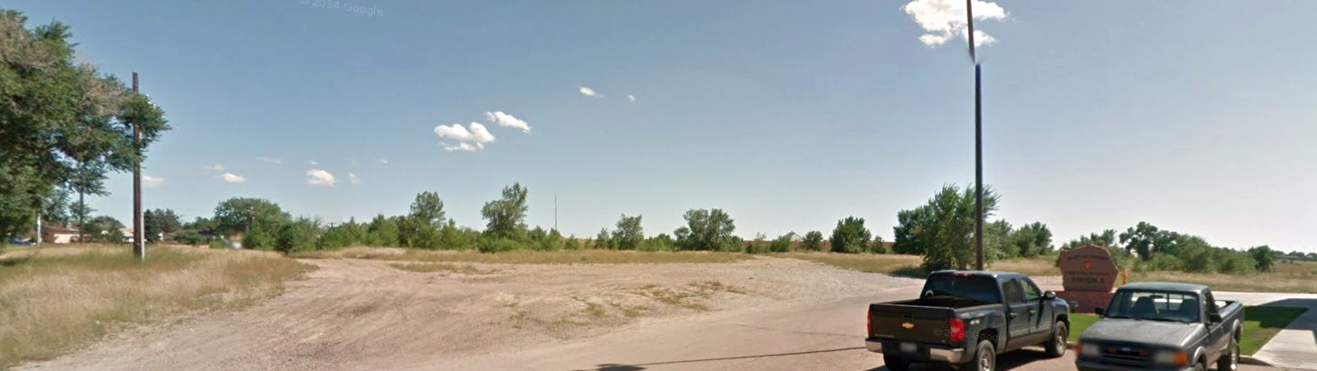
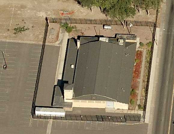
A September 2014 photo looking southeast at the site of the Pikes Peak Airport hangar foundations, southeast of the Security Fire Department Station 2.
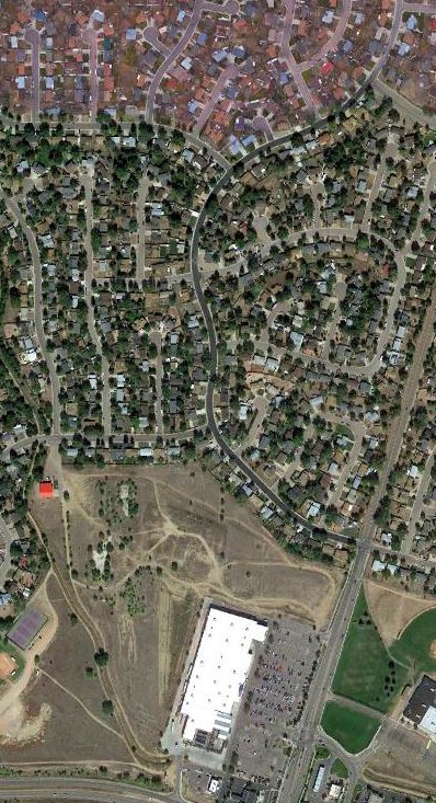
A 2019 aerial photo showed the majority of the Pikes Peak Airport site covered by housing.
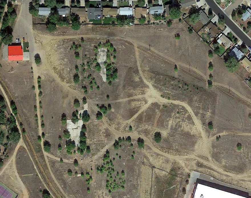
A closeup from the 2019 aerial photo of the southern portion of the Pikes Peak Airport site, showing the hangar foundations & the faintest traces of the runway alignment.
Cameron Martin reported in 2022, “I discovered some old foundations near a Lowe's within walking distance of my house, behind a fire station.
There was an airport there - those foundations had been hangars!
When the neighborhood was built, they bulldozed the northern end of the runway & the hangars were turned into warehouses.
All that remains today are the concrete pads.”

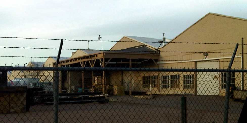
A 3/6/24 photo by Sean Doyon looking southwest at the Pikes Peak Airport hangar foundation.
Sean reported, “It really is a curious piece of forgotten property, behind a neighborhood, a fire station, and a Lowe's.
The ground is uneven in the area now, with a large berm in the middle of where the runway used to be. I was surprised to find so much at the site despite its closure over 50 years ago.”

A 3/6/24 photo by Sean Doyon of Pikes Peak Airport hangar door rails.
Thanks to Cameron Martin for pointing out this airfield.
____________________________________________________
Alexander Airport / Nichols Field, Colorado Springs, CO
38.88, -104.813 (South of Denver, CO)
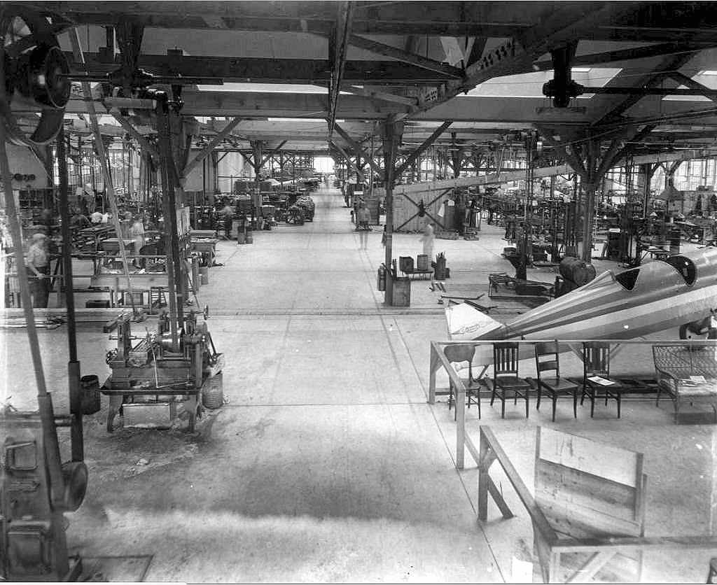
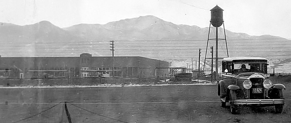
A 1928 view of the interior of the Alexander Aircraft Company plant.
The Alexander Film Company, under the brothers J. Don & S. Don Alexander, specialized in film advertising.
When the younger J. Don Alexander wanted 40-50 airplanes for his salesmen, he was forced to produce his own aircraft,
as no company at the time was able to fill such an order.
Originally headquartered in Englewood, the film-turned-aircraft company was forced to move to Colorado Springs in order to expand.
The Alexander Aircraft Company built a number of successful versions of the Alexander Eaglerock biplane, which were especially popular with barnstormers.
They were also used for carrying airmail, aerial photography, crop dusting, and air racing.
The earliest depiction which has been located of the Alexander Aircraft plant was a 1928 view of the interior, showing several aircraft under construction.
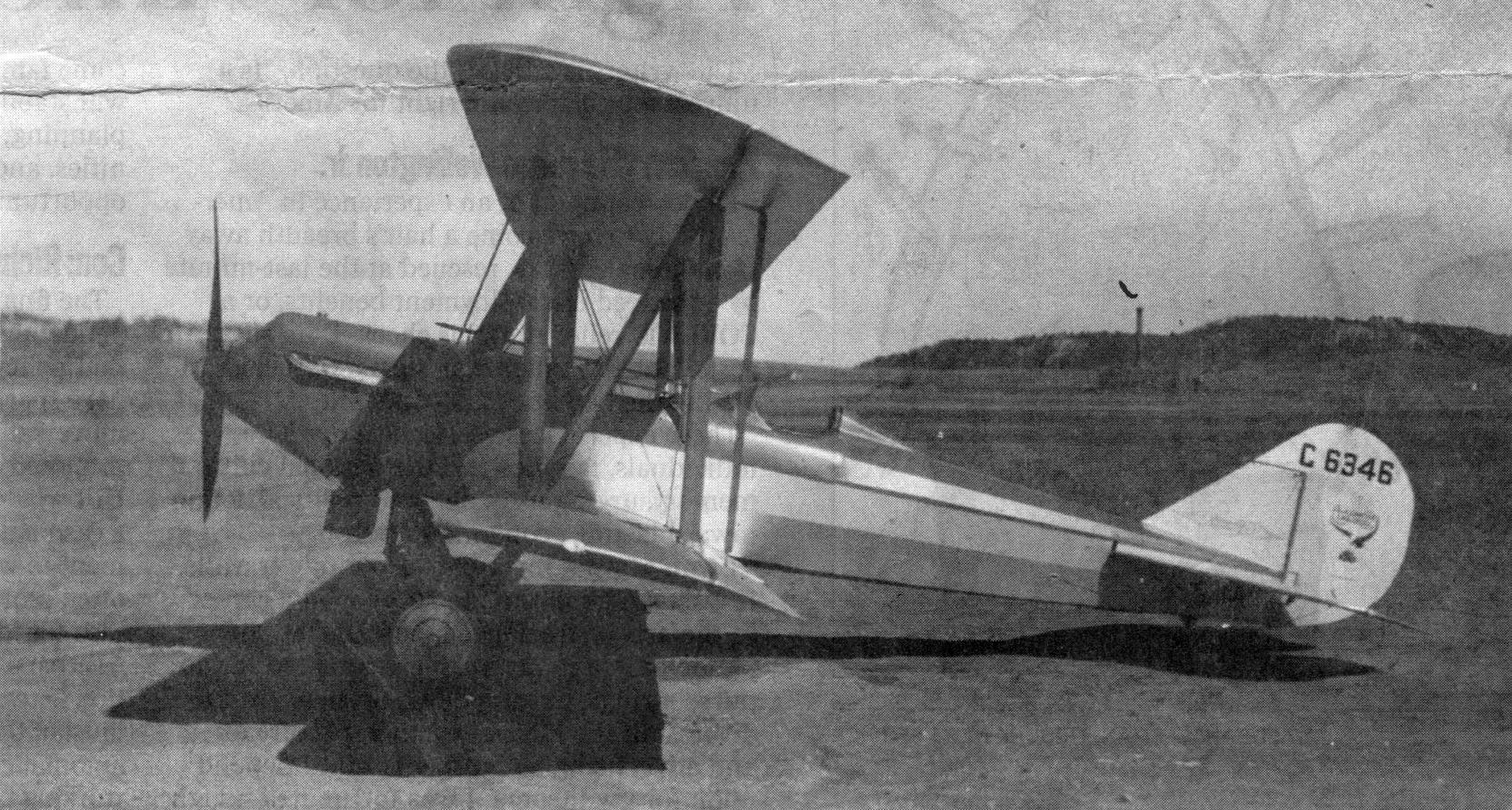
A Summer 1928 photo of an A-2 OX5 Center-Section Eaglerock biplane at Alexander Airport (courtesy of Jonathan Westerling), originally captioned, “Craft may be prototype.”
For a brief period from 1928-29, Alexander was the largest aircraft manufacturer in the world,
and more aircraft were built in Colorado than anywhere else in the world.
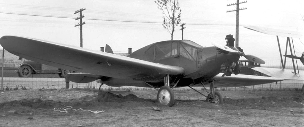
A 5/19/29 photo of Alexander "Bullet" #8228, a low-wing monoplane, at the Alexander Colorado Springs plant.
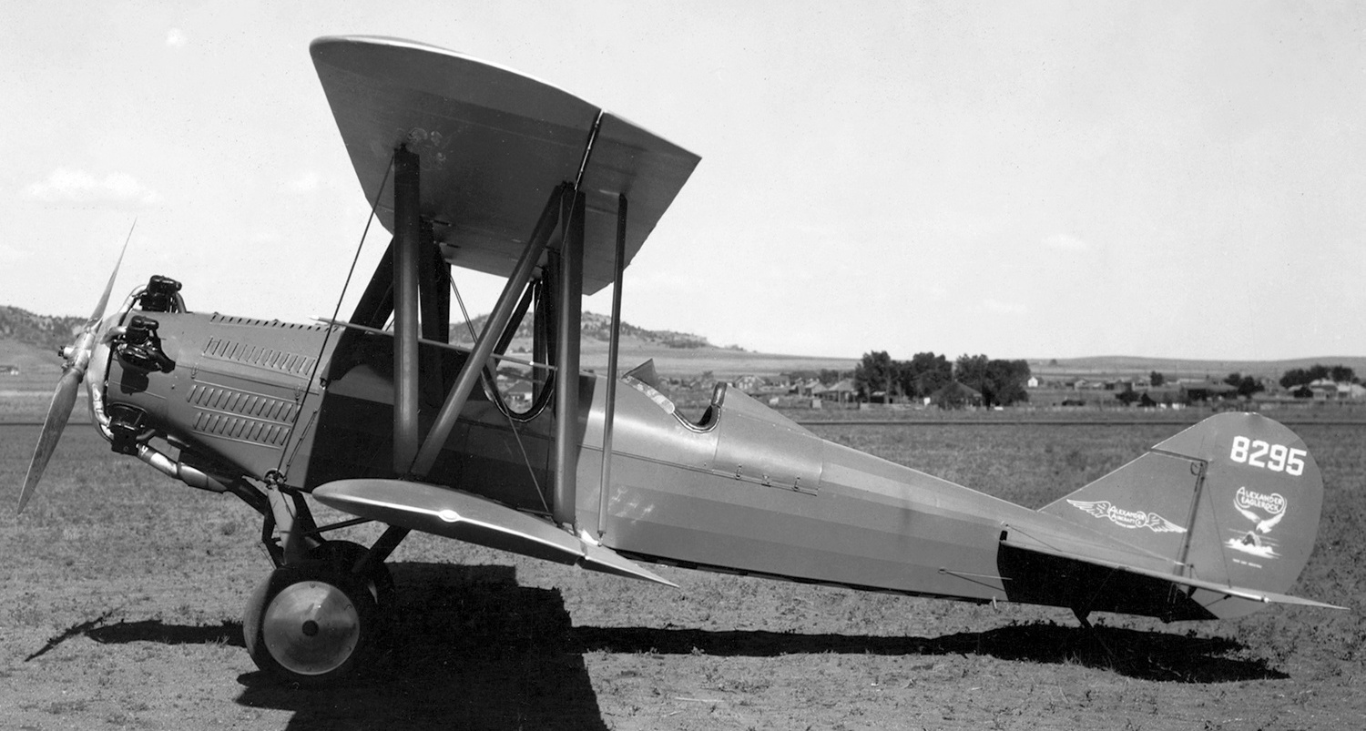
A 1930 photo of the prototype of the Wright-powered Alexander Eaglerock A-14, NC8295, C/n 849, at Nichols Field.
Financial woes forced the Alexander Aircraft Company into bankruptcy in 1932.
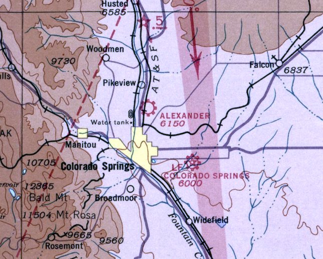
The earliest aeronautical chart depiction which has been located of the Alexander Airport was on the March 1936 Denver Sectional Chart.
It depicted Alexander as a commercial/municipal airport.
The earliest airport directory listing which has been located of the Alexander Airport
was in The Airport Directory Company's 1937 Airport Directory (courtesy of Bob Rambo).
It described Alexander as a commercial airport, located 3 miles north of Colorado Springs.
The field was said to consist of a 160 acre T-shaped sod field with one oiled 4,200' north/south runway & 2 hangars.
The earliest photo which has been located of Alexander Airport was a 1938 aerial view (courtesy of Jim Densmore).
It depicted the field as having a single northwest/southeast runway, with a few small hangars on the west side.
Across the road to the west sat the facilities of the Alexander Aircraft Company.
The Alexander Airport had evidently closed (for reasons unknown) at some point between 1937-39,
as it was not depicted on the February 1939 Denver Sectional Chart nor on the March 1940 Denver Sectional Chart.
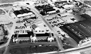
An undated (1940s?) aerial view looking west at the Alexander Aircraft Company plant & film studios.
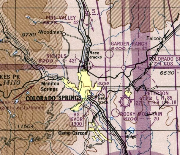
At some point between 1940-45, the former Alexander Airport was evidently reopened as Nichols Field, as that is how it was depicted on the February 1945 Denver Sectional Chart.
It depicted Nichols as an auxiliary airfield.

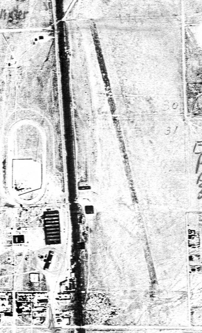
Nichols Field was evidently significantly expanded at some point between 1938-47, as depicted on a 7/25/47 USGS aerial photo.
The original northwest/southeast runway was joined by 2 new runways, oriented northeast/southwest & northwest/southeast, along with multiple taxiways.
Several buildings were depicted on the west side of the field, along with no less than 21 light aircraft.
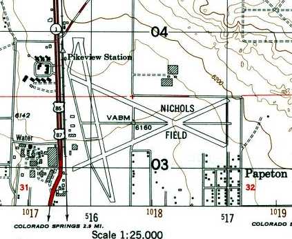
The 1949 USGS topo map depicted Nichols Field as having 3 paved runways, taxiways, and several buildings along the west side.
The last aeronautical chart depiction which has been located of Nichols Field was on the February 1949 Denver Sectional Chart.
It depicted Nichols as having a 4,200' unpaved runway.
Nichols Field was evidently closed (for reasons unknown) in 1949, as it was no longer depicted on the October 1949 Denver Sectional Chart.
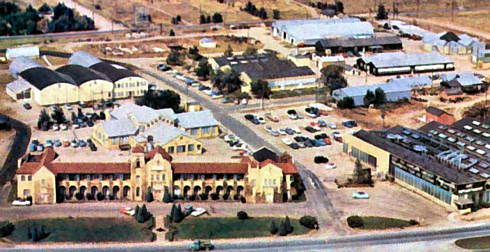
An undated (1950s?) aerial view looking west at the Alexander Aircraft Company plant & film studios.
A 10/24/60 aerial photo showed the Nichols Field site had been covered with new streets & buildings.
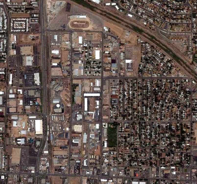
A 6/19/06 aerial photo shows no obvious remaining trace of Nichols Field,
although a few of the buildings used by Alexander Aircraft for manufacturing still remained.
A circa 2008-2011 aerial view looking west showed that a few of the buildings used by Alexander Aircraft for manufacturing still remained,
although their main building had been removed & replaced with a smaller bank building.
It is not apparent if any of the buildings on the west side of the airfield site (in the foreground) were former hangars.
A 2011 photo by Jim Densmore of the former Alexander Aircraft manufacturing buildings.
Brandon Lackey reported in 2019, “The old Alexander Aircraft factory... All buildings of the manufacturing & film studio (except the HQ) are still standing. Nothing remains of the original airfield.”
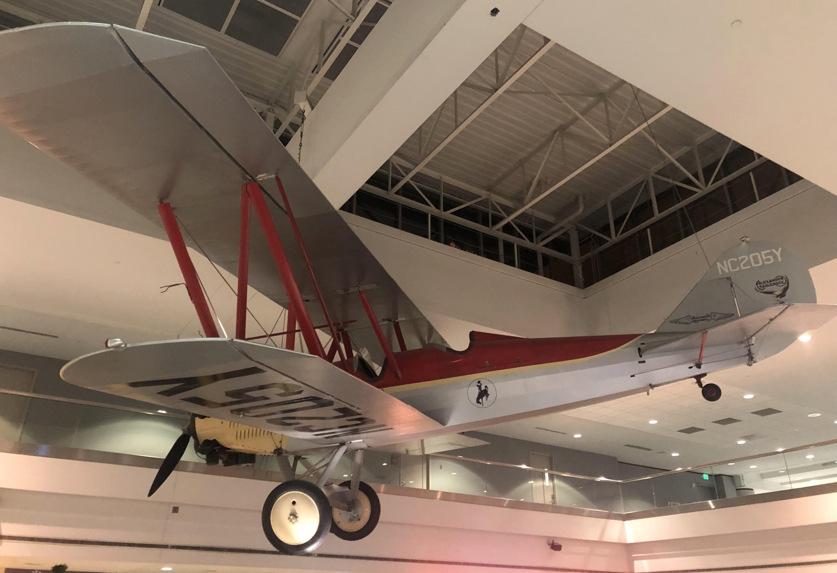
A 12/29/21 photo by Paul Freeman of the 1930 Alexander Eaglerock A-14 biplane (built at Nichols Field) which is suspended from the ceiling of Denver International Airport's United Airlines Concourse B.
The site of Nichols Field is located northeast of the intersection of Route 85 & East Filmore Street.
____________________________________________________
Black Forest Gliderport, Black Forest, CO
38.97, -104.68 (South of Denver, CO)
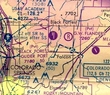
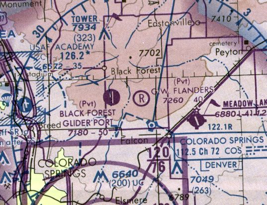
Black Forest Gliderport, as depicted on the June 1963 Denver Sectional Chart.
This general aviation glider airfield was evidently established at some point between 1962-63,
as it was not yet depicted on the November 1960 Denver Sectional Chart nor on the 1962 USGS topo map.
The earliest depiction which has been located of Black Forest Gliderport was on the June 1963 Denver Sectional Chart.
It depicted Black Forest as having a 5,000' unpaved runway.
Kevin Shaw recalled, “Black Forest Glider Port was a very active, internationally known location for high altitude wave flying over the nearby mountains.
It was owned by Mark Wild & Dave Johnson, and was most active in the 1960s & 1970s.”
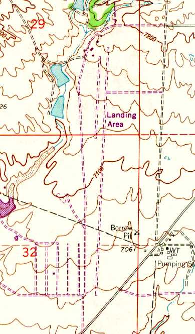
The earliest topo map depiction which has been located of Black Forest Gliderport was on the 1969 USGS topo map,
which a north/south unpaved runway, with several buildings at the north end, labeled simply as “Landing Area”.
The 1970 Denver Sectional Chart (courtesy of Ed Granato)
depicted Black Forest Glider Port as a private field with 2 parallel paved runways, the longest being 6,000'.
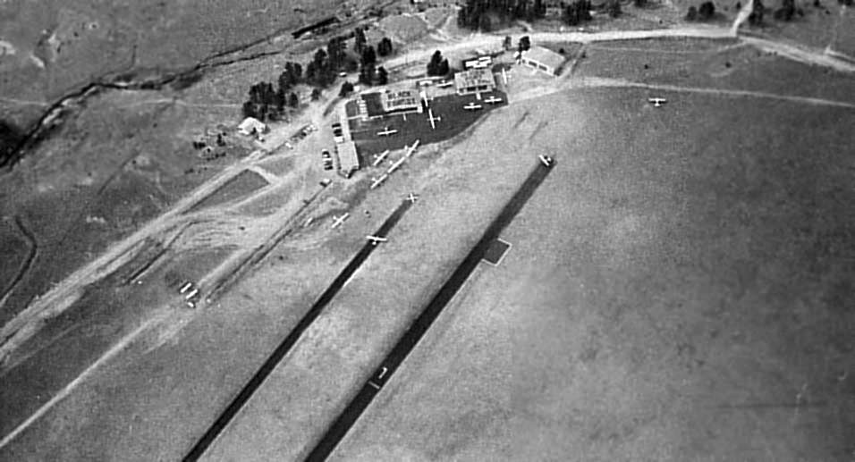
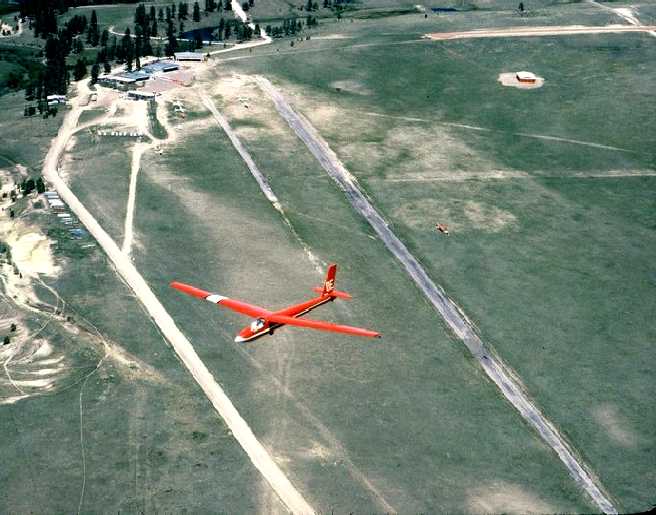
A 1972 aerial view looking north by Jim Foreman (courtesy of Mark Hess) depicted Black Forest as having a pair of parallel asphalt runways,
one of which was marked Runway 7, the other with an X.
Fifteen aircraft were visible on the field, including both gliders & single-engine aircraft.
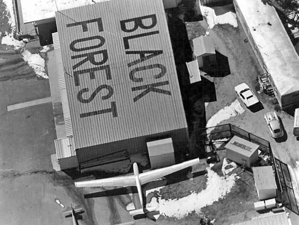
The hangars were marked with “Black Forest” & “Glider Port” & the Unicom frequency.
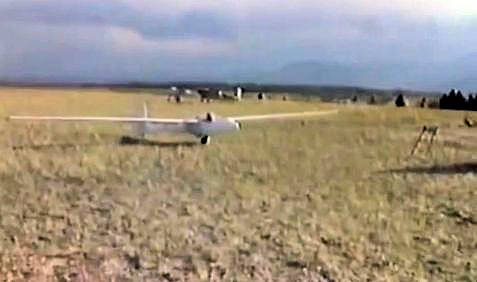
A 1972 photo by Jim Foreman (courtesy of Mark Hess) of a single-seat Burkhart Grob Flugzebau AG G102 Astir CS glider (serial #1171) at Black Forest,
with 4 other gliders in the background.
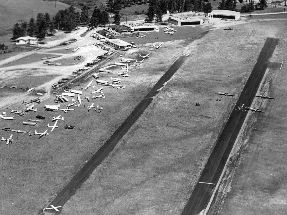
An amazing 1973 aerial view by Jim Foreman (courtesy of Mark Hess) depicted an amazing assemblage of at least 28 gliders & single-engine aircraft at Black Forest.
An undated photo of a glider in a tight turn over Black Forest from the movie “Memories of Black Forest Gliderport” by Jim Foreman.
An undated aerial view looking east at Black Forest Glider Port from the 1976 CO Airport Directory (courtesy of Alex Hauzer).
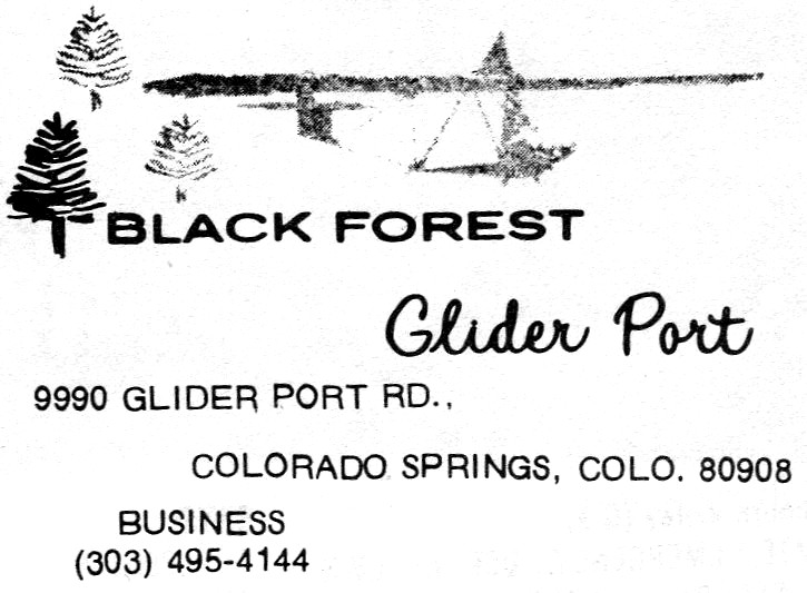
An advertisement for Black Forest Glider Port from the 1976 CO Airport Directory (courtesy of Alex Hauzer).
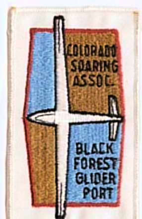
An undated photo of patch for the CO Soaring Association Black Forest Glider Port from the movie “Memories of Black Forest Gliderport” by Jim Foreman.
The February 1977 Denver Sectional Chart (courtesy of Jim Hackman)
depicted Black Forest Glider Port as a private field with 2 parallel paved runways, the longest being 5,000'.
A 1979 aerial view by Jim Foreman (courtesy of Mark Hess) of 2 gliders next to the Black Forest hangar.
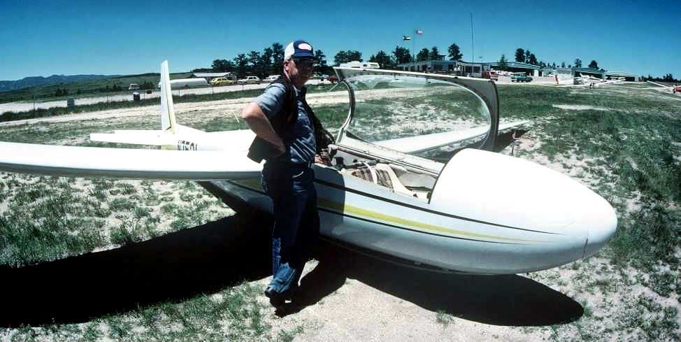
An undated photo of Jim Foreman & a Schweitzer SGS 2-32 glider tied down at Black Forest Gliderport.
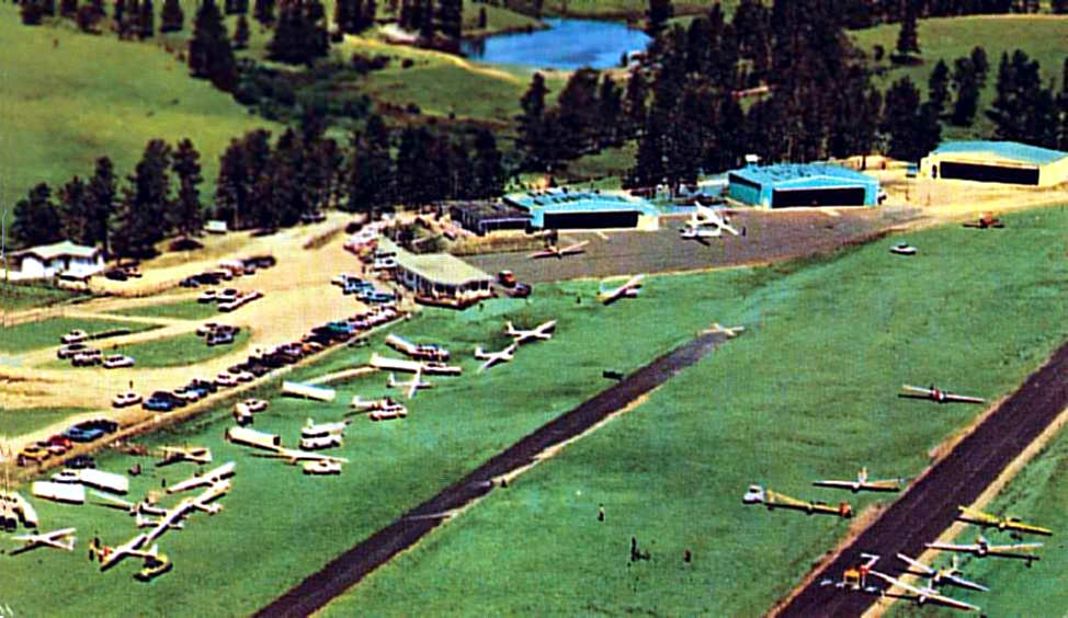
A circa 1970s aerial view looking north at a very busy Black Forest Gliderport(courtesy of Mike Newgard).
It depicted Black Forest as having 2 parallel asphalt runways, 3 hangars, and dozens of gliders.

The logo of the Black Forest Gliderport.
An undated aerial view by Jim Foreman looking north at a glider overflying Black Forest Gliderport,
with the paved runway, hangars, and a few gliders visible on the field.
Jim Foreman recalled, “It was a very unusual place with pilots coming from all over the world.
Also had a number of notable people come fly there, Neil Armstrong and most of the other astronauts came there at one time or another.
John Denver would often drop by for a day or two, especially if he wanted to get away from Aspen.
Hugh Downs kept a glider there for several years & would come there to fly.
In fact, the tail letters on his glider were OE for his program Over Easy.
You can see it in some of the photos like the red glider over the field (he sold it to the club for a dollar & the club had it repainted).
Christopher Reeve came a couple times as did John Wayne.
Beryl Markham (first woman to fly the Atlantic from east to west) when she was about 75.
She had never flown in a glider & wanted to get a ride.
I took her up & while she hadn't flown in many years, I could tell she still had the feel of an aircraft.
The world glider altitude record for women (41,428') was set there by Sabrina Jackintell who had a home at the northeast corner of the field.
That record still stands after 35 years.”
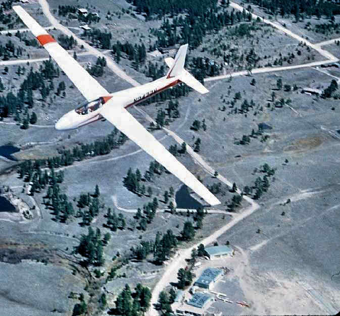
An undated aerial view by Jim Foreman looking north at a Schweitzer SGS 2-32 glider overflying Black Forest Gliderport,
with the hangars & a few gliders visible on the field.
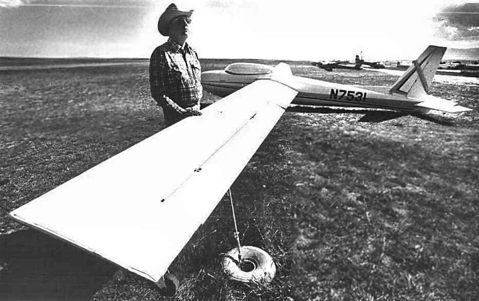
An undated photo of N7531, a 1970 Schweizer SGS 2-32, serial #71 at the Black Forest Gliderport.
Kevin Shaw recalled, “Black Forest Glider Port... I gave instruction & rides there for a time in the early to mid-1980s.
In that era, the original owners sold the land to a real estate developer.
A real estate downturn delayed the redevelopment & allowed the airport operation to continue there for a time while an alternative location was found.”
Mike Newgard recalled, “It was very active until the mid-1980s. Lots of high altitude flights & some contests.”
The last aeronautical chart depiction which has been located of the Black Forest Gliderport was on the 1986 Denver Sectional Chart (courtesy of Jonathan Westerling).
It depicted Black Forest Glider Port as a private field with 2 parallel paved runways, the longest being 5,000'.
The last pilot to land at Black Forest Gliderport, Darryl Hickey, from Mike Cavanagh's 1986 video, The Last Day At Black Forest Gliderport.
According to Jim Foreman, “The day finally came when the insurance & airport permits ran out
and word was sent out that even though the place was technically closed, there would be one final party held at Black Forest Gliderport.
A tow plane was brought in & 5 or 6 people brought their gliders for one last flight.
Mike Cavanagh had a video camera & walked around visiting with people, unfortunately the sound was very bad and people could not be understood in places.
The last pilot to land at Black Forest Gliderport was Darryl Hickey.
Mike sent me the video which I posted on YouTube, The Last Day At Black Forest Gliderport.
It was more of a wake & I selected a funeral dirge from the Civil War as the musical backdrop to the video.
It was a great loss to soaring when it closed.”
Mike Cavanagh recalled, “After the LAST DAY & video I shot, the glider port ended up staying open for several weeks if not more.”
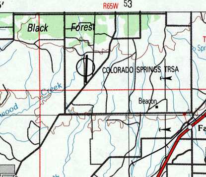
The last depiction which has been located of Black Forest Gliderport was on the 1989 USGS topo map.
It depicted the single runway of Black Forest,
but erroneously labeled the field as “Colorado Springs TRSA”, a dubious error by the mapmakers.
Jim Foreman reported, “The short version of what happened to Black Forest Gliderport:
First the tax hogs changed the zoning from ranch to light commercial
which multiplied the taxes by about 20 times which far exceeded any profit potential of keeping it open.
Mark Wild owned the 240 acres of the gliderport as well as 51% of Wave Flights, the commercial operation.
He was approached by a guy from Chicago who said he wanted to buy it as a long-time investment
so the property was valued for $3 million & the business for $300,000.
He paid the $300,000 up front & gave Mark a note for the $3 mil with a 10% interest to be paid annually.”
Jim continued, “Seeing the writing on the wall, the Colorado Soaring Association, which represented perhaps half of the income of the operation,
began to look for another home & bought the Owl Canyon Airport north of Fort Collins & moved there.
Their 5 gliders had been on leaseback to Wave Flights so that reduced the remaining equipment considerably.”
Jim continued, “At the end of the first year after the sale,
the Chicago owner couldn't come up with the $300,000 interest payment so it was added to the principal of the note.
Shortly after that, he began to sell the remaining equipment with Dick Seaman buying most of it.
He lived on what was called Glider Loop which was 80 acres carved out of the original land
which was divided into 5 acre plots & sold to settle the divorce when Mark & Ruth separated.
The ranch was originally 320 acres (half a section).”
Jim continued, “Then the Chicago owner sold the land to a guy named Aires from Phoenix
who was buying all the vacant land north & east of Colorado Springs that he could lay hand on.
Rumor had it that he paid $7.5 million which he borrowed from Lincoln Savings & Loan.
Mark still had the $3 million plus 10% interest 1stmortgage on the land but still hadn't received a dime from anyone, just rolling the interest back into the loan.
In order to get the taxes reduced, Aires simply gave all the hangars & other buildings to whoever wanted them as long as they were removed.
The Lennie Inn & Recreation Room somehow didn't go with the rest of the buildings & remained there for several years.”
Jim continued, “A year or so later the whole house of cards fell in with Lincoln S&L going toes up
and all the debt on all that money was dumped onto HUD & the government.
A new club called The Black Forest Soaring Society was formed from some local members of the Colorado Soaring Association
and made a deal to manage a new air park located about 20 miles to the north.
Mark Wild never got a dime out of the land but did finally regain ownership after about 7 years.
He had subdivided & sold most of it for homes but still had 40 acres right around where the hangars had been located when he died.”
The Black Forest Gliderport was evidently closed by 1992,
as it was no longer depicted on the 1992 Denver Sectional Chart (courtesy of Jonathan Westerling).
Kurt Olson reported, “I met a guy [who] had a Black Forest Gliderport jacket on.
He said the reason they closed it was when they built the new east runway at KCOS, Black Forest Gliderport was in conflict with it.
It was a fun place with lots of activity.”
Kevin Shaw recalled, “The Black Forest commercial operation ended & a new successor club, the Black Forest Soaring Society was formed.
They purchased the hangars & clubhouse, and moved them to the new location –Kelley Air Park, a residential airport north of the old location.”
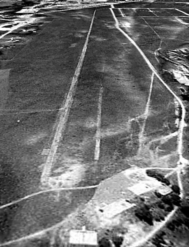
A 9/4/99 USGS aerial view looking south showed that all of the hangars & other airfield buildings had been completely removed,
with the ramp & hangar foundations remaining on the north side of the airfield site.
The entire length of the runway remained intact, though.
A 2005 aerial photo showed that streets & houses had covered the southern half of the airfield site at some point between 1999-2005.
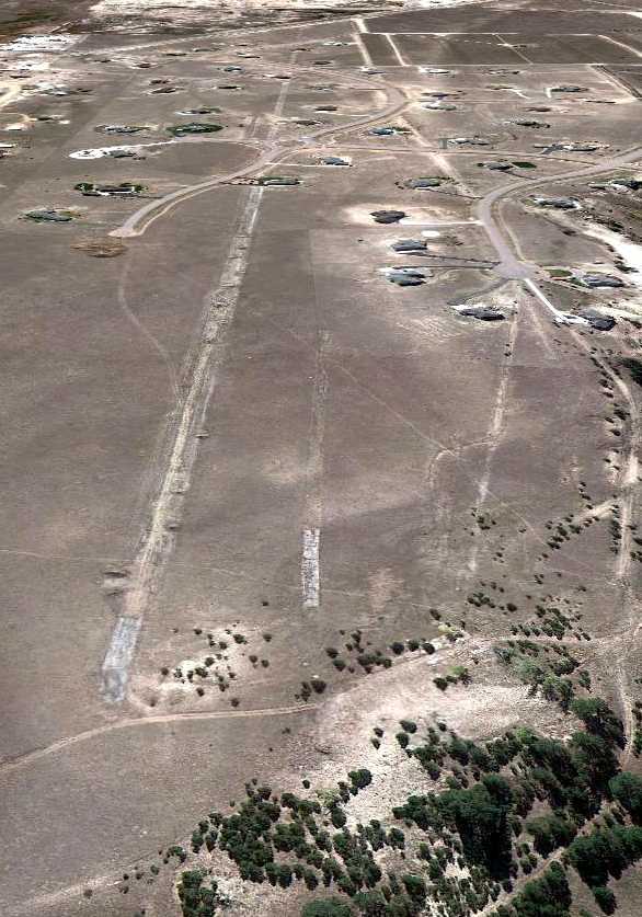
A 10/23/11 aerial view looking south showed that the northern half of the Black Forest runway remained intact.
The site of Black Forest Gliderport is located north of the intersection of Forestgate Drive & Lochwinnoch Lane.
____________________________________________________
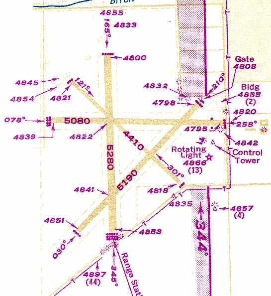
(Original) Pueblo Municipal Airport, Pueblo, CO
38.25, -104.66 (South of Denver, CO)
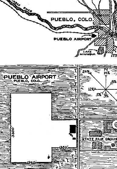
The location & layout of the Pueblo Airport, as depicted on the 7/26/27 Commerce Department Airway Bulletin (courtesy of David Brooks).
The original airport for the town of Pueblo was located on the southwest side of the town.
According to the article “City's first airport was bustling, had major carriers” by Mary Porter in the 11/2011 Pueblo Chieftain (courtesy of Lee Corbin),
“Cows were a hazard at Pueblo's first airport on the prairie.
At least a decade before there was a true landing field on the South Side, the open ground of Uplands Park attracted early aviators.
And visiting 'aeroplanes' attracted crowds to the State Fairgrounds where, in December 1910,
they paid 50 cents apiece to see a Farman biplane & a Bleriot monoplane.
Puebloans turned out again to see 12 visiting planes at a 3-day show in April 1911 at the Fairgrounds.”
Pueblo Star-Journal reporter wrote, "Pilots skimmed treetops and buzzed cows and chickens during takeoffs from pastures in South Pueblo."
It was the cows' turn to agitate the pilots when, on a dusty day in the 1920s, a drover guided his stock into the path of a series of landing planes.
Horrified observers got the cowboy's attention & he was able to divert the herd at the last minute & avoid disaster.
The Porter article continued, “By 1920, six 150' wide runways had been graded out of the prairie
and, in 1923, the Colorado National Guard organized Flight B of the 120th Observation Squadron in Pueblo & equipped it with 6 planes.
The squadron was called 'The eyes of the Army'.”
The Porter article continued, “The city boasted 60,000-plus people in 1925 when its first municipal airport was established on the South Side, on what is now Prairie Avenue.
The airport hangar was completed in 1925 & airmail service was begun a year later.
The steel girders & corrugated sheet metal for the hangar had been used in France during World War I
and were sent to Pueblo by the federal government; penitentiary inmates from Canon City provided most of the labor for construction of the $50,000 hangar.
Among the first planes to occupy the hangar were four World War I-surplus Curtis JN4 Jennies, according to History Colorado.
The Jennies were open-cockpit biplanes used as trainers during the war & as show planes afterward.”
According to a plaque by the Colorado Historical Society, the Pueblo Airport hangar was constructed in 1925.
The Porter article continued, “On 5/31/26 Puebloans gathered at their new airport to celebrate departure of the first airmail flight from the city to Cheyenne, WY.”
The plane "soared away like some majestic bird into the turquoise blue of a cloudless Colorado sky," The Pueblo Chieftain enthused, while thousands cheered & the national anthem was played.
Newspaper promotions urged citizens to send letters anywhere in the U.S. for 20 cents / ounce, and 6,000 letters posted by Puebloans were carried on the inaugural run.
The first piece of mail it delivered to Pueblo was a copy of the 5/30/26 New York Times sent to The Pueblo Chieftain with a congratulatory message enclosed.
It cost $8.35 in airmail stamps for the package to be flown to Pueblo.
Local businessmen predicted great things with the coming of airmail service & bragged, "The landing field here is one of the best in the entire country."
Ten planes competed in a Denver-to-Pueblo air race in August 1926, with the prize a silver loving cup provided by Spencer Penrose of Colorado Springs.
The earliest directory reference to the Pueblo Airport which has been located
was in the 7/26/27 Commerce Department Airway Bulletin (courtesy of David Brooks).
It described Pueblo Airport as a municipal field owned by the County, and operated by the Pueblo Commerce Club, caretaker Carle Jackson.
The field was said to consist of a 190 acre T-shaped sandy loam field, measuring 3,300' north/south.
A steel 120'x x 66' hangar was depicted on the east side.
The Porter article continued, “City rivalry also figured in Pueblo's early romance with aviation.
The Colorado School of Aviation, one of several local flight schools, furnished a plane & a pilot to fly over the Central-Centennial football game
on 11/24/27 at Central stadium during halftime & drop red & blue confetti on the field.”
The Porter article continued, “The 1929 Pueblo City Directory listed the Pueblo Airport in the 900 block of Prairie Avenue,
and Piele Brothers and William Conner, all commercial aviators, at 1000 Prairie along with Western Air Express.”
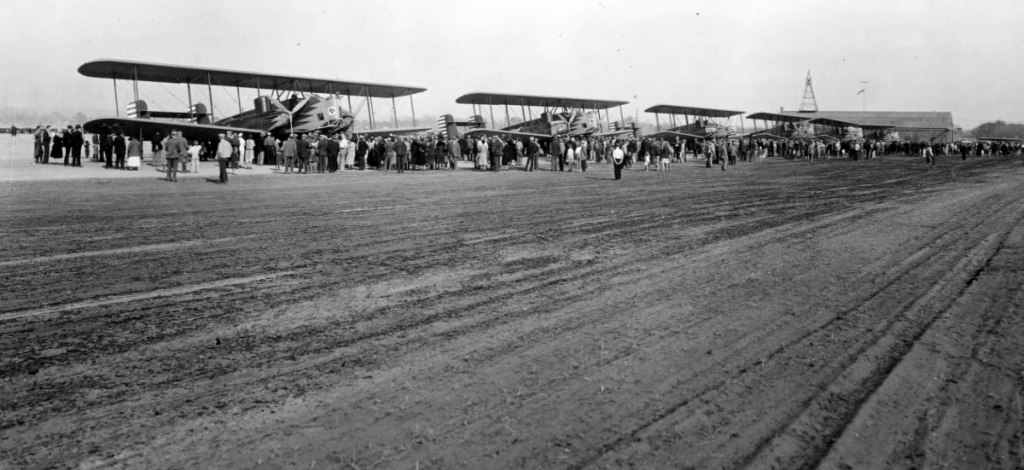
The earliest photo which has been located of Pueblo Airport was a circa 1929-34 photo of 6 Air Corps Curtiss B-2 Condor heavy bombers.
According to Bill Grasha, “Only 13 were made so about half the production was visiting Pueblo.”
Pueblo's hangar & beacon tower are visible in the background.
The Airport Directory Company's 1933 Airport Directory (courtesy of Chris Kennedy)
described Pueblo as a municipal airport, located 3.25 miles southwest of the post office.
The field was said to consist of a 534-acre prairie grass field, “T” shaped, containing a single 3,300' north/south runway.
The earliest aeronautical chart depiction of the Pueblo Airport which has been located was on the March 1936 Denver Sectional Chart.
The Porter article continued, “Federal work-relief programs of the 1930s were a boon to the small airport.
Civil Works Administration & Works Progress Administration laborers installed nearly 10,000' of paved runways & nearly 4,500' of unpaved runways.
The hangar was moved to a better location & a steel tower with a beacon was installed near it.
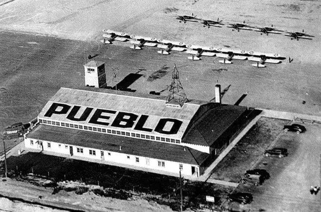
A large 'Pueblo' sign was painted on the hangar roof to identify the airport, and lights were installed to mark the perimeter.
A map, drawn to indicate placement of the lights, noted that the airport area was 424 acres.
The airport was bounded on the east by Prairie Avenue & on the south by Northern Avenue.
One corner (the airport was irregularly-shaped) stretched nearly to Thatcher Avenue & the western boundary was notated only by legal description, not street name, on the map.
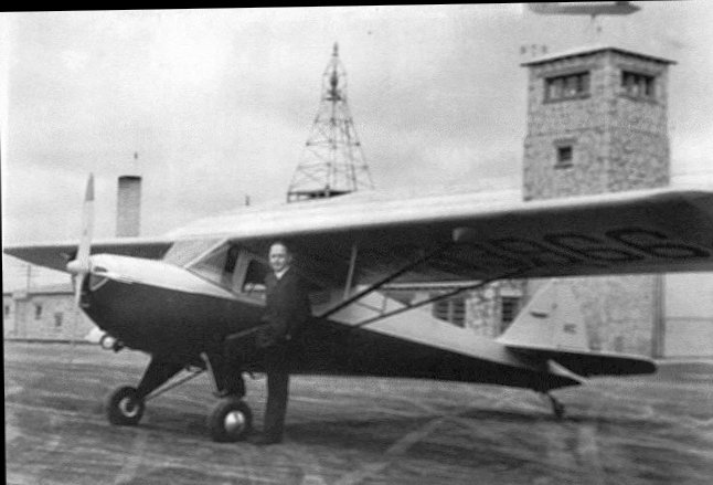
The WPA crews built a limestone control tower & offices adjoining the hangar for flying schools, the city, and commercial airlines.
The north side of the hangar was enlarged to provide space for aircraft maintenance.”
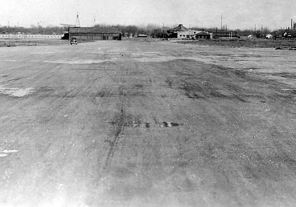
The earliest dated photo which has been located of the Pueblo Municipal Airport was a 2/7/38 view looking along an unpaved runway,
showing a hangar with a beacon tower, and several other small buildings.
A 4/16/41 aerial view looking southwest at the Pueblo Airport hangar & 11 USAAF training biplanes.
A circa 1940s aerial view looking southwest depicted Pueblo Airport as having 4 runways & a hangar on the east side.
A circa 1940s photo of a man & a single-engine taildragger in front of the Pueblo Airport hangar.
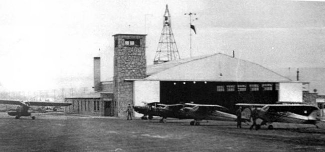
A circa 1940s photo of 5 single-engine high-wing taildraggers & the Pueblo Airport hangar.
Pueblo Airport, as depicted on the December 1941 7M Regional Aeronautical Chart (courtesy of Chris Kennedy).
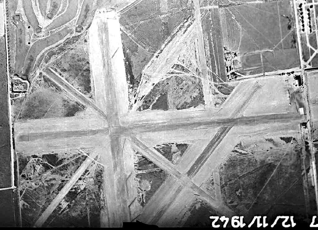
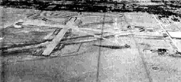
A 12/11/42 aerial view depicted Pueblo as having 5 runways, with a few small buildings & at least 4 light aircraft on the east side.
An 8/2/43 aerial view looking north from the 1945 AAF Airfield Directory(courtesy of Scott Murdock)
depicted Pueblo as having 4 paved runways.
The January 1944 Denver Sectional Chart (courtesy of Chris Kennedy) continued to depict Pueblo as a municipal/commercial airport,
but it also depicted the newly-constructed Pueblo Army Air Field on the northeast side of the town, which would eventually replace the original Pueblo Airport.
The Porter article continued, “In 1944, the citizens of Pueblo - on behalf of the airport -
were given the National Security Award to recognize the cooperation that existed between the airport & the Civil Aeronautics Authority, a federal agency.”
The 1945 Haire Publishing Airport Directory (courtesy of Chris Kennedy) described Pueblo Municipal Airport as a “class 4” field, owned & operated by the City.
It was said to have 4 paved runways, with the longest being the 5,200' north/south strip.
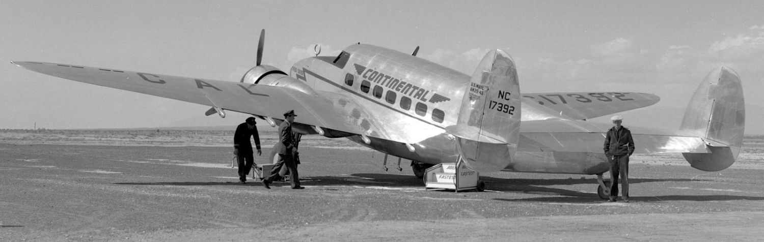
A hangar was said to be marked with the field's name. The field was said to offer airline service by Braniff & Continental.
The Southern Colorado Flying Service was listed as an operator, and the Airport Manager was listed as E.G. Wayman.
The 1945 AAF Airfield Directory (courtesy of Scott Murdock) described Pueblo Municipal Airport
as a 546 acre irregularly-shaped property having 4 asphalt runways, the longest being the 5,200' north/south & northeast/southwest strips.
The field was said to have a single 128' x 70' steel & stone hangar, and to have airline service by Braniff & Continental.
The airport was described as being owned & operated by the City of Pueblo.
The Porter article continued, “Local historian George Williams said it was a busy place after World War II.
There were flying schools for men learning to fly on the GI Bill. There were flying clubs - The Flying Farmers was one.
Braniff & Continental airlines served the airport & Continental had mechanics stationed there.
Williams worked as night janitor at the airport while he attended Central High School.”
"The last flight out was about 9 o'clock, and then the lights would go down & I'd do my work. A guy who carried a gun came & brought the mail for the last flight out."
Williams didn't learn to fly, but he did ride along on night flights to Lamar & back.
"There were just 3 people in a plane, and I'd sit in back & go along for the ride."
He said there was a restaurant & coffee shop at the airport & a weather station nearby, built by the WPA crews,
where employees checked wind direction & velocity at night by sending balloons carrying lighted candles into the sky.
Historian John Korber said the only time he flew out of the old airport was on a flight to Trinidad with his brother Leo in Leo's BT-13.
"It was a training plane, with one person in the front & one in the back. I didn't go up with him when he flew over the Royal Gorge."
Shirley Herrington remembers the airport from childhood trips to town with her father, who delivered produce here for a Trinidad company.
"To me, it was just fascinating to see the planes going in & out & the people going in & out of the terminal," says Herrington.
"When I tell people that the Sunset Plaza area was an airport, they look at me like I'm crazy. A lot of people aren't aware that this very populated area was an airport at one time."
Ray Sisson, historian for the Weisbrod Aircraft Museum at Pueblo Memorial Airport, said the museum's focus is military rather than civilian aviation.
"When we've talked about expanding the role of our museum, I've wished we could move the old hangar (on Prairie Avenue) here. It certainly is a piece of history, in and of itself."
Sisson is the caretaker of a large collection of clippings on the Pueblo Airport that John Downey compiled.
Downey intended to write a book on civil aviation here but was unable to finish his project, Sisson said.
His files start in 1904 and stretch to 1949, a year after the city acquired the former Pueblo Army Air Base east of town with the intention of moving the airport.
The Porter article continued, “A 1949 Pueblo Chieftain article offered these statistics about the airport:
10 city workers & 63 other workers employed; 1,300-2,000 passengers / month served by the commercial airlines;
air freight averaged 16,000 pounds / month; nearly 11,000 gallons of gasoline sold at the field / month; 16 commercial flights - Continental, Braniff & Monarch - arrived & left the field each day;
more than 100 planes were based at the field, most privately-owned.
The airport's budget for 1948 was just over $33,000, plus a $6,000 emergency appropriation from the city.”
The 1950 USAF Pilot's Handbook (courtesy of Chris Kennedy) depicted the original Pueblo Municipal Airport as having 4 paved runways,
with the longest being the 5,280' north/south strip.
A control tower & a building were depicted on the east side of the field.
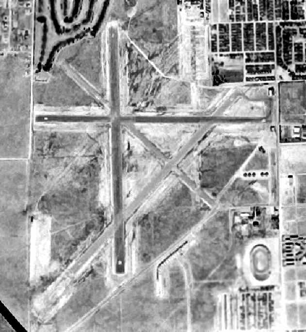
The last photo which has been located of the Pueblo Municipal Airport was a 10/28/53 aerial view.
It depicted Pueblo as having 4 paved runways, with some small buildings along the east side.
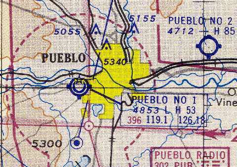
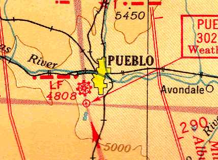
The last depiction which has been located of the original Pueblo Municipal Airport was on the May 1954 Denver Sectional Chart (courtesy of Chris Kennedy).
It labeled the field as “Pueblo #1”, described it as a shared Air Force & public field, and depicted the field as having a 5,300' hard-surface runway & a control tower.
The original Pueblo Municipal Airport was evidently abandoned at some point during 1954,
as it was no longer depicted at all on the November 1954 Denver Sectional Chart (according to Chris Kennedy).
The Porter article continued, “The airport was moved in 1954, and the former airport land on the South Side was platted & sold to developers,
except for a few acres around the hangar, and land north of St. Clair Avenue, which was used to expand the municipal golf course.
The subdivided & developed area is today's Sunset Park.
The former airport weather station became a fire station, which later was replaced by two fire stations at better locations.
In 1957, the city of Pueblo deeded the hangar and 3 acres of land to the State Historical Society (now History Colorado).
El Pueblo State Historical Museum opened at the site on 7/12/59.
Dedication ceremonies were held in the auditorium of nearby Calvary Baptist Church.
During the first 10 days of operation, more than 4,000 people from 27 states & 3 countries visited the new museum.
But the airport building needed repair before it could serve as a museum.”
“We start from nothing with the biggest project the society has ever undertaken and, perhaps next to this central Denver museum, the most important,"
wrote Historical Society president James Grafton Rogers in his January 1958 annual report.
"The city of Pueblo has shown enterprise & courage. The state can do likewise.”
The Porter article continued, “The museum closed at that location in 1992 & reopened in a refurbished building on First Street near the site of the original El Pueblo trading post.
A new museum was built there a decade later.
History Colorado now uses the former museum/airport hangar as a support center.
Old carriages, furniture, farm equipment and early washing machines, as well as artifacts excavated in archaeological digs at Fort Garland, are stored there,
according to Kathleen Eriksen, education coordinator and curator for El Pueblo History Museum.”
"It's all alarmed, and there are conservation methods to regulate the heat & moisture level," she said.

A 2007 photo by James O'Leary of the former Pueblo Airport hangar, since restored by the Colorado Historical Society.
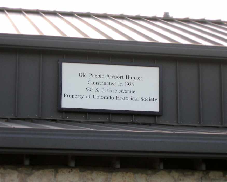
A 2007 photo by James O'Leary of a plaque on the former Pueblo Airport hangar (with the word “hangar” misspelled).
A circa 2007-2010 aerial view looking north at the former Pueblo Airport hangar.
A 2013 aerial view looking north showed the site of the original Pueblo Municipal Airport to be densely redeveloped.
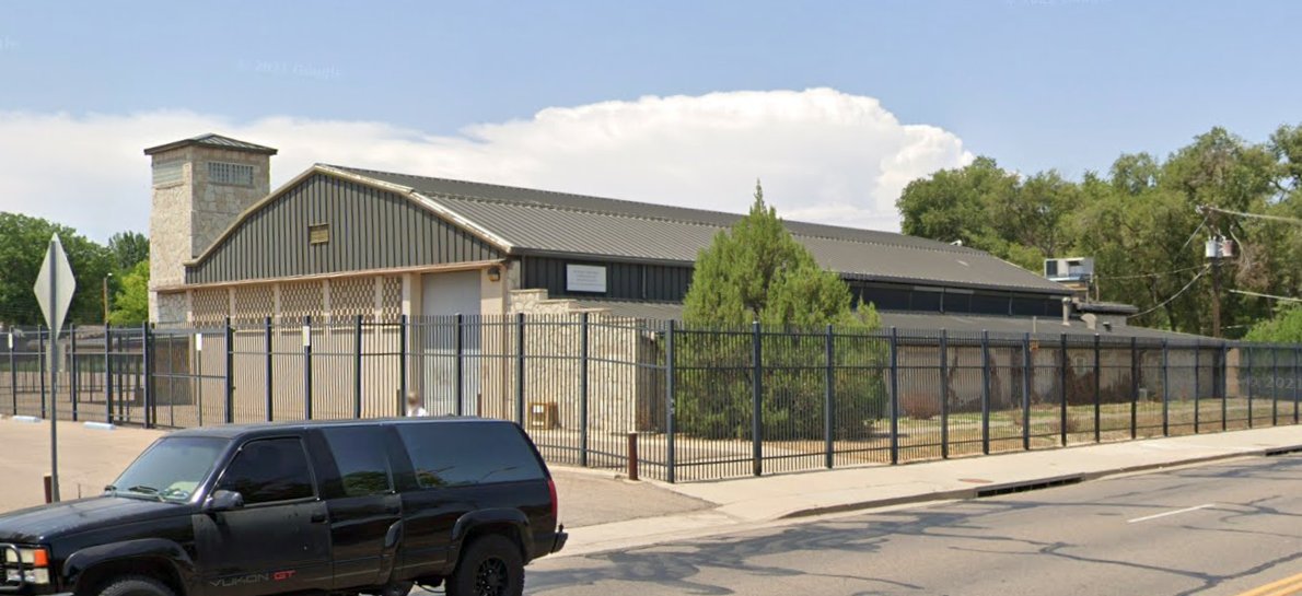
A July 2021 photo looking northwest at the former Pueblo Airport hangar.
The site of the original Pueblo Municipal Airport is located northwest of the intersection of South Prairie Avenue & Route 78.
____________________________________________________
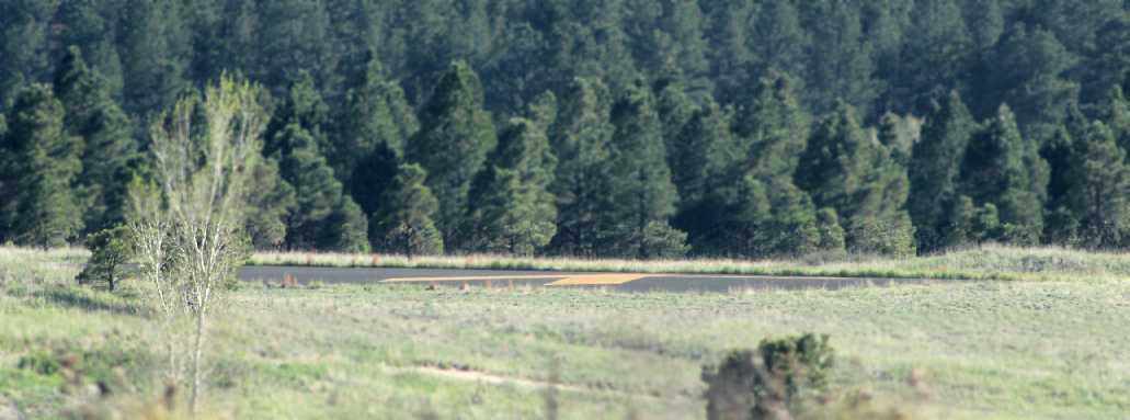
Aardvark Field, Colorado Springs, CO
39.035, -104.845 (South of Denver, CO)
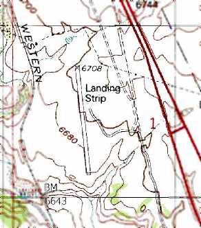
Aardvark Field was labeled simply as a “Landing Strip” on the 1986 USGS topo map.
Photo of the airfield while in use has not been located.
This small airfield is located on the north edge of the property of the Air Force Academy.
Aardvark Field was evidently constructed at some point between 1983-86,
as it was not yet depicted on the 1983 USGS topo map or a 1983 aerial photo.
The earliest depiction which has been located of Aardvark Field was on the 1986 USGS topo map,
which depicted a single northwest/southeast runway, generically labeled "Landing strip".

The earliest photo which has been located of Aardvark Field was an 8/11/88 USGS aerial view,
which depicted a single northwest/southeast asphalt runway.
Aardvark Field was not depicted on the October 1993 Denver Sectional Chart (courtesy of Ron Plante).
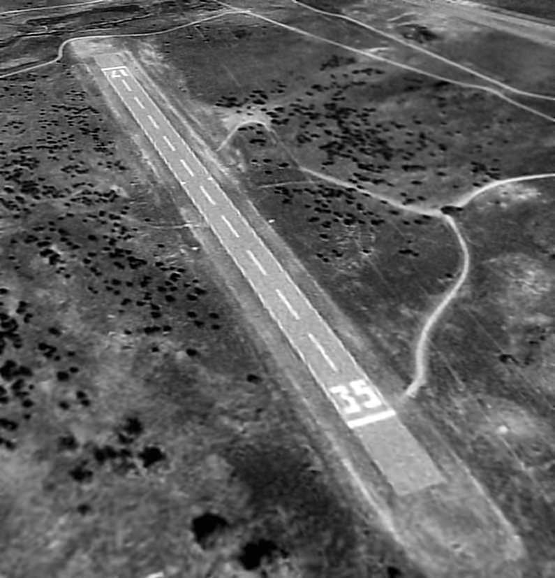
A 9/4/99 USGS aerial view looking northeast depicted Aardvark Field as consisting of a single 2,300 asphalt Runway 17/35, with no other facilities.
The 2002 USGS aerial photo depicted Aardvark Field as consisting of a single 2,300 asphalt Runway 17/35, with no other facilities.
However, even though the airfield was not listed in the Airport Facility Directory as an active facility, the runway was not marked as closed.
Aardvark Field was not depicted at all on the 2003 Denver Sectional Chart (according to Russ Roslewski).
According to a recent Academy graduate (via Russ Roslewski), Aardvark Field "is used by the Academy's soaring training program.
The first flight or two before the cadets get into the gliders is done in a motorglider.
They use the runway for practicing patterns & approaches, though they do not touch down on it.
I suspect that may be due to lack of any support equipment or quick access in the event of a botched landing.
That explains why it's in good condition!
Operating here gets them away from the main airfield,
which at least up until several years ago I had seen listed as the busiest VFR tower in the world."
Therefore, Aardvark Field was not officially listed as an "airfield", since it was not intended for aircraft to actually land at it.
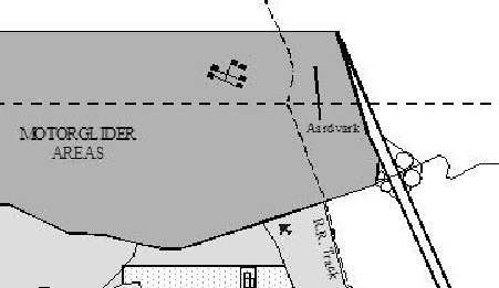
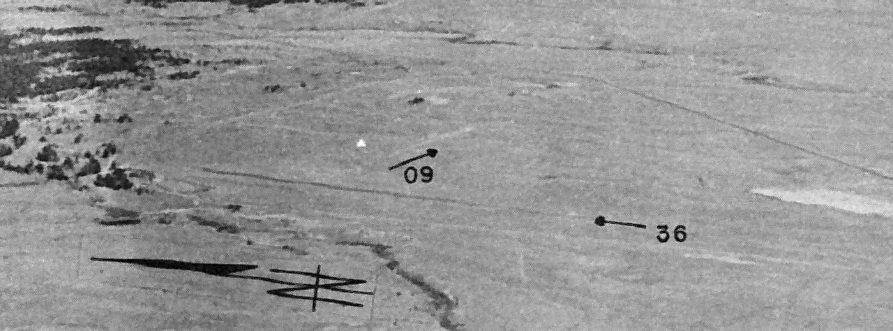
Aardvark Field, as depicted on an Air Force Academy local flying area publication (courtesy of Matthew Zimmerman).
According to Air Force Academy Cadet Matthew Zimmerman, "The airfield is known as 'Aardvark'.
It's listed on all our local area charts here.
It also can be (and has been) used as an emergency landing site for gliders if they can't get back to KAFF (extremely rare though)."
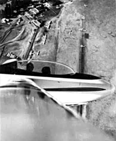
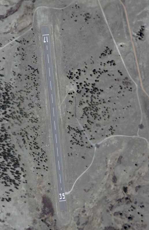
A 6/19/06 aerial view showed Aardvark Field still had runway numbers painted on its runway.
A 10/23/11 aerial view looking northwest showed that closed-runway X symbols were painted on each end of Aardvark's runway at some point between 2006-2011.
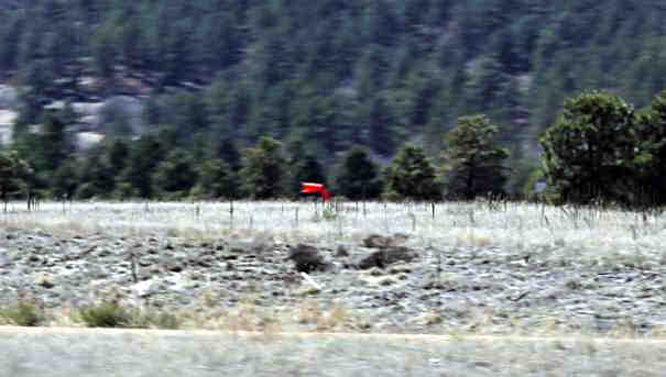
An April 2013 photo by Devan Mayer of Aardvark Field's windsock.
A 5/25/13 photo by Devan Mayer of a closed-runway X symbol painted on the end of Aardvark's runway.
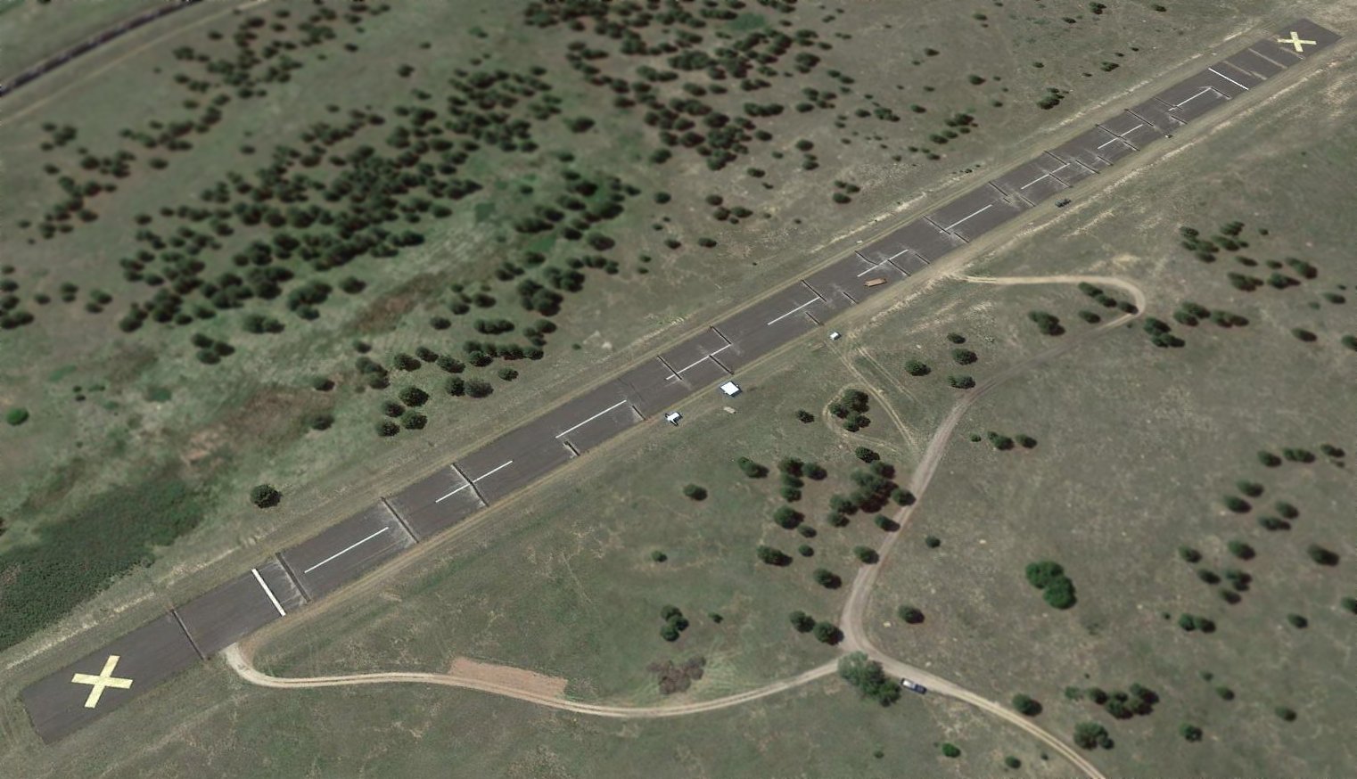
A 2017 aerial view looking northwest showed that Aardvark's runway remained intact.
Aardvark Field is located northwest of the intersection of Interstate 25 & North Gate Boulevard, only 4 miles north of the Air Force Academy's main airfield.
Thanks to Russ Roslewski for pointing out this airfield.
____________________________________________________
Or if you prefer to contact me directly concerning a contribution (for a mailing address to send a check),
please contact me at: paulandterryfreeman@gmail.com
If you enjoy this web site, please support it with a financial contribution.
____________________________________________________
This site covers airfields in all 50 states.