
Abandoned & Little-Known Airfields:
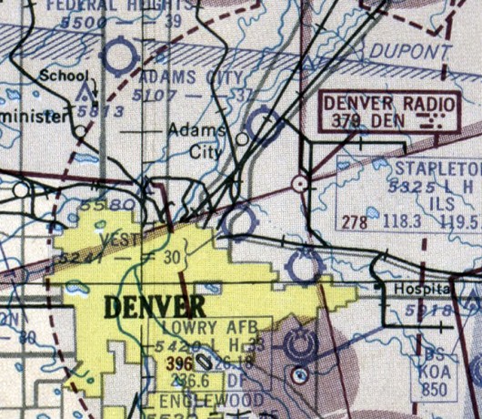
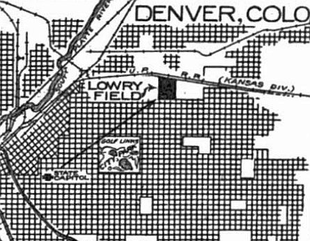
Colorado: Northeastern Denver area
© 2002, © 2026 by Paul Freeman. Revised 7/4/26.
This site covers airfields in all 50 states: Click here for the site's main menu.
For a 9th year, the CO pages of this website are sponsored by the Colorado Pilots Association:
____________________________________________________
Please consider a financial contribution to support the continued growth & operation of this site.
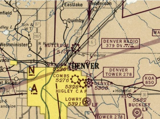
Colorado Airways Field / Western Flying Service Airport / Walt Higley Airport / C A P Airport (revised 7/4/26) - Curtiss Aviation Field / Park Hill Airport / Ray Wilson Flight School Field / Hayden Field / Vest Field (revised 4/15/26)
Denver Municipal Airport / Stapleton International Airport (revised 1/2/26) - Lowry Field (1st location) / Combs Field (revised 3/11/23)
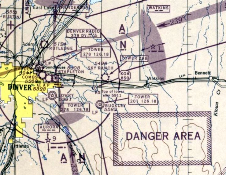
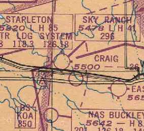
Rutledge Field / Adams City Airport (revised 12/13/22) - Sky Ranch Airport (revised 12/13/22)
____________________________________________________
Colorado Airways Field / Western Flying Service Airport / Walt Higley Airport / C A P Airport, Denver, CO
39.757, -104.906 (East of Downtown Denver, CO)
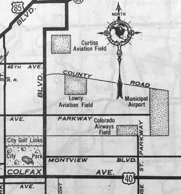
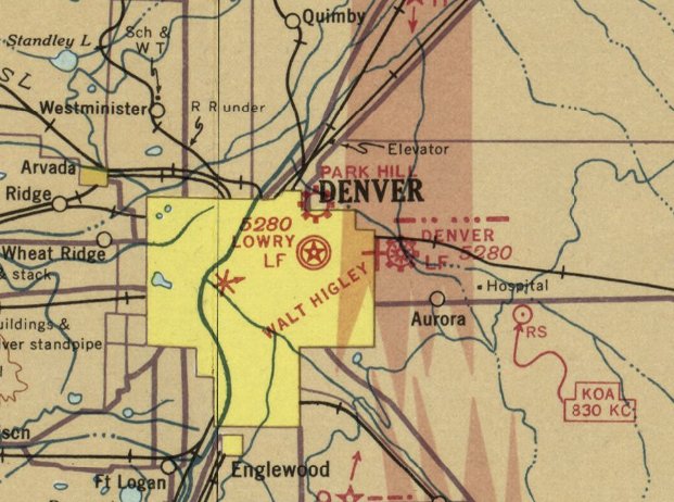
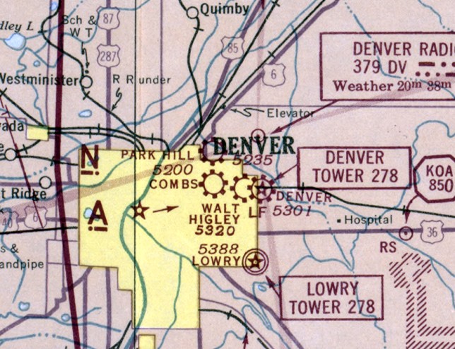
Colorado Airways Field, as depicted on a 1935 street map (courtesy of Kevin Walsh).
This early airport went thru at least 4 different names over the years.
According to the article “Harry Combs: The Early Years” in the 3/1/01 Airport Journals,
“The airport at 26th & Oneida came into being when Ira Boyd 'Bumps' Humphries & his younger brother Albert soloed in OX-powered Jennies in 1918. After WW1, both brothers returned to Denver.
Bumps formed the Curtiss-Humphries Airplane Company in 1919 to open & maintain an airport, sell airplanes, and engage in other air operations,
including, in its early years, passenger service/sightseeing trips (at the rate of $12.50) to limited areas.
By the following year, the company had 8 aircraft: 5 Curtiss Orioles & 3 Curtiss Standard J-1s.
The field was also the site for the Martin-Sweet Motor Company, which operated until 1921.
In 1921, Humphries surrendered his Curtiss distributorship & sold his aircraft. The next owner was Don Hogan, an automobile dealer.
When Colorado Airways won the contract to carry airmail over a route that included Cheyenne, Denver, Colorado Springs and Pueblo in 1926, they leased the field from Hogan.”
According to the Denver Public Library, “Higley organized the Western Flying Service in 1932 to train students.”
According to the article “Harry Combs: The Early Years” in the 3/1/01 Airport Journals,
“In 1934, Walter Higley bought the airport & formed Colorado’s first flying school; it became known as Higley Field.
The earliest depiction which has been located of Colorado Airways Field was on a 1935 street map (courtesy of Kevin Walsh).,
It depicted Colorado Airways Field as a rectangular property outline, along with 3 other airports in close proximity: Curtiss Aviation Field, Lowry Aviation Field, and Denver Municipal Airport.
Aeronautical charts from 1936-41 did not depict this airport at all, perhaps overlooked as a relatively minor airport.
A 1937 street map (courtesy of Rex Ricks) depicted this airport as “Western Flying Service”.
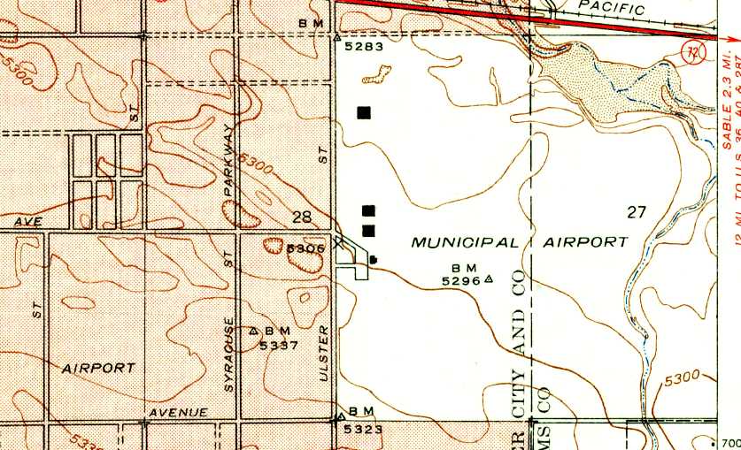
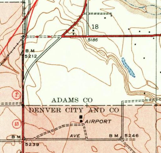
The earliest topo map depiction which has been located of this airport was on the 1938 USGS topo map,
which labeled it generically as “Airport” (at bottom-left), with the much-larger Municipal Airport only 2 blocks to the east.

The earliest aeronautical chart depiction which has been located of this airport was on the January 1942 Denver Sectional Chart, which depicted “Walt Higley” as a commercial/municipal airport.
According to the Denver Public Library, “ In 1942, Higley formed Higley Aircraft Corp. to manufacture landing gear parts during WWII.”
According to the article “Harry Combs: The Early Years” in the 3/1/01 Airport Journals, “In 1942, the Colorado Wing of the Civil Air Patrol assumed control of the field.”

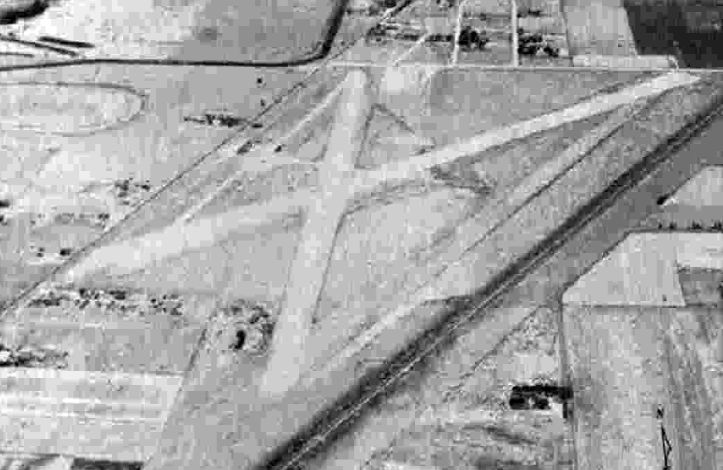
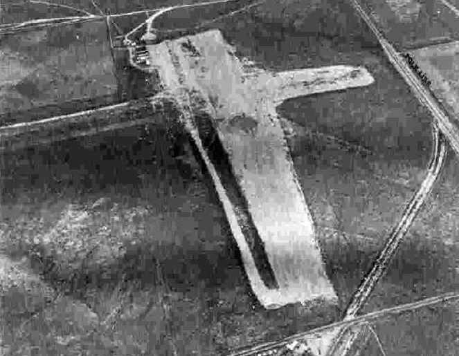
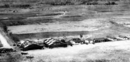
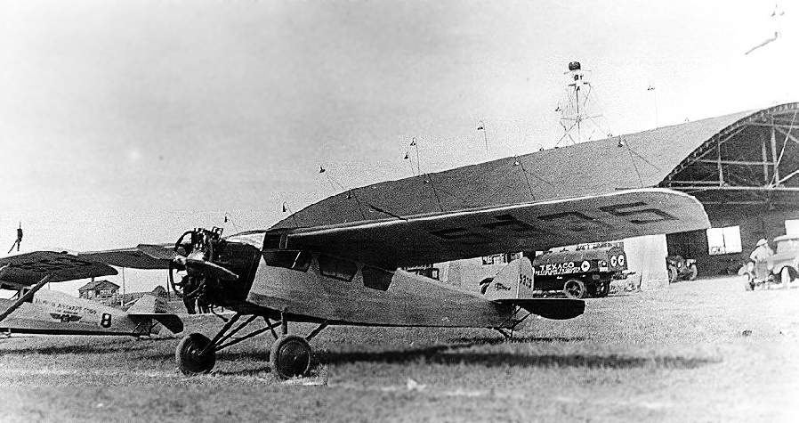
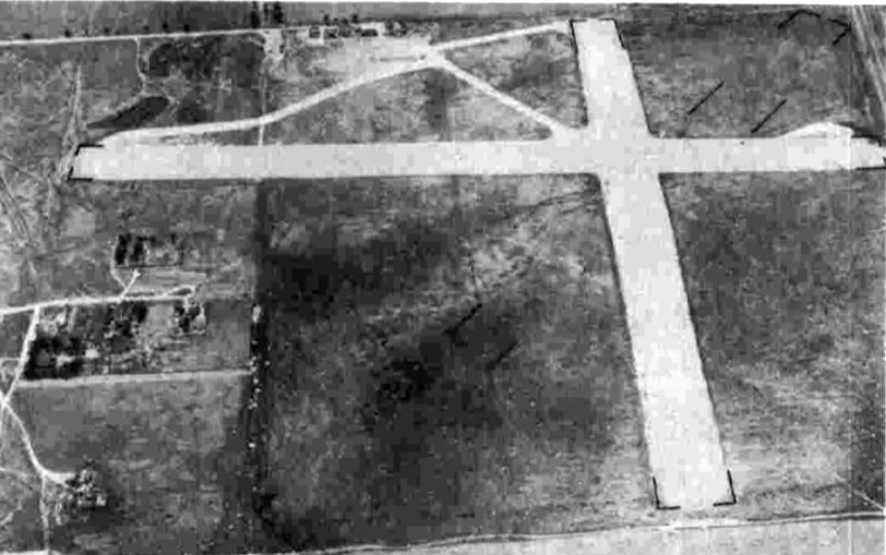
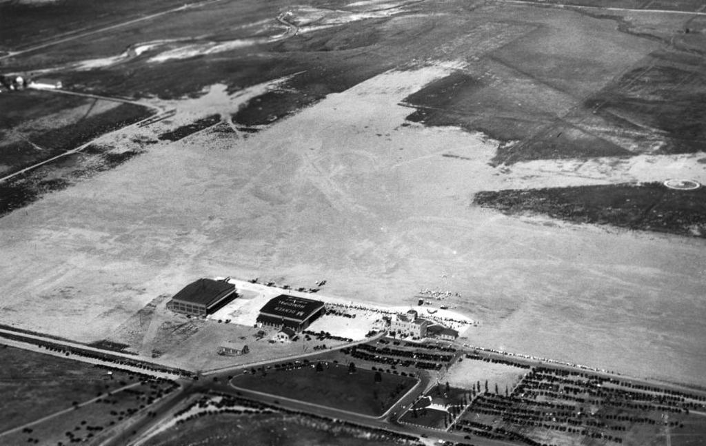
The only photo which has been located of the Denver Civil Air Patrol Airport was an 8/29/43 aerial view looking north from the 1945 AAF Airfield Directory (courtesy of Scott Murdock).
It depicted Civil Air Patrol Airport as having 4 unpaved runways, with some small hangars at the southwest side.
Also note the larger hangars of nearby Denver Municipal Airport in the background (top-right).
The 1945 AAF Airfield Directory (courtesy of Scott Murdock) described Civil Air Patrol Airport as a 129 acre property having 4 sod runways, with the longest measuring 2,900' northwest/southeast.
It was said to have 2 hangars, and to be owned & operated by private interests.
The February 1945 Denver Sectional Chart (courtesy of Richard Doehring) depicted “C A P” as a commercial/municipal airport.

The last aeronautical chart depiction which has been located of “C A P” Airport was on the March 1946 Denver Sectional Chart.
According to the article “Harry Combs: The Early Years” in the 3/1/01 Airport Journals,
“The Colorado Wing of the Civil Air Patrol remained there until 1947.”
The C A P Airport was evidently closed in 1947, as it was no longer depicted on the 1947 Denver Sectional Chart.
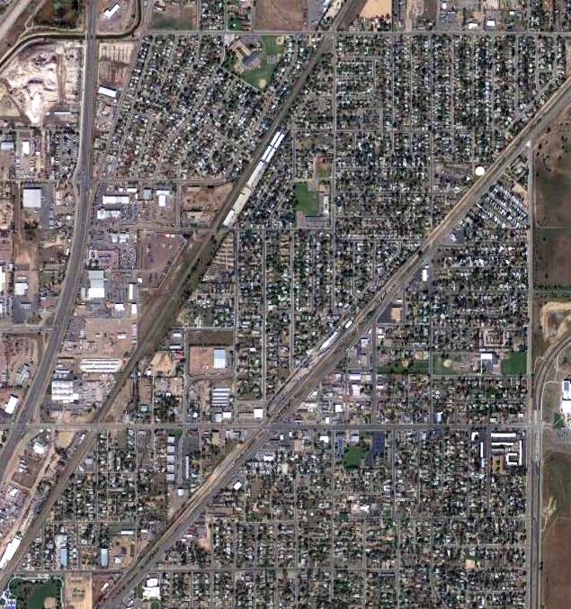
A 1956 aerial photo showed dense housing covering the site of C A P Airport.

A 2023 aerial photo showed no trace remaining of C A P Airport.
Thanks to Phil Sterritt for pointing out this airfield.
____________________________________________________
Rutledge Field / Adams City Airport, Commerce City, CO
39.84, -104.92 (Northeast of Downtown Denver, CO)
Rutledge Field, as depicted on the July 1943 Denver Sectional Chart.
This general aviation airport was evidently established at some point between 1942-43,
as it was not yet depicted on the September 1942 Denver Sectional Chart.
The earliest depiction which has been located of Rutledge Field was on the July 1943 Denver Sectional Chart.
It depicted Rutledge as a commercial/municipal airport.
The earliest photo which has been located of Rutledge Field was an 8/29/43 aerial view looking north from the 1945 AAF Airfield Directory (courtesy of Scott Murdock).
It depicted Rutledge as having 3 unpaved runways, with taxiways leading to a ramp on the west side.
The 1945 AAF Airfield Directory (courtesy of Scott Murdock) described Rutledge Field
as a 190 acre irregularly-shaped property having 3 sod runways, with the longest being the 4,195' north/south strip.
Rutledge was said to have a single 50' x 46' wood & metal hangar, and to be owned & operated by private interests.
Rutledge Field was not depicted at all on USGS topo maps from the 1940s & 1950s.
Rutledge Field was still depicted on the March 1946 Denver Sectional Chart.
Rutledge Field was evidently renamed Adams City Airport at some point between 1946-48,
as that is how it was labeled on the August 1948 Denver Sectional Chart.
It depicted Adams City Airport as having a 3,700' unpaved runway.
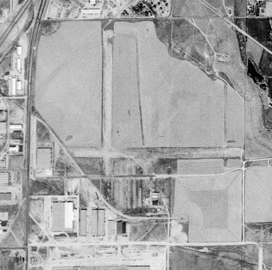
The last depiction which has been located of Adams City Airport was on a 9/25/53 USGS aerial view.
It depicted Adams City as having 3 unpaved runways, with taxiways leading to a ramp on the west side.
The last aeronautical chart depiction which has been located of Adams City Airport was on the November 1954 Denver Sectional Chart.
It depicted Adams City Airport as having a 3,700' unpaved runway.
Adams City Airport was evidently closed (presumably due to rising property values) at some point between 1952-55,
as it was no longer depicted on the May 1955 Denver Sectional Chart.
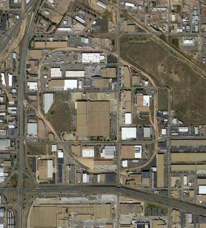
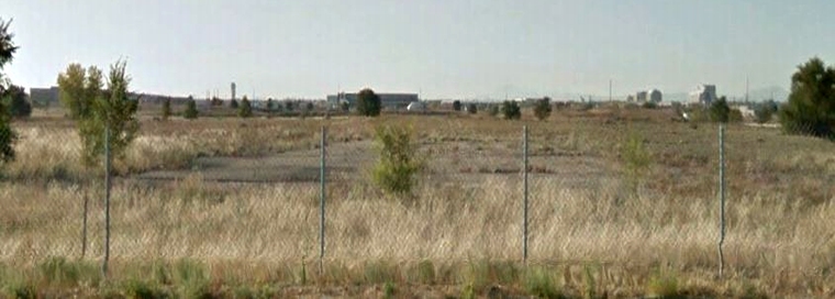
There was no recognizable trace of Adams City Airport on a 1991 aerial photo.
A 2014 aerial view showed no trace remaining of Adams City Airport.
The site of Adams City Airport is located at the intersection of Kearney Street & East 76th Avenue.
Thanks to Eric Karnes for pointing out this field.
____________________________________________________
Curtiss Aviation Field / Park Hill Airport / Ray Wilson Flight School Field / Hayden Field / Vest Field, Denver, CO
39.79, -104.93 (Northeast of Downtown Denver, CO)
“Curtiss Aviation Field”, as depicted on a 1935 street map (courtesy of Kevin Walsh).
The date of construction of this general aviation airport has not been determined.
It also went through a confusing series of at least 5 different names.
The earliest depiction which has been located of an airport at this location was on a 1935 street map (courtesy of Kevin Walsh),
which depicted “Curtiss Aviation Feld” as a square property outline.
The airport was evidently renamed Park Hill Airport at some point between 1935-36, as that is how it was labeled on the March 1936 Denver Sectional Chart.
It depicted Park Hill as a commercial/municipal airport.
A 1937 street map (courtesy of Rex Ricks) depicted Park Hill Airport as a square property.
The 1938 USGS topo map depicted 2 buildings on the south side of an open area, generically labeled as “Airport”.
According to an article in Airport Journals, in the late 1930s, “Ray Wilson was operating a flying school, Ray Wilson Flight School, at 46th & Colorado Boulevard.”
An advertisement for Ray Wilson Inc Flight School appeared in the 5/22/39 Daily Sentinel (courtesy of Fred Kelso).

The earliest photo which has been located of Ray Wilson Field was a circa 1930s photo of 2 aircraft in front of 2 hangars (courtesy of Fred Kelso).

Two stills from a circa 1935-41 movie by Frederick Calhoun (courtesy of Rick Calhoun) of aircraft in front of the Ray Wilson Flying School hangars.
Rick Calhoun recalled, “My mom & dad (Elizabeth & Frederick Calhoun) were taking flying lessons at Ray Wilson's flight school in northeast Denver sometime after WW2.
My dad took some 8mm movies of Ray Wilson's ground facilities.”
According to an article in Airport Journals, business partners Lou Hayden & Harry Combs “bought Wilson’s fields.
Wilson’s former airfield, now Hayden Field, was used to train students from D.U.
Soon, their aircraft included a mix of Wacos & Cubs.
Between 1940-44, Mountains States Aviation trained 9,000 pilots, with 45 planes, 45 flight instructors & 160 employees.”
It was still depicted as Park Hill Airport on the January 1942 Denver Sectional Chart.
The earliest aerial photo which has been located of Hayden Field was an 8/29/43 aerial view from the 1945 AAF Airfield Directory (courtesy of Scott Murdock).
It depicted Hayden Field as having 2 perpendicular unpaved runways.
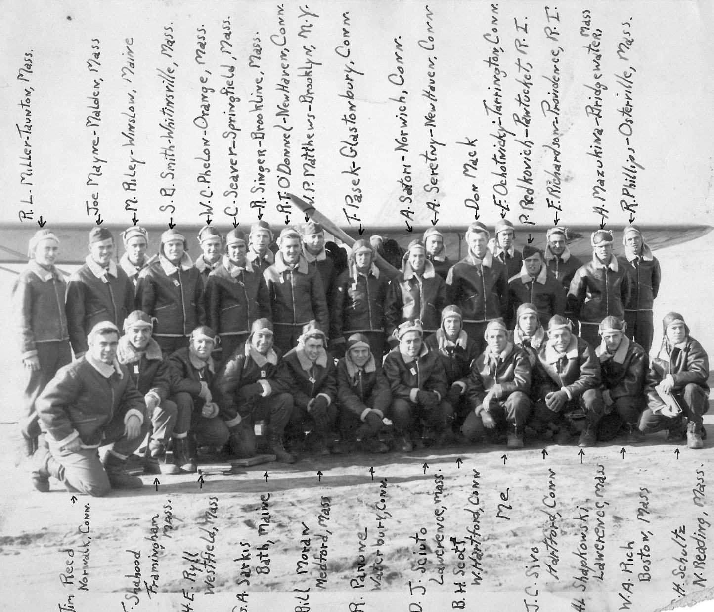
An undated photo of the “Hot Pilots” of Class 43-CO-12 at Hayden Field (courtesy of Deb Nicholls).
Deb Nichols reported, “My father was in the class & he wrote the name & hometown of everyone on it. 'Me' is my father: Francis Nicholls.”
A circa 1940s photo of students & Piper Cubs of the CO Women’s College Flight School at Hayden Field.
The 1945 AAF Airfield Directory (courtesy of Scott Murdock) described Hayden Field
as a 330 acre irregularly-shaped property having 5 gravel runways, the longest measuring 4,000'.
Hayden was said to have 2 hangars, the largest being a 120' x 86' brick & steel structure,
and to be owned & operated by private interests.
The earliest aeronautical chart depiction which has been located of Hayden Field
was as a commercial/municipal field on the February 1945 Denver Sectional Chart (courtesy of Richard Doehring).
According to the Univair Aircraft Corporation history, “In 1945 J.E. 'Eddie' Dyer was released from the U.S. Army Air Corps
and came to the Denver area looking for some sort of a living in the airplane business rather than returning home to Missouri.
Eddie teamed up with fellow veteran & well respected Denver area aircraft salesman, Don Vest.
In February 1946 Dyer & Vest formed the Vest Aircraft Company.
This new organization would eventually become Univair Aircraft Corporation.
The Vest Aircraft Company began operation at Hayden Field.
Upon their arrival, the airport was renamed Vest Field.”
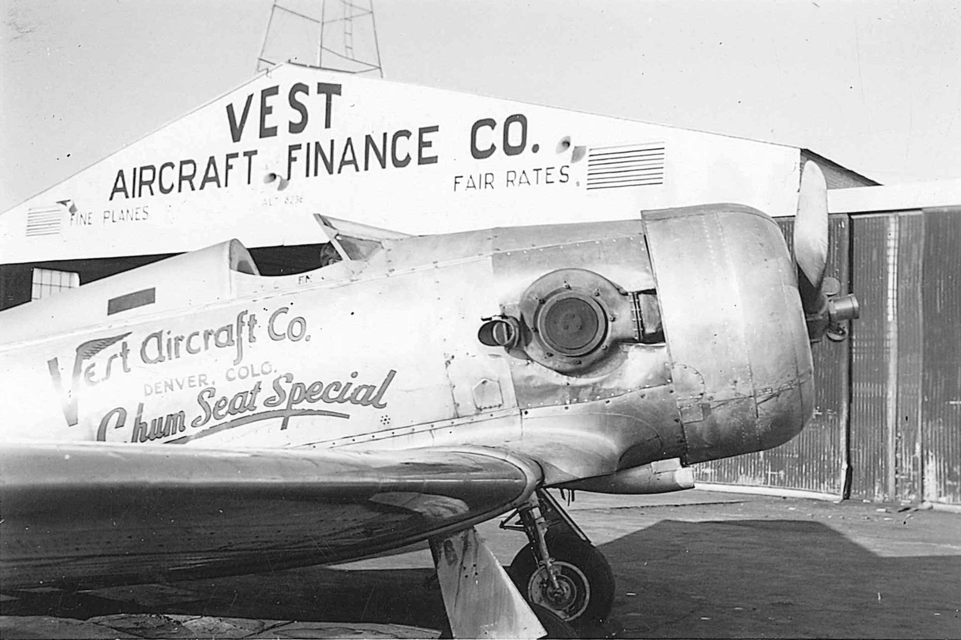
A 1946 photo (courtesy of John Bybee) of North American AT-6A Texan, Race 54 (41-277, NX 64448) in front of Vest Field's Vest Aircraft Finance Company hangar.
John Bybee recalled, “Don Vest modified 2 AT-6A Texans with turbo-superchargers from either a B-24 or B-17. NX-64448, the Chum Seat Special, Race 54, had a 2nd seat with 2 small windows.
Jane Page finished in 2nd place (200) in 1946 the Halle Air Race at Cleveland in this aircraft.”
It was still depicted as Hayden Airport on the March 1946 Denver Sectional Chart.
It depicted as Vest Field on the August 1948 Denver Sectional Chart.
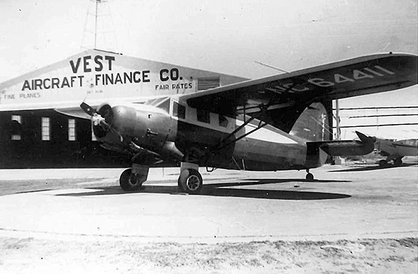
A circa 1940s-50s photo (courtesy of John Bybee) of an unidentified single-engine taildragger in front of the Vest Aircraft Finance Company hangar.
The 1950 USGS topo map continued to depict 2 buildings on the south side of an open area, generically labeled as “Airport”.
The last aeronautical chart depiction which has been located of Vest Field was on the April 1952 Denver Sectional Chart,
which depicted Vest as having a 3,000' unpaved runway.
According to the Univair Aircraft Corporation history, “Soon after the establishment of the company, it was apparent that the business had outgrown the Vest Field facilities.
Vest Aircraft Company relocated to Sky Ranch Airport northeast of the Denver suburb of Aurora in early 1953.”
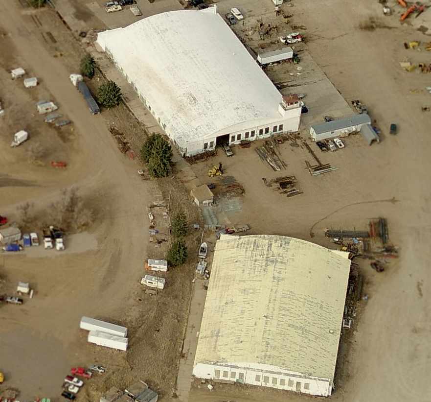
A 9/25/53 USGS aerial view showed that Hayden Field had already been closed.
The majority of 2 perpendicular runways remained at the site, but a road had already been built over the southwest corner of the airport property.
Vest Field was no longer depicted on the May 1955 Denver Sectional Chart.
The 1957 USGS topo map depicted several large buildings covering the site of Hayden Field.
A 2014 aerial view showed no trace remaining of Hayden Field.
The site of Hayden Field is located southwest of the intersection of Dahlia Street & East 52nd Avenue.
Thanks to Eric Karnes for pointing out this field.
____________________________________________________
Lowry Field (1st location) / Combs Field, Denver, CO
39.77, -104.93 (Northeast of Downtown Denver, CO)
A circa 1924 aerial view of buildings & hangars at the original Lowry Field.
The first "Lowry Field" was dedicated by the Colorado Air National Guard in 1924.
The field was named in honor of Francis Lowry,
a Denver native who had been killed when he was shot down in 1918 while serving as an aerial observer.
According to the Wings Over the Rockies Museum,
the original Lowry Field was located in the vicinity of 38th Avenue & Dahlia Street.
The earliest photo which has been located of Lowry Field was a circa 1924 aerial view of buildings & hangars.
A sign over a hangar reportedly read, "This field is short, USE IT ALL."
The 4/15/25 Commerce Department Airway Bulletin (courtesy of Mike Denja) depicted Lowry Field's proximity to the State Capitol.
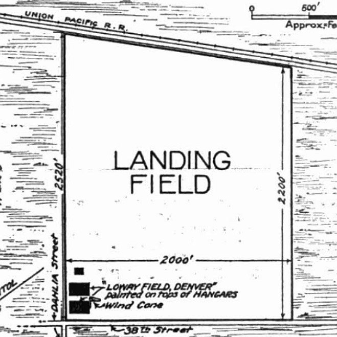
The 4/15/25 Commerce Department Airway Bulletin (courtesy of Mike Denja) depicted Lowry Field's as measuring 2,200' north/south,
and having 3 buildings at the southwest corner, with the 2 hangars having “Lowry Field, Denver” painted on their roofs.
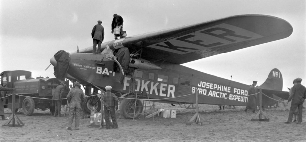
A 10/28/26 photo of the Fokker BA-1 trimotor of the Josephine Ford Byrd Arctic Expedition being refueled at the original Lowry Field.
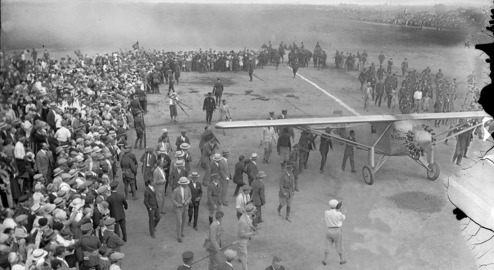
A 1927 photo of Charles Lindbergh arriving in his Spirit of St. Louis at Lowry Field.
A circa 1927 photo of a Cessna Model AA at Lowry Field (courtesy of Jim Culbertson of Sea Bird Publishing Inc.).
A circa 1920s photo (courtesy of Chris Whisler) of his grandfather, Forest Whisler, sitting on an unidentified biplane (a Jenny?).
The original caption on the photo read, “Lowry Field, U.S. Air Mail.”
The Airport Directory Company's 1933 Airports Directory (courtesy of Chris Kennedy)
described "Lowry National Guard" Airfield as being located "4 miles northeast of the State Capitol Building".
The Union Pacific Railroad was said to form the Northern boundary of the field.
The airfield was said to consist of a 2,300' sod square.
The southern hangar was said to have "Denver, CO, Lowry Field" painted on the roof.
A circa 1930s photo of a Douglas O-2 from the CO National Guard's 120th Aero Observation Squadron
in front of a long row of Boeing P-12 fighters lined up for an airshow at Lowry Field, near Dahlia Street & 38th Avenue.
“Lowry Aviation Field” was depicted on a 1935 street map (courtesy of Kevin Walsh),
along with the nearby “Curtiss Aviation Field” to the northwest, and the “Colorado Airways Field” & “Municipal Airport” to the southeast.
The earliest aeronautical chart depiction which has been located of Lowry Field was on the March 1936 Denver Sectional Chart.
It depicted Lowry as a military airfield.
The Airport Directory Company's 1937 Airports Directory (courtesy of Bob Rambo)
described "Lowry National Guard" Airfield as consisting of a sod 2,300' square landing area.
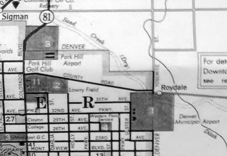
Lowry Field was depicted on a 1937 street map (courtesy of Rex Ricks),
along with the nearby Park Hill Airport to the north, and the Western Flying Service & Denver Municipal Airport to the southeast.
A confusing development in the story of Lowry Field came in 1937,
when the Army dedicated a separate & unrelated "Lowry Field" in a different location, 4 miles to the southeast.
These 2 "Lowry Fields" continued in simultaneous operation for one more year,
until the original Lowry Field was inactivated (for reasons unknown) by the National Guard in 1938.
No airport was depicted at this location on the 1938 or 1940 USGS topo maps,
nor on the February 1939 or March 1940 Denver Sectional Charts.
As shown on the January 1942 Denver Sectional Chart, at some point between 1940-42, the original Lowry Field was reused as a civilian airfield named Combs Field.
A circa 1943-45 aerial view looking west at Combs Field from the 1945 AAF Airfield Directory (courtesy of Scott Murdock)
depicted Combs Field as having 3 unpaved runways, with a few small buildings along the west side.
The 1945 AAF Airfield Directory (courtesy of Scott Murdock) described Combs Field
as a 205 acre rectangular property having 3 sand runways, the longest being a 3,200' north/south strip.
Combs was said to have 2 hangars, the largest being a 80' x 60' brick & steel structure,
and to be owned & operated by private interests.
Gil Bliss recalled, “The old Combs Airport was Combs Hayden.
There seemed to be a problem between the two [partners] & Hayden moved to Stapleton with the Cessna dealership.
Eventually Combs moved the Beechcraft dealership to Stapleton.
My first airplane ride was at the Combs Hayden Airport.”
Bob Parrick recalled, “My dad worked as a mechanic at Continental's B-29 modification center at Denver Stapleton.
He & a partner bought a surplus PT-19 trainer in the summer of 1945
and based it on a small turf field that was to the west of & within sight of the Stapleton hangars.
I recall that it had several small hangars that housed some small private aircraft.”
Based on the description & pictures of the original Lowry Field,
Bob is convinced that this was the same airport where his dad's plane was based.
Bob continued, “I marvel now to think that, not owning a car,
we on more than one occasion walked from our house near the fence of the 'new' Lowry Field
to the old Lowry to work on that plane.
Or at least Dad worked on the plane as I was too little to be of much help.
Retracing the route on current maps shows it was a 3-4 mile hike.
As I say this was in 1945, so apparently the Old Lowry was still in use
(perhaps under a different name) long after the Air Guard left in 1938.”
No airport was depicted at this location on the 1947 USGS topo map.

The last aeronautical chart depiction which has been located of Combs Field
was as a commercial/municipal field on the August 1948 Denver Sectional Chart.
Combs Field was evidently closed (for reasons unknown) at some point between 1948-50,
as it was no longer depicted on the April 1950 Denver Sectional Chart.
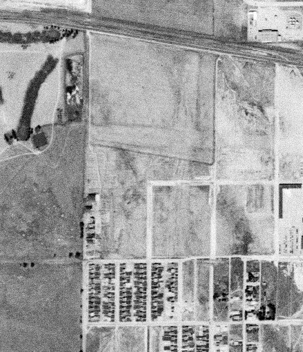
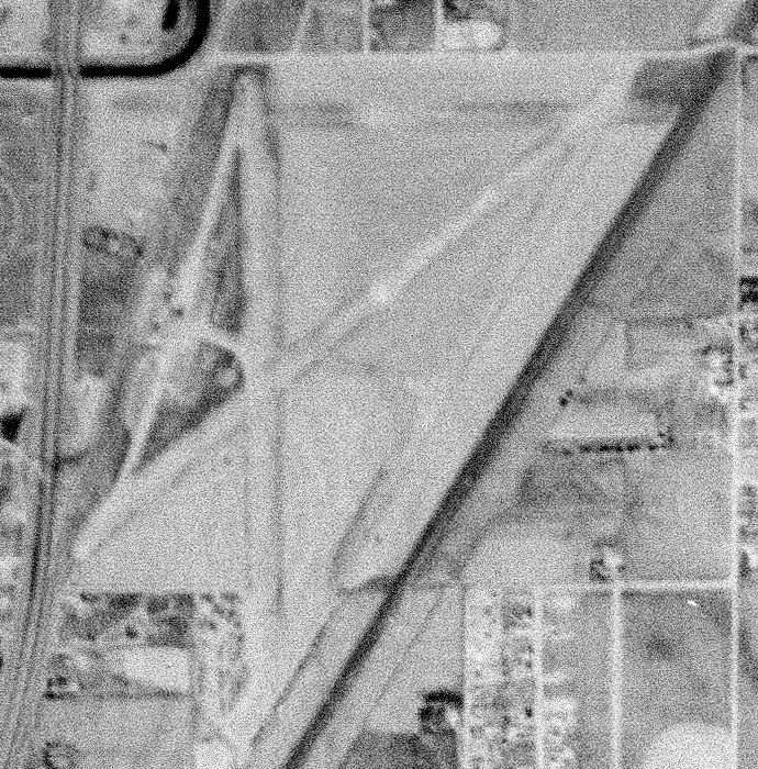
A 9/25/53 USGS aerial view showed what appeared to be traces of perpendicular runways on the site of Combs Field.
In the 1993 USGS aerial photo, there did not appear to be any remaining traces of the original Lowry Field.
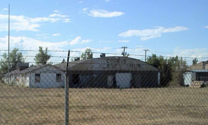
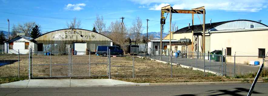
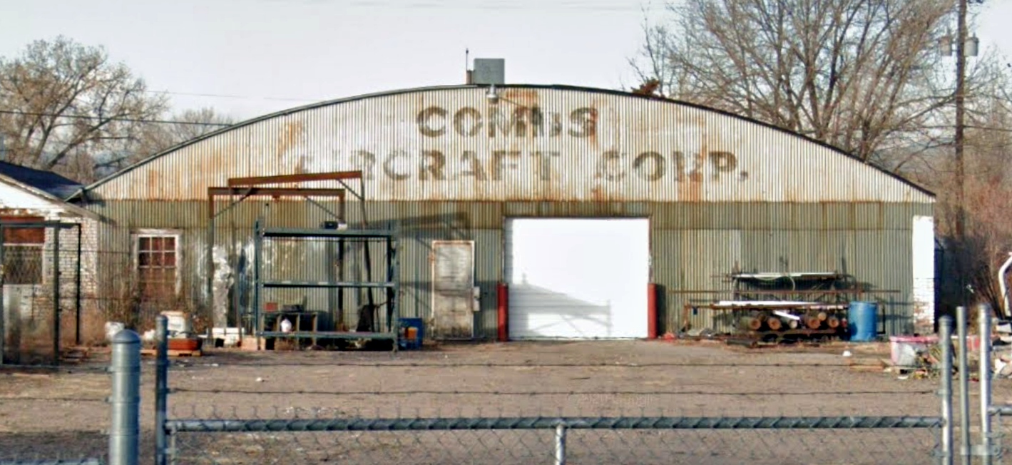
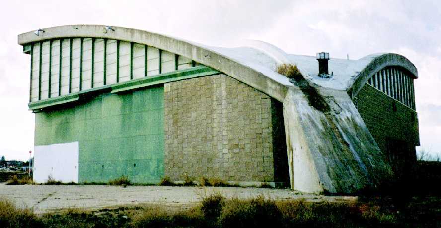
A 2005 photo by Frank Niehus of a hangar which remains standing at the site of the 1st location of Lowry Field.
Note the “Combs Aircraft Corp.” lettering still visible along the top of the hangar.
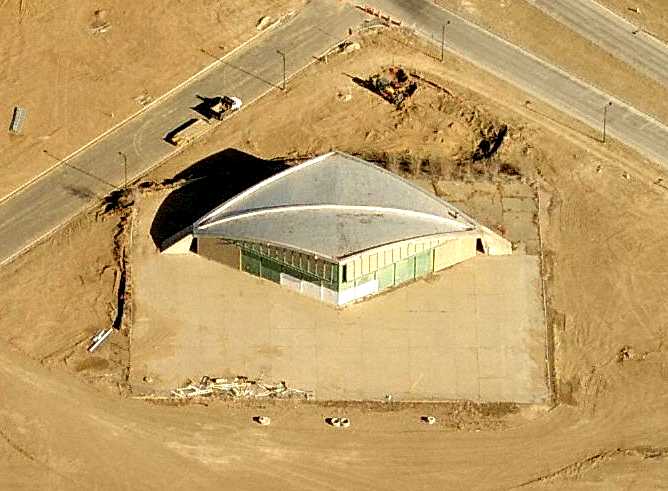
In a 2005 aerial photo, the former hangar was visible in the center of the photo, along the eastern edge of the golf course.
There did not appear to be any other recognizable traces of the original Lowry Field.
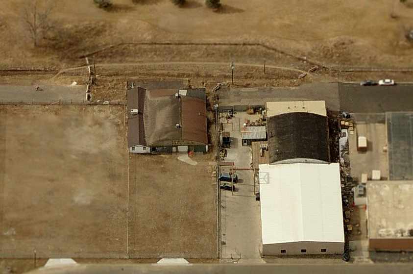
A 2006 aerial view looking west at the former “Combs Aircraft Corp.” hangar which remains standing at the site of the 1st location of Lowry Field.
What appears to be a 2nd arch-roof hangar is to the right.
A November 2007 view looking west by Scott Murdock at the 2 hangars at the site of the original Lowry field.
A November 2020 view looking west at the “Combs Aircraft Corp.” hangar at the site of the original Lowry field.
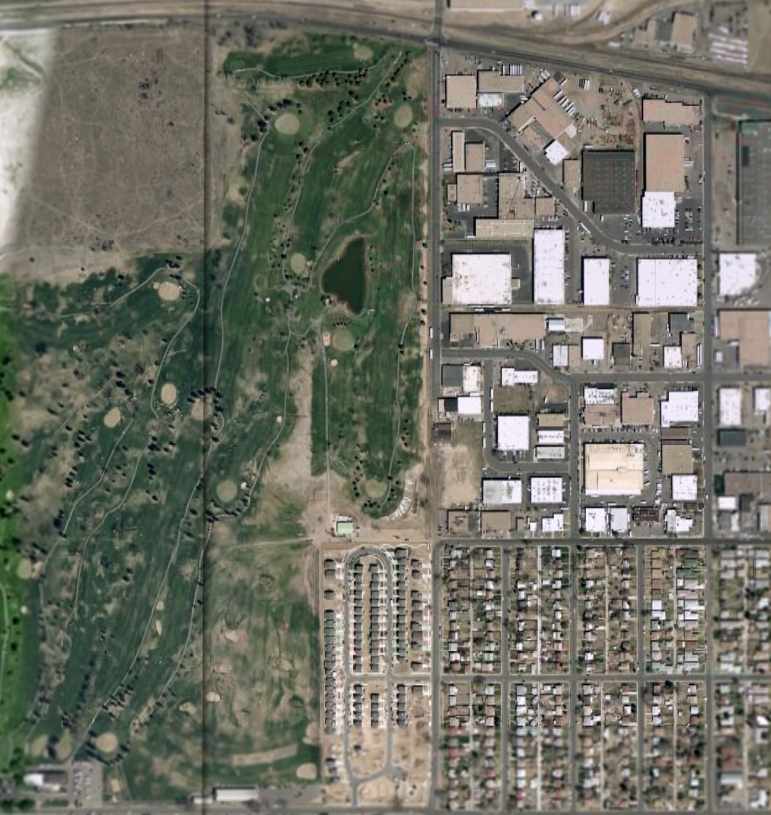
The site of the original Lowry Field is located in the vicinity of 38th Avenue & Dahlia Street, on the eastern edge of the present-day Park Hill Golf Club.
____________________________________________________
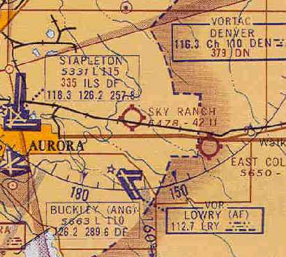
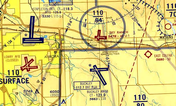
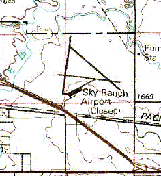
39.76, -104.75 (East of Stapleton International Airport, CO)
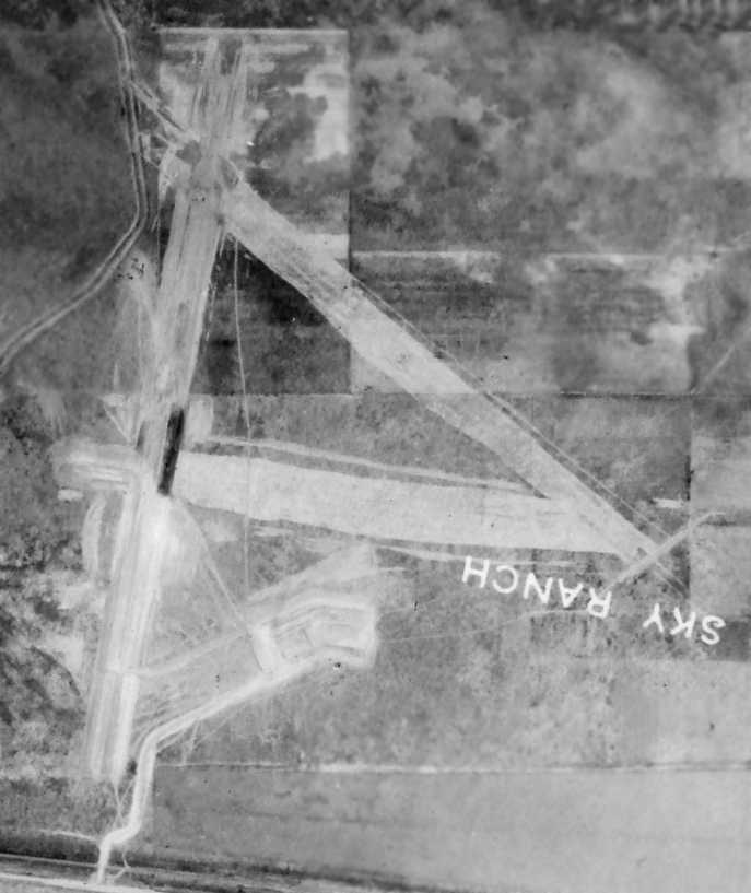
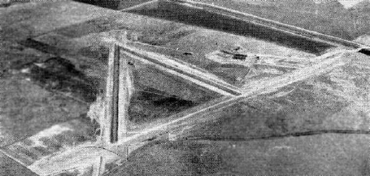
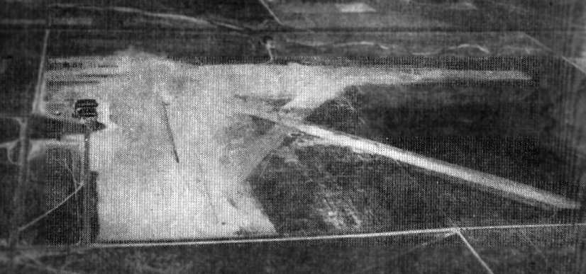
An 8/10/44 aerial view of Sky Ranch (from the NRPC St Louis, courtesy of Ron Plante) appeared to show the field still under construction.
The date of construction of this general aviation airport is unknown.
Sky Ranch Airport was yet depicted on the 1936/39/40/41/42/43/44 Denver Sectional Charts.
According to Brian Richardson, the owner of the property in 2006 (Brian Seib) thinks “that the airport was built prior to the 1940s.”
Sky Ranch Airport was yet depicted on the 1942 USGS topo map.
Doug Ryan recalled, “Sky Ranch Airport... My father was an Airframe & Powerplant mechanic there.
We lived on the airport... 1943-48? We left in 1948 when I was 3.
I recall my father saying it was owned by the Mack family. The hangars must have been built before 1942.”
The earliest depiction of Sky Ranch which has been located was an 8/10/44 aerial view (from the NRPC St Louis, courtesy of Ron Plante).
It appeared to show the field still under construction, with 3 newly-graded dirt runways, a cleared unpaved ramp,
and possibly the foundation for the 2 hangars on the south side.
An undated aerial view looking southeast at Sky Ranch Airport
from a December 1944 Southern Flight Magazine article (courtesy of Mark Hess).
The article described Sky Ranch as “the largest private airfield in the United States.”
It said that the property consisted of 1,500 acres, containing 3 clay & gravel 6,000' runways.
The first hangar was said to be 200' x 150', and the manager was listed as Williard Bridgeman.
Doug Ryan recalled, “My father set up the ground school there for University of Denver training for WW2 veterans returning.
He bought WW2 aircraft for the airport for training for $1. He also flew planes.
During the war German prisoners were kept near the airport. They used to wave at my mom on her car trips to town.
The military did not take over the airport in the 1940s & it was the largest private airport in the U.S. then.”
Sky Ranch Airport still was yet depicted on the February 1945 Denver Sectional Chart (courtesy of Richard Doehring).
The earliest aeronautical chart depiction of Sky Ranch which has been located was on on the August 1945 Denver Sectional Chart.
It depicted Sky Ranch as a commercial/municipal airport.
Brian Richardson reported in 2006, “According to the Adams County tax folks both hangars were constructed in 1945.”
Varel Freeman recalled, “My grandfather trained at Sky Ranch, picking up 70 hours in Luscombe aircraft in 1946-47.”
The February 1949 Denver Sectional Chart (courtesy of Chris Kennedy) depicted Sky Ranch as having a 4,100' paved runway.
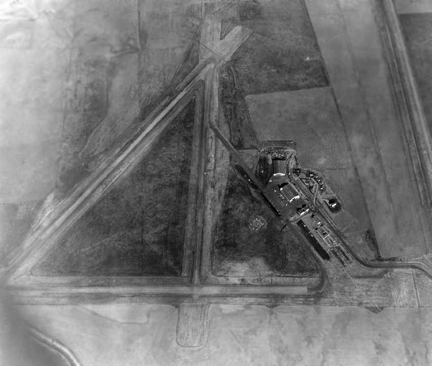
A circa late 1940s-50s aerial view looking east at Sky Ranch (courtesy of Mike Wotovich).
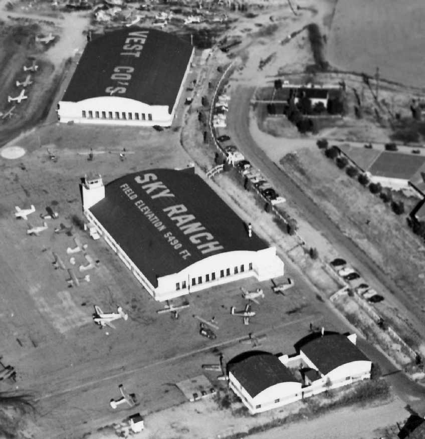
A circa late 1940s-50s closeup-up aerial view looking east at the 3 hangars at Sky Ranch (courtesy of Mike Wotovich).
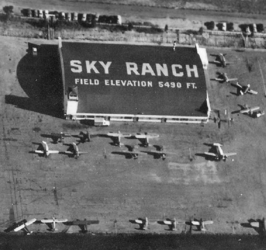
A circa late 1940s-50s aerial view looking south at the main hangar at Sky Ranch, with its attached control tower (courtesy of Mike Wotovich).
John Geiger recalled, “My father Vernon Geiger was chief mechanic at Sky Ranch from about 1950-53. We lived in a house on the airport.
The reason we left Sky Ranch in 1953 was because a new company took over & brought their own people.”
According to the Univair Aircraft Corporation history, “Vest Aircraft Company relocated [from Hayden Field] to Sky Ranch Airport in early 1953.
Eddie Dyer established a salvage yard at Sky Ranch Airport.
Wrecked & damaged aircraft were purchased & disassembled for usable parts.
In the early 1950s, there were 2 divisions of Vest Aircraft: the aircraft sales division & the Aircraft Repair & Parts Division.”
Joseph McKinley reported that he took flying lessons & soloed at Sky Ranch in 1956.
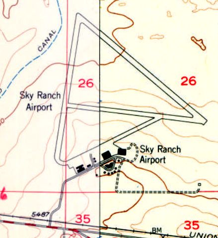
The 1957 USGS topo map depicted Sky Ranch Airport as having at least 2 paved runways, with several buildings on the south side.
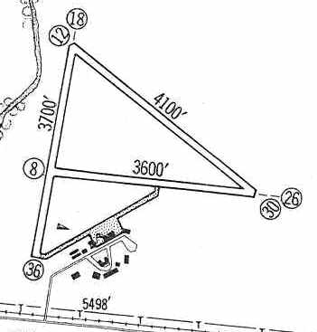
Sky Ranch was depicted in the 1960 Jeppesen Airway Manual (courtesy of Chris Kennedy)
as having 3 unpaved runways (with the longest being the 4,100' Runway 12/30),
as well as a taxiway leading to a ramp on the south side of the field with numerous buildings.
Sky Ranch was listed among active airports in the 1962 AOPA Airport Directory,
with 3 gravel runways (the largest being 4,700' long),
and the operators listed as Universal Aircraft Industries & Vest Aircraft & Finance Company.
Sky Ranch Airport was depicted on the June 1963 Denver Sectional Chart (courtesy of Chris Kennedy) as having a 4,200' unpaved runway.
Larry Leger recalled, “After I graduated from Aurora Central High school in 1963,
I worked at Sky Ranch for 3 summers while going to college.
Univar was the Fixed Base Operator & had a substantial maintenance & engine / propeller rebuild operation.
Univar owned the jigs & dies for many older airplanes including Swift, Stinson, and Ercoupe.
In fact in 1963 a new Stinson was manufactured as a 16th birthday present for the owners' son.
The owners of Univar were named Dyer. The general manager was Bob Williams or Williamson.
It ran into financial problems & ceased doing business. Sky Ranch was owned by the Mack family.
Mack Realty was a large commercial real estate firm in Denver at the time.
Vest was a airplane broker that operated at the airport. I took lessons & soloed at Sky Ranch in 1963.
The east/west & north/south runways were paved & the hangars painted in 1964.”
Varel Freeman recalled, “The Mack family did own the airport, and Vest was a broker.
By the mid-1960s when I was flying there, the Vest hangar was occupied by Univair.
The buildings to the right of the hangars - members of the Mack family lived there in what was a pretty nice compound.”
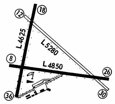
Sky Ranch was depicted in the 1967 Flight Guide (courtesy of Chris Kennedy)
as having 2 paved runways (4,850' Runway 8/26 & 4,625' Runway 18/36) & a 5,280' unpaved Runway 12/30.
A taxiway led to a ramp on the south side of the field with several hangars.
Kelli Eckert reported that Barbara Mack's family owned Sky Ranch Airport from 1968-73.
Dennis Ramey recalled, “I received the training for both my private & commercial licenses at [Sky Ranch],
the former in August of 1968 & the latter in November of 1969.
The school, ATA, was located in the one-story buildings west of the large hangars.
I worked for the Fixed Base Operator for several months in 1969.
In 1969, the airport had an active flying club, a very busy repair facility, the flight school, a small diner, and probably 70-80 aircraft.”
Dennis continued, “The primary runways were paved when I made my first flights at Skyranch in November of 1967.
I suspect land development, bothersome neighbors, and the age of the owners
had more to do with closing the airport than did Stapleton.
The approach pattern to Runways 26 L & R at Stapleton were well above our altitudes in the pattern at Sky Ranch.
I never encountered any wake turbulence from the Stapleton traffic nor did anyone else I knew.
The neighbors that built around the airport were a problem.
There was one particular family that lived at the departure end of Runway 26 that complained continually.
I met the owner several times & believe him to be in his 70’s in 1969. All in all, it was a great place to fly from.
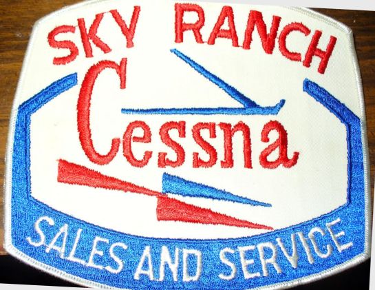
A photo by Mike Pustaver “of a patch my dad gave me back in 1971 or 72.
My father (Richard Pustaver) used to be a flight instructor at Sky Ranch Airport.
I remember his office hung from the ceiling of the hangar with the tower on it. I had some great times out there as a kid.”
According to the Univair Aircraft Corporation history, “In the early 1970s, the cities of Denver & Aurora began encroaching the Sky Ranch Airport.
There was talk of the sale of the property, closing of the airport & industrial development.
Steve Dyer, Eddie & Veda's son, took on the project of moving the company to a new facility just off the airport property in 1972.”
Mark Davis recalled, “I last flew into Sky Ranch on 12/8/73.”
The last depiction which has been located showing Sky Ranch as an active airport
was on the 1974 Denver Terminal Control Area Chart (courtesy of Ted Frison).
It depicted Sky Ranch as having 2 paved runways, with the longest being 4,800'.
Jesse Colvin recalled, "I don't know exactly when Sky Ranch was closed but I do know that it was closed by the mid 1970s.
I went to W.C. Hinkely in Aurora from 1974-77 & Sky Ranch at that time had already been closed for some time."
By the time it was closed, Sky Ranch Airport was very substantial in terms of facilities, for a general aviation airport.
Sky Ranch was no longer depicted at all on the 1976 USGS topo map,
and it was depicted as an abandoned airfield on the February 1977 Denver Sectional Chart (courtesy of Chris Kennedy).
Dennis Ramey recalled, “I was sorry to see it closed when I returned to Denver in 1977.”
According to Patrick Griffith, “The site of that old airport became the location
of an outer marker & low-frequency compass locator (NDB) for the approach to Stapleton International Airport.
Virtually every aircraft approaching to land at Stapleton from the east
announced their presence at Sky Ranch to the tower to indicate that they were on final approach.”
The runways of Sky Ranch were still depicted on the 1981 USGS topo map, but the field was labeled "Sky Ranch Airport (Closed)".
Sky Ranch was no longer depicted at all on the June 1989 Denver Terminal Chart (courtesy of Robert Brown).
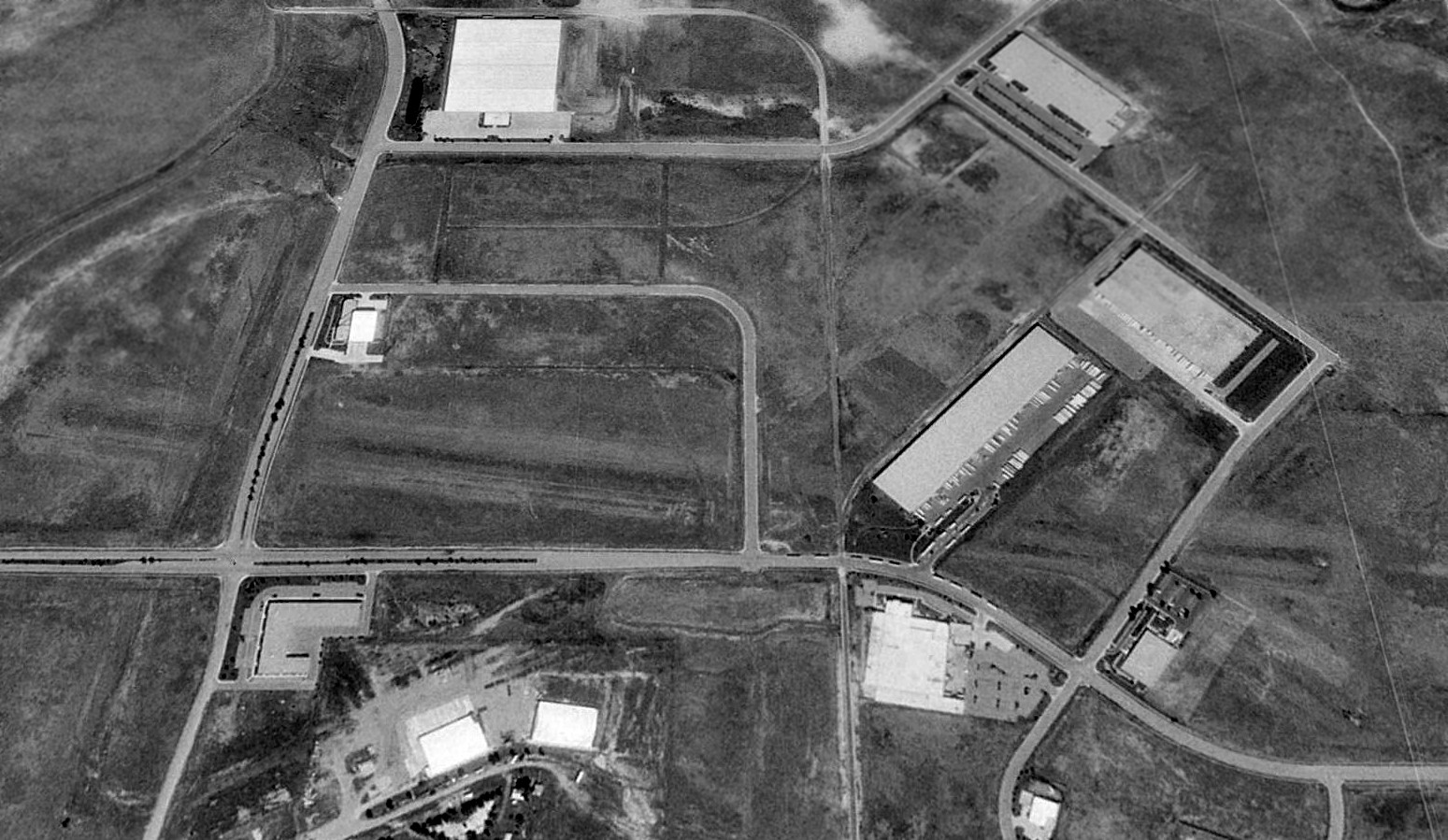
A 1993 USGS aerial view looking north showed the Sky Ranch runways had all been removed,
but their location was still barely perceptible.
Several roads & commercial buildings had been built over the former runways.
Two large hangars (one with an attached control tower) still stood as the only remaining element of the airport.
A 2001 photo by Neal Braatz of the remaining hangars & control tower at Sky Ranch.
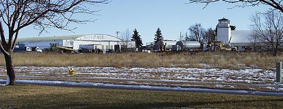
A 2001 photo by Neal Braatz of the remaining hangars & control tower at Sky Ranch.
Raymond Cober recalled in 2003, "I had once lived within a mile or so of the former facilities
and in fact it is quite possible my home was built on former airport grounds!
The remaining hangar & control tower/hangar combo are very visible landmarks from either I-70 or Tower Road,
including the intersection of both roadways.
I remember once driving up to there to see what the exact deal was.
A chain link fence surrounds the remaining facilities,
with signage indicating that the property is privately owned, apparently by some local construction firm.
Construction equipment was parked both outside & within the hangars themselves.
A few other additional facilities were built within the fenced perimeters,
mostly seeming to be temporary in nature (sheds, etc.).
The area has become somewhat more built up since the 1993 aerial survey
and I suspect even more so from the 2001 aerial survey.
The surrounding areas are becoming increasingly built-up with commercial interests
since the land is relatively cheap to buy & tax,
as well as the close proximity to DIA (KDEN) and the traditional technological & educational centers of Denver.
About a month ago, I passed by the area on the interstate,
and it seemed as if there were commercial facilities built up almost to the chain link fence.
I would not be surprised if the property is bought-up, the facilities demolished,
and any last vestige of Sky Ranch obliterated within the next five years.
A similar fate could very well be in the near future for nearby Aurora (01V),
which for the time being is privately operated & remains open as a general aviation airport."
Brian Richardson reported in 2006 that the former airport property is currently owned by Brian Seib.
Brian Richardson reported, “During a recent tour of the facilities
I witnessed what is left of the old military barracks facilities on the West side of the property.”
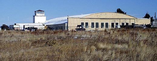
A 2006 aerial view looking west at the 2 former hangars which remain standing at the site of Sky Ranch Airport.
Note the control tower on the northern corner of the western hangar.
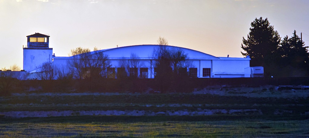
A 5/23/13 photo of a Sky Ranch hangar & control tower.
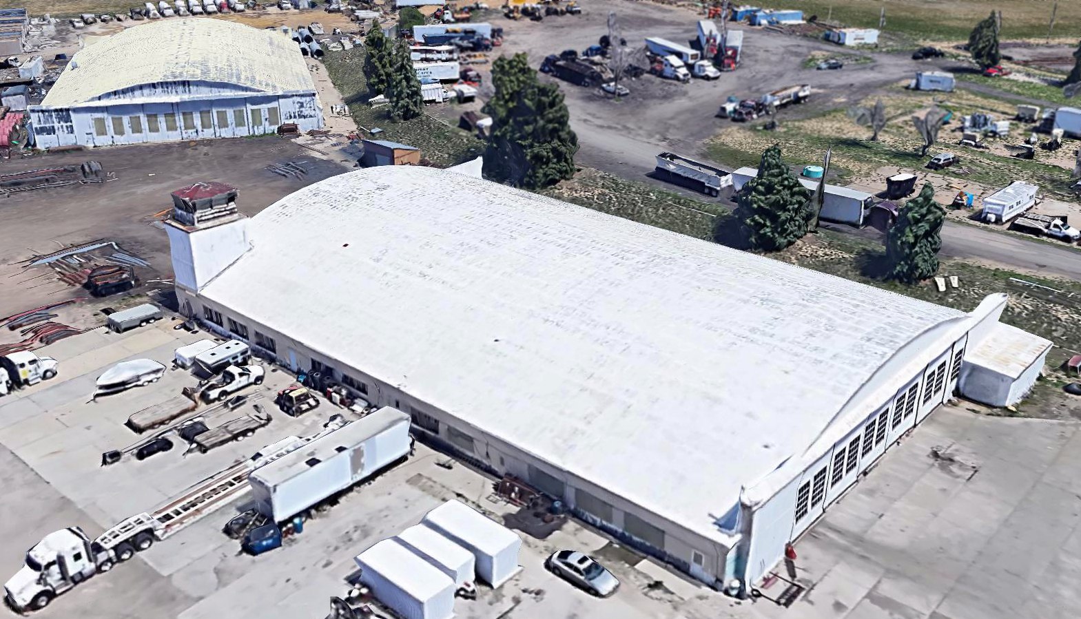
A circa 2013-2018 3-D aerial view looking southeast at the 2 former Sky Ranch hangars, one with an attached control tower.
A 2017 aerial view looking north showed portions of 2 of Sky Ranch's runways still remained (at bottom-left, and center through bottom-right).
Several roads & commercial buildings had been built over the former runways.
Two large hangars (one with an attached control tower) still stood at the southern end of the property.
A July 2021 photo looking south at the 2 former Sky Ranch hangars, one with an attached control tower.
As of 2022, street maps label the 2 former Sky Ranch Airport hangars as Hayden Industries.
The site of Sky Ranch Airport is located at the eastern terminus of Sky Ranch Road, appropriately enough.
Thanks to Neal Braatz for pointing out this field.
____________________________________________________
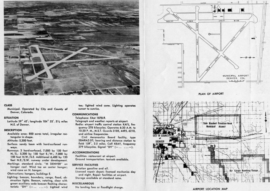
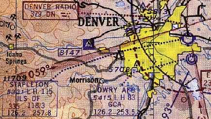
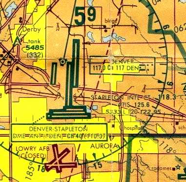
Denver Municipal Airport / Stapleton International Airport (DEN), Denver, CO
39.77, -104.88 (East of Downtown Denver, CO)
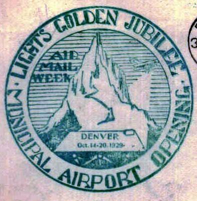
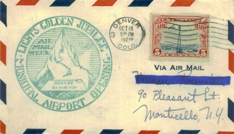
A postmark commemorated the 10/14/29 Denver Municipal Airport Opening.
This field, originally known as Denver Municipal Airport, was opened on 10/17/1929.
It was called the "Union Station of the Air", and heralded as the most modern facility in the country.
The airport was an immediate financial success.
A 1930 aerial view looking west at the Denver Municipal Airport terminal & hangars.
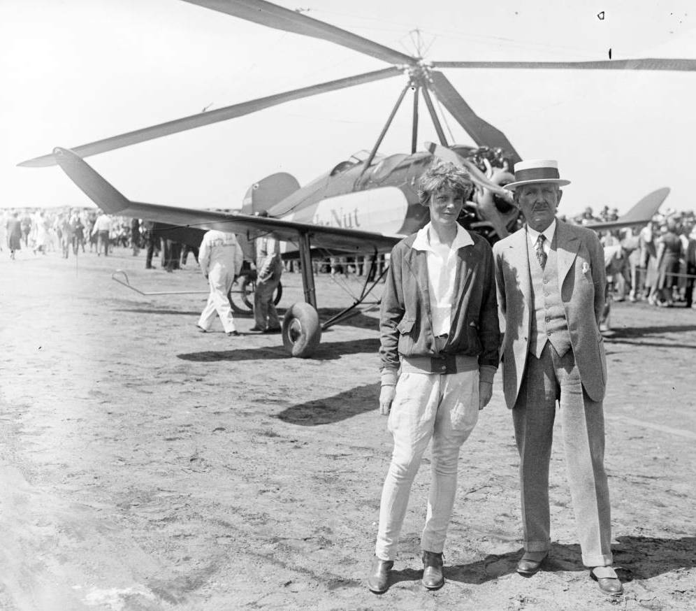
A June 1931 photo of Amelia Earhart & Frederick Bonfils (editor & publisher of the Denver Post) in front of a Beech-Nut Autogiro.
Earhart had stopped at Denver Municipal Airport on one of her cross-country escapades.
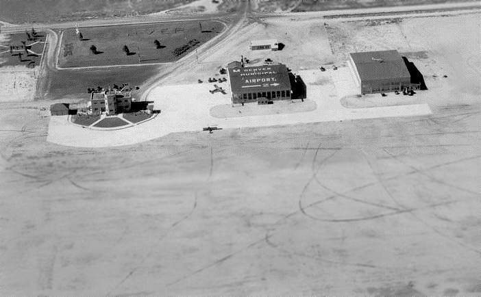
A 1931-35 aerial view looking northeast at Denver Municipal Airport, showing several unpaved runways, and 2 hangars & the terminal along the west side.
The 1934 Department of Commerce Airport Directory (according to Chris Kennedy)
described Denver Airport as having 4 sandy loam runways, with the longest being a 5,000' northeast/southwest strip.
A hangar was said to have "Denver Municipal Airport" painted on the roof.
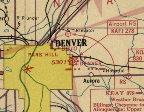
Denver “Municipal Airport” as depicted on a 1935 street map (courtesy of Kevin Walsh),
along with a string of 3 other airports in close proximity to the northwest: “Colorado Airways Field”, “Lowry Aviation Field”, and “Curtiss Aviation Field”.
Boyd Finch recalled, “As a boy age 10-13 (1935-38), I lived in the 2200 block of Krameria Street in Denver.
From the north end of our block there was open prairie all the way to the Denver Municipal Airport (Stapleton),
and I would ride my bike on diagonal paths to 32nd (now Martin Luther King) and on to a low bluff on the west of the airport.
I remember the terminal building & the 2 hangars.
I could wander wherever I wanted on the flight line & into the hangars, talking to mechanics, etc.”
An undated aerial view looking north at Denver Municipal Airport
from The Airport Directory Company's 1937 Airports Directory (courtesy of Bob Rambo).
It described Denver Municipal Airport as having 3 "surfaced" runways,
with the longest being a 5,250' northwest/southeast strip.
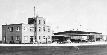
A circa 1930s view looking northwest at the Denver Municipal Airport terminal & a hangar.
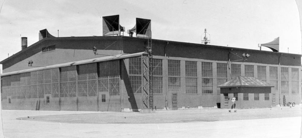
A circa 1930s photo of Denver Municipal Airport Hangar 1. What was the purpose of the large megaphones mounted on its roof?
A 1938 photo of a Lockheed Model 10 Electra being refueled in front of the Denver Municipal Airport terminal / control tower (courtesy of Eric Hansen).
The earliest map depiction which has been located of Denver Municipal Airport was on a 1937 street map (courtesy of Rex Ricks),
which also depicted nearby Park Hill Airport & Lowry Field.
The first control tower at Denver became functional in 1938.
The earliest topo map depiction which has been located of Denver Municipal Airport was on the 1938 USGS topo map,
which depicted it as an open square field with 4 buildings along the west side.
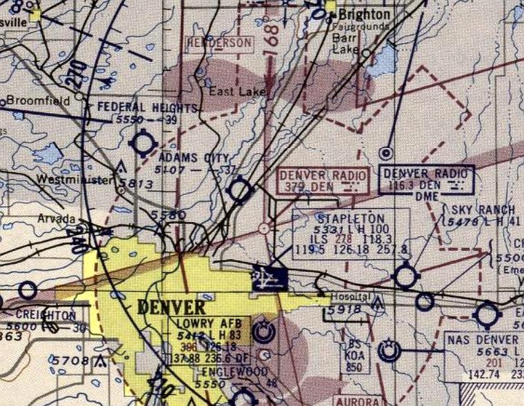
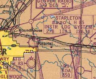
Note the map also depicted an adjacent “Airport” to the southwest, presumably the “C A P” Airport later depicted on the 1945 Sectional Charts.
The earliest aeronautical chart depiction which has been located of Denver Municipal Airport was on the February 1939 Denver Sectional Chart.
It depicted Denver as a commercial/municipal airport.
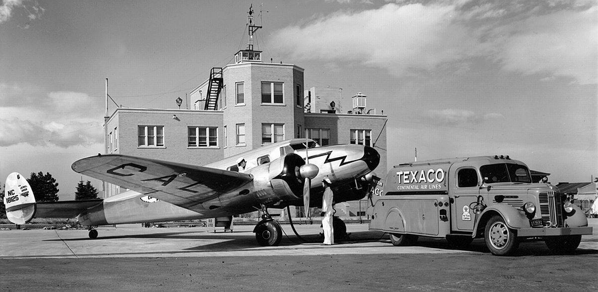
During WW2, Stapleton housed the Continental Denver Modification Center, and was also used by the Air Transport Command.
In 1944, the field was renamed after Mayor Stapleton, who had led the fight for the new airport.
A 1944 aerial view looking northwest at large numbers of B-17 bombers parked behind the Stapleton terminal (courtesy of John Voss).
The February 1945 Denver Sectional Chart (courtesy of Richard Doehring) depicted Stapleton as a commercial/municipal airport.
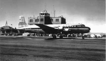
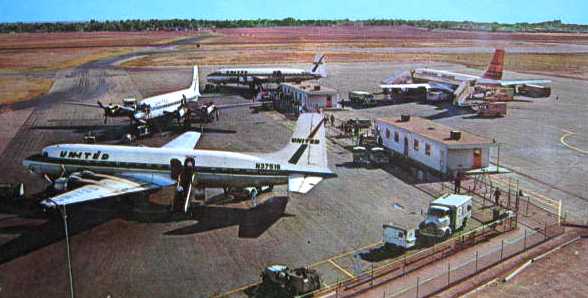
A 1940s photo of a United Airlines DC-4 in front of the Stapleton terminal.
A circa 1940s airport directory entry for Denver Municipal Airport.
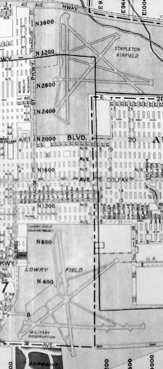
A 1948 street map (courtesy of Rex Ricks) depicted Stapleton Airfield's proximity to Lowry Field.
The February 1949 Denver Sectional Chart (courtesy of Chris Kennedy) depicted Stapleton as having an 8,500' hard surface runway.
The 1950 USGS topo map depicted “Municipal Airport” in the same fashion as depicted in 1938, as an open square field with 4 buildings along the west side.
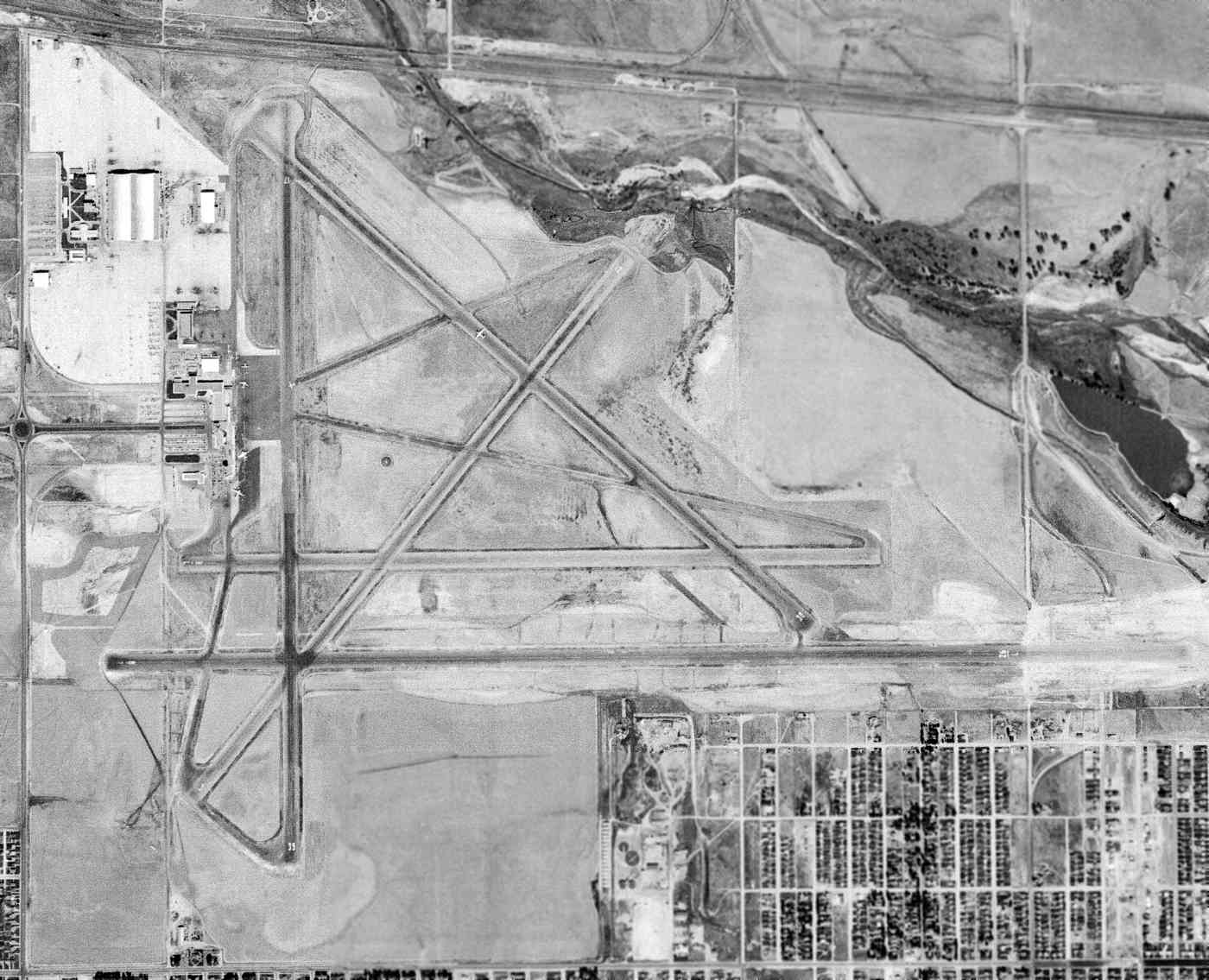
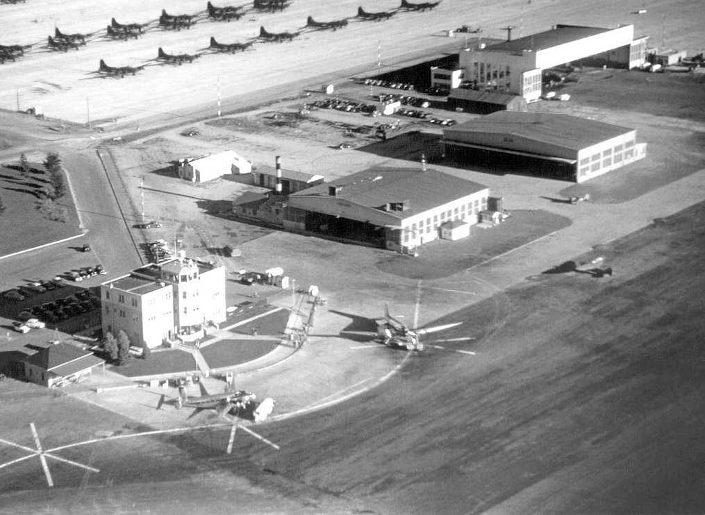
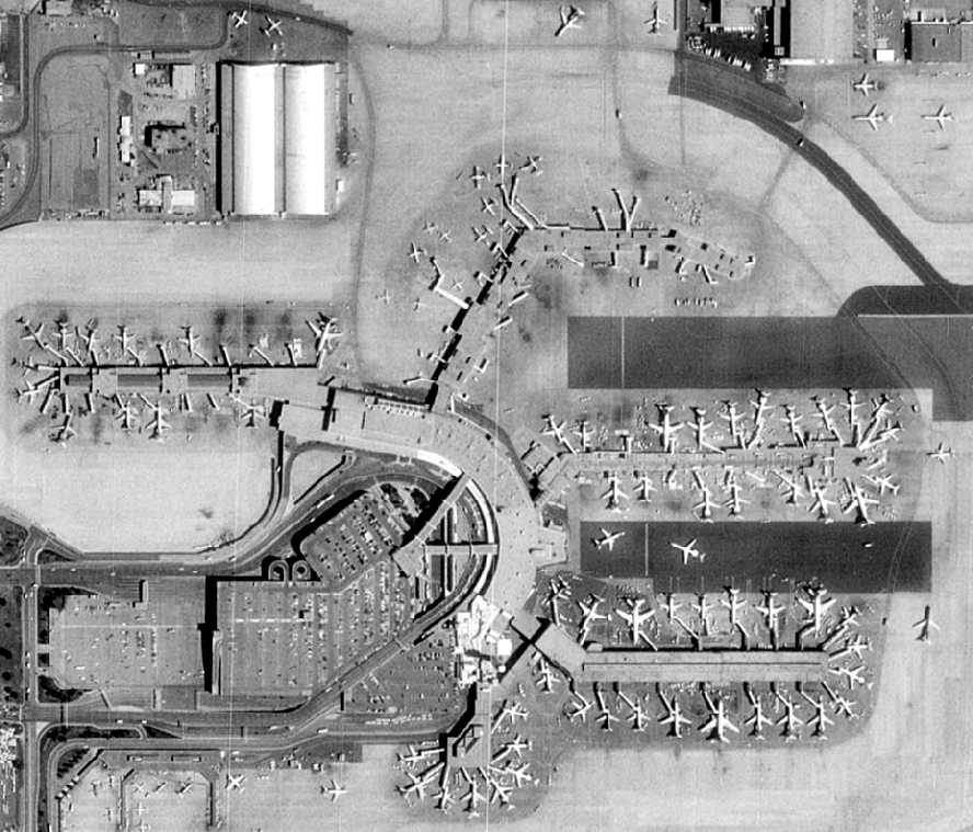
A 9/25/53 USGS aerial view depicted Stapleton as having 5 paved runways, taxiways, ramps, hangars, and a terminal.
In 1954 Stanley Aviation was awarded an ejection seat contract, and opened a 75,000 square foot plant adjacent to the south side of Stapleton's Runway 8R/26L.
Stanley was an early innovator in the ejection seat market, perhaps best known for developing the B-58 Hustler's encapsulated ejection seats.
The Stanley plant was expanded to 140,000 square feet in the mid-1950s.
A 1954 aerial photo by Robert Boser, taken from a Bell 47 helicopter, showing Douglas & Convair airliners in front of the Stapleton tower.
A 1954 photo by Robert Boser of Douglas & Convair airliners at Stapleton.

The 1957 USGS topo map depicted “Stapleton Field Municipal Airport” with a significantly improved layout,
with 6 paved runways, taxiways, ramps, numerous hangars, terminals, and a control tower.
Ted Frison recalled, “I remember the 'original' terminal that was an amazing sandstone building which was incorporated into the 'new' terminal.
I think that piece of the terminal was preserved after Stapleton closed.
I also remember my dad excitedly taking us out there, sometime in the late 1950s to watch the arrival of the first turboprop to come to Denver (probably a Lockheed Electra).
The oil company my dad worked for owned a DC-3 that they kept in one of the very large hangars on the south side.
They eventually bought a jet, but it proved to be more expensive than they could afford.”
By the late 1950s, the jet age was a reality, and the need to expand the terminal facilities & runways became a necessity.
Additional land was acquired from the Rocky Mountain Arsenal.
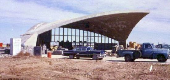
A 1959 photo of Stapleton's iconic Hangar 61 under construction on the southeast side of the airport.
In 1959 the Ideal Basic Cement Corporate Hangar (later known as Hangar 61) was built to house the corporate plane, a Fairchild F-27 turboprop,
of the Ideal Basic Cement Company owned by the prominent Boettcher family of Colorado.
The 8,500 square foot cement structure was an example of sophisticated engineering creating an innovative architectural design.
The design utilized a unique barrel shell section cut into an organic diamond shape that fit the plane both vertically & horizontally.
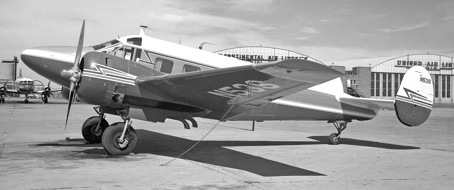
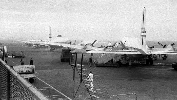
A December 1960 photo by Ed Coates of Beech E18S-9700 N53S C/n BA-293 in front of Stapleton hangars.
Stapleton Airport was depicted on the October 1963 Sangre De Christo Mountains World Aeronautical Chart (courtesy of Donald Felton) as having a 11,500' hard-surface runway.
Steve Barnes recalled, "My dad was a private pilot in the 1960s & we flew out of Combs Aviation here at Stapleton
when it was still an everyday thing to mix 172s up with 707s on the runway.
I remember many times taxiing out behind a heavy & gagging on the JP fumes coming into the cockpit. Sometimes it seems like yesterday."
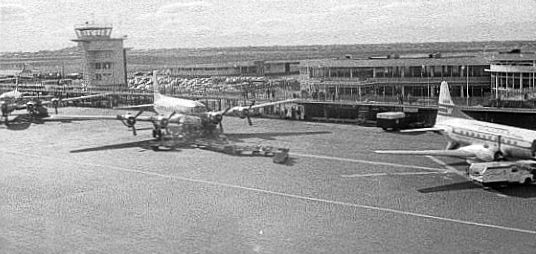
A circa 1960s photo of 3 United DC-6s & a 707 at Stapleton Airport.
A January 1966 aerial view by Robert Boser looking north at Stapleton Airport.
Robert observed, “It shows Runways 8L, 8R and R35 (later to be designated 35L).
Runway 35R had not yet been constructed. It shows the old United Airlines Pilot Training Buildings on the airport proper.
Later, a newer complex was constructed immediately west of the airport.
A UAL DC-8 training flight is making a missed approach, complete with its shadow on the ground.”
A January 1966 aerial view by Robert Boser looking west at Stapleton Airport.
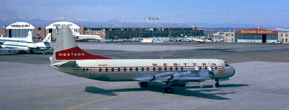
A 10/24/67 photo by Ian MacDonald of a Western Airlines Lockheed L-188A Electra at Stapleton.
The April 1969 Denver Sectional (courtesy of Richard Doehring),
depicted Stapleton as having 4 paved runways, with the longest being 11,500'.
The 1974 Denver Terminal Control Area Chart (courtesy of Ted Frison)
depicted Stapleton as having 3 paved runways, with the longest being 11,500'.

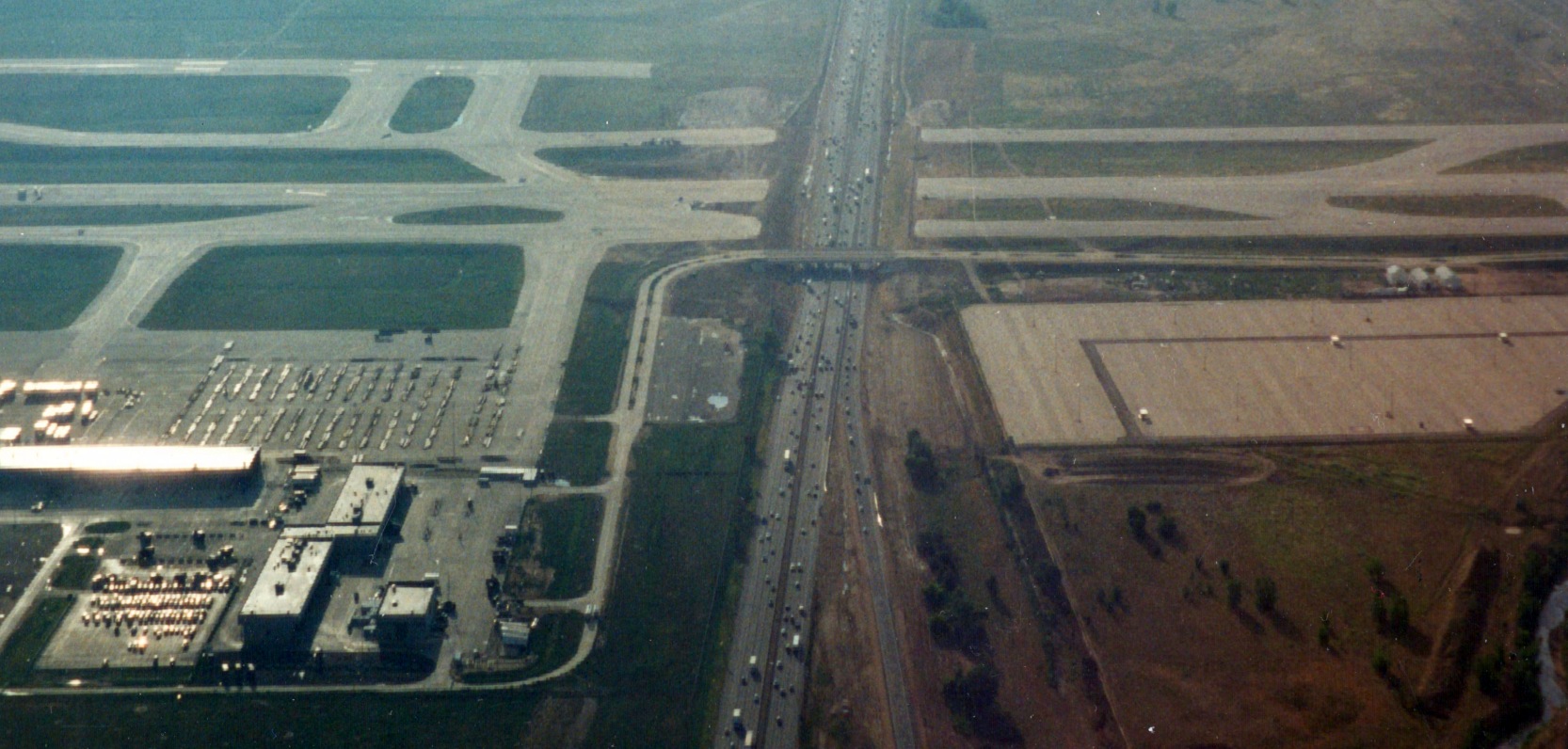
An 8/16/78 USGS aerial photo depicted Stapleton as having 5 paved runways.

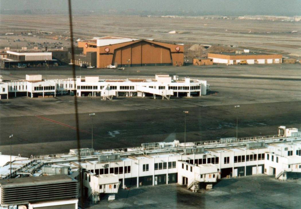
A closeup of the 8/16/78 USGS aerial photo showing a wide variety of aircraft on the south side of Stapleton.
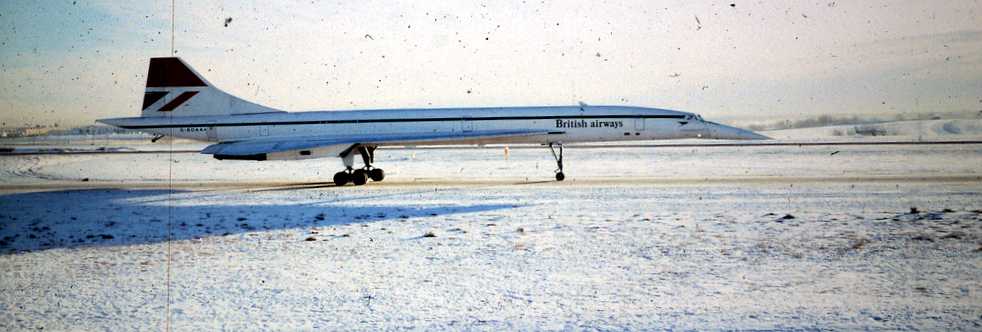
A December 1978 photo of a beautiful British Airways Concorde taxiing on a snowy Stapleton Airport.

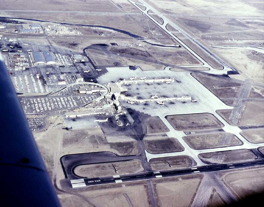
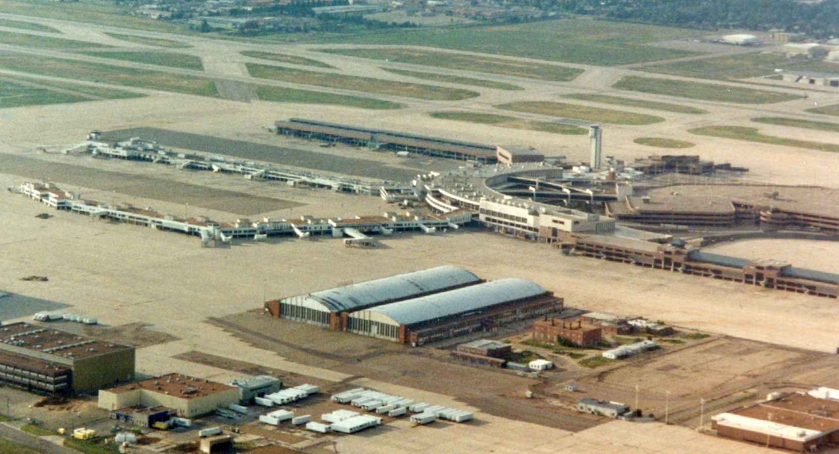
A 1980 aerial view looking southwest showing an amazing assemblage of airliners at Stapleton's terminals.
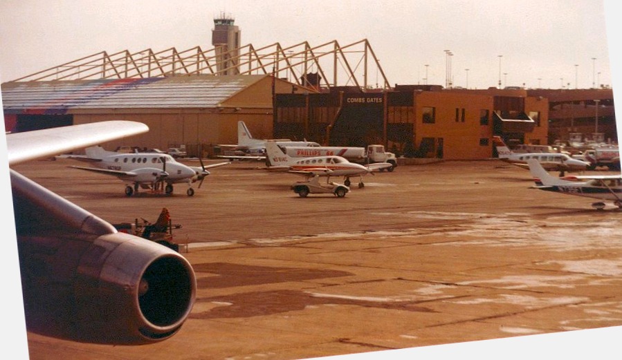
A December 1980 photo by Kevin Peterson of a variety of general aviation aircraft on Stapleton's ramp in front of the Combs Gates building.
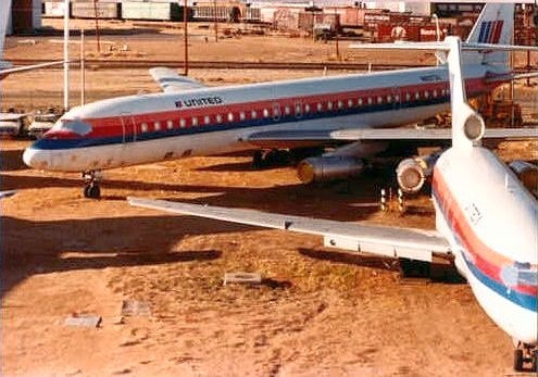
A circa 1980s photo by Kevin Peterson of a retired United Airlines Douglas DC-8 & Boeing 727 at Stapleton.

A 2/17/84 airport directory (courtesy of John Kielhofer) depicted Stapleton as having 5 paved runways.
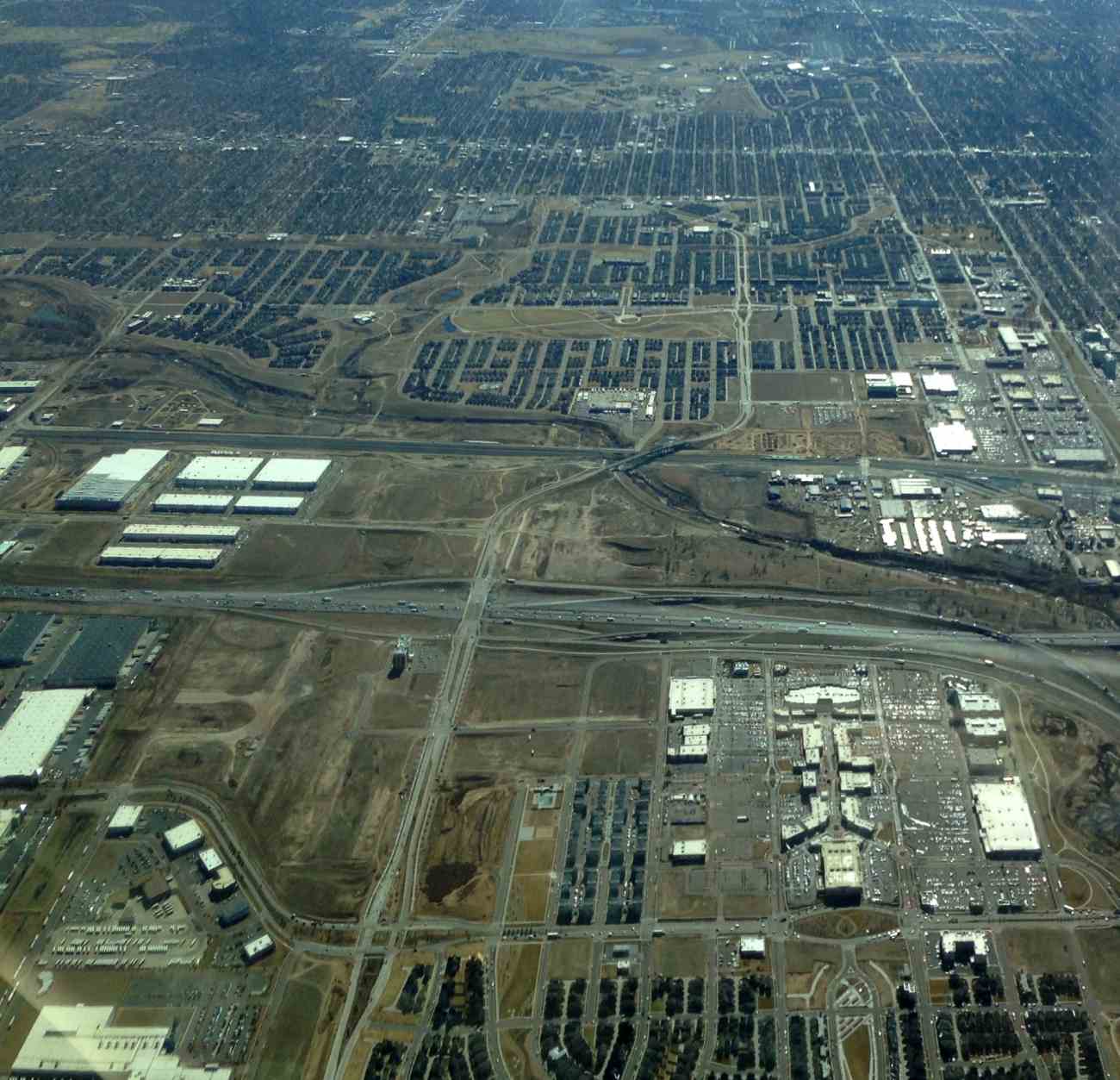
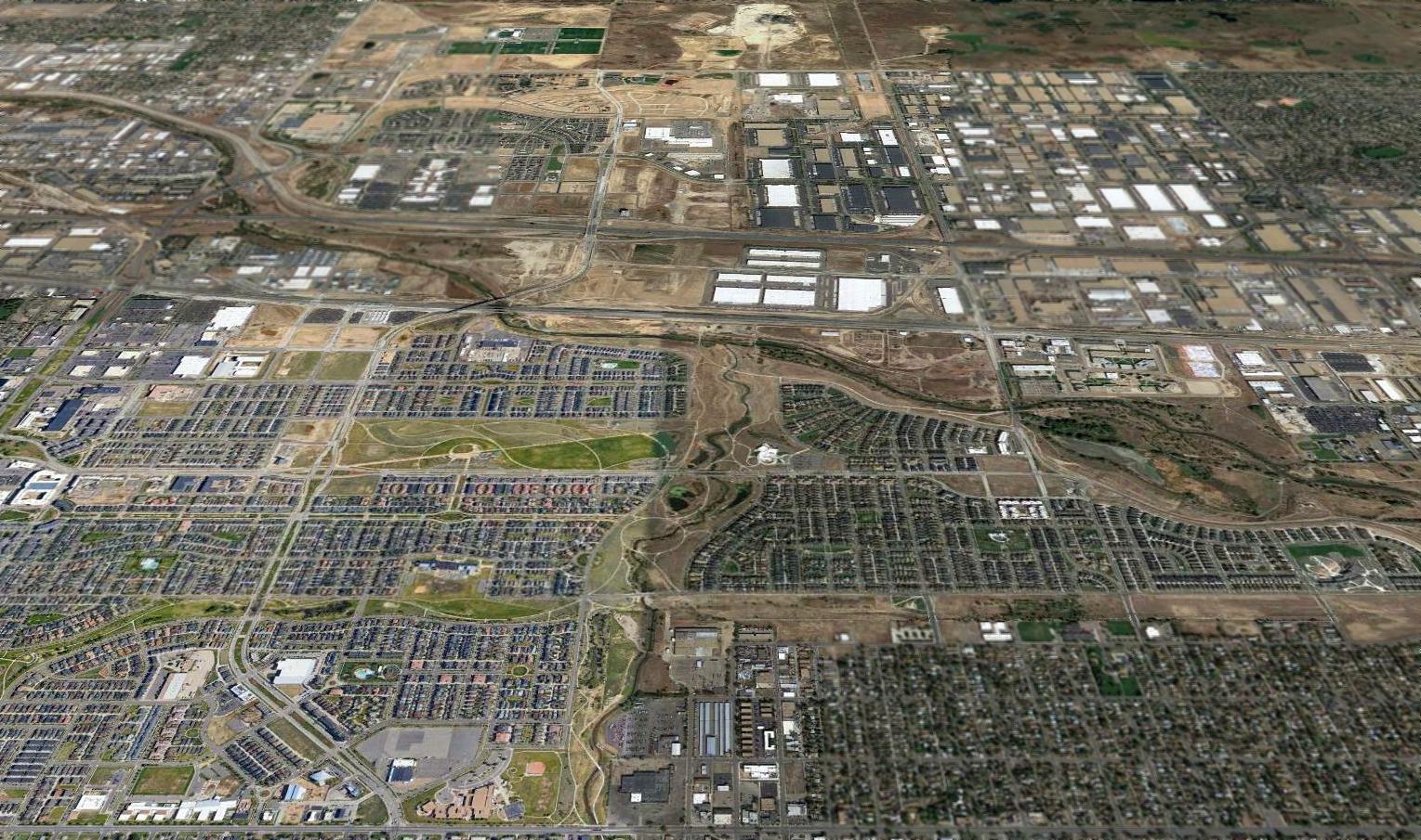
By 1985, Stapleton Airport had grown to 4,700 acres.
However, while passenger levels at the airport expanded dramatically in the 1980s, Denver neighborhoods were expanding east towards the airport.
This led to a decision to replace Stapleton with a completely new airport, Denver International, a mere 10 miles to the northeast, at a cost of several billion dollars.
The June 1989 Denver Terminal Chart (courtesy of Robert Brown) depicted Stapleton as having 6 paved runways.

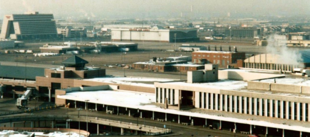
A circa 1980s/1990s aerial view looking west at a busy Stapleton Airport, with the Denver skyline & Rocky Mountains in the background.
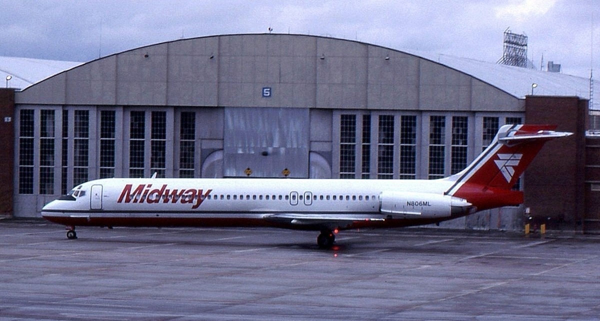
A 4/1/90 photo by Peter Lea of Midway Airlines McDonnell Douglas MD-87 N806ML C/n 49778 / 1646 in front of a Stapleton hangar.
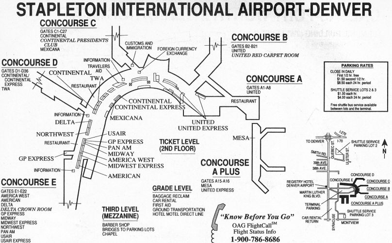
A 1991 diagram of Stapleton's terminal layout.
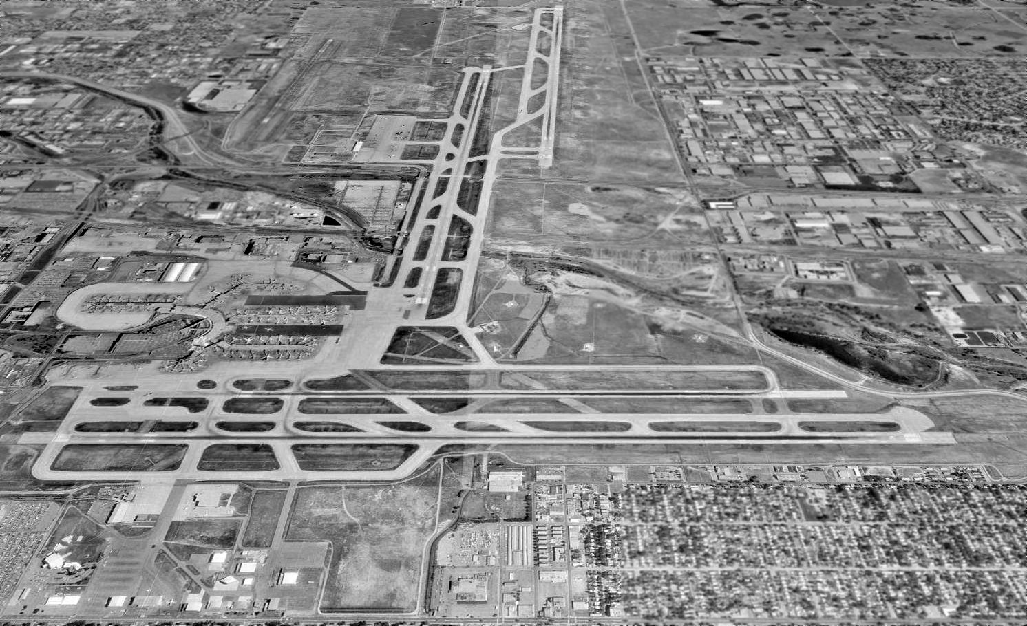
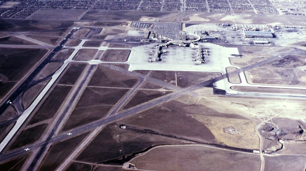
A June 1993 USGS aerial view looking north at Stapleton, taken only a few years before the field's closure.
A June 1993 USGS aerial view showing an amazing assemblage of airliners at Stapleton's terminals.

The last aeronautical chart depiction which has been located of Stapleton Airport was on the October 1993 Denver Sectional Chart (courtesy of Ron Plante).
It depicted Stapleton as having 6 paved runways, with the longest being 12,000'.

A 6/7/94 USGS aerial view of the northern portion of Stapleton Airport.
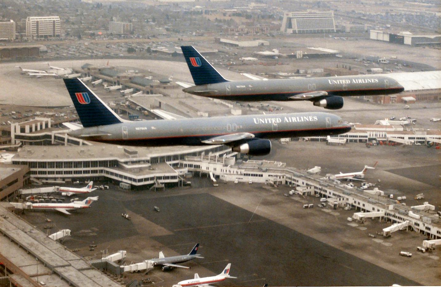
A 2/27/95 photo (from the collection of Richard Van Lew, courtesy of Kevin Peterson) of a formation of 2 United Airlines Boeing 757s over Stapleton's terminal,
on the last day of the airport's flight operations.
On 2/27/95, the last commercial flight left Stapleton: a Continental Airlines flight to London Gatwick.
Stapleton was closed later that evening, and a massive convoy of all airport vehicles (everything from baggage carts to rental cars)
headed for the new Denver International Airport, which opened the following morning.
Yellow "X"'s were placed across all Stapleton runways to keep aircraft from landing at the now-closed airport.
DIA dropped DVX and KDVX as its temporary airport codes, adopting Stapleton's DEN and KDEN.
Visitors to Denver at this time had the experience of flying out of a different airport as the one they arrived at, although the airport had the same code.
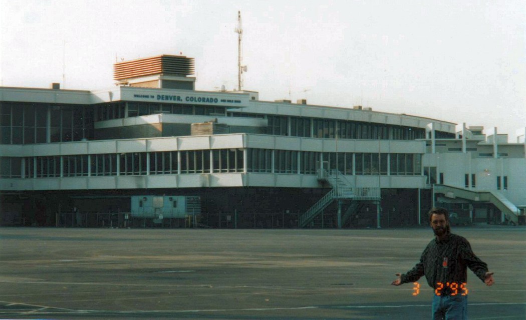
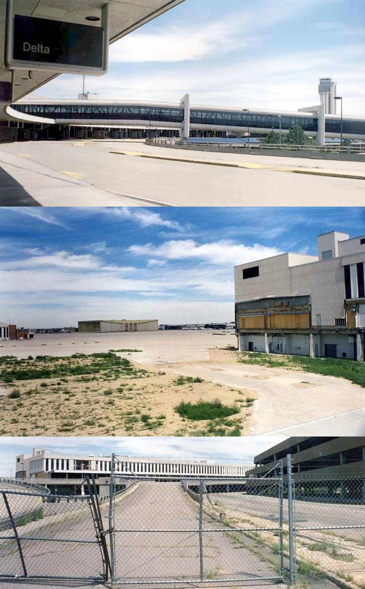
A 3/2/95 photo by David Ulane of Dave Tjarks in front of Stapleton's terminal, “less than 72 hours after the airport closed.
Dave had access to the whole airport, and we explored it all.”
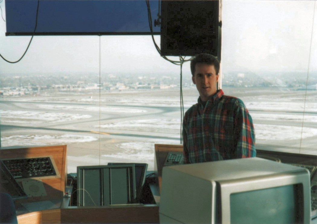
A 3/2/95 photo by Dave Tjarks of David Ulane inside Stapleton's control tower.
David recalled, “We went up in the tower, where the floor was still littered with champagne bottles leftover from the post-closure party by the controllers.”
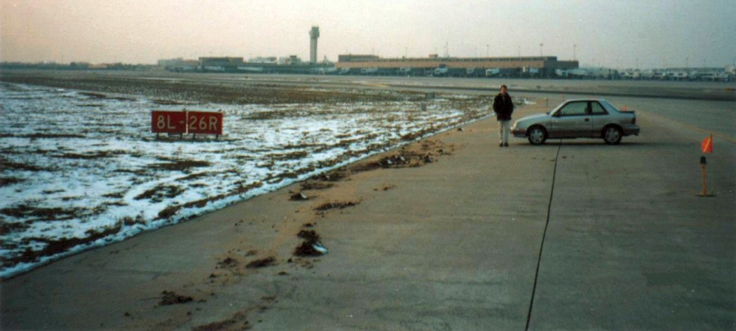
A 3/2/95 photo by Dave Tjarks of David Ulane next to Stapleton's Runway 8L/26R.
David recalled, “We were able to drive my car on the ramp & the airfield, where everything was still in place, but without one single aircraft or piece of ground support equipment.”
A 3/2/95 photo by David Ulane from Stapleton's control tower, looking out at a Continental hangar.
A 3/2/95 photo by David Ulane from Stapleton's control tower, looking out at a United Air Lines hangar.
Amazing to think that all of those massive buildings would be completely leveled within a decade.
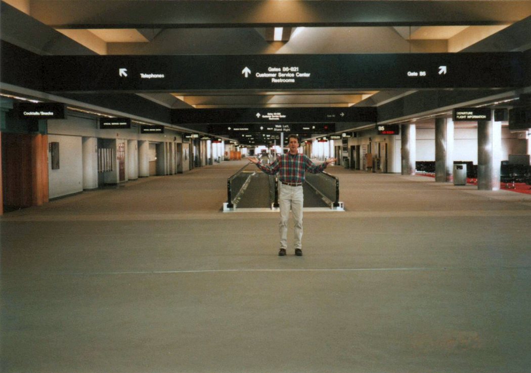
A 3/2/95 photo by Dave Tjarks of David Ulane inside Stapleton's terminal.
David recalled, “The terminal was particularly surreal - without hundreds of people, computers and HVAC systems running,
it was so quiet you could literally hear footsteps from hundreds of feet away - a huge change from the busy terminal I remember visiting since age 5.
All of the digital gate signs still contained the departure information for the last flight to operate from each gate,
and virtually everything was still there - it was as if humans had suddenly vanished from the earth.
That March day was one of the most memorable in my aviation career.
My childhood trips to the old Stapleton played a huge part in my love for airports & aviation.”
A July 1996 aerial view by David Ulane of the remains of Stapleton Airport, “taken during a ride with one of Denver’s helicopter traffic reporters,
looking east from over I-70 at the north/south runway complex. The bridges over I-70 that carried Runway 35L (middle) & taxiways Lima (near/west side) & Zulu (far/east side) had already been removed.”
A July 1996 aerial view by David Ulane of the remains of Stapleton Airport, “looking southeast, with Runways 8R & 8L in the background.
Clearly most of the infrastructure remained, even though the airport had been closed for 16 months.”
By the time of the January 1997 Denver Sectional (courtesy of Richard Doehring), Stapleton was still depicted, but was labeled as Closed.
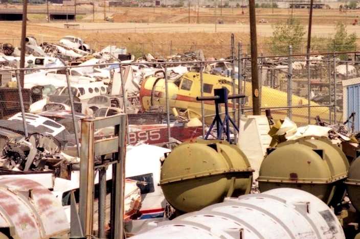
A March 1997 photo by George Baczkowski of a Noorduyn Norseman & dozens of other aircraft in a salvage yard at Stapleton.
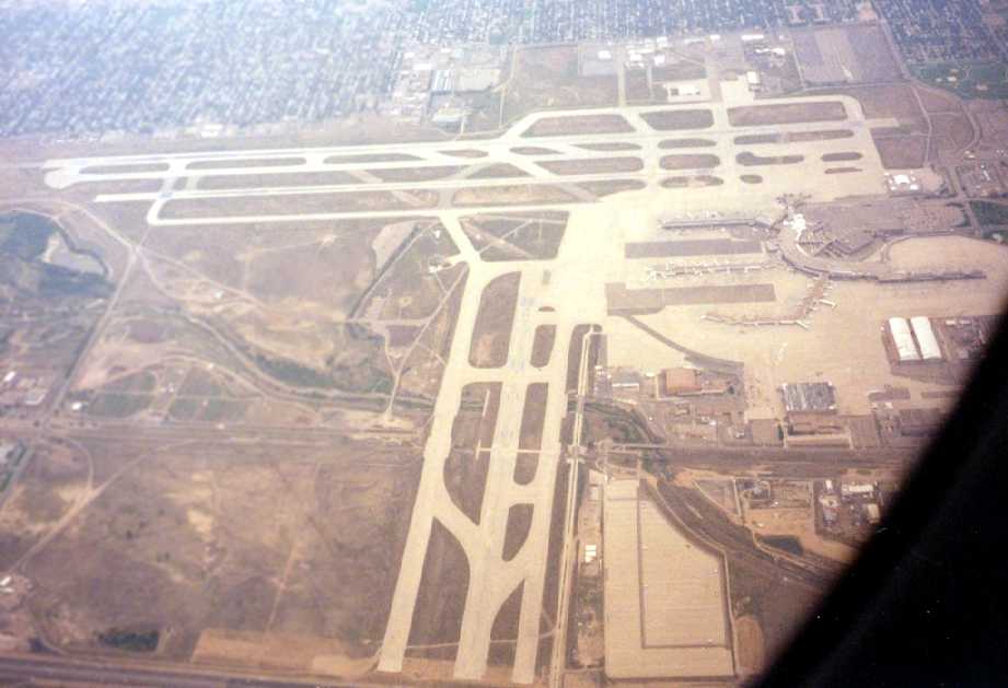
A late 1990s aerial view by Philip Kineyko of www.FlyinPhilsPhotos.com, looking south at the Stapleton runways & terminal,
”shot out the window of a commercial turboprop out of the new Denver International.”
Stapleton was depicted as an abandoned airfield on the August 1999 Denver Terminal Aeronautical Chart (courtesy of Ron Plante).
Circa 1990s photos of remains of the airport infrastructure at Stapleton (courtesy of Rex Ricks).
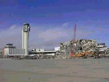
A circa 1990s photo of the Stapleton terminals being demolished.
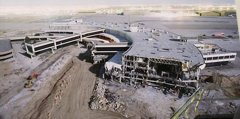
A circa 1990s photo of the Stapleton terminals being demolished.
At the date of its closure, Stapleton consisted of 6 runways, up to 12,000' in length.
It is planned to redevelop the property for a variety of residential & commercial purposes,
and all of the extensive aviation infrastructure at Stapleton has been progressively destroyed.

A 2001 aerial view looking north at the Stapleton Airport site, with the terminals having been leveled, but portions of the runways not yet removed.
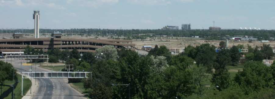
A 2002 photo by Tim Tyler of the Stapleton control tower & parking garage.
A 2003 photo by Benjamin Shumaker looking east at the lonely control tower which still stands at the Stapleton Airport site.
Benjamin Shumaker visited the site of Stapleton in 2003. His report:
"The terminal area is drastically different than 2 years ago.
The entire terminal structure & runway complex does not exist,
although from the air, I could still make out where the runways used to be.
The parking structure & control tower are the only structures still standing & I guess they will remain.
Entry into the airport via MLK Boulevard is still the same.
I was able to drive to the back of the parking structure
and get some shots of the control tower & surrounding area looking east.
Two rows of fencing kept me from walking right up to the tower
and every ramp & stairwell to the upper-deck of the parking structure
was obstructed with fencing to keep people out."
A 2003 aerial view of the Stapleton Airport site by Craig Mills (used by permission).
Craig observed, "This taken on climbout from Allegiant Air headed to Vegas.
We were just through 10,000' at this point (roughly 4,500' above the ground).
The warehouses on the left are right where the threshold of 35R was located.
There is almost no indication that there were runways on the south side of the site anymore."
A 2003 aerial photo looking east at the remains of Stapleton by Craig Mills (used by permission).
"Taken from the west of the Old Stapleton site at 1,000' AGL.
Here you can see where houses have now taken the place of the 3 east/west parallel runways.
The spared control tower is in the lower left."
A 2003 aerial photo of the Stapleton control tower by Craig Mills (used by permission).
A 2004 aerial photo by Craig Mills (used by permission) looking north at the remains of the Stapleton runways,
with the control tower still visible on the left.
A 2004 aerial photo by Craig Mills (used by permission) of Stapleton's former control tower & parking garage.
A 2004 aerial photo by Craig Mills (used by permission) of a remaining runway portion at Stapleton.
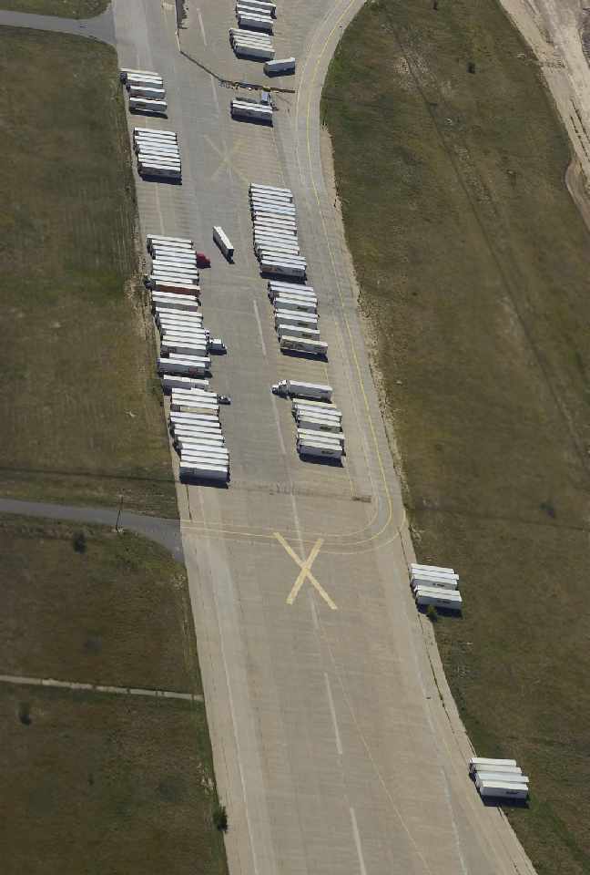
Steve Barnes reported in 2004, "The picture showing a portion of the old runway 35R with semi-trailers parked on it is where I work!
The warehouse just to east of the runway (and that is what we call it at work too)
is a meat, produce, cheese, and frozen food warehouse for King Soopers, the local branch of the Kroger Company.
I am a yard hostler here and spend my day shuttling trailers back and forth from the warehouse to the runway
where the drivers pick them up for store delivery.
This facility was the first building built at the former airport."
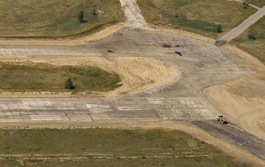
A 2004 aerial photo by Craig Mills (used by permission) of the markings still visible on the former Runway 17R.
An October 2004 photo by Chris Ness of the former Stapleton tower, which remains standing.
Chris observed, "United's headquarters is still there (for now)
as is one of the old parking decks & a number of the old commercial buildings.
The runways seem to be mostly going for housing."
A 2005 picture by Craig Mills looking east at the site of Stapleton Airport.
Craig observed, “You can't tell that there were 3 runways to the right (south) of the control tower (center of the pic) anymore.
Even the north/south parallel runways (17s/35s) are hard to distinguish anymore on the left side of the photo.
They're making big changes to the old airport layout now.
Soon, only the tower will hint that a major airport once sat on that land.”
A circa 2005 photo of Stapleton's unique Hangar 61.
It is believed to be the only diamond-shaped cylindrical arch-thin shell structure ever constructed worldwide.
No use was found for Hangar 61 after the closure of Stapleton,
and the possibility of demolition was imminent.
In 2005, the property was nominated for & named to CPI ’s Most Endangered Places List.
In 2005, Colorado Preservation, Inc. purchased the property with a grant from the State Historical Fund
and developed construction drawings for stabilization & exterior rehabilitation.
An option on the property was granted to a developer, Hangar 61 LLC,
and Historic Denver, Inc. is holding a perpetual easement on the property.
Colorado Preservation, Inc. has partnered with Hangar 61, LLC to rehab the Hangar
and to market the property to a new owner for a new use.
Phase 1 of the project will consist of structural repairs
and Phase II will encompass the exterior rehabilitation,
not including any tenant finish work which would only be necessary after an end user is identified.
A circa 2006 aerial view looking north at Stapleton's unique Hangar 61
which remains intact on the south side of the former airport.
Dennis Heap reported in 2006 that a control tower previously used at Stapleton by United Airlines for ground control
had been relocated to the Front Range Airport.
He reported, “We were working on a plan to use the tower cab as a line-of-sight tower,
until we identified funding for a permanent tower - we then abandoned the line-of-sight idea.”
A remnant of Stapleton's aviation industry closed in 2007, when the former Stanley Aviation plant (adjacent to the south side of Stapleton's Runway 8R/26L)
was closed by Eaton Corporation, which had acquired Stanley.
A November 2007 photo by Scott Murdock of Stapleton's control tower & parking garage,
which remained as an odd reminder of the huge airport which once occupied the site.
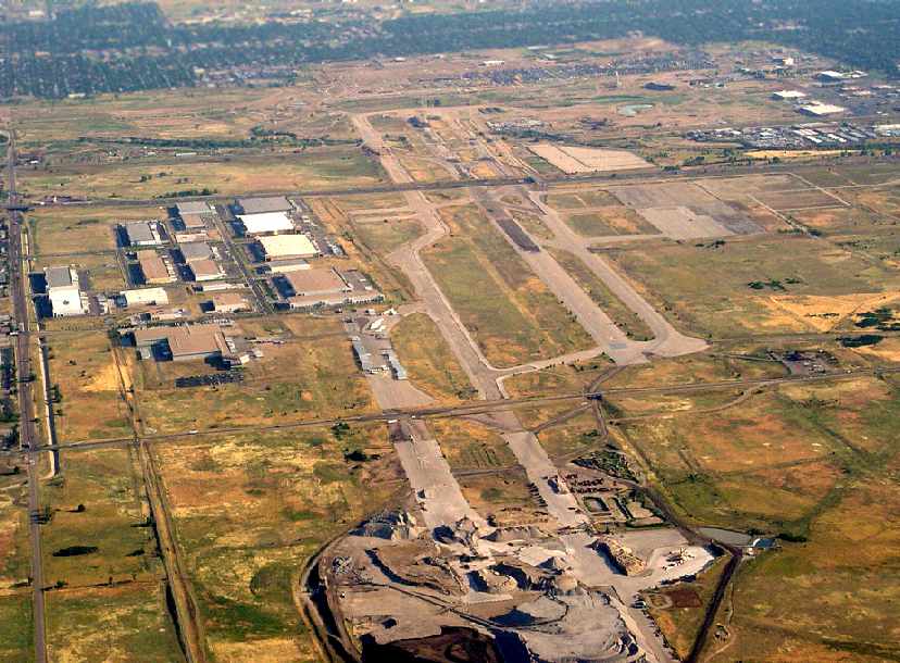
An October 2008 aerial view looking north at the north end of the Stapleton Airport site by Bryan Lipson.
Bryan observed, “The control tower is the white speck of a building in the lower left corner.
Basically everything south of the highway is now unrecognizable as an airport.
However, north of the highway, much of the original runway & taxiway complex remains very visible despite buildings on their surface.”
A circa 2010-2013 photo (courtesy of Devan Mayer) of the pavement which remained from Stapleton's Runway 18/36.
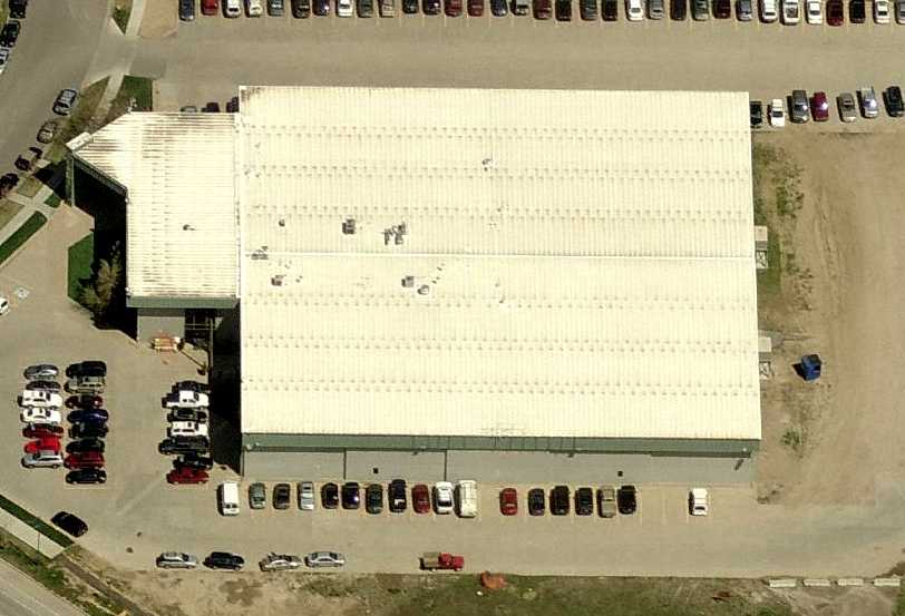
A circa 2010 aerial view looking north at a former Stapleton general aviation hangar,
reused by the Bladium Sports & Fitness Club.
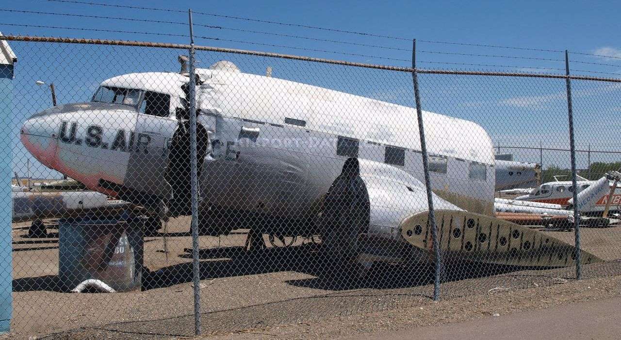
A 7/28/12 photo of the remains of 43-15957, a 1943 Douglas C-47A-90-DL Skytrain, serial #20423, stored at the site of Stapleton Airport.
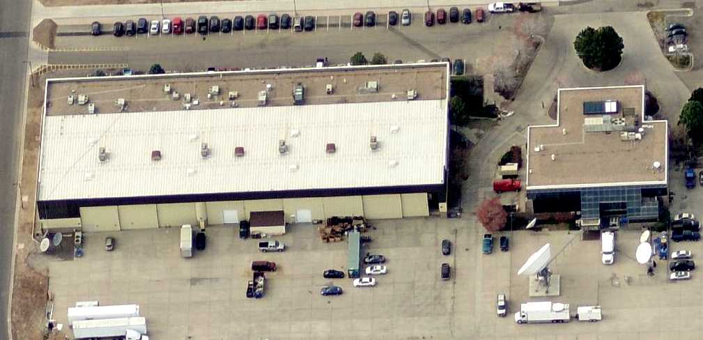
A circa 2010 aerial view looking west at a pair of former Stapleton general aviation hangars, reused by Denver 8 TV.
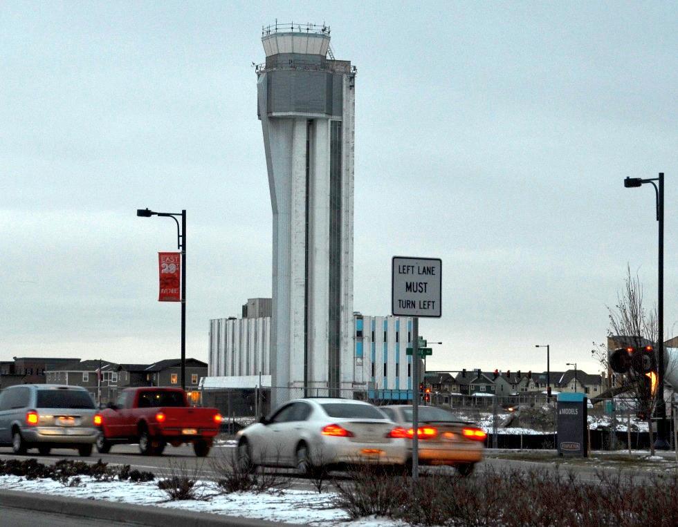
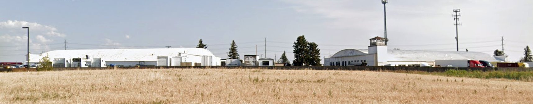
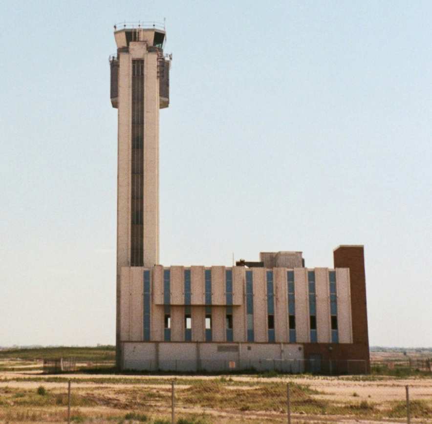
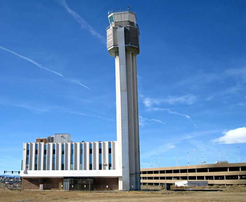
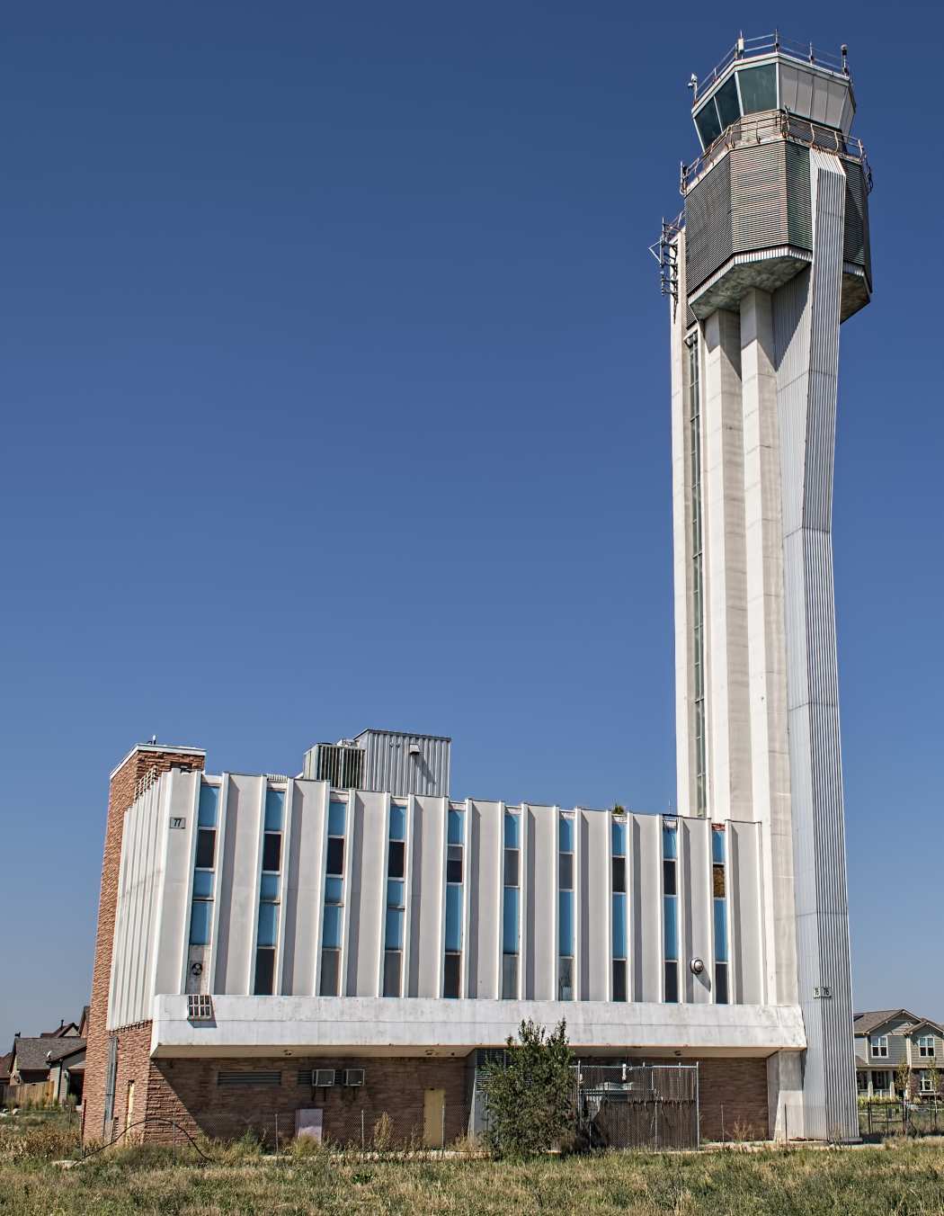
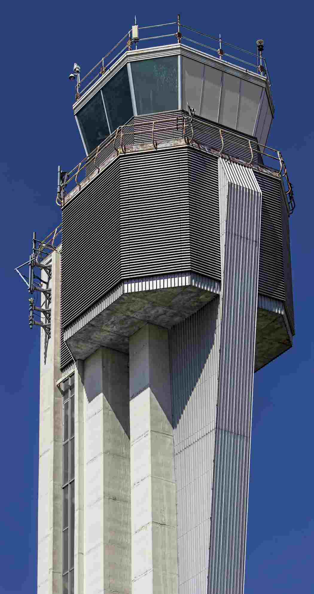
A 1/15/13 photo by Clifton Salas of Stapleton's control tower, by then oddly surrounded by suburbia.
Clifton observed, “The control tower is now in the middle of a subdivision called 'Tower Place'.
It appears that this is the last piece of land to be developed in this neighborhood. The parking garages are now gone & it is all residential homes in the area.”
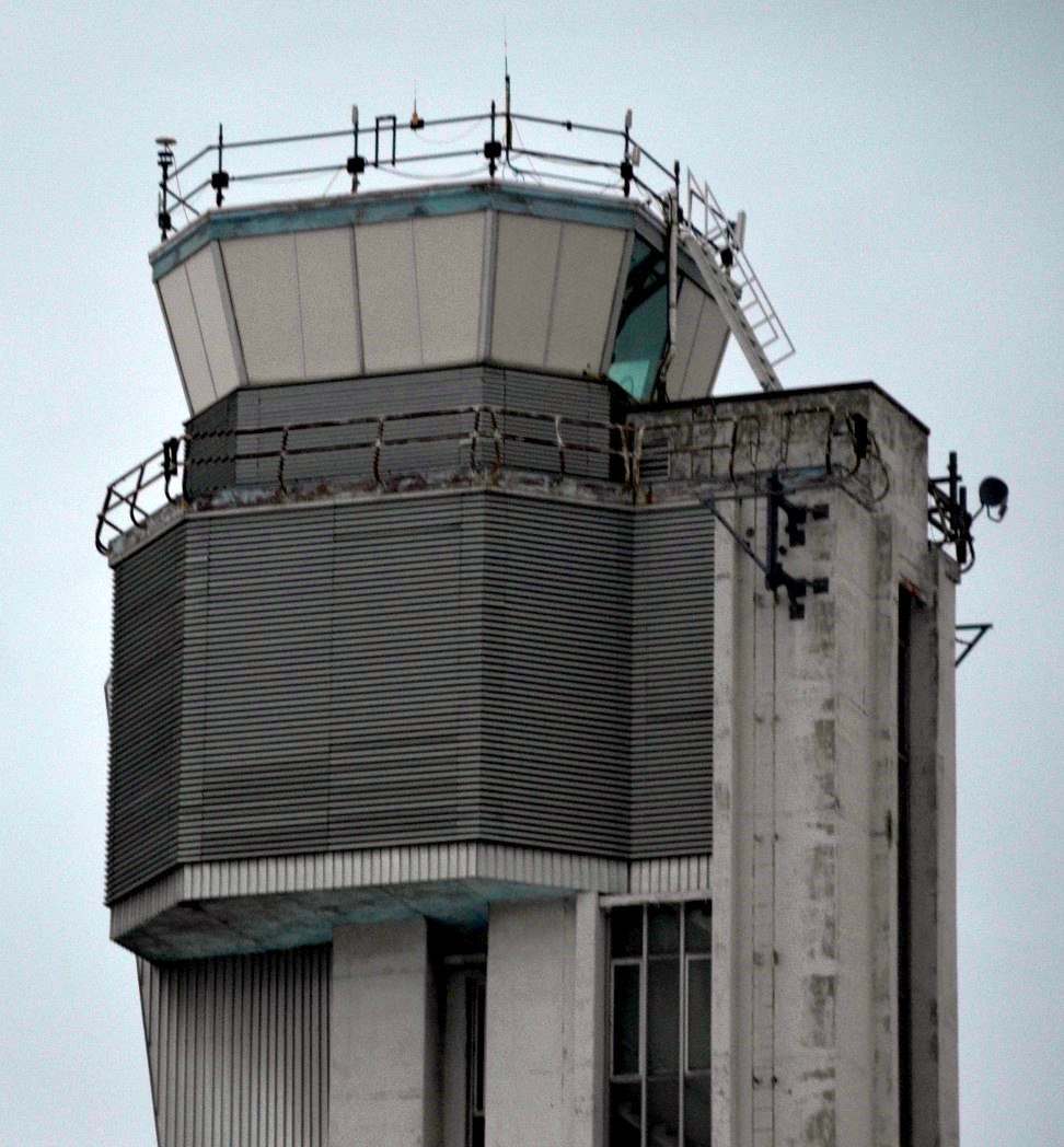
A 1/15/13 closeup by Clifton Salas of Stapleton's control tower cab.
Paul Freeman visited the site of Stapleton in 2013, and found that at least 6 buildings remained from its airport days, all along the airport site's southern edge:
the control tower, Hangar 61 reused by Stapleton Fellowship church, a hangar reused by the Denver Police Academy,
a hangar reused by the Bladium Sports & Fitness Club, and a pair of hangars reused by Denver 8 TV.
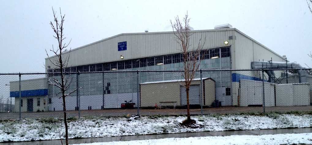
A 5/1/13 photo by Paul Freeman looking northwest at a former Stapleton general aviation hangar, marked as “Denver Police Academy”.
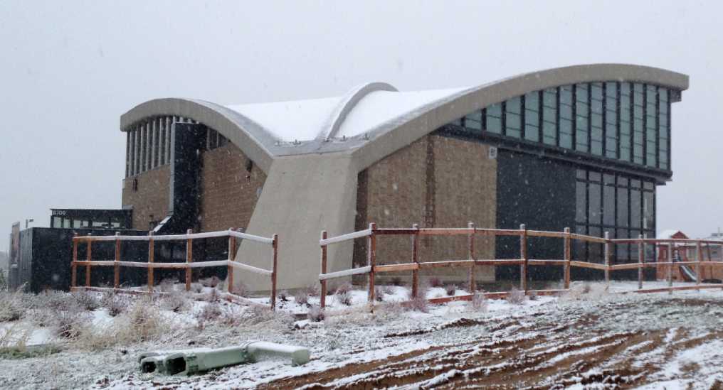
A 5/1/13 photo by Paul Freeman looking east at Stapleton's iconic Hangar 61, restored & reused as the home of Stapleton Fellowship Church.

A 5/1/13 photo by Paul Freeman of Stapleton Fellowship Church's sign on the west side of Hangar 61, on which the building's aviation origin is commemorated.
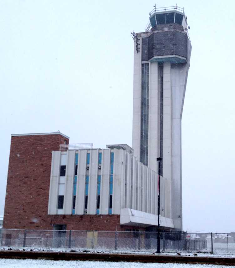
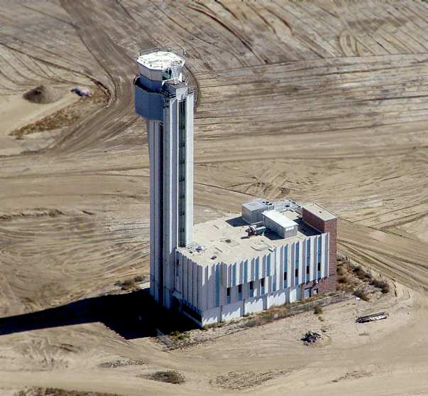
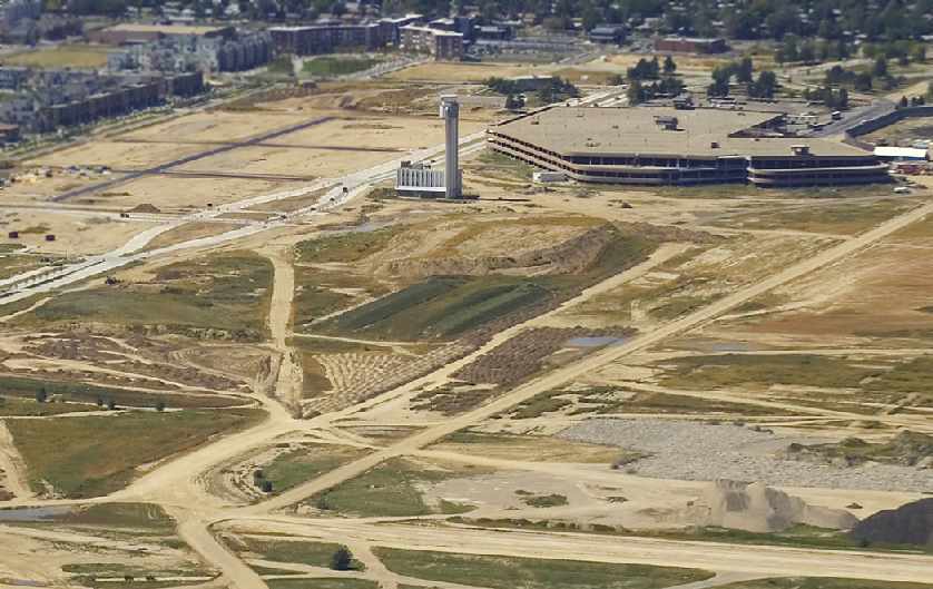
A 5/1/13 photo by Paul Freeman looking northwest at Stapleton's control tower, which oddly remained standing in the middle of an otherwise empty 1-block area surrounded by fencing,
which sat among a dense neighborhood of new single-family houses.
A 9/19/14 photo by Devan Mayer of Stapleton's control tower,
which still sat in the middle of an otherwise empty 1-block area surrounded by fencing amidst a dense neighborhood of new single-family houses.
A 9/19/14 closeup by Devan Mayer of Stapleton's control tower cab.
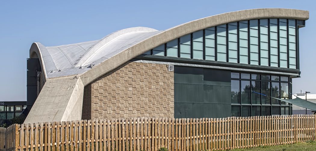
A 9/19/14 photo by Devan Mayer of Stapleton's iconic Hangar 61, restored & reused as the home of Stapleton Fellowship Church.
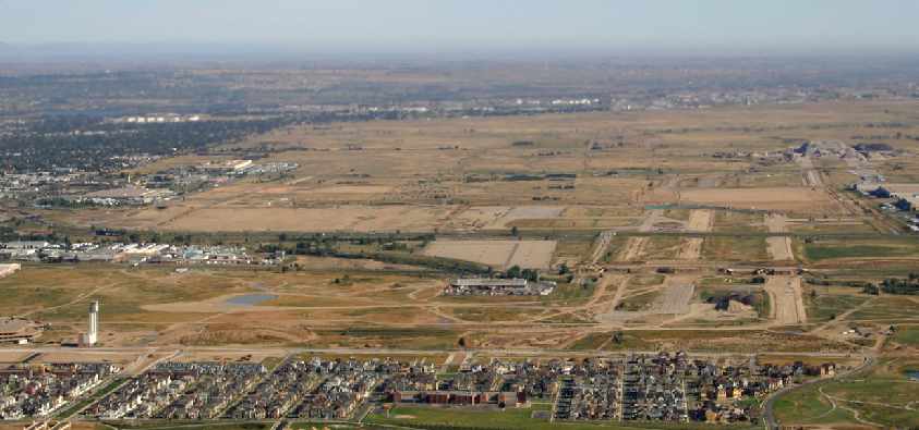
A February 2015 aerial view by Kevin Peterson looking south at the site of “the grand old airport, sadly there is little left to see of what was once my world.
If you look close enough you can see the 2 taxiway entrances to 35R just north of I-70.”
A 3/10/15 photo by Devan Mayer of a remnant of Stapleton Airport.
A 3/10/15 photo by Devan Mayer of a remnant of Stapleton Airport – former taxiway pavement markings.
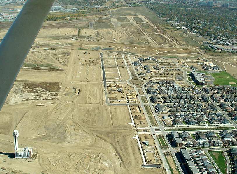
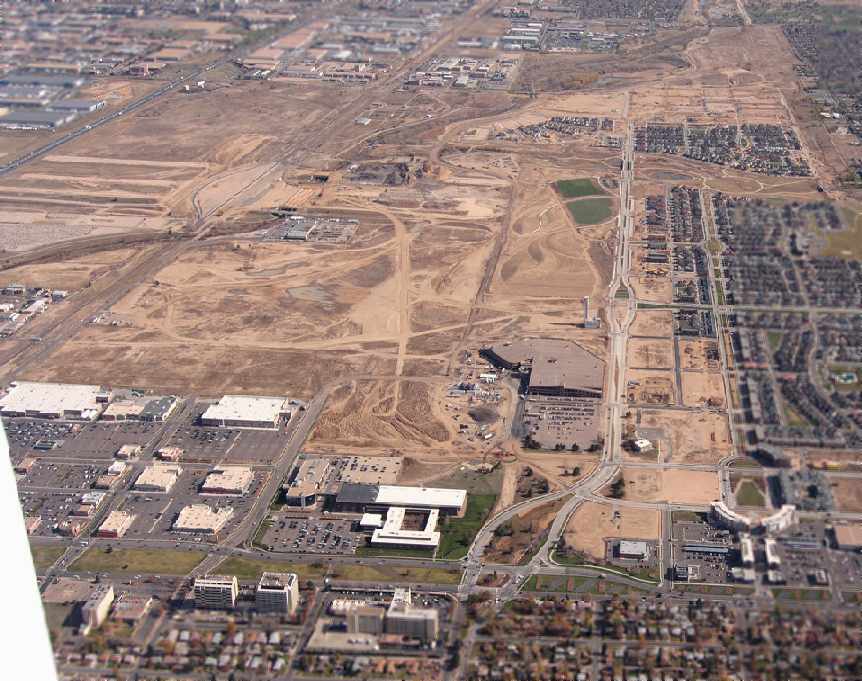
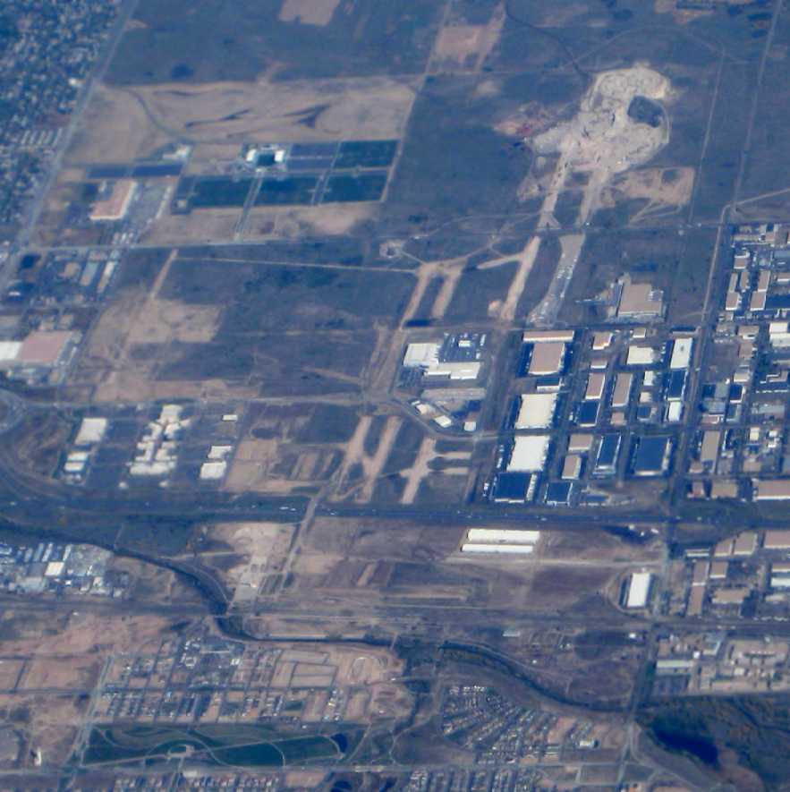
A 2017 aerial view looking north at the Stapleton Airport site, with the property being unrecognizable as ever having been a major international airport.
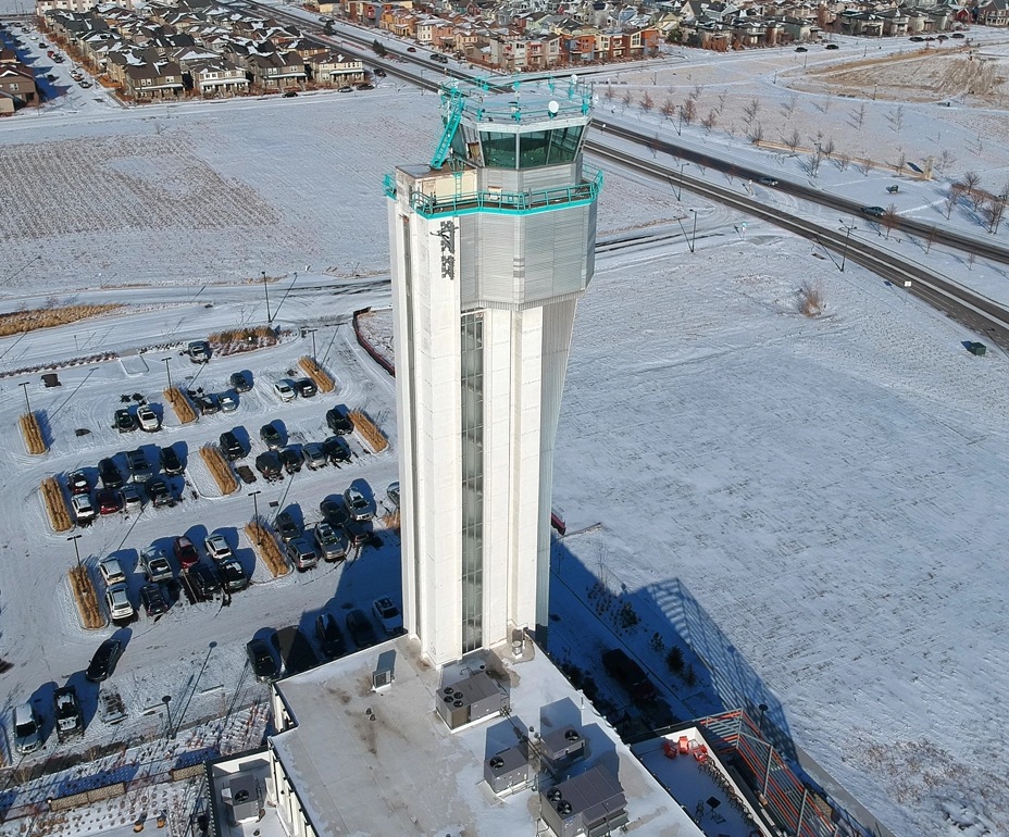
A 1/1/19 aerial view by Tamas Kolos-Lakatos of the Stapleton control tower.
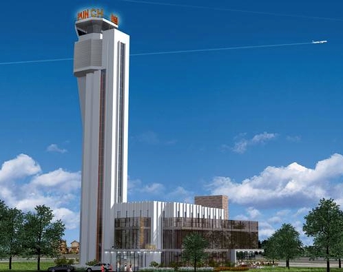
A 2019 photo by Seabass of the former Stapleton control tower. Seabass related, “I'm happy to report that it has been reopened as a Punch Bowl Social.
It attracts quite the crowd as it is dead center of the neighborhood & a short walk from the RTD light rail station (and easily seen from almost any angle).
Someone not familiar with the history would scratch their head as to why the ATC tower is there.
In fact, on my second time there, I had a brief chat with the bartender who happened to have started work there a week prior.
It turns out he thought the Punch Bowl Social management were pranking him & telling him there used to be an airport here - he honestly thought the tower was purely for decoration!
There's 2 levels to entertain your party with various carnival-type games, and a massive number of Stapleton airport themed decorations/photos including the old runway layout across one of the walls.
The tower itself is open but not to the general public right now; the management said 'special requests' can be made to go up there in the near future.
I think the tower is not fully open to the public due to ADA noncompliance/fire code, so the 'special request' is a way to get around it for now.
It could be the case that there's not a functioning elevator in the tower right now.
There are other areas inside the base that are reserved for corporate events & larger parties/offices, so outside of the tower itself it's being thoroughly invested in & used.
Punch Bowl Social literally saved the whole building from the wrecking ball, no doubt about that.”
A 2019 photo by Seabass of the interior the former Stanley Aviation plant (located adjacent to the south side of Stapleton's Runway 8R/26L), “that has been turned into a food hall gathering spot, Stanley Marketplace.”
The Punch Bowl Social Restaurant which operated in the building at the base of the Stapleton control tower closed in 2020 due to the COVID pandemic & did not reopen.
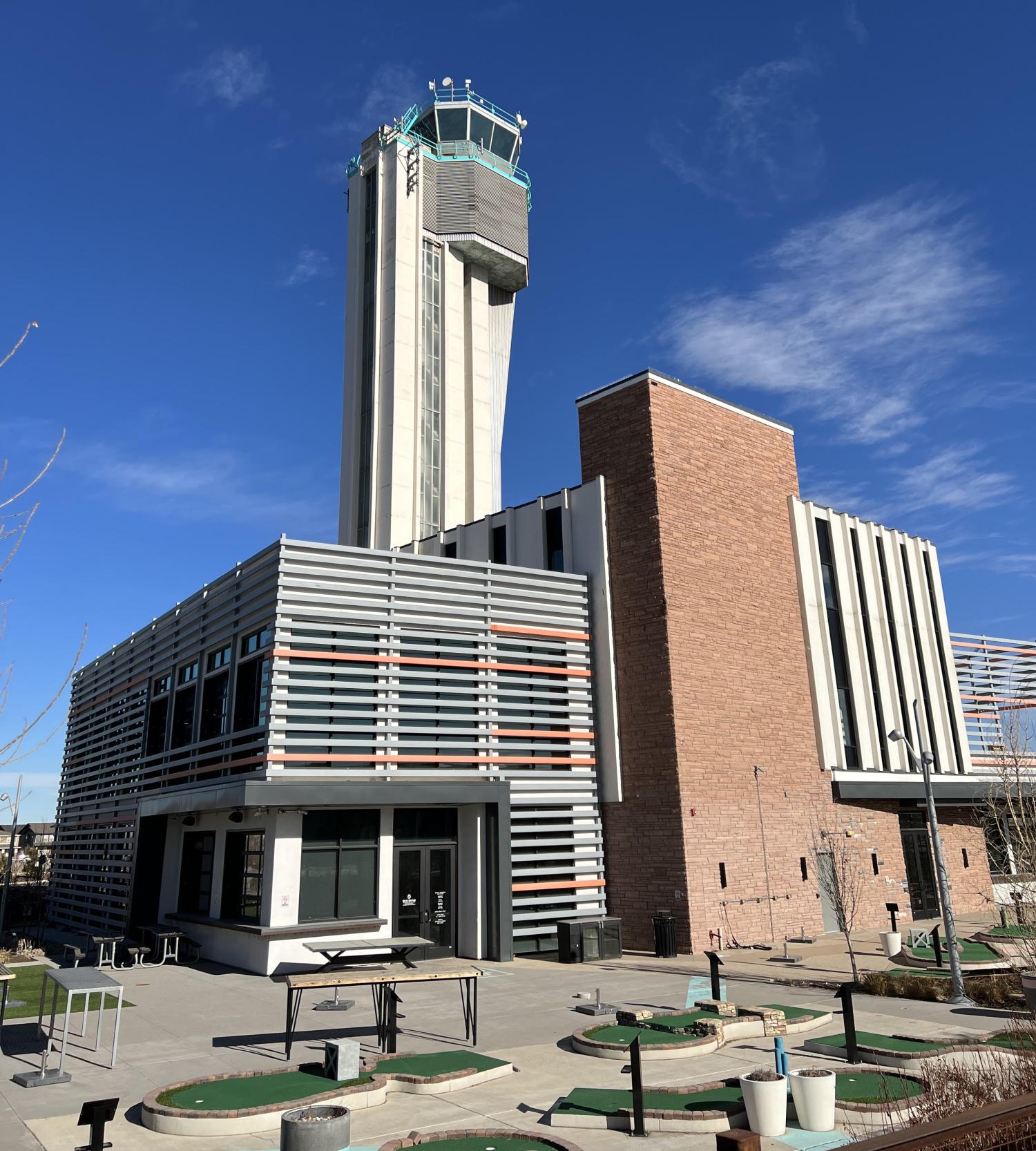
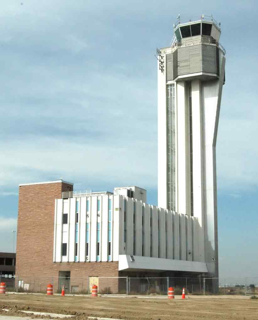
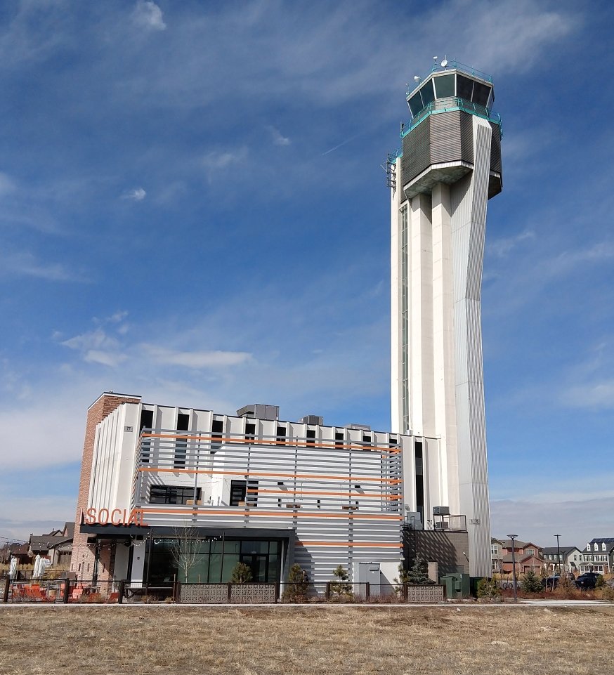
A 12/21/21 photo by Paul Freeman looking northeast at the former Stapleton control tower & the building at its base which briefly was reused as a Punch Bowl Social restaurant, complete with a mini-golf course.
A 12/21/21 photo by Paul Freeman looking northwest at the former Stapleton control tower.
A 12/21/21 photo by Paul Freeman looking west at the former Stapleton control tower.

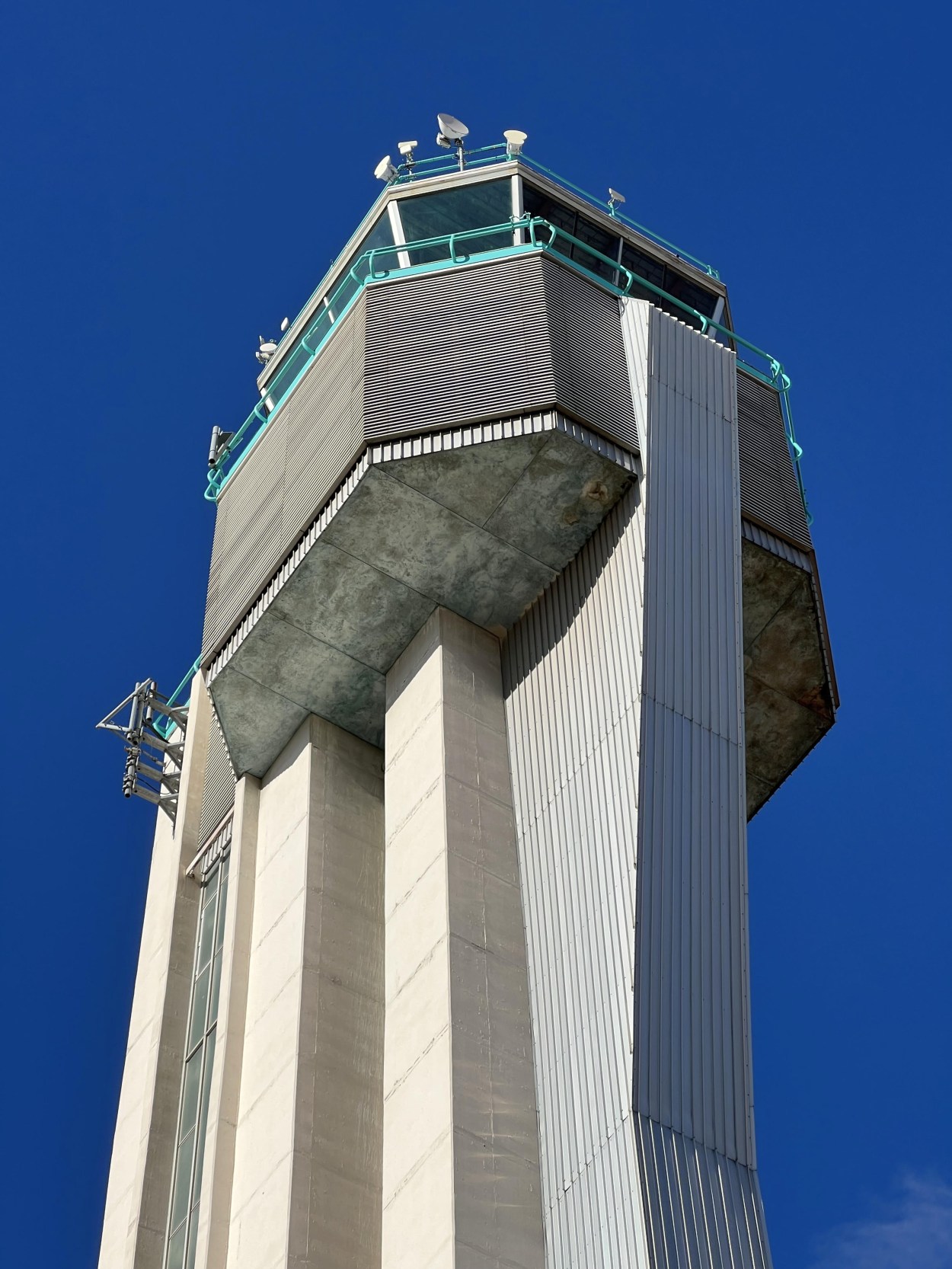
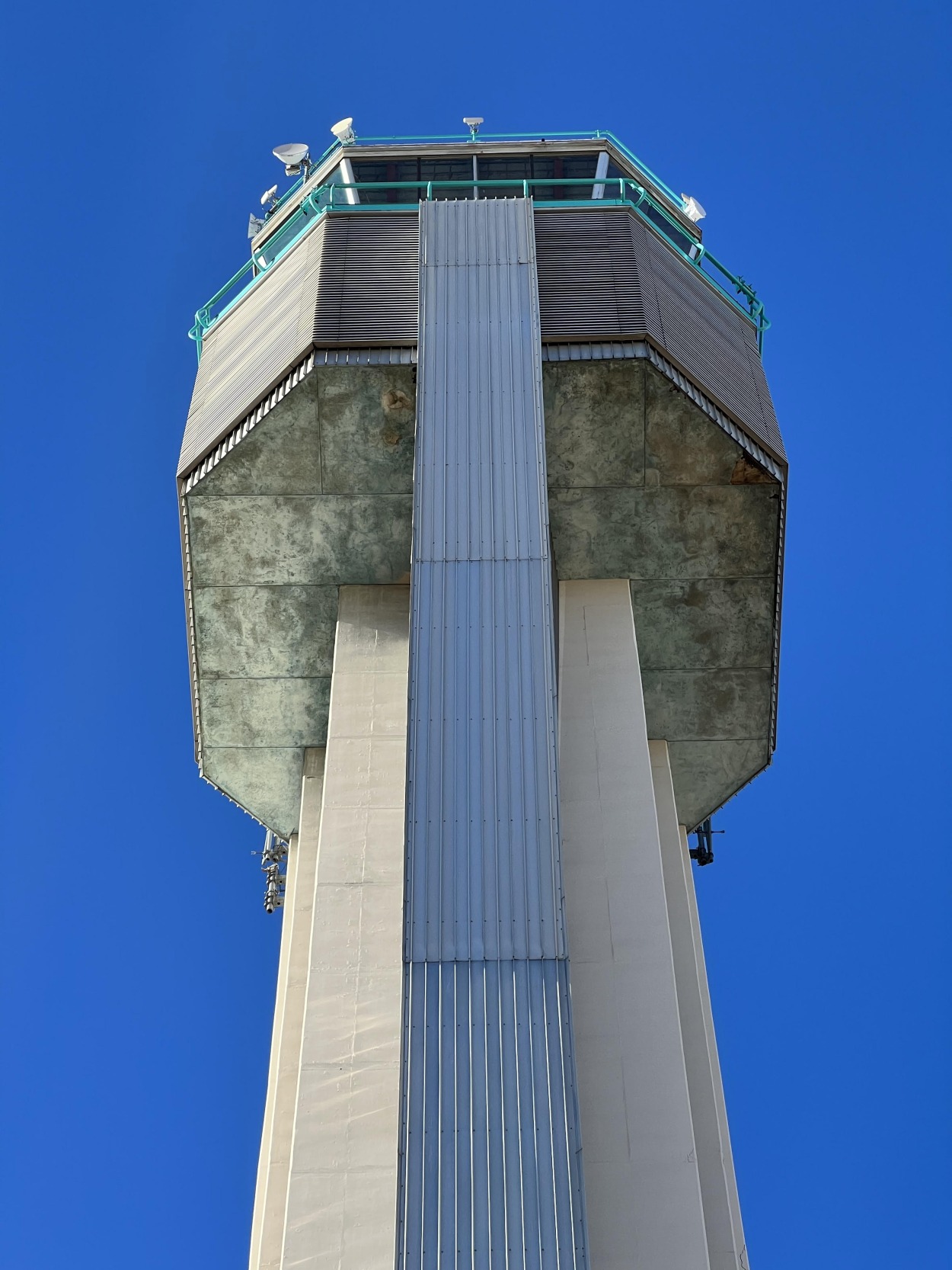
A 5/10/25 photo by Christian O'Brien of the exterior of the former Stapleton control tower.

A 5/10/25 photo by Christian O'Brien of the interior of the former Stapleton control tower.
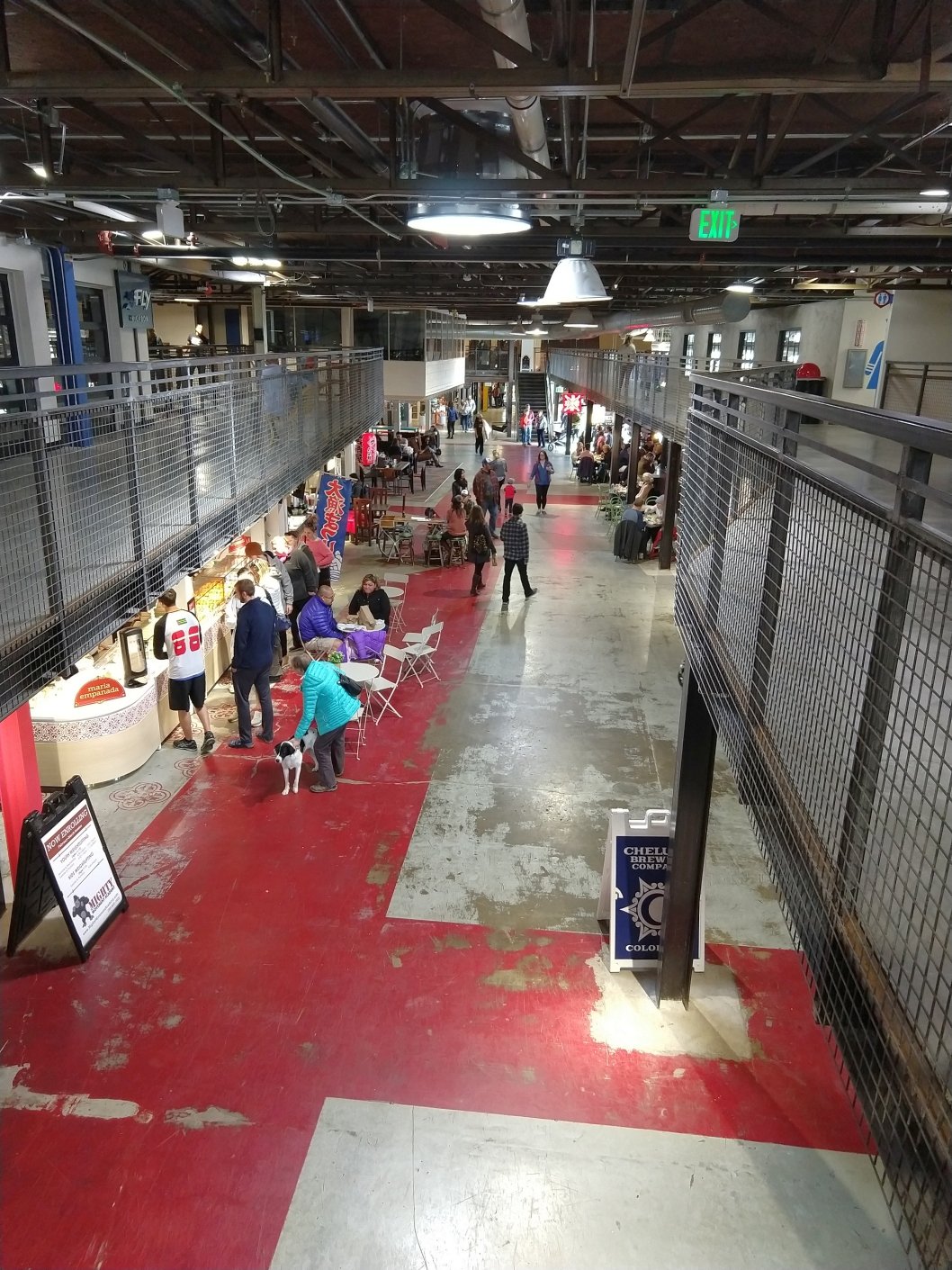
Christian reported, “I visited the old Stapleton Airport control tower & it has a lot of activities.
Operating under the name FlyteCo Tower, it's a classic entertainment center w/ mini golf, food, drinks, apparel & many games.
It occupies the first 3 floors of structure which has been heavily refurbished & is family-friendly (I saw a lot of families w/ kids there).
You can take a guided tour of the tower as long you are willing to climb 12 flights of stairs (you don't go up them all at once as at each floor you stop while the guide explains some pictures).
The upper floors are open but undergoing a long-term restoration. The interior had been stripped long before the restoration started”

A 5/10/25 photo by Christian O'Brien of the view from the former Stapleton control tower.
Christian reported, “If you time it right you can see a good sunrise/sunset over the Rockies & I highly recommend it for anyone who's interested in aviation history.”
See also:
http://milehifield.topcities.com/main.html
http://www.stapletondenver.com/history/earlyyears_20s-40s.asp
____________________________________________________
Or if you prefer to contact me directly concerning a contribution (for a mailing address to send a check),
please contact me at: paulandterryfreeman@gmail.com
If you enjoy this web site, please support it with a financial contribution.
____________________________________________________
This site covers airfields in all 50 states.