
Abandoned & Little-Known Airfields:
Northwestern Colorado
© 2002, © 2025 by Paul Freeman. Revised 3/5/25.
For a 9th year, the CO pages of this website are sponsored by the Colorado Pilots Association:
____________________________________________________
Please consider a financial contribution to support the continued growth & operation of this site.
____________________________________________________
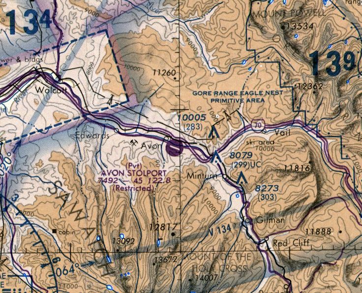
Avon STOLPort (WHR), Avon, CO
39.63, -106.51 (West of Denver, CO)

A 6/9/82 USGS aerial view of Avon STOLPort.
The predecessor of this airport was Nottingham Airport, a private dirt strip.
The date of construction of Nottingham Airport has not been determined.
Nottingham Airport was not yet depicted on a 1969 aerial photo nor on the 1974 Denver Sectional Chart (courtesy of Jonathan Westerling).
An article in Vail Trail (courtesy of Steve Comer) reported, “The proposed use of the Nottingham air strip in Avon
by Rocky Mountain Airways was stalled by the county commissioners in 1976.
Members of the county airport authority were worried that allowing commercial flights
over nearby schools & neighborhoods would be too noisy & possibly dangerous."
Another Vail Trail article (courtesy of Steve Comer) reported, “Armed with a revised Environmental Impact Statement
and a formal resolution promising continued service to the area,
Rocky Mountain Airways submitted a new application for a special use permit to fly daily flights into Avon.
The application was the second attempt to get approval for a STOLport (short takeoff & landing) on Bill Nottingham’s private dirt runway in Avon.
Their first application was killed by the County Airport Authority’s recommendation to deny the request.”
No airfield was depicted at this location on the July 1977 CG-19 World Aeronautical Chart (according to Chris Kennedy), or the 1977 or 1978 USGS topo maps.
The earliest reference to Avon Airport which has been located was in the 1982 AOPA Airport Directory (courtesy of Ed Drury),
in which Avon Airport was described as having a single 4,000 asphalt Runway 10/28,
along with the remark, "Private. Closed to public. Landings prohibited - risk aircraft impoundment."
According to Paul Reinman, the airport in Avon was used to fly well-heeled skiers to near the base of Vail.
Avon Airport was run by a commuter airline, Rocky Mountain Airways. It was a STOLport (Short Takeoff & Landing), surrounded by mountains.
The airline pilots actually needed a specific type rating to fly into Avon Airport. This was covered in an issue of Flying Magazine.
Jon Silver (former Rocky Mountain Airways Captain) recalled, “Avon Airport...
The glideslope was 8 degrees, and was the steepest glideslope in the world.
It was a TALAR (Tactical Landing Aid Radio) and was used originally used during the Vietnam war.”
According to former Rocky Mountain Airways pilot Lou Popolizio, the 11/2/79 Avon MLS Rwy 28 Approach plate indicated Avon Airport was located at an 7,538' elevation.
Rick reported, “The MLS approach had a Decision Height of 8,644' MSL.
The distance from the final approach fix (SCALI intersection) to the end of the Runway 28 was 8.7 NM & the glideslope intercept began at 15,000' MSL.
You had to descend 7,468' in 8.7 NM which is an 8 degree glideslope.
This descent amounted to an altitude loss of 858' / NM.
We typically had an approach speed of 77 KIAS which is approximately 90 KTAS.
We typically saw 1,000-1,400 FPM descents on the glideslope.”
Tim Fitz-Gerlad recalled, “I lived in Avon, Colorado from 1972-92. This airport was called the Avon STOLport.
The airplane that was frequently used by Rocky Mountain Airways was the DeHavilland DHC-7 (Dash 7).
The contract for keeping the airport cleared was under the Nottingham family (Randy)
and they installed an underground heating system to actually help heat the ground
and make cleaning/clearing the runway easier & at times also completely unnecessary.
Rocky Mountain Airways had a local nickname of Rocky Mountain Scareways
and the descents into this airport occasionally produced a zero-G sensation due to the steep descents
(I have flown into that airport at least 4 times & it was better than any roller coaster ride I’ve ever been on with steep banks & rapid descents).
Missed approaches were not a big deal because the valley descends & widens very quickly 'down valley' to the west.”
David Duval recalled, “Avon... I landed there in a [Cessna] 182 on 3/16/77 (with permission).”
The earliest photo which has been located of the Avon STOLport was a 6/9/82 USGS aerial view.
It depicted Avon STOLport as having a paved Runway 10/28 (marked “STOL” on both ends), with a paved ramp & terminal building on the northwest.
There were no hangars or aircraft visible on the field.
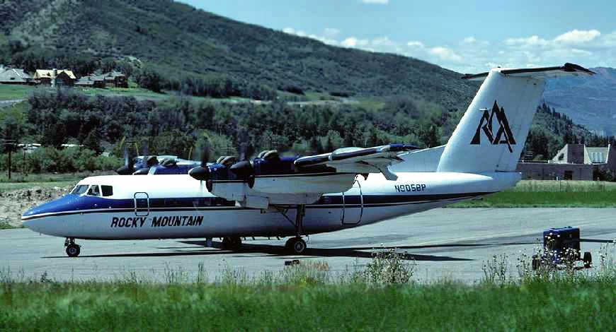
An August 1983 photo by Eduard Marmet looking southwest at a Rocky Mountain Airways De Havilland Canada DHC-7-102 Dash 7 (N9058P) taxiing at the Avon STOLport.
Beaver Creek ski area is visible in the background (where the homes on the hill are).
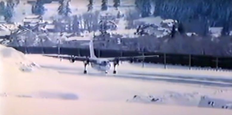
A scene from the 1986 John Denver TV movie The Christmas Gift showing a Rocky Mountain Airways De Havilland Canada DHC-7 arriving at the Avon STOLport (courtesy of Brett Derby).
The only aeronautical chart depiction which has been located of the Avon STOLport was on the 1986 Denver Sectional Chart (courtesy of Jonathan Westerling).
It depicted Avon STOLport as a “Restricted” private airfield having a single 4,500' paved northwest/southeast runway.
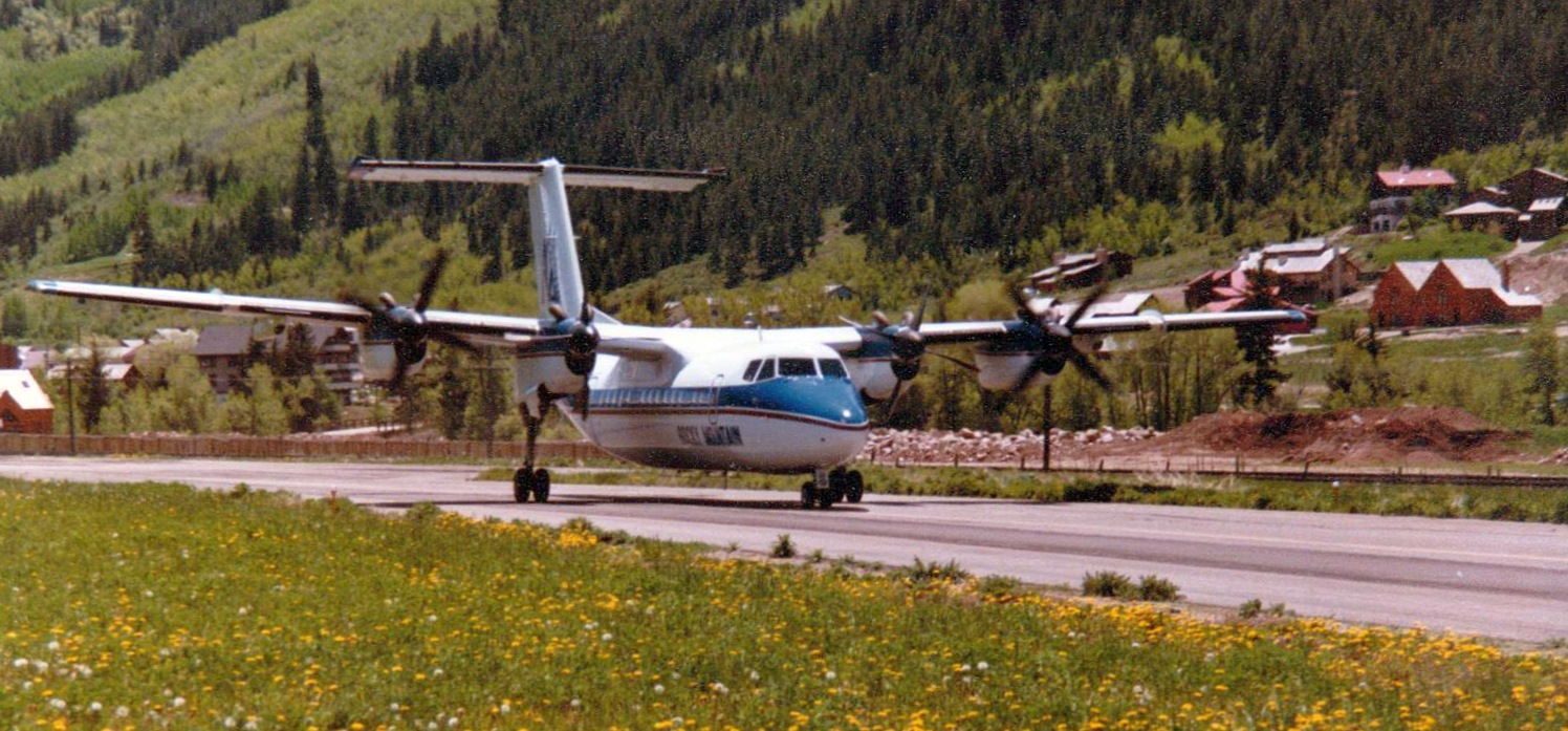
An undated photo of a Rocky Mountain Airways De Havilland Canada DHC-7 taxiing on the Avon STOLport runway.
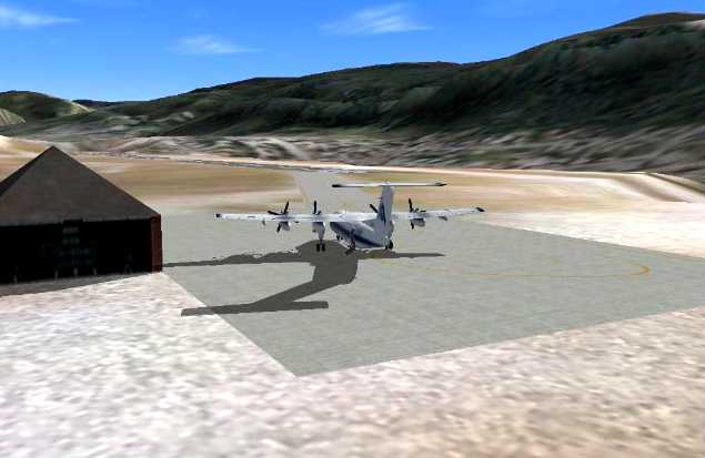
A Flight Simulator depiction of a De Havilland Canada DHC-7 at the Avon STOLport (courtesy of Herman Lueckenotte).
Unfortunately for thrill seekers, Avon Airport was operated as a private airport,
and in the event that a private aircraft landed at the field, it would have to be trucked out.
This was due to the fact that many private airports have found that they are incurring liability
for unauthorized landings that don't succeed at their fields.
Moral of the story: don't land at Avon Colorado unless it was an absolute emergency.
According to Kevin Shaw, “In the mid-1980s, a noted sailplane pilot, Dave Allen, and his father
landed their high performance sailplane at Avon after overdevelopment forced them down.
There are no other places in the valley to land safely, so they had no choice but to land at Avon.
Under the terms of a special-use permit from Eagle County,
the only permitted users of the STOLport were Rocky Mountain Airways & med-evac aircraft.
So the aircraft was 'impounded' by the airport officials. Eventually, the Allens' crew & trailer arrived.
They talked the authorities into letting them disassemble the glider to protect it from the storm & load it into the trailer.
But it was 'impounded' & they were not allowed to take the sailplane from the airport.
I don't know the details, but sometime later that night,
they snuck back into the airport & drove away with the sailplane & trailer.”
Kevin continued, “The next morning, I got a call from Dave saying he heard that maybe a warrant had been issued for their arrest.
As a fellow glider flight instructor & a lawyer, I set about trying to deal with the legal & political issues.
Dave, who flew for a major airline & is an honorable guy who always wanted to do the right thing,
wanted to demonstrate to the county & Rocky Mountain Airways
that he had done the proper thing by landing at Avon under the conditions.
The lawyers for Rocky Mountain Airways threatened to do whatever they could to the Allens,
since the county was threatening to revoke the special use permit, and with it, the very lucrative ski-traffic franchise.
It turned out that there had been a number of unauthorized landings in recent months,
and the county was unhappy that yet another had occurred.”
Kevin continued, “I persuaded the county's attorney that they could not lawfully impound aircraft under these circumstances.
We were brought before the county commissioners at a public hearing.
They were not interested in understanding the story of why this sailplane had to land at Avon,
but just wanted the unauthorized landings to stop.
They instructed the county attorney to do everything possible to pursue us.
The county attorney, knowing that the law did not favor the county,
called me not too long after the hearing & said he was leaving on vacation
and, assuming the emotions had cooled by the time he got back, we would never hear from the county again. And we never did.”
Kevin continued, “The STOLport was in a very tight location & probably should never have been built.”
The Avon Airport was reportedly still depicted as an active runway on a 1986 aeronautical chart.
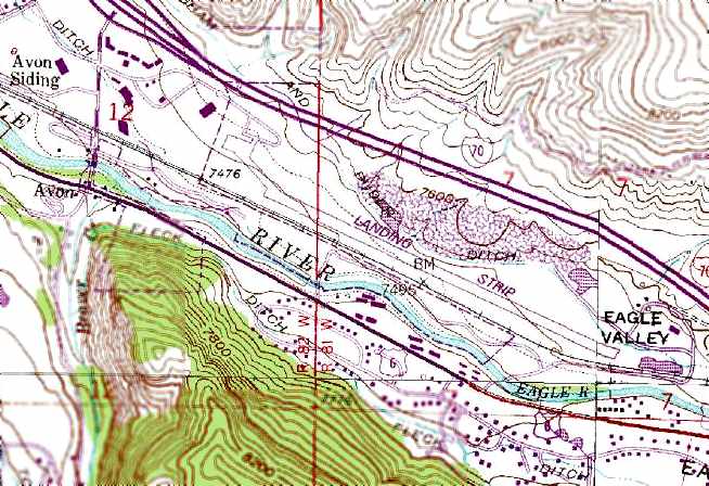
The single runway of the Avon STOLport was depicted simply as a “Landing Strip” on the 1987 USGS topo map.
The last reference which has been located showing Avon STOLPort still in operation was in the 9/6/89 Pocket OAG (according to Fred DeGuio),
which described Rocky Mountain Airways as serving the STOLport with DHC Dash-7 flights to Denver.
The Avon STOLPort was evidently closed at some point between 1989-92, as it was depicted as an abandoned airfield on the 1992 Denver Sectional Chart (courtesy of Jonathan Westerling).
An 8/29/97 article in Vail Trail (courtesy of Steve Comer) reported, “The Eagle County Planning & Zoning Commission
decided Magnus Lindholm’s Vail Valley Centre proposal had all of its T’s crossed & I’s dotted
and finally accepted the plan which would include a village center on the old STOLport property adjacent to Avon.”
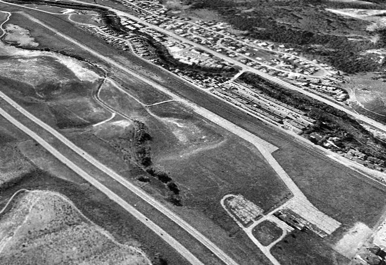
A 1999 USGS aerial view looking southeast showed the Avon STOLport to have a single paved 4,800' runway,
along with a paved taxiway at the western end of the runway leading to a paved ramp area.
There did not appear to be any hangars or other buildings directly associated with the airfield.
Joe Forish reported in 2003, "The airport at Avon is no longer in existence.
It was removed & paved over to allow access east from Avon to a new SuperWalmart & Home Depot development.
The new buildings are located north of Route 6, south of I-70 in the approach to this former airfield.
The new road covers or is right next to what used to be the airfield. The former buildings at the site have been removed."
Pretty soon every little airport will be covered by a Walmart.
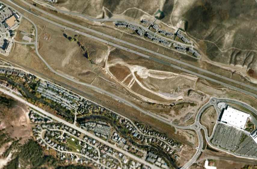
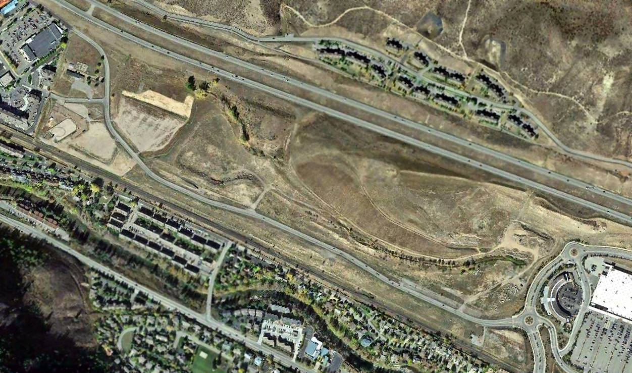
A 2003 aerial view of the remains of the Avon STOLport (courtesy of David Ulane).
David observed, “Portions of the runway & ramp are still visible. East Beaver Creek Road overlays the old runway, which is still faintly visible.
The road actually curves to overlay the old taxiway that connected the west end of the runway to the ramp.
At the upper left of photo where the road Y's, you can see the old ramp & access road.”
A 2015 aerial view of the site of Avon STOLport showed that portions of the runway & ramp were still barely recognizable.

A 2021 photo looking north at the Salvation Army store which sits on top of the remains of the Avon STOLport ramp pavement.
The site of Avon STOLPort is located on the north bank of the Eagle River, in between the railroad tracks & Interstate 70, southeast of Avon Road.
____________________________________________________
Or if you prefer to contact me directly concerning a contribution (for a mailing address to send a check),
please contact me at: paulandterryfreeman@gmail.com
If you enjoy this web site, please support it with a financial contribution.
____________________________________________________
This site covers airfields in all 50 states.