
Abandoned & Little-Known Airfields:
Florida, Daytona Beach area
© 2002, © 2025 by Paul Freeman. Revised 4/5/25.
This site covers airfields in all 50 states: Click here for the site's main menu.
____________________________________________________
Please consider a financial contribution to support the continued growth & operation of this site.
Bear Island Airfield (revised 9/6/18) - Bunnell Airport (revised 2/10/24) - (Original) Flagler Beach Airport (revised 12/9/17)
Green Pasture Airfield / Green Air Park / Shawnee Airpark / Rockledge Flypark / Rockledge Airpark (revised 4/5/25) - Haulover Canal Airfield (revised 5/22/21)
Osceola NOLF (revised 6/21/19)
____________________________________________________
(Original) Bunnell Airport, Bunnell, FL
29.465, -81.25 (Northwest of Daytona Beach, FL)
Bunnell Airport, as depicted (the circled “AP”) on a 1935 FL Road Department map of Flagler County (courtesy of University of FL Digital Collections, via Tom Duncan).
Tom Duncan reported, “A new municipal grass airfield was approved for construction at Bunnell in late 1933
using Federal Emergency Relief Administration (FERA) and Civil Works Administration (CWA) funds.
The Flagler Tribune reported that approximately 40 men commenced clearing 100 acres of land owned by the town in southeastern Bunnell on 11/27/33, working 5 days/week.
The land was being put in shape for a new municipal landing field usable by both light & heavy planes.
The effort was coordinated with the Aviation Division of the State Road Department.
The construction was to result in an airfield 250' wide by 3,500' long.”
Tom continued, “On 12/17/33, Okey & Martha Bevins landed on the new Bunnell Airport in their little Aeronca C-3 monoplane, becoming the first to use the still unfinished airfield.
Most of that afternoon, the little plane was in use giving various Flagler County citizens their first air ride over Bunnell.
A small fare was charged, one-half of which was turned over to the town to be used for construction of a hangar.
Okey continued flying back to Bunnell throughout the Christmas holidays, and many more citizens went for aerial sightseeing tours of the town in his little plane.
Bevins also offered to set aside a day for black members of the community to experience a plane ride.
One of their community leaders, Will Johnson, was to organize a picnic near the airfield in conjunction with this.
The Tribune followed up by announcing that the picnic & plane rides for the black community would occur on 1/13/34.”
Tom continued, “Okey Bevins announced that he was planning to extend operations of his Flagler Beach flying school to include the new Bunnell Airport.
Subject to suitable arrangements with the town, he would offer local flying lessons there for students there.
Harry Wymer, sales representative for the Aeronautical Corporation of America (Aeronca) in Cincinnati, flew from Orlando to Bunnell on 1/3/34 to inspect the new airfield.
Okey Bevins came over from Flagler Beach to meet him there. Wymer then challenged Bevins to a short air race in their respective Aeronca aircraft. Bevins won.”
Tom continued, “On 5/19/34, the new airfield at Bunnell was inspected by Major A. B. McMullen, Aviation Director of the State Road Department.
He was accompanied by Ray Sheldon & Allan McDonough, operations director and assistant operations director, respectively,
of the Flagler and Volusia County offices of the Federal Emergency Relief Administration (FERA).
As a result of the inspection, McDonough appeared before the Flagler County Board of Commissioners to request County equipment to finish the construction.
The County Commissioners agreed to provide a tractor, grader & other equipment as well as an operator, provided FERA cover the fuel costs.
The completed airport was to have a 250' wide by 3,500' long runway.
Luther Upson, Flagler County FERA Supervisor, stated that plans were active to provide boundary markers & a permanent wind sock at the airfield, items that Major McMullen considered urgent.
Upson also stated that FERA had approved a project for directional markings to the airfield at Bunnell.
FERA workers painted directional markings to the airport on the roof of Bunnell High School in July 1934.”
The earliest depiction which has been located of Bunnell Airport was on a 1935 FL Road Department map of Flagler County (courtesy of University of FL Digital Collections, via Tom Duncan).
However, Bunnell Airport was not depicted on the 1935-37 Orlando Sectional Charts.

The 1937 USGS topo map (courtesy of Tom Duncan) depicted Bunnell Airport as having a single unpaved northwest/southeast runway.

The earliest aeronautical chart depiction which has been located of Bunnell Airport was on the June 1939 Orlando Sectional Chart.
It depicted Bunnell as an auxiliary airfield.
The last aeronautical chart depiction which has been located of Bunnell Airport was on the January 1942 Orlando Sectional Chart.
Bunnell Airport was evidently closed (at least in an official capacity), as it was no longer depicted on the July 1942 Orlando Sectional Chart (or subsequent aeronautical charts).
According to Tom Duncan, Sisco Deen (Flagler County Historian) recalled that this field was just south of the old Bunnell General Hospital:
“George Allen kept his Piper Cub in a hangar there when we were kids, and I used to go sit in it when I was about 8 years old & play pilot.”

The earliest photo which has been located of Bunnell Airport was a 2/8/43 USDA aerial view (courtesy of The University of FL Map & Imagery Library, via Tom Duncan).
Tom observed, “The Department of Commerce standard 50' diameter chrome-yellow circle for daytime marking of the runway centerline is visible,
with two 2' wide by 20' long panels extending from outside the circle along the runway centerline to indicate the landing directions.
Tom Duncan continued, “The 8/10/44 issue of The Flagler Tribune carried an announcement by Tom Gordon, President of Orlando Air Lines,
that test flights to the Bunnell Airport would be carried out in the next few days
with the objective of immediately beginning daily air passenger service from Bunnell connecting with 35 other FL cities over 2 routes.
There would be 2 stops/day at Bunnell, one 3-passenger plane each way.
Gordon planned to meet with Bunnell business & civic leaders to discuss the airport facilities.
He made it clear that the plan was contingent on what the local civic groups could or would do to improve the airport & make it suitable for passenger service.
It was also contingent on military conditions permitting regular air passenger landings there.
The requisites were apparently not all satisfied, as Orlando Air Lines never added Bunnell to their regular passenger service.”

A circa late 1940s photo of George Elliott Allen, Jr.’s Fairchild PT-19 surplus WW2 primary trainer on the grass airfield at Bunnell Airport
(courtesy of Sisco Deen, Flagler County Historical Society, via Tom Duncan).

A circa late 1940s photo (courtesy of Sisco Deen, Flagler County Historical Society, via Tom Duncan) of George Elliott Allen, Jr., with a cigar in his mouth,
standing on the wing of his Fairchild PT-19 surplus WW2 primary trainer at Bunnell Airport as his wife, Johnnie Maxine Buckles Allen, is preparing to enter the rear cockpit.
Tom reported, “While in the Army Air Corps during WW2, Lt. Allen was a Boeing B-29 Superfortress bomber pilot.

The last photo which has been located showing Bunnell Airport still intact was a 1/9/52 USDA aerial view (courtesy of The University of FL Map & Imagery Library, via Tom Duncan).
Tom Duncan observed, “Bunnell Airport appeared to still be largely intact, although structures had encroached along the runway.”
Tom Duncan continued, “The grass field at Bunnell was in use to at least the late 1950s.
Gloria McArn Deen recalls her uncle George Allen flying her from the Bunnell Airport in his Beechcraft Bonanza to Tallahassee where she attended FL State University.
This was in the period from 1958-62. So, it is possible that the airfield may have been in use as late as the early 1960s.”
Tom continued, “A 1970 USDA aerial photo shows the airfield overcome by development & no longer present.”

A 2019 aerial view looking northeast showed no recognizable trace remaining of Bunnell Airport.
Thanks to Tom Duncan for pointing out this airfield.
____________________________________________________
Green Pasture Airfield / Green Air Park / Shawnee Airpark /
Rockledge Flypark / Rockledge Airpark (21FA), Rocklegde, FL
28.298, -80.721 (South of Daytona Beach, FL)
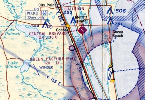
Green Pasture Airfield, as depicted on the November 1965 Orlando Sectional Chart.
This little general aviation airfield may have been established at some point between 1962-65,
as it was not yet depicted on a 1958 aerial photo or the 1962 USGS topo map.
The earliest depiction which has been located of Green Pasture Airfield was on the November 1965 Orlando Sectional Chart.
It depicted Green Pasture as a private airfield having a 1,300' unpaved runway.

Green Pasture Airfield evidently gained a paved runway at some point between 1965-71,
as the 1971 USGS topo map depicted a single paved north/south runway, labeled simply as “Landing Strip”,
with a single small building on the southeast side.

The 1976 USGS topo map depicted “Green Air Park” as a single paved north/south runway.
There were no buildings depicted on the airfield.

The earliest photo which has been located of Green Air Park was a 12/13/77 USGS aerial view.
It depicted a single paved north/south runway, with signs of a former grass southeast/northwest runway that appeared to have been truncated by a drive-in movie theater to the southeast.
There were no hangars or aircraft visible on the field.
At various points, the airport was reportedly known as Shawnee Airpark or Rockledge Flypark.
By the 1980s, the airport was owned by Billy Squires, and was known as Rockledge Airpark.
Billy owned & flew a 1959 Piper PA-25 & a 1963 Cessna 172E.
A 1984 aerial view depicted Rockledge Airpark as having a single paved north/south runway, with signs of the former grass crosswind runway.
A hangar & 8 light single-engine aircraft were visible on the southeast side.

A circa late 1980s / early 1990s photo of Bills Squires at Rockledge Airpark, with his 1959 Piper PA-25 visible in the hangar in the background.

A circa late 1980s / early 1990s photo of Bills Squires at Rockledge Airpark, with several light planes in the background.

The last aeronautical chart depiction which has been located of Rockledge Airpark was on the March 1994 Orlando Sectional Chart.
It depicted Rockledge as a private airfield having a single 2,000' paved north/south runway.

A 1994 USGS aerial view looking northeast at Rockledge Airpark showed it had a single paved north/south runway,
with a few small hangars on the west side, and a small hangar on the east side, outside of which was parked one single-engine light plane.

A 2011 photo by John Rensing looking along Rockledge Airpark's runway.

A 2011 photo by John Rensing looking northeast at a series of modern individual hangars
which had evidently been added to the southeast side of Rockledge Airpark at some point between 1994-2011.

A 2011 photo by John Rensing of the office of a business operating out of Rockledge Airport: Aero Adventure which sells homebuilt aircraft kits.
As of 2013, Rockledge Airport's FAA Airport/Facility Directory data described it as having a single 2,010' asphalt Runway 18/36.
It listed the owner as Rockledge Airport Corporation, and the manager as Balz Feiner.
But the airport's future jeopardy was unfortunately foreshadowed, by the remark “Continued use of airport subject to further study.”

A 2014 aerial view looking northeast at Rockledge Airpark showed one single-engine light plane parked on the ramp on the southeast side.
Unfortunately the end for this little airport came in 2015, as described in a 7/16/15 article:
“The Florida Department of Transportation lined the runway with yellow X’s, showing that the runway is closed.”
"My son, we would sit out here & watch them fly all the time and now it's, he asked my dad where did the planes go?" resident Jamey Orsborn said.
The article said, “FDOT said they sent pilots at the airport a cease & desist letter because they were landing planes on the grass next to the runway”,
which is hardly a safety issue, and basically sounds like an excuse to close the airport to allow more lucrative property redevelopment.
“They are grounded for no reason,” Brevard County resident Erskine Brewington said.
Brewington said he is friends with some of the pilots & they’ve been operating safely there for years.
"They are flying their patterns right, they are landing right," Brewington said.
Rockledge Airpark was no longer depicted on the August 2016 Jacksonville Sectional Chart.

A 2016 aerial view looking southeast showed Rockledge Airpark to remain completely intact, but devoid of aircraft, and with closed-runway “X” symbols marking the runway.
What a shame to see this fine little grassroots airport going to waste.
Unfortunately in 2018 the current owner of Rockledge Airpark confirmed “the airpark is closed.”

Contradicting previous reports that Rockledge Airpark had been closed, a June 2019 photo looking northeast showed a low-wing single-engine light aircraft in front of the hangar just north of the airport office.

A 2023 photo looking northeast a Rockledge Airpark hangar & airport office no longer showed any sign of recent aviation use.

A 2023 photo looking southeast at the southern-most row of former Rockledge Airpark hangars, now unfortunately taken over by non-aviation use.

An undated aerial view looking southwest at Rockledge Airpark from a 2025 article (courtesy of Dennis Jenkins) showed it to remain completely intact, but devoid of aircraft, and with closed-runway “X” symbols marking the runway.
The article said “Brevard County records show the property was purchased for $3.75 million on February 28 from Ronald Mardosa, Daniel Mardosa and Mike Nuechter.
Real estate developer Stellar Communities is planning a $72 million townhome community at the former Rockledge Airport site.”
Thanks to Jess Sagalow for pointing out this airfield.
____________________________________________________
Haulover Canal Airfield, Allenhurst, FL
28.743, -80.761 (South of Daytona Beach, FL)

Haulover Canal Airfield, as depicted on the August 1949 Orlando Sectional Chart (courtesy of Doug Reed).
This little general aviation airfield was located along a narrow barrier island on Florida's coast.
Haulover Canal Airfield was evidently established at some point in 1949,
as it was not yet depicted on the February 1949 Orlando Sectional Chart (courtesy of Doug Reed).
The earliest depiction which has been located of Haulover Canal Airfield was on the August 1949 Orlando Sectional Chart (courtesy of Doug Reed).
It depicted Haulover Canal Airfield as having a 3,000' unpaved runway.
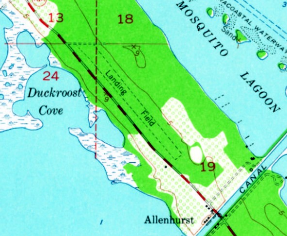
The 1949 USGS topo map depicted Haulover Canal Airfield as a single unpaved northwest/southeast runway paralleling the east side of the road, labeled simply as “Landing Strip”.
There were no buildings or other improvements depicted.
According to the Indian River Journal (courtesy of Robert Wark),
“Haulover Heights was located on the northeast side of SR#3 & had a 3,800' airstrip until the early 1960s.
Planes would circle the Camp or Motel who were expecting them & by the time they were on the ground & tied down,
a station wagon would be picking up the passengers.
It was not unusual to have several light planes tied down at one time.”

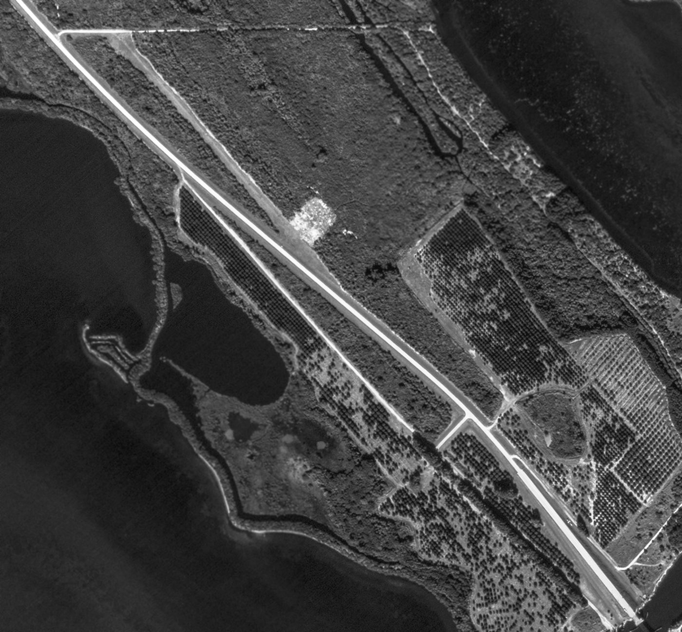
The only photo which is available of Haulover Canal Airfield was a 12/19/50 USGS aerial view.
It depicted a single unpaved northwest/southeast runway paralleling the east side of the road.
There were no buildings or other improvements depicted, nor any aircraft visible.

The last aeronautical chart depiction which has been located of Haulover Canal Airfield was on the August 1957 Orlando Sectional Chart.
It depicted Haulover Canal Airfield as having a 3,000' unpaved runway.

Haulover Canal Airfield, as depicted on the 1958 USGS topo map.
A 1958 aerial view depicted the Haulover Canal Airfield in an unchanged fashion.
Haulover Canal Airfield was evidently closed at some point between 1957-58,
as it was no longer depicted on the March 1958 Orlando Sectional Chart.
According to Robert Wark, “In the early 1960s, NASA bought all the land on north Merritt Island in Florida to create the Kennedy Space Center.
Quite a few communities ceased to exist after this time.”
The 1970 USGS topo map showed State Route 3 had been rerouted over the southern half of the former Haulover Canal Airfield runway.
A 3/11/83 USGS aerial view depicted SR3 had been rerouted over the southern half of the former Haulover Canal Airfield,
but the northern portion of the runway was still recognizable.

A 2016 aerial view looking north depicted SR3 had been rerouted over the southern half of the former Haulover Canal Airfield,
but the northern portion of the runway was still recognizable.
Thanks to Robert Wark for pointing out this airfield.
____________________________________________________
Bear Island Airfield, Crescent City, FL
29.44, -81.49 (West of Daytona Beach, FL)

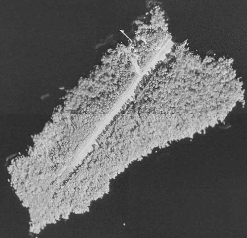
The Bear Island Airfield, as depicted on a 10/13/69 USGS aerial photo (courtesy of Dallam Oliver-Lee).
This unusual little airfield takes up almost the entire length of Bear Island, in the middle of Crescent Lake.
Bear Island Airfield was evidently constructed at some point between 1964-69,
as it was not yet depicted on a 1/29/64 USDA aerial photo (courtesy of Dallam Oliver-Lee) or the November 1967 Orlando Sectional Chart.
The earliest depiction which has been located of the field was on a 10/13/69 USGS aerial photo (courtesy of Dallam Oliver-Lee).
It depicted Bear Island as having a single paved northeast/southwest runway, running almost the whole length of the island.
The runway may still have been under construction at the time of the photo.
A 1970 aerial photo (from the U of FL Libraries) depicted the Bear Island runway somewhat more distinct, possibly after construction was completed.

The 1972 USGS topo map depicted a single northeast/southwest runway, labeled simply as “Landing Strip”.

The 1978 USGS topo map depicted a single northeast/southwest runway, labeled simply as “Landing Strip”.
The 1999 USGS aerial photo depicted Bear Island as having a single unpaved runway,
along with what may have been a residence on the north side of the island.
The airfield was presumably a private field for the residence.

The only photo which has been located of an aircraft on Bear Island was a spring 2004 photo by Jeff Ellsworth of his friend & his Murphy Rebel.
Jeff recalled, “After landing, we walked off the length of the runway & estimated it to be 900'.
My Murphy Rebel... only used about 300' of the 900'.
We went in there on 2 different occasions in 2004, but in August/September of that same year 3 hurricanes struck Central Florida,
and I remember my buddy who flew over it some time later telling me that he saw pine trees down on the runway.”

A 2004 aerial view (courtesy of Dan Guerra) looking northeast at the Bear Island Airfield.
According to Dan, “The guy who took these pics actually landed a Cessna 185 there.”

A 3/20/04 aerial view by Philip Pecoulas looking northeast at the Bear Island runway from a Piper PA-12 Super Cruiser.
William Chambers reported in 2006, “The last time I flew over here it looked overgrown.”
As of 2006, there was no airfield depicted on aeronautical charts on Bear Island,
nor any listed among the FAA Airport/Facility Directory data.

In contrast to the earlier reports of the runway being overgrown, a 2018 aerial view looking north showed the Bear Island runway to be very distinct & cleared.
____________________________________________________
(Original) Flagler Beach Airport, Flagler Beach, FL
29.47, -81.13 (North of Daytona Beach, FL)

A circa 1929 photo of a biplane taking off from the unfinished Flagler Beach Airport (from the Flagler Beach Historical Museum, courtesy of Tom Duncan).
According to an article by Rob Creal (courtesy of Matthew Reynolds) in the Winter 2007 Flagler Beach Historical Society newsletter,
“In May of 1929 the Flagler Beach Town Commissioners began exploring the establishment of an emergency aviation landing field.
By August the town had agreed to lease land from George Moody, D.F. Fuquay, and L.O. Upson for an airfield
and by the end of the year it was nearly complete.
The airfield was located on what is now South Flagler Avenue.”
The earliest depiction which has been located of Flagler Beach Airport was a circa 1929 photo
of a biplane taking off from the unfinished airport (from the Flagler Beach Historical Museum, courtesy of Tom Duncan).

A circa 1930 aerial view looking northeast at the Flagler Beach Airport (from the Flagler Beach Historical Museum, courtesy of Tom Duncan).
Tom Duncan observed, “The oceanside mansion visible in the top center is the Fuquay home, still existing today as the central building of the Topaz Motel and where the Island Grille is located.”

A November 1931 photo of spectators gathered in front of Charles Lindbergh's Army Curtiss Falcon biplane at the Flagler Beach Airport (from the Flagler Beach Historical Museum, courtesy of Tom Duncan).

A November 1931 photo (courtesy of Matthew Reynolds), of “my Grandfather, John Upson, walking with Charles Lindbergh & I think the woman flight instructor at Flagler
after Lindy emergency landed after he had engine problems.”
The article continued, “Two years later, one of the most famous aviators of all time would make an unexpected landing there.
On Saturday, 11/28/31 Colonel Charles Lindbergh left Miami before daylight in a borrowed U.S. Army airplane on a flight to New York.
While flying over Flagler Beach Lindbergh noticed the airfield & about 15 miles north of town he encountered dense fog.
Colonel Lindbergh turned around & landed on the grass runway at the Flagler Beach Municipal Airport at 9:15 am.
The Army airplane was larger than the aircraft that normally used the airfield & immediately attracted the attention of local residents.
When asked by Dewey Moody, Lindbergh admitted his identity & told residents that he expected to leave by 10:30 am.
The news spread quickly that he was at the airport & other local residents went there to greet him.
After receiving weather updates, he decided to stay in Flagler Beach until the flying conditions improved.”
The article continued, “Mr. & Mrs. J.L. Bivens were establishing a flying school at the airport
and Colonel Lindbergh took up one of their 2-cylinder Aeronoca airplanes for 2 short flights.
Afterward he posed for pictures with local residents & then the Bivens took him to the Flagler Beach Hotel for his second breakfast of the day.
Lindbergh decided to get a room at the hotel & as the news spread that he was in Flagler Beach,
visitors began to arrive from Daytona Beach, St. Augustine, and Jacksonville.
He became more reticent when confronted by the crowds of people trying to get a glimpse of him.
Lindbergh spent most of Sunday in his motel room studying charts & receiving weather reports.”
The article continued, “By Monday morning the weather had cleared & Colonel Lindbergh began preparing his aircraft to resume the flight to New York.
Several groups of people flew in from Daytona Beach to see him off.
It was noted that Mr. Bivens assisted him with the safety checks on the aircraft.
Colonel Lindbergh said that he enjoyed Flagler Beach & would like to return for a longer stay.
After shaking hands with those present at the airport, he climbed into the airplane & took off flying south for a short distance.
He then turned north & flew back. When he was over the center of town, Lindbergh dipped the wing of his airplane half a dozen times.”

A 1930s photo (courtesy of Matthew Reynolds) of “my great grandfather & his 4 sons (including my granddad), the Upsons,
after they all received their pilot’s licenses at Flagler.
I remember that a newspaper article at the time called them the 'Flying Family of Flagler (or Florida)'.”
Pictured are: Luther Upson, Lawrence Upson, Louis Upson, John Upson, and Reginald Upson, in front of an unidentified high-wing monoplane.
The 1934 Department of Commerce Airfield Directory (courtesy of Chris Kennedy)
described Flagler Beach as a municipal field having 2 sod runways under construction: 3,200' northwest/southeast & 3,000' north/south.
According to the Flagler Beach Historical Museum, Amelia Earhart landed at the Flagler Beach Airport in the early 1930s.

The earliest aeronautical chart depiction which has been located of Flagler Beach Airport was on the 1935 Orlando Sectional Chart (courtesy of Chris Kennedy).
It depicted Flagler Beach as an auxiliary airfield.

The 1937 USGS topo map depicted Flagler Beach Airport as having 2 unpaved runways,
with a beacon on the northeast corner.

An undated aerial view looking northeast at Flagler Beach Airport, from the 1937 WPA publication “America Spreads Her Wings” (courtesy of Tom Duncan).
According to Tom Duncan, Civil Air Patrol (CAP) Coastal Patrol Base 5 operated at the Flagler Beach Airport starting on 10/28/42.

A 2/12/43 USDA aerial view (courtesy of Dallam Oliver-Lee) depicted Flagler Beach Airport
as having 2 grass runways, with an airport circle marking at the intersection.
A dozen light aircraft were parked along the northeast side of the field, near some small buildings.
Tom Duncan observed that this “is the airport configuration as it existed for the Civil Air Patrol (CAP) Coastal Patrol Base 5.
Those are the CAP patrol aircraft lined up on the field & the buildings include the Main Operations Building & hangar.
The long building on the south end is the aircraft hangar housing the CAP engineering department.
The building immediately north of the hangar is the administration building (CAP Main Operations Building).”

"Flagler Beach (Aux)" was depicted as a municipal airport on the July 1943 Orlando Sectional Chart (courtesy of Chris Kennedy).

A 1942-43 photo of the Civil Air Patrol's Coastal Patrol Base 5 Administration Building built by the town of Flagler Beach as part of its lease agreement with the CAP (courtesy of the Flagler County Historical Society, via Tom Duncan).
Tom Duncan reported, “It served as the Main Operations Building, with the radio shack on the second floor & U.S. Weather Bureau instruments for wind speed & direction atop that.”

A 1942-43 photo of the Civil Air Patrol's Coastal Patrol Base 5 six-plane metal hangar furnished by the town of Flagler Beach as part of its lease agreement with the CAP (courtesy of the Flagler County Historical Society, via Tom Duncan).
Tom Duncan reported, “The hangar included a supply room, offices, showers & work benches for the engineering department that was housed in it.”
According to Tom Duncan, CAP Coastal Patrol Base 5 operated at the Flagler Beach Airport until 8/31/43.
The 4/1/44 US Army/Navy Directory of Airfields (courtesy of Ken Mercer) described Flagler Beach Airport as having a 3,000' unpaved runway,
and indicated that the field conducted Civil Air Patrol Operations.
Flagler Beach Airport was still depicted on the 1944 USGS topo map.
The Flagler Beach Airport was evidently closed (for reasons unknown) at some point within the next year,
as the February 1945 Orlando Sectional Chart (according to Chris Kennedy)
no longer depicted an airfield at the location, although its beacon was still depicted.
A 12/19/50 USGS aerial photo (courtesy of Dallam Oliver-Lee) still showed Flagler Beach Airport as remaining intact,
but there did not appear to be any aircraft on the field.
A 1/17/52 USDA aerial photo (courtesy of Dallam Oliver-Lee) showed several streets
as having been built over the eastern edge of the site of Flagler Beach Airport.
Nothing was depicted at the site of the airport on the 1960 USGS topo map.
Chris Kennedy pointed out in 2004 that the reason the airfield property has remained intact & not redeveloped is that it is a preserve -

Incredibly, a 1/19/12 aerial photo showed that the outline of the 2 runways
of the former Flagler Beach Airport remained almost completely intact.
When this picture is compared with the 1943 aerial photo, it is amazing that the site has remained largely intact after 69 years.
The site of the Flagler Beach Airport is located west of the intersection of Flagler Avenue & South 12th Street.
____________________________________________________
Osceola Naval Outer Landing Field, Osceola, FL
28.79, -81.08 (Northeast of Orlando, FL)

"Osceola (Navy)", as depicted on the February 1944 Orlando Sectional Chart.
Naval Outlying Field Osceola was not yet depicted on the July 1942 Orlando Sectional Chart.
Naval Outlying Field Osceola was built in 1943 as an auxiliary gunnery field for Sanford NAS,
which initially trained bomber crews, and later switched to training fighter crews.
The earliest depiction which has been located of NOLF Osceola was on the 1943 Orlando Sectional Chart (according to Chris Kennedy).
It depicted "Osceola (Navy)" as having a 4,000' hard-surface runway.
The earliest depiction which has been located of the Osceola airfield was on the February 1944 Orlando Sectional Chart.
It depicted “Osceola (Navy)” as an auxiliary airfield.

The earliest photo which has been located of the Osceola airfield
was a 3/15/44 U.S. Navy aerial view looking west at NOLF Osceola (courtesy of Brian Rehwinkel).
It depicted Osceola as having 4 paved runways, paved taxiways, and a few small buildings alongside the access road.

A closeup from the 3/15/44 U.S. Navy aerial view of NOLF Osceola (courtesy of Brian Rehwinkel),
showing a single low-wing single-engine aircraft on a taxiway on the north side of the field.
Osceola NOLF was declared surplus in 1946.
It is not known if the field was ever reused for civilian aviation.

An 11/25/48 USDA aerial photo of Osceola NOLF, from the FL DOT (courtesy of Brian Rehwinkel).
The airfield consisted of 4 paved 4,100' runways & taxiways.
In this photo, the airfield was still completely intact,
but it appeared abandoned - there was no indication of any current use of the airfield.
There also did not appear to be any traces of any buildings at the site.
"Osceola OLF (Navy)" was still depicted as an active airfield on the August 1954 Orlando Sectional Chart (courtesy of Chris Kennedy),
but the Aerodromes table on the chart listed its status as "Closed, leased for grazing."

The last aeronautical chart depiction which has been located of "Osceola OLF (Navy)" was on the February 1956 Orlando Sectional Chart.
Osceola OLF was no longer depicted on the July 1956 Orlando Sectional Chart.

The last photo which has been located showing the Osceola airfield remaining intact was a 1958 aerial photo (from the U of FL Libraries).
It would've made a nice municipal airport, if it had been located elsewhere.
Al Fitzgerald recalled, “Osceola NOLF was used mostly as a drag strip & model airplane flying field when I knew of it in the early 1960s.
I can remember landing there a couple times for the fun of it in a Mooney M21 around 1964-65.
The runways were in good shape, but had a lot of trash on them.”

The 1966 USGS topo map still depicted the 4 intact runways & taxiways of “Osceola Field (Abandoned)”.
Sonny Hartley recalled of Osceola, “When I was in high school in the early 1960s,
drag races were held on the old airstrip every other Saturday night.
That was from about 1961-67. In 1968 the SCCA held regional sports car races on the airfield.
I was a volunteer flagman at many of those events until 1973.”

The 1988 USGS topo map showed that the southern half of the runways & taxiways of “Osceola Field (Abandoned)” remained,
but the northern half had been removed at some point between 1966-88.
Ross Burton recalled, “I did a lot of flight training down in the Orlando area.
I had always wanted to know the origin of the abandoned airfield in Osceola.
One day in 1991 we had a massive wind storm.
The next day I flew over the site & the runways were far more visible (largely intact) as the sand/dirt had blown off the runways.”

A 1995 USGS aerial view looking north at the site of Osceola Field showed that a significant proportion of the runways had been removed.
Gary Klingebiel reported in 2002 that the property is currently being used as the county landfill, with almost nothing left of the runways.

A circa 2006-2007 aerial view looking north at the remains of the Osceola runways,
showing that a shed had been built over the former east/west runway.
Sonny Hartley reported in 2007, “I had occasion to visit Osceola Airfield. Yes, it is a [landfill].
Most of the landing strips are gone but a lot of the access roads are still there.”

A 2016 aerial view looking north shows the Osceola Field site remains recognizable as a former airfield.
____________________________________________________
Or if you prefer to contact me directly concerning a contribution (for a mailing address to send a check),
please contact me at: paulandterryfreeman@gmail.com
If you enjoy this web site, please support it with a financial contribution.
____________________________________________________
This site covers airfields in all 50 states.