Abandoned & Little-Known Airfields:
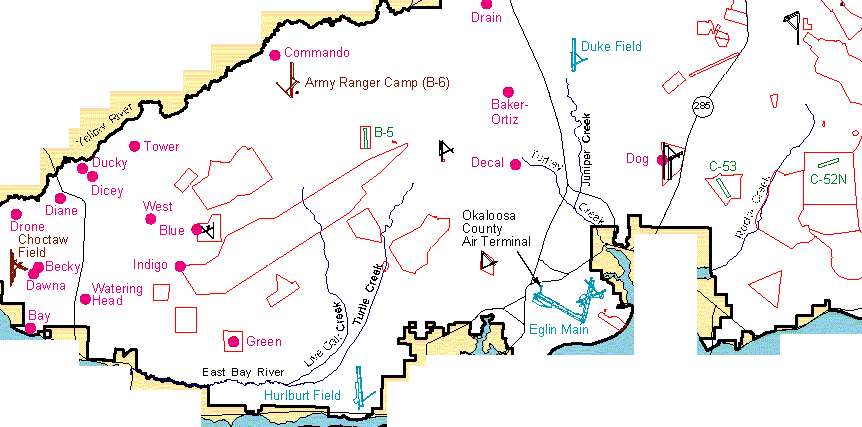
Florida: Eglin area
© 2002, © 2024 by Paul Freeman. Revised 12/13/24.
This site covers airfields in all 50 states: Click here for the site's main menu.
____________________________________________________
Please consider a financial contribution to support the continued growth & operation of this site.
Baldsiefen Field / Eglin AF Aux #8 (revised 9/21/18) - Biancur Field / Eglin AF Aux #6 (revised 2/21/20) - Epler Field / Eglin AF Aux #7 (revised 12/13/24)
Freeport Airfield (added 4/8/13) - Peel Field / Eglin AF Aux #4 (revised 9/22/18) - Piccolo Field / Eglin AF Aux #5 (revised 9/22/18)
Pierce Field / Eglin AF Aux #2 (revised 9/22/18) - Wagner Field / Eglin AF Aux #1 (revised 9/22/18)
____________________________________________________
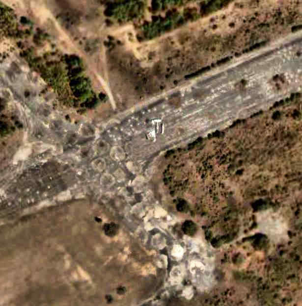
Freeport Airfield, Freeport, FL
30.48, -86.19 (East of Eglin AFB, FL)
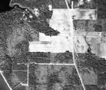
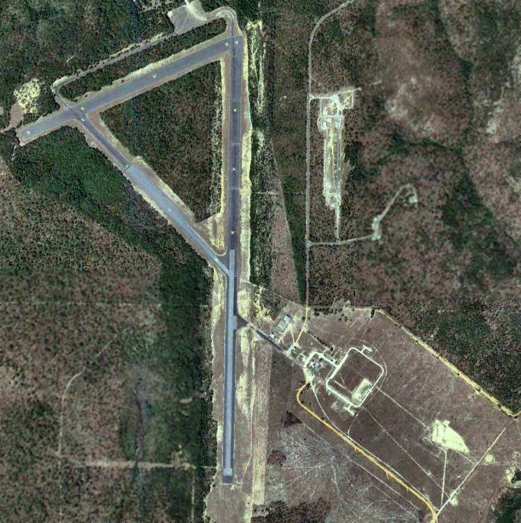
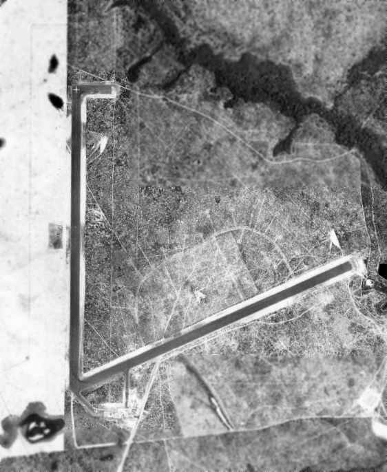
Freeport Airfield, as depicted on a 11/15/79 aerial view (courtesy of Dallam Oliver-Lee)
Not much is known about this small airfield, including its name, purpose, or date of construction.
The Freeport Airfield was evidently built at some point between 1969-79,
as it was not yet depicted on a 1969 aerial photo (courtesy of Dallam Oliver-Lee),
New Orleans Sectional Charts from 1971/1980/1983/1993, or 1970s USGS topo maps.
The earliest depiction which has been located of the Freeport Airfield was on a 11/15/79 aerial photo (courtesy of Dallam Oliver-Lee).
It depicted Freeport as having a single east/west unpaved runway.
Dallam Oliver-Lee recalled, “I remember driving by it when I was younger & always wondering if it was an airfield.”
A 1994 aerial photo (courtesy of Dallam Oliver-Lee) depicted Freeport in the same fashion as depicted on the 1979 aerial view.
The 1996 USGS topo map continued to depict the clearing of the runway, but not the airfield itself.
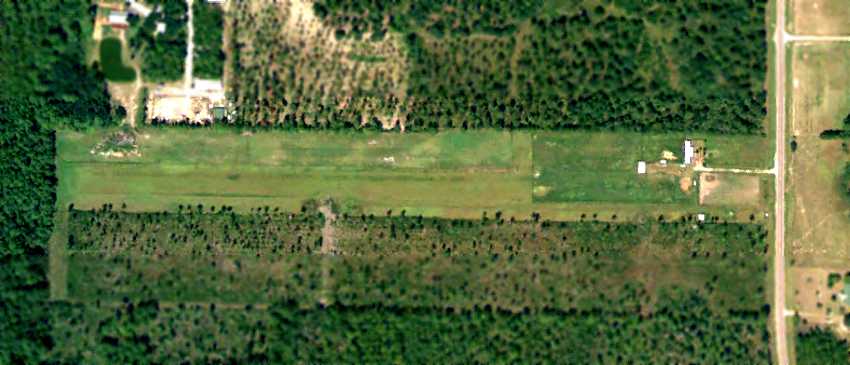
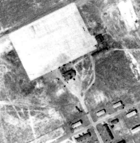
A 1999 aerial photo (courtesy of Dallam Oliver-Lee)
showed that 3 small buildings had been added to the northeast side at some point between 1994-99,
but no aircraft were visible on the field.
The last photo which has been located still showing the Freeport Airfield as remaining clear (and presumably still used as an airfield)
was a May 2007 aerial view (courtesy of Dallam Oliver-Lee).
A December 2009 aerial photo (courtesy of Dallam Oliver-Lee)
showed that Freeport had presumably been abandoned as an airfield at some point between 2007-2009,
as the runway area appeared to be starting to be overgrown.
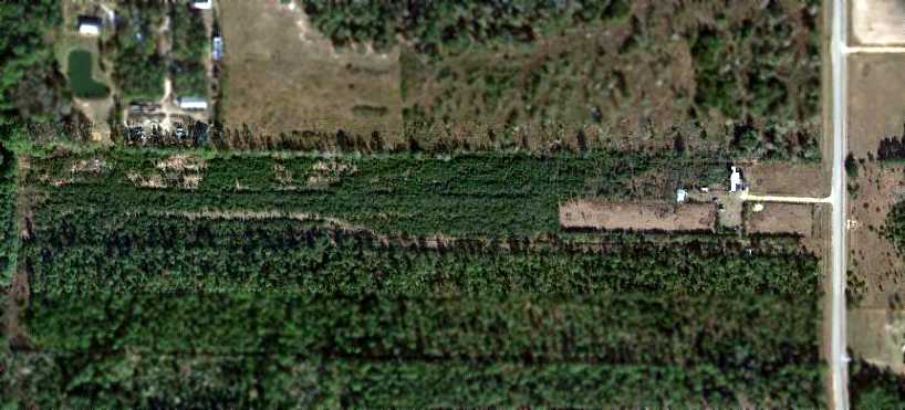
A December 2012 aerial view (courtesy of Dallam Oliver-Lee) showed the former Freeport Airfield buildings remained standing, and the runway outline was still recognizable, but it was heavily overgrown.
The site of Freeport Airfield is located northwest of the intersection of West Bay Loop Road & Delorean Drive.
____________________________________________________
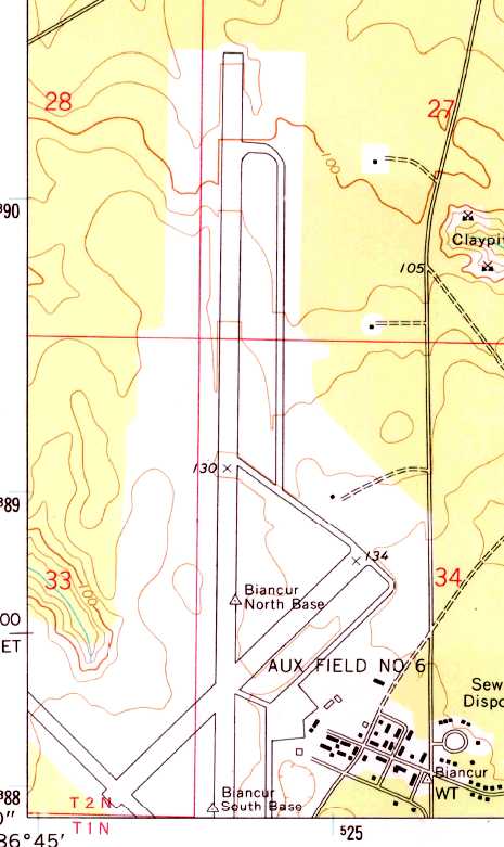
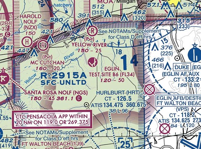
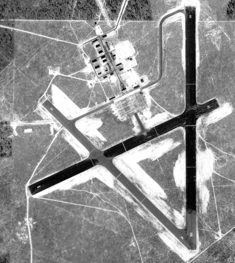
Biancur Field / Eglin Air Force Aux #6 (FL34), Crestview, FL
30.63, -86.74 (Northwest of Eglin AFB, FL)
Biancur Field #6, along with the large number of satellite airfields associated with Eglin AAF, as depicted on the January 1944 Mobile Sectional Chart.
Biancur Field was not yet depicted on the 1937 USGS topo map.
Biancur Field was one of numerous satellite airfields established to support Eglin AAF.
Brian Rehwinkel reported, “According to a 1944 History of the Army Air Forces Proving Ground Command (AFHRA/Air Force Historical Research Agency),
plans for the first 3 fields [Eglin Auxiliary fields] were approved in October 1940.
In May of 1941, four additional fields were started - Fields #1, #3, #5, and #6.
Initially, these fields consisted of 2 paved runways, a north/south & a northeast/southwest runway each.
There were not buildings at these fields. The original plan was for the planes & personnel to return to Eglin main every evening.
It soon became obvious that this would not work & plans were made to add an operations building with tower,
barracks for enlisted men, officers’ quarters, an administration building, a warehouse, and a mess hall.
At this point, these auxiliaries fields would become more of a sub-base rather than just an auxiliary field.
Each of the fields would be a small installation, with facilities & staff to carry out their mission.”
Brian continued, “A 3rd runway was authorized for Auxiliary Field #4 & the other 6 gunnery fields in August 1942.
All of the fields received a 3rd northwest/southeast runway.”
Field #6 was not yet depicted on the December 1942 Mobile Sectional Chart.
The earliest depiction which has been located of Field #6 was on the January 1944 Mobile Sectional Chart.
Brian Rehwinkel reported, “In March 1944, all of the Auxiliary Fields, previously only referred to by their numerical designation, were named for fallen airman.”
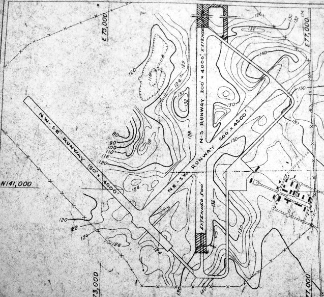
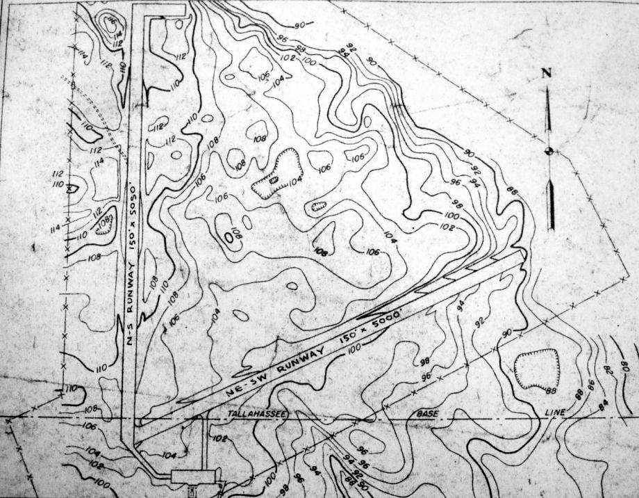
A circa 1950 layout of “#6 Biancur Airdrome” (from the St. Louis National Personnel Records Center, courtesy of Ron Plante)
depicted it as having 3 paved runways with a paved ramp on the southeast side.
A 4/16/55 US Government aerial photo (from the University of FL online library, via Brian Rehwinkel) of Eglin Aux #6.
The original WW2-era airfield configuration had been expanded at some point between 1945-55,
as the primary runway had been lengthened to 8,000'.
A closeup of Eglin Aux #6 from the above 4/16/55 US Government aerial photo (from the University of FL online library, via Brian Rehwinkel),
showing what appears to be a B-24 parked on the northeast/southwest runway, which was apparently closed by that point.
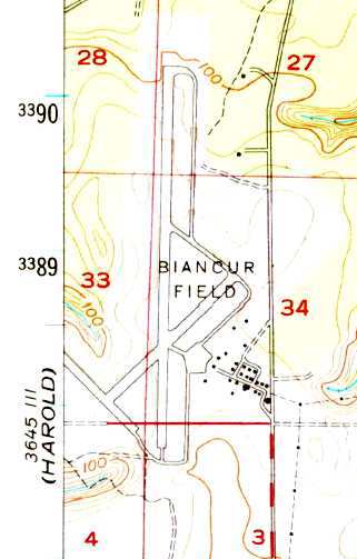
The 1956 USGS topo map depicted "Biancur Field” as having 3 paved runways, taxiways, a ramp, and a cluster of buildings on the southeast side.
The 1956 Mobile Sectional Chart (courtesy of Dallam Oliver-Lee) depicted "AF #6" as having an 8,000' paved runway.
The February 1966 Mobile Sectional Chart (courtesy of David Stevenson) depicted "Eglin AF #6" as having 3 paved runways, with the longest being 8,000'.
Douglas Rusmisell recalled of the 1960s, “I lived at Eglin Field #6 as my father was the supervisor of education at the prison camp there.
We moved there before Hurricane Camille [1969].
On the right side of the 1973 topo, you will see a side street with a circle. There were house there for the warden, assistant warden, etc.
And south of the circle, there is a another side street that loops down to the pond, it had mobile homes and I lived in the first one.
There was an aircraft on the runway when the prison was there.
My dad took me down to the clay pits to teach me to shot a shotgun.
Us boys found an old car top roof which must have been from an 1940s era car (it was really round) and we flipped it over & paddled across the pond.
The Army rangers were at Field #7, but they regular had exercises outside the parameter of the housing area (north east side beyond the circle).”
The 1973 USGS topo map depicted "Aux Field #6" as having 3 paved runways, taxiways, a ramp, and a cluster of buildings on the southeast side.
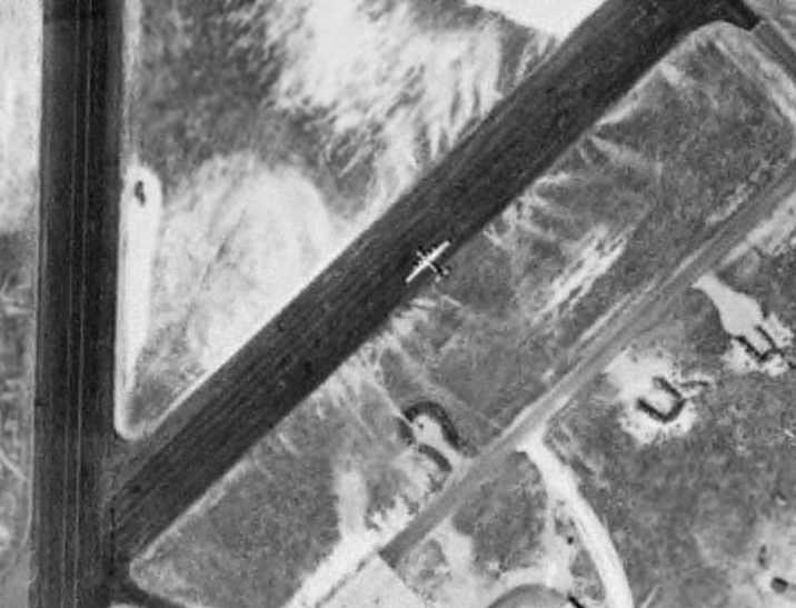
There were no aircraft visible on Biancur on a 1974 aerial photo.
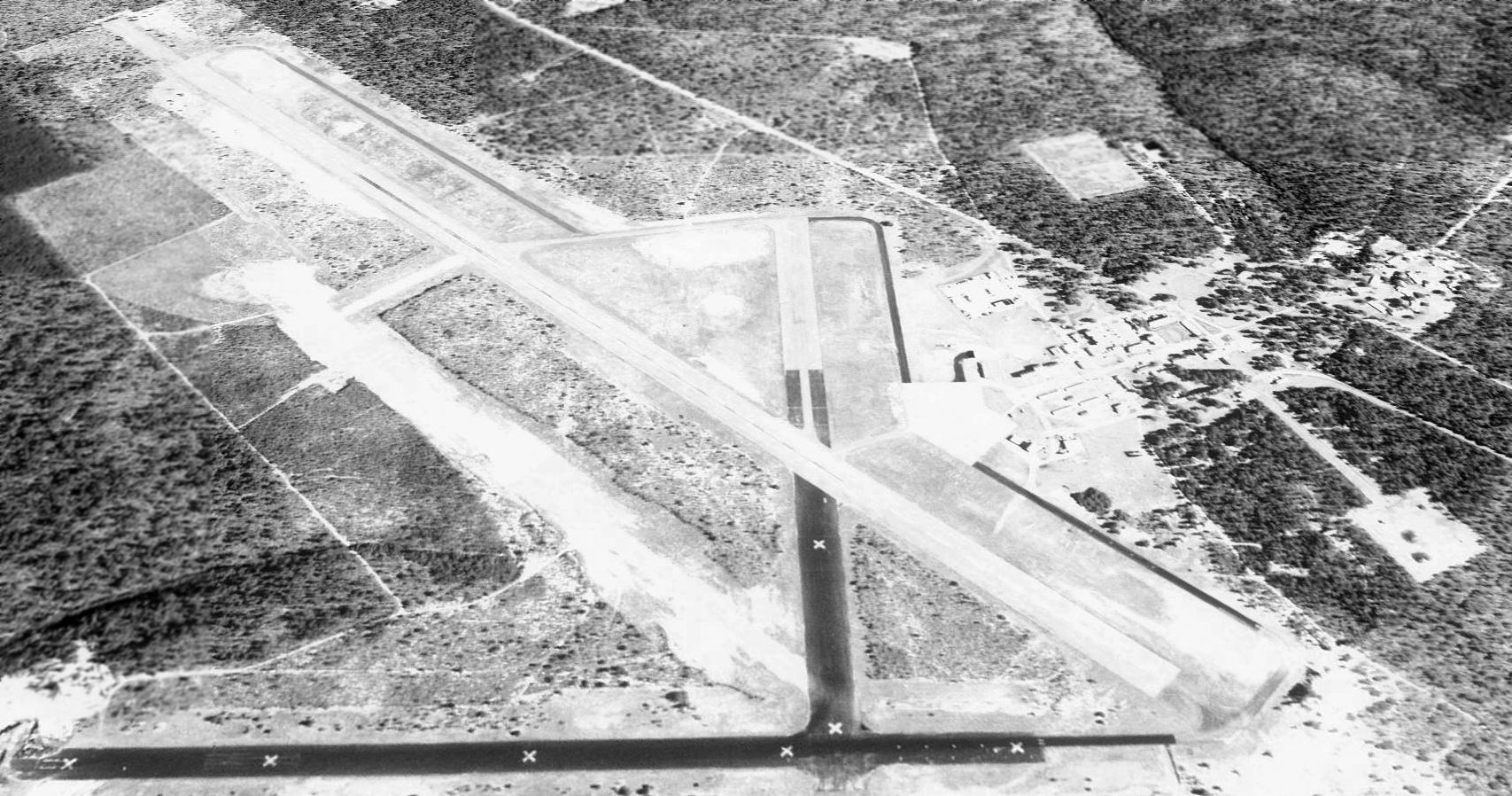
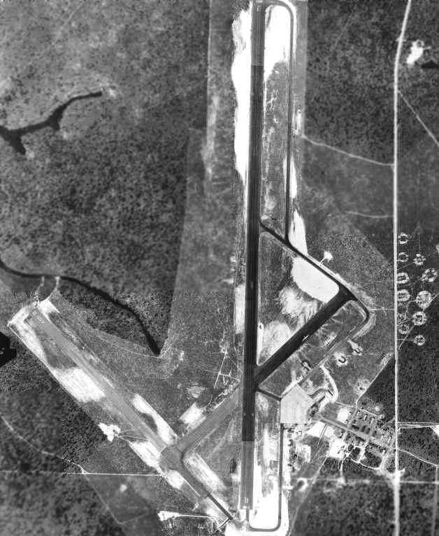
As seen on a 1994 USGS aerial view looking northeast, Biancur's primary runway, 18/36, is 8,000' long.
There are also 2 paved abandoned runways, taxiways, and a paved ramp.
Eglin AFB & its numerous surrounding auxiliary airfields.
As of 2002, Biancur was still an active airfield, also known as Test Site B6.
Biancur Field is the site of the Army 6th Ranger Training Battalion, who refer to it as Camp Rudder.
It is identified on most base maps as Tab 6 & is located just north of area B-12.
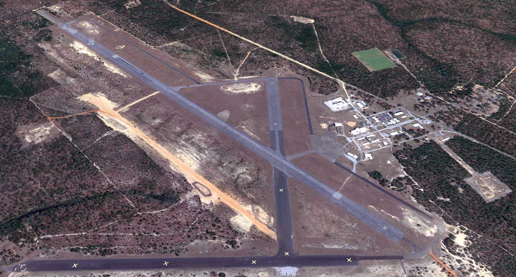
A 2013 aerial view looking northeast at Biancur Field.
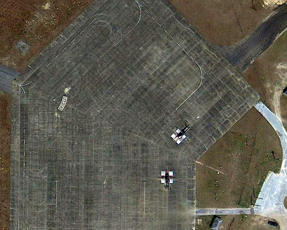
A 3/28/13 aerial photo (courtesy of Dallam Oliver-Lee) of what appear to be 2 EADS UH-72 Locata helicopters on the Biancur Field ramp, which is painted with the “Ranger” tab.
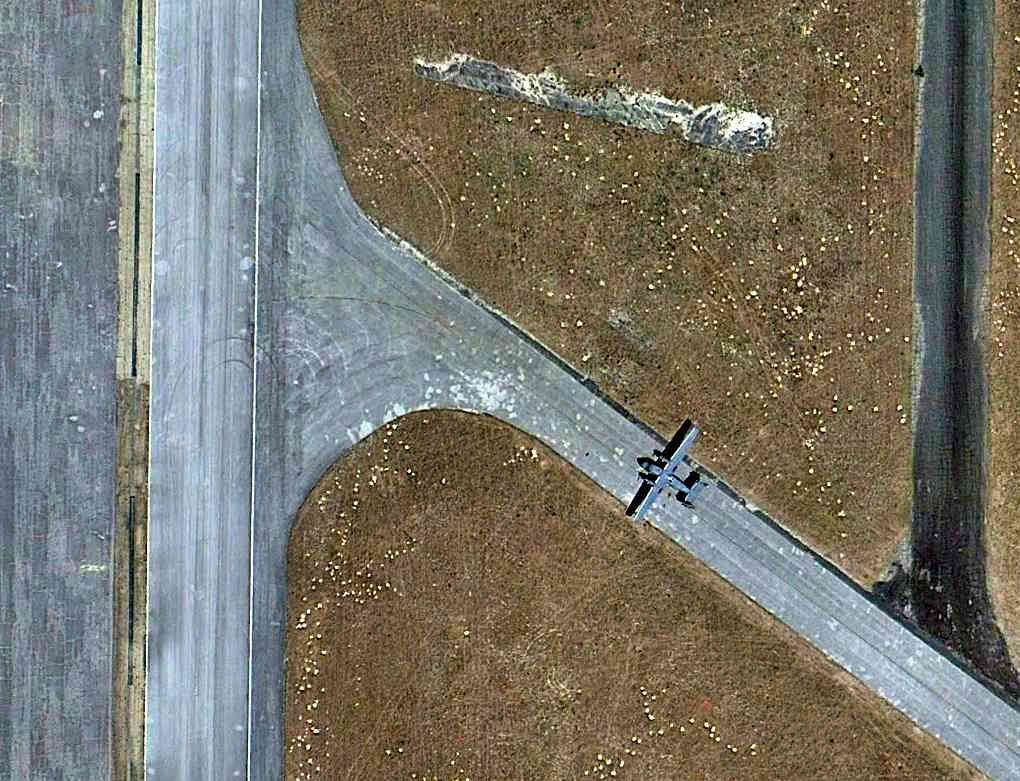
A 3/28/13 aerial photo (courtesy of Dallam Oliver-Lee) of what appears to a PZL C-145 Skytruck on a Biancur Field taxiway.
The Skytruck is a Polish STOL cargo aircraft used in small numbers by the U.S. Special Operations forces.
The 2016 Sectional Chart depicted "Eglin Test Site B6" as having 3 paved runways, with the longest being 5,000'.
See also:
http://www.specialoperations.com/Schools/Army/Ranger_School/Camp_Rudder.htm
http://www.eglin.af.mil/newcomers/history.htm
____________________________________________________
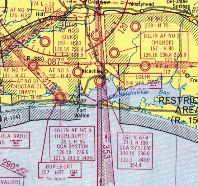
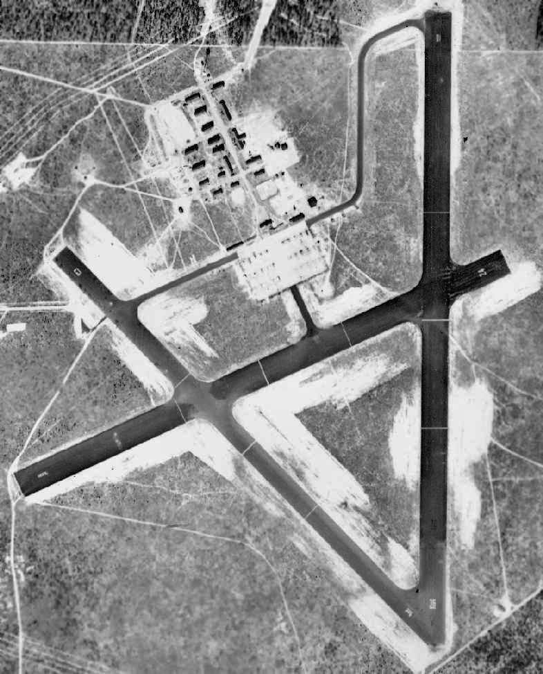
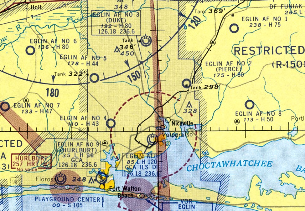
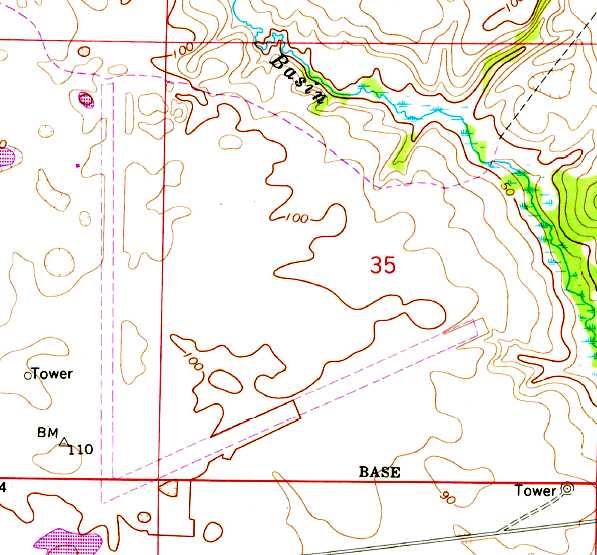
Pierce Field / Eglin Air Force Aux #2 (FL35), Niceville, FL
30.58, -86.44 (Northeast of Eglin AFB, FL)
Eglin Army Airfield Auxiliary #2. as depicted on the January 1944 Mobile Sectional Chart.
Pierce Field is one of numerous satellite airfields built during WW2 for the use of Eglin AAF.
Brian Rehwinkel reported, “According to a 1944 History of the Army Air Forces Proving Ground Command (AFHRA/Air Force Historical Research Agency),
plans for the first 3 fields [Eglin Auxiliary fields] were approved in October 1940.
Although there was an initial proposal for 11 fields, only 3 were approved initially.
These 3 fields were Auxiliary Fields #2, #4, and #7.
Work began in January 1941, and work proceeded pretty slowly.
By October 1941, according to this document, only one field, Auxiliary Field #2, was substantially complete.”
Brian continued, “Initially, these fields consisted of 2 paved runways, a north/south & a northeast/southwest runway each.
There were not buildings at these fields. The original plan was for the planes & personnel to return to Eglin main every evening.
It soon became obvious that this would not work & plans were made to add an operations building with tower,
barracks for enlisted men, officers’ quarters, an administration building, a warehouse, and a mess hall.
At this point, these auxiliaries fields would become more of a sub-base rather than just an auxiliary field.
Each of the fields would be a small installation, with facilities & staff to carry out their mission.”
Brian continued, “A 3rd runway was authorized for Auxiliary Field #4 & the other 6 gunnery fields in August 1942.
All of the fields received a 3rd northwest/southeast runway.”
The earliest depiction which has been located of Eglin Auxiliary #2 was on the January 1944 Mobile Sectional Chart.
It depicted “#2” as an auxiliary airfield.
Brian Rehwinkel reported, “In March 1944, all of the Auxiliary Fields, previously only referred to by their numerical designation, were named for fallen airman.”
A circa 1950 layout of “#2 Pierce Airdrome” (from the St. Louis National Personnel Records Center, courtesy of Ron Plante)
depicted it as having 3 paved runways with a concrete ramp on the southeast side.
Darrell Gilliland recalled, “Pierce Field (Auxiliary 2)... During the Korean War this base was used by the 4403rd Air Base Squadron, a part of the 9th Air Force.
I arrived mid-January [1951] along with 10 other new recruits (I believe it was established just before our arrival).
We became a bombing & gunnery range crew & were assigned there until February 1953.
The mission of the base was to train Reserve & National Guard [personnel] who would arrive for a period of 2-3 weeks to use the bombing & gunnery range.
In February we all were reassigned to other duties at various locations in Europe. I believe the base was closed soon after that.
During that time the permanent party assigned to this base averaged between 100–110 personnel.”
At some point between 1950-55, Eglin Aux #2's original WW2-era airfield configuration of 3 runways was augmented by a newly-built 8,000' paved Runway 18R/36R,
constructed in parallel to the original Runway 18/36, which became Runway 18L/36R, as seen on a 4/16/55 USDA aerial photo of Eglin Aux #2 (courtesy of Dallam Oliver-Lee).
The reason for this runway expansion has not been determined. What may be 3 light aircraft were visible on the southeast end of the northwest/southeast runway.
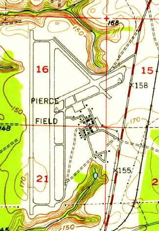
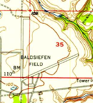
The 1956 USGS topo map depicted "Pierce Field” as having 4 paved runways, taxiways, a ramp, and a cluster of buildings on the southeast side.
The 1956 Mobile Sectional Chart (courtesy of Dallam Oliver-Lee) depicted "Eglin AF #2 (Pierce)" as having a 8,000' paved runway & a control tower.
"Eglin AF #2 (Pierce)" was described on the 1964 Mobile Sectional Chart (courtesy of John Voss) as having an 8,000' hard-surface runway.
Accoridng to Dave Kirsch, “During 1968-69 Field 2 was used for combat training the USAF Redhorse civil engineering teams for deployment to Vietnam.”
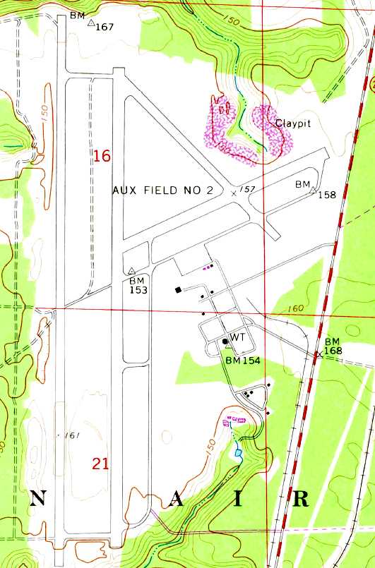
The 1973 USGS topo map depicted "Aux Field #2" as having 4 paved runways, taxiways, and a ramp.
The number of buildings on the southeast side had decreased considerably as depicted on the 1956 topo map.
There were no aircraft visible on Pierce on a 1974 aerial photo,
but the eastern end of the crosswind runway showed signs of being used to test battle damage runway repair.
Pierce Field was the site of one of the Vietnamese Resettlement Camps in 1975.
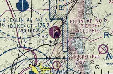
Pierce Field was evidently closed at some point between 1964-76,
as that is how it was depicted on the January 1976 New Orleans Sectional Chart (courtesy of Chris Kennedy).
Pierce Field was depicted as “Eglin Test Site C3 (Closed)” on the December 1983 New Orleans Sectional Chart.
Pierce Field was reopened at some point between 1983-2000.
Pierce was still listed in the Airport Facility Directory as an active airfield until 2000, when it was listed as being closed.
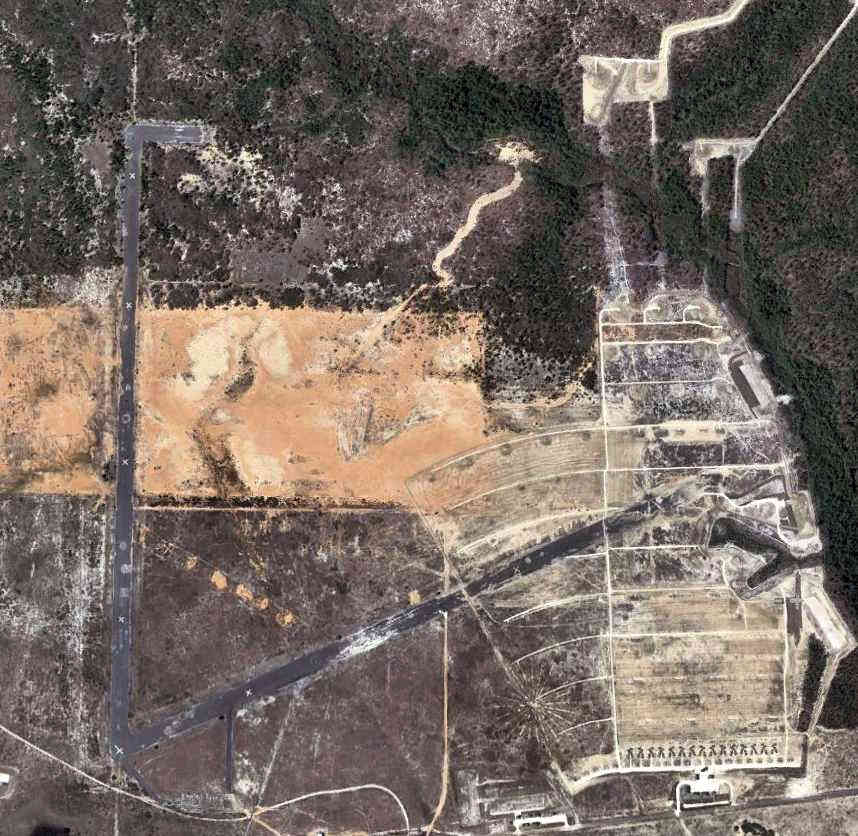
Known as Eglin Test Site C3, the installation served as the Base Installation Security Systems Test Site.
It covers 757 acres of cleared area on the Eglin Test Range.
The site simulates a section of a base perimeter & a secure area within a base or installation.
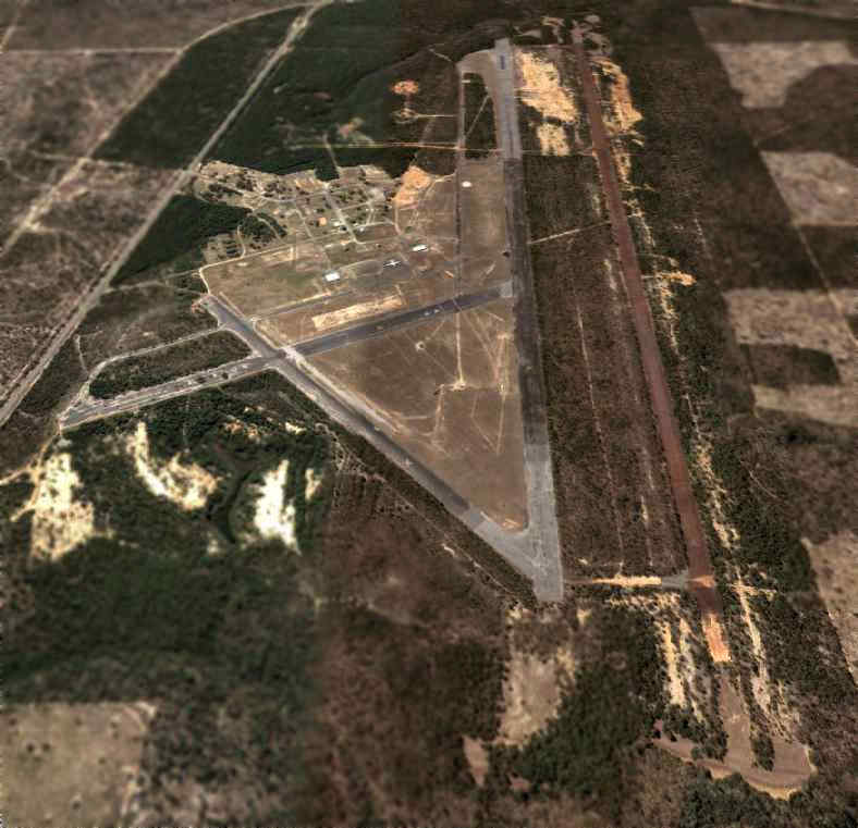
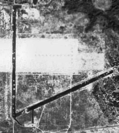
A circa 2000-2005 USGS aerial photo looking south at the numerous abandoned runways at Pierce Field.
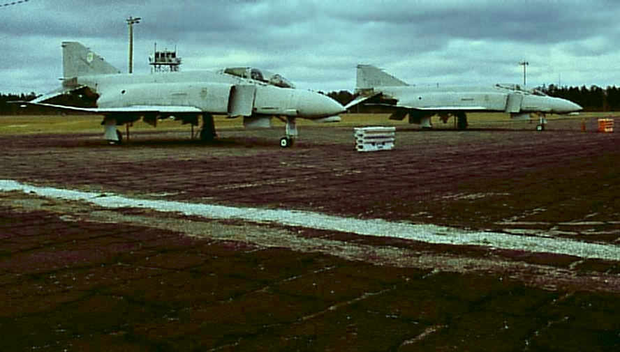
A 2/15/09 photo by Mark Sublette of 2 F-4D Phantoms sitting on the Eglin Aux #2 ramp.
Mark reported, “I sleuthed around the Eglin ranges a bit.
The pair of F-4 Phantoms sitting on Auxiliary Field 2, Pierce Field, Test Site C-3, are are F-4D-33-MC, 66-8800, and F-4D-24-MC, 64-929.
The first carries incorrect tail number 68-800, and both last served with the 3246th Test Wing at Eglin AFB.”
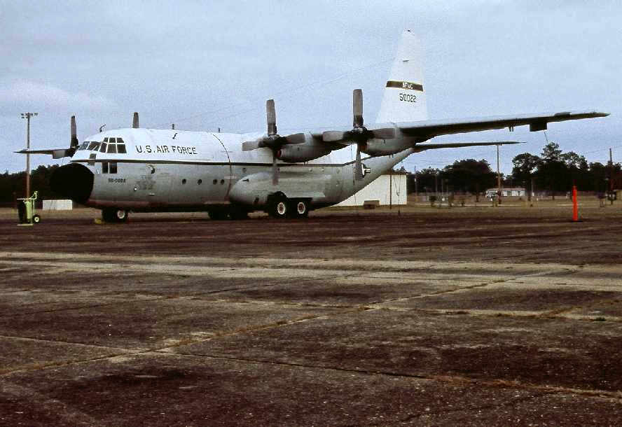
A 1/19/09 photo by Mark Sublette of a C-130A Hercules sitting on the Eglin Aux #2 ramp.
Mark Sublette reported in 2006, “The Hercules in the picture is C-130A 55-022 (182-3049), which was the last flying USAF C-130A Hercules, and was modified to NC-130A standard.
It was still in use with 46th Test Wing, Eglin AFB until 2003 & I had photographed it at Duke Field (Eglin Aux #3) in 1999.
It was retired 10/3/03 & has been sitting on Pierce Field, Eglin Aux #2 since at least August of 2004
when I first noted it there from the air while flying Delta commercial into Eglin AFB.”
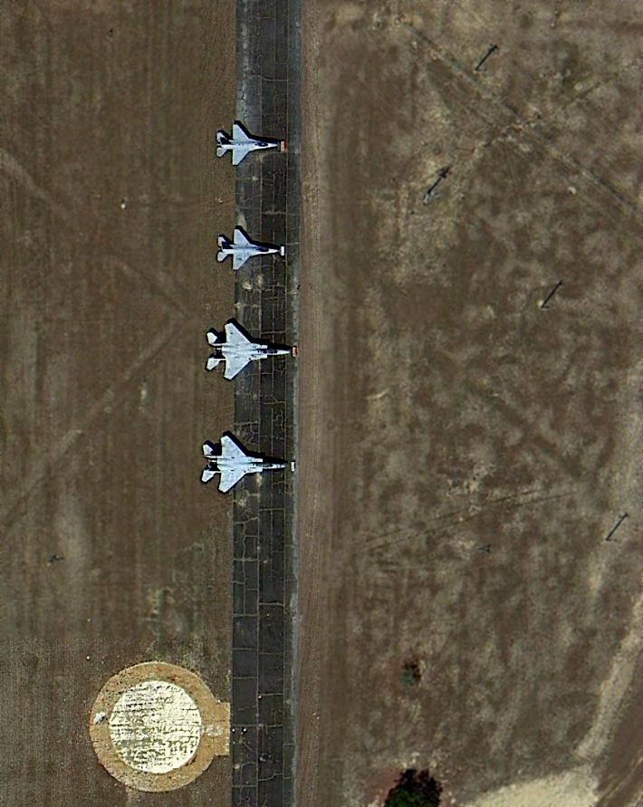
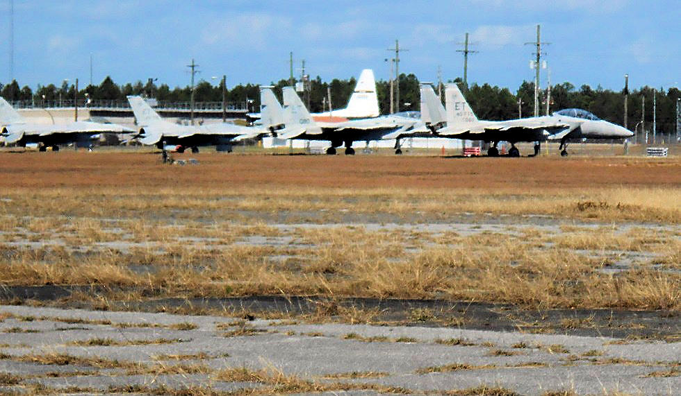
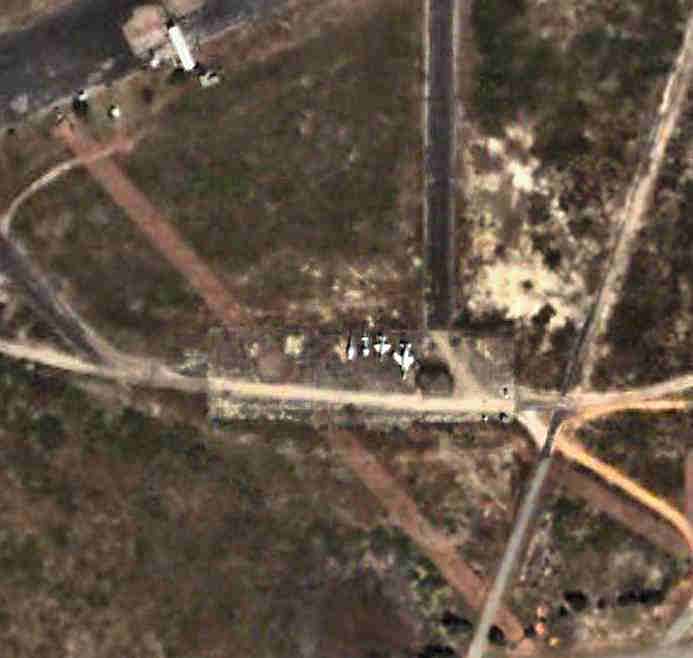
A 3/28/13 aerial photo (courtesy of Dallam Oliver-Lee) of 2 F-16s & 2 F-15s on the taxiway leading to Eglin Aux #2's Runway 36R.
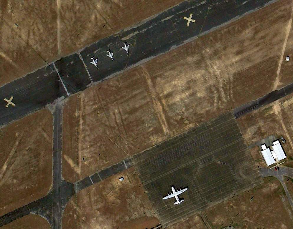
A 3/28/13 aerial photo (courtesy of Dallam Oliver-Lee) showing 3 F-4 Phantoms on a closed runway at Pierce Field,
as well as a NC-130A Hercules on the ramp.
A 3/13/16 photo by Daniel Shea of 2 F-4 Phantoms & a Soviet MiG-23/27 2-seater at Pierce Field.
Daniel reported, “There was a MIG-23/27 there from the fall of 2015 to the fall of 2016.”
A 3/13/16 photo by Daniel Shea looking southwest at 2 F-16A/Cs, an F-15A/C, an F-15B/D, and an NC-130A.
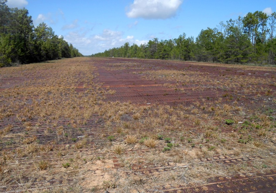
A 3/13/16 photo by Daniel Shea of Pierce Field's steel grate Runway 18R/36L.
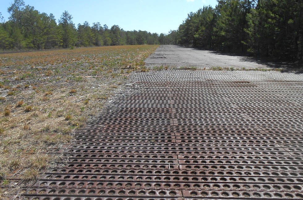
A 3/13/16 photo by Daniel Shea of Pierce Field's steel grate Runway 18R/36L.
Daniel Shea reported in 2017, “Eglin Aero Modelers fly model airplanes on the south end of the main runway.
You can see a black rectangle on the runway. That's where they fly. We can't go past the 4th 'X' from the south of the runway.”
____________________________________________________
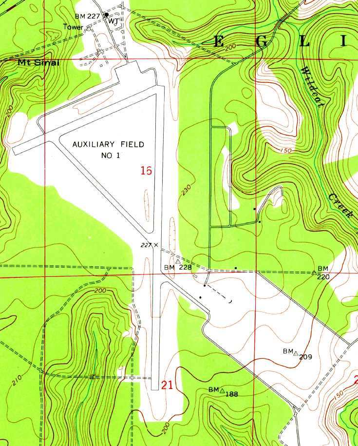
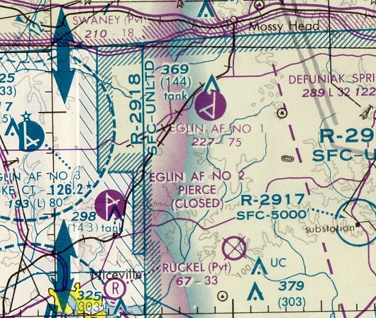
Wagner Field / Eglin Air Force Aux #1, Niceville, FL
30.67, -86.35 (Northeast of Eglin AFB, FL)
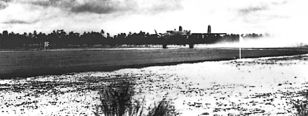
A March 9-25 1942 USAAF photo of a Doolittle Raider B-25 practicing carrier-style short takeoffs at Wagner Field in preparation for their 4/18/42 raid on Japan.
No airfield was yet depicted at this location on a 1/19/41 USDA aerial photo (courtesy of Dallam Oliver-Lee).
Wagner Field was established as one of numerous satellite airfields which supported Eglin AAF.
Brian Rehwinkel reported, “According to a 1944 History of the Army Air Forces Proving Ground Command (AFHRA/Air Force Historical Research Agency),
plans for the first 3 fields [Eglin Auxiliary fields] were approved in October 1940.
In May of 1941, four additional fields were started - Fields #1, #3, #5, and #6.
Initially, these fields consisted of 2 paved runways, a north/south & a northeast/southwest runway each.
There were not buildings at these fields. The original plan was for the planes & personnel to return to Eglin main every evening.
It soon became obvious that this would not work & plans were made to add an operations building with tower,
barracks for enlisted men, officers’ quarters, an administration building, a warehouse, and a mess hall.
At this point, these auxiliaries fields would become more of a sub-base rather than just an auxiliary field.
Each of the fields would be a small installation, with facilities & staff to carry out their mission.”
Brian continued, “A 3rd runway was authorized for Auxiliary Field #4 & the other 6 gunnery fields in August 1942.
All of the fields received a 3rd northwest/southeast runway.
In March 1944, all of the Auxiliary Fields, previously only referred to by their numerical designation, were named for fallen airman.”
The earliest depiction of Wagner Field which has been located was a March 9-25 1942 USAAF photo
of a Doolittle Raider B-25 practicing carrier-style short takeoffs at Wagner Field in preparation for their 4/18/42 raid on Japan.
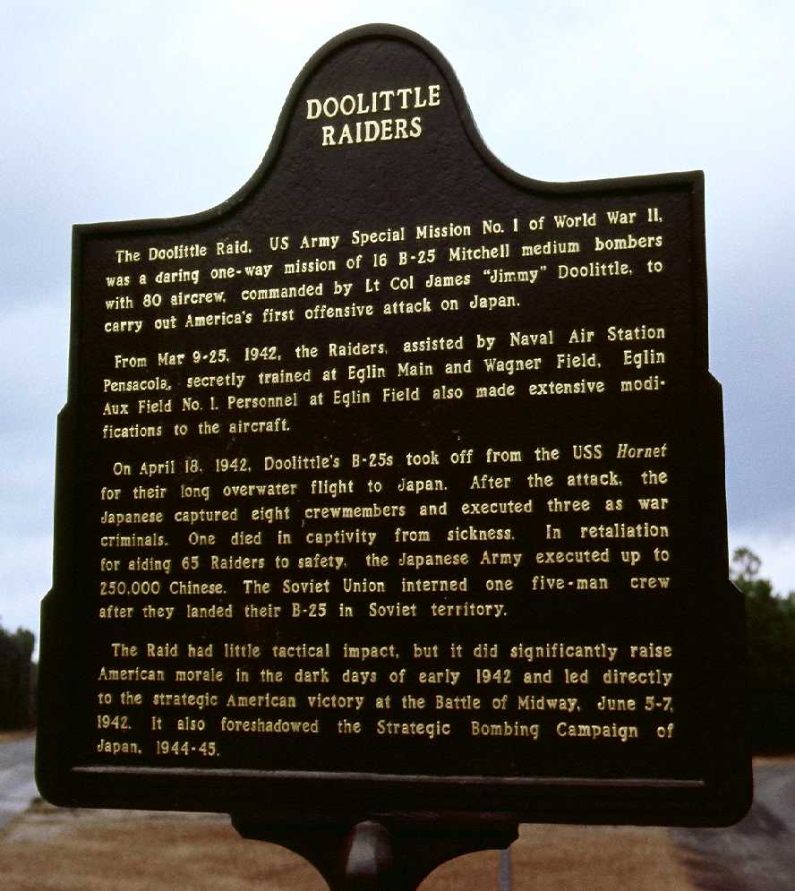
According to a historical plaque (photographed by Mark Sublette in 2009) at the at the entrance to Eglin Aux #1,
from March 9-25, 1942, Lt. Col. Jimmy Doolittle's “Raiders” secretly trained at Eglin Aux #1
for their historic carrier-based B-25 bomber raid on Japan.
Their training was assisted by personnel from nearby NAS Pensacola.
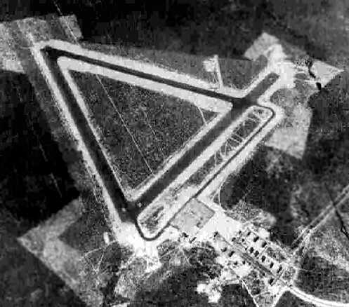
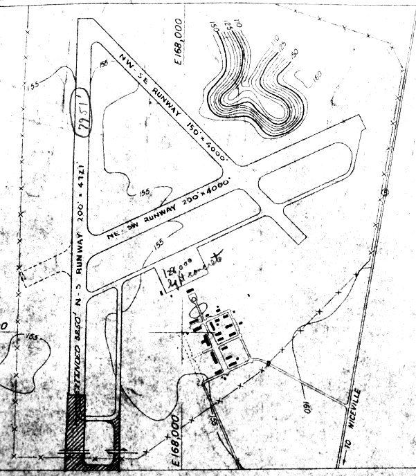
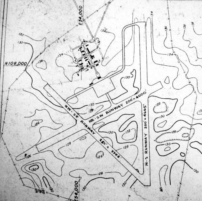
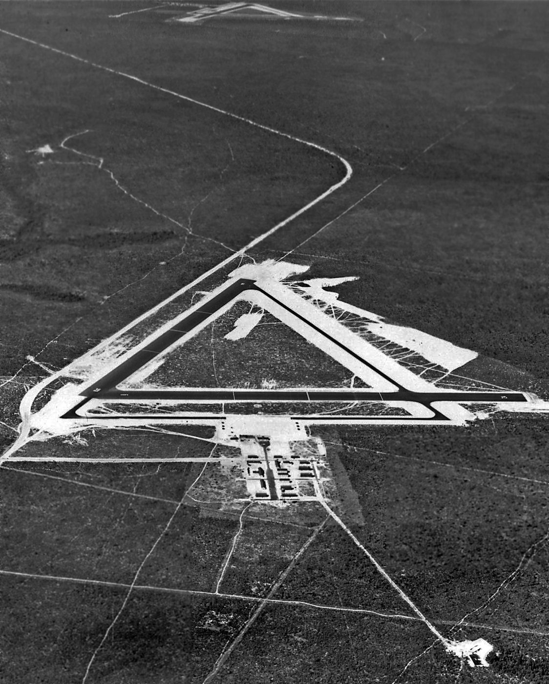
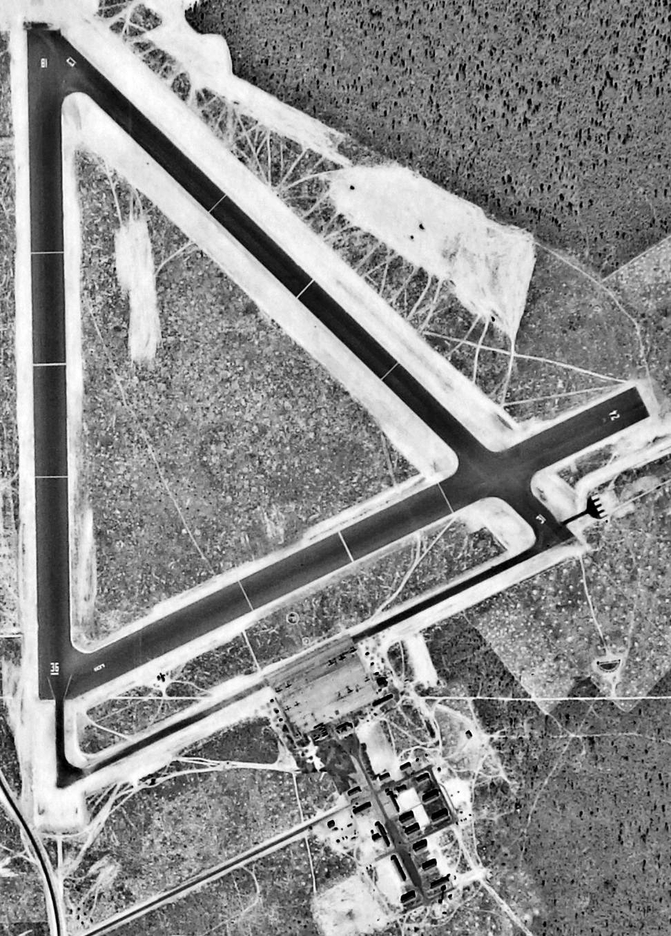
A 9/9/43 aerial view looking southwest at “Eglin Field Auxiliary #1” from the 1945 AAF Airfield Directory (courtesy of Scott Murdock).
It depicted “Eglin Field Auxiliary #1” as having 3 asphalt runways in a equilateral triangle, with a taxiway leading to a ramp area at the north end of the field.
There did not appear to be any hangars, but a clearing north of the ramp had a large number of buildings.
The earliest aeronautical chart depiction of Wagner Field which has been located was on the January 1944 Mobile Sectional Chart.
It depicted “#1” as an auxiliary airfield.
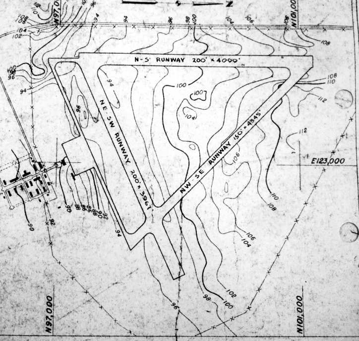
The 1945 AAF Airfield Directory (courtesy of Scott Murdock) described “Eglin Field Auxiliary #1”
as a 450 acre irregularly-shaped property having 3 sand-bituminous runways,
the longest being the 4,000' north/south & northeast/southwest strips.
The field was not said to have any hangars, to be owned by the U.S. Government, and operated by the Army Air Forces.
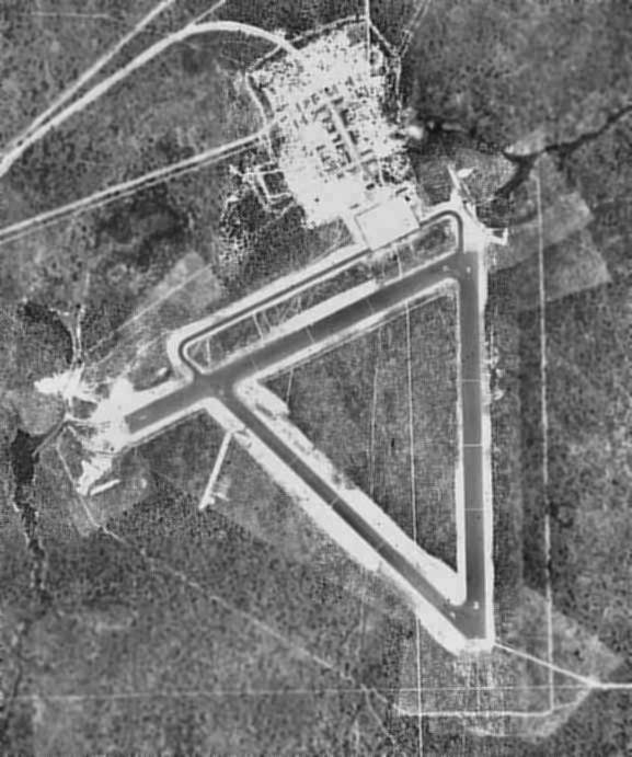
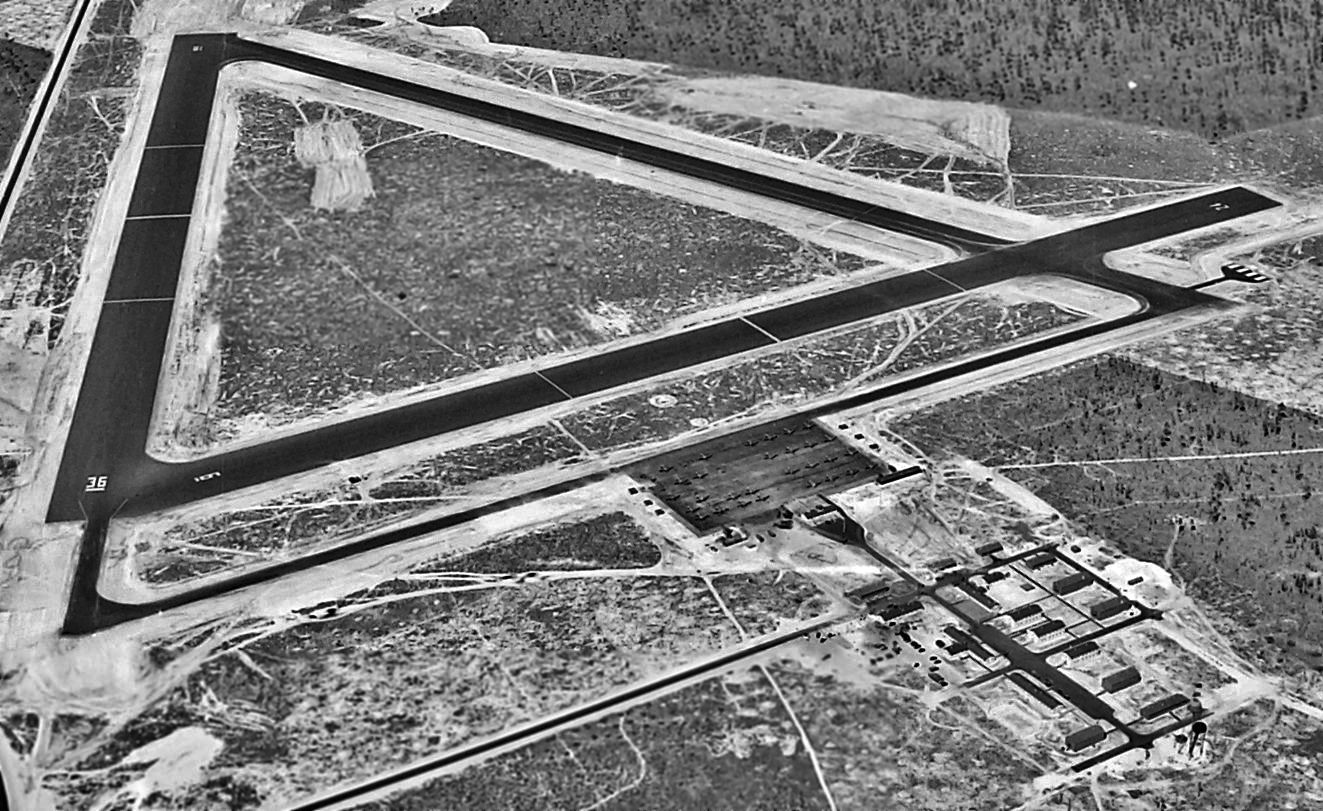
A 1949 USDA aerial photo of Eglin Aux #1, from the Digital Library Center / University of FL George Smathers Libraries (courtesy of Brian Rehwinkel).
The airfield was still in its original WW2-era configuration, with three 5,000' asphalt runways,
with a taxiway leading to a ramp area at the north end of the field.
There did not appear to be any hangars, but a clearing north of the ramp had a large number of buildings (or remains of buildings).
At some point after 1949, an area adjoining the southeast corner of the airfield was cleared,
and a metal launch structure was erected & used to conduct tests of German V-1 rockets.
Fred Edwards recalled, "I was stationed at Eglin from 1955-57.
We pulled duty at an abandoned field north of Niceville for a summer tour of Navy Air Cadets.
The buildings were all closed & sealed. Our job was to open & clean them out. Hindsight is great you know.
The field was used by a 'Major James Doolittle' for his raid on Japan.
The landing strip area still showed signs used to approximate the deck of an aircraft carrier.
I have often wished we kept just a small percentage of what we threw away."
Fred Edwards confirmed that Wagner Aux #1 was used by Doolittle:
"There were several single-story barracks & offices.
We cleaned out the orderly room & found numerous orders, records & notes, some signed by Doolittle.
If we had only known."
At some point between 1949-55 the north/south runway at Wagner Field was lengthened to 7,500',
as that is how it was depicted on a 10/23/55 USGS aerial photo (courtesy of Dallam Oliver-Lee).
The 1956 Mobile Sectional Chart (courtesy of Dallam Oliver-Lee) depicted "AF #1" as having a 7,500' paved runway.
The 1973 USGS topo map depicted "Auxiliary Field #1" as having 2 paved runways, taxiways, and a ramp.
There were no aircraft visible on Wagner on a 1974 aerial photo.
"Eglin AF #1" was still depicted as an active airfield on the 1980 New Orleans Sectional Chart, with a 7,500' paved runway.
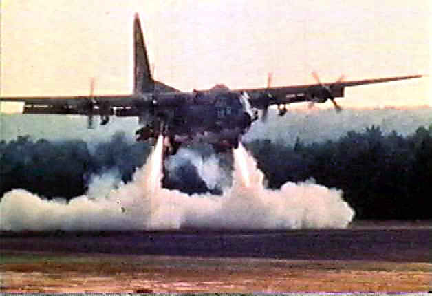
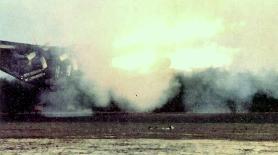
A rare 1980 photo (courtesy of Tim Rathbone) of the exotic prototype YMC-130H Credible Sport 1,
firing its downward-facing rockets in a test of its STOL capabilities at Wagner Field.
Wagner Field played a pivotal role in the testing of one of the most unorthodox American military aircraft,
conceived as an urgent response to the Iranian Hostage Crisis & the unsuccessful attempt to rescue the hostages.
According to Tim Rathbone, “Wagner Field was the test site of the Credible Sport program from August-October 1980.
After the failure of the hostage rescue mission in Iran on 4/24/80,
the Office of the Secretary of Defense Directorate approached Lockheed Georgia to modify 3 C-130H aircraft
for a planned 2nd hostage rescue mission to Iran.
The 'Credible Sport' Phase 1 program was initiated by the OSD directorate
and was designed to validate short takeoff & landing approach configuration & associated avionics.
The airframes for CS Phase 1 were tested in September-October 1980.
The original CS1 aircraft was a single-point design & only explored a limited portion of the flying envelope.
The CS1 aircraft were designed for a specific, limited mission.
The Phase I program did not posses the normal margins of safety required for peacetime operations.”
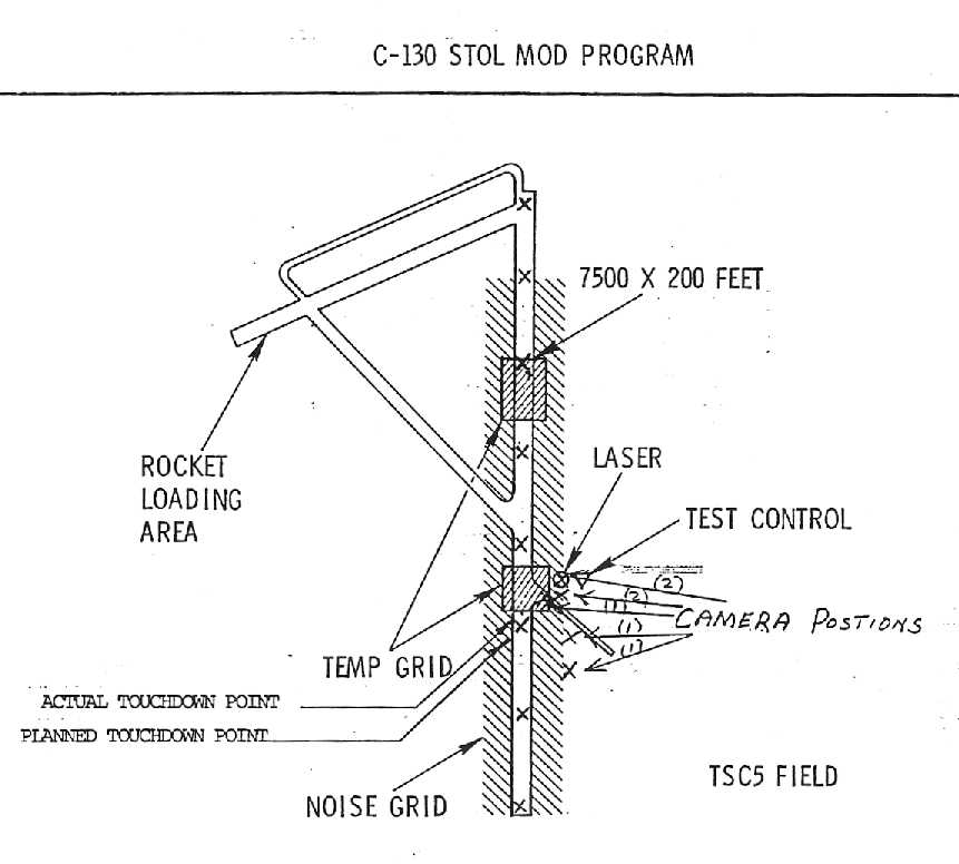
A 1980 diagram (courtesy of Tim Rathbone) of the facilities at Wagner field used to test the prototype YMC-130H Credible Sport 1.
According to Tim Rathbone, “The mission: These aircraft were to take off from Eglin AFB in Florida,
and refuel in-flight on the way to Iran, then land in the Amjadien soccer stadium across the street from the U. S. Embassy in Tehran Iran,
with the intention of extracting the American hostages from the Embassy.
After rescuing the hostage these aircraft were to land on the USS Nimitz aircraft carrier in the Persian Gulf.
These airframes were specially modified to take off & land in a very short distance
(specifically the Amjadien or Amjadieh soccer stadium across the street from the embassy).
Airframe modification included but were not limited to the following:
Take off & landing capability was as follows to make a ground clearance of 90' at 600' from the starting point, as was the case for testing in 1980.”
Tim continued, “The airframe was fitted with an array of 30 rockets on the airframe:
8 ASROC/Zenith engines pointing forward in fairings on the fuselage side,
8 pointing straight down along the forward fuselage at the wheel wells to cushion the landing
and fire approximately 6 inches from the ground for reverse-thrust augmentation.
For takeoff 8 ASROC engines provided lift pointing back & down on rear fuselage
and 6 smaller rocket engines (Platypus), 2 on each wing pylon mount
and 2 on the rear fuselage forward of the beaver tail to prevent over-rotation of the airframe.
Horsal (horsals) fins were installed forward of the Horizontal stabilizers,
a dorsal fin was fitted on the rudder spine, the flaps were double-slotted, and the ailerons were extended.
An In-flight refueling pod from a C-141 was installed on the fuselage centerline.
A tail hook was fitted forward of the rear cargo door; for the planned carrier landing.”
Tim continued, “Avionics modifications were as follows: A DC-130 type radome with a FLIR turret was installed on the nose.
This FLIR turret was slaved to the onboard computer
and in combination with the FLIR telemetry & mission avionics fired the forward-pointing rockets 20' above the ground.”
Tim continued, “Lockheed # A.F. Serial Number # 4658 382 c-41 d 74-1683, airframe #1
was modified to a YMC-130H configuration for a rescue operation in Iran,
with a C-141 in-flight refueling pod, DC-130 type radome, 30 rockets total (ASROC engines provided by the Navy)
pointing forward & downward on the forward & rear fuselage.
This was the 1st airframe modified. It was tested at Wagner Field. It flew approximately 4 test flights there.
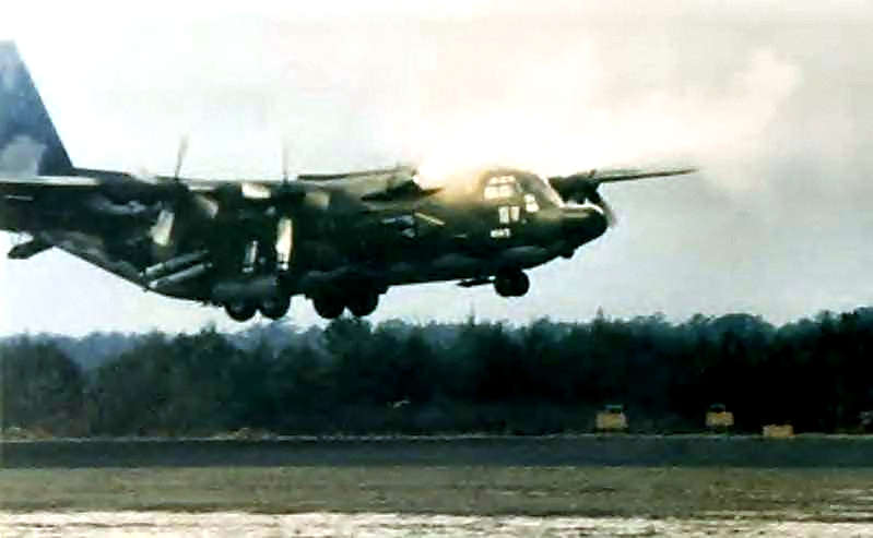
A 1980 photo (courtesy of Tim Rathbone) of the prototype YMC-130H Credible Sport 1,
firing its forward-facing retrorockets in a test of its STOL capabilities at Wagner Field.
An amazing 1980 photo (courtesy of Tim Rathbone) of the prototype YMC-130H Credible Sport 1,
violently firing its forward-facing retrorockets in a test of its STOL capabilities at Wagner Field.
According to Tim Rathbone, “This airplane crashed at a demonstration on 10/29/80 with Col. Belden as Pilot In Command.”
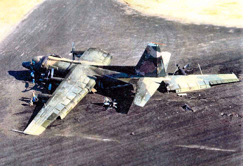
A 1980 photo (courtesy of Tim Rathbone) of the wreckage of the prototype YMC-130H Credible Sport 1,
after its crash at Wagner Field caused by improper timing of the firing of its retrorockets.
According to Tim Rathbone, “The airframe was buried at Wagner Field / Eglin Air Force Aux #1.”
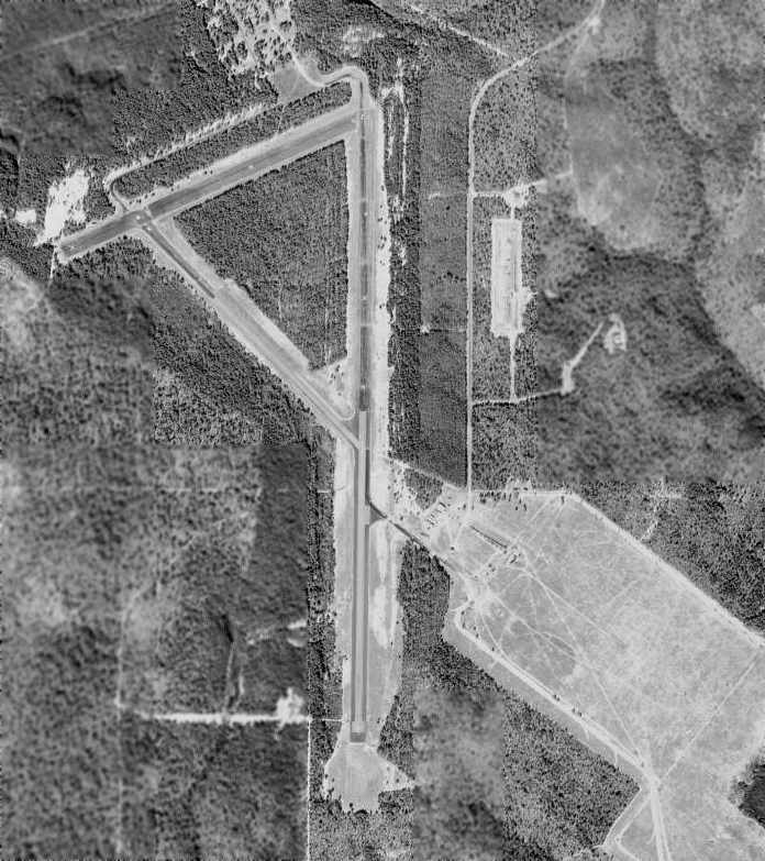
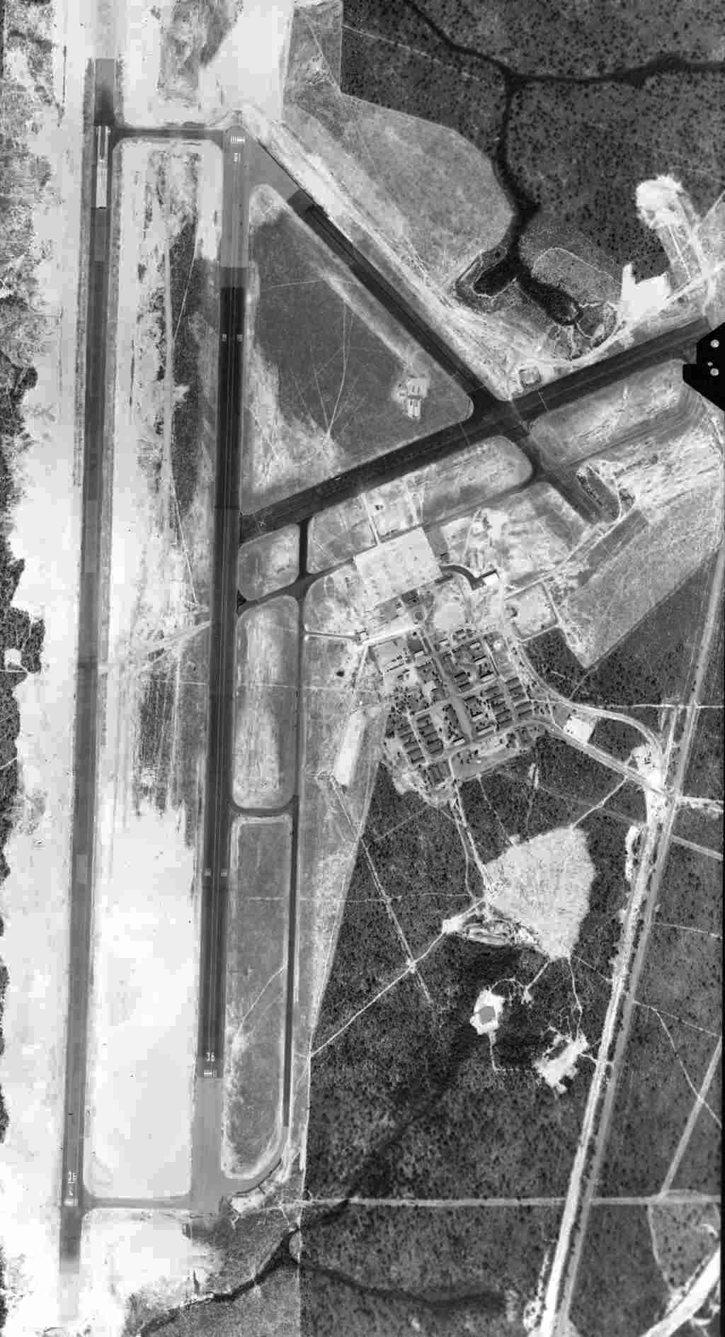
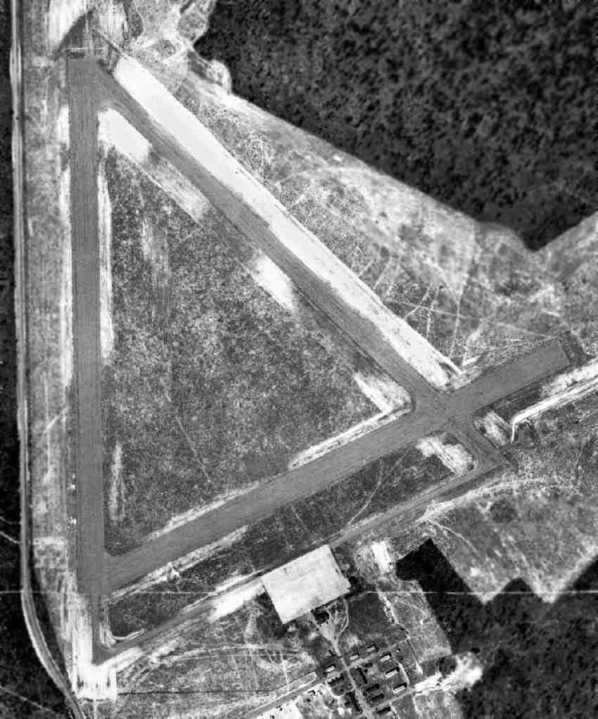
As seen in the 1998 USGS aerial photo, the remains of 3 paved runways still exist (the longest is 8,000' long).
According to Kevin Russo, “The cleared area [extending away from the airfield toward the southeast]
is the northwest tip of a bombing range called C-72.”
The metal launch structure used for post-WW2 tests of German V-1 rockets was still visible, at the top of this cleared area.
Wagner is still used today as a satellite airfield for Eglin Air Force Base, particularly for airdrops of troops & equipment.
It is also known as Eglin Test Site C5.
Kevin Russo reported in 2005, “I've been down at Eglin AFB over the last few months
supporting some Unmanned Aerial Vehicle test flights at the C-5 (Auxiliary Field #1) test site.
At C-5 there is only one building, a 3 story control tower, that looks like it could date back to the 1940's.
All the other structures are trailers & a hangar of modern construction.
The rusting metal launch ramp [used for post-WW2 V-1 rocket tests] is still there.
The range control guys told me that no one at Eglin wants to pay to tear the ramp down so there it sits rusting away.”
A 2/15/09 photo by Mark Sublette of the historical plaque at the entrance to Eglin Aux #1
commemorating its use by Jimmy Doolittle during WW2.
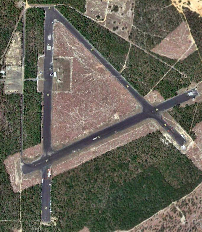
A 3/28/13 aerial photo (courtesy of Dallam Oliver-Lee) showed the Wagner airfield remaining in good shape.
Notably all 3 of the runways were marked with closed-runway “X” markings except for the southern half of the north/south runway.
____________________________________________________
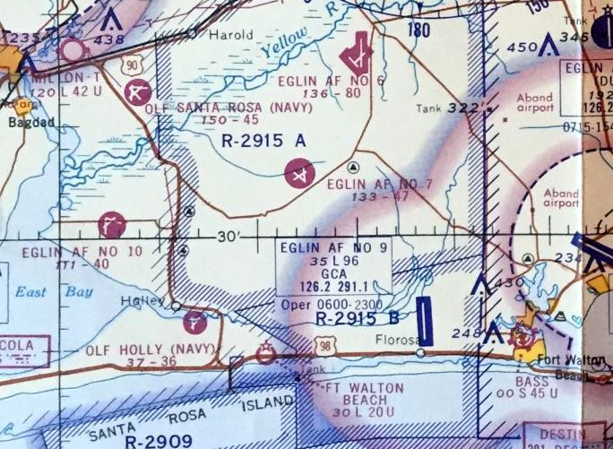
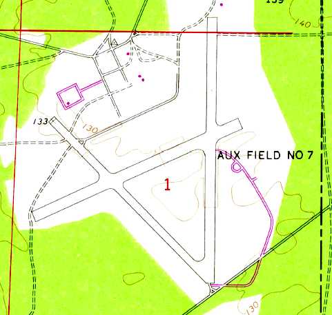
Epler Field / Eglin Air Force Aux #7, Fort Walton Beach, FL
30.53, -86.8 (West-Northwest of Eglin AFB, FL)
The Eglin Aux #7 airfield as depicted on the January 1944 Mobile Sectional Chart.
No airfield was yet depicted at this location on the 1938 USGS topo map (courtesy of Dallam Oliver-Lee).
Epler Field was established as one of numerous satellite airfields which supported Eglin AAF.
Brian Rehwinkel reported, “According to a 1944 History of the Army Air Forces Proving Ground Command (AFHRA/Air Force Historical Research Agency),
plans for the first 3 fields [Eglin Auxiliary fields] were approved in October 1940.
Although there was an initial proposal for 11 fields, only 3 were approved initially.
These 3 fields were Auxiliary Fields #2, #4, and #7.
Work began in January 1941, and work proceeded pretty slowly.
By October 1941, according to this document, only one field, Auxiliary Field #2, was substantially complete.
The beginning of the war obviously lit a fire under the construction process because by latter part of December Fields #4 & #7 were complete.
The proving grounds history also makes note of the oddity that Field #7 was included as one of the first fields built.
Fields # 2 & 4 made sense because they are the 2 closest fields to the main airfield, but Field # 7 was the farthest away at the time
(17.3 air miles away from the main field according to the document).”
Brian continued, “Initially, these fields consisted of 2 paved runways, a north/south & a northeast/southwest runway each.
There were not buildings at these fields. The original plan was for the planes & personnel to return to Eglin main every evening.
It soon became obvious that this would not work & plans were made to add an operations building with tower,
barracks for enlisted men, officers’ quarters, an administration building, a warehouse, and a mess hall.
At this point, these auxiliaries fields would become more of a sub-base rather than just an auxiliary field.
Each of the fields would be a small installation, with facilities & staff to carry out their mission.”
Brian continued, “A 3rd runway was authorized for Auxiliary Field #4 & the other 6 gunnery fields in August 1942.
All of the fields received a 3rd northwest/southeast runway.”
Field #7 was not yet depicted on the December 1942 Mobile Sectional Chart.
The earliest depiction which has been located of Field #7 was on the January 1944 Mobile Sectional Chart.
Brian Rehwinkel reported, “In March 1944, all of the Auxiliary Fields, previously only referred to by their numerical designation, were named for fallen airman.”
The earliest photo which has been located of Epler Field was a 1/18/46 aerial view (from the U of FL Libraries).
It depicted Epler Field as having 3 asphalt runways, paved taxiways, ramps, and a number of buildings.
No aircraft were visible on the field.
A January 1949 aerial view of Eglin Aux #7 (US Government photo, courtesy of the FL DOT, via Brian Rehwinkel).
There may be one or 2 aircraft parked on the apron.
Note the number of barracks or administrative buildings, north of the airfield.
A circa 1950 layout of “#7 Epler Airdrome” (from the St. Louis National Personnel Records Center, courtesy of Ron Plante)
depicted it as having 3 paved runways with a paved ramp on the northwest side.
There were no aircraft visible on Epler on a 1955 aerial photo.
The 1956 Mobile Sectional Chart (courtesy of Dallam Oliver-Lee) depicted "AF #7" as having a 4,700' paved runway.
The February 1966 Mobile Sectional Chart (courtesy of David Stevenson) depicted "Eglin AF #7" as having 3 paved runways, with the longest being 4,700'.
The 1970 USGS topo map depicted "Aux Field #7" as having 3 paved runways.
A 1974 aerial view showed that the north/south runway had been repaved in concrete at some point between 1955-74.
"Eglin AF #7" was still depicted as an active airfield on the January 1976 New Orleans Sectional Chart (courtesy of Chris Kennedy),
and described as having a 4,700' hard-surface runway.

As seen in the 1994 USGS aerial picture, Epler Field consisted of 3 paved runways (the longest, 18/36, is 5,200' long).
Epler Field was officially closed as an airfield at some point between 1976-2000.
Although not publicly listed as an active airfield, Epler is still an operating airfield that is used to support special operation activity within the Eglin complex.
It is also known as Test Area B-12.
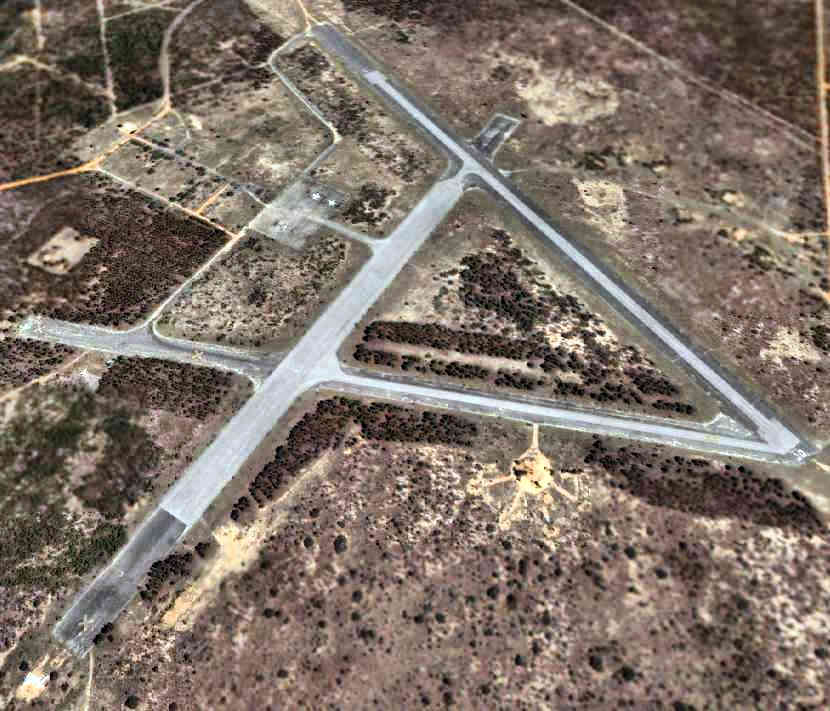
A 2005 USGS aerial picture looking northeast at Epler Field.
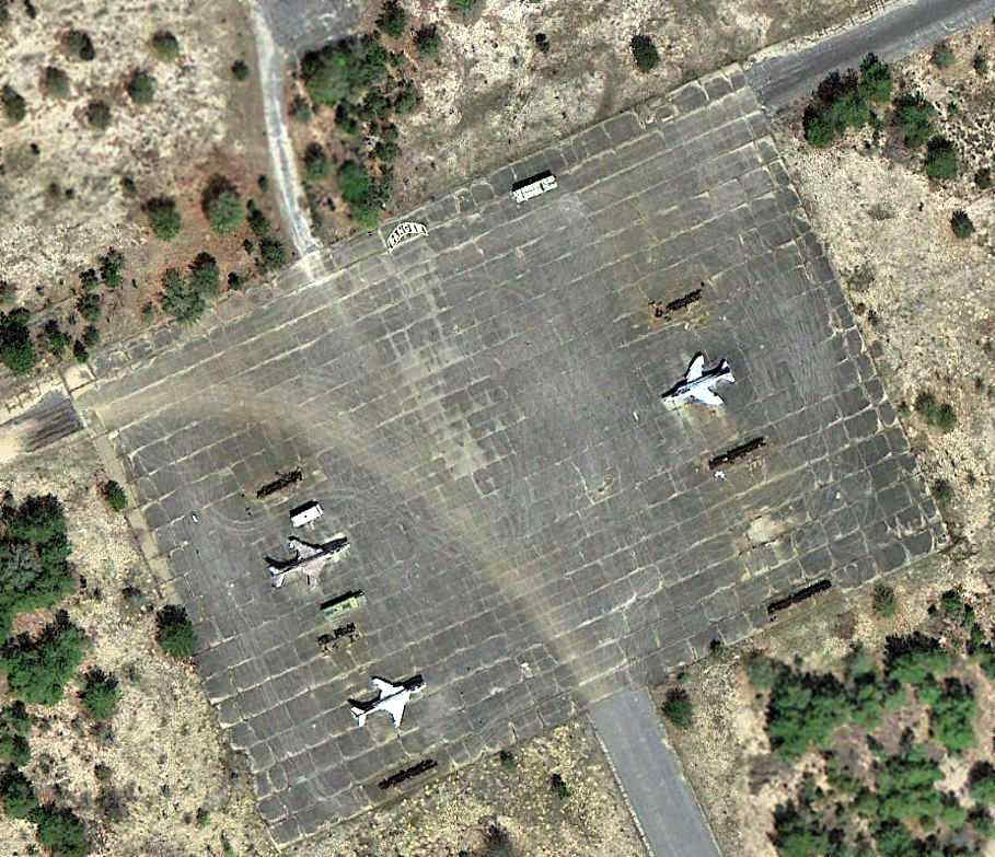
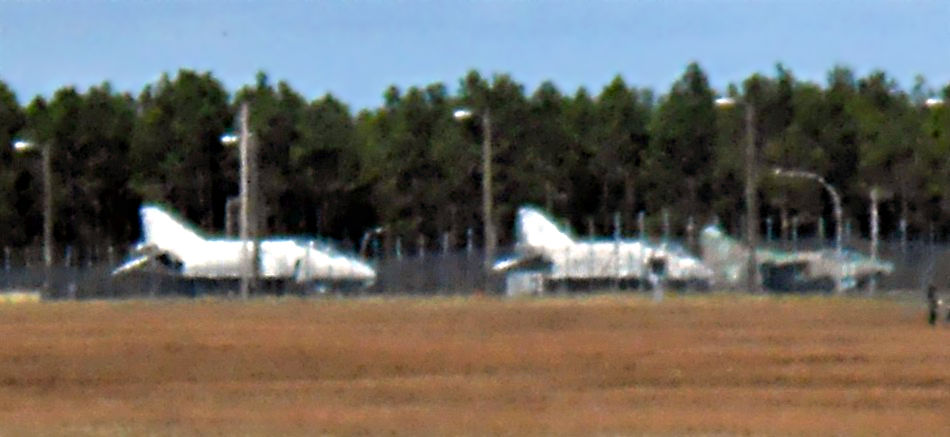
A 3/28/13 aerial photo (courtesy of Dallam Oliver-Lee) of 2 F-101 Voodoos & an F-4 Phantom on the Epler Field ramp.
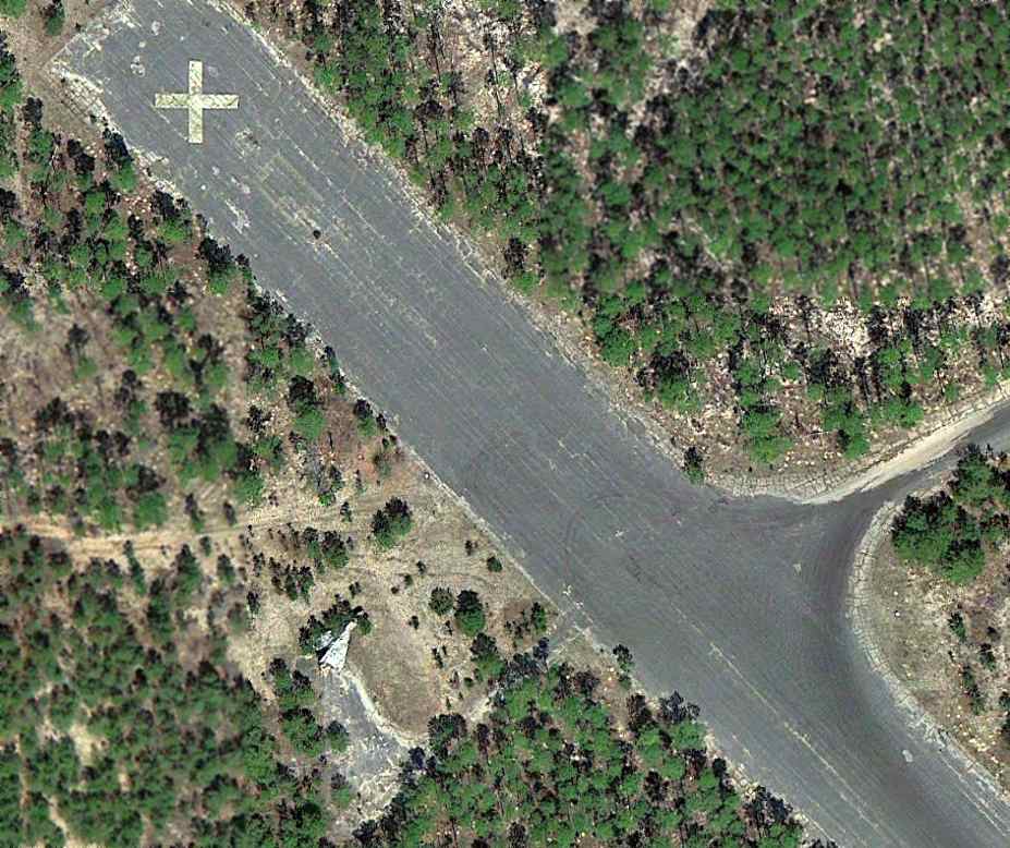
A 3/28/13 aerial photo (courtesy of Dallam Oliver-Lee) of a delta-wing fighter (either an F-102 or F-106) next to the northeast end of Epler Field's Runway 13.

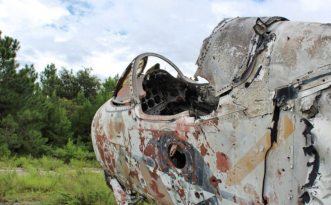
A 2024 photo (courtesy of Cam Brown) of a rare “family model” Air Force Convair TF-102A Delta Dagger rotting away on Epler Field.
Cam reported, “Epler is still used to practice airfield interdiction and most of the aircraft sitting there are riddled with bullet holes.”

A 2024 photo (courtesy of Cam Brown) of an Air Force McDonnell Douglas F-15C Eagle at Epler Field.
Cam reported, “Within the last year or so they’ve added an F-15C to their ramp.”

A 2024 photo (courtesy of Cam Brown) of an Air Force McDonnell Douglas F-4E Phantom II at Epler Field.

A 2024 photo (courtesy of Cam Brown) of an Air Force McDonnell F-101B Voodoo at Epler Field.
Cam reported, “All of the old trucks on this field are filled with empty shell casings & spent ammunition.”
____________________________________________________
Baldsiefen Field / Eglin Air Force Aux #8, Valparaiso, FL
30.54, -86.32 (Northeast of Eglin AFB, FL)
Eglin Auxiliary Army Airfield #8, as depicted on the January 1944 Mobile Sectional Chart.
Baldsiefen Field is one of numerous satellite airfields built during WW2 for the use of Eglin AAF.
Baldsiefen was evidently established at some point between 1941-44, as it was not yet depicted on a 1941 aerial photo or the June 1942 Mobile Sectional Chart.
The depiction which has been located of Baldsiefen Field was on the January 1944 Mobile Sectional Chart, which depicted “#8” as an auxiliary airfield.
The earliest photo which has been located of Baldsiefen was a 1949 USDA aerial photo
from the Digital Library Center / University of FL Smathers Libraries (courtesy of Brian Rehwinkel).
It was not apparent if the field was still in use, as there were no aircraft visible on the field.
The airfield consisted of 2 asphalt 5,500' runways, as well as 2 taxiways leading to a small ramp at the south end of the field.
There did not appear to be any buildings at the airfield.
Note the network of dispersal aircraft parking pads visible to the north of the northeast/southwest runway.
A circa 1950 layout of “#8 Buldsiefen Airdrome” [sic] (from the St. Louis National Personnel Records Center, courtesy of Ron Plante) depicted it as having 2 paved runways with a paved ramp on the south side.
The 1956 USGS topo map depicted Baldsiefen Field as having 2 paved runways, taxiways, and a ramp at the southwest corner.
The last aeronautical chart depiction which has been located showing Baldsiefen Field still open was on the March 1960 Mobile Sectional Chart.
It depicted "Eglin AF #8" as having a 5,000' paved runway.
"Eglin AF #8" was evidently closed at some point between 1956-64,
as that is how it was labeled on the 1964 Mobile Sectional Chart (courtesy of John Voss).
It was described as having a 5,000' hard-surface runway.
The 1970 USGS topo map depicted 2 unpaved runways, without labeling the airfield at all.
A 1974 aerial photo showed that both runways appeared to have been cratered along several portions,
so the field may have been used for target practice or runway battle damage repair.
No trace remained of the the network of dispersal aircraft parking pads originally located to the north of the northeast/southwest runway.
As seen in the 1995 USGS aerial photo, Baldsiefen Field's two 5,500' paved runways still existed,
but both runways appeared to have been cratered along several portions.
Note that no trace remains of the the network of dispersal aircraft parking pads originally located to the north of the northeast/southwest runway.
Baldsiefen is located in an area of the Eglin base called Range 52.
It is currently used for training involving rough field landings & takeoffs, cargo extractions, air assault landings & parachute drops.
A closeup from a circa 2000-2005 USGS aerial photo, showing 4 aircraft (used as targets?) parked on the Baldsiefen Field ramp,
including an A-4 Skyhawk & an F-4 Phantom.
A 3/28/13 aerial photo (courtesy of Dallam Oliver-Lee) showing the effect of numerous bomb hits on Baldsiefen Field.
A 3/28/13 aerial photo (courtesy of Dallam Oliver-Lee) of the Baldsiefen ramp, showing all that remains of the F-4 Phantom & an unidentified aircraft.
____________________________________________________
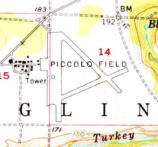
Piccolo Field / Eglin Air Force Aux #5, Valparaiso, FL
30.59, -86.62 West (Northwest of Eglin AFB, FL)
The earliest aeronautical chart depiction which has been located of Eglin Auxiliary #5 was on the January 1944 Mobile Sectional Chart.
Piccolo Field as it was not yet depicted on the 1937 USGS topo map (courtesy of Dallam Oliver-Lee).
Piccolo Field was established as one of numerous satellite airfields which supported Eglin AAF.
Brian Rehwinkel reported, “According to a 1944 History of the Army Air Forces Proving Ground Command (AFHRA/Air Force Historical Research Agency),
plans for the first 3 fields [Eglin Auxiliary fields] were approved in October 1940.
In May of 1941, four additional fields were started - Fields #1, #3, #5, and #6.
Initially, these fields consisted of 2 paved runways, a north/south & a northeast/southwest runway each.
There were not buildings at these fields. The original plan was for the planes & personnel to return to Eglin main every evening.
It soon became obvious that this would not work & plans were made to add an operations building with tower,
barracks for enlisted men, officers’ quarters, an administration building, a warehouse, and a mess hall.
At this point, these auxiliaries fields would become more of a sub-base rather than just an auxiliary field.
Each of the fields would be a small installation, with facilities & staff to carry out their mission.”
Brian continued, “A 3rd runway was authorized for Auxiliary Field #4 & the other 6 gunnery fields in August 1942.
All of the fields received a 3rd northwest/southeast runway.”
The earliest depiction which has been located of Eglin Auxiliary #5 was on the January 1944 Mobile Sectional Chart.
Brian Rehwinkel reported, “In March 1944, all of the Auxiliary Fields, previously only referred to by their numerical designation, were named for fallen airman.”
A circa 1950 layout of “#5 Piccolo Airdrome” (from the St. Louis National Personnel Records Center, courtesy of Ron Plante)
depicted it as having 3 paved runways with a concrete ramp on the southeast side.

The earliest photo which has been located of Piccolo Field was a 4/16/55 U.S. Government aerial photo (from the University of FL online library, via Brian Rehwinkel).
It was not apparent if the airfield was still in use.
The 1956 USGS topo map depicted Piccolo Field as having 3 paved runways, a large ramp along the west side, and a large number of buildings.
Eglin Aux #5 was not depicted at all on the 1956 Mobile Sectional Chart (courtesy of Dallam Oliver-Lee),
unlike most of the other Eglin Auxiliary fields..
"Eglin AF #5" was evidently closed at some point between 1945-64,
as that is how it was labeled on the 1964 Mobile Sectional Chart (courtesy of John Voss).
It was described as having a 4,400' hard-surface runway.
William Staab recalled, “I retired from the Air Force but while I was in I was a Forward Air Controller
who traveled & worked airstrikes at some of those fields.
I spent an awful lot of time down there over the years training with AC-130 gunships.
It was always easier to travel to the airplane for training than trying to bring the airplane you.
Those guys are perpetually busy.
I remember one particular time a group of us were down there training with them & it was either an early Saturday or Sunday morning.
We were working up at Aux 5 sitting off the end of the runway targeting everything in the area, it was a simulated airfield take-down scenario.
The gunship was operating around 5,500’ above ground level
when out of nowhere a MC-130 Combat Talon came blasting underneath the gunship & did an assault landing right in front of us.
Sure got our attention but then the Talon became a target of opportunity for us.
LOLOL sitting there on a closed airfield what a show.”
As seen in the 1995 USGS aerial photo, the remains of 3 runways (the longest is 4,400' long) still exist.
The runways are marked with closed "X" markings.
Piccolo Field currently serves as a microwave station, also known as Eglin Test Site C4.
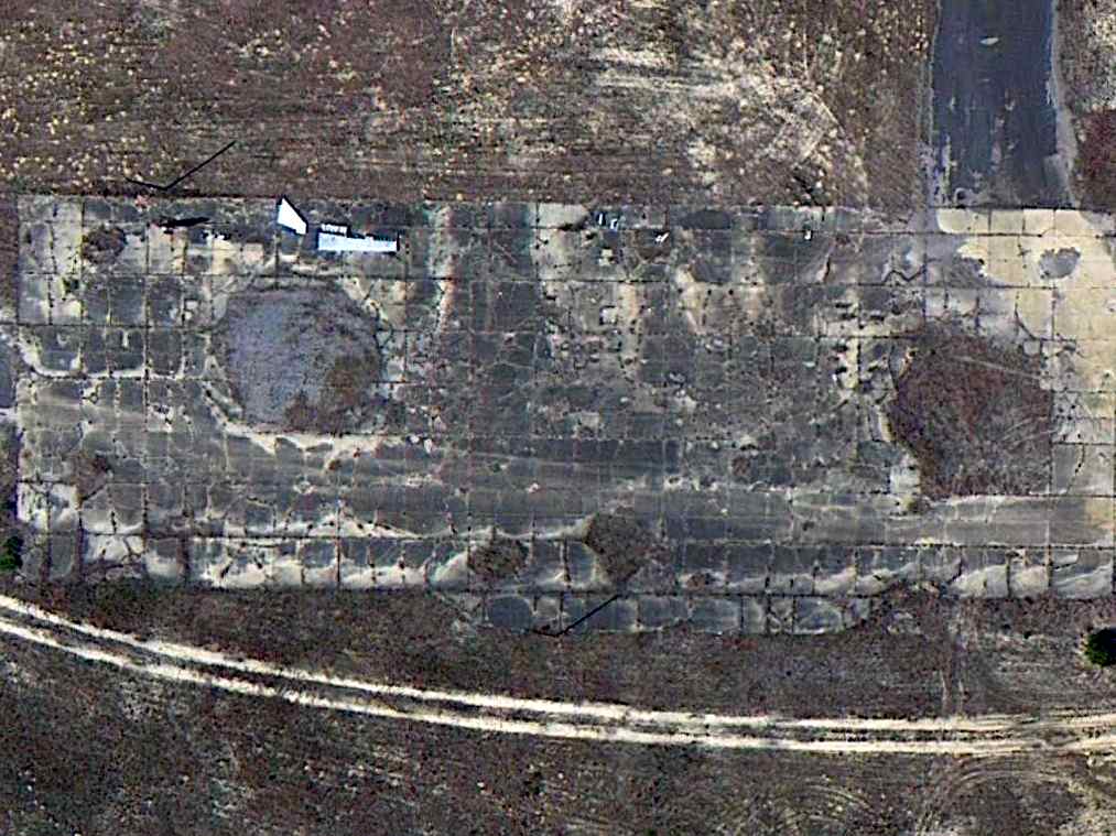
A 3/28/13 aerial view (courtesy of Dallam Oliver-Lee) of Piccolo Field.
____________________________________________________
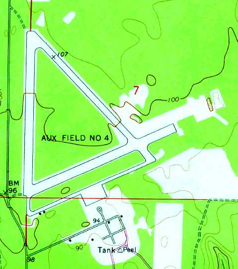
Peel Field / Eglin Air Force Aux #4, Valparaiso, FL
30.51, -86.59 (West-Northwest of Eglin AFB, FL)
A 10/7/42 Army Air Forces aerial photo (courtesy of AFHRA, via Brian Rehwinkel) looking northwest at Auxiliary Field #4, with Auxiliary Field # 5 in the distance.
No airfield was yet depicted at this location on the 1937 USGS topo map (courtesy of Dallam Oliver-Lee).
Peel Field was established as one of numerous satellite airfields which supported Eglin AAF.
Brian Rehwinkel reported, “According to a 1944 History of the Army Air Forces Proving Ground Command (AFHRA/Air Force Historical Research Agency),
plans for the first 3 fields [Eglin Auxiliary fields] were approved in October 1940.
Although there was an initial proposal for 11 fields, only 3 were approved initially.
These 3 fields were Auxiliary Fields #2, #4, and #7.
Work began in January 1941, and work proceeded pretty slowly.
By October 1941, according to this document, only one field, Auxiliary Field #2, was substantially complete.
The beginning of the war obviously lit a fire under the construction process because by latter part of December Fields #4 & #7 were complete.
In May of 1941, four additional fields were started - Fields #1, #3, #5, and #6.
The proving grounds history also makes note of the oddity that Field #7 was included as one of the first fields built.
Fields # 2 & 4 made sense because they are the 2 closest fields to the main airfield, but Field # 7 was the farthest away at the time
(17.3 air miles away from the main field according to the document).”
Brian continued, “Initially, these fields consisted of 2 paved runways, a north/south & a northeast/southwest runway each.
There were not buildings at these fields. The original plan was for the planes & personnel to return to Eglin main every evening.
It soon became obvious that this would not work & plans were made to add an operations building with tower,
barracks for enlisted men, officers’ quarters, an administration building, a warehouse, and a mess hall.
At this point, these auxiliaries fields would become more of a sub-base rather than just an auxiliary field.
Each of the fields would be a small installation, with facilities & staff to carry out their mission.”
The earliest depiction which has been located of Peel Field
was a 10/7/42 Army Air Forces aerial photo (courtesy of AFHRA, via Brian Rehwinkel) of Auxiliary Field #4 in its original 2-runway configuration.
Brian Rehwinkel reported, “A 3rd runway was authorized for Auxiliary Field #4 (and the other 6 gunnery fields) in August 1942.
All of the fields received a 3rd northwest/southeast runway.
As with each of the gunnery fields, Field #4 had 2 nearby gunnery ranges.
One of the ranges was located about 2.5 miles to the southwest of the field & the other was about the same distance to the northwest.”
A 3/4/43 US Army Air Forces aerial view (courtesy of the National Archives, via Brian Rehwinkel) looking north at Auxiliary Field #4,
showing the new 3rd runway, and a large number of aircraft on its ramp.
A 1943 Eglin Proving Ground Map (US Army Air Forces, courtesy of AFHRA via Brian Rehwinkel) of Auxiliary Field # 4 in its original 2-runway configuration.
Other Eglin auxiliary airfields & the gunnery ranges were also shown.
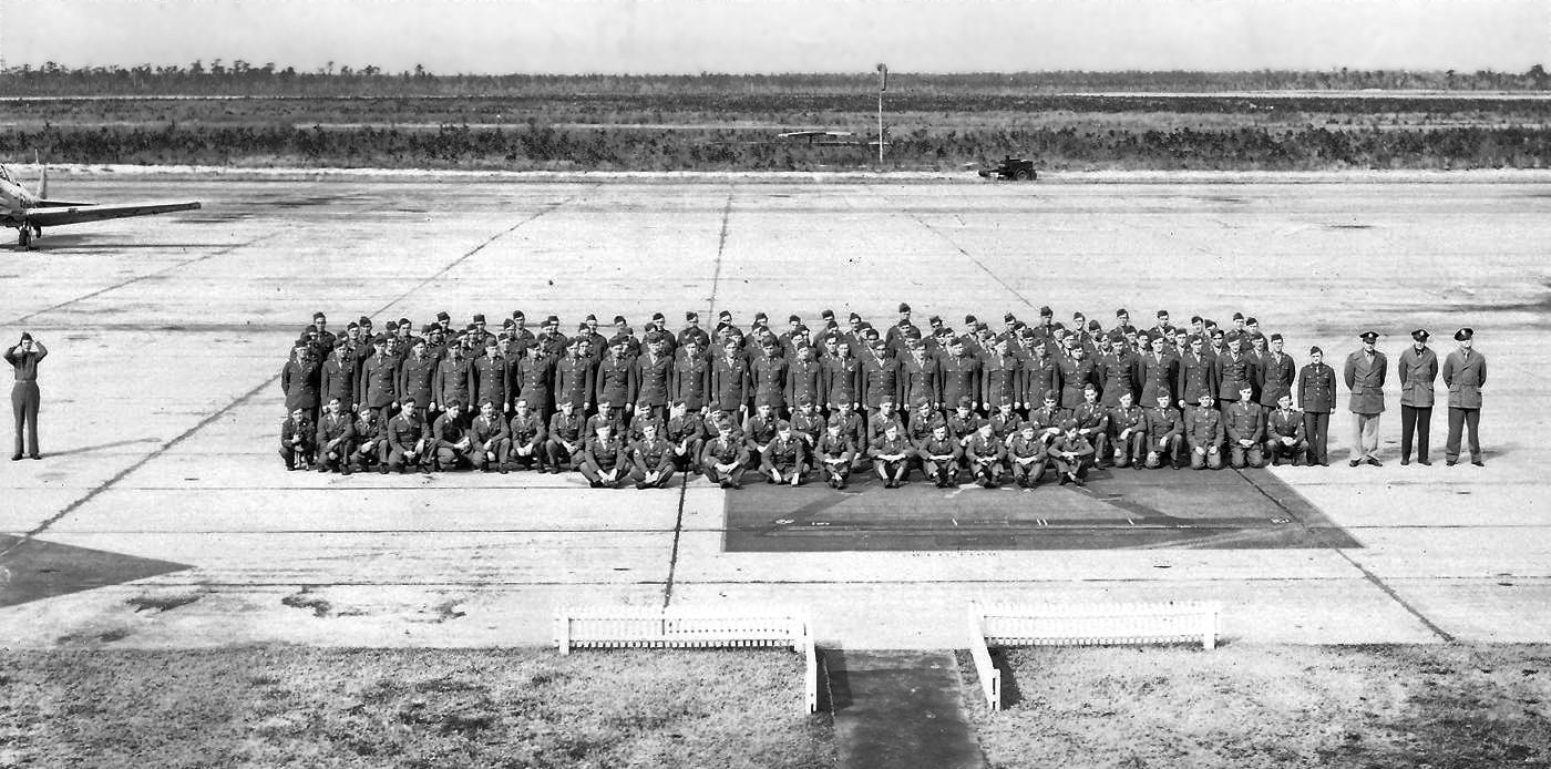
A circa 1943-44 US Army Air Forces photo (courtesy of AFHRA, via Brian Rehwinkel) of personnel at Auxiliary Field #4.
Brian Rehwinkel observed, “The photo was apparently taken from the tower of the operations building & the runways are in the background of the picture.
If you look carefully, you can see a portion of a site map of the auxiliary field painted on the ramp in front of the group.”
A 1/16/44 US Army Air Forces aerial view (courtesy of the National Archives, via Brian Rehwinkel) of Auxiliary Field #4, showing 10 aircraft on its ramp.
The earliest aeronautical chart depiction which has been located of Eglin Auxiliary #4 was on the January 1944 Mobile Sectional Chart.
It depicted “#4” as an auxiliary airfield.
Brian Rehwinkel reported, “In March 1944, all of the Auxiliary Fields, previously only referred to by their numerical designation, were named for fallen airman.
Auxiliary Field #4 was named for 2nd Lt. Garland Peel, a gunnery instructor at Eglin Field who died in a plane crash on 1/2/42 near the main base.
Field #4 had 3 asphalt runways (at the end of WWII) of 4,000’ x 200’, 4000’ x 200’, and 4,300 x 150’ on approximately 415 acres.
This field had a concrete parking apron of 25,000 square feet.
The small installation also had an operations building, with a tower, a small nose hangar, aircraft maintenance shops, and housing for about 200 airman & 100 officers.
There was also a mess hall that could handle about 450 people.”
A circa 1950 layout of “#4 Peel Airdrome” (from the St. Louis National Personnel Records Center, courtesy of Ron Plante)
depicted it as having 3 paved runways with a concrete ramp on the southeast side.
A 3/9/55 US Government aerial view of Eglin Aux #4 (courtesy of the FL DOT, via Brian Rehwinkel).
Brian Rehwinkel observed, "Even though this picture shows the field almost 10 years after WW2, all the buildings & runways seem to be intact."
A closeup of what appears to have been a single aircraft on the ramp,
from the 3/9/55 US Government aerial view of Eglin Aux #4 (courtesy of the FL DOT, via Brian Rehwinkel).
The 1956 Mobile Sectional Chart (courtesy of Dallam Oliver-Lee) depicted "AF #4" as having a 4,300' paved runway.
According to Mark Sublette, articles in the Fort Walton Beach Playground newspaper indicated “In the 1950s & into the 1960s,
Peel Field had old-wartime era housing that families lived in (presumably enlisted),
but these rickety structures were condemned in the early 1960s & torn down.
An occasional illicit drag race by local students on the closed runways was about its only current use... That was about 1963.”
"Eglin AF #4" was described on the 1964 Mobile Sectional Chart (courtesy of John Voss)
as having an 4,300' hard-surface runway.
The 1970 USGS topo map depicted "Aux Field #4" as having 3 paved runways, a taxiway, and a ramp on the south side.
Peel Field was evidently closed at some point between 1964-76,
as that is how it was depicted on the January 1976 New Orleans Sectional Chart (courtesy of Chris Kennedy).
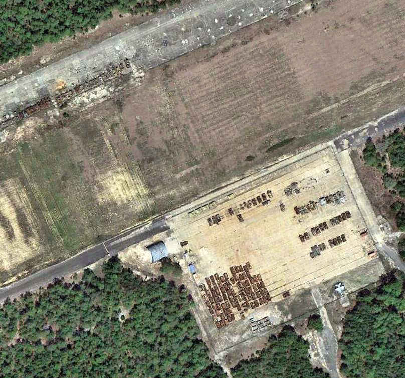
Peel currently serves as the home for a variety of civil engineering & services mobility training programs.
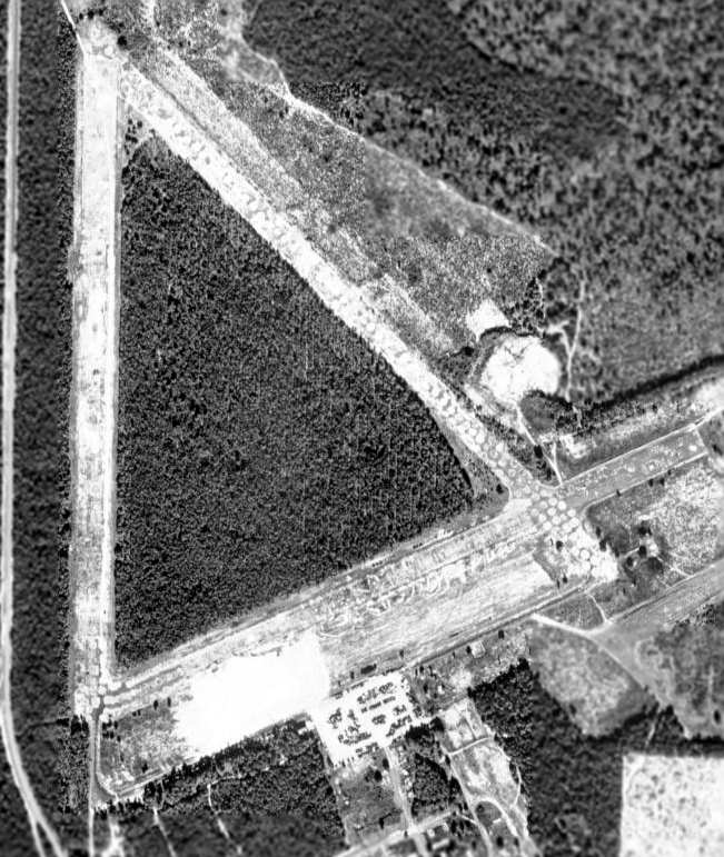
As seen in the 1999 USGS aerial photo, the remains of 3 runways (the longest is 4,400' long) & a large ramp area still exist.
A circa 2000-2005 USGS aerial photo of Peel Field.
A close-up from a circa 2000-2005 USGS aerial photo,
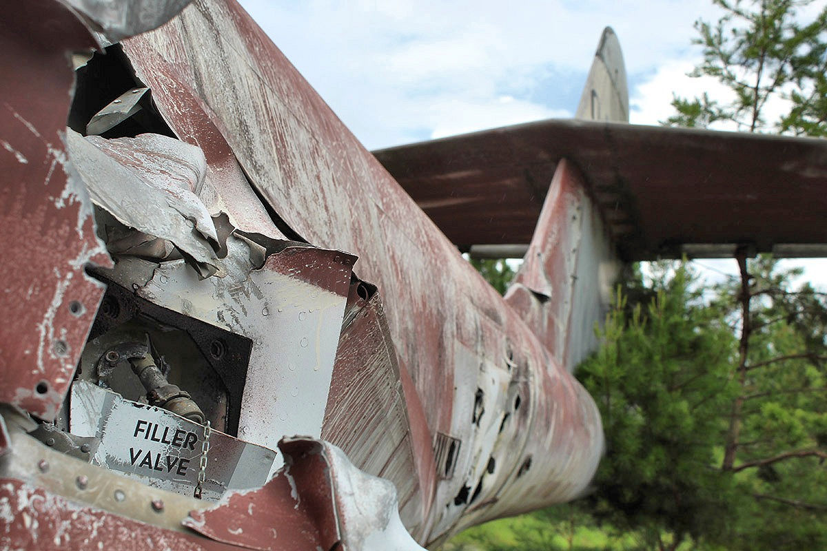
showing the remains of an F-89D Scorpion & an A-4 Skyhawk at the southeast runway intersection of Peel Field.
A 2006 photo by Mark Sublette, looking west at the remains of an F-89D Scorpion (65-NO53-2584) & an A-4A Skyhawk on Peel Field.
Mark observed, “Field 4 appears to be the site where used target aircraft & armor
get dumped after being expended in weapons tests on the Eglin ranges.”
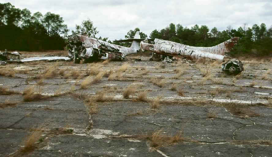
A 2006 photo by Mark Sublette of the remains of an F-89D Scorpion an A-4A Skyhawk on Peel Field.
Mark observed, “That is an early model A-4A Skyhawk, but I was unable to determine its Bureau of Aeronautics Number.”
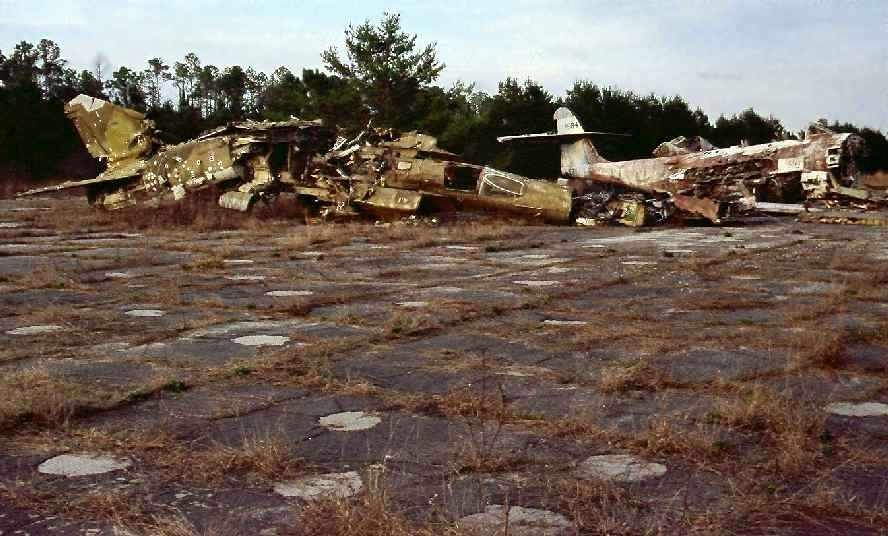
A 2/21/09 photo by Mark Sublette of the remains of a Luftwaffe MiG-23 Flogger, an F-89D Scorpion, and an A-4A Skyhawk on Peel Field.
Mark observed, “Peel Field's large collection of scrap target airplanes (A-7D from Ohio ANG, 2 USCG HH-52s from Mobile, others)
that were on the main ramp in December 2006 were all gone, presumably for scrap, in January,
and all armor is now parked inside a new chain-link with barbed-wire top enclosure.
The F-89 & A-4 were still at the runway intersection & a blasted ex-Luftwaffe [MiG-23, marked] 20+52 had joined them.”
The MiG appears to have taken a serious hit to the midsection – presumably some kind of damage-tolerance evaluation?
Mark Sublette reported in 2009, “The Eglin Aero Modelers flying club
does use the south end of the long runway at Pierce Field, Site C-3, for radio-controlled flying on weekends.”
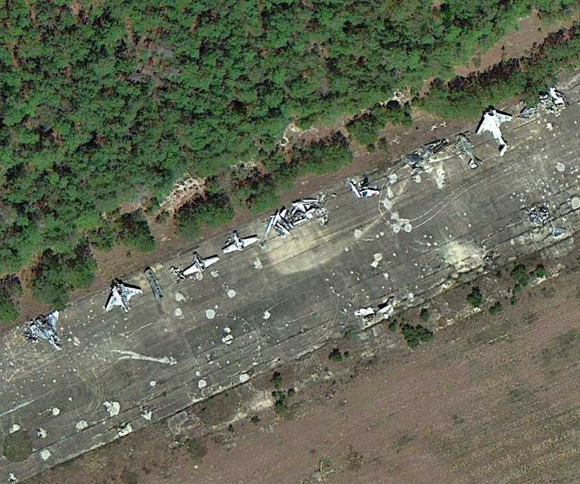
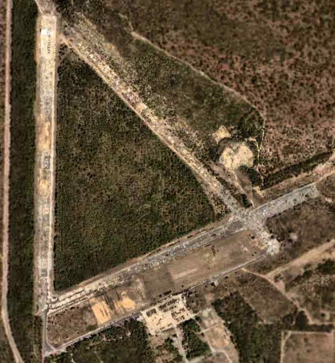
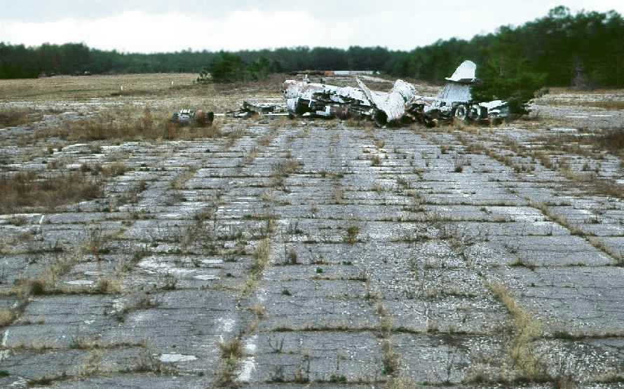
A 3/28/13 aerial view (courtesy of Dallam Oliver-Lee) showing an array of historic aircraft wreckage on a Peel Field runway.
A 3/28/13 aerial view (courtesy of Dallam Oliver-Lee) showing a single F-16 on the Peel Field ramp.

A 9/3/16 photo by Matt Franklin of the sad remains of a Northrop F-89D Scorpion (65-NO53-2584) at Peel Field.
Matt reported, “Most people go to the Panhandle to get trashed on the beach, but I went for the disused airports.
I hope they keep the aircraft around for a while”
A 9/3/16 closeup by Matt Franklin of the sad remains of a Northrop F-89D Scorpion (65-NO53-2584) at Peel Field.
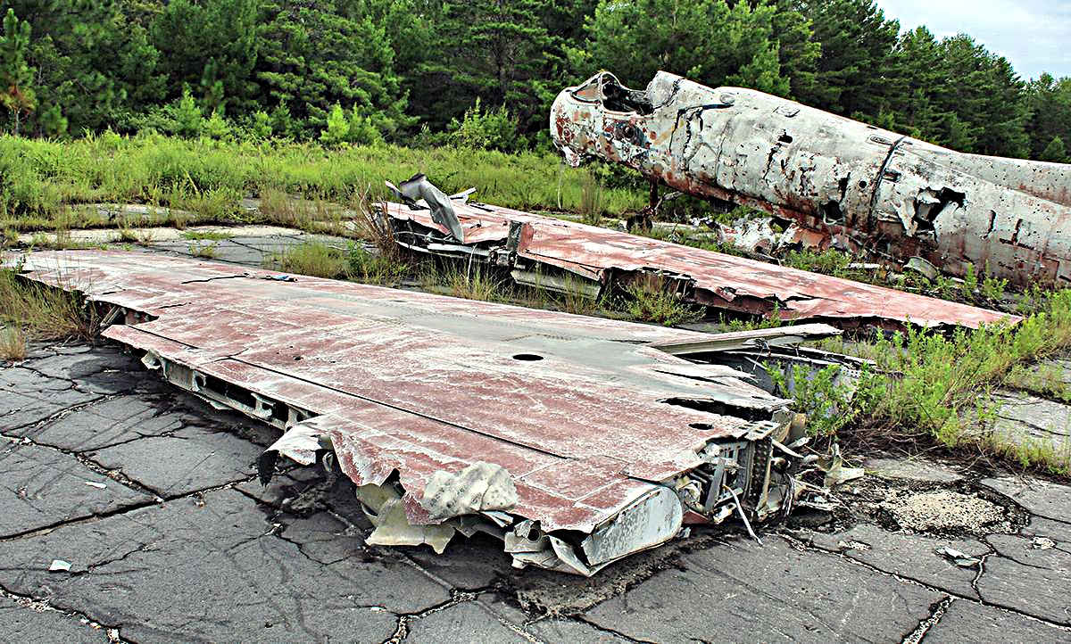
A 9/3/16 photo by Matt Franklin of the sad remains of an early-model Douglas A-4 Skyhawk at Peel Field.
A 9/3/16 photo by Matt Franklin of the cockpit of an early-model Douglas A-4 Skyhawk at Peel Field, exposed to the elements.
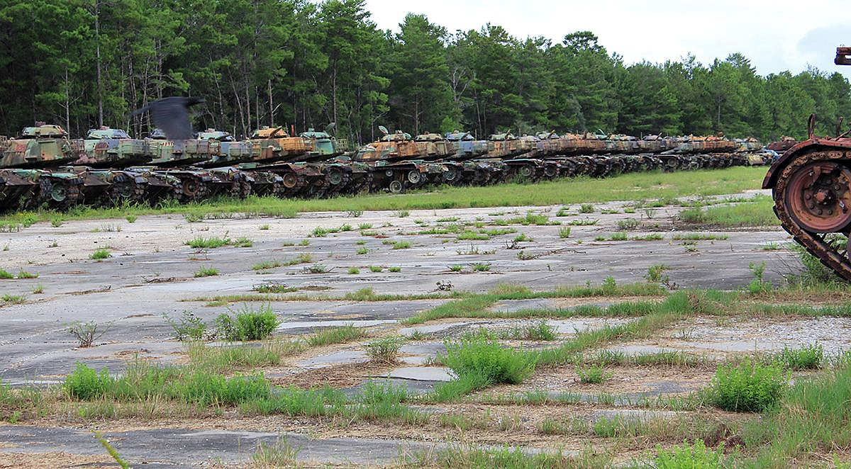
A 9/3/16 photo by Matt Franklin of a long row of M-48 or M-60 tanks “occupying the west runway” at Peel Field.
____________________________________________________
Or if you prefer to contact me directly concerning a contribution (for a mailing address to send a check),
please contact me at: paulandterryfreeman@gmail.com
If you enjoy this web site, please support it with a financial contribution.
____________________________________________________
This site covers airfields in all 50 states.