Abandoned & Little-Known Airfields:
Florida: Fort Lauderdale Area
© 2002, © 2025 by Paul Freeman. Revised 7/25/25.
This site covers airfields in all 50 states: Click here for the site's main menu.
____________________________________________________
Please consider a financial contribution to support the continued growth & operation of this site.
____________________________________________________
Please consider a financial contribution to support the continued growth & operation of this site.
Broward Field / Bradley Field (revised 7/26/21) - Davie NOLF / South Florida Airport (revised 10/6/18)
Forman NOLF / Ft. Lauderdale-Davie Airport / Davie NOLF (revised 7/25/25) - Ft. Pierce Airport (added 9/3/18) - MacArthur Field / Hollywood Airpark (revised 2/4/21)
____________________________________________________
Ft. Pierce Airport, Ft. Pierce, FL
27.408, -80.321 (North of Fort Lauderdale, FL)
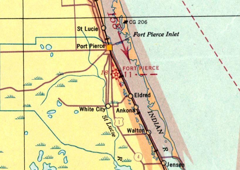
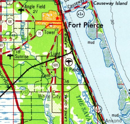
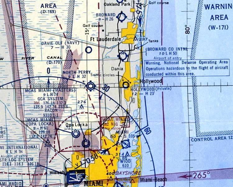
Ft. Pierce Airport, as depicted on the December 1935 Miami Sectional Chart.
The date of establishment of this early airport has not been determined.
The earliest depiction which has been located of Ft. Pierce Airport was on the December 1935 Miami Sectional Chart.
It depicted Ft. Pierce Airport as the Commerce Department's Site 11 along the Miami – Jacksonville Airway.
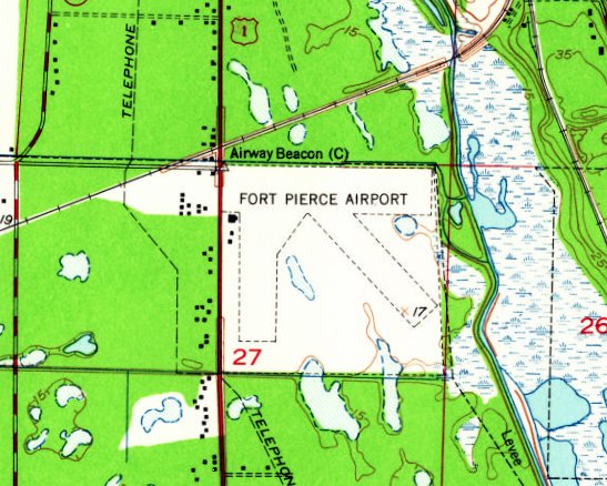
The 1949 USGS topo map depicted Fort Pierce Airport as having 3 unpaved runways,
with 3 small buildings on the west side, and an Airway Beacon on the northwest corner.

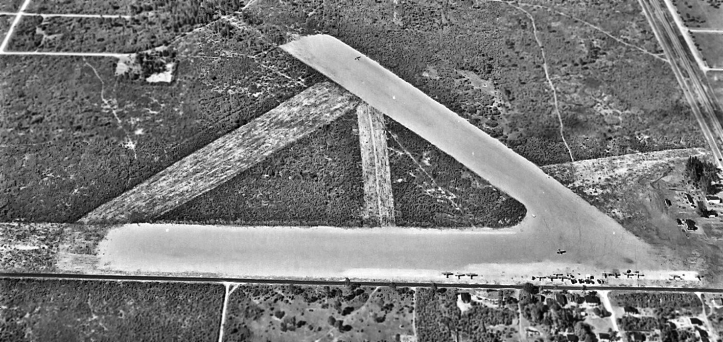
The earliest photo which has been located of Ft. Pierce Airport was a 4/7/50 USGS aerial view.
It depicted Ft. Pierce Airport as having 3 unpaved runways, with an airport circular marking in the northwest corner.
Several small buildings were located on the west side.
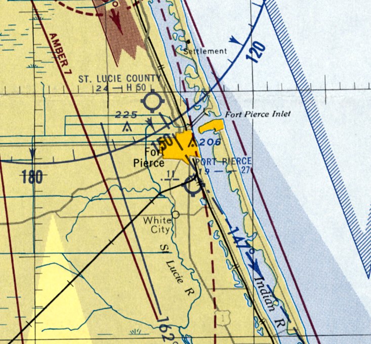
The last aeronautical chart depiction which has been located of Ft. Pierce Airport was on the February 1955 Miami Sectional Chart.
It depicted Ft. Pierce Airport as having a 2,700' unpaved runway.
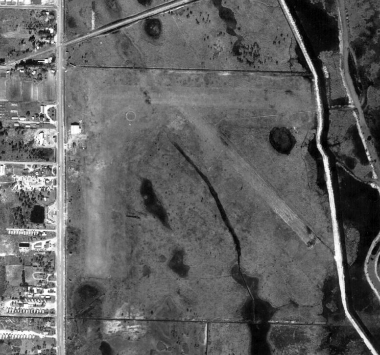
The last photo which has been located of Ft. Pierce Airport was a 1958 aerial view (courtesy of John Crimi).
It depicted Ft. Pierce Airport as having 3 unpaved runways, with an airport circular marking in the northwest corner.
One light single-engine aircraft was visible near a hangar & other small buildings on the west side.
The last topo map depiction which has been located of Ft. Pierce Airport was on the 1959 USGS topo map.
Ft. Pierce Airport was evidently closed at some point between 1955-60, as it was no longer depicted on the February 1960 Miami Sectional Chart.
It had evidently been replaced by the larger St. Lucie County Airport to the northwest.
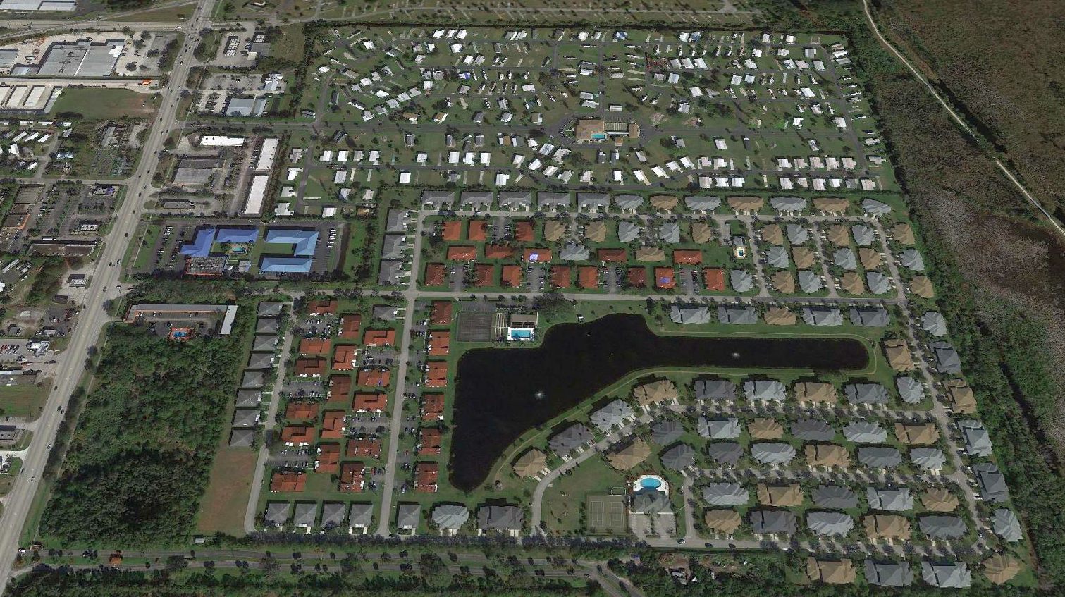
A 2018 aerial view looking north showed no trace remaining of Ft. Pierce Airport, with the property covered by the Sandhill Shores housing development.
The site of Ft. Pierce Airport is located southeast of the intersection of Route 1 & Pleasure Avenue.
Thanks to John Crimi for pointing out this airfield.
____________________________________________________
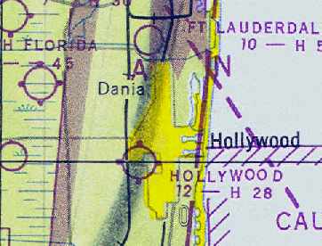
MacArthur Field / Hollywood Airpark, Hollywood, FL
26, -80.15 (South of Fort Lauderdale, FL)
A 3/18/43 National Archives aerial view looking north at MacArthur Field from the 1945 AAF Airfield Directory (courtesy of Brian Rehwinkel).
This small general aviation airport was located in Hollywood, just north of the Dade / Broward County line.
MacArthur Field was evidently established at some point between 1941-43,
as it was not yet depicted on the July 1940 Miami Sectional Chart
nor listed among active airfields in The Airport Directory Company's 1941 Airport Directory (according to Chris Kennedy).
The earliest depiction of MacArthur Field which has been located was a 3/18/43 National Archives aerial view looking north (courtesy of Brian Rehwinkel).
It depicted MacArthur as having 2 unpaved runways connected by 2 taxiways.
There did not appear to be any hangars or other buildings on the airfield.
A total of 14 light single-engine aircraft were visible on the field, most parked on the southeast corner, and one on the northwest runway end.
Brian Rehwinkel observed, “One of the neat things about this photo is that it shows some of the land just north of the airfield
and you can see how there was still some undeveloped land in this area in early 1943.
Just a few years later – soon after the war, this area became a 'sea' of houses as Broward County experienced tremendous post-war growth.”
The earliest aeronautical chart depiction of MacArthur Field which has been located
was on the August 1943 Miami Sectional Chart (courtesy of Chris Kennedy).
It depicted MacArthur as a commercial/municipal airport.
The Haire Publishing Company's 1945 Airport Directory (courtesy of Chris Kennedy)
described MacArthur as a "class 2" airport, owned & operated by the City of Hollywood.
The field was said to have 2 turf runways, and the manager was listed as N. Holzmark.
It was still depicted as "MacArthur" Field on the 1945 Miami Sectional Chart (courtesy of John Voss).
The 1945 AAF Airfield Directory (courtesy of Scott Murdock) described MacArthur Field
as a 300 acre rectangular property having 2 sand & sod runways: 2,600' east/west & 1,200' northwest/southeast.
The field was not said to have any hangars, and to be owned & operated by the City of Hollywood.
A 7/1/46 aerial photo of MacArthur Field (courtesy of The Florida Department of Transportation, via Brian Rehwinkel).
At some point within the past year, the field had apparently gained a paved east/west runway.
The grass crosswind runway was still very much evident.
Brian Rehwinkel pointed out, "One of the most interesting things about this airport was the fact that it was built in the middle of a city.
The airport was actually built with development on all 4 sides."
A close-up from the 7/1/46 aerial photo of MacArthur Field (courtesy of The Florida Department of Transportation, via Brian Rehwinkel)
showed a total of at least 26 aircraft visible parked on the field.
The field was evidently was very busy immediately after the end of the Second World War.
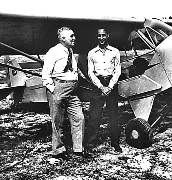
A 1946 photo of William Piper (founder of Piper Aircraft) & Maynard Abrams (manager of Hollywood Airpark) in front of a Piper Cub at Hollwood Airpark.
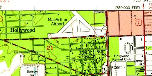
The earliest topo map depiction of MacArthur Field which has been located was on the 1947 USGS topo map.
It depicted MacArthur as having 2 runways & 2 taxiways, with some small buildings on the southeast side.
At some point between 1945-47, the field was evidently renamed "Hollywood" Airpark,
as that is how it was labeled on the August 1947 Miami Sectional Chart (courtesy of Chris Kennedy).
It was depicted as having a 2,800' hard-surface runway.
A 2/26/49 aerial photo of Hollywood Airpark, from the Digital Library Center / University of FL George Smathers Libraries (courtesy of Chris Kennedy).
Residential development had begun to encroach on the field, already covering the northwest portion of the former northwest/southeast runway.
A 5/7/51 USDA aerial photo of Hollywood Airpark (courtesy of The Florida Department of Transportation, via Brian Rehwinkel).
A close-up from the 5/7/51 USDA aerial photo of Hollywood Airpark showed a total of at least 16 aircraft visible parked on the field.
The 1952 Aviation Week Airport Directory (according to Brian Rehwinkel) described Hollywood Airpark as having 2,400' paved runway.
The last aeronautical chart depiction which has been located of Hollywood Airpark was on the July 1953 Miami Sectional Chart.
It depicted Hollywood Airpark as a private airfield having a 2,300' paved runway.
Hollywood Airpark was evidently closed at some point in 1953,
as Robert Ochampaugh recalled that "our house was built in 1953 & I am most definitely sure that our house was on the actual airfield
as when I was a kid I used to find old scrap metal buried in the yard & they looked like airplane parts."
Hollywood Airpark was no longer depicted on the January 1954 Miami Sectional Chart.
Brian Rehwinkel observed, "Aerial photography from March 1957 shows that housing almost completely covered the airport site.
The former east/west runway looked as if it was being used as a residential street.
Residential development eventually completely covered this site."
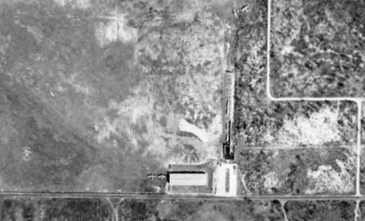
A 1960 aerial view looking east at the site of MacArthur Airport (from the FL DOT, via Brian Rehwinkel).
The majority of the site had been built over with houses, but a portion of the former taxiway was still extant (on the right side of the photo), along with at least one former hangar.
A 1999 USGS aerial photo showed the site of MacArthur Field had been densely redeveloped with housing, and no traces of the runways appeared to remain.
A 2004 aerial photo of the southeast corner of the MacArthur Field site (courtesy of Robert Ochampaugh)
shows the traces of a few foundations of buildings from the site's days as an airport.
A 2016 aerial photo of the MacArthur Field site.
The site of MacArthur Field is located on the Northwest side of the intersection of Moffet Street & South Dixie Highway.
____________________________________________________
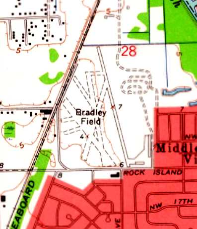
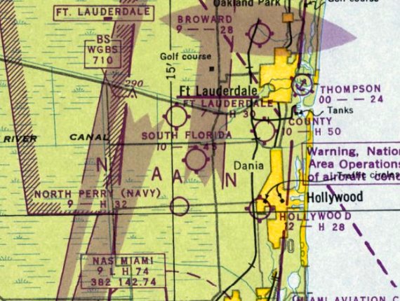
Broward Field / Bradley Field, Fort Lauderdale, FL
26.16, -80.16 (North of Fort Lauderdale International Airport, FL)
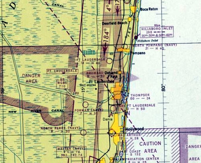
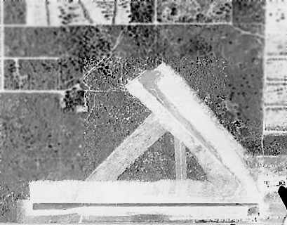
Broward Field, as depicted on the February 1947 Miami Sectional Chart.
This small general aviation airport was evidently established at some point between 1946-47,
as it was not yet depicted on a 1940 aerial photo, the 1945 USGS topo map, or the August 1946 Miami Sectional Chart.
The earliest depiction which has been located of Broward Field was on the February 1947 Miami Sectional Chart.
It depicted Broward Field as having a 3,000' unpaved runway.
Broward Field was not yet depicted on the 1949 USGS topo map.
A 1949 USDA aerial view (from the University of FL Smathers Libraries, courtesy of Chris Kennedy) depicted Broward Field as a simple rectangular grass field,
with a cluster of a few small buildings & hangars on the southeast corner of the field.
A close-up from the 1949 USDA aerial photo (from the University of FL Smathers Libraries, courtesy of Chris Kennedy) showed at least 4 planes parked on Broward Field.
The field was apparently renamed "Bradley" Field at some point between 1947-54,
as that is how it was labeled on the August 1954 Miami USAF Sectional Chart (courtesy of Chris Kennedy).
It had also gained a paved runway, as the Aerodromes table described the field as having 3 runways, with the longest being a 2,600' asphalt strip.
Michael Metzger recalled, “I grew up in Wilton Manors Florida just a few miles from Bradley Field & went to school with Ben Bradley Junior around 1957.
My dad had a hanger & flew out of Bradley Field & have fond memories of the airport.
Ben Bradley Senior had 2 children ... son Ben Junior & a daughter named Piper.
Ben Senior loved planes & mini race cars & he built a oval track on the airport ... clearly visible on [the photo below].
I remember hanging out the airport looking at several of Ben's mini-race cars he kept in hangars right next to planes.”
Alan Reno recalled, “I have many fond memories of Bradley Field, having learned to fly there - my first lesson being on 1/17/57 with my father (Max - a pilot for Mackey Airlines) as my instructor.
We rented one of Ben Bradley’s PA-18 Super Cubs. I was 17 years old & a Junior at Ft. Lauderdale High School. I soloed on 3/12/57.
On 6/7/57 I bought a Piper J-3 Cub for $900. I took my Private Pilot flight test with 'Buzz' Price who was a flight instructor for Ben Bradley on 8/20/57.
The line boy at Bradley Field was Gary Parmateer.”
Alan continued, “One day on 9/7/57 my father was sitting on the fence at the airport watching me do touch & go’s
and a man struck up a conversation with him & asked if I would want to fly his airplane (a PA-11 Cub) and do some aerial photography while building my flying time.
This was Jim Smith of Jim Smith Aerial Photos. Of course, I jumped at the chance & I flew for him for 16 months while attending my Junior/Senior years of High School.”
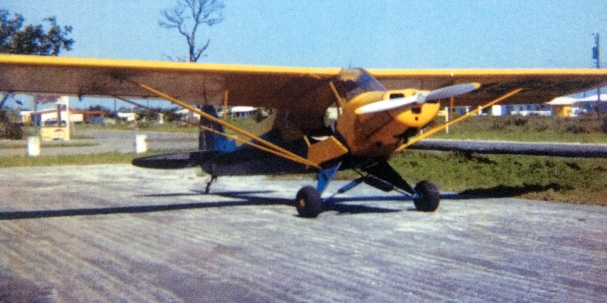
A circa late 1957 / early 1958 photo by Alan Reno of Jim Smith’s PA-11 on the south side of Bradley's hangars along the road, with the parking lot entrance behind the Piper's tail.
Alan Reno recalled, “Jim Smith subsequently merged with Bill Bosworth Aerial Mapping Company of Lantana.
Although he had purchased a North American T-6G (N7404C) for high altitude mapping purposes, he did not have a pilot so Jim Smith told him I could fly for him.
My first dual instruction flight in that airplane was conducted on 1/31/59 out of Bradley Field.
I passed my Commercial Pilot check ride on 2/2/59 & started flying for Bill Bosworth.
I soloed the T-6G on 2/3/59 at Bradley Field after 3:20 of dual instruction including 9 landings.
Since I lived in Ft. Lauderdale & Bill’s company operated out of Lantana, he let me commute back & forth from Bradley field in the T-6.
I did not receive a salary but flying time was like gold to me & it was a great arrangement for both of us.
I have often wondered if Ben Bradley & the other guys had thoughts of; 'That 18 year old kid will kill himself flying in & out of this small airport.'
The T-6 had 10 times the horsepower that my 65 HP J-3 had, and since it was the advanced trainer used by the military during WW2,
it could be a handful of airplane operating out of a narrow, paved, 1-runway, airfield.”
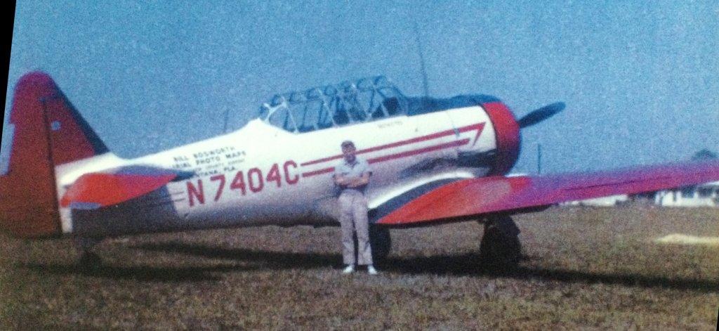
A 1959 photo of Alan Reno in front of Bill Bosworth Aerial Photo Maps' North American T-6 Texan at Bradley Field.
Alan Reno continued, “Part of the fascination with hanging around Bradly Field was the assortment of aircraft based there.
Besides the T-6, there was a Great Lakes biplane, Mooney Mite, a Fairchild 10,
and other assorted transient types such as a clipped-wing Monocoupe, Ryan STA, PT-22, and Ben Bradley had his Grumman F3F (a rare, last-of-the biplane Navy fighters) there for a time.
On occasion, a veteran pilot would put on an aerobatic performance over the field. That was pretty heady stuff for a new teenage fledgling pilot.”
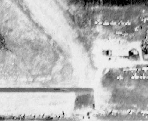
A 9/20/60 aerial photo of Bradley Field (from the FL DOT, courtesy of Brian Rehwinkel).
The single paved runway was evident, as well as the 2 grass runways.
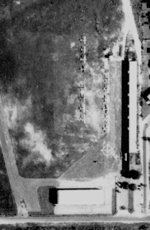
A close-up from the 9/20/60 aerial photo of Bradley Field (from the FL DOT, courtesy of Brian Rehwinkel),
showing 2 hangars as well as a total of at least 14 light aircraft on the field.
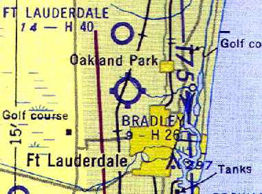
The 1962 USGS topo map depicted Bradley Field as having a single paved northwest/southeast runway & a paved ramp on the east side,
and 4 unpaved runways on the west side.
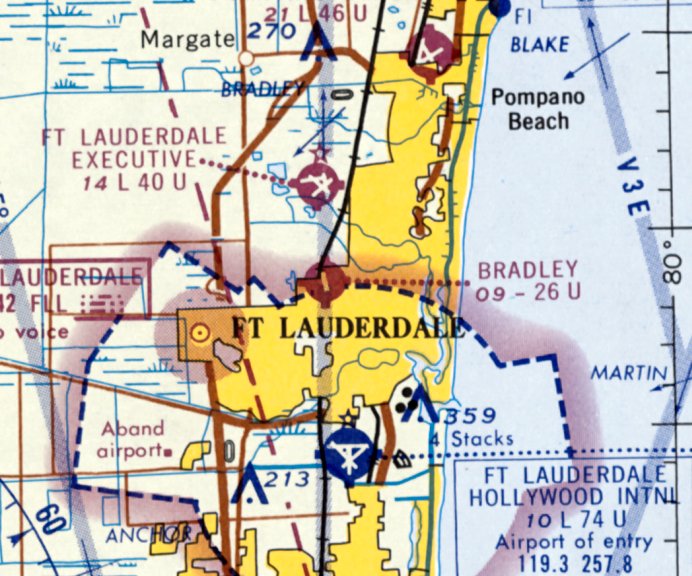
The last depiction which has been located of Bradley Field was on the April 1965 Miami Sectional Chart.
It depicted Bradley as having a 2,600' paved northwest/southeast runway.
Craig Wilbur recalled, “I grew up in the Ft. Lauderdale area & remember Bradley Field, run by Ben Bradley.”
Bradley Field was evidently still open on 6/26/65,
when NTSB records indicated a "Watts Knight Twister" aircraft suffered a ground loop accident at the field,
in which a contributing factor was noted to be the "weeds along runway 3-4' high."
Bradley Field was evidently closed (for reasons unknown) at some point within the next year,
as it was labeled "Abandoned airport" on the March 1966 Miami Sectional Chart (courtesy of Chris Kennedy).
A contributing factor for the closure of the airport may have been the construction of Interstate 95,
which was built along the western side of the airport property.
Craig Wilbur recalled, “In 1970, I had jury duty for 'land condemnation' for the I-95 corridor, which only existed in the Miami & Jacksonville areas.
At that time, very little remained [of Bradley Field]… just remnants of the old runways. The land was sold to make way for I-95.
Ben & family constructed Bradley Aviation at Ft. Lauderdale Executive (FXE).”
The 1999 USGS aerial photo showed that the site of the former Bradley Field had been reused as Mills Pond Park,
with a pond having been built along the northwestern side of the former former airfield.
Not a trace of the former airport appeared to remain.
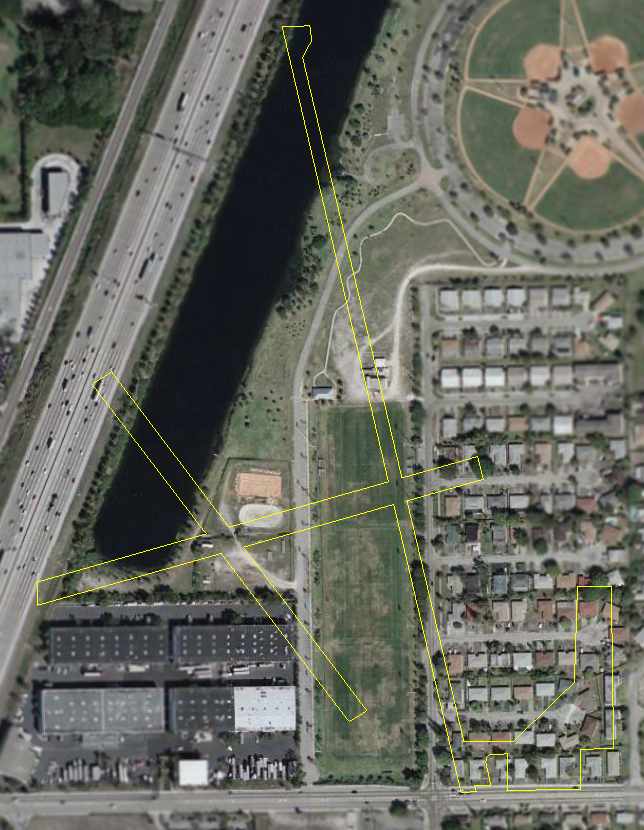
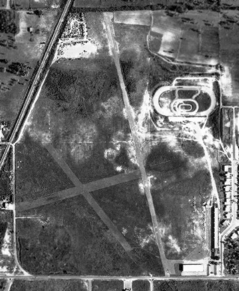
A 2006 aerial photo annotated by Chris Kennedy to show the outline of the runways of the former Bradley Field.
Not a trace of the former airport appears to remain.
The site of Bradley Field is located northeast of the intersection of Interstate 95 & Northwest 19th Street.
____________________________________________________
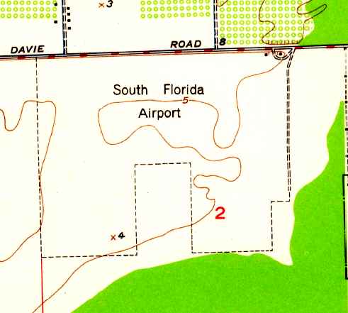
Davie NOLF / South Florida Airport, Davie, FL
26.04, -80.23 (Southwest of Fort Lauderdale International Airport, FL)
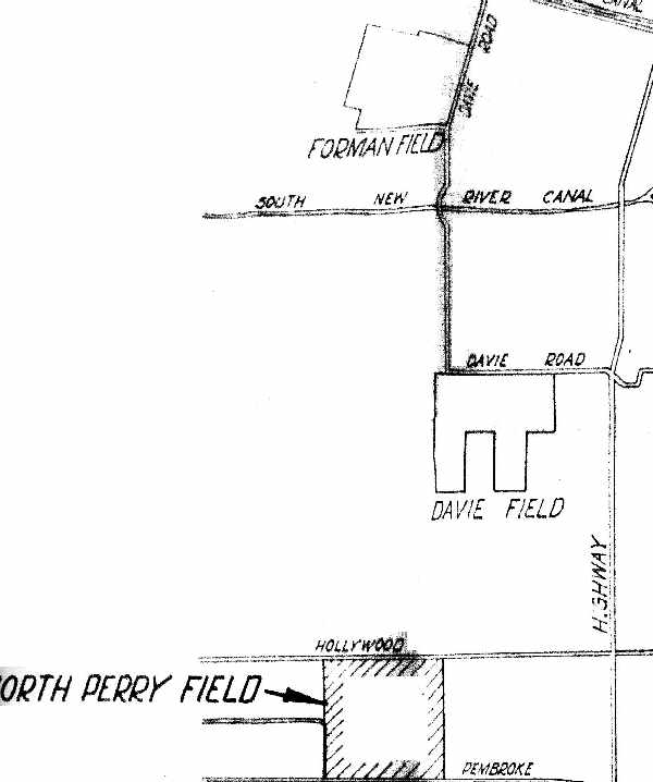
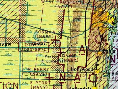
"Davie Field" (along with nearby Forman Field & North Perry Field),
as depicted on a 1942 Navy map for NAS Miami (from the National Archives, via Brian Rehwinkel).
Davie NOLF was not yet depicted on the July 1940 Miami Sectional Chart.
According to Navy documents (from The National Archives, via Brian Rehwinkel),
Davie Field was acquired in April 1941 as an outlying "emergency field"
to be used in conjunction with Forman & North Perry Fields (part of the NAS Miami Complex).
Davie Field was located between Forman Field & North Perry Field, and consisted of sod runways.
The earliest depiction of Davie NOLF which has been located
was on a 1942 Navy map for NAS Miami (from the National Archives, via Brian Rehwinkel).
The August 1943 Miami Sectional Chart (courtesy of Chris Kennedy) depicted "Davie (Navy)" as an auxiliary airfield.
Davie Field may have been closed by the Navy at an earlier point than other nearby Navy auxiliary fields,
as it was no longer listed among active airfields in the 1944 US Army/Navy Directory of Airfields (courtesy of Ken Mercer),
even though Forman & North Perry were still listed, nor listed in the 1945 AAF Airfield Directory (courtesy of Scott Murdock).
Davie NOLF had apparently been relinquished by the Navy at some point between 1945-47 & reused as a civilian airport,
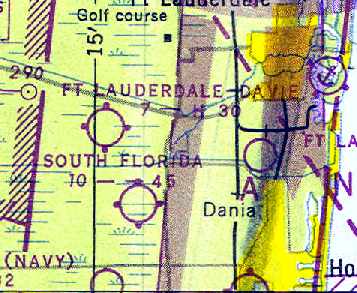
as that is how "South Florida" was depicted on the August 1947 Miami Sectional Chart (courtesy of Chris Kennedy).
It was depicted as having a 4,500' unpaved runway.
A 3/26/47 USDA aerial photo of South Florida Airport,
from the Digital Library Center / University of Florida George A. Smathers Libraries (courtesy of Brian Rehwinkel).
The field was apparently still being used as a civilian airport at this point.
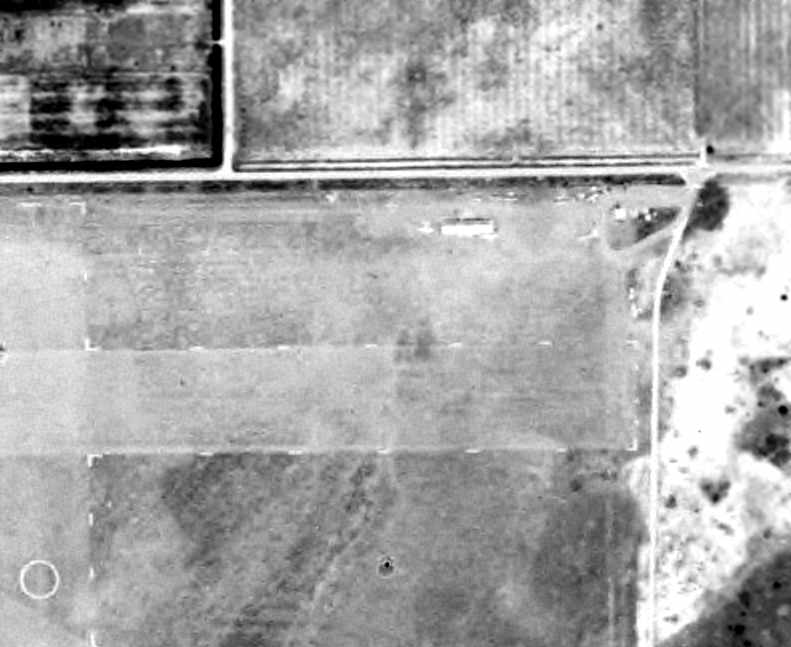
A close-up from the 3/26/47 USDA aerial photo of South Florida Airport,
from the Digital Library Center / University of Florida George A. Smathers Libraries (courtesy of Brian Rehwinkel),
showing at least 8 light aircraft clustered around a few small buildings on the northeast corner of the field.
The last aeronautical chart depiction which has been located of South Florida Airport was on the August 1948 Miami Sectional Chart.
It depicted South Florida Airport as having a 4,500' unpaved runway.
The 1949 USGS topo map depicted South Florida Airport as an irregularly-shaped property outline with 2 small buildings at the northeast side.
South Florida Airport was evidently closed (for reasons unknown) at some point between 1947-49,
as it was no longer depicted at all on the February 1949 Miami Sectional Chart.
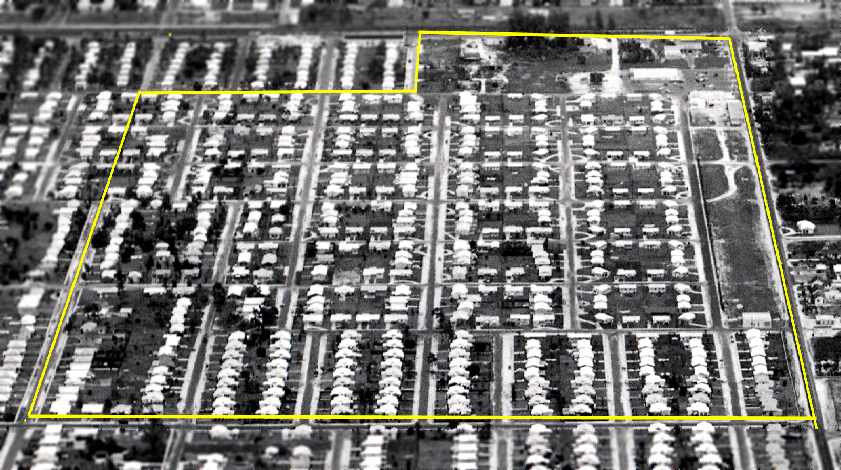
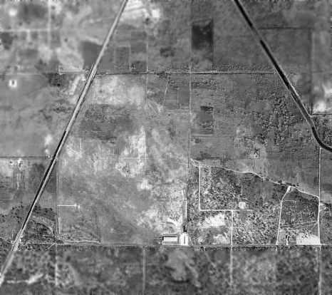
By 1957, an aerial photograph (according to Brian Rehwinkel) showed that housing developments had taken over the location of the former airfield.
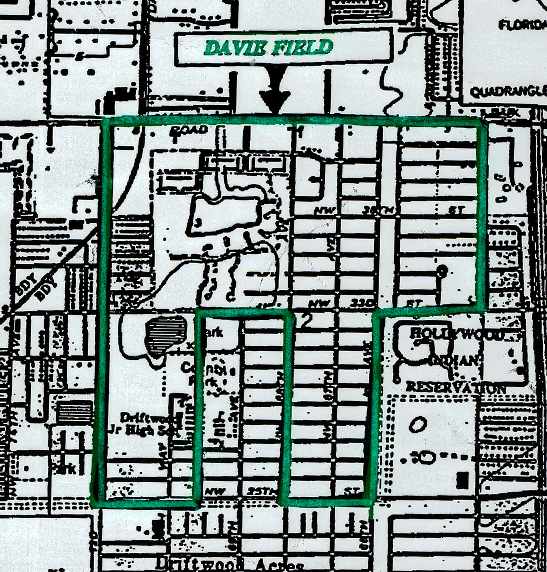
The boundaries of Davie Field, as superimposed by Dynamac Corporation
on a 1983 Army Corps of Engineers map (courtesy of Brian Rehwinkel).
In 2004, Brian Rehwinkel reported that "the site is part of Pembroke Pines, and is covered by residential development & a school."
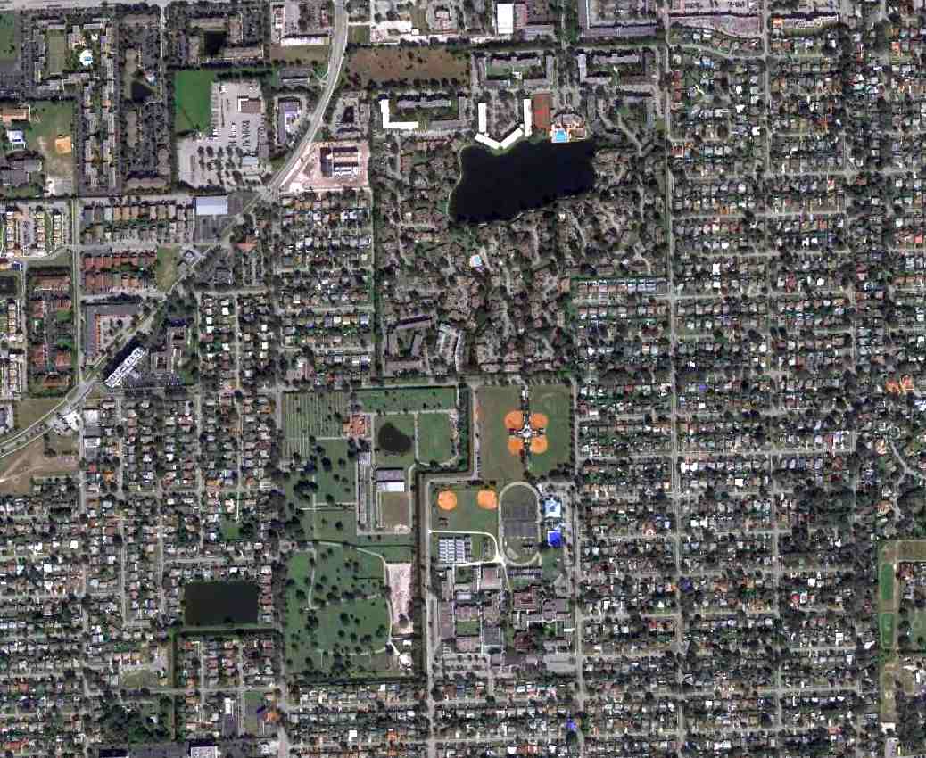
A1/18/14 aerial photo showed no trace remaining of Davie Field.
The site of Davie Field is located southeast of the intersection of Davie Road & Stirling Road.
____________________________________________________
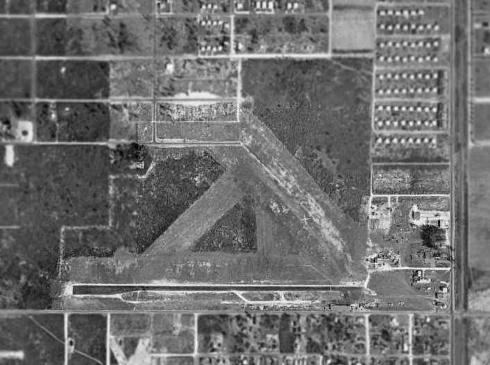
Forman NOLF / Ft. Lauderdale-Davie Airport / Davie NOLF, Davie, FL
26.08, -80.24 (West of Fort Lauderdale International Airport, FL)
"Forman Field" (along with nearby Davie Field & North Perry Field),
as depicted on a 1942 Navy map for NAS Miami (from the National Archives, via Brian Rehwinkel).
Forman Field was not yet depicted on the July 1940 Miami Sectional Chart.
This former airfield has gone through a series of confusing name changes & changes of use.
Before the airfield was constructed on the property, farmers Hamilton & Blanche Forman ran the 1,000-acre Forman Dairy.
Brian Rehwinkel reported, “Forman is an interesting airfield.
Apparently, the field was first leased by the Navy in 1940 or 1941
for use as one of the outlying fields for Naval Aviation training associated with NAS Miami (and NRAB Miami).
The land for the field was eventually purchased by the Navy around 1942.
A letter from the Forman family indicated most – but not all - of the land was acquired through the Forman family around May 1942.
This seemed to be a convoluted land deal because some of the land for the field was being leased to the Formans by the state of Florida
and the family, in effect, assigned the lease to the Navy.”
Brian continued, “In its initial setup, Forman Field was apparently a grass field.
Sometime in the first part of 1942 (probably late spring), the Navy began construction of the 4 hard-surfaced runways.
Since NAS Miami stopped primary training in early 1942, a grass landing field was no longer suitable.
The paved runways would eventually serve NAS Miami very well for operational training.”
Forman Field was one of 4 satellite airfields used by NAS Fort Lauderdale.
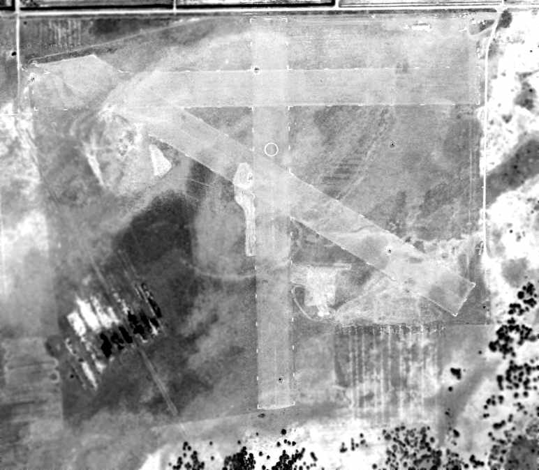
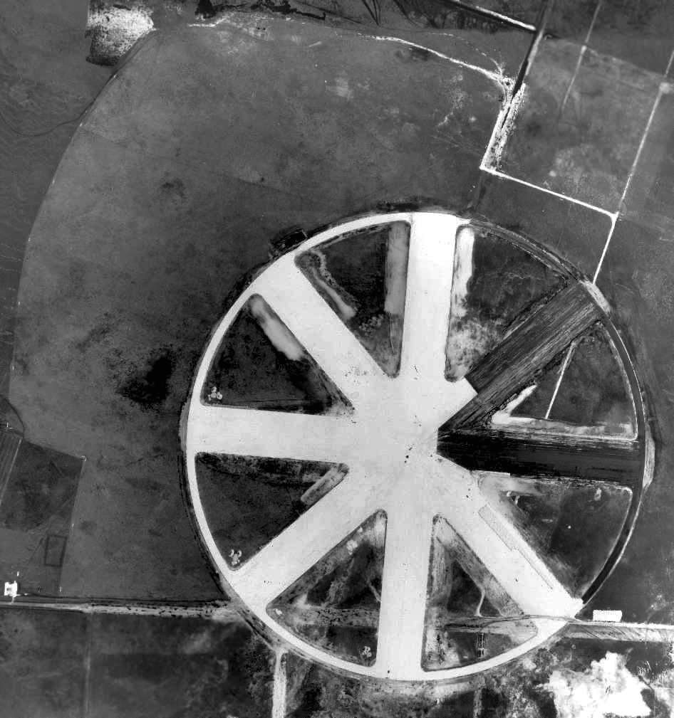
The field had a "wagon wheel" configuration of four 3,000' paved runways,
oriented along the cardinal directions of the compass,
along with a circular taxiway running along the periphery of the runways.
This airfield layout was perfect for training brand-new pilots,
as it precluded ever having to make a crosswind landing.
Although this airfield layout is quite rare today,
it was actually quite common among WW2 training airfields.
The earliest depiction of Forman NOLF which has been located
was on a 1942 Navy map for NAS Miami (from the National Archives, via Brian Rehwinkel).
The earliest photo of Forman Field which has been located was a 6/28/42 U.S. Navy aerial view (courtesy of Brian Rehwinkel).
The photo was taken during construction of the paved field,
and Brian observed, “You can see the shape of the original grass field – complete with the white field boundary markers.”
Brian Rehwinkel reported, “The project for paved runways was completed in late 1942.”
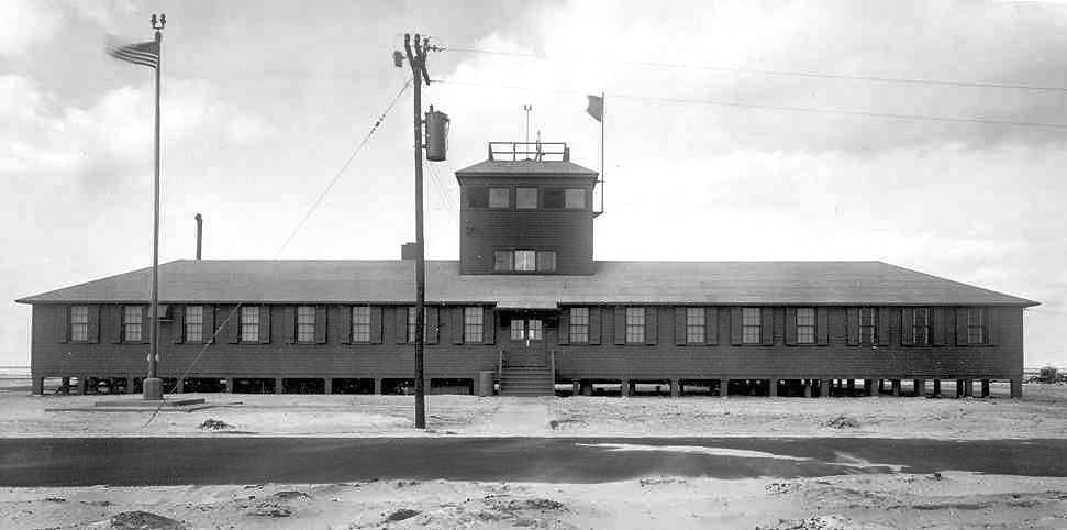
A 12/17/42 U.S. Navy photo (courtesy of Brian Rehwinkel) of Forman's “Operation Building”.
Brian noted “This building included offices, a mess hall, and a small control tower.”
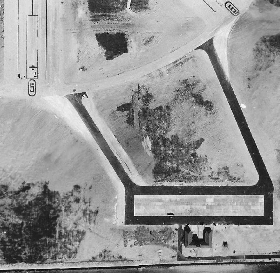
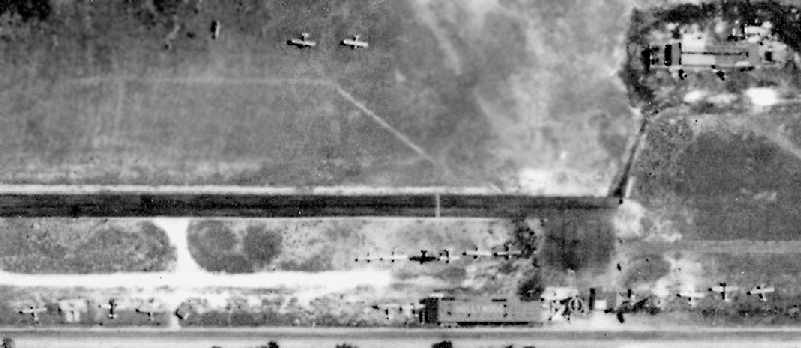
The only photo which has been located showing aircraft operating at Forman Field was a 12/18/42 U.S. Navy aerial view (courtesy of Brian Rehwinkel).
A biplane is visible parked on the south ramp, and a monoplane is visible just over the Runway 5 numbers.
In addition to its unusual wagon-wheel runway layout,
Forman NOLF had 2 asphalt taxiways leading to the southeast to an asphalt ramp (with a concrete portion in the center).
This was a feature that most other WW2-era outlying fields lacked.
The earliest aeronautical chart depiction which has been located of Forman Field was on the August 1943 Miami Sectional Chart (courtesy of Chris Kennedy).
It depicted "Forman (Navy)" as an auxiliary airfield.
The 1944 US Army/Navy Directory of Airfields (courtesy of Ken Mercer) described "Forman OLF, Navy" as having a 3,000' hard-surfaced runway.
Brian Rehwinkel reported, “A 10/6/46 letter from the Forman family [asked] the War Assets Administration to consider selling the land back to their family.”
Brian continued, “Forman OLF was released by the Navy in 1947 and leased to the City of Fort Lauderdale as an airport.”
The former Forman NOLF was depicted as a civilian airport, "Ft. Lauderdale-Davie",
on the August 1947 Miami Sectional Chart (courtesy of Chris Kennedy).
It was depicted as having a 3,000' hard surface runway.
A 12/31/48 USDA aerial photo of the former Forman NOLF,
from the Digital Library Center / University of Florida George A. Smathers Libraries (courtesy of Brian Rehwinkel).
In spite of its depiction as a civilian airport on the previous year's Sectional Chart,
there were no signs of any active use of the airfield at this point.
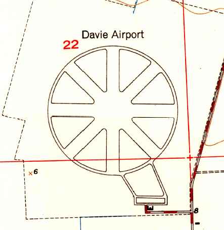
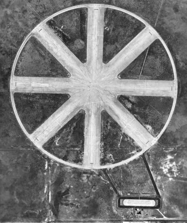
The 1949 USGS topo map depicted Davie Airport with its distinctive wagon-wheel runway layout.

The Souvenir Autograph Program of the 1/23/49 Fort Lauderdale Davie Speedway (courtesy of Don Pugsley) featured an undated aerial photograph of the former Forman NOLF, with the circular taxiway to be used as a racetrack.
Evidently the runways within the circular taxiway had been removed from photograph.
Don Pugsley photographed the program at the NASCAR Hall of Fame in Charlotte.
Don reported, “The race was apparently NASCAR-sanctioned but not part of the NASCAR calendar. Prizes payouts were $7,000!
The race track was the circular taxiway paved around the runways that formed a 2 mile track. The race was apparently only held once.”
Brian Rehwinkel reported that the use of Forman Field as a civilian airport continued “until April 1952 when it was again used by the military.
This time it was used by the Marine Corps as an OLF of MCAS Miami. This field was attached to the Marine Air Station.”
It was depicted as "Davie OLF (Navy)" on the August 1954 Miami Sectional Chart (courtesy of Chris Kennedy).
The use of the name "Davie" is quite strange, considering it was the same name as had been used for the nearby Davie NOLF.
It was depicted as having a 3,000' hard surface runway.
The last aeronautical chart depiction which has been located of "Davie OLF (Navy)" was on the February 1956 Miami Sectional Chart.
It depicted Davie as having a 3,000' paved runway.
Forman NOLF was no longer depicted at all on the August 1956 Miami Sectional Chart.
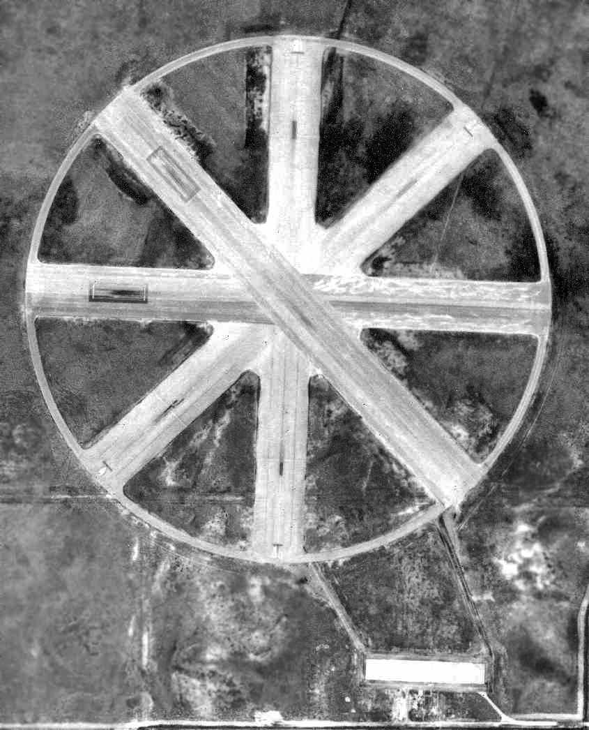
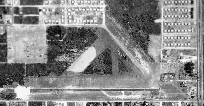
As seen in the 3/27/57 USDA aerial photo (courtesy of the FL DOT, via Brian Rehwinkel) the Forman/Davie airfield was still completely intact,
but the pavement of the runways & taxiways was somewhat decayed.
There were no aircraft on the field, or any other indication of any active use of the airfield.
Charlie Henault recalled, “My father used to manage a JrU-Tote-Um store across Davie Boulevard from Foreman Field in 1957-60.
I would work with him on the weekends while drag races were going on Saturday & Sundays.
I was 12 at the time & my job was to sort the soda bottles that were turned in for the 2 cent deposit.
There had to be thousands as I would spend all day sorting, both days.
When I looked out from the backroom to see what was going on in the front of the store, it was packed.
All I can remember the amount of people in the store. They were packed in like sardines. They were all from the races.
This was like this all summer long. This was a very popular event for the Broward community.
As I got older I would ride my bike to Foreman Field & ride up & down the runways at dusk.
I would catch snakes who would crawl on the runways for the heat stored there. I would collect enough to sell to Bill Hass.
Bill required 3 burlap bags to make it worth while to him & me & I would be able to get them in 5 or 6 trips.
When I got my first car I found a tire dump at the end of the Northwest runway.
I would go there & find retread tires that had the sidewall cut but the bead was still good. I could patch the inside of the sidewall & have a free tire.”
The site of Forman NOLF was depicted as an abandoned airfield on the May 1958 Miami Sectional Chart.
According to Brian Rehwinkel, Forman Field was used by the Marine Corps “until October 1958, when MCAS Miami was closed.
The field was declared excess & the land was transferred or sold between 1958-63 to governmental agencies for use as an education complex.”
A 9/9/61 aerial view (courtesy of Brian Rehwinkel) showed that Forman Field remained completely intact,
but Brian noted, “Urban growth is beginning to swallow the once-isolated airfield.”
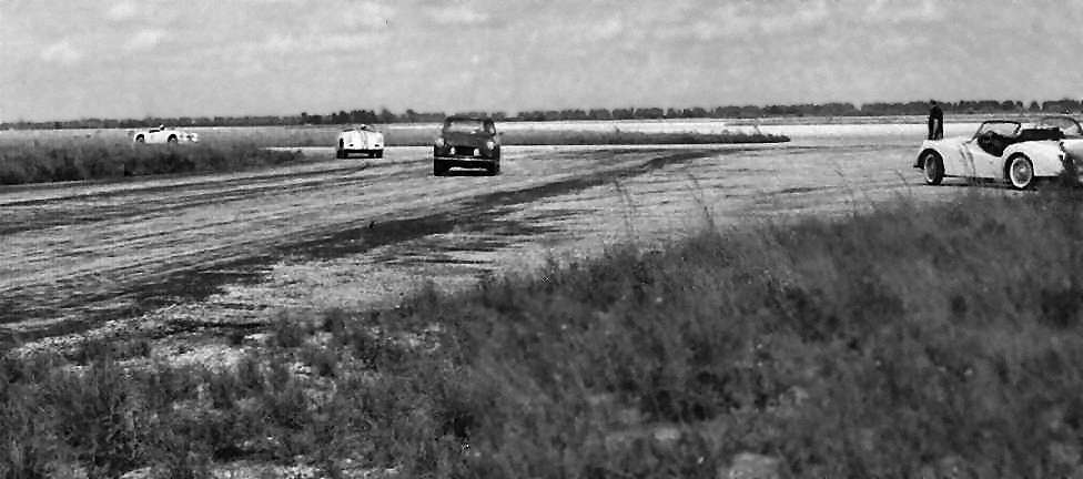
A circa 1960s National Archives photo (courtesy of Brian Rehwinkel) of several sports cars racing on the abandoned runways of Forman Field.
The use of the Forman runways for auto racing was described in the June 1960 issue of Hot Rod Magazine (courtesy of Marty Lineen).
After WW2, the government had made a commitment to the Formans (the original land owners)
that the land would never be reused for anything other than education.
That promise was eventually kept in 1962, when construction was started on the property for Nova Junior High School & Nova Senior High School.
These 2 schools opened in 1963, becoming the first of several schools to occupy the airfield property.
A 6/25/66 aerial view (courtesy of Brian Rehwinkel) showed that portions of Forman Field was beginning to be covered by redevelopment.
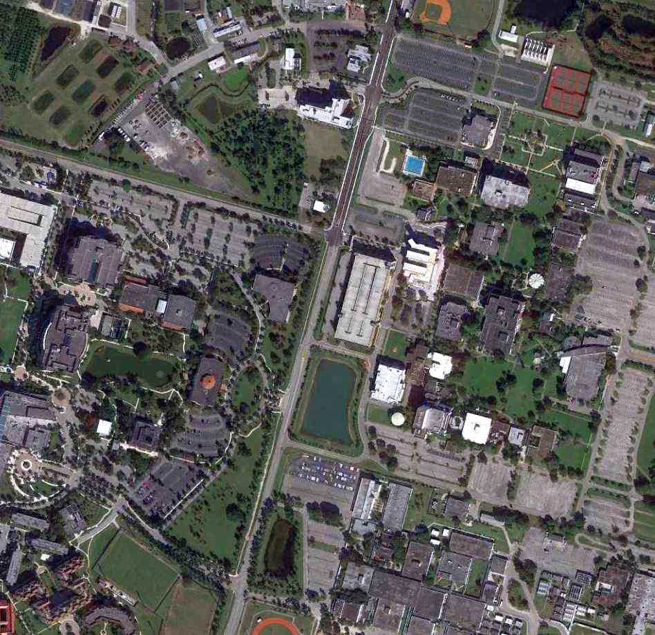
The site of Forman NOLF eventually became the location of Nova University, Broward Community College, the University of Florida,
Florida International University, and Florida Atlantic University.
Collectively, it became known as the South Florida Education Center.
The site of Forman Field in 1982.
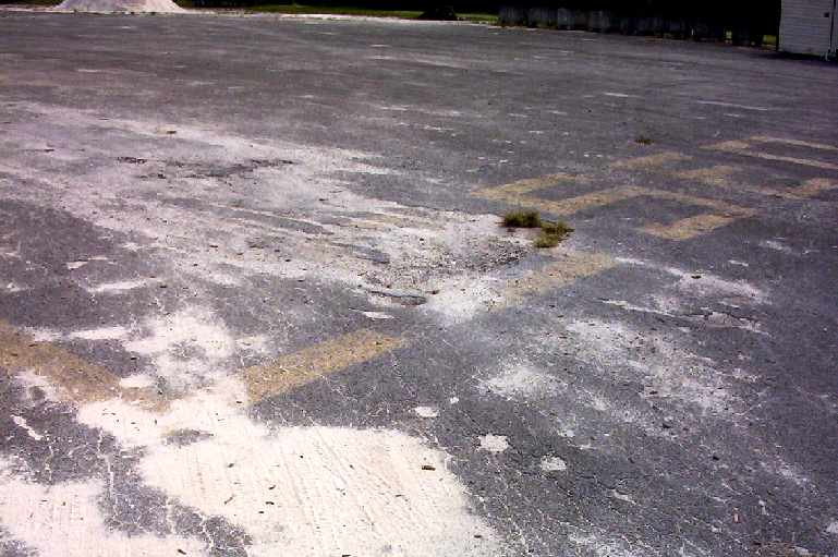
A 2003 photo by Robert Ochampaugh of the "Closed" lettering which is still visible on the former runway pavement of Forman NOLF.
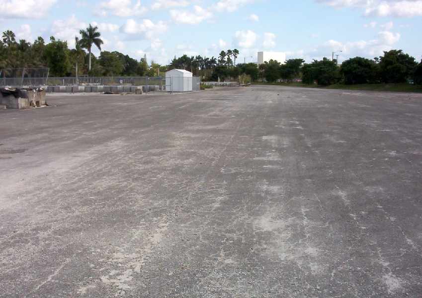
A 2003 photo by Robert Ochampaugh of remains of one of the former runways of Forman NOLF,
looking toward the center of the "wagon wheel".
An August 2007 photo by Marty Lineen looking southeast along the remains of Forman's Runway 13, showing the word “Closed” still visible.
Marty reported that “You can see the top half of the '3' in the number 13.
I can see just a little of the number '1' under the letter L.”
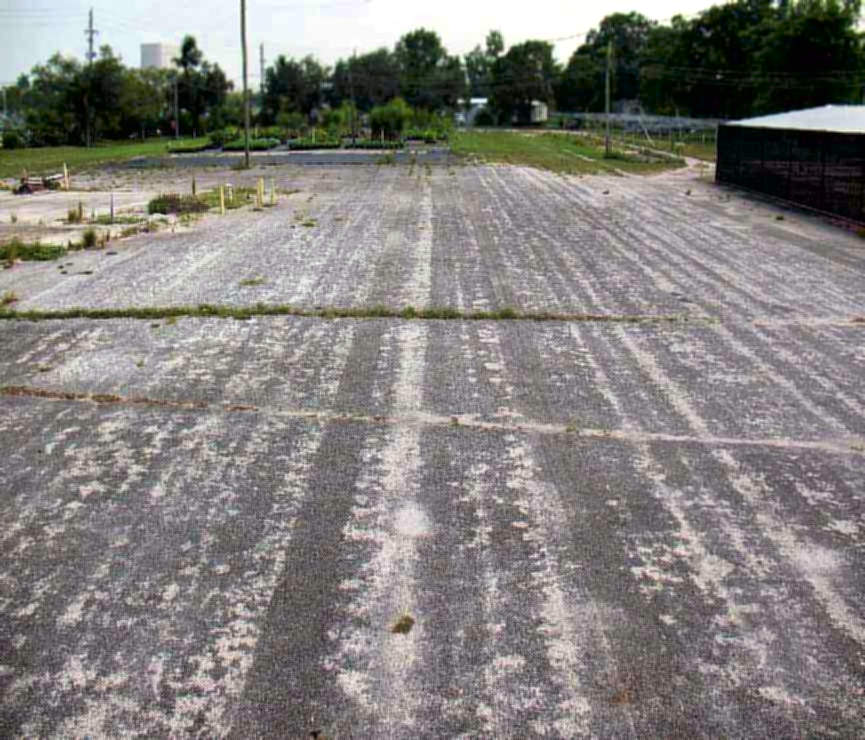
An August 2007 photo by Marty Lineen looking at the remains of Forman's Runway 18.
Marty reported that “I was able to see a little yellow paint but it does not show in the picture.
You can see 2 black marks running beside each other. I can not see any yellow paint under the marks.”
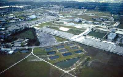
A 1/18/14 aerial photo showed the characteristic circular layout of the Forman airfield remained recognizable along the northwest & southwest portions.
The site of Forman Field is located at the present-day intersection of College Avenue & Southwest 30th Street.
Thanks to Frank Cruz & Mike Cooper for pointing out Forman Field.
____________________________________________________
Or if you prefer to contact me directly concerning a contribution (for a mailing address to send a check),
please contact me at: paulandterryfreeman@gmail.com
If you enjoy this web site, please support it with a financial contribution.
____________________________________________________
This site covers airfields in all 50 states.