Abandoned & Little-Known Airfields:
Florida: Central Miami Area
© 2002, © 2026 by Paul Freeman. Revised 3/17/26.
This site covers airfields in all 50 states: Click here for the site's main menu.
____________________________________________________
Please consider a financial contribution to support the continued growth & operation of this site.
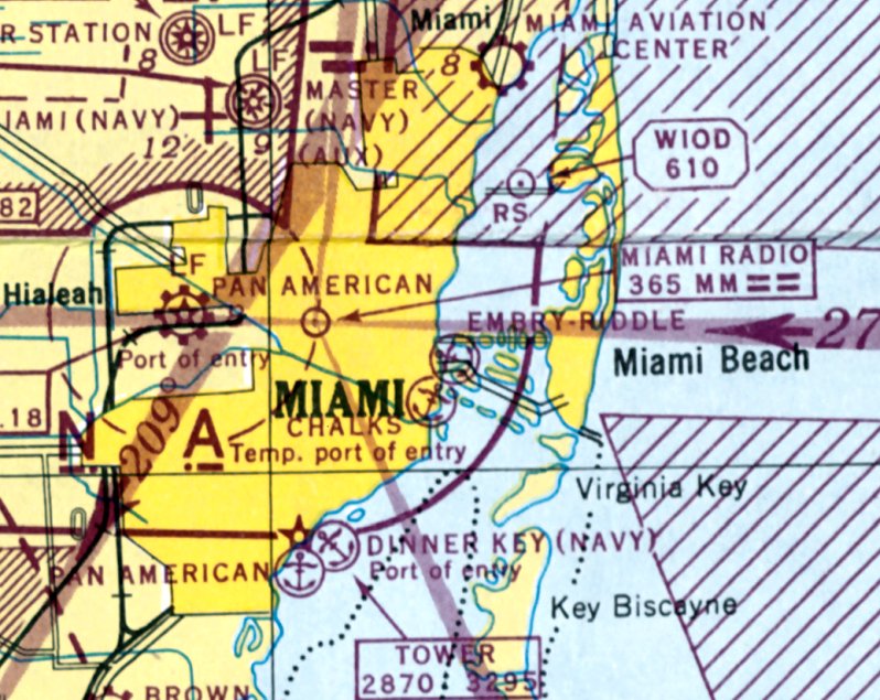
54th Street Aviation Field (added 10/26/22) - Dinner Key NAF / CGAS Miami (revised 3/17/26) - (Original) Tamiami Airport (revised 2/5/21)
Pan American Field / 36th Street Airport (revised 7/19/24) - Watson Island Blimp Base (revised 6/16/19)
Venetian Causeway Seaplane Base / Viking Airport / Embry-Riddle Seaplane Base (revised 10/10/25)
____________________________________________________
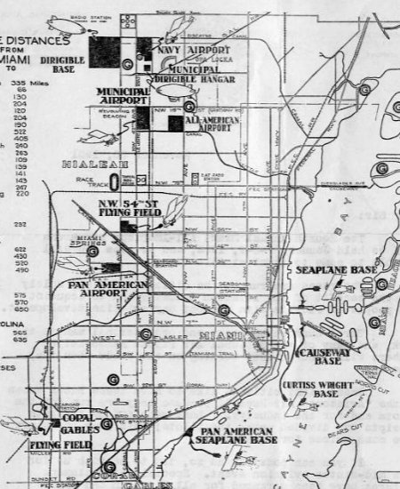
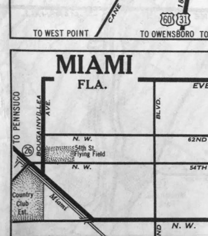
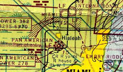
54th Street Aviation Field / Haileah Airport, Miami, FL
25.825, -80.279 (North of Miami International Airport, FL)
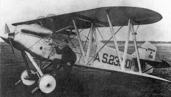
A 1925 photo of a Curtiss P-8 fighter at Hialeah Airport.
The date of establishment of this early Miami Airport has not been determined.
The earliest depiction which has been located of Hialeah Airport was a 1925 photo of a Curtiss P-8 fighter.
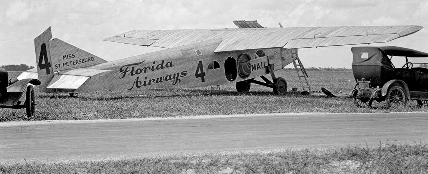
A 1926 photo of Miss St. Petersburg, Florida Airways Stout 2-AT at 54th Street Airport.
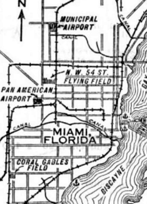
N.W. 54th Street Flying Field”, as depicted in the 5/24/29 Commerce Department Airway Bulletin (courtesy of Mike Denja).
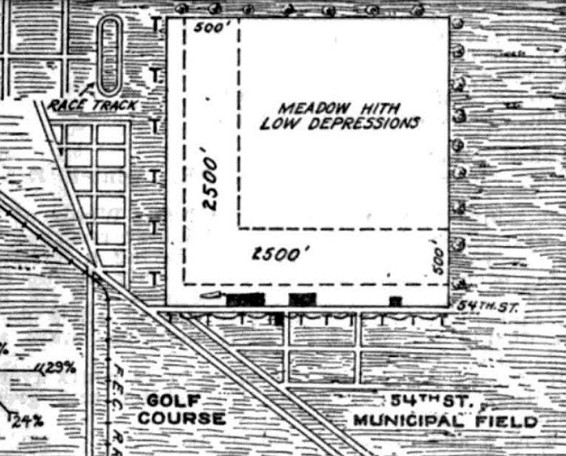
The 5/24/29 Commerce Department Airway Bulletin (courtesy of Mike Denja) described “54th Street Aviation Field” as a municipal airport owned by N.B Roney, loaned to the City.
It was said to consist of a 144 acre square sod field having 2 perpendicular runways in an L-shape. Three buildings were depicted on the south side.
“N.W. 54th Street Flying Field”, as depicted on a 1932 City of Miami Air Guide (courtesy of Rich Moravsik).
“54th Street Flying Field”, as depicted on a 1935 street map (courtesy of Kevin Walsh).
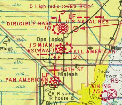
The only aeronautical chart depiction which has been located of the 54th Street Flying Field was on the December 1935 Miami Sectional Chart (courtesy of Chris Kennedy),
which depicted it as an auxiliary airfield.
The 54th Street Flying Field was evidently closed (for reasons unknown) at some point between 1935-37,
as it was no longer depicted on the April 1937 Miami Sectional Chart.
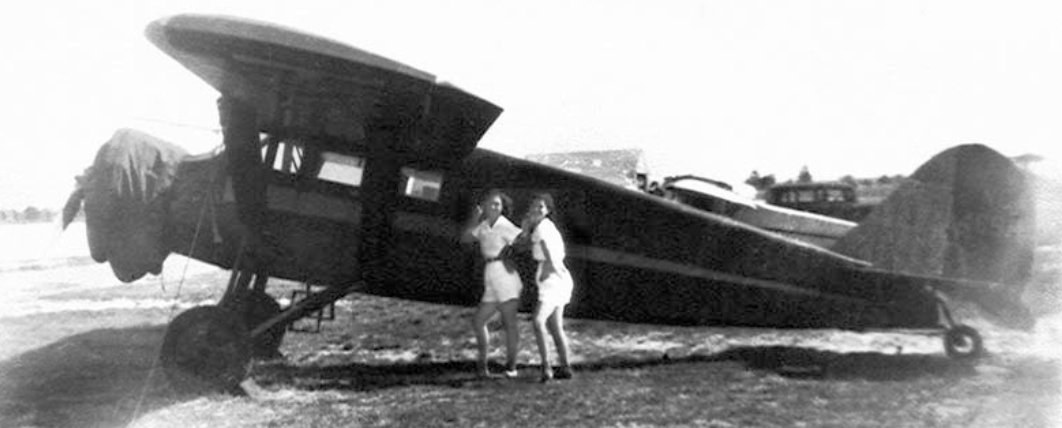
The last photo which has been located of Hialeah Airport was a reported 1940 photo of Beatrice Wirth & Sarah Hughes posing with Bellanca CH-200 Pacemaker NC469M.
The 1950 USGS topo map showed the site of the 54th Street Flying Field had been densely redeveloped,
as was also seen on a 1961 aerial photo, with no trace of the airport discernible.
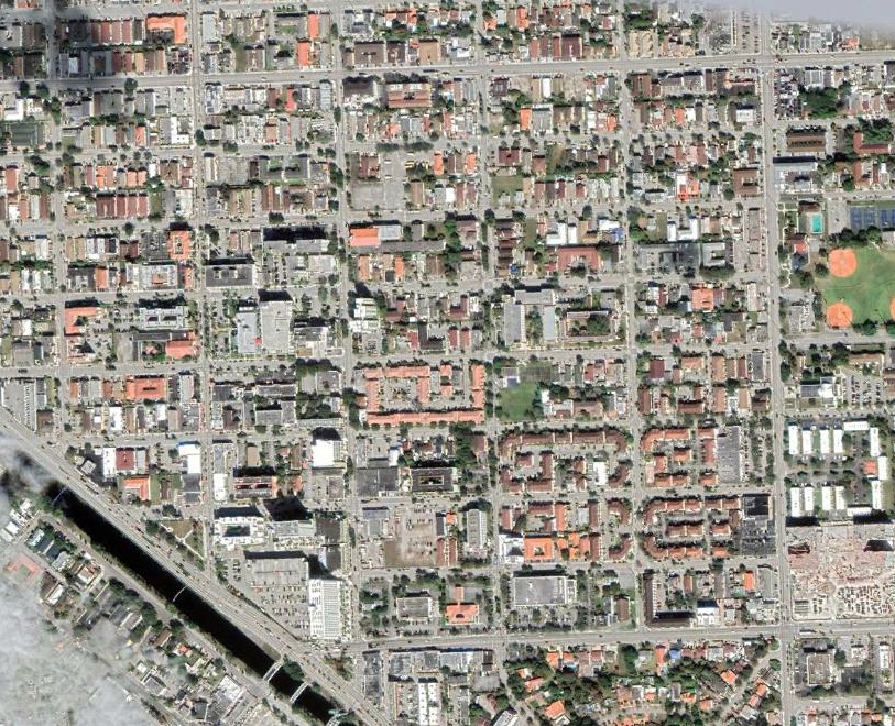
A 2021 aerial view of the site of the 54th Street Flying Field showed no trace remained of the airport.
NW 54th Street Flying Field was reportedly located on the north side of Hialeah Drive (NW 54th Street in Dade County) between East 4th Avenue & East 8th Avenue (LeJeune Road).
Thanks to Mike Denja for pointing out this airfield.
____________________________________________________
Watson Island Blimp Base, Watson Island, FL
25.76, -80.18 (East of Downtown Miami, FL)
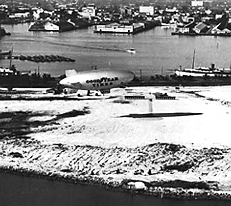
A 1935 aerial view of a Goodyear Blimp approaching the original blimp base on the northeast side of Watson Island.
According to Goodyear's chief project engineer for the airship Goodyear NT (via Matt Lussier), Goodyear based blimps at Watson Island starting in 1930.
According to Goodyear Spirit of Innovation pilot Matt Lussier, “We had 2 separate bases on Watson Island.
The first one was located on the northeast side of the island before they built out the man-made land to the west of the causeway road (prior to that, it was still water).”
For over 50 years the Goodyear company offered limited public rides at its Watson Island winter base
as part of its land-lease deal with the city in order to operate from the island.
The Watson Island blimp base was not depicted on Miami Sectional Charts from the 1930s/40s/60s.
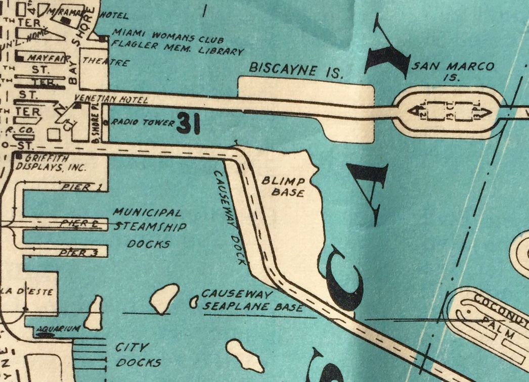
A 1940 map (courtesy of Kevin Walsh) depicted the “Blimp Base” on the eastern part of Watson Island.
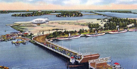
A 1940s postcard aerial view (courtesy of Roger Kinney) looking east at a Goodyear blimp at Watson Island.
A 1952 aerial aerial view (courtesy of Roger Kinney) showing a Goodyear blimp moored at Watson Island.
In the 1950s a new bridge was constructed connecting Watson Island.
Roger Kinner reported, “With the new bridge, the alignment of the highway was shifted further east, and now went right through the middle of the blimp base.”
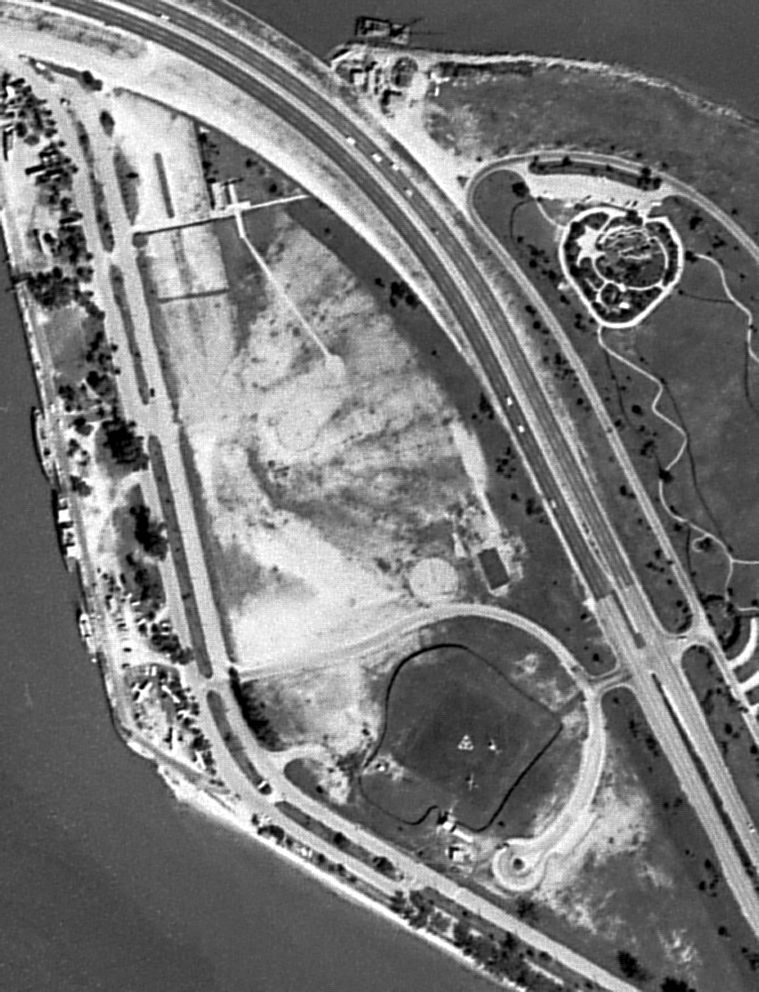
A 10/21/61 USGS aerial view of Watson Island showed several blimp mooring circles on the northwest side & a heliport adjacent to the south.
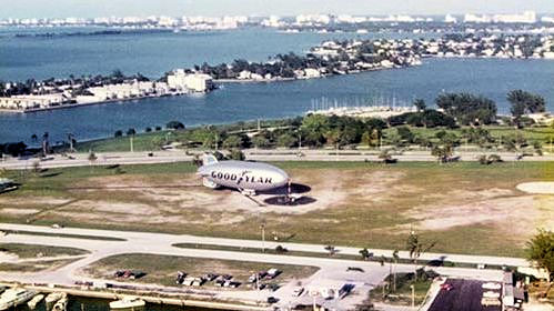
A 1975 aerial view of the Goodyear Blimp Mayflower N1A at its Watson Island base.
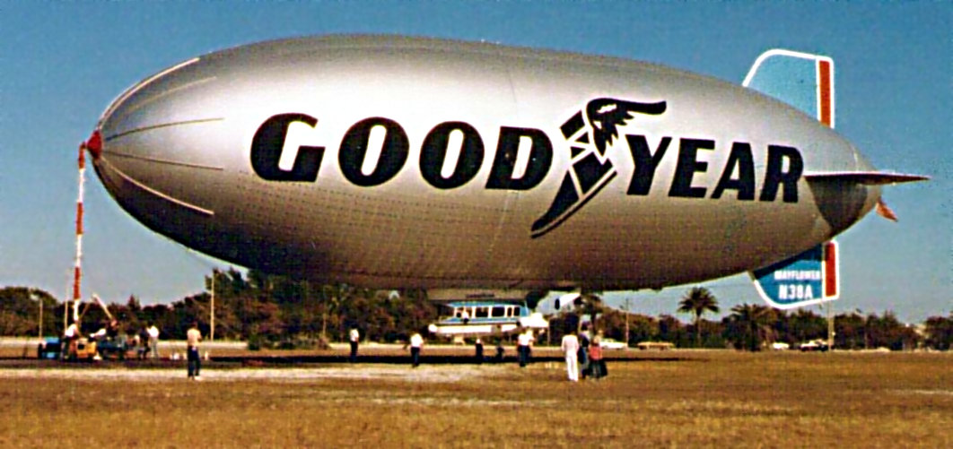
The last photo which has been located of a Goodyear Blimp at Watson Island was a 1978 view of the Mayflower by Gilberto Almeyda.
Goodyear blimp operations at Watson Island ended in 1978,
after the company & the City of Miami reportedly could not come to terms for future use of the property.
Their Florida blimp operations were moved to Pompano.
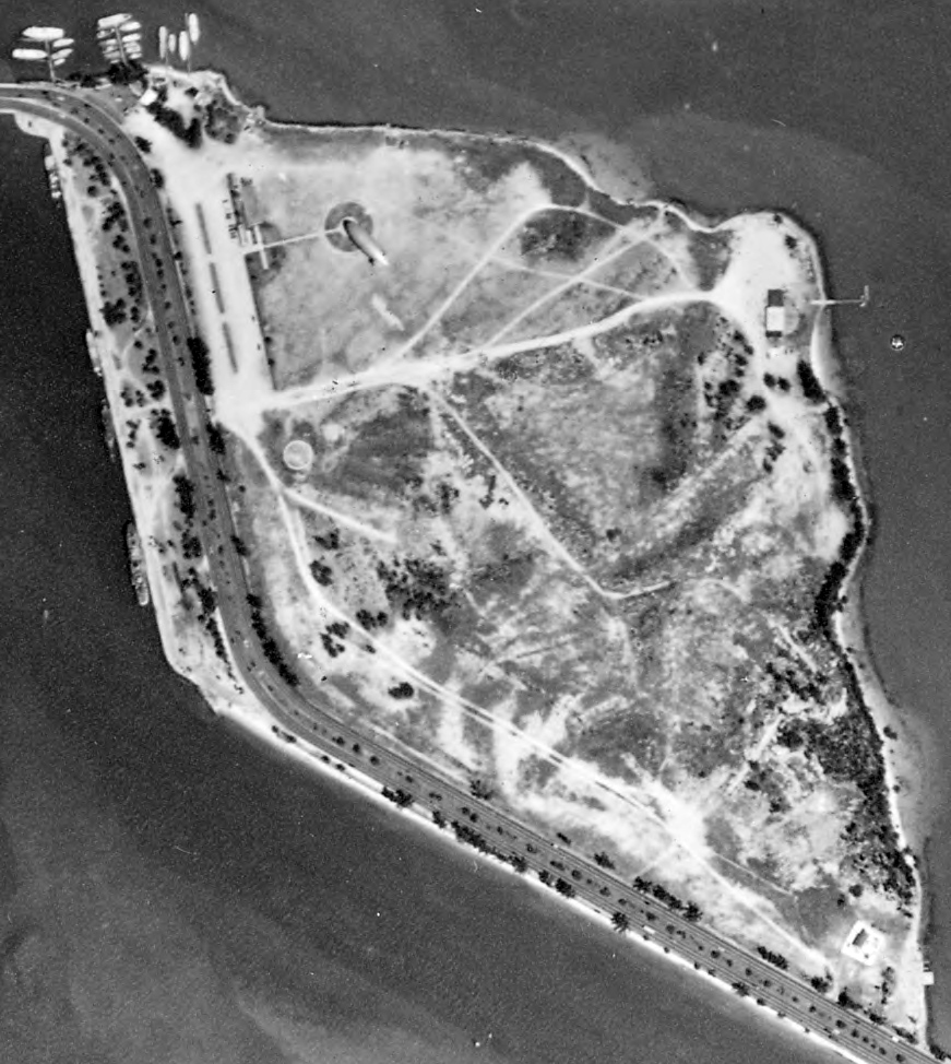
A 1999 aerial view showed the site of the blimp base was abandoned, but the blimp mooring circle was still evident.
A 2001 aerial view showed that construction had begun for a new building to house the Miami Children's Museum
on the southern portion of the Watson Island blimp base site.
For years after the closure of the Watson Island blimp base the imprint of the mooring circle was still visible, though covered with rocks.
Other vestiges of the old base included the narrow roadway that was used by a cart to carry passengers from the visitors' center to the airship.
A 3/26/11 aerial view showed the remains of the circular blimp mooring circle on the northern end of the Watson Island site.
Ironically, a property across the street was still being used for aviation – note the 2 seaplanes at the southern edge of the island: the Miami seaplane base.
Goodyear Spirit of Innovation pilot Matt Lussier reported in 2014,
“Up until about 6 months ago, parts of our old masting circle were still visible but recently have been bulldozed for development.”
____________________________________________________
Pan American Field / 36th Street Airport, Miami, FL
25.8, -80.28 (North of Miami International Airport, FL)

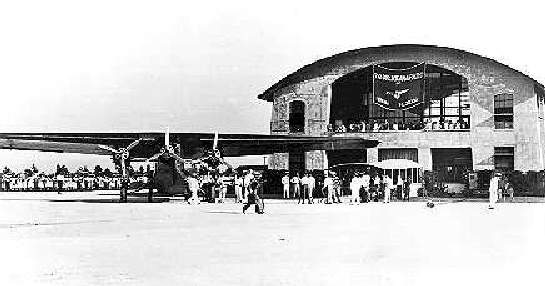
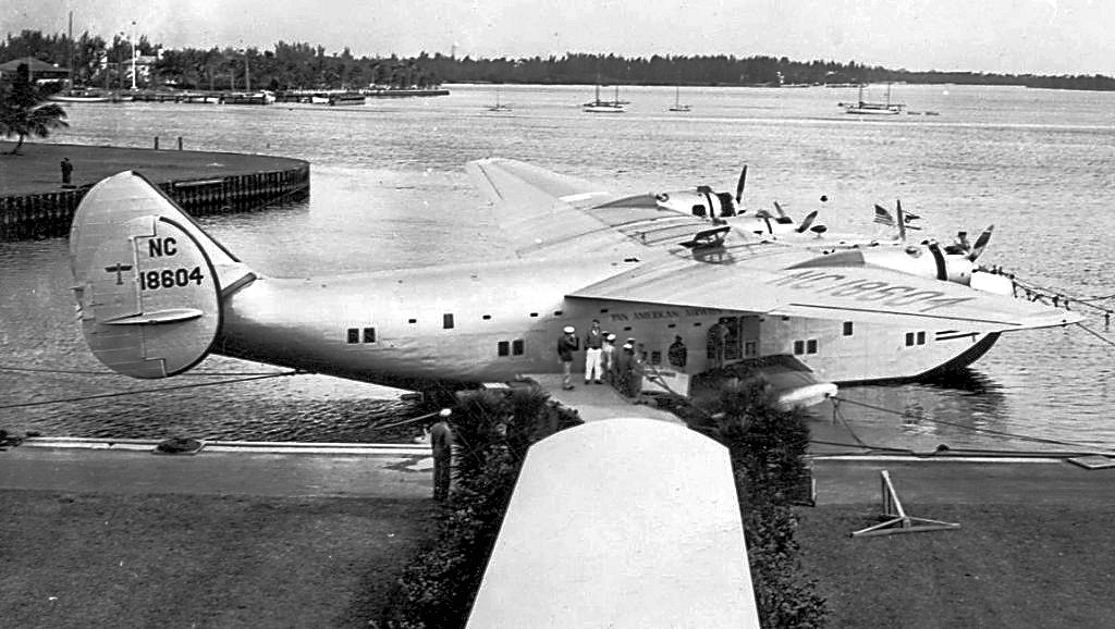
A 1928 artist's rendering of the concrete Pan American Airways terminal of Miami's 36th Street Airport (courtesy of Kevin Walsh), designed by architects Delano & Aldrich.
Of the millions of travelers who pass through the present-day Miami International Airport,
very few are probably aware that the current airport sits on land once occupied by 3 separate airports.
Furthermore, there are still perceptible remnants of one of these predecessors, if you know where to look.
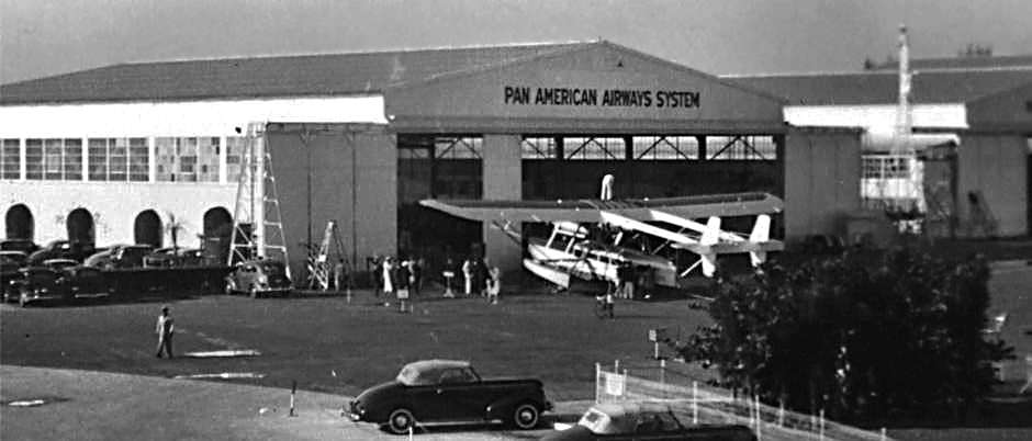
In 1927, Pan American Airways decided to move its Florida base from Key West to Miami.
The company purchased 116 acres of land from the Seminole Fruit Company near NW 36th Street.
Pan American Field was opened in 1928, and featured the 1st modern airline terminal in the nation.
It was at the time the only customs entry airport on the US Atlantic mainland.

A circa 1928 photo of the dramatic 2-story interior of the Pan American Airways terminal at Miami's 36th Street Airport (courtesy of Kevin Walsh).
The location of Pan American Airport, as depicted in the 5/24/29 Commerce Department Airway Bulletin (courtesy of Mike Denja).
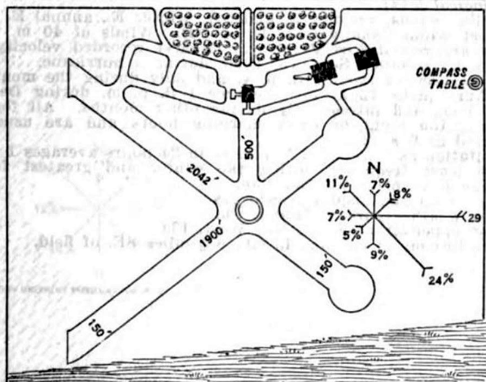
The 5/24/29 Commerce Department Airway Bulletin (courtesy of Mike Denja) described Pan American Airport
as a commercial airport owned & operated by Pan American Airways.
It was said to consist of a 135 acre irregularly-shaped sandy field containing 2 runways, measuring 2,042' northwest/southeast & 1,900' northeast/southwest.
Three buildings were depicted on the north & northeast sides.
The 1st US Mail flight to Nassau, Puerto Rico, and Panama departed from Pan Am Field in 1929.
Eastern Airlines began scheduled service from Pan Am Field in 1931.
The earliest chart depiction which has been located of Pan American Airport was on a 1932 City of Miami Air Guide (courtesy of Rich Moravsik).
The 1934 Department of Commerce Airport Directory (according to Chris Kennedy)
described Pan American Airport as having 4 sandy runways, with the longest being a 2,140' northwest/southeast strip.
The passenger station was said to have "Pan American Airways" painted on the roof.
Pan American Field was depicted as a commercial airport
on the December 1935 Miami Sectional Chart (courtesy of Chris Kennedy).
National Airlines began scheduled service from Pan Am Field in 1936.
An undated aerial view looking southeast at Miami 36th Street Airport,
with Pan Am's maintenance base on the left side of the airfield,
from the Airport Directory Company's 1937 Airports Directory (courtesy of Bob Rambo).
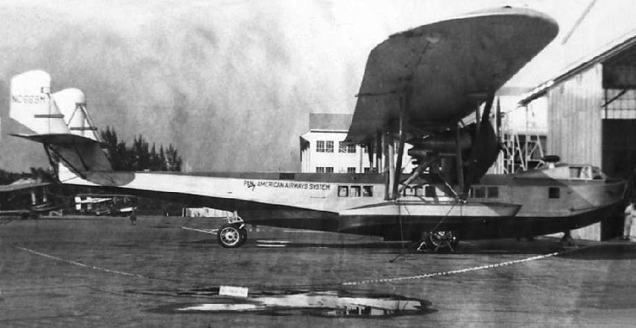
A 12/20/38 USDA aerial photo of Pan American Field (from the University of FL Smathers Libraries, courtesy of Brian Rehwinkel).
During the WW2 period, Pan Am Field had 4 paved runways: 17/35, 09/27, a Northwest/Southeast, and a Northeast/Southwest runway.
A smaller, separate airfield had been built adjacent to the east side of Pan Am Field, at an unknown date prior to the establishment of Pan Am Field.
This field was known at times as Miami's "City Airport",
or Miami Municipal (leading to inevitable confusion with the Miami Municipal Airport a few miles to the northeast).
This field had a northwest/southeast runway & an east/west runway.
When Pan Am Field was built next door, Pan Am's Runway 9/27 was built as an extension to the existing Runway 9/27.
This created a total length of 7,000', "which wasn't bad for the DC-3 days!", in the words of Joe Benson.
National Airlines' everything-in-one building was on the opposite (east) side of the north/south street,
opposite of the southeast end of the Miami City Airport northwest/southeast runway.
It is visible in the above 1945 aerial photo, with office windows along the front of the building appearing as a black line.
It had 2 nose dock hangars that looked just like Eastern's, and they were on the north & south sides of the building.
There is ramp area all around the building & National also used this as their passenger terminal.
They would load the planes & then stop traffic on LeJeune Road & taxi the planes across the road to the runway & takeoff.
Even up into the sixties, until they built their new complex over east of the terminal,
they still taxied the DC-6's, 7's & Connies across there.
In Joe Benson's words, "It was pretty neat seeing a big airliner cross a main drag like that when traffic was heavy & had to stop.
I was lucky enough to catch the light more than once back then. Just wish I had a camera then!"
"Pan American" Airport, as depicted on the 1943 Miami Sectional Chart (courtesy of Chris Kennedy).
In 1943, the Army opened yet another adjacent airfield, the 36th Street AAF, later known as Miami AAF.
This was located to the south of Pan Am Field, right where the present-day MIA terminal is located.
Three runways were built for the AAF,
including a Runway 17/35 which was separated from Pan Am Field's Runway 17/35 by the SAL railroad tracks.
Joe Benson reports that "the last time I was there, 2 maintenance buildings from the old cantonment area
were still in there next to some parking lots."
As part of the construction, to aid the Ferry Command along the southern route,
they also built the Air Depot (MIAD) which is located in the "V" between Runway 12/30 (New) and 09R/27L (New).
The 1944 US Army/Navy Directory of Airfields (courtesy of Ken Mercer)
described "Pan American - 36th Street Army Air Base" as having a 7,000' hard-surfaced runway.
The remarks included, "Owned by Army & PAA. East/West runway joins Intercontinent East/West runway."
The 1944 US Army/Navy Directory of Airfields (courtesy of Ken Mercer) described "Intercontinent" as having a 3,100' hard-surfaced runway.
The remarks said, "Pan American Airport West."
A 1945 aerial view (courtesy of Joe Benson) looking east at Pan American Field in the foreground, with Miami City Airport in the background.
In 1946, the 223-acre Pan American Field & the Army Airport were joined after being purchased by the Dade County Port Authority.
The name Miami International Airport was adopted in 1948, thus ending any distinct identity of the former Pan American Field.
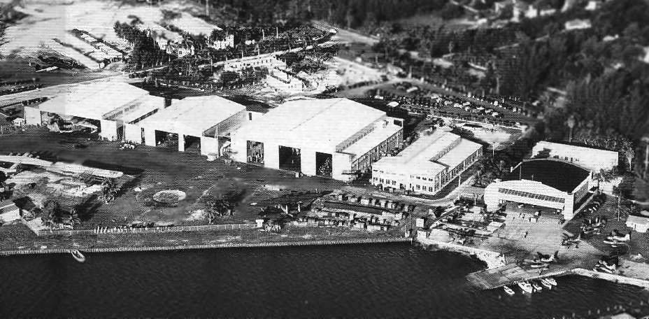
A 2/22/56 USDA aerial photo of the original Pan Am terminal building along the north ramp (courtesy of the FL DOT, via Brian Rehwinkel).
In the post-WW2 period, the north ramp of MIA became the home of massive maintenance facilities & headquarters buildings
for both Eastern Airlines & Pan American.
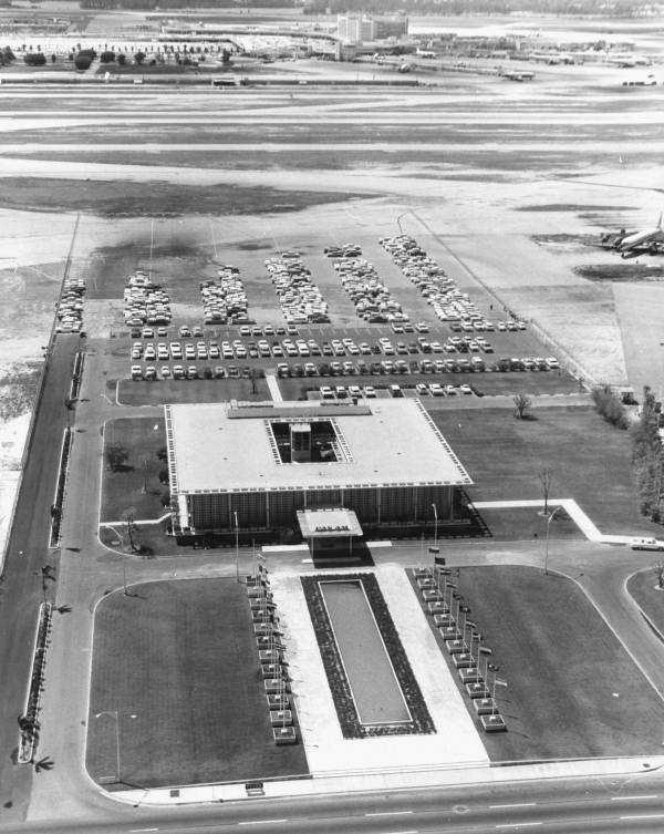
The Miami headquarters for Pan Am was located in an elegant building midway along the north ramp,
with a long fountain on the north side of the building.
It was built on the ground previously occupied by the original (vintage 1928) Pan Am terminal building.
Pan Am also had massive maintenance hangars to the west of their HQ building.
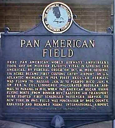
A photo by Jerry Jelincic of a historic marker at the corner of Fairway Drive & Palmetto.
Pan Am's training building was located just south of the HQ building, and it contained a large number of flight simulators.
Following Pan Am's bankruptcy in 1991, their training operations were divested into an independent company,
Pan Am International Flight Academy, which continues in operation to the present day (as of 2002).
This web site's author participated in installing & certifying a business jet flight simulator at the Miami Pan Am facility in 1999.
Eastern Airlines also had their headquarters at MIA (in an elaborate high-rise at the northeast corner of the MIA property),
as well as large maintenance hangars.
The massive Eastern HQ building (which had sat abandoned for years) was eventually demolished in 2001.
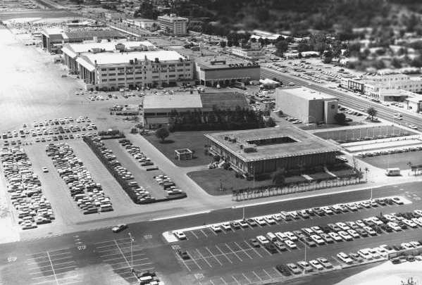
The former Pan Am headquarters building still exists (as of 2002), but its occupant has not been determined.
The large former Pan Am maintenance hangars are also still standing (as of 2002),
and are used by companies performing heavy maintenance on jet airliners.
Antolin Carbonell said in 2003 of the former Eastern & Pan Am buildings, "Almost everything has been torn down.
Only one of the 3 Eastern Administration Buildings is still standing & I worked there for several years.
Unfortunately there is very little interest in Miami's Aviation Heritage & what little remains is scheduled for demolition."
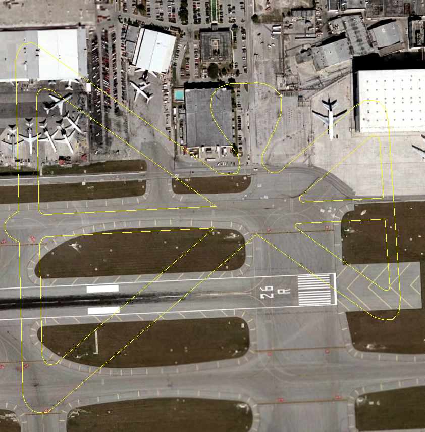
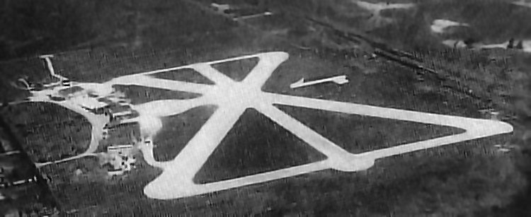
A 2006 aerial view of the site of the original 36th Street Airport, annotated by Chris Kennedy to show the runway layout of the original 1938 airport configuration.
Chris observed, “It appears that there are at least 2 hangars still existing from 1938.
Two of them are just to the right of the ramp area of the diagram, set at an angle.
The white hangar to the left of those that is set at the opposite angle may be an expansion of one that is in that same position in the 1938 photo.”
See also:
A 1990 Army Corps of Engineers Report.
http://www.pack484.com/Spring/site05.html
____________________________________________________
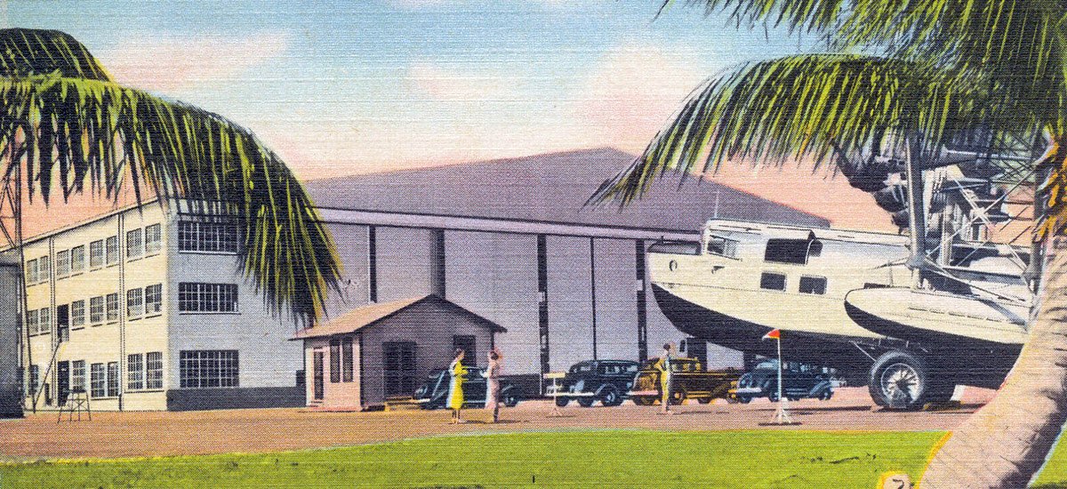
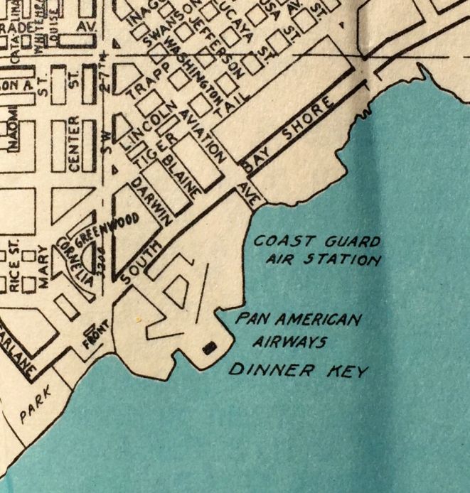
Dinner Key Naval Air Facility / Coast Guard Air Station Miami, Dinner Key, FL
25.73, -80.24 (Southwest of Miami Beach, FL)
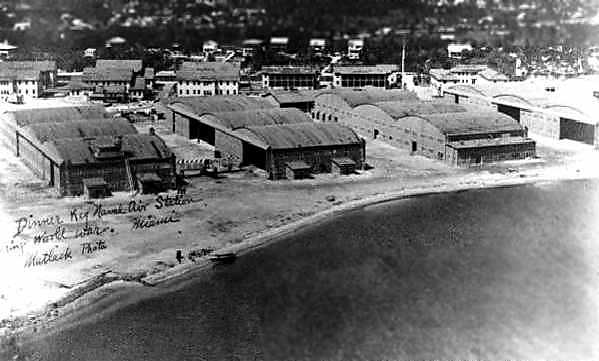
A 1918 aerial view looking west at the hangars of NAS Dinner Key (State Library & Archives of FL).
Dinner Key was originally an island in Biscayne Bay, which was connected to the mainland with fill in 1914.
In 1917, Lt. Patrick Bellinger (Naval Aviator #8) chose the site at Dinner Key to become the first continental Naval Air Station in the country.
The base was commissioned the following year, and conducted flight training with 12 seaplanes & a single dirigible.
The earliest depiction which has been located of the Dinner Key facility was a 1918 aerial view (State Library & Archives of Florida).
It depicted a row of 4 multi-bay hangars along the seaplane ramp, with the hangar doors arranged perpendicular to the waterfront.
After the end of WW1, the Navy vacated Dinner Key, but the seaplane facility continued in operation by commercial operators.
The New York, Rio & Buenos Aires Airline began service from Dinner Key in 1929.
That airline was merged with Pan Am the following year.
Pan Am operated an extensive route structure from Dinner Key in the 1930s.
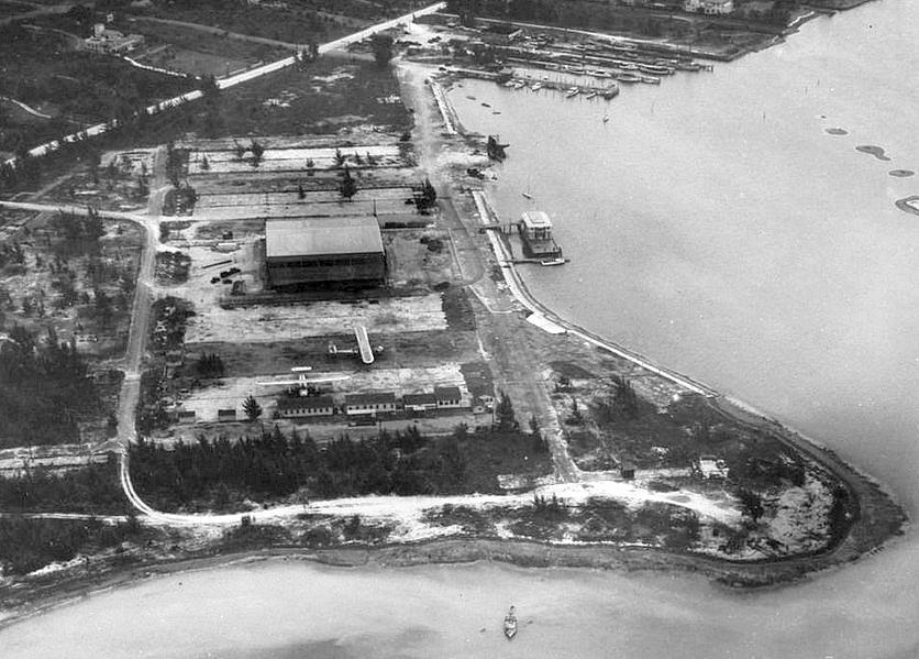
A circa 1931 aerial looking north at Dinner Key, showing 2 Pan Am Consolidated Commodore 16 flying boats (courtesy of Tom Heitzman).
Note that the hangar configuration was very different from that depicted in the 1918 photo:
the 4 rows of hangars appared to have been removed, with only their foundations remaining, and 1 smaller hangar had been built in their place.
Were the earlier hangars removed by a hurricane, or for some intentional reason?
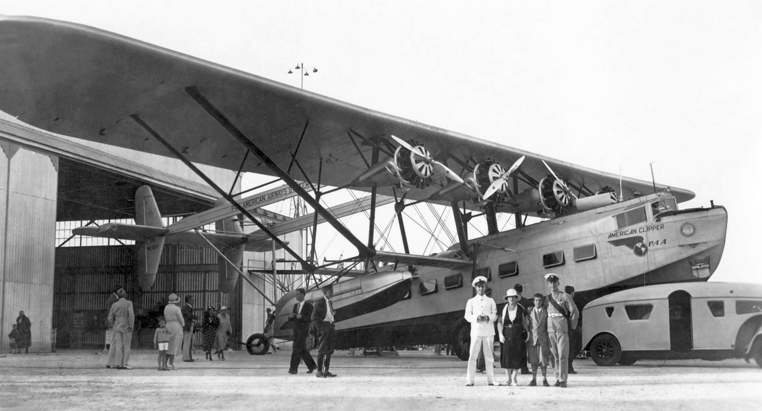
A 1931-35 photo by Jesse Wooley of Pan American Airways American Clipper, Sikorsky S-40 flying boat NC80V C/n 2000 in front of a Dinner Key hangar.
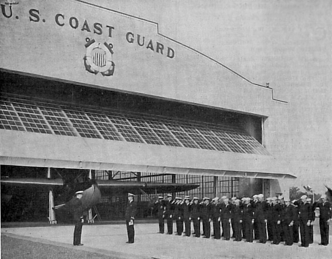
In 1932, Coast Guard Air Station Miami was commissioned at Dinner Key,
and became the first "contemporary" aviation unit in the US Coast Guard.
In the early years the Coast Guard unit flew a variety of fixed-wing amphibians.
These early fliers were tasked with routine coastal patrols, search & rescue (both maritime as well as aviation related),
and additionally were involved in the interdiction of smugglers.
The earliest chart depiction which has been located of the Pan American Seaplane Base was on a 1932 City of Miami Air Guide (courtesy of Rich Moravsik).
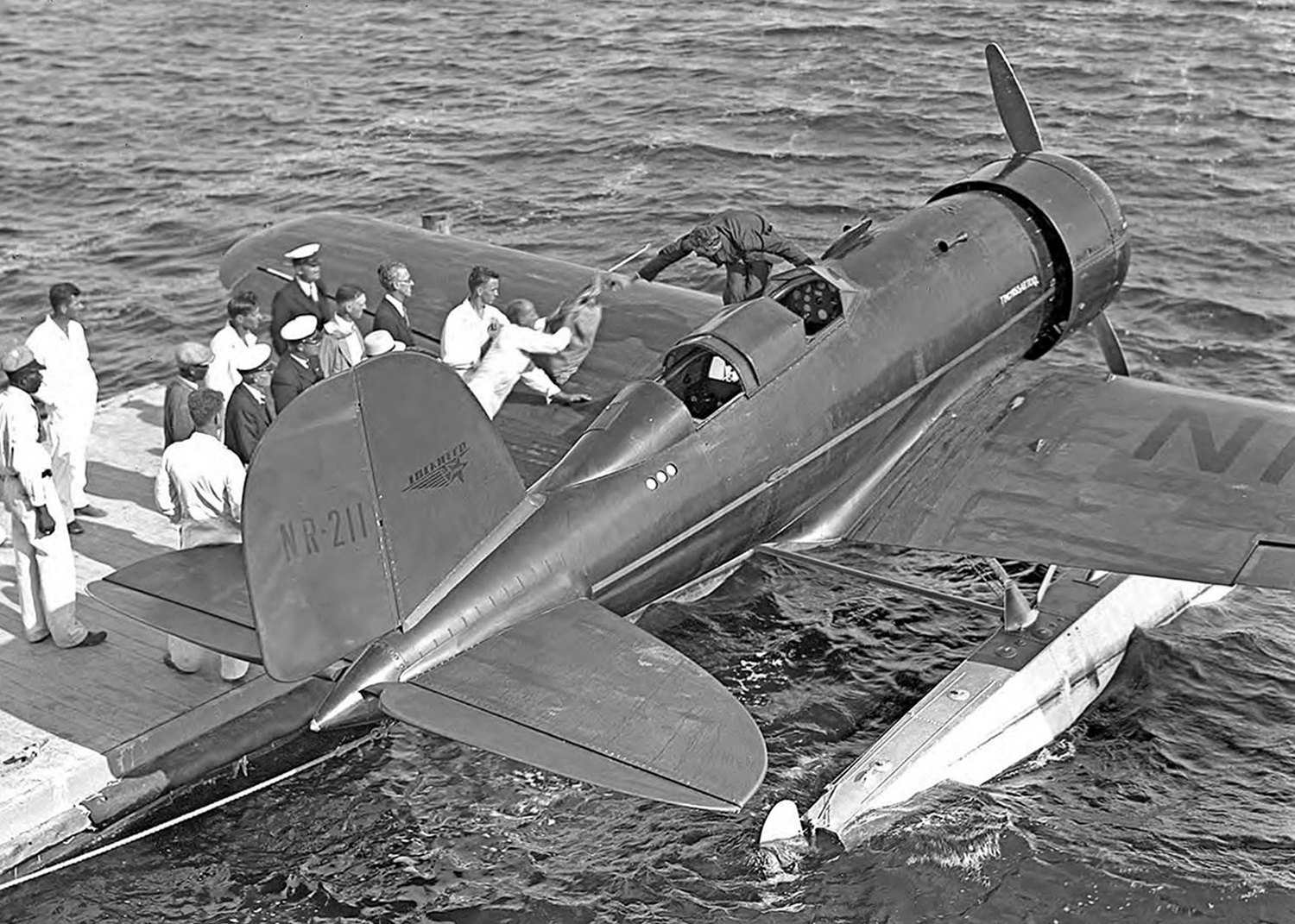
A 12/16/33 photo by Gleason Romer of Charles & Anne Lindbergh's Tingmissartoq, Lockheed 8 Sirius NE211 C/n 140 in the water at Dinner Key hangar.
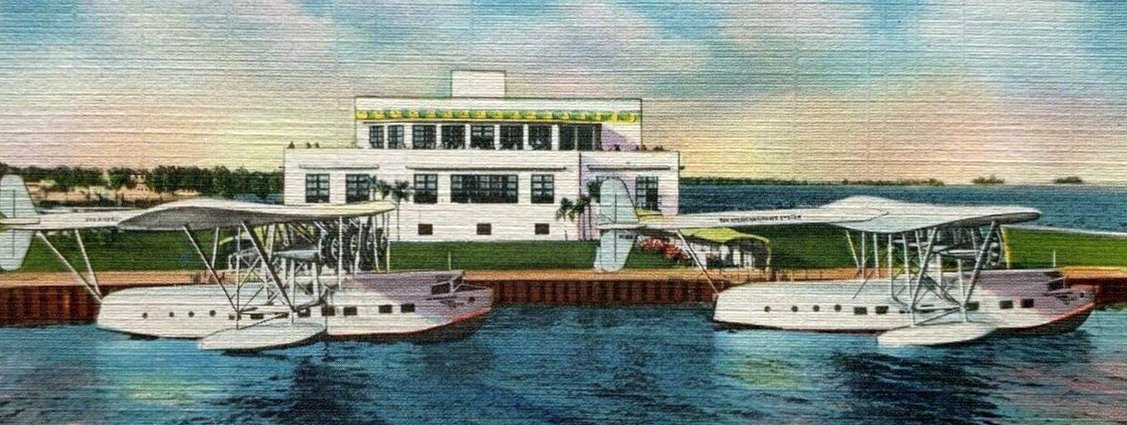
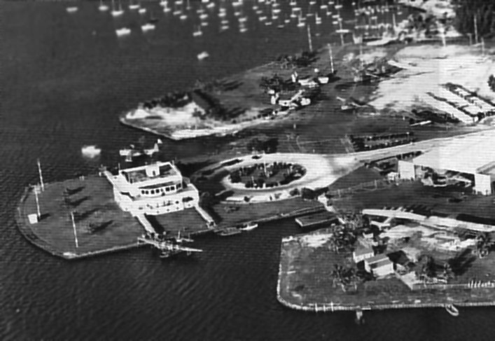
Pan Am completed an elaborate Art Deco passenger terminal building at Dinner Key in 1934.

A circa 1930s aerial view by W.F. Gerecke looking north at the Pan Am terminal at Dinner Key (courtesy of David Henderson) showing Pan Am's terminal at bottom-right & 3 hangars at top-right.
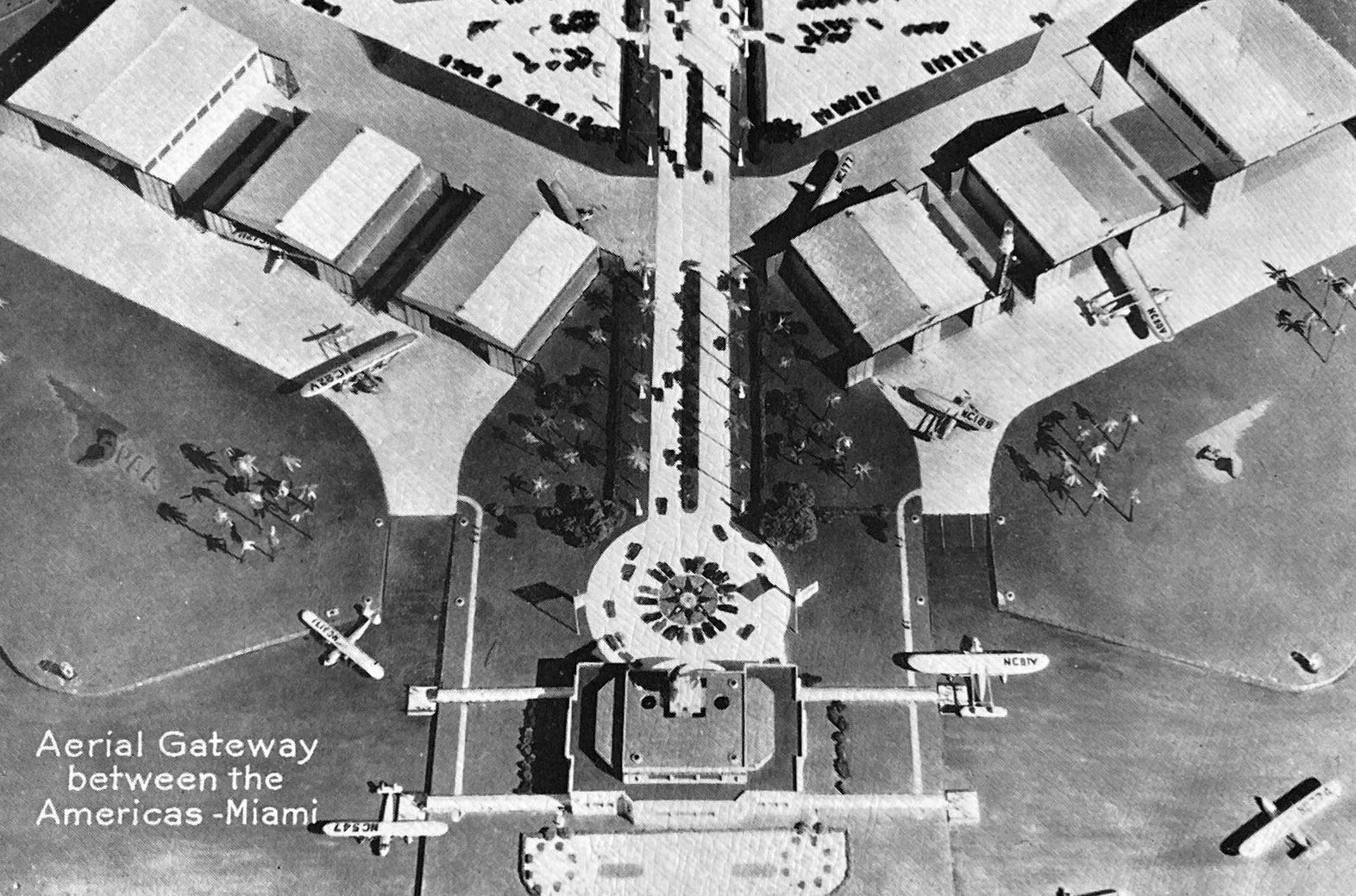
A circa 1930s artist's conception of Pan Am's “Aerial Gateway between the Americas” at Dinner Key (courtesy of David Henderson),
evidently showing a planned configuration which was never realized, with a symmetrical total of 6 hangars, 3 on either side.
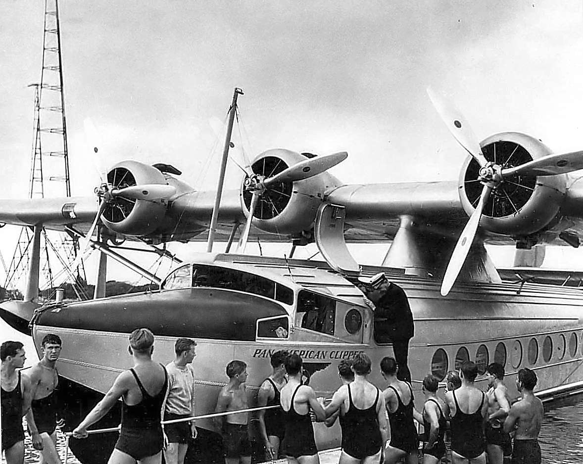
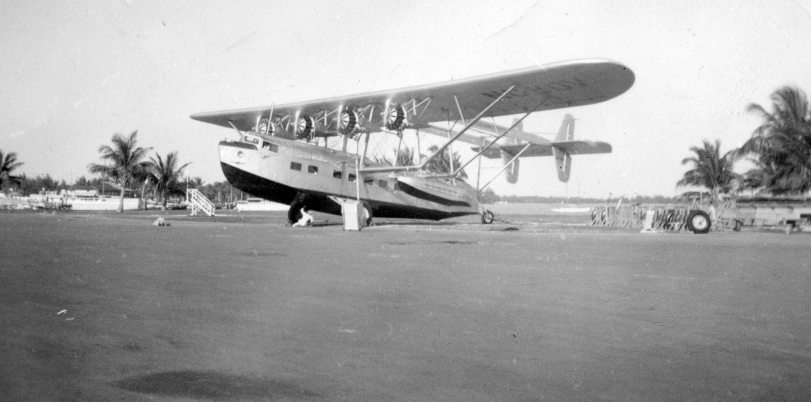
A 1934 aerial view looking northwest at the Pan Am terminal at Dinner Key, showing at least 6 flying boats (courtesy of David Henderson),
including a Sikorsky S-42 in the water, S-43 at middle-left, S-40 at center-foreground, and S-42 at center-back.
The number of hangars on the north side of the terminal had increased to 5.

A 1934 photo of a crowd at the Dinner Key terminal watching the landing of a Sikorsky S-40 flying boat (courtesy of David Henderson).
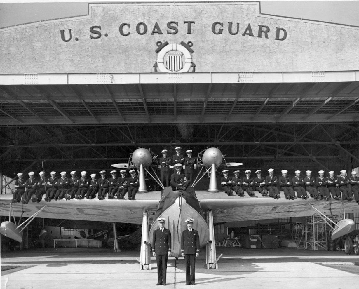
A 1/31/35 photo (courtesy of Bill Grasha) of Coast Guardsman sitting on a flying boat (model unidentified) for “General Muster” at Dinner Key CGAS Miami.
A 1935 photo a Pan Am Sikorsky S-42 Clipper being maneuvered at Dinner Key (courtesy of Paul Siwulich).
A circa 1930s colorized postcard photo of a Pan Am Sikorsky S-42 Clipper at Dinner Key (courtesy of David Henderson),
in front of what the caption claimed was the “World's largest airplane hangar”.
The earliest aeronautical chart depiction which has been located of the Dinner Key Facility
was on the December 1935 Miami Sectional Chart (courtesy of Chris Kennedy).
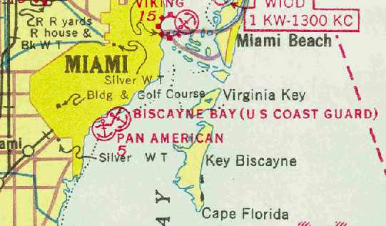
It depicted the “Pan American” & “Biscayne Bay (US Coast Guard)” seaplane bases as 2 separate facilities.

A still from the 1936 movie China Clipper looking southeast at the Dinner Key hangars & terminal (courtesy of Kevin Walsh).

A still from the 1936 movie China Clipper looking north at the Dinner Key terminal (courtesy of Kevin Walsh).
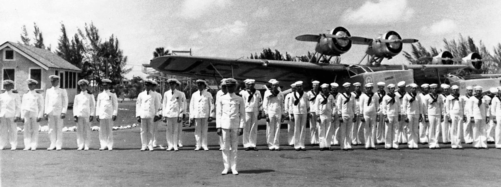
A 1936 photo (courtesy of Bill Grasha) of Coast Guardsman lined up in front of a Douglas RD-1 flying boat at CGAS Dinner Key.
A circa 1930s colorized postcard photo by W.F. Gerecke of 2 Clippers moored in front of the Dinner Key Pan Am terminal (courtesy of David Henderson).
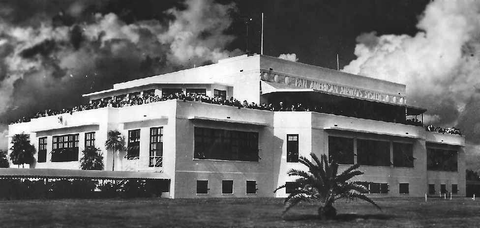
A circa 1930s photo looking north at large crowds of spectators on top of the Pan Am terminal at Dinner Key (courtesy of Lynn Higgins).
A circa 1936-38 photo of 2 Sikorsky S-42 flying boats on the Pan Am ramp at Dinner Key (courtesy of Jennifer O'Rourke).
Jennifer reported the photo was taken by her father, “when he visited Miami in the 1930s - he was a ship's photographer on cruise ships.
The ship's records indicate the photos were taken either in March 1936 or March 1938.”

A circa 1936-37 photo of Pan American Airways Sikorsky S-43 NC15064 C/n 4304 in front of the Dinner Key terminal.
The April 1937 Miami Sectional Chart (courtesy of Chris Kennedy)
continued to depict the “Pan American” & “Biscayne Bay (US Coast Guard)” seaplane bases as 2 separate facilities.

A 1939 photo of the 10' diameter, 3.5 ton globe in the interior of the Pan Am passenger terminal at Dinner Key (courtesy of David Henderson).
A 1940 map (courtesy of Kevin Walsh) of the Dinner Key “Pan American Airways” facility & “Coast Guard Air Station”.
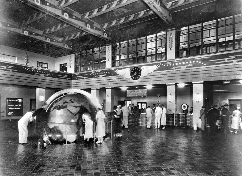
A 1940 photo of passengers looking at the massive globe in the interior of the Pan Am passenger terminal at Dinner Key (courtesy of David Henderson).
The sign above the desk advertised flights to Havana & Nassau for $35.
A Sikorsky S-41 flying boat in front of the Pan Am hangars at Dinner Key in 1940 (courtesy of Ruth Straw).
A rare Consolidated Commodore, pictured at Dinner Key in 1940 (courtesy of Ruth Straw).
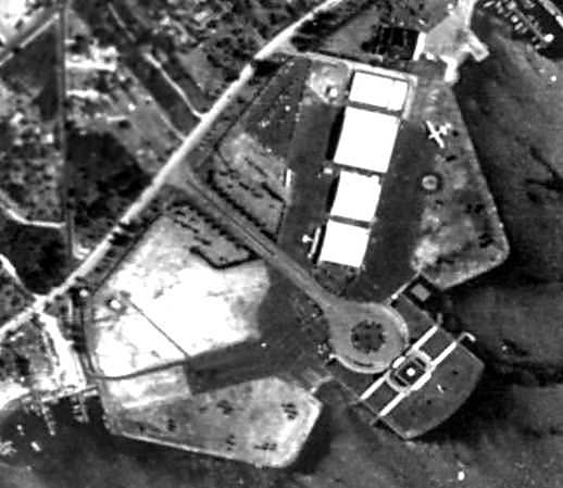
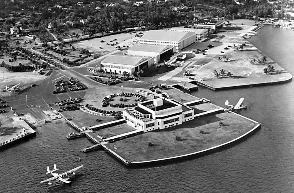
A 1940 aerial view showed the 5 seaplane hangars on the northeast side of the Dinner Key terminal building.
With the outbreak of WW2, the Coast Guard pilots from Miami flew anti-submarine warfare & convoy support missions.
All of these missions were in addition to the station’s primary function as a military search & rescue asset.
The May 1941 Miami Sectional Chart (courtesy of Chris Kennedy) continued to depict the Pan American & Coast Guard seaplane bases as 2 separate facilities,
but the latter was now labeled as “Dinner Key (US Coast Guard)”.
A March 1941 photo of a Sikorsky S-40 flying boat on the Dinner Key ramp (courtesy of Roger Cooper).
The Navy began to use Dinner Key once again in 1942,
when a detachment of VR-1 from Norfolk conducted winter training at the facility.
A 1942-43 photo of a Boeing Atlantic Clipper at Dinner Key (courtesy of John Bayless).
John recalled, “It was my father's photo when he was in Miami in 1942-43 for training prior to going over to England.”
The entire Dinner Key facility was requisitioned by the Navy in 1943, and commissioned as a Naval Air Facility.
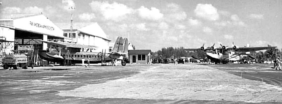
A series of 2 photographs of the seaplane facilities at Dinner Key NAF during the WW2 period (National Archives photos).
A total of 20 flying boats & floatplanes are visible in the 2 photos.
Navy squadron VR-6 was commissioned at Dinner Key in 1943.
The squadron was equipped with 18 Martin PBM flying boats,
and conducted transport missions throughout the Caribbean & Central America, and also conducted training.
A detachment of VS-39 also operated OS2U Kingfisher floatplanes from Dinner Key.
During WW2, the Coast Guard operated PBY, PBM, JRF & OS2U seaplanes from Dinner Key.
The total complement in 1944 was 745 personnel.
By the end of WW2, the facilities at Dinner Key consisted of the former Pan Am seaplane terminal,
four hangars, aircraft parking aprons on either side of the terminal, and several seaplane ramps.
An undated aerial view looking northwest at the Dinner Key terminal & hangars,
from the Haire Publishing Company's 1945 Airport Directory (courtesy of Chris Kennedy).
Naval Air Facility Dinner Key was disestablished in 1945.
With the competition from more efficient long range land-based aircraft,
Pan Am discontinued seaplane operations shortly after the end of the war, and moved their Miami operations to Pan American Field.
A historical sign was errected at the Dinner Key site in 1953 by the Historical Association of Southern FL.
The Coast Guard thus became the primary user of the Dinner Key facility in the post-WW2 period.
By the mid 1950s, the Coast Guard crews at Dinner Key were flying the amphibious Grumman HU-16 Albatross flying boat
and a new type of rescue aircraft, the Sikorsky HH-19 helicopter.
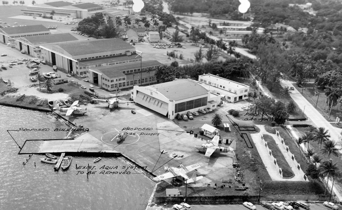
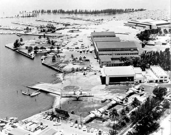
An 11/10/56 aerial view (courtesy of Bill Grasha) looking west at CGAS Dinner Key.
Note the 11 earthern-covered ammunition bunkers squeezed into a very small plot of land at bottom-right, right along the base's perimeter.
Parked on the ramp were 4 Grumman HU-16 Albatross amphibious flying boats & 1 Sikorsky HH-19 helicopter.
Visible were a total of 7 hangars, including 2 hangars on the wetsern end (top-left) which had evidently been added at some point between the 1940s & 1956.
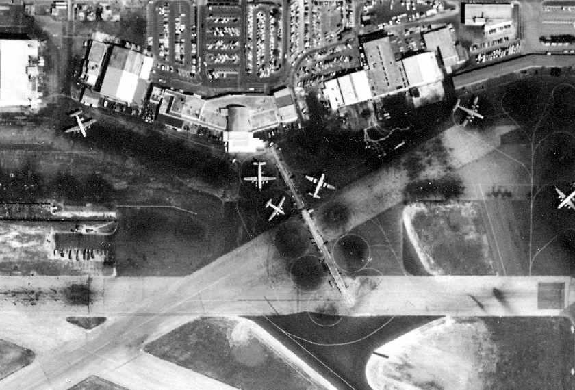
A 10/21/61 USGS aerial view of CGAS Miami / Dinner Key, showing 3 Coast Guard Grumman HU-16 Albatross flying boats on the northeast ramp.
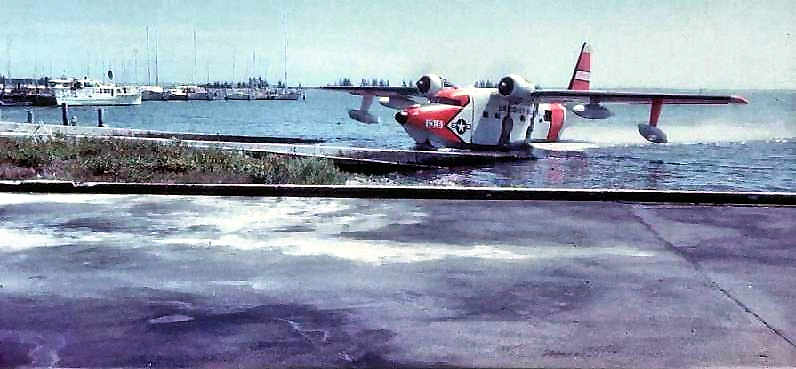
A 1963 photo of a Grumman HU-16E flying boat coming up the CGAS Dinner Key ramp.
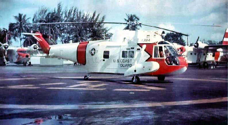
The turbine-powered HH-52 had replaced previous piston-engined helicopters at the station.
A 1964 aerial view looking southwest at CGAS Miami / Dinner Key (Florida State Archives photo),
showing 4 HU-16 Albatrosses & 2 helicopters on the ramp.
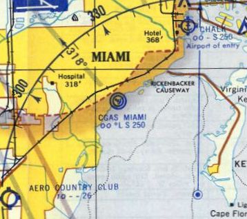
The last aeronautical chart depiction which has been located of the Dinner Key facility
was on the 1964 Miami Local Aeronautical Chart (courtesy of Tim Zukas).
It depicted the “CGAS Miami” seaplane base.
With the phasing out of flying boats from Coast Guard service,
the Coast Guard Air Station relocated to Opa-Locka Airport in 1965.
That was presumably the last aviation use of the Dinner Key facility.
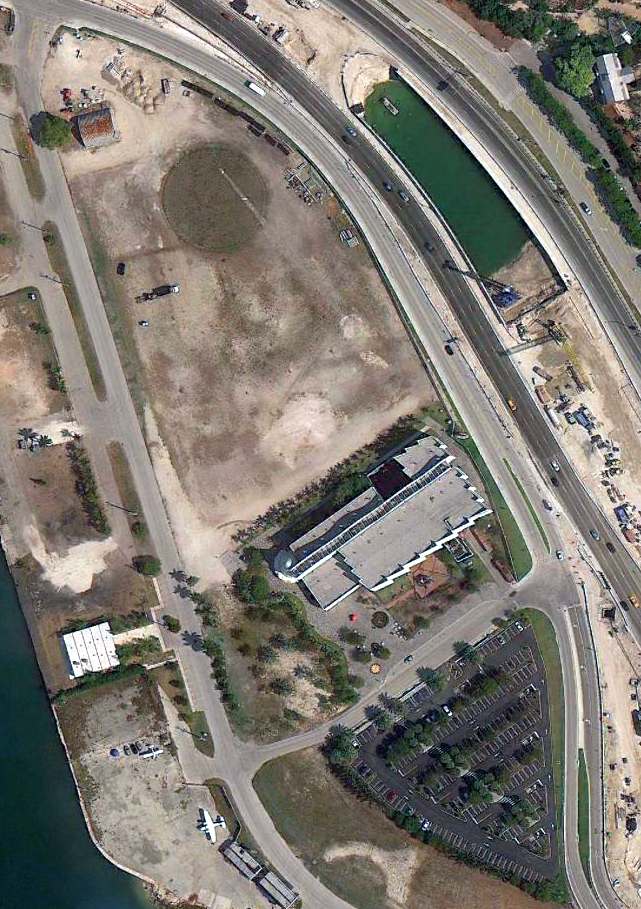
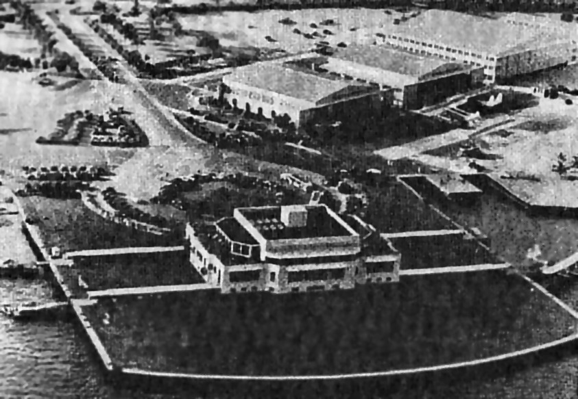
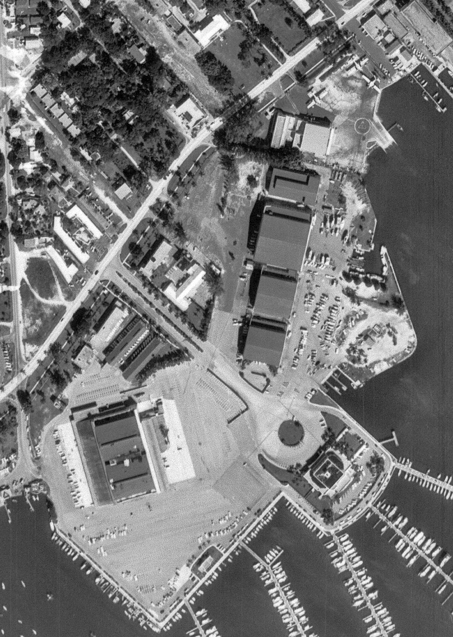
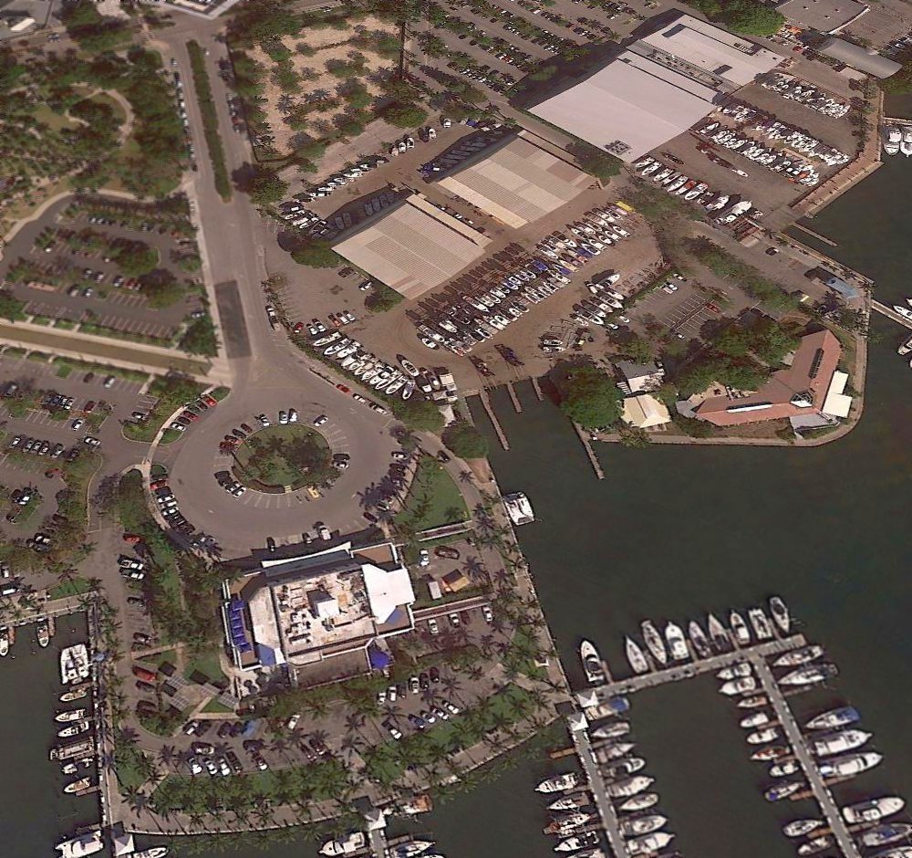
Today, the former Pan Am seaplane terminal has been reused as the Miami City Hall,
and the surrounding property has been reused as Florida's largest pleasure boat marina.
The 4 former Pan Am seaplane maintenance hangars still stand.
Two of the hangars are used by the Grove Key Marina, and another is a Sailing & Kayaking Center.
The tracks previously used to tow the Clipper seaplanes out of the water are still visible today,
still devoid of rust, in the boat basin to the right of the main terminal.
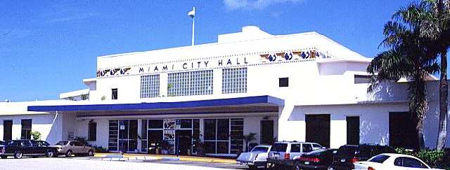
A circa 2005 photo of the former Pan Am seaplane terminal, now reused as the Miami City Hall.
As of 2005, the circa-1930s globe from the Dinner Key Pan Am passenger terminal was on display in the Miami Museum of Science.
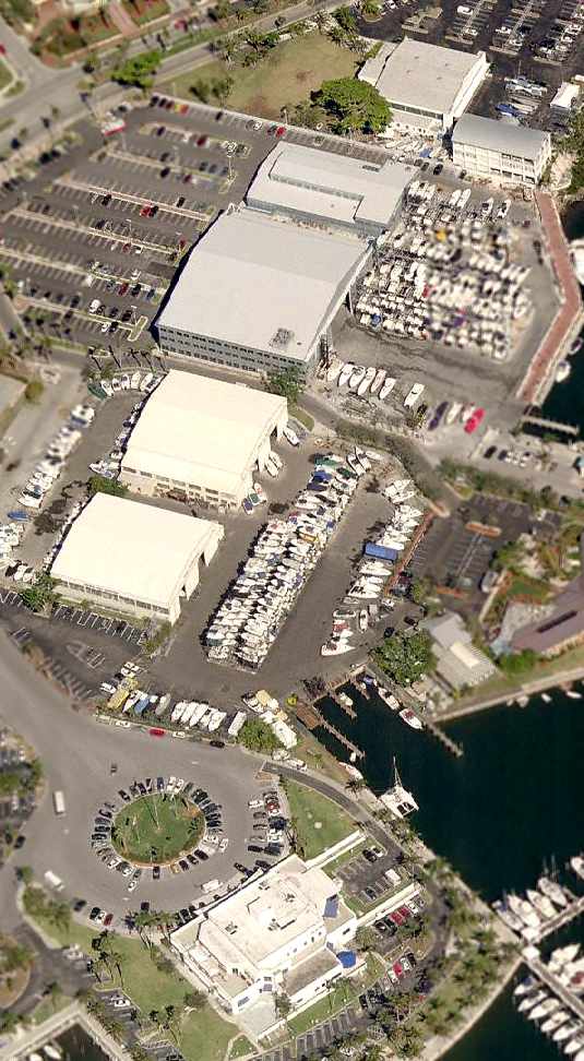
A circa 2005-2006 aerial view looking north at the former Dinner Key terminal & hangars.
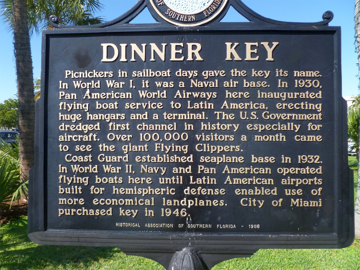
A circa 2011 photo (courtesy of Bill Grasha) of the historical sign errected at the Dinner Key site in 1953 by the Historical Association of Southern FL.
A 2017 aerial view looking northwest at the former Dinner Key terminal & hangars.

A 2025 3-D aerial image looking east at the former Pan Am seaplane terminal, now reused as the Miami City Hall.

A 2025 3-D aerial image looking northwest at the former Dinner Key seaplane hangars.
The former Dinner Key seaplane base is located at the end of Pan American Drive.
See also:
http://dhr.dos.state.fl.us/wwii/sites.cfm?PR_ID=101
http://www.globalsecurity.org/military/facility/miami.htm
____________________________________________________
Venetian Causeway Seaplane Base / Viking Airport / Embry-Riddle Seaplane Base, Miami Beach, FL
25.79, -80.17 (East of Downtown Miami, FL)
A 12/18/28 photo of a Ford Tri-Motor at Viking Airport (courtesy of Dallam Oliver-Lee).
A 1923 aerial photo (courtesy of Dallam Oliver-Lee) showed that Biscayne Island did not yet exist at that point.
The first photo which has been located of Biscayne Island was a 1927 aerial photo (courtesy of Dallam Oliver-Lee).
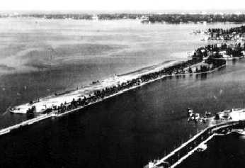
This unique (and apparently short-lived) airport was located on Biscayne Island,
along the Venetian Causeway which connects Miami Beach to the mainland.
According to the book "Wings Over Florida" by Lynn Homan & Thomas Reilly (according to Brian Rehwinkel),
this airport opened in 1928 as the "Venetian Causeway Seaplane Base".
The earliest photo which has been located of the Venetian Causeway Seaplane Base was a 12/18/28 photo (courtesy of Dallam Oliver-Lee).
In spite of the facility's name, landplane operations were evidently already being conducted,
as the photo depicted a Ford Tri-Motor on a grass field, with the water visible in the background.
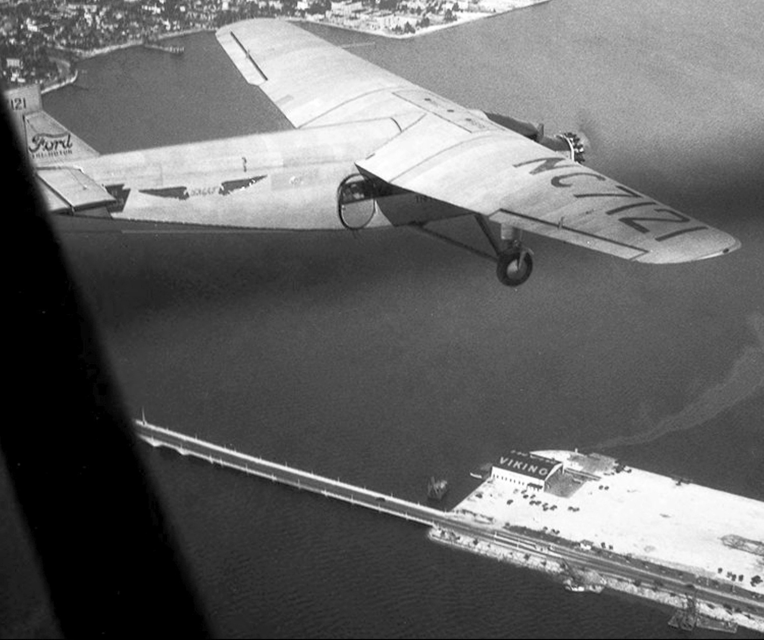
A January 1930 aerial view by Gleason Romer looking northeast at Tri-Motored Air Tours Ford 4-AT-B Tri-Motor NC7121 C/n 4-AT-35 overlflying Viking Airport,
with the hangar on the west side painted with “Viking” on its roof.
According to the book "Wings Over Florida" by Lynn Homan & Thomas Reilly (according to Brian Rehwinkel),
this airport was renamed "Viking Field" in 1931.
A 12/10/31 aerial view looking southwest at Viking Airport (courtesy of Dallam Oliver-Lee)
showed the field to have a single hangar on the west side of an east/west grass runway along the north side of the road.
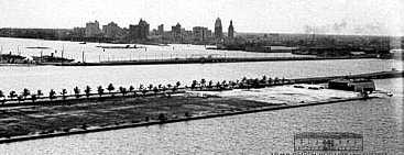
An undated aerial view looking northeast at Viking Airport,
from the Airport Directory Company's 1933 Airport Directory (courtesy of Chris Kennedy).
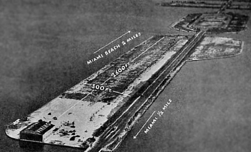
The directory described Viking Airport as having a 2,600' sod runway.
The runway layout was far from ideal, though,
as the aerial photo in the directory depicted the airfield's single large hangar
as being located right along the centerline of the western end of the runway!
Two seaplane ramps were also available.
At least 2 aircraft were visible parked near the hangar. The manager was listed as Lloyd Fales.
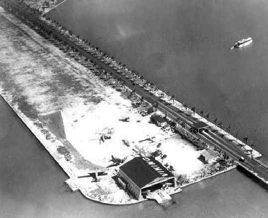
An undated aerial view looking southeast at Viking Airport (from the FL Photographic Collection).
The Viking Airport & Viking Seaplane Base were still listed
in the 1934 Department of Commerce Airport Directory (courtesy of Chris Kennedy),
and were described in basically the same fashion as in the 1933 directory.
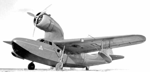
A 1935 photo of a "Kona", a Fairchild Model 91 amphibian at Viking Airport (from the FL Photographic Collection).
According to Tom Beamer, Kona was the 2nd of 7 Fairchild "Jungle Clippers" built;
it was used to explore New Guinea by Richard Archbold.
The Model 91 was designed for PanAm,
but in the end they only accepted 2 of their original order of 6.
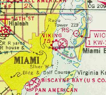
Viking was depicted as a commercial airport & seaplane base on the December 1935 Miami Sectional Chart (courtesy of Chris Kennedy).
Viking Airport was still depicted (if not labeled) on a 1936 FL Airway map (courtesy of Chris Kennedy).
 '
'
An 8/15/36 photo (courtesy of John Dougherty) of Mr. Clements & wife in front of an unidentified biplane floatplane at Viking Airport.
John Dougherty reported, “He took my eventual parents up on a short familiarization flight.”

An 8/15/36 photo (courtesy of John Dougherty) of an unidentified biplane floatplane at Viking Airport.

An 8/15/36 photo (courtesy of John Dougherty) of several floatplanes & the Viking Airport hangar.
John Dougherty reported, “From mother's 1936 diary... She visited the hangar almost exactly one year later in 1937. It was still there, but seemed abandoned.”
L.B. Clements recalled, “My Father was living in Miami in the 1930s at Viking Airport; living in the hangars, fishing off the dock.
Howard Hughes landed one afternoon & asked for a pilot to take his plane up to Palm Beach while he & his friends partied on Miami Beach.
He was willing to pay $5 for the flight; my father stepped forward & said he could pick anyone but the price was $15 (first pilots union?).
They drew straws & Father 'won' & started to get in the plane when he asked Hughes for the money.
Hughes gave him a check for $15, father said 'What can I do with a check at 8 pm in Palm Beach?'
Hughes said he owned the Palm Beach Hotel & to go there for the night.
Father got up the next day, took his first bath in 2 weeks & started out of the hotel.
The doorman stopped him & told him to pay his bill. Father replied 'You don't understand, I am Howard Hughes guest.'
The doorman replied 'You don't understand, HH called this morning & said for you to pay your bill' - $15!
He signed over the check & hitchhiked home to Miami.”
The Viking Airport was apparently closed (for reasons unknown) at some point between 1936-37,
as it was no logner depicted at all on the April 1937 Miami Sectional Chart (courtesy of Chris Kennedy)
nor listed in the Airport Directory Company's 1937 Airport Directory (courtesy of Bob Rambo).
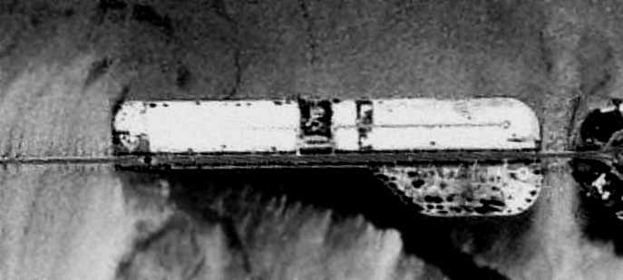
A 4/15/40 US Government aerial photo (courtesy of Brian Rehwinkel) of the site of Viking Airport.
"It does show that the airport had apparently been abandoned & the site was being re-developed by the time the photo was taken.
The street pattern has already been laid out for the housing.
If you compare it to recent photos, you can even see how the street has been routed around, what looks like, a large house.
There also appear to be 2 other houses already in place."
The last photo which has been located showing the Viking Airport site still remaining clear
was a 1942 aerial view looking northeast (courtesy of Dallam Oliver-Lee).
By 1943 the only aviation use of the island was apparently a seaplane base,
as the 1943 Miami Sectional Chart (courtesy of Chris Kennedy) depicted an "Embry-Riddle" seaplane base at roughly the same location.
The February 1945 Miami Sectional Chart still depicted an "Embry-Riddle" seaplane base at roughly the same location as Viking Airport.
By 1949, an aerial photo of Biscayne Island showed that all of the island had been covered with residential development.
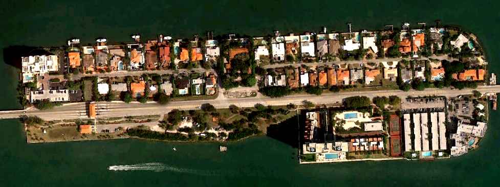
A 3/26/11 aerial photo showed that not a trace appears to remain of Viking Airport.
____________________________________________________
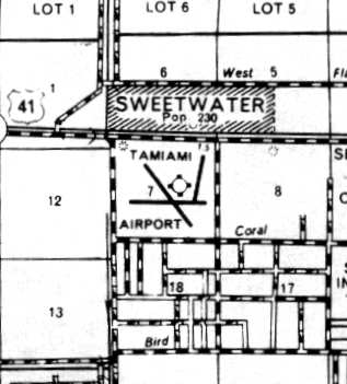
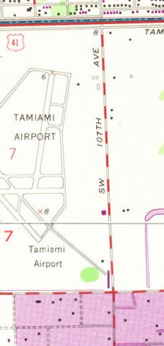
(Original) Tamiami Airport, Tamiami, FL
25.76, -80.38 (Southwest of Miami International Airport, FL)
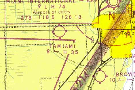
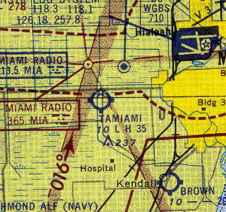
The original Tamiami Airport, as depicted on the August 1947 Miami Sectional Chart (courtesy of Chris Kennedy).
The original Tamiami Airport evidently was established at some point in 1947,
as it was not yet depicted on a 1940 aerial view nor on the February 1947 Miami Sectional Chart.
The earliest depiction which has been located of the original Tamiami Airport was on the August 1947 Miami Sectional Chart (courtesy of Chris Kennedy).
It depicted the field as having a 3,500' hard-surface runway.
The Tamiami Airport was damaged by a hurricane in 1947, which flooded the runways & caused training operations to be shifted to Opa-Locka,
according to "The History of Opa-Locka Airport", by Antolin Carbonell.
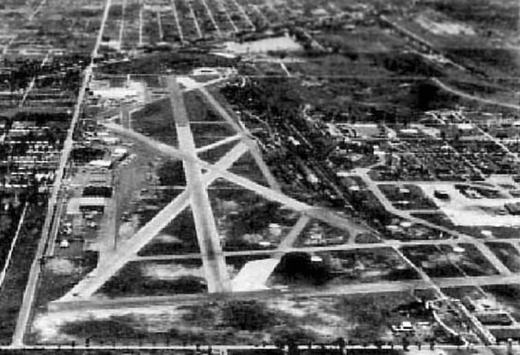
The earliest photo which has been located of Tamiami Airport was an 11/29/50 USGS aerial view.
It depicted Tamiami as having 3 paved runways, each with parallel taxiways, and a ramp area with numerous hangars on the west side of the field.
According to Joe Benson, "A Navy [Banshee] had to make an emergency landing there in the 1950s.
The runways were so short for those underpowered fighters that I think I was told they had to truck it out!"
Rachel Milliron reported, “The pilot was Fred Haise, future Apollo 13 Lunar Module pilot.
It was in a Banshee & they did end up towing it to Masters Field with the wings folded after borrowing some tires from Fred’s wingman.”
The August 1954 Miami Sectional Chart (courtesy of Chris Kennedy)
depicted the original Tamiami Airport as having a 3,500' hard-surface runway.
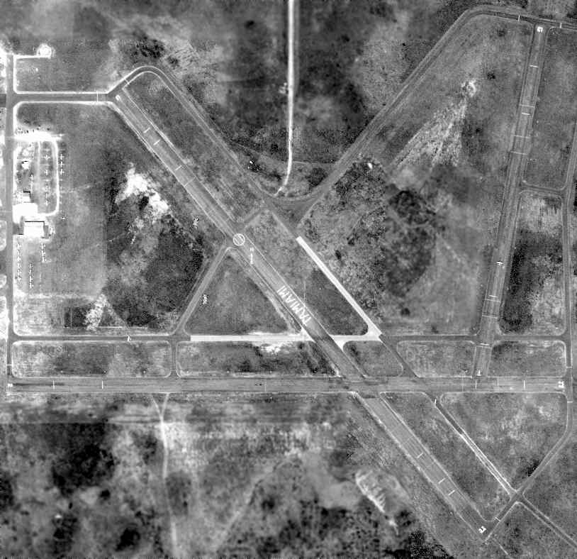
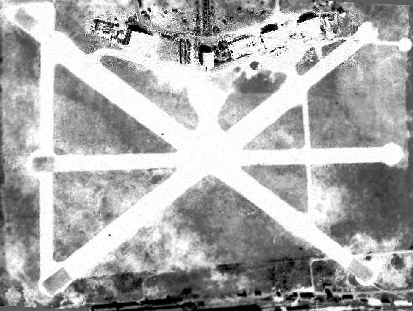
A 2/29/56 USDA aerial photo of the original Tamiami Airport, from the FL DOT (courtesy of Brian Rehwinkel).
It depicted the field as having 3 paved runways, each with parallel taxiways, and a ramp area with numerous hangars on the west side of the field.
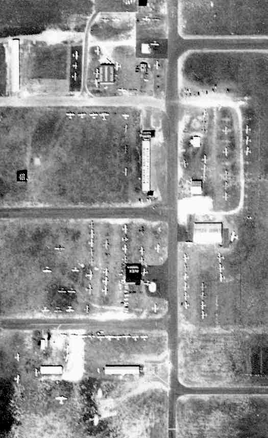
A close-up from the 1956 aerial photo (courtesy of Brian Rehwinkel) of Tamiami's ramp.
In the words of Brian Rehwinkel, "This airport was a very busy general aviation airport in 1956.
I count over 130 aircraft at the field (parked or on the runway/taxiway)."
Steve Moddle observed, “The big hangar on the east side of the picture, that was Embry Riddle's hangar.”
Stephen Moddle recalled, “I learned to fly at the Old Tamami Airport in 1957 at Embry Riddle, I started in March.
On my first solo for Runway 9, I looked down & there wass a J3 rolled over on its back.
It went through my mind, 'What am I doing up here?'
I found out later that it was a student getting ready for the commercial checkride; I don't know what caused him to flip.
Embry Riddle had a 4-5 story building that I think was on 27th Street & ground school was done there.
Behind that building was a big shop where they had the aircraft & engine school.
In back of that building was a 3-story building that was the dorm for us. It was a very busy airport in those days.
In 1957 you could get 2 years of college in conjunction with the University of Miami with Embry Riddle.
I had my commercial license then got my instrument with Sanderson Aviation which had the ground school somewhere in Miami & the plane a Cessna 172 at Tamiami.”
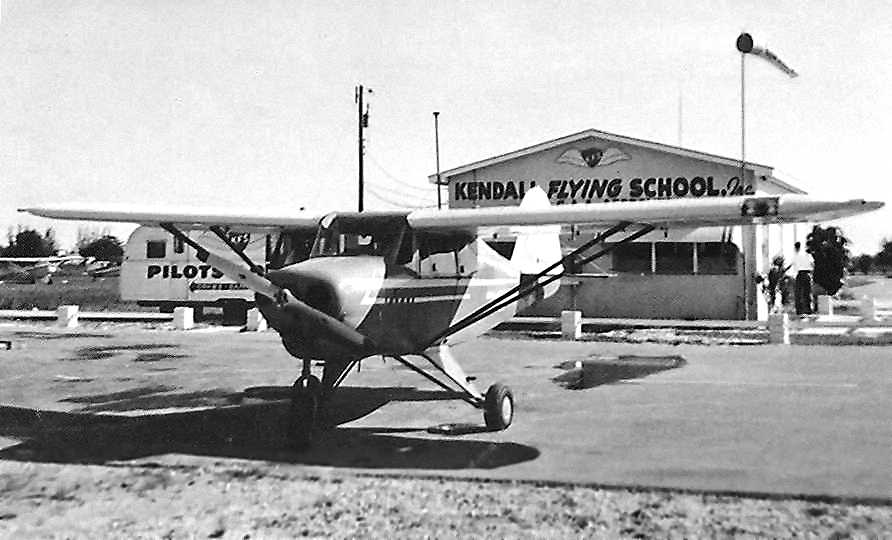
An undated photo by Fred Robbins of a Piper Tri-Pacer in front of the office of Kendall Flying School Inc. at Tamiami Airport.
Joe Benson recalled, "I took my first flying lessons there in 1960 at Kendall Flying School.
It was run by a former Women's acrobatic champion named Mary Gaffney.
She held every certificate the FAA could issue, as far as pilots were concerned; everything!"
The 1960 Jeppesen Airway Manual (courtesy of Chris Kennedy)
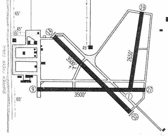
depicted Tamiami Airport as having 3 paved runways: 3,500' Runways 14/32 & 9/27, and a 2,650' Runway 1/19.
A large number of hangars were depicted along the west side.
Katherine Ryan recalled, “On 2/23/61 my father landed his Luscombe at the old Tamiami Airport.
We had escaped Castro's Cuba, and landed with 1 cup of gasoline left over!”
The original Tamiami Airport, as depicted on an early-1960s FL Department of Transportation street map (courtesy of Brian Rehwinkel).
The 1962 Miami Local Aeronautical Chart (courtesy of Jonathan Westerling) depicted the original Tamiami Airport as having a 3,800' paved runway & a control tower.
During the Cuban Missile Crisis in 1962, a surplus control tower from Miami International Airport ("Old Tower #5")
was reassembled at the original Tamiami Airport, presumably to handle an influx of deployed military aircraft.
The original Tamiami Airport was listed in the 1962 AOPA Airport Directory
with 3 asphalt runways (14/32: 3,800' long, 9/27: 3,700' long, and 1/19: 2,400' long).
The operators were listed as Avex Inc., American Aviation, Embry Riddle Aviation,
Howe Aviation, Kendall Flying School, Miami Executive Aircraft, Mike's Flying Service, Great Southern Aircraft Corp., and Tursair Inc.
Joe Benson recalled, "The last time I flew into Old Tamiami was in 1967.
I did some ups & downs in a Twin Comanche on the Northwest/Southeast runway.
The road on the north side of the field is US41, the Tamiami Trail.
On the south side of the road, there were high tension power lines.
It wasn't a sweat to bring the J-3's in across 41 & those lines, but a twin was all you could handle.
By the time you got it down to the runway, you had to bounce back in the air because the runway was so short.
The tower that's still there is one of the original towers from Miami International.
While the field was open, Miami Tower provided personnel on a rotation basis to run that tower
and in later years, the tower at Dade Collier Training & Transition."
"The reason the field closed was: it was always a hassle in later years to the traffic pattern at Miami.
In the DC-6, 7 days, it was no big deal. But with the jets on long finals, they were mixing too much out there."
The last aeronautical chart depiction which has been located of the original Tamiami Airport was on the August 1967 Miami Sectional Chart.
It depicted the original Tamiami Airport as having 3 paved runways, with the longest being 3,800'.
By the mid-1960s most of the tenants at Tamiami had relocated to Opa-locka.
The original Tamiami Airport was replaced by the new Tamiami Airport, which opened in 1967.
Mike Vidal recalled, “I lived close to the airport in 1968 & although closed,
there was still a Fixed Base Operation that was grandfathered & allowed to finish repairing some aircraft to make them airworthy.
One of those was a B-25. I moved away in 1969 & never did know when that FBO finished their work.”
Steve McDonald recalled, “The B-25 at Old Tamiami belonged to George Sullivan, an Eastern Airlines pilot.”
Tamiami Airport was still depicted on the 1969 USGS topo map.
Mike Vidal recalled, “My next visit was in 1971 and it was gone. FL International University was starting construction at that time & opened in 1974.”
The site of the original Tamiami Airport was redeveloped as the Tamiami Campus of Florida International University.
By the time of the March 1978 Miami Sectional Chart (courtesy of Ed Drury), the site of the original Tamiami Airport was depicted as an abandoned airfield.
The original Tamiami Airport was not depicted at all (even as an abandoned airfield) on the 1979 USGS topo map.
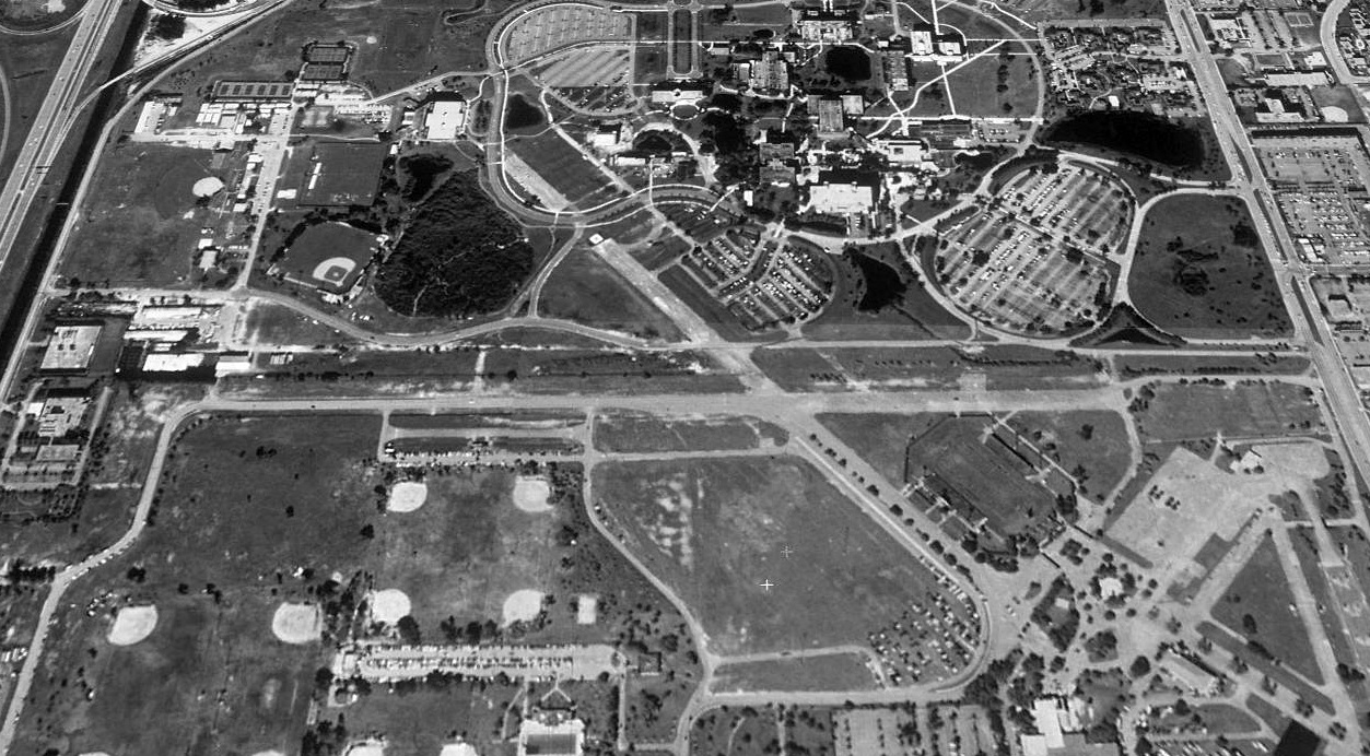
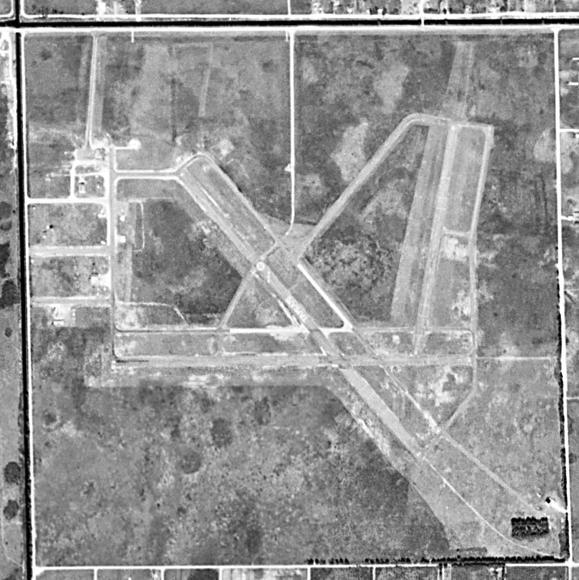
The remains of the original Tamiami Airport were still visible in the 1994 USGS aerial view looking north:
two 3,800' paved runways, parallel taxiways, and a parking ramp on the southeast corner of the property.
A circa 2006 aerial photo shows that the remains of the runways have been erased by further construction.
There does not appear to be any remaining trace of the former airport.
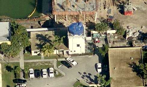
A circa 2011 aerial view looking north at the former Tamiami Airport control tower.
Mike Vidal recalled in 2013, “The only vestige that remains of the original airport is the tower building, which houses the university police.
There are still vestiges of the original runways on the property but very few, toward the south side.”
A 2/25/15 photo by Steve Beuttel of the former Tamiami Airport control tower, “now the veterans' affairs office for the campus.”
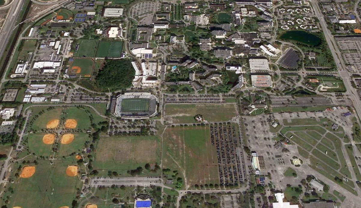
A 2020 aerial view looking north showed no recognizable trace of the original Tamiami Airport.
The site of the old Tamiami Airport is is located southeast of the intersection of the Florida Turnpike & SW 8th Street.
Thanks to Brian Rehwinkel for pointing out this airfield.
____________________________________________________
Or if you prefer to contact me directly concerning a contribution (for a mailing address to send a check),
please contact me at: paulandterryfreeman@gmail.com
If you enjoy this web site, please support it with a financial contribution.
____________________________________________________
This site covers airfields in all 50 states.