Abandoned & Little-Known Airfields:
Florida: Northern Miami Area
© 2002, © 2025 by Paul Freeman. Revised 1/12/25.
This site covers airfields in all 50 states: Click here for the site's main menu.
____________________________________________________
Please consider a financial contribution to support the continued growth & operation of this site.
All American Field / Master Airport / South Field #1 / Navy Master Field (revised 1/12/25)
Everglades Jetport / Dade-Collier Training & Transition Airport (revised 9/23/17)
Miami Municipal Airport / South Field #2 / Navy Municipal Field / Amelia Earhart Field (revised 11/25/23)
Opa-Locka West Airport (revised 3/5/18) - Sunnyside Airport / Sunny South Airport (revised 12/1/24)
____________________________________________________
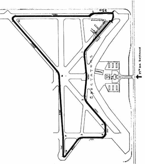
Opa-Locka West Airport, Miami, FL
25.95, -80.42 (Northwest of Miami, FL)
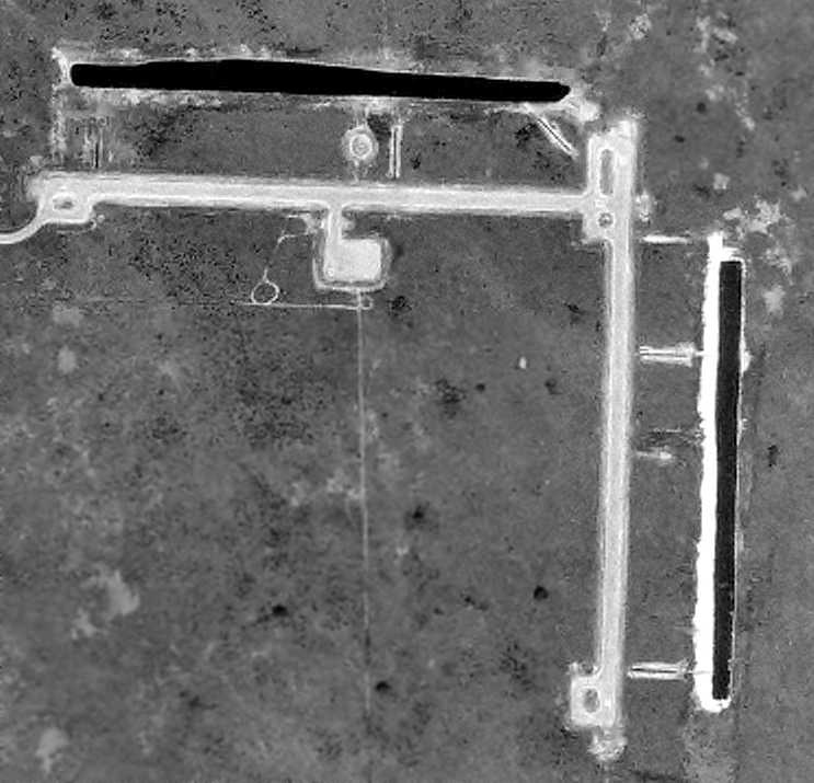
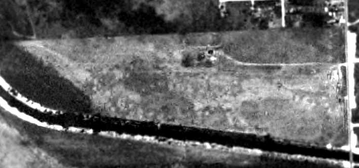
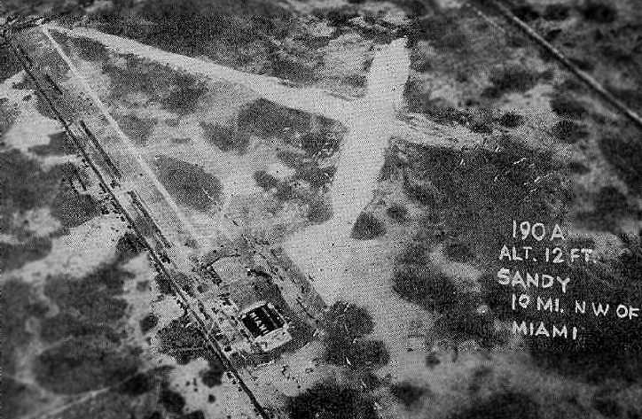
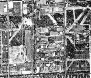
A 12/28/70 USDA aerial photo (from the University of FL Digital Library Center, courtesy of Brian Rehwinkel).
depicted Opa-Locka West as having 2 paved runways.
According to a FL Department of Transportation report, this small airport on the edge of the Everglades
was opened in 1970 with the primary purpose of relieving flight congestion of nearby Opa-locka Airport,
which in the late 1960s was one of the busiest civilian airports in the world due to flight training activity.
Opa-locka West was designed specifically for touch & go training
and consisted of two 3,000' paved runways with turnarounds at the ends and a small ramp area to park or check an aircraft.
Limited landside access & a lack of airside facilities for based aircraft were a result of the airport’s designed function.
The airport consisted of a 420 acre property.
According to Chuck Clapper, “When the airport was built it was actually paid for by Burnside Ott flight school
which at the time was the largest flight school in the country.”
The earliest depiction of Opa-Locka West Airport which has been located
was a 12/28/70 USDA aerial photo (from the University of FL Digital Library Center, courtesy of Brian Rehwinkel).
It depicted the field as consisting of 2 paved runways.
However, the assertion about an intentional lack of landside access
was obviously contradicted by this photo (and by subsequent depictions),
which clearly showed a road leading onto the airport from the adjacent West Okeechobee Road.
According to Gerard Cuomo, “The old-timers that flew in the area during the 1960s & 1970s
would still refer to Opa Locka West as 'Evergreen International Airport' as it was a major drop-off point for smugglers back then.”
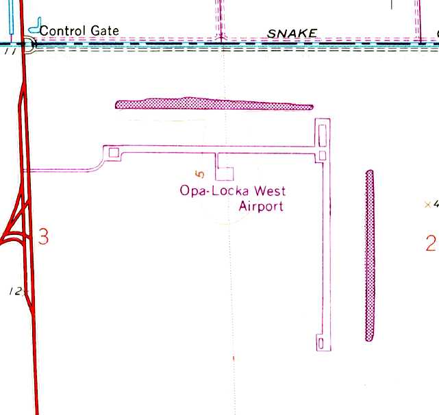
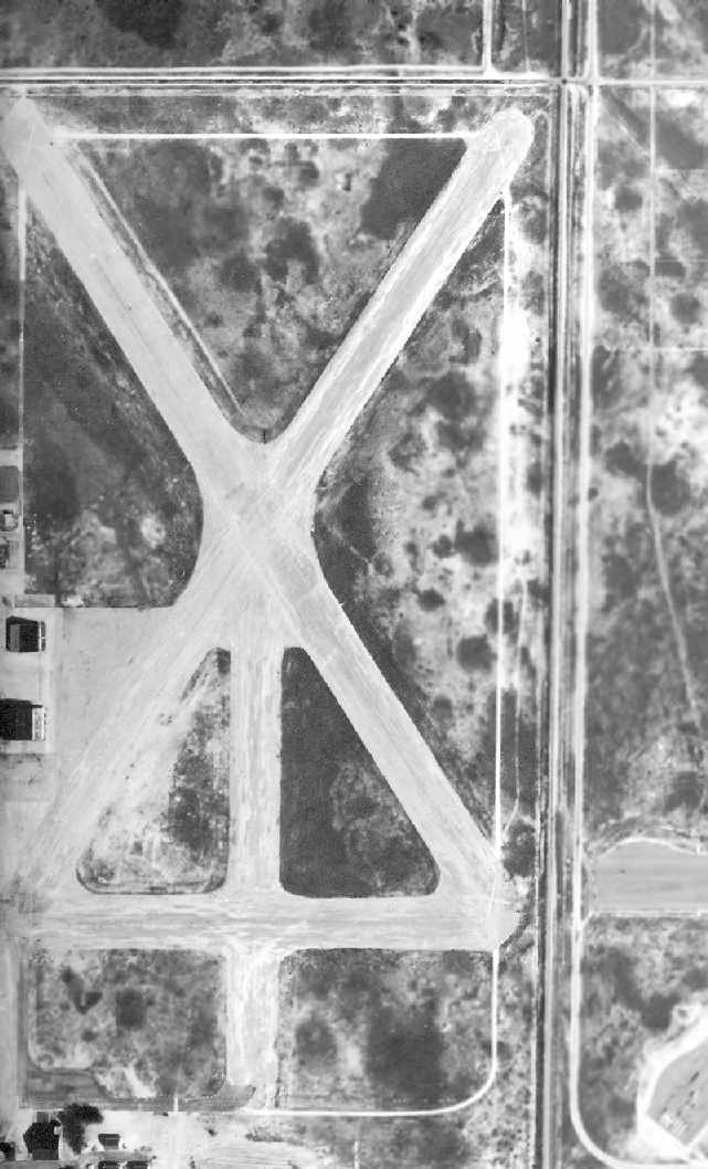
The 1973 USGS topo map depicted Opa-Locka West Airport as having 2 paved runways & a small paved ramp.
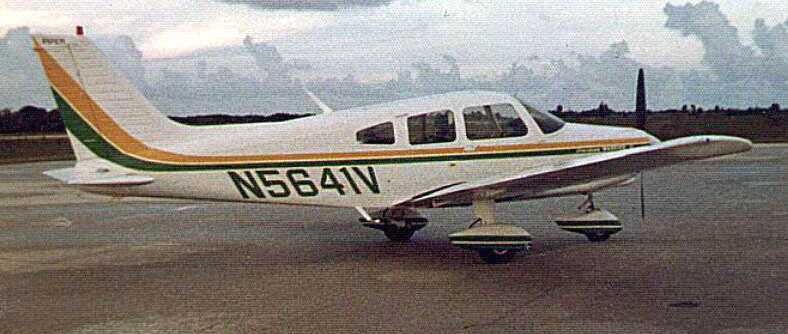
The earliest photo which has been located of an aircraft at Opa-Locka West Airport was a 1977 photo of N5641V, a Piper PA-28-161 Cherokee.
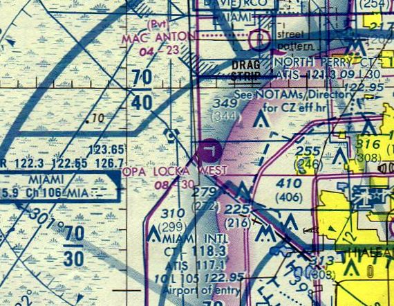
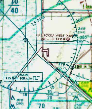
The earliest aeronautical chart depiction which has been located of Opa-Locka West Airport
was on the September 1980 Miami Sectional Chart (courtesy of Mitchell Hymowitz).
It depicted Opa Lock West as having 2 paved runways, with the longest being 3,000'.
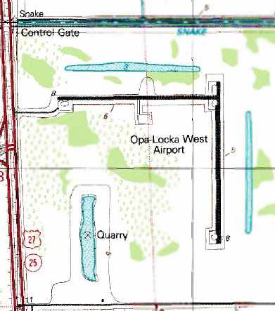
The 1988 USGS topo map depicted Opa-Locka West Airport as having 2 paved runways.
Note the appearance of the quarry to the southwest (not yet present in the 1970 photo).
This quarry would grow over the subsequent years, and eventually provide the “rationale” for closing the airport.
The March 1993 Miami Terminal Aeronautical Chart (courtesy of Charles Taylor)
depicted Opa Lock West as having 2 paved runways, with the longest being 3,000'.
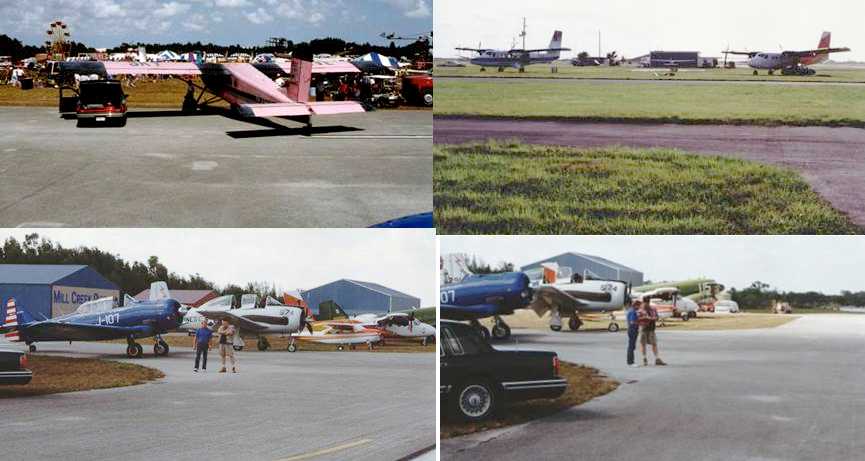
The last photos which have been located of aircraft at Opa-Locka West
were a series of 1994 photos by Chuck Clapper taken during the filming of the movie “Drop Zone”.
Chuck Clapper reported, “A lot of the movie Drop Zone was filmed at Opa-Locka West.
There were temporary buildings, a ferris wheel, and a number of airplanes operating there.
Everything was put up by Paramount for the movie then taken down.
I flew the C-47 in the movie, and used my SNJ to commute.”
Scott Levy recalled, “ I was a stagehand & construction helper for the movie 'Drop Zone' which was shot at Opa Locka West Airport [in 1994].
I helped build all of the sets for the movie. We were there for almost a month building the bar & drop zone control tower as well as the bathroom where the fight scene took place.”
According to an April 2005 FL Department of Transportation report,
“The top projects identified by management as being needed in the near term are:
1. Runway lighting & lighting vault - Equipment Project, and 2. Parallel taxiways - Capital Project.”
The largest aircraft that use Opa-locka West Airport regularly are light twin-engine aircraft such as Cessna 310s.
The current Airport Reference Code for Opa-locka West Airport is B-II.
There are no based aircraft & no storage facilities at the airport.
Opa-locka West Airport has limits to growth because of the presence of wetlands on the property.
However, the Aviation Department is planning to enhance the facility with an electrical vault
and parallel taxiway to Runway 9/27 in anticipation of future landside development for FBO & flight school activity.
Currently, the airport does not have a master plan.
Opa-locka West Airport accommodates high training activity & limited military activity.
Historic & and forecast FDOT aviation activity information on file for the airport are as follows:
General aviation operations [takeoffs & landings], 2002: 12,100, 2007: 12,406, 2012: 12,719, 2022: 13,369.
There are no buildings or facilities, and there is no public access to the airfield by land.
The airport serves as a remote area for training flights to practice touch & gos,
easing the burden of these flights on Opa-locka Airport & other nearby general aviation airports in Miami-Dade & Broward Counties.”
Gerard Cuomo recalled, “Opa Locka West... Aside from the use as a training field,
I worked for a banner towing company that operated out of there from 1996-2000.
Weekend operations would have us making sometimes up to 8 or 9 round trips in & out of there per plane each day.
We would have a full ground crew laying out banners in between flights,
and mostly tried to use the Runway 18/36 as Runway 9/27 had trees at the east end & power lines across US-27 at the west end.”
Gerard continued, “It has a very personal place in my heart for many reasons.
Flying banners was my first flying job after getting my Commercial Pilots License.
In that respect, the memories are fond.
Unfortunately, it also represents a very dark time for me
as in late January 1998, I watched a very good friend crash & die after a botched banner pickup.
The crash site is in the muddy grassy area in the northeast corner about 50 yards from the runway intersection.
To me, it's hallowed ground.”
Gerard continued, “Opa Locka West was featured routinely during the filming of Miami Vice [1984-89].
It's been in numerous episodes, and was their favorite 'smuggling' destination, which isn't that far from the truth.”
Gerard Cuomo recalled of the crash site at the northeast corner of Opa Locka West,
“As recently as 2004, I visited the site & could still find debris from the wreckage.”
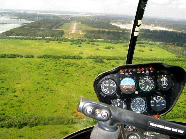
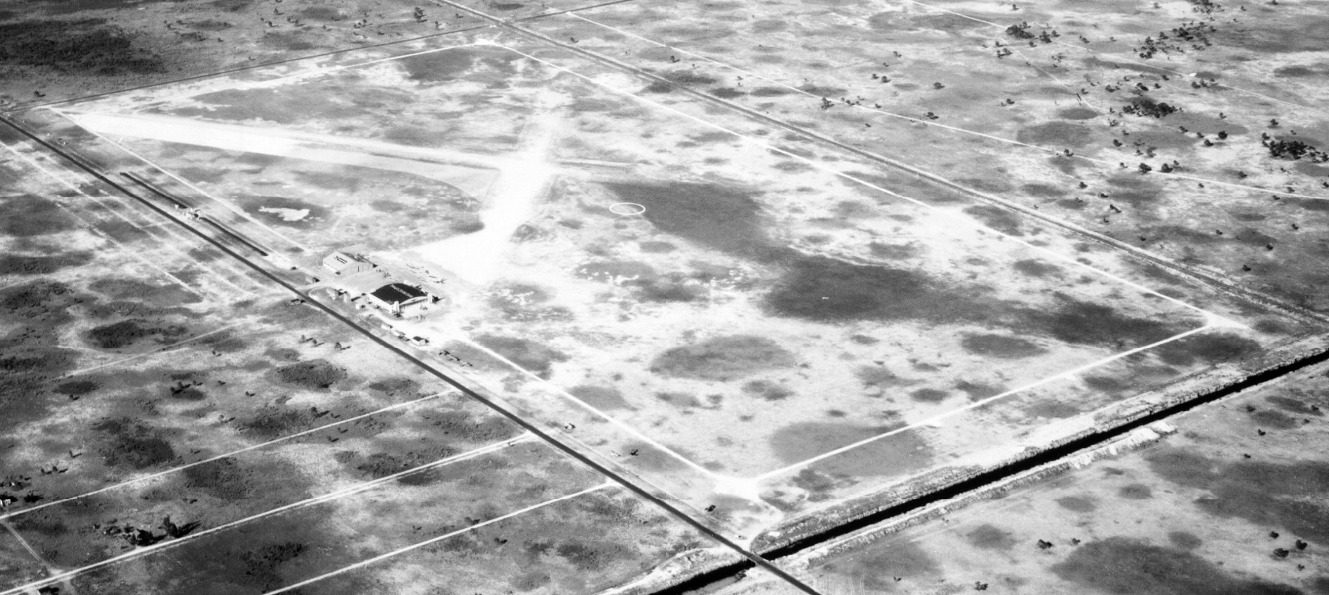
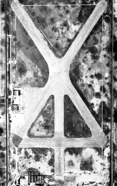
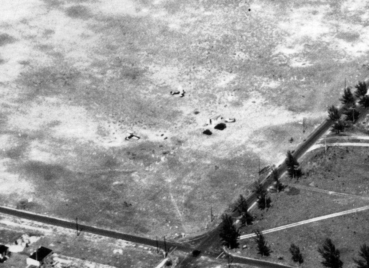
A 2004-2005 aerial view of Opa-Locka West Airport as seen from a Robinson helicopter.
Opa-locka West Airport was reportedly damaged by Hurricane Wilma in October 2005.
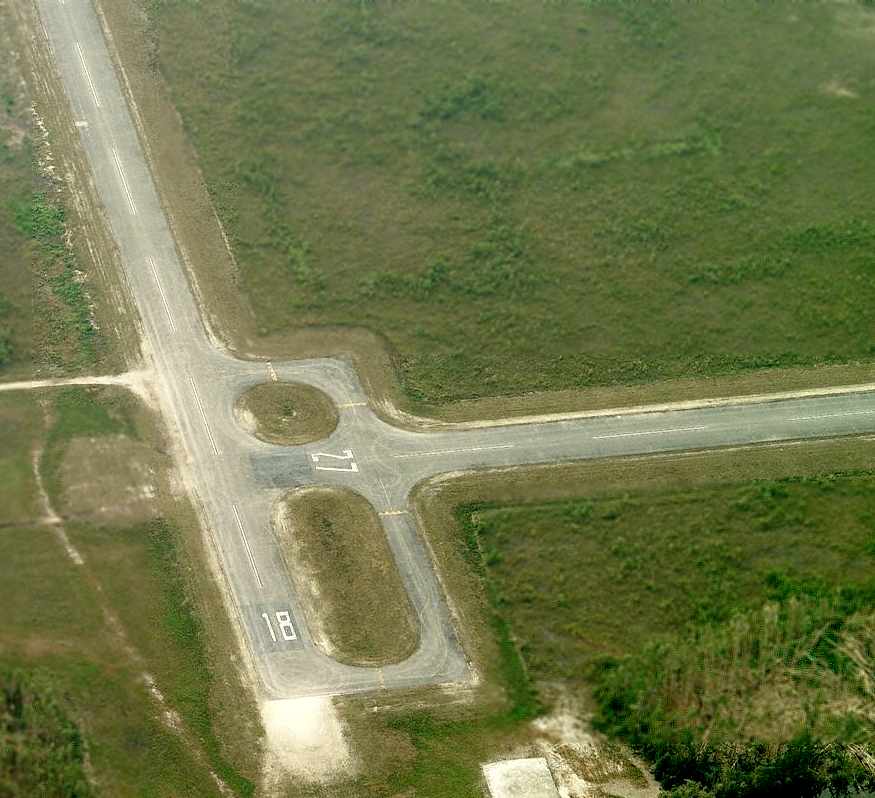
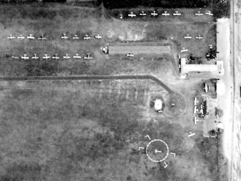
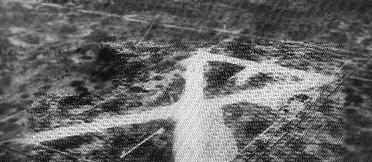
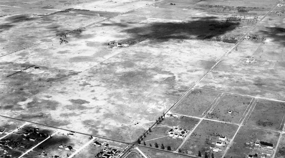
A circa 2006 aerial photo looking south along Opa-Locka West Airport's former Runway 18.

A circa 2006 aerial photo looking east along Opa-Locka West Airport's former Runway 9,
with the traffic pattern circle on the north side, and a small ramp on the south side.
In spite of the assertion that the airport had been damaged by the hurricane in 2005, the pictures from 2006 did not show any apparent damage.
Miami-Dade County announced in June 2006 that Opa-Locka West Airport would be decommissioned.
The real reason for the county's closure of the airport soon became apparent – greed.
The county planned to use the land as a quarry,
with an estimated yield of 47 million cubic feet of limestone worth between $500 million - $1.2 billion.
Countyline Dragway, a 1/8-mile drag racing strip sanctioned by the International Hot Rod Association
opened at the Opa-Locka West Airport site in January 2007.
The August 2007 Miami Terminal Aeronautical Chart depicted the site of Opa-Locka West Airport as an abandoned airfield.
Gerard Cuomo reported of Opa-Locka West Airport in 2009, “I had hoped the field would flourish with the rapid population push westward,
but I see now that it is no more. Quite sad.”
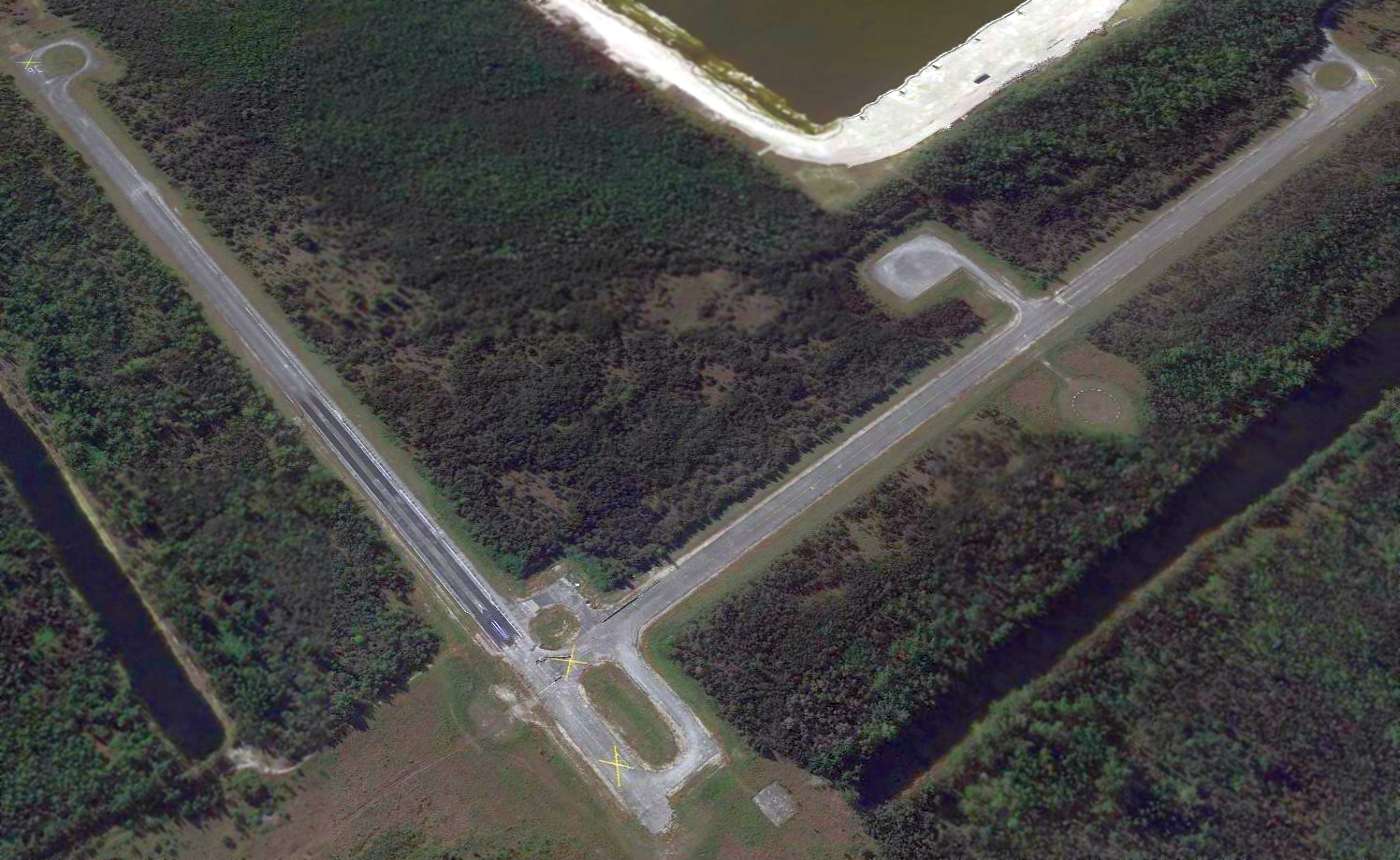
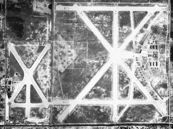
A 2014 aerial view looking southwest depicted the former Opa-Locka West Airport after its closure, with the former Runway 18/36 having been reused as a drag strip.
Note how much bigger the quarry (filled with water) had become, compared to its depiction on the 1988 topo map.
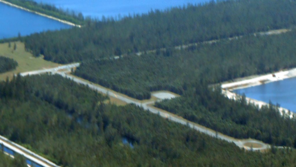
A 3/4/18 aerial view by Alex Price looking southeast at Opa-Locka West Airport.
What a shame to see this nice general aviation infrastructure just wasting away.
The site of Opa-Locka West Airport is located east of the intersection of West Okeechobee Road & North Krome Avenue.
____________________________________________________
Sunnyside Airport / Sunny South Airport, Miami, FL
25.86 North / 80.21 West (Northeast of Miami International Airport, FL)
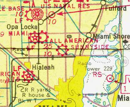
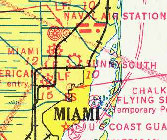
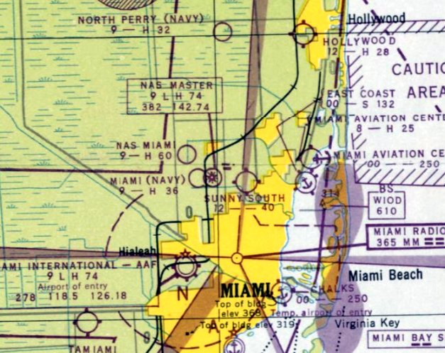
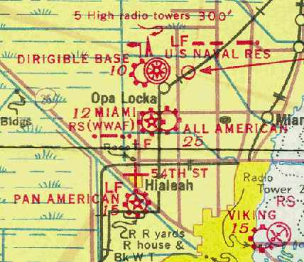
Sunnyside Airport, as depicted as a commercial airport on the April 1937 Miami Sectional Chart (courtesy of Chris Kennedy).
This little general aviation airport was located was located on the north side of the Little River Canal in what eventually became the center of Miami.
Sunnyside Airport was evidently established at some point between 1935-37,
as it was not yet depicted on the December 1935 Miami Sectional Chart (courtesy of Chris Kennedy).
The earliest depiction which has been located of Sunnyside Airport was on the April 1937 Miami Sectional Chart (courtesy of Chris Kennedy).
It depicted Sunnyside as a commercial airport.
The airport was evidently renamed “Sunny South” at some point in 1937,
as that is how it was listed in The Airport Directory Company's 1937 Airport Directory (courtesy of Bob Rambo).
It described Sunny South as a commercial airport having a single 2,640' east/west sod runway.
The 5/3/40 USDA aerial photo (courtesy of Brian Rehwinkel)
depicted Sunny South Airport as consisting of a very simple grass landing area, oriented east/west,
with possibly a single hangar & some other small buildings on the east side of the field.
Bob Maxey reported, “My grandfather, Lee Maxey, soloed at Sunny South in 1940.”
The May 1941 17M Regional Aeronautical Chart (courtesy of Brian Rehwinkel)
depicted Sunny South as a commercial airport.
Michael Fiset reported, “Sunny South Airport was closed on 12/1/42 due to overcrowding of airspace.
It closed along with 2 other civilian airports in the area.”
Sunny South Airport was was not listed among active airfields in the April 1944 US Army/Navy Directory of Airfields (courtesy of Ken Mercer),
nor was it depicted on the 1944 Miami Sectional Chart (according to Brian Rehwinkel)
or the 1946 Miami Local Aeronautical Chart (according to Brian Rehwinkel).
According to Robert Uricho's obituary (courtesy of Michael McMurtrey), following his Army discharge after WW2, Robert purchased Sunny South Airport.
Sunny South Airport was evidently reopened at some point during 1946,
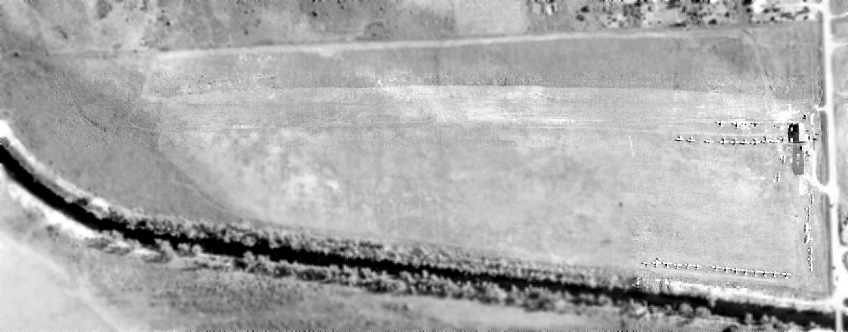
as the 7/1/46 FL DOT aerial photo of Sunny South Airport (courtesy of Brian Rehwinkel) showed the field to be quite well-used.
Like many other general aviation fields, it served many returning veterans during this port-war aviation boom.
As seen in this photo, the airfield consisted of an east/west grass runway, with a single hangar at the east side of the field.
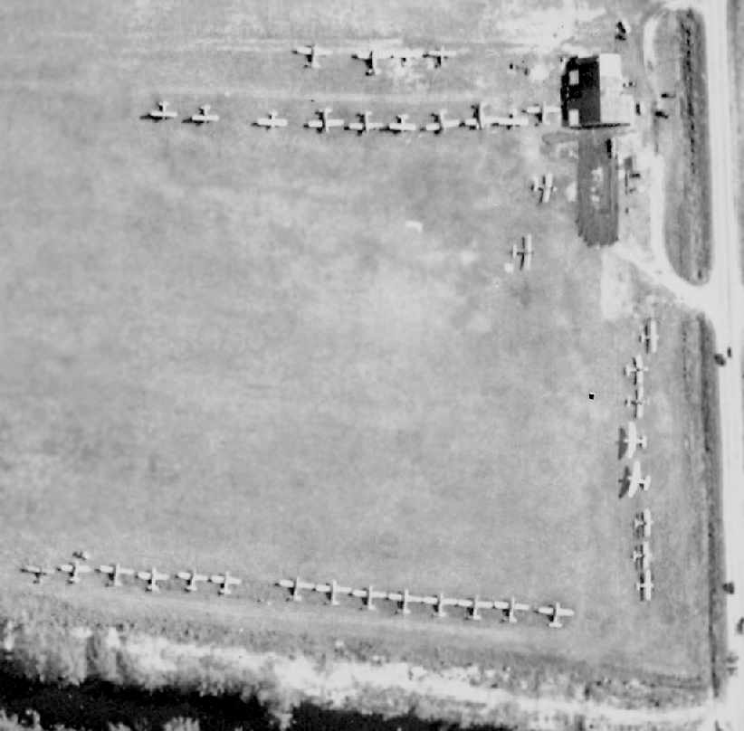
A close-up from the 7/1/46 FL DOT aerial photo of Sunny South Airport (courtesy of Brian Rehwinkel),
showing the hangar & a total of 37 light general aviation aircraft.
Steve McDonald recalled, “Sunny South on 7th Avenue about 95th Street was run by Charlie Darnes.
Ruth Mullis recalled, “I had around 25-30 miles to go to work [at Brown's Airport].
I lived in Dade County (northwest area); the back fence at my home was the north extension of Sunny South Airport.
Sometimes I would work later than my regular hours & Al would tell me to take a plane home instead of facing all the work traffic driving.
Sounded good to me; I could make it home in 10 minutes & tie down right next to my backyard.
I'd put my car in the hanger at work which was locked overnight. Then I'd fly back to work the next day. HOW ABOUT THAT??”
The August 1947 Miami Sectional Chart depicted Sunny South Airport as having a 4,000' unpaved runway.
The 1950 USGS topo map depicted Sunny South as an open area on the north side of the Little River, with a single T-hangar on the east side.
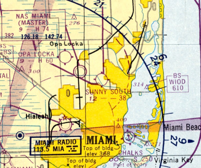
The last aeronautical chart depiction which has been located of Sunny South Airport was on the July 1950 Miami Sectional Chart.
It depicted Sunny South Airport as having a 3,800' unpaved runway.

An undated aerial view looking south at Sunny South Airport from the November 1950 Skyways Magazine (courtesy of Tony Richardson).
At some point between 1946-50, 2 rows of T-hangars had been added on the northeast side.
Note also the "Sunny South Airport" lettering in between the runway & the canal bordering the south side of the field.

An undated photo from the November 1950 Skyways Magazine (courtesy of Tony Richardson) showing a Grumman Widgeon amphibian & other light aircraft in front of a row of Sunny South Airport T-hangars.

An undated photo from the November 1950 Skyways Magazine (courtesy of Tony Richardson) of an observer & Sgt. Yancey in a Miami Police Department Harbor Patrol biplane at Sunny South Airport.

An undated photo from the November 1950 Skyways Magazine (courtesy of Tony Richardson) of hunters & their dog boarding a charter plane at Sunny South Airport, going after quail in the Everglades.
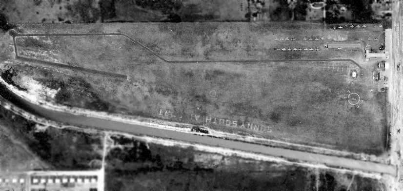
A 5/7/51 FL DOT aerial photo of Sunny South Airport (courtesy of Brian Rehwinkel).
A paved taxiway had been added, running to a paved takeoff strip which had been added over the western third of the grass runway.
A close-up from the 5/7/51 FL DOT aerial photo of Sunny South Airport (courtesy of Brian Rehwinkel),
showing a total of 32 light general aviation aircraft parked at the field, along with a few small buildings.
The last reference to Sunny South Airport which has been located was in the 1952 Aviation Week Airport Directory (according to Brian Rehwinkel),
which described Sunny South as having a 3,800' unpaved runway.
Sunny South Airport presumably closed at some point between 1952-53,
as it was no longer depicted at all on the January 1953 Miami Sectional Chart.
It presumably succumbed to the explosive post-war urban growth in the Miami metropolitan area.
A 1980 aerial view showed housing covering the site, with no trace left of the airport.
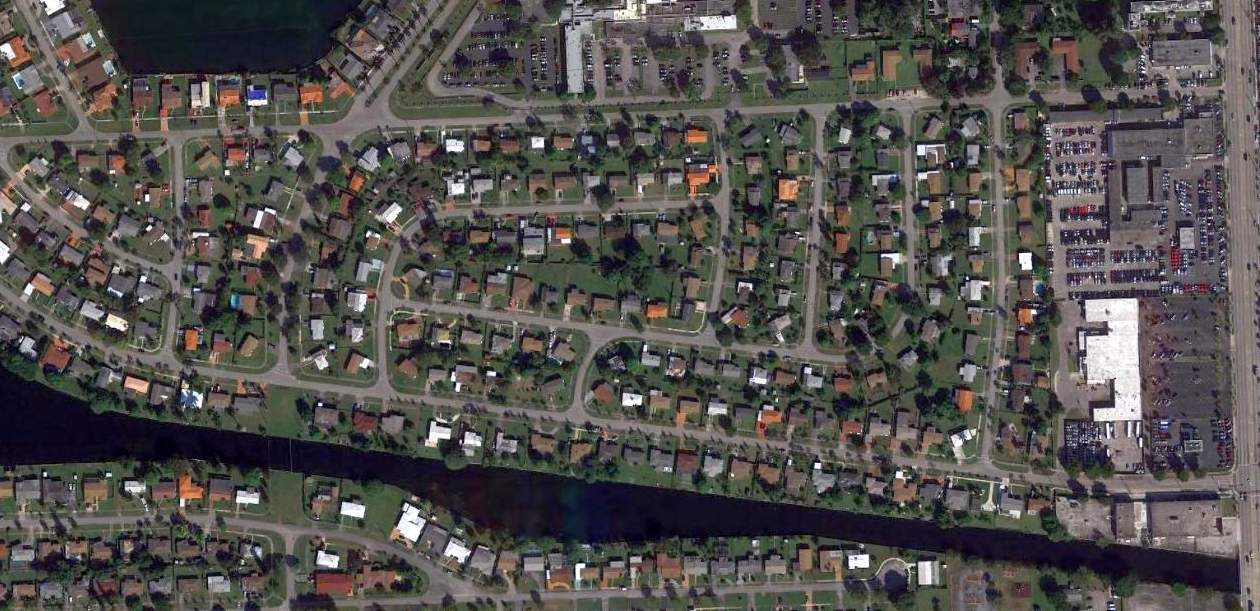
A 2014 aerial view showed the site of Sunny South Airport consists of residential housing & some commercial development.
The North Shore Medical Center is located adjacent to the north side of the airport site.
Not a trace appears to remain of the former airport.
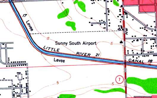
The site of Sunny South Airport is located at the southwest corner of Northwest 7th Avenue & 91st Street.
____________________________________________________
Miami Municipal Airport / South Field #2 / Navy Municipal Field / Amelia Earhart Field, Hialeah, FL
25.88, -80.26 (Northeast of Miami International Airport, FL)
Miami Municipal Airport, as depicted on the 4/30/29 Commerce Department Airway Bulletin (courtesy of Mike Denja).
The history of this airfield is intertwined with that of Master Field, which sat adjacent to Miami Municipal to the east.
The fields were separated by a set of railroad tracks.
Both fields were located a mere 2 miles to the southeast of present-day Opa-Locka Airport.
Glenn Curtiss gave the City of Miami the site of this airfield in 1928
and the city created an Aviation Department to administer it (according to Antolin Carbonell).
According to Joe Benson, Miami Municipal Airport was used by Eastern & one or two other airlines early on.
Once Pan Am Field opened (in 1928), Municipal Airport was then left to general aviation.
The earliest depiction which has been located of Miami Municipal Airport was on the 4/30/29 Commerce Department Airway Bulletin (courtesy of Mike Denja).
The 4/30/29 Commerce Department Airway Bulletin (courtesy of Mike Denja) described Miami Municipal Airport as being owned by the City of Miami & operated by A.H. Heermance.
It was said to consist of a 160 acre square sandy field, within which were 2 perpendicular runways.
Two small buildings were depicted along the southwest edge, including a 100' x 90' steel hangar.
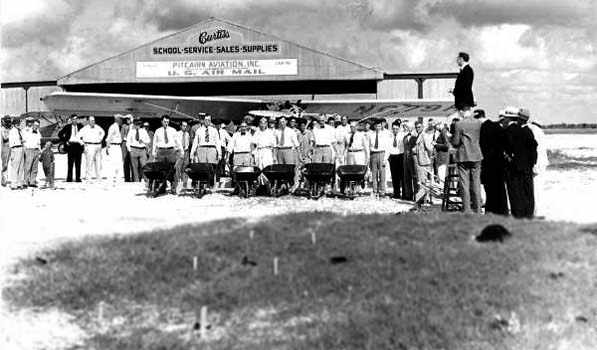
The earliest photo which has been located of Miami Municipal Airport was an 11/4/29 photo (Florida State Archives photo)
of a groundbreaking ceremony at the Curtiss Flying Service / Pitcairn Aviation hangar.
This groundbreaking presumably was for a 2nd hangar.
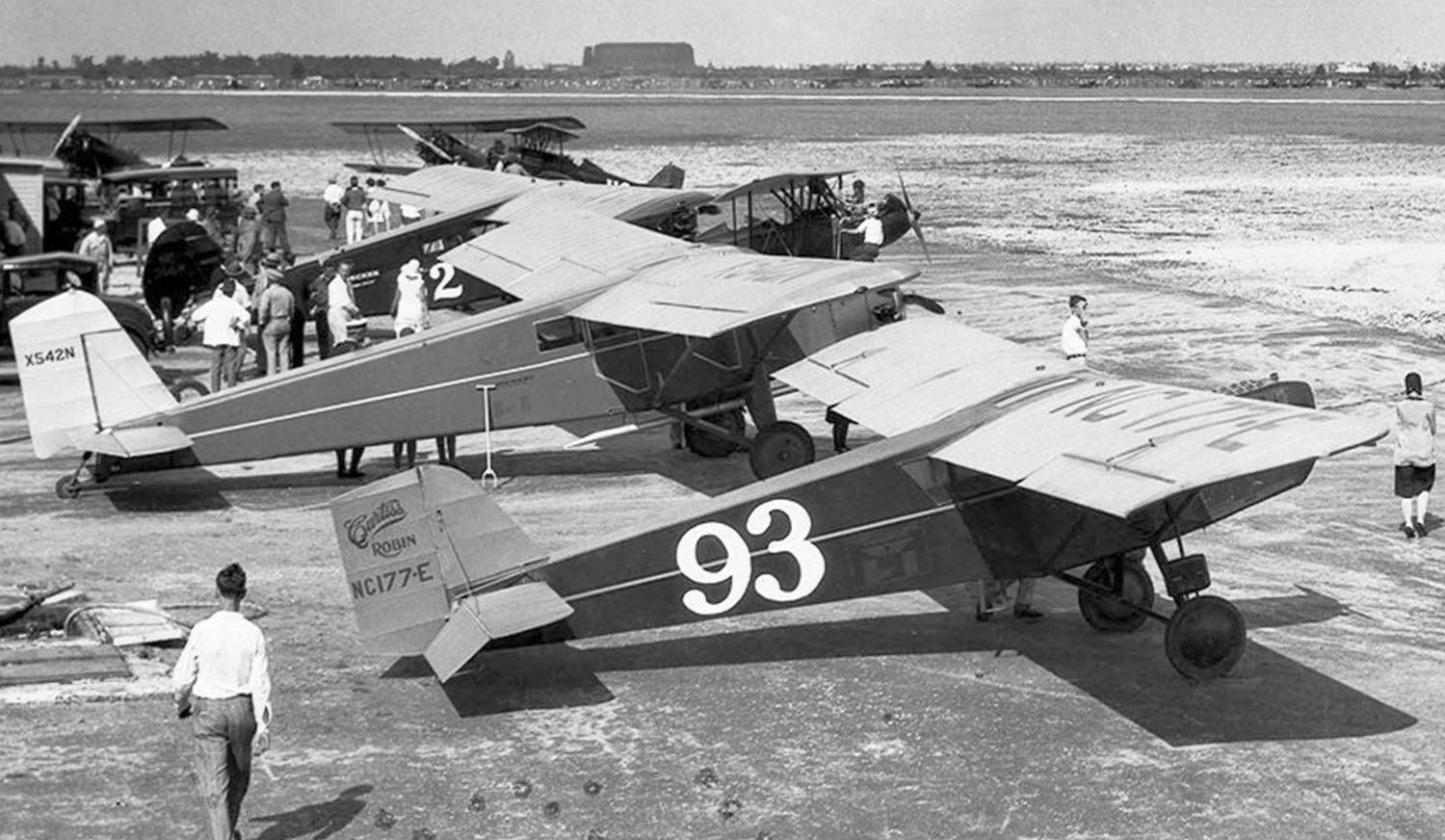
A January 1930 photo by Gleson Romer of planes gathered at Amelia Earhart Field for the 2nd Miami All American Air Races.
Plane in the foreground is Curtiss 50B Robin NC177E C/n 92.
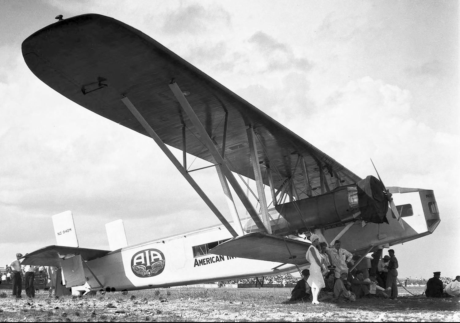
A January 1930 photo by Gleson Romer of American International Airways Sikorsky S-37-2 NC942M C/n 2, seen at Amelia Earhart Field during the 2nd Miami All American Air Races.
A 1930 photo of the Curtiss-Wright Corporation hangar at Miami Municipal Airport (Florida State Archives photo).
According to the state archives, this hangar was utilized by Pitcairn Aviation (the predecessor to Eastern Air Lines), and by Eastern Air Lines.
The small building on the right was the U. S. Weather Bureau Weather Station.
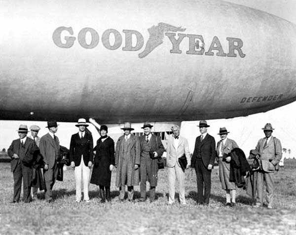
A 2/11/30 photo of the Goodyear Blimp “Defender” at Miami Municipal Airport (Florida State Archives photo).
Before he died in 1930, Glenn Curtiss donated additional acreage to this field (according to Antolin Carbonell).
An aerial view looking northeast at Miami Municipal Airport from the Airport Directory Company's 1933 Airports Directory (courtesy of Chris Kennedy).
Note the large number of planes scattered around the hangar at the bottom of the photo.
The directory described Miami Municipal as having two 2,500' unpaved runways, oriented northeast/southwest & northwest/southeast.
The aerial photo in the directory depicted 3 hangars on the southwest side of the field, one of which had "Miami" painted on the roof.
The manager was listed as the Department of Aviation.
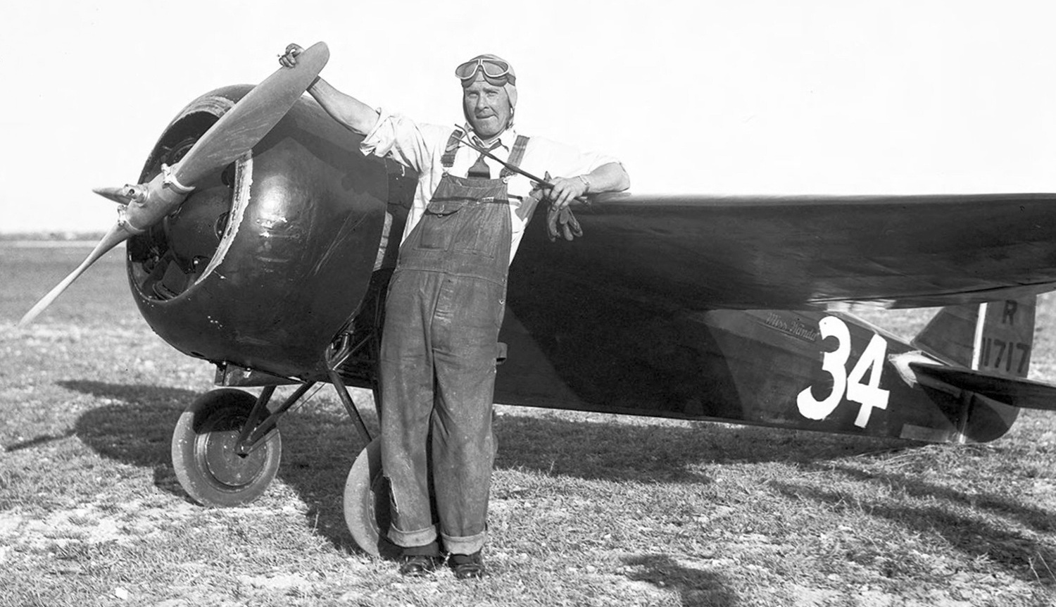
A January 1933 photo by Gleson Romer of Roy Liggest & the sole Cessna CR-2 racer, NR11717, at Amelia Earhart Field during the Miami All American Air Races.
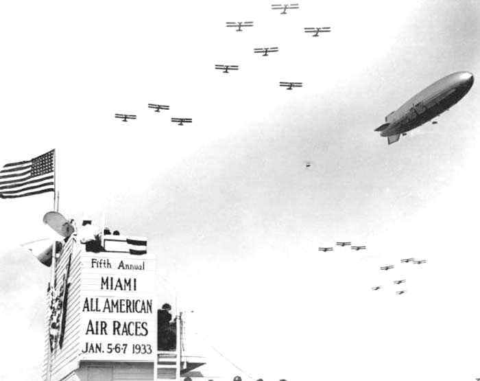
A 1933 photo of a dirigible & 18 biplanes at the 5th Annual Miami All American Air Races
held January 5-7 at Miami Municipal Airport (Florida State Archives photo).
The 1934 Department of Commerce Airport Directory (according to Chris Kennedy)
described Miami Municipal Airport as having 2 2,300' sandy runways, oriented northeast/southwest & northwest/southeast.
The hangars were said to have "Miami" painted on the roof.
Eastern & National Airlines both started operations out of this field
and by the mid 1930's it had several hangars (according to Antolin Carbonell).
One of the hangars built in the Pueblo style burned down in the 1930's.
Miami Municipal was depicted directly adjacent to All American Field
on the December 1935 Miami Sectional Chart (courtesy of Chris Kennedy).
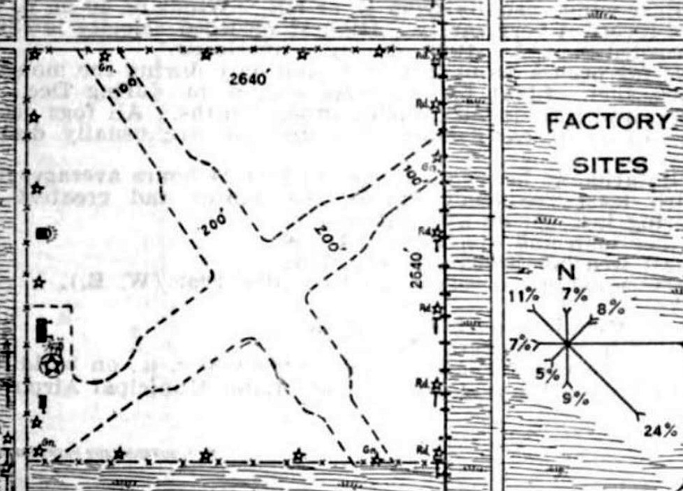
A 3/21/36 aerial view looking northeast (courtesy of Mike Denja) depicted Miami Municipal Airport as having two unpaved runways in an “X” shape, with an airfield circle marking south of the runway intersection.
Two hangars & several planes were depicted along the west side of the field.
Amelia Earhart took off from Miami Municipal Airport on her ill-fated 1937 final flight (according to Antolin Carbonell).
An aerial view looking southeast at Miami Municipal Airport from the Airport Directory Company's 1937 Airports Directory (courtesy of Bob Rambo).
The directory described Miami Municipal as having 4 paved runways, with the longest being the 3,500' northwest/southeast runway.
The aerial photo in the directory depicted a single hangar on the west side of the field.
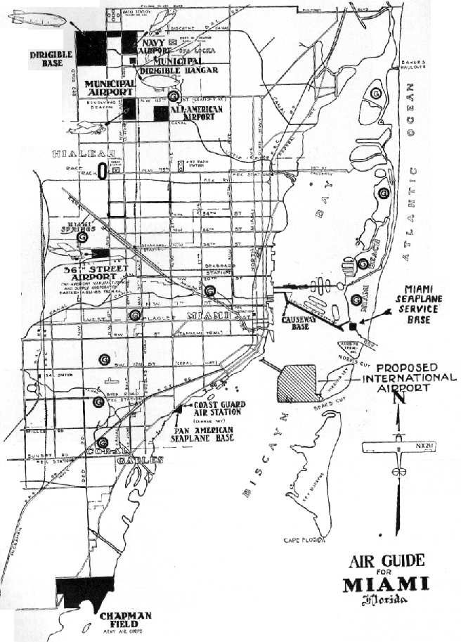
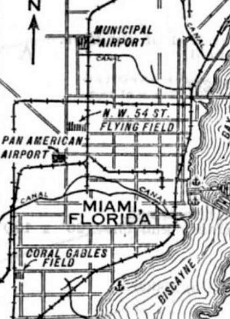
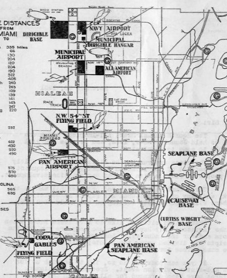
A map of the airports within the Miami area, from the Airport Directory Company's 1937 Airports Directory (courtesy of Bob Rambo).
Miami Municipal was depicted as a municipal or commercial airport on the April 1937 Miami Sectional Chart (courtesy of Chris Kennedy).
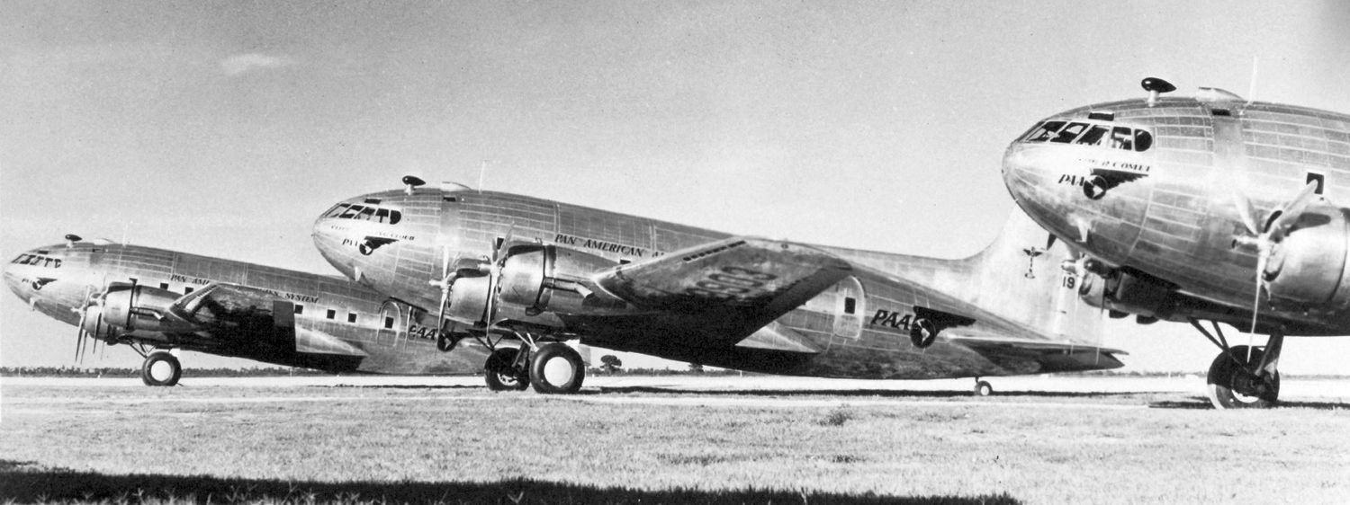
A June-December 1940 photo of 3 Pan Am Boeing 307B Stratoliners at Miami Municipal Airport.
Originally captioned: “Pan American's new high-altitude fleet. Ready for 'top flight' to Rio & San Cristobal [Panama]: the Comet [NC19910], the Rainbow [NC19902] and the Flying Cloud.”
This was Pan Am's entire 'Strato-Clipper' fleet. The 307s had to use Miami Municipal Airport until the runways at Pan Am's 36th Street Airport were lengthened.
Miami Municipal was depicted as a municipal or commercial airport on the May 1941 Miami Sectional Chart (courtesy of Chris Kennedy).
A circa 1942 aerial view of Miami Municipal Airport (Florida State Archives photo),
showing the field to have 4 paved runway, with 2 hangars & 2 aircraft on the west side of the field,
and 3 aircraft along the southeast side of the field.
Miami Municipal was purchased in 1942 by the Navy from the City of Miami.
It was used by the Navy for the duration of WW2
as among the 6 satellite airfields for Miami Naval Air Station (later to become Opa-Locka Airport),
which conducted training in SBD Dauntlesses, TBF Avengers & PB-4Y Privateers.
Miami Municipal & Master Field were connected by a taxiway running over the railroad tracks.
A WW2-era National Archives aerial view of Miami Municipal Airport (west) & Master Field (east).
During its period of Navy use, Miami Municipal Airport was also known as South Field #2 & Navy Municipal Field.
According to Benson, Miami Municipal was controlled from the tower at Master as an NOLF/MCOLF.
Master Tower controlled the gates for taxiing aircraft that had to cross the railroad between the 2 fields.
During World War II the Navy used the field for its personnel transport operations.
"Miami" was depicted as a military airfield on the 1943 Miami Sectional Chart (courtesy of Chris Kennedy).
The 1944 US Army/Navy Directory of Airfields (courtesy of Ken Mercer).
described "Miami, Navy" airfield as having a 3,600' hard-surfaced runway.
The remarks included, "Restricted to training operations & scheduled Naval transports.
Serviced by International Airport Tower."
The airfield at Miami Municipal Airport eventually consisted of 4 asphalt runways
and a few small buildings west of the runways.
"Miami (Navy)" was depicted as a military airfield having a 3,600' paved runway on the August 1947 Miami Sectional Chart.
Miami Municipal Airport was rededicated on 10/26/47 as Amelia Earhart Field
(her tragic final flight launched from Miami Municipal, thus the name).
Joe Benson noted, "They made sort of a tapered stone marker by taking chunks of coral rock
and stacking them & securing them with cement.
It was about 4' high I'd guess & they mounted the plaque on it's face.
It was there for years even when the field was abandoned.”
Miami Municipal Airport was evidently closed at some point between 1947-48,
as it was no longer depicted at all on the February 1948 Miami Sectional Chart.
A 1948 aerial view looking east-northeast at Amelia Earhart Field, with the larger Master Field in the background (Florida State Archives photo).
Several aircraft were visible on the Amelia Earhart ramp at the bottom of the photo.
The taxiway over the Seaboard Air Line Railroad tracks connecting the 2 airports was still visible (but was eliminated later).
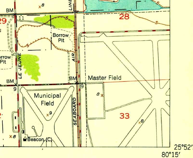
The 1949 USGS topo map depicted “Municipal Field” as having 2 paved runways, along with taxiways, and a ramp & beacon on the west side.
It also depicted the adjacent “Master Field”.
Joe Benson noted, "Municipal never saw another aircraft after Master closed [in 1954], that I've ever heard of.
I went to several drag racing events at the field during the 1950s."
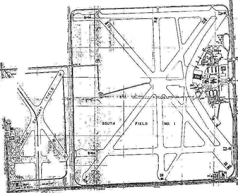
The 1956 Layout of Miami Municipal Airport (labeled "Amelia Earhart Field") and Master Airport (labeled "South Field #1").
Miami Municipal Airport, as depicted on a 2/27/56 US Government aerial photo (courtesy of the FL DOT).
Miami Municipal airport appeared to be abandoned, as there were no aircraft visible on the field, or any other indications of current usage.
The field remained completely intact, though, with all 4 runways & 2 hangars still remaining in good condition.
Miami Municipal Airport was labeled “Closed” on on a 1956 Approach Plate (courtesy of Tom Beamer).
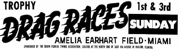
A 1959 advertisement for drag races at Amelia Earhart Field.
According to Dick Besoli, the drag races at Amelia Earhart were run by 3 members
of The Cabriolets car club, including Ernie Schorb & Harry Steele.
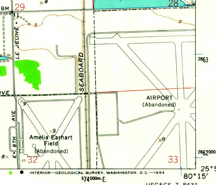
The 1962 USGS topo map depicted the runways of "Amelia Earhart Field (Abandoned)”
as well as the adjacent Master Airport - labeled simply “Airport (Abandoned)".
Miami Municipal Airport was used to stage military supplies during the 1962 Missile Crisis (according to Antolin Carbonell).
Joe Benson noted of the historical marker to Amelia Earhart which formerly stood on the site, "when I went there to look around in the mid 1970s,
it was gone & the marker/pillar that it was mounted on was knocked down & just a pile of rocks."
According to Joe Benson, "There was an effort to try & save the field & put an aviation museum on it, but the project fell through.
Meanwhile, Seaboard (CSX) bought the Miami Municipal property,
tore up all the runways & built an Intermodal freight yard in there."
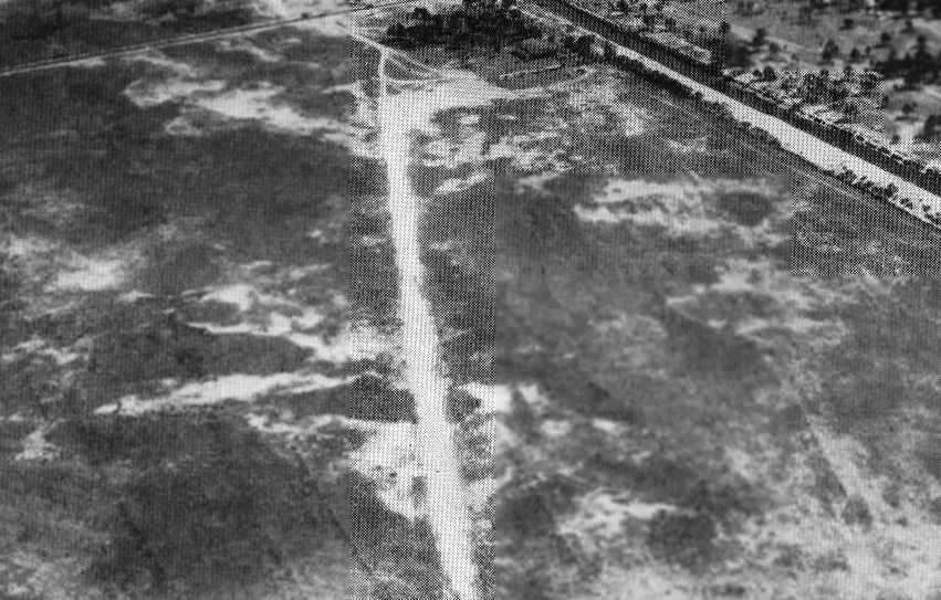
Portions of Miami Municipal Airport's northwest/southeast runway were still recognizable in a 1994 USGS aerial photo.
In a 2014 aerial photo, the site of Miami Municipal Airport had been completely redeveloped,
with only the faintest trace of the northwest/southeast runway still recognizable.
The site of Miami Municipal Airport is located northeast of the present-day intersection of East 8th Avenue & East 49th Street.
A park named Amelia Earhart Park has been built to the northwest, but does not include the site of the former airfield.
Additional details about Miami Municipal can be found at a State of Florida page, and an Army Corps of Engineers report.
____________________________________________________
All American Field / Master Airport / South Field #1 / Navy Master Field, Hialeah, FL
25.88 North / 80.25 West (Northeast of Miami International Airport, FL)
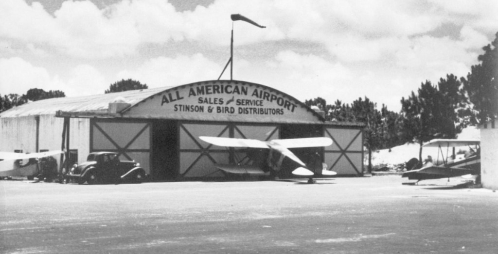
All American Field, as depicted on an 8/26/31 aerial view.
The history of this airfield is intertwined with that of Miami Municipal Airport, which sat adjacent to Master Field to the west.
The fields were separated by a set of railroad tracks.
Both fields were located a mere 2 miles to the southeast of present-day Opa-Locka Airport.
This field was originally known as All-American Airport.
All American Field was the site of the All American Air Meets as early as 1931 (according to Antolin Carbonell).
The earliest depiction of All American Field which has been located was an 8/26/31 aerial view.
It depicted a rectangular grass field, with an airport circle marking on one side. The surrounding countryside was strikingly undeveloped.
A closeup of All American Field from the 8/26/31 aerial view, showing 2 biplanes next to a small building on one corner of the airfield.
The earliest map depiction which has been located of All American Airport was on a 1932 City of Miami Air Guide (courtesy of Rich Moravsik).
The 1934 Department of Commerce Airport Directory (according to Chris Kennedy)
described All-American Airport as having two 3,900' sod runways in an "L" shape,
with the north/south runway also having a 1,500' hard-surface portion.
The hangar was said to have "All-American Airport" painted on the roof.
The earliest aeronautical chart depiction of All American Field which has been located
was on the December 1935 Miami Sectional Chart (courtesy of Chris Kennedy).
It depicted All American Field directly adjacent to Miami Municipal Airport.
An undated aerial view of All-American Airport from the Airport Directory Company's 1937 Airports Directory (courtesy of Bob Rambo).
The directory described All-American Airport as having a single 1,800' shell runway, oriented northwest/southeast.
The aerial photo in the directory depicted a single hangar on the field, which had "All-American Airport" painted on the roof.
An undated (circa 1930s?) photo of several planes in front of a hangar marked “All American Airport” (courtesy of Tom Heitzman).
The photo depicts hills behind the hangar – is this really of the All American Airport in Miami?
All American was depicted as a municipal or commercial airport on the April 1937 Miami Sectional Chart (courtesy of Chris Kennedy).
The City of Miami acquired All American Field circa 1938
and built the 1st Miami International Airport, with 7 runways & one hangar (according to Antolin Carbonell).
Robert Law Weed designed a terminal, which never was built.
Joe Benson found a pre-WW2 blueline drawing at the Airport District Office
which confirmed that the name of the airport at that time was "Miami International (Master) Airport".
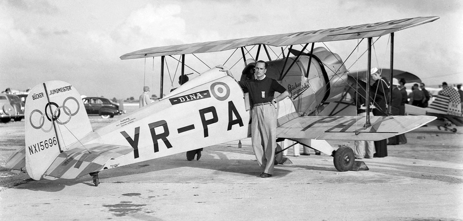
A1/7/40 photo by Gleason Romer of Alex Papana & Bucker Bu 133C Jungmeister NX15696 C/n 42 at the Miami All American Air Races at Master Field ramp.
The Jungmeister was named Dina in honor of his wife who had died during childbirth 2 years prior.
This airfield was evidently abandoned at some point between 1938-41,
as it was no longer depicted at all on the May 1941 Miami Sectional Chart (courtesy of Chris Kennedy).
In 1942 the Navy bought the Airport & added it to the Naval Air Station Miami complex (according to Antolin Carbonell).
Around that time the airport became known as Master's Field.
The Navy built several barracks & a mess hall.
"International" Airport was depicted as a military airfield on the 1943 Miami Sectional Chart (courtesy of Chris Kennedy).
A 1943 aerial view looking east at dozens of aircraft on the Master Field ramp (National Archives photo).
Master Field was used by the Navy during WW2
as among the 6 satellite airfields for Miami Naval Air Station (later to become Opa-Locka Airport),
which conducted training in SBD Dauntlesses, TBF Avengers & PB-4Y Privateers.
A WW2-era National Archives aerial view of Miami Municipal Airport (west) & Master Field (east).
A WW2-era aerial view (courtesy of Lyle Lamboley) looking southwest at a Brewster F2A Buffalo,
with Master Field ahead of the plane's nose & Miami Municipal Airport barely visible under the far wing.
The 1944 US Army/Navy Directory of Airfields (courtesy of Ken Mercer).
described "International (Master), Navy" as having a 7,400' hard-surfaced runway.
The remarks included, "Restricted to training operations & scheduled Naval transports."
The airfield at Master Airport eventually consisted of 5 asphalt runways (the largest was 6,600' long),
and a large curved ramp area in front of a complex of buildings to the east of the runways.
During its period of Navy use, Master Airport was also known as South Field, South Field #1, and Navy Master Field.
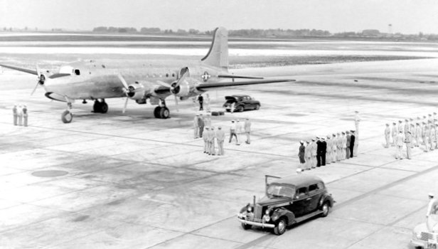
A 1944 photo of a Douglas R5D-1 at Master Field, presumably for the arrival of a VIP (courtesy of Nick Williams).
Richard Snedeker recalled, “In early 1946 I was assigned to Master Field after completing training as an Aviation Machinists Mate.
In Miami, I joined a squadron designated ASDEVRON, for Anti-Submarine DEVelopment squadRON.
Our mission was to develop new techniques for anti-submarine warfare using existing aircraft then in the Navy's inventory.
Accordingly, our squadron had at least one of just about every aircraft then used by the Navy,
including F4U's, F6F's, TBM's, SB2C's, PBY's, SNJ's, etc. We even had an F7F Tigercat.
The 2 main projects during my time with the squadron were the use of a wing-mounted, carbon-arc searchlight
for night-time attack by fighter aircraft against surfaced subs
the use of surplus wing-mounted fuel tanks as airborne napalm bombs.
We had to develop a satisfactory set of easily fabricated tail fins that would stabilize the tanks during a dive-bomb type delivery.
After a few months, the name of the squadron was changed to VX-1 & we moved to Boca Chica Naval Air Station near Key West.”
"NAS Master" was depicted as a military airfield having a 7,400' paved runway on the August 1947 Miami Sectional Chart.
A 1948 aerial view looking northeast at Master Field, with the smaller Amelia Earhart Field also visible on the left (Florida State Archives photo).
The 1949 USGS topo map depicted “Municipal Field” as having 4 paved runways.
It also depicted the adjacent “Municipal Field”.
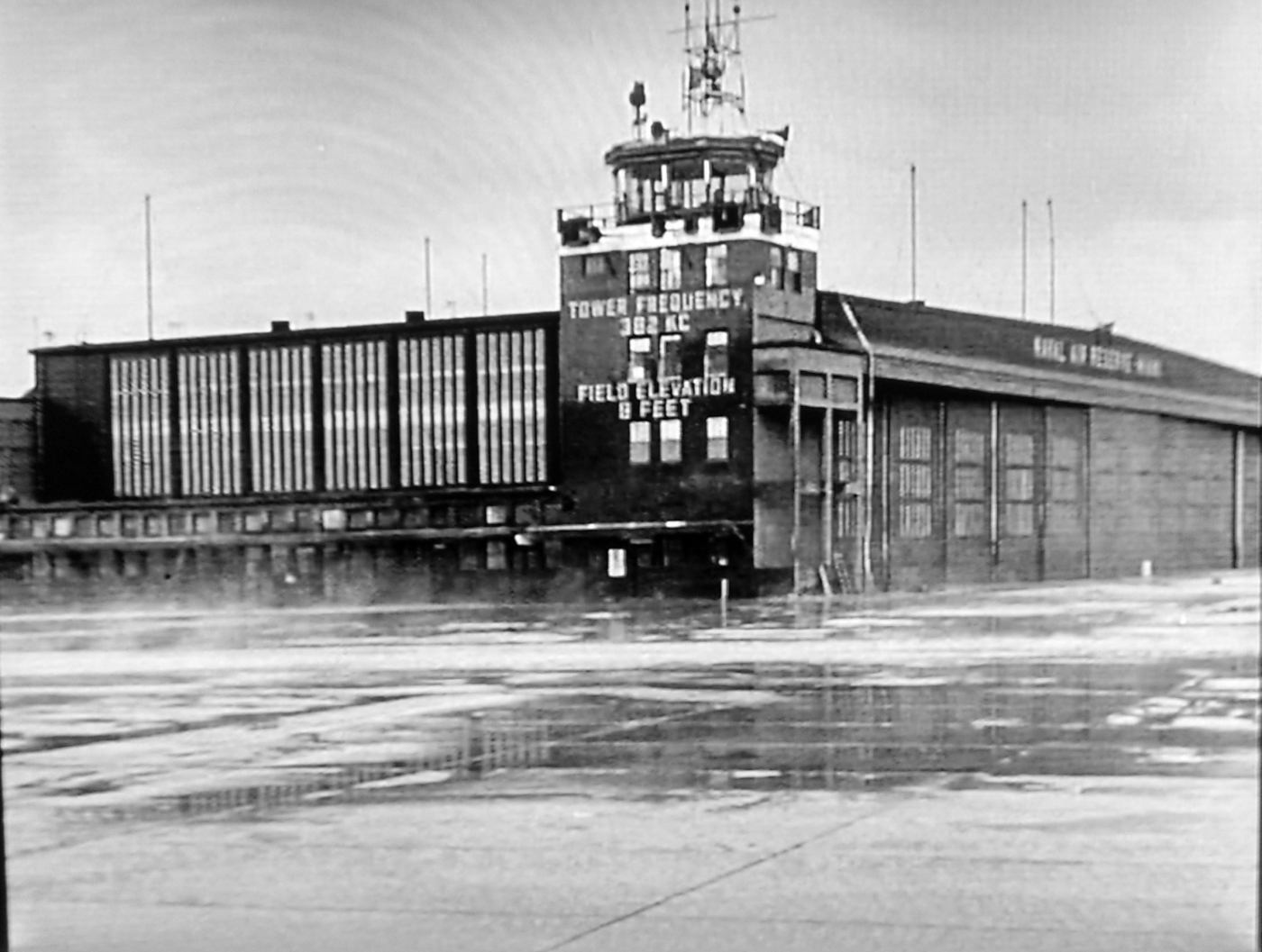
A still from the 1949 movie “Slattery's Hurricane” showing Master Field' control tower & attached hangar (courtesy of Harper Poling).
According to Joe Benson, the base scenes for the movie "Slattery's Hurricane" were filmed at Master Field in 1949, when they were flying the PB4Y-2 Privateers for hurricane hunting.
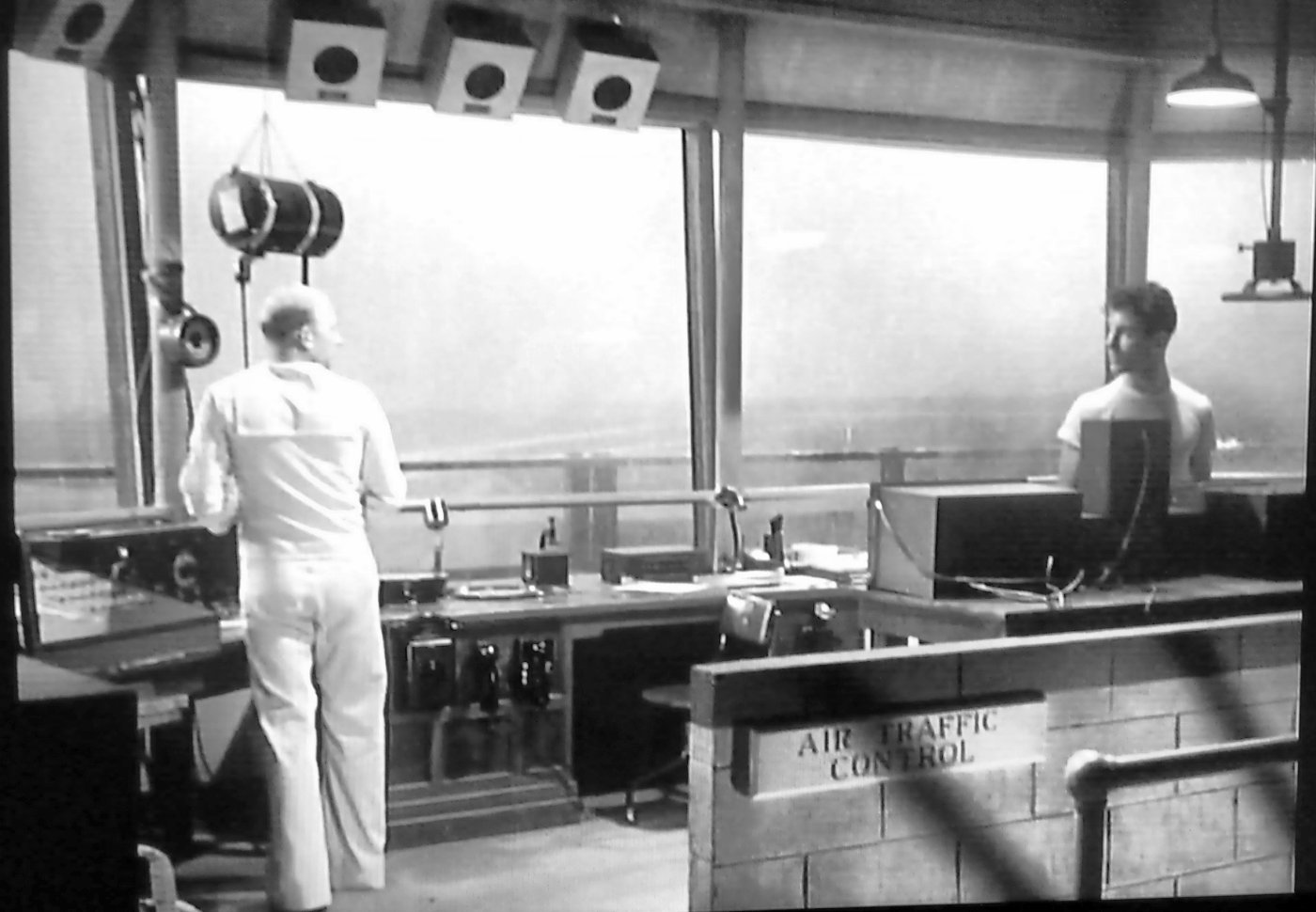
A still from the 1949 movie “Slattery's Hurricane” showing the interior of Master Field' control tower (courtesy of Harper Poling).
Although some sources have indicated that Master Field was "closed in 1954",
this evidently refers to the point at which the use of the field was transferred to the Naval Reserve,
which continued to operate aircraft from Master Field for several more years.
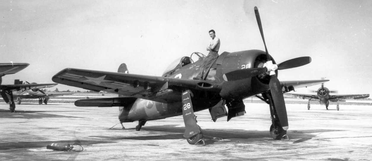
A 1950s photo of Harper Poling on a mighty Grumman F8F Bearcat at Master Field.
Harper recalled, “In the 1950s our Squadron VF 724 visited Master from NAS Glenview.”
A 1950s photo by Harper Poling of Master Field's control tower & attached hangar.
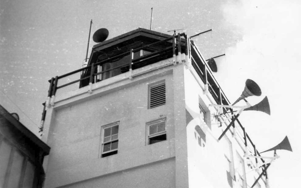
A 1950s photo by Harper Poling of Master Field's control tower.
The last aeronautical chart depiction which has been located showing Master Field still open was on the February 1955 Miami Sectional Chart.
It depicted “Miami (Master)” as a military airfield having a 7,400' paved runway & a control tower.
The 1956 Layout of Miami Municipal Airport (labeled "Amelia Earhart Field") and Master Airport (labeled "South Field #1").
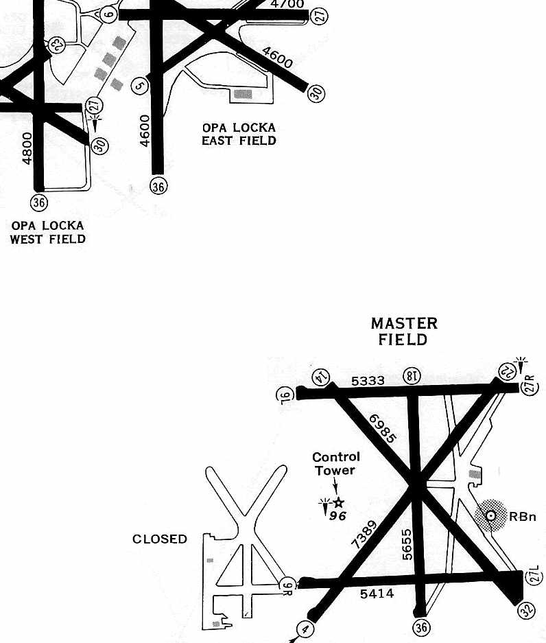
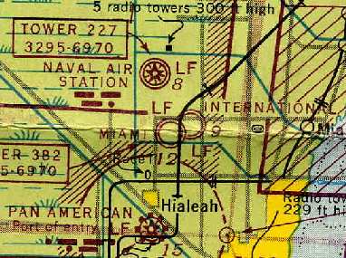
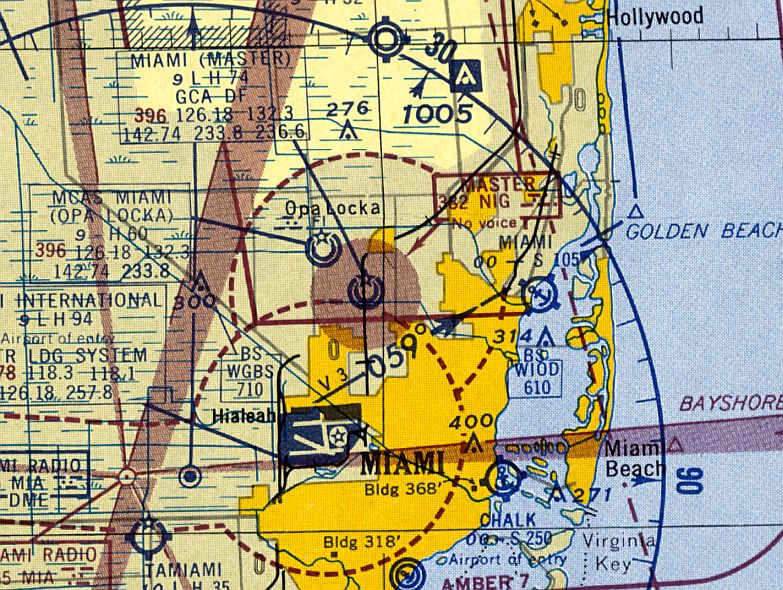
Master Field (bottom-right) & the former Miami Municipal Airport (bottom-center), shown in relation to Opa-Locka Airport (top-left),
as depicted on a 1956 Approach Plate (courtesy of Tom Beamer).
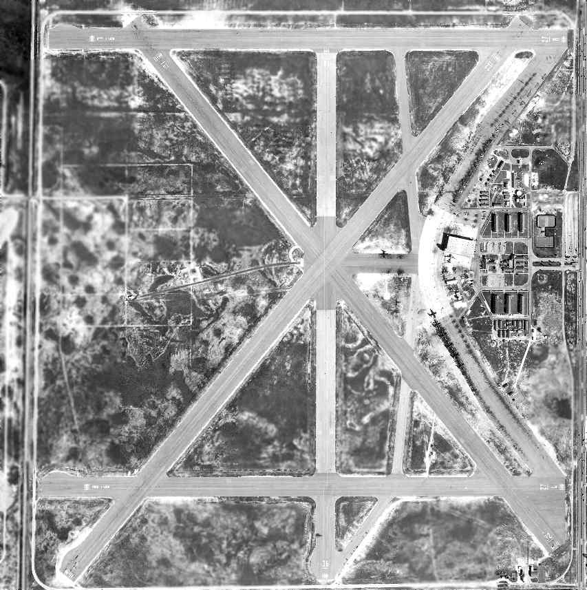
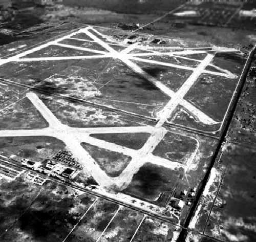
Master Field, as depicted on a 2/27/56 US Government aerial photo (courtesy of the FL DOT).
The photo shows the field very much in use by the Navy,
with a total of over 24 fighters & patrol aircraft on the ramp.
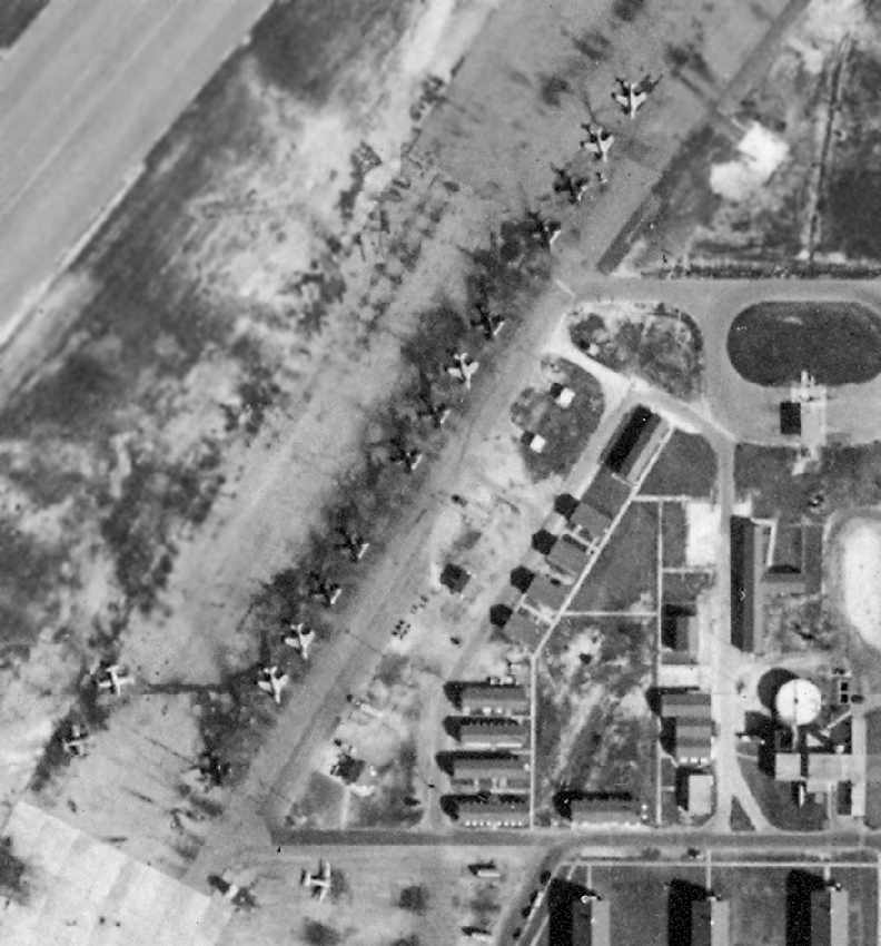
A closeup of the northeast ramp of Master Field from the 2/27/56 US Government aerial photo (courtesy of the FL DOT),
showing a large number of Grumman F9F Cougar jet fighters & several other jet & propeller aircraft.
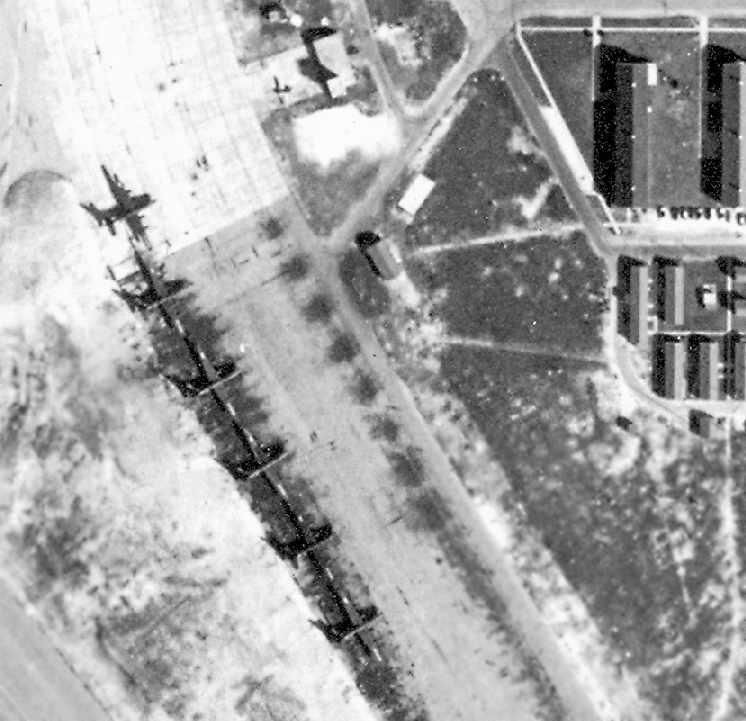
A closeup of the southeast ramp of Master Field from the 2/27/56 US Government aerial photo (courtesy of the FL DOT),
showing a total of 6 Consolidated PB4Y-2 Privateer patrol bombers.
According to Joe Benson, Master Field hosted several airshows in the 1950s, "one of which John Glenn flew his F8U at in 1957."
A 1958 map of a “Masters Field Course” for a road race to be held on the runways.
Automobile races were held on the Master Field runways in 1958 & 1959.
Master Field was closed by the Navy in 1959, according to Brian Rehwinkel.
Master Field was depicted as an abandoned airfield on the February 1960 Miami Sectional Chart.
The 1962 USGS topo map depicted the runways of Master Airport, labeled simply “Airport (Abandoned)",
as well as the adjacent "Amelia Earhart Field (Abandoned)”.
A planned race in 1962 on the Master Field runways was canceled due to the use of the airfield for staging military supplies & equipment during the Cuban Missile Crisis.
That was presumably the last military use of the facility.
John Clark recalled, “Master Field... In 1962 I watched legionary Don Garlits in his Swamp Rat IV Red Swoop tail dragster make a few passes.
There was absolutely nothing between the speeding race cars & the spectators parked on the south side of the runway/drag strip.”
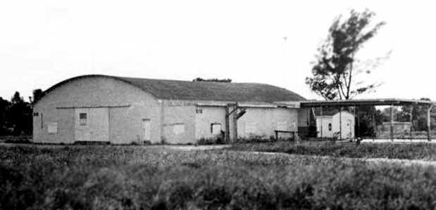
A March 1962 photo of a Former NAS Miami Master's Field hangar (Florida State Archives photo).
This building later became the Pen Playhouse at the Dade County Junior College.
The Master Field property was declared surplus in the early 1960s & became the Miami-Dade Community College North Campus (according to Antolin Carbonell).
A hangar was later converted into a gymnasium.
Master Field, as depicted on a 12/27/63 US Government aerial photo (courtesy of the FL DOT).
The photo shows the airfield still almost complete intact, but the early stages of construction of the college had started,
with at least one building & parking lot having already been built over the former ramp on the east side of the field.

A circa 1964 photo (courtesy of John Clark) looking northeast at Miss Big Go South & a drag race winner in front of his car on the northern Master Field east/west runway.
John recalled, “It shows the starting line in the background. The races were east-to-west. I remember no other significant buildings on any of the runways.”
Master Field, as depicted on a 12/28/70 US Government aerial photo (courtesy of the FL DOT).
The photo shows that the buildings & parking lot of the college had completely covered the former ramp & hangar area by this time,
although most of the length of most of the runways were still largely intact.
According to Joe Benson, "Master Field sat for a long time with only the college on there, but later expanded rapidly & you can hardly see anything anymore."
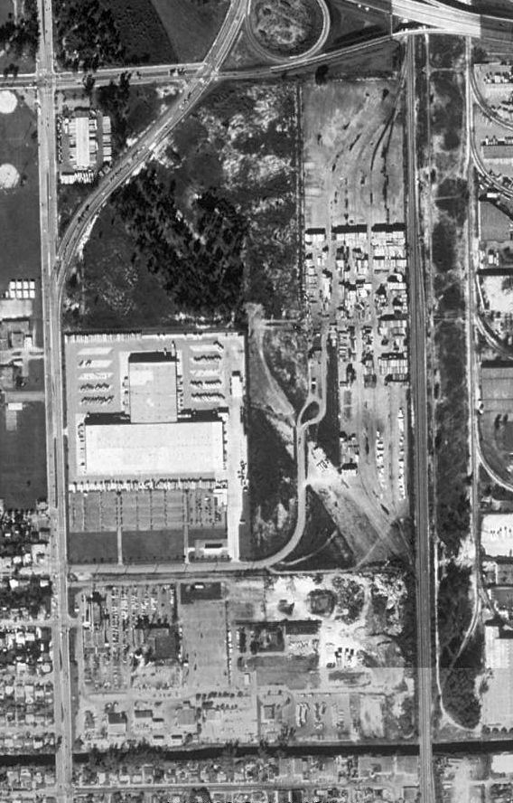
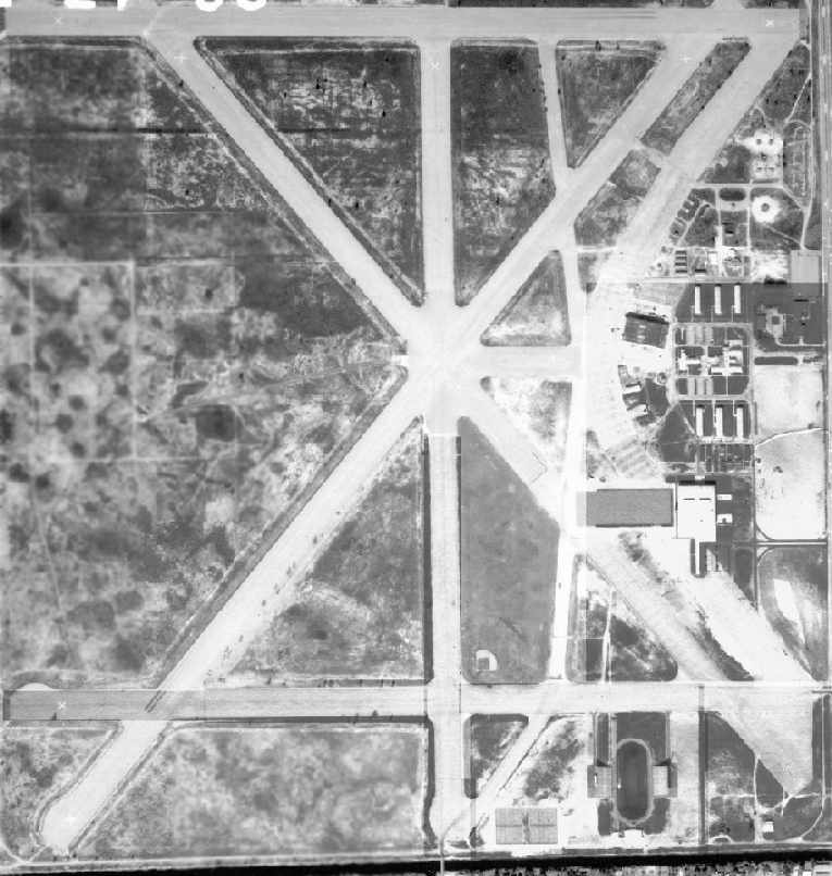
The remains of Miami Municipal Airport & Master Airport in 1986.
The property of Master Airport has been extensively redeveloped as the North Campus of the Miami Dade Community College,
but recognizable portions of at least 5 asphalt runways still remain on the eastern half of the airfield site.
Furthermore, Antolin Carbonell reported in 2005 that “A hangar built in the mid 1930s still survives at the southeast corner of the Miami-Dade College Campus.
It is used for Maintenance shops. The building was recently refurbished but bears little resemblance to its original use.
A couple of ancillary buildings from that period survived as recently as 2003 but have since been demolished.”
A circa 2005-2006 aerial view looking north at a WW2-era hangar which still remains standing
on the east side of the former Master Airport (just east of the intersection of Lake Road & Kennedy Drive).
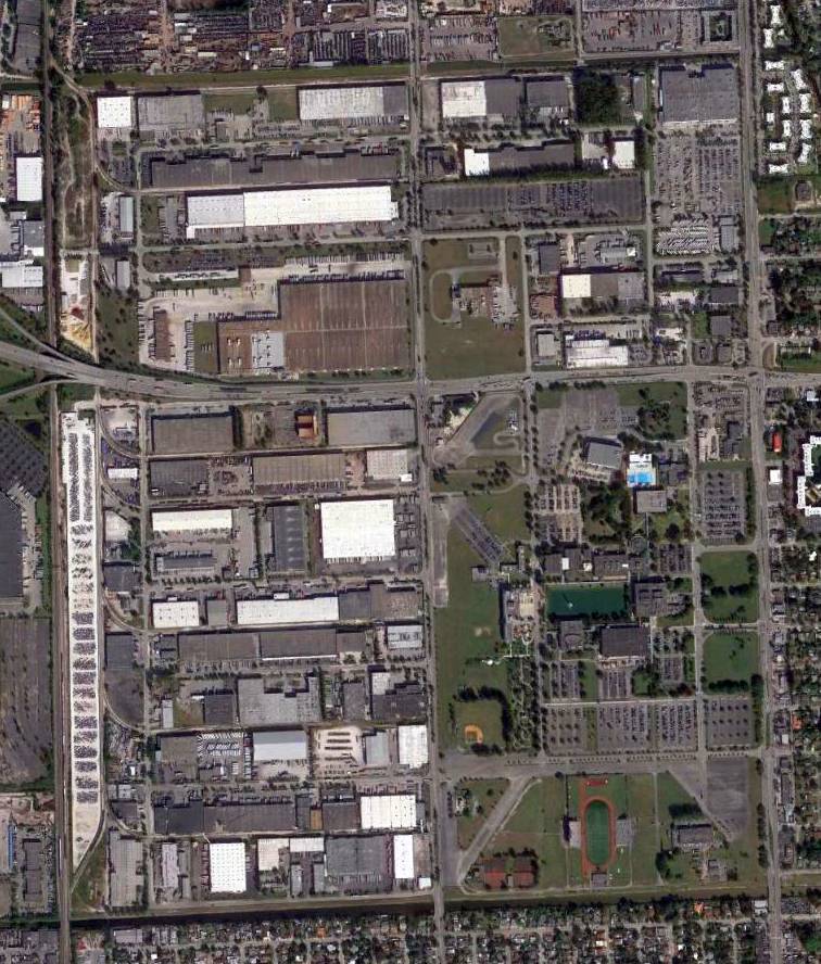
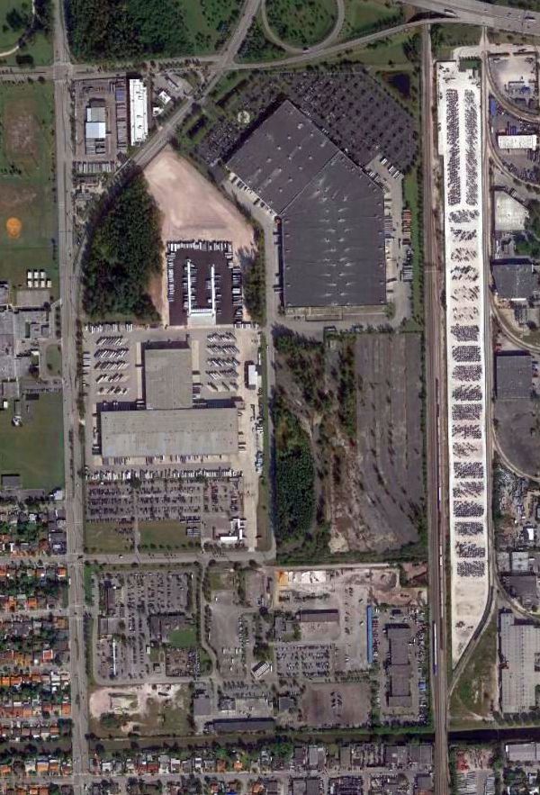
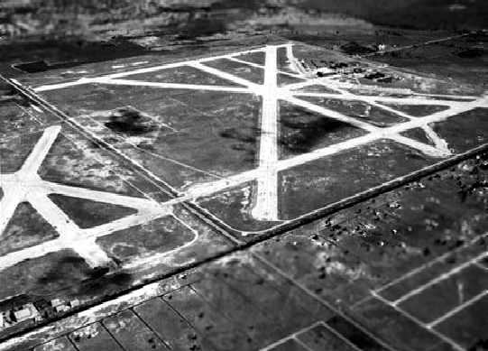
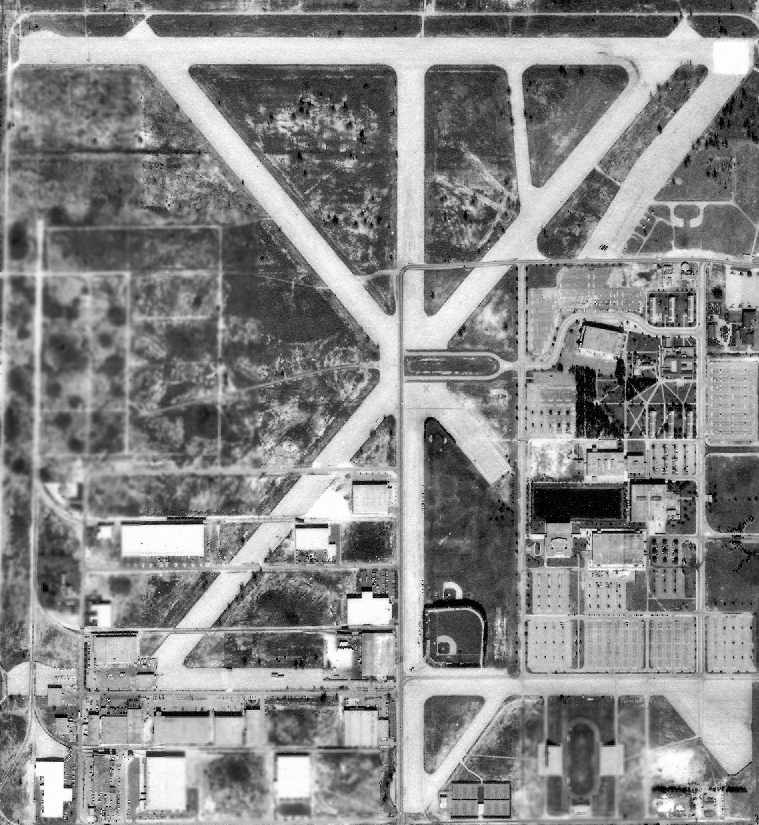
A 2014 aerial photo of the site of Master Airport showed the remains of 5 runways remain recognizable.
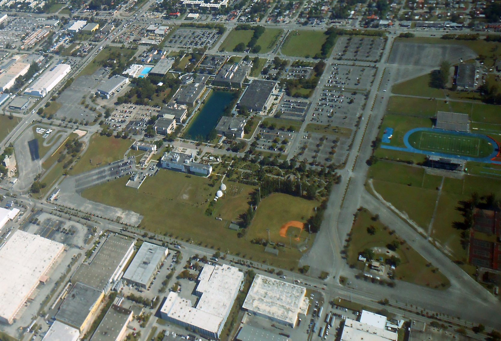
A 12/17/18 aerial view by Alex Price looking northeast at the site of Master Airport, showing the remains of several runways.
Alex remarked, “Even to a superficial observer, the runways are still intact enough to suggest an airfield was here.
I wonder what air traffic control was like in the days when Opa-Locka was two airports crowded together with Master Field, Amelia Earhart Field, and Miami Army Airfield (now KMIA).
It's busy enough just between OPF & MIA – it would be vastly harder still to fit in if Master or Amelia Earhart were still open.”
The site of Master Airport is located west of the present-day intersection of Unity Blvd & Gratigny Parkway.
Additional details about Master can be found at a State of Florida page, and an Army Corps of Engineers report.
____________________________________________________
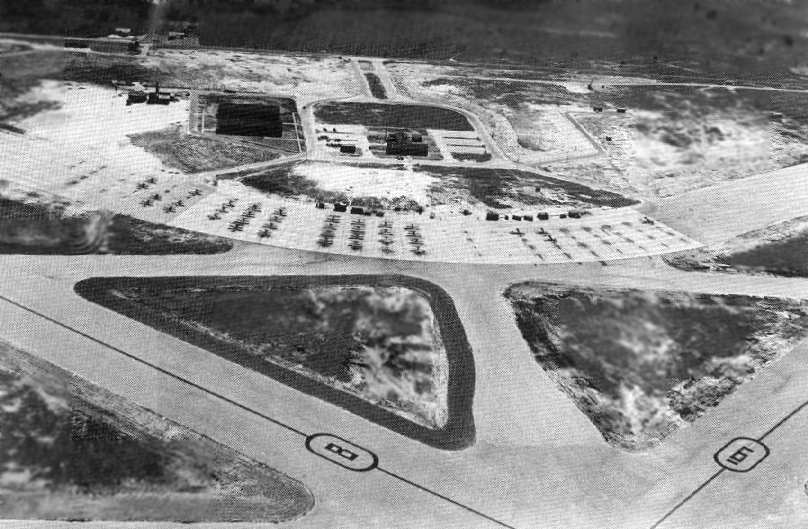
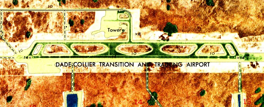
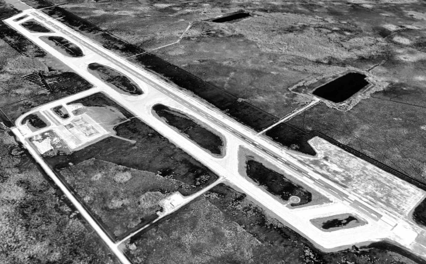
Everglades Jetport / Dade Collier Training & Transition Airport (TNT), Everglades, FL
25.86, -80.9 (West of Miami, FL)
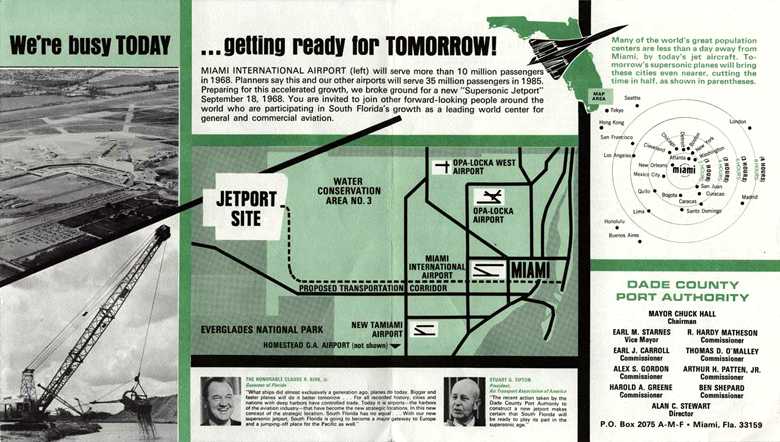
An undated brochure from the Miami-Dade Aviation Department Planning Division
touting the 9/18/68 groundbreaking for the new Miami “Supersonic Jetport”.
This huge, nearly abandoned modern airport is a true "white elephant".
It was intended to provide service for the Miami area by the never-built US supersonic transport,
and was thus situated far outside of the populated area, in the Everglades, to mitigate the noise impact of SST operations.
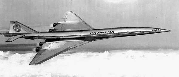
An artist's conception of what the Dade-Collier Airport was built to operate -
the never-built US SST (in this case, a Boeing 2707, in Pan Am markings).
What was originally known as the Everglades Jetport was originally planned to be the largest airport in the world, with 6 runways.
It was built from scratch in the middle of the Everglades.
No airport was yet depicted at this location on a 1964 aerial photo nor on the March 1967 Miami Sectional Chart.
According to historymiamiarchives.org, “The Dade County Port Authority began making plans
to build a larger, regional 'jetport' in the Everglades that could accommodate supersonic aircraft in 1965.”
According to an undated brochure from the Miami-Dade Aviation Department Planning Division,
ground was broken on 9/18/68 for the new Miami “Supersonic Jetport”.
According to Brannen Sanders, “Maybe 1968 is the year the Jetport was considered 'finished',
or when the court case brought by the environmentalists was finally decided, but we were landing on it in 1967!
We used to fly out to what we called the 'Miami Jetport' & shoot 'dead stick' landings in our little Cessna 150s.
I never knew it was supposed to be for the American SST.
From what I recall, the runway & taxiways were literally brand new, but I don't remember seeing any buildings out there.
When we started using that field, it was totally deserted. No one or no other airplanes (besides ours) were anywhere around.
This was before the airlines decided to use the Jetport to shoot 'Touch & Goes' for crew training.
What we would do would be to climb to 11,000' or 12,000', 10-15 miles away from the Jetport
and then pull our power (except for blasts of power every minute or so to keep carburetor Ice from forming) & then glide in the general direction of the Jetport.
Over the Jetport we would start doing 360 degree banked turns,
as we would lose approximately 500' with each turn to come out in the 'Key Position' at the end of the downwind leg at approximately 800' AGL.
After that, it was a normal Power Off landing for us.
Of course, the trick was to keep going further & further away from the airport & then make it back to land.
It was a fun 'game' but no danger was ever involved because IF we saw we were running out of altitude before we got to the Jetport,
all we had to do was add power.”
The earliest photo which has been located of he Everglades Jetport was a 1969 aerial photo,
which depicted the field as having a single paved east/west runway with a parallel taxiway.
Before the Everglades Jetport was ever was used for airline service,
the US SST was canceled, eliminating the airport's reason for being.
Furthermore, environmentalists convinced the government that the operation of a major airport
would bring unacceptable harm to the Everglades.
Therefore, even though one runway had already been built,
the decision was made to cancel the new airport, and construction ceased in 1970.
Yet it was also decided that removing the already-built runway would cause further environmental harm,
so it was allowed to remain as it was built, strangely all alone.
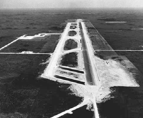
An undated (circa 1970s?) aerial view looking east over the newly-constructed single runway of the Everglades Jetport.
The boondoggle was eventually opened for very limited use under the name of Dade Collier Training & Transition Airport,
with its only purpose being to support infrequent civil flight training by heavy airliners.
Its single concrete Runway 9/27 measured a whopping 10,500' in length.
In the era before the widespread use of flight simulators for airline training,
airline crews had to be trained with flights in actual aircraft.
Dade Collier was a natural for this kind of operation, as it did not have any other kind of traffic.
Plus, two major airlines were headquartered nearby at Miami International: Eastern Airlines & Pan Am.
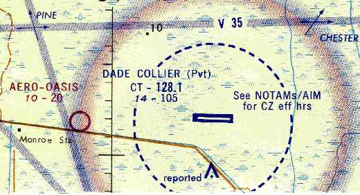
The earliest aeronautical chart depiction which has been located of the field
was on the January 1970 Miami Sectional Chart (courtesy of Chris Kennedy).
It depicted Dade Collier as a private airfield having a single 10,500' paved runway & a control tower.
The 1973 USGS topo map depicted the Dade-Collier Transition & Training Airport
as having a single paved runway, paved parallel taxiway, and a paved ramp with a tower.
During the 1970s, it was not unusual to find 5-10 transport aircraft (707, 747, C-130, DC-6) in the TNT pattern,
flying ILS approaches around the clock.
A Douglas DC-9-14 (N8910E cn 45771/58) was destroyed in a non-fatal crew training accident at Dade-Collier Airport on 2/9/79.
According to Mike Vidal, “The DC9-14 that crashed belonged to Eastern Airlines (I worked for them at the time in Aircraft Overhaul).
The pilot was in his check ride to start working for the airline & they did an engine out at takeoff.
When the FAA examiner pulled the engine, the pilot lost control & hit the end of the runway in a level attitude.
The plane was a mess, front bottom of it was ripped up & mud was thrown all into the cockpit.
EAL dismantled the aircraft, pained over the logos & numbers & hauled it back on a flatbed.
What was salvageable was repaired/overhauled & returned to service, the rest was sold off as scrap.”
A 1995 USGS aerial view looking southeast at Dade Collier.
Mark Williams recalled, “When I was training as a 727 Second Officer for the 'new' PanAm, we went out to TNT to do our bounces.
This was in 1996, and there were still personnel & fire/crash/rescue equipment based there.”
According to Al, "Dade County aviation authority allows use of TNT by permit only, which are free to general aviation.
Airlines have to pay a fee for each landing."
He applied for & received the permit in 1997 through 2003.
Al continued, "I fly there about once a week from North Perry Airport to shoot the ILS.
I have encountered over the years in the pattern every type of commercial jet and prop aircraft.
Even once a B-17 bomber using the surrounding area & airport for background footage for a motion picture.
The US coast guard uses it regularly for practice 'drops'.
General aviation uses it regularly for IFR practice.
The airport used to be manned and open 24 hours a day, now it is closed from sunset to sunrise.
All the navigation facilities at the airport are maintained & repaired expeditiously:
ILS, LOC, inner & outer marker beacons, LOM."
However, with the advent of high fidelity Level C & Level D flight simulators,
airline pilots can now be trained exclusively in simulators,
without resorting to much more expensive training flights in actual aircraft.
Therefore, this use of Dade Collier Training & Transition Airport has largely gone away,
leaving the field once again almost completely unused.
The 2003 Airport Facility Directory listed an average of 40 flight operations per day,
but that is almost definitely an exaggerated figure.
The 2003 Airport Facility Directory included the remark,
"Airport closed to public except by arrangement with Dade County Aviation Department Miami."
A 12/13/04 aerial view looking southwest showed what appears to be a business jet taxiing to the east at Dade-Collier.
This is the earliest photo which has been located showing any aircraft at Dade Collier Training & Transition Airport.
Mark Williams reported, “I fly over it on finals to MIA frequently,
and saw a 747 on the ground there, obviously doing a 'taxi back'. This was late in 2007.”
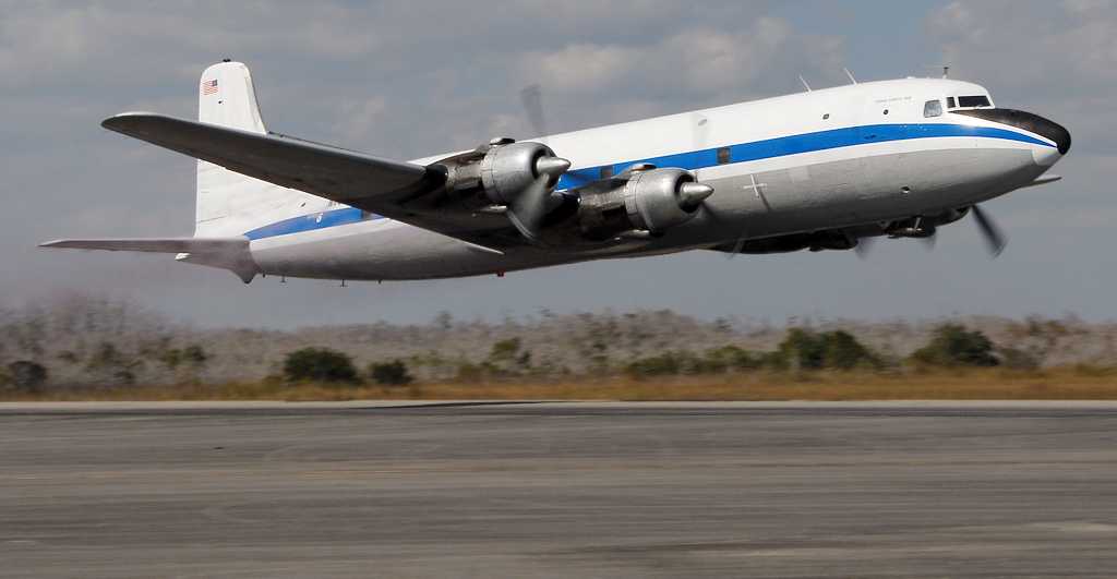
A 1/25/13 photo by Ralph Peterson of a DC-6A making a low pass down the Dade-Collier runway during testing of aircraft spray systems.
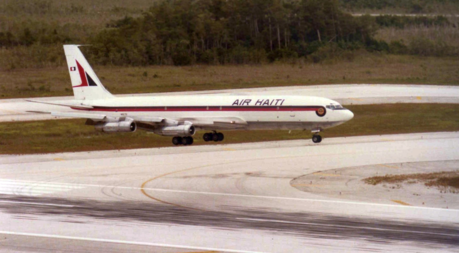
A 7/10/13 photo of a Boeing Air Haiti 707 on approach to the Dade-Collier runway during a training flight.
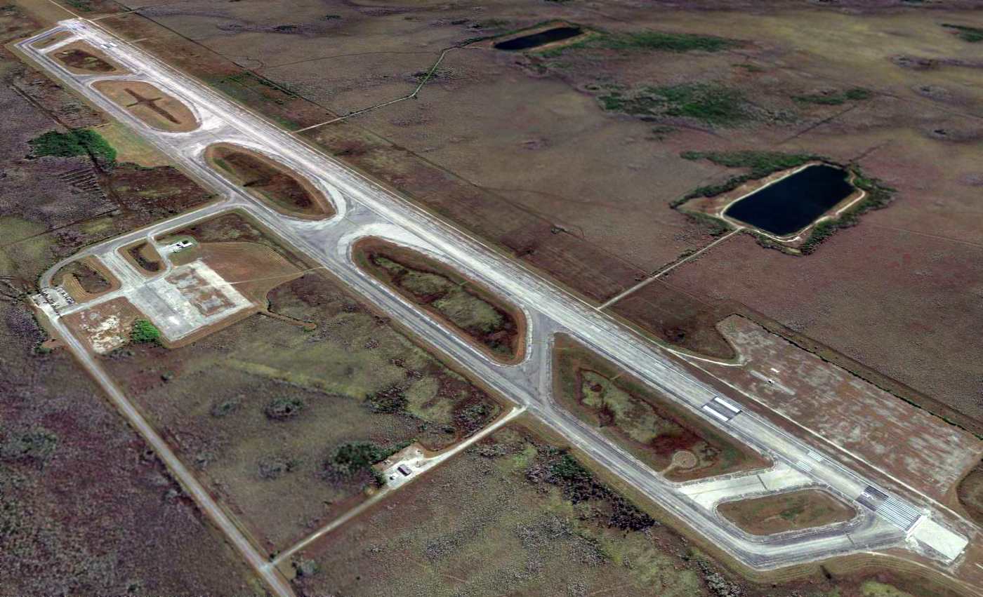
A 2014 aerial view looking southeast at Dade-Collier.
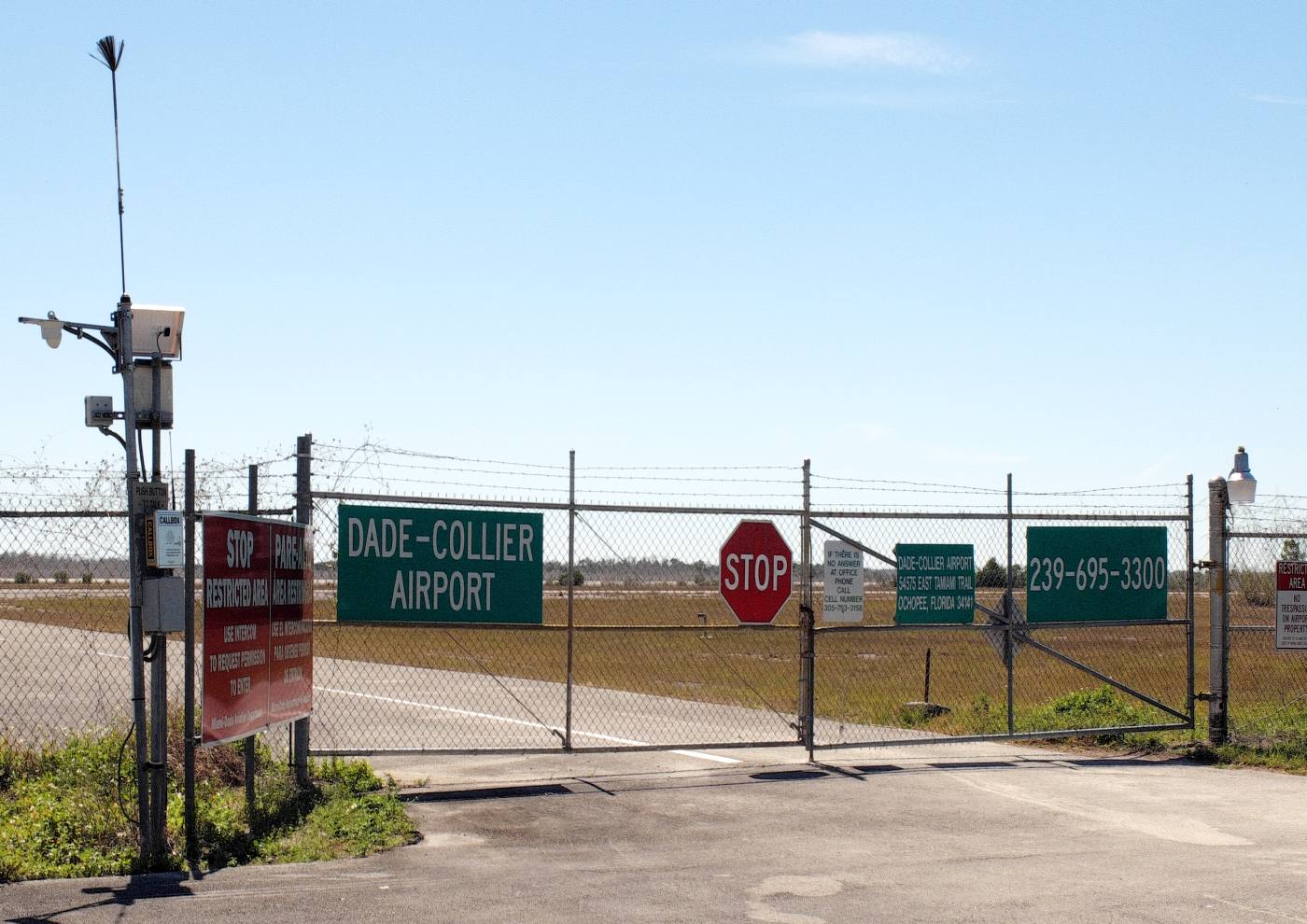
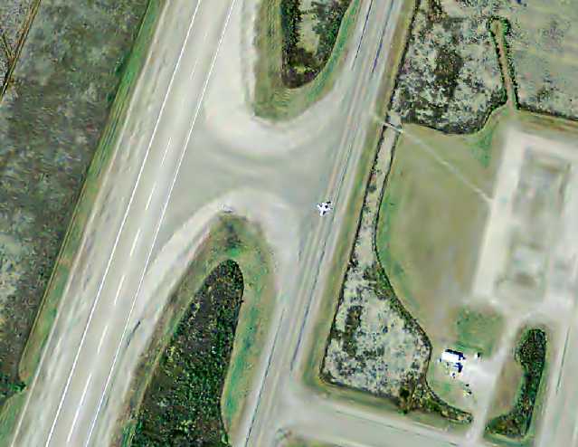
A 2/27/16 photo by Mike Legeros of the Dade-Collier Airport gate.

A 2/27/16 photo by Mike Legeros of the Dade-Collier Airport taxiway & runway, with an operations building on the left.
The 2016 Miami Terminal Aeronautical Chart depicted Dade-Collier as a public-use airport having a single 10,500' paved runway.
____________________________________________________
Or if you prefer to contact me directly concerning a contribution (for a mailing address to send a check),
please contact me at: paulandterryfreeman@gmail.com
If you enjoy this web site, please support it with a financial contribution.
____________________________________________________
This site covers airfields in all 50 states.