
Abandoned & Little-Known Airfields:
Florida: Southwestern Orlando area
© 2002, © 2024 by Paul Freeman. Revised 6/7/24.
This site covers airfields in all 50 states: Click here for the site's main menu.
____________________________________________________
Please consider a financial contribution to support the continued growth & operation of this site.
____________________________________________________
Please consider a financial contribution to support the continued growth & operation of this site.
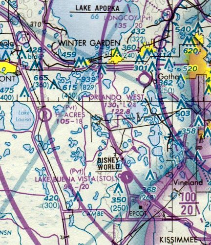
Air Lando Airpark (revised 6/21/19) - Armour Field (added 6/7/24) - Epcot Airport of Tomorrow (added 7/3/15) - Epcot Center Ultralight Flightpark (revised 4/30/16) - Hoequist Airport (revised 7/11/15)
Lake Buena Vista STOLport / Disney Airport (revised 8/6/17) - Longcoy Airport (revised 8/6/17) - Maguire Airport / Orlando West Airport (revised 9/29/18)
____________________________________________________
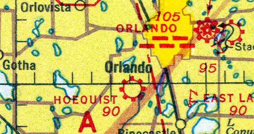
27.894, -81.861 (Southwest of Orlando, FL)
Armour Field, as depicted on the December 1935 Orlando Sectional Chart.
Rebecca Whalon reported, “Armour Field was created on land owned by the Armour Fertilizer Works. The earliest found mention of Armour Field is from 1930.
Armour Fertilizer Works leased Armour Field to the City of Bartow in 1931.
The grand opening of Armour Field occurred on 1/15/31 during the All-Florida Air Tour. Six airplanes from Naval Air Station Pensacola flew in for the occasion.
William Hammond, an aviator from New York, died from injuries received during a crash during the dedication.”
The earliest depiction which has been located of Armour Field was on the December 1935 Orlando Sectional Chart.
It depicted Armour as an auxiliary airfield.

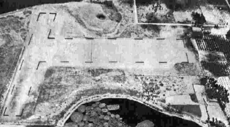
The only photo which has been located of Armour Field was a 1941 aerial view (courtesy of Rebecca Whalon).
It depicted a north/south grass landing area, with an airfield circle marking in the center (possibly with the airfied's name).
A hangar was on the north side, but no aircraft were visible.
Rebecca Whalon reported, “On 3/6/43 a fire broke out at the airport, destroying 5 airplanes, a hangar & a trailer.”

The last depiction which has been located of Armour Field was on the February 1945 Orlando Sectional Chart.
It depicted Armour as a commercial/municipal airport.
Rebecca Whalon reported, “The City of Bartow decided to end its lease on Armour Field in late 1945.
A recently constructed smokestack near the airport caused the Civil Aeronautics Administration to object to using the field for flight training or commercial purposes.
Shortly after the return of Armour Field to the Armour Fertilizer Works, the land was mined for phosphate.”
Armour Field Airport was no longer depicted on the August 1945 Orlando Sectional Chart.
Rebecca Whalon reported, “The 1949 USGS maps show the area had already been mined. After the land was mined it was reclaimed.”
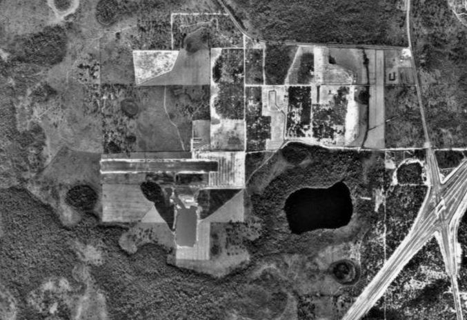
A 1957 aerial view showed the site of Armour Field remained an open field, but with no sign of recent aviation use.
The hangar had been removed at some point between 1941-57.

A 2023 aerial view showed no trace remaining of Armour Field.
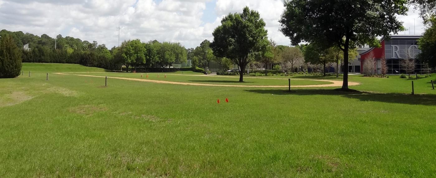
Rebecca Whalon reported in 2024, “The land now hosts commercial buildings of various companies.
The airport was bordered by West Main Street (Highway 60) on the north, Agricola Road on the west, Century Boulevard on the east, and Centennial Boulevard on the south.”
Thanks to Rebecca Whalon for pointing out this airifeld.
____________________________________________________
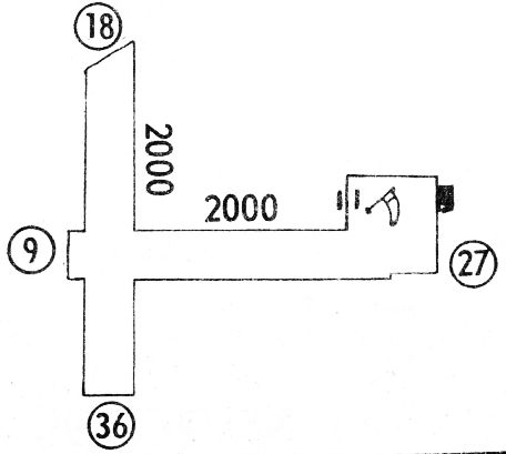
28.575, -81.511 (West of Orlando, FL)
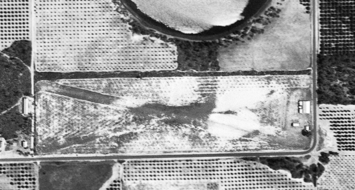
Longcoy Airport, as depicted on a 5/1/52 USGS aerial photo.
The date of construction of this small general aviation airport on the west side of Orlando has not been determined.
Longcoy Airport was not yet depicted on Orlando Sectional Charts from 1950/55/60.
The earliest depiction which has been located of Longcoy Airport was on a 5/1/52 USGS aerial photo.
It depicted Longcoy as having 2 unpaved runways in an X-shape, with a few small buildings on the east side.
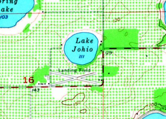
The 1956 USGS topo map depicted Longcoy Airport as 2 runways in an X-shape, labeled simply as “Landing Field”, with 3 small buildings on the east side.
The earliest aeronautical chart depiction which has been located of Longcoy Airport was on the November 1965 Jacksonville Sectional Chart.
It depicted Longcoy as a private airfield having a 2,000' unpaved runway.
The earliest photo which has been located showing aircraft at Longcoy Airport was a 1969 aerial view,
which depicted 4 light single-engine aircraft parked on the east side.
Gary English recalled, “Longcoy Airport... I kept a plane there from 1976 to at least the early 1980s. It was a small grass strip.”

An 11/26/77 USGS aerial photo It depicted Longcoy Airport as having 2 unpaved runways in an X-shape, with a small building on the east side.
A 1980 aerial view depicted 4 light single-engine aircraft parked near Longcoy's hangar on the east side.
The last photo which has been located showing aircraft at Longcoy Airport was a 1984 aerial view,
which depicted 2 light single-engine aircraft parked on the east side.
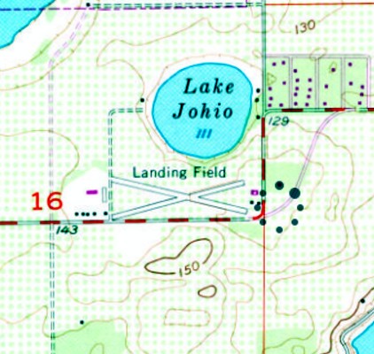
The 1984 USGS topo map continued to depict Longcoy Airport as 2 runways in an X-shape, labeled simply as “Landing Field”, with a few small buildings on the east side.
The last aeronautical chart depiction which has been located of Longcoy Airport was on the 1985 Jacksonville Sectional Chart,
which depicted it as a private airfield having a 2,000' unpaved runway.
Longcoy Airport was evidently closed (for reasons unknown, but presumably due to rising property values) by 1990,
as a 1990 aerial photo showed the runways as deteriorated, and the hangar remained, but there were no aircraft on the field.
Longcoy Airport was no longer depicted on the 1994 Jacksonville Sectional Chart (courtesy of Ron Plante).
A 1999 aerial view showed the hangar remained standing on the east side of the Longcoy Airport site.
A 2016 aerial view looking northwest shows the Longcoy Airport property remains vacant, but the runways are overgrown & no longer recognizable, and the hangar has been removed.
The site of Longcoy Airport is located northeast of the intersection of Lake Johio Road & Silver Star Road.
Thanks to Gary English for pointing out this airifeld.
____________________________________________________
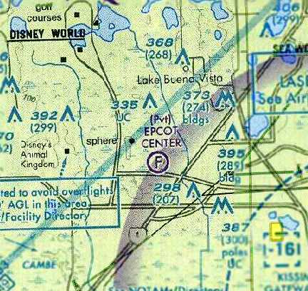
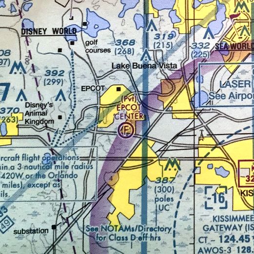
Epcot Airport of Tomorrow, Lake Buena Vista, FL
28.4, -81.57 (West of Orlando, FL)
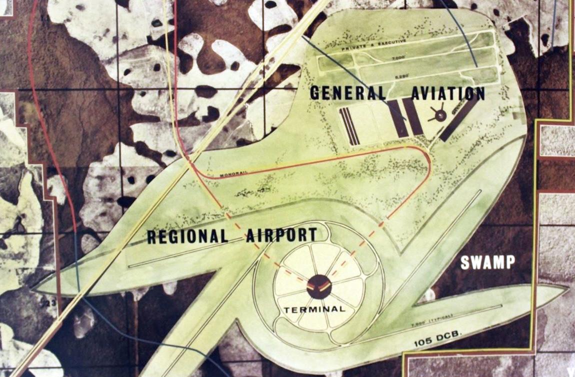
A 1966 artist's conception of the never-built Epcot Airport of Tomorrow.
Walt Disney's original expansive plans for the Epcot complex planned to be built within Disney World
included an “Airport of Tomorrow” located on the southern portion of Epcot.
This included a fanciful Regional Airport on the south side with four 7,000' runways extending out tangentially from a circular terminal,
and a General Aviation complex on the north side with 3 shorter parallel runways.
Ironically note that this airport plan evidently did not take into account any aeronautical factors,
as none of these runways were oriented in the direction of the prevailing wind in the local area.
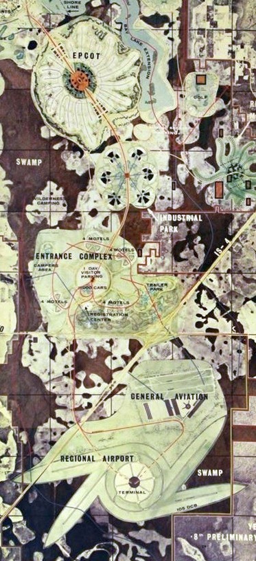
From the 1966 artist's conception, the location of the Epcot Airport of Tomorrow is shown relative to the rest of the planned Epcot complex.
The airport was planned to be located on the south side of Interstate 4.
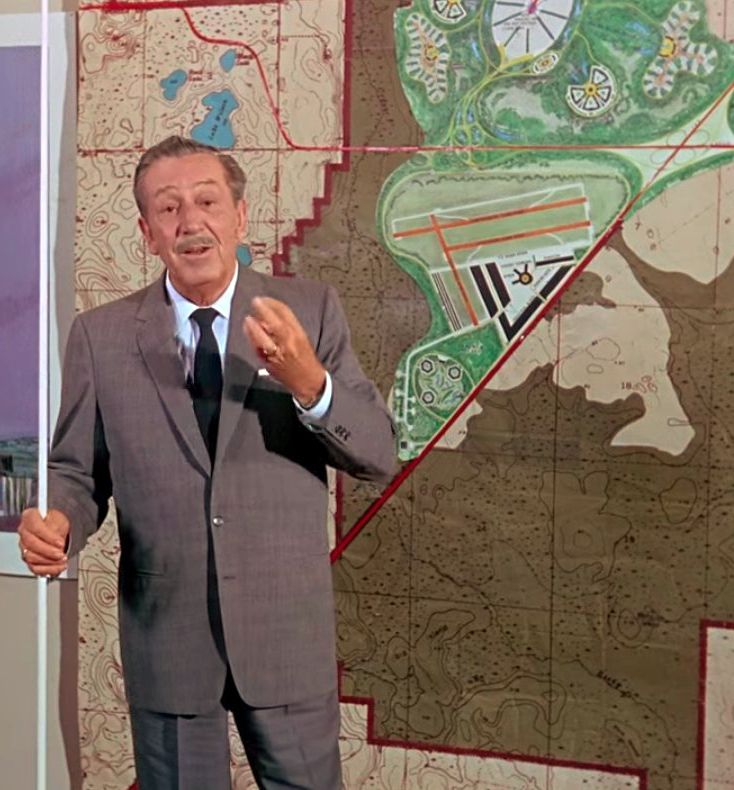
Walt Disney filmed a promotional film about his planned Epcot development in 1966 only 2 months before he passed away.
A still from this film shows a revised version of the planned Epcot Airport of Tomorrow.
In contrast to the earlier plans, note that the airport had been moved to the north side of Interstate 4,
and was smaller & completely different in design, with 3 runways.
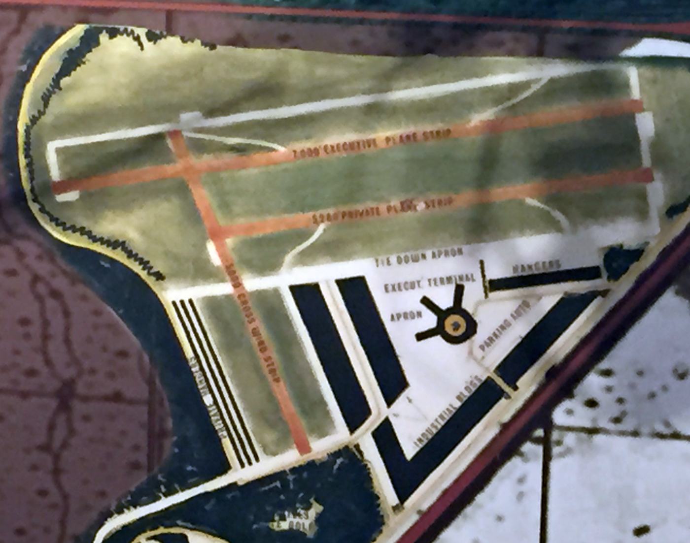
A 6/23/15 photo by Paul Freeman of the plans for the Epcot Airport of Tomorrow, which remains on display in Disney World's Hollywood Studios theme park.
This descoped version of the planned airport included 3 runways, with the longest being the 7,000' northeast/southwest “Executive plane strip”.
An apron, executive terminal, and hangars were located on the south side.
After Walt Disney's passing in 1966, the Disney company shelved his elaborate plans for Epcot.
When they eventually began work on the complex in 1979, it was considerably de-scoped from Walt's original plan,
and no longer included an airport.
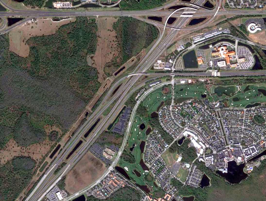
A 2/18/15 aerial view of the planned site of the Epcot Airport of Tomorrow shows that the site on the north side of Interstate 4 remains undeveloped,
while Disney's Celebration community occupies the planned airport site on the south side of Interstate 4.
The planned site of Epcot Airport of Tomorrow is located south of the intersection of Interstate 4 & Route 530.
____________________________________________________
Air Lando Airpark, Lake Buena Vista, FL
28.38, -81.52 (Southwest of Orlando, FL)
A circa 1960-62 aerial view of Air-Lando Airpark (courtesy of Daniel Lewis).
Stan Bronson reported, “My dad was Dave Bronson & he & a couple of his WWII buddies built Air-Lando [Airpark] in 1959.
We had a little over 300 acres with the airport in the middle of the property. We had a hangar with an office & lounge.
The location of the strip & our house was just northwest of the Beunavista Palace.
My job as a 12 & 13 year old was to gas planes & to mow the strip. My dad taught me how to fly by the time I was 10.
I remember helping Dad seed the strip with Bahia grass & it was my job on Saturdays to mow the strip with an old Case tractor at the ripe old age of 12.
The instructor there was named Al Krueger.”
The earliest depiction which has been located of Air Lando Airpark was a circa 1960-62 aerial view (courtesy of Daniel Lewis),
which depicted a single unpaved east/west runway.
Stan Bronson observed of the photo, “The grass has not grown yet to the edges.
The white dots below the strip are planes.”
Air-Lando Airpark was not yet depicted on the February 1961 Orlando Sectional Chart.
According to a 9/27/62 county commissioners meeting minutes,
“Communication from Florida Development Commission with reference to application for a public airport site
was read to the Board & upon motion by Commissioner Cooper, seconded by Commissioner Surguine
and unanimously carried approval of public airport site, to be known as Air Lando Airpark,
in Section 21, Township 24 South, Range 28 East was recommended.”
Daniel Lewis reported, “My dad took flying lessons from a grass strip that was bought by Disney.”
Stan Bronson recalled, “The hangar was built in 1962.
Right after the hangar was built my dad cleared the woods to the east of the house.
We had about 20-25 planes there when the property sold & had secured the dealership for Maule & Cavalier,
which was the converted P-51 sport version made in Sarasota.
We were the very first sale to Disney on 2/3/63.
About a week later a cousin of mine, Irlo Bronson, sold the major piece of the property, which was 27,000 acres.
The house, which was over 4,000 square feet & just built, was sawed in half, moved to another location, buried & became the soil testing lab.”

“Airlando Airpark” was still depicted on a 1965 map (courtesy of Daniel Lewis).
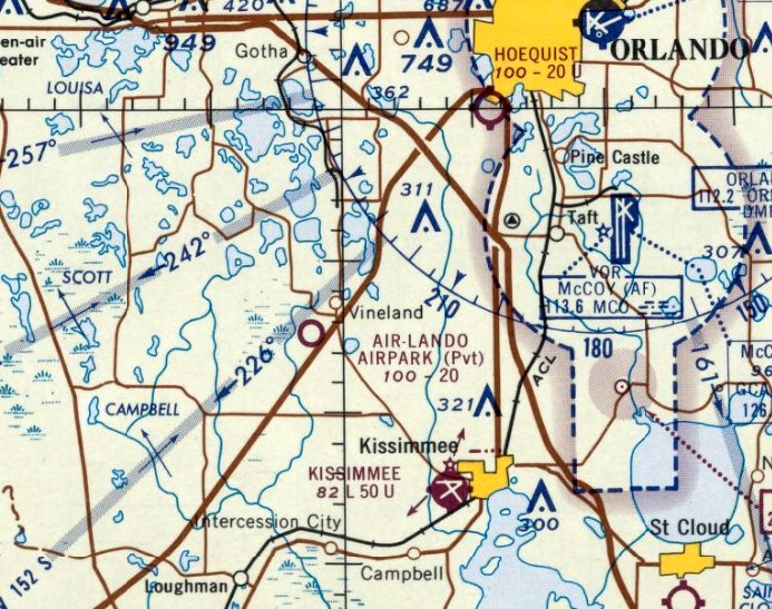
The earliest aeronautical chart depiction which has been located of Airlando Airpark was on the April 1965 Orlando Sectional Chart.
It depicted Airlando Airpark as a private airfield having a 2,000' unpaved runway.
Air Lando Airpark was not depicted on the 1965 USGS topo map.
According to a 10/29/78 Orlando Sentinel article (courtesy of Silversmith),
Tom Enos moved into the house adjacent to Airlando Airport in 1965,
so that he could have a hangar & runway right next to his home.
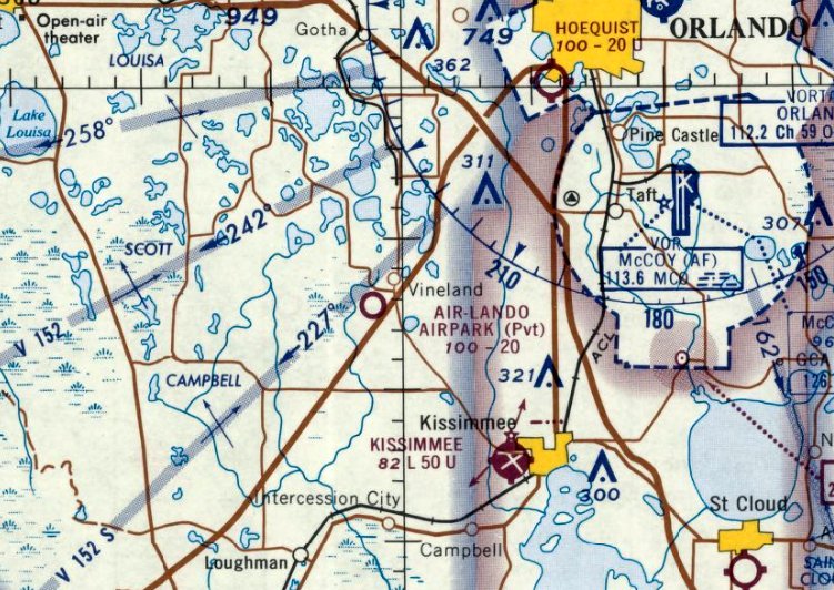
The last aeronautical chart depiction which has been located of Airlando Airpark was on the April 1966 Orlando Sectional Chart.
It depicted Airlando Airpark as a private airfield having a 2,000' unpaved runway.
Air Lando Airpark was no longer depicted on the November 1966 Orlando Sectional Chart.
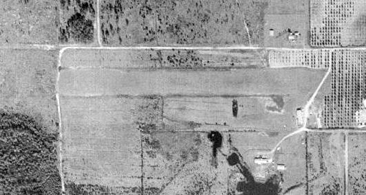
A 1969 aerial view of the site of Airlando Airpark (courtesy of Daniel Lewis) showed the single east/west grass runway & building remained intact, though abandoned.
According to a 10/29/78 Orlando Sentinel article (courtesy of Silversmith),
the Airlando Airport land was sold to Disney, and Airlando Airport was closed in 1970.
A 1980 aerial view showed Buena Vista Drive had been built through the site of the runway.
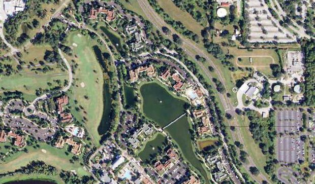
A 2013 aerial view (courtesy of Daniel Lewis) of the site of Airlando Airpark.
Daniel Lewis observed, “What amazes me most is how they were able to rearrange water features at will, which you could never get away with nowadays.
I think the state legislation set up the Reedy Creek Improvement District so that Disney could pretty much do as they wish.”
A 2015 photo by Daniel Lewis of the site of Air Lando Airpark.
Daniel Lewis reported in 2015, “The eastern end of the strip is currently a running track adjacent to the Reedy Creek Fire Department building on Buena Vista Drive.”
Daniel Lewis reported in 2015, “There is a house & several outbuildings adjacent to the former strip
which is sandwiched between Disney property & the Grand Cypress Resort property.
As I was walking by, the owner was leaving for a doctor’s appointment.
He said that this was one of what was going to be a series of houses along the runway.”
A 2015 photo by Daniel Lewis of the site of Air Lando Airpark.
Stan Bronson reported in 2015, “The hangar was still in use as a maintenance shop last time I checked.”
The site of Air-Lando Airpark is located northwest of the intersection of Buena Vista Drive & Club Lake Drive.
Thanks to Daniel Lewis for pointing out this airfield.
____________________________________________________
28.5, -81.41 (Southwest of Central Orlando, FL)
Hoequist Airport, as depicted on the 1942 Orlando Sectional Chart.
Hoequist Airport was evidently established at some point between 1940-42, as it was not yet depicted on the August 1940 Orlando Sectional Chart.
The earliest depiction which has been located of Hoequist Airport was on the 1942 Orlando Sectional Chart, which depicted Hoequist as a commercial/municipal airport.
Hoequist Airport was founded by Elmer Hoequist.
The earliest photo which hash been located showing Hoequist Airport was a 3/24/43 aerial view looking north from the 1945 AAF Airfield Directory (courtesy of Scott Murdock).
It depicted Hoequist as having 2 unpaved runways.
Mark Terry reported, “Grace Butt had a fascination with all things aviation.
Soon she found herself at Hoequist Airport at the intersection of 40th Street & Rio Grande Avenue, cleaning parts in exchange for flying lessons.
Grace joined the Civil Air Patrol, and with the help of the Civilian Pilot Training Program & a push for women to become aviators by First Lady Eleanor Roosevelt, she learned mechanics & the art of flight.
Under the guidance of Elmer Hoequist, she soloed on her 16th birthday, and by her 17th birthday, she had earned her Private Certificate.
During the war, Grace flew reconnaissance for the Civil Air Patrol out of Orlando as a private citizen, searching for enemy activity along the coast of Florida.”
The 1945 AAF Airfield Directory (courtesy of Scott Murdock) described Hoequist Airport as a 150 acre irregularly-shaped property
having 2 sand 2,000' runways, oriented north/south & east/west.
Hoequist was said to have a 94' x 60' wood & metal hangar, and to be owned & operated by private interests.
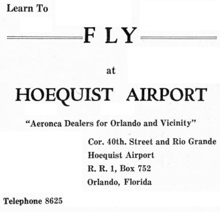
A 5/2/46 advertisement (courtesy of Mark Hess) described Hoequist Airport as “Aeronca Dealers for Orlando & Vicinity.”
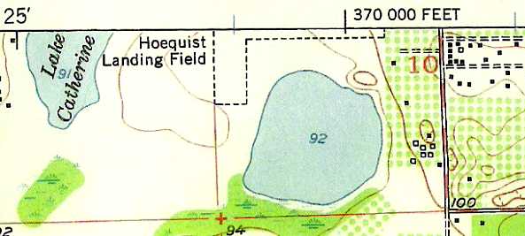
The 1951 USGS topo map depicted Hoequist Landing Field as having 2 unpaved runways.
The last photo which hash been located showing Hoequist Airport was a 4/9/52 USGS aerial view.
It depicted Hoequist as having 2 grass runways, with 3 hangars & 10 single-engine light planes on the northeast side.
Hoequist Landing Field was depicted in an unchanged fashion on the 1960 USGS topo map.
The November 1965 Sectional Chart (according to Stephen McNicoll)
described Hoequist as having 2 turf runways, with the longest being 2,000'.
The last aeronautical chart depiction which has been located of Hoequist Airport was on the 1967 Orlando Sectional Chart.
It depicted Hoequist as having a 2,000' unpaved runway.
Dgil987 recalled, “Hoequist Airport... My dad had a C-140 there for a few years. The field closed down about 1967.”
The 1968 Flight Guide (courtesy of Robert Levittan) depicted Hoequist Landing Field as having 2 unpaved 2,000' runways,
with 3 small buildings on the northeast side.
Hoequist Airport was no longer depicted on the October 1968 Jacksonville Sectional Chart (courtesy of Ron Plante).
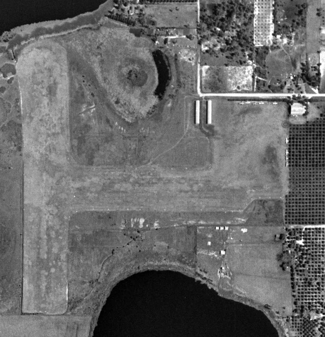
A 1969 aerial photo showed that Hoequist Airport's 2 runways remained clear,
but all 3 hangars had been removed at some point between 1952-69, and no aircraft were visible.

The last depiction which has been located of Hoequist Airport was on a 1969 FL DOT map (courtesy of Jim Burnett).
The 1970 USGS topo map no longer depicted Hoequist Airport.
A 1/22/13 aerial view showed the site of Hoequist Airport. Jim Burnett observed, “An apartment complex is now located where the airport once was.”
The site of Hoequist Airport is located west of the intersection of South Rio Grande Avenue & 40th Street.
____________________________________________________
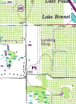
Epcot Center Ultralight Flightpark (44FD), Lake Buena Vista, FL39.497, -75.645
28.35, -81.55 (West of Orlando, FL)
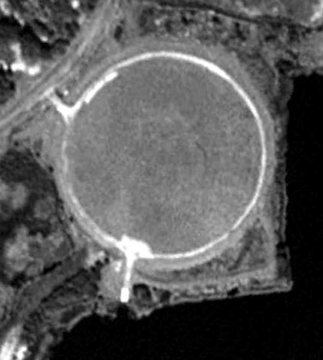
The circular landing pad of the Epcot Center Ultralight Flightpark, as depicted on a 2/5/95 USGS aerial photo.
In addition to the Walt Disney World's primary airport,
a second smaller airfield was evidently operated for several years along the southern edge of the Disney property.
The Epcot Center Ultralight Flightpark was not yet depicted on a 1984 aerial view.
According to Wikipedia, “Epcot Center Ultralight Flightpark (44FD) was a private-use ultralight airport,
privately owned by the Walt Disney World Company,
and was used to launch aircraft used in the 'Skylaidescope' & 'Surprise in the Skies' shows at the Epcot theme park.
According to John Sarra, “The earlier show 'Skyleidoscope' was from 1985-87
and used a conventional grass runway visible to the [east] across the water from the circular runway.
It ran along the water, there is a very straight dirt road there now,
About 10 fixed-wing planes were based there from 1985-87.”
The Epcot Center Ultralight Flightpark was not yet depicted on the 1991 USGS topo map.
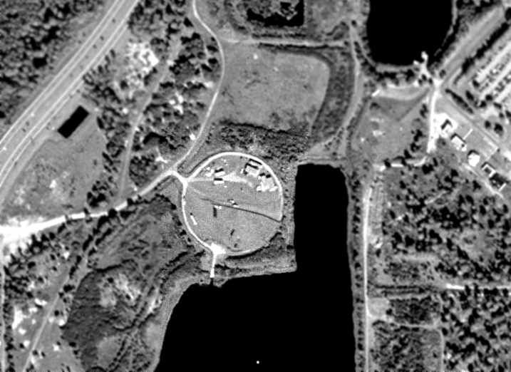
John Sarra recalled, “I worked on the show in 1991 on the circular runway.
The circular runway was created in 1991 for 'Surprise in the Skies' and was only used for Powered Parachutes called ParaPlanes.
There were 10 paraplanes based there, no buildings just large trailers.
After each day the paraplanes were loaded in the trailers & driven to a warehouse 1 mile away.
There was a boat ramp off the round runway, still visible, used for the rescue boat which was launched prior to all takeoffs & landings.
I was the ParaPlane dealer in Orlando. We sold Disney the 10 Paraplanes. We trained all the pilots.
We also provided ongoing support, consulting, and spare parts for the duration of the 1-year show.”
John continued, “'Surprise in the Skies' only ran for only one year.
The show was planned from the beginning to be just a 1-year show for the 10th anniversary of Epcot.
There was some talk towards the end that they might extend it since it was under budget & accident-free
but Disney discontinued all of the shows associated with the 10th anniversary at the end of the year as scheduled.”
According to Wikipedia, “Epcot Center Ultralight Flightpark... closed for theme park use in 1992, when Surprise in the Skies ended.”
The earliest depiction of the Epcot Center Ultralight Flightpark which has been located was on a 2/5/95 USGS aerial photo.
It depicted the field as consisting of a 400' diameter circular grass field.
The Epcot airfield was still not depicted on the September 1996 Orlando Sectional Aeronautical Chart (according to Chris Kennedy).
A 1999 USGS aerial view showed several small buildings or trailers on the circular landing pad of the Epcot Center Ultralight Flightpark.
According to Wikipedia, “The land sat unused for nearly 10 years, when it was cleared for the 2nd phase of Disney's Pop Century Resort, named the Legendary Years.
Construction on the hotel was stopped after the September 11 attacks caused tourism to drop off.”
Showing how much you can sometimes trust the published aeronautical information,
the “Epcot Center” airfield was still depicted on the September 2002 Orlando Terminal Aeronautical Chart (courtesy of Chris Kennedy),
even though the airfield had been covered by a hotel for at least a year by that point.
A 1/1/04 aerial view showed the site of the Epcot Center Ultralight Flightpark had been covered by hotel buildings,
with no remaining trace of the former airfield.
The “Epcot Center” airfield continued to be depicted
on the February 2004 Orlando Terminal Aeronautical Chart (according to Chris Kennedy).
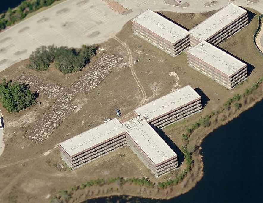
A circa 2006 aerial view looking north at the site of the Epcot Center Ultralight Flightpark,
covered by the abandoned hotel buildings of the uncompleted Disney Pop Century Legendary Years Resort.
There was no remaining trace of the former airfield.
As of 2007 the “Epcot Center Ultralight Flightpark (44FD)” was still listed in the FAA Airport/Facility Directory as an active private airfield,
even though the site of the airfield had been covered by buildings for at least 6 years by that point.
The A/FD data described the airfield as having a single 424' circular turf landing pad,
which matches the airfield configuration seen in the 1999 aerial photo.
The owner was listed as the Walt Disney World Company, with the manager listed as Jay Parker.
The field was said to have a total of 20 aircraft based on the field, including 10 single-engine aircraft, and 10 ultralights.
“Epcot Center” was still depicted as a private ultralight airfield on the February 2009 Tampa Orlando Terminal Aeronautical Chart,
even though the airfield had been covered by a hotel for at least 8 years by that point.
A 5/2/10 aerial view showed the hotel buildings on the site of the Epcot Center Ultralight Flightpark remained uncompleted.
According to Wikipedia, “Although still listed active in FAA records as recently as September 2010,
the former airport is now the site of Disney's Art of Animation Resort, which opened in May 2012.”
____________________________________________________
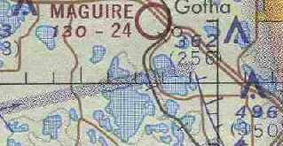
Maguire Airport / Orlando West Airport (X30), Gotha, FL
28.53, -81.54 (West of Orlando, FL)
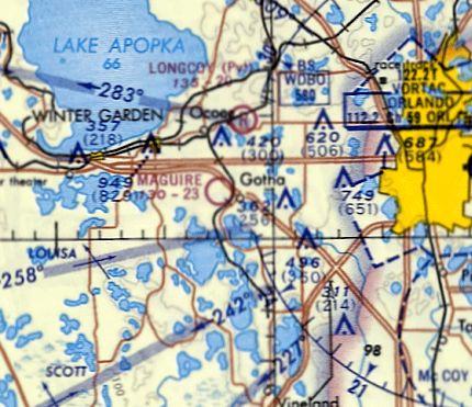
Maguire Airport, as depicted on the October 1968 Jacksonville Sectional Chart (courtesy of Ron Plante).
Nancy Maguire (Harold Maguire's daughter) recalled, “The airport was never 'built' - it just evolved.
Dad always had a plane & had to keep it either at Herndon or Longcoy's Airport.
He decided to remove some trees in his orange grove (where the grove barn was built) and make a landing field just for himself.
He built a hangar - more like an airplaneport instead of a carport.
For many years when he came back from a trip, he would buzz the house so Mom would know to go pick him up. The whole town knew when he returned.
He even landed out there at night without lights - he would line up with the lights from Highway 50 & the light from the hangar & judge the distance & land.
He could even do this with a Baron. Growing up I never thought this was anything special but when I got my pilots license, I found out differently.”
Maguire Airport was not yet depicted at all on the 1966 Orlando Sectional Chart (according to Chris Kennedy).
According to Nancy Maguire, “After a few years several people in Windermere, Ocoee and Winter Garden
asked Dad is they could keep their planes at his strip & before long it became Maguire Airport.
I graduated from high school in 1967 & it was not an official airport.”
Maguire Airport was not yet depicted at all on the 1968 USGS topo map.
The earliest depiction which has been located of Maguire Airport was on the October 1968 Jacksonville Sectional Chart (courtesy of Ron Plante).
It depicted Maguire as having a 2,300' unpaved runway.
According to Nancy Maguire, “By the time I started attending FSU in 1969 I believe it was Maguire Airport.”
A 1969 aerial view depicted Maguire Airport as a single unpaved north/south runway in the middle of orange groves,
with a few small buildings on the southwest side.
There were no aircraft visible on the field.
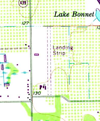
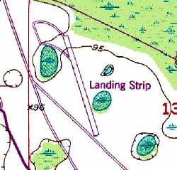
The 1970 USGS topo map depicted Maguire as having a single unpaved north/south runway, labeled simply as “Landing Strip”,
with a few small buildings on the southwest side.
The earliest official listing of the airport which has been located was in the 1971 Flight Guide (which listed it in the "Low Use" airports section).
It described Maguire Airport as having a single 2,800' unpaved runway.
Harold Maguire was the original owner & operator of the airport, according to Brian Smith.
According to Sue Thompson, Selby Birch was the contractor “who used his tractor to clear & create the runway.
He was also the first to land there. Debbi Huckabee was my ground school instructor.
I was a broke college student who had always dreampt of flying.
Harold [Maguire] was my first instructor. I was honored... he was a great teacher. I loved that place.”
The March 1972 Jacksonville Sectional Chart (courtesy of Chris Kennedy) depicted Maguire as having a 2,400' unpaved runway.
The earliest photo which has been located of Maguire Airport was an undated aerial view from a 5/7/72 article (courtesy of David Henderson).
It depicted a dozen light single & twin-engine aircraft parked near a few small hangars.
The article said that “A shutttle service between Maguire Airfield & Disney World will be innaurated Monday
when local dignitaries board a Short Takeoff & Landing plane & make the 5-minute flight to the Disney World landing port.”
David Hendernson reported, “The obscure commuter VQ Airlines... I found a timetable that show that VQ Airlines' Disney World flights operated from Maguire Airport, not the Disney STOLport.
Other articles show that for a short time, starting in May 1972, Shawnee Airlines operated shuttle flights between Maguire & Disney using Twin Otters!
VQ moved their Orlando flights from Maguire to Herndon in September 1972.”
The January 1976 CH-25 World Aeronautical Chart (courtesy of Chris Kennedy) depicted Maguire an unchanged configuration.
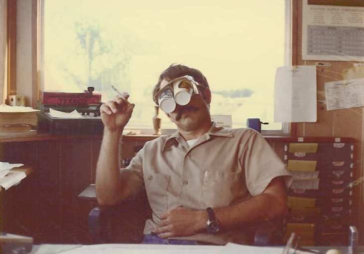
A 1979 photo by Brian Smith of a Maguire Airport lineman clowning around in the flight office at with a pair of view limiting goggles.
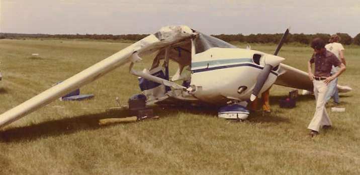
A 1979 photo by Brian Smith of the wreck of Cessna 172 N734YH at the end of Maguire's Runway 18.
The aircraft crashed into orange trees off end of runway,
and was pictured here after being pulled back out of the trees onto the runway.
The tail tore away from fuselage during this process.
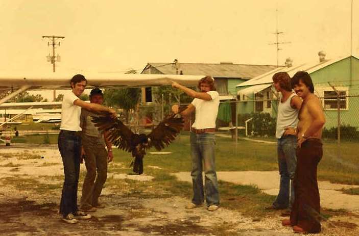
A 1979 photo (courtesy of Brian Smith) of the aftermath of a turkey buzzard strike on the left wing of Cessna 150 during cable patrol.
Pilot Bob Coffey, continued the patrol with the deceased buzzard on his wing & returned safely to the airport.
The airport Flight Office is in the background on the right,
and the maintenance hangar is visible in the center background.
Left to right: Dan Black, Dan Isaacs, Doug Denny, and Brian Smith.
A 1980 aerial view looking north at Maguire Airport by Brian Smith
depicted over a dozen light aircraft on the southwest side of the field.
Brian Smith recalled, "I was a flight instructor at the airport from 1978-80.
At that time the airport was called 'Maguire Airport' and Mr. Harold McGuire ran the operation.
The airport was located on Maguire Road between Windemere & Ocoee, FL.
It was almost exactly 12nm west of the Orlando Executive Airport (then called Herndon Airport - ORL).
The Maguire family was prominent in the area, as you might surmise,
and lived in the town of Ocoee, several miles north of the airport.
Harold Maguire was a pilot during WW2. I think at one point as a instructor pilot.
I also understood that he ferried B-17s across the Atlantic."
Brian continued, "Many of the airport buildings were originally part of a farm implement company owned by the Maguires.
Before the location became an airport, they manufactured some sort of farm implement used in the orange groves.
If I remember correctly, the manufacturing rights were eventually sold to the Ford Company.
Perhaps this is when Harold decided to turn the place into an airport."
Brian continued, "Harold's son, Mickey, tragically died in an airplane crash at the airport several years before I began work there [on 1/6/72].
The name of the FBO in the late 1970s was 'Mickey's Air Service', I assume in memory of Harold's son."
"During my tenure the airport was indeed a busy place.
I was kept busy teaching students to fly, we had a contract with AT&T to fly cable patrol
and also flew a pipeline patrol every week from Florida all the way out to Texas.
Mickey's Air Service sold av-gas & the tie-down lines were always nearly full.
Sue Hauchabee held ground school regularly. Mark Calderazzo & Paul Weston were linemen, and our mechanic's last name was "Dietz".
And of course, there was Harold McGuire."
Brian continued, "My first day on the job was a disaster.
I showed up & Harold immediately gave me the keys to an airplane & introduced me to who I thought was another instructor pilot.
Me & this 'IP' walked out to the airplane when he mentioned he was 'looking forward to learning to fly.'
That's when I found out this guy was actually my first student.
Mind you, I had never flown a C-152, nor had I ever flown into, or out, of this short grass airport before.
We lined up on this 2,300' grass runway with orange trees at the end & firewalled the thing.
It began to look like we weren't going to get airborne so I made an executive decision & aborted.
We skidded down the remaining runway & almost stopped when the nose wheel dipped into the ditch at the end of Runway 18.
The tail of the plane was now sticking up on about a 30 degree angle.
Fortunately we were only moving at a few MPH by this time & not much else happened.
Talk about an embarrassing start to a new job!
Harold & I had a talk, followed by an evaluation flight, he released me to fly & I stayed there two more years
and was the only flight instructor for the majority of the time."
Brian continued, "After I left in 1980, the airport was run for a time by Joe & Peg Austin.
Joe & Peg were flight students of mine. I know they eventually moved to Camellia, GA & ran an FBO at that airport.
That job was perhaps the most enjoyable of all my flying career with the exception of the pay (a great week was $90).
I also remember chucking rolls of toilet paper out of a C-152 over top the airport,
buzzing a ground school class in a Bonanza & other stuff we shouldn't have been doing.
Most of which was done when Harold wasn't around."
Maguire Airport was described in the 1982 AOPA Airport Directory (courtesy of Ed Drury) as having a single 2,340' turf Runway 18/36.
Ronald Walden recalled, “Maguire Airport: From 1979-82, my father, Alfred Walden was co-owner of Orange Aviation & he ran the day-to-day operations of the airport.
Dave Pearlman & 2 investors purchased the physical property & leased it back to Orange Aviation.
I learned to fly there trading my time working as a flight boy (with Doug Hammock) for lessons with Ted Huckabee.
My first flight was in a Piper J-3 Cub (black with orange stripes) that belonged to Dave Pearlman & was piloted by Ed Isaacs.
My first some time later was in my father’s 1945 Piper J-3; it was yellow with black stripes.
The shop was run by Emmett 'Mad Dog' Watson who is shown in the buzzard picture with his shirt off.
Two others that worked on the planes were Bob Feree (Orlando Helicopter)
and an old timer named Harry that was always doing something to Dave Pearlman’s collection of antique planes.”
Ronald continued, “I had my student pilot’s license 3 days before I could legally drive a car…
so I could fly an airplane, I just needed someone to drive me to the airport.
It was a regular occurrence to take off in Mr. Maguire’s Baron & go to River Ranch Acres for breakfast,
or head over to Cedar Key with Hugh Grimes (mayor of Winter Garden) in his C-210.
It wasn’t until later in life that I realized these were special, almost surreal times.
The antics of the bush pilots were a treat.
For instance, Kerry Simms coming in on Runway 09 with his J-3…Runway 09 was the taxiway out of the T-hangars!
He came in over Maguire Road in slow flight & plopped it down in the grass, kicked it 90 degrees to the left,
shut it down & jumped out to push it right back into the parking spot in the T-hangar!
The plane might have rolled a total of 50’ on that landing. I will always cherish the memories.”
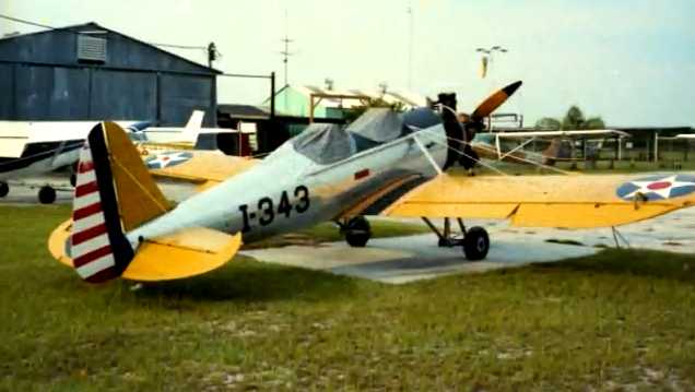
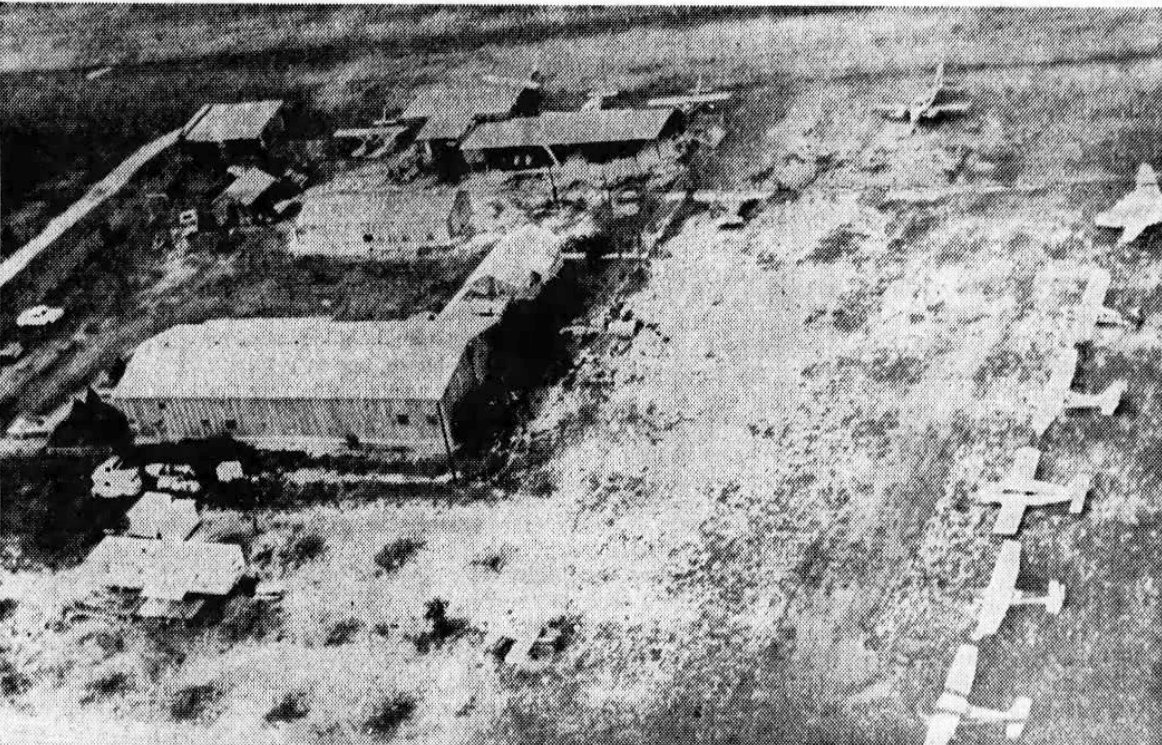
A circa 1980s photo of a beautifully restored Ryan PT-22 trainer at Maguire Airport.
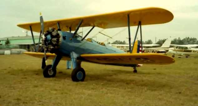
A circa 1980s photo of a beautifully restored Stearman trainer at Maguire Airport.
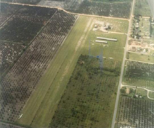
A circa 1980s aerial view looking south at Orlando West Airport by Stephen Mahaley.
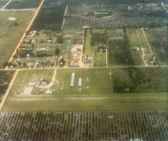
A circa 1980s aerial view looking west at Orlando West Airport by Stephen Mahaley.
Several hangars & other buildings sat at the southwest corner of the airfield, along Maguire Road.
The airport was apparently well-used, as over 20 light aircraft can be seen in the photos.
According to Stephen Mahaley, by the 1980s it was known as Orlando West Airport.
He recalls, "The parallel north/south turf runways were about 2,600'.
A glider operation used the outside runway, other aircraft used the inner runway."
The 1985 USGS topo map depicted Orlando West as having a single unpaved north/south runway, labeled simply as “Landing Strip”,
along with a few small buildings on the southwest side.
The last aeronautical chart depiction which has been located of Orlando West Airport was on the 1985 Jacksonville Sectional Chart,
which depicted it as having a 2,400' unpaved runway.
Steve Christmas recalled, “Maguire Airport... In 1986 I bought a home just north of the approach end past Highway 50.
Being a pilot I watched planes on final or departure from my back porch. I frequented visiting the field commuting right by it daily to work.
The eclectic fleet of planes then were an end of an era. I went to renew my biennial but it unfortunately closed at that same time.
I never took off from the field but liked it's vibe.”
Mike Skinner recalled, “In 1988 I was west of Orlando & saw a Ford Trimotor flying.
I looked up & saw that thing & HAD to find out what it was all about.
A little detective work brought me to Maguire Field where the Trimotor was offering rides.
Unfortunately,due to my work schedule, I couldn't hang around to take advantage of this opportunity.
There was also a derelict twin Cessna (Bobcat?) - like Sky King's original aircraft from the TV series.”
S. Christmas recalled, “Its closing was a loss to local culture & the sleepy Florida I knew. The mass development had begun. They don't care about airports.”
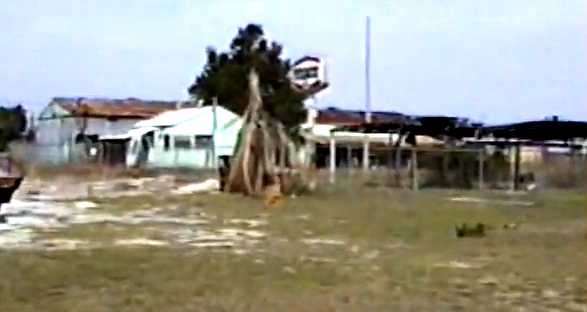
A 3/25/90 photo of the abandoned Maguire Airport office & hangars.
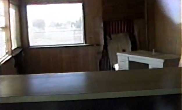
A 3/25/90 photo of the interior of the abandoned Maguire Airport office.
Jack Mannix recalled, "I moved to Windermere, FL in 1991 & Orlando West Airport was still there but closed & abandoned.
A Publix Supermarket was built there maybe around 1993 along with other strip mall stores."
Orlando West Airport was no longer depicted on the March 1994 Jacksonville Sectional Chart (courtesy of Ron Plante).
The 1999 USGS aerial photo showed that the Orlando West Airport property had been redeveloped with housing & a shopping center.
The 2002 USGS aerial photo showed that the site of Maguire Airport has been covered with housing & retail construction.
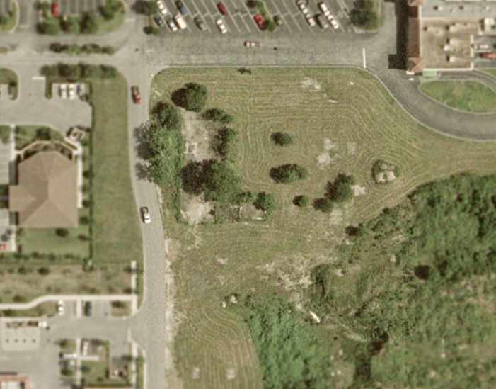
However, Brian Smith pointed out that a close-up view from the 2002 USGS aerial photo of the southwest portion of the site
reveals the concrete foundation of the former Maguire Airport maintenance hangar (the rectangular foundation in the center, surrounded by trees),
as well as the smaller foundation to its right of the former flight office.
Former Maguire Airport instructor Brian Smith reported in 2003, "I periodically make it back to the area.
The airport is now completely gone. In its place is a shopping center & residential homes.
It is no longer the rural area & the groves are all gone. The area looks nothing like it did in the heyday of the airport.
I wonder if any of the new homeowners know what went on there in the 1970s?"
Bob Fairchild reported in 2004, "Yesterday I passed the Maguire house [Harold Maguire, founder of Maguire airport] and noticed an estate sale.
After buying a memento I found that Harold had just recently died. He was quite a dreamer."
Jeff Olynick reported in 2008 that a more-recent aerial photo shows “that the concrete foundation
of the former Maguire Airport maintenance hangar as well as the smaller foundation to its right of the former flight office is all gone.
They appear to be expanding the shopping center, and the place where those foundations were
appears to be being prepared for an expansion to the parking lot.
The expansion project may be all complete by now.”
Orlando West Airport was located southeast of the intersection of Maguire Road & Bridge Creek Boulevard.
____________________________________________________
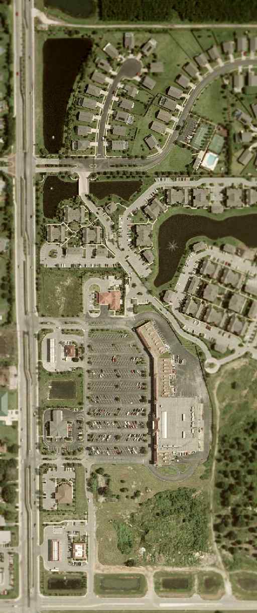
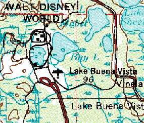
Lake Buena Vista STOLport / Disney Airport (DWS), Lake Buena Vista, FL
28.4, -81.57 (West of Orlando, FL)
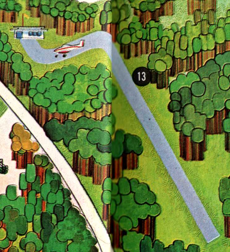
The Disney World Airport, as depicted on a 1971 Disney World map (courtesy of Dallam Oliver-Lee).
Among the millions of visitors who arrive at the Disney World resort every year,
how many people realize that the resort has its own private airport,
situated just adjacent to the east side of the main parking lot?
A 1969 aerial view did not yet show any sign of an airfield at this location.
Disney World's airfield was reportedly built in 1970 or 1971 during the construction of the Disney World resort.
But it was not yet depicted on the October 1971 Jacksonville Sectional Chart (according to Chris Kennedy).
The earliest depiction of the Disney airfield which has been located was on a 1971 Disney World map (courtesy of Dallam Oliver-Lee).
It depicted a single northwest/southeast runway, with a taxiway leading to a small office on the northwest side.
When Walt Disney World opened in 1971,
Shawnee Airlines began regular passenger service from Orlando's McCoy Airport directly to Disney World's own STOLport,
using 19 seat DeHavilland DHC-6 Twin Otters.
The actual flight time was only a few minutes.
Shawnee was the only airline ever to fly directly into the Magic Kingdom.
According to David Henderson, “Shawnee Airlines & Executive Airlines both commenced service to Disney on 10/22/71 using Twin Otters.
Shawnee initially offered nonstop service to Ft. Lauderdale, Orlando Herndon Airport, Tampa, and West Palm Beach
while Executive operated nonstops to Orlando Herndon & Tampa.
A third airline, VQ, operated by Volusia Aviation Service, used Beech Bonanzas & a Piper Cherokee on flights between Disney, Orlando Herndon and Daytona Beach.”
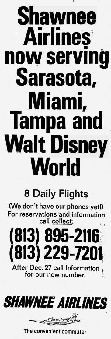
A circa 1971 advertisement for Shawnee Airlines, describing their flights into Walt Disney World.
A circa 1971 aerial view looking north at the Disney World STOLport (courtesy of Tim Buntin).
Note the de Havilland DHC-6 Twin Otter headed right toward the camera, right above the Runway 34 numbers.
According to David Henderson, “The photo must have been taken between October & December 1971 as it appears to be an Executive Airlines aircraft
(Shawnee Twin Otters had white below the windshield; Executive had dark blue).
The fresh asphalt & bright runway paint also suggest the picture was taken shortly after the airport opened.”
The earliest aeronautical chart depiction of the Disney airfield which has been located
was on the March 1972 Jacksonville Sectional Chart (courtesy of Chris Kennedy).
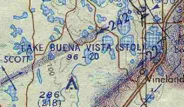
It labeled the field as the "Lake Buena Vista STOL" Airport,
and described the field as having a 2,000' unpaved runway.
Curiously, although the name of the field was labeled,
there was no symbol depicting the actual location of the field.
"Lake Buena Vista" Airport, as depicted on the 1972 USGS topo map.
According to David Henderson, “Executive Airlines service at Disney was short-lived & the airline ceased all Florida operations on 12/9/71.
VQ's service to Disney was noted in the 2/17/72 issue of Flight International but I've not found anything else after that date.
By late summer of 1972, Shawnee had moved their Orlando operations from Herndon Airport to McCoy Jetport, allowing Disney flights to connect with major carriers.
A Shawnee timetable from 9/1/72 shows 6 daily (except Saturday) round trips between Disney & McCoy with connecting service to other cities.
Nonstop flights between Disney & other cities were discontinued earlier in the year.
Mounting debt & low passenger loads forced Shawnee to shut down on the evening of 12/28/72, marking the end of commercial airline service at the STOLport.
The Disney airport , which obviously seemed like a great idea at the time, was evidently regarded as a failed experiment by Disney & the commuter airlines.
It's telling that Disney officials told the Sarasota Herald-Tribune that the loss of airline service at the airport would have no significant effect on park attendance.
When Shawnee Airlines was resurrected in 1973, the Twin Otters had been disposed of & service was never reinstated to Disney.”
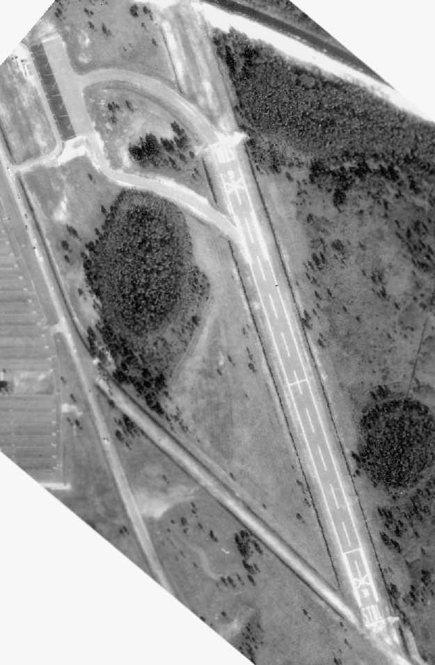
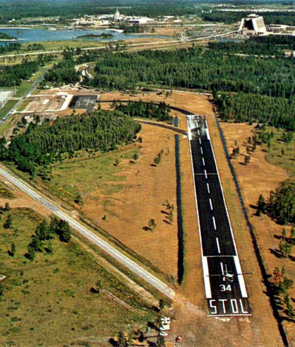
A 2/5/73 Florida Department of Transportation aerial photo (courtesy of Brian Rehwinkel) of the Disney World Airfield.
Runway 12/30 was marked as "STOL", but it also had closed-runway "X" symbols
(which may have been due to its status as a private airfield,
or maybe this indicates that the airfield was not yet in use at this point).
Note that the paved ramp at the northwest corner of the field had painted aircraft parking spots for a total of 4 aircraft.
The Disney Airfield was kept at a very low profile. It was not listed at all in the 1976 AOPA Airports USA directory (according to Chris Kennedy).
Unfortunately for the Disney Airport, in the late 1970s / early 1980s a monorail extension to EPCOT Center was constructed,
which placed an elevated monorail track just west of the runway.
Therefore by the early 1980s Disney no longer allowed anyone to land at the Lake Buena Vista STOLport.
Even when Mickey Mouse One (Walt Disney's own private plane) was being flown into Walt Disney World
so that it could then go on display in Disney-MGM's boneyard,
this aircraft couldn't get clearance to land at WDW's private airfield.
Which is why Mickey Mouse One actually touched down out on World Drive
(which had been completely shut down to traffic just prior to the plane's arrival).
Once the old Disney corporate plane was on the ground, it was then safely towed back to the studio theme park.
The 1985 USGS topo map depicted a 2,000' paved runway (labeled merely as "Landing Strip").
The 1985 Jacksonville Sectional Chart depicted the "Lake Buena Vista (STOL)" Airport as a private field having a 2,000' paved northwest/southeast runway.
A 1995 USGS aerial view looking southeast depicted "X" closed-runway markings on the Disney World runway.
However, the airfield was still listed as an active private airfield, up until the late 1990s.
"Lake Buena Vista" Airport was still depicted as an active private airfield on the 1998 Jacksonville Sectional Chart.
Paul Freeman visited the Disney Airfield in September 2004.
The runway, taxiways, and ramp remained completely intact.
The former runway was being used as a staging area for buses.
As of 2004, the Disney Airfield was no longer listed as an active airfield.
However, LJ reported in 2006, “I work for the company & go by the airstrip on a regular basis.
The airstrip is closed only to the public but is still in use.
In the last 2 years they have been parking buses, sea creates, and tractor trailers on the runway.
The monorail has never been a problem.
Yesterday 2/16/06 the sea creates & truck trailers were moved off but still lined the runway.
An aircraft landed & took off after making its drop.
A truck trailer was then immediately towed on to the runway to block any other aircraft from landing.
This turned out to be the preparation team for President Bush's visit today.
I have known company executives to also land there on occasion.”
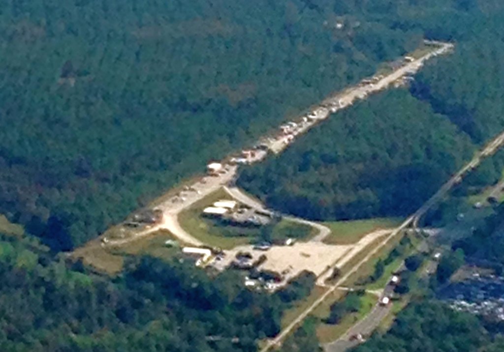
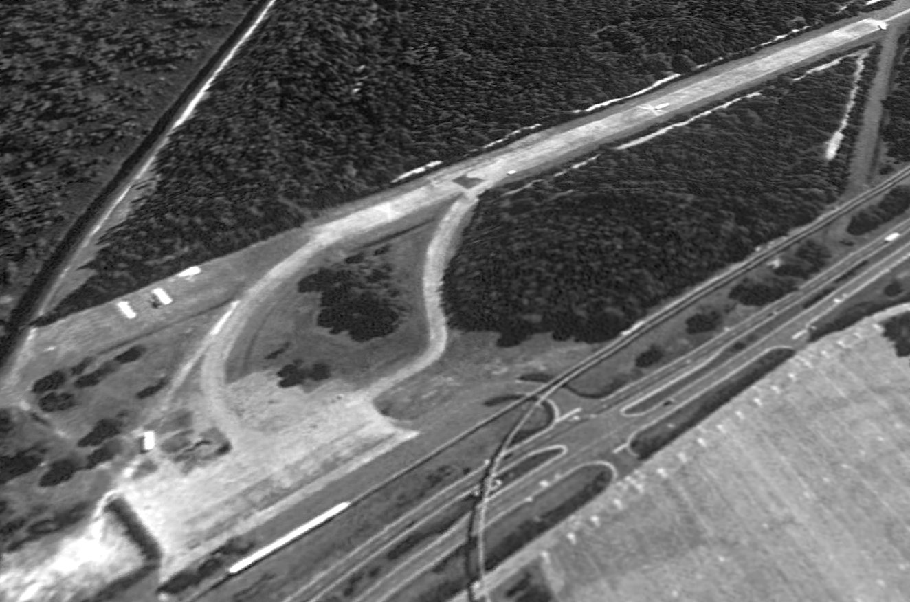
A 10/28/13 aerial view by Ryan Lowrey looking southeast at the Lake Buena Vista STOLport.
Ryan reported, “Unfortunately, as you can see, it is covered with vehicles & equipment and is far from being anywhere near operational.”
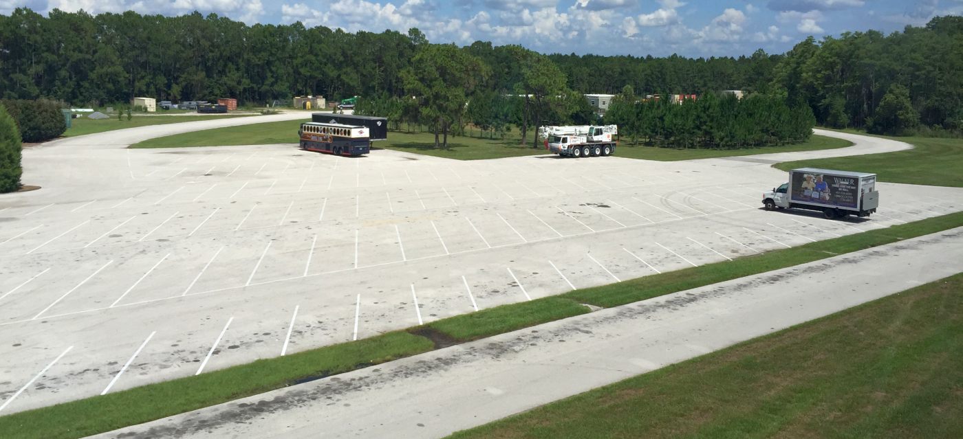
A 6/24/15 photo by Paul Freeman looking southeast at the parking ramp of the Lake Buena Vista STOLport,
with the runway visible in the background.
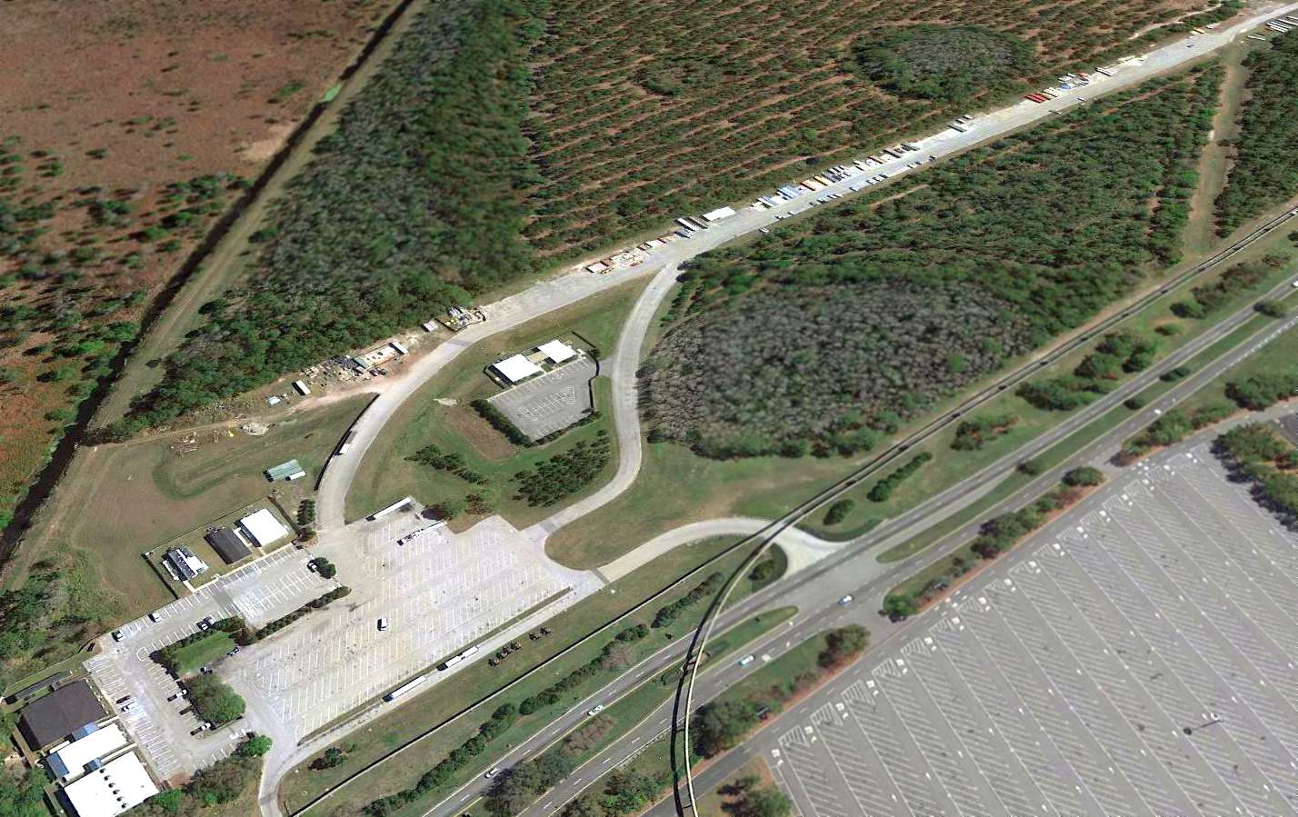
A 2016 aerial view looking southeast at the Disney World runway.
Ironically, in our paranoid post-9/11 world, the airspace over Walt Disney World is now “protected” by its very own no-fly zone (TFR 9/4985),
a “Temporary” Flight Restriction which has been in place for years.
How ironic for a resort that was originally built with its own airport.
____________________________________________________
Or if you prefer to contact me directly concerning a contribution (for a mailing address to send a check),
please contact me at: paulandterryfreeman@gmail.com
If you enjoy this web site, please support it with a financial contribution.
____________________________________________________
This site covers airfields in all 50 states.