Abandoned & Little-Known Airfields:
Florida: Northwestern Pensacola area
© 2002, © 2026 by Paul Freeman. Revised 1/3/26.
This site covers airfields in all 50 states: Click here for the site's main menu.
____________________________________________________
Please consider a financial contribution to support the continued growth & operation of this site.
Coastal Airport / Three-Star Airport (revised 1/3/26) - Helm NOLF (revised 9/21/18) - K Field / Murphy Field / Pensacola Field #9 / NOLF 35015 (revised 9/27/18)
Fountain NOLF (revised 6/14/12) - Felton's Field / Saufley NOLF (revised 10/16/22) - NOLF 33615 / Site 8A (revised 1/18/23)
NOLF 35013 / Site 6 (revised 1/19/23) - Perdido River Ranch Airport (added 4/7/21) - V Field (revised 9/21/18) - X Field NOLF (revised 9/21/18)
____________________________________________________
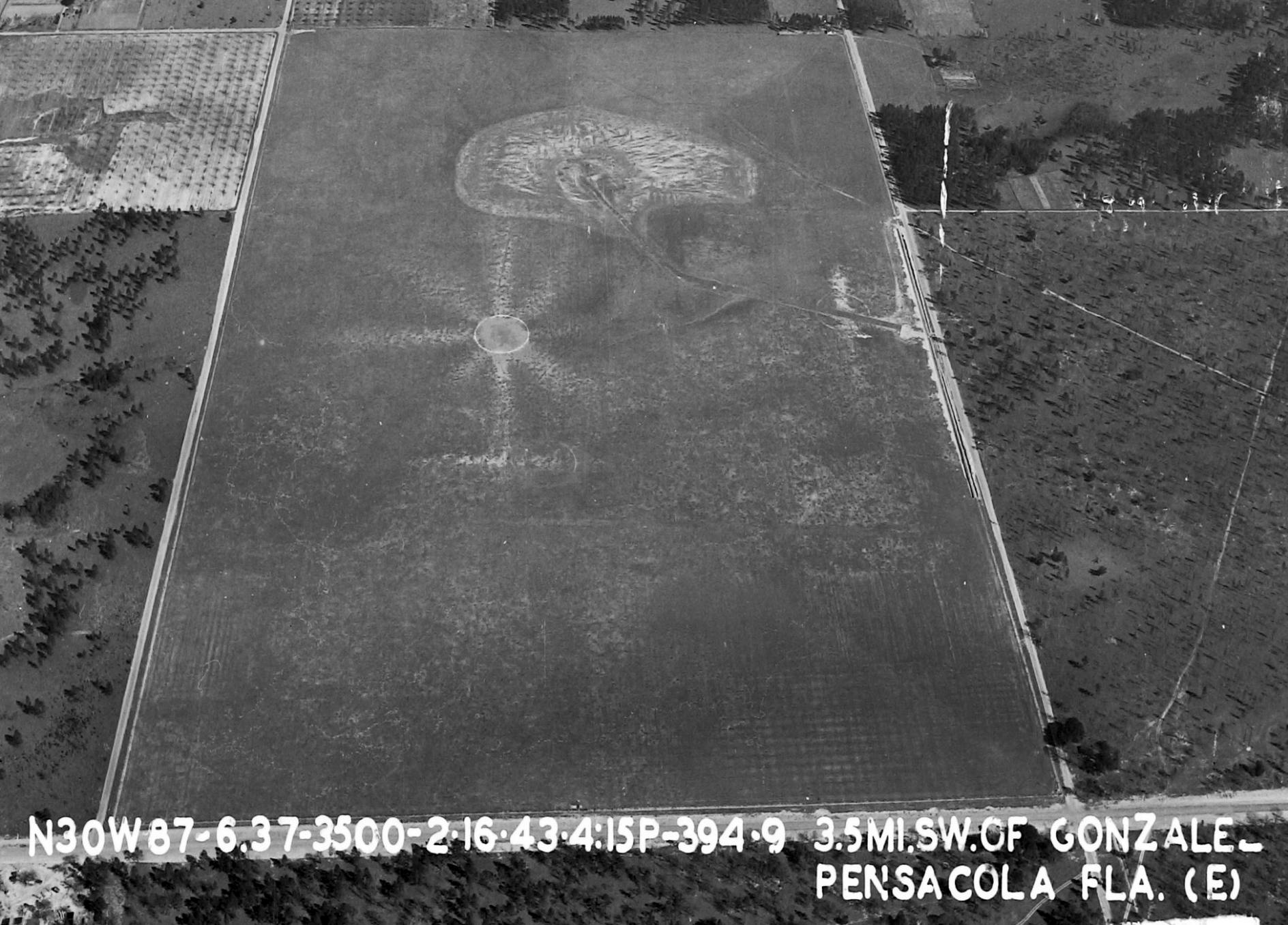
Naval Outer Landing Field 35013 / Site 6, Ensley, FL
30.537, -87.308 (Northwest of Pensacola, FL)
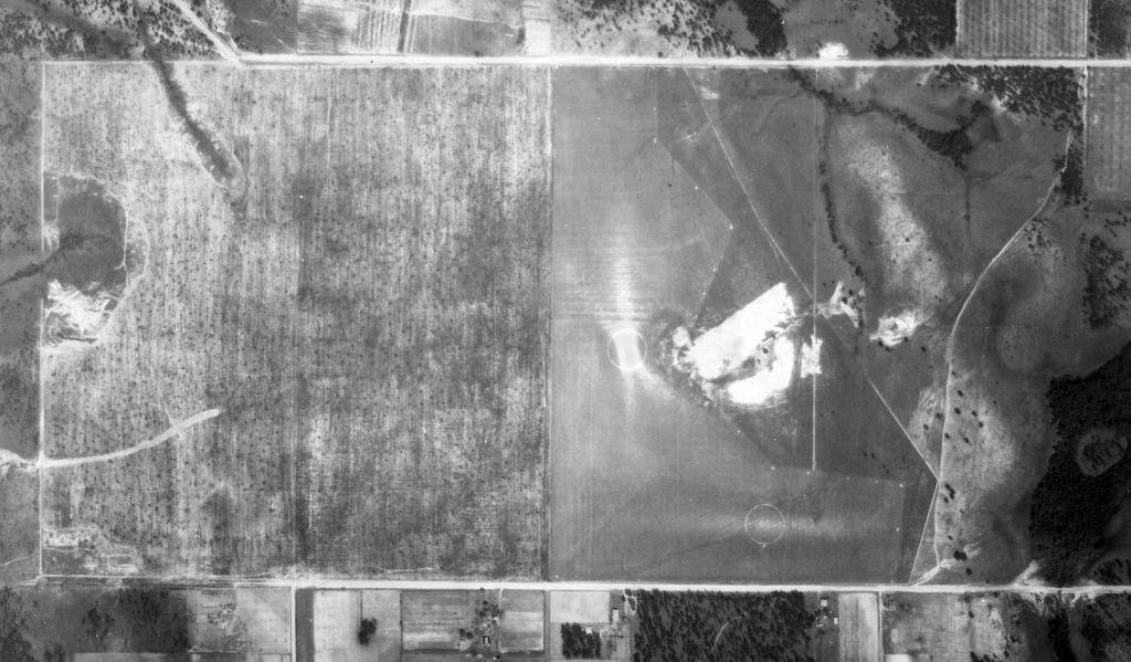
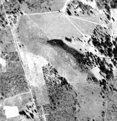
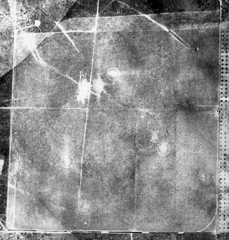
NOLF 35013, as depicted on a 2/16/43 aerial view looking east (from the National Archives, courtesy of Brian Rehwinkel).
Brian Rehwinkel reported, “The Navy began acquiring the land (about 240 acres) for Site 6 / NOLF 35013 in late 1939.
It was one of a series of training fields the Navy developed, partly because of the the deteriorating international situation.
The Navy also wanted to own more of the outlying fields...
in the early 1930s, the Navy leased most of the Outlying Fields or used them without a formal agreement... more of a handshake agreement with the owner.
In this round expansion/development, the fields were referred to as 'Sites'.”
NOLF 35013 was not depicted at all on 1941/42/44 Mobile Sectional Charts.
The earliest depiction which has been located of NOLF 35013 was on a 2/16/43 aerial view looking east (from the National Archives, courtesy of Brian Rehwinkel).
It depicted NOLF 35013 as a rectangular grass field.
Brian Rehwinkel observed, “Notice the well-used landing circle near the middle of the field.”'

The earliest aeronautical chart depiction which has been located of NOLF 35013 was on the February 1945 Mobile Sectional Chart.
Brian Rehwinkel reported, “After WW2, Site 6 continued to be used by the Navy.
In the mid-1950s, this field began to be used by helicopters from Ellyson Field.”
Site 6 was depicted on a circa 1955 Navy map of Outlying Fields which supported ALF Ellyson (courtesy of Brian Rehwinkel) simply as a rectangular property outline.
Site 6 was not yet depicted on the 1971 New Orleans Sectional Chart.
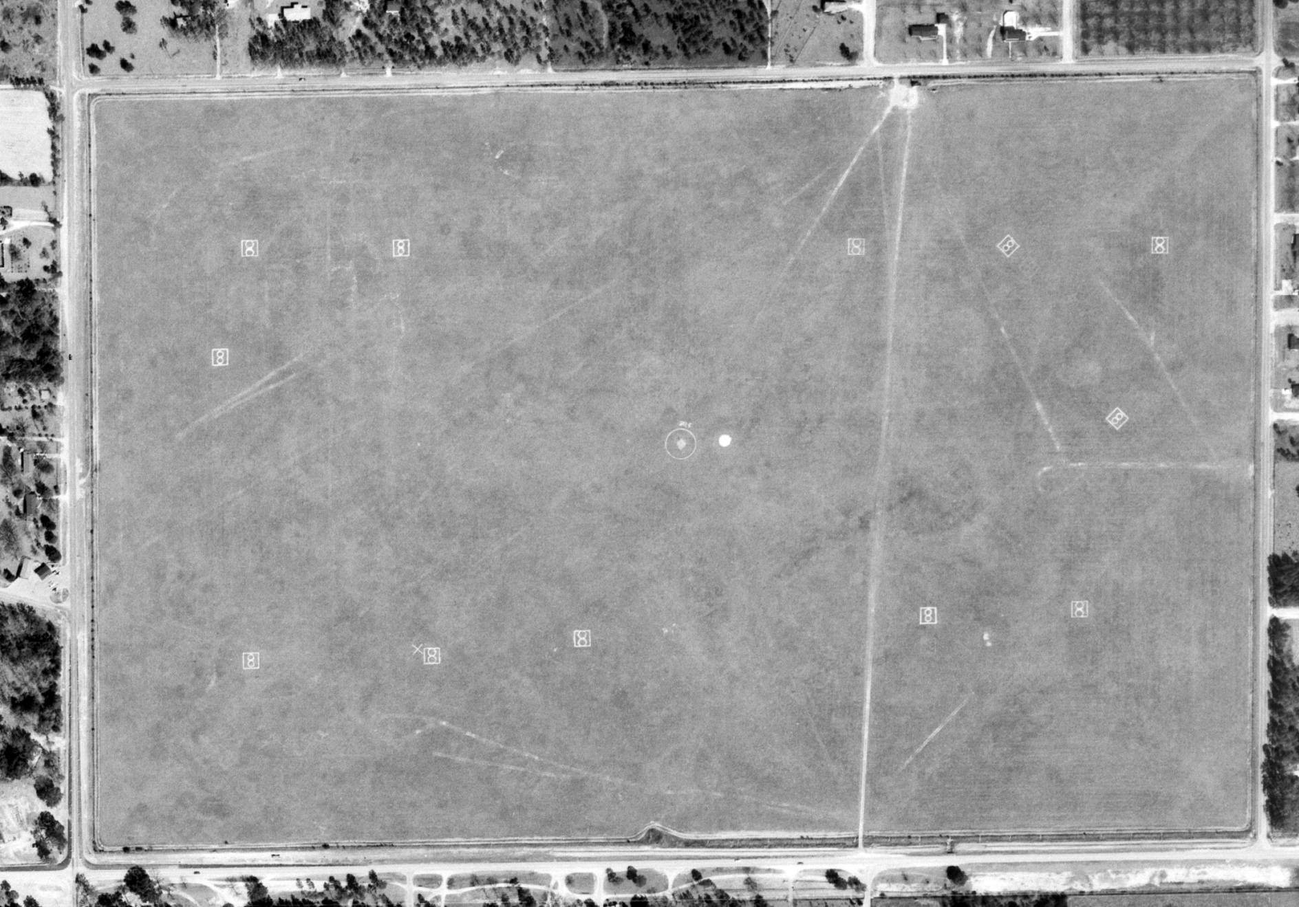
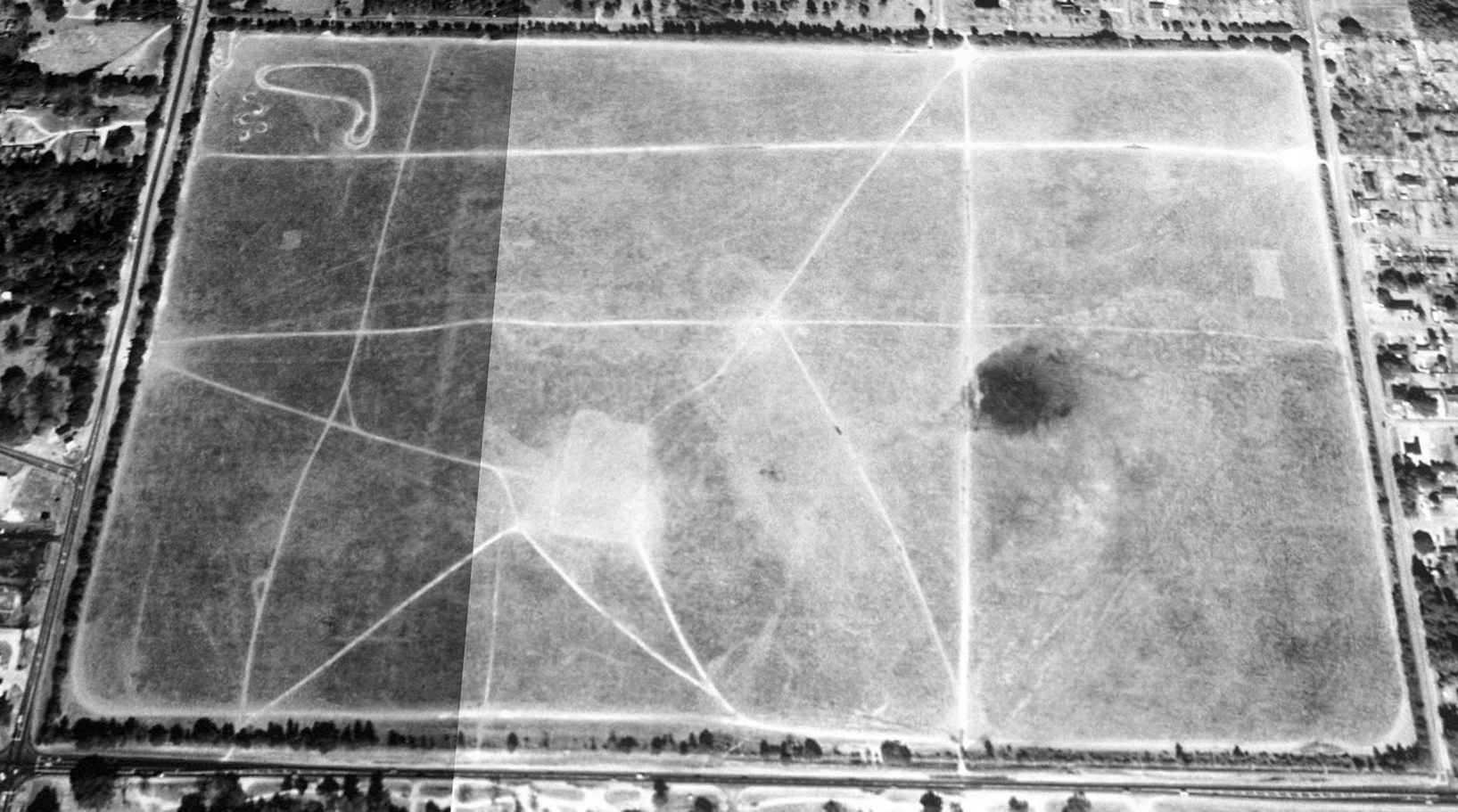
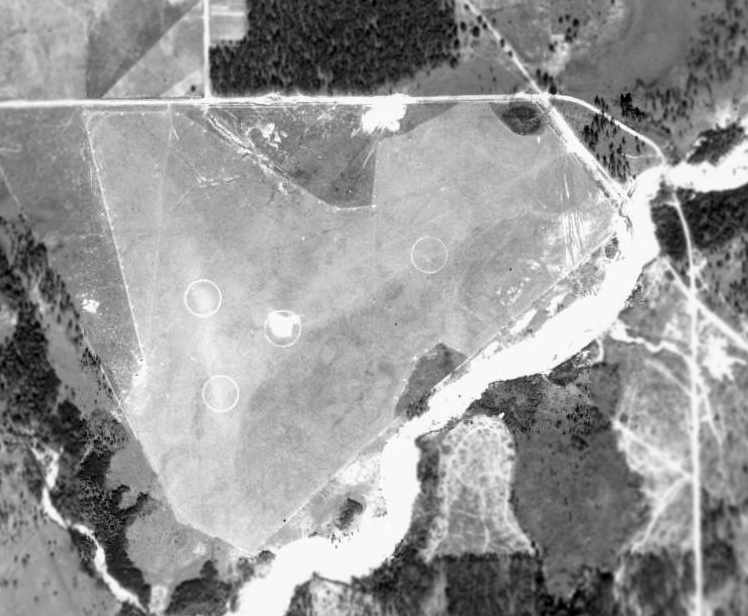
The earliest photo which has been located of Site 6 was on a 2/10/74 USGS aerial view.
It depicted Site 6 as a rectangular grass field, within which were 10 helicopter landing spots (a figure-8 within a square). There were no buildings or other improvements.
Brian Rehwinkel reported, “When helicopter training moved to Whiting Field at the beginning of 1974,
the use of Site 4 was discontinued & undoubtedly this also meant Site 6 was not used much either.”
The earliest aeronautical chart depiction which has been located of Site 6 was on the July 1974 New Orleans Sectional Chart,
which generically depicted it as a Heliport.
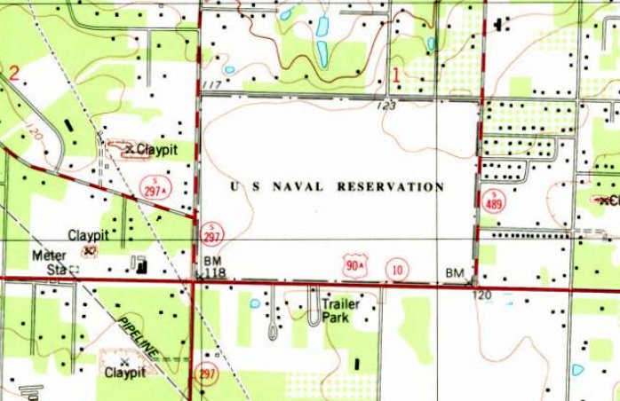
The earliest topo map depiction which has been located of Site 6 was on the 1978 USGS topo map.
It depicted a rectangular open area, labeled “U S Naval Reservation”.
The use of Site 6 for helicopter training may have ended by 1981,
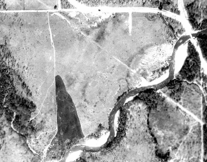
as a 1981 aerial photo showed the field remained clear but the 10 helicopter landing spots seen in the 1974 photo no longer perceptible.
Site 6 continued to be labeled “U S Naval Reservation” on the 1987 USGS topo map.
The 1994 USGS topo map no longer labeled Site 6 as a Navy property, instead depicting an empty rectangular property.
A 1994 aerial view looking north showed Site 6 remained as an open field.
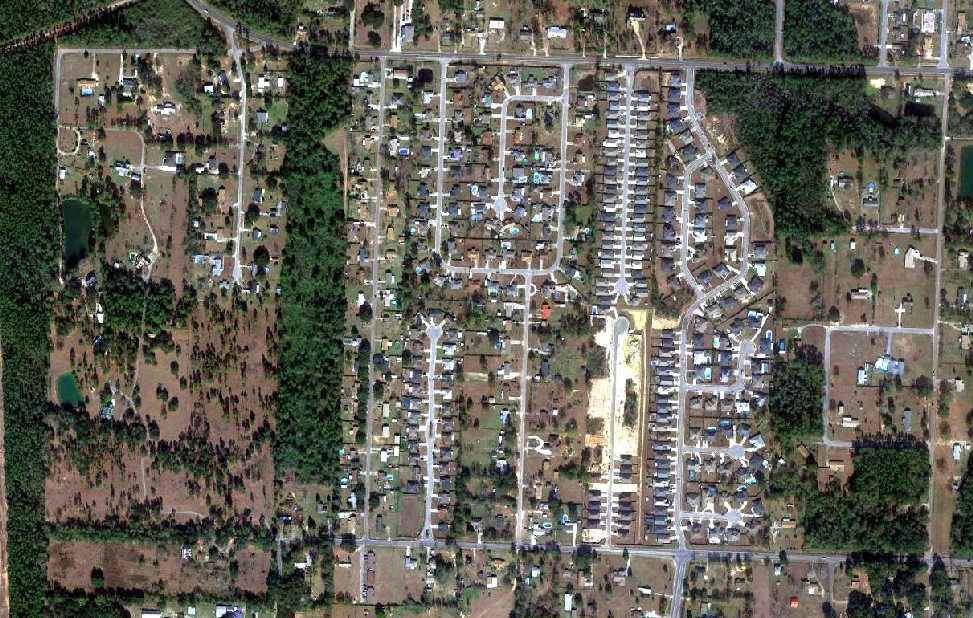
According to Joel Cotton, “I've lived in Pensacola the majority of my life; I know the site of NOLF 6 well.
There were flags & wind socks at the location almost up until they started developing the land. It wasn’t developed until the early 1990s but I do remember it well as an open field.
The wife & I looked at homes there. It has been developed as a subdivision / commerce park.”
The last aeronautical chart depiction which has been located of Site 6 was on the June 1999 New Orleans Sectional Chart.
It generically depicted Site 6 as a Heliport.
Site 6 was evidently abandoned by the Navy by 1999,
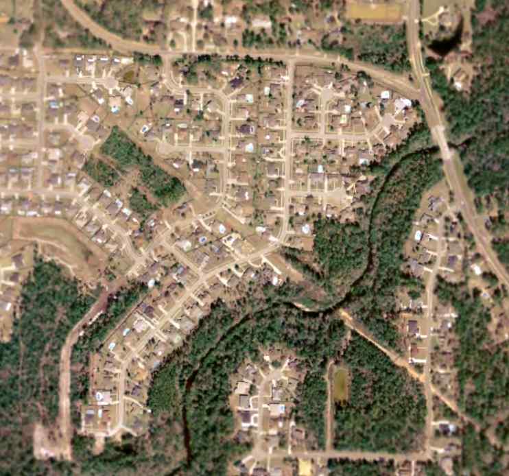
as a 1999 aerial photo showed houses, other buildings, and streets had been built over it.
Joel Cotton reported of Site 6, “The wife & I looked at homes there. It has been developed as a subdivision / commerce park.”
Site 6 was no longer depicted on the June 2008 New Orleans Sectional Chart.
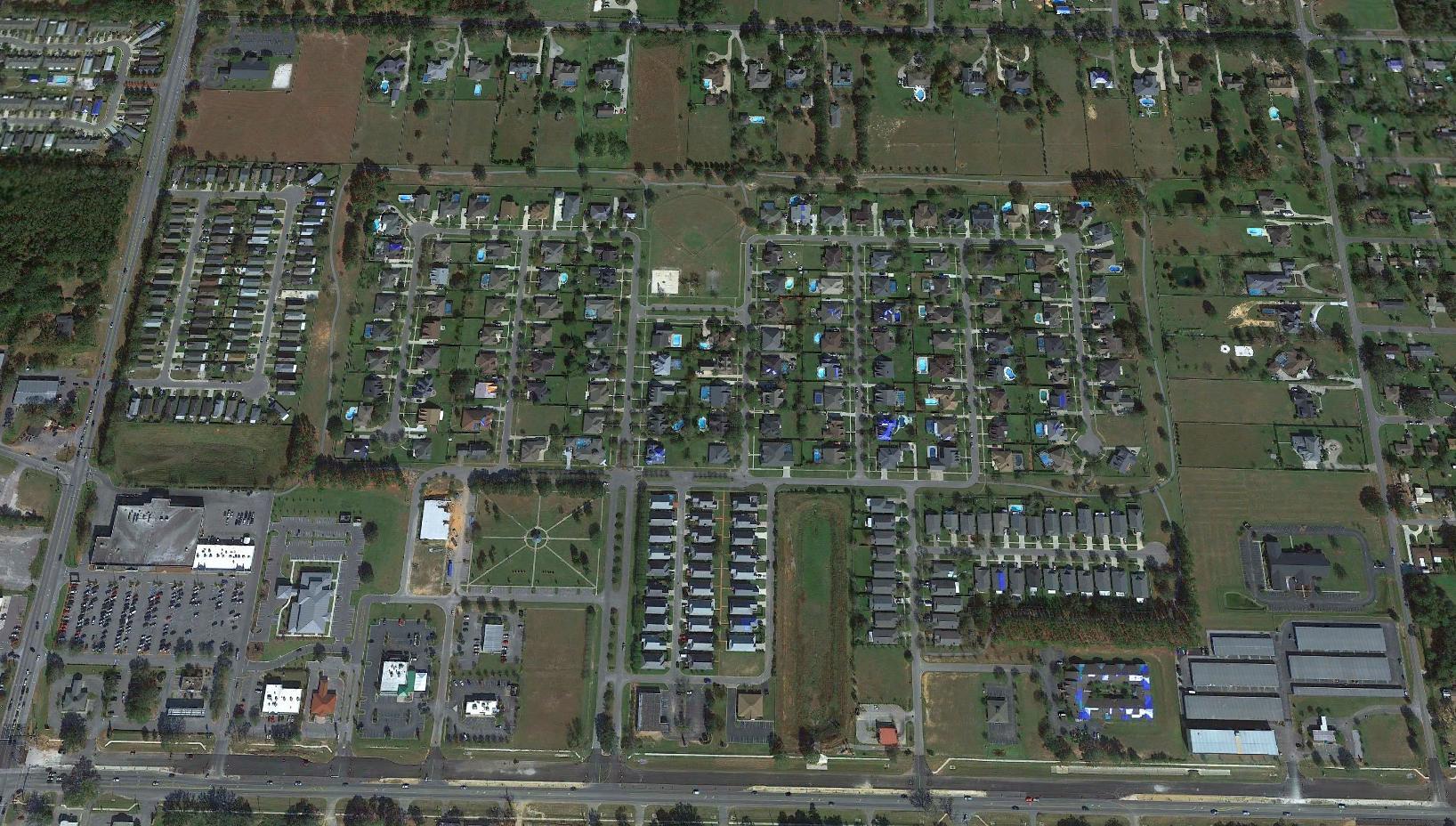
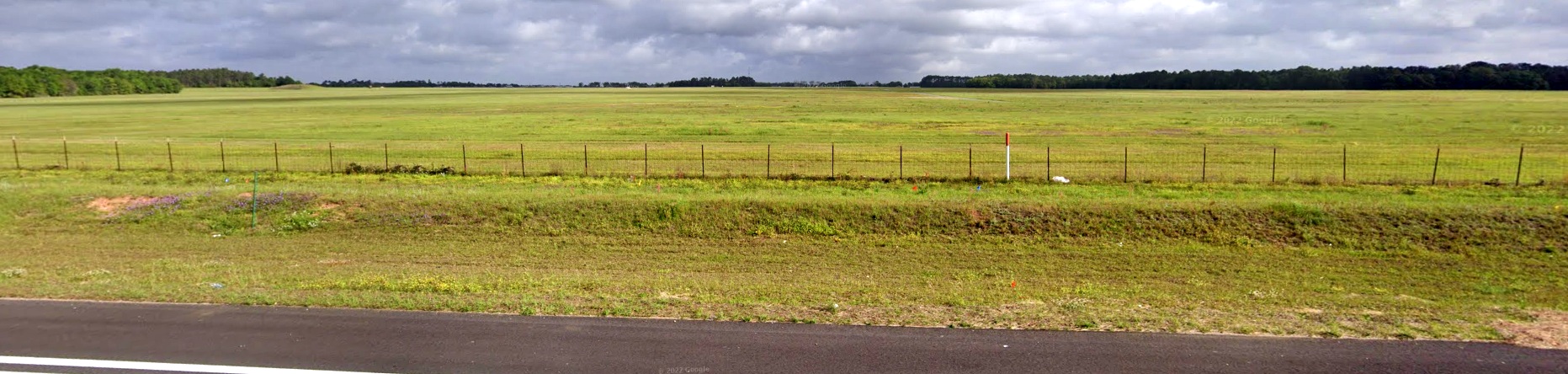
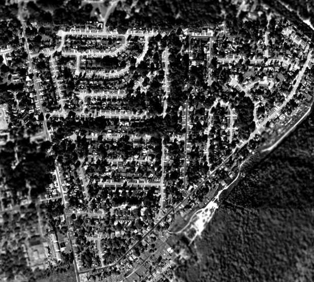
A 2020 aerial view looking north showed Site 6 covered with houses & streets.
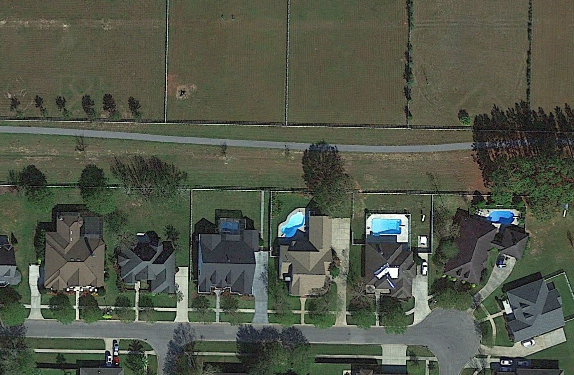
Amazingly, Brian Rehwinkel pointed out that a closeup from the 2020 aerial view of the location of Site 6
shows that recognizable traces of 2 of the helicopter landing spots (a figure-8 within a square)
are still recognizable in the backyards of the houses which cover property, 43 years after the former helicopter airfield was abandoned:
one just north of Newberry Street & another just north of Mt. Pilot Street.
The location of Site 6 is located at Pine Forrest Road & None Mile Road.
Thanks to Joel Cotton for pointing out this airfield.
____________________________________________________
Perdido River Ranch Airport, Cantonment, FL
30.576, -87.395 (Northwest of Pensacola, FL)
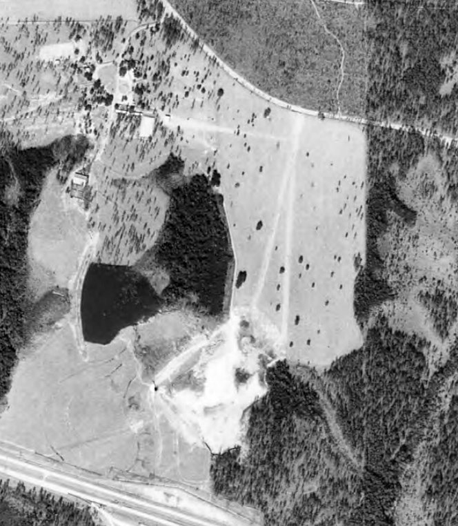
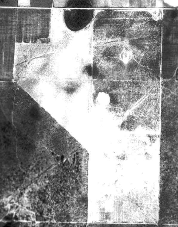
Perdido River Ranch Airport, as depicted on a 1/22/73 USDA aerial photo (courtesy of Dallam Oliver-Lee).
This small private airfield on the northwest side of Pensacola was evidently established at some point between 1958-78,
as it was not yet depicted on a 1958 USDA aerial photo (courtesy of Dallam Oliver-Lee).
Perdido River Ranch Airport was not depicted at all on 1956/68/78 USGS topo maps,
or 1971/93/99 New Orleans Sectional Charts.
The earliest depiction which has been located of Perdido River Ranch Airport was on a 1/22/73 USDA aerial photo (courtesy of Dallam Oliver-Lee).
It depicted 2 unpaved north/south runways & a cluster of buildings on the northwest side.
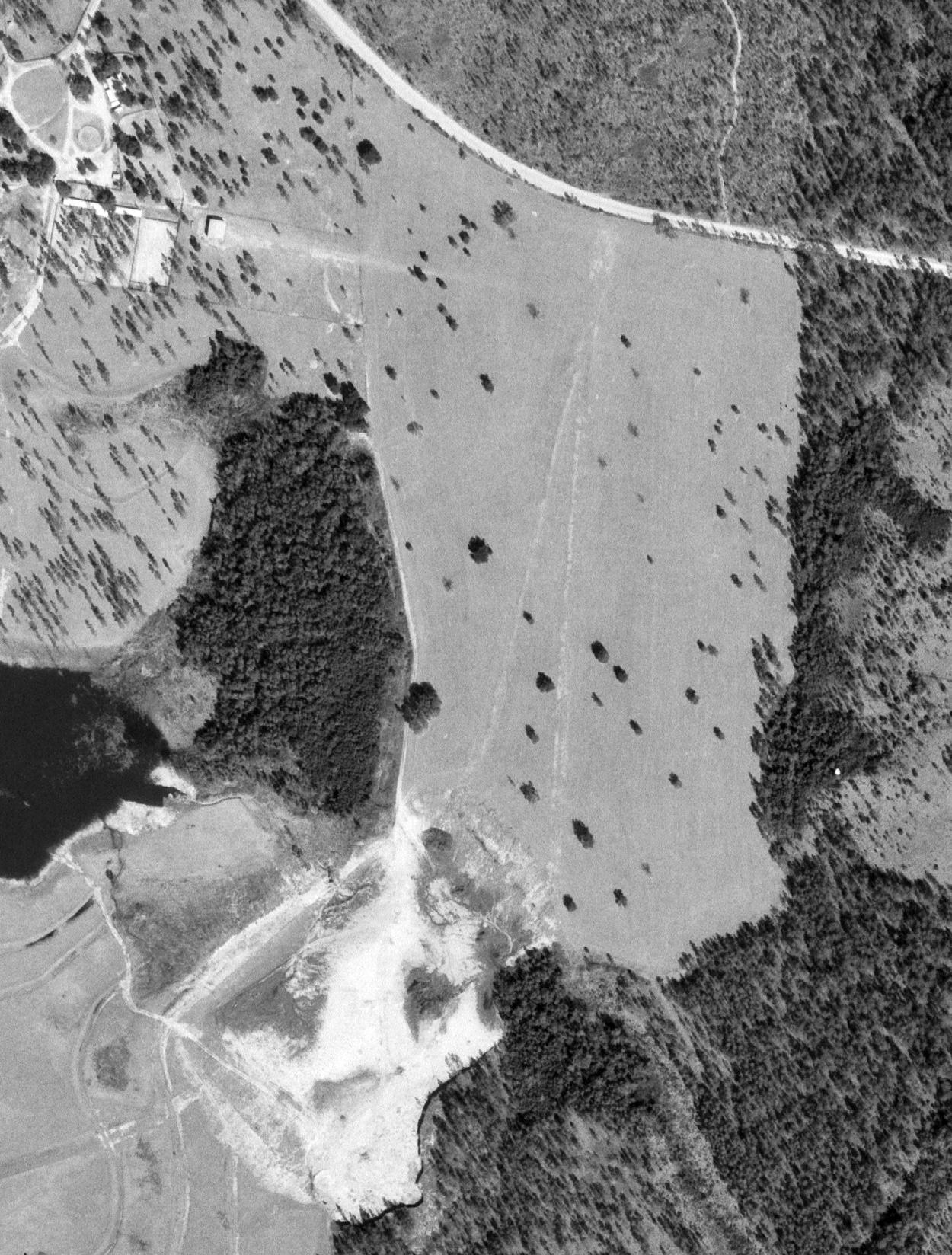
A 2/10/74 USDA aerial photo (courtesy of Dallam Oliver-Lee) depicted Perdido River Ranch Airport as having 2 unpaved north/south runways & a cluster of buildings on the northwest side.
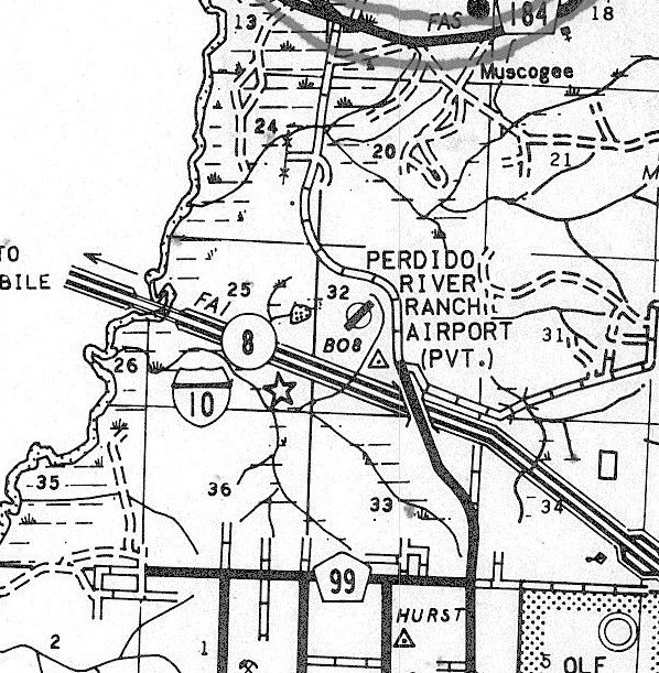
The only labeled depiction which has been located of Perdido River Ranch Airport was on a 1978 road map (courtesy of Dallam Oliver-Lee).
It depicted Perdido River Ranch Airport as a private airfield having a single northeast/southwest runway.
According to Dallam Oliver-Lee, Perdido River Ranch Airport was “closed in June 1980 to make way for the Perdido Landfill.
The north/south grass runway [was] still visible in a February 1982 [aerial photo].”
A 1992 USGS aerial photo (courtesy of Dallam Oliver-Lee) showed no trace remaining of Perdido River Ranch Airport, with the landfill covering the property.
A 2019 aerial photo (courtesy of Dallam Oliver-Lee) showed no trace remaining of Perdido River Ranch Airport, with the landfill covering the property.
Thanks to Dallam Oliver-Lee for pointing out this airfield.
____________________________________________________
Coastal Airport / Three-Star Airport (83J), Pensacola, FL
30.533, -87.385 (Northwest of Downtown Pensacola, FL)

Coastal Airport, as depicted on the 1964 Mobile Sectional Chart.
This small general aviation airport on the west side of Pensacola was evidently established at some point between 1961-64,
as it was not yet depicted on the February 1961 Mobile Sectional Chart.
The earliest depiction which has been located of Coastal Airport was on the 1964 Mobile Sectional Chart.
It depicted Coastal Airport as having a 2,200' unpaved runway.
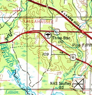
At some point between 1964-70 the airport was evidently renamed “Three-Star”,
as that is how it was labeled on the 1970 USGS topo map.
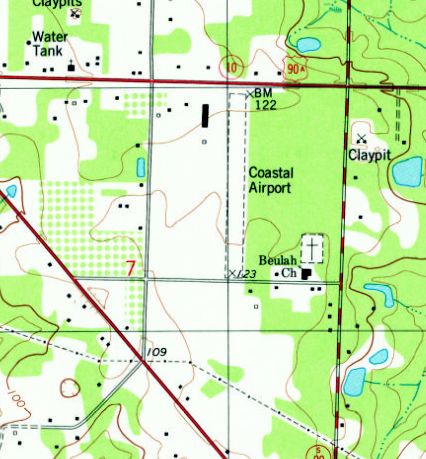
At some point between 1970-78 it was evidently renamed back to Coastal Airport,
as that is how it was labeled on the 1978 USGS topo map.
It depicted Coastal as having an unpaved north/south runway, with a few small buildings on the northwest side.
The 1980 New Orleans Sectional Chart depicted Coastal Airport as having a 2,500' unpaved runway.
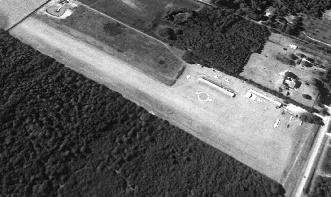
The earliest photo which has been located of Coastal Airport was a 1994 USGS aerial view looking southwest.
It depicted Coastal as having an unpaved north/south runway, with 2 rows of hangars & 10 light single-engine aircraft on the northwest side.
The last aeronautical chart depiction which has been located of Coastal Airport was on the June 1999 New Orleans Sectional Chart (courtesy of Ron Plante).
It depicted Coastal Airport as having a 2,500' unpaved runway.
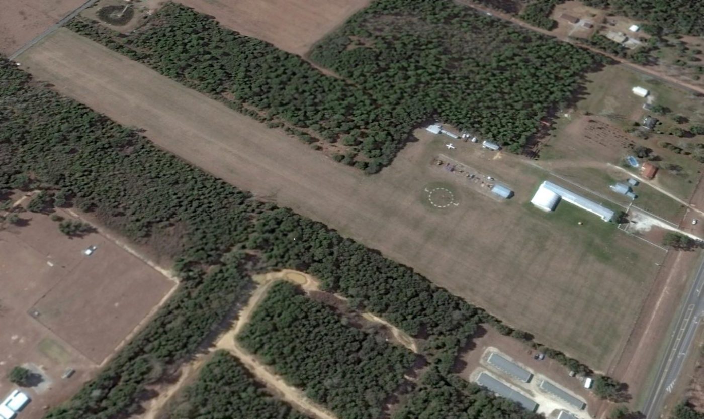
The last photo which has been located showing aircraft at Coastal Airport was 2014 aerial view looking southwest.
The southern hangar had been removed at some point between 1994-2014, and only 1 light single-engine aircraft remained visible on the field.
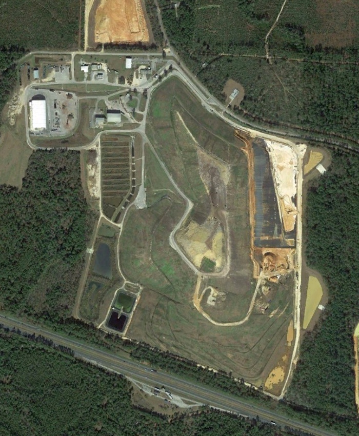
Coastal Airport was closed in 2015, and the property was sold to the local school district for the construction of a new school.
Yet another one of our nation's legacy of small grassroots general aviation airports, lost to declining economic fortunes coupled with rising property values.
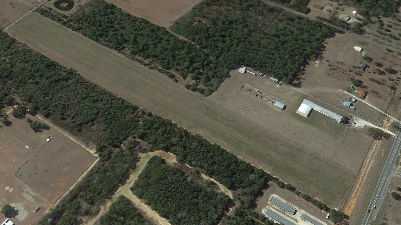
A 2015 aerial view looking southwest showed Coastal Airport remained intact for the time being.

A 2016 photo looking north showed Coastal Airport remained intact.
Coastal Airport was no longer depicted on the May 2017 New Orleans Sectional Chart.
A 2021 photo showed Beulah Middle School having covered the northern portion of the Coastal Airport site, and a retention pond had been built over the southern portion.
The site of Coastal Airport is located southwest of the intersection of Beulah Road & West 9 Mile Road.
Thanks to Robert Booth for pointing out this airfield.
____________________________________________________
Helm Naval Outlying Landing Field / Field 32713, Pensacola, FL
30.5, -87.39 (Northwest of Pensacola, FL)
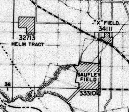
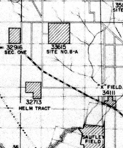
Helm OLF, as depicted on a 6/30/42 map showing locations of OLFs for NAS Pensacola (from the National Archives, courtesy of Brian Rehwinkel).
Helm Field was one of the massive number of outlying fields
which were established by the Navy to support WW2 flight training operations at NAS Pensacola.
According to Brian Rehwinkel, “Helm was part of a large expansion of outlying fields in 1940-41.
Helm was one of around 17 fields that were purchased by the Navy in Pensacola during this period
(sme were fields that had been previously been leased, and some were completely new airfields).
Helm OLF was originally called 'Site 1940-a' or 'Helm Tract' (it was the first of the fields purchased in early 1941).
The Bureau of Aeronautics number for this fields was 32713.
'Helm' was the name of one of the former landowners of the property.”
The earliest depiction which has been located of Helm Field
was on a 6/30/42 map showing locations of OLFs for NAS Pensacola (courtesy of Brian Rehwinkel).
It depicted “32713 Helm Tract” as a square outline with a cutout at the southwest corner.
According to Brian Rehwinkel, “Helm OLF was originally assigned to NAS Pensacola.
However, it was assigned to NAAS Saufley Field during World War II.”
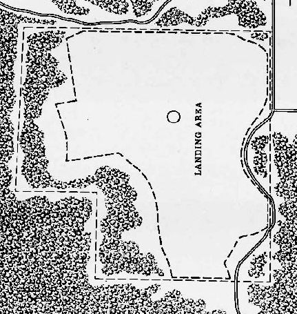
The 1945 AAF Airfield Directory (courtesy of Dallam Oliver-Lee)
depicted Helm as an irregularly-shaped landing area with an airfield circle marking in the center.
The earliest aeronautical chart depiction which has been located of Helm Field was on the January 1945 Mobile Sectional Chart.
It depicted “Helm (Navy)” as an auxiliary airfield.
The last aeronautical chart depiction which has been located of Helm Field was on the August 1946 Mobile Sectional Chart.
It depicted “Helm (Navy)” as an auxiliary airfield.
The earliest photo which has been located of Helm Field was a 10/22/55 aerial view (courtesy of Dallam Oliver-Lee).
It depicted 3 runways marked out on a grass airfield.
Helm Field was evidently closed by 1957, as it was no longer depicted on the 1957 USGS topo map (courtesy of Dallam Oliver-Lee).
A 1958 aerial photo (courtesy of Brian Rehwinkel) showed that Helm Field remained intact, but the runway markings had been removed at some point between 1955-58.
According to Brian Rehwinkel, “I do not know when the Navy stopped using the field for flight operations, but is must have been between 1955-58.
You can see from the 1958 photo that the field is not being used for aviation any longer.”
According to Brian Rehwinkel, “The Navy declared the field surplus to their needs in the late 1950s
and the General Services Administration offered the land for sale on 5/27/59.
The field was divided up into 14 tracts – ranging from 20-40 acres - and offered at a public sale.”
A 1959 plat (from the National Archives, courtesy of Brian Rehwinkel) showed the division of the former airfield for public sale.
A 1/31/65 USGS aerial photo (courtesy of Dallam Oliver-Lee) showed that Helm Field's outline was still recognizable,
but 2 buildings had been built in the center of the property.
A 1/3/12 aerial photo (courtesy of Dallam Oliver-Lee) showed that housing had covered the site of Helm Field.
The site of Helm Field is located west of the intersection of Beulah Road & Helms Road,
appropriately enough.
____________________________________________________
K Field / Murphy Field / Pensacola Naval Outlying Landing Field #9 / Field 35015, Pensacola, FL
30.57, -87.31 (Northwest of Pensacola Regional Airport, FL)
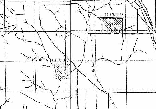
"K Field", as depicted on a 1939 map of NAS Pensacola & its satellite fields (courtesy of Brian Rehwinkel).
Brian Rehwinkel reported, “K Field was one of the pre-WW2 alphabet training fields (K, V, X, Y, and Z Fields) in Pensacola”,
which were established by the Navy to support flight training operations at the Pensacola Flight School.
According to Brian Rehwinkel, “K Field (also sometimes referred to as Murphy Field – the name courtesy of the owners of the land) was leased as early as 1936 for use in training.
The original acreage for the field as is listed in the 1936 lease is 160 acres; however, I do not believe that was the size of the cleared landing field.
By 1938, the Navy was working on expanding K Field to the (by leasing additional land).
By 1939, the Navy was leasing approximately 240 acres.
This was part of a larger effort to expand the number of training fields & improve existing fields.”
The earliest depiction which has been located of K Field was on a 1939 map of NAS Pensacola & its satellite fields (courtesy of Brian Rehwinkel).
Brian observed, “At the time this map was made, all 240 acres of the expanded field were leased. But, the field had not yet been purchased.”
According to Brian Rehwinkel, “The Navy committed money to buy land for several new fields (and to expand others) in 1939 & 1940.
A July 1940 memo from the station’s public works officer explained the reason for the delay in getting the western portion of the field ready –
the large number of fields added required that office to complete the development of the other new fields first.
The new portion of this field would have to wait until the new fields were completed.
This made sense given the fact that there was an existing runway area, whereas the new fields had to be developed in order for them to be used in any way.”
According to Brian Rehwinkel, “By late 1940, the Navy had purchased the original airfield & additional land for a total of 240 acres.
At this point, the field changed names from K Field to Site 9.
The fields purchased during this time were referred to by 'Site numbers' (Sites 3, 4-A, 5, 6, 7, 8-A, 9, 10, 12, and 14).
So, even though the field has been originally called K Field, this larger version of K Field was eventually called Site 9
because all of the fields that were purchased at this time were referred to by ‘site numbers'.”
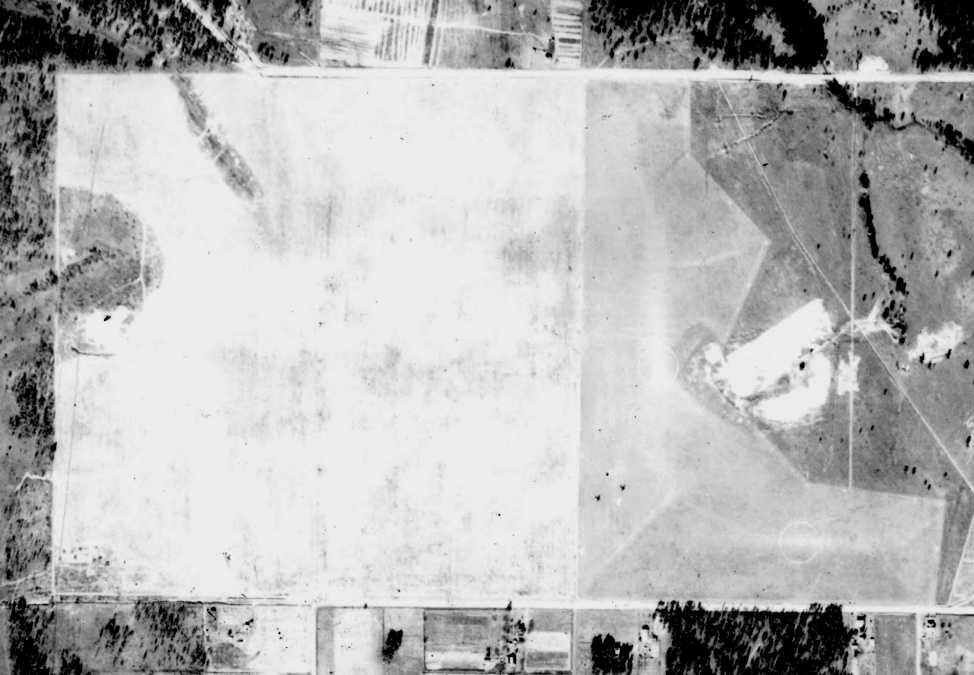
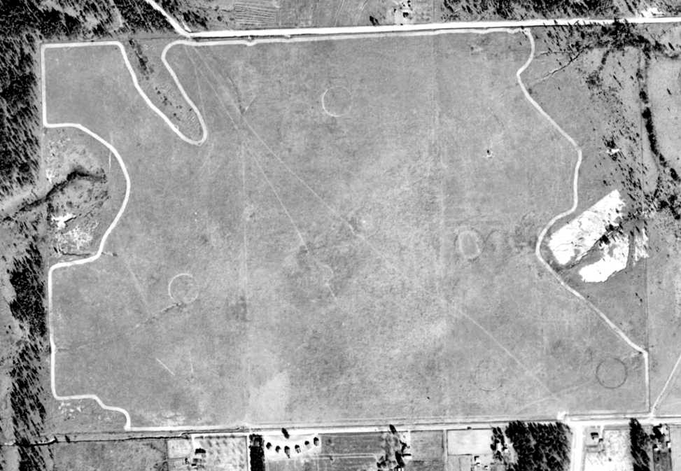
The earliest photo of Field #9 which has been located was a 12/6/40 USDA aerial view from the University of FL Smathers Libraries (courtesy of Dallam Oliver-Lee).
The airfield consisted of an square grass area, with an irregularly-bordered additional area to the east.
There did not appear to be any buildings or other aviation facilities associated with the field.
A 4/14/41 U.S. Navy aerial view of K Field (courtesy of Brian Rehwinkel).
Brian observed, “You can see the original airfield - along with the expanded portion - to the west.
The additional land for Site 9 has been cleared, but the new portion of the field is apparently not ready for use by planes.”
Brian Rehwinkel reported, “Some Navy documents continued to refer the field as K Field / Site 9 in 1941.
The field was used by planes from NAS Pensacola & eventually was used during World War 2 by planes from NAAS Saufley Field.”
Field “35015” / “Site #9” was depicted on a 1942 Navy map of Pensacola-area airfields (courtesy of Brian Rehwinkel).
A 2/16/43 aerial view looking east at K Field (courtesy of Brian Rehwinkel).
Brian observed that the photo “shows the final form of the field. You can see a landing circle has been added to the middle of the field.”
Brian Rehwinkel observed, “Pensacola had at least 34 outlying fields at the peak of training in WWII.
One of the interesting things about the fields in Pensacola is the ad hoc nature of the development of these fields before WWII.
It is easy to forget how financially challenged the military was in the 1930s.
This was evident in the way the Navy “cobbled” together a plan for fields.
There were several fields that were used with the permission of the owners, but without a lease.
And, even the fields that had leases were not making the property owners rich.
In fact there are letters from property owners who – although not complaining – ask the Navy to at least pay them enough rent to cover the property taxes
(the Navy was extremely 'cheap' at times when it came to paying rent during this time).
In Pensacola, the layout of the fields in WWII was part of a plan –
but the plan came about after facilities had been in place for many years & training had been ongoing for several decades.
This is one of the reason so many of the original outlying fields were relegated to a role as an emergency field, or were abandoned altogether.”

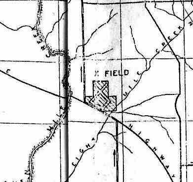
Field #9 was still depicted (labeled simply as “Landing Field”, on the top-right) on the 1944 USGS topo map.
The only aeronautical chart depiction which has been located of NOLF 35015 was on the January 1945 Mobile Sectional Chart.
It depicted “35015” as an auxiliary airfield.
A 1951 USDA aerial photo of Field #9 (from the Digital Library Center / University of FL Smathers Libraries, via Dallam Oliver-Lee)
showed that the airfield area had been outlined with a prominent border, and several circles had been marked across the field (for what purpose?).
According to a 4/3/72 NAS Pensacola Installation Survey Report (courtesy of Maureen Keillor),
the 240 acres of “OLF Site 9” were “sold by GSA at public auction” in 1957.
Dallam Oliver-Lee reported in 2012, “I came across several legal documents referring to property deeds where Field Nine use to be
and they refer the location area to where these properties are in as 'Field Nine'.
'Field Nine' or NOLF #9 was divided up into all these properties & yet the government & real estate brokers use the name still for this specific area.”
A 1994 USGS aerial photo showed that most of the Field #9 site had been covered with housing.
A 1/4/12 aerial photo showed that the Field #9 property outline still remained recognizable.
The site of Field #9 is located south of the intersection of Kingsfield Road & Pine Forest Road.
____________________________________________________
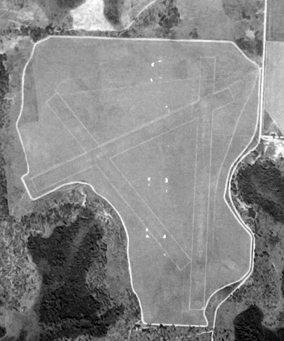
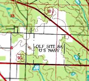
Field 33615 / Site 8A Naval Outer Landing Field, Cantonment, FL
30.55, -87.37 (Northwest of Pensacola, FL)
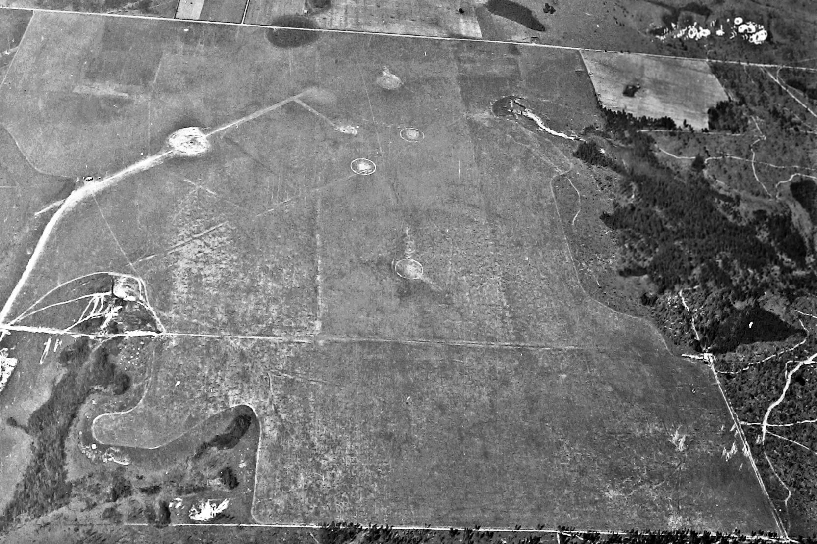
A 12/2/40 U.S. Department of Agriculture aerial photo of Field 33615 (courtesy of the Digital Library Center / University of Florida Smathers Libraries).
This airfield was one of a large number of auxiliary airfields which were eventually established
to support the high volume of Navy flight training operations in the Pensacola area during the Second World War years.
According to Brian Rehwinkel, “The recommendation to develop Site 8-A was made in late 1939
and the field was acquired & developed sometime in early or mid-1940.
It consisted on 640 acres & was purchased for approximately $9,150.
I say 'approximately' because that is how much a Navy memo said it cost in 1941.
Sometimes the condemnation cases were in court for years…
and the Navy may have had to pay more than the initial 'purchase price'.”
The earliest depiction of the field which has been located was a 12/2/40 U.S. Department of Agriculture aerial photo
(courtesy of the Digital Library Center / University of Florida Smathers Libraries).
According to Brian Rehwinkel, “The field was brand new when this photograph was taken - in fact I am not absolutely sure it was operational yet.
Although, because there is a landing circle on the Northeast portion of the field, I am guessing it was probably being used at the time.”
Field “33615 / Site 8A” was depicted on a 1942 Navy map of Pensacola-area airfields (courtesy of Brian Rehwinkel)
as a rectangular plot of land.
A 2/16/43 National Archives aerial view looking north at Site 8A (courtesy of Brian Rehwinkel),
showing several landing circles on the north portion of an irregularly-shaped grass airfield.
The earliest aeronautical chart depiction which has been located of Field 33615 was on the January 1945 Mobile Sectional Chart.
It depicted Field “33615" as an auxiliary airfield.
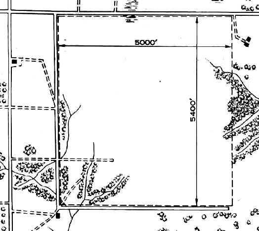
The 1945 AAF Airfield Directory (courtesy of Scott Murdock) described “Saufley Field Auxiliary (33615 Outlying Field #8A)”
as a 620 square-shaped field having a 5,400' all-way sod field.
The field was said to not have any hangars, to be owned by the U.S. Government, and operated by the Navy.
The last aeronautical chart depiction which has been located of Field 8A was on the February 1950 Mobile Sectional Chart.
It depicted the field as having a 3,400' unpaved runway, but note that the field's designation was apparently printed erroneously, as “33515”.
A 1/5/51 U.S. Department of Agriculture aerial photograph of Field 33615 (courtesy of the Digital Library Center / University of Florida Smathers Libraries).
A close-up from the 1/5/51 aerial photograph of Field 33615,
depicting 2 aircraft (presumably Navy trainers) on the northern portion of the field.
Field 33615 was evidently abandoned by the Navy at some point between 1951-55,
as no airfield was depicted at this location on the February 1955 Mobile Sectional Chart.
Brian Rehwinkel also noted that he has a 1956 photograph which shows planes on the field.
Mel Shettle recalled, “When I was in flight training in 1962, the Navy brought a modified A4D [Skyhawk] to Pensacola.
The aircraft had dual landing wheels instead of the usual one – 4 main wheels total.
They tested it at [Field] 8A for the feasibility of using the A4 on unimproved/grass runways for the Marines.
One day, I saw the banged-up A4 with its gear sheared off sitting on a flatbed truck down near the seawall. I guess that was the end of that!”
Brian Rehwinkel reported, “According to a June 1974 Navy draft environmental impact statement regarding the acquisition of land for 2 new OLFs,
three OLFs (Site 4, Site 6, and Site 8A) were supposed to be replaced by 2 new OLFs in Santa Rosa County (OLFs Harold & OLF Pace).
This was all related to the transfer of helicopter training in late 1973 from NAS Ellyson to NAS Whiting.
However, only Sites 4 & 6 were closed, and Site 8A – somewhat of an orphan as it was on the west side of Pensacola and around 24 miles from its parent station - continued to be used by the Navy.”
At some point between 1964-81, the site of the WW2-era Field 33615 was evidently reused
as an Outlying Landing Field to support helicopter flight training operations at nearby NAS Whiting Field,
as the 1981 USGS topo map labeled the site as “OLF Site 8A U.S. Navy”.
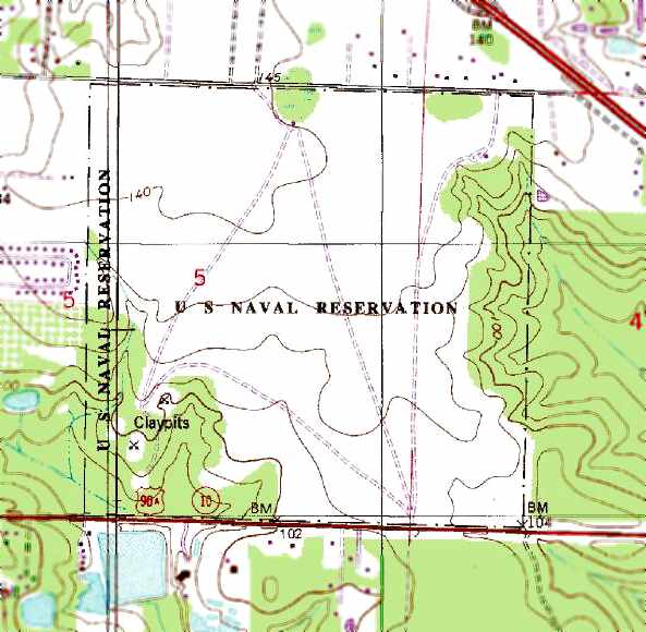
The 1987 USGS topo map depicted the “U.S. Naval Reservation”
as consisting of a large open grass field.
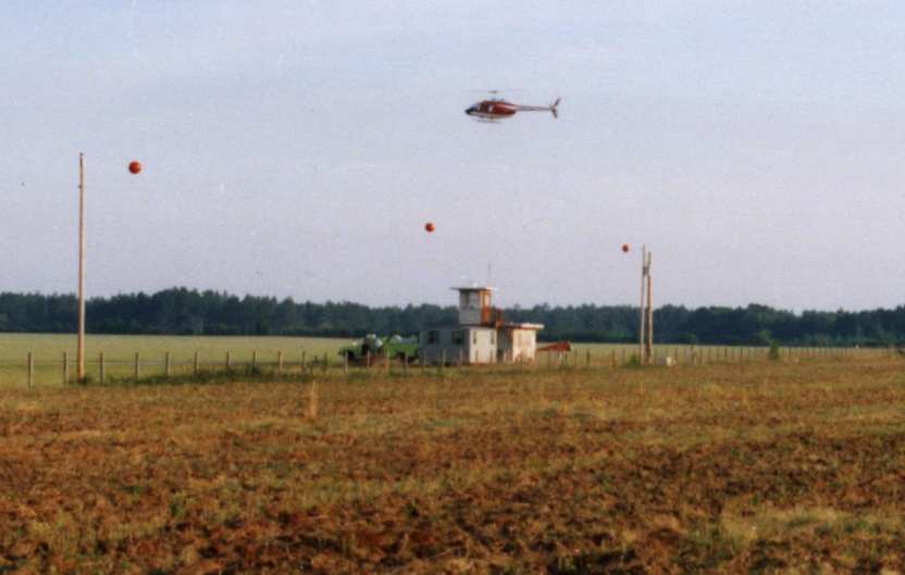
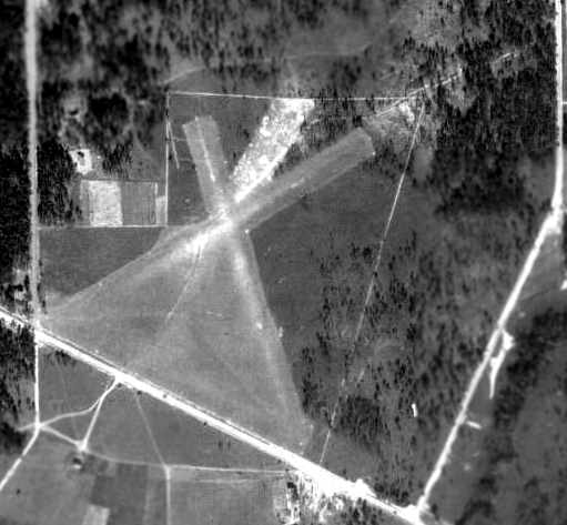
A 1987 photo by John Voss looking southwest at a Navy TH-57 helicopter over the little control tower on the north side of Site 8A.
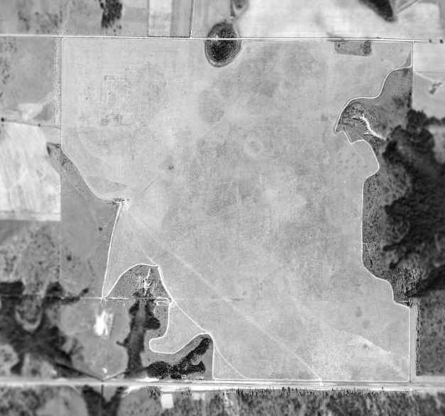
The 1999 USGS aerial photo depicted Site 8A as a large grass field,
on which were laid out a number of lines & landing targets
(including several numbered Confined Area Landing zones,
in small clearings in the woods along the southwest corner of the site).
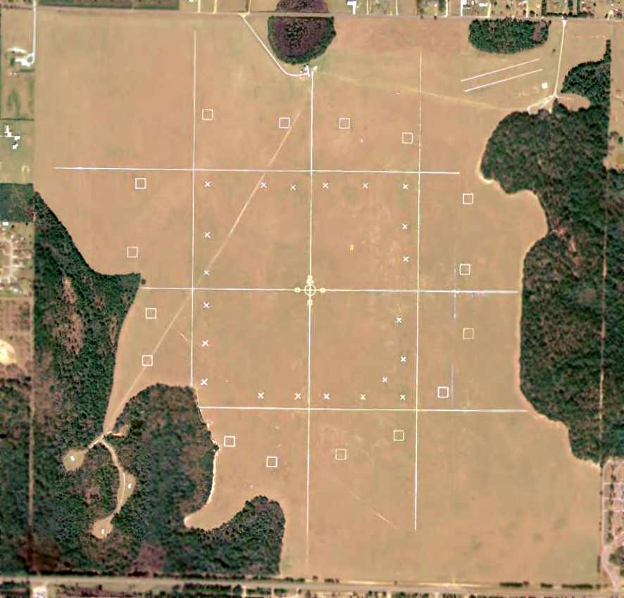
A 2004 aerial photo depicted Site 8A as a large grass field, on which were laid out a number of lines & landing targets
(including several numbered Confined Area Landing zones, in small clearings in the woods along the southwest corner of the site).
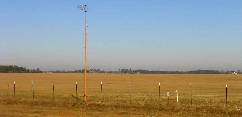
A January 2006 photo by Paul Freeman, looking northwest at Site 8A,
showing a windsock pole (sans windsock) along the southern edge of the field.
According to GlobalSecurity.org, as of 2006,
“NAS Whiting Field provides aviation & ground fuel support services at Outlying Field Site 8.
[Site 8 is] supported by the deployment of 2,000-gallon JP5 fuel servicing trucks to service helicopters.”
However, inexplicably, as of 2006, the FAA Airport/Facility Directory did not list any active airfield at all at Site 8A,
and no airfield facility was depicted at Site 8A on the 2006 Sectional Chart.
Brian Rehwinkel noted in 2006, “I believe the field has been continually used by the Navy since it was opened.
Since it was purchased approximately 66 years ago,
I think Navy has retained ownership of the land - and used it for training most of that time.
I believe this airfield (along with Spencer OLF & Pace OLF/Site 14)
are the 3 oldest Outlying Fields still used by the Navy in Pensacola.
All were developed in 1940 & are currently used by NAS Whiting Field.”

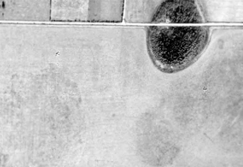
A circa 2007 aerial view looking north at Site 8's control tower.
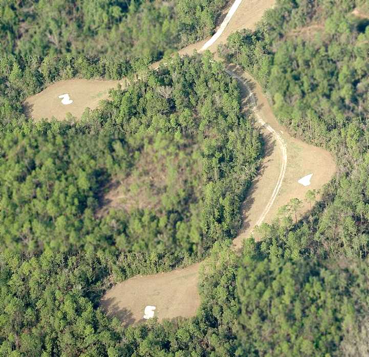
A circa 2007 aerial view looking north at the 3 CAL sites on the southwest side of Site 8
(Confined Area Landing zones, small clearings in the woods used to teach helicopter approaches to confined locations).
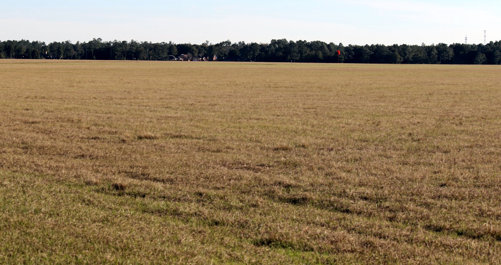
A December 2013 photo by Brian Rehwinkel looking south at Site 8A from its north gate.
Brian observed, “This airfield looks like an open pasture – you can see a wind sock, but not the field markings.”
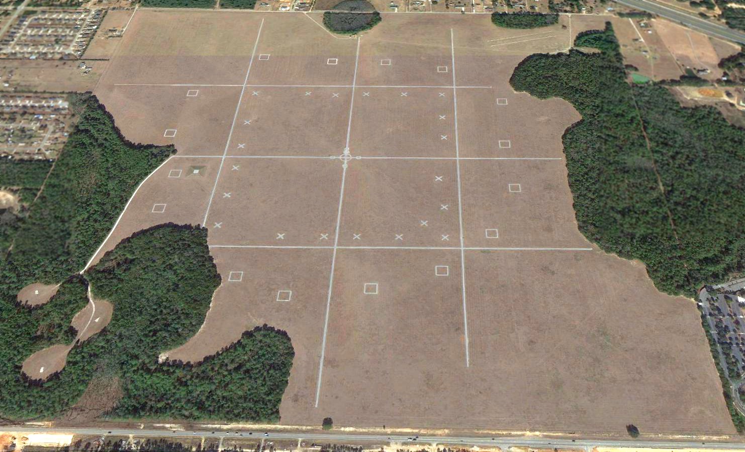
A 2018 aerial view looking north at Site 8A depicted a large grass field, on which were laid out a number of lines & landing targets
(including several numbered Confined Area Landing zones, in small clearings in the woods along the southwest corner of the site).
Brian Rehwinkel reported in 2019, “Site 8A... The Navy & Escambia County have been working on a project
to exchange the 640 acre property for a brand new outlying field in neighboring Santa Rosa County.
The deal involved Escambia County purchasing 601 acres in Santa Rosa County & developing a brand new airfield to replace Site 8A – at the cost of about $17 million.
The process has taken several years, and required approval by Congress. The new outlying field has been named (OLF) Site X.
For someone who grew up in Escambia County, this is a little bittersweet… Site 8 was the last active Navy outlying field in the county
(Pensacola’s airport was an OLF, but was not Navy-owned & the development of the field was not funded by the Navy).
During the WWII, there were at least 20 Navy-owned or leased Navy outlying fields in Escambia County & an era ended when Site 8 OLF closed permanently at the end of January.
Of course, as the population of the Pensacola metropolitan areas grows, these once isolated airfields have become surrounded by development.
The now abandoned field will be used by the county for various purposes, possibly including an industrial park.
Navy Federal Credit Union has a huge complex next to the former airfield & has asked the county to sell some of the land so Navy Federal can expand.”
An April 2022 photo looking north at Site 8A showed it remained an open grass field.
____________________________________________________
Fountain Naval Outlying Landing Field, Pensacola, FL
30.55, -87.33 (Northwest of Pensacola Regional Airport, FL)
"Fountain Field", as depicted on a 1939 map of NAS Pensacola & its satellite fields (courtesy of Brian Rehwinkel).
Fountain Field was one of the large number of auxiliary fields which were established by the Navy
in the late 1930s to support flight training operations at the Pensacola Flight School.
The date of establishment of Fountain Field has not been determined.
Fountain Field was not depicted on the 1935/39/40/41/42/44/45 Mobile Sectional Charts,
nor listed in The Airport Directory Company's 1937 Airports Directory (courtesy of Bob Rambo).
The earliest depiction of Fountain Field which has been located
was on a 1939 map of NAS Pensacola & its satellite fields (courtesy of Brian Rehwinkel).
It depicted Fountain Field simply as a rectangular outline.
A 1940 USDA aerial view of Fountain Field, from the Digital Library Center / University of FL Smathers Libraries (courtesy of Brian Rehwinkel).
The airfield consisted of an irregularly-shaped grass area, with runways oriented northeast/southwest & northwest/southeast.
There did not appear to be any buildings or other aviation facilities associated with the field.
According to Brian Rehwinkel, Fountain Field was evidently abandoned by the Navy in 1941 or early 1942.
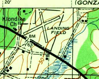
Fountain Field was still depicted (labeled simply as “Landing Field”, on the bottom-left) on the 1944 USGS topo map.
Three buildings were depicted along the edge of the field, but it is not known if these were related to the airfield.
Fountain Field was no longer listed in the April 1944 US Army/Navy Directory of Airfields (courtesy of Ken Mercer).
In a 1/3/58 USDA aerial photo of the site of Fountain Field (from the Digital Library Center / University of FL Smathers Libraries, via Brian Rehwinkel),
at least 3 of the former landing circles were still barely recognizable on the abandoned field, 15 or 16 years after the field was evidently last used.
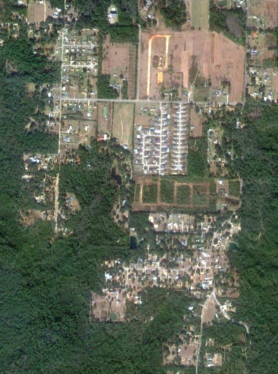
As seen in the 1999 USGS aerial photo, the site of Fountain Field had been covered with housing,
and no recognizable trace appeared to remain of the former Navy airfield.
As seen in a 2004 aerial photo, the site of Fountain Field has been covered with housing,
and no recognizable trace appears to remain of the former Navy airfield.
The site of Fountain Field is located south of the intersection of Jacks Branch Road & Bristol Park Road.
____________________________________________________
X Field Naval Outlying Landing Field, Pensacola, FL
30.5, -87.33 (Northwest of Pensacola Regional Airport, FL)
"X Field", as depicted on a 1939 map of NAS Pensacola & its satellite fields (courtesy of Brian Rehwinkel).
X Field was one of the large number of auxiliary fields which were established by the Navy
in the late 1930s to support flight training operations at the Pensacola Flight School.
The date of establishment of X Field has not been determined.
It was not listed in The Airport Directory Company's 1937 Airports Directory (courtesy of Bob Rambo).
The earliest depiction of X Field which has been located
was on a 1939 map of NAS Pensacola & its satellite fields (courtesy of Brian Rehwinkel).
It depicted X Field as having 2 runways, in the shape of an "X" (thus the name).
The 1940 USDA aerial view (from the Digital Library Center / University of FL Smathers Libraries, courtesy of Brian Rehwinkel) showed X Field to have 2 grass runways,
but there did not appear to be any buildings or other aviation facilities associated with the field.
The only aeronautical chart depiction which has been located of X Field was on the June 1942 Mobile Sectional Chart,
which depicted “Navy X” as an auxiliary airfield.
The 1944 USGS topo map depicted X Field as having 2 runways (in an X-shape, of course), labeled as “Landing Field”.
It has not been determined how much longer X Field was used by the Navy.
It was apparently abandoned at some point between 1940-44,
as it was not listed in the April 1944 US Army/Navy Directory of Airfields (courtesy of Ken Mercer)
or depicted on the February 1945 Mobile Sectional Chart (courtesy of Chris Kennedy).
As seen in the 1999 USGS aerial photo of the site of X Field, the site of X Field had been covered with housing,
and not a trace appeared to remain of the former Navy airfield.
A 2004 aerial photo of the site of X Field showed no trace appeared to remain of the former Navy airfield.
The site of X Field is located north of the intersection of Route 90 & Lockhart Street.
____________________________________________________
30.445, -87.308 (North NAS Pensacola, FL)
A 12/6/40 USDA aerial photo of V Field (courtesy of the Digital Library Center / University of FL Smathers Libraries, via Brian Rehwinkel).
Note what appears to be a single aircraft at the southeast end of the northwest/southeast runway.
According to Brian Rehwinkel, "V" Field was another pre-war outlying field the used for training by NAS Pensacola.
Although the field may have been used earlier than 1935, it was first leased by the Navy in late 1935.
At that time the Navy leased a total of 370 acres from 3 different landowners for a total of $110 per year.
"V" Field was typical of the early outlying fields in Pensacola - it was a fairly primitive sod field (with 3 sod runways).
There were apparently no other improvements to the land.
Interestingly enough, even though the Navy leased nearly 400 acres,
the runways only occupied a small portion of the total acreage
(a portion of Marcus Bayou made up the southern portion of the land).
The earliest depiction of V Field which has been located was a 12/6/40 USDA aerial photo
(courtesy of the Digital Library Center / University of FL Smathers Libraries, via Brian Rehwinkel).
The photo appeared to depict a single aircraft on (or flying over) the airfield.
"V" Field was apparently used (or at least kept as an emergency field) by the Navy until sometime during WW2.
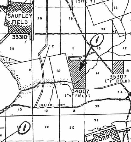
A 6/30/42 Navy map (courtesy of Brian Rehwinkel) showed V Field in relation to Saufley Field, Y Field, and Corry Field.
The only aeronautical chart depiction which has been located of V Field was on the June 1942 Mobile Sectional Chart,
which depicted “Navy V” as an auxiliary airfield.
V Field was depicted on the 1944 USGS topo map (on the top-left) as having 3 runways, labeled as “Auxiliary Landing Field”.
V Field was evidently abandoned by the Navy at some point between 1942-45,
as it was no longer depicted at all on the 1945 Mobile Sectional Chart (courtesy of John Voss).
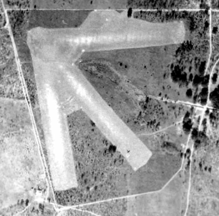
A 1/5/51 USDA aerial photo of V Field (courtesy of the Digital Library Center / University of FL Smathers Libraries, via Brian Rehwinkel).
Although the airfield was abandoned, the 3 grass runways remained mostly intact.
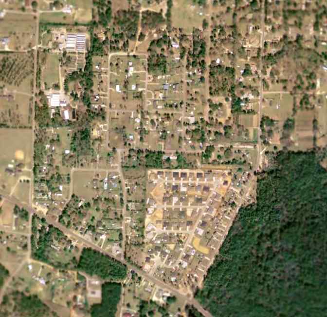
The 1999 USGS aerial photo of the site of V Field shows that is has been densely covered with housing,
with not a trace of the former airfield appearing to remain.
A 3/29/16 aerial view by Dallam Oliver-Lee looking south at the site of V Field.
The site of V Field is location south of the intersection of Mariane Drive & Gelndora Street.
____________________________________________________
Felton's Field / Saufley Naval Outer Landing Field (NUN), Bellview, FL
30.47, -87.34 (North of Pensacola NAS, FL)
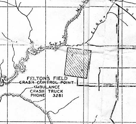
What was originally known as "Felton's Field",
as depicted on a 1939 map of NAS Pensacola & its satellite fields (courtesy of Brian Rehwinkel).
A Navy airfield known as Felton's Farm Field was originally constructed on leased land on this location in 1933,
as a satellite airfield for nearby Pensacola Naval Air Station.
A 1939 Navy aerial photo depicted Felton Field as an outlying field (courtesy of Brian Rehwinkel).
The field consisted simply of a square grass field,
without any buildings or other improvements.
Note the aircraft (presumably a Navy trainer) crossing the Northeast corner of the field.
Due to the pre-WW2 military buildup,
the Navy purchased 867 acres of land at the site in order to significantly expand the airfield, opening Saufley Field in 1940.
It conducted primary training, instrument training, and fighter training.
Saufley was commissioned in 1943 as a Naval Auxiliary Air Station.
For the rest of WW2, Saufley Field was used for a variety of training in PBY5A, SBD, SNJ & N2S aircraft.
A 9/4/43 aerial view (from the Emil Beuhler Library at the National Naval Aviation Museum at Pensacola, courtesy of Maureen Keillor)
looking at a Saufley Field ramp packed with Navy planes.
In 1944, the number of aircraft at the field peaked at 160, and the station complement was over 2,200 men.
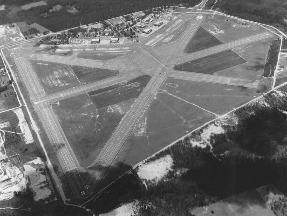
A WW2-era view looking north at Saufley Field (National Archives photo).
The airfield had been expanded so as to be unrecognizable compared to the 1939 photo,
with a large rectangular asphalt mat in the center, over which extended 4 asphalt runways.
Four hangars at the south end bracketed a control tower.
The 1944 USGS topo map depicted Saufley Field as an unlabeled property outline,
with no details within other than a military airfield symbol.
"Saufley (Navy)", as depicted on the February 1945 Mobile Sectional Chart (courtesy of Chris Kennedy).
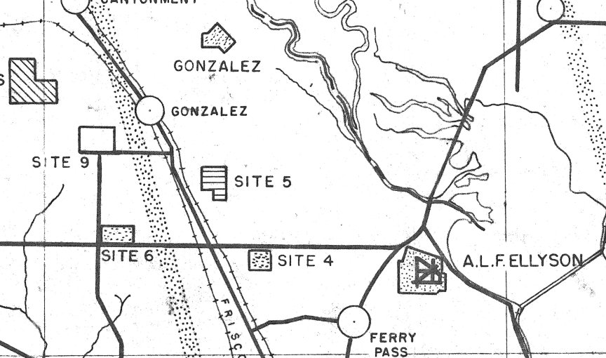
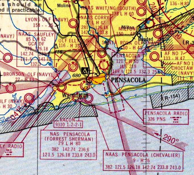
Saufley had a large number of outlying airfields during the WW2 era, including:
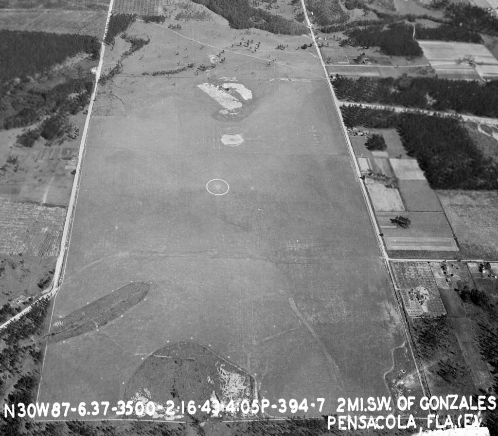
Helm Airport (12 miles NW of Pensacola), Pensacola Field #1 (14 miles NW of Pensacola),
Pensacola Field #5 (3 miles SE of Gonzales), Pensacola Field #6 (2.5 miles N of Gonzales),
Pensacola Field #7 (7 miles NW of Pensacola), and Pensacola Field #9 (1.5 miles S of Gonzales).
Due to its substantial pre-war construction, Saufley remained open following the end of WW2.
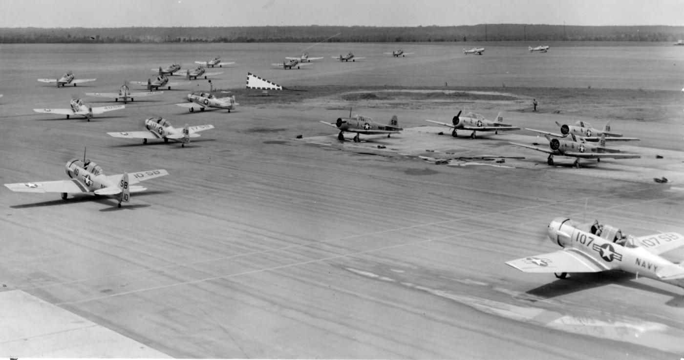
A circa 1950 photo (from the National Museum of Naval Aviation) of SNJ Texans taxiing out for training flights at Saufley Field.
An undated USN photo of Navy fliers in front of a T-28B at NAAS Saufley (courtesy of John Voss).
An undated USN photo of a T-28 (courtesy of John Voss);
John noted “It's interesting that the field name [Saufley] appears on the wing & tail of the aircraft... a station aircraft?”
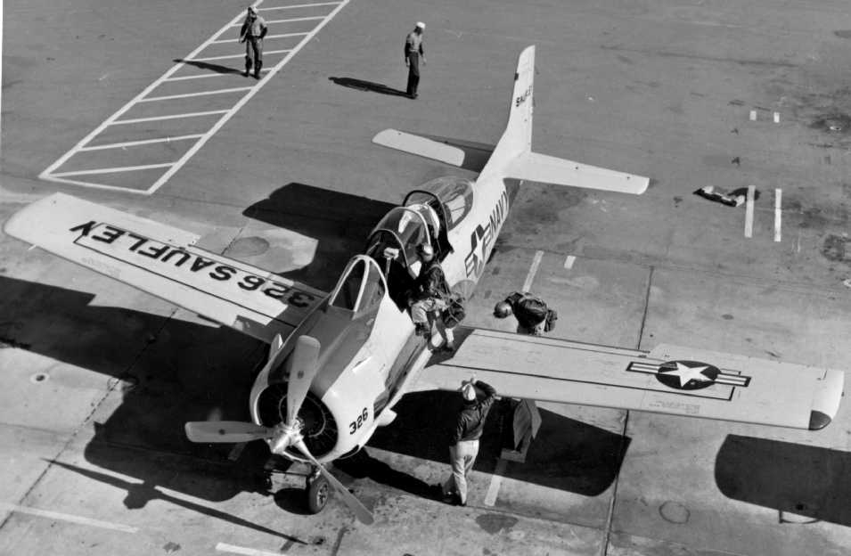
A 1956 aeronautical chart (courtesy of Dallam Oliver-Lee) depicted NAAS Saufley
(among a dizzying array of Pensacola-area airfields) as having a 6,200' paved runway.
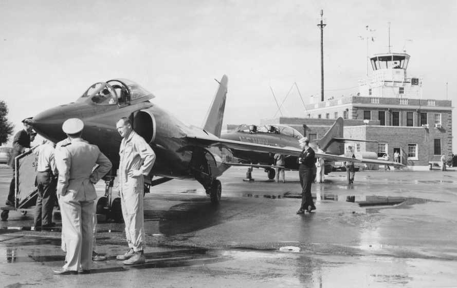
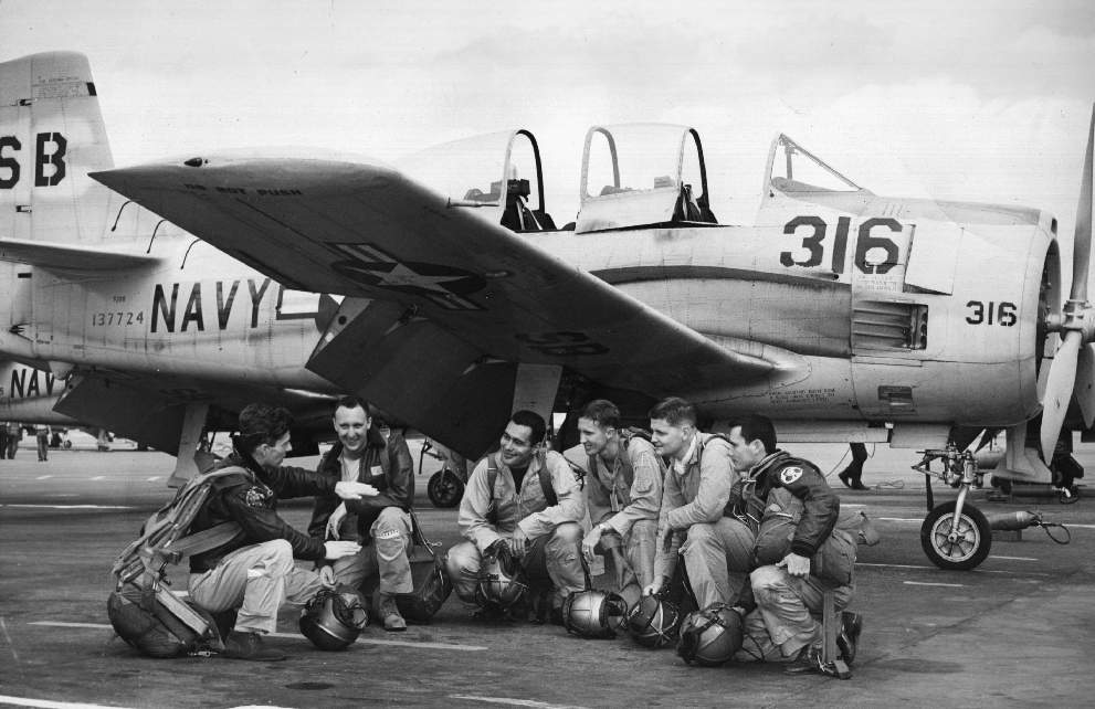
A circa 1956-57 photo of Blue Angels team boss, CDR Edwards Holley in front of a Grumman F11F-1 'Tiger' & a Grumman F9F Cougar,
with the Saufley control tower in the background.
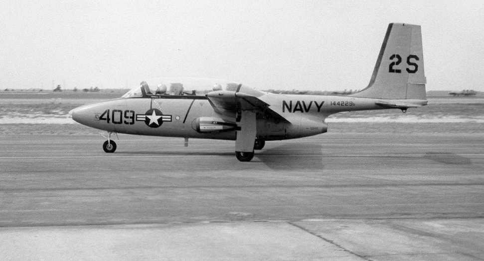
A circa 1959-60 photo of an extremely rare Temco TT-1 Pinto (BuNo 144229)
at Saufley Field ('2S' tail code) during their trial use in Pensacola's training program.
The 1960 Jeppesen Airway Manual (courtesy of Chris Kennedy)
depicted "Saufley NAAS" as having 4 paved runways, with the longest being the 6,035' Runway 4/22.
In 1961, 2 Douglas AD4-2N Skyhawks were modified with dual-wheel main landing gear & tested for possible use by the Army from unpaved runways.
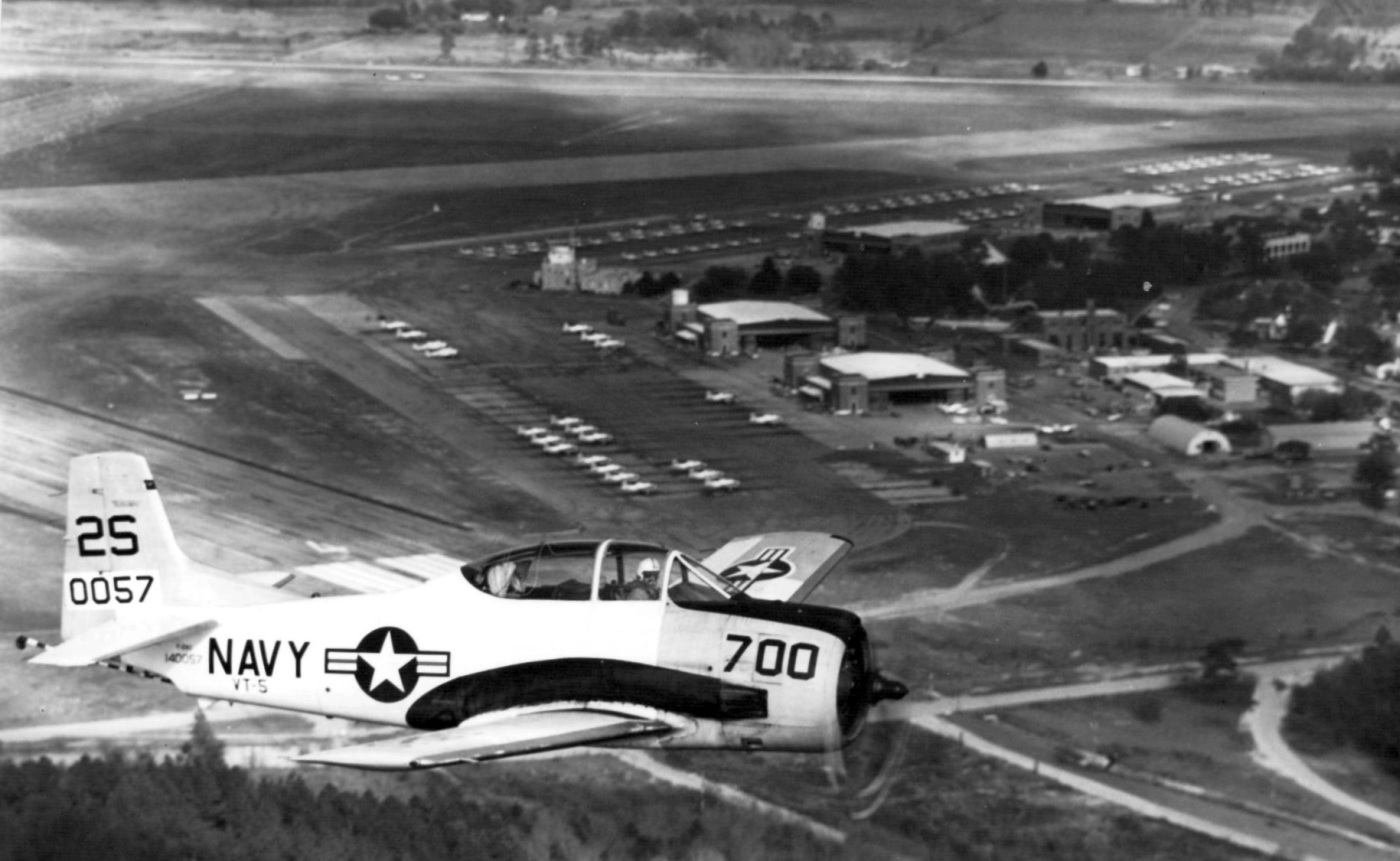
A 3/28/63 aerial view (from the National Museum of Naval Aviation) looking east at a T-28C Trojan of Training Squadron 5 overflying Saufley Field.
A “pre-1965” aerial view (from the Emil Beuhler Library at the National Naval Aviation Museum at Pensacola, courtesy of Maureen Keillor)
looking southwest at Saufley Field.
A 1/31/65 aerial view (courtesy of Dallam Oliver-Lee) showed an amazing array of aircraft on the Saufley ramps.
Saufley was redesignated a Naval Air Station in 1968.
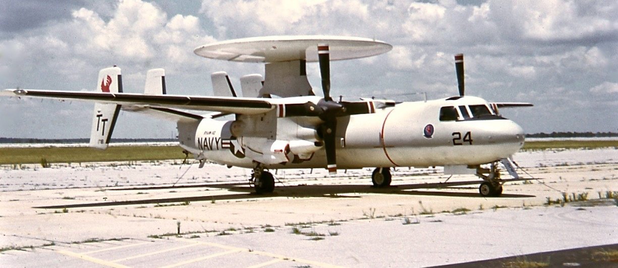
A July 1972 photo by Bob Thomas of Navy RAW-110 Grumman E-2B Hawkeye 151719 C/n 39 at Saufley Field.
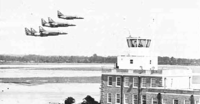
The A-4 Skyhawks of the Blue Angels do a flyby of the Saufley Field tower in September 1976.
Saufley Field was decommissioned in 1976 & designated an outlying landing field.
Saufley Field was reactivated in 1979 when the Naval Education & Training Program Development Center relocated from Ellyson Field,
and it also served as an outlying field for NAS Whiting Field pilot training.
Also on the base is a minimum security Federal Prison Camp, one of the so-called "Country Club prisons".
"OLF Saufley (Navy)" was still depicted as an active airfield on the 1980 New Orleans Sectional Chart.
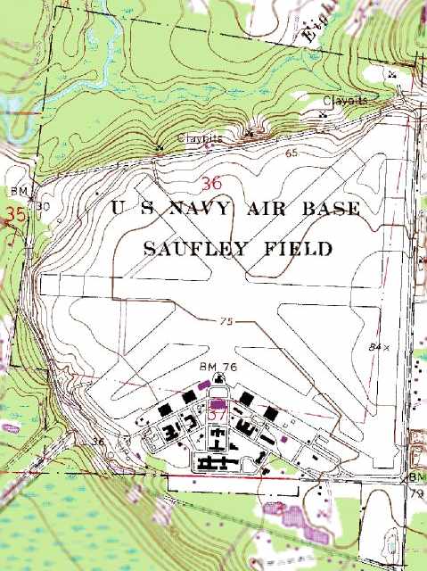
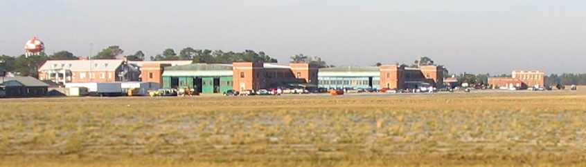
The 1987 USGS topo map depicted “U.S. Navy Air Base Sufley Field”
as having numerous paved runways & a large number of hangars & other buildings.
Dallam Oliver-Lee reported, “They used the airfield for FEMA [storage] during the hurricanes when I lived in Pensacola from 1987-2007.”
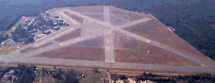
A circa 1990s aerial view looking west at Saufley Field.
As of 2002, two runways were still active (5/23 & 14/32, each 4,000' long).
Saufley also had in excess of 34,425 square ft of hangar space.
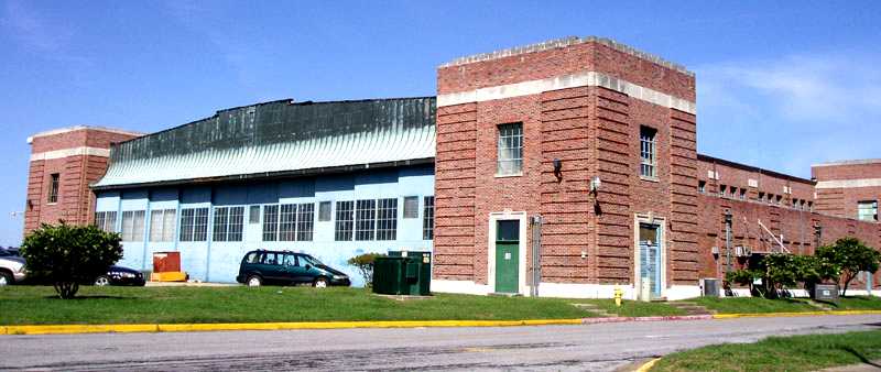
A 2000 photo by William Larkins of a Saufley hangar.
Whiting Field T-34 instructor Bob Adair reported in 2002, “Saufley has been repaved & painted this year.
It is manned by a Whiting Runway Duty Officer & is the primary student pilot solo field in what we call Area 1.
The instrument approaches practiced at Saufley are done using the Saufley VOR above 4,500' to avoid the PNS Class C airspace."
The Navy plans to eventually conduct training at Saufley using the new T-6A Texan II, the replacement for the T-34.
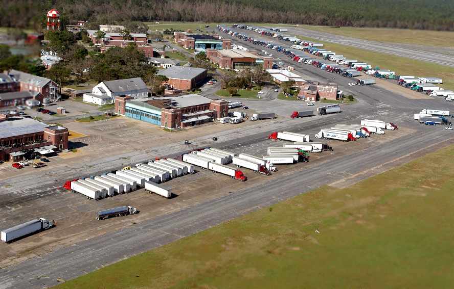
A 9/20/04 DOD aerial view looking west at Saufley Field,
showing over one hundred 18-wheeler trucks filled with ice, food and drinking water,
staged on the Saufley ramp to provide relief for victims of Hurricane Ivan.
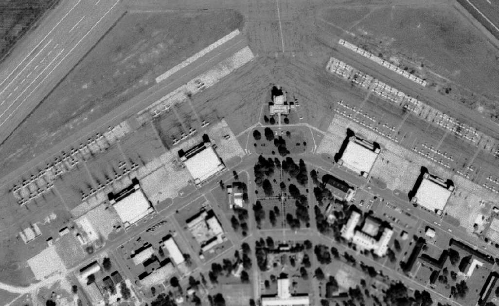
The control tower cab was removed from the top of the operations building at some point between 1976-2004.
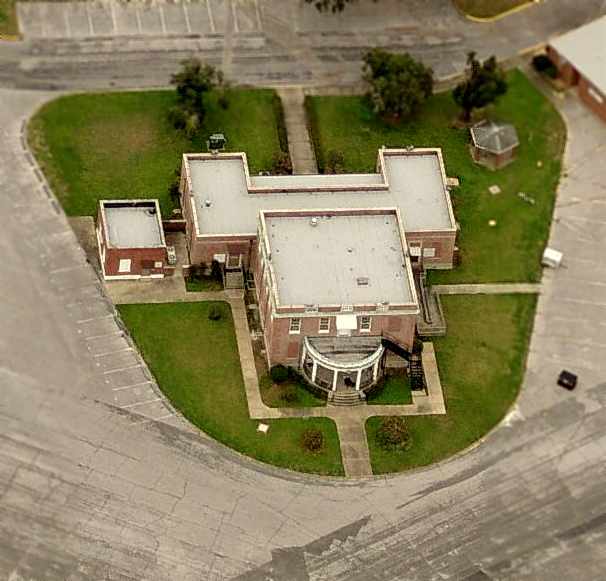
A circa 2006 aerial view looking south at the operations building, which no longer had the control tower cab mounted on top.
A circa 2006 aerial view looking east at a hangar & helipad at Saufley.
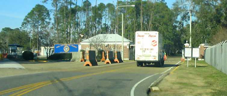
A January 2006 photo by Paul Freeman, looking west at the gate to Saufley.
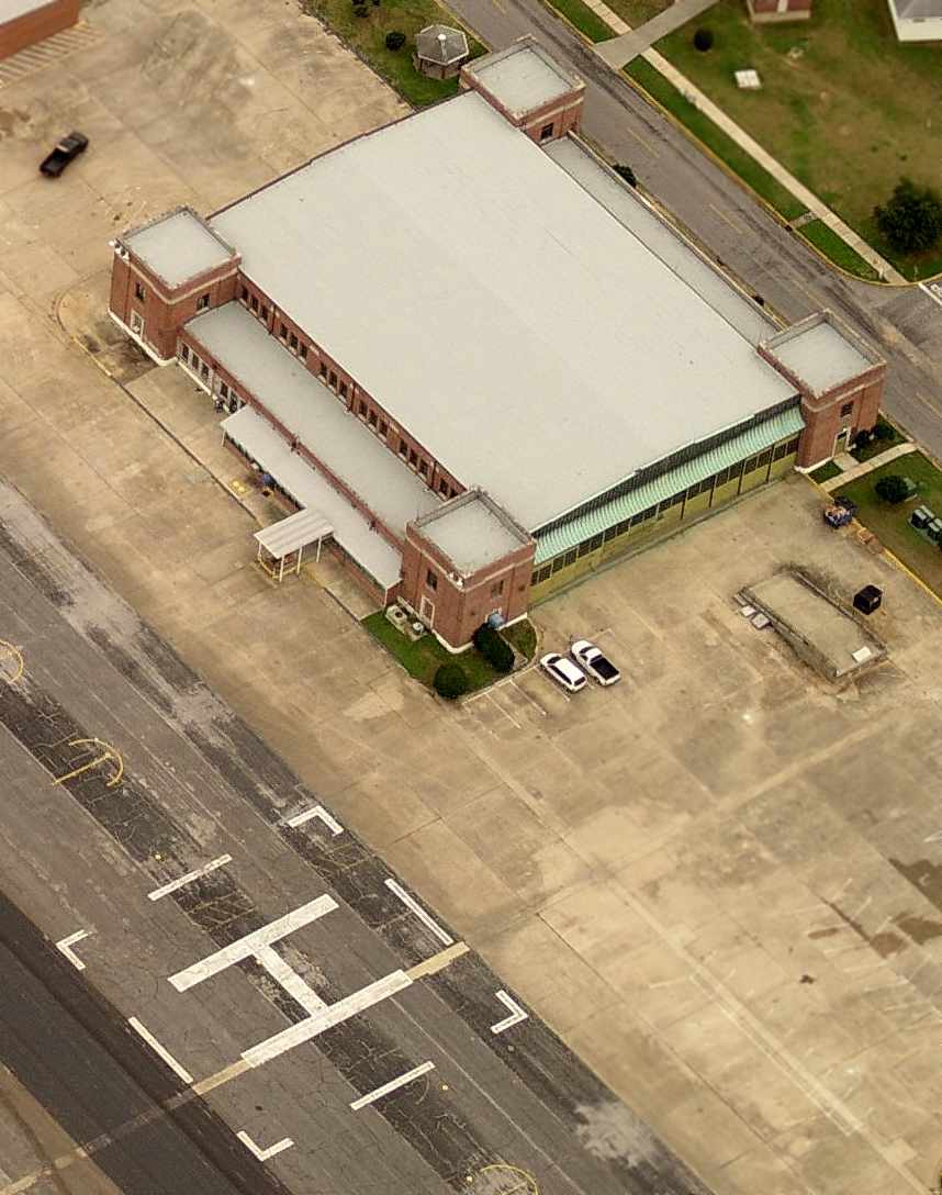
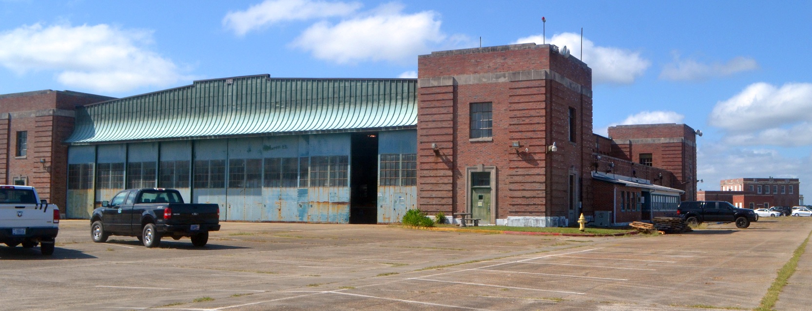
A January 2006 photo by Paul Freeman, looking west at the hangars which remain at Saufley Field,
with the decayed asphalt runway pavement of one of the unmaintained runways visible in the foreground.
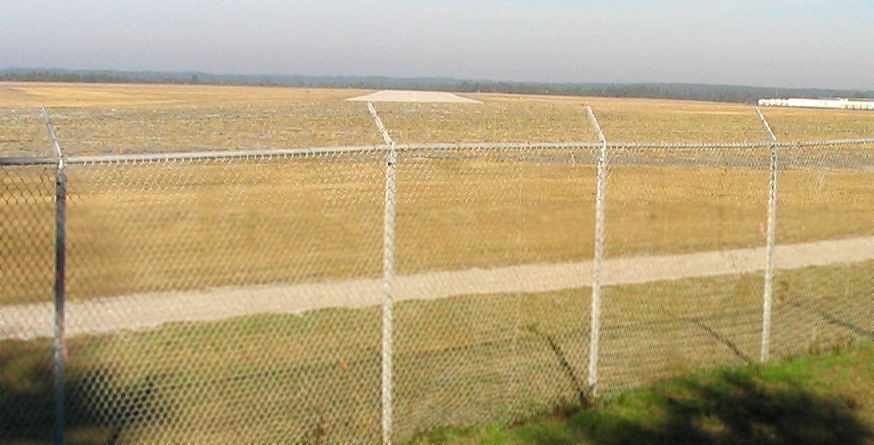
A January 2006 photo by Paul Freeman, looking northwest along the still-maintained Runway 32.
Note the FEMA trailers on the right side.
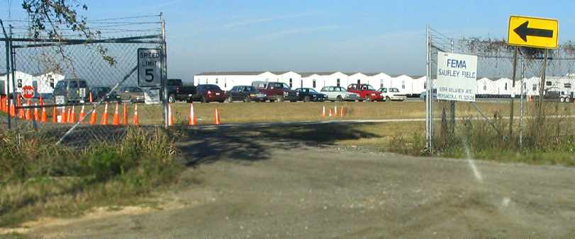
A January 2006 photo by Paul Freeman, looking west at the “FEMA Saufley Field” facility.
Most of Saufley Field's former north/south runway was being used to house trailers
of the Federal Emergency Management Agency, used to house displaced hurricane damage victims.
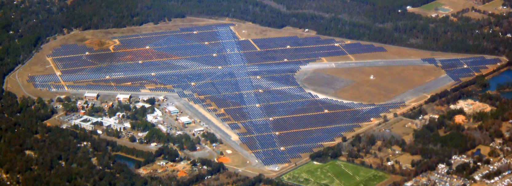
A 1/25/18 aerial view by Alex Price looking northwest at the site of Saufley Field, with the runways now covered by solar panels.
A 10/21/18 aerial view by Dallam Oliver-Lee looking southwest at the site of Saufley Field, showing the hangars which remain standing, and the runways covered by solar panels.
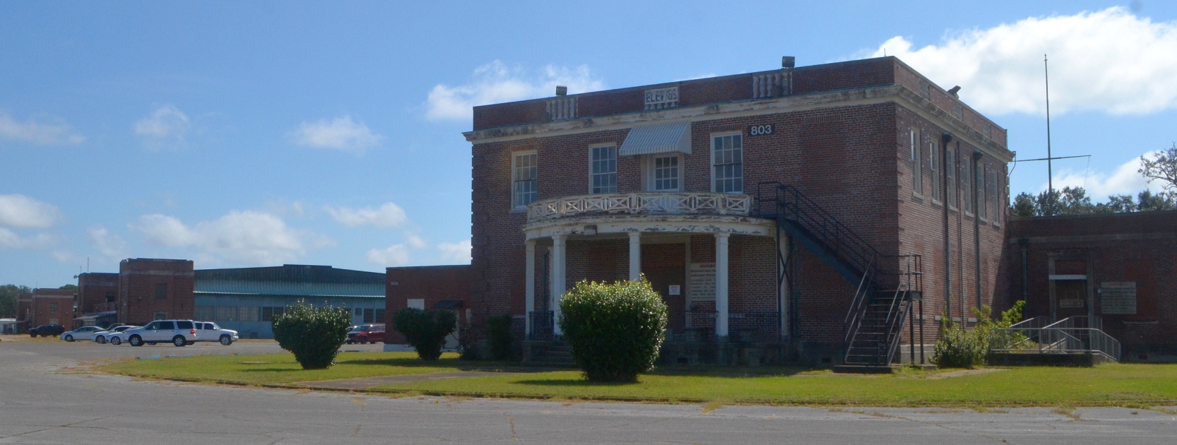
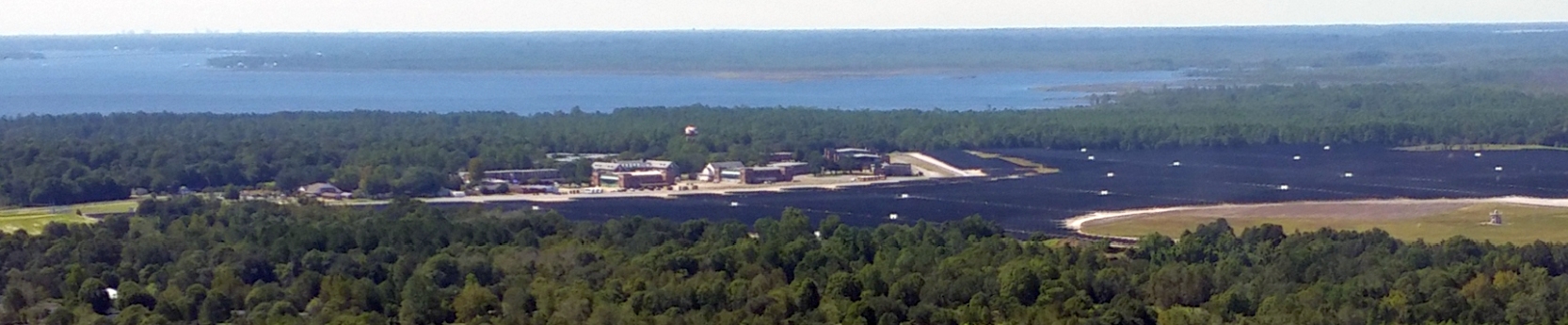
A 10/22/20 photo by Mark Morgan looking southeast at the former Saufley Field operations building, with hangars visible in the background.
A 10/22/20 photo by Mark Morgan looking southwest at a former Saufley Field hangar, with the former operations building visible in the background.
See also: http://www.tailhook.org/Saufley.htm
____________________________________________________
Or if you prefer to contact me directly concerning a contribution (for a mailing address to send a check),
please contact me at: paulandterryfreeman@gmail.com
If you enjoy this web site, please support it with a financial contribution.
____________________________________________________
This site covers airfields in all 50 states.