
Abandoned & Little-Known Airfields
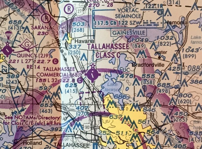
Florida: Tallahassee area
© 2002, © 2026 by Paul Freeman. Revised 1/23/26.
This site covers airfields in all 50 states: Click here for the site's main menu.
____________________________________________________
Please consider a financial contribution to support the continued growth & operation of this site.
Atkinson Field / Panama City Airport (revised 6/15/20) - Bainbridge Aux AAF #3 / Faceville Field (revised 6/15/20) - Blountstown Airport / Hammock Field (revised 4/9/20)
Buchanan STOLPort (revised 6/15/20) - Chipley Municipal Airport (revised 11/11/24) - Dale Mabry Field (revised 1/4/21) - Fannin Field / Panama City Bay County International Airport (revised 9/27/22)
Lake Jackson Airport / Tallahassee Commercial Airport (revised 11/11/24) - Marianna Aux AAF #1 / Ellis Field (revised 4/9/20) - Marianna Aux AAF #2 / Malone Field / Stage Field (revised 4/9/20)
Marianna Aux AAF #3 / Bascom Field (revised 6/14/19) - Marianna Aux AAF #4 / Alliance Field (revised 4/9/20) - Open Sands Airfield (revised 1/23/26) - Sky Road Inn Airfield (added 1/23/26)
____________________________________________________
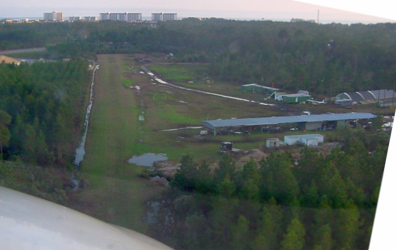
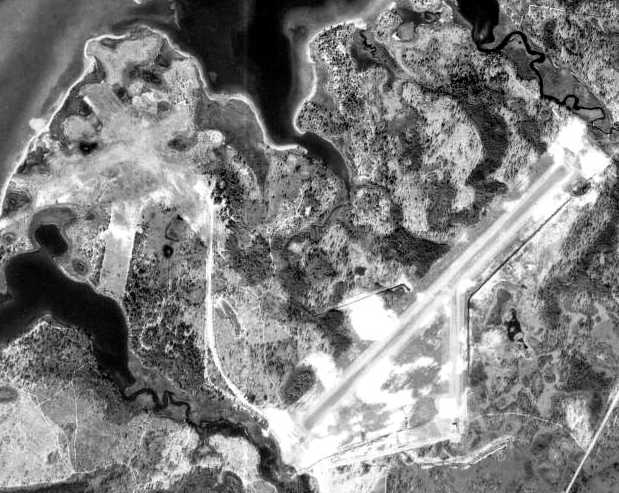
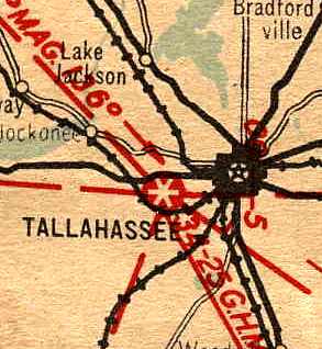
Sky Road Inn Airfield, High Springs, FL
29.9, -82.608 (Southeast of Tallahassee, FL)
Sky Road Airfield, as depicted on the August 1955 Orlando Sectional Chart.
This small rural airfield was evidently established at some point between 1954-55,
as it was not yet depicted on the 1954 Orlando Sectional Chart.
The earliest depiction which has been located of Sky Road Airfield was on the August 1955 Orlando Sectional Chart.
It depicted Sky Road as having a 2,100' unpaved runway.
The earliest photo which has been located of Sky Road Airfield was a 1955 aerial view.
It depicted a single northeast/southwest unpaved runway, with a taxiway leading to 2 T-hangars & 1 light single-engine plane on the northwest side.
The 1962 Orlando Sectional Chart.(courtesy of Jim Sharp) depicted it as Sky Road Inn Airfield.

The earliest topo map depiction which has been located of Sky Road Inn Airfield was on the 1964 USGS topo map.
It depicted a single northeast/southwest unpaved runway, with a taxiway leading to 6 small buildings on the northwest side.

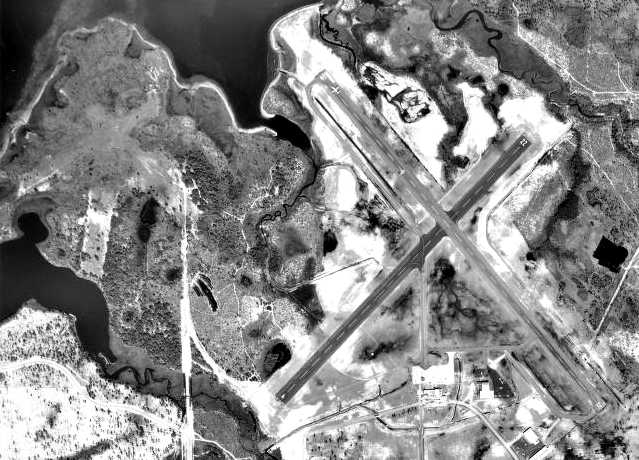
The last photo which appears to show Sky Road Inn Airfield still in use was a 1/16/68 USGS aerial view.
It depicted a single northeast/southwest unpaved runway, with a taxiway leading to 4 T-hangars on the northwest side.

The last aeronautical chart depiction which has been located of Sky Road Inn Airfield was on the October 1971 Jacksonville Sectional Chart (courtesy of Jim Sharp).
It depicted Sky Road Inn as having a 2,000' unpaved runway.
Sky Road Inn Airfield was probably closed (for reasons unknown) at some point between 1971-83,
as a 1983 aerial view no longer showed any distinct runway, and all but 1 of the T-hangars had been removed.
The 1991 USGS topo map continued to depict Sky Road Inn Airfield.
Sky Road Inn Airfield was no longer depicted on the 1993 USGS topo map, or the 1994 Jacksonville Sectional Chart (courtesy of Ron Plante).
A 1994 aerial photo showed that a road (Southeast Sunset Glen) & several houses had been built over the Sky Road Inn Airfield site.

A 2024 aerial view showed no trace remaining of Sky Road Inn Airfield.
Thanks to Jim Sharp for pointing out this airfield.
____________________________________________________
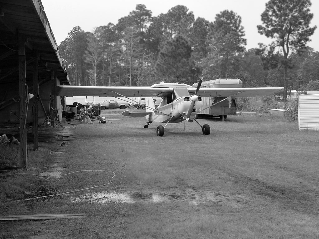
Open Sands Airfield, Panama City Beach, FL
30.21, -85.855 (Southwest of Tallahassee, FL)
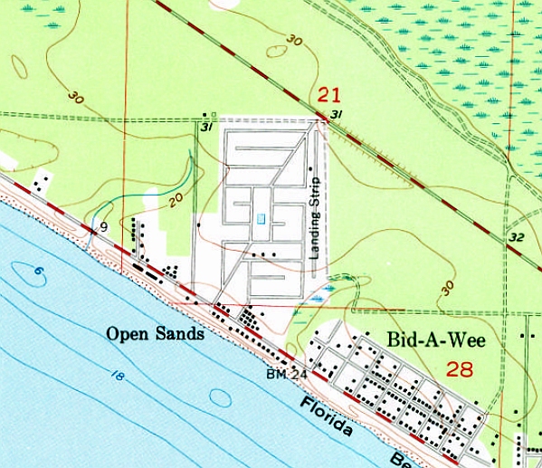
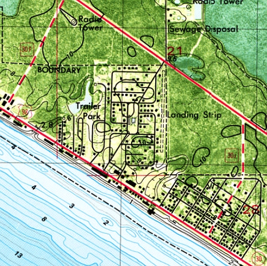
Open Sands Airfield, generically labeled “Landing Strip”, as depicted on the 1955 USGS topo map.
Not much is known about this small beach airfield, including its name, purpose, or date of construction.
No airfield was depicted at this location on a 1941 aerial photo, the 1943 USGS topo map, or 1950s/60s/70s/90s Sectional Charts.
The earliest depiction which has been located of the Open Sands Airfield was on the 1955 USGS topo map.
It depicted a single north/south paved runway, generically labeled “Landing Strip”,
adjacent to the east side of the Open Sands housing development.
Presumably the airfield was built to support the construction &/or sales of the beachfront community.
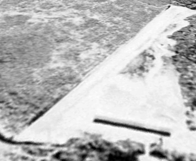
The earliest photo which has been located of the Open Sands Airfield was a 1964 aerial photo,
which depicted a single north/south runway adjacent to the east side of the housing development.

A 1/16/75 USGS aerial photo depicted the Open Sands runway remained intact, but with a closed-runway “X” symbol painted on the southern end.
The 1982 USGS topo map depicted the Open Sands Airfield in an unchanged fashion:
a single north/south paved runway, generically labeled “Landing Strip”, adjacent to the east side of the Open Sands housing development.
Aerial photos from 1994 & 1999 showed the Open Sands runway more overgrown.
A 2005 aerial photo showed houses had been built along the northern end of the former Open Sands runway.
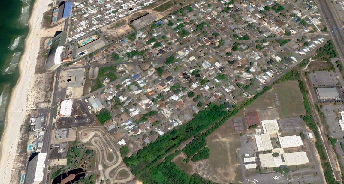
A 2022 aerial view looking northwest showed the southern portion of the Open Sands runway covered in trees, and the northern end covered in houses.
Thanks to Donna Stark for pointing out this airfield.
____________________________________________________
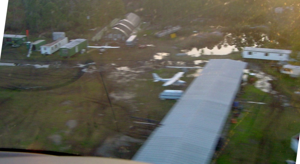
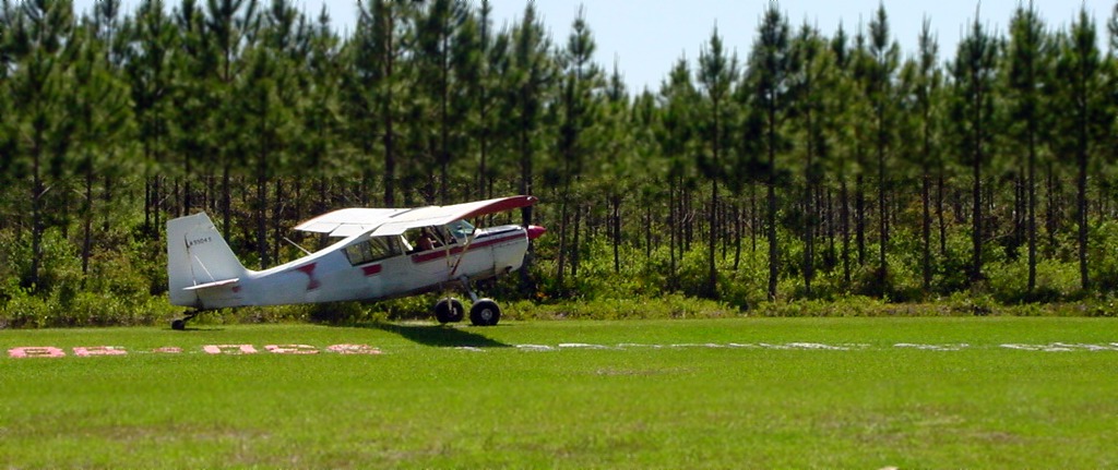
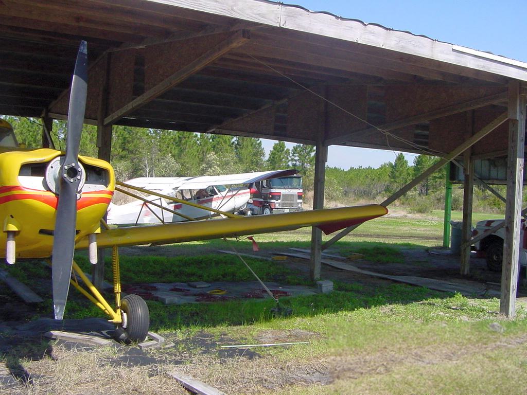
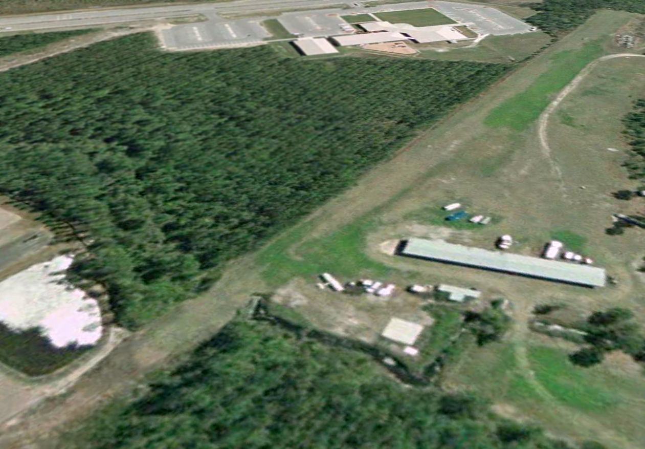
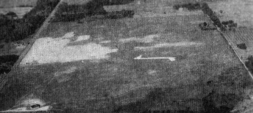
Buchanan STOLPort, Panama City Beach, FL
30.2, -85.82 (Southwest of Tallahassee, FL)
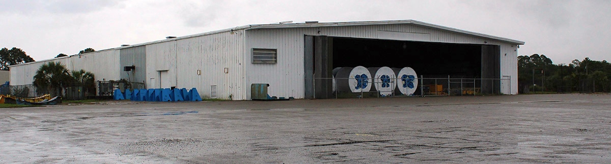
An admittedly low-quality 1994 aerial view looking southeast at Buchanan STOLPort.
Buchanan STOLPort was not yet depicted on a 1979 aerial photo or the 1984 USGS topo map.
Brian Beard recalled, “Panama City Beach Airfield was cut out of the forest in 1992 but it was 1993 before the hangar was built.”
Buchanan STOLPort was not depicted on the June 1993 or June 1999 New Orleans Sectional Charts.
The earliest depiction which has been located of Buchanan STOLPort was an 1994 aerial view.
It depicted the field as having a single unpaved north/south runway, with a long hangar on the northwest side.
Brian Beard recalled, “Panama City Beach Airfield... I used to setup the banners for towing there, and cracked up a Traumahawk [Piper PA-38 Tomahawk] in 1997.
I hit a camouflaged mudhole & ripped the nose gear off while sucking most of the seat cushion up my... well, you know!”
A 1999 aerial view showed 2 light single-engine aircraft next to the Buchanan STOLPort hangar.
A 3/9/03 aerial view by Nick Kaplan looking south at Buchanan STOLPort from final approach,
showing the grass north/south runway, hangars, and several single-engine planes.
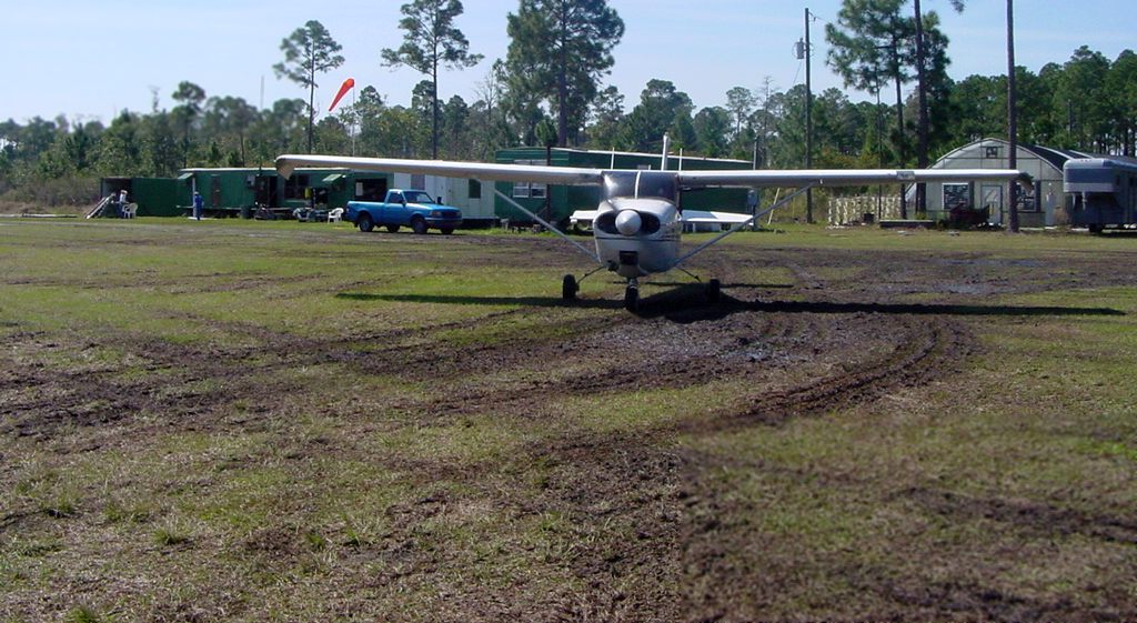
Nick Kaplan recalled, “ I was a banner tow pilot back in 2003 at a small grass strip in Panama City Beach.
The Company was called Aerial Ads of the Southeast.
The trailers we lived in [were] next to the hangar. I had always logged it as simply PCB-A.
I have lost touch with past co-workers & pilots, and the company no longer exists, nor do I remember the owners name.
It was about 1,000' when the ground was dry, with a NNE/SSW runway. We had one open-aired hangar that could cover about 5 planes.
The year I was there we towed with modified Cessna 150s, a Cessna 175 & Scouts, and had a [Piper] Pawnee that never ran.
It was an extremely narrow runway lined with a fence & trees on the East side
and grassy area for the banners to be laid out & picked up to the immediate west of the runway & the proverbial 50' obstacle (trees) on either end.
I had a lot of fun & enjoyed the challenges of this field for about 700 hours worth of flying.”
A 3/9/03 aerial view by Nick Kaplan looking west at 2 Cessnas & several small buildings at Buchanan STOLPort.
A 3/9/03 photo by Nick Kaplan of a Cessna 172 preparing to depart from Buchanan STOLPort.
A 3/9/03 photo by Nick Kaplan of a Scout behind an aerial advertising banner ready for pickup at Buchanan STOLPort.
A 3/9/03 photo by Nick Kaplan of a Scout next to the shed hangars at Buchanan STOLPort.
A 3/9/03 photo by Nick Kaplan of a Piper Pawnee & a Scout at Buchanan STOLPort.

A 3/9/03 photo by Nick Kaplan of the Buchanan STOLPort runway, showing the poles used for pickup of an aerial advertising banner.
The last photo which has been located showing an aircraft at Buchanan STOLPort was a 2/28/06 aerial view looking southwest,
which showed 1 single-engine aircraft on the field.
An 8/30/06 aerial view did not show any aircraft on the field at Buchanan STOLPort.
Brian Beard recalled, “Panama City Beach Airfield... Operations ran [until] 2008.”
The only labeled depiction which has been located of Buchanan STOLPort was on the 2012 USGS topo map.
It did not depict any runways or other details, just the Buchanan STOLPort name.
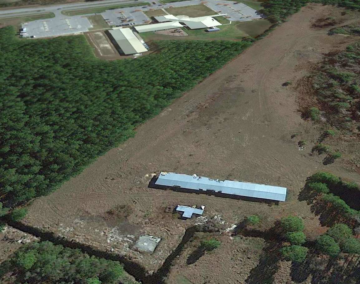
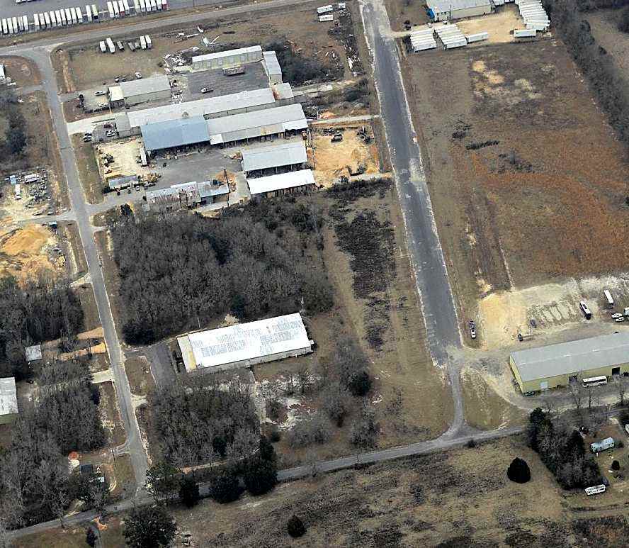
A 2012 aerial view looking southeast showed the runway & hangars remained intact at Buchanan STOLPort, but there were no aircraft visible or other signs of recent aviation usage.
The date of closure of Buchanan STOLPort has not been determined, but no airfield there is registered with the FAA as of 2015,
and it was no longer depicted on the 2015 USGS topo map.
Brian Beard reported in 2019, “The hangar is still there as well as the runway, but getting back to it requires a 4WD, [as there is a] big mudhole in the trail these days.”
The site of Buchanan STOLPort is located north of the intersection of Panama City Beach Parkway & Art Coleman Road.
Thanks to Nick Kaplan for pointing out this airfield.
____________________________________________________
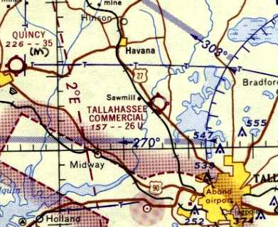
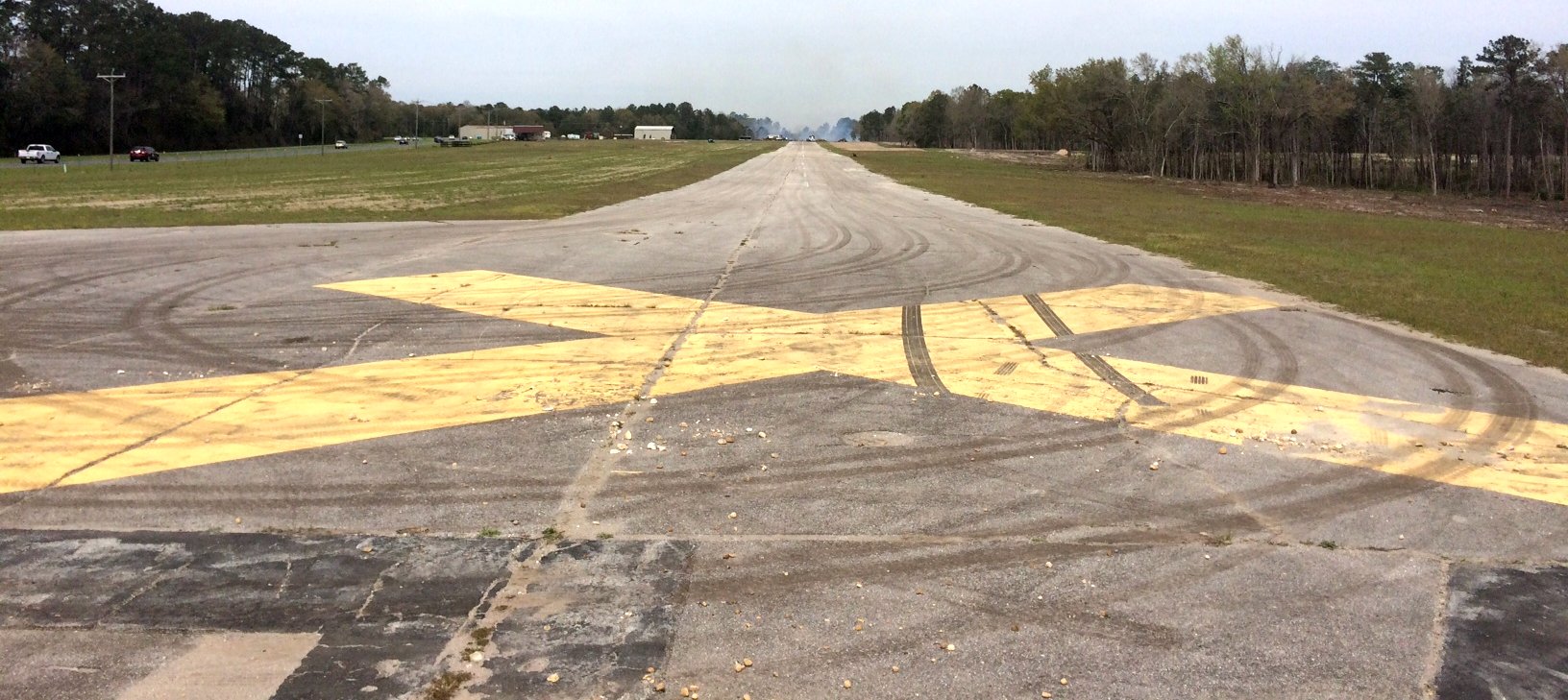
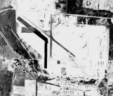
Lake Jackson Airport / Tallahassee Commercial Airport (68J), Tallahassee, FL
30.55, -84.37 (Northwest of Tallahassee, FL)

Lake Jackson Airport, as depicted on the January 1946 Mobile Sectional Chart.
Lake Jackson Airport was not yet depicted on the July 1945 Mobile Sectional Chart.
According to its FAA Airport/Facility Directory data, this small general aviation airport was established in October 1945.
The earliest depiction which is available of Lake Jackson Airport was on the January 1946 Mobile Sectional Chart.
It depicted Lake Jackson as a commercial/municipal airport.
The earliest photo which has been located of Lake Jackson Airport was a 1952 aerial view.
It depicted the field as having 2 unpaved runways, with a small building & a single-engine aircraft on the southeast side of the field.
Lake Jackson Airport was evidently renamed Tallahassee Commercial Airport at some point between 1946-63,
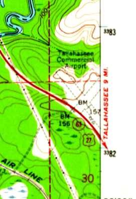
as that is how it was depicted on the 1963 USGS topo map, with 2 unpaved runways.
The 1964 Mobile Sectional Chart depicted Tallahassee Commercial Airport as having a 2,600' unpaved runway.
A 1967 aerial view depicted Tallahassee Commercial Airport as having 2 unpaved runways,
with 4 T-hangars & 5 single-engine aircraft along the west side of the field.
The 1968 Flight Guide (courtesy of Robert Levittan) depicted Tallahassee Commercial Airport
as having 2 unpaved 2,600' runways, and a few small buildings on the west & east sides.
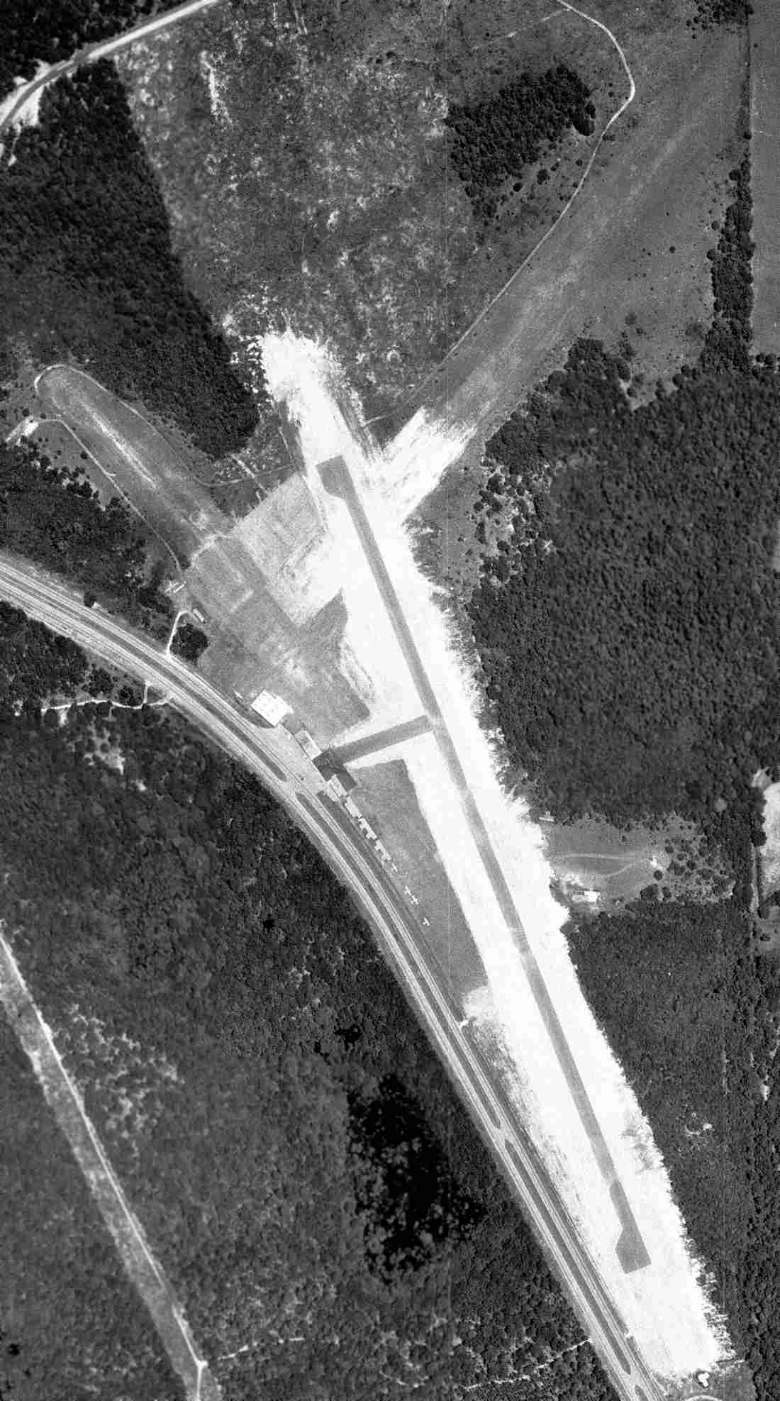
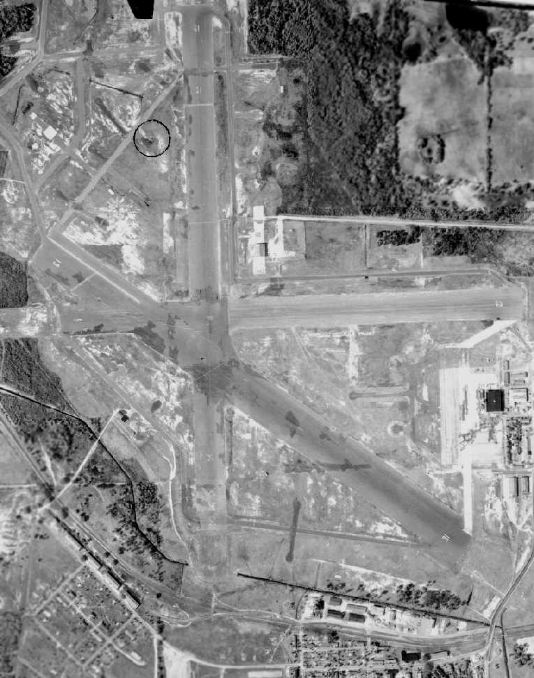
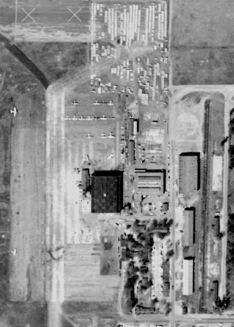
The earliest photo which is available of Tallahassee Commercial Airport was a 5/8/70 FL DOT aerial view (courtesy of David Henderson).
It depicted the field as having a newly paved northwest/southeast runway (which had replaced 2 unpaved runways),
and several small hangars & 5 single-engine aircraft on the west side.
Bill Walker recalled, “I have flown out of Tallahassee Commercial Airport before it closed.
That place was populated by some real cowboys.
One guy I saw, with about 100 hours, claimed he could take off in a 172, clear a 50' obstruction, and land, on that little runway.
Damn sure did it, too. I was ready to go dig him out of the trees.”
The 1983 USGS topo map showed that Tallahassee Commercial's Runway 16/34 was paved at some point between 1967-83.
Steve Christmas recalled, “In 1983 I flew my first 6 hours primary [flight instruction] out of Tallahassee Commercial Airport.
Mr Hinson had an instructor named Michael Hurley. We flew a Cherokee 140 hangared in the Piper logo hangar.
The runway was rough paved but the airport was great. Mr Hinson's family ruled the place with an iron fist.
I last flew out of there in 1989 or 1990 in their Tomahawk.”
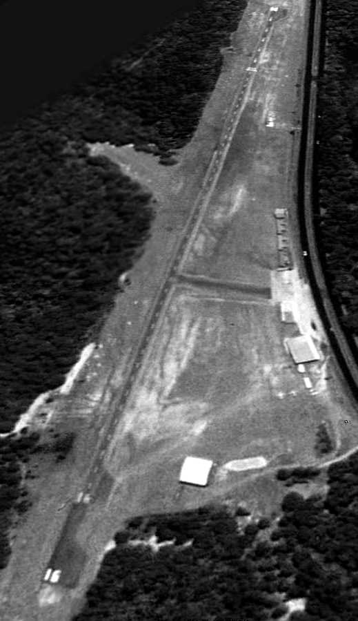
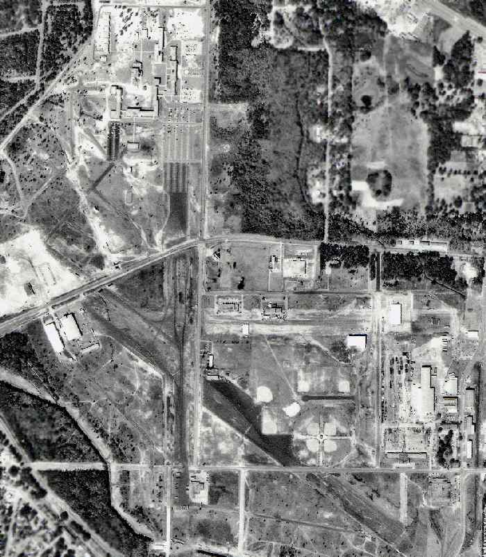
A 3/2/92 USGS aerial view looking southeast depicted Tallahassee Commercial Airport as having a unpaved Runway 16/34,
with a several small hangars & 2 single-engine aircraft on the west side.
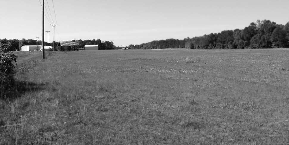
A 4/7/07 photo looking north at Tallahassee Commercial's runway & buildings.
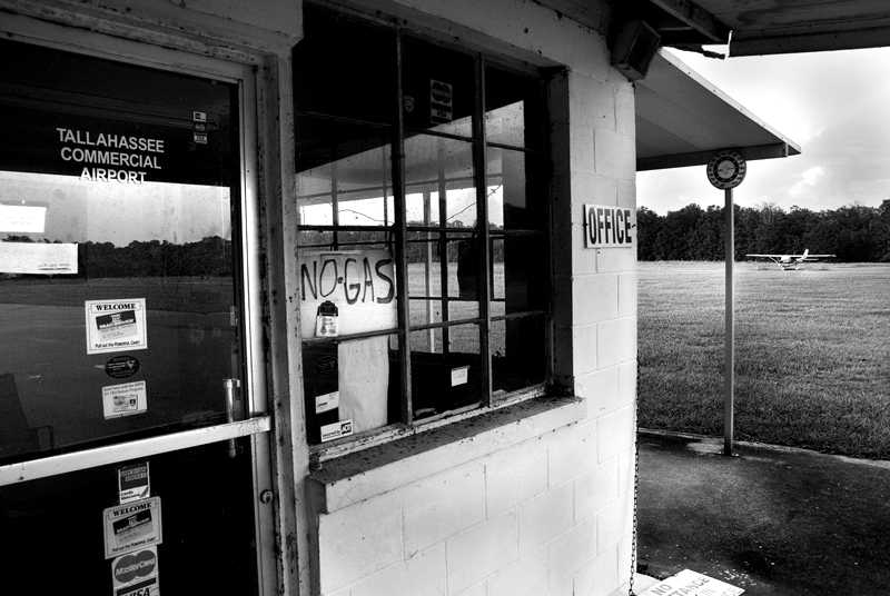
A 2009 photo showed the Tallahassee Commercial Airport office, with a Cessna in the background.
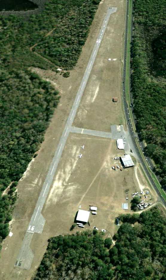
The last photo which has been located showing Tallahassee Commercial Airport while still open was a 1/30/09 aerial view looking southeast.
It showed that the threshholds had been displaced on both ends, decreasing the runway length.
Two single-engine aircraft were still visible on the west side.
Most of the T-hangars along the west side of the field had been removed at some point between 1992-2009.
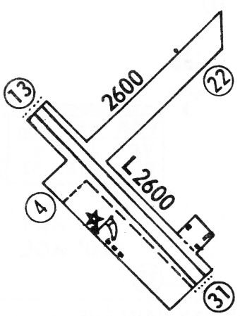
The last aeronautical chart depiction has been located of Tallahassee Commercial Airport was on the 2009 Jacksonville Sectional Chart.
It depicted Tallahassee Commercial as having a 3,200' paved northwest/southeast runway.
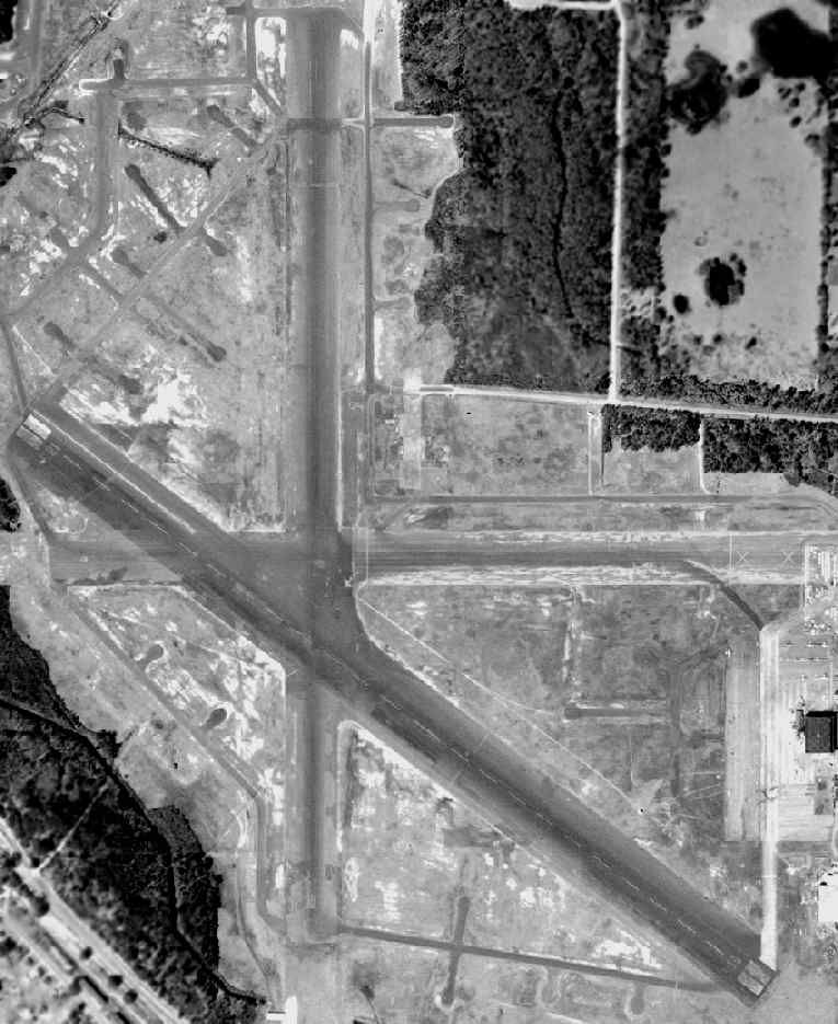
Tallahassee Commercial Airport was evidently closed at some point between 2009-2010,
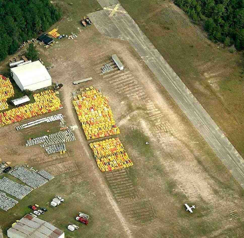
as a 12/30/09 aerial view showed closed-runway X symbols painted along the runway,
and showed large numbers of yellow objects stored to the west of the runway.
Jamie Peate reported of the yellow objects stored on runway, “We drove by frequently.
The items were oil & debris containment booms, etc. that were used during the BP Deepwater Horizon oil spill.
They used the field at the end/side of the airport as a storage area for several months during the cleanup effort.
Not sure why they used Tallahassee since it is not actually on the coast, but I guess close enough.”
A circa 2010-2011 aerial view looking north at Tallahassee Commercial Airport
showed a closed-runway X symbol painted on the runway,
but a solitary Cessna was evidently “stranded” on the field (presumably not airworthy).
Large numbers of oil containment booms were stored to the west of the runway.
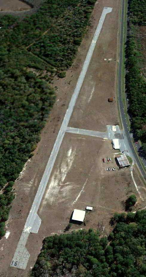
The last photo which has been located showing Tallahassee Commercial Airport was a 1/14/12 aerial view looking southeast.
The oil containment booms previously being stored on the field in 2010 had been removed, and the airport remained otherwise intact.
In 2013 the FAA Airport/Facility Directory data described Tallahassee Commercial Airport as having a single 3,249' asphalt Runway 16/34,
“in poor condition”, with “surface cracking”.
The field was said to have 10 based aircraft, and as of 2010 was said to conduct an average of 50 takeoffs or landings per week.
The owner was listed as J.W. Hinson Jr., and the manager listed as Jonnie Stephens.
However the airport use was listed as “Closed Indefinitely”.
Aidan Brainard reported of Tallahassee Commercial Airport in 2013, “Grass is growing through the runway cracks.”
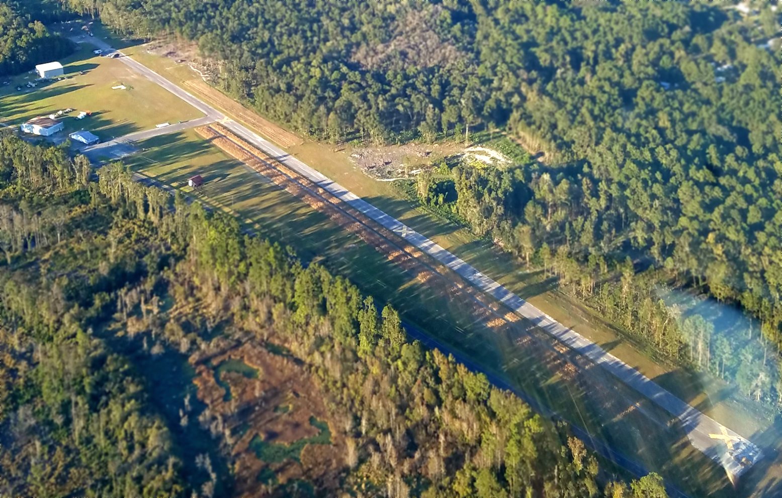
A 10/26/17 aerial view by Alex Melia looking north at Tallahassee Commercial Airport.
Alex reported, “We landed a few miles away at Quincy & asked the old timers.
A log company now owns it & has equipment parked on the runway. On the north side there are cords of trees parked on the threshold.”
A 3/10/18 photo by Matt Franklin looking northwest along the former Tallahassee Commercial Airport runway.
Maytt observed, “I reckon I could have the runway cleared in about an hour with a shovel. They were burning trees on one end of it.”
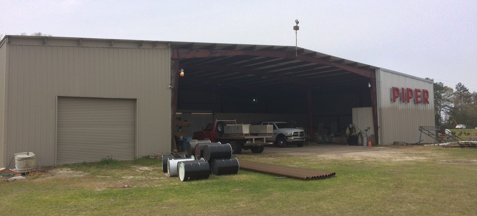
A 3/10/18 photo by Matt Franklin of the former Tallahassee Commercial Airport hangar, still marked with “Piper” lettering.
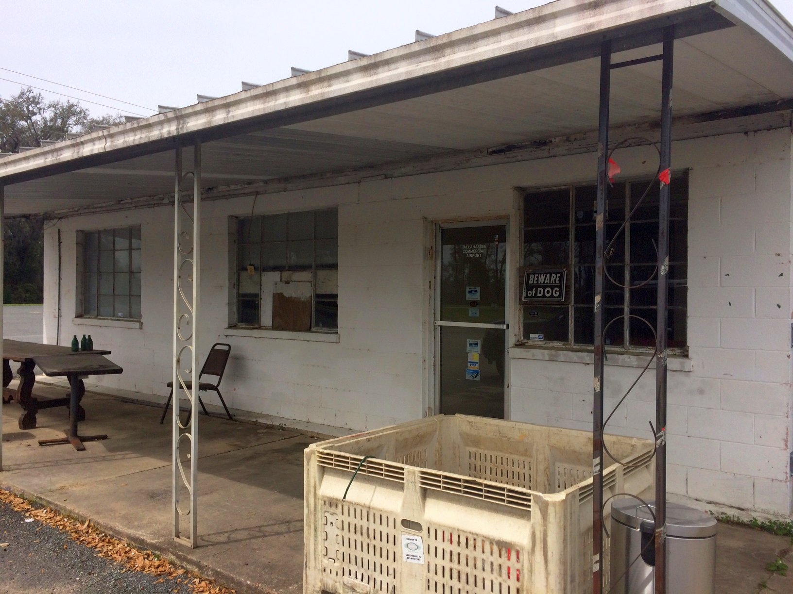
A 3/10/18 photo by Matt Franklin of the former Tallahassee Commercial Airport office.
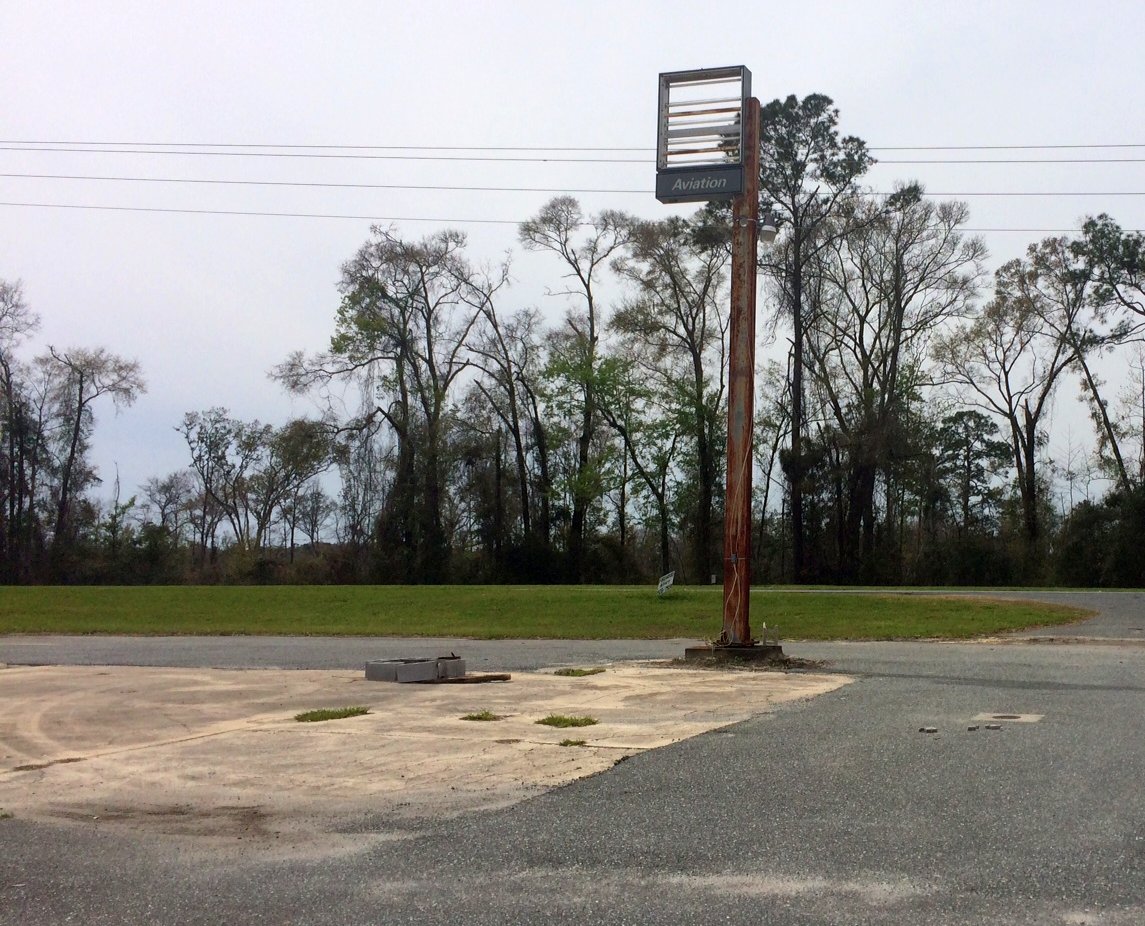
A 3/10/18 photo by Matt Franklin of the former Tallahassee Commercial Airport sign.
A 3/10/18 photo by Matt Franklin of the ruins of an unknown building at the former Tallahassee Commercial Airport.
Tallahassee Commercial Airport is located north of the intersection of North Monroe Street & Box Wood Lane.
____________________________________________________
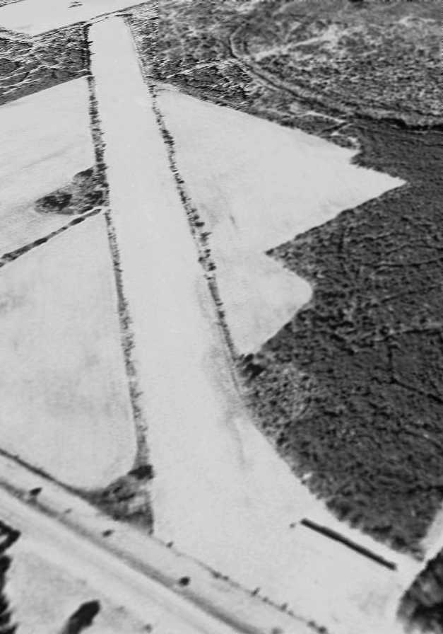
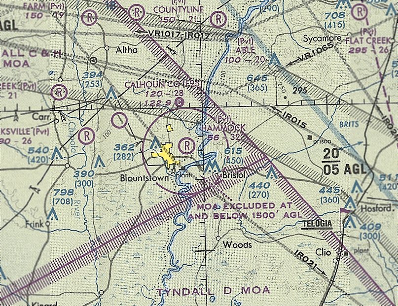
Blountstown Airport (0J9), Blountstown, FL
30.45, -85.02 (West of Tallahassee, FL)
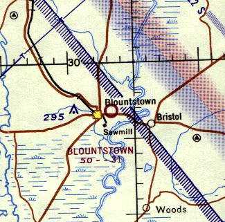
Blountstown Airport, as depicted on the 1964 Mobile Sectional Chart.
This small general aviation airport evidently was established at some point between 1961-64,
as it was not yet depicted on a 1957 aerial photo (courtesy of Dallam Oliver-Lee)
nor on the February 1961 Mobile Sectional Chart.
The earliest depiction which has been located of Blountstown Airport was on the 1964 Mobile Sectional Chart.
It depicted Blountstown as having a 3,100' unpaved runway.
Bill Walker recalled, “In 1963 my family moved to Tallahassee.
With extended family in Panama City, we traveled Highway 20 regularly.
As soon as you come off the bridge spanning the Apalachicola River (westbound), on the right was the strip, and on the left was the Airport Hotel.
I always thought the name of the hotel was a tad overambitious, since the strip was nowhere near being a proper airfield.
I very distinctly remember the strip being at right angles to the highway.
And I don't believe this smaller strip being anywhere 3,000'. It couldn't be over 1,000'.
One reason I remember is the hotel was directly under northbound approach (roughly 360).
And the highway was on an about 15-20' berm, due to the proximity of the river, with its flood issues, which would further complicate the approach.”
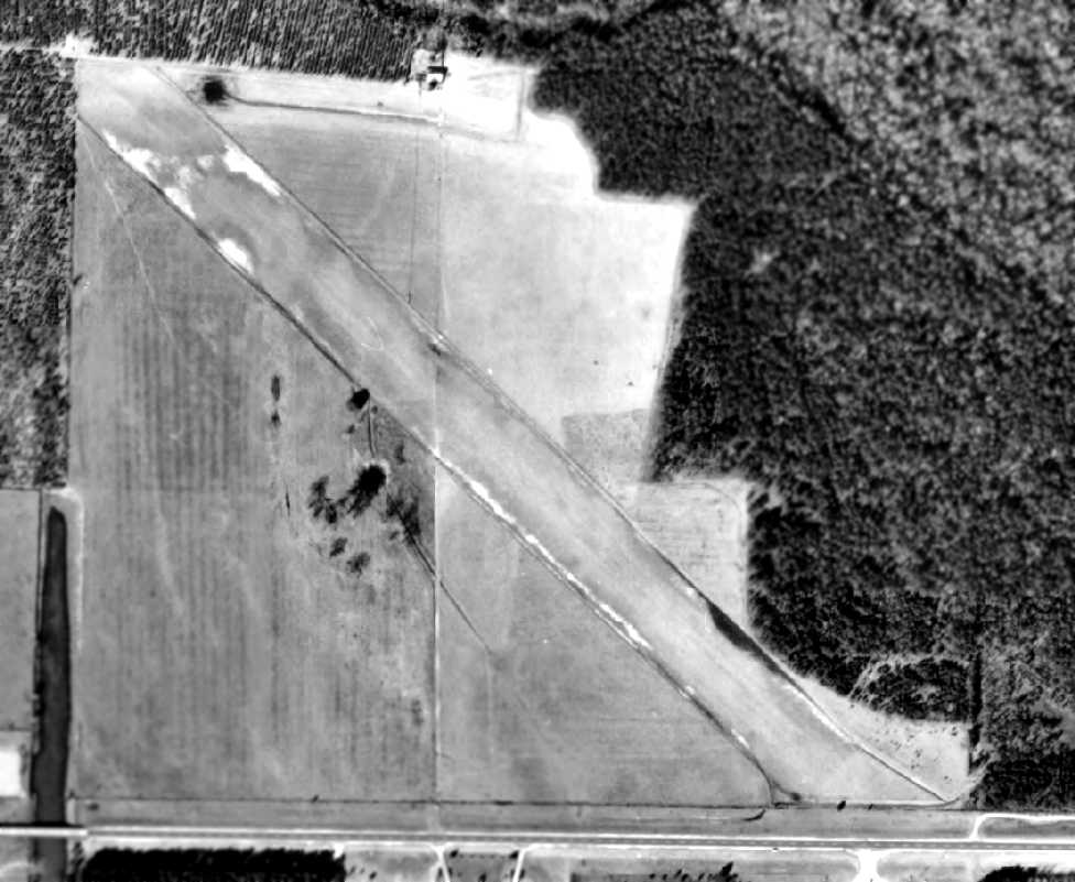
The earliest photo which has been located of Blountstown Airport was on a February 1964 aerial view (courtesy of Dallam Oliver-Lee).
It depicted Blountstown as having a single unpaved northwest/southeast runway.
No hangars or aircraft were visible on the field.
Blountstown Airport still was not depicted on the 1979 USGS topo map (according to Dallam Oliver-Lee).
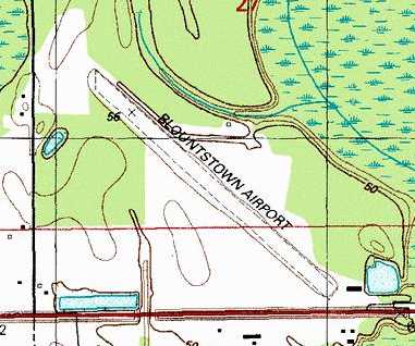
The 1990 USGS topo map (courtesy of Dallam Oliver-Lee) depicted Blountstown Airport
as having a single unpaved northwest/southeast runway, with a single building (hangar?) on the southeast side.
The June 1993 New Orleans Sectional Chart (courtesy of Ron Plante) depicted Blountstown Airport as having a 3,200' unpaved runway.
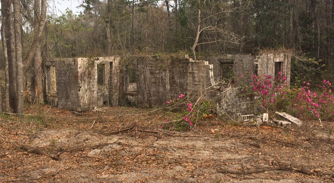
A 2/14/94 USGS aerial view looking northwest along Blountstown's runway showed the building at the southeast corner.
Use of Blountstown Airport as a public-use airport may have ended “around 1996 when Calhoun County Airport opened”, according to Dallam Oliver-Lee.
At some point between 1993-99, Blountstown Airport evidently was repurposed as a private airfield named “Hammock”,
as that is how it was depicted on the June 1999 New Orleans Sectional Chart (courtesy of Ron Plante).
It depicted Hammock Field as having a 3,200' unpaved runway.
The building at the southeast corner of Blountstown Airport was evidently removed at some point between 1994-98,
as only its foundation was visible on a 1998 aerial photo & later photos.
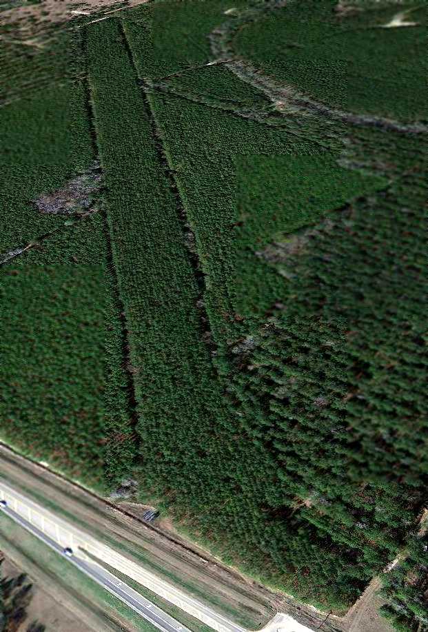
Hammock Field was evidently closed at some point between 1999-2012,
as a 1/3/12 aerial view looking northwest showed the outline of the runway to remain recognizable,
even though the surface was covered with pine trees planted after the airport's closure.
The foundation of the building at the southeast corner was also still barely recognizable.
Aidan Brainard reported in 2013, “Across Highway 20 from this former airport, there is a small hotel called the 'Airport Hotel'."
Kevin Fleming reported in 2015, “I drive by the old Blountstown airstrip often.
The overgrowth mentioned [in the caption of the 2012 photo] was actually planted pines.
I say 'was' because they recently clear-cut them, and it looks like the old airstrip again, sort of!”
The site of Blountstown Airport is located northeast of the intersection of Route 20 & Mason Road.
____________________________________________________
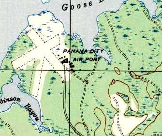
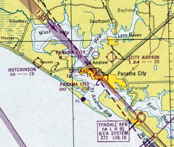
Atkinson Field / Panama City Airport, Panama City, FL
30.22, -85.69 (Southwest of Tallahassee, FL)
The original Panama City Airport, as depicted on the September 1936 Mobile Sectional Chart.
The date of establishment of Atkinson Field has not been determined.
Atkinson Field reportedly began as a private field owned by Panama City citizen J.B. Atkinson, Jr.
The facility consisted of 292 acres with grass runways.
In 1932, Atkinson donated the property to the Panama City Chamber of Commerce so that a city airport could be established.
At that time the airport was named Atkinson Field.
An article entitled “Panama City Gets Modern Airport; will accommodate both land & seaplanes” appeared in the 11/17/32 Panama City Pilot:
“Possibly nothing of the year is quite equal to the magnanimous gift to the city of the site for ;the municipal airport.
This gift was made Wednesday afternoon by Mr. & Mrs. J. B. Atkinson.
The site which lies just north of St. Andrews 3/4 of a mile from the the gulf coast near Pretty Bayou,
is a tract of 292 acres, a beautiful level plateau, touching the bayou & giving to the port excellent field for the land planes
with North Bay as a landing for seaplanes in the finest harbor in the South.
The seaplanes may land in North Bay & taxi into the bayou in the roughest weather.
The city commission through the Federal Employment Relief Board has been assured that could a proper site be secured,
Federal funds would be available for the complete development of the port.”
The article continued, “It is understood the the streets leading to the port will be hard surfaced immediately.
And that within 10 days actual work will begin & rushed to completion.
This has been one of Panama City's greatest needs. And the public spirited generosity of Mr. & Mrs. Atkinson is greatly appreciated.
It is most appropriate that the field should be named Atkinson Municipal Airport.
For the generosity of Mr. & Mrs. Atkinson at this time makes possible the immediate opening of the field,
which in all probability would have been delayed for some time because of the city's present financial situation would not allow the purchase of the valuable property.”
The 1/1/36 Department of Commerce Airway Bulletin (courtesy of Brian Rehwinkel) described “Panama City Airport”
as a municipal field located 5 miles northwest of the center of the city.
It was said to be an irregular sod field containing two 1,800' runways, oriented northwest/southeast & northeast/southwest.
A hangar on the north side was said to have “Panama City” on the roof.
The earliest depiction which has been located of Panama City Airport was on the September 1936 Mobile Sectional Chart.
It depicted Panama City Airport as a commercial/municipal airport to the northwest of Panama City.
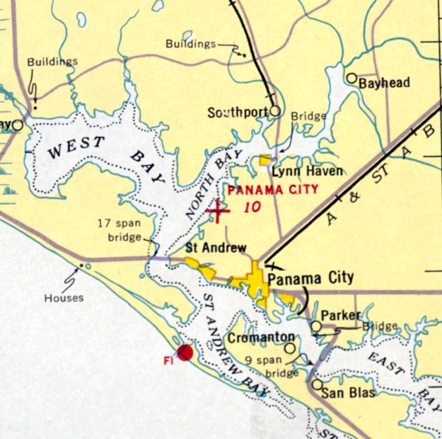
Panama City Airport was depicted on the July 1940 Mobile Sectional Chart as an auxiliary arfield.
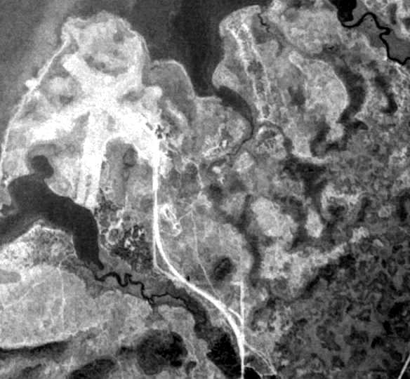
The earliest photo which has been located of Atkinson Field was a 11/3/42 USGS aerial view (courtesy of Brian Rehwinkel).
It depicted the field as having 3 unpaved runways.
Note that there was not yet any sign of the “new” airport which would eventually be constructed adjacent to the east side of the original airfield.
Throughout World War II, Panama City Airport was used as a Civil Air Patrol facility.
The 1945 AAF Airfield Directory (courtesy of Scott Murdock) described Panama City Municipal Airport
as a 360 acre irregularly-shaped property having 3 sand & sod runways, the longest being the 1,900' north/south & northwest/southeast strips.
The field was said to have a single 120' x 50' wood hangar,
to be owned by Bay County & the City of Panama City, and to be operated by private interests.
The last aeronautical chart depiction which has been located of the original Panama City Airport was on the August 1946 Mobile Sectional Chart.
It depicted “Panama City” as a commercial/municipal airport.
Robert Wilson recalled, “The original Panama City airport was located at the north end of Frankford Avenue.
I landed there once in about 1946/47. [It had a] lighted grass runway.”
The last depiction which has been located of Atkinson Field was on a 1947 Army Map Service map (courtesy of the University of Alabama online Map Library).
It depicted “Panama City Air Port” as having 3 unpaved runways.
The original Panama City Airport evidently closed at some point between 1947-49,
after being replaced by the new & larger Bay County Airport / Fannin Field located to the southeast,
as depicted on the February 1949 Mobile Sectional Chart.
It is not known why the replacement airport didn't incorporate the original airfield,
but it is possible that the location of the original airfield, squeezed into a narrow spit of land, did not offer room for longer runways.
A 1/2/53 USDA aerial photo (courtesy of Brian Rehwinkel), “that shows the new airfield, along with the abandoned (old) airfield to the northwest.”
The 1957 USGS topo map no longer depicted Atkinson Field, just a clearing.
The last photo which has been located showing any trace of the original Atkinson Field
was a 1/8/64 USDA aerial photo (courtesy of Brian Rehwinkel).
The 3 grass runways of the original field were still perceptible.
The 1/19/94 USGS aerial photo showed that a road (Frankford Avenue) had been built at some point between 1964-94 across the site of Atkinson Field,
and no trace was recognizable of the former runways.
Ironically, almost 50 years after Atkinson Field had closed, aviation at this site came full-circle in 1993,
when the “Heli-Tech Inc Heliport” (99FD) was established on the southeast corner of the former Atkinson Field property.
A circa 2006-2010 aerial view looking south at the Heli-Tech Inc Heliport which sits at the southeast corner of the Atkinson Field site.
The heliport was still operational as of 2010, engaged in the business of overhauling light civilian helicopters.
A 11/13/07 aerial view shows no recognizable trace remaining of Atkinson Field,
although the Heli-Tech Inc Heliport is located on the southeast corner of the site.
____________________________________________________
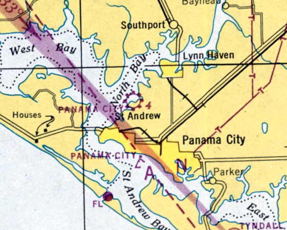
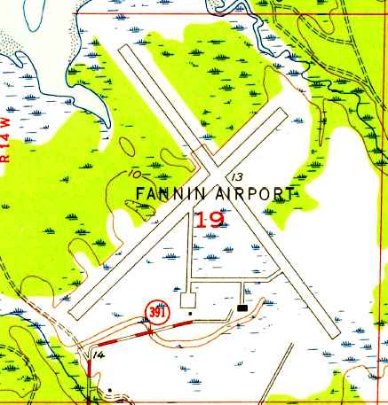
Fannin Field / Panama City Bay County International Airport (KPFN), Panama City, FL
30.21, -85.68 (Southwest of Tallahassee, FL)
Panama City Bay County Airport, as depicted on the February 1948 Mobile Sectional Chart.
Panama City's original airport, Atkinson Field, was geographically constrained on a narrow spit of land.
Panama City & the Bay County Commissioners joined forces to develop a more-capable airport.
The facility’s $604,000 development project included the construction of a small passenger terminal & two 4,000' intersecting runways,
located adjacent to the east side of the original Atkinson Field.
After construction was completed, the new airport was named Fannin Field in honor of the Panama City mayor during this period.
In 1943, the Florida legislature approved the formation of an airport authority,
the Panama City-Bay County Airport & Industrial District, to manage Fannin Field.
Fannin Field was not yet depicted on the 1943 USGS topo map.
Fannin Field was established in 1945, according to a historical marker at the site.
Fannin Field was not yet depicted on the February 1947 Mobile Sectional Chart.
Commercial operations at Fannin Field commenced in 1948.
At some point between 1945-48 the airport was renamed Panama City Bay County Airport.
The earliest depiction which has been located of Panama City Bay County Airport was on the February 1948 Mobile Sectional Chart.
It depicted Bay County Airport as having a 4,000' paved runway.
The earliest photo which has been located of Bay County Airport was a 1/2/53 USDA aerial photo (courtesy of Brian Rehwinkel),
“that shows the new airfield, along with the abandoned (old) airfield to the northwest.
This 1953 photo shows the 'new' field with only one runway - a paved runway situated southwest/northeast.
The photo also shows what looks to be a small building to the southeast of the runway.”
The 1956 USGS topo map depicted Fannin Airport as having 2 perpendicular paved runways & taxiways leading to a ramp & 2 small buildings on the south side.
A 1956 aerial view of Bay County Airport (courtesy of Brent Mooney), showing where the terminal soon would be constructed.
Bay County Airport gained a crosswind runway, an expanded ramp, and several hangars at some point between 1953-64,
as depicted on a 1/8/64 USDA aerial photo (courtesy of Brian Rehwinkel).
According to a historical marker at the site, Panama City's control tower was erected by FAA in 1967.
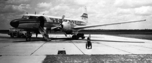
The earliest photo which has been located of an aircraft at Fannin Field was a 1969 photo (courtesy of Brent Mooney) of a National Airlines Convair 440.
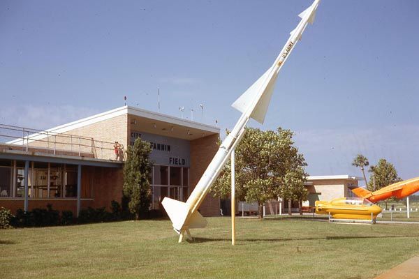
A 1969 photo of the Fannin Field terminal building (courtesy of Brent Mooney), with a static display in front of a Nike Ajax surface-to-air missile,
what appears to be some type of small submarine, and a Ryan Firebee drone.
Panama City continued to be served by commercial airlines throughout the regulated period of airline history,
until the passage of the Airline Deregulation Act of 1978.
During the 1970s & 1980s, the airport had many airlines serving the facility with jet aircraft.
However, the flight service offered was mainly point-to-point, therefore there were few destinations offered,
and, in turn, passenger enplanements were relatively low.
The 1982 USGS topo map depicted “Panama City Bay County Airport Fannin Field” as having 2 perpendicular paved runways
with parallel taxiways & a ramp on the south side.
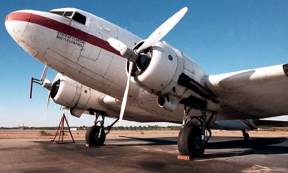
A January 1988 photo by Javier Bobadilla at Panama City Airport of a 1945 Douglas VC-47D Skytrain (N843DD, cn 32286) used by the State of Florida to spray pesticides.
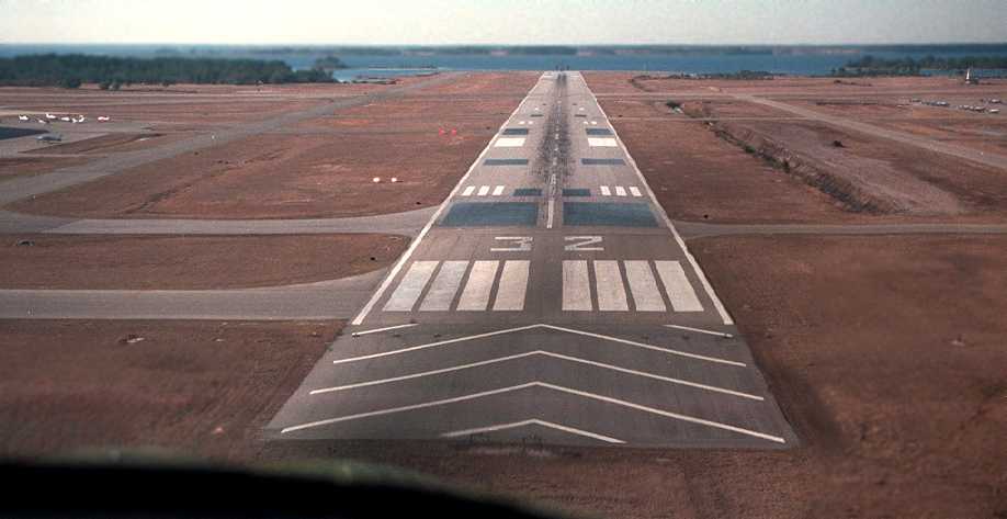
A February 1988 aerial view by Javier Bobadilla on final approach to Panama City's Runway 32.
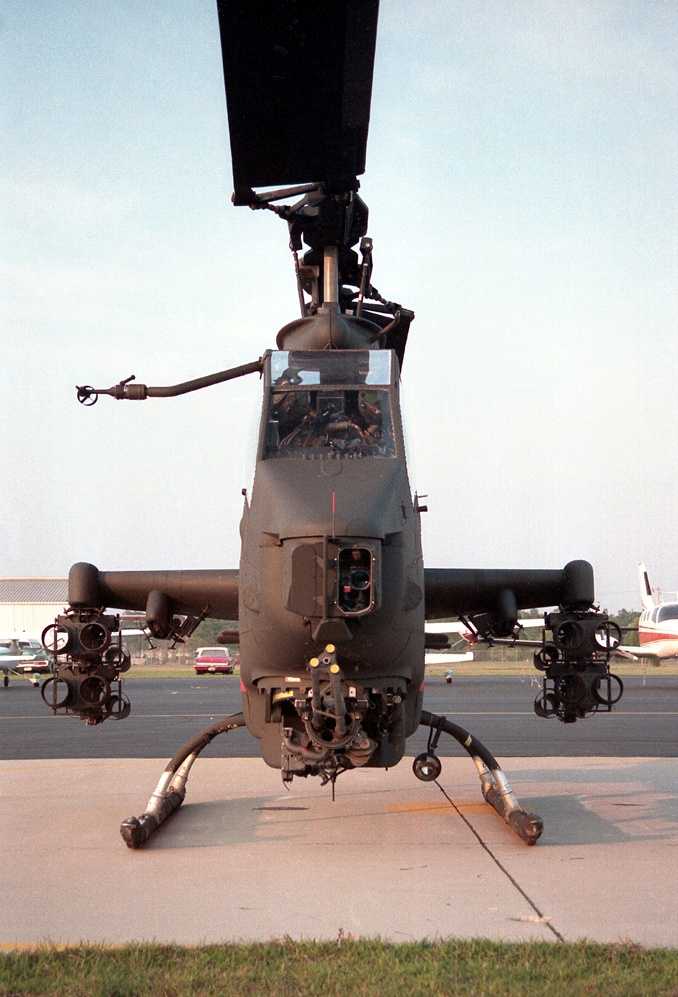
A May 1988 photo by Javier Bobadilla of a Ft. Rucker AH-1S Cobra refueling at Panama City's Bay Aviation.
In 1992, the airport was designated as an international airport & renamed Panama City-Bay County International Airport.
At this time, the airport was equipped with on-call customs & immigrations facilities provided through the Port of Panama City.
In addition, the airport was also declared a Foreign Trade Zone, a location which allows special customs procedures to be used.
These procedures permit domestic activity involving foreign items to take place as though they were outside of a U.S. Customs territory.
A 1994 USGS aerial view looking north depicted Panama City Airport as having 2 perpendicular paved runways with parallel taxiways,
and ramps on the south & east sides with several hangars.
In 1995, the airport went through an extensive development program,
demolishing their old terminal building & constructing a new 55,573-square-foot facility with 6 gate areas, 2 equipped with jetbridges.
Additional enhancements to the terminal included concession areas, a passenger hold room, airline ticketing counters & office space,
airport administration offices, public and rental car parking lots, and an expanded terminal apron.
Harvey Weir reported in 2010, “The primary FBO for many years was Sowell Aviation based on the west ramp,
but later sold out to Sheltair just a few years ago.
Bay Aviation was purchased by Sowell Aviation around the 2000 time frame, but only operated it as an FBO for a short time.
Sowell then leased the 'Bay Aviation' hangar to a maintenance facility.”
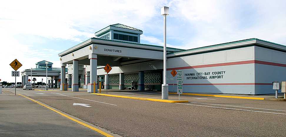
A 10/25/03 photo by Paul Robbins of the exterior of the new Panama City terminal building.
It served for only 15 years before the airport was closed.
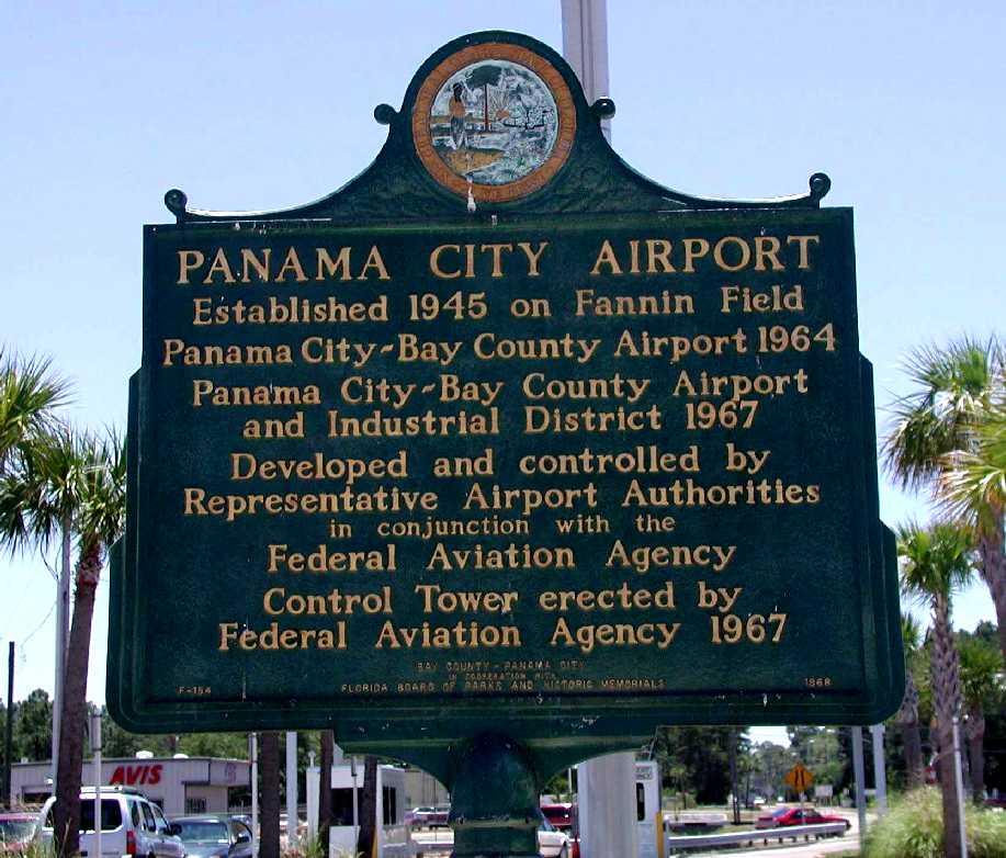
A 2006 photo of a historical marker.
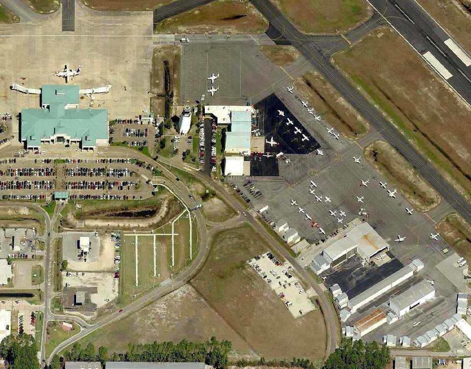
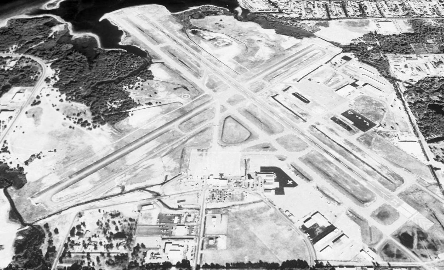
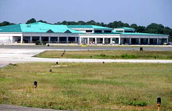
A circa 2006-2010 aerial view looking north at the busy ramp of Panama City Bay County International Airport.
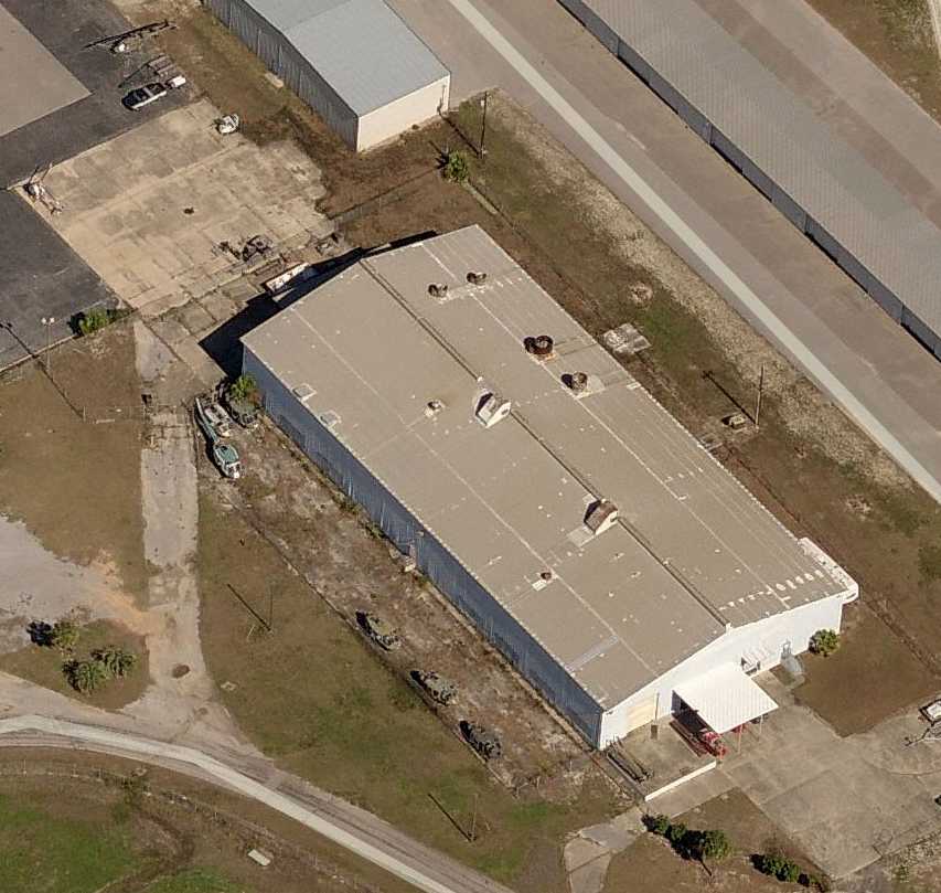
A circa 2006-2010 aerial view looking north at a hangar on the east side of Panama City Bay County International Airport
with 6 UH-1 Huey fuselages on the west side.
Due to the lack of adjacent room for further expansion of Panama City-Bay County International Airport,
in 2007 construction started on a new airport to the northwest (Northwest Florida Beaches International Airport) to replace the original field.
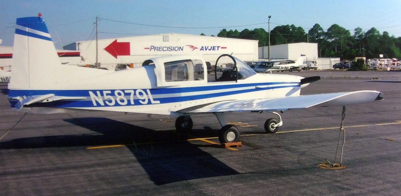
Bill Fusselman recalled, “Panama City/Bay County International Airport...
I rented planes from Precision Avjet & also kept my 1972 Grumman AA5 Traveler there after I bought it in 2007.
Precision Avjet was owned by Jeff Kish & his wife Ellen Rodeman Kish.
Jeff was an absentee owner, being a pilot with Delta Air Lines in Atlanta.
Although living in Atlanta, Jeff made frequent visits to Precision Avjet.
Precision Avjet, to the pilots who based there, was known as 'The Fun FBO.'
We pilots & the Precision Avjet staff, particularly the front counter girls, always joked & clowned around about something.
Rainy days were 'hang out' days & no matter the weather, we all had a good time inside the front counter area.
Sometimes, the staff dressed up in costume, say for Halloween. It was a wonderful time in the airport's history.
A Spring 2007 photo by Bill Fusselman of his 1972 Grumman AA5 Traveler
“in front of the Precision Avjet main building & maintenance hangar as seen from the Sowell Aviation General Aviation tiedown ramp.”
A 2007 aerial view of looking north at Panama City Bay County International Airport, showing many aircraft on its numerous ramps.
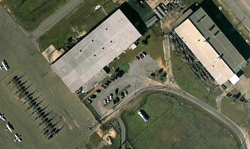
A 1/9/09 aerial view showing an amazing array of over 40 UH-1 Huey fuselages
on the east ramp & adjacent to a hangar on the east side of Panama City Bay County International Airport.
Harvey Weir reported in 2010, “The helicopters... a large number parked tail to tail.
Those were being completely overhauled, zero-timed, and fitted with 2 Allison turbines instead of the single engine.
The name of the company... might have been DynCorp. They were going to a foreign army, possibly down to Panama.
The company that was rebuilding them did not stay in that hangar very long ('Bay Hangar') and eventually the whole operation moved elsewhere.”
A Summer 2010 photo by Bill Fusselman “on final approach to Runway 32, Panama City/Bay County International Airport, in a Waco. I was passenger, the pilot was Terry Hagle.”
Harvey Weir reported, “The tower at PFN closed forever at 10 pm May 22
and all airline service was discontinued as well as all the instrument approaches including GPS approaches.
PFN was left without police and fire & rescue services when the tower closed as well.”
The new Northwest Florida Beaches International Airport opened 5/23/10,
with airline flights moving to the new airport.
Harvey Weir reported, “PFN then became a General Aviation airport only
and all based GA aircraft had to remain at PFN because there were no GA facilities available at the new airport.
When fuel services began at ECP [Northwest Florida Beaches International Airport], fuel services ended at PFN.”
A May-September 2010 photo by Harvey Weir of the exterior of the old 'Bay Hangar'.
Harvey remarked, “The hangar has been home to several FBOs including Bay Aviation, Sowell Aviation (as a second facility on the field)
and several maintenance facilities, including one that used it for Beech 1900 commuters.”
A May-September 2010 photo by Harvey Weir of the interior of the old 'Bay Hangar'. Harvey remarked, “Notice an airplane is left inside.”
A May-September 2010 photo by Harvey Weir of the Panama City terminal building.
Bill Susselman recalled, “On 8/9/10, I was forced to relocate my plane from KPFN to Blountstown Airport
because Precision Avjet was forced out of business as KPFN was closing & all planes had to vacate the airport.”
In its last year of operation (2010), the FAA Airport/Facility Directory statistics for Panama City listed a total of 139 aircraft based on the field,
which was said to conduct an average of 251 takeoffs or landings per day.
The field was described as having 2 asphalt runways: 6,308' Runway 14/32 & 4,884' Runway 5/23.
Harvey Weir reported, “GA was finally ordered to move off PFN by midnight 9/30/10 & the airport closed forever.
At the time of the airport closing, the FBOs on the field were Sheltair & Precision Avjet, both based on the west ramp.”
Bill Fusselman recalled, “We were all so sad when the airport closed!
This wonderful airport we all loved so much - It was a time never to be experienced again!”
The November 2010 Sectional Chart depicted Panama City Bay County International Airport
as having 2 paved runways, the longest being 6,300'.
The replacement airport was depicted to the northwest.
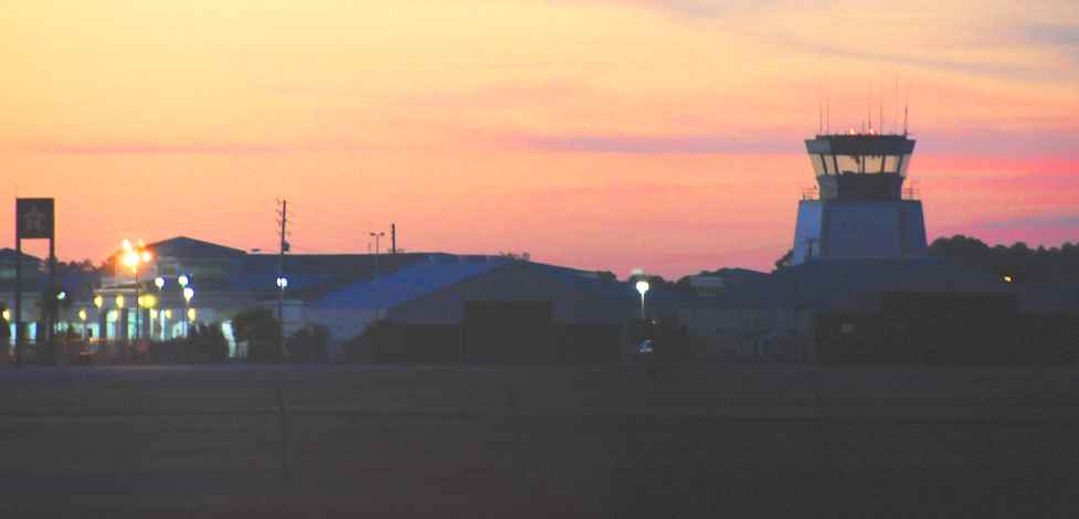
A 12/20/10 view over a sunset over the abandoned Panama City Bay County International Airport terminal & control tower.
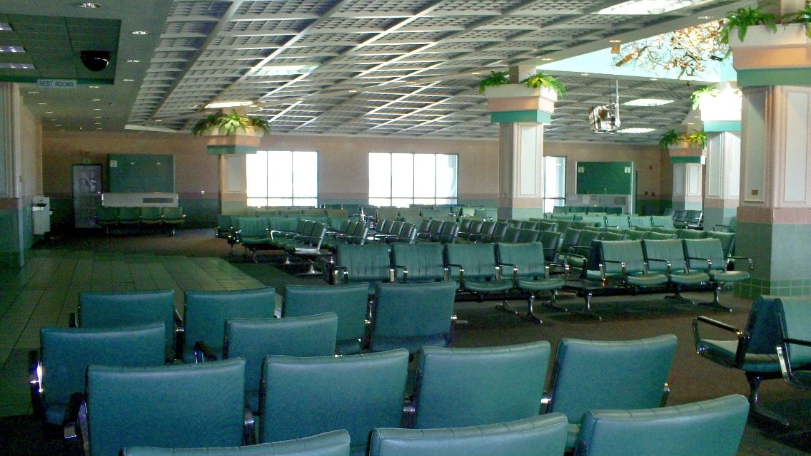
A 2011 photo of the interior of the abandoned Panama City Bay County International Airport terminal building (courtesy of Brent Mooney).
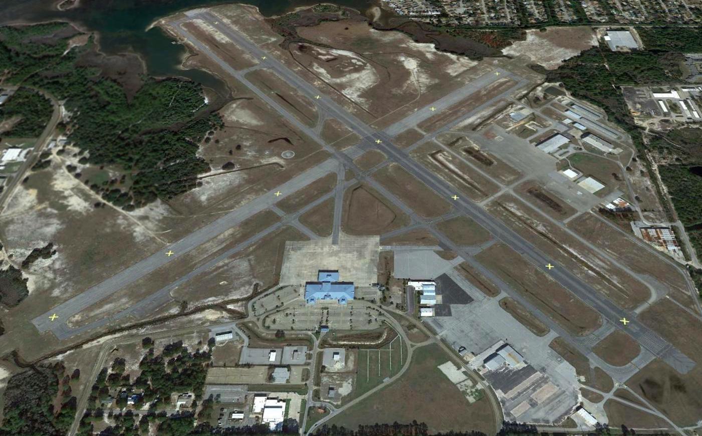
A 2012 aerial view of looking north at Panama City Bay County International Airport.
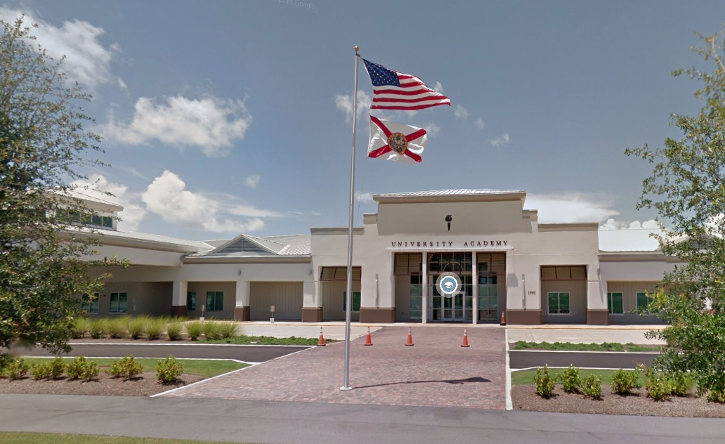
A June 2015 photo looking north at the former Panama City terminal building, reused as a school.
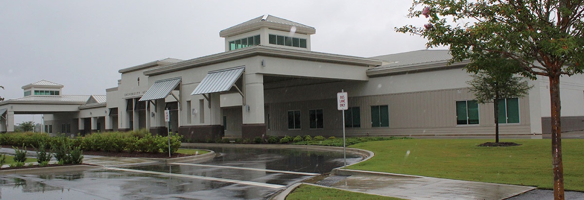
A 9/3/16 photo by Matt Franklin of the curbside of the Panama City terminal building.
Matt reported, “The terminal building has been turned into a school, and they left the back gate open to drive right onto the airport.
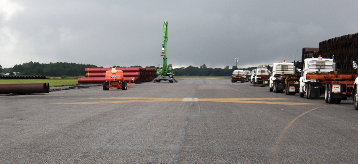
A 9/3/16 photo by Matt Franklin of the curbside of the Panama City terminal building.
Matt reported, “They’ve dug up some of the taxiways & part of the runways so I had to gingerly pick my way around, but one of the runways has been repurposed for holding miles of piping.”
A 9/3/16 photo by Matt Franklin of a former Panama City hangar.
Matt reported, “One of the FBO hangars has been repurposed for holding massive wire spools.
Some of the GA hangars are used by private businesses & the city,
and a housing development is encroaching on the airport from the south side, which I am sure will envelope the remainder of the airport.
The west ramp is pretty much gone.”
A 1/25/18 aerial view by Alex Price looking southeast at Panama City Bay County International Airport.
A 9/30/18 aerial view by Alex Melia looking northwest at Panama City Bay County International Airport,
showing the large swath of land which has been cleared over the southwest runway end and west of the former terminal building.
A 9/30/18 aerial view by Alex Melia looking southeast at Panama City Bay County International Airport.
A September 2019 photo looking north at a hangar which remains on the north side of the Panama City Bay County International Airport site.
A 9/25/22 aerial view by Karl Kuersteiner looking north at the Panama City Bay County International Airport site.
Karl observed, “The old terminal building is prominent in the lower left quadrant, and since the 2018 photo has been completely surrounded by houses.”
____________________________________________________
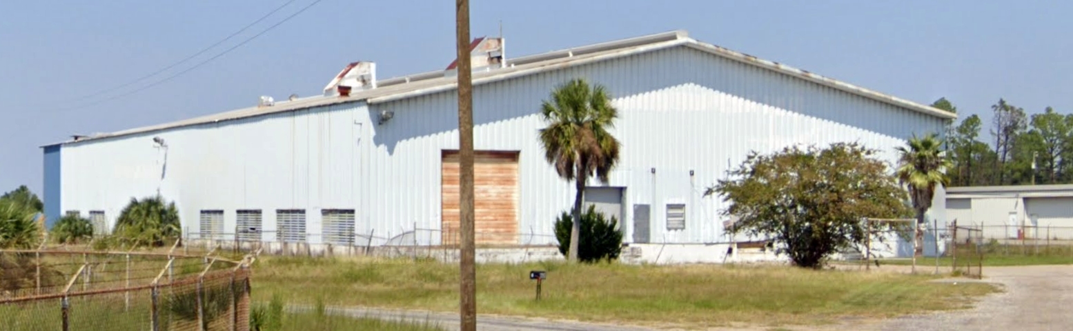
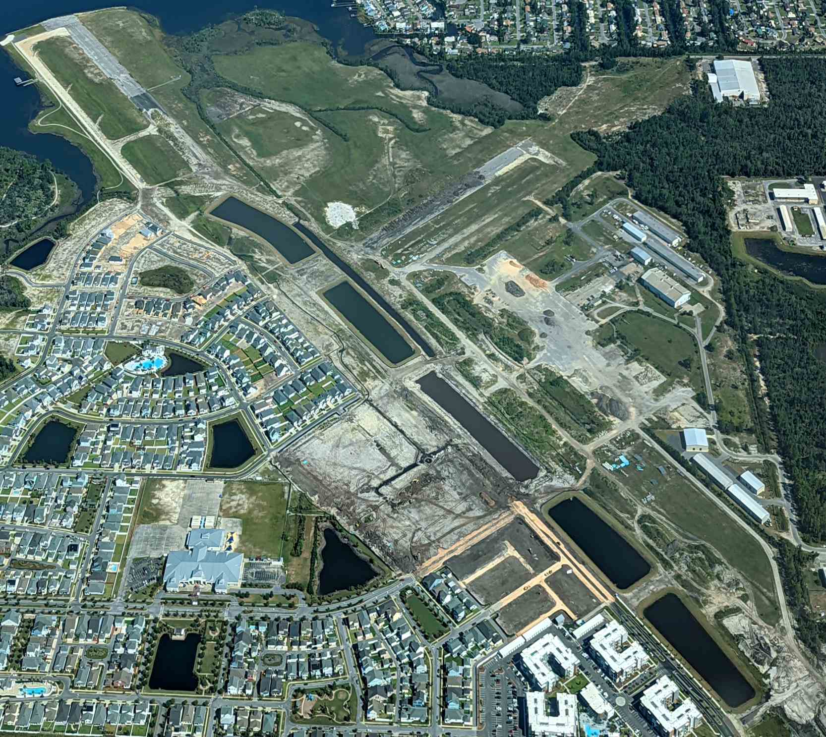
Chipley Municipal Airport, Chipley, FL
30.76, -85.52 (Northwest of Tallahassee, FL)
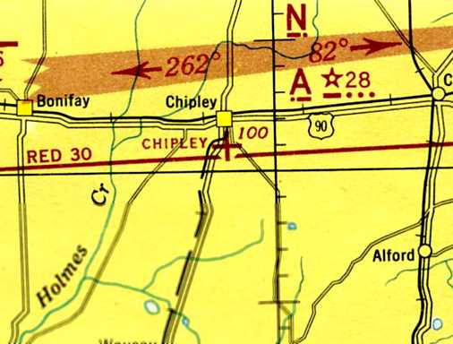
Chipley Municipal Airport, as depicted on the February 1945 Memphis Sectional Chart (courtesy of Chris Kennedy).
This small general aviation airport was evidently established at some point between 1944-45,
as it was not yet depicted on the January 1944 Mobile Sectional Chart.
The earliest depiction which has been located of the Chipley Airport was on the February 1945 Memphis Sectional Chart (courtesy of Chris Kennedy).
It depicted Chipley as an auxiliary airfield on the southeast side of the town.
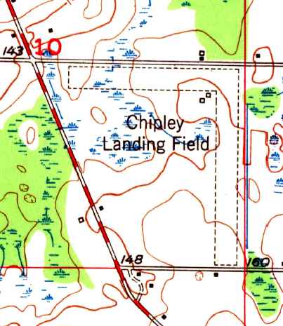
The 1950 USGS topo map depicted the Chipley Landing Field as having 2 unpaved runways, with 2 small buildings just southwest of the runway intersection.
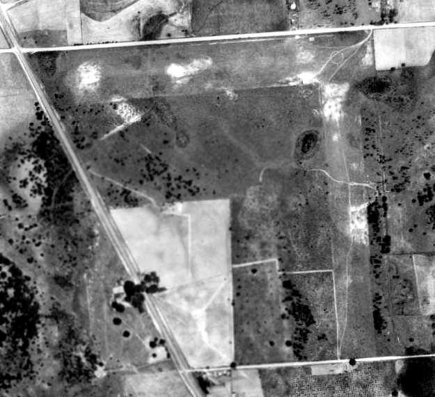
The only photo which is available showing the Chipley Airport while it was operational was a 1955 aerial view.
It depicted Chipley as having 2 perpendicular grass runways, with a circular airport marking visible at the runway intersection.
There did not appear to be an hangars or other buildings at the airport, and there were no planes visible either.
The 1964 Mobile Sectional Chart (courtesy of John Voss) depicted Chipley as having a 2,400' unpaved runway.
A 1966 aerial view showed Chipley Airport in an unchanged configuration.
Lindy Kirkland recalled, “I flew my first airplane flight from this field around 1970.”
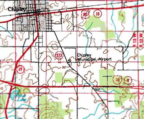
The 1976 USGS topo map depicted Chipley Municipal Airport as having 2 perpendicular runways.
The last aeronautical chart depiction which has been located of the Chipley Airport was on the December 1976 New Orleans Sectional Chart (according to Chris Kennedy).
It depicted Chipley as having a single north/south paved 2,300' runway, with the field having been paved at some point between 1966-76.
Lindy Kirkland recalled of the Chipley Airport, “I flew from it several times with a friend in the summer of 1981.
It was a very small runway, probably only 3,000', paved, with just some tie-downs in the grass around it was all that was there.
It closed between 1981 when I last flew from there, and around 1984 when the West Point plant & the industrial park was built.
The airport was replaced by the Tri County Airport (1J0) in Bonifay, a few miles to the northeast.”
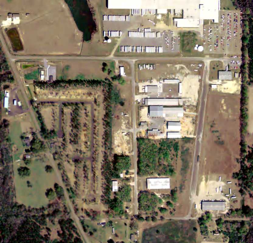
A 1984 aerial view showed the former Chipley Airport paved north/south runway marked with 2 yellow closed-runway “X” symbols,
and a large industrial building had been built adjacent to the northwest side.
A 1/4/94 USGS aerial photo showed that the north/south runway had been reused as a street,
and additional industrial buildings had been built around the former airport site.
A 12/30/04 aerial view showed the remains of the 2 Chipley runways still were recognizable.
According to Lindy Kirkland, “The buildings have all been built since the airport closed.”
A circa 2006 aerial view looking north along the remains of Chipley Airport's north/south paved runway.
Lindy Kirkland reported in 2009, “The area is now an industrial park with the primary tenant being West Point Stevens. They make curtains in the plant there now.”

A 2021 photo looking south along the former Chipley Airport north/south paved runway, reused as Roland Fowler Road.
The site of Chipley Airport is located southeast of the intersection of Orange Hill Road & Airport Road, appropriately enough.
Thanks to Lindy Kirkland for pointing out this airfield.
____________________________________________________
Bainbridge Auxiliary Army Airfield #3 / Faceville Field, Faceville, FL
30.7, -84.63 (Northwest of Tallahassee, FL)
A 4/27/43 aerial view looking east at Faceville Auxiliary Field (from the National Archives, courtesy of Brian Rehwinkel).
Faceville Field was evidently not a pre-war civilian airport, as it was not listed in The Airport Directory Company's 1937 Airports Directory (courtesy of Bob Rambo).
Faceville Field was used during WW2 as one of 6 satellite airfields for Bainbridge AAF, a training field for the 50,000 Pilot Training Program.
According to Brian Rehwinkel, a 1946-47 War Assets Administration report
described the Faceville auxiliary field property as having been acquired in 1942 & attached to Bainbridge AAF.
The field consisted of a total of 329 acres, including 311 acres acquired by the government for $13,022 & 17 acres of leased property.
The field had 2 runways, both "bituminous base, mixed-in-place" (apparently a very thin layer of asphalt):
a 3,800' north/south runway & a 3,600' east/west strip.
The field also had one building, described as being of "temporary construction, one story".
The total cost of the field - including acquisition cost & betterments - was $92,113.
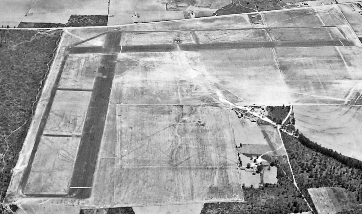
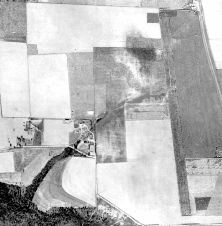
The earliest depiction which has been located of Faceville Field was a 4/27/43 aerial view (from the National Archives, courtesy of Brian Rehwinkel).
It depicted Faceville Field as having 2 asphalt runways, each with a parallel taxiway.
There did not appear to be any buildings or aircraft at the airfield.
Faceville Field was not yet depicted on the January 1944 Mobile Sectional Chart.
The 1944 US Army/Navy Directory of Airfields (courtesy of Ken Mercer) described Faceville Aux #3 as having a 3,000' hard-surface runway,
and the remarks said "Auxiliary to Bainbridge Field."
It also erroneously listed Faceville in the Georgia section of the directory, even though the field is entirely within the State of Florida
(with the northern end of the runway just a few feet south of the state line).
The 1945 AAF Airfield Directory (courtesy of Scott Murdock) described “Bainbridge AAF Auxiliary #3 (Faceville Field)”
as a 311 acre L-shaped property within which were 2 asphalt 3,000' runways, oriented north/south & east/west.
The field was said to not have any hangars, to be owned by private interests, and operated by the Army Air Forces.
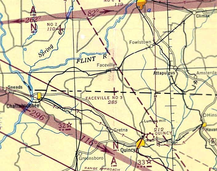
The earliest aeronautical chart depiction which has been located of Faceville Field was on the February 1945 Mobile Sectional Chart.
It depicted Faceville Aux #3 as an auxiliary field right on the GA/FL border.
According to Brian Rehwinkel, the 1946-47 War Assets Administration report
recommended the land be disposed of & returned to its "highest & best use" as "Farm Land".
A 3/17/47 USDA aerial photo of Faceville Aux #3,
from the Digital Library Center / University of Florida George A. Smathers Libraries (courtesy of Brian Rehwinkel).
In this photo it appeared as if the airfield had already been abandoned.
The outline of 2 runways was still quite apparent, as well as the much more faint trace of parallel taxiways along both runways.
There was no trace of any buildings or other facilities.
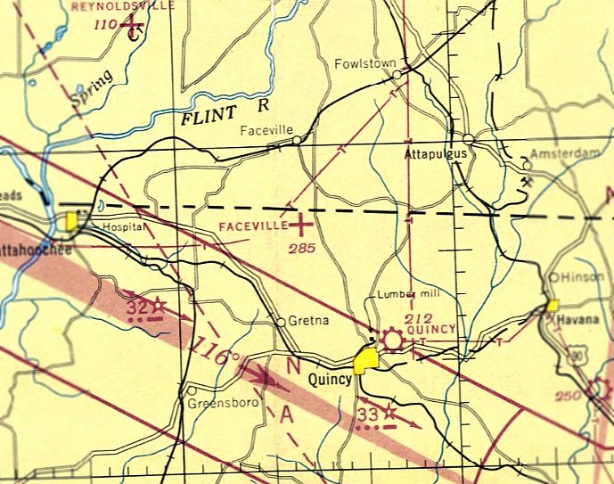
The last aeronautical chart depiction which has been located of Faceville Field was on the February 1947 Mobile Sectional Chart.
It dpeicted Faceville as an auxiliary field right.
Faceville Field was evidently closed at some point in 1947,
as it was no longer depicted on the August 1947 Mobile Sectional Chart.
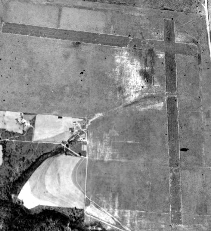
By the time of this 2/13/55 aerial view of Faceville Aux #3 from the FL DOT (courtesy of Brian Rehwinkel),
the east/west runway had been replaced by a plowed field, but most of the north/south runway remained intact.
Faceville Field was not depicted at all on the 1957 USGS topo map.
Brian Rehwinkel reported in 2003, "I have visited this site recently & it is (and has been) used for agricultural purposes.
There is nothing left of the runways."
A 4/1/13 aerial photo showed no trace remaining of Faceville Field.
The site of Faceville Aux #3 is located on the west side of Florida Route 267, 3 miles south of Faceville, GA.
Thanks to Brian Rehwinkel for pointing out this airfield.
____________________________________________________
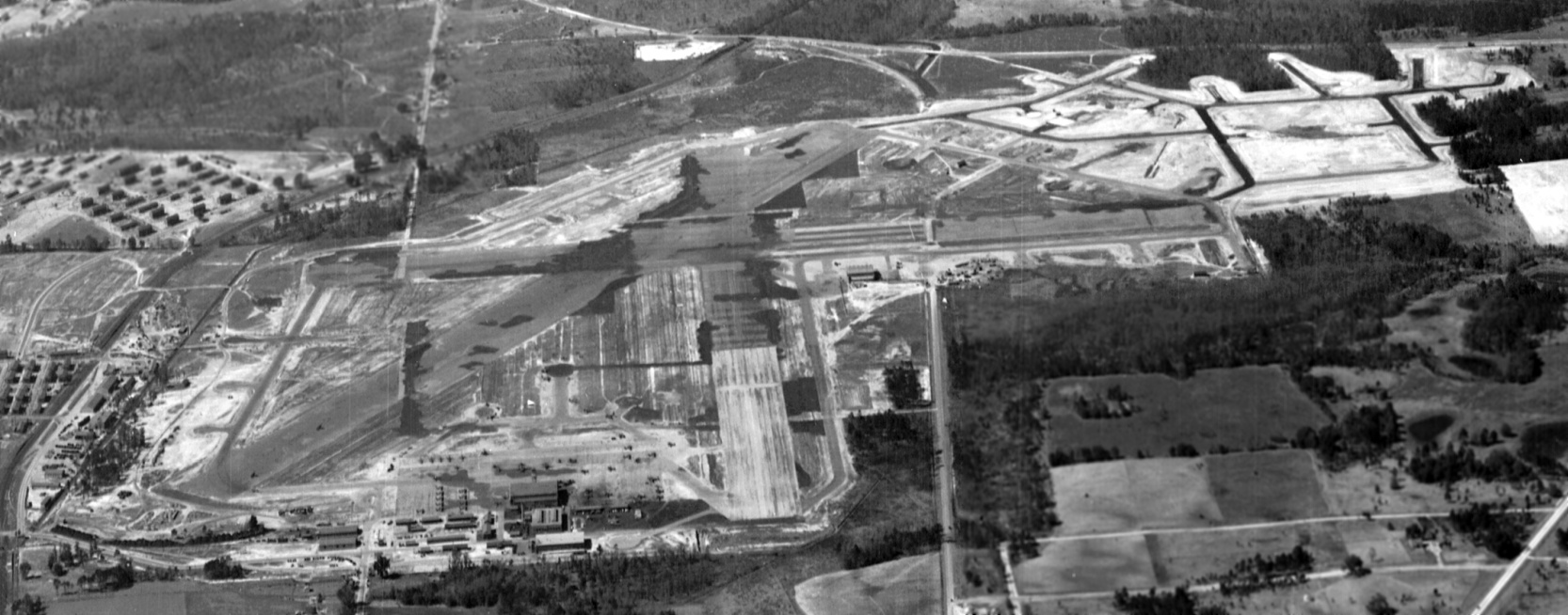
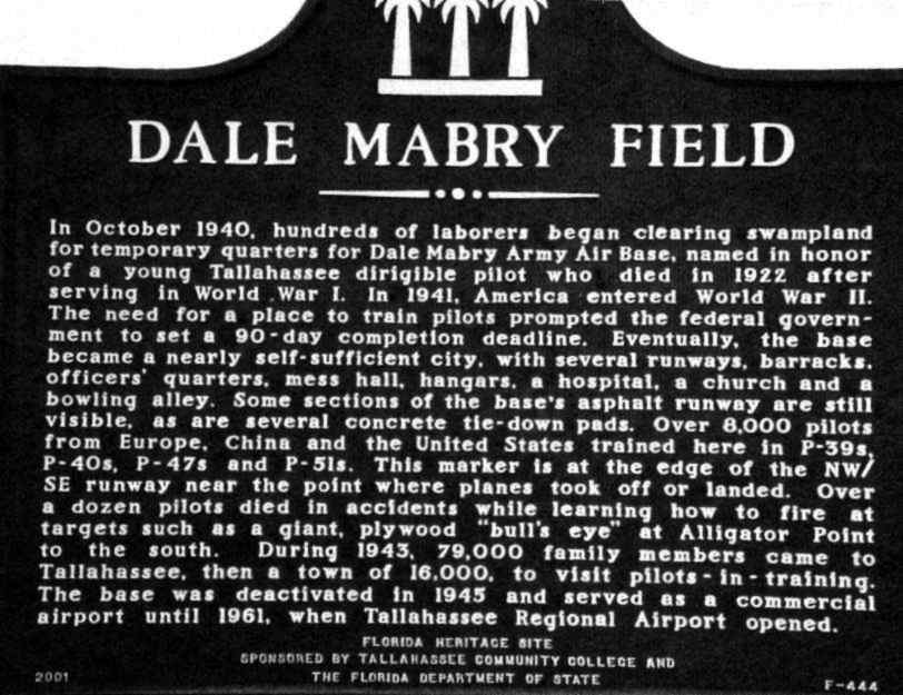
Dale Mabry Field, Tallahassee, FL
30.45, -84.34 (West of Jacksonville, FL)
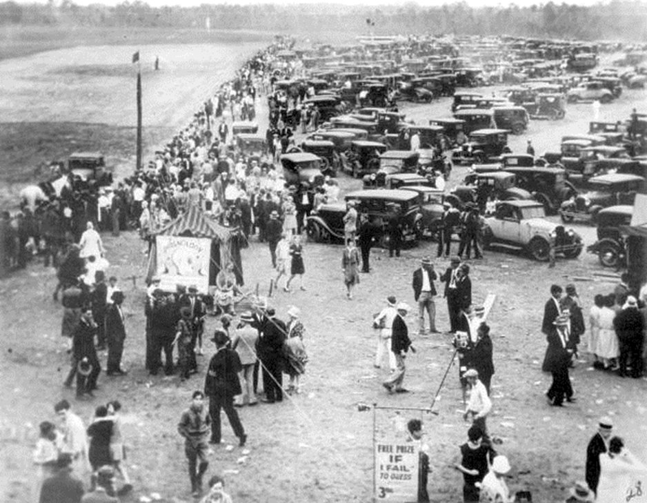
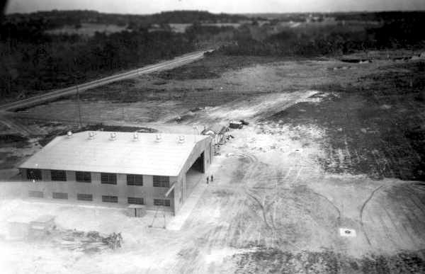
An 11/10/29 photo of the dedication of Dale Mabry Field (from the State Library of FL, courtesy of Terrance Schwartz).
The City of Tallahassee purchased a 200-acre tract for its first municipal airport in 1928.
The land was purchased for $7,075, and the airfield (one grass runway) was built with the assistance of federal funds.
Jonnie Williams reported, “My grandfather (Simon Mann) & great-grandfather (Lane Ross) along with their neighbors
were owners of the land that was purchased by the City of Tallahassee for $7,075 for the first municipal airport in 1928.”
Local officials named the airport Dale Mabry Field in honor of Tallahassee native Army Captain Dale Mabry,
killed while commanding the Army semi-rigid airship Roma which crashed on 2/21/22 at Norfolk, VA.
The new airport was dedicated on 11/10/29, and the first manager was Ivan Munroe.
Large crowds gathered for a 2-day event to witness flying demonstrations & enjoy the festivities.
The earliest photo which has been located of Dale Mabry Field was a photo of crowds at the 11/10/29 dedication (from the State Library of FL, courtesy of Terrance Schwartz).
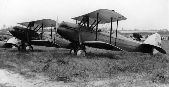
An 11/10/29 photo of several unidentified biplanes at Dale Mabry Field's grand opening.
An 11/10/29 photo by Ray Williams of 3 Navy Vought biplanes & 2 unidentified Army biplanes at Dale Mabry Field's grand opening (from the State Library of FL).
Atlantic Gulf Coast Airlines began commercial flights at the new airport during its first month.
A 1929 aerial view looking east depicted Dale Mabry Field as consisting of an irregularly-shaped grass field with a single hangar on the northwest side.
Airport manager Ivan Munroe began giving flying lessons at the new airport in the early 1930s in a Travelaire.
The 1934 Department of Commerce Airport Directory (according to Chris Kennedy)
described Dale Mabry Field as having 4 sod runways, with the longest being 2,600'.
The earliest aeronautical chart depiction which has been located of Dale Mabry Field was on the August 1935 Mobile Sectional Chart.
It depicted “Dale-Mabry” as a commercial/municipal airport.
Dale Mabry Field, as depicted on the November 1936 "Official Airway Map of FL" (courtesy of Chris Kennedy).
An undated aerial view looking east at Dale Mabry Field from The Airport Directory Company's 1937 Airports Directory (courtesy of Bob Rambo).
The directory described Dale Mabry Field as having two 2,400' paved runways, under construction.
A single hangar was depicted on the northwest corner of the airfield. The operator was listed as Ivan Munroe.
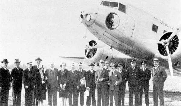
A 1938 photo of Eddie Rickenbacker & other dignitaries in front of an Eastern Airlines DC-2 at Dale Mabry Field
on the occasion of the first scheduled airline service into Tallahassee.
Eastern Airlines began service at Dale Mabry Field in 1938, with 4 daily flights to Memphis, Birmingham, and Montgomery.
National Airlines began serving Tallahassee in the same year, offering flights to Jacksonville, Pensacola, Mobile, and New Orleans.
A circa 1930s aerial view of a hangar at Dale Mabry Field, which had been built by the WPA with material bought by the city.
In 1938-39, the Army's 3rd Air Force established a fighter pilot training school at Mabry & developed 3 runways to serve their needs.
The 1940 USGS topo map depicted the configuration of the “Municipal Airport”, with 3 paved runways & a few small buildings.
An aerial view of Dale Mabry Field from The Airport Directory Company's 1941 Airports Directory (courtesy of Chris Kennedy).
Compare this view with the 1937 aerial photo above, to see how dramatically the airport had been expanded in 4 years.
The field was described as having 2 paved runways (4,000' northwest/southeast & 2,500' north/south), along with a 3,400' sand & sod east/west runway.
A single hangar was depicted on the field.
The manager was listed as Ivan Munroe, and the operators were Ivan Monroe, Eastern Air Lines, and National Air Lines.
Through the political influence of U.S. Senator Claude Pepper & Florida Governor Spessard Holland,
Dale Mabry Field became an Army base in 1941 & aircraft & trainees arrived in May that same year.
Aircraft used at Dale Mabry for training during the early part of WW2 included the P-39 Airacobra, P-40 Warhawk, and P-47 Thunderbolt.
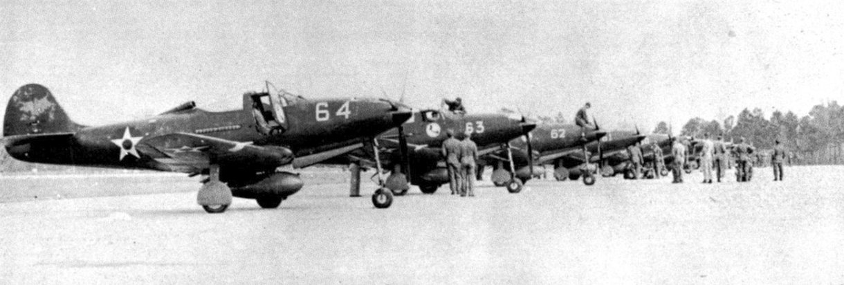
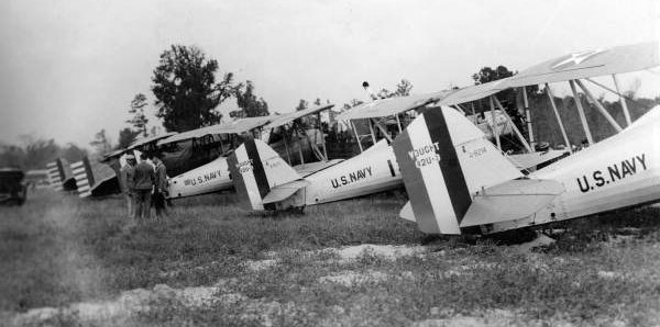
A circa 1941-44 photo of Bell P-39 Airacobra fighters at Dale Mabry Field.
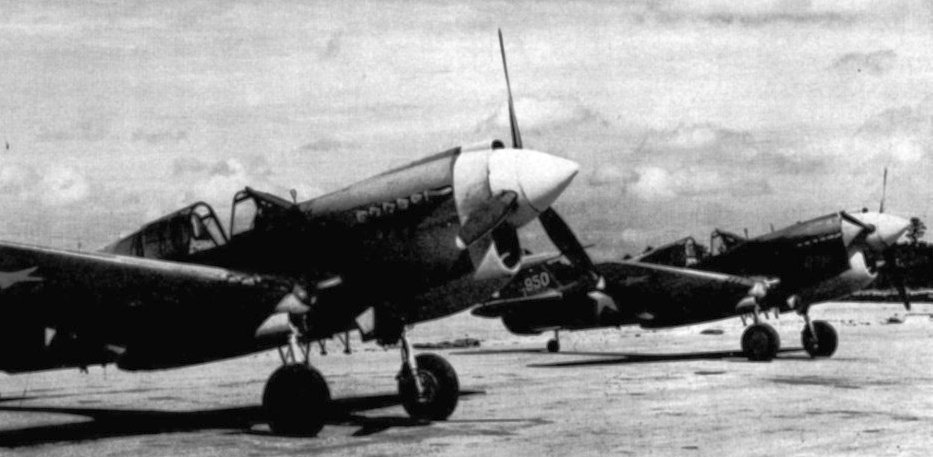
A circa 1941-44 photo of Curtiss P-40 Warhawk fighters at Dale Mabry Field.
A 1942 aerial view of Dale Mabry AAF.
Chinese & French cadets also trained at Dale Mabry Field in 1942 & 1944.
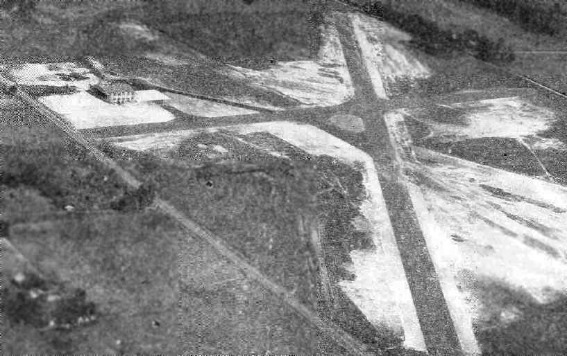
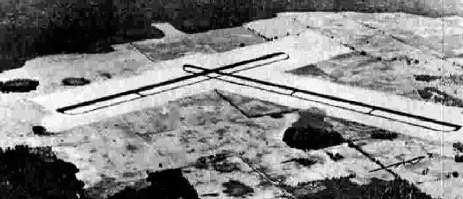
A 1/31/43 aerial view looking west at Dale Mabry Field (National Archives photo, courtesy of Brian Rehwinkel),
showed the field to have 3 paved runways, with an extensive system of aircraft dispersal parking pads on the northwest side.
Despite being closed to general aviation during WW2, the commercial airlines (Eastern & National) continued to use Dale Mabry Field during the war.
Training on the P-51 Mustang fighter occurred at Dale Mabry later in the war.
Originally 530 acres, the airfield grew to 1,720 acres & 133 buildings during the course of the war.
Training activity peaked in mid-1944 with base complement averaging 1,300 officers,
3,000 enlisted men & women, and 800 civilian employees.
More than 8,000 pilots trained at Dale Mabry during WW2, and, tragically, more than a dozen pilots died in training accidents.
Students used a gunnery base at Alligator Point & a bombing range at Sopchoppy on the Gulf for their training needs.
Mabry had satellite fields at Thomasville & Harris Neck, GA.
The pilots also utilized auxiliary bases in Perry, Alachua, Cross City & Dunnellon.
A branch Prisoner of War compound at Mabry held 150 POWs who worked on the base.
Dale Mabry AAF, as depicted on the February 1945 Mobile Sectional Chart (courtesy of Chris Kennedy).
Dale Mabry AAF was placed on inactive status in 1945, and eventually resumed its role as a civilian airport after WW2.
When the airfield was transferred from the military to the city,
Dale Mabry Field's original 1930s-vintage hangar was dismantled & moved to St. Marks,
reassembled & used as a warehouse & office for the Tallahassee Electric System.
Later it was moved again to the new Tallahassee Municipal Airport.
A March 1949 U.S. Government aerial view of Dale Mabry Field,
after it had been returned to the City of Tallahassee (courtesy of the FL DOT, via Brian Rehwinkel).
A 1956 photo of the Dale Mabry terminal (courtesy of David Henderson).
A 1956 photo of the interior of the Dale Mabry terminal (courtesy of David Henderson).
A 3/22/60 USDA aerial view (courtesy of the FL DOT, via Brian Rehwinkel) of Dale Mabry,
only one year before the airfield was closed.
A closeup from the 3/22/60 USDA aerial view (courtesy of the FL DOT, via Brian Rehwinkel)
of numerous planes on the ramp at Dale Mabry.
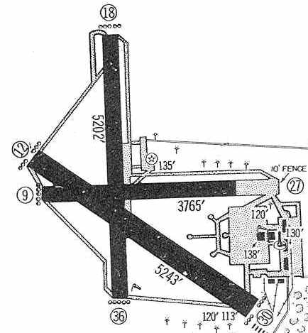
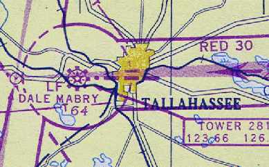
Dale Mabry Field, as depicted in its very last year of operation, in the 1960 Jeppesen Airway Manual (courtesy of Chris Kennedy).
The field was depicted as having 3 paved runways, with the longest being the 5,243' Runway 12/30.
The last aeronautical chart depiction which has been located showing Dale Mabry Field in operation was on the March 1960 Mobile Sectional Chart.
It depicted Dale Mabry Field as having a 5,200' paved runway.
Dale Mabry Field was abandoned in 1961, when a new Tallahassee Airport was built several miles to the southwest.
According to Rick Bell, Dale Mabry Field's Runway 9/27 was reused as a drag strip following the airport's closure.
Rick recalled, “Seminole Drag strip opened 4/22/62, and was run by Jack Patrick, a local speed shop owner, and a AA/D Dragster driver.”
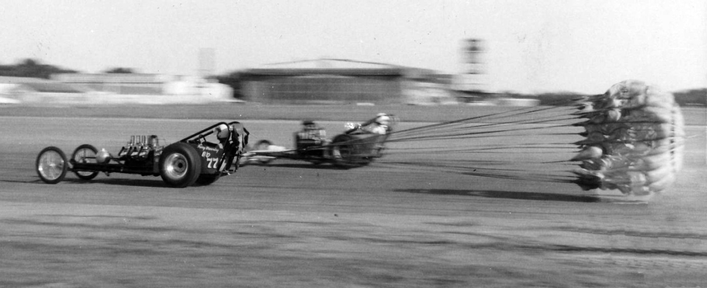
A summer 1962 photo by Rick Bell looking east at “Dale Mabry Field, when Runway 9/27 was converted into Seminole Drag Strip”, with hangars & the control tower visible in the background.
Rick recalled, “One dragster, whose chute failed to open properly ran off of the end of the strip, jumped the road & crashed into a chain link fence.
One weekend it rained severely in the morning but turned sunny by the afternoon so everybody showed up even though it had been called off.
I raced the family car. I was 16 & in 10th grade. I left in June 1963 & the drag strip was still open.”
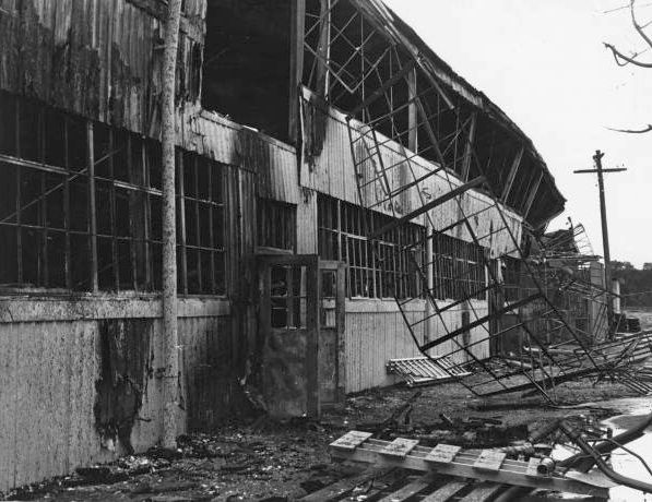
A 1960s photo of a hangar destroyed by fire at Dale Mabry Field.
The 1964 Mobile Sectional Chart (courtesy of John Voss) depicted the site of the field as "Aband airport".
The 1966 USGS topo map continued to depict the “Municipal Airport” as having 3 paved runways & a few small buildings.
However by the time of the 1972 USGS topo map the runways & airport buildings had disappeared from the depiction.
A 2/15/73 USDA aerial view (courtesy of the FL DOT, via Brian Rehwinkel) of the site of Dale Mabry Field,
showing the redevelopment of the property in progress.
Several roads had been built directly over the former runways, the outlines of which were still perceptible.
The buildings of the Tallahassee Junior College had begun to cover the north end of the former airfield.
The property of Mabry Field eventually became the home of Tallahassee Community College,
the Florida Highway Patrol Training Academy, and a variety of other public & private applications.
The 1976 USGS topo map (courtesy of William Stanton) still outlined the runway layout of the former Dale Mabry Field.
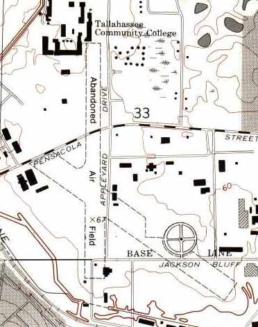
According to Tallahassee resident Richard Travis, "In the 1999 USGS photo,
the north-south road running vertically through the center of the frame is now Appleyard Road,
which runs in front of the TCC campus.
My calculations indicate that Appleyard Road is virtually superimposed over the north/south runway of the old Dale Mabry Field."
Richard Travis continued, "Some remnants of the runways are still in much evidence.
In the northwest corner of the Appleyard Road / Pensacola Street intersection,
on the TCC campus (at almost dead-center of the frame),
is a patch of aging pavement, sometimes used for over-flow parking, which once was part of the north/south runway.
A commemorative plaque designating Dale Mabry Field was erected at the site & dedicated during a ceremony in October 2001."
"To the southeast of this location, in the lower right quadrant of [the above] photo, are some additional remnant patches of runway.
This area along Jackson Bluff Road contains a sports complex with numerous ball fields - the 2 circles forming a figure 8.
Just to the east of these fields, on the south side of Jackson Bluff,
is a fairly large parking area, with aging pavement similar to the TCC patch,
commonly understood to be runway remnants, and my figures indicate it was once part of the northwest/southeast diagonal runway."
In 2003, the City of Tallahassee unveiled a sculpture at the Tallahassee Regional Airport
memorializing the Dale Mabry Air Field & the pilots that served there.
The sculpture will be permanently on display in the second-floor Observation Room of the Ivan B. Munroe Terminal.
A 2004 photo by Richard Travis of the historical marker at the northwest corner of the intersection of Pensacola Street & Appleyard Road.
Note that the text on the plaque has 2 fairly significant errors:
the plaque is located on the site of the north/south runway (not the northwest/southeast runway as stated, which is located some distance to the south),
and the airfield opened in 1929, whereas the plaque seems to indicate that it was established in 1940.
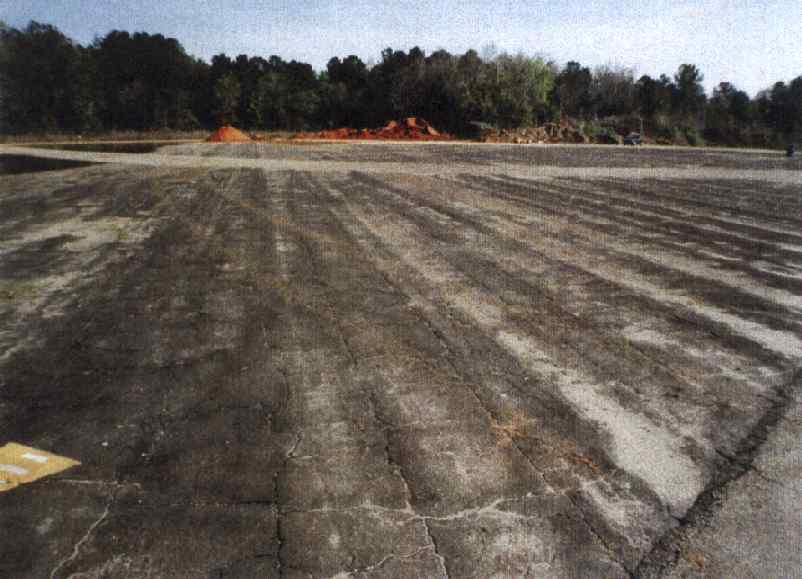
A 2004 photo by Richard Travis looking southeast at a portion of remaining runway pavement
which by then served as a parking lot for the Jim Messer Sports Complex.
Note the wear grooves in the former runway pavement, aligned with the longitudinal direction of the runway.
Craig Hiers reported in 2005, “I grew up on what was the old Dale Mabry Airport.
The community we lived in was called Mabry Manor, and all the streets were named after military generals & admirals.
The buildings of the elementary school I went to (Sable Palm Elementary) were part of the base.”
Richard Travis reported in 2010, “The patch of runway on the Appleyard Drive / Pensacola Street corner of TLH Community College,
with the commemorative plaque, has been paved over (blacktop) and is now an active parking space for the school.
The plaque is still there in its original spot.”
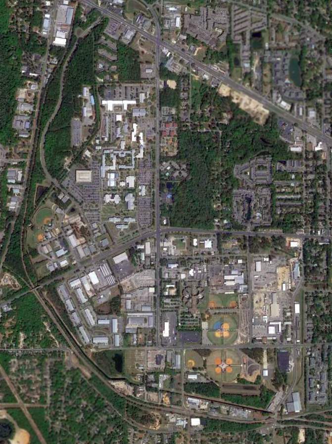
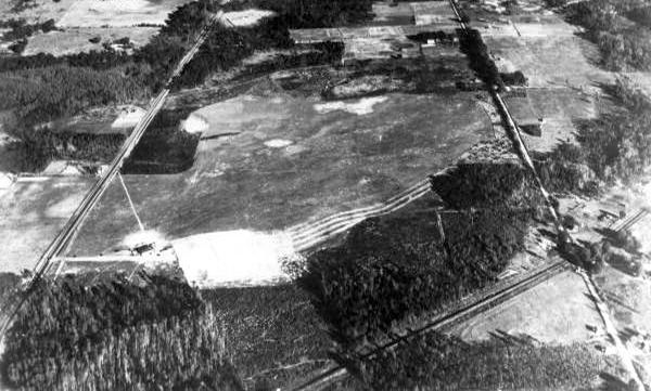
A 4/1/13 aerial photo of the site of Mabry AAF, now the campus of the Tallahassee Community College.
On 4/6/17 a group called Tallahassee's Dale Mabry Army Air Field Museum was incorporated in an effort to establish a museum on the site.
The site of Mabry Field is located northwest of the intersection of West Pensacola Street & Appleyard Drive.
Thanks to Lawrence Sharp (who once flew out of Mabry) for pointing out this airfield.
See also:
http://www.state.fl.us/citytlh/aviation/gihistory.html
http://dhr.dos.state.fl.us/wwii/sites.cfm?PR_ID=151
____________________________________________________
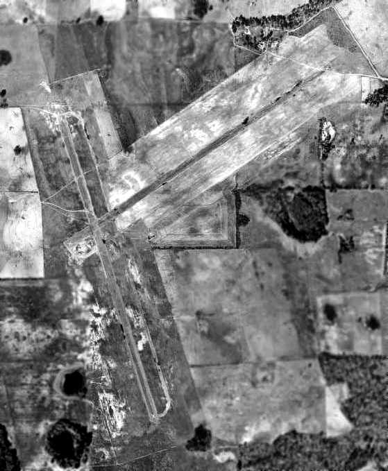
Marianna Auxiliary Army Airfield #1 / Ellis Field, Ellis, FL
30.91, -85.26 (Northwest of Tallahassee, FL)
A 7/23/43 aerial view looking northwest at “Mariana AAF Auxiliary #1 (Ellis Field)”
from the 1945 AAF Airfield Directory (courtesy of Scott Murdock).
Mariana Auxiliary Army Airfield #1 / Ellis Field was constructed in 1943 as one of 4 satellite airfields for Marianna AAF,
which conducted training of light bomber crews.
The airfield cost $249,000 to build, plus $28,000 to purchase its 754 acres of land,
according to a 12/31/45 Inventory of U.S. Army "Owned, Sponsored, and Leased Facilities" (according to Chris Kennedy).
The earliest depiction of Ellis Field which has been located
was a 7/23/43 aerial view looking northwest from the 1945 AAF Airfield Directory (courtesy of Scott Murdock).
It depicted “Mariana AAF Auxiliary #1 (Ellis Field)” as having 2 asphalt runways, each with a parallel taxiway.
Ellis Field was not yet depicted on the January 1944 Mobile Sectional Chart.
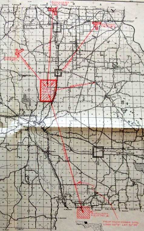
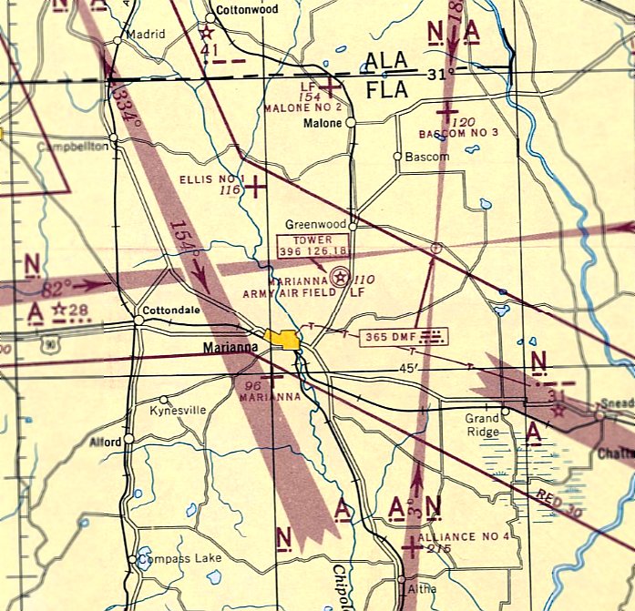
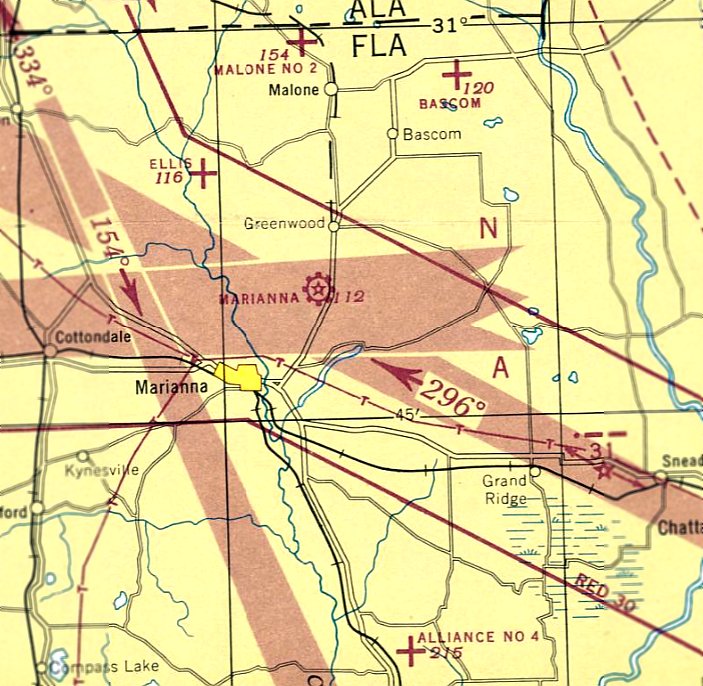
A 1944 map (courtesy of Ron Plante) depicted the location of the 4 Auxiliary Fields relative to Mariana “Main Field”.
The 1945 AAF Airfield Directory (courtesy of Scott Murdock) described “Mariana AAF Auxiliary #1 (Ellis Field)”
as a 977 acre T-shaped property having 2 asphalt 5,000' runways, oriented northeast/southwest & NNW/SSE.
The field was said to not have any hangars, to be owned by the U.S. Government, but not to be currently in operation.
The earliest aeronautical chart depiction of Ellis Field #1 which has been located
was on the February 1945 Mobile Sectional Chart (courtesy of Chris Kennedy).
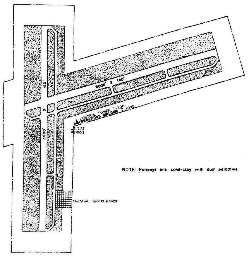
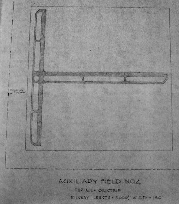
A WW2-era layout map for for Ellis Auxiliary Field # 1 (courtesy of the National Archives, via Brian Rehwinkel).
It depicted the field as having two 5,500' "sand-clay with dust palliative" runways.
along with a control tower & an operations building.
The last aeronautical chart depiction of Ellis Field #1 which has been located was on the February 1947 Mobile Sectional Chart.
Ellis Field was evidently abandoned at some point in 1947, as it was no longer depicted on the August 1947 Mobile Sectional Chart.
A December 1948 USDA aerial photo of Ellis Aux #1 (after it had been closed),
from the Digital Library Center / University of Florida George A. Smathers Libraries (courtesy of Brian Rehwinkel).
The airfield consisted of 2 paved runways, with the east/west runway having a parallel taxiway along the south side.
Both runways were marked with closed-runway "X" symbols.
There did not appear to have been any buildings associated with the airfield.
In the words of Brian Rehwinkel, "It is fascinating to me that this airfield (as well as Alliance Aux AAF # 4)
was in poor condition by 1948 - only 5 or 6 years after they were built!
You can see from the photo the northeast/southwest runway appears to be quite deteriorated."
A close-up of the closed-runway "X" symbol on the Ellis runway, from the December 1948 USDA aerial photo.
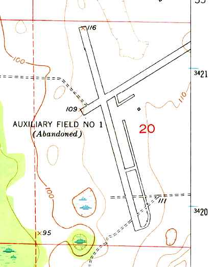
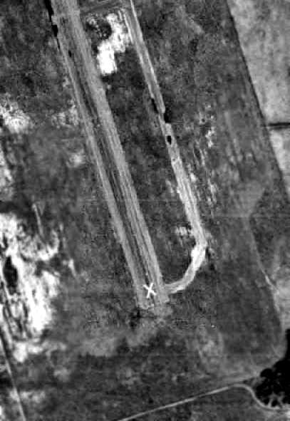
The 1951 USGS topo map depicted “Auxiliary Field # 1 (Abandoned)” as having 2 paved runways,
with a parallel taxiway on the southeast side & a single small building on the east of the runway intersection.
The 1973 USGS topo map continued depicted the airfield as having two 4,100' paved runways.
By the time of the 1983 USGS topo map, nothing of the airfield was still depicted.
Brian Rehwinkel recalled in 2004, "I have visited this site before & spoken with the owner of the property.
He told me the runways were removed many years ago.
Even though in the current USGS photos appear to show a portion of the north/south runway remaining -
there is nothing left of the runway except small bits & pieces of asphalt.
The remaining portion of the airfield has been replaced by plowed fields.
I believe the wooded portion has been used by a hunting club."
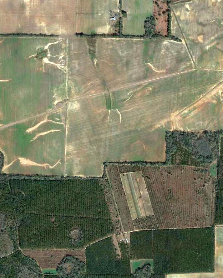
A 2/2/13 USGS aerial photo showed the outline of a 2,500' section of the south end of the north/south runway & its parallel taxiway remained quite distinctive.
The remaining (northern) portion of the airfield land had been cleared for agricultural purposes,
but still bore faintly recognizable traces of the runway layout.
____________________________________________________
Marianna Aux Army Airfield #2 / Malone Field / Stage Field, Malone, FL
30.99, -85.18 (Northwest of Tallahassee, FL)
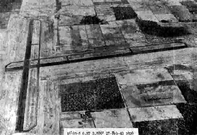
A 2/27/43 aerial view looking east at “Mariana AAF Auxiliary #2 (Malone Field)”
from the 1945 AAF Airfield Directory (courtesy of Scott Murdock).
This military airfield was built during WW2 as one of 4 satellite airfields for Marianna AAF, which conducted training of light bomber crews.
The date of construction of Malone Aux #2 has not been determined,
but its parent airfield (Marianna AAF) was opened in late 1942, and its auxiliary fields were apparently built in late 1942 or early 1943.
The airfield cost $329,000 to build, plus $30,000 to purchase its 519 acres of land.
according to a 12/31/45 Inventory of U.S. Army "Owned, Sponsored, and Leased Facilities" (according to Chris Kennedy).
The earliest depiction of Malone #2 which has been located
was a 2/27/43 aerial view looking east from the 1945 AAF Airfield Directory (courtesy of Scott Murdock).
It depicted “Mariana AAF Auxiliary #2 (Malone Field)” as having 2 asphalt runways, each with a parallel taxiway.
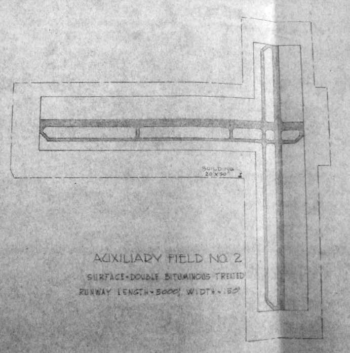
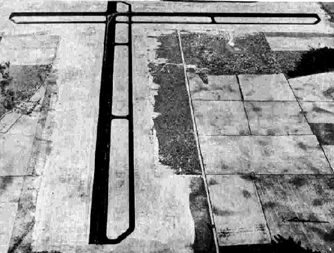
A 1943 layout (courtesy of Ron Plante) depicted “Auxiliary Field #2” as having 2 “double bituminous treated” 5,000' runways, each with a parallel taxiway,
and a 20' x 30' building to the southwest of the runway intersection.
Malone Field was not yet depicted on the January 1944 Mobile Sectional Chart.
A 1944 map (courtesy of Ron Plante) depicted the location of the 4 Auxiliary Fields relative to Mariana “Main Field”.
The 1945 AAF Airfield Directory (courtesy of Scott Murdock) described “Mariana AAF Auxiliary #2 (Malone Field)”
as a 613 acre T-shaped property having 2 asphalt 5,000' runways, oriented north/south & east/west.
The field was said to not have any hangars, to be owned by the U.S. Government, but not to be currently in operation.
The earliest aeronautical chart depiction of Malone Field #2 which has been located
was on the February 1945 Mobile Sectional Chart (courtesy of Chris Kennedy).
The last aeronautical chart depiction of Malone Field #2 which has been located was on the February 1947 Mobile Sectional Chart.
Malone Field was evidently abandoned at some point in 1947, as it was no longer depicted on the August 1947 Mobile Sectional Chart.
A 12/4/48 USDA aerial photo of Malone Aux #2,
from the Digital Library Center / University of Florida George A. Smathers Libraries (courtesy of Brian Rehwinkel).
Malone #2 was apparently abandoned at some point between 1945-48, as it appeared to be abandoned at the time of this photo
(as there were no signs of use, and it appears a road had been cut across the north/south runway).
According to Brian Rehwinkel, "Apparently this airfield was rehabilitated for use with Graham Air Base
(a USAF Contract School which operated at the former Marianna AAF from, I believe, 1952-61).
I don't know how many of the auxiliary fields were used during the time it was operated as Graham Airbase,
but apparently this field was used during that time."
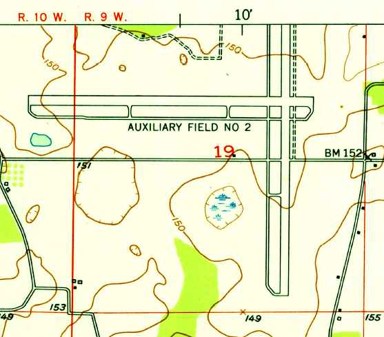
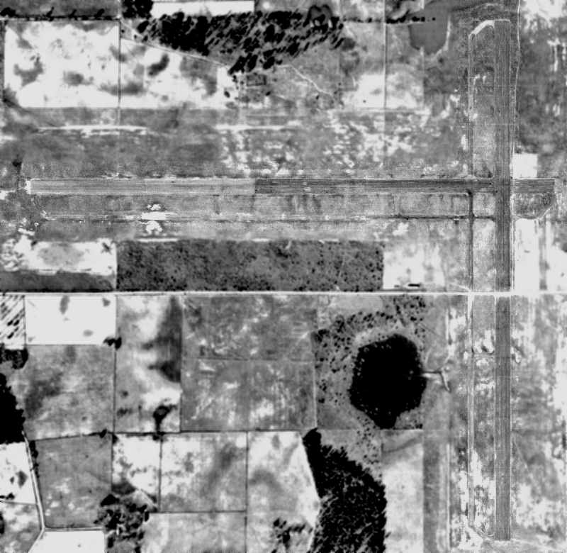
The 1953 USGS topo map depicted “Auxiliary Field #2” as having 2 paved perpendicular runways with parallel taxiways.
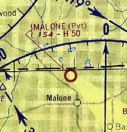
"Malone" was depicted as a private airfield on the 1962 Mobile Sectional Chart (courtesy of Chris Kennedy),
and was described as having a 5,000' hard-surface runway.
The 1962 AOPA Airport Directory listed the name of the field as "Graham #2",
and described it as having 2 paved runways, although with the note "Emergency use only".
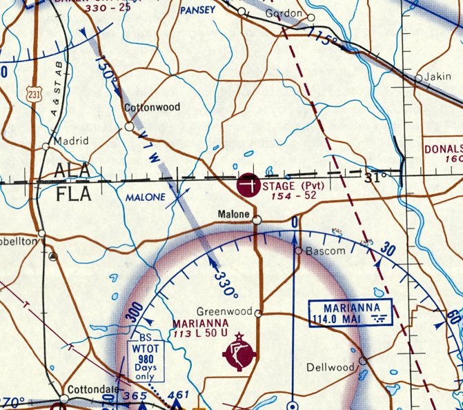
The Malone airfield was depicted as "Stage", a private airfield on the February 1968 Mobile Sectional Chart,
and was described as having 2 paved runways, with the longest being 5,200'.
The Malone airfield was apparently abandoned again at some point between 1968-79,
as the property was reused as the location for the Coast Guard's LORAN Station Malone, commissioned in 1979,
a LORAN-C navigation radio station, with a 300' tower southwest of the runway intersection.
Malone was depicted as an abandoned airfield on the 1980 New Orleans Sectional Chart (courtesy of Robert Brown).
The property was labeled as “U.S. Coast Guard Station” on the 1983 USGS topo map,
with the radio tower labeled to the southwest of the former runway intersection.
Only a small western portion of the east/west runway was still depicted.
The Coast Guard's LORAN Station Malone was decommissioned in 2010,
as the LORAN system was increasingly replaced by GPS.
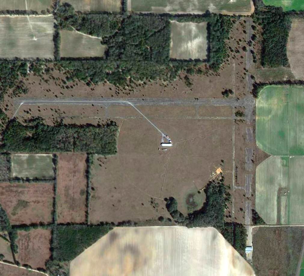
A 2/2/13 aerial view showed that the majority of Malone's WW2-era runways remained intact, along with the former Coast Guard LORAN installation to the southwest of the runnways.
____________________________________________________
Marianna Auxiliary Army Airfield #3 / Bascom Field, Bascom, FL
30.97, -85.07 (Northwest of Tallahassee, FL)
A 2/27/43 aerial view looking east at “Mariana AAF Auxiliary #3 (Bascom Field)”
from the 1945 AAF Airfield Directory (courtesy of Scott Murdock).
This military airfield was built during WW2 as one of 4 satellite airfields for Marianna AAF, which conducted training of light bomber crews.
The date of construction of Bascom Aux #3 has not been determined, but its parent airfield (Marianna AAF) was opened in late 1942,
and its auxiliary fields were apparently built in late 1942 or early 1943.
The airfield cost $385,000 to build, plus $24,000 to purchase its 1,236 acres of land,
according to a 12/31/45 Inventory of U.S. Army "Owned, Sponsored, and Leased Facilities" (according to Chris Kennedy).
The earliest depiction of Bascom #3 which has been located
was a 2/27/43 aerial view looking east from the 1945 AAF Airfield Directory (courtesy of Scott Murdock).
It depicted “Mariana AAF Auxiliary #3 (Bascom Field)” as having 2 asphalt runways, each with a parallel taxiway.
A 1943 layout (courtesy of Ron Plante) depicted “Auxiliary Field #3” as having 2 “double bituminous treated” 5,000' runways, each with a parallel taxiway,
and a building & beacon to the southeast of the runway intersection.
Mel Shettle’s book “Florida’s Army Air Fields of WWII” stated that P-40 fighter aircraft were based at Bascom Field to keep them separated from the AT-6 training aircraft at Marianna AAF.
John Voss noted, “The basing of the P-40s there probably accounts for the small building existing near the runway intersection.”
Bascom Field was not yet depicted on the January 1944 Mobile Sectional Chart.
A 1944 map (courtesy of Ron Plante) depicted the location of the 4 Auxiliary Fields relative to Mariana “Main Field”.
The 1945 AAF Airfield Directory (courtesy of Scott Murdock) described “Mariana AAF Auxiliary #3 (Bascom Field)”
as a 717 acre T-shaped property having 2 asphalt 5,000' runways, oriented east/west & NNW/SSE.
The field was said to not have any hangars, to be owned by the U.S. Government, and operated by the Army Air Forces.
Notably, Bascom was the only field among Mariana AAF's 4 auxiliary fields which were still in operation at this point.
The earliest aeronautical chart depiction of Bascom Field #3 which has been located
was on the February 1945 Mobile Sectional Chart (courtesy of Chris Kennedy).
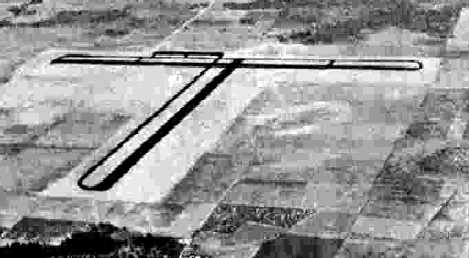
A December 1948 USDA aerial photo of Bascom Aux #3, from the Digital Library Center / University of Florida George A. Smathers Libraries (courtesy of Brian Rehwinkel).
The the Bascom airfield consisted of 2 paved runways, each of which had parallel taxiways.
Unlike many other WW2-era auxiliary airfields, Bascom had a paved ramp area, southeast of the runway intersection, which appeared to have at least one building (a hangar?).
It is not apparent if the field has been abandoned by this point, as the field appeared in decent condition, and there were no closed-runway "X" symbols on the runways.
Bascom was apparently abandoned by the military at some point between 1945-49 & reused as a civil airfield,
as it was labeled simply as "Bascom" on the 1949 Mobile Sectional Chart (courtesy of John Voss).
The 1953 USGS topo map depicted “Auxiliary Field #3 (Abandoned)” as having 2 paved perpendicular 5,000' runways with parallel taxiways,
and paved ramp with one small building on the southeast side.
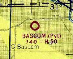
"Bascom" was still depicted as a private airfield on the 1962 Mobile Sectional Chart (courtesy of Chris Kennedy), and described as having a 5,000' hard-surface runway.
The 1962 AOPA Airport Directory listed the name of the field as "Graham Auxiliary #1",
and described it as having 2 paved runways, and the note "Emergency use only".
The Bascom airfield was apparently abandoned (again) at some point between 1962-80,
as it was not depicted at all on the 1980 New Orleans Sectional Chart (courtesy of Robert Brown).
The 1982 USGS topo map continued to depict the abandoned airfield in the same fashion as depicted in 1953.

A 1994 USGS aerial view looking northwest showed the remains of the Bascom Field runways remained mostly intact.
Bascom Field was depicted on 1997 USGS topo map as "Auxiliary Field #3".
Brian Rehwinkel recalled in 2004, "I have actually been on that airfield (about 5 years ago) and it was being used by crop dusters.
The airfield was owned by North American Farms.
Although I have to say that anyone who actually was able to land on the field at that time & MISS the giant potholes -
must have been an accomplished pilot (or very lucky)."
A 2001 aerial view looking southeast at Bascom by Bill Ezell, taken from the back seat of Richard Stumpf's Tandem Airbike ultralight.
Chris Kennedy pointed out in 2003 that the former Bascom Auxiliary Army Airfield #3
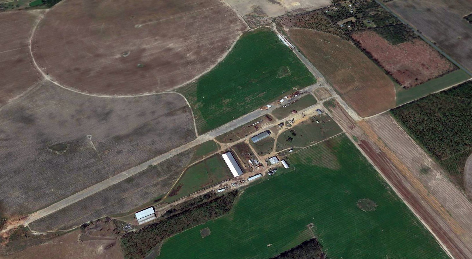
had apparently been reopened at some point between 1997-2003 as a private airfield, North American Farms Airport (56FD),
"used for crop dusting operation & owner's private use."
The owner is listed as Joseph Hall, and the field consists of a single 4,400' asphalt Runway 18/36, "in good condition".
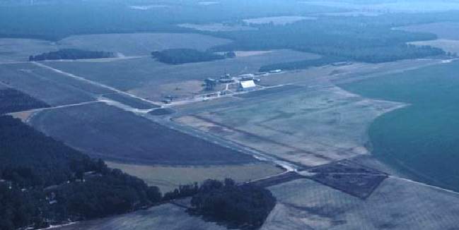
A 2018 aerial view looking northwest showed the remains of the Bascom Field runways remained mostly intact, although the eastern half of the east/west runway pavement had been removed.
____________________________________________________
Marianna Auxiliary Army Airfield #4 / Alliance Field, Alliance, FL
30.6, -85.11 (Northwest of Tallahassee, FL)
A 7/23/43 aerial view looking west at “Mariana AAF Auxiliary #4 (Alliance Field)”
from the 1945 AAF Airfield Directory (courtesy of Scott Murdock).
This military airfield was built during WW2 as one of 4 satellite airfields for Marianna AAF, which conducted training of light bomber crews.
The date of construction of Alliance Aux #4 has not been determined,
but its parent airfield (Marianna AAF) was opened in late 1942, and its auxiliary fields were apparently built in late 1942 or early 1943.
The airfield cost $306,000 to build, plus $110,000 to purchase its 1,663 acres of land,
according to a 12/31/45 Inventory of U.S. Army "Owned, Sponsored, and Leased Facilities" (according to Chris Kennedy).
The earliest depiction of Alliance #4 which has been located
was a 7/23/43 aerial view looking west from the 1945 AAF Airfield Directory (courtesy of Scott Murdock).
It depicted “Mariana AAF Auxiliary #4 (Alliance Field)” as having 2 asphalt runways, each with a parallel taxiway.
A 1943 layout (courtesy of Ron Plante) depicted “Auxiliary Field #4” as having 2 “oil strip” 5,000' runways, each with a parallel taxiway,
and a building to the southwest of the runway intersection.
Alliance Field was not yet depicted on the January 1944 Mobile Sectional Chart.
A 1944 map (courtesy of Ron Plante) depicted the location of the 4 Auxiliary Fields relative to Mariana “Main Field”.
The 1945 AAF Airfield Directory (courtesy of Scott Murdock) described “Mariana AAF Auxiliary #4 (Alliance Field)”
as a 1,960 acre square-shaped property having 2 asphalt 5,000' runways, oriented north/south & east/west.
Notably, this field was over twice the acreage of the 3 other Mariana AAF auxiliary airfields.
Alliance Field was said to not have any hangars, to be owned by the U.S. Government, but not to be currently in operation.
The earliest aeronautical chart depiction of Alliance Field #4 which has been located
was on the February 1945 Mobile Sectional Chart (courtesy of Chris Kennedy).
The last aeronautical chart depiction of Alliance Field #4 which has been located was on the February 1947 Mobile Sectional Chart.
Alliance Field was evidently abandoned at some point in 1947, as it was no longer depicted on the August 1947 Mobile Sectional Chart.
A 1949 USDA aerial photo of Alliance Aux #4,
from the Digital Library Center / University of Florida George A. Smathers Libraries (courtesy of Brian Rehwinkel).
The airfield consisted of two 5,000' paved runways, both marked with closed-runway "X" symbols, and each had a parallel taxiway.
It is not known if the airfield originally had any buildings or hangars.
Alliance Field was no longer depicted on the 1953 USGS topo map.
A 2/14/57 USDA aerial photo of Alliance Aux #4 (courtesy of the FL DOT, via Brian Rehwinkel).
Remnants of the airfield were fading fast by this point, with only the southern-most portion of the former north/south runway pavement still remaining,
with just traces still perceptible of the remainder of that runway & the former east/west runway.
Brian Rehwinkel reported in 2003, "I have visited the site, and there is no obvious evidence there was ever an airfield at that site."
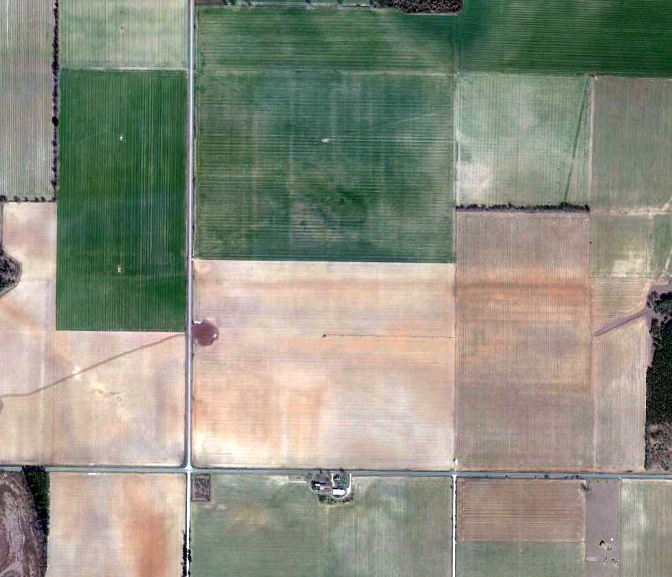
A 2/1/13 aerial photo showed the runways had been removed, with the property reused for farming.
However, close examination of the center of the photo
will reveal the "ghosted" outline of a section of the east/west runway & its parallel taxiway.
The site of Alliance Aux #4 is located southwest of the intersection of Alliance Road & Jesse Lane.
____________________________________________________
Or if you prefer to contact me directly concerning a contribution (for a mailing address to send a check),
please contact me at: paulandterryfreeman@gmail.com
If you enjoy this web site, please support it with a financial contribution.
____________________________________________________
This site covers airfields in all 50 states.