Abandoned & Little-Known Airfields:
Florida, Northern Tampa area
© 2002, © 2025 by Paul Freeman. Revised 3/23/25.
This site covers airfields in all 50 states: Click here for the site's main menu.
____________________________________________________
Please consider a financial contribution to support the continued growth & operation of this site.
Brooksville Airport (revised 2/20/18) - Bushnell Airport (1st location) / Bushnell Army Airfield (revised 4/8/20)
Bushnell Auxiliary Army Airfield / Bushnell Airport (2nd location) (revised 4/8/20) - Haldeman-Elder Field (revised 1/19/22)
Hillsbororough AAF / Henderson AAF / Henderson-Hillsborough International Airport (revised 2/20/18) - Lakeland Municpal / Lodwick Field (revised 3/23/25)
Skyland Airport (added 8/11/22) - Torii Field (revised 8/20/17) - West Pasco Airpark / Tampa Bay Executive Airport (revised 3/3/23) - Withlacoochee AAF (revised 2/28/23)
____________________________________________________
28.05, -81.989 (East of Tampa, FL)
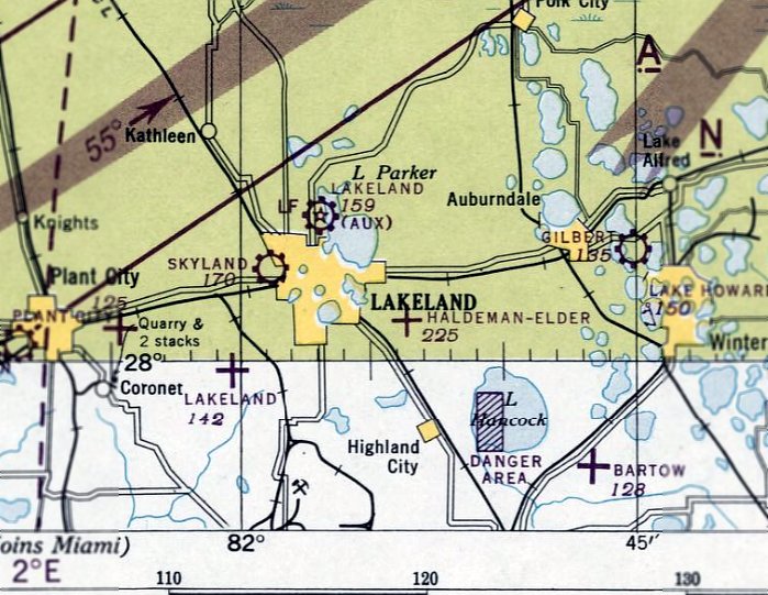
Skyland Airport, as depicted on the February 1946 Orlando Sectional Chart.
Skyland Airport was not yet depicted on the 1945 Orlando Sectional Chart.
This small general aviation airport was located on the west side of Lakeland.
Rebecca Whalon of the Lakeland History & Culture Center reported, “Skyland Airport was located just outside of the city limits of Lakeland.
The airport was in operation by 1946. Leroy Silkett managed the airport, and also operated Leory Silkett Flying Service for flight instruction & chartered trips.
Pilots would often utilize the paved runways at nearby Drane Field to practice touch-&-go landings & takeoffs, since the runways at Skyland were a combination of turf & sand.
Skyland Airport was approved by the VA & CAA to offer flight training to Gis.
Instructors at Skyland included Woodford Baxter, former Flight Commander at the Lodwick School of Aeronautics,
Don Emerson, future manager of Lakeland Municipal Airport, and aviator Tony Bragoz.”
The earliest depiction which has been located of Skyland Airport was on the February 1946 Orlando Sectional Chart,
which depicted Skyland as a commercial/municipal airport.
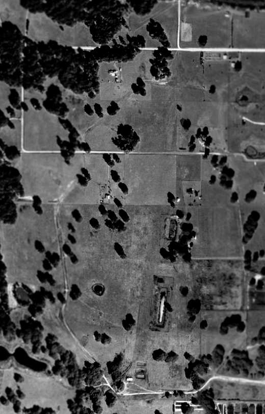
The earliest photo which has been located of Skyland Airport was a 1952 aerial view.
It depicted Skyland as having 3 grass runways, with 9 light single-engine planes & 3 hangars on the west side.
Rebecca Whalon reported, “Florida Southern College offered a flying course for 5 credit hours though the Skyland Airport in 1953.
Students took 17 hours of dual instruction & 18 hours of solo flying, in addition to cross-country flying.”
Rebecca Whalon reported, “On 8/13/54 the airport was hit by an event some describe as a windstorm, and by others as a tornado.
Airplanes were tossed about & buildings were damaged. Two days later, another windstorm hit the airport, causing even more damage.”
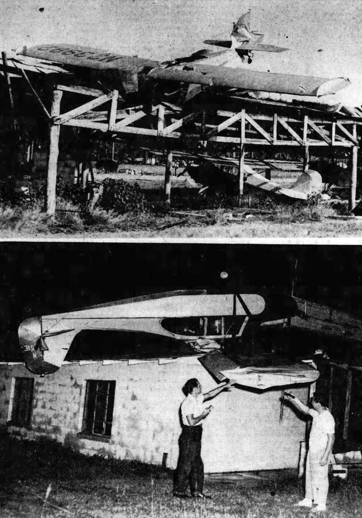
Two photos published on 8/14/54 of the damaged inflicted on Skyland Airport by the previous day's windstorm (courtesy of Rebecca Whalon of the Lakeland History & Culture Center).
Rebecca Whalon reported, “The airport never fully recovered from the damage. It operated until 1954.”
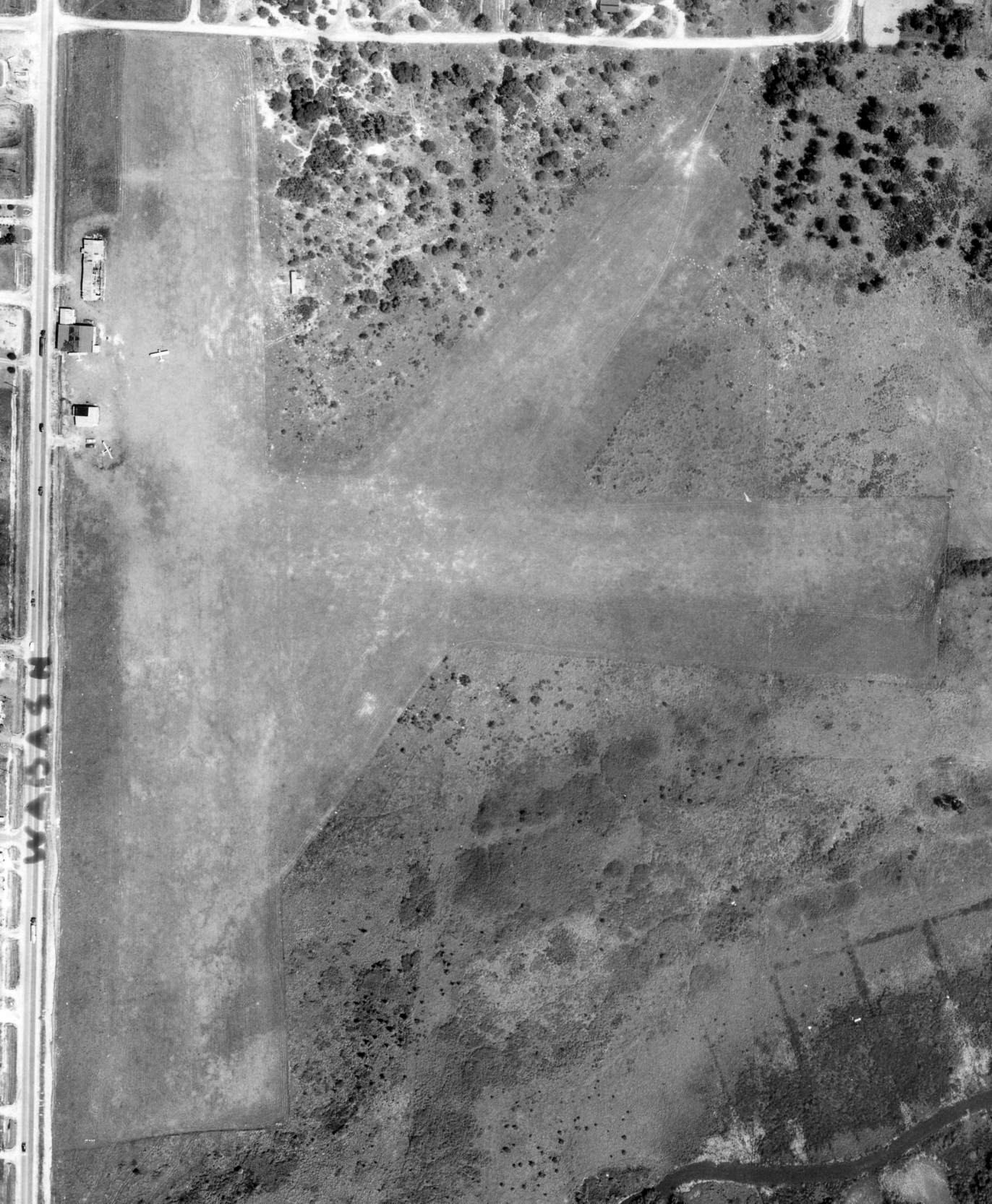
The last photo which has been located of Skyland Airport was a 1955 aerial view (courtesy of Rebecca Whalon of the Lakeland History & Culture Center).
It depicted Skyland as having 3 grass runways, with 3 light single-engine planes & 3 hangars on the west side, 2 of which had visible structural damage from the preceding year's windstorm.
Rebecca Whalon reported, “By 1956 the airport was gone & a racing track, The Lakeland Speedway, was constructed.
Early advertisements for the speedway stated it was located 'at the old airport'.”
A 1957 aerial view showed no trace remaining of Skyland Airport, with buildings & houses on the northern portion,
and the racetrack on the southern portion.
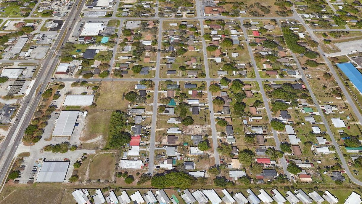
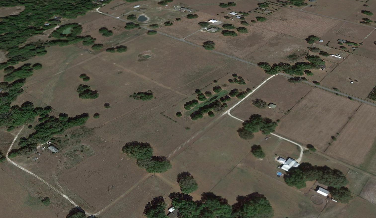
A 2021 aerial view looking north showed no trace remaining of Skyland Airport.
Rebecca Whalon reported in 2022 of the Skyland Airport site, it “is unrecognizable today. A commercial building & a trailer park occupy much of the site.”
Thanks to Rebecca Whalon for pointing out this airfield.
____________________________________________________
28.14, -82.674 (Northwest of Tampa, FL)
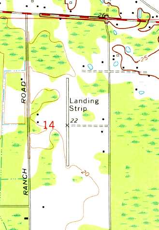
Torii Field, as depicted on the 1974 USGS topo map.
This small general aviation airfield was evidently established at some point between 1956-74,
as it was not yet depicted on the 1956 FL Aeronautical Chart (courtesy of Roger Connor).
The earliest depiction which has been located of Torii Field was on the 1974 USGS topo map.
It described a single paved north/south runway, labeled simply as “Landing Strip”.
NTSB accident records indicate aviation activity at Torii Field in 1975, 1977, and 1982.
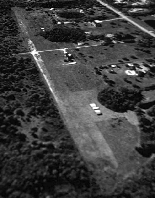
The only photo which has been located showing Torii Field in operation was a 1982 aerial view,
which showed 3 single-engine aircraft parked west of the runway.
The runway appeared to have been paved, but was somewhat deteriorated by 1982.
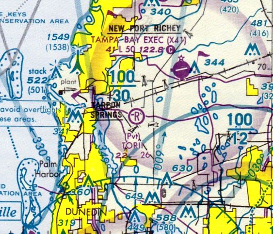
The earliest aeronautical chart depiction which has been located of Torii Field was on the 1985 Jacksonville Sectional Chart,
which depicted Torii as a private airfield having a 2,600' unpaved runway.
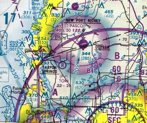
The last aeronautical chart depiction which has been located of Torii Field was on the 1994 Miami Sectional Chart (courtesy of Ron Plante),
which depicted Torii as a private airfield having a 2,600' unpaved runway.
The earliest photo which is available of Torii Field was a 1/27/95 USGS aerial view looking southwest.
While still remaining mostly intact, the field appeared to already have been abandoned, and the runway was deteriorated.
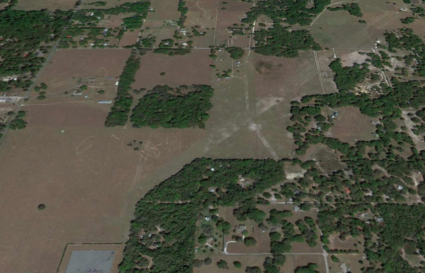
A 4/5/10 aerial view looking southwest at Torii Field showed the runway remained somewhat recognizable,
although several buildings were located on top of it.
The site of Torii Field is located west of the intersection of Lora Lane & Fletch Haven Drive.
____________________________________________________
Brooksville Airport, Brooksville, FL
28.548, -82.377 (North of Tampa, FL)
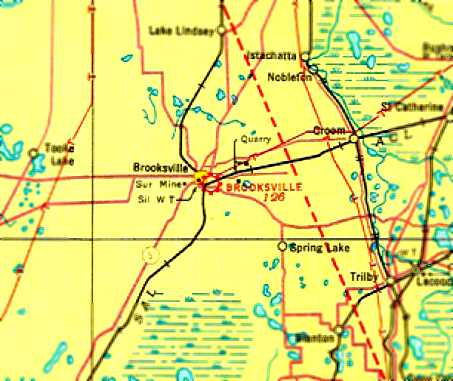
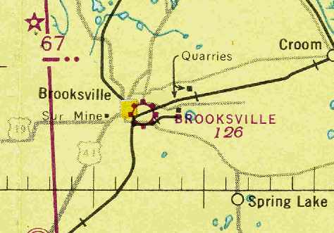
Brooksville Airport, as depicted on the 1935 Orlando Sectional Chart.
The date of construction of this general aviation airport has not been determined.
The earliest reference to the Brooksville Airport which has been located
was in The Airport Directory Company's 1933 Airport Directory (courtesy of Chris Kennedy).
It described Brooksville as a commercial field, consisting of a 40-acre sod field,
with 2 runways in a cross shape: 1,900' east/west & 1,350' north/south.
The earliest depiction of the Brooksville Airport which has been located was on the 1935 Orlando Sectional Chart.
It depicted Brooksville as a commercial/municipal airport.
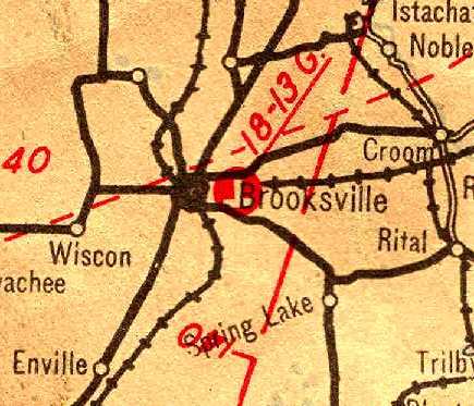
Brooksville Airport, as depicted on the 1936 Official Airway Map of Florida (courtesy of Chris Kennedy).
An aerial view looking northwest at Brooksville Airport,
from The Airport Directory Company's 1938 Airport Directory (courtesy of Chris Kennedy).
The directory described Brooksville as a municipal airport,
consisting of a irregularly-shaped 40-acre sod field,
with 2 runways: 2,000' east/west & 1,200' north/south.
The last chart depiction which has been located of the Brooksville Airport
was on the July 1943 Orlando Sectional Chart (courtesy of Chris Kennedy).
It depicted Brooksville as a municipal/commercial airport.
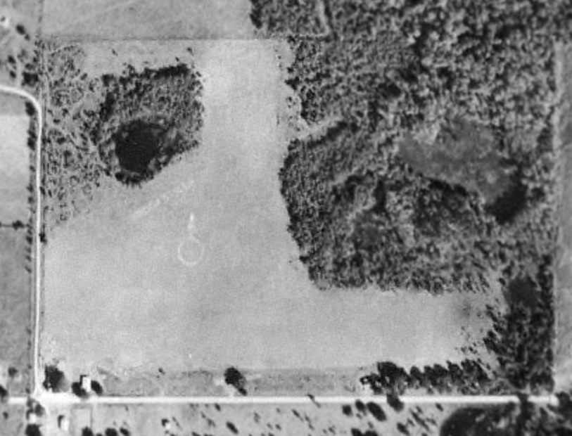
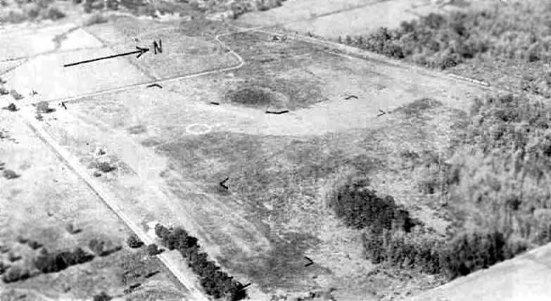
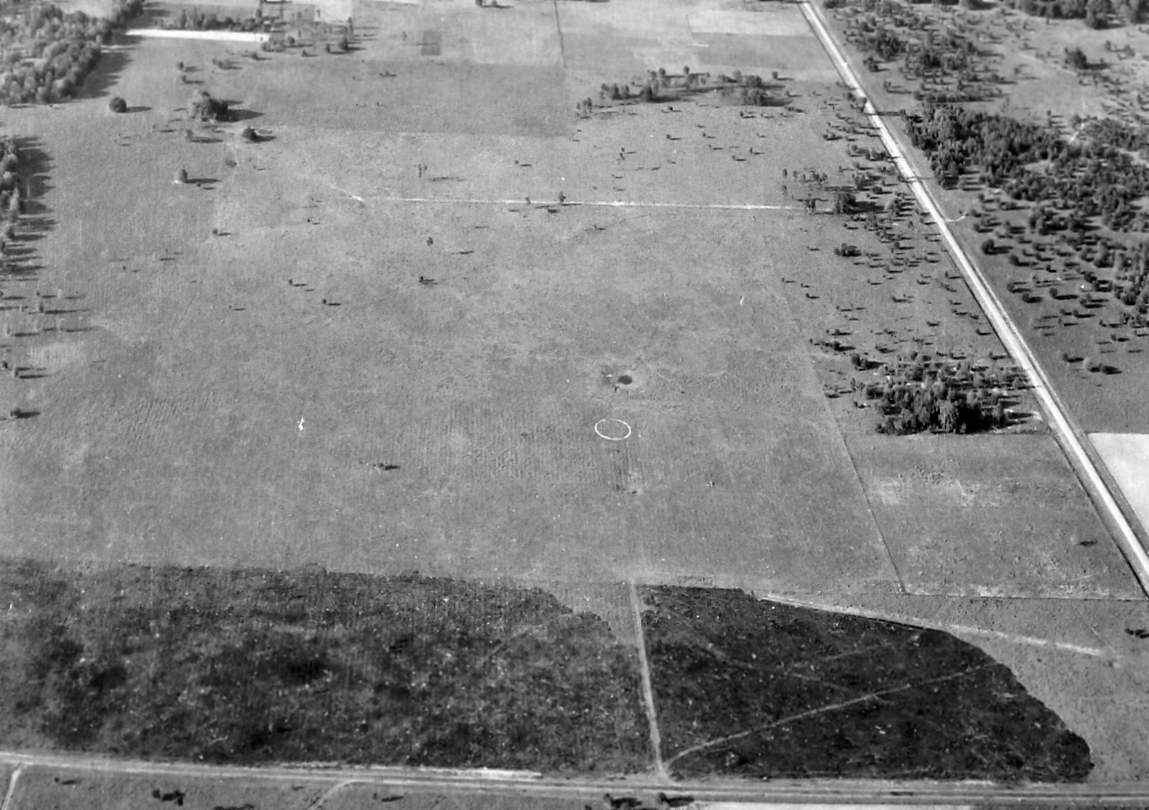
In a 1944 aerial photo (from the UFL Photo Library, via Chris Kennedy),
the 2 grass runways of Brooksville Airport were quite evident, along with a airport circle marking.
A single small building along the southwest corner of the field may have been related to the airport.
The Brooksville Airport evidently was abandoned at some point between 1943-44,
as it was no longer depicted at all on the February 1944 Orlando Sectional Chart (courtesy of Chris Kennedy).
It was presumably replaced by the much-larger Brooksville Army Airfield (northwest of the town), once that field became available for civilian reuse.
A 3/16/51 USGS aerial view showed that Route 98 had been constructed over the southwest corner of the airport site.
The original Brooksville Airport was no longer depicted on the 1952 Orlando Sectional Chart
nor on the 1955 USGS topo map.
A 1995 USGS aerial view showed no trace remaining of Brooksville Airport.
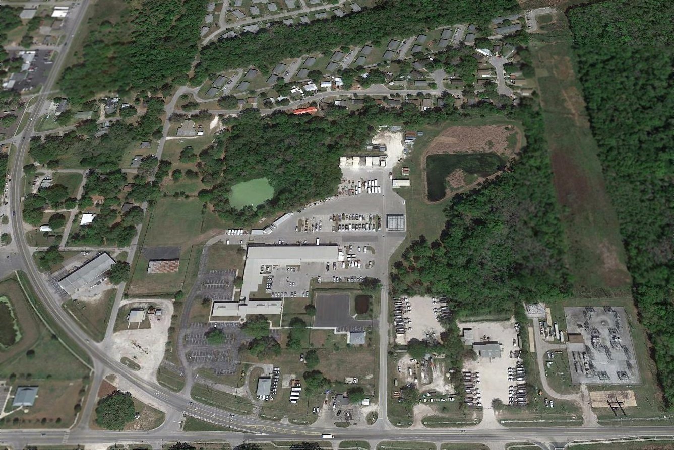
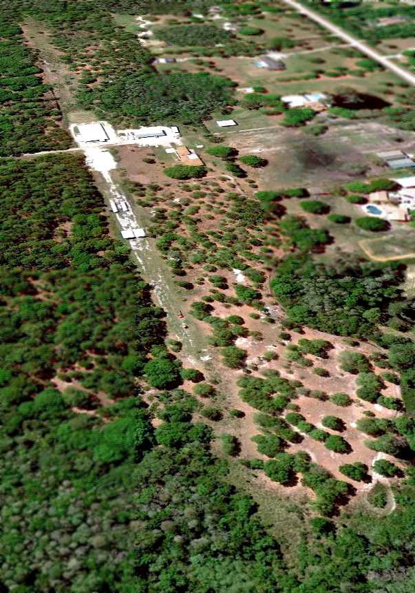
A 2017 aerial view looking north showed no trace remains of Brooksville Airport.
The site of Brooksville Airport is located northeast of the intersection of Route 98 & Continental Drive.
____________________________________________________
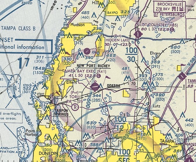
West Pasco Airpark / Tampa Bay Executive Airport (3FD1), New Port Richey, FL
28.19, -82.627 (North of Tampa, FL)
West Pasco Airpark, as depicted on a 1/20/68 USDA aerial photo (courtesy of Dallam Oliver-Lee).
This general aviation airport was evidently established at some point between 1957-68,
as it was not yet depicted on a 3/27/57 USDA aerial photo (courtesy of Dallam Oliver-Lee)
nor listed in the 1967 AOPA Airport Directory (according to Chris Kennedy).
The earliest depiction which has been located of West Pasco Airpark was a 1/20/68 USDA aerial photo (courtesy of Dallam Oliver-Lee).
It depicted West Pasco Airpark as having 2 grass runways, with a single hangar on the northeast side.
No aircraft were visible on the field.
West Pasco Airpark was not yet depicted on the October 1968 Orlando Sectional Chart.
A 1969 aerial photo showed a 2nd small building had been added at West Pasco Airpar,
and 3 single-engine aircraft were parked near the hangar.

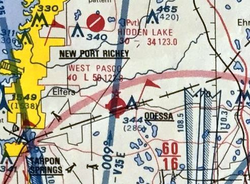
The earliest aeronautical chart depiction of West Pasco Airpark which has been located
was on the April 1971 Jacksonville Sectional Chart (courtesy of Chris Kennedy).
It described West Pasco as having a 3,000' unpaved runway.
A 12/1/71 USGS aerial photo (courtesy of Dallam Oliver-Lee) showed a total of 5 buildings on the airport,
along with 3 single-engine aircraft & one twin-engine aircraft.
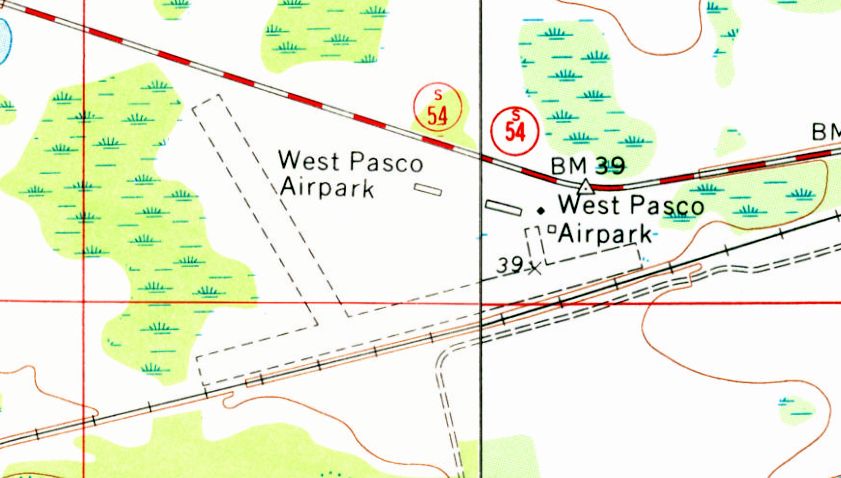
The 1974 USGS topo map depicted West Pasco Airpark as having 2 unpaved runways,
oriented northeast/southwest & northwest/southeast.
A 11/13/74 USGS aerial photo (courtesy of Dallam Oliver-Lee) showed West Pasco as still having 2 grass runways.
The January 1977 CH-25 World Aeronautical Chart (courtesy of Chris Kennedy)
depicted West Pasco as having a 3,200' unpaved runway.
West Pasco's Runway 8/26 was evidently paved at some point between 1974-77,
as that is how it was depicted on a 11/13/77 USGS aerial photo (courtesy of Dallam Oliver-Lee).
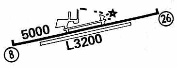
The 1979 Flight Guide (courtesy of Chris Kennedy) depicted West Pasco as having a 5,000' paved Runway 8/26,
parallel to the original grass runway on the south.
The crosswind northwest/southeast runway had apparently been abandoned.
A parallel taxiway & a ramp were depicted on the north side of the paved runway.
Joe Purcell recalled, “West Pasco Airpark... I took my first flying lesson here in 1979.”
The 1982 AOPA Airport Directory (courtesy of Ed Drury)
described the West Pasco Airport as having a single 5,000' asphalt Runway 8/26.
The original northeast/southwest grass runway had apparently been abandoned.
The operators were listed as Flying Aero and Ed Silvernell & Sons Inc.
A 1982 aerial photo depicted West Pasco as a very healthy little airport, with dozens of light aircraft.
A 2/7/84 USGS aerial photo (courtesy of Dallam Oliver-Lee) showed that 4 rows of hangars had been constructed just north of the former runway intersection,
replacing the original hangars on the northeast side.
The last aeronautical chart depiction which has been located of West Pasco Airpark
was on the 1985 FL Aeronautical Chart (courtesy of Alex Hauzer).
It depicted West Pasco as having a 5,000' paved northeast/southwest runway.
According to an article in the 5/12/04 issue of the St Petersburg Times,
Lew Friedland (owner of Seven Eagles Inc.) purchased the airport in 1985.
Hangars & a new building were added, and the runway was widened a bit.
A September 1987 NTSB accident report (Charles Oppermann) listed the airport as West Pasco Airpark.
Charles Oppermann recalled, “It was known at 'Tampa Bay Executive [Airport] from at least late 1988 onward.
I’m pretty sure it got renamed sometime in 1988, based on my logbook endorsement from January 1989 referring to “'ampa Bay Executive'.
I did my private pilot checkride with Philip Beale there on 11/14/89.”
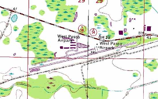
The 1990 USGS topo map depicted West Pasco Airpark as having a single runway, oriented northeast/southwest.
A parallel taxiway on the northwest side led to a total of five hangars on the north side of the field.
A March 1991 NTSB accident report (Charles Oppermann) listed the airport as Tampa Bay Executive.
The last aeronautical chart depiction which has been located of Tampa Bay Executive Airport was on the March 1994 Jacksonville Sectional Chart (courtesy of Ron Plante).
It depicted Tampa Bay Exec as having a 5,000' paved northeast/southwest runway.
The field was labeled "Tampa Bay Executive Airport" on the 1998 Sectional Chart.
A 1999 USGS aerial view looking southeast a Tampa Bay Executive Airport, a total of nine buildings (hangars) were visible on the ramp on the north side of the field,
as well as a good number of aircraft.
However, things for this well-used airport started to go downhill.
By 2001, the Tampa Bay Executive had officially changed to a private airfield, although it essentially continued to function as a public-use airport.
Julie DeStefano reported in 2001, "This is a vital airport for general aviation in the northern Pinellas/Pasco region.
Pilots who use this facility are often charmed by its laid back, friendly atmosphere.
Now, this airport is at risk of closure and may be taken from the 100+ base customers who have enjoyed it for years. It's a shame."
The airport teetered on the brink of closure when it lost is liability insurance in the aftermath of the 9/11/01 terrorist attacks, but insurance was obtained again.
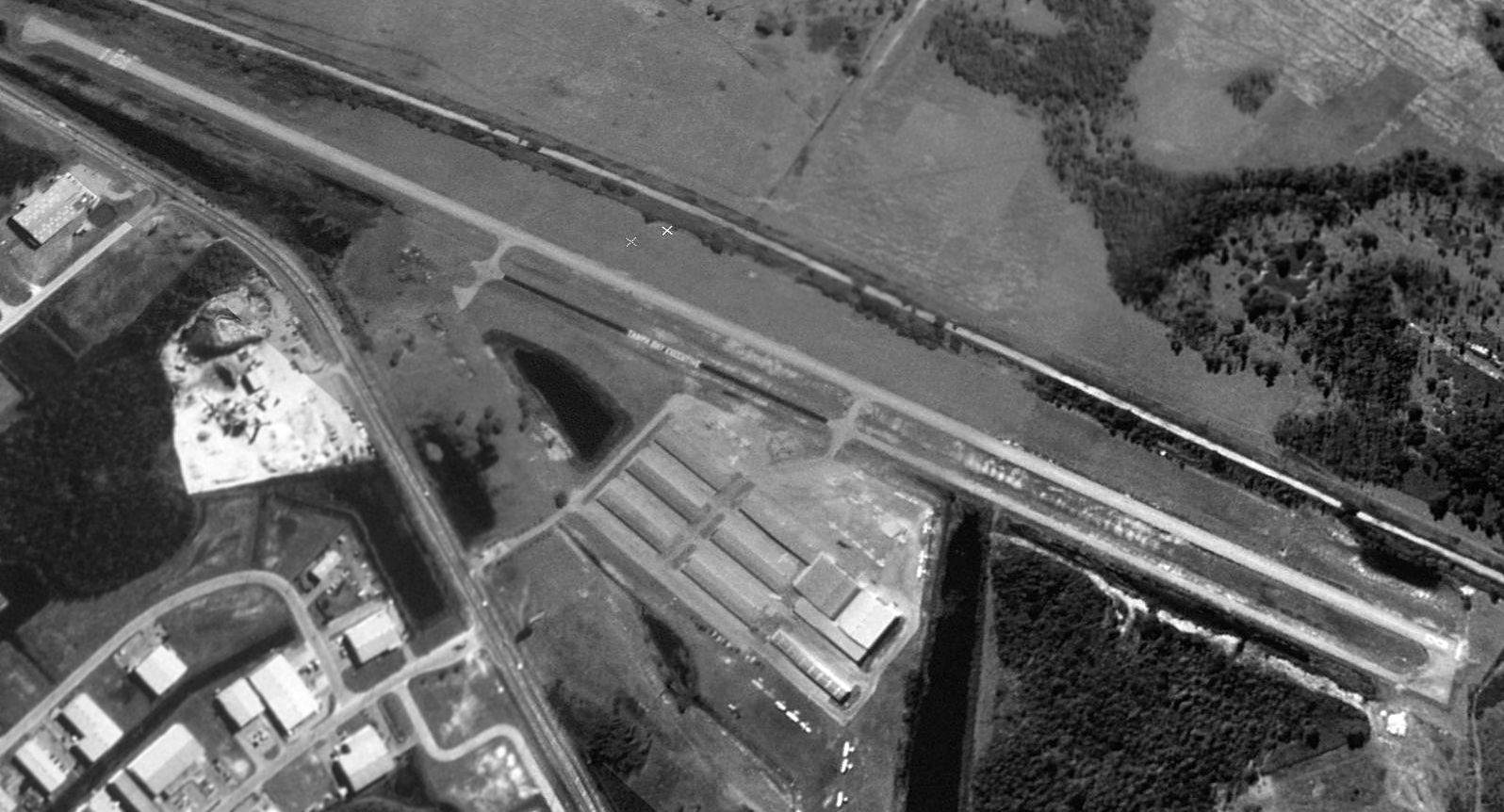
The last photo which has been located showing Tampa Bay Executive Airport still operational was a 12/31/03 aerial view (courtesy of Dallam Oliver-Lee).
Over a dozen light aircraft were still visible on the field.
William LeFebvre reported in 2004, "Sadly, this airport is closing on 10/1/04.
This is a great airport with a good location. I've flown in here several times. It will be missed."
An article in the 5/12/04 issue of the St Petersburg Times reported on the plans for the airport's closure.
Airport owner Lew Friedland says the airport will close on 10/1/04
and he is already talking to potential buyers of the 75-acre property on the fast growing State Road 54 corridor.
Friedland is president of Seven Eagles Inc., which owns Tampa Bay Executive & is an affiliate of the companies developing Trinity Communities.
The move, although long expected, was a shock to many in the community
and left county leaders wondering how it will affect the area.
Tampa Bay Executive was home to 100 aircraft, including a Bayflite medevac helicopter.
On Tuesday, County Commissioner Peter Altman suggested creating a "citizens task force"
to review the impact of the airport closure, particularly to Bayflite's air ambulance service.
The panel could also consider the possibility of building a new airport, Altman said.
But in a county where vacant land easily goes for $40,000 an acre,
Commissioner Steve Simon said, a 300-acre airport site could cost $12-million.
"While I feel for the private plane owner... I don't think the county's responsibility is to provide a facility for that," he said.
Airport owner Lew Friedland said "We do have some folks who are genuinely interested in the property,"
although "nobody's talking about building another airport."
Fast-paced residential growth surrounding Tampa Bay Executive & road widenings posed challenges for the airport.
"Everybody knew it was going to close," said Friedland, who has run the business for 19 years.
About 30 people work at the airport.
Pasco's building boom was a bust for Tampa Bay Executive.
Residential growth surrounding the airport now overwhelms it.
The widening of State Road 54 will bring vehicle traffic to the airport's doorstep -
posing a liability risk that Friedland said he does not want to take.
"I'm just kinda sick and tired of being in a business with so many potential lawsuits," he said Tuesday.
Tampa Bay Executive faced several suits & saw a number of "heartbreaking" crashes & accidents over the years.
Friedland said he wanted to close before SR 54 was widened
and we "felt like that gave everybody time to find new headquarters for their planes."
He is working on an agreement to keep Bayflite at the airport,
noting it does not need a runway, merely a helicopter pad & an office.
Other departments, such as "the mechanical shop and the flight school
are moving their operations to other airports in Pasco County," Friedland said.
In the 2004 Airport/Facility Directory listing,
Tampa Bay Executive Airport was described as having a single 5,000' asphalt Runway 8/26.
However, the runway was a mere 48' wide,
which was apparently a serious limitation preventing the use of this airfield by business jets.
Although a length of 5,000' is quite sufficient for most light jets,
most runways of that length would typically be at least 100' wide.
The field's owner was listed as Seven Eagles Inc., and the manager was listed as Anita Brink.
Jensen Aviation conducted flight training from the field.
A total of 108 aircraft were listed at being based on the field, including 11 multi-engine aircraft & 2 helicopters.
The field was said to conduct an average of 233 takeoffs or landings per day,
which would make the field extremely well used.
As pilots, how can we allow an airport which conducts over 80,000 takeoffs/landings per year to be lost?
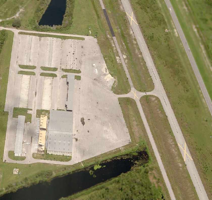
A 12/17/04 aerial photo (courtesy of Dallam Oliver-Lee) showed Tampa Bay Executive Airport remaining intact,
but devoid of aircraft, and with yellow closed-runway “X” symbols painted over the runway.
The February 2005 Tampa Terminal Aeronautical Chart (courtesy of Alex Price) depicted Tampa Bay Executive Airport as being closed.
A 5/27/05 aerial photo (courtesy of Dallam Oliver-Lee) showed that half of Tampa Bay Executive's hangars had been removed.
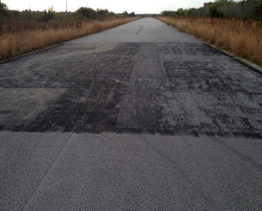
A 2005 photo by Charlie Helms looking along the runway at the former Tampa Bay Executive Airport,
with closed-runway “X” symbols visible.

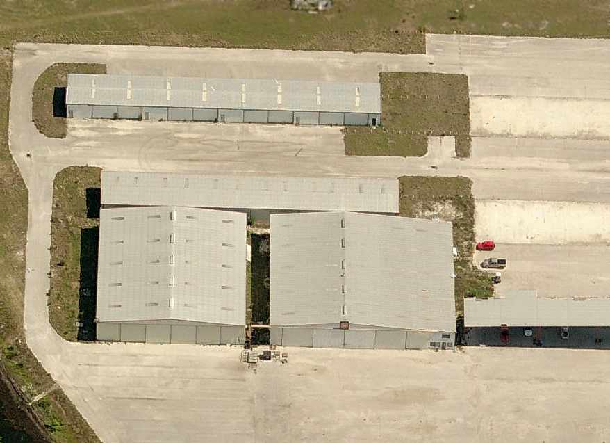
A 2005 photo by Charlie Helms, showing former hangars at the former Tampa Bay Executive Airport
in the process of being disassembled, with the walls having already been removed.
A circa 2005-2006 aerial view looking east at the site of Tampa Bay Executive Airport,
showing several of the hangars still remaining.
A circa 2006-2006 aerial view looking north at the hangars which remained at that point at the site of Tampa Bay Executive Airport.
A 12/31/06 aerial photo (courtesy of Dallam Oliver-Lee) showed the last of Tampa Bay Executive's hangars had been removed.
Paul Freeman flew over the site of the former Tampa Bay Executive Airport in April 2007.
All of the hangars & other buildings had been removed, but the former runways, taxiways, and ramps remained intact.
A 5/7/07 aerial photo (courtesy of Dallam Oliver-Lee) showed that most of the property of Tampa Bay Executive
had been scraped clean in preparation for new construction,
with the exception of a remaining northeastern third of Runway 8/26.
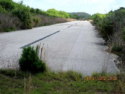
A 4/1/12 photo by Joe Purcell of “what is left of West Pasco Airpark... maybe about 400' of runway.
The rest is being developed as Trinity Corporate Park.”
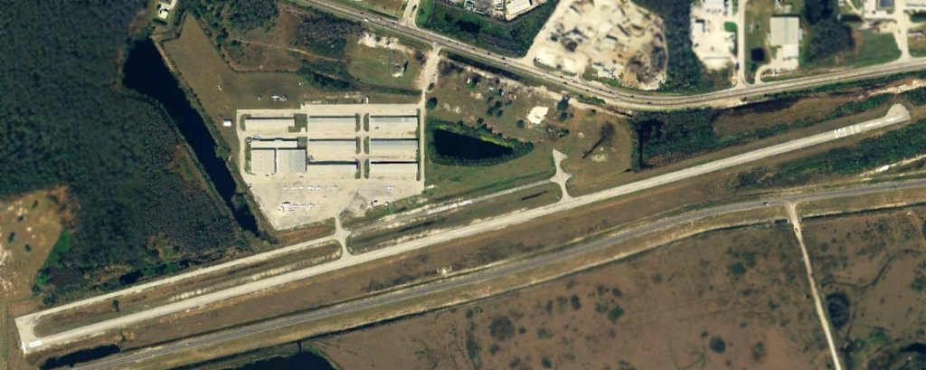
A 3/14/13 aerial view (courtesy of Dallam Oliver-Lee) showed the northeastern third of Runway 8/26 as the sole remnant of Tampa Bay Executive Airport.
A February 2013 photo by John Hisghman showing the recognizable Runway 26 numbers at the site of Tampa Bay Executive Airport.
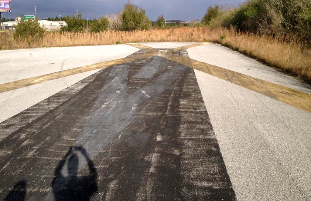
A February 2013 photo by John Hisghman showing the closed runway “X” symbol at the site of Tampa Bay Executive Airport.
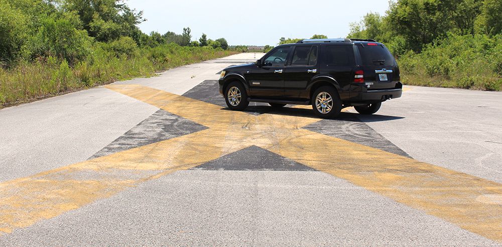
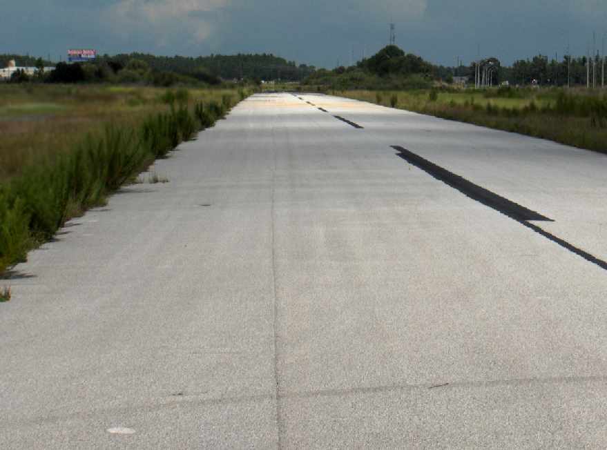
A May 2016 photo by Matt Frankling of the closed runway “X” symbol at the site of Tampa Bay Executive Airport.
Matt reported, “The 1,600' remaining of Tampa Bay Executive Airport is still there. I christened my new Exploder’s 4X4 mode getting to it.
The asphalt is in great condition, but there is a sign on the road saying a car wash is going in soon, so I think the pavement's days are numbered.”
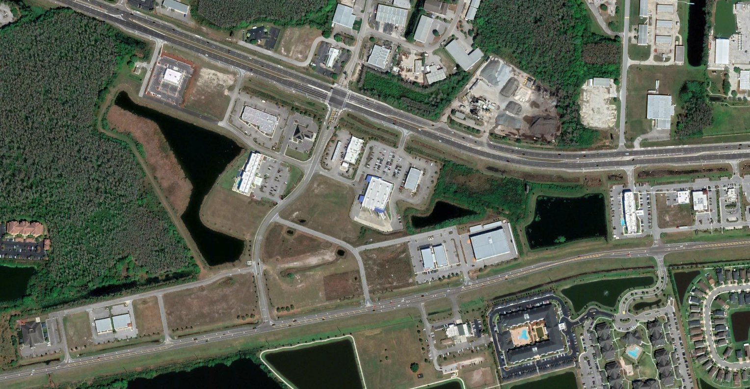
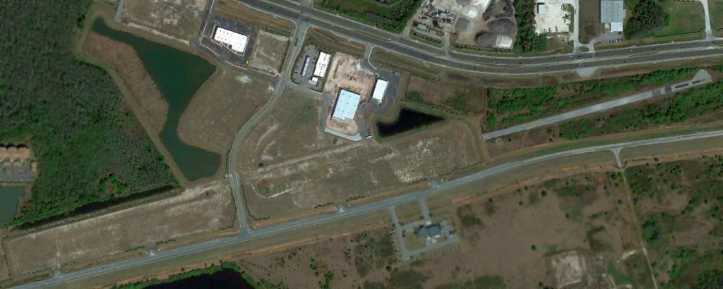
Unfortunately a 2022 aerial view shows no trace remaining of Tampa Bay Executive Airport.
Tampa Bay Executive Airport is located south of the intersection of Route 54 & Success Drive.
____________________________________________________
Haldeman-Elder Field, Lakeland, FL
28.021, -81.9 (East of Tampa, FL)
A 12/8/27 photo of Haldeman-Elder Field's Dedication, from the March 1928 Popular Aviation magazine (courtesy of The Lakeland History & Culture Center).
Lakeland's original airport was located southeast of the city.
According to Lakeland Librarian Rebecca Whalon, “Haldeman-Elder Field was constructed in 1927 & dedicated on 12/8/27.”
The earliest depiction which has been located of Haldeman-Elder Field was a 12/8/27 photo of the airport's Dedication
from the March 1928 Popular Aviation magazine (courtesy of The Lakeland History & Culture Center).
Haldeman-Elder Field was named for 2 famous Lakeland pilots, George Haldeman & Ruth Elder,
who in 1927 had attempted a transatlantic flight in an attempt to make Elder the first woman to fly across the ocean.
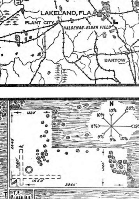
The January 1928 Commerce Department Airway Bulletin (courtesy of The Lakeland History & Culture Center)
Haldeman-Elder Field as a municipal airport consisting of a 160 acre L-shaped grass field
within which were 2 runways measuring 1,650' east/west & 1,260' north/south.
One 4-place hangar was described as “to be constructed”.
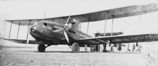
An undated aerial view looking northeast from the March 1928 Popular Aviation magazine (courtesy of The Lakeland History & Culture Center)
depicted Haldeman-Elder Field as having 2 perpendicular runways.
The earliest aeronautical chart depiction which has been located of Haldeman-Elder Field was on the June 1935 Orlando Sectional Chart.
It depicted Haldeman-Elder Field as a commercial/municipal airport.
By the 1930s, Haldeman-Elder Field was proving inadequate to meet Lakeland's needs.
Land was acquired on the north side of the town, and Lakeland Municipal Airport was dedicated in 1935.
However, Haldeman-Elder Field continued to remain open, in a lesser capacity.
According to Lakeland Librarian Rebecca Whalon, “In the years after the construction of Lakeland Municipal Airport,
Haldeman-Elder Field was primarily used by local pilots flying small aircraft.
There was quite a kerfuffle where angry pilots tried to take the job of Lakeland Municipal Airport's director,
since he was more interested in accommodating larger commercial flights rather than the local pilots.
A deal was struck where the local pilots flew primarily out of Haldeman-Elder Field, and Lakeland Municipal Airport's director hung onto his job.”
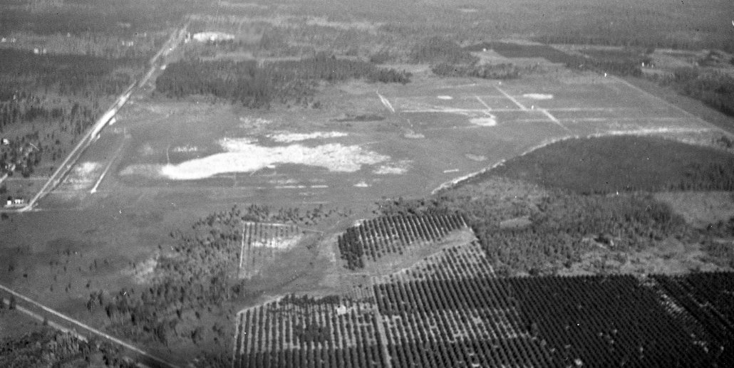
A circa 1941 aerial view looking south at Haldeman-Elder Field (courtesy of The Lakeland History & Culture Center).
Lakeland Librarian Rebecca Whalon noted, “It shows Haldeman-Elder Field shortly before it came into use as an auxiliary field.
You can see the original runways. The area to be used by the Lodwick cadets hasn’t been cleared of trees yet.”

A circa 1941-45 aerial view looking southwest at Haldeman-Elder Field (courtesy of The Lakeland History & Culture Center).
Lakeland Librarian Rebecca Whalon noted, “It shows the original runways with the area used by the Lodwick cadets to the slight northeast.
This part of the airport property was bordered to the north by Skyview Drive.”
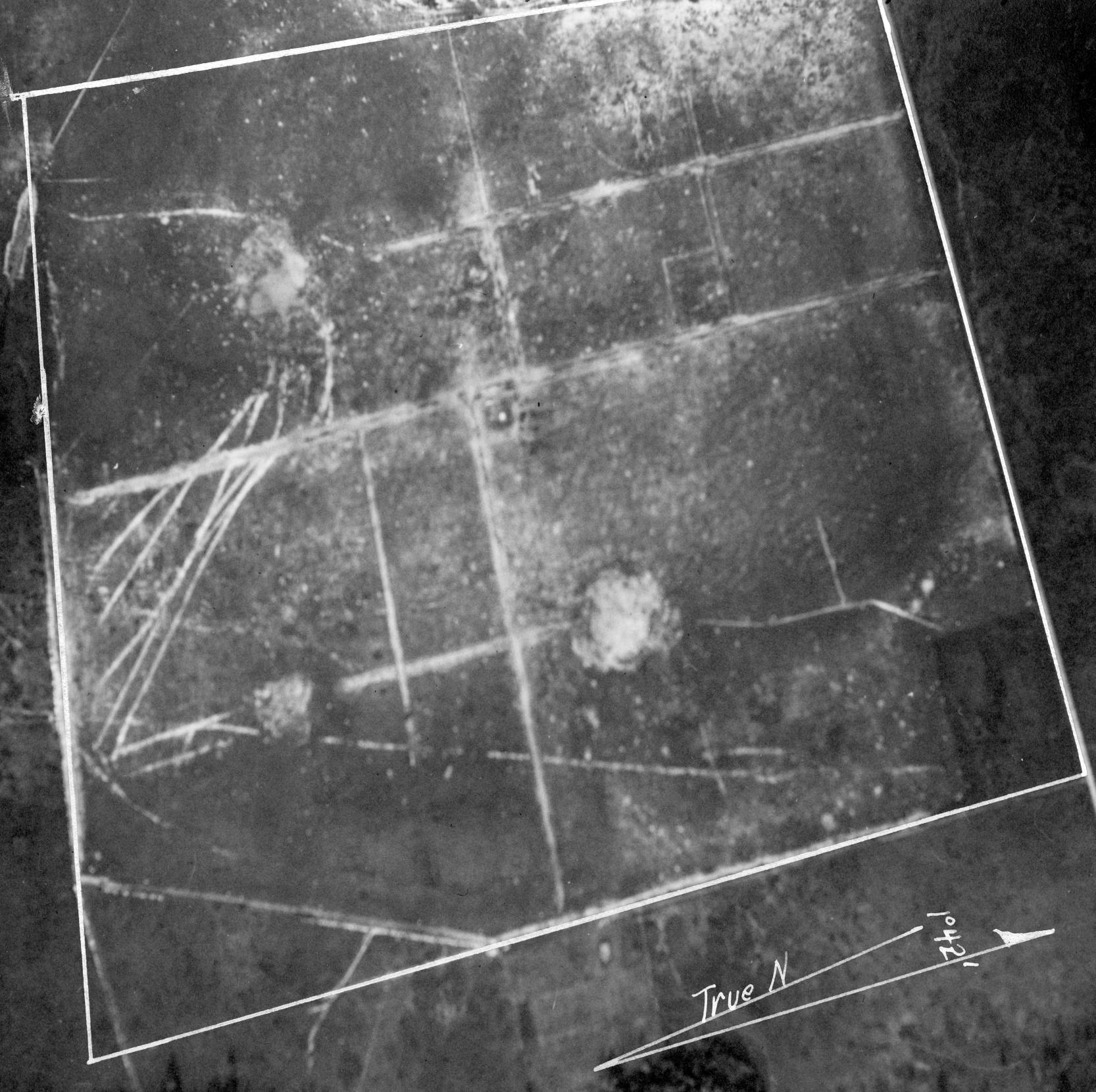
The earliest photo which has been located of Haldeman-Elder Field was a circa 1941-45 aerial view looking west (courtesy of Lakeland History Room at Lakeland Public Library).
It was originally captioned, “Approximate vertical Haldeman-Elder Auxiliary Field, Lodwick School of Aeronautics, Lakeland, FL.”
According to Lakeland Librarian Rebecca Whalon, “In regards to Haldeman-Elder Field's use as a WW2 Auxiliary field,
I have found that all of the Lodwick activities were concentrated in the upper right area of the field.
Cadets regularly used the site, and there were multiple crashes / ground loops.”
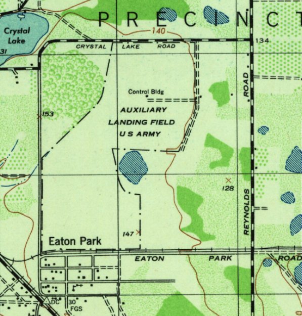
The 1944 USGS topo map depicted Haldeman-Elder Field as an irregularly-shaped property outline, labeled “Auxiliary Landing Field US Army”.
A “Control Building” on the northeast side was the only improvement depicted.
The last depiction which has been located of Haldeman-Elder Field was on the February 1946 Orlando Sectional Chart.
It depicted Haldeman-Elder Field as an auxiliary airfield.
Haldeman-Elder Field was evidently closed at some point in 1946,
as it was no longer depicted on the August 1946 Orlando Sectional Chart.
According to Lakeland Librarian Rebecca Whalon, “The exact date Haldeman-Elder Field closed is unclear.”
The 1962 USGS topo map continued to depict the irregularly-shaped property outline of Haldeman-Elder Field, but generically labeled as “Airfield”.
The “Control Building” also was still depicted on the northeast side.
According to Lakeland Librarian Rebecca Whalon, “Aerial photography of the area show that phosphate mining was underway by 1964.
At that point, only the portion of the airfield where the runways crossed was untouched, the rest had been / was being mined.”
A 1971 aerial photo showed that residential streets had been constructed over portions of the Haldeman-Elder Field property,
while other portions were overgrown.
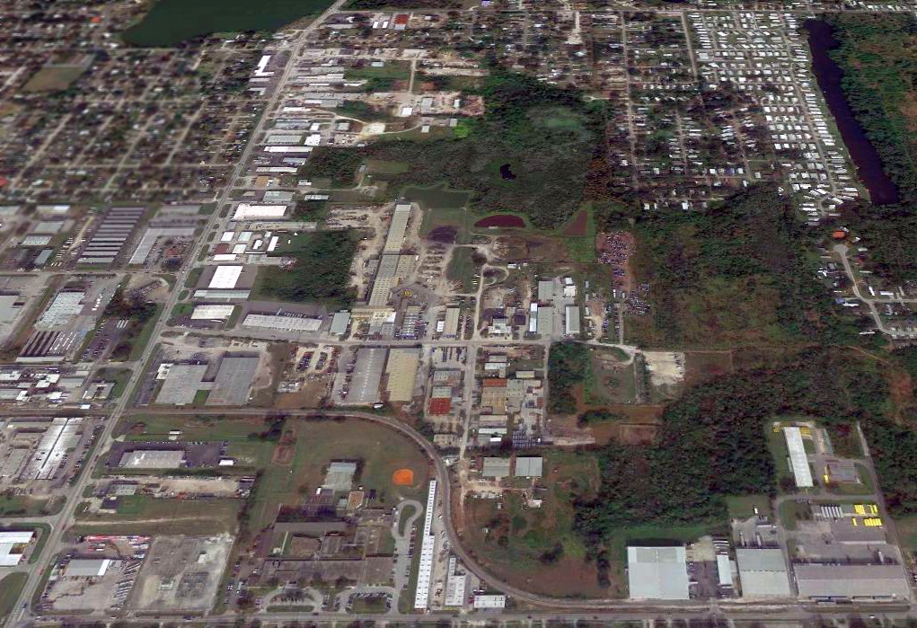
A 2018 aerial view showed no trace remaining of Haldeman-Elder Field.
The only present-day clue to the existence of Haldeman-Elder Field comes from the street names on the north side of the airfield site: Skyview Drive & Skyview Boulevard.
Thanks to Rebecca Whalon for pointing out this airfield.
____________________________________________________
Lakeland Municipal Airport / Lodwick Field, Lakeland, FL
28.078, -81.95 (East of Tampa, FL)
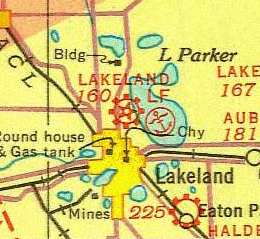
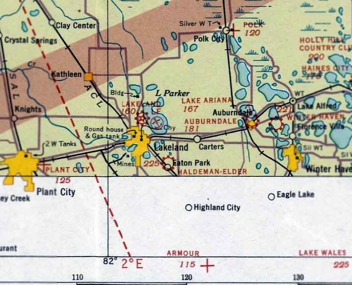
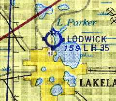
What was originally known as "Lakeland" Airport, as depicted on the 1935 Orlando Sectional Chart.
By the 1930s, Lakeland's Haldeman-Elder Field (southeast of the city) was proving inadequate to meet the city's needs.
In late 1933 & early 1934, the city acquired several parcels of land between Lakeland Hills Boulevard & Lake Parker
and applied for funds from the Civil Works Administration to build a new airport.
The funds were approved & construction begun in early 1934.
The airport was dedicated as Lakeland Municipal Airport in 1935.
The earliest depiction which has been located of the Lakeland Airport was on the 1935 Orlando Sectional Chart.
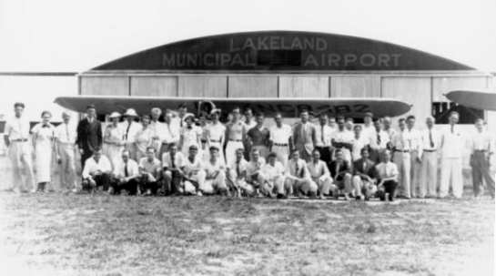
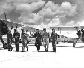
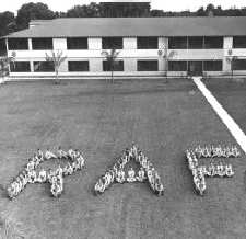
A 1936 photo of an "Air School" class (funded by the Works Progress Administration)
posing in front of a hangar at Lakeland Municipal Airport.
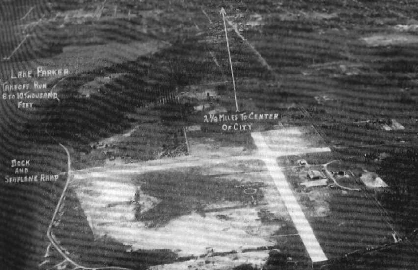
An aerial view looking south at Lakeland Municipal Airport,
from the Airport Directory Company's 1937 Airports Directory (courtesy of Bob Rambo).
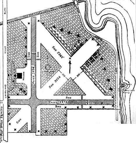
The layout of Lakeland Municipal Airport,
from the Airport Directory Company's 1937 Airports Directory (courtesy of Bob Rambo).
The directory described Lakeland Municipal Airport as having two paved runways (with the longest being the 2,496' north/south strip)
and two sod runways.
A dock & seaplane ramp were adjacent to the west side of the field, on the shore of Lake Parker.
The manager was listed as Charles Bentley.
Del Harding reported that, in 1940, "My grandfather E.J. Sias moved the Lincoln Airplane & Flying School
flight ops [from Lincoln NE] to Lakeland because of its better flying weather.
When he found it difficult to commute between Lincoln & Lakeland,
he sold the flight ops business to [Albert] Lodwick.
Albert Lodwick purchased the flight school, he renamed it Lakeland School of Aeronautics, later the Lodwick School of Aeronautics,
and established its headquarters at leased facilities at the Lakeland Municipal Airport.
A year later he established the Lodwick Aviation Military Academy in nearby Avon Park, FL.
Both schools were civilian operations under contract to the Army
to provide primary flight training to Army Air Force cadets.
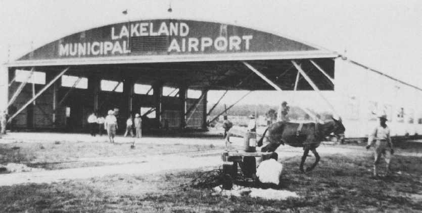
A 1940 photo of an Army mule in front of a hangar at Lakeland, during construction (courtesy of David Brooks).
A late-1940 aerial view looking northwest at Lakeland Municipal Airport,
showing the significantly expanded airport configuration (courtesy of David Brooks).
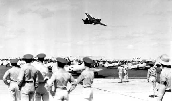
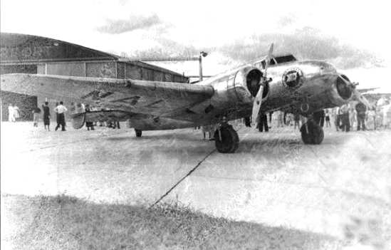
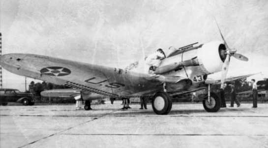
A September 1943 photo of a Douglas P-70 night fighter completing a flyover of the Lodwick School of Aeronautics.
The P-70 was most likely part of a squadron from Orlando used to train pilots in night-fighting tactics.
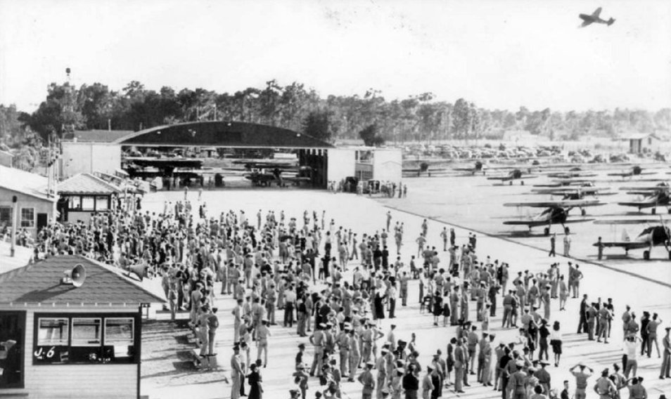
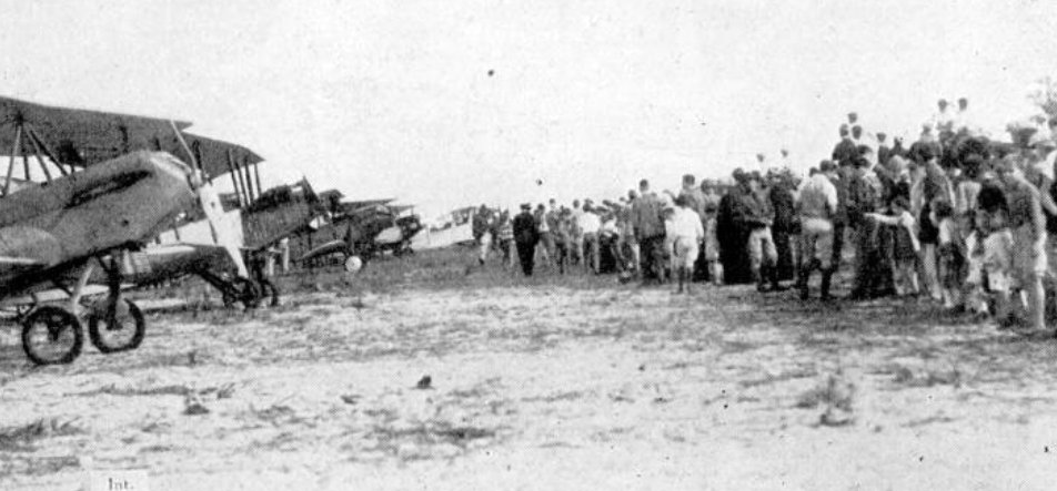
A 1940s photo of a large number of spectators viewing the Lodwick School of Aeronautics.
The 1944 US Army/Navy Directory of Airfields (courtesy of Ken Mercer)
described "Lakeland Municipal #1" as having a 3,500' hard-surface runway,
and indicated that Army flight operations were conducted from the field.
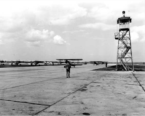
A circa 1940s photo of several biplanes next to Lodwick Field's control tower.
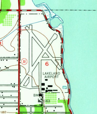
The 1944 USGS topo map depicted Lakeland Airport as having 3 paved runways & several buildings on the southeast side.

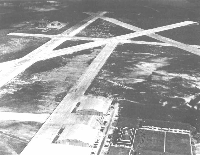
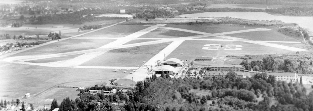
A WW2-era aerial view looking northwest at Lakeland Municipal Airport (courtesy of Scott Kimball), captioned “Main Airport, 60th AAFFTD, Lodwick School of Aeronautics, Lakeland”.
It depicted Lakeland Municipal as having 4 paved runways, along with a paved taxiway leading to 2 arched-roof hangars on the south side of the field.
A large number of planes appeared to be parked on the taxiway between the hangars & runways.
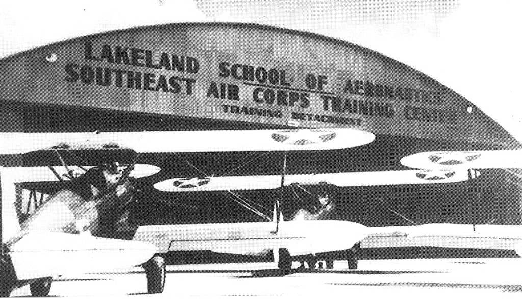
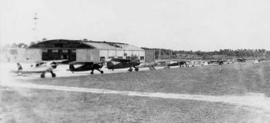
A WW2-era photo of Stearman PT-17 biplane trainers in front of a “Lakeland School of Aeronautics” hangar.
During its nearly 5 years of existence, the Lodwick School of Aeronautics admitted more than 8,000 cadets (including British Royal Air Force cadets),
graduating more than 6,000.
The Lodwick School of Aeronautics closed in August, 1945.
Lodwick wasted little time in converting his war time operation into a peacetime industry.
He incorporated Lodwick Aircraft Industries in February, 1946.
The new company engaged in the business of converting war surplus military aircraft to commercial use
and contracted with the War Assets Administration to sell war surplus aviation parts & equipment.
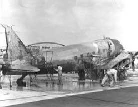
An undated photo of a military C-47 being converted to civilian use at Lodwick Aircraft Industries.
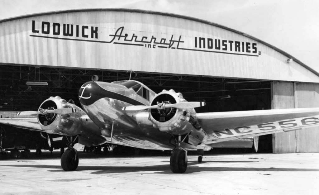
A 1946 photo of a beautiful Beech 18 which served as the corporate aircraft for Lodwick Aircraft Industries, in front of their hangar.
The City Commission honored Lodwick's service to the country by renaming the airport Al Lodwick Field in 1948.
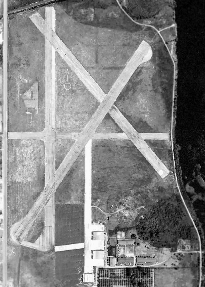
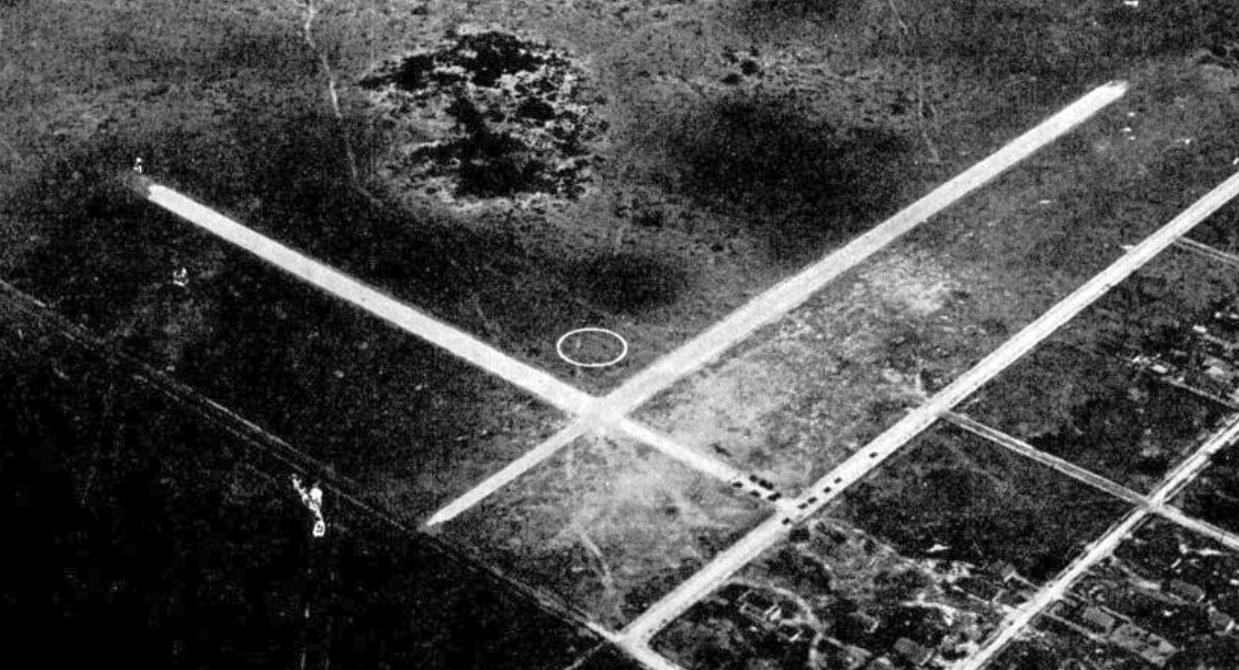
An April 1952 US Government aerial view of Lakeland Municipal Airport (courtesy of FL DOT, via Brian Rehwinkel).
The photo depicted Lakeland Municipal as having 4 paved runways, along with a paved taxiway leading to 2 arched-roof hangars on the south side of the field.
The buildings formerly used to house the Lodwick School of Aeronautics were adjacent to the east side of the hangars.
If you look very closely at the aerial photo, you can even see a plane on the northwest/southeast runway.
Lodwick Aircraft Industries foundered after some early success.
The number of military aircraft available for conversion to commercial use dwindled
and most of the surplus parts & equipment it contracted to sell were obsolete & had no market.
By 1954 the company was moribund. It had lost most of its assets in a bank foreclosure & ceased operations in September.
The Municipal Airport continued to be used by the city for several more years,
but gradually more & more of the complex was converted for use as the spring training home of the Detroit Tigers.
By the summer of 1957, the city had decided to phase out Lodwick Field as an airport
and concentrate its resources on Drane Field in south Lakeland
(what eventually became today's Lakeland Linder Regional Airport).
Lodwick Field was still depicted as an active airfield on the August 1957 Orlando Sectional Chart (courtesy of Chris Kennedy),
and was described as having a 3,500' hard-surface runway.
Several light aircraft were visible parked around the hangars.
Lodwick Field was evidently closed at some point between 1958-60,
as it was no longer listed among active airfields in the 1960 Jeppesen Airway Manual (according to Chris Kennedy)
and was no longer depicted on the 1962 USGS topo map.
By the time of the April 1964 Orlando Sectional Chart (courtesy of Chris Kennedy),
the former Lodwick Field was depicted as "Abandoned airport".
A note about some of the above photos:
The Lodwick School of Aeronautics & Lodwick Aircraft Industries
had been housed in a building leased from the City of Lakeland.
When the latter company went out of business in the early 1950's,
Lodwick apparently left behind a cache of photographic prints & negatives
which he had collected during his long career in the aviation industry.
After Lodwick's departure, the site became the spring training headquarters of the Detroit Tigers baseball team.
The photos remained undisturbed until discovered in 1988
by Lakeland city workers preparing to raze the building which housed them.
At this point the Albert Lodwick Photograph Collection
was transferred to the Special Collections unit of the Lakeland Public Library.
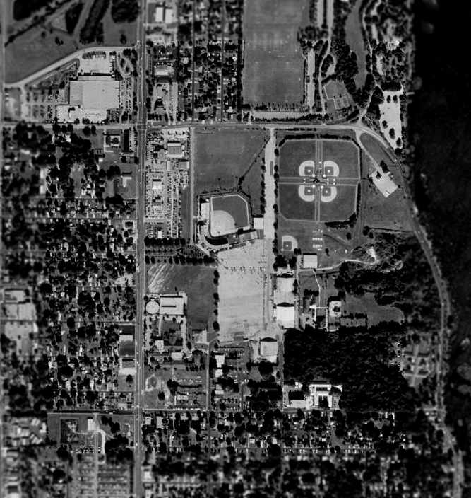
In the 1999 USGS aerial view, quite a few elements of the former airport still remained:
the three arched-roof hangars, as well as the paved taxiway leading away from the hangars toward the north,
and even the outline of a portion of the northeast/southwest runway (visible on either side of the baseball stadium).
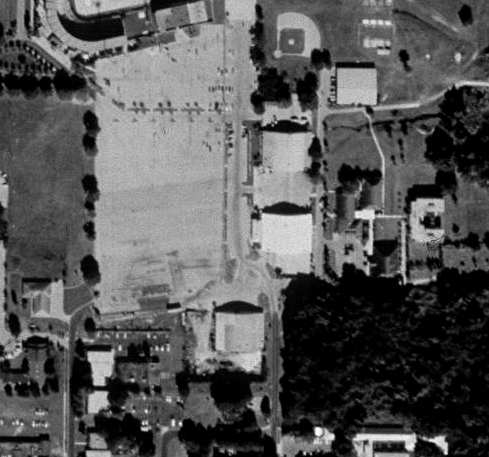
A closeup from the 1999 USGS aerial photo of the three arched-roof hangars which remain at the site of Lodwick Field.
A portion of the airport site is now Tiger Town, the modern spring training complex of the Detroit Tigers,
with Joker Merchant Stadium occupying part of the site.
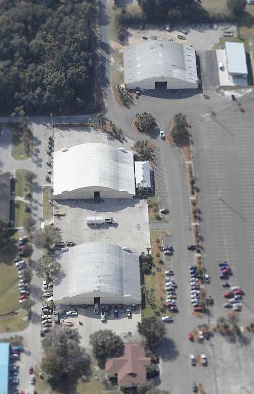
A circa 2000-2005 aerial view looking south at the 3 remaining former hangars at the site of Lodwick Field.
Ken Webb pointed out in 2003 that 3 hangars from Lodwick Field remained standing,
"where the city holds various events & stores equipment.
The hangars are in pretty good shape."
Other current occupants of the site of the former airfield (in addition to the stadium)
include a car dealership (Regal Pontiac), a nursing home, and fire training complex.

An 8/23/15 photo by Matt Franklin of a former Lodwick Field hangar, “the one that terminates off the taxiway.”
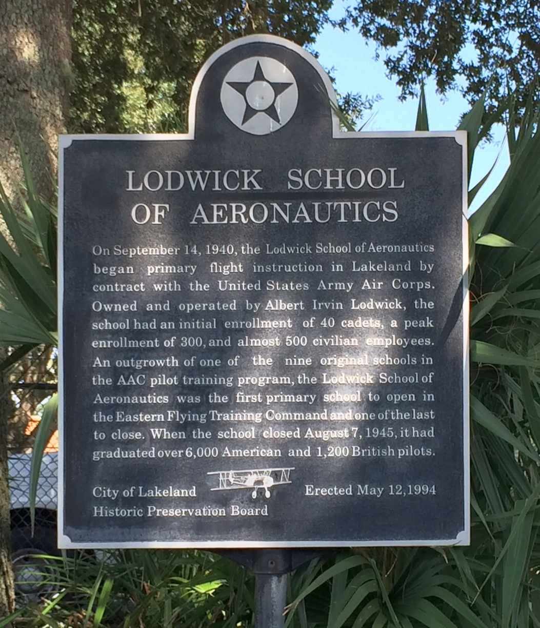
An 8/23/15 photo by Matt Franklin of a historic marker commemorating the Lodwick School of Aeronautics.
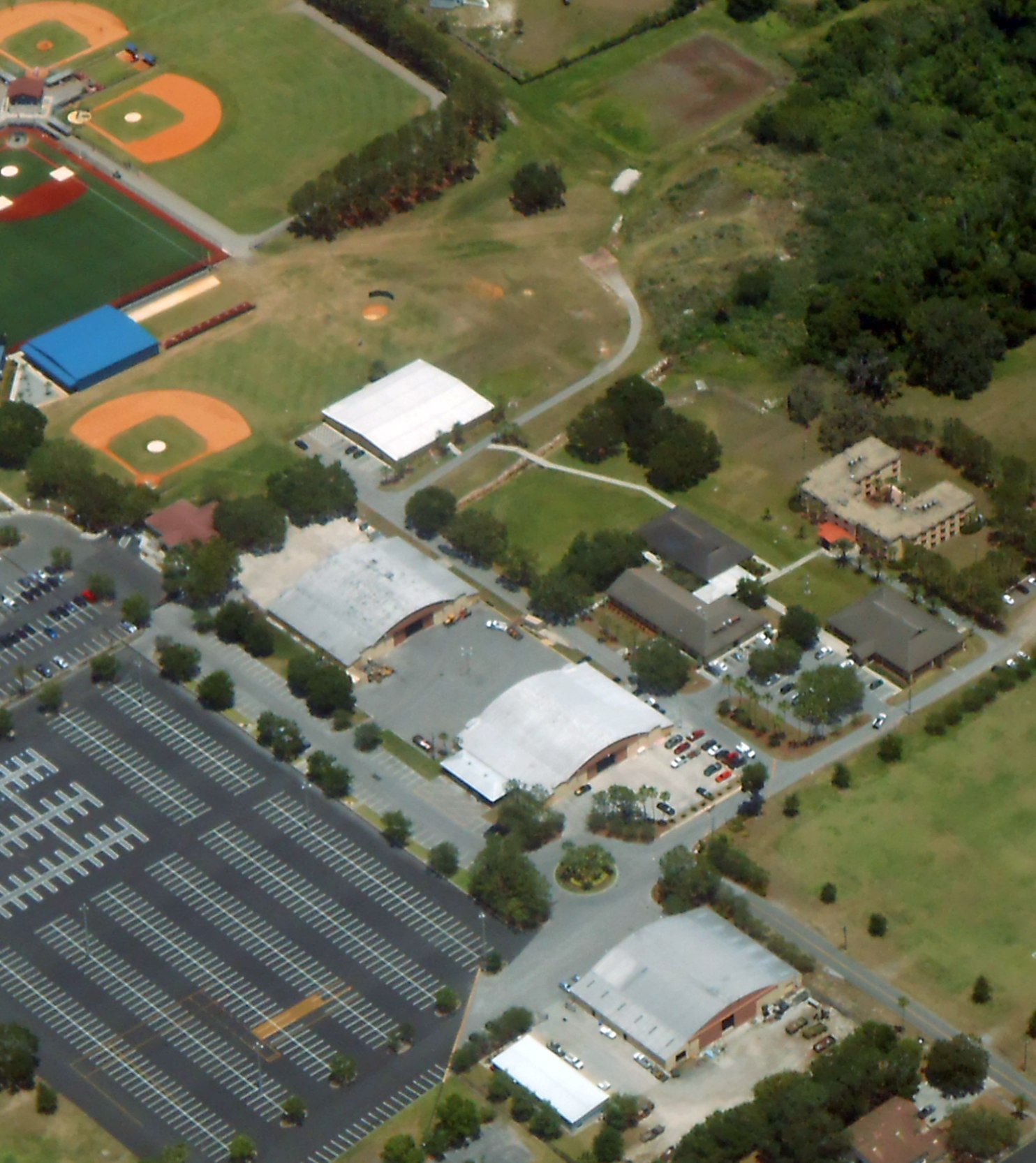
A 5/4/18 aerial view by Alex Price looking northeast at the 3 remaining former hangars at the site of Lodwick Field.
Alex observed, “You can see a bit of runway just east of the 4-pack of baseball fields [top-right of photo].
Also, the hangars apparently survive. If this airport were still around, it'd be a great releiver for Sun 'N' Fun!”
The site of Lodwick Field is located north of the intersection of East Bella Vista Street & North Lake Avenue.
Thanks to Don Emerson & Ken Webb for pointing out this airfield.
____________________________________________________
Bushnell Airport (original location) / Bushnell Army Airfield, Bushnell, FL
28.654, -82.06 (West of Orlando, FL)
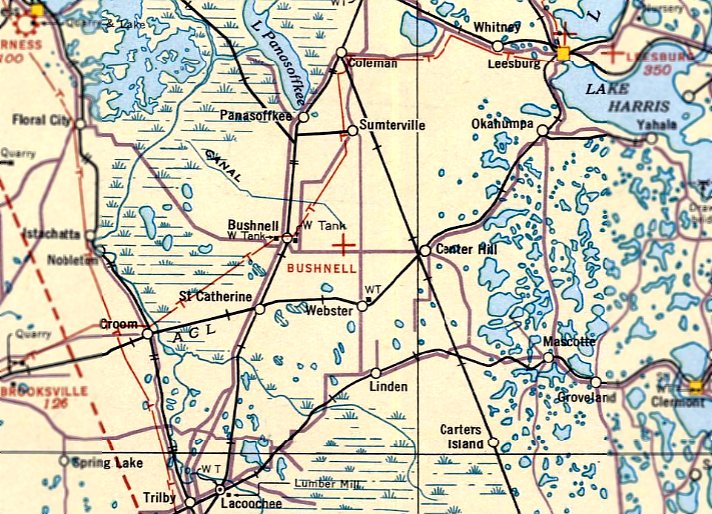
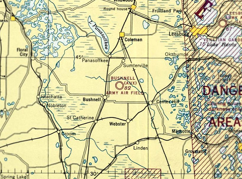
Bushnell Airport, as depicted on the June 1935 Orlando Sectional Chart.
The date of establishment of Bushnell Airport has not been determined.
The earliest depiction which has been located of Bushnell Airport was on the June 1935 Orlando Sectional Chart.
It depicted Bushnell Airport as an auxiliary airfield.
The January 1936 Commerce Department Description of Airports & Landing Fields (according to Brian Rehwinkel) described Bushnell Airport as bring 4 miles southeast of the town of Bushnell,
triangular shaped, and having 3 grass runways from 2,000' to 2,800' feet in length.
Bushnell Airport was still depicted as an auxiliary airfield on the July 1942 Orlando Sectional Chart.
The earliest photo which has been located of Bushnell Airport was a 3/14/43 aerial view looking north (from the National Archives, courtesy of Brian Rehwinkel).
It depicted Bushnell Airport as a rectangular grass clearing, with an airfield circle marking in the center.
There were no buildings or other airport improvements visible, nor any aircraft.

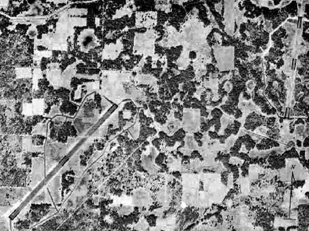
A September 1943 aerial view looking north (from the National Archives, courtesy of Brian Rehwinkel) depicted all 3 airfields to the east of Bushnell:
Bushnell Airport in the lower-right corner of the photo, the Bushnell Aux Army Airfield “Bomber runway” at top-left, and the Bushnell Aux Army Airfield “Fighter runway” at top-center.
The October 1943 Army & Navy Directory of Airfields (according to Brian Rehwinkel) described Bushnell Airport as being used by the Army as an undesignated airfield.
Bushnell Airport was evidently taken over for military use during WW2,
as it was labeled Bushnell Army Air Field on the February 1944 Orlando Sectional Chart.
The Bushnell Airport location to the east of the town was evidently abandoned at some point in 1944,
as it was no longer depicted on the July 1944 Orlando Sectional Chart.
Instead it depicted the “Bushnell (Aux) Army Air Field” a mile to the north, to the northeast of the town.
A 1949 aerial photo (according to Brian Rehwinkel) depicted the site of Bushnell Airport as being unchanged from the 1943 aerial photo - very undeveloped.
No airfield was depicted at this location on the 1960 USGS topo map.
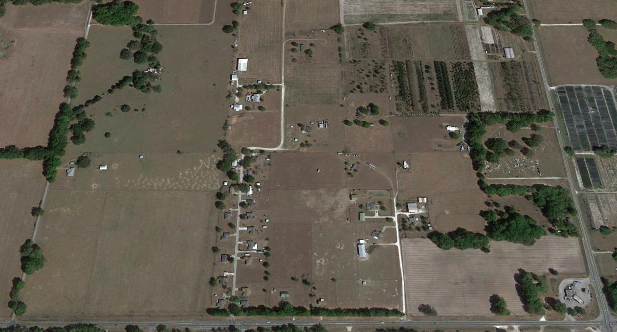
A 2017 aerial view looking north did not show any recognizable trace of Bushnell Airport.
The site of Bushnell Airport is located northwest of the intersection of East County Road 48 & State Road 471.
____________________________________________________
Bushnell Auxiliary Army Airfield / Bushnell Airport (2nd location), Bushnell, FL
28.68, -82.09 (West of Orlando, FL)
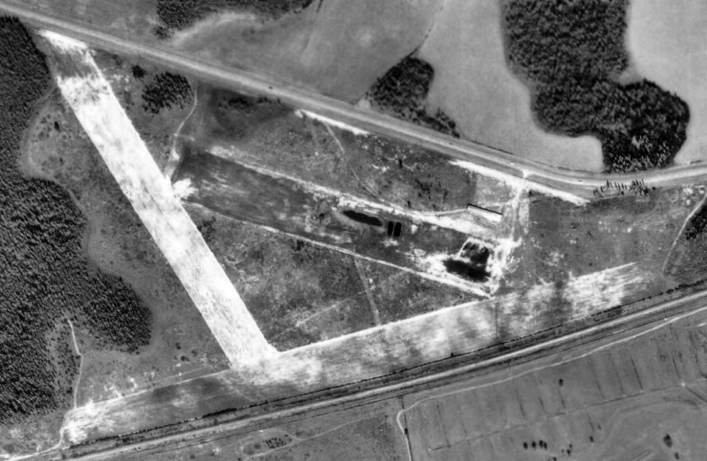
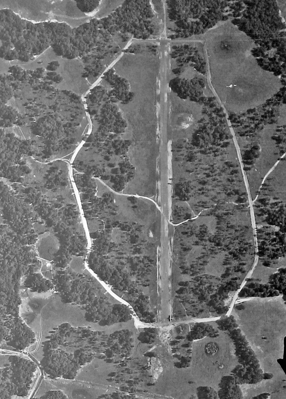
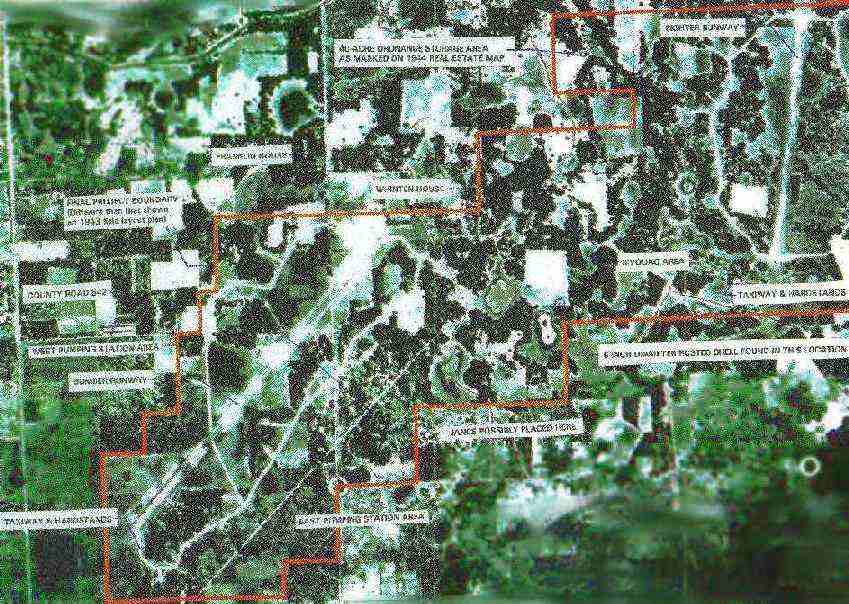
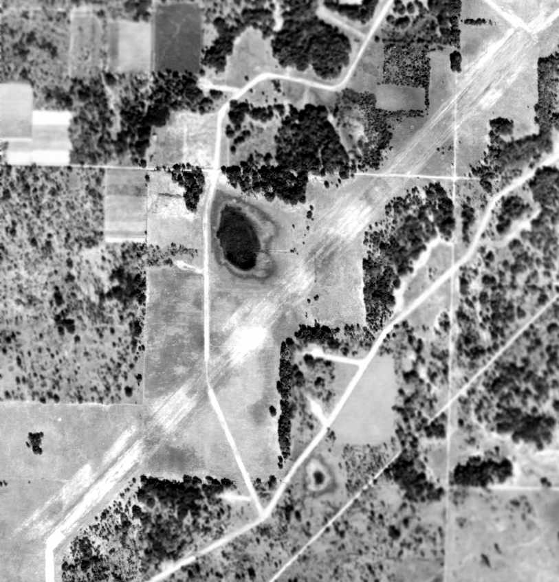
A 9/4/43 aerial view of Bushnell's southwest “bomber” runway (from the National Archives, courtesy of Brian Rehwinkel).
The Bushnell Auxiliary Army Airfield was acquired by lease from various owners beginning in 1940.
The airfield was constructed the by the 841st Aviation Engineers Battalion in 1943.
According to Bushnell Auxiliary Army Air Field's April 1945 Basic Layout Plan (according to Brian Rehwinkel),
“The runways, taxiways, and roads were constructed by units of the engineer aviation troops attached to Orlando Army Air Base as a training program.”
According to an Army Corps of Engineers report, Bushnell Auxiliary Army Airfield was used extensively in chemical warfare trials.
In 1943 the Dugway Proving Ground Mobile Chemical Warfare Service Unit
arrived at Bushnell Auxiliary Army Airfield to begin experiments on non-persistent chemical agents,
setting up the Chemical Warfare Service Experimental Station.
The airfield was used by the Dugway Proving Ground Mobile CWS Unit
as a landing strip for the planes used in the field trials at Withlacoochee Bombing & Gunnery Range
(which also had its own airfield, Withlacoochee AAF).
According to other sources, Bushnell Auxiliary Army Airfield was also used by B-17s from Brooksville AAF, B-25s from Montbrook AAF,
P-47s from Cross City AAF, P-38s from Lakeland AAF, and B-26s from Tampa.
In 1943, Bushnell Auxiliary Army Airfield was called a "T/O training field, supporting the main base of the AAF School of Applied Tactics at Orlando".
It was classed as a temporary field on standby basis in 1944.
The earliest depiction which has been located of Bushnell Auxiliary Army Airfield was 9/4/43 aerial view (from the National Archives, courtesy of Brian Rehwinkel).
It depicted 2 runways not located adjacent to each other: the larger “Bomber runway” to the southwest & a smaller “Fighter runway” to the northeast.
The northeast/southwest bomber runway appeared to be in the process of being paved with asphalt,
and had an extensive system of taxiways on either side leading to a number of dispersal aircraft parking positions.
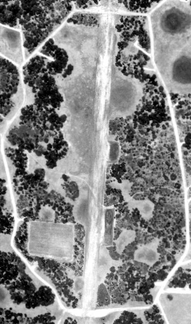
The only photo which has been located showing an aircraft at either Bushnell Auxiliary runway
was a 9/4/43 aerial view of Bushnell's northeast “fighter” runway (from the National Archives, courtesy of Brian Rehwinkel).
The north/south fighter runway appeared had taxiways on either side, but the dispersal aircraft parking positions had not yet been constructed.
An unidentified single-engine aircraft was visible on the very southern end of the runway.
A September 1943 aerial view looking north (from the National Archives, courtesy of Brian Rehwinkel) depicted all 3 airfields to the east of Bushnell:
the Bushnell Aux Army Airfield “Bomber runway” at top-left, the Bushnell Aux Army Airfield “Fighter runway” at top-center, and Bushnell Airport in the lower-right corner of the photo.
A 1/6/44 aerial view from the 1945 AAF Airfield Directory (courtesy of Scott Murdock) depicted the 2 runways of Bushnell Aux AAF:
the “Bomber runway” to the southwest & a smaller “Fighter runway” to the northeast.
Bushnell Auxiliary Army Air Field was not yet depicted on the February 1944 Orlando Sectional Chart.
The earliest aeronautical chart depiction which has been located of Bushnell Auxiliary Army Air Field was on the July 1944 Orlando Sectional Chart.
The 1944 US Army/Navy Directory of Airfields (courtesy of Ken Mercer) described Bushnell AAF as having a 6,000' hard-surface runway.
The 1945 Airport Directory for Continental US described the airfield as 1,480 acres total area
having no radio facilities, no gasoline, and no hangars.
Bushnell AAF had 2 runways: a 4,000' NNE/SSW steel plank landing mat runway
and a 6,000' NE/SW rod & bar landing mat runway with limerock base.
The 6,000' runway was known as the "Bomber runway", while the 4,000' strip was known as the "Fighter runway".
An aircraft parking area was apparently located at the southwest end of the bomber runway.
According to Bushnell Auxiliary Army Air Field's April 1945 Basic Layout Plan (according to Brian Rehwinkel),
the 6,000' northeast/southwest “bomber runway” consisted of heavy rod & bar matting over 4”-6” limestone base.
The 4,020' north/south “fighter runway” was covered by perforated steel planking on top of compacted sand.
The taxiways were made of rod & bar matting on a limestone base.
The airfield had a few buildings, including a fire station, a post exchange, and a day room.
Brian Rehwinkel remarked, “I am sure there was not much in the way of substantial buildings because everything about this airfield seemed to be very temporary.”
The 1945 AAF Airfield Directory (courtesy of Scott Murdock) described “Bushnell AAF”
as a 1,480 acre irregularly-shaped field having 2 runways: a 6,000' rod & bar northeast/southwest strip, and a 4,000' steel plank NNE/SSW strip.
The field was not said to have any hangars, to be owned by the U.S. Government, and operated by the Army Air Forces.
“Bushnell (Aux) Army Air Field” was still depicted on the August 1945 Orlando Sectional Chart.
Bushnell Aux AAF was closed in 1945.
At the end of the war, the 20,000 steel mats which had made up the 2 runways at Bushnell were sold for scrap,
but many found new life as miles of fences scattered across west-central Florida.
The Bushnell Aux AAF property was certified to the War Assets Administration for disposal in 1946.
The lands reverted to the owners & most land was put back into agricultural use.
Bushnell Auxiliary Army Air Field was evidently briefly reused as a civilian airport after WW2,
as it was depicted as an auxiliary airfield labeled simply “Bushnell” on the February 1946 & August 1946 Orlando Sectional Charts.
No airfield at this location was depicted on the February 1947 Orlando Sectional Chart.
A 5/15/51 US Government aerial photo (courtesy of the FL DOT, via Brian Rehwinkel)
depicted the Bushnell "Fighter Field" as a single north/south runway.
There did not appear to be any buildings associated with the airfield.
It appeared to be completely abandoned, and evidently not reused as a civilian airfield.
A 1952 Army Corps of Engineers aerial photo of Bushnell Aux AAF,
showing the "bomber runway" at the lower-left & the "fighter runway" at the upper-right.
A 2/17/53 US Government aerial photo (courtesy of the FL DOT, via Brian Rehwinkel)
depicted the Bushnell "Bomber Field" as having a single northeast/southwest runway.
There did not appear to be any buildings associated with the airfield.
No airfield at all was depicted at the location on USGS topo maps from 1955, 1958, or 1977.
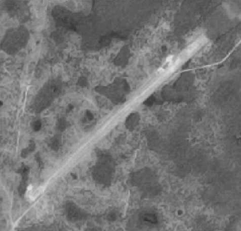
A 1998 USGS aerial photo of the former Bushnell Aux AAF "fighter runway",
the outline of which is barely still apparent, running north from the bottom-center.
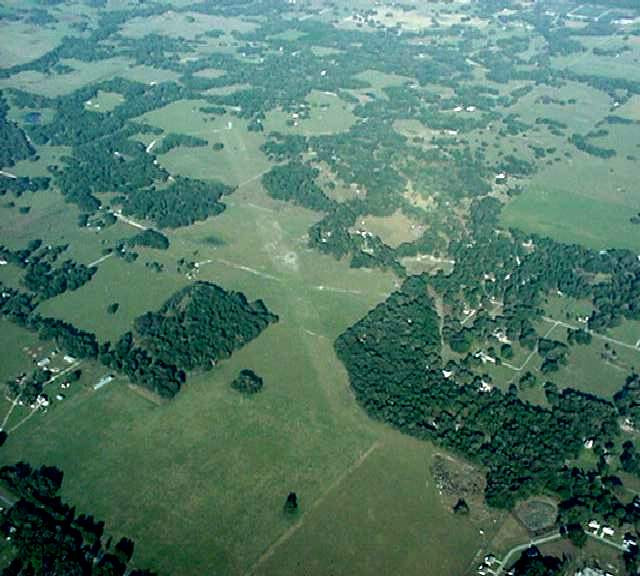
A 2002 aerial view looking northeast along the remains of the Bushnell Aux AAF "bomber runway" (the diagonal outline running toward the top-left).
The WW2 chemical warfare activities conducted at Bushnell caused it to be the site of environmental cleanup investigations in 2001.
A 2017 aerial view looking northwest at the remains of the Bushnell Aux AAF “fighter runway", the outline of which is barely still apparent, running toward the top-right of the picture.
A 2017 aerial view looking north at the remains of the Bushnell Aux AAF “bomber runway", the outline of which is barely still apparent, running toward the top-right of the picture.
The site of Bushnell Aux AAF is located northeast of the intersection of Route 301 & Walker Avenue, one mile northeast of the town of Bushnell.
Thanks to Bob Widner & Matt Mattson for pointing out this airfield.
See also: http://www.geocities.com/bwidner1/Bush2.jpg
____________________________________________________
Withlacoochee Army Airfield, Lacoochee, FL
28.488, -82.04 (West of Orlando, FL)
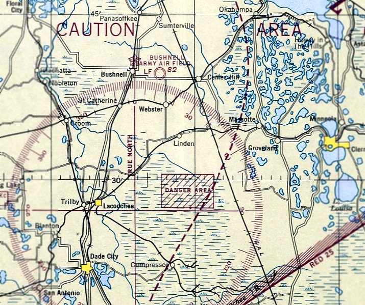
The airspace over Withlacoochee AAF was depicted as a rectangular "Danger Area" on the February 1944 Orlando Sectional Chart.
Photo of the airfield in use has not been located.
The date of construction of the Witchlacoochee airfield is unknown.
It was not yet depicted on the July 1942 Orlando Sectional Chart.
Withlacoochee AAF was used during WW2 in conjunction with Bushnell AAF as a testing site for chemical weapons.
The February 1944 Orlando Sectional Chart depicted a rectangular “Danger Area” over Witchlacoochee, but did not depict an airfield there.
The February 1945 Orlando Sectional Chart depicted the “Danger Area” as a larger trapezoidal area.
The Witchlacoochee airfield was not listed among active airfields in the 1945 AAF Airfield Directory (courtesy of Scott Murdock).
The date of closure of Witchlacoochee AAF is unknown, but is was presumably abandoned at the end of WW2.
The February 1946 Orlando Sectional Chart still depicted the Witchlacoochee “Danger Area”.
The August 1946 Orlando Sectional Chart no longer depicted the Witchlacoochee “Danger Area”.
The earliest photo which has been located of Withlacoochee AAF was a 10/29/49 USGS aerial view.
It depicted a single northeast/southwest runway.
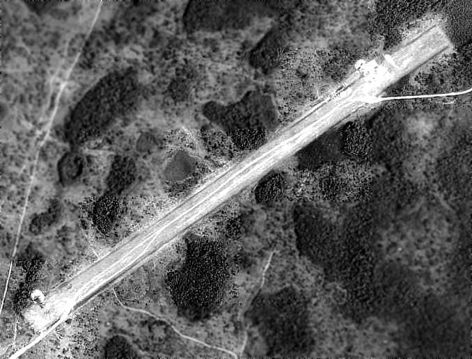
A 5/6/51 USDA aerial photo of Withlacoochee AAF (courtesy of the FL DOT, via Brian Rehwinkel)
didn't show any signs of recent aviation use.
The Withlachoochee airfield was no longer depicted on the 1955 USGS topo map.
The Withlachoochee AAF site has been the subject of several cleanup efforts
aimed at removing any remaining traces of the chemical weapons previously tested at the site.
It is not known if the field was ever reused for civil aviation,
but that is unlikely, given the possible continued presence of chemical weapons.
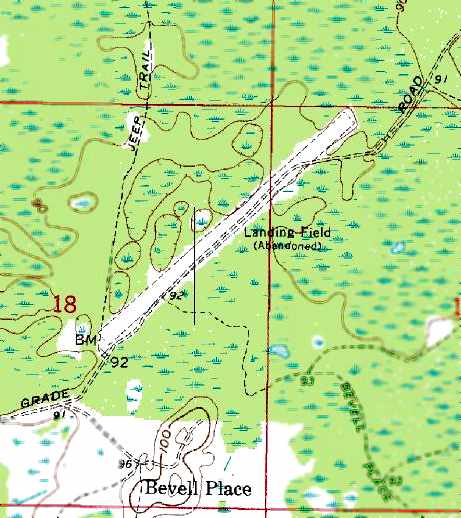
The 1960 USGS topo map depicted Witchlacoochee as having a single unpaved runway, labeled "Landing Field (Abandoned)".
Cole Coon recalled, “I spent many hours hunting in the Withalacoochee State forest when I was a boy.
As late as 1968-71, we had friends land Cessna 172s on the grass strip & spend the day hunting,
or sometimes people would go for rides in the airplane.”
The airfield was depicted on the 1977 USGS topo map, labeled "Landing Strip (Abandoned)".
The airfield was no longer depicted at all (even as an abandoned airfield) on the 1998 World Aeronautical Chart.
Cole Coon recalled, “When I visited in summer 2003, the field was mostly overgrown with small pine trees,
except a small (500'?) area at the south end that was being regularly mowed.”
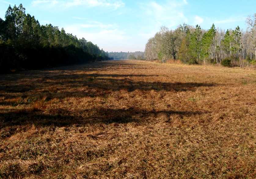
A 2004 photo by Daryl Naskale of the Withlachoochee airfield, from the northeast end of the strip looking southwest.
Daryl reported, “"The strip is covered with a thick layer of grass that is being mowed at least semi-regularly, probably by the State Forest people.
There is an active state-run fish hatchery right nearby that can be seen in the [aerial] photos.
If there ever was a paved runway, it is covered with enough dirt to support a thick layer of grass & weeds.”
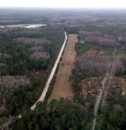
A 1/13/13 aerial view looking southwest along the abandoned Witchlacoochee runway.
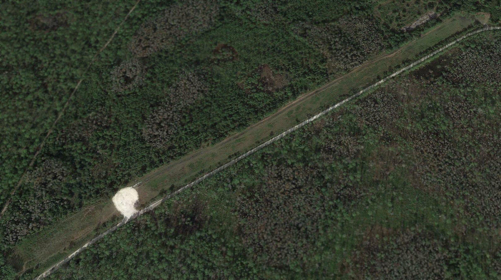
A 2019 aerial view looking north along the abandoned Witchlacoochee runway.
A November 2019 photo looking northwest at the abandoned Witchlacoochee runway.
The Witchlacoochee runway is located along the northwest side of North Grade Road, one mile northeast of its intersection with Route 471.
____________________________________________________
Hillsbororough Army Airfield / Henderson Airport / Henderson-Hillsborough International Airport, Tampa, FL
28.045, -82.42 (Northeast of Tampa International Airport, FL)
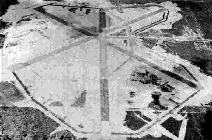
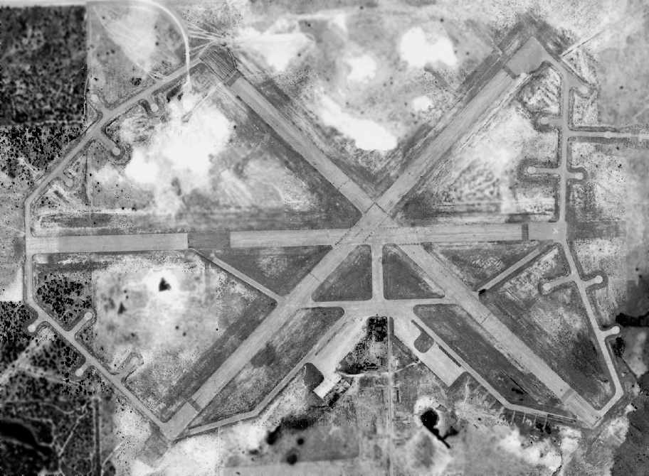
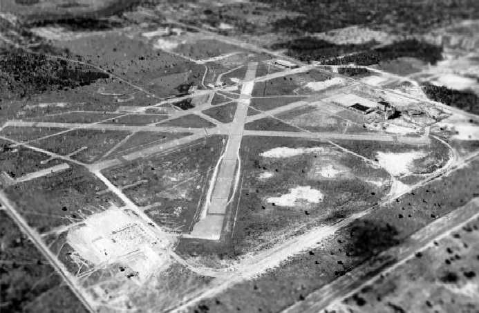
A 3/17/43 aerial view looking east from the 1945 AAF Airfield Directory (courtesy of Scott Murdock)
depicted “Hillsborough AAF” as having 3 asphalt runways.
Hillsborough AAF was evidently constructed at some point between 1935-43,
as it was not yet depicted on the 1935 Orlando Sectional Chart.
The earliest depiction which has been located of Hillsborough AAF
was a 3/17/43 aerial view looking east from the 1945 AAF Airfield Directory (courtesy of Scott Murdock).
It depicted “Hillsborough AAF” as having 3 asphalt runways.
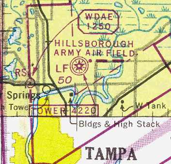
The earliest aeronautical chart depiction which has been located of Hillsborough AAF
was on the July 1943 Orlando Sectional Chart (courtesy of Chris Kennedy).
Hillsborough AAF was described in the 1944 US Army/Navy Directory of Airfields (courtesy of Ken Mercer)
as having a 5,000' hard-surface runway.
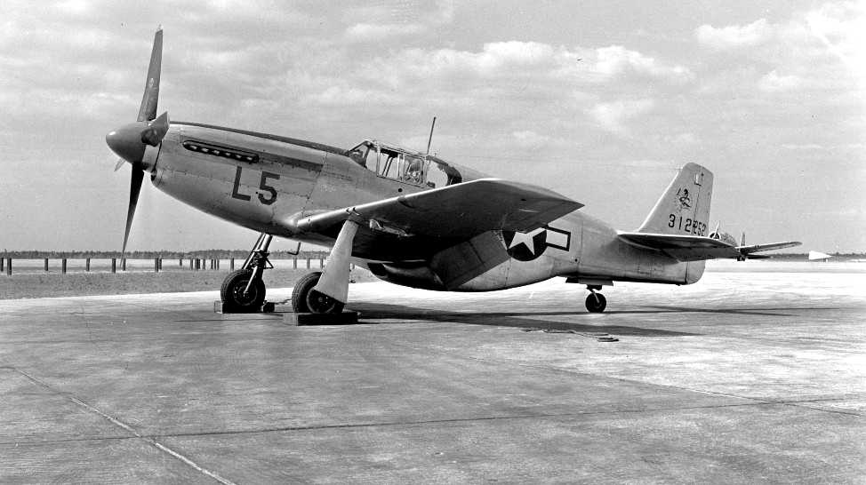
A 4/17/44 photo of P-51B-1-NA 43-12252 during a visit to Hillsborough AAF (courtesy of Martin Kyburz / Swiss Mustangs).
This field was used by the Army during WW2 as an auxiliary airfield for both Drew & MacDill Fields.
It had 3 paved 5,200' runways (NE/SW, NW/SE & E/W),
and several hangars along the west side of the airfield.
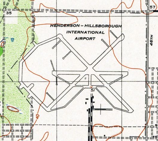
Strangely, the field was labeled “Henderson-Hillsborough International Airport” on the 1944 USGS topo map.
“Hillsborough AAF” was still depicted as an active airfield on the 1945 Miami Sectional Chart (courtesy of John Voss).
The 1945 AAF Airfield Directory (courtesy of Scott Murdock) described “Hillsborough AAF”
as a 2,135 acre irregularly-shaped field having 3 asphalt 5,000' runways.
The field was not said to have any hangars, to be owned by Hillsborough County, and operated by the Army Air Forces.
An article in the 1/27/02 Tampa Tribune (according to Brian Rehwinkel) described the WW2 field as being a small base.
Ansley Watson, the last base commander at Hillsborough AAF said the airfield had one hangar,
a control tower and a concrete building where fighters were parked.
Mr. Watson said the base normally had about 28 airplanes at the field at one time.
According to the article, the base closed in early 1945.
A 1/15/48 USDA aerial photograph of Hillsborough AAF (courtesy of Brian Rehwinkel).
"Although the photo does not show any obvious activity at the field,
it does give an idea of the wartime configuration of the field.
You can still see some buildings at the field."
At some point after WW2, Hillsborough was reused as a civilian airport.
It was depicted as "Hillsborough" on the 1949 Orlando Sectional Chart (according to Chris Kennedy).
It continued to be labeled “Henderson-Hillsborough International Airport” on the 1949 USGS topo map.
"Hillsborough" was depicted on the 1953 Miami Sectional Chart.
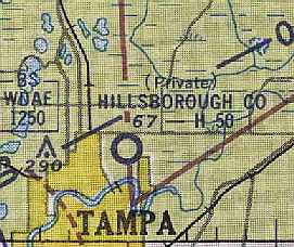
Strangely, "Hillsborough County" Airport was depicted as a private airfield
on the August 1954 Orlando Sectional Chart (courtesy of Chris Kennedy).
It also became known as Henderson Field during its period of civilian usage.
Hillsborough / Henderson Field was evidently closed at some point between 1954-55,
as it was no longer depicted on the 1955 USGS topo map.
It was labeled “Henderson-Hillsborough International Airport (Abandoned)” on the 1956 USGS topo map.
Jim Stahl recalled, “In 1957, kids were still using the runways for drag racing.
We used to go & watch them.
The police constantly tried to stop it.
They finally came in just prior to the brewerys being built
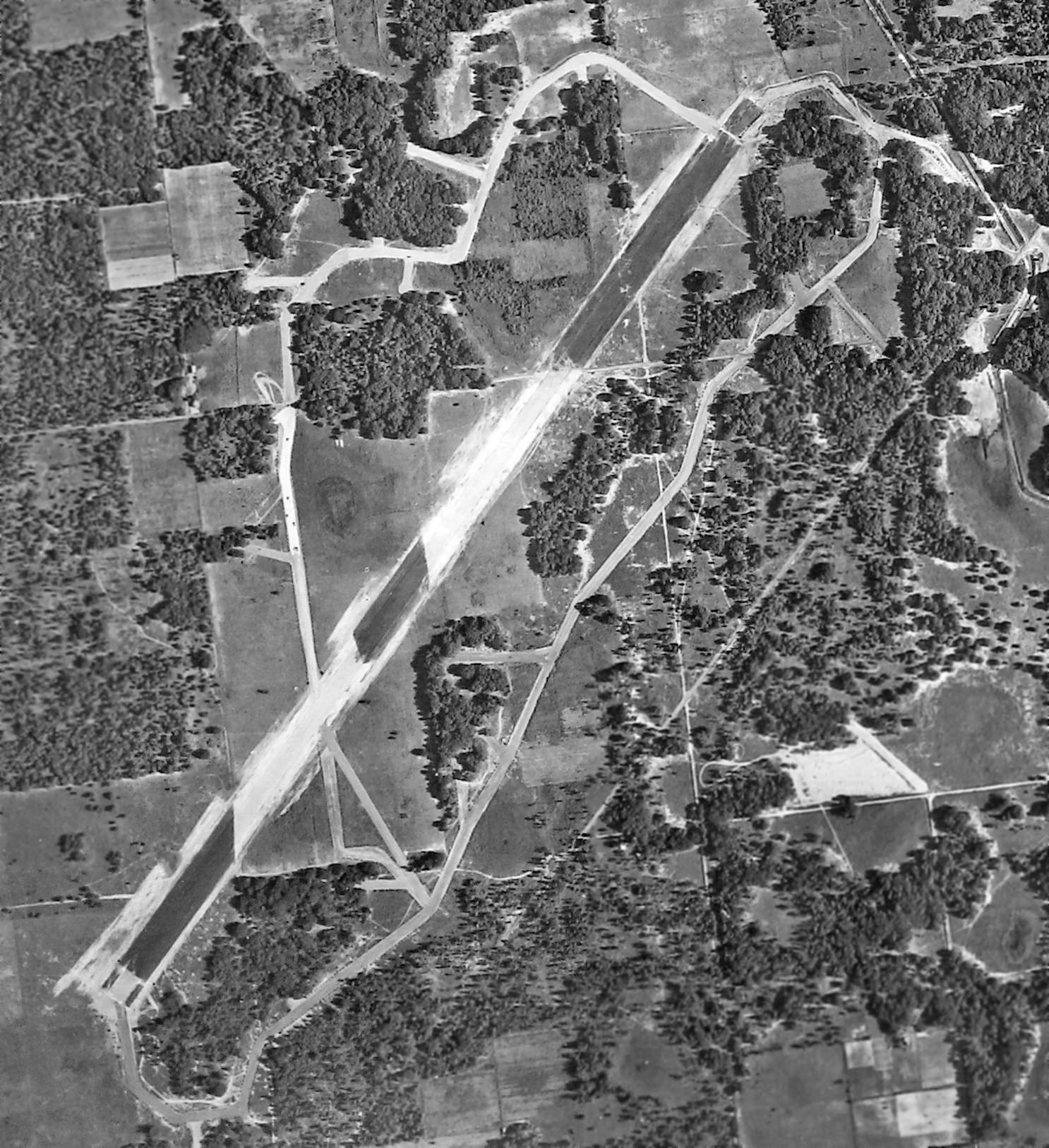
and dug trenches across the runways & that finally stopped the racing.”
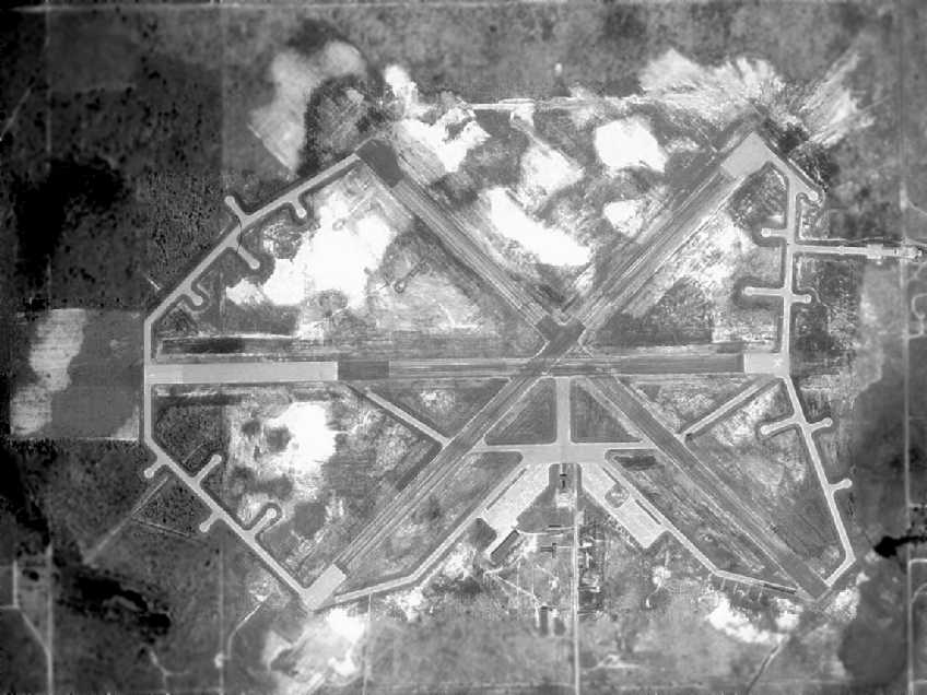
A March 1957 aerial view of Henderson Airport (which appears to be abandoned at this point).
US Government photo, courtesy of the FL DOT, via Brian Rehwinkel.
It appears as if Henderson Airport had been abandoned by the time of the photo,
as all of the buildings had been removed from the airfield.
However, all of the runways still remained intact at this point,
along with several taxiways leading to a extensive number of dispersal hardstands.
According to Brian Rehwinkel, the University of South Florida campus began construction in 1957
on a site adjacent to the north side of Henderson Airport,
and the Busch Gardens theme park was opened in 1959 just south of the airport.
A 1959 view looking southwest at Henderson Field,
after the Schlitz Brewery (on the right) had been built over a portion of the former airfield.
Photo is from the Tamp Hillsborough County Public Library (courtesy of Joe Benson).
The site of the former Henderson Airport was labeled "Aband aprt"
on the 1964 Orlando Sectional Chart (according to Chris Kennedy).
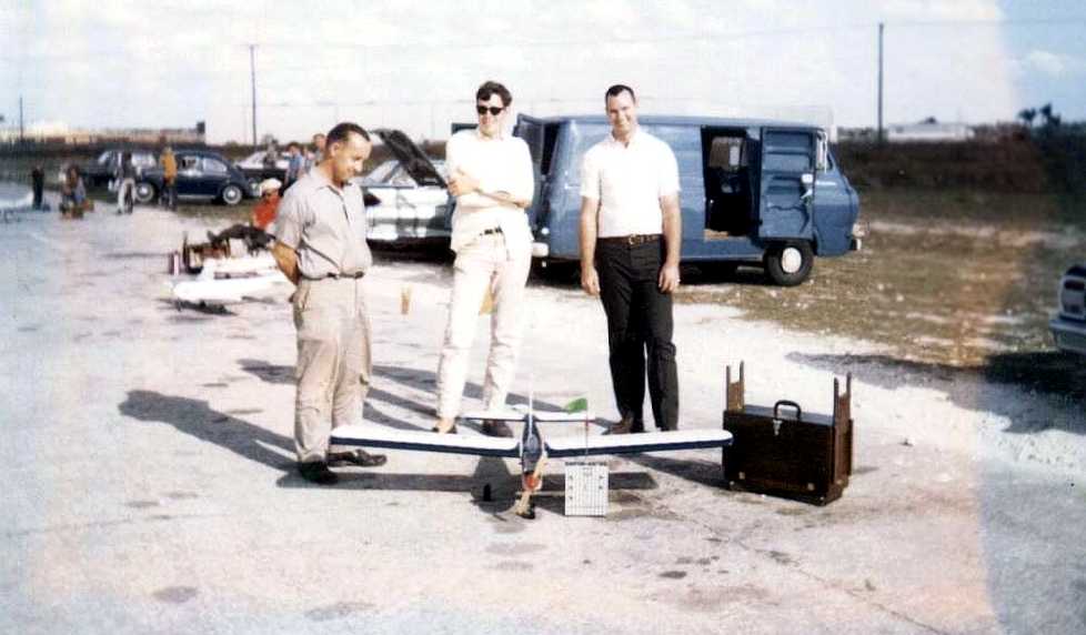
A 1967 photo (courtesy of Lonnie Kobres) of Donald Haas, Lonnie Kobres, and another model aircraft enthusiast at Henderson Field,
where Lonnie learned to fly radio-controlled model aircraft.
A 1969 aerial photo showed the majority of 3 runways remained intact,
although buildings had started to cover portions of them.

The 1987 USGS topo map still depicted portions of several runways.
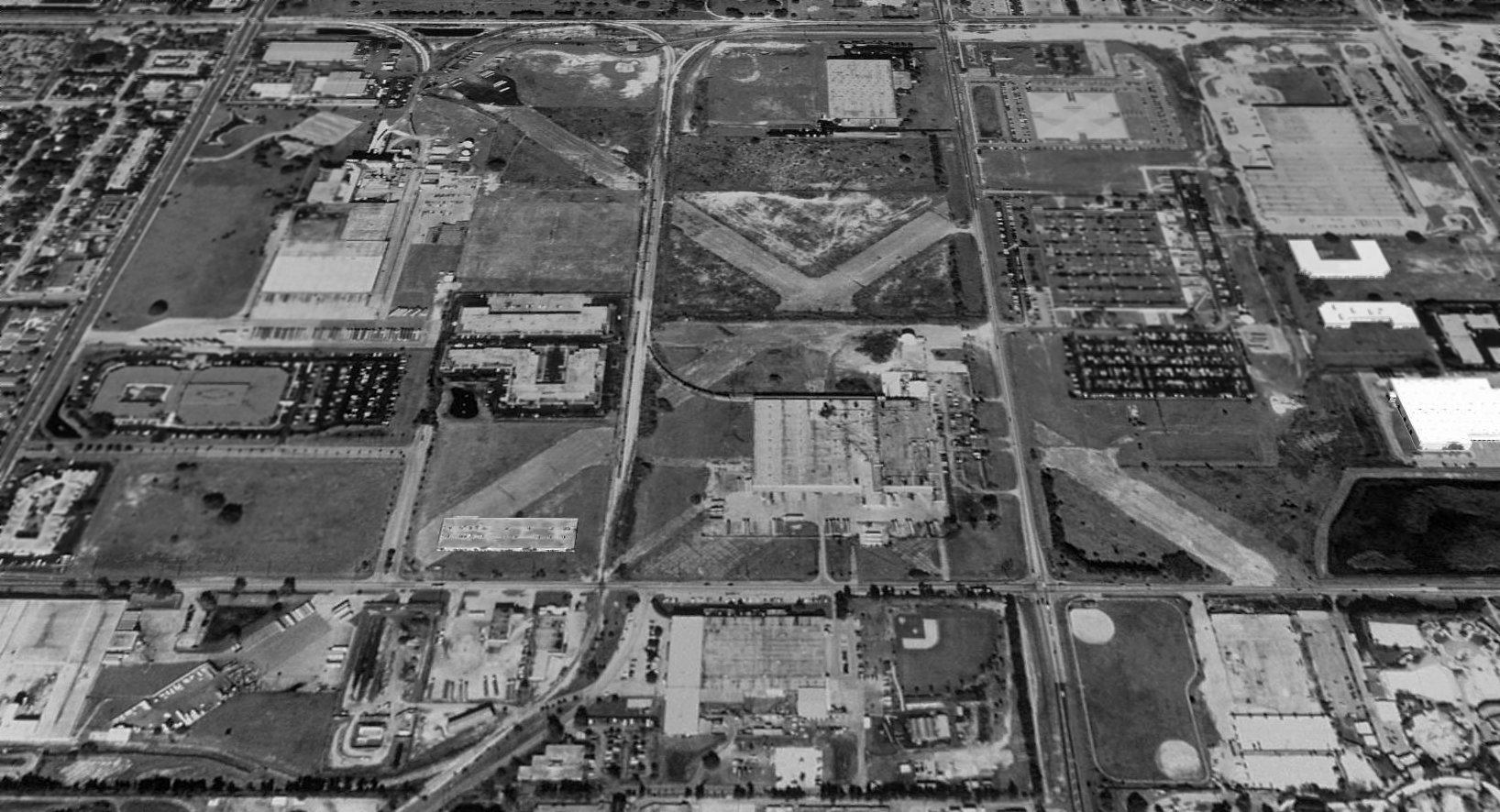
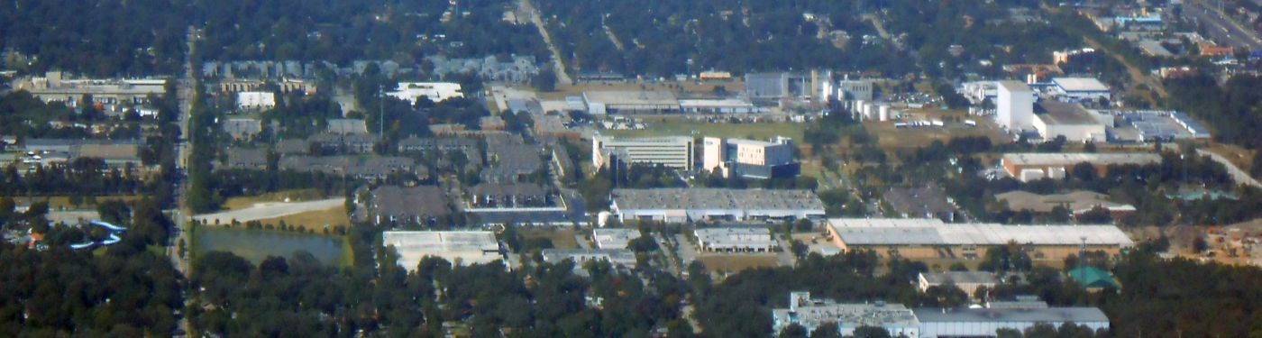
A 1995 USGS aerial view looking north showed Henderson Field's X-shaped runway layout to still be recognizable.
Most of the area of the former airfield had been reused as an industrial park,
with rail lines going to the old Busch Brewery at the northwest corner of the former airfield.
It did not appear as if any original airport buildings remained standing.
The Busch Gardens theme park was built over the former airfield cantonment area, south of the airfield.
Henderson Field was no longer depicted at all (even as an abandoned airfield) on aeronautical charts from the late 1990s.
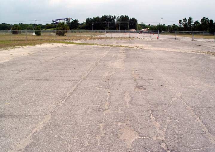
with a Busch Gardens waterslide in the background.
Vince reported, the site of Henderson Field is "a place I've passed by many times & never knew what it was!
The main area where the runways cross is still nothing more than an overgrown field,
but it is fenced off with plenty of 'no trespassing' signs.
This abandoned airfield is just a block north of Busch Gardens Theme park…
the area where I was able to stand on the runway has been cut in half by a fence -
the southernmost portion is now used as a training facility by Busch Gardens to instruct new drivers on some of their vehicles."
Danny Perez reported in 2004 that the building currently used as Mel's Hot Dogs restaurant
is housed in is the last surviving structure of Henderson Field.
Martha Quick reported in 2015 of the X-shaped runway remnant seen in the 1995 photo:
“Sadly this is no longer visible. It is the site of Moffitt Cancer Center's '200,000-square-foot, 6-story outpatient facility slated to open in fall 2015.'”
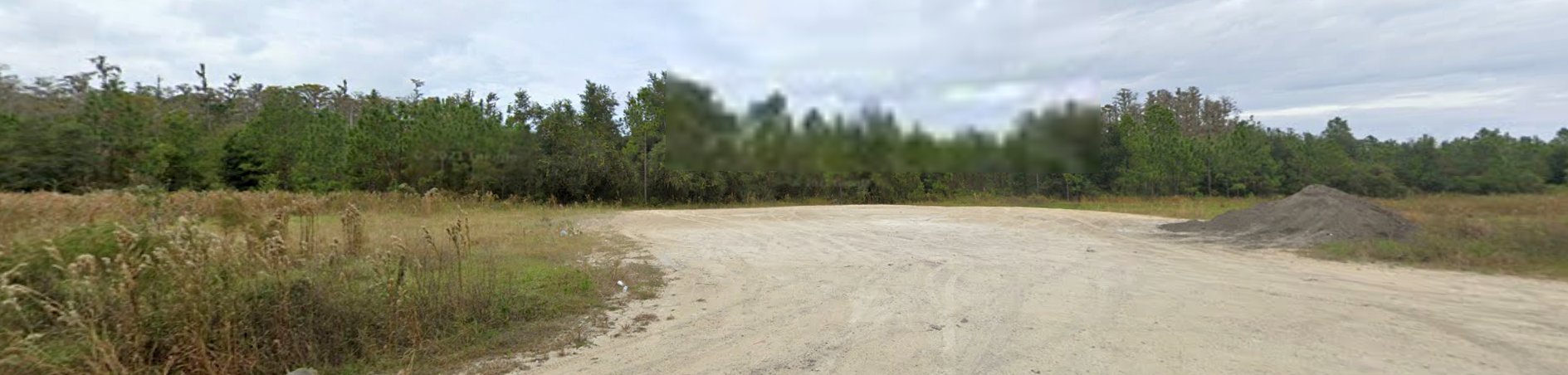
An 11/5/16 aerial view by Alex Price looking west at the site of Henderson Field showed a runway segment remaining at bottom-left.
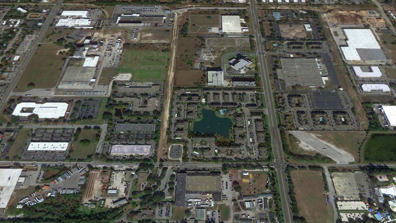
A 2017 aerial view looking north showed the site of Henderson Field to no longer be recognizable as a former airfield.
But a close inspection reveals 2 runway segments remaining, at the southwest & southeast corners of the site.
A 2/19/18 aerial view by Alex Price looking southwest at a remaining portion of Henderson Field runway (at top-left),
and a small piece of former hardstand (running up to the white fence at bottom-left).
The site of Henderson Field is located north of Busch Gardens & south of the University of South Florida Campus.
Thanks to Charles Schuttig, Brian Rehwinkel, and Joe Benson for information about this field.
____________________________________________________
Or if you prefer to contact me directly concerning a contribution (for a mailing address to send a check),
please contact me at: paulandterryfreeman@gmail.com
If you enjoy this web site, please support it with a financial contribution.
____________________________________________________
This site covers airfields in all 50 states.