Abandoned & Little-Known Airfields:
Florida: Southern Tampa area
© 2002, © 2023 by Paul Freeman. Revised 12/14/23.
This site covers airfields in all 50 states: Click here for the site's main menu.
____________________________________________________
Please consider a financial contribution to support the continued growth & operation of this site.
Bradenton Airport (revised 10/7/18) - Brandon Airport (added 12/14/23) – Venice Airport / Albee Field / Venice Municipal Airport / Venice State (revised 12/14/23)
Grand Central Airport / Sky Harbor Airport (revised 6/7/21) - Holmes Airport / Holmes Beach Airfield (revised 12/14/23) - Piper-Fuller Airport (revised 11/2/19) - Robinson Airport / Plant City Airpark / Hillsboro Airport (revised 1/23/20)
(Original) Sarasota Airport / Lowe Airport (revised 11/2/19) - (Original) Wauchula Municipal Airport (revised 12/14/23)
____________________________________________________
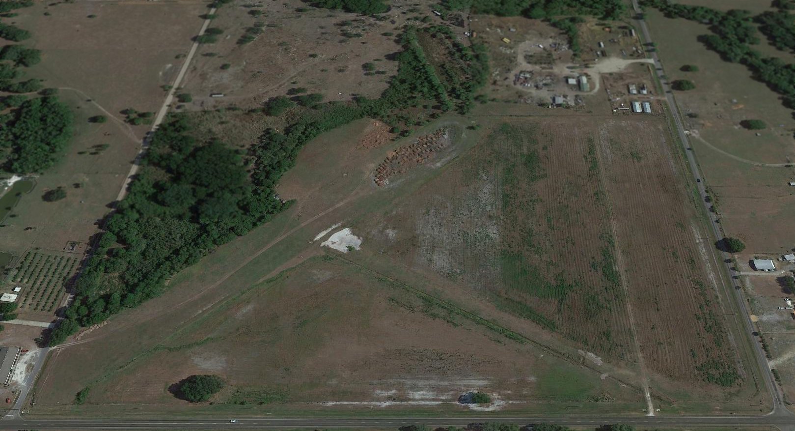
27.901, -82.311 (Southeast of Tampa, FL)
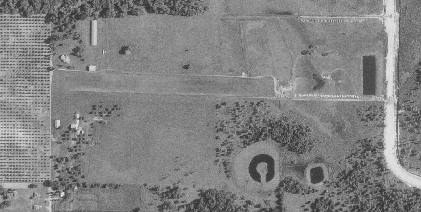
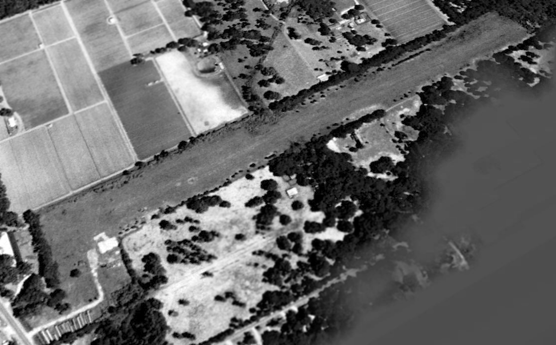
Brandon Airport, as depicted on a 11/6/69 aerial view.
This small general aviation airport was apparently established at some point between 1957-69, as it was not yet depicted on a 1957 aerial photo.
Brandon Airport was not yet depicted on the March 1966 Miami Sectional Chart.
The earliest depiction which has been located of Brandon Airport was on an 11/6/69 aerial photo.
It depicted Brandon Airport as a single east/west unpaved runway, with 1 light single-engine plane & 2 hangars on the northwest side.
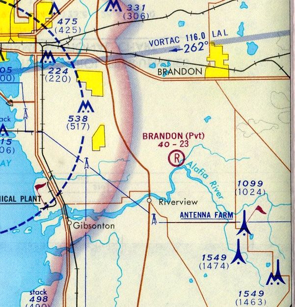
The earliest aeronautical chart depiction which has been located of Brandon Airport was on the 1971 Miami Sectional Chart.
It depicted Brandon as a private airfield having a 2,300' unpaved runway.
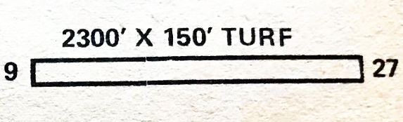
The 1974 Flight Handbook (courtesy of Earl Tuggle) described Brandon Airport as having a single 2,300' turf Runway 9/27, and to be operated by C.W. “Gene” Pratt.
Earl Tuggle recalled, “Brandon Airport... was quite popular & based 20-30 airplanes during the late 1960s through the mid-1980s.”
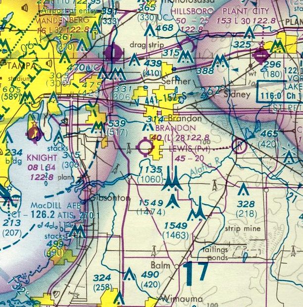
The last aeronautical chart depiction which has been located of Brandon Airport was on the September 1980 Miami Sectional Chart.
It depicted Brandon as a public-use airport having a 2,800' unpaved runway.
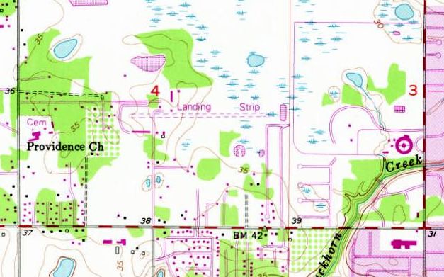
The only topo map depiction which has been located of Brandon Airport was on the 1981 USGS topo map.
It depicted Brandon as an unpaved east/west runway, generically labeled “Landing Strip”, with 4 small buildings on the northwest side.
A 1982 aerial photo depicted Brandon Airport perhaps at the zenith of its popularity, with 14 light aircraft parked near the hangars on the northwest side.
The last photo which has been located of Brandon Airport was a 1984 aerial photo, which depicted a dozen light aircraft on the northwest side.
Earl Tuggle recalled, “In the mid-1980s the owners, Gene & Dorothy Pratt, sold out to land developers.”
Brandon Airport was evidently closed at some point between 1984-89, as it was no longer depicted on the March 1989 Miami Sectional Chart.
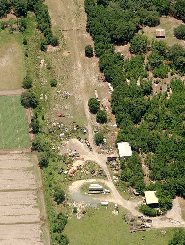
A 1995 aerial view showed no trace remaining of Brandon Airport, with construction covering the site for new streets & houses.
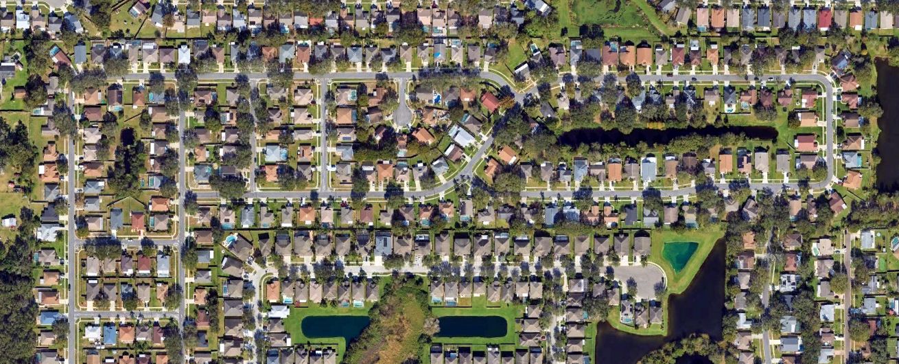
A 2022 aerial view showed no trace remaining of Brandon Airport, with the property covered by houses.
Earl Tuggle reported in 2023, “It is now the Random Oaks subdivision.”
Wellman Drive today occupies the alignment of the former Brandon Airport runway.
Thanks to Earl Tuggle for pointing out this airfield.
____________________________________________________
(Original) Wauchula Municipal Airport, Wauchula, FL
27.553, -81.78 (Southeast of Tampa, FL)
Wauchula Municipal Airport, as depicted on the December 1935 Miami Sectional Chart.
The original municipal airport for the town of Wauchula was located to the east of the town.
According to Kyle Long, “The Wauchula Municipal Airport property was deeded to the City in 1934.
In its early days, the airport had just two 2,000' grass runways, one running east/west & one running north/south.”
The earliest depiction which has been located of Wauchula Municipal Airport was on the December 1935 Miami Sectional Chart.
It depicted Wauchula as an auxiliary field.
The earliest photo which has been located of Wauchula Municipal Airport was a 1952 aerial view (courtesy of Kyle Long).
It depicted Wauchula as having 3 unpaved runways, with a hangar & 1 light single-engine aircraft at the southeast corner.
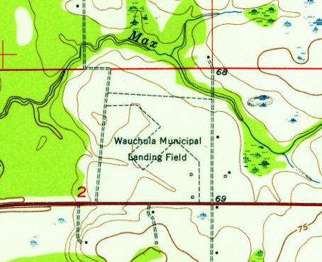
The 1955 USGS topo map depicted “Wauchula Municipal Landing Field” as having 3 unpaved runways, with 2 small buildings on the southeast side.
According to Kyle Long, “Sometime in the early 1960s, a longer 2,900' runway was added running northeast/southwest.”
The last aeronautical chart depiction which has been located of Wauchula Municipal Airport was on the March 1967 Miami Sectional Chart.
It depicted Wauchula as having a 2,700' unpaved runway.
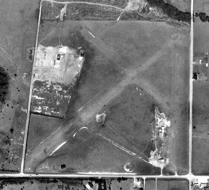
The last photo which has been located showing the original Wauchula Municipal Airport still in operation was a 1974 aerial view (courtesy of Kyle Long).
It depicted Wauchula as having 3 unpaved runways, with 8 light single-engine aircraft visible parked near a few small hangars on the southeast side.
The last depiction which been located showing the original Wauchula Municipal Airport still in operation was on the 1978 USGS topo map,
which depicted Wauchula as having 3 runways.
According to Kyle Long, “In 1979, in an effort to build a larger airport, the City of Wauchula purchased land southwest of downtown
and constructed a new Wauchula Municipal Airport with a 4,000' asphalt runway.”
This replacement Wauchula Municipal Airport was opened in 1983.
The original Wauchula Municipal Airport was evidently closed at some point between 1983-94,
as a 1994 aerial view showed the northeast portion of the runways having been reused for storage, and the hangars removed from the southeast corner.
According to Kyle Long, “As for the old airport, in the 1990s & into the 2000s, the Heartland radio-controlled model airplane club used a portion of the old runway as an airstrip.
In 2015 the City forced this group out.”
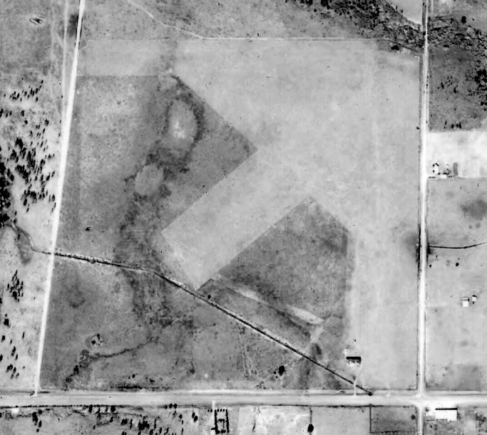
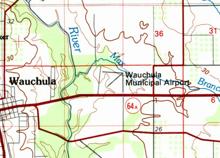
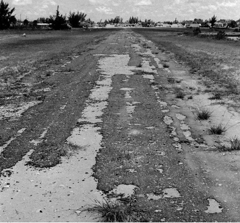
A 2017 aerial view of the site of the original Wauchula Municipal Airport shows portions of 3 former runways remain recognizable.
Kyle Long reported in 2017, “As for the old airport, it has remained in the City's ownership to this day, and the property is now used as a dump site for yard debris.”
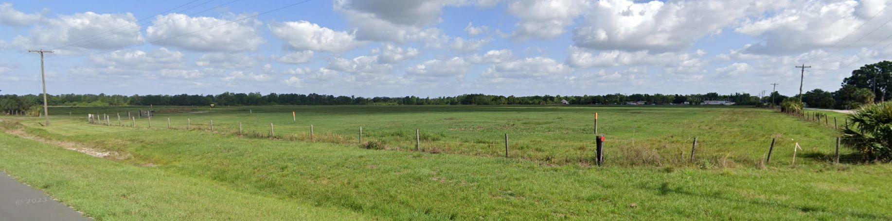
A 2023 photo looking northwest shows the site of the original Wauchula Municipal Airport remains clear.
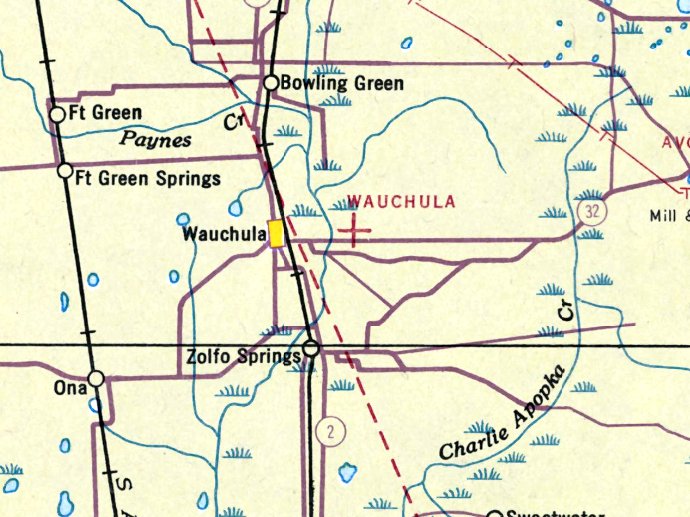
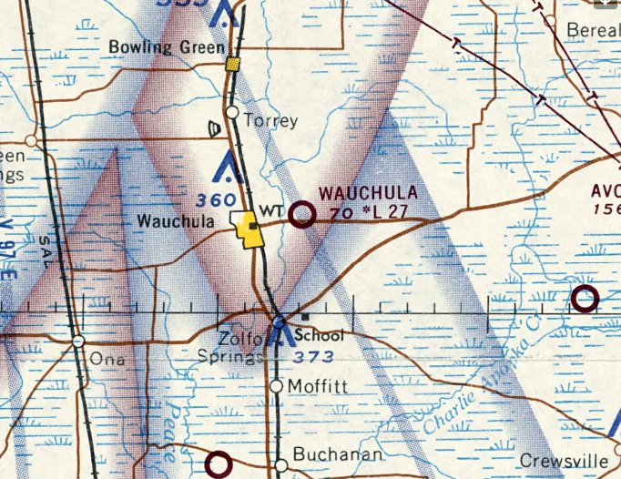
The site of the original Wauchula Municipal Airport is located northwest of the intersection of East Main Street & Airport Road, appropriately enough.
Thanks to Kyle Long for pointing out this airfield.
____________________________________________________
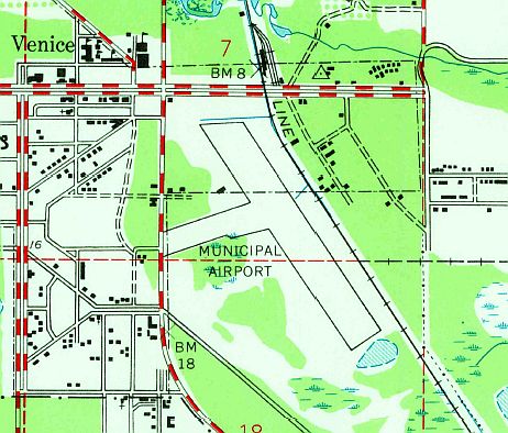
Venice Airport / Albee Field / Venice Municipal Airport / Venice State Airport, Venice, FL
27.1, -82.44 (South of Tampa, FL)
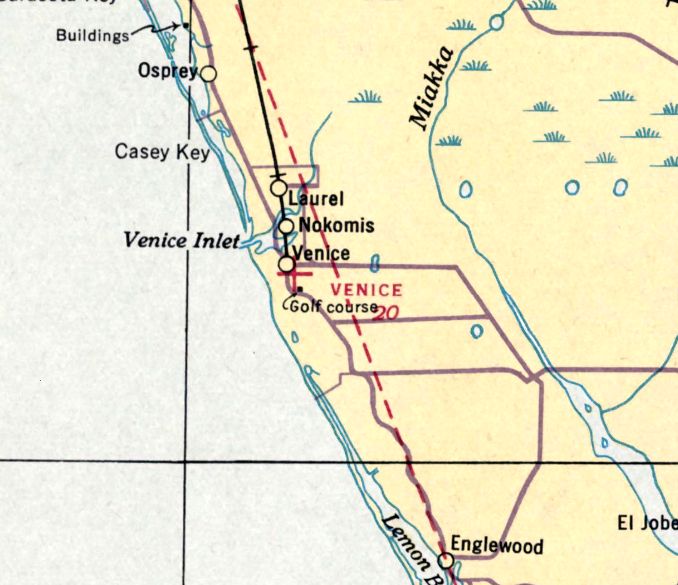
Venice Municipal Airport, as depicted on the June 1938 Miami Sectional Chart.
According to Steve Wooden, Albee Field was established in 1925.
According to the City of Venice, Ablee Field was founded by Venice resident Fred Albee, a prominent doctor whose son Stephen became a pilot.
Venice Municipal Airport was not yet depicted on the 1935-37 Miami Sectional Charts.
The earliest depiction which has been located of Venice Municipal Airport was on the June 1938 Miami Sectional Chart.
It depicted Venice Municipal Airport as an auxiliary airfield.
The earliest photo which has been located of Venice Municipal Airport was a 3/16/43 aerial view from the 1945 AAF Airfield Directory (courtesy of Scott Murdock).
It depicted Venice Municipal Airport as having 2 unpaved runways with an airport circle marking at the intersection.
The 1944 USGS topo map depicted Venice “Municipal Airport” as having 2 runways, with a few small buildings along the west side.
The 1945 AAF Airfield Directory (courtesy of Scott Murdock) described “Venice Municipal Airport (Albee Field)”
as a 160 acre rectangular property having a single 3,600' NNW/SSE sod & sand runway (the crosswind runway presumably having been closed).
The field was said to have a single 60' x 40' wood & concrete hangar,
to be owned by the State of FL, but not to be in operation (presumably due to wartime restrictions on general aviation airports near the coasts).

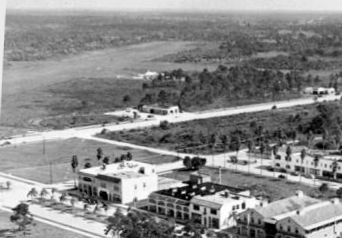
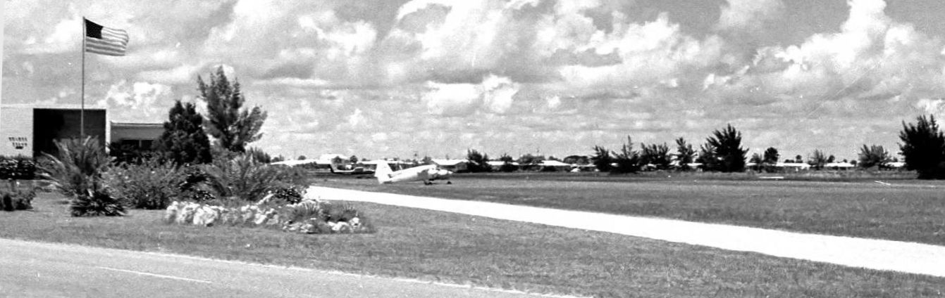
A circa 1940s photo (courtesy of Phil Brooks) of spectators in front of a hangar at Venice Albee Field.
A circa 1940s aerial view (courtesy of Steve Wooden) looking southeast at the 2 grass runways of Venice Municipal Airport,
with a hangar visible along the west side.
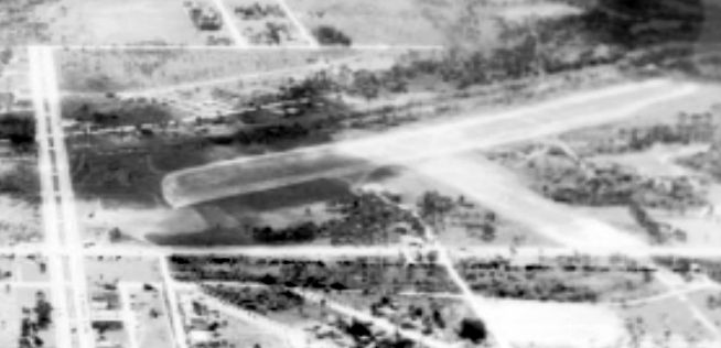
A circa 1940s aerial view looking east at Venice Municipal Airport.
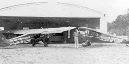
A circa 1940s photo of H.J. “Doc” Chiddix with a Piper J3 Cub & a Luscombe,
two of the aircraft he used for flight instruction in front of an Albee Field hangar.
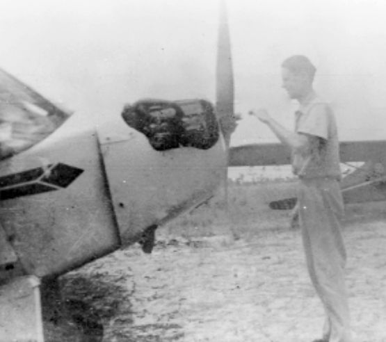
A circa 1940s photo of James Cousins inspecting a Piper J3 Cub at Albee Field.
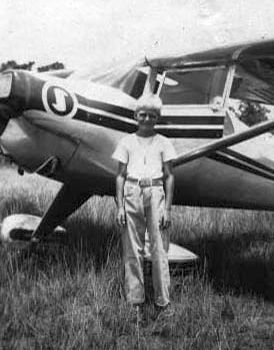
A circa 1947 photo of Steve Wooden in front of “the almost brand new Luscombe Silvair owned by Leighton Yonge, an instructor at the Venice Field.”
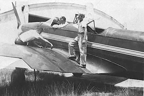
A circa 1947 photo of Steve Wooden standing on the wing of a Fairchild PT-23 at Venice Municipal Airport.
It was depicted as Venice Municipal Airport on the 1947 Miami Sectional Chart.
It was depicted as Venice State Airport on the 1949 Miami Sectional Chart.
The last depiction which has been located of Venice State Airport was on the February 1954 Miami Sectional Chart.
It depicted Venice State Airport as having a 1,900' unpaved runway.
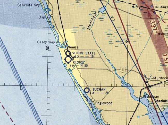
It also depicted the successor Venice Airport nearby to the south, the larger former Venice Army Airfield which had been reused as a civilian airport.
Venice State Airport was evidently closed at some point in 1954, as it was no longer depicted on the August 1954 Miami Sectional Chart.
Venice State Airport was no longer depicted on the 1956 USGS topo map.
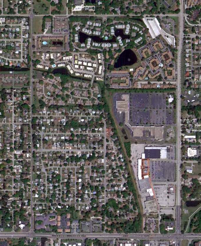
A 1977 aerial photo showed a variety of buildings covering the site of Venice State Airport.
A 2014 aerial photo showed no trace of Venice State Airport.
According to Steve Wooden, the site is occupied by a Publix shopping center & the new Venice High School.
The site of Venice State Airport is located southeast of the intersection of East Venice Avenue & Business Route 41.
____________________________________________________
Holmes Airport / Holmes Beach Airfield, Anna Maria Island, FL
27.511, -82.714 (Southwest of Tampa, FL)
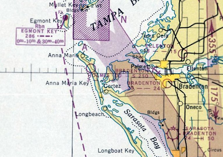
Holmes Airport, as depicted on the February 1947 Miami Sectional Chart.
This small private airfield was evidently established at some point between 1946-47,
as it was not yet depicted on the 1944 USGS topo map or the February 1946 Miami Sectional Chart.
The earliest depiction which has been located of Holmes Airport was on the February 1947 Miami Sectional Chart.
It depicted Holmes Airport as having a 1,600' unpaved runway.
Mark Ratliff recalled, “Anna Maria Island [was] where I was raised.
I don’t have the identifier for the field, and I don’t even know what it was officially called – all the native islanders just called it 'The airport'.
It was built by Jack Holmes, a real estate developer for whom Holmes Beach was named.
He built the strip specifically for the filming of the movie, 'On an Island with You', which starred Esther Williams.
The strip not only accommodated the transportation needs of the actors & film crew, but was in integral part of the story.
The film is generally fascinating for Anna Maria Island history buffs, but especially so for aviation geeks like myself since there are a number of shots of the airstrip from the ground & the air.”
Mark continued, “The runway ran north/south, and extended from a bayou on the north end to the boat basin on the south end.”
I remember taking sailing lessons as a child in the little bayou at the north end of the strip,
and being thrilled a couple of times when airplanes would do a short-field take off by applying takeoff power while holding the brakes.
The end of the runway was so close to the water that the prop wash would whip the mangroves around & disturb the water.
It was always fun to watch landing approaches from that end of the strip as well.
Of course, Saturday morning bicycle visits to the field were always fun for me & my friends.
We might have to hang around for a few hours before we saw anything, but if we were patient eventually we’d see someone take off or land,
or if we were really lucky they would shoot some touch-and-goes.”
Mark continued, “I also recall that there was a twin of some sort (and as I think of it now I think it was a Beech 18 when I was very little, and then a Cessna 310 by the time of Apollo 11)
that 'lived' in a hangar that was situated beneath an elevated house.
I always thought that was the coolest house on the island!
That house is still there, but the hangar was long ago converted to an apartment.
Still, I never look at that house without thinking of the hangar that was there so many years ago.”
Mark continued, “As Anna Maria Island grew, so did the activity at the airport.
While never a busy field by any stretch, you could count on a couple of operations a day.
My uncle flew his rented Piper TriPacer in & out of there frequently in the late 1950s and early 1960s.”
According to Steve Wooden, “A small field from which we flew in the late 1950s & early 1960s... was on Anna Maria Island West of Bradenton.
It had waterfront homes (with hangars/garages) lining the south side of the only runway.
I remembered the thrill of taking off over the masts of sailboats docked at the east-southeast end of the runway.”
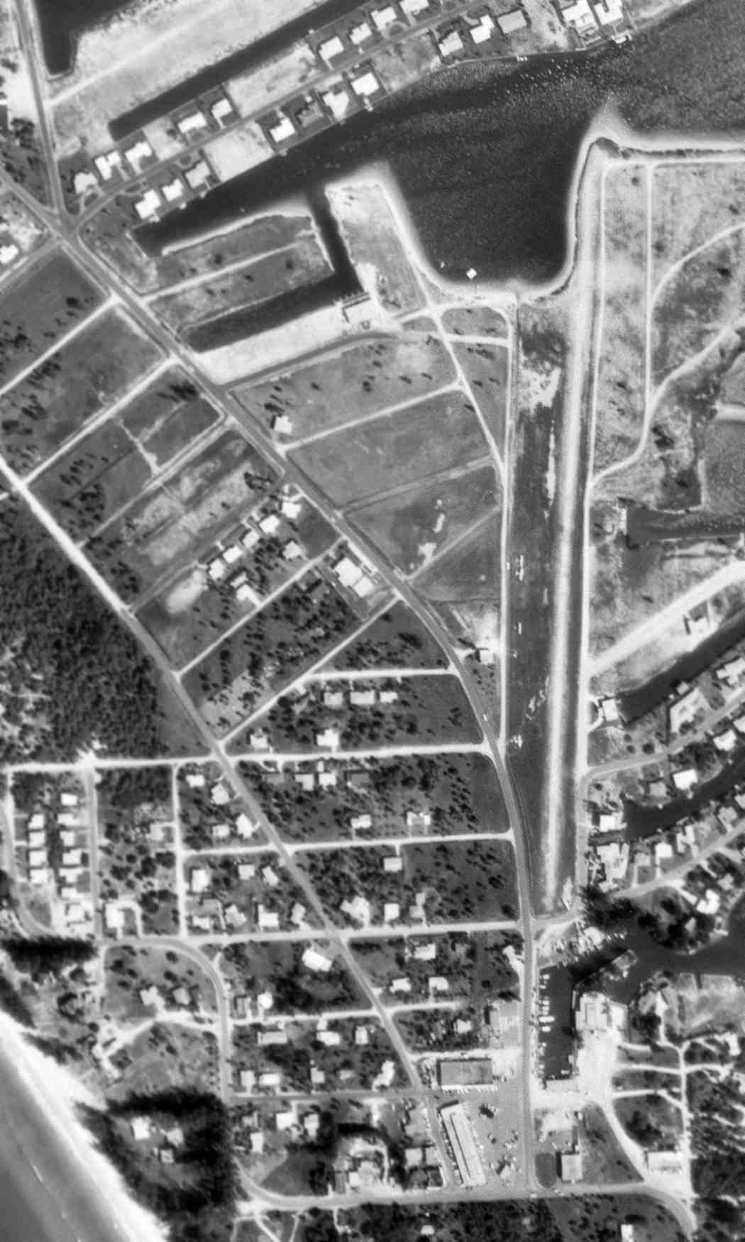
The earliest photo which has been located of Holmes Airport was a 1962 USGS aerial view,
which depicted an unpaved north/south runway with 4 single-engine planes parked along the west side.
No airfield was depicted at this location on the 1966 USGS topo map.
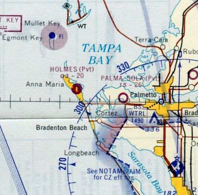
The March 1966 Miami Sectional Chart (courtesy of Ron Kunse) depicted Holmes as a private airfield having a single 2,000' paved north/south runway.
An August 1966 photo looking along the Holmes Airport paved runway (courtesy of Mark Ratliff), not in very good condition.
A 1966 photo of 3 light aircraft parked along the Holmes Airport runway (courtesy of Mark Ratliff), with the City Hall on the left.
A 1969 aerial photo still depicted the Holmes Airport runway, but there were no aircraft on the field.
The last aeronautical chart depiction which has been located of Holmes Airport was on the 1971 Miami Sectional Chart.
It depicted Holmes Beach as a private airfield having a 1,900' unpaved runway.
Mark Ratliff recalled, “I think the field was closed around 1973 following an unfortunate accident that pushed the anti-aviation folks in the community to say 'No more airport here!'
Luckily, the pilot walked away from the accident – he lost power on takeoff & ended up-nose down in a boat basin at the end of the runway.
As for the anti-aviation sentiment of some folks, it didn’t help that the boat basin was the view from the area’s most expensive restaurant at the time.”
Holmes Airport was no longer depicted on the 1973 Miami Sectional Chart.
A 1995 aerial photo showed no trace of Holmes Airport, with housing starting to encroach on the airport site.
Mark Ratliff reported in 2007, “Nowadays the strip is occupied by (from south to north) a library,
the City Hall (for the incorporated City of Holmes Beach, the outfield of a baseball diamond & some public tennis courts.
Three streets now cut across the runway as well.”
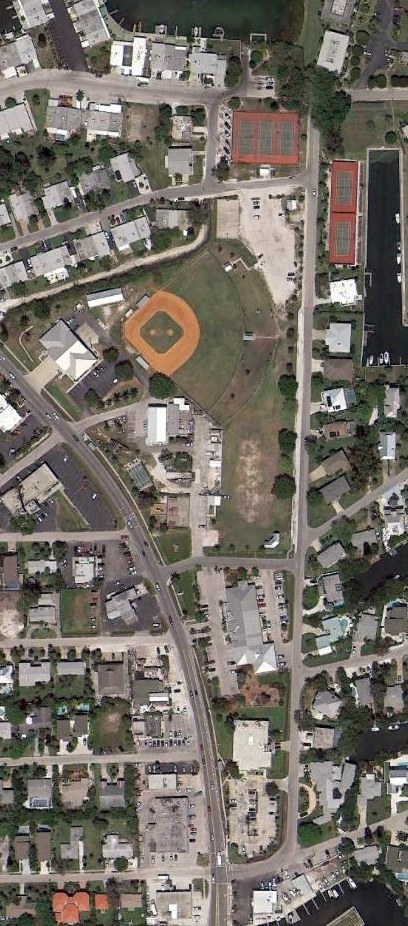
A 2014 aerial photo shows the site of Anna Maria Island Airfield to be covered with a park, a softball field, a small skate park, and a fire station.
The site of Anna Maria Island Airport is located northeast of the intersection of Marina Drive & 56th Street.
____________________________________________________
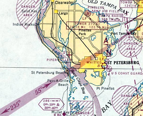
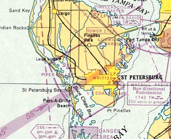
Piper-Fuller Airport, St. Petersburg, FL
27.8, -82.74 (Southwest of Tampa, FL)
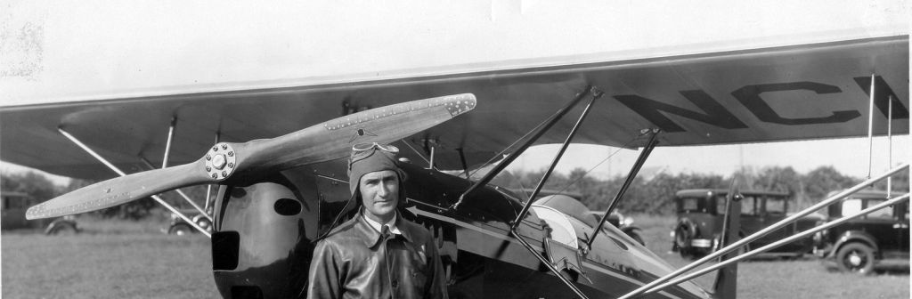
A 1928 photo of an unidentified pilot in front of a parasol monoplane (type undetermined) at Piper-Fuller Airport.
No airfield at this location was yet depicted on the 1921 USGS topo map.
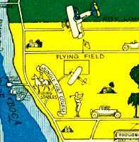
According to the book “St. Petersburg, Florida: a visual history”, “St. Petersburg's first airport was built by Walter Fuller in 1926.
It was designed as an amenity for tourist-oriented projects that the owner was involved with & to show his surrounding subdivision, the Jungle.”
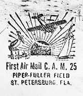
A stamp commemorated the 1st air mail from Piper-Fuller Field, on the back of a 12/14/29 letter (courtesy of Rob McHugh).
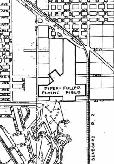
A circa 1930 map depicted “Piper-Fuller Flying Field” as having 3 unpaved runways.
Strangely, Piper-Fuller Airport was not depicted at all on the 1935 Miami Sectional Chart
(or subsequent Miami Sectional Charts from 1937 & 1938).
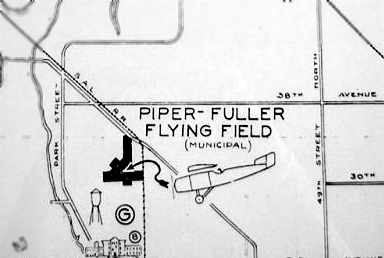
Piper-Fuller Airport, as depicted on a 1936 Airway Map.
According to “The History of Piper-Fuller Airport”, “Piper-Fuller airfield was a very colorful airport in its time.
It originally consisted of 32 acres. It was the scene of early air meets.
Once, General Clair Chenault & an Air Corps flying team put on an air show there.
It is rumored that it was used by bootleggers during the Prohibition years.”
Piper-Fuller Airport, as depicted on a circa 1930s map.
According to the St. Petersburg Times, on 9/23/41 the City of St. Petersburg authorized the purchase of the airport & additional land.
It was listed as 220 acres; options obtained covered 140 acres for actual landing surfaces,
30 acres for future extension or shops, 10 acres for hangars, 10 acres for parking,
and 30 acres north of Tyrone Boulevard for which no use had yet been designated.
The cost was $7,133.
According to the article filed with the city council,
the airport would provide a 2,780' north/south runway & 3,330' northeast/southwest runway.
It stated that the entire surface of the field was fairly smooth but needed mowing.
A 12/17/41 St. Petersburg Times article stated a provision for a major extension of Piper-Fuller Airport
was made through the city council’s authorization to the city manager
to purchase an additional 80 acres of property adjoining the recently acquired field for $1,000.
Negotiations were also underway to purchase an additional 40 acres to provide an east/west runway.
According to “The History of Piper-Fuller Airport”,
“With the start of World War II, just months after the city purchased the airport,
private aviation came to a halt & Albert Whitted Airport was already established with good approaches over water;
it had hangars & paved runways.
Piper-Fuller was a grass field & could not compete with other more improved airports even though it was used for primary training.”
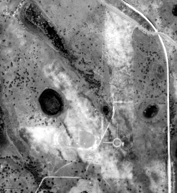
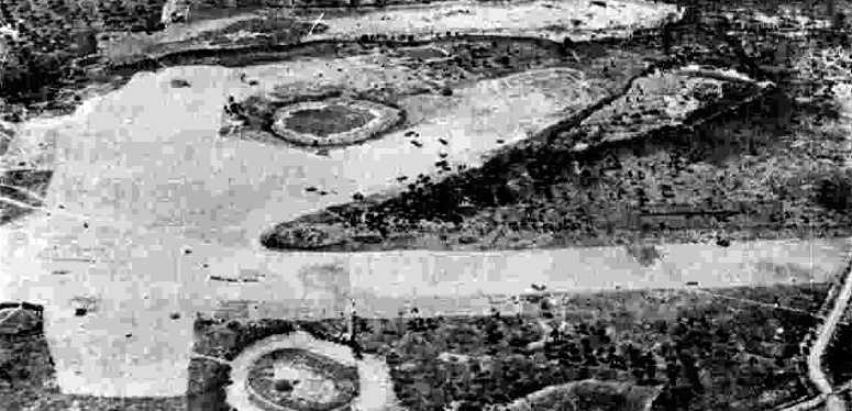
A 1942 aerial photo (from the University of FL online library, via Chris Kennedy)
depicted Piper-Fuller Airport as having 3 unpaved runways, with an airport circle marking at their intersection.
There did not appear to be any hangars or aircraft on the field.
A 3/17/43 aerial view looking west from the 1945 AAF Airfield Directory (courtesy of Scott Murdock)
depicted Piper-Fuller Airport as having 3 unpaved runways.
There did not appear to be any hangars or other improvements on the field.
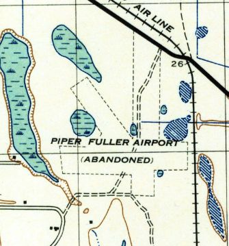
The 1943 USGS topo map labeled the field as “Piper Fuller Airport (Abandoned)”,
and depicted it having 3 unpaved runways.
According to the book “Mangroves to Major League”, in 1943 about 10,000 Army trainees
were camped out at the Piper-Fuller Flying Field & the Jungle Gulf Course.
Piper-Fuller Airport still was not depicted on the January 1944 Miami Sectional Chart.
Piper-Fuller Airport was evidently reopened in 1944, as the July 1944 Miami Sectional Chart depicted it as an auxiliary airfield.
The 1945 AAF Airfield Directory (courtesy of Scott Murdock) described Piper-Fuller Airport
as a 254 acre irregularly-shaped property having 3 turf runways, the longest being a 3,200' north/south strip.
The field was not said to have any hangars, to be owned by the City of St. Petersburg, but not to be currently in operation.
The last aeronautical chart depiction which has been located of Piper-Fuller Airport was on the August 1946 Miami Sectional Chart.
It depicted Piper-Fuller as an auxiliary airfield.
Piper-Fuller Airport was evidently closed at some point between 1946-47,
as it was no longer depicted on the August 1947 Miami Sectional Chart.
The 1947 USGS topo map continued to label the field as “Piper Fuller Airport (Abandoned)”,
and depicted it having 3 unpaved runways.
According to the book “St. Petersburg, Florida: a visual history”,
“While there was interest in developing the airport after the war,
the proposal was defeated by the Jungle Property Owners Association to develop into more housing.”
The 1957 USGS topo map no longer depicted the airport,
and instead depicted a Sewage Disposal facility in the middle of the site.
According to “The History of Piper-Fuller Airport”, “In 1960, with the Piper-Fuller Airport abandoned,
the city decided to use most of the old airport property for a park.”
However, a 1969 aerial view showed several industrial buildings covering the site of Piper-Fuller Airport.
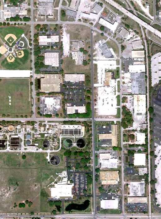
A 4/5/10 aerial photo shows the site of Piper-Fuller Airport covered mostly by industrial buildings, with not a trace remaining of the former airport.
The site of Piper-Fuller Airport is located southwest of the intersection of Tyrone Boulevard & Pinellas Trail.
____________________________________________________
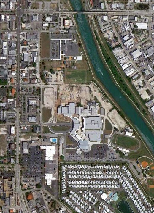
Bradenton Airport, Bradenton, FL
27.49, -82.57 (South of Tampa, FL)
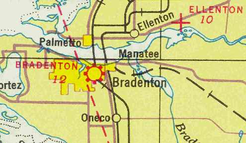
Bradenton Airport, as depicted on the April 1937 Miami Sectional Chart (courtesy of Chris Kennedy).
The Bradenton Airport was located only a quarter-mile southeast of the center of the town.
The airport was apparently established at some point between 1935-37,
as it was not yet depicted on the December 1935 Miami Sectional Chart (according to Chris Kennedy).
The earliest depiction of Bradenton Airport which has been located was on the April 1937 Miami Sectional Chart (courtesy of Chris Kennedy).
It depicted Bradenton as a commercial or municipal airport.
The Airport Directory Company's 1937 Airport Directory (courtesy of Bob Rambo) described Bradenton as a Municipal Airport having 2 sod runways:
a 2,600' northeast/southwest strip & a 2,300 northwest/southeast strip.
The Airport Directory Company's 1938 Airport Directory (courtesy of Chris Kennedy) described Bradenton Airport in the same manner.
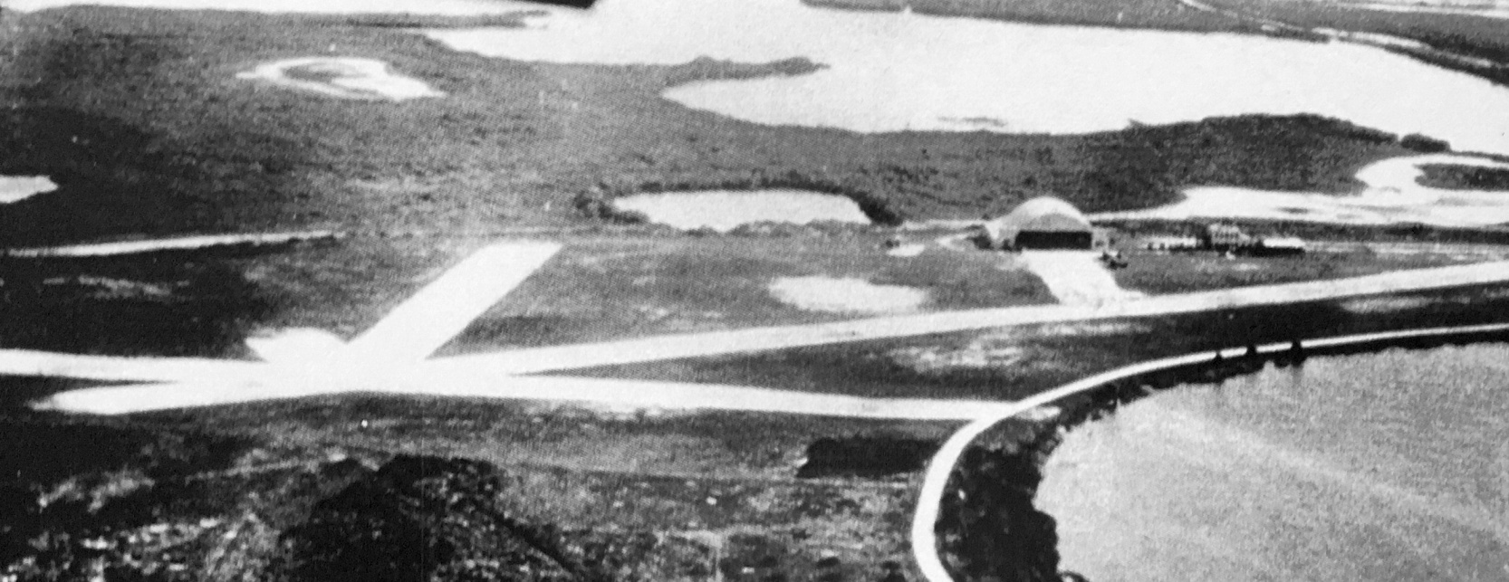
A 1940 aerial photo (from the University of FL online library, via Chris Kennedy) depicted Bradenton Airport as having 2 grass runways in an "X" configuration.
Bradenton Airport may have been closed for a few years during WW2 (like many other small civilian airports along the coasts,
due to wartime security concerns & fuel rationing),
as it was not depicted at all on the August 1943 Miami Sectional Chart (according to Chris Kennedy)
nor listed among active airfields in the 1945 AAF Airfield Directory (courtesy of Scott Murdock).
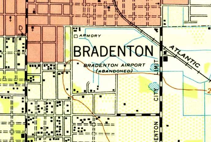
The 1947 USGS topo map depicted “Bradenton Airport (Abandoned)” as an open area with a few small buildings along the south side.
Bradenton Airport reopened at some point between 1945-47,
as the August 1947 Miami Sectional Chart (courtesy of Chris Kennedy) depicted Bradenton as having a 2,400' unpaved runway.
Bradenton's longest runway had gained a thousand feet in length at some point between 1947-54,
as the Aerodromes table on the August 1954 Miami Sectional Chart (courtesy of Chris Kennedy)
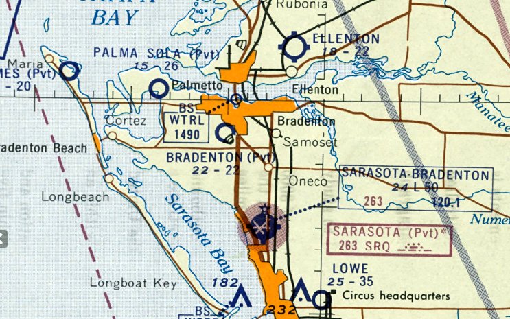
described Bradenton as having 2 runways, with the longest being a 3,460' turf strip.
It also depicted Bradenton somewhat farther west (on the west side of Route 41) compared to the 1947 Sectional, but that may have been erroneous.
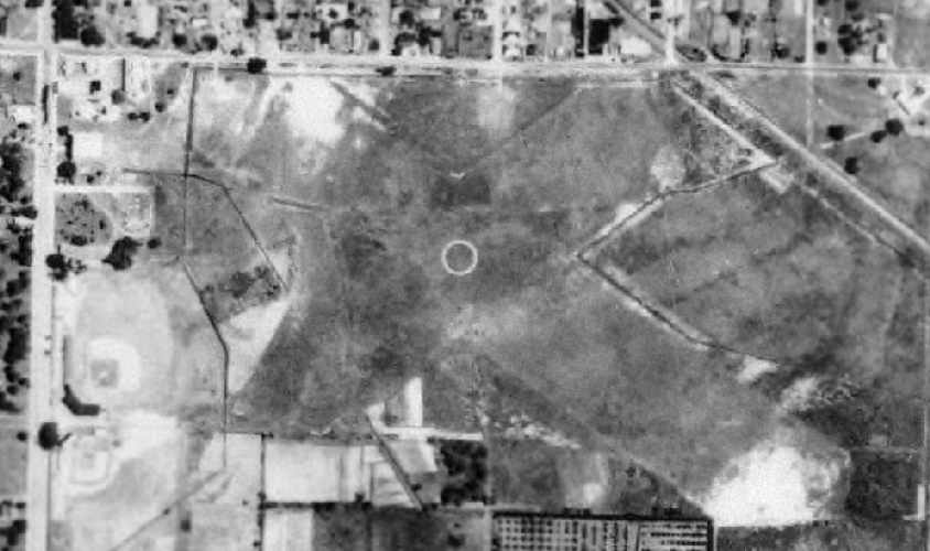
A 1957 aerial view showed no recognizable trace remaining of Bradenton Airport.
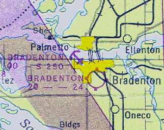
The last aeronautical chart depiction which has been located of Bradenton Airport was on the August 1959 Miami Sectional Chart.
Bradenton's status had changed to a private airfield, depicted as having a 2,200' unpaved runway.
Bradenton Airport was evidently closed at some point between 1959-60, as it was no longer depicted on the February 1960 Miami Sectional Chart.
It was most likely squeezed out of business by residential development, being located very close to the expanding town of Bradenton.
Bradenton Airport was no longer depicted at all on the 1964 USGS topo map.
The 1998 USGS aerial photo showed that the site of Bradenton Airport was covered
by apartment buildings, a school, and several baseball diamonds at some point between 1954-98.
A 1/20/12 aerial photo showed the site of Bradenton Airport to be covered by apartment buildings, a school, and several baseball diamonds.
Jonathon Jankovich observed, “Where the old Bradenton Airport used to be, is McKechnie Field,
spring training stadium for the Pittsburgh Pirates, and the home stadium of Single-A Marauders baseball team.”
The site of Bradenton Airport is bordered on the south by 17th Avenue West, on the west by 9th Street West, and on the north by 13th Avenue West.
____________________________________________________
(Original) Sarasota Airport / Lowe Airport, Sarasota, FL
27.35, -82.5 (South of Tampa, FL)
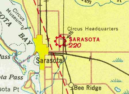
The original Sarasota Airport, as depicted on the December 1935 Miami Sectional Chart (courtesy of Chris Kennedy).
Sarasota's original Municipal Airport was located 2.5 miles east of the center of the town.
The date of construction of the original Sarasota Municipal Airport has not been determined.
The earliest reference which has been located of Sarasota Municipal Airport
was in The Airport Directory Company's 1933 Airport Directory (courtesy of Chris Kennedy).
It described Sarasota Municipal Airport as having 2 sod runways: a 2,640' east/west strip & a 1,980 north/south strip.,
The earliest depiction which has been located of Sarasota Municipal Airport was on the December 1935 Miami Sectional Chart (courtesy of Chris Kennedy).

The 1936 FL Airway Chart (courtesy of Chris Kennedy) depicted Sarasota Airport as having 2 runways.
The earliest photo which has been located of the Sarasota Municipal Airport
was an undated aerial view looking east from The Airport Directory Company's 1938 Airport Directory (courtesy of Chris Kennedy).
The field was described as having 3 sod runways, with the longest being the 3,500' north/south & northwest/southeast strips.
A single hangar was depicted at the northeast corner of the field.
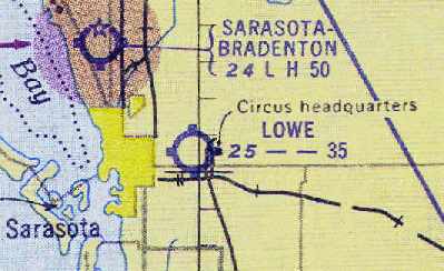
Note the circus headquarters which was visible in the background, adjacent to the east side of the field.
Stephen Wooden recalled, “Lowe Field... I was taken there by my mother to say goodbye to someone who was leaving in an airliner about 1939.
We all got blasted by sand & grass when the plane turned around & took off on the grass strip.”
Robert Parks recalled, “I soloed out of Johnny Lowe's Field in Sarasota.
I 'lived' there when I was a kid in the late 1930s & early 1940s.
I took flying lessons there in a 1937 Piper Cub with a 55 horsepower Lycoming & no brakes & a tail skid.
When I wasn't flying I spent time at the Circus Quarters with those whom I knew. Wonderful memories.”
The 1945 Haire Publishing Company Airport Directory (courtesy of Chris Kennedy)
described Sarasota Airport as a privately owned & operated "Class 2" airport.
It was said to have 3 sod runways, with the longest being the 3,500' north/south & northwest/southeast strips).
The field was said to have a hangar, and the manager was listed as John Lowe.
A 3/16/43 aerial view looking north from the 1945 AAF Airfield Directory (courtesy of Scott Murdock)
depicted Sarasota Airport as having 2 unpaved runways.
The 1945 AAF Airfield Directory (courtesy of Scott Murdock) described Sarasota Airport
as a 117-acre L-shaped property having 3 sand & sod runways, with the longest being a 3,500' north/south strip.
The field was described as having 2 hangars, with the largest being a 60' square wood & iron structure.
Sarasota Airport was described as being owned & operated by private interests.
The August 1947 Miami Sectional Chart (courtesy of Chris Kennedy) depicted Sarasota Airport as having a 3,500' unpaved runway.
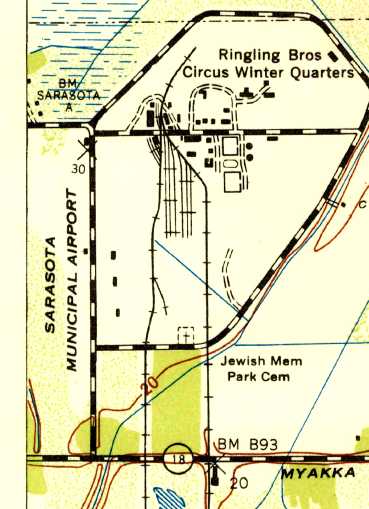
The 1947 USGS topo map depicted “Sarasota Municipal Airport” as an open field adjacent to the Ringling Brothers Circus Winter Quarters.
A 1948 aerial photo (from the University of FL online library, via Chris Kennedy) showed Sarasota Airport to have 2 unpaved runways oriented north/south & east/west),
with a few hangars along the east edge of the field.
The field was renamed "Lowe" Airport at some point between 1947-54,
as that is how it was labeled on the August 1954 Miami Sectional Chart (courtesy of Chris Kennedy).
It was described as having 3 runways, with the longest being a 3,500' turf strip.
Lowe Airport was still listed in the 1960 Jeppesen Airway Manual (according to Chris Kennedy),
and described as having 2 runways, with the longest being 3,500'.

The last aeronautical chart depiction which has been located of Lowe Airport was on the February 1961 Miami Sectional Chart.
It depicted Lowe as having a 3,500' unpaved runway.
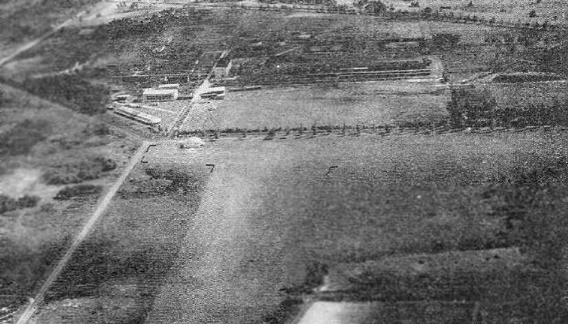
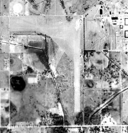
The last photo which has been located of Lowe Airport was a 3/28/62 USGS aerial view.
It depicted Lowe as having 2 unpaved runways & a few hangars along the east edge of the field.
There were no aircraft visible on the field, or any other sign of recent aviation use.
Lowe Airport was no longer listed among active airfields in the 1963 AOPA Airport Directory (according to Chris Kennedy).
Lowe Airport was evidently closed at some point between 1961-65, as it was no longer depicted on the April 1965 Miami Sectional Chart.
Sam Kurtz recalled, “Sarasota's Lowe Field... several entries in my own logbook from the 1960s.
When I was working on my CFI at a Venice flight school called Suncoast Aviation,
I would fly to Lowe Field to practice short & soft field grass strip procedures in a Cessna 150.
Also since I lived in Sarasota & worked at the airport in Venice I would jump into a Champ 7AC
and fly up the railroad tracks to Lowe Field where my wife would pick me up,
then have lunch, change clothes and fly back to the airport & go to work again.
Great fun & a good memory. My last log entry for Lowe Field is 2/16/1968.
At that time the airport had only the north/south runway & it was rough & the grass was long.
I think the property was sold shortly thereafter. I may have been the last pilot to use the airport.”
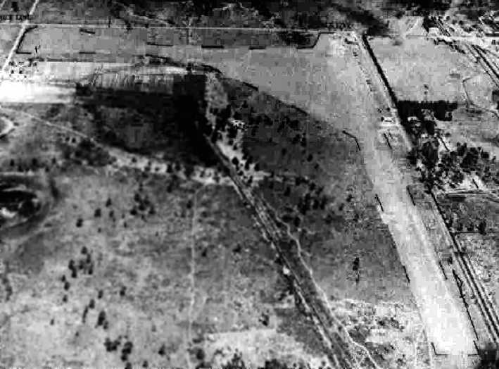
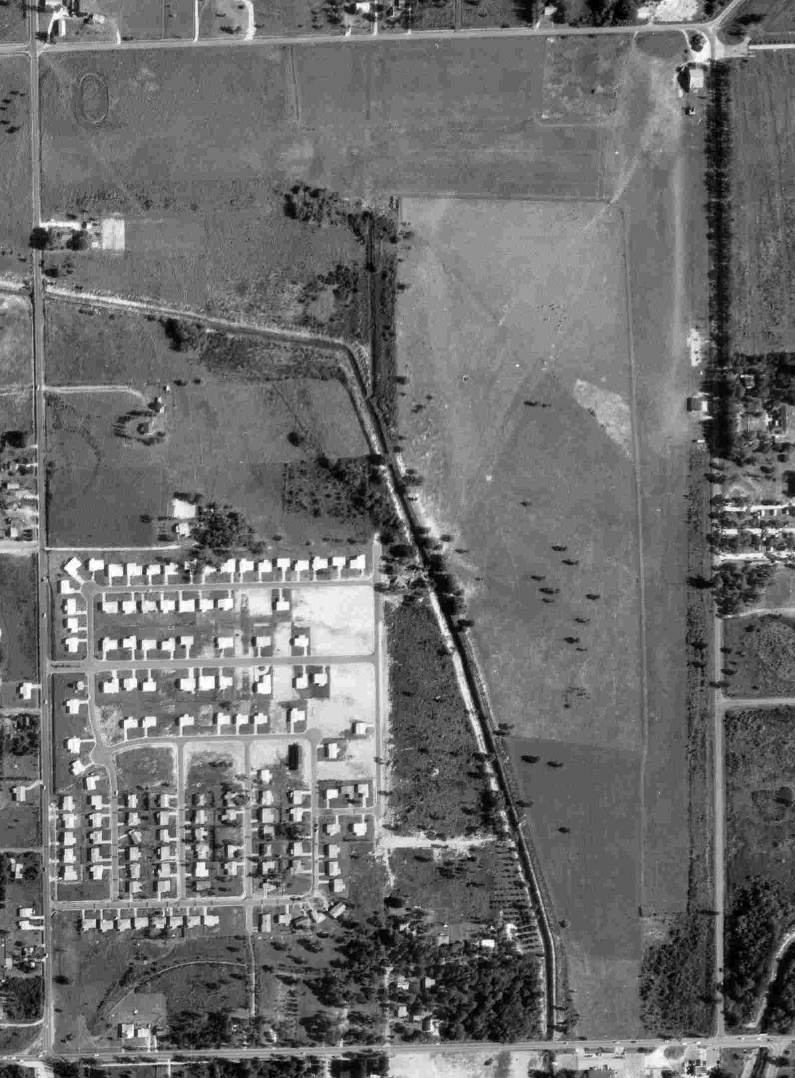
A 1969 aerial view showed Lowe Airport remained intact, with 2 grass runways & a few small hangars along the east side,
but there were no aircraft visible on the field.
Stephen Wooden recalled, “Lowe Field... The main building was a pagoda.
When the strip was closed, someone moved the pagoda to a new private airstrip further east out Fruitville Road.”
According to Sam Kurtz, “The shopping center / apartment complex was built within the next 5 years [circa 1973].”
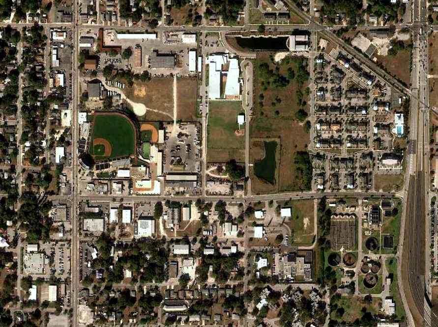
In the 1999 USGS aerial photo of the site of the original Sarasota Airport,
the shape of the canal which formed the southwest border of the airport property is still quite recognizable, compared to the 1948 aerial photo.
But all traces of the former airport itself appear to have been removed,
and the property has been densely redeveloped with housing & shopping.
The site of the original Sarasota Airport is located at the southeast corner of North Beneva Road & 12th Street.
____________________________________________________
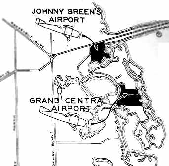
Grand Central Airport / Ludwig Sky Harbor, St. Petersburg, FL
27.85, -82.61 (Southwest of Tampa, FL)
Grand Central Airport, as depicted on the 1930 Air Guide (courtesy of Jonathan Westerling).
According to an article by Will Michaels in the 11/19 FL Aviation Historical Society Newsletter (courtesy of Cliff Cady),
“Grand Central Airport opened in 1929. Its location was on Weedon Island in north St. Petersburg
The name is after Dr. Leslie Weedon, one-time island owner.
Grand Central was the brainchild of Fred Blair.
After arriving in St. Petersburg, he turned his talents to real estate & development.
Blair formed Blair & Company, Inc. and began selling stock for $10 a share.
Investment advertisements touted 'Airports—Aviation Industry & Aviation Properties are in demand. The Future of Aviation offers the greatest speculation.'”
The article continued, “Grading for the airport began in late 1929. The airport had 3 hard-surface marl runways, the longest 3,200'.
An administration building & hangar were also built at a cost of $10,000. A dock was built on adjacent Papy's Bayou for seaplanes.
Arrangements were made for a bus line to facilitate transportation between the new airport & downtown St. Petersburg.
Eastern Air Transport began regular mail service to Grand Central in December 1929.”
The earliest depiction which has been located of Grand Central Airport was on the 1930 Air Guide (courtesy of Jonathan Westerling).
According to an article by Will Michaels in the 11/19 FL Aviation Historical Society Newsletter (courtesy of Cliff Cady),
“On 1/1/31 Eastern began regular passenger service between Grand Central & Daytona Beach, with stops in Tampa & Orlando,
using yellow & black Curtis Kingbird airliners', each carrying 7 passengers. Travel time was about 1.5 hours.
Service out of St. Petersburg was scheduled daily. Grand Central served as the Eastern HQ for northbound passenger travel.”
The article continued, “In August 1931, Blair opened Gulf Coast Airways which focused on flight training for pilots & repair of aircraft. It was not an airline.
Numerous air shows & events were held at Grand Central, helping to promote the Airport.
Blair also managed to attract a movie studio to the island which produced 3 unsuccessful films ['Chloe', 'Playthings of Desire', and 'Hired Wife'].
Comedian Buster Keaton participated briefly in the film making.
The airport facilitated the travel of actors, and film was flown to NY for editing.”
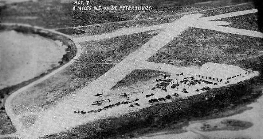
An aerial view looking northeast at Grand Central Airport
from The Airport Directory Company's 1933 Airport Directory (courtesy of Chris Kennedy).
The directory described Grand Central Airport as having 3 "hard surface marl" runways,
with the longest being the 3,200' northeast/southwest strip.
A single hangar & a 2-story terminal building were depicted along the southern edge of the field.
The operator was listed as Fred Blair, and the operators were All-American Airways (instruction, commercial service),
Beard Brothers (instruction, commercial service), and Eastern Air Transport Inc. (schedule mail, passenger, and express service).
A seaplane anchorage was also said to be available in the basin west of the field.
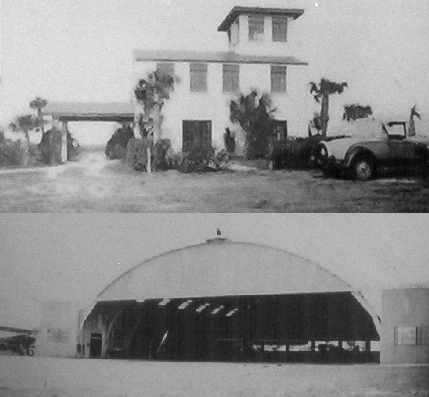
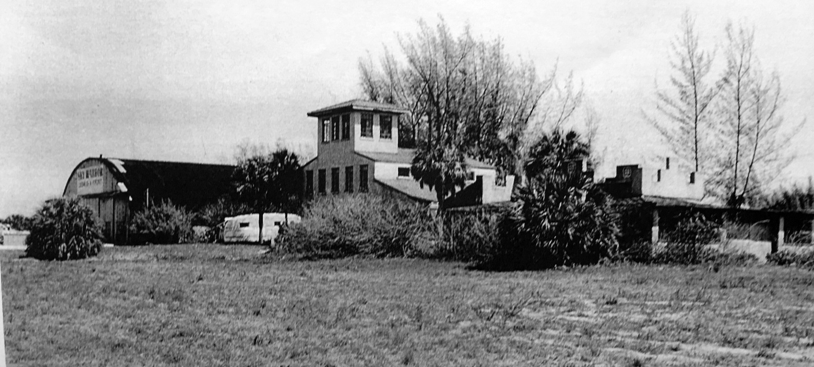
A pair of circa 1930s photos of Grand Central's control tower & hangar,
photographed in 2005 by Timothy Aanerud from a historical sign at the site of the airport.
Micheal Mock reported, “My Fairchild PT-19 was sold to Ludwig School of Flying in 1945 & that looks like a monoplane in the back of the hangar.”
A circa 1930s aerial view looking southeast at Grand Central Airport showed 3 runways, and an arch-roof hangar & another building on the southeast side (courtesy of Jim Goodburn, via Timothy Williamson).
The earliest aeronautical chart depiction which has been located of Grand Central Airport was on the December 1935 Miami Sectional Chart (courtesy of Chris Kennedy).
It depicted Grand Central as a commercial/municipal airport.
The 1936 FL Airway Chart (courtesy of Chris Kennedy) depicted Grand Central as having 3 runways.
According to an article by Will Michaels in the 11/19 FL Aviation Historical Society Newsletter (courtesy of Cliff Cady),
“With onset of the Great Depression in the 1930s, the airport eventually failed.
Eastern Air Lines ended their use of the airport in 1936.
The airport was foreclosed in 1937 & purchased by a private party.”
A 4/14/40 aerial view looking west from the 1945 AAF Airfield Directory (courtesy of Scott Murdock)
depicted Ludwig Sky Harbor as having 3 sod runways & a hangar on the south side of the field.
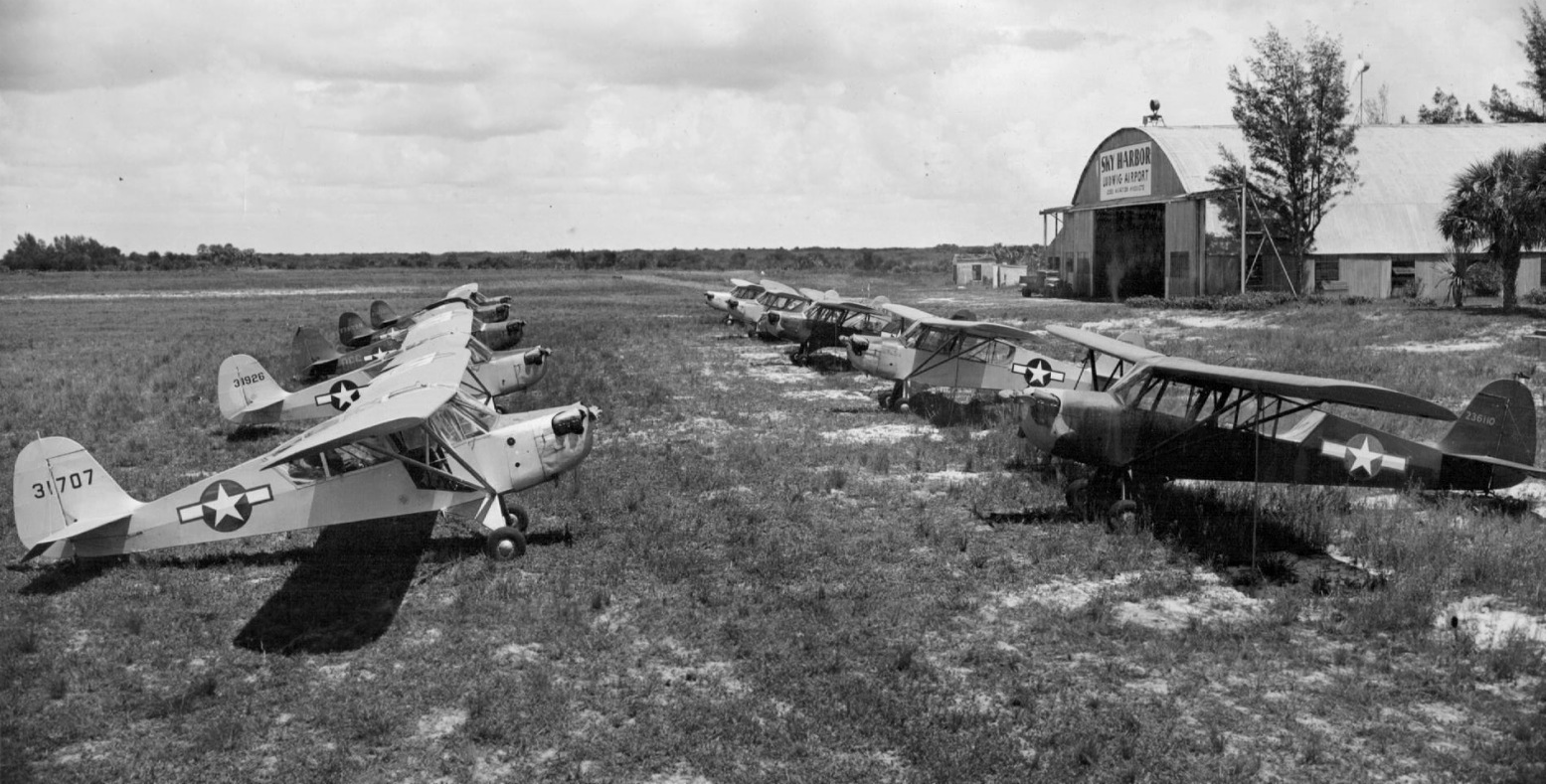
A WW2-era photo of military Aeronca aircraft lined up in front of a hangar marked “Sky Harbor Ludwig Airport (courtesy of Richard Baker).
Richard Baker recalled, “The rear of the picture says that my grandfather (Francis 'Frank' Ross) 'ran' this airport.”
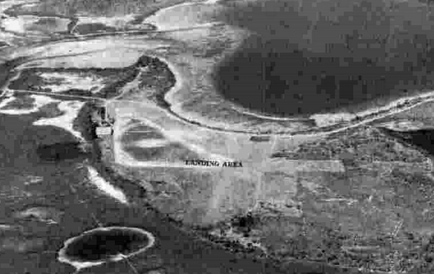
As seen in a 1/31/43 USDA aerial photo (from the FL DOT, courtesy of Brian Rehwinkel), Sky Harbor had 3 sod runways,
along with a hangar & small 2-story terminal (with a small tower), on the southwest corner of the field.
Ludwig Sky Harbor may have gone through a short period of closure during WW2, however (like many other small civil airports),
as it was not depicted at all on the August 1943 Miami Sectional Chart (according to Chris Kennedy),
and was not listed in the April 1944 US Army/Navy Directory of Airfields (courtesy of Ken Mercer).
According to an article by Will Michaels in the 11/19 FL Aviation Historical Society Newsletter (courtesy of Cliff Cady),
“In 1944, Clarence Ludwig - who operated an aviation maintenance faculty & school for flyers at Peter Knight Airport in Tampa -
acquired Grand Central & changed the name to Sky Harbor Airport.
He proposed to establish an 'Aero Country Club' on the field with opportunities for fishing & swimming, but this failed due to the airport's then-remoteness.
The idea was not new; Blair had considered an aviation country club back in 1931.”
By the time of the December 1944 US Army & Navy Directory of Airfields (according to Brian Rehwinkel),
Ludwig Sky Harbor was listed again, and was described as having a 3,300' runway.
The 1945 AAF Airfield Directory (courtesy of Scott Murdock) described Ludwig Sky Harbor
as a 525-acre irregularly-shaped property having 3 sod runways, with the longest being a 3,250' northeast/southwest strip.
The field was described as having a single 120' x 100' steel hangar, and to be owned & operated by private interests.
Ludwig Sky Harbor was depicted as a commercial/municipal airport on the 1945 Miami Sectional Chart (courtesy of John Voss).
According to an article by Will Michaels in the 11/19 FL Aviation Historical Society Newsletter (courtesy of Cliff Cady),
“In 1946, Sky Harbor was leased to Carl Stengel who planned an aviation school to operate under the GI Bill of Rights.
This soon folded.”
A circa 1940s photo looking northeast at Sky Harbor Airport's hangar & control tower (courtesy of Jim Goodburn, via Timothy Williamson).
The last aeronautical chart depiction which has been located of Sky Harbor Airport was on the August 1947 Miami Sectional Chart (courtesy of Chris Kennedy).
It depicted Sky Harbor Airport as having a 2,800' unpaved runway & and adjacent seaplane base.
The 1947 USGS topo map did not depict Sky Harbor Airport at all (just an empty area with one unlabeled building),
which may indicate that it had ceased operating by that point.
According to an article by Will Michaels in the 11/19 FL Aviation Historical Society Newsletter (courtesy of Cliff Cady),
“In 1948 Ludwig sold the airfield to multimillionaire Ed Wright & the airport was closed.
FL Power erected a powerplant on the east end of the island, and the state purchased the remaining land for a State Park.”
A historical sign on the site of Sky Harbor Airport put its closing date as 1948.
The February 1948 Miami Sectional Chart no longer depicted Sky Harbor Airport.
In 1963, the former Sun Haven Studios burned.
Joe Walker recalled, “In the mid-1960s as a junior high age child,
my friends & I stumbled across this old airport while riding bicycles north from Shore Acres along Weedon Island Drive.
We found the hangar & what was left of the old terminal off to the east of the main road.
Curiosity, of course, got the better of us, so we took a peek into the hangar through the dirty windows.
Inside we found a hangar full of parade floats in storage from the Festival of States & Gasparilla parades.
We found a broken window on the back side of the hangar & crept inside the hangar to play on the floats.
We returned several times that summer to play on the floats & only came close to getting caught once.”
The Sky Harbor Airport site was reportedly affected by a fire in 1967.
A 1969 aerial photo showed the Grand Central Airport hangar still standing.
Clint Hawkins recalled, “The old Ludwig Field out on Weedon Island....
As kids (1984ish) it was our area to take the bikes & explore parts of the old hangar (some areas were too decrepit & just creepy) & field.
The building foundations were very visible as well as the 'Ludwig' text on the hangar.
We would hunt citrus rats with BB guns until ran off by the caretaker (I believe Storm was the name on the mailbox) or FL Power security.
Good times! I had heard stories of blimps mooring there.”
Adam Albright recalled, "I first came across the old hangar in 1987.
There were still foundations from other buildings around the hangar still easily visible back then.
The actual runways were overgrown & were never visible while I lived the in area.
I was told the airport was also frequently used by blimps before shutting down.”
The hangar & another small building on the southwest corner of the former Sky Harbor Airport property continued to be depicted on the 1988 USGS topo map.
A historical sign on the site of Grand Central Airport said the hangar was removed in 1989.
According to Adam Albright, “the hangar... was torn down in the early 1990s because it was falling apart.”
A 1994 aerial photo showed the Grand Central Airport hangar had been removed.
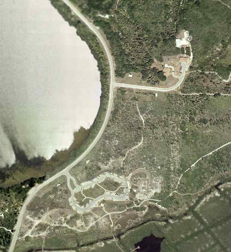
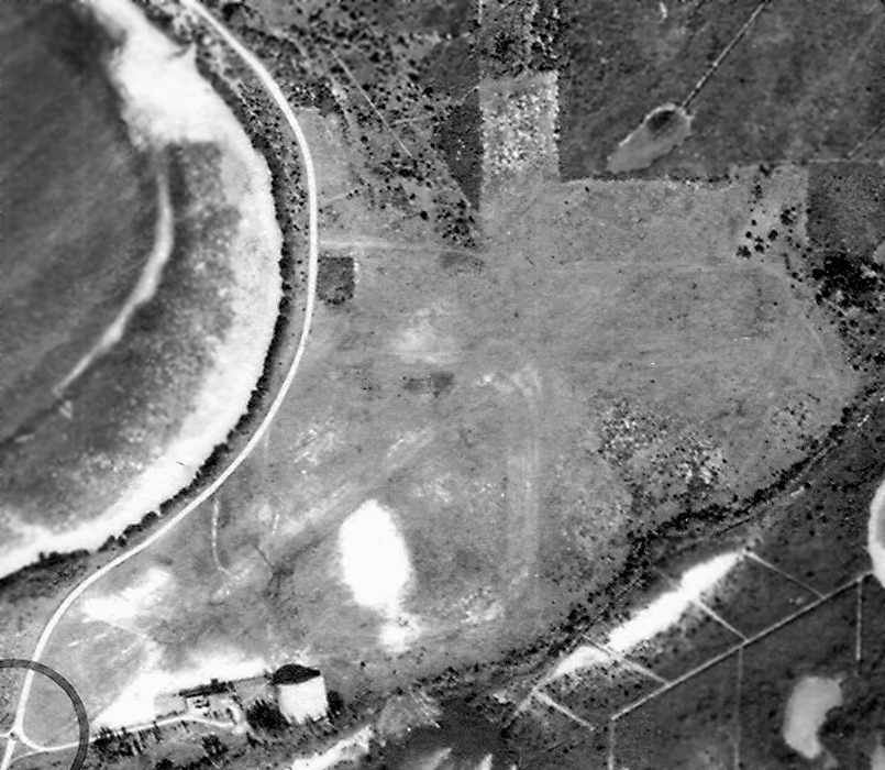
A 2002 USGS aerial photo of the site of Sky Harbor Airport.
The remains of the former control tower are visible on the southwest corner of the site.
As of the 2000s the Sky Harbor Airport site was part of The Weedon Island Preserve,
owned by the state & managed by the Pinellas County Park Department under a lease agreement with the state of FL.
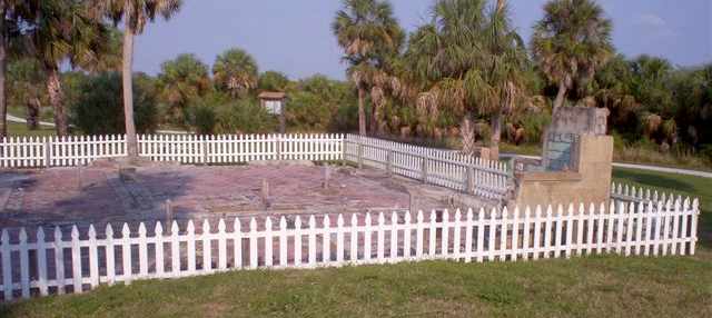
A 2005 photo by Timothy Aanerud of the remains of the Sky Harbor Airport control tower.
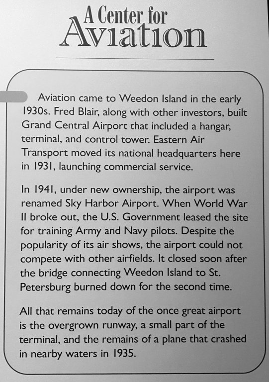
A 6/5/21 photo by Timothy Williamson of a historical sign inside the small museum at the site of Sky Harbor Airport.
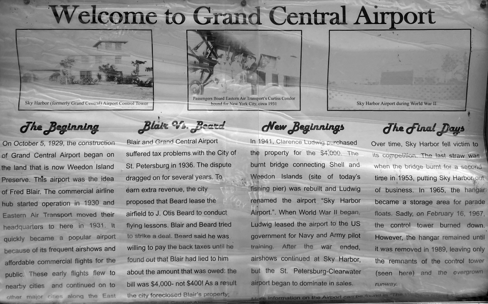
A 6/5/21 photo by Timothy Williamson of a historical sign at the site of Sky Harbor Airport.
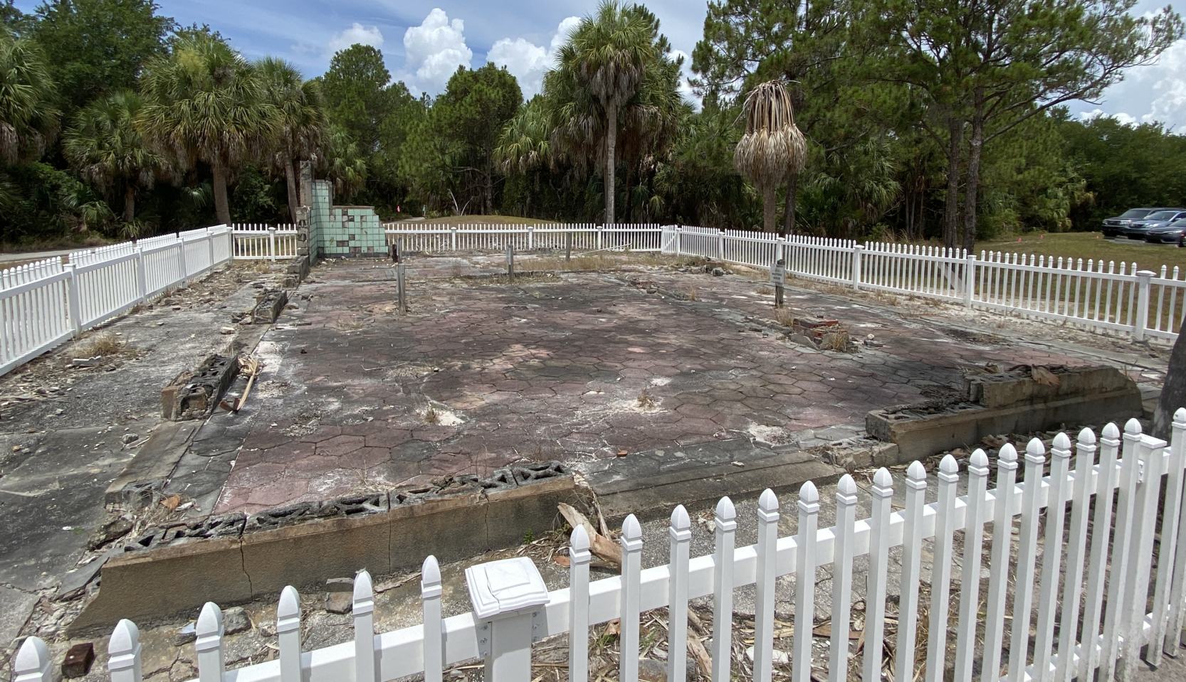
A 6/5/21 photo by Timothy Williamson of the remains of the Sky Harbor Airport control tower.
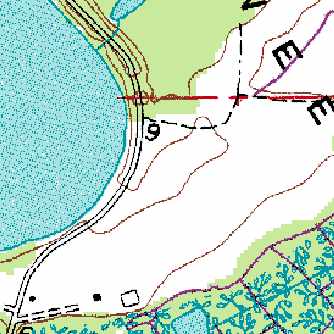
The site of Ludwig Sky Harbor is located southeast of Weedon Drive, along the western shore of Weedon Island.
Thanks to Brian Rehwinkel for pointing out this airfield.
____________________________________________________
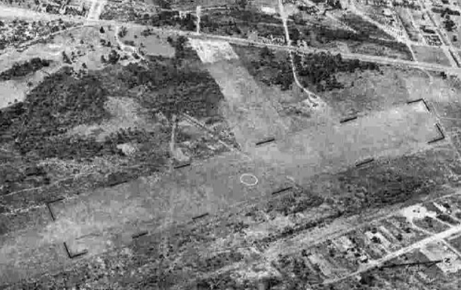
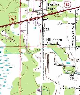
Robinson Airport / Plant City Airpark / Hillsboro Airport (X08), Seffner, FL
28.01, -82.25 (East of Tampa, FL)

Robinson Airport, as depicted on the April 1966 Orlando Sectional Chart (courtesy of Chris Kennedy).
Photo of the airport while open has not been located.
This small general aviation airport apparently went through at least 4 different names before fading away into obscurity.
The airfield at this location was apparently established at some point between 1964-66,
as it was not yet depicted on a 1957 aerial photo or the April 1964 Orlando Sectional Chart (according to Chris Kennedy).
The earliest depiction which has been located of this airfield was on the April 1966 Orlando Sectional Chart (courtesy of Chris Kennedy).
It depicted "Robinson" as a private airfield, having a 3,000' unpaved runway.
The earliest photo which has been located of Robinson Airfield was on a 1969 aerial view.
It depicted a single north/south unpaved runway, with a small hangar & 2 light single-engine aircraft on the northwest side.
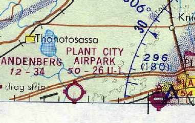
At some point between 1966-71, it was apparently renamed "Plant City Airpark",
as that is how it was labeled on the April 1971 Jacksonville Sectional Chart (courtesy of Chris Kennedy).
It was described as having a 2,600' unpaved runway.
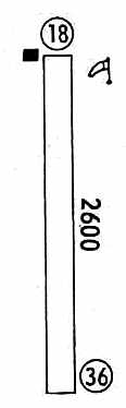
The 1971 Flight Guide (courtesy of Chris Kennedy) listed the field as "Tampa-Brandon",
and depicted it as having a single 2,600' unpaved Runway 18/36, with a single building at the northwest corner of the field.
The field was next renamed as "Hillsboro" at some point between 1971-75.
Cliff Cady recalled, “I started taking lessons at the Hillsboro Airport in February 1975 & took lessons through June 1975.
At that time it had at least 5 Cessna 150s & was a active FBO operation giving flight training & doing maintenance.
It was run by Ed Riley who was also a CFI and A&I.
About the June 1975 time frame the sod runway was closed to do some filling & grading to improve the drainage.”
The 1976 AOPA Airport Directory (according to Chris Kennedy) listed Hillboro's operator as Ed's Flying Service, Inc.
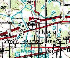
Hillsboro Airport, as depicted on the 1977 USGS topo map.
The 1979 Flight Guide (courtesy of Chris Kennedy) depicted Hillsboro as having a single 2,500' unpaved Runway 18/36,
with 2 buildings at the northwest corner of the field.
Hillsboro Airport was described in the 1982 AOPA Airport Directory (courtesy of Ed Drury) as having a single 2,500' turf Runway 18/36.
The field was said to offer flight instruction, rentals, hangars, and repairs, and the operator was listed as Ed's Flying Service, Inc.
The last photo which has been located showing aircraft at Hillboro Aorport was a 1984 aerial view.
It several small hangars on the north side of the runway, and 1 light single-engine aircraft on the northeast side.
The last aeronautical chart depiction which has been located of Hillsboro Airport was on 1985 FL Aeronautical Chart (courtesy of Alex Hauzer).
It depicted Hillsboro as having a 2,600' unpaved runway.
The 1987 USGS topo map depicted Hillsboro Airport as having a single north/south unpaved runway,
as well as what might have been a cluster of small hangars at the north end of the property.
It was still depicted as "Hillsboro Airport on the 1988 USGS topo map as well.
According to Ed Jarnagin, "Hillsborough had its certification pulled due to some 'Legal' problems."
Hillsboro Airport was no longer depicted on the March 1989 Miami Sectional Chart.
In a 1992 aerial view looking southeast, the cleared area of the Hillsboro Airport runway still remained, but the airfield appeared abandoned, as the hangars had been removed at some point between 1984-92, and there were no aircraft visible on the field.
No airfield at this location was listed in the 2000 AOPA Airport Directory.
A circa 2006-2010 aerial view looking south at the north end of the former Hillsboro Airport runway.

A 2019 aerial view looking southeast showed the cleared area of the former Hillsboro Airport runway still remained recognizable.
The site of Hillsboro Airport is located southwest of the intersection of Route 92 & McIntosh Road.
Thanks to Josh Garfield for pointing out this airfield.
____________________________________________________
Or if you prefer to contact me directly concerning a contribution (for a mailing address to send a check),
please contact me at: paulandterryfreeman@gmail.com
If you enjoy this web site, please support it with a financial contribution.
____________________________________________________
This site covers airfields in all 50 states.