Abandoned & Little-Known Airfields:
Northern Georgia
© 2002, © 2024 by Paul Freeman. Revised 9/3/24.
This site covers airfields in all 50 states: Click here for the site's main menu.
____________________________________________________
Please consider a financial contribution to support the continued growth & operation of this site.
Camfield Airfield (revised 11/15/20) - Conyers Airport / Styx Airport (revised 9/9/16) - Cumberland Academy Airfield (revised 9/3/24)
Cumming Airfield (revised 2/19/09) - Mercer Air Field (revised 5/3/22) - Poole Farm Airport (revised 9/3/24)
Rome Airport (revised 5/11/18) - Shuford Municipal Airport (revised 9/23/19)
____________________________________________________
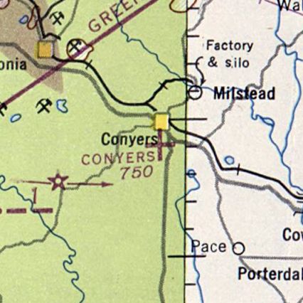
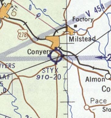
Conyers Airport / Styx Airport, Coners, GA
33.655, -84.02 (East of Atlanta, GA)
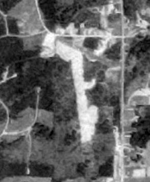
Conyers Airport, as depicted on the 1947 Birmingham Sectional Chart (courtesy of David Henderson).
Conyers Airport was evidently established at some point between 1946-47,
as it was not yet depicted on the April 1946 Birmingham Sectional Chart.
The earliest depiction which has been located of Conyers Airport was on the 1947 Birmingham Sectional Chart (courtesy of David Henderson),
which depicted Conyers as an auxiliary airfield.
According to David Henderson, “Conyers Airport was a private grass airfield just south of Conyers, GA, 23 miles directly east of Atlanta Hartsfield-Jackson International Airport.
It consisted of a 2,000' north/south turf runway & a smaller southwest/northeast runway.”
The 1950 Birmingham Sectional Chart (courtesy of David Henderson) depicted Conyers Airport as having a 2,000' runway.
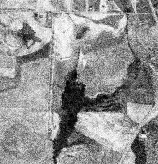
The earliest photo which has been located of Conyers Airport was a 1951 USGS aerial view (courtesy of David Henderson),
which depicted Conyers as having 2 grass runways & 2 small buildings on the northeast side.
A 1955 USGS aerial view (courtesy of David Henderson) depicted Conyers in an unchanged fashion.
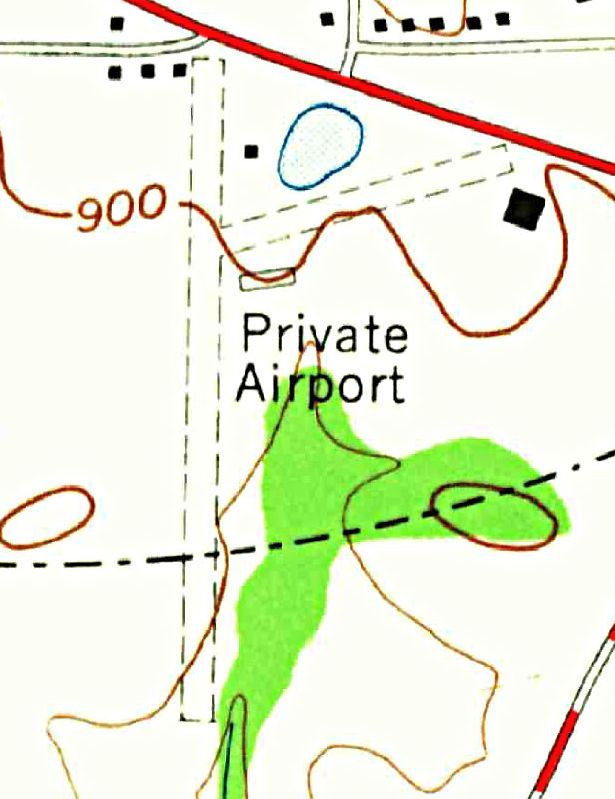
The earliest topo map depiction which has been located of Conyers Airport was on the 1956 USGS topo map (courtesy of David Henderson).
It labeled it simply as “Private Airport”, with 2 unpaved runways & 2 small buildings on the northeast side.
Conyers Airport may have been closed at some point between 1956-56,
as it was no longer depicted on the 1957 & 1958 Birmingham Sectional Charts (according to David Henderson).
This airport was evidently reopened under a new name – Styx Airport,
as that is how it was depicted on the 1959 Birmingham Sectional Chart (courtesy of David Henderson).
The last aeronautical chart depiction which has been located of Styx Airport was on the 1961 Birmingham Sectional Chart (courtesy of David Henderson).
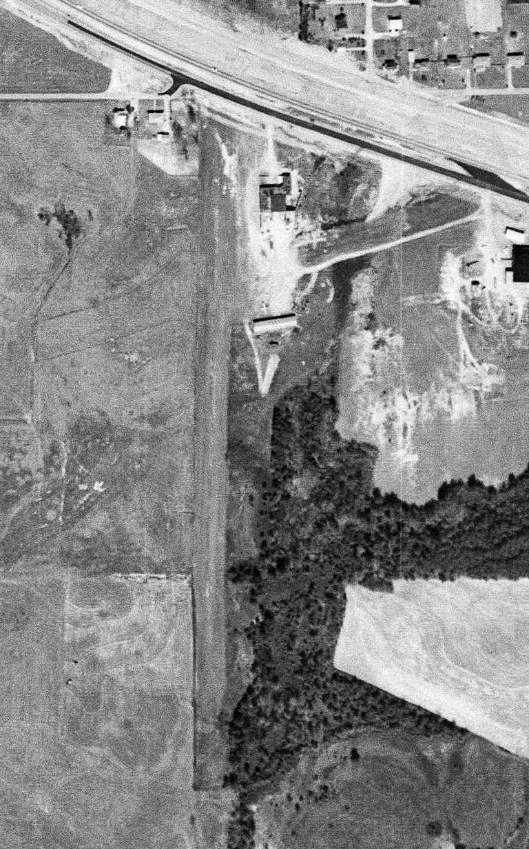
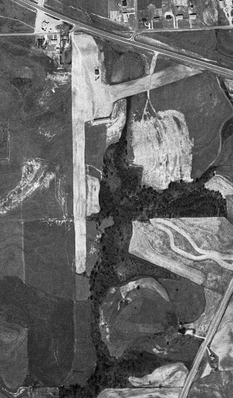
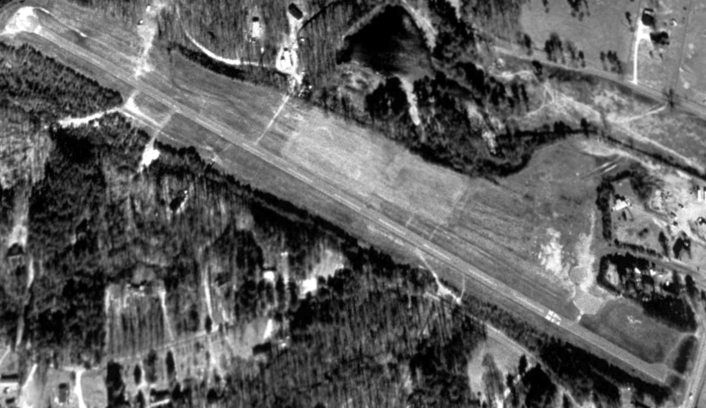
The last photo which has been located showing Styx Airport in operation was a 1962 USGS aerial view (courtesy of David Henderson),
One light single-engine aircraft was visible just north of the long building on the east side of the runway.
Styx Airport was evidently closed at some point between 1962-65,
as it was no longer depicted on the April 1965 Birmingham Sectional Chart.
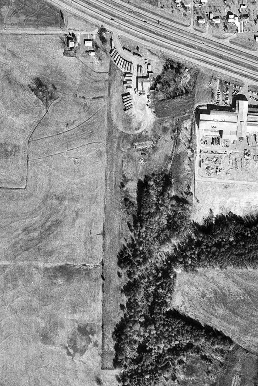
A 1968 USGS aerial view (courtesy of David Henderson) depicted trailers parked on the northern end of Styx Airport, although the majority of the 2 runways remained clear.
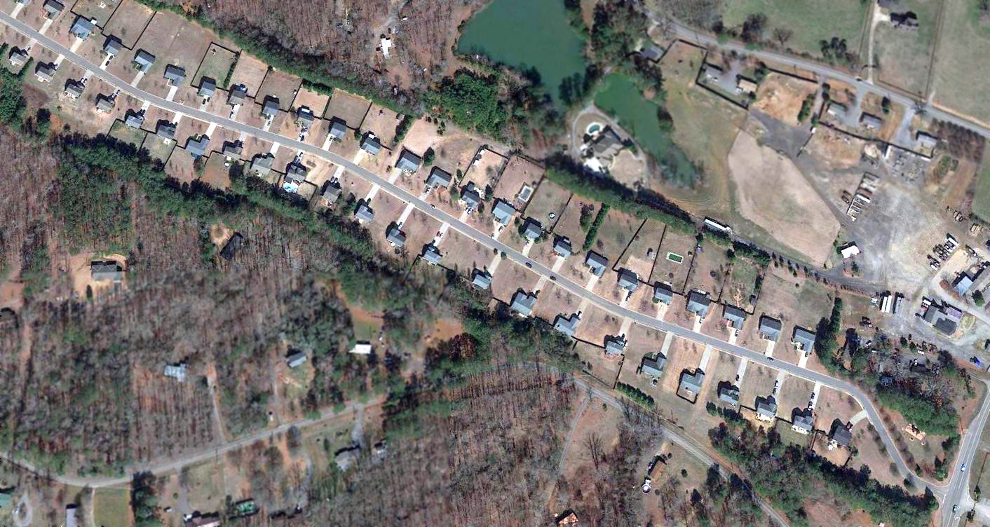
A 1988 aerial view showed new construction covering the site of Styx Airport, with no trace recognizable of the old airport.
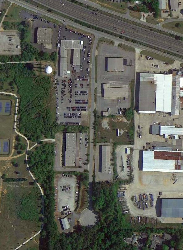
A 2014 aerial view showed no trace remaining of Styx Airport.
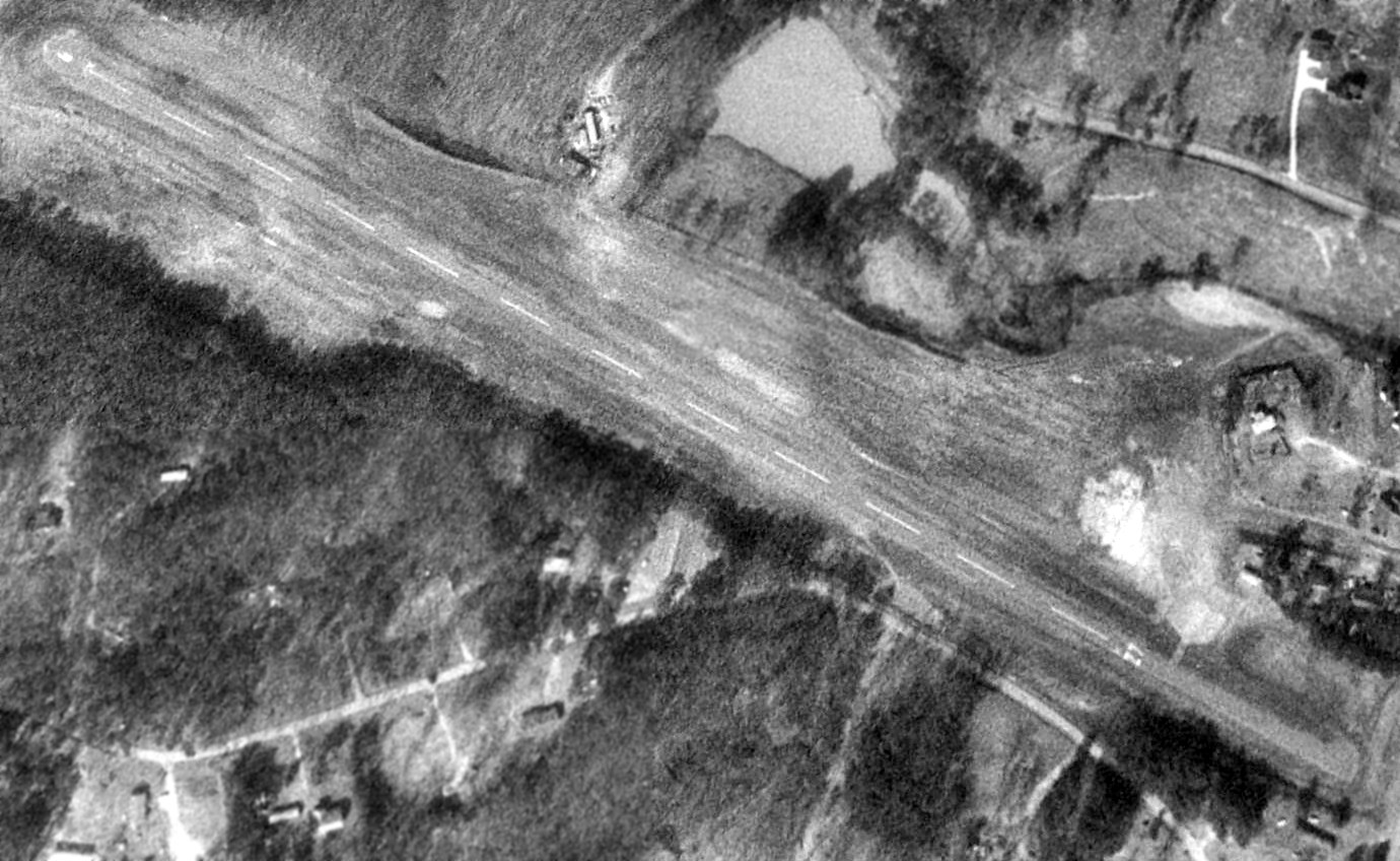
A 6/23/15 photo by David Henderson looking north along the site of Styx Airport's north/south runway.
David reported, “A Hyundai dealership sits at the north end of the former runway & a residential area is at the south end.
The edge of the parking lot at the left was once the western edge of the runway.”
The site of Conyers Airport is located near the intersection of Iris Drive & Portman Drive just south of Interstate I-20.
Thanks to David Henderson for pointing out this airfield.
____________________________________________________
Camfield Airfield, McDonough, GA
33.48, -83.97 (Southeast of Atlanta, GA)
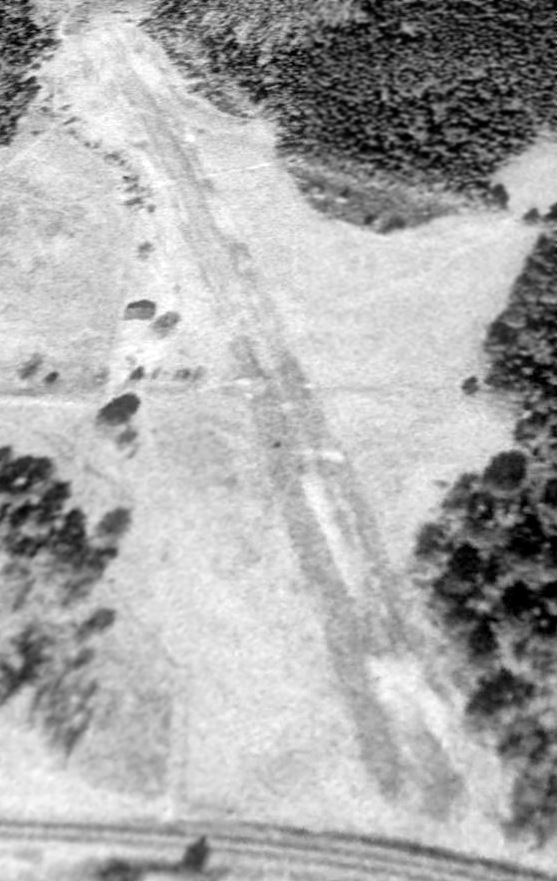
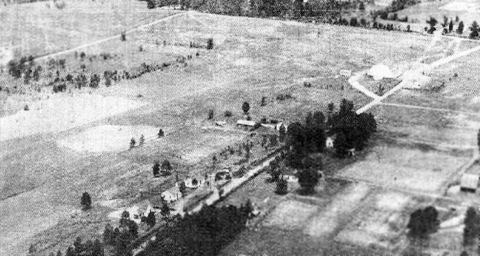
A 2/12/88 USGS aerial view looking northwest along the Camfield runway (courtesy of David Henderson).
Camfield Airport was not yet depicted on the September 1986 Atlanta Sectional Chart.
Pete Smart reported, “I established Camfield Airport (GA36) in 1988.
It was 1,600' long & was oriented 15/33 (southeast/northwest).”
The earliest depiction which has been located of Camfield Airport was on a 2/13/88 USGS aerial photo (courtesy of David Henderson).
It depicted Camfield as having a single northwest/southeast turf 2,200' runway with a single building on the west side of the strip.
A 3/7/93 aerial view showed the addition of a second building.
Pete Smart recalled, “I originally had 2 'pole barn' type hangars which were very convenient.
Just taxi in & taxi out, but they didn't offer enough protection for my fabric covered airplanes.”
He eventually built a replacement hangar: “It was 60' x 75' & was built after the strip.”
The only aeronautical chart depiction which has been located of Camfield Airport was on the March 1995 Atlanta Sectional Chart.
It depicted Camfield as a private airfield having a 1,600' unpaved runway.
Pete Smart reported, “The property was sold in 2001 [for ] a subdivision.”
David Henderson observed, “An April 2002 photo of Camfield, facing southwest,
shows that some of the forest surrounding the airport had been cleared, presumably in preparation for a planned subdivision.
The runway still appeared to be in good condition & a third & much larger building [the 3rd & last hangar] had been constructed adjacent to the 2 earlier structures.”
David Henderson observed, “Construction of the subdivision was well underway in 2004 & over 24 houses had been built on the site of the old airport.
Most of the old runway had been graded & built over although the 3 buildings visible in previous photos remained.”
David continued, “The 2 smallest airport structures had been removed by August 2005
and the only remaining section of runway had been transformed into backyards.”
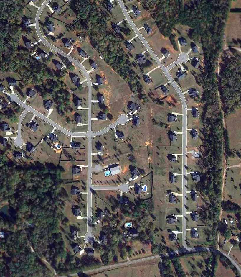
A 10/31/12 aerial view showed no recognizable trace of Camfield Airfield.
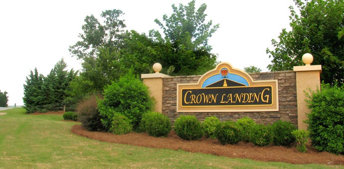
An undated photo of the entrance sign for the Crown Landing development, on the site of Camfield Airfield (courtesy of David Henderson).
David Henderson reported, “I visited the site of Camfield airport, now the Crown Landing subdivision, in November 2013.
The streets are named in honor of the former field (Airport Court, Crosswind Place, Terminal Court, etc.)
and the subdivision logo includes a runway & small aircraft.”

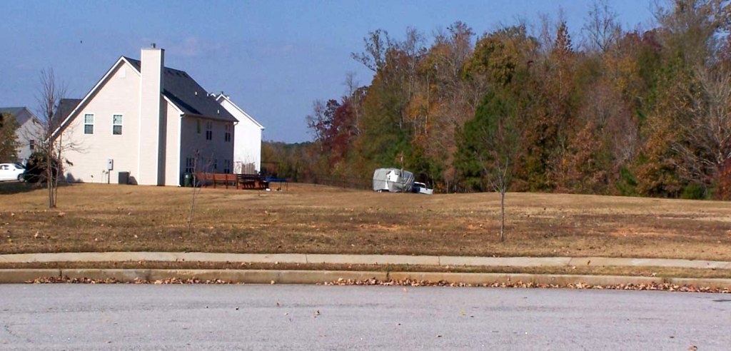
A November 2013 photo by David Henderson of the last hangar built at Camfield.
David observed, “The large building seen in the 2002 photo is now used as the community recreation center.
The picnic area to the right of the red building in the photo sits atop the concrete pad of one of the smaller airport structures.”
A November 2013 photo by David Henderson “looking northwest along the former runway, now covered by houses.”
The site of Camfield Airport is located at the intersection of River Road & Crown Landing Parkway.
____________________________________________________
Poole Farm Airport (21GA), Oxford, GA
33.68, -83.853 (East of Atlanta, GA)
Poole Farm Airport, as depicted on a 1974 aerial view (courtesy of David Henderson).
Poole Farm Airport was evidently established at some point between 1962-74,
as it was not yet depicted on the 1959 Atlanta Local Aeronautical Chart (courtesy of Tim Zukas),
a 1962 USGS aerial photo, or the 1966 USGS topo map.
The earliest depiction which has been located of Poole Farm Airport was a 1974 aerial view (courtesy of David Henderson),
which depicted 2 unpaved runways.
According to its FAA Airport/Facility Directory data, Poole Farm Airport was activated in January 1975.
According to David Henderson, “The airport was home to a single light aircraft which was kept in a small hangar on the east side of the field.”
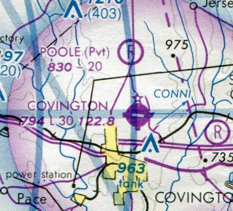
The earliest aeronautical chart depiction which has been located of Poole Farm Airport was on the 1978 Atlanta Sectional Chart (courtesy of David Henderson).
It depicted Poole as a private airfield having a 2,000' unpaved runway.
The 1988 USGS topo map depicted the clearings for Poole Farm Airport's 2 unpaved runways, but without any label.
David Henderson observed, “A 1988 aerial [photo] showed the airport in excellent condition.
Runway 17/35 was 2,000' long & 200' wide while Runway 12/30 was 1,400' by 80'.”
David continued, “A 2/8/99 USGS photo showed brush & small trees growing over parts of the runways.
Two rather large trees appear to be growing between the hangar & runway.”
The last photo which has been located presumably still showing Poole Farm Airport as maintained was an April 2002 aerial view (courtesy of David Henderson).
David observed, “The runways had been mowed & maintained but I don't see how a plane could fit between the trees growing between the runway & hangar.”
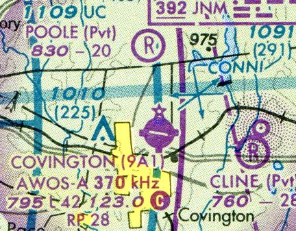
The September 2003 Atlanta Sectional Chart (courtesy of David Henderson)
depicted Poole as a private airfield having a 2,000' unpaved runway.
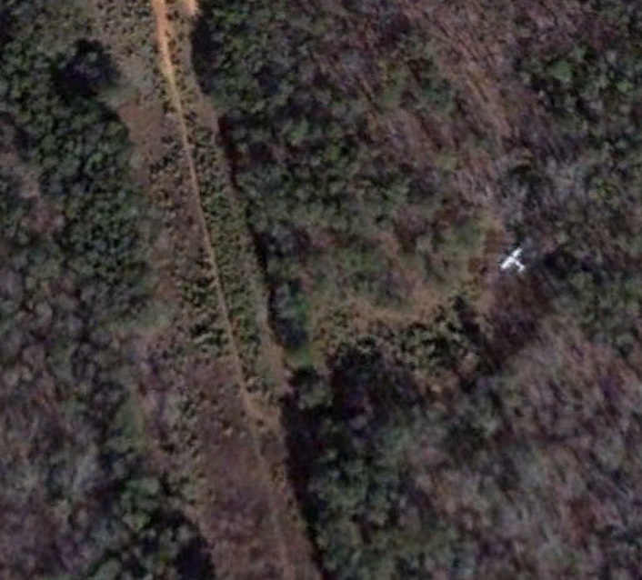
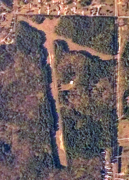
David Henderson observed, a January 2006 aerial view showed “the airport abandoned & the runways covered in small pines.
A single-engine aircraft was evidently also abandoned & can be seen stranded in the woods at the site of the old hangar.”
David Henderson observed, “Later photos confirm that the framework of the hangar was still in place but the roof & siding had been stripped off.
The aircraft is also seen in a photo from 2007.
Between 2008-2010 the entire property was logged & cleared, possibly in preparation for residential development.”
David Henderson observed, “The aerial from May 2011 shows the remains of the hangar & a portion of the badly eroded former Runway 17/35.”
David Henderson observed, “I drove past the old airport in November 2013 & the site is still undeveloped & covered in small pines.”
As of 2013, Poole Farm Airport's FAA Airport/Facility Directory data lists its owner as Irene Poole, and its manager as Joseph & Robert Poole.
It is described as having 2 turf runways: 2,000' Runway 17/35 & 1,400' Runway 12/30.
The field is said to have one single-engine based aircraft.

A 2021 aerial view looking northwest showed the alignment of the 2 former Poole Farm Airfield runways to remain barely recognizable.
Poole Farm Airport is located southwest of the intersection of Duncan Road & Highway 81.
____________________________________________________
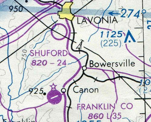
Shuford Municipal Airport, Lavonia, GA
34.42, -83.11 (Northeast of Atlanta, GA)
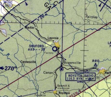
Shuford Municipal Airport, as depicted on the August 1958 Charlotte Sectional Chart.
The eventual site of Shuford Municipal Airport was depicted an open farmland on a 1955 USGS aerial photo (according to David Henderson).
Shuford Municipal Airport was evidently established in 1958,
as it was not yet depicted on the January 1958 Charlotte Sectional Chart.
The earliest depiction which has been located of Shuford Municipal Airport was on the August 1958 Charlotte Sectional Chart.
It depicted Shuford as having a 2,500' unpaved runway.
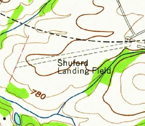
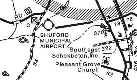
The 1961 USGS topo map (courtesy of David Henderson) depicted “Shuford Landing Field” as having a single unpaved northeast/southwest runway.
There were no buildings depicted on the field.
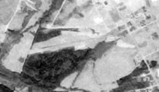
The earliest photo which has been located of Shuford Municipal Airport was a 1977 USGS aerial view (courtesy of David Henderson).
David observed, “The airport layout remained unchanged.”
The last aeronautical chart depiction which has been located of Shuford Municipal Airport was on the 1978 Atlanta Sectional Chart (courtesy of David Henderson).
It depicted Shuford as an unpaved public airport with a 2,400' unpaved runway.
According to David Henderson, “Topo maps from the 1970s & 1980s show a single building located on the southeast side of the field.”
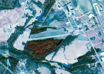
The last photo which has been located showing Shuford Municipal Airport remaining intact (and presumably still operational)
was a 1981 aerial view (courtesy of David Henderson).
According to David Henderson, “Sometime between 1981-88 the airport was closed to make way for an industrial park.
Shuford Street was built along the length of the airport. Aircraft now use Franklin County Airport several miles to the south.”
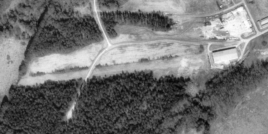
A 1993 USGS aerial photo (courtesy of David Henderson) shows that “an industrial building had been constructed over the eastern end of the runway.”
David Henderson remarked, “The airport appears on a 1995 DOT map of Franklin County even though the airport had been closed for about a decade.”
According to David Henderson, “By 2005 the site had been completely developed.”
A 2008 aerial photo (courtesy of David Henderson) showed no trace remaining of Shuford Municipal Airport.
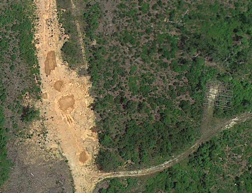
David Henderson reported in 2013, “No trace of the airport remains today.
Oddly, as of 2013 the Shuford Municipal Airport name & location still appear on Google Maps even though the airport has been closed for nearly 3 decades.”
____________________________________________________
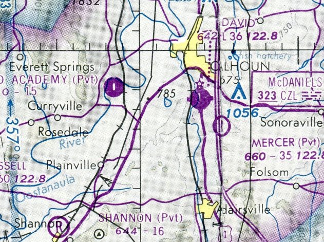
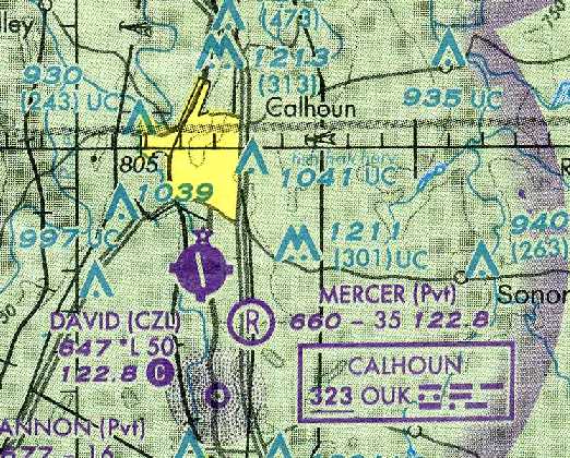
Cumberland Academy Airfield, Calhoun, GA
34.465, -85.032 (Northwest of Atlanta, GA)
Cumberland Academy Airfield, as depicted on the 1978 Atlanta Sectional Chart (courtesy of David Henderson).
A 1964 USGS aerial photo did not yet depict any airfield at this location,
nor did the October 1970 Atlanta Sectional Chart (courtesy of Ron Plante) or the 1971 USGS topo map.
Fred Boettcher recalled, “On the property of Georgia Cumberland Academy, a private christian high school that I attended years ago...
They have a strip out by the river that was in OK shape last time I saw it, but that's been a few years.
The school used to offer a private pilots course for students interested in going into mission aviation.”
They offered a ground school one year while I was there.
One of the teacher's husband was a flight instructor at the Calhoun Airport.”
The earliest depiction of which has been located of Cumberland Academy Airfield was on the 1978 Atlanta Sectional Chart (courtesy of David Henderson).
It depicted Cumberland Academy as a private airfield having a paved north/south runway a mere 1,500' in length.
Fred Boettcher recalled, “They stopped the program in the 1970s or 1980s.
They had a hangar at one time, which turned into a bakery, then an indoor pool, then an outdoor pool, now no pool.”
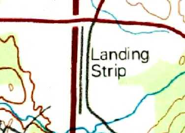
The earliest topo map depiction of which has been located of the Cumberland Academy Airfield was on the 1985 USGS topo map.
It depicted a single unpaved north/south runway at Cumberland Academy, labeled simply as “Landing Strip”.
The earliest photo which has been located of Cumberland Academy Airfield was a 1/26/93 USGS aerial view looking southwest,
which depicted a single north/south runway.

A 2024 aerial view looking northwest showed the remains of the Cumberland Academy Airfield paved runway.
The site of Cumberland Academy Airfield is located at the western terminus of Academy Drive.
____________________________________________________
34.44, -84.92 (Northwest of Atlanta, GA)
Mercer Air Field as depicted on the 1978 Atlanta Sectional Chart.
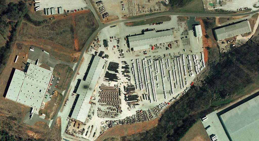
David Henderson reported, “Mercer Air Field was a private airport bordering Interstate I-75 northwest of Atlanta
and was the home of the World Aircraft Museum & its collection of over a dozen military aircraft.
The airport was constructed in 1974 by Ervin Lamar Mercer on land he purchased for his trucking company (which bordered the field)
and had a single 3,500' north/south grass runway.
Mercer built & initially used the airport for his personal Beechcraft Bonanza,
but after he became a grandparent he began bringing in military aircraft for his grandchildren to play on!
What began as a giant air-themed playground gradually became the World Aircraft Museum.
The formation of the museum was necessary to acquire more military aircraft from the government.”
The earliest depiction of Mercer Air Field which has been located was on the 1978 Atlanta Sectional Chart.
It depicted Mercer as a private airfield having a 3,500' unpaved runway.
David Henderson reported, “During the 1980s, the collection featured nearly 20 aircraft.”
The earliest topo map depiction of Mercer Air Field which has been located was on the 1982 USGS topo map.
It labeled Mercer Air Field simply as “Landing Strip”, and depicted a single north/south runway.

The earliest photo which has been located of Mercer Air Field was a 2/21/88 USGS aerial view (courtesy of Dallam Oliver-Lee),
which depicted several of the aircraft of the growing collection of the World Air Museum.
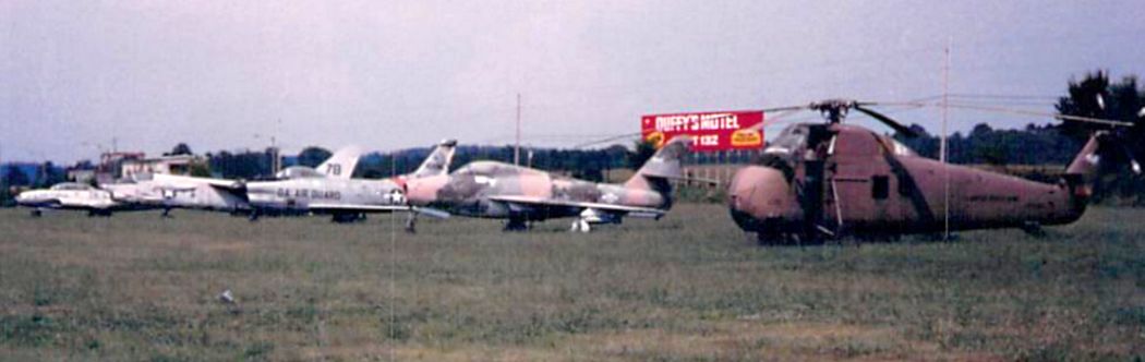
A late August 1989 photo by John Black of the lineup of jets & a helicopter at Mercer Airfield.
A late August 1989 photo by John Black of the lineup of the helicopter & planes at Mercer Airfield.
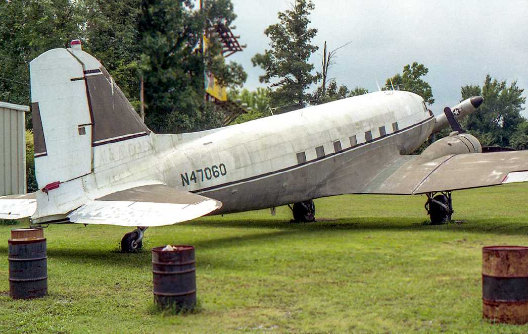
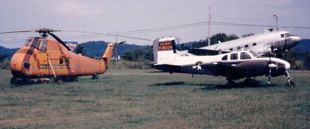
An 8/22/92 photo by David Henderson of DC-3 N47060 at Mercer Air Field, with the nose of a Mace cruise missile visible behind the DC-3's nose.
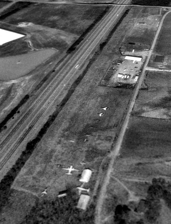
A 12/12/92 USGS aerial view looking northwest depicted the World Air Museum at Mercer Air Field perhaps at its peak, with over a dozen aircraft on display.
An April 1993 photo by David Henderson of C-47 N2805J which David reported “had flown in earlier that day” to Mercer Air Field.
David Henderson reported, “By the late 1990s, time, exposure to the elements, and vandalism
had taken a toll on the aircraft & Mr. Mercer began to sell off the collection.
The valuable C-47s were among the first to go.
N2805J, the one plane to have been kept in immaculate condition, went on to fly cargo with Dodson International Airlines.
The brown & white C-47 N47060, which looked nearly derelict, was sold to a private owner who managed to fly it out of Mercer Air Field
but engine troubles forced an emergency landing at nearby Rome, GA only a few minutes into the flight.”
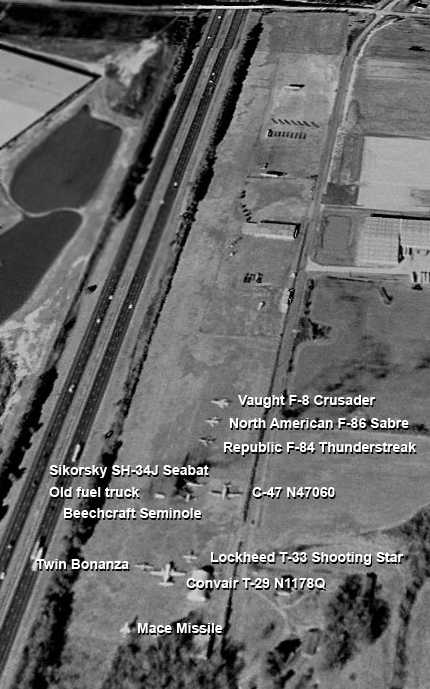
A 1999 USGS aerial view looking northwest, annotated by David Henderson to label the variety of aircraft on display.
David Henderson reported, “Mr. Mercer's declining health was also an issue & after suffering several strokes in the early 2000s,
he was unable to keep up with the maintenance of the airport & planes.
Relatives said he lost interest in the museum as he got older.
Throughout the early 2000s the smaller aircraft, most of which were on loan from the military, were dismantled & hauled away.
Many were restored by other museums while a few had deteriorated to the point that they ended up being scrapped.
The F-86 went to the Museum of Aviation in Warner Robins, GA, the last Sikorsky helicopter was taken to Texas, the Mace missile went to Maryland.”
The last aeronautical chart depiction which has been located of Mercer Air Field was on the 2002 Sectional Chart (courtesy of David Henderson),
which depicted Mercer as a private airfield with a 3,500' unpaved runway.
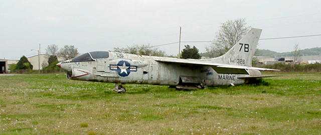
A sad 4/10/04 photo of a once-mighty supersonic Vought F8U Crusader, looking very deteriorated at Mercer Air Field.
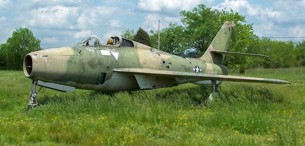
A 4/30/09 photo by David Henderson of a Republic F-84F Thunderstreak at Mercer Air Field.
The canopy was gone, allowing water inside the cockpit.
David Henderson reported, “On my visit to Mercer in April 2009, the airport had obviously not been mowed for some time
and only 3 aircraft (the big Convair T-29, the T-33, and F-84) remained, rotting away in the field.”
A 4/30/09 photo by David Henderson looking north along Mercer Air Field's runway.
David Henderson reported, “The trees bordering the runway had grown so large that most of the airport was no longer visible from the expressway.”
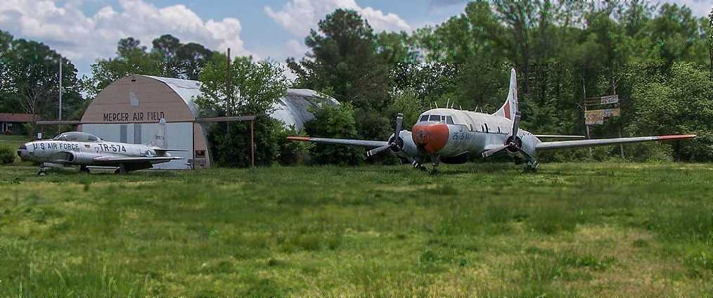
A 4/30/09 photo by David Henderson of a Lockheed T-33 Shooting Star, the Mercer Air Field hangar, and a Convair T-29.
David Henderson reported, “The hangar was in poor condition.
Not long after these photos were taken, the tail section of the Convair was inexplicably cut off & left in the grass next to the fuselage where it remained for over a year.”
The last photo which has been located showing aircraft at Mercer Air Field was a 6/7/09 USGS aerial view (courtesy of Dallam Oliver-Lee),
which showed the last 3 display aircraft on the south end of the field.
David Henderson reported, “Mr. Mercer passed away in May 2010 just days short of his 82nd birthday.
After the estate was settled, the Convair (which had been purchased by Mr. Mercer) was sold for scrap,
the T-33 went to the American Legion in Alpharetta, GA, and the F-84 went to the Marietta Museum of History's Aviation Wing at Dobbins ARB.
Shortly after Mr. Mercer's passing, the state of Georgia bought the right of way along the north end of the airport
and began construction of a new interchange on Union Grove Road & I-75 to give access to the county industrial park that had built up around the field.
This effectively precluded any possible future use of the runway.”
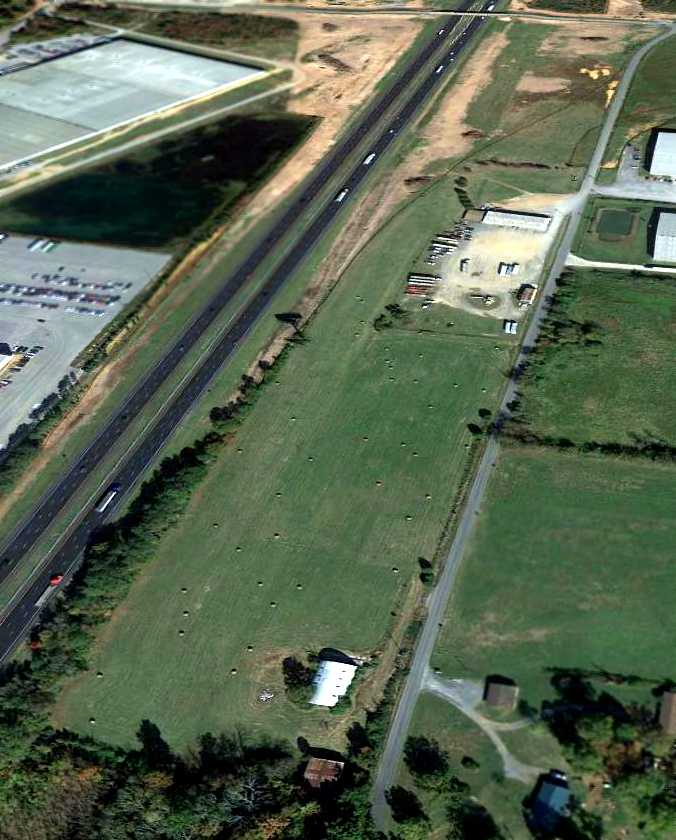
A 10/23/12 aerial view looking northwest sadly showed Mercer Air Field devoid of aircraft,
and it showed construction starting to cover the northern half of the airfield for a new interchange for Interstate 75.
David Henderson reported, “I drove past Mercer Air Field in April 2013 & the interchange construction was well underway.
Amid the heavy machinery & mounds of red Georgia clay, a tattered wind sock still hung from a pole by the site of the new exit ramp.
The hangar at the south end of the airport was still standing but looked as if could cave in at any time.”
John Black reported of Mercer Airfield, “I drove by the field on 7/31/14.
It looked like they had just recently rolled the hay on what remained of the runway, I could still read Mercer Air Field on the hangar, and no aircraft in sight.”
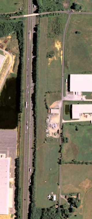
The site of Mercer Air Field is located southeast of the intersection of Interstate 75 & Union Grove Road Southeast.
____________________________________________________
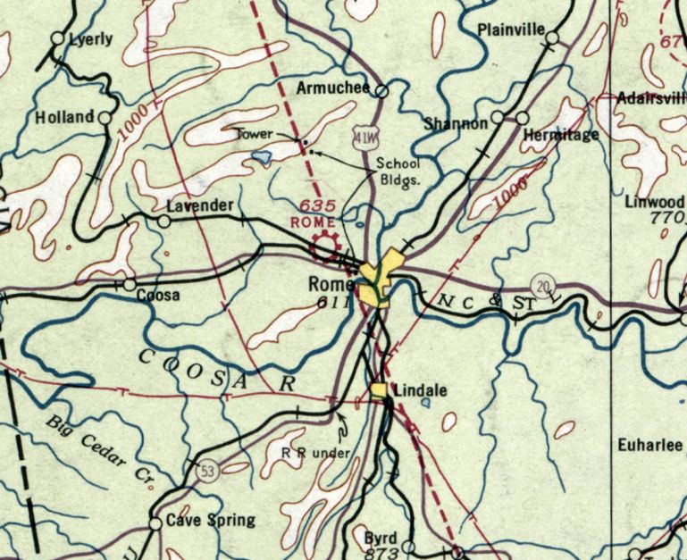
34.282, -85.222 (Northwest of Atlanta, GA)
Rome Airport, as depicted on the 1929 Georgia Rand-McNally Standard Indexed Map with Air Trails (courtesy of Chris Kennedy).
According to Mark Hess, “Rome Airport... was started in 1926 by the city of Rome.”
However, Dorothy Garrard reported that the “old Rome Airport” was built by her father, John Garrard,
“on his farm with one runway that had been a cornfield.”
The earliest depiction of the Rome Airport which has been located
was on the 1929 Georgia Rand-McNally Standard Indexed Map with Air Trails (courtesy of Chris Kennedy).
It described Rome as a municipal airport, operated by the Rome Airport Association.
It was said to consist of a 2,450' x 1,900' field.
The earliest aeronautical chart depiction which has been located of Rome Airport was on the January 1936 Chattanooga Sectional Chart.
It depicted Rome as a commercial/municipal airport.
The Airport Directory Company's 1941 Airport Directory (courtesy of Chris Kennedy)
described Rome as a commercial airport, with 2 sod runways in a "T" shape: 3,000' east/west & 2,000' north/south.
The field was said to have a hangar, and it was noted not to be usable in wet weather.
The earliest photo which has been located of Rome Airport was a 4/16/43 aerial view looking north from the 1945 AAF Airfield Directory (courtesy of Scott Murdock).
It depicted Rome Municipal Airport as having 2 runways.
A 1943 aerial view of Rome Airport (from the Georgia Aerial Photo Collection, via Chris Kennedy).
The airport appeared to consist of 2 unpaved runways (oriented north/south & east/west), along with possibly 2 hangars southeast of the runway intersection.
C-47 transports carrying wounded soldiers reportedly landed at Rome Airport during WW2, with the grass runways barely long enough.
The 1945 AAF Airfield Directory (courtesy of Scott Murdock) described Rome Municipal Airport
as a 75 acre T-shaped property having 2 clay & sod runways: 2,500' east/west & 2,000' north/south.
The field was said to have 4 wooden hangars, the largest measuring 60' square.
Rome Municipal Airport was described as being owned by the City of Rome, and operated by private interests.
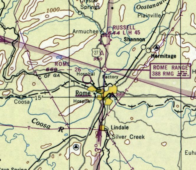
The last aeronautical chart depiction which has been located of Rome Airport was on the February 1950 Chattanooga Sectional Chart.
It depicted Rome Airport as having a 2,600' unpaved runway.
A circa 1950s aerial view looking northwest at Rome Airport (courtesy of Mark Hess).
The field consisted of 2 perpendicular grass runways, with an arched-roof hangar at the top-right. One single-engine taildragger was visible at the center of the photo.
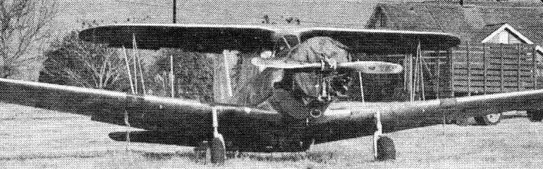
A circa 1950s photo (courtesy of Mark Hess) at Rome Airport of a rare & bizarre conversion of a Vultee BT-13 into a biplane, with a small upper wing added by Robert Stroop.
Dorothy Garrard reported that “My father sold the old Rome Airport & his farm & home to General Electric in 1952.
All of that land, farm, houses, and airport for $100,000. Think of it!”
The Rome Airport was no longer depicted on the August 1954 Chattanooga Sectional Chart (according to Chris Kennedy).
It had evidently been replaced by the larger Richard B. Russel Airport, north of Rome.
The Coosa Valley Fair was reportedly held on the former airport grounds for several years after the airport's closure.
A 1964 aerial photo showed a General Electric plant covered the site of Rome Airport,
completely obscuring any remaining trace of the airfield.
A 2018 USGS aerial photo showed a General Electric plant covered the site of Rome Airport.
The site of Rome Airport is located north of the intersection of West Butler Street Northwest & Old Airport Road, appropriately enough.
____________________________________________________
34.255, -84.205 (Northeast of Atlanta, GA)
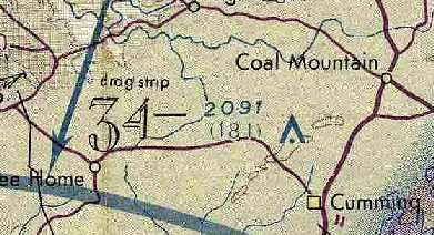
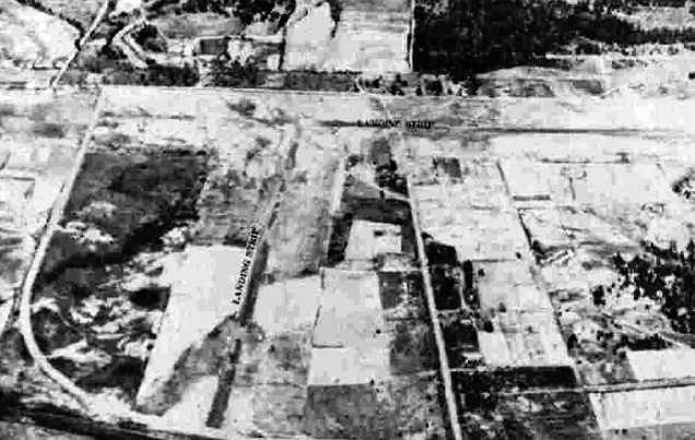
What would later become the Cumming Airfield was still depicted as a "drag strip"
on the October 1975 Atlanta Sectional Chart (courtesy of Chris Kennedy).
Nothing was yet depicted at this location on a 1956 aerial photo.
According to drag racing historian Bret Kepner, the Cumming Airport "is one of those extremely rare examples
of a dragstrip being converted into an airport instead of vice versa. It was built in 1962.
A 1963 aerial photo showed the drag strip still under construction.
According to drag racing historian Bret Kepner, “It opened as Forsyth County Drag Strip; it closed in the late 1960s & was reconfigured into a small airstrip."
Phil Bonner Jr. recalled, "My dad drove funny cars & landed his airplane at Cumming Dragway as Lamar Sexton was also a friend & owner of the dragstrip."
It was labeled "drag strip" on the 1964 USGS topo map.
Neither the drag strip nor an airfield was depicted at this location on the October 1970 Atlanta Sectional Chart (courtesy of Ron Plante).
A 1972 aerial view depicted a single paved east/west drag strip, without runway markings or any other indication of aviation use.
It was labeled "drag strip" on the October 1975 & April 1980 Atlanta Sectional Charts.
A 1982 aerial view depicted a single paved east/west drag strip, without runway markings or any other indication of aviation use.
It was labeled "drag strip" on the September 1986 Atlanta Sectional Charts.
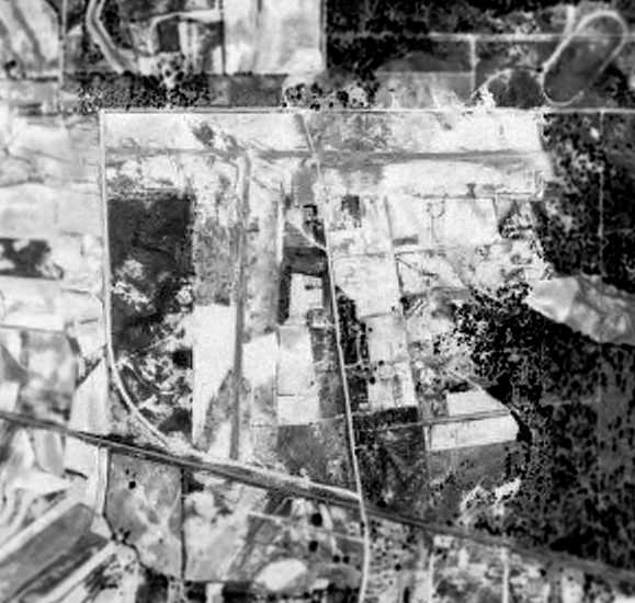
At some point between 1982-92, the former drag strip was apparently reused as Cumming Airfield.
As depicted in a 1992 USGS aerial view looking northwest, the Cumming Airfield consisted of a single 3,200' asphalt Runway 9/27,
which was still painted at the time with runway markings.
The Cumming Airfield apparently closed at some point between 1993-95,
as it was depicted as an abandoned airfield on the March 1995 Atlanta Sectional Chart.
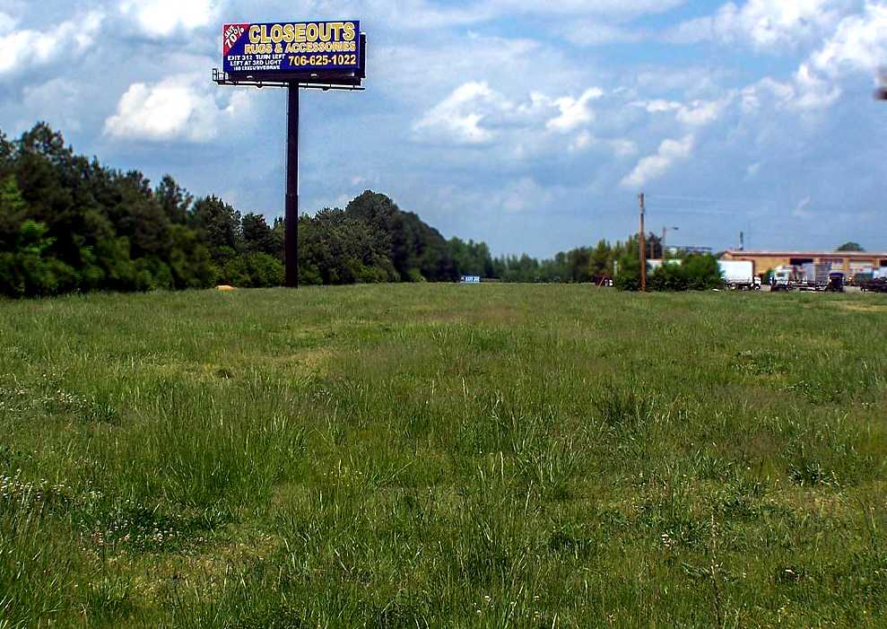
A 1999 USGS aerial view looking Northwest at Cumming Airfield.
Bret Kepner said in 2003, "It remained active until just recently, when one of our group visited the site to find it in the midst of redevelopment as a subdivision."
A 2007 aerial view showed a housing development had erased all traces of the former Cumming Airfield.
Unfortunately small airfields seem to “attract” housing, as a 2015 aerial view looking northwest shows the former Cumming Airfield had been redeveloped as a housing development.
The site of Cumming Airfield is located southwest of the intersection of Hurt Bridge Road & Watson Road.
____________________________________________________
Or if you prefer to contact me directly concerning a contribution (for a mailing address to send a check),
please contact me at: paulandterryfreeman@gmail.com
If you enjoy this web site, please support it with a financial contribution.
____________________________________________________
This site covers airfields in all 50 states.