Abandoned & Little-Known Airfields:
Southwestern Georgia
© 2002, © 2024 by Paul Freeman. Revised 12/21/25.
This site covers airfields in all 50 states: Click here for the site's main menu.
____________________________________________________
Please consider a financial contribution to support the continued growth & operation of this site.
Air Corps Advanced Flying School Albany / Turner Field / Turner AFB / Albany NAS (revised 2/24/24) - Albany Field (revised 2/24/24) - Ayresport Airport (added 1/29/21)
Babcock Aux AAF #5 (revised 10/17/19) - Bainbridge Auxiliary Field #2 / Reynoldsville Field (revised 10/17/19) - Commodore Decatur Aux AAF #6 (revised 12/21/25)
Lake Park Aux AAF #2 (revised 4/26/18) - Moody Aux AAF #3 / Bemiss Field (revised 2/24/24) - Rocky Ford Aux AAF #1 (revised 2/24/24)
Turner Auxiliary Field #2 / West Smithville Field (revised 1/26/25) - Turner Auxiliary Field #3 / West Leesburg Field / Lee County Airport (revised 1/26/25)
Turner Auxiliary Field #6 / North Smithville Field (revised 1/26/25) - Vada Aux AAF #4 (revised 10/17/19) - Vose Field / Rose City Airport / Thomasville Airport (Original) (revised 2/24/24)
____________________________________________________
Ayresport Airport (52GA), Dawson, GA
31.645, -84.318 (Southwest of Atlanta, GA)
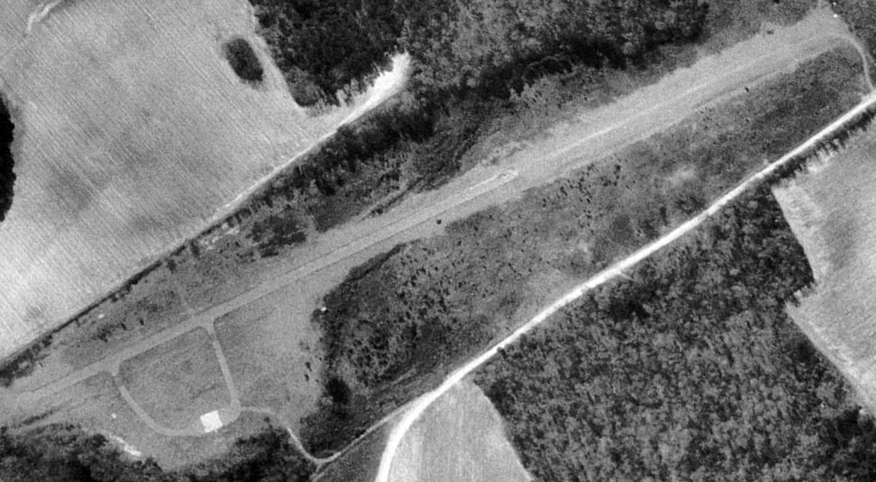
Ayresport Airport, as depicted on a 1993 USGS aerial view looking southeast.
The purpose of this small rural airport has not been determined.
It was presumably operated as a outlying airfield (to support customer flight training?) by the Ayres Aircraft Company,
which operated out of Albany to the southeast.
Ayresport Airport was evidently constructed at some point between 1972-83, as it was not yet depicted on a 1972 aerial photo.
The earliest depiction which has been located of Ayresport Airport was on a 1983 aerial photo.
It depicted a single unpaved northwest/southeast runway, with a clearing on the northeast side, but no other improvements.
Ayresport Airport was not depicted at all on the 1988 USGS topo map (or any other topo maps which have been located).
Ayresport Airport was evidently improved at some point between 1984-93,
as a 1993 aerial photo showed the runway had been paved, and 2 paved taxiways led to a small paved ramp on the northeast side.
But there were still no buildings or aircraft on the field.
Ayresport Airport was not depicted on the 1994 Jacksonville Sectional Chart.
Ayresport Airport was not depicted at all on the 2017 USGS topo map.
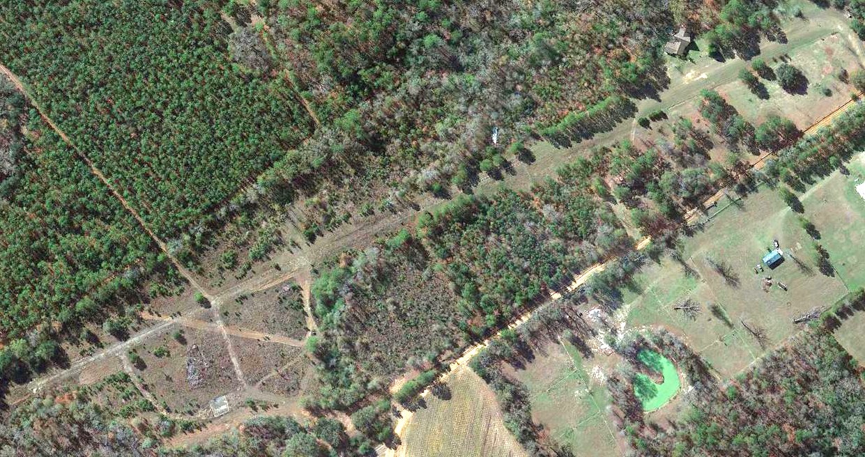
A 2019 aerial view looking southeast at the site of Ayresport showed the paved runway remained intact though deteriorated, along with the taxiways & ramp on the northeast side.
As of 2024, street maps labeled the site as Ayresport Airport.
Ayresport Airport is located at the western terminus of Airstrip Road, appropriately enough.
Thanks to Lee Corbin for pointing out this airfield.
____________________________________________________
31.556, -84.173 (Southwest of Atlanta, GA)
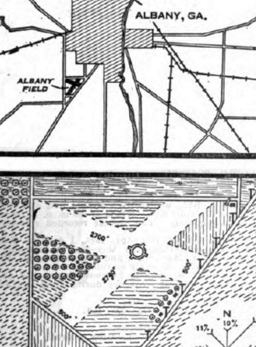
Albany Field, as depicted on a 1929 Commerce Department Airway Bulletin (courtesy of Lee Corbin).
The original airport for the town of Albany was located less than 2 miles southwest of the center of the town.
The date of construction of Albany Field has not been determined.
The earliest depiction which has been located of Albany Field was on a 1929 Commerce Department Airway Bulletin (courtesy of Lee Corbin).
It described Albany Field as a municipal airport owned & operated by the City of Albany.
It consisted of a 150 acre trapezoidal property having 2 loam runways, measuring 2,740' northeast/southwest & 2,700' northwest/southeast.
It was said to not have any hangars or other facilities.
The earliest aeronautical chart depiction which has been located of Albany Field was on the August 1935 Mobile Sectional Chart.
It depicted Albany as a commercial/municipal airport.
The earliest photo which has been located of Albany Field was a 2/20/38 aerial view (from GA Aerial Photographs).
It depicted Albany Field as having 2 unpaved runways, with a few small buildings at the northeast corner.
The last photo which has been located of Albany Field was a 4/27/43 National Archives aerial view looking to the west (courtesy of Brian Rehwinkel).
Brian Rehwinkel observed, “On the northeast portion of the field you can see at least 6 aircraft & a few T-hangars.
I am a little surprised to see this airport operating so close to training field just to the south, but it looks like it is in operation in this picture.
I suppose it is possible this field was used by the Darr Aero Tech Training field as an auxiliary, but this field is not listed as an auxiliary in material I have seen.
You can also see the name 'Albany' in the circle in the middle of the field.”
The last aeronautical chart depiction which has been located of Albany Field was on the January 1944 Mobile Sectional Chart.
Note that it also depicted the larger Albany Army Airfield to the southwest, which would soon replace Albany Field.
Albany Field was evidently replaced by a larger Albany Airport 1.5 miles further southwest at some point between 1944-45,
as only the new airport was depicted on the February 1945 Mobile Sectional Chart.
A September 1947 newspaper article entitled “Cards Buy Camp Site” (courtesy of Lee Corbin)
said “A 69 acre tract of land comprising the old Albany Airport had been sold for $15,000
to the St. Louis National League baseball club for use as a spring training ground.”
The 1956 USGS topo map depicted the site as “Cardinal Field”, and no longer depicted anything related to an airfield.
A 1957 aerial photo depicted baseball diamonds covering the former airfield site.
A 2016 aerial view showed no trace remaining of Albany Field.
The site of Albany Field is located southwest of the intersection of Highway 91 & Lippitt Drive.
Thanks to Lee Corbin for pointing out this airfield.
____________________________________________________
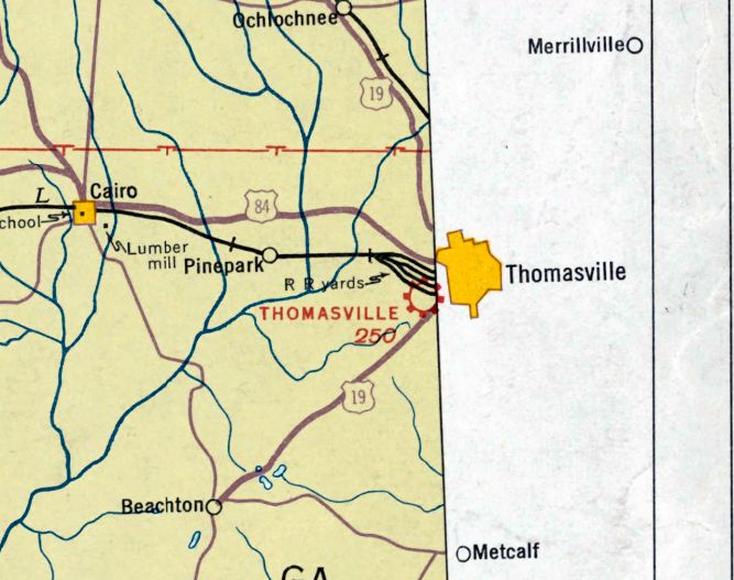
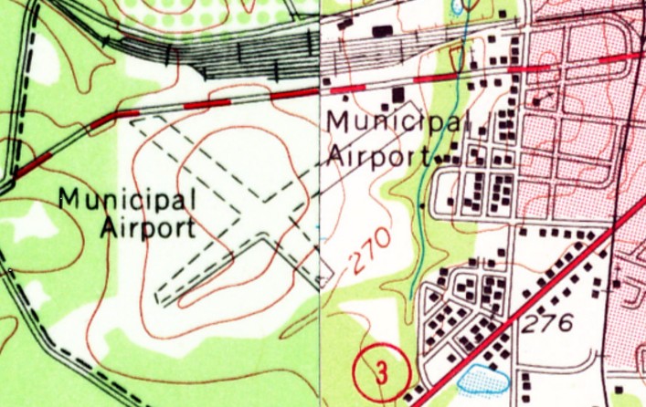
Vose Field / Rose City Airport / Thomasville Airport (Original), Thomasville, GA
30.827, -84.002 (Northeast of Tallahassee, FL)
Thomasville Airport, as depicted on the August 1935 Mobile Sectional Chart.
According to the article “A Place To Land” in the 9/20/14 Thomasville Times-Enterprise by Susanne Reynolds (courtesy of Brian Rehwinkel),
“The first organized airport [in Thomasville] was Vose Field.
Vose Field was an area donated by Greenwood Plantation.
The Jock Whitney family of Greenwood Plantation had a plane they used on trips to & from New York & needed a place to land & depart.
Airplanes also were slowly becoming more prominent.
The location of the airport was southwest of Thomasville, off Campbell Street, near the present-day industrial park.
Later, the airport was named 'Rose City Airport.'”
According to former Thomasville Regional Airport manager Mike Woodham, “Vose Field / Rose City Airport was built in the late 1920s.”
Its hangar on the northeast side, “the one & only hangar / Operations structure on the airport for a number of years dated back to the late 1920s.”
The earliest depiction which has been located of the original Thomasville Airport was on the August 1935 Mobile Sectional Chart.
It depicted Thomasville as a commercial/municipal airport.
The earliest airport directory listing which has been located of the original Thomasville Airport
was in the 1/1/36 Commerce Department Description of Airports & Landing Fields in the United States (according to Brian Rehwinkel).
It described Thomasville Airport as an “almost square” field with 2 sod runways measuring 2,500’ & 2,200’.
The earliest photo which has been located of the original Thomasville Airport / Vose Airport
was a 4/27/43 U.S. Government aerial view looking north (from the National Archives, courtesy of Brian Rehwinkel).
It depicted “Vose Airport” as a square-shaped unpaved airfield, with a large hangar adjacent to the northeast side of the airfield.
The original Thomasville Airport was not depicted on the February 1945 Jacksonville Sectional Chart (courtesy of Ron Plante).
It may have gone through a period of closure during WW2, like many other small civilian airports near the coasts.
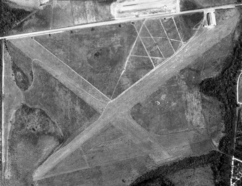
The earliest photo which has been located of Thomasville Airport was a 1952 USGS aerial view (courtesy of David Henderson).
It depicted Thomasville as having 2 runways, with a large hangar on the northeast side.
It was not apparent if the field was still in operation at this point, as there were no aircraft visible on the field.
According to Mike Woodham, Vose Field's “hangar burned in 1954, destroying 6 to 8 airplanes.
Aviation activity was very limited at the airfield until the mid-1950s. By this time, interest was on the increase.
Shortly after the hangar fire, a local fireman named Shelly Mash 'volunteered' to be the new Airport Manager & live at the field.
The City agreed, and in a short time the 'Rose City Airport" became a very active place.”
Brenda Palensky recalled, “My grandfather Shelly Mash was the airport manager.
The little house on the property [was] where I lived with my Mom & grandparents.”
The last aerial view which has been located of the Thomasville Airport was a 1956 aerial view (courtesy of John Clark).
Ir depicted the field as having 2 runways, with a building on the northeast side.
It was not apparent if the field was still in operation at this point, as there were no aircraft visible on the field.
The last map depiction which has been located of Thomasville Airport was on the 1956 USGS topo map.
It depicted the “Municipal Airport” as having 2 unpaved runways, with a few buildings on the northeast side.
According to Mike Woodham, “Although relatively brief, the high-water-mark of activity was in the last few years of the 1950s.
At it's height, 20+ airplanes were based at the Rose City Airport, including 2 corporately-owned Twin Beech 18s.
The Airport was very well maintained for an all-grass facility, and had a reputation as a 'friendly stop-over' for transient airplanes of the day, especially flying to-&-from Florida.”
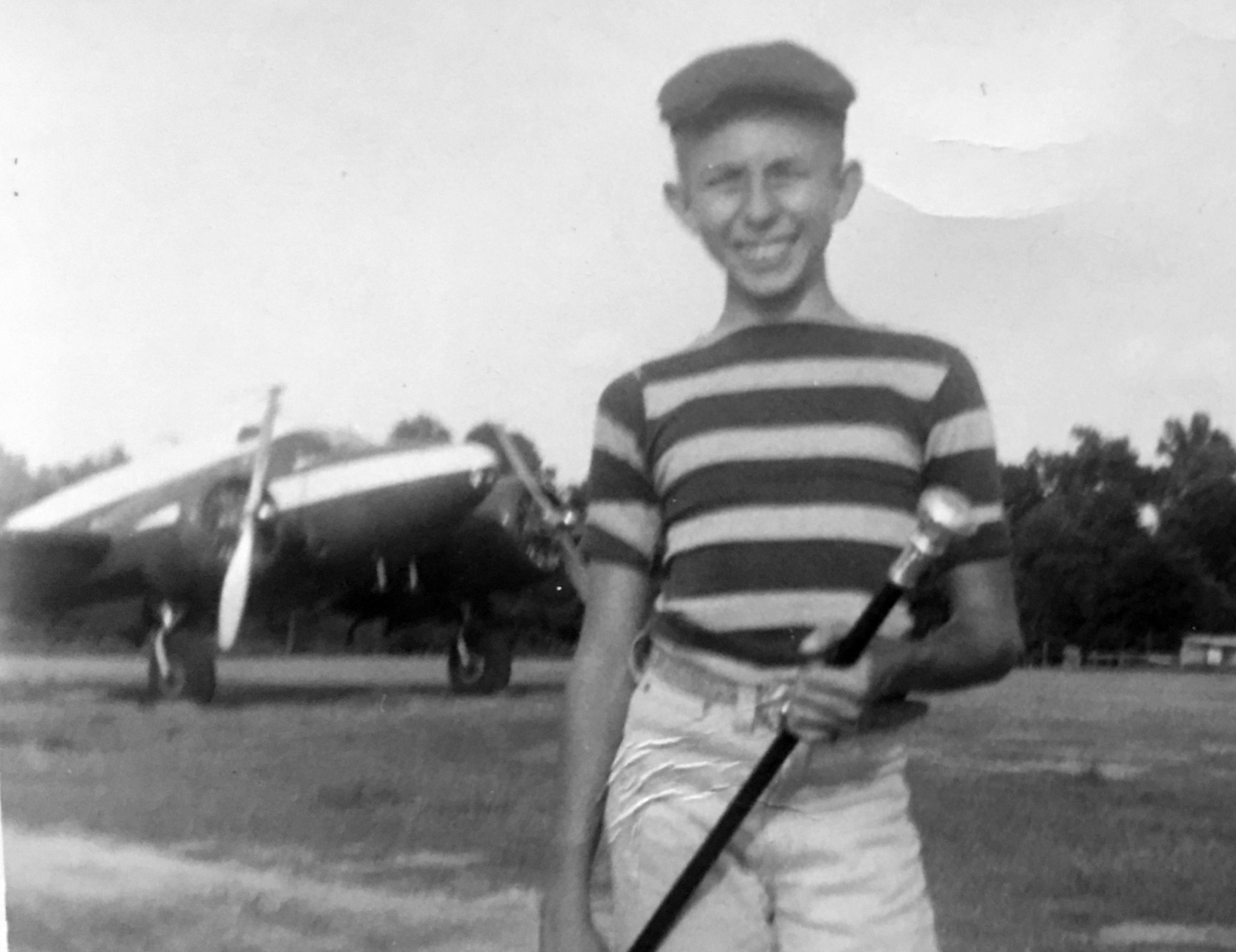
A 1958 photo (courtesy of Mike Woodham) of “A young George Stoner, son of Sunnyland Chief Pilot Ron Stoner”, in front of Beechcraft E18S (N42D) owned by Watkins Motor Lines, at Rose City Airport.
According to the article “A Place To Land” in the 9/20/14 Thomasville Times-Enterprise by Susanne Reynolds (courtesy of Brian Rehwinkel),
the much larger Thomasville Army Airfield (northeast of the town) was closed by the Department of Defense & relinquished for civilian reuse in 1958.
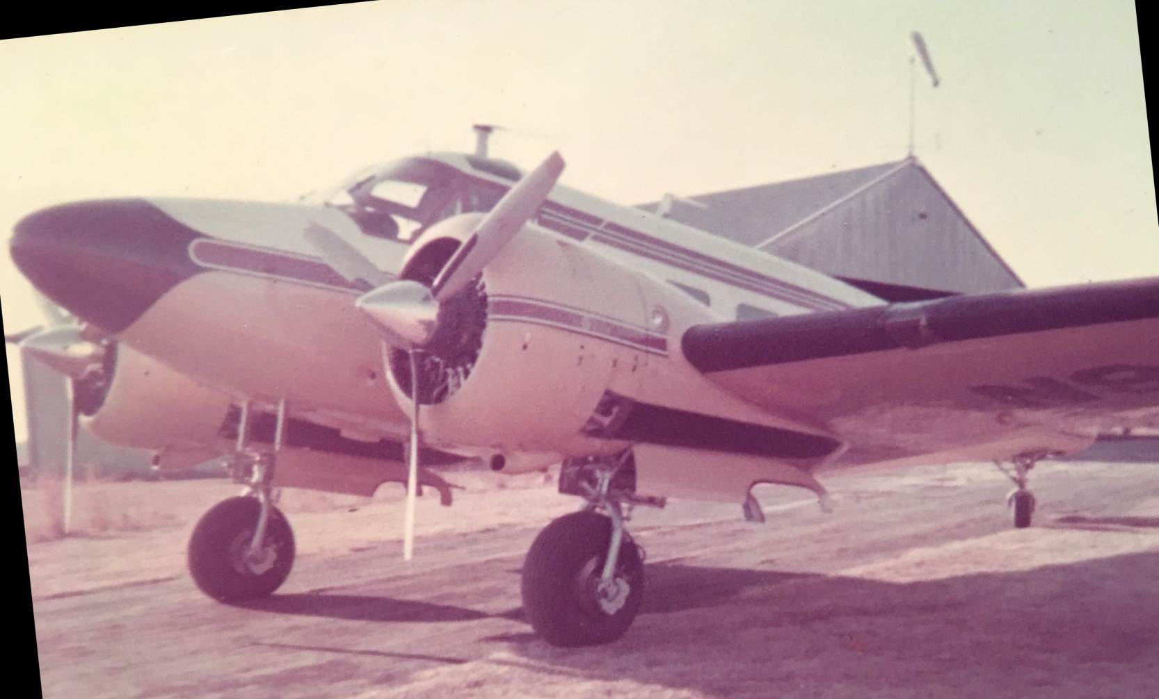
A 1960 photo (courtesy of Mike Woodham) of “1960 Beechcraft Model G18S when it was brand new”, at Rose City Airport.
According to Mike Woodham, the Beechcraft was “originally N9675R, purchased by Sunnyland Packing Company. Chief Pilot was Ronald Stoner.”
According to the article “A Place To Land” in the 9/20/14 Thomasville Times-Enterprise by Susanne Reynolds (courtesy of Brian Rehwinkel),
“The relinquishing allowed Thomasville to begin making plans to move from Rose City Airport on Campbell Street to the former Army Air Base off Pavo Road.
In March 1961, renovations & construction of the new airport were completed. Rose City Airport closed & was considered abandoned.”
According to Mike Woodham, “When the old Army Air Field became available for civilian use, it presented the City with a golden opportunity to have a much nicer & more modern facility.
So, the decision was made, much to the chagrin of some of the local 'Sunday afternoon crowd', to close Rose City & move to the old military facility.
While the 'locals' were sad to see the old grass field closed, the corporate pilots of the day, flying Twin Beeches, Twin Bonanzas, Aero Commanders, even DC-3,
were more than happy to move to the former Army Air Field with it's 5,000' hard-surface runways!”
The last aeronautical chart depiction which has been located of Rose City Airport was on the January 1961 Mobile Sectional Chart.
It depicted Rose City as having a 4,200' unpaved runway.
The last photo which has been located of Rose City Airport was a March 1961 photo (courtesy of Mike Woodham)
of “Sunnyland Packing Company's Twin Beech landing to the southwest on the primary northeast/southwest grass runway for the last time.
The next time it landed in Thomasville would be at the 'new' Municipal Airport northeast of the City.”
According to Mike Woodham, “The metal hangar [seen in the 1960 photo] was dismantled in 1961 when the field closed & moved 8 miles northeast to the former Thomasville Army Air Field,
which was opened as the 'new' Thomasville Municipal Airport in March, 1961.”
The original Thomasville Airport / Rose City Airport was it was no longer depicted on the 1964 Mobile Sectional Chart.
The 1968 Flight Guide (courtesy of Robert Levittan) only listed the new Thomasville Municipal Airport, to the northeast.
By the time of a 1974 USGS aerial photo, industrial buildings had covered the site of the original Thomasville Airport, and not a trace remained of the airfield.
A 1/14/11 aerial photo showed no trace remaining of Thomasville Airport.
The site of Thomasville Airport is located south of the intersection of Campbell Street & Davenport Drive.
Thanks to John Clark for pointing out this airfield.
____________________________________________________
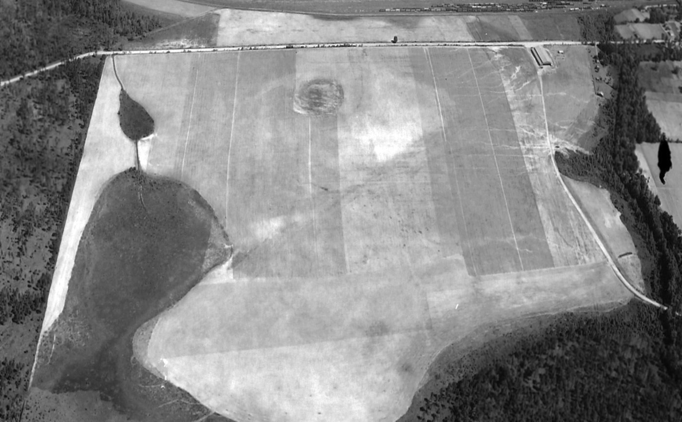
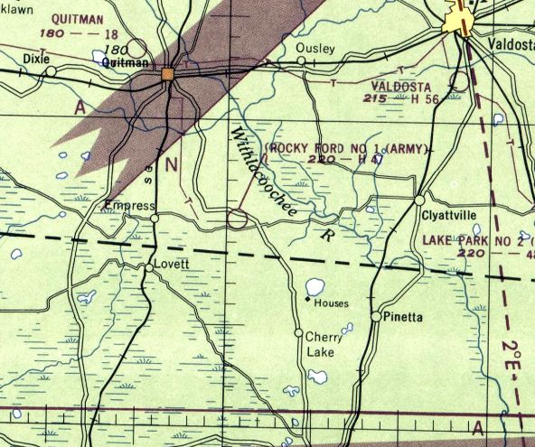
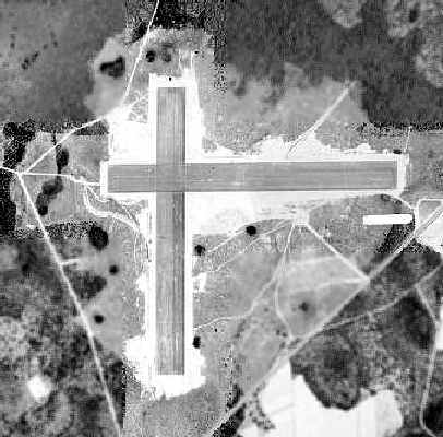
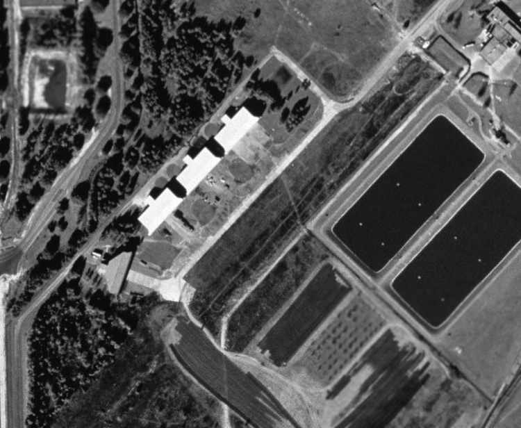
Rocky Ford Auxiliary Army Airfield #1, Nankin, GA
30.67, -83.49 (Northwest of Jacksonville, FL)
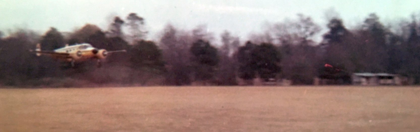
A 4/27/43 aerial view looking west at “Moody Field Auxiliary #1 (Rocky Ford Field)”
from the 1945 AAF Airfield Directory (courtesy of Scott Murdock).
This airfield was established during WW2 as one of four satellite fields for Moody AAF (a few miles northeast),
which was a training base for light bombers, and later acquired an advanced pilot training school.
Rocky Ford Aux #1 was evidently constructed at some point between 1942-43,
as it was not yet depicted on the September 1942 Jacksonville Sectional Chart.
The earliest depiction which has been located of Rocky Ford Field
was a 4/27/43 aerial view looking west from the 1945 AAF Airfield Directory (courtesy of Scott Murdock).
It depicted “Moody Field Auxiliary #1 (Rocky Ford Field)” as having a single east/west runway.
According to Brian Rehwinkel, a circa 1947 War Assets Administration report
stated that the property for the Rocky Ford field consisted of 109 acres acquired at a cost of $5,892.
The field had a single 5,000' east/west runway, constructed of "light bituminous oil binder material".
The airfield improvements apparently consisted of only grading & a very light surfacing of the runway
for the purpose of establishing a "temporary auxiliary landing field."
The earliest aeronautical chart depiction of Rocky Ford which has been located
was on the August 1943 17M Regional Aeronautical Chart (courtesy of Chris Kennedy).
It depicted “Rocky Ford” as an auxiliary airfield.
The April 1944 US Army/Navy Directory of Airfields (courtesy of Ken Mercer)
described "Rocky Ford Army Auxiliary #1" as having a 5,000' hard-surface runway,
and listed the field as being an "Auxiliary to Moody Field."
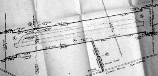
A circa 1945 AAF layout (from the National Archives, courtesy of Ron Plante)
depicted Rocky Ford Auxiliary Airfield as having a single east/west runway with a parallel taxiway.
The 1945 AAF Airfield Directory (courtesy of Scott Murdock) described “Moody Field Auxiliary #1 (Rocky Ford Field)”
as a 109 acre irregularly-shaped property having a single 5,000' oiled east/west runway.
The field was not said to have any hangars, to be owned by private interests, and operated by the Army Air Forces.
The last aeronautical chart depiction which has been located of Rocky Ford Field was on the August 1947 Jacksonville Sectional Chart.
It depicted “Rocky Ford #1 (Army)” Airfield as having a 4,700' paved runway.
According to Brian Rehwinkel, by the time of a circa 1947 War Assets Administration report, the Rocky Ford airfield had already deteriorated considerably.
In fact the report states, "...improvements are in extremely bad condition
and the surfacing has been completely absorbed by natural erosion."
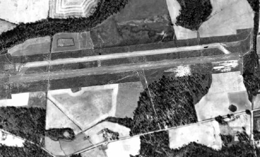
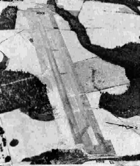
A 1947 USDA aerial photo of Rocky Ford Aux #1,
from the Digital Library Center / University of Florida George A. Smathers Libraries (courtesy of Brian Rehwinkel).
The Rocky Ford airfield consisted of a single paved east/west runway, with a parallel taxiway on the north side.
There did not appear to have been any ramp, buildings, or other aviation facilities at the site.
In the words of Brian Rehwinkel, "Like so many of the other auxiliary fields in rural areas,
once the war ended, these fields had no value as airports & were abandoned.
By the time the photo was taken in 1947, it looks as though the field had been abandoned.
In the photo, there are roads crossing the airfield... and the condition of the field suggests it has not been maintained."
The Rocky Ford airfield was presumably not ever reused as a civilian airport.
It was no longer depicted on the February 1948 Jacksonville Sectional Chart or the 1956 USGS topo map.
A 1999 USGS aerial photo showed the site of Rocky Ford Aux #1 had been reused for agricultural purposes,
and the runway pavement had been removed at some point between 1947-94.
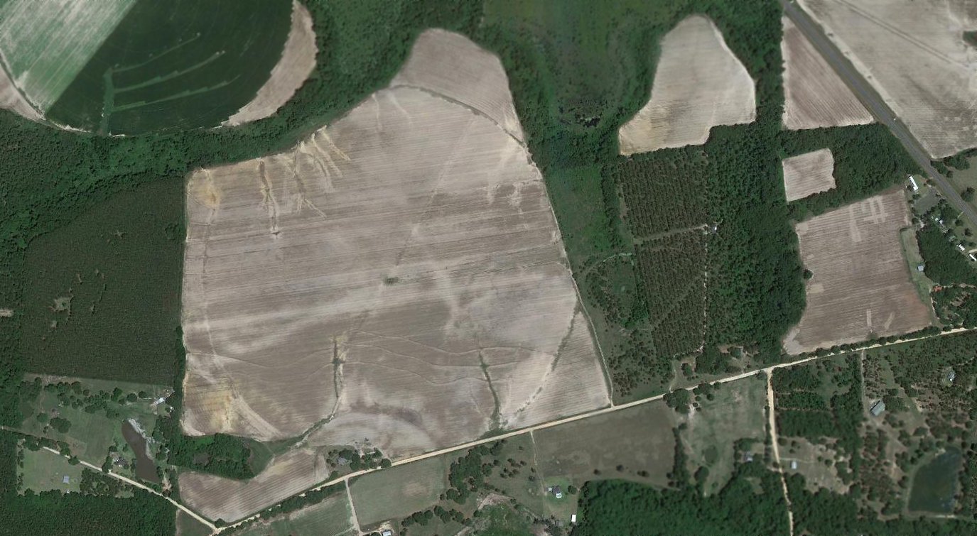
A 2017 aerial view of the site of Rocky Ford Aux #1 showed that amazingly, more than 70 years after this airfield has been abandoned,
the 'ghosted' trace of the outline of the east/west runway & parallel taxiway can still be recognized in the middle of the fields.
The site of Rocky Ford Field is located northeast of the intersection of Route 114 & Wheeler Road.
Thanks to Brian Rehwinkel for locating this former airfield.
____________________________________________________
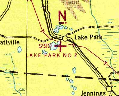
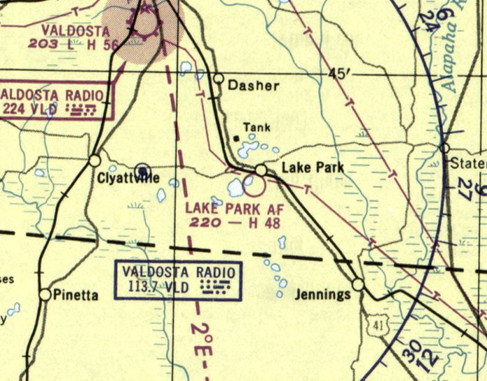
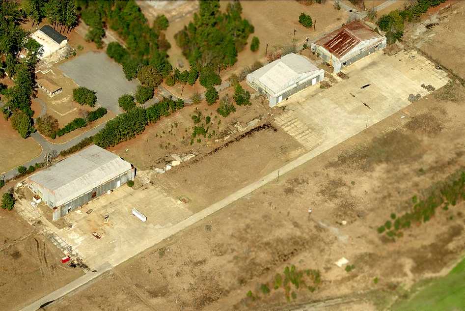
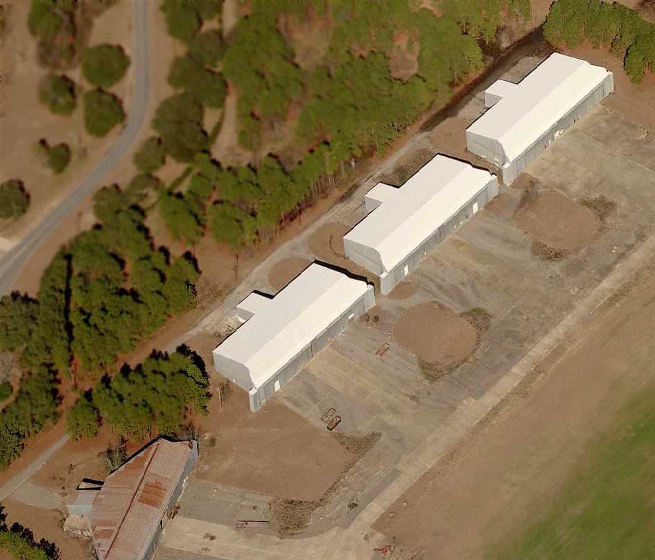
Lake Park Auxiliary Army Airfield #2, Lake Park, GA
30.67, -83.19 (Northwest of Jacksonville, FL)
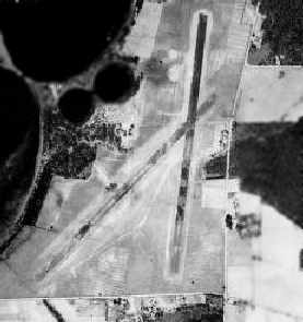
A 4/14/43 USDA aerial photograph of Lake Park Aux #2
(courtesy of GALILEO, University of GA Libraries, Georgia Aerial Photography Collection, via Brian Rehwinkel).
This airfield was used during WW2 as one of 4 satellite fields for Moody AAF (a few miles northwest),
which was a training base for light bombers, and later acquired an advanced pilot training school.
The date of construction of Lake Park Aux #2 is unknown.
It was most likely not a pre-war airport, but was built by the military during WW2,
as no airfield at Lake Park was listed in The Airport Directory Company's 1937 Airports Directory (courtesy of Bob Rambo),
nor was it yet depicted on the September 1942 or January 1944 Jacksonville Sectional Charts.
The earliest depiction which has been located of Lake Park Airfield
was a 4/14/43 USDA aerial photograph (courtesy of GALILEO, University of GA Libraries, Georgia Aerial Photography Collection, via Brian Rehwinkel).
It depicted Lake Park as having 2 runways.
A 4/27/43 aerial view looking west from the 1945 AAF Airfield Directory (courtesy of Scott Murdock)
depicted “Moody Field Auxiliary #2 (Lake Park Field)” as having 2 runways.
The Lake Park airfield was not yet depicted at all on the January 1944 Jacksonville Sectional Chart (according to Chris Kennedy).
The April 1944 US Army/Navy Directory of Airfields (courtesy of Ken Mercer)
described "Lake Park Army Auxiliary #2" as having a 4,500' unpaved runway
(even though the 1943 aerial photo appeared to depict asphalt runways).
The remarks included, "Auxiliary to Moody Field."
The earliest aeronautical chart depiction of Lake Park which has been located
was on the July 1944 Jacksonville Sectional Chart (courtesy of Chris Kennedy).
It depicted "Lake Park #2" as an auxiliary airfield.
"Lake Park #2" was still depicted as an active airfield
on the 1945 Jacksonville Sectional Chart (courtesy of Chris Kennedy).
The 1945 AAF Airfield Directory (courtesy of Scott Murdock) described “Moody Field Auxiliary #2 (Lake Park Field)”
as a 474 acre triangular property having 2 oiled 4,500' runways, oriented north/south & northeast/southwest.
The field was not said to have any hangars, to be owned by private interests, and operated by the Army Air Forces.
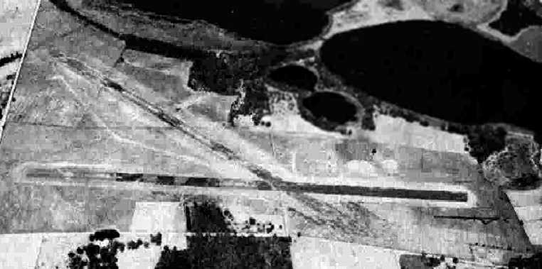
A 1947 USDA aerial photo of Lake Park Aux AAF,
from the Digital Library Center / University of Florida George A. Smathers Libraries (courtesy of Brian Rehwinkel).
The runways at Lake Park were apparently paved at some point between 1944-47,
as the 1947 aerial photo depicted the field as having 2 paved runways,
oriented north/south & northeast/southwest.
The last aeronautical chart depiction which has been located of the Lake Park airfield was on the February 1950 Jacksonville Sectional Chart.
It depicted “Lake Park AF" as having a 4,800' paved runway.
It is not known if the Lake Park airfield was ever reused as a civilian airport.
It was evidently closed at some point between 1950-54,
as it was not depicted on the July 1954 Jacksonville Sectional Chart (according to Chris Kennedy).
The airfield was no longer depicted at all on subsequent aeronautical charts,
or USGS topo maps from 1965, 1971, 1977, or 1981.
Gene Greneker recalled, "It was paved & at one time had a windsock with lights around the windsock.
My girlfriend & I took the windsock frame in 1961 when the sock frame fell down in a wind.
She lived nearby & was instructed to take it back several weeks later.
The Auxiliary field was just east of the cemetery just east of Ocean Pond, a large lake south of the town of Lake Park.
If you know where to look, you can still see one end of the runway.
A trucking company or other industrial company is built on the site now."
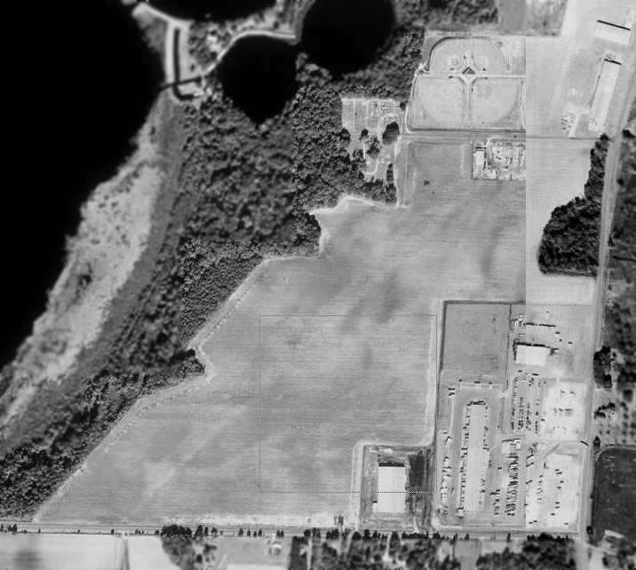
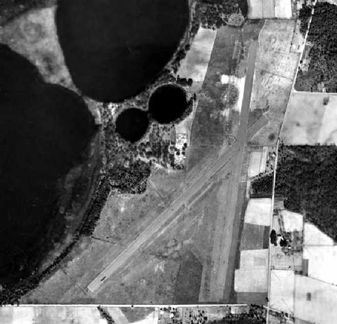
In the 1993 USGS aerial photo, a complex of buildings had covered the southeastern portion of Lake Park Aux AAF,
and ball fields had been built over the northern portion.
However, the ghosted outline of the northeast/southwest runway was still barely perceptible.
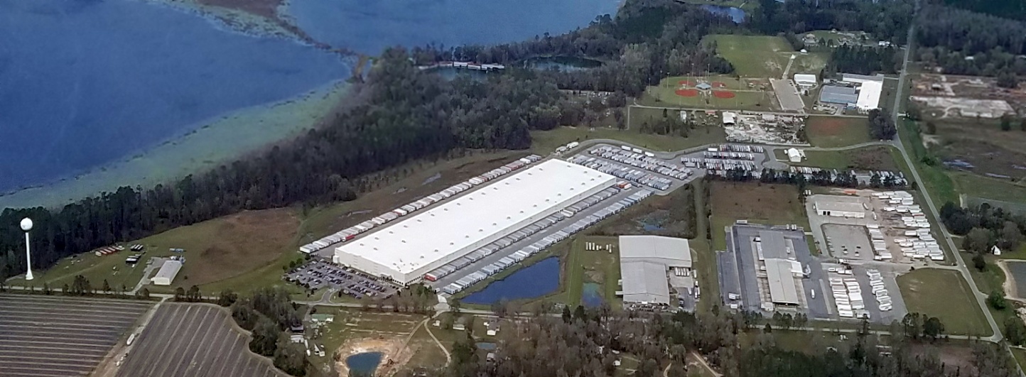
A 3/2/17 aerial view by Alex Melia looking north showed a large warehouse had been built at some point between 1993-2017, erasing the last traces of Lake Park Aux AAF.
The site of the Lake Park airfield is located northwest of the intersection of Lake Park Road & Patterson Road.
____________________________________________________
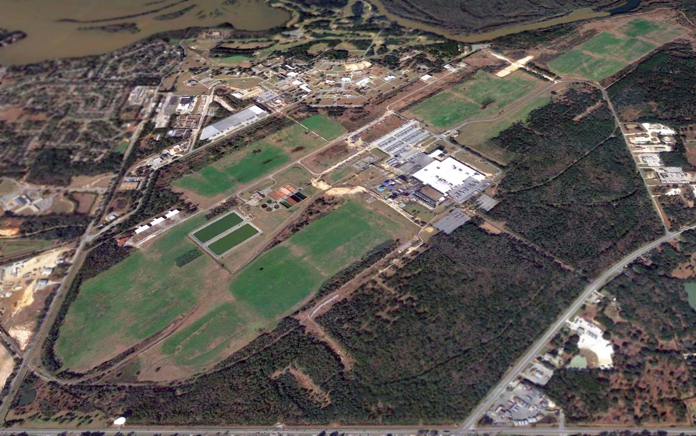
Moody Auxiliary Army Airfield #3 / Bemiss Field, Bemiss, GA
30.95, -83.15 (West of Savannah)
A 4/14/43 USDA aerial photograph of Bemiss Aux AAF
(courtesy of GALILEO, University of GA Libraries, Georgia Aerial Photography Collection, via Brian Rehwinkel).
This airfield was built during WW2 as one of 4 satellite fields for Moody AAF (located only 2 miles northwest),
which was a training base for light bombers, and later acquired an advanced pilot training school.
The date of construction of the Bemiss Auxiliary Airfield has not been determined.
The earliest depiction of the field which has been located was a 4/14/43 USDA aerial photograph
(courtesy of GALILEO, University of GA Libraries, Georgia Aerial Photography Collection, via Brian Rehwinkel).
It depicted Bemiss as having 2 paved runways, oriented north/south & east/west.
There did not appear to be a ramp or any buildings at the airfield.
A 4/27/43 aerial view looking north from the 1945 AAF Airfield Directory (courtesy of Scott Murdock)
depicted “Moody Field Auxiliary #3 (Bemiss Field)” as having 2 runways.
Bemiss Field was not yet depicted on the January 1944 Jacksonville Sectional Chart.
The earliest aeronautical chart depiction which has been located of Bemiss Field was on the July 1944 Jacksonville Sectional Chart.
It depicted "Bemiss #3" as an auxiliary airfield.
The 1945 AAF Airfield Directory (courtesy of Scott Murdock) described “Moody Field Auxiliary #3 (Bemiss Field)”
as a 112 acre square-shaped property having 2 oiled 5,000' runways, oriented north/south & east/west (although the north/south runway was noted to be closed).
The field was not said to have any hangars, to be owned by the U.S. Government, and operated by the Army Air Forces.
A June 1946 Department of Commerce Airman's Guide (according to Chris Kennedy)
described “Bemiss Field #3 (Valdosta)” as “Closed. Not used as flying field”, as of 11/13/45.
However, Bemiss may have been reopened by the military at some point between 1945-49,
as "Bemiss AF" was still depicted as an active military airfield
on the 1949 Jacksonville Sectional Chart (according to Chris Kennedy).
A 1952 aerial view depicted Bemiss' 2 runways in a deteriorated condition.
The last aeronautical chart depiction which has been located of Bemiss Field was on the February 1960 Jacksonville Sectional Chart.
It depicted "Bemiss AF” as having 2 perpendicular paved runways, the longest being 5,000'.
Bemiss was apparently abandoned at some point in 1960,
as it was depicted as “Abandoned airport” on the August 1960 Jacksonville Sectional Chart.
Stu Braud recalled, “We used Bemiss Field as a parachute training field while I was at Moody [1973-75)].
They used a pickup truck to tow parasails (really just old parachutes).
I saw a few broken legs while I was an instructor there.
One could still see, from the air, a few hard-to-distinguish remains in the nearby woods
of old trainers that supposedly crashed on 'Bloody Friday' sometime in the 1940s,
when a dozen or so students went down during bad weather at Bemiss & Moody.”
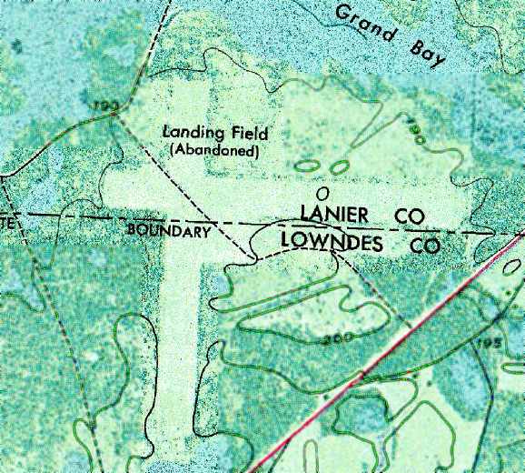
The former Bemis airfield was labeled "Landing Field (Abandoned)" on the 1971 USGS topo map.
The cleared area of Bemiss Field was depicted, but unlabeled, on the 1981 USGS topo map,
which also showed the property be within the Grand Bay Wildlife Management Area.
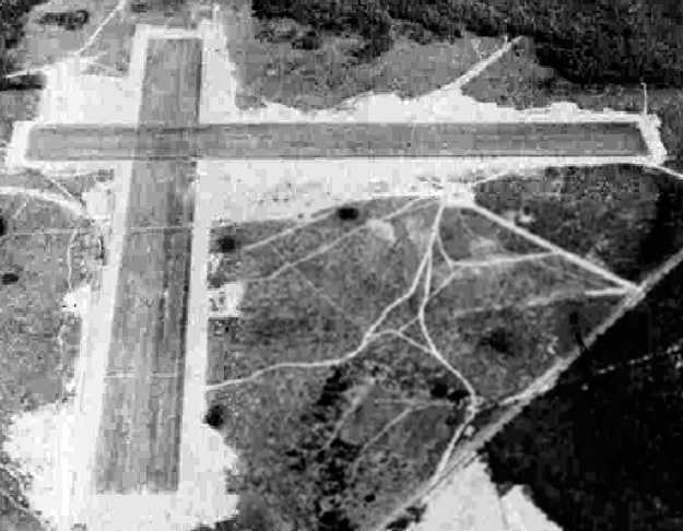
As seen in a 1993 USGS aerial view looking northwest, the remains of Bemiss Field's two 5,000' paved runways still existed in quite good condition.
There did not appear to be any buildings remaining at the site.
A list of proposed construction projects in Georgia contained a year 2001 solicitation to "Construct parasail training area - Bemiss Field, Moody AFB."
Bemiss Field has also been considered for use as a field training area for the 820th Security Forces Group from Moody AFB,
and has been proposed as a drop zone for paratroop operations.
Matthew Smith recalled, “I went through pilot training in 2002 at Moody AFB in the T-6A.
We used the old Bemiss Field for parachute training, just as they had in the 1970s.
The field was still clearly evident during a T-38 ride I took over the area that year.
I'm not sure which base agency was responsible for it, but the north/south runway at least was mown grass & maintained as a clear area.
I was told that in the 1990s when an A-10 squadron had been at the field [Moody AFB]
they had parked old Humvees & other vehicles in cleared areas & used them for target practice;
no evidence that any munitions had ever been dropped there was obvious to me, though.
With A-10s due to return to Moody in the next few years perhaps this field may find use as a target range again.”
USAF HH-60G pilot Capt. Mandy Hutchison of the 41st Rescue Squadron reported in 2007,
“Bemiss IS in fact now a Drop Zone, used by the 820th SFG & the 38th Rescue Squadron PJs.
It is inside the boundaries of R-3008 (Grand Bay Range).
There are a handful of 'hover holes' in & around the field
(one to the southwest, and 2 to the northeast, between Bemiss & Grand Bay) used by my squadron (41 RQS).
One of the hover holes has an old Mohawk fuselage, though I don’t know if it crashed or was placed there.
Combat Survival Training refresher for the base is also conducted in this area.
I don’t think Bemiss was ever inside the actual Range
(as in, no targets down there; all the targets for bombing/strafing/etc are 1 mile north of Bemiss Field),
though it is part of the buffer impact area.”
A 2009 aerial view showed the area of Bemiss Field's 2 grass runways was still being kept cleared.
A 2011 aerial view showed that a new paved runway was being constructed over the site of Bemiss Field's north/south runway,
for what purpose has not been determined.
A 2015 aerial view looking northwest showed Bemiss Field's newly paved north/south runway, along with the outline still recognizable of its grass east/west strip.
____________________________________________________
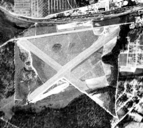
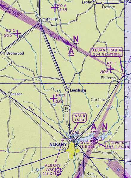
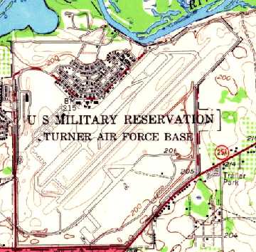
Air Corps Advanced Flying School Albany / Turner Field / Turner AFB / Albany NAS, Albany, GA
31.62, -84.06 (South of Atlanta, GA)
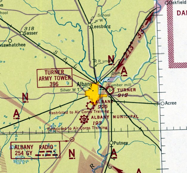
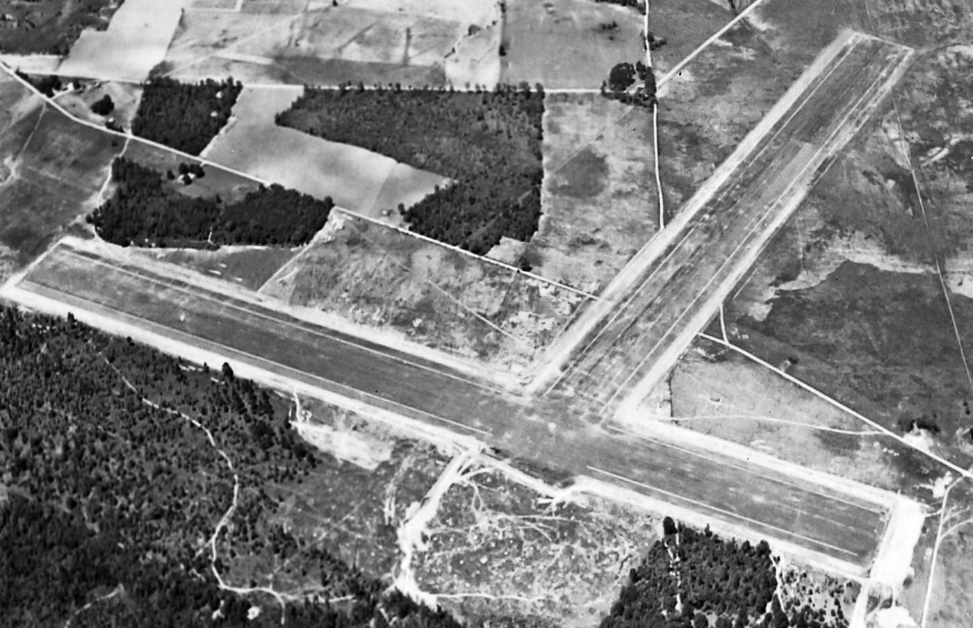
Turner Field, as depicted on the June 1942 Mobile Sectional Chart.
Turner Field is a rare example of a huge military airfield (which eventually morphed into a SAC B-52 bomber base, which are known for their huge runways)
being completely redeveloped into something other than an airfield.
In the summer of 1940, Army Air Corps personnel from Maxwell AAF contacted the Albany Chamber of Commerce
about the possibility of locating a training base at their community with the stipulation that the local government purchase the property.
Anticipating the economic benefit to the area, the local government accepted the proposal.
The Air Corps looked at several sites including the existing Albany Municipal Airport.
The Air Corps finally settled on a site 4 miles northeast of town in Dougherty County.
The Chamber of Commerce raised $95,000 to purchase over 4,700 acres for the main base & 4 auxiliary fields in Lee County.
When the Army indicated it desired an additional 200 acres for the main base, the City purchased the property outright.
All of the land was then leased to the Air Corps for $51/year with a 99-year option (what a deal!).
Construction of the new training airfield got under way on 3/25/41.
The immediate construction involved runways & hangars, with 3 concrete runways, several taxiways & a large parking apron & a control tower.
Buildings were ultimately utilitarian & quickly assembled.
Most base buildings, not meant for long-term use, were constructed of temporary or semi-permanent materials.
Although some hangars had steel frames & the occasional brick or tile brick building could be seen,
most support buildings sat on concrete foundations but were of frame construction clad in little more than plywood & tar paper
The base was initially named Air Corps Advanced Flying School Albany, but was renamed Turner Field on 7/21/41,
in honor of Georgia native Lt. Sullivan Turner, killed the year before as a result of a mid-air collision.
The Army Air Forces Flying Training Command, Southeast Training Center 75th Flying Training Wing
offered elementary & advanced training in twin-engine aircraft at Turner Field during World War II.
Turner was initially operated as a school for navigators.
In July, 1941, fifteen navigator instructors arrived at Turner Field with the rank of Cadet.
Turner Field was activated on 8/12/41, although the base was far from complete.
From July-September, the navigator instructors oversaw the construction of the navigation school while organizing a training syllabus.
When navigation training began in September, the instructors were commissioned as 2nd Lieutenants.
The aircraft used exclusively for navigation training at Turner was the Beech AT-7, a modification of the C-45 Expeditor.
The AT-7 carried 3 navigation students, each with a navigation table & instruments, an instructor, and a pilot.
Navigators received approximately 100 hours of navigation training in the AT-7.
Turner Field was not yet depicted on the October 1941 Mobile Sectional Chart.
Starting in June 1942, Turner was also used to train Royal Air Force aircrews.
The earliest depiction which has been located of Turner Field was on the June 1942 Mobile Sectional Chart.
In September 1942, Turner Field's navigation school moved to Selman Field, Monroe, LA.
At the end of 1942, aircraft complement numbered 33 Curtiss AT-9s, 80 Cessna AT-17s, 9 AT-6 Texans, 7 BT-13 Valiants, and a few miscellaneous types.
In the fall of 1942, one half of the AT-9s were removed & replaced with the Cessna AT-17 "Bobcat”.
The AT-17 was a military version of Cessna T-50 with wooden wings, fabric covered steel tube fuselage, and fixed-pitch propellers.
The AT-17 was described by pilots as having the characteristics of a twin-engine Cub.
Although the AT-17 was one of the safest trainers, some instructors felt it lacked the performance to properly prepare students for the combat aircraft they would eventually fly.
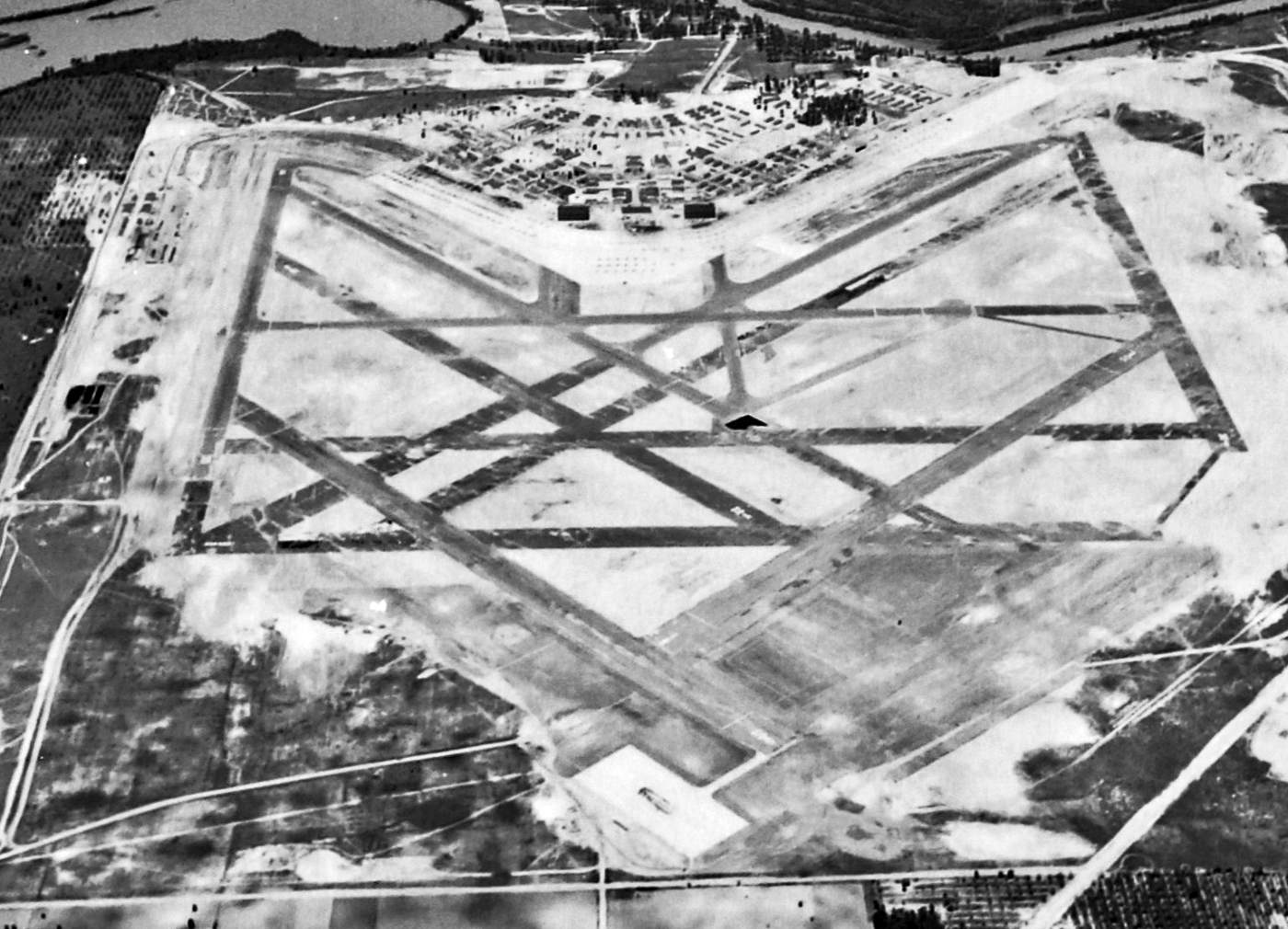
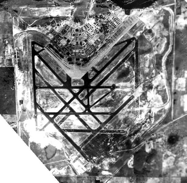
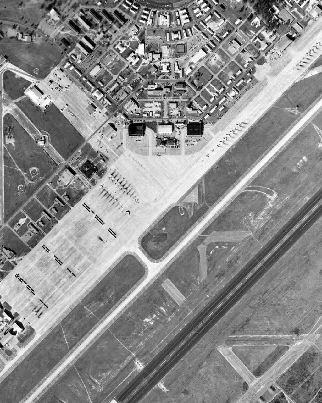
The earliest photo which has been located of Turner Field was a 4/27/43 aerial view looking north (National Archives photo, courtesy of Brian Rehwinkel).
It depicted Turner Field as having an amazing array of no less than 11 runways.
A circa 1944 photo of AT-10 trainers inside a Turner AAF hangar.
Their "T" prefix on the fuselage indicates the aircraft were assigned to Turner Field.
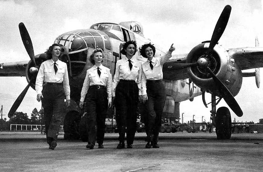
A circa 1944 photo of 4 WASP trainees in front of a TB-25 Mitchell at Turner AAF.
During July 1944, Turner AAF began transitioning to the TB-25 Mitchell medium bomber for the twin-engine training role.
George Albritton recalled, “My father was at Turner Field in the war years & his job was to make the aluminum fuel tanks
that were placed in the bomb bays of the bombers so that they could cross the Atlantic to England.
I went with him a couple of times as a small child, and once we had Christmas (1944) in one of the large hangars.
My grandfather (mother’s father, W. E Drake) owned most of the land across the Cordele highway at the time.
With scrap or excess aluminum, he made all kinds of toys, and household items for my mom. One was a nice airplane for me, and a popcorn popper for my mom.”
In September 1944, Turner received its first class of Free French students (covered in a French-language web site).
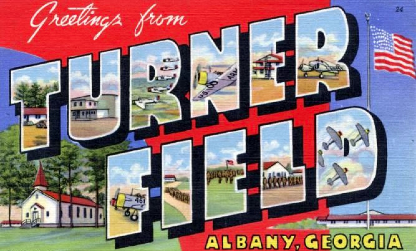
A WW2-era postcard for Turner Field.
In November of 1944, aircraft complement stood at 183 TB-25s, 38 AT-10s, plus a few miscellaneous types.
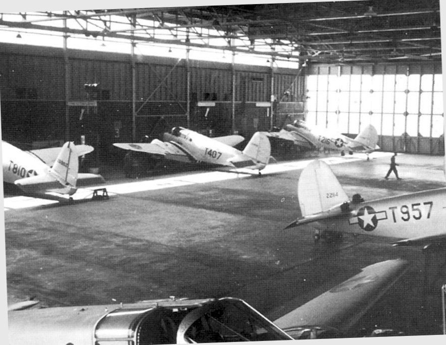
A circa January 1945 aerial view of Turner Field (National Archives photo, courtesy of Brian Rehwinkwel).
It showed an amazing complement of hundreds of aircraft on the field, including some on an overflow pad at the south end (so many aircraft that others were parked on the grass next to the pad).
Brian Rehwinkel observed, “The field is fully developed at this point & you can see all 11 runways.
Ten runways were marked & the runway on the far right - Runway 36A or 36R - is not marked.
At least 4 of the runways were added as 'temporary' runways.
These runways were paved with some type of thin surface treatment, maybe more like oiled runways.”
During WW2, Turner had the following 9 satellite airfields: Leesburg Auxiliary #1 (8.5 miles NE of Leesburg), West Smithville Auxiliary #2 (4.5 miles SW of Smithville),
West Leesburg Auxiliary #3 (2.5 miles SW of Leesburg), Albany Auxiliary #4, Albany, GA, Turner Auxiliary #5, Albany, GA,
North Smithville Auxiliary #6 (3.5 miles NE of Smithville), Cordele Auxiliary #7 (1.5 miles NE of Cordele),
Vidalia-Lyons Auxiliary #8 (3 miles SE of Vidalia), and Tifton Auxiliary #9 (2 miles SE of Tifton).
The February 1945 Mobile Sectional Chart (courtesy of Chris Kennedy) depicted Turner Field along with 4 of its satellite airfields.
The 1945 AAF Airfield Directory (courtesy of Scott Murdock) described Turner Field
as a 1,989 acre irregularly-shaped property having 11 asphalt or oiled runways, the longest being a 7,550' northeast/southwest asphalt runway.
The field was said to have 3 hangars, the largest being 2 metal 200' x 122' structures.
Turner Field was described as being owned by the City of Albany, and operated by the Army Air Forces.
It had the following 5 auxiliary fields still active:
#1 Leesburg Field (13 miles NNE), #2 West Smithville Field (24 miles NW), #3 West Leesburg Field (10 miles NW),
#6 North Smithville Field (24 miles NNW), and #7 Cordele Municipal Airport (34 miles NNE).
Turner Field was inactivated on 8/15/46.
Although inactive, Turner Field was under the control of the 2621st AAF Base Unit from Barksdale Field, LA which acted as a caretaker unit.
The airfield remained under the overall control of Army Air Force Training Command.
Turner Field was reactivated on 4/1/47 & assigned to the Tactical Air Command's 9th Air Force.
A major renovation project was required to upgrade the temporary wooden facilities from its World War II configuration into a permanent Air Force Base,
involving the construction of concrete & brick buildings, along with rebuilding the runway to accommodate jet aircraft.
On 7/1/48, the airfield was renamed Turner Air Force Base, as a result of the United States Air Force becoming a separate uniformed service.
The 31st Fighter Wing was transferred without personnel or equipment to Turner on 9/4/47 from Langley Field, Virginia.
Initially flying North American P-51D Mustangs, the wing trained to achieve tactical proficiency.
A 1948 aerial view of Turner AFB in its original WW2 configuration (courtesy of Ralph Hawes),
showing an amazing total of no less than 11 asphalt runways.
In 1948, after the jet runway was completed at Turner, the 31st Fighter Wing was upgraded to the Republic F-84 Thunderjet.
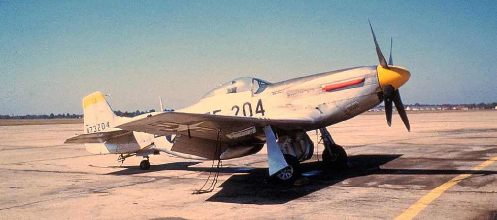
A November 1949 photo of TF-51D 44-73204 at Turner AFB's 31st Fighter Wing.
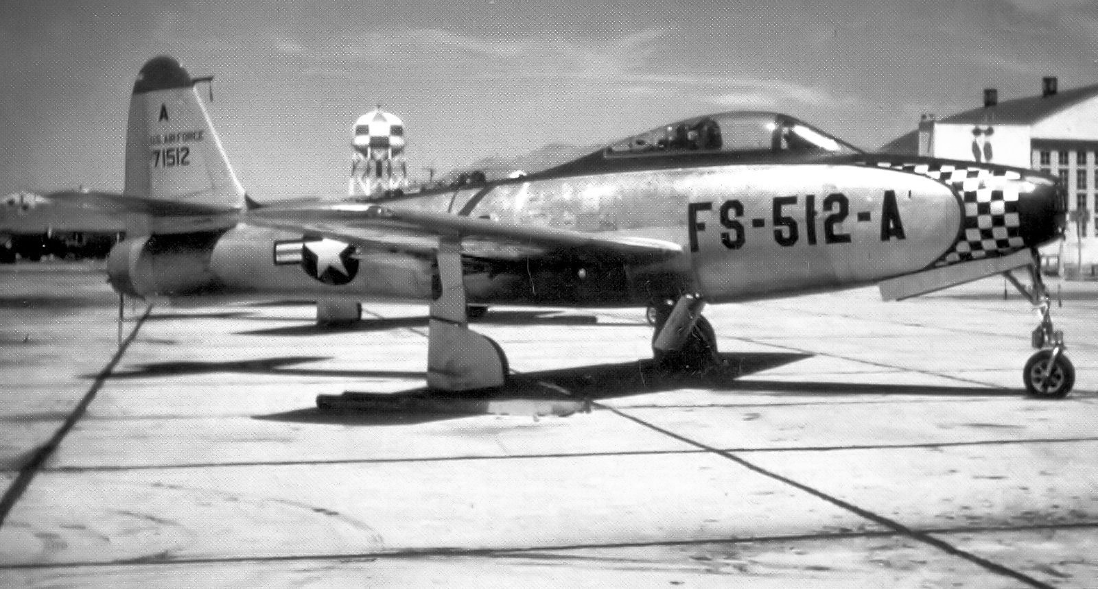
A 1949 photo of a Republic F-84C-11-RE Thunderjet of the 31st Fighter Wing at Turner AFB.
The 31st was redesignated as the 31st Fighter-Bomber Wing on 1/20/50 upon joining Strategic Air Command's 2nd Air Force
and subsequently the 31st Fighter-Escort Wing on 7/16/50,
reflecting the Wing's new mission to escort SAC's intercontinental Boeing B-29 & Boeing B-50 Stratofortress bomber fleet.
Beginning in December 1950 through July 1951, all tactical & most support components deployed to England.
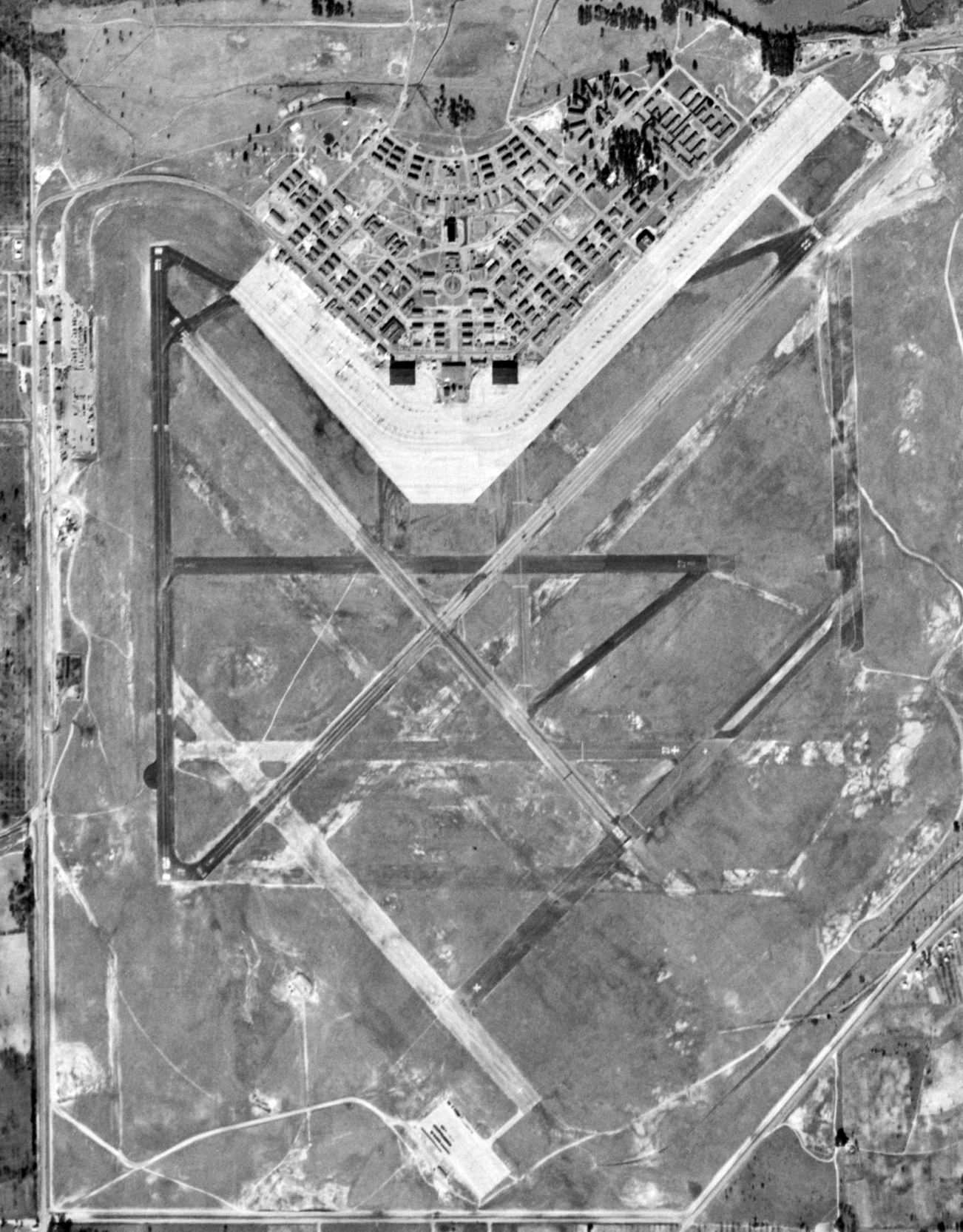
A 1/25/51 USGS aerial view of Turner AFB showed that perhaps only 4 runways were still used by that point.
Brian Rehwinkel pointed out that at least 4 of Turner Field's runways had been constructed as 'temporary' runways.
By 1951, these 4 other runways had deteriorated to the point of barely being visible.
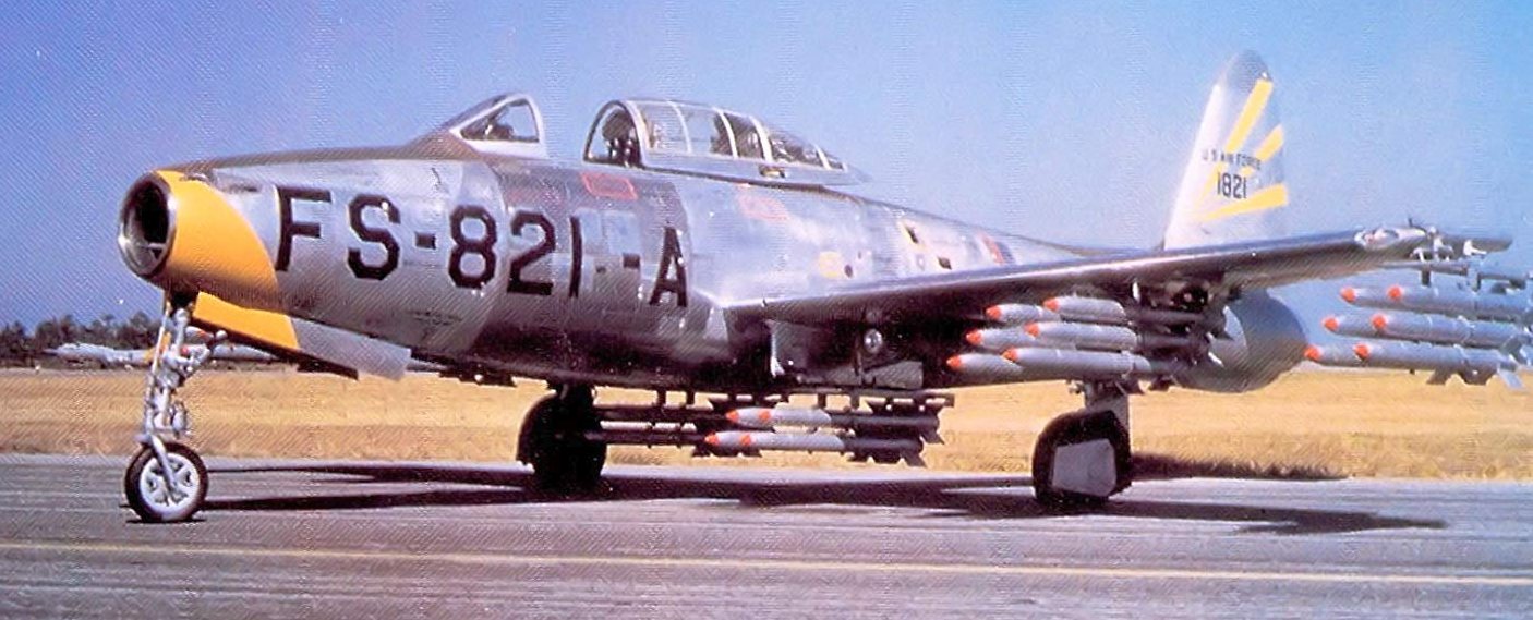
A 1952 photo of a 31st Fighter-Escort Wing Republic F-84G-1-RE Thunderjet 51-821 at Turner AFB, carrying an almost impossibly high-drag load of unguided rockets.
The 31st Fighter-Escort Wing deployed to provide air defense in Japan during the Korean War from July - October 1952 & November 1953 - February 1954.
The 31st FEW earned an Air Force Outstanding Unit Award for making the first massed jet fighter crossing of the Pacific Ocean in July 1952.
The wing was again redesignated as the 31st Strategic Fighter Wing on 1/20/53, as the escort mission within SAC became deemphasized.
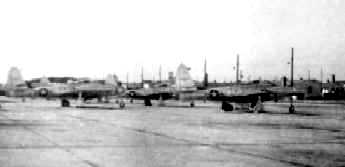
A circa 1954 photo of F-84 Thunderjets on the Turner ramp.
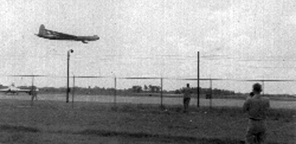
A 1950s photo of a massive Convair B-36 bomber making a low pass over Turner Field.
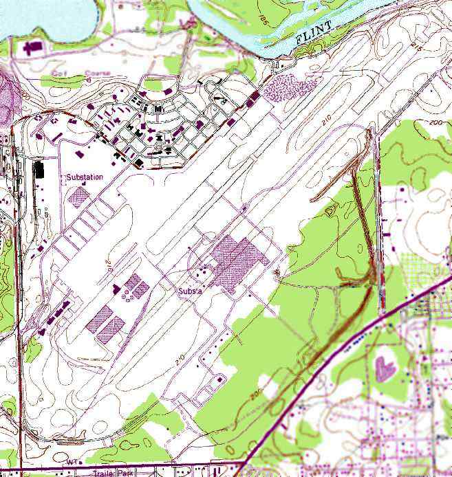
The 1956 USGS topo map depicted Turner AFB in its 2nd major configuration,
after the WW2-era cluster of runways was replaced by a much-longer single runway for jet operations.
On 4/1/57 the 31st was transferred to Tactical Air Command at Turner
and was redesignated as the 31st Fighter-Bomber Wing when re-equipped with the new North American F-100 Super Sabre aircraft.
The wing rotated tactical components to Alaska in 1956 & 1957 & to Europe in 1958 & 1959.
It became non-operational at Turner on 3/15/59 & was transferred to George Air Force Base, California.
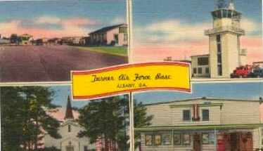
An undated (circa 1950s?) postcard of Turner AFB (courtesy of Rex Ricks).
A major expansion of the base in preparation for the arrival of B-52 bombers
resulted in the airfield at Turner being greatly expanded into a configuration that was typical of a SAC B-52 base:
a single 12,000' runway with a parallel taxiway & a huge ramp area.
Turner became the home of the Strategic Air Command's 4080th Strategic Reconnaissance Wing in 1957
resulting in extensive expansion of the primary runway & other facilities.
One of the most significant aspects of the SAC expansion at Turner was the nearby installation of a ring of U.S. Army Nike Hercules surface-to-air missiles,
which was a customary defensive shield for many B-52 bases.
The Nikes were installed in 2 nearby off-base installations & were armed with nuclear warheads.
Upon transfer of the 4080th SRW to Laughlin AFB, TX in 1957,
SAC established the 4138th Strategic Wing as the primary entity at Turner, operating B-52D Stratofortress bombers & their companion KC-135A Stratotanker tankers.
On 1/1/59 SAC headquartered the 8th Air Force's 822nd Air Division at Turner.
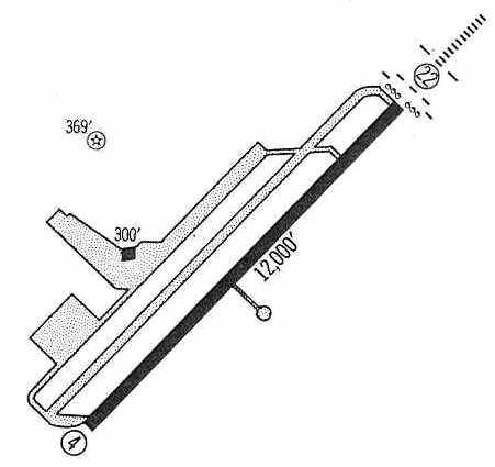
The 1960 Jeppesen Airway Manual (courtesy of Chris Kennedy) depicted Turner as having a single 12,000' paved Runway 4/22,
along with a parallel taxiway leading to a paved massive ramp.
The 3 other (much smaller) runways from the original WW2 airfield layout had apparently been abandoned.
Strangely, only a single hangar was depicted.
A circa 1960s view of a Turner hangar.
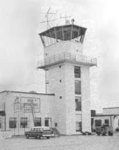
An undated photo of the Turner AFB tower.
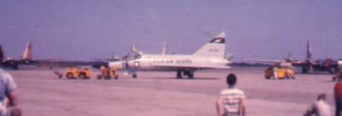
A 1961 photo by Jim Kinter of an F-102A of the FL Air National Guard,
pictured at the Turner AFB Armed Forces Day Airshow.
Tom Hildreth recalled, “The Miltary Air Transport Service operated the 1370th Photo Mapping Wing at Turner AFB for a number of years.
Some of their RB-50 aircraft are visible in the background, they are the 4-prop jobs with fluorescent red noses & rear fuselage stripe.”
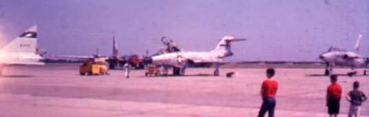
A 1961 photo by Jim Kinter of an F-101B Voodoo at the Turner AFB Armed Forces Day Airshow.
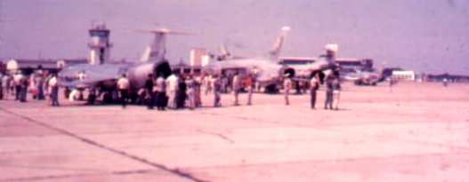
A 1961 photo by Jim Kinter of an F-104 Starfighter, F-105 Thunderchief, and F-101B Voodoo at the Turner AFB Armed Forces Day Airshow.
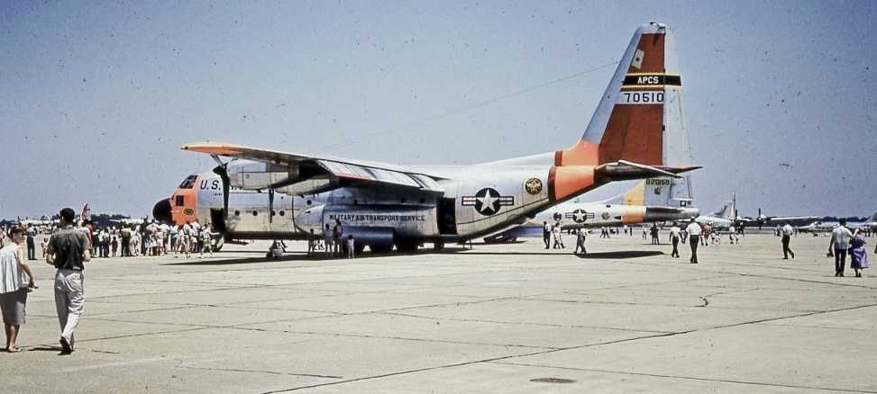
A 1961 photo of a C-130 Hercules at a Turner AFB airshow.
On 2/1/63, the 4138th SW was deactivated & all subordinate squadrons & B-52D & KC-135A aircraft assets
transferred to the newly-established 484th Bombardment Wing (Heavy).
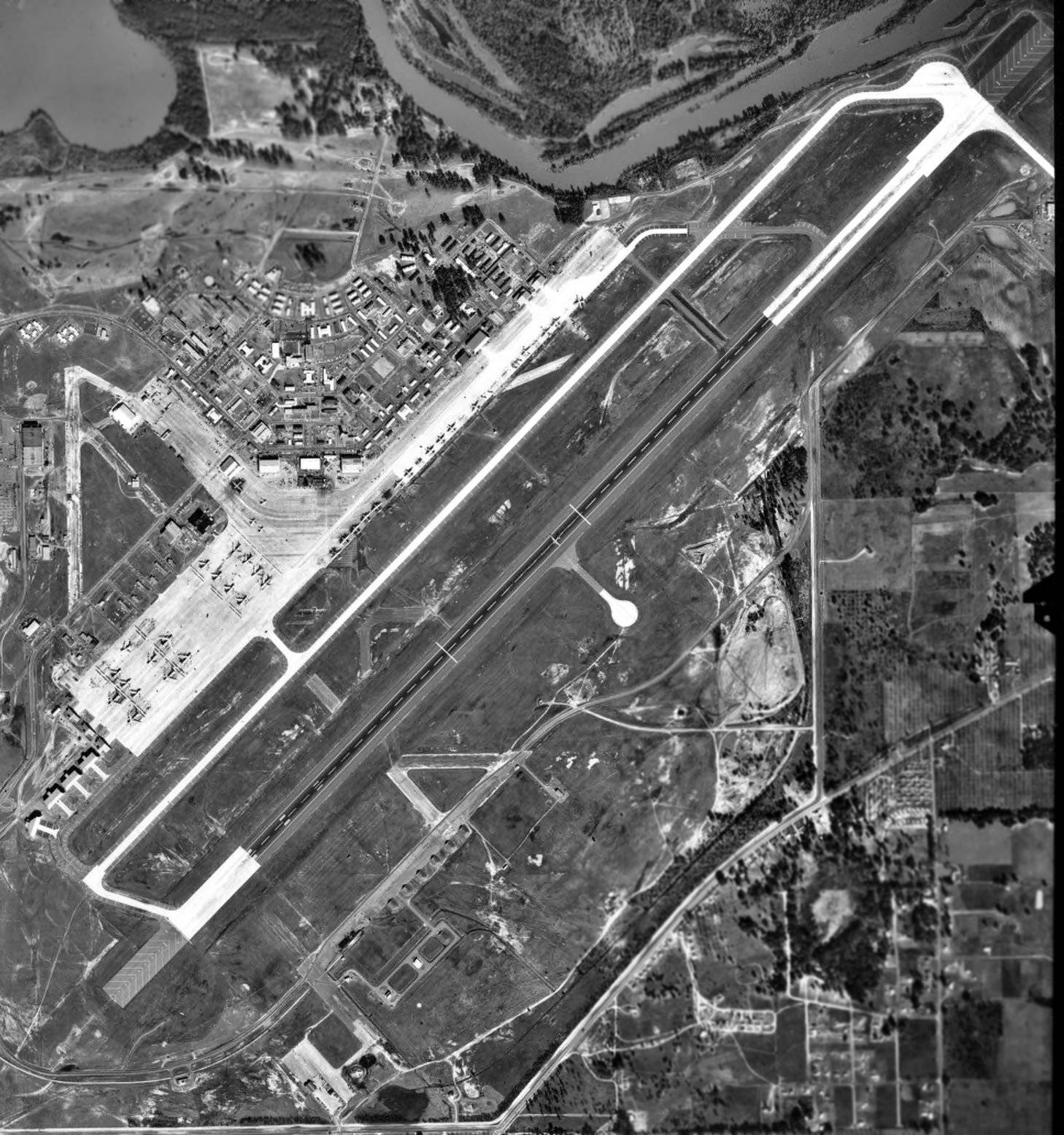
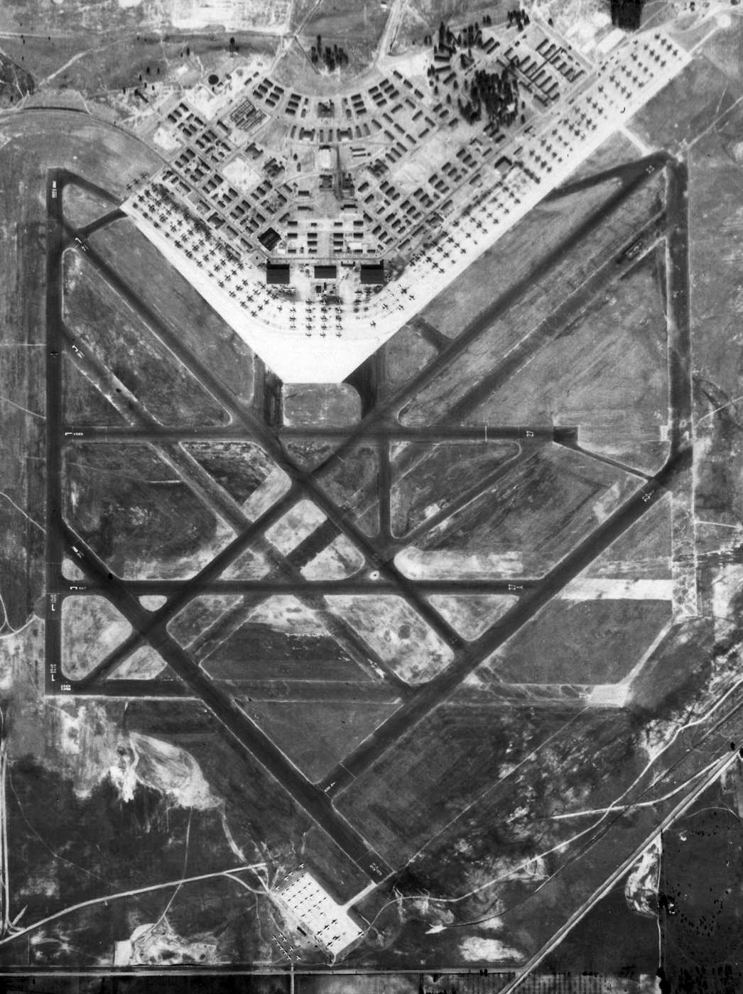
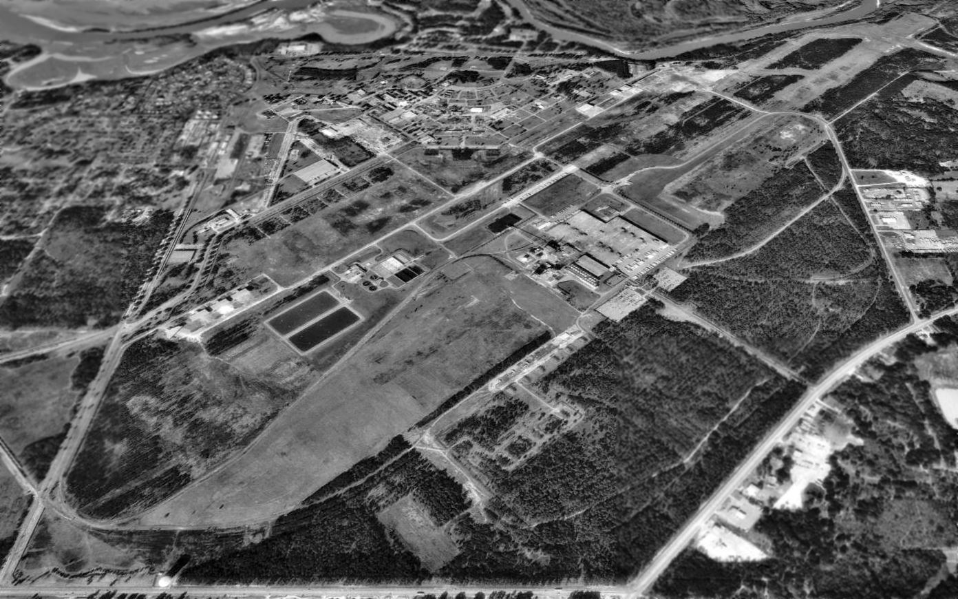
A 1/3/64 USDA aerial photograph of Turner AFB (courtesy of GALILEO, University of GA Libraries, Georgia Aerial Photography Collection)
depicted the massive single runway of the SAC base, along with traces of at least 3 former runways from its WW2 era.
A massive ramp on the northwest side of the field held large numbers of B-52 bombers & other straight-wing transport aircraft.
A smaller ramp also existed on the south side of the field,
but it is not apparent whether this was a WW2-era facility that had been abandoned by this point.
Several large hangars lined the north edge of the main ramp, and 4 nose-dock hangars sat just above the west end of the main runway.
Ralph Hawes recalled, “I lived there from 1960-1967 with my father who was at the Wing headquarters.
I remember seeing the planes sticking out of the hangars. They're the same-styled nose docks one can see at almost every base that had B-52s.”
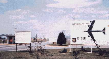
A circa 1960s photo of Turner AFB's gate, showing the “Peace is our Profession” sign with a B-52.
According to Tom Hildreth, Turner's 1370th Photo Mapping Wing's RB-50s “were replaced in 1965 by brand-new Boeing RC-135A aircraft.”
The 484th BW continued to maintain CONUS-based strategic nuclear alert responsibilities at Turner through the 1960s
and deployed to Southeast Asia for most of 1966.
Turner began phasing down in 1966 in preparation for its transfer to the U.S. Navy when the 822nd Air Division was deactivated on 9/2/66.
The 484th BW was deactivated on 3/25/67 & its aircraft assets were redistributed to other SAC units.
Turner AFB was closed by the Air Force in 1967 & was turned over to the Navy.
It then became Albany Naval Air Station,
and housed 10 squadrons of the Navy's Reconnaissance Attack Wing One,
operating the Mach 2 RA-5C Vigilante carrier-based reconnaissance aircraft,
the wing & squadrons relocating during 1967–1968 from the then-closing NAS Sanford, FL.
Additional Navy aircraft based at NAS Albany during this period included the TA-4F/TA-4J Skyhawk II & the TA-3B Skywarrior.
Marine Corps Reserve units also operated CH-53 helicopters.

A 1967 aerial view looking northwest at a beautiful North American RA-5C Vigilante of RVAH-3 in flight over NAS Albany.
The February 1968 Mobile Sectional Chart depicted NAS Albany as having 12,000' paved northeast/southwest runway.
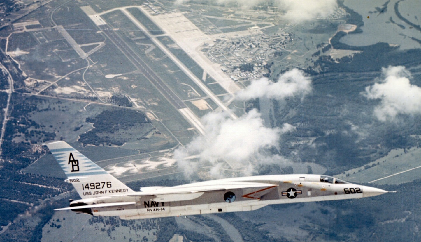
A June 1969 aerial view looking southwest at a beautiful North American RA-5C Vigilante of RVAH-14 in flight over NAS Albany.
The last aeronautical chart depiction which has been located of NAS Albany was on the 1971 Jacksonville Sectional Chart.
It depicted NAS Albany as having 12,000' paved northeast/southwest runway.
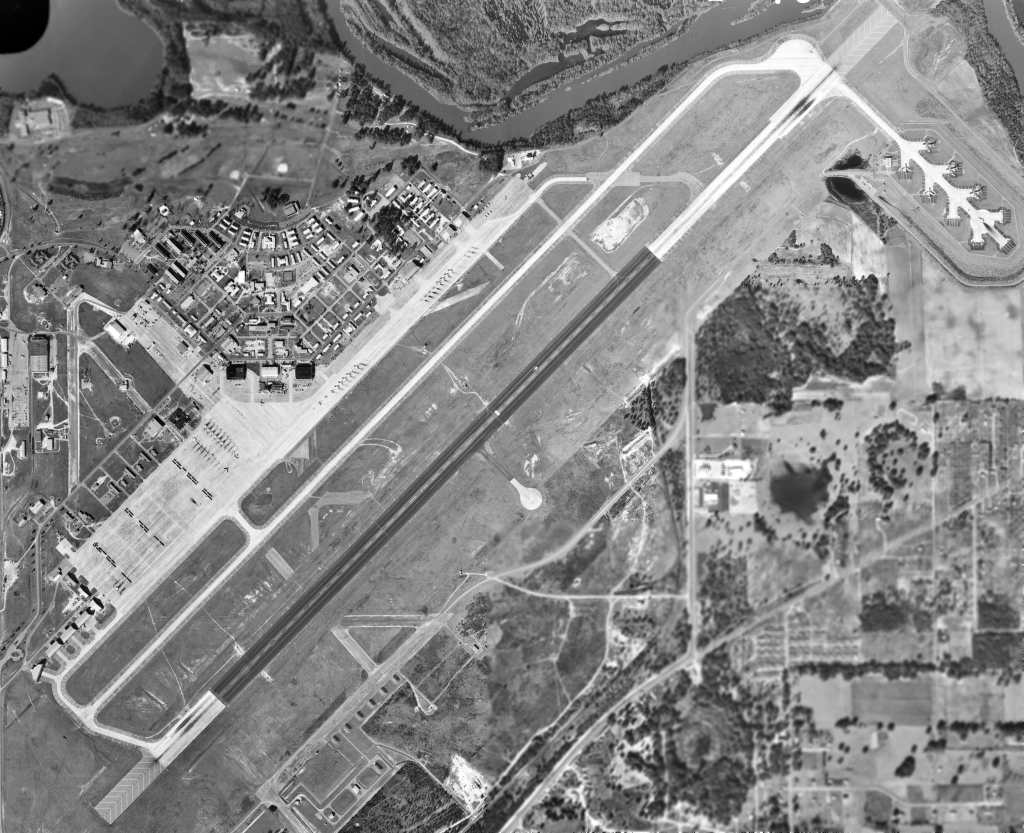
The last photo which has been located of NAS Albany was a 12/29/71 USGS aerial view (courtesy of David Henderson).
It appears that some Air Force use of the base continued after its turnover to the Navy,
as 3 B-52 bombers & 2 KC-135 tankers were parked on the alert “Christmas Tree” off the northeast end of the runway,
in addition to the large number of Navy RA-5 Vigilantes parked on the massive ramp.
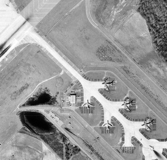
A closeup from the 12/29/71 USGS aerial view (courtesy of David Henderson)
showing as 3 B-52 bombers & 2 KC-135 tankers parked on the alert “Christmas Tree” off the northeast end of the NAS Albany runway.
A closeup from the 12/29/71 USGS aerial view (courtesy of David Henderson)
showing the large number of Navy RA-5 Vigilantes parked on the massive NAS Albany ramp.
Stu Braud recalled, “We used Albany NAF (Turner AAF) as a T-37 emergency alternate field.
My instructor pilot & I landed there once during bad weather over Moody in 1973;
very little support available; fuel had to be trucked over from Moody.
Both T-37's & T-38's used Albany/Turner for GCA's (ground-controlled approaches, the old radar guided approach),
but, rarely touched down (one wing commander did allow touch-&-go's for a while).”
Micheal Maddox recalled, In the “early & mid-1970s from Turner Field... I recall seeing both the Blue Angels & the Thunderbirds there, when the field was in decommissioning but still usable.
For years afterward, the base housing was still used by Marine Corps personnel from the nearby Logistics Base.”
Turner was closed by the Navy in 1976, and its RA-5C Vigilante wing & squadrons transferred to NAS Key West, FL.
At the time of its closure, Turner's airfield consisted of a massive 12,050' runway, taxiways, a large ramp area, and numerous hangars & buildings.
According to a resident of Albany at the time (Douglas Wright), Turner was briefly reused for civil flying,
with the nearby Ayres aircraft manufacturing company using the field to train pilots for their crop-duster aircraft.
But no aeronautical chart depictions or other confirmations have been located of this civil reuse.
Following its closure, the Turner AFB site was actively marketed for economic redevelopment by the local government.
They were rewarded by the selection in 1978 of the Turner AFB site by the Miller Brewing Company,
which built an extensive brewery operation at the location,
almost completely obliterating any trace of the former huge airfield facilities.
This is extensively documented in their impressive web site.
The 1988 USGS topo map still depicted the runway, taxiways, ramps & hangars of the former Turner AFB,
but the new brewery building was also depicted over the center of the former runway.
A 1993 USGS aerial view looking north at the massive site of Turner AFB, following its redevelopment.
The characteristic street layout of an AAF was still visible in the NE corner,
and the shape of the massive former runway was still discernible running from southwest to northeast, with the brewery building right in the center.
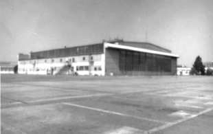
A close-up from the 1993 USGS aerial photo, showing 3 remaining large hangars on the northeast side of the former Turner AFB ramp.
A close-up from the 1993 USGS aerial photo, showing the 4 remaining former B-52 nose-dock hangars on the west side side of the former Turner AFB.
Keith Wood reported in 2005, “A large part of the base still exists.
The brewery took the site from the runways east, but most of the base is still intact,
including a lot of the signage & even guard & utility shacks around the perimeter.
Western concrete ramps are still there, and so is a lot of the leftover hardware.
The original perimeter chain link fence is still up,
and there are still signs warning against photography without permission of the commander!”
Eric Patrick reported in 2006, “Miller Brewing does occupy most of the old site,
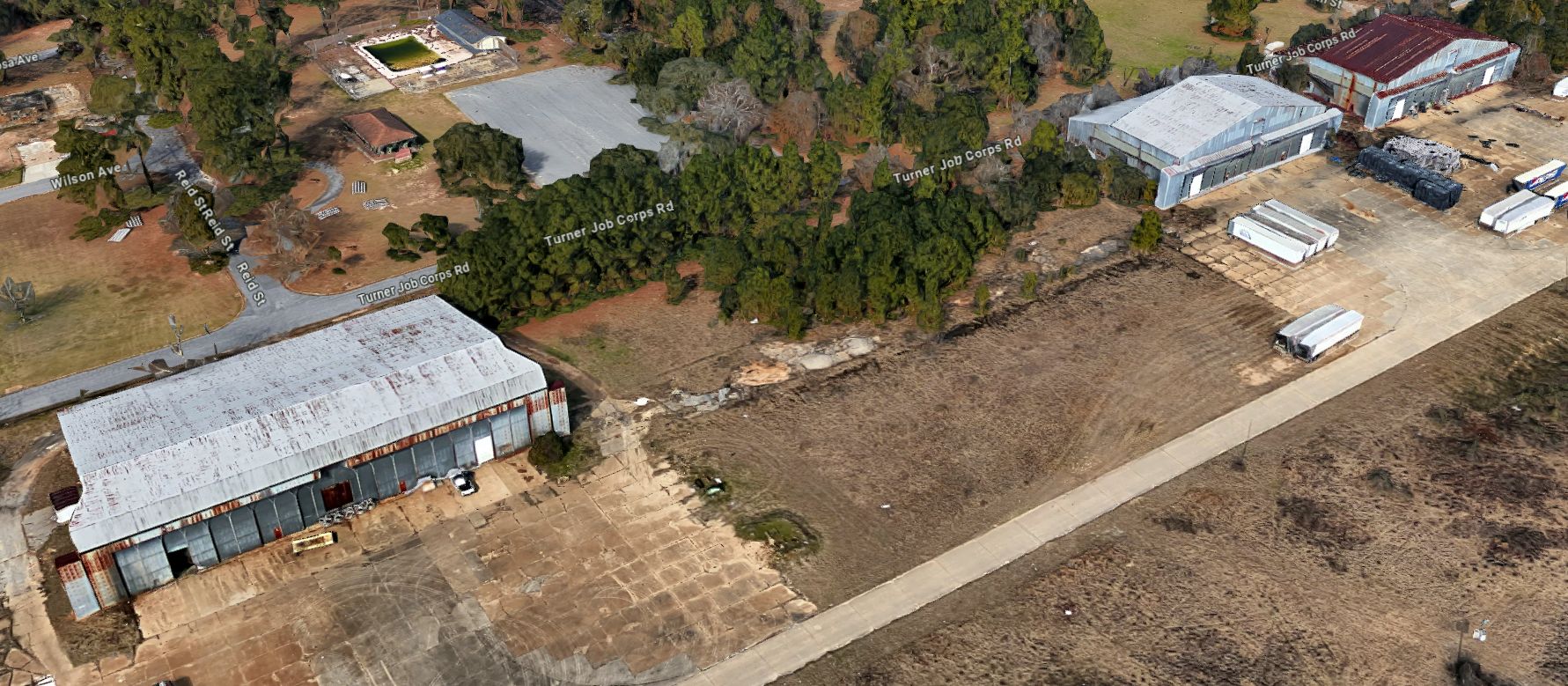
but the northwestern part of the base is occupied by the US Department of Labor with a site called Turner Job Corps.
There are many buildings still in existence today.
Having driven onto that site several times a week, it looks as if this was the residential side of the base when it was active.
The old housing units down the street from Turner Field still are being used by the Marines as 'off base' housing.”
A circa 2007 aerial view looking north at 3 remaining large hangars on the northeast side of the former Turner AFB ramp.
A circa 2007 aerial view looking north at 4 remaining former B-52 nose-dock hangars on the southwest side side of the former Turner AFB.
A 2016 aerial view looking north at the site of Turner AFB, showing 2 remaining sections of runway pavement, 7 hangars, and the base's characteristic street layout on the north side.
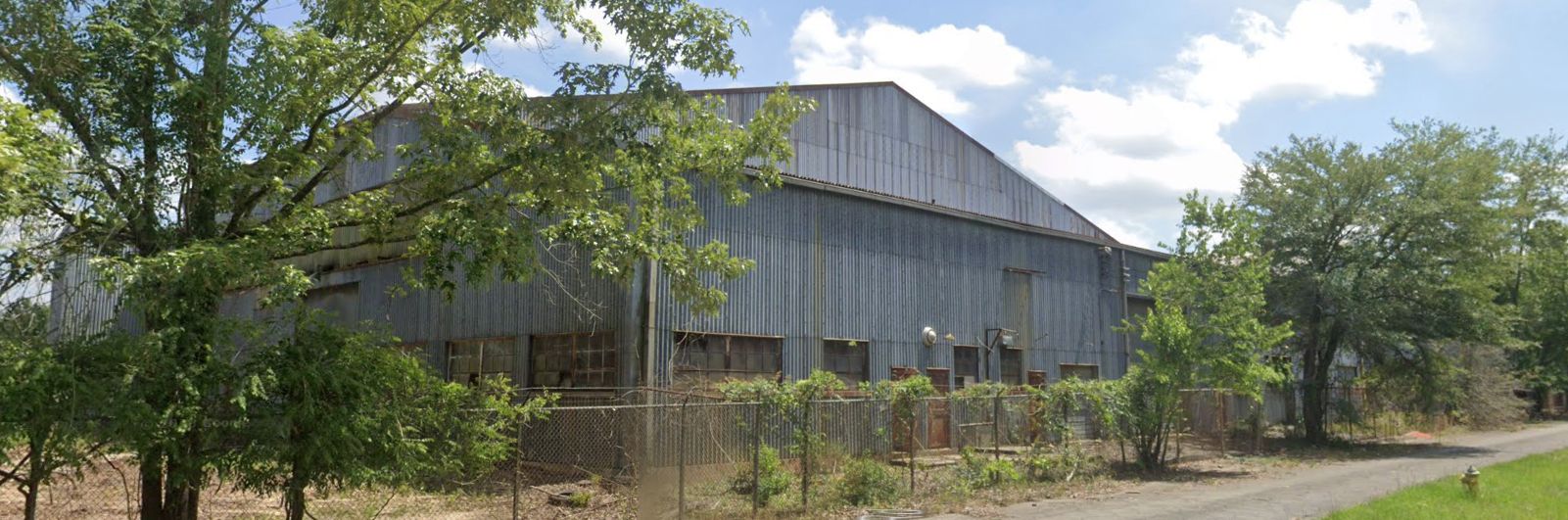
A 2023 photo looking south at the northeastern-most of the 3 remaining large hangars on the northeast side of the former Turner AFB ramp.
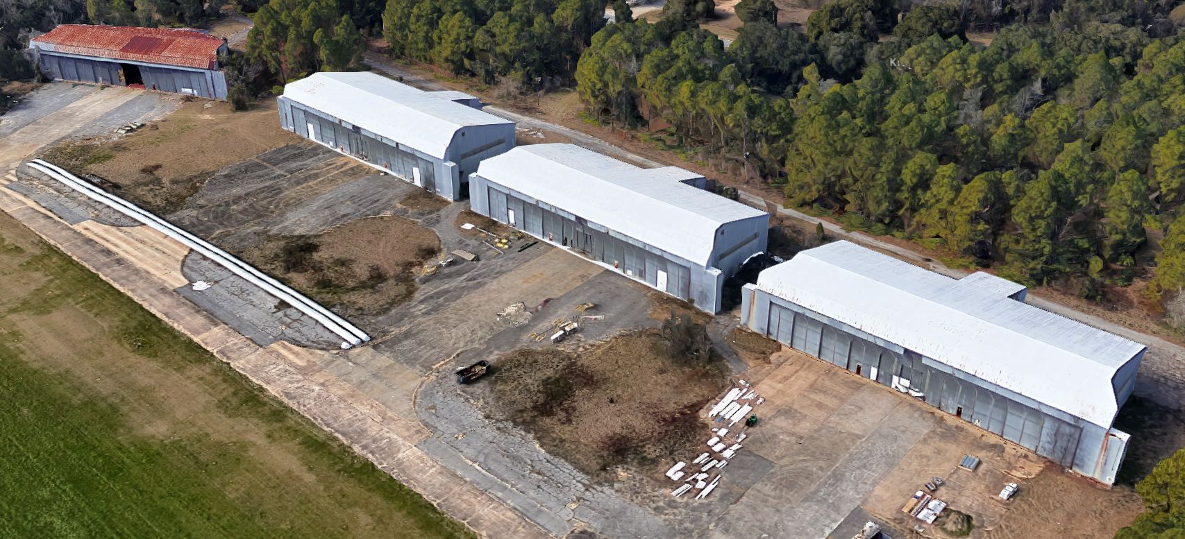
A circa 2024 3-D aerial image looking north at 3 remaining large hangars on the northeast side of the former Turner AFB ramp.
A circa 2007 aerial view looking west at 4 remaining B-52 nose-dock hangars on the southwest side side of the former Turner AFB.
____________________________________________________
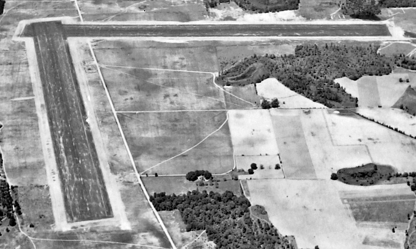
Turner Auxiliary Field #2 / West Smithville Field, Smithville, GA
31.89, -84.33 (South of Atlanta, GA)
A 4/27/43 aerial view looking north at Turner Aux Field #2 (from the National Archives, courtesy of Brian Rehwinkel).
Turner Auxiliary Field #2 was one of 7 satellite airfields used during WW2 by Turner AAF,
which conducted training for navigators, and also offered elementary & advanced training in twin engine craft.
The date of construction of Turner Aux Field #2 has not been determined
but Brian Rehwinkel observed, “As with the several other auxiliary fields, I suspect this field was opened sometime in 1942.”
The earliest depiction which has been located of Turner Aux Field #2 was a 4/27/43 aerial view (from the National Archives, courtesy of Brian Rehwinkel).
It depicted Turner Aux Field #2 as having 2 perpendicular asphalt runways,
with the northeast/southwest runway bisecting a road.
Turner Aux Field #6 was not listed in the 1944 US Army/Navy Directory of Airfields (courtesy of Ken Mercer).
The earliest aeronautical chart depiction which has been located of Turner Aux AAF #2
was on the February 1945 Mobile Sectional Chart (courtesy of Chris Kennedy),
which depicted "#2" as an auxiliary airfield.
The 1945 AAF Airfield Directory (courtesy of Brian Rehwinkel) described “Turner Field Auxiliary #2 (West Smithville Field)”
as a 584 acre irregularly-shaped property having 2 oiled 4,500' runways, oriented north-northeast/south-southwest & west-northwest/east-southeast.
The field was said to not have any hangars, to be owned by the U.S. Government, and to be operated by the Army Air Forces.
West Smithville was apparently relinquished by the military at some point between 1945-49 & reused as a civilian airfield,
as the 1949 Mobile Sectional Chart (courtesy of Chris Kennedy) depicted the field as "West Smithville",
and described the field as having a 4,500' hard-surface runway.
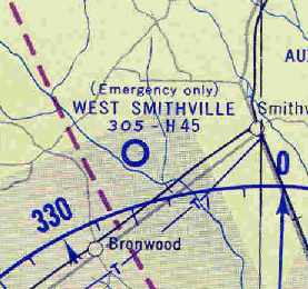
"(Emergency only) West Smithville" was depicted on the August 1954 Mobile Sectional Chart (courtesy of Chris Kennedy).
The Aerodromes table described it as a private field having a single 4,488' asphalt runway, and the remarks said "Owner lives at field."
The West Smithville airfield was not listed at all in the 1962 AOPA Airport Directory,
nor depicted on the 1964 Mobile Sectional Chart (courtesy of John Voss).
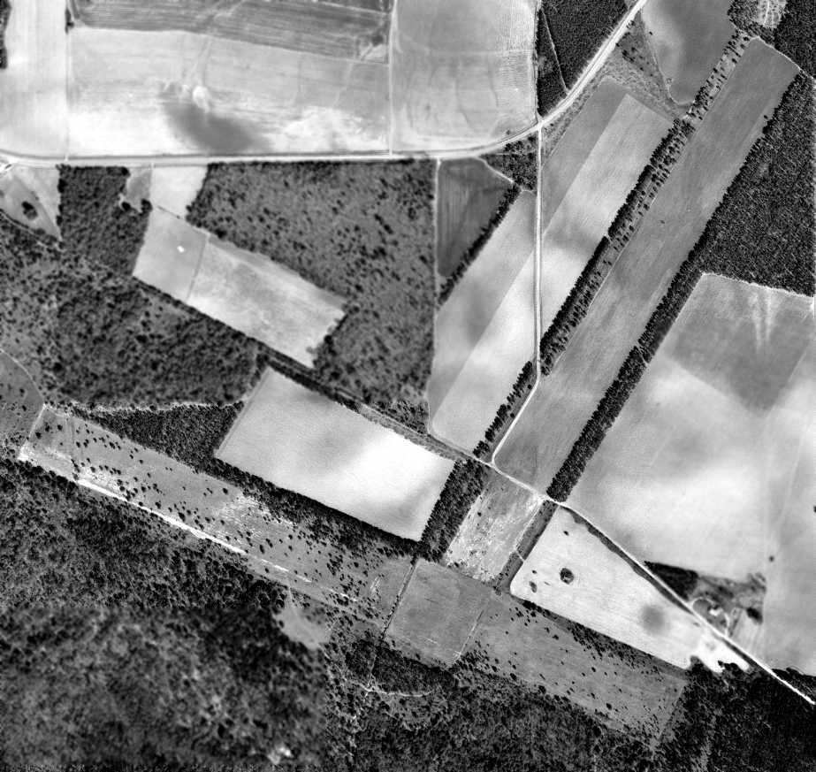
A 3/9/72 aerial photo showed the remains of 2 runways at the West Smithville airfield site.
The 1987 USGS topo map still depicted the outline of 2 runways.

A 2024 aerial view looking north showed the remains of 2 runways at the West Smithville airfield site.
The site of West Smithville Aux #2 is located south of the intersection of Andrews Edwards Road & Airport Road, appropriately enough.
Thanks to Chris Kennedy for locating this airfield.
____________________________________________________
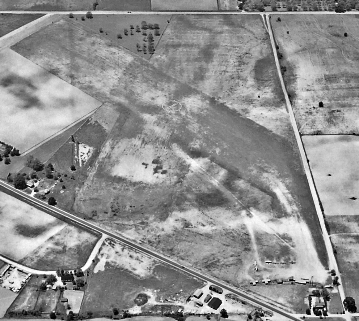
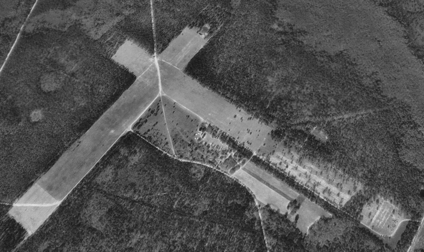
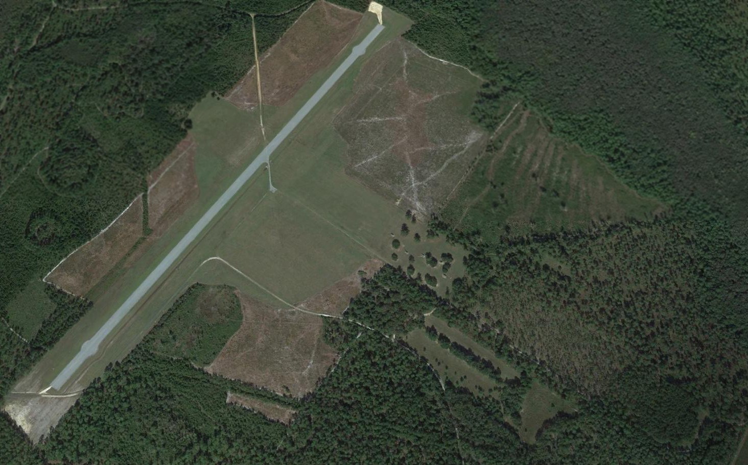
Turner Auxiliary Army Airfield #3 / West Leesburg Field / Lee County Airport, Leesburg, GA
31.72, -84.21 (South of Atlanta, GA)
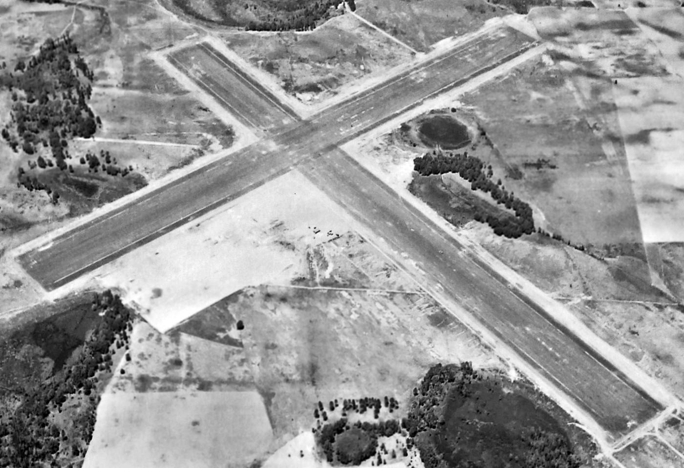
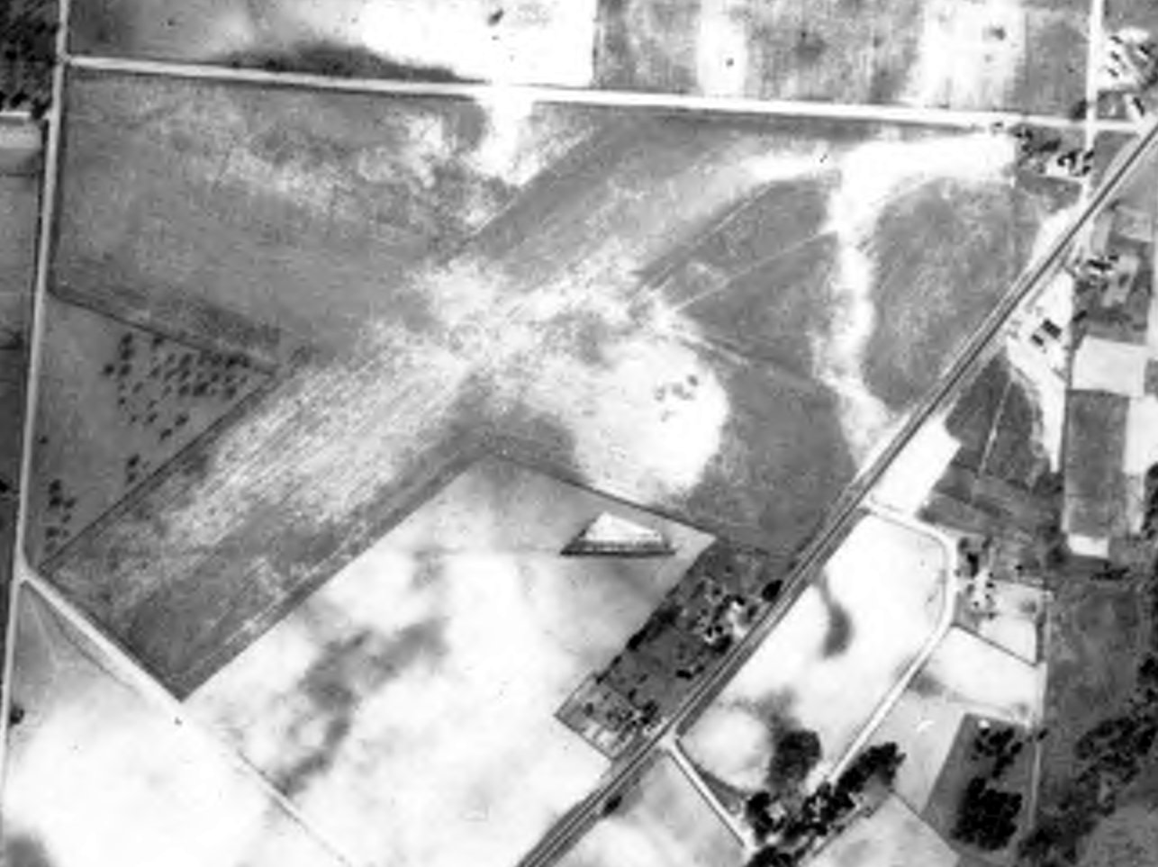
A 4/27/43 aerial view looking north at Turner Aux Field #3 (from the National Archives, courtesy of Brian Rehwinkel).
Turner Auxiliary Field #3 was one of 7 satellite airfields used during WW2 by Turner AAF,
which conducted training for navigators, and also offered elementary & advanced training in twin engine craft.
According to Brian Rehwinkel, “Turner Field was opened in mid-1941, so this auxiliary field was opened sometime after that.
The base history says that Auxiliary # 3 runways were treated with a dust palliative in November 1942.
I don’t know if the runways were there before November 1942 & paved at that time, or if the runways were installed at that time.”
The earliest depiction which has been located of Turner Aux AAF #3
was a 4/27/43 aerial view (from the National Archives, courtesy of Brian Rehwinkel).
Brian Rehwinkel observed, “The field was shaped like a cross.
It appears there was a parking area & a small building just to the southwest of the intersection of the runways.”
Turner Aux #3 was not listed in the 1944 US Army/Navy Directory of Airfields (courtesy of Ken Mercer).
The earliest aeronautical chart depiction which has been located of Turner Aux AAF #3
was on the February 1945 Mobile Sectional Chart (courtesy of Chris Kennedy),
which depicted "#3" as an auxiliary airfield.
The 1945 USAAF Airfield Directory (courtesy of Brian Rehwinkel) described “Turner Field Auxiliary #3 (West Leesburg Field)
as 565 acre irregularly-shaped property having 2 oiled 4,500' runways, oriented northwest/southeast & northwest/southeast.
The field was said to not have any hangars, to be owned by the U.S. Government, and operated by the Army Air Forces.
At some point between 1945-49,
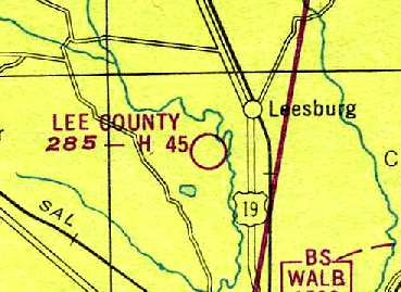
this airfield was relinquished by the military, and was reopened as "Lee County" Airport,
which is how it was depicted on the 1949 Mobile Sectional Chart (courtesy of Chris Kennedy).
It was described as having a 4,500' hard-surface runway.
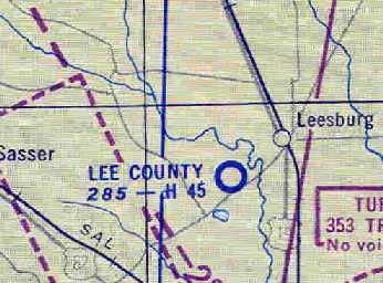
Lee County Airport was still depicted on the August 1954 Mobile Sectional Chart (courtesy of Chris Kennedy).
The Aerodromes table described the field as having 2 runways, with the longest being a 4,500' "Dust palliative" strip (?),
but the remarks said, "Closed, hazardous."
The Lee County Airport no longer depicted on the 1956 USGS topo map,
not listed at all in the 1962 AOPA Airport Directory,
nor depicted on the 1964 Mobile Sectional Chart (courtesy of John Voss) or the 1974 USGS topo map.
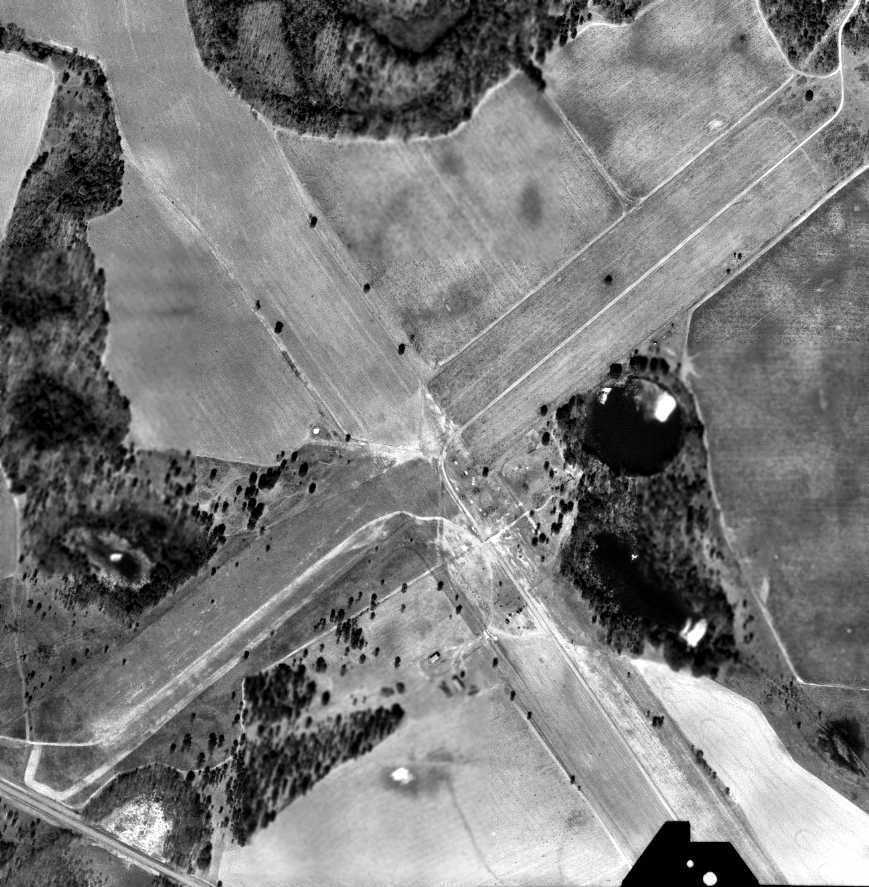
A 3/7/72 aerial view showed the remains of West Leesburg's 2 runways.

A 2024 aerial view looking north still showed the recognizable remains of West Leesburg's 2 runways.
The site of West Leesburg Aux #3 is located southeast of the intersection of Route 32 & James Pond Road.
Thanks to Chris Kennedy for pointing out this airfield.
____________________________________________________
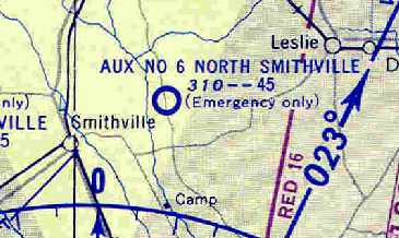
Turner Auxiliary Field #6 / North Smithville Field, Smithville, GA
31.92, -84.19 (South of Atlanta, GA)
A 4/27/43 aerial view looking north at Turner Aux Field #6 (from the National Archives, courtesy of Brian Rehwinkel).
Turner Auxiliary Field #6 was one of 7 satellite airfields used during WW2 by Turner AAF,
which conducted training for navigators, and also offered elementary & advanced training in twin engine craft.
The date of construction of Turner Aux Field #6 has not been determined
but Brian Rehwinkel observed, “As with the several other auxiliary fields, I suspect this field was opened sometime in 1942.”
The earliest depiction which has been located of Turner Aux Field #6 was a 4/27/43 aerial view (from the National Archives, courtesy of Brian Rehwinkel).
It depicted Turner Aux Field #6 as having 2 asphalt runways.
In a very unusual configuration, the east/west runway crossed over Route 377.
Turner Aux Field #6 was not listed in the 1944 US Army/Navy Directory of Airfields (courtesy of Ken Mercer).
The earliest aeronautical chart depiction which has been located of Turner Aux Field #6
was on the February 1945 Mobile Sectional Chart (courtesy of Chris Kennedy),
which depicted "#6" as an auxiliary airfield.
The 1945 AAF Airfield Directory (courtesy of Brian Rehwinkel) described “Turner Field Auxiliary #6 (North Smithville Field)”
as a 613 acre irregularly-shaped property having 2 oiled 4,500' runways, oriented north/south & east/west.
The field was said to not have any hangars, to be owned by the U.S. Government, and to be operated by the Army Air Forces.
The 1949 Mobile Sectional Chart (courtesy of Chris Kennedy) still depicted the field as "North Smithville #6 (Army)",
and described the field as having a 4,500' hard-surface runway.
The North Smithville Airfield was apparently relinquished by the military at some point between 1949-54,
as the August 1954 Mobile Sectional Chart (courtesy of Chris Kennedy)
depicted the field as "Aux #6 North Smithville", although with the note, "Emergency only."
The Aerodromes table described it as a private field, with a single 4,500' "Dust palliative" north/south runway.
The remarks said, "Unattended, no public services, east/west strip closed, Emergency use only."
The North Smithville airfield was no longer depicted at all on the 1956 USGS topo map,
not listed at all in the 1962 AOPA Airport Directory,
nor depicted on the 1964 Mobile Sectional Chart (courtesy of John Voss).
North Smithville's former east/west runway was still depicted on the 1973 USGS topo map, labeled simply as "landing strip".
Nothing at all was depicted at North Smithville on the 1974 USGS topo map.

A 2024 aerial photo showed traces of North Smithville's 2 former runways were still quite recognizable.
The site of North Smithville Aux #6 is located north of the intersection of Route 377 & Airport Road, appropriately enough.
Thanks to Chris Kennedy for locating this airfield.
____________________________________________________
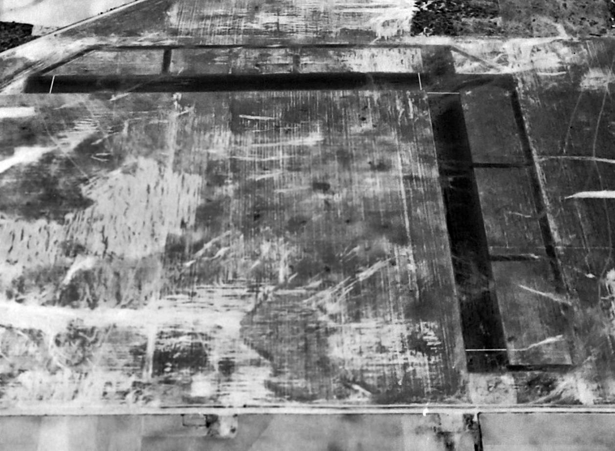
Bainbridge Auxiliary Field #2 / Reynoldsville Field, Reynoldsville, GA
30.84, -84.79 (North of Tallahassee, FL)
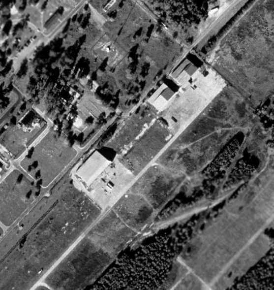
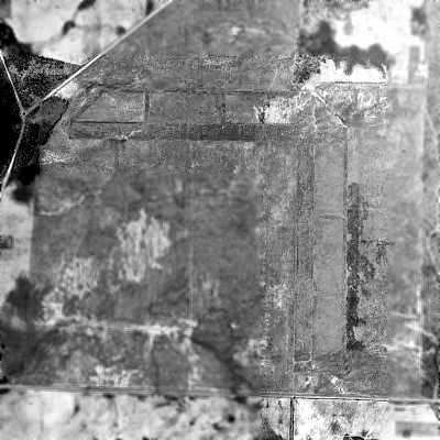
A circa 1943-45 USAAF aerial view looking west at Reynoldsville Aux Field (courtesy of Brian Rehwinkel).
Reynoldsville Auxiliary Army Airfield #2 was one of 6 satellite airfields used during WW2 by Bainbridge AAF,
a training field for the 50,000 Pilot Training Program.
The date of construction of Reynoldsville Aux #2 is unknown.
It was not yet depicted at all on the August 1943 17M Regional Aeronautical Chart (according to Chris Kennedy).
The earliest depiction which has been located of Reynoldsville Aux Field
was a circa 1943-45 USAAF aerial view looking west (courtesy of Brian Rehwinkel).
Brian Rehwinkel observed, “Notice the small rectangular building & clearing in the foreground.
I don’t know what the building was used for (it certainly looks like it is part of the air field), but it looks like a few planes could park in this clearing.
It is interesting that most of the auxiliary fields for Bainbridge AAF had very similar runway patterns, and were placed in agricultural areas that looked very similar.”

The earliest aeronautical chart depiction which has been located of Reynoldsville Aux Field
was on the February 1945 Mobile Sectional Chart (courtesy of Chris Kennedy).
It was simply labeled as Auxiliary Field "#2".
The last aeronautical chart depiction which has been located of Reynoldsville Field was on the February 1947 Mobile Sectional Chart.
It depicted Reynoldsville as an auxiliary airfield.
A 3/13/48 USDA aerial photograph of Reyoldsville Aux #2
(courtesy of GALILEO, University of GA Libraries, Georgia Aerial Photography Collection, via Brian Rehwinkel).
It depicted Reyoldsville as having 2 perpendicular asphalt runways, each of which also had a parallel taxiway.
The field showed no sign of any current usage.
As was the case with many other WW2-era satellite airfields,
Reynoldsville Aux #2 was apparently abandoned immediately after the end of the war & never used again,
as it was not depicted at all on the 1949 Mobile Sectional Chart (courtesy of John Voss).
A 1952 aerial view showed the remains of the Reynoldsville airfield basically in the same condition as seen in 1948.
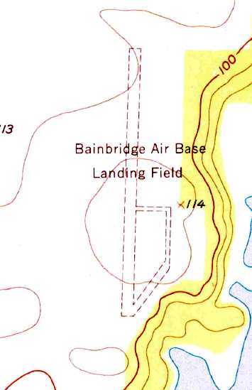
The 1955 USGS topo map depicted “Bainbridge Air Base Landing Field”
as having one unpaved north/south runway, with a taxiway on the southeast side.
The former east/west runway was no longer depicted.
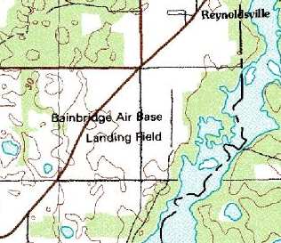
"Bainbridge Air Base Landing Field" was still depicted on the 1976 USGS topo map,
shown as having a single 4,200' north/south runway.
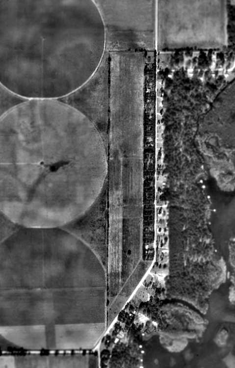
In the above 1993 USGS aerial photo,
the outline of the north/south runway & its parallel taxiway was still plainly apparent,
along with the faint traces of the former east/west runway.
Brian Rehwinkel reported in 2004, "I have visited that site in the past year
and there is nothing on the ground these days to suggest there was ever an airfield there."
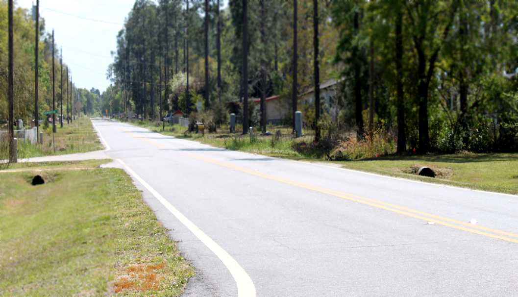
A March 2013 photo by Brian Rehwinkel looking south along the alignment of the Reynoldsville taxiway, now a residential street.
Brian reported, “It was interesting to see how the former taxiway is now a paved road
and – if you look carefully – you can still see where the north/south runway was located.
There are probably 40 or more houses along the road (former taxiway) & I would bet most people have no idea what used to be on that site.”
The site of Reynoldsville Aux Field is located along the west side of Green Acres Road, south of Route 253.
____________________________________________________
Vada Auxiliary Army Airfield #4, Vada, GA
31.088, -84.442 (North of Tallahassee, FL)
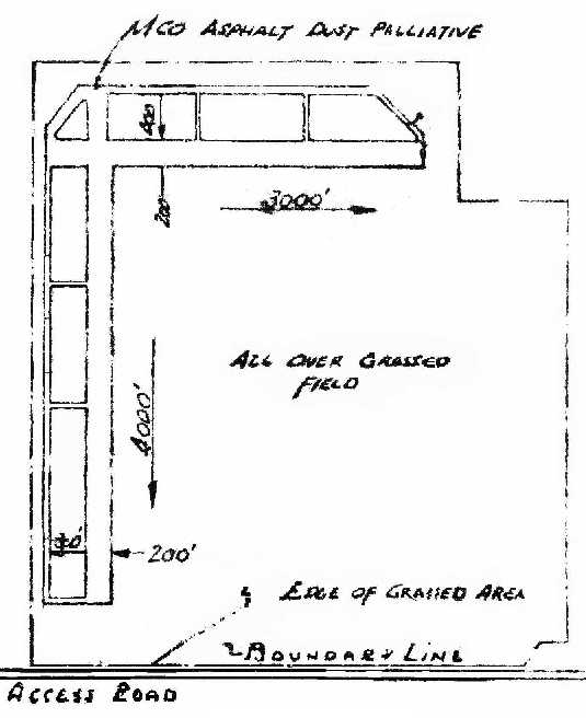
“A4 Vada”, as depicted on the January 1943 “Map of Basic Flying School Auxiliary Fields - Bainbridge” (courtesy of Brian Rehwinkel).
Photo of the airfield while in use has not been located.
Vada Auxiliary Army Airfield #4 was one of 6 satellite airfields used during WW2 by Bainbridge AAF,
a training field for the 50,000 Pilot Training Program.
The date of construction of the Vada airfield has not been determined.
The earliest depiction of the field which has been located
was on the January 1943 “Map of Basic Flying School Auxiliary Fields - Bainbridge” (courtesy of Brian Rehwinkel).
It depicted “A4 Vada” as having 2 runways: 4,000' north/south & 3,000’ east/west,
both of a “MCO Asphalt Dust Palliative” surface.
Brian observed, “This was apparently one of the materials used for the 'temporary' AAAF fields.
It would have been a very thin asphalt layer.”
The Vada airfield was not yet depicted at all on the August 1943 17M Regional Aeronautical Chart (according to Chris Kennedy).
The earliest airfield directory listing of the Vada field which has been located
was in the April 1944 US Army/Navy Directory of Airfields (courtesy of Ken Mercer),
which described "Vada Aux #4, Army" as having a 3,000' hard-surface runway.
The earliest aeronautical chart depiction of Vada Field which has been located
was on the February 1945 Mobile Sectional Chart (courtesy of Chris Kennedy).
It depicted “Vada #4” as an auxiliary airfield.
The last aeronautical chart depiction which has been located of Vada Field was on the February 1947 Mobile Sectional Chart.
It depicted Vada as an auxiliary airfield.
A 3/12/47 USDA aerial photograph of Vada Aux #4
(courtesy of GALILEO, University of GA Libraries, Georgia Aerial Photography Collection, via Brian Rehwinkel).
The photograph depicted the field as having 2 perpendicular asphalt runways,
each of which also had a parallel taxiway.
The field showed no sign of any current usage at the time.
As was the case with many other WW2-era satellite airfields,
Vada Aux #4 was apparently abandoned immediately after the end of the war & never used again,
as it was not depicted at all on the 1949 Mobile Sectional Chart (courtesy of John Voss),
on subsequent aeronautical charts or on the 1965 USGS topo map.
A 1968 aerial photo showed the outline of the Vada Aux #4 runways were still recognizable,
although the property had reverted to agricultural use.
A 2014 USGS aerial photo showed the site of Vada airfield has been reused for agriculture,
and not a trace of the former Army Airfield appears to remain.
The site of Vada Aux #4 is located northwest of the intersection of County Line Road & Hopeful Park Road.
____________________________________________________
Babcock Auxiliary Army Airfield #5, Boykin, GA
31.12, -84.62 (North of Tallahassee, FL)
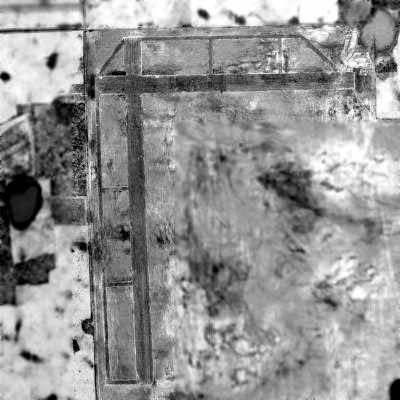
A 4/27/43 NARA aerial view looking north at Babcock Aux #5 (courtesy of Brian Rehwinkel).
Babcock Auxiliary Army Airfield #5 was one of 6 satellite airfields used during WW2 by Bainbridge AAF,
a training field for the 50,000 Pilot Training Program.
The earliest depiction which has been located of Babcock Field was a 4/27/43 NARA aerial view looking north (courtesy of Brian Rehwinkel).
It depicted Babcock as having 2 perpendicular asphalt or oiled runways, each of which also had a parallel taxiway.
There did not appear to be any buildings on the airfield.
Babcock Field was not yet depicted on the January 1944 Mobile Sectional Chart.
The April 1944 US Army/Navy Directory of Airfields (courtesy of Ken Mercer)
described "Babcock Aux #5, Army" as having a 3,000' hard-surface runway.
The earliest aeronautical chart depiction which has been located of Babcock Field
was on the February 1945 Mobile Sectional Chart (courtesy of Chris Kennedy).
It labeled Babcock simply as auxiliary airfield “#5”.
The last aeronautical chart depiction which has been located of Babcock Field was on the February 1947 Mobile Sectional Chart.
It depicted Babcock as an auxiliary airfield.
A 3/12/47 USDA aerial photograph of Babcock Aux #5
(courtesy of GALILEO, University of GA Libraries, Georgia Aerial Photography Collection, via Brian Rehwinkel).
The photograph depicted the field as having 2 perpendicular asphalt or oiled runways, each of which also had a parallel taxiway.
The Babcock runways appeared to already be quite deteriorated, even in 1947, and the field appeared to be abandoned.
As was the case with many other WW2-era satellite airfields,
Babcock Aux #5 was apparently abandoned shortly after the end of the war & never used again,
as it was not depicted at all on the August 1947 Mobile Sectional Chart,
on subsequent aeronautical charts or on the 1965 USGS topo map.
The 1999 USGS aerial photo showed the site of the Babcock Field had been reused for agriculture,
and not a trace of the former Army Airfield appeared to remain.
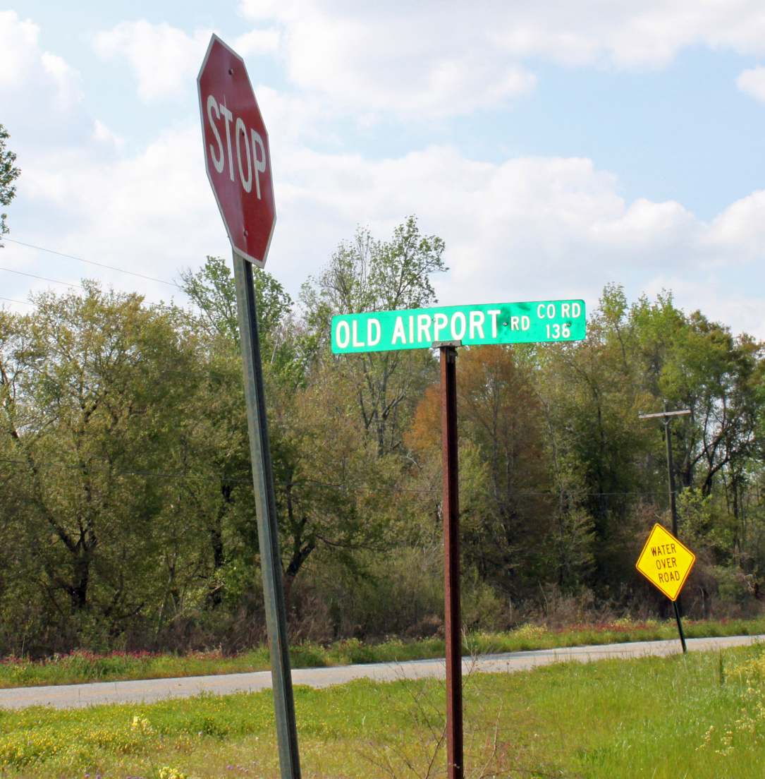
A March 2013 photo by Brian Rehwinkel of the sign for Old Airport Road at the site of Babcock Field.
Brian reported, “Other than the 'Old Airport Road', there is no indication a landing field ever existed on this site.”
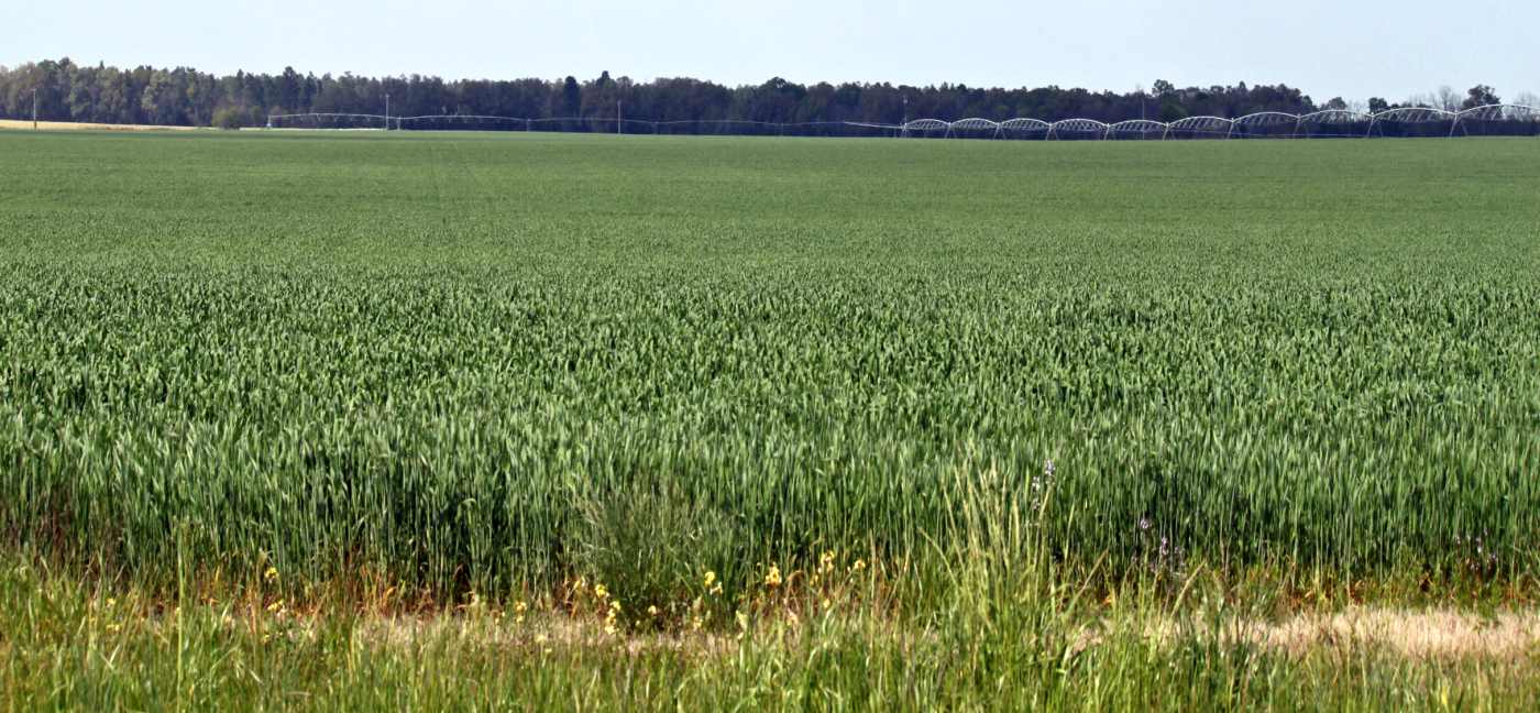
A March 2013 photo by Brian Rehwinkel of the site of Babcock Field. “looking southwest at the crops planted.”
The site of Babcock Aux #5 is located east of the intersection of Avenue Road & Old Airport Road, appropriately enough.
____________________________________________________
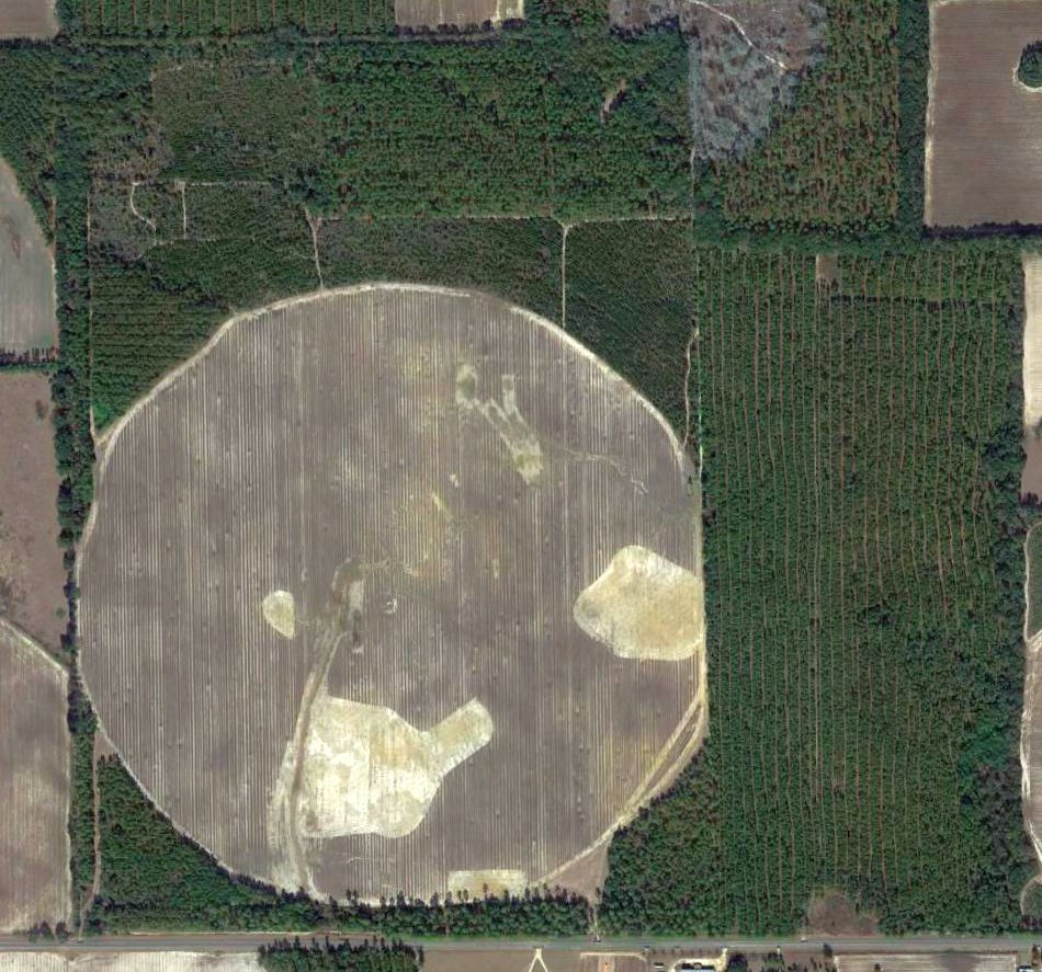
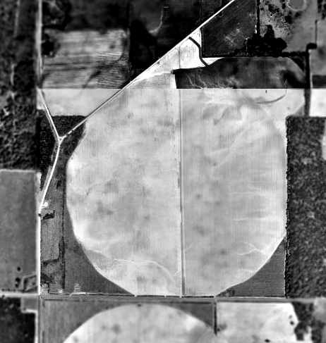
Commodore Decatur Auxiliary Army Airfield #6 (20J), Bainbridge, GA
30.916, -84.61 (North of Tallahassee, FL)
“Commodore Decatur #6”, as depicted on the February 1945 Mobile Sectional Chart (courtesy of Chris Kennedy).
This field was used during WW2 as one of 6 satellite airfields for Bainbridge AAF,
a training field for the 50,000 Pilot Training Program.
The date of construction of the Commodore Decatur airfield has not been determined.
It was not yet depicted at all on the August 1943 17M Regional Aeronautical Chart (according to Chris Kennedy).
The earliest reference to the field which has been located was in the April 1944 US Army/Navy Directory of Airfields (courtesy of Ken Mercer),
which described "Commodore Decatur Aux #6, Army" as having a 4,000' hard-surface runway.
The earliest depiction of the field which has been located was on the February 1945 Mobile Sectional Chart (courtesy of Chris Kennedy).
Decatur #6 was abandoned by the military at some point after 1945.
The February 1947 Mobile Sectional Chart depicted Commodore Decatur as a commercial/municipal airport.
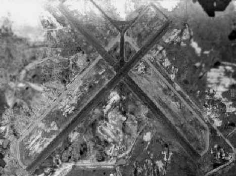
A 3/12/47 USDA aerial photograph of Commodore Decatur Airport
(courtesy of GALILEO, University of GA Libraries, Georgia Aerial Photography Collection, via Brian Rehwinkel).
The airfield did not show any sign of remaining in use.
A 2/3/51 USGS aerial photograph showed Commodore Decatur Airport remained intact but did not show any sign of recent aviation use.
Commodore Decatur Airport was reused as a civilian airport by 1956.
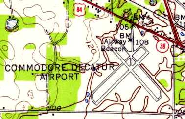
The 1956 USGS topo map depicted it as having 2 paved runways & parallel taxiways,
as well as an Airway Beacon north of the runway intersection.
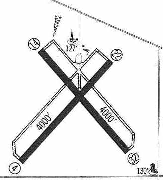
Commodore Decatur was depicted in the 1960 Jeppesen Airway Manual (courtesy of Chris Kennedy)
as having two 4,000' paved runways: 4/22 & 14/32, each of which had a parallel taxiway.
The field did not appear to have any hangars, and it was described as unattended.

The August 1962 Mobile Sectional Chart (courtesy of Chris Kennedy)
depicted Commodore Decatur Airport as having a 4,000' hard-surface runway.
Commodore Decatur was described in the 1962 AOPA Airport Directory as having 2 paved runways.
The 1968 Flight Guide (courtesy of Robert Levittan) depicted Commodore Decatur Airport
as having two 4,000' paved runways: 4/22 & 14/32, each of which had a parallel taxiway.
The 1974 USGS topo map depicted the 2 runways & taxiways of Commodore Decatur Airport,
as well as a beacon north of the runway intersection.
Commodore Decatur was described in the 1982 AOPA Airport Directory (courtesy of Ed Drury)
as having two 4,000' asphalt runways (4/22 & 14/32), and the operator was listed as Harrell Aviation.

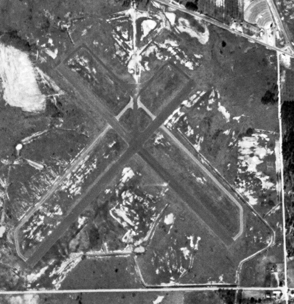
A 1993 USGS aerial view looking north showed Commodore Decatur Airport's Runway 14/32 was still marked as being active.
But several buildings for a cotton gin had been built on the southwest end of Runway 4/22.
Commodore Decatur Airport was depicted as an abandoned airfield on 2002 aeronautical charts.
Brian Rehwinkel reported in 2004, "I visited that site last year & about half (the northern portion) of that airfield has been removed.
I suspect it won't be long before the rest of the runway(s) are removed."
Barry Van Kirk reported in 2004, "As for the Commodore Decatur Field,
it is abandoned, but used every year for a Bikefest.
MC Clubs from all over the southeast show up for a week & race on the strip & camp out.
The runway on the northwest is complete, with runway markers & lines still visible.
The runway end on the southwest is intact but fenced off,
and the last 100 yards used by the company [as shown in the 1995 USGS aerial photo].
The southeast runway end is only 20-30' long, and ends in 2 roads that lead to State Route 84 & Bainbridge.
The southeast runway was cutoff halfway down it's length, replaced by a 1/4 mile dirt & gravel extension that ends in 2 dirt roads.
This area is called the Commodore Decatur Industrial Park, and is NOT used for air traffic.
An old-timer told me today that a crop duster with an engine problem landed there about 2 years ago, and flew out again.
The runways still there are in good shape considering their age. No cracks, potholes or washboard surfaces."
A 2018 aerial view looking north showed the site of Commodore Decatur Airport remained recognizable, but some pavement had been removed from both former runways.
A 2025 photo looking southwest showed pavement remaining of both former Commodore Decatur Airport runways.
____________________________________________________
Or if you prefer to contact me directly concerning a contribution (for a mailing address to send a check),
please contact me at: paulandterryfreeman@gmail.com
If you enjoy this web site, please support it with a financial contribution.
____________________________________________________
This site covers airfields in all 50 states.