Abandoned & Little-Known Airfields:
Hawaii, Northern Oahu Island
© 2001, © 2023 by Paul Freeman. Revised 10/3/23.
This site covers airfields in all 50 states: Click here for the site's main menu.
____________________________________________________
Please consider a financial contribution to support the continued growth & operation of this site.
Haleiwa Fighter Strip / Haleiwa Airport (revised 2/20/23) - Kahuku AAF / Kuilima Air Park (revised 2/14/21)
Kailua Sky Ranch (revised 11/7/22) - Kualoa Army Airfield (revised 4/21/18) - Waiele Gulch Army Airfield (revised 10/3/23)
___________________________________________________
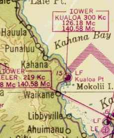
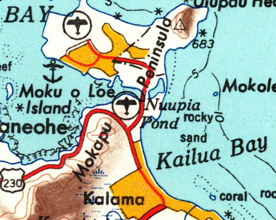
Kualoa Army Airfield, Kualoa, HI
21.52, -157.84 (Northeast of Honolulu, HI)
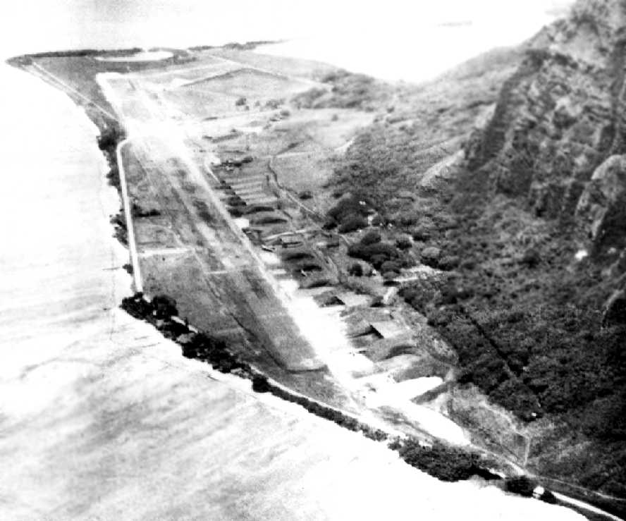
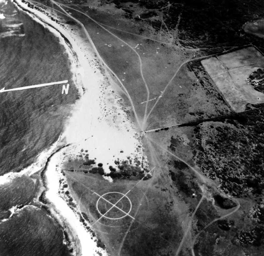
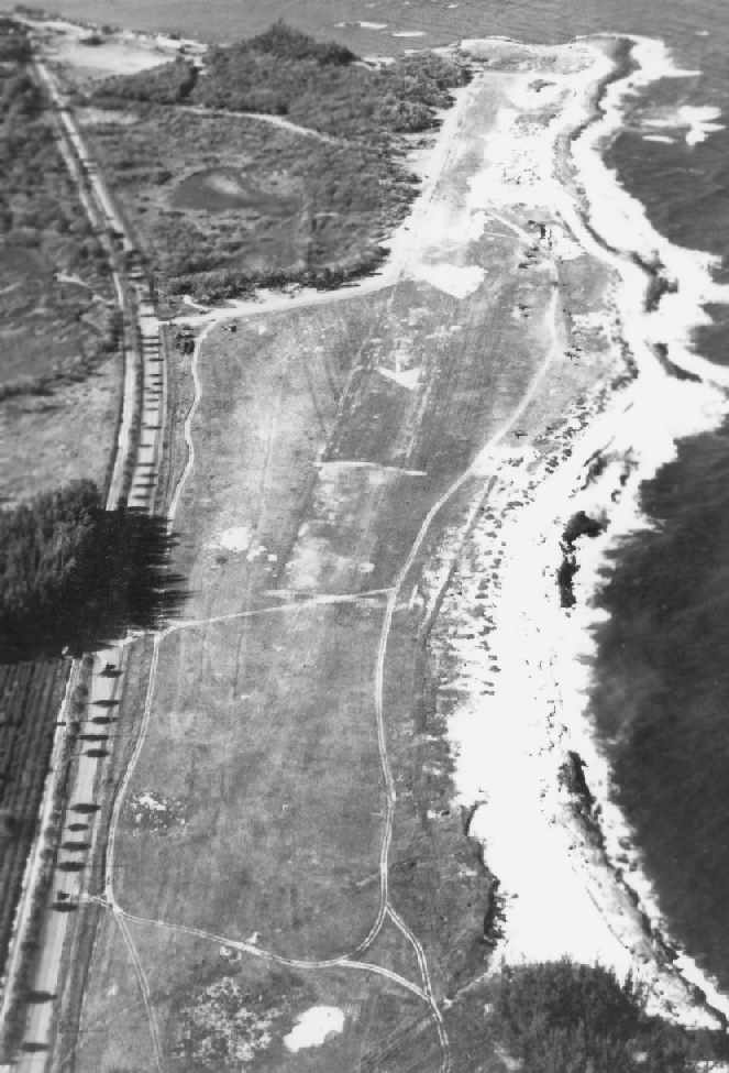
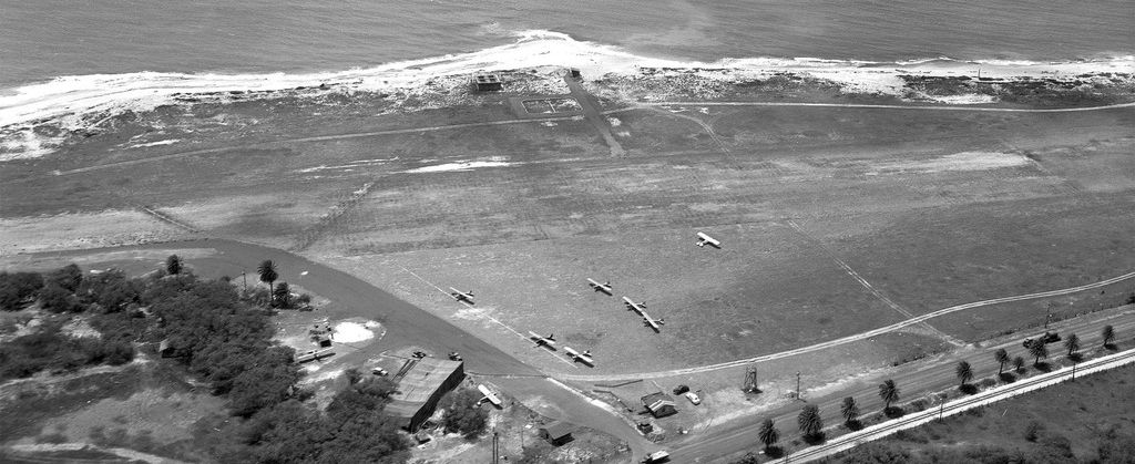
A 5/10/42 aerial view looking southwest at Kualoa Field.
Barely visible within the revetments along the bottom of the photo were B-17, LB-30, and B-18 bombers.
Kualoa Army Airfield was evidently constructed during the early portion of WW2
a satellite field for units assigned to Bellows Field, and was used mainly for training.
According to Valerie King, “During WWII, the land was taken over by the US government & they built the airstrip & bunkers.”
The date of construction of the Kualoa airfield has not been determined.
The earliest depiction which has been located of Kualoa Army Airfield was a 5/10/42 aerial view,
which depicted Kualoa as having a single north/south runway, with aircraft revetments along the west side.
Kualoa Field's runway was formed of pierced steel planking.
The road to Ka'a'awa & the north shore crossed over Kualoa's runway, so the cars would have to wait whenever an airplane took off.
A row of revetments for protected aircraft parking was along the west side of the runway.
Several fortified bunkers for coast artillery batteries were constructed in the cliffs overlooking Kualoa Field during WW2.
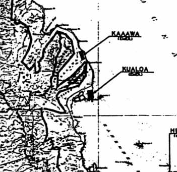
The 1943 USGS topo map (courtesy of John Voss) depicted the "Kualoa (Emer.)" airfield,
as well as the nearby "Kaaawa (Emer)" airfield just along the coast to the northwest.
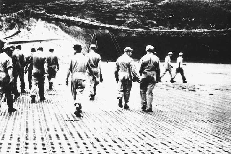
A 10/8/44 photo of men walking over the perforated steel planking
which formed the runway of Kualoa Field (courtesy of Dave Fahrenwald of Hawaiian Aviation History).
The aircraft at the left is a Lockheed P-38 Lightning fighter.
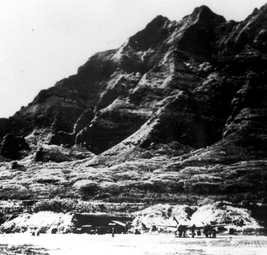
A 10/8/44 photo looking west at a Lockheed P-38 Lightning fighter on the Kualoa airfield.
The April 1945 V-450 Hawaiian Islands U.S. Navy Aviation Chart (courtesy of Chris Kennedy) depicted Kualoa Field as having a control tower.
W. Dick recalled, “At Kualoa... In 1945 we had to wait at the strip crossing while Grumman carrier planes taxied into position.
I don't recall any real structures at the strip. The surface was made up of those temporary perforated metal strips about 1' x 8'.”
According to Valerie King, “After the war, the land was returned to the family.”
The Kualoa Airfield was closed at some point between 1944-47,
as it was labeled "Kualoa AAB (Closed)" on the Sptember 1947 Hawaiian Islands Sectional Chart.
It was depicted as having a single 6,500' hard-surface runway.
The Kualoa Airfield was no longer depicted at all on the 1952 USGS topo map.
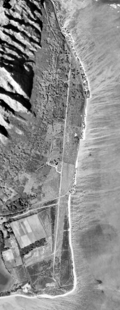
A 1/12/63 aerial view showed the remains of the Kualoa airfield (from the University of HI).
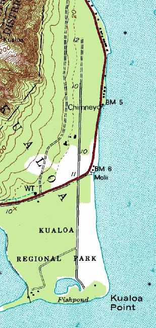
The 1983 USGS topo map no longer depicted Kualoa runway, but labeled the airfield site as "Kualoa Regional Park".
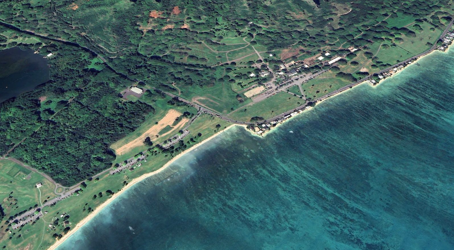
Dave Fahrenwald reported in 2000 that the property has become Kualoa State Park & Kualoa Ranch.
A few of the fortified revetments along the shear cliffs above the former airfield still remain intact,
as the only remaining indication of this site's military history.
A 2005 photo by David Trojan of the Kualoa Beach Park, which occupies the site of the former airfield
(courtesy of Colin Perry of the Hawaii Aviation Preservation Society).

A 2005 photo by David Trojan of the the remains of a bunker adjacent to the former Kualoa airfield
(courtesy of Colin Perry of the Hawaii Aviation Preservation Society).
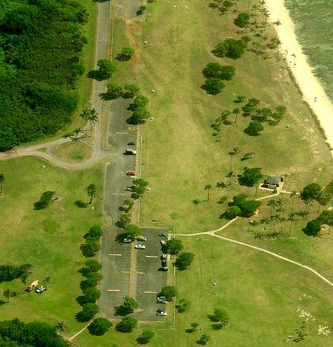
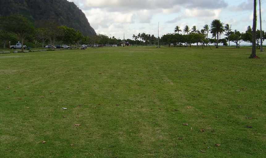
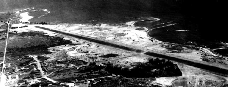
A circa 2007 aerial view looking north at what appears to be the remains of the paved runway at Kualoa, reused as a parking lot.
According to Valerie King, “We own the property where the Kualoa WWII airstrip & bunkers are located.
The Battery Cooper bunker is still intact & we open it up for visitors to view.
We are putting some WWII displays inside the bunker to show how it looked during WWII.”
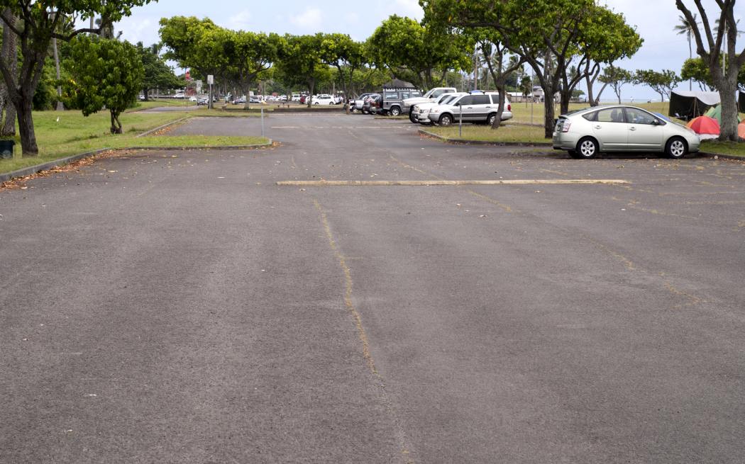
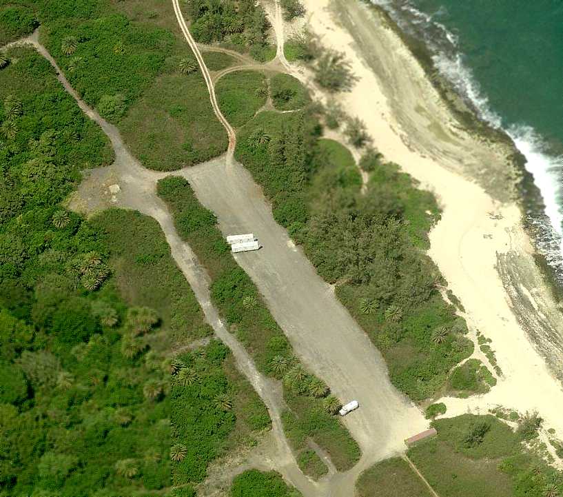
An 8/23/14 photo by Timothy Williamson looking south along the remains of the paved runway at Kualoa, reused as a parking lot.
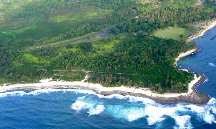
A 2024 aerial view looking northwest of the remains of Kualoa's paved runway, both north & south of the road which crosses the former runway.
____________________________________________________
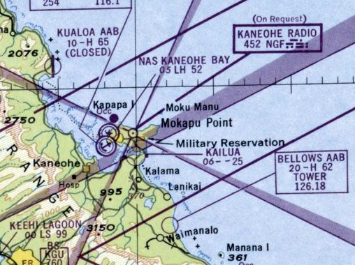
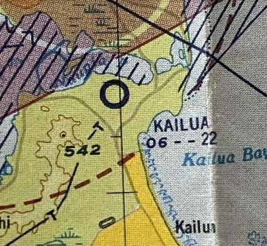
Kailua Sky Ranch, Airfield, Kailua, HI
21.43, -157.75 (Northeast of Honolulu, HI)
Kailua Sky Ranch, as depicted on the September 1947 Hawaiian Islands Sectional Chart.
Photo of the airfield has not been located.
Kailua Sky Ranch, a small general aviation airport adjacent to the south side of Naval Air Station Kaneohe Bay, was reportedly “built after World War 2.”
The earliest depiction which has been located of Kailua Sky Ranch was on the September 1947 Hawaiian Islands Sectional Chart.
It depicted Kailua as having a 2,500' unpaved runway.
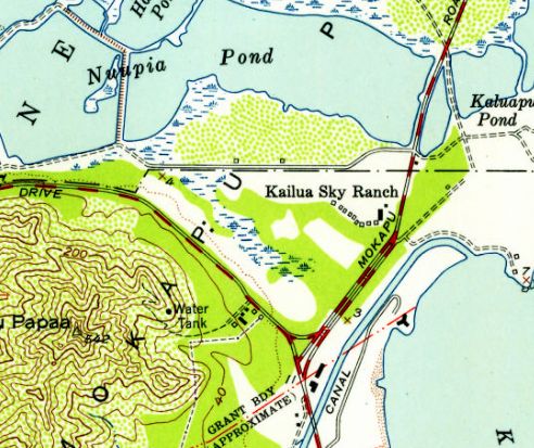
The 1952 USGS topo map depicted Kailua Sky Ranch as an east/west oriented clearing, with a row of small buildings (hangars?) along the southeast side.
Minutes of a 1956 Hawaii Aeronautics Commission reported of a request from the Aircraft Owners' & Pilots' Association of Hawaii
for the Hawaii Aeronautics Commission to acquire the Kailua Sky Ranch so as to support the continuation of light aircraft flying.
The last aeronautical chart depiction which has been located of Kailua Airport was on the 1957 Hawaiian Islands Sectional Chart (courtesy of Kevin Walsh).
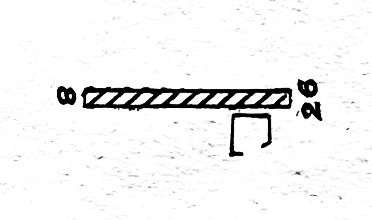
The 1957 Hawaiian Islands Sectional Chart (courtesy of Kevin Walsh) depicted Kailua as having a 2,200' turf Runway 8/26.
Bob Hurd recalled, “Kailua Sky Ranch... I started to learn to fly there in 1957.
There was an grass field in Kailua, windward side of Oahu. It was located parallel to the southern fence of Kaneohe Marine Base,
near the Mokapu gate to the base, and west of Mokapu Boulevard.
The runway was where the east/west portion of Aikahi Loop is now.
It would have appeared in any sectional published pre-1960.
It had a 200' asphalt strip & about 1,800' of grass,and power lines at the East end, along Mokapu Blvd.
There was a large Quonset hut as a hangar, shop combination, and a small raised house that served as the office & bathroom.
There was a gasoline-powered pump & 3,500 gallon tank of 80/87 avgas.
The field was operated by Robert Whittinghill, who was an instructor at the state aircraft mechanic school at Honolulu Airport.
I remember other Sky Ranch guys & I flying the planes to Honolulu Airport's old North ramp area, where Wittinghill had a large T-hangar & a Fixed Base Operation.”
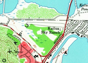
The 1959 USGS topo map depicted Kailua Sky Ranch as having an east/west runway.
In contrast to the 1952 topo map, only 2 small buildings were depicted along the southeast side.
In 1959, the Hawaii Soaring Club was formed with Wood Brown as President.
Plans called for the operation of Pratt-Read gliders from Kailua Sky Ranch.
Bob Hurd recalled, “Kailua Sky Ranch...I was away at school when it was plowed under for the Aikahi tract.
It was turned into housing about 1962, or so.”
The last depiction which has been located of Kailua Sky Ranch was on the 1965 USGS topo map,
even though it had reported been redeveloped for 3 years by that point.
The 1968 USGS topo map depicted streets covering the site of Kailua Sky Ranch.
Kailua Sky Ranch was no longer depicted on the June 1971 Hawaiian Islands Sectional Chart (courtesy of Ron Plante).
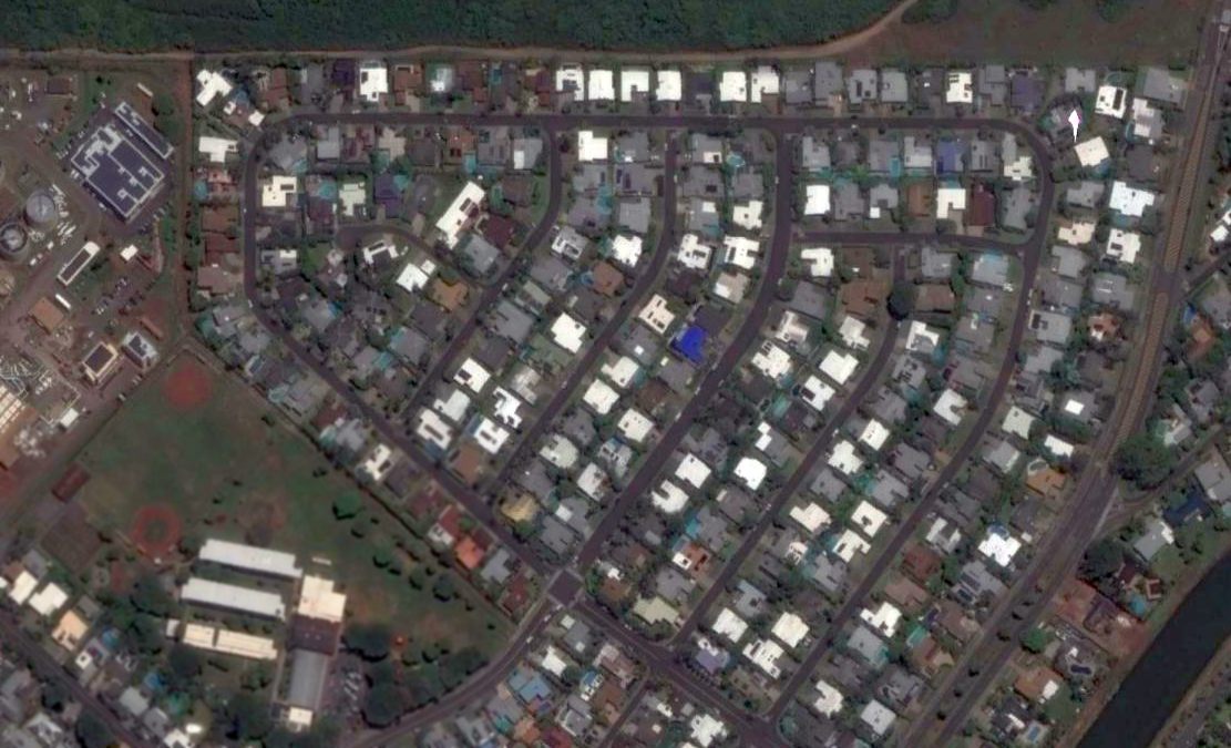
A 2014 aerial view showed no trace remaining of Kailua Sky Ranch.
Thanks to Bob Hurd for pointing out this airfield.
____________________________________________________
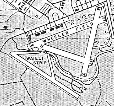
Waiele Gulch Army Airfield, Wahiawā, HI
21.47, -158.04 (North of Honolulu, HI)
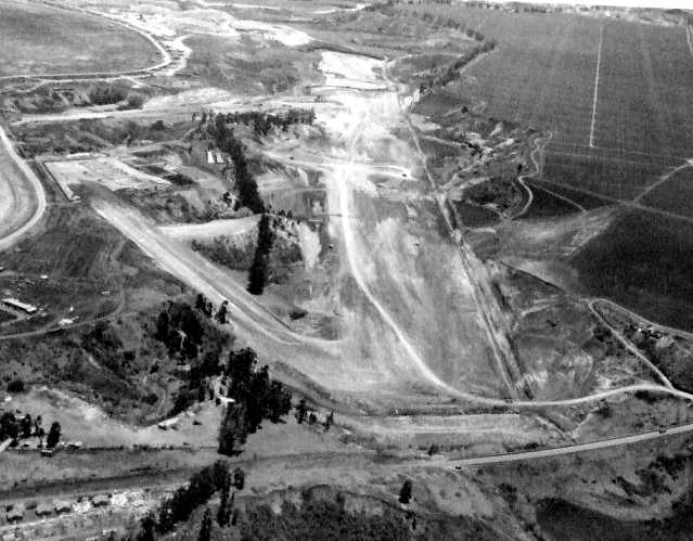
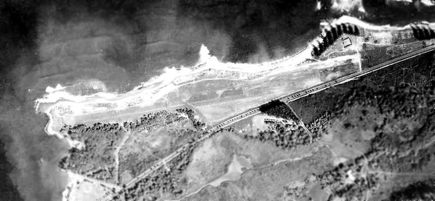
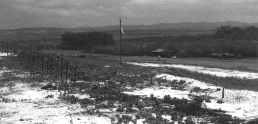
A 7/9/42 aerial view looking south showing the Waiele Gulch Airfield under construction (courtesy of Ron Plante).
This is an unusual case of an airfield built in a gulch, below the surrounding ground level.
According to the Hawaii Aviation Preservation Society, “The date of construction of the airfield is believed to be in late 1941.
An 8/20/41 photo shows the airfield under construction.
The airfield lies in a gully running parallel to Waieli Stream next to pineapple fields, separate & just south of Wheeler Air Field.
Bunkers were excavated in conjunction with the initial construction of the airfield.
Provision for bombproof protection of assembly & disassembly operations for large bombers
was not worth the expenditure of money & materials required in conjunction with the initial construction.
The initial plan was for paved bunkers for these operations adjacent to the Waieli Gulch runway.
Three 100' x 200' bunkers with paved working areas were provided for this purpose.
Pockets were laid out in the cliffs along the side of the runway were used as aircraft parking areas
with sheer earth side slopes to provide maximum protection from strafing of enemy aircraft.”
According to the Hawaii Aviation Preservation Society, “A huge underground bunker complex
was later constructed at the northwest end of the airfield for aircraft maintenance & storage
after the 12/7/41 attack on Pearl Harbor forced the military to build facilities less vulnerable to the enemy.”
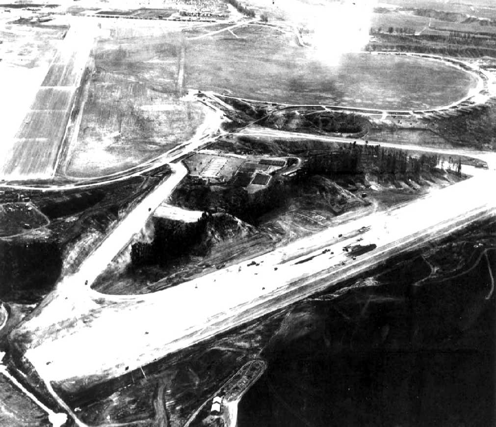
A 1942 aerial view looking east showing the Waiele Gulch Airfield under construction, with a Wheeler AAF runway in the background.
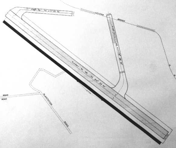
A 1942 plan of the Waiele Gulch Airfield (courtesy of Ron Plante).
According to the Hawaii Aviation Preservation Society, “Construction began in 1942 on a bombproof underground bunker complex & aircraft assembly plant
located 2,400' from the end of the Waieli Gulch Airstrip.
The fear of a repeat-attack prompted the Army & Navy to build these underground facilities for vital defense & storage installations.”
A 1943 U.S. Army Corps of Engineers Schofield Quadrangle map
identified the airfield as Waieli Gulch Field (according to the Hawaii Aviation Preservation Society).
An 11/17/43 aerial photo depicted an active runway (according to the Hawaii Aviation Preservation Society).
According to the Hawaii Aviation Preservation Society, “Called 'The Hole' in the 1940s, construction on the $23,000,000 facility was completed in 1944.
The facility is not a true tunnel, but a freestanding 3-story structure that was later covered with 5' of soil for pineapple cultivation.
The entrance was placed in the steep side of the Gulch to obscure visibility by enemy aircraft.
When construction was completed, it was assigned to the 7th Air Force.”
According to the Hawaii Aviation Preservation Society, “The bunker facility was naturally constructed as an open bay area, without interior cement blocks.
The outer walls are composed of reinforced concrete & dirt.
It is approximately 250,000 square feet in overall size, with 30,000 square feet used for power generation & air conditioning.
The remaining 220,000 square feet were available for assembly or disassembly of aircraft
and was surrounded by smaller repair shops & storage rooms.
The main shop was designed to provide space for three B-17 planes, two without wings & one with wings
and was later modified to accommodate larger bombers.
Access to the structure was via a ramp built on a curve with a 90-degree bend intended to provide protection for the entrance to the bunker.
Aircraft including the B-24s, B-17s, B-26s bombers & other types were serviced in the bunker
but there is no historical evidence to suggest the field station was ever used for aircraft assembly.”
According to the Hawaii Aviation Preservation Society, “The Kunia Bunker was equipped with every modern facility.
The entire facility was air-conditioned & humidity controlled & had a cafeteria that could turn out 6,000 meals a day.
Some idea of the size of the building may be gained from the fact that to light the facility, it took almost 5,000 forty-inch fluorescent tubes for the job.
Two elevators serviced the field station, one capable of accommodating 10 tons for bulky plane parts.
For passenger service, another elevator was provided with a carrying capacity of 20 persons.”
An August 1944 map of the “Waiele Strip”.
According to the Hawaii Aviation Preservation Society, “At the end of World War II, the [bunker] facility was kept in a reserve status.
Waieli Gulch Field was apparently abandoned shortly after the end of World War II most likely because of the hazards of operating an airfield in a gulch.”
Waieli Gulch Field was not depicted on the September 1947 Hawaiian Islands Sectional Chart.
A 1948 aerial view depicted the Waiele Gulch runway being used to store vehicles.
According to the Hawaii Aviation Preservation Society, “The [bunker] facility was kept in a reserve status until 1953,
at which time the Navy assumed control & used it for ammunition storage & a command center.
It was eventually converted into a communications facility.”
According to the Hawaii Aviation Preservation Society, “The very close proximity of Wheeler Field will prevent this airfield from ever being reactivated.
Continual erosion along the steep sides of the runway poses major problems & limits the use of the ramp & parking areas.
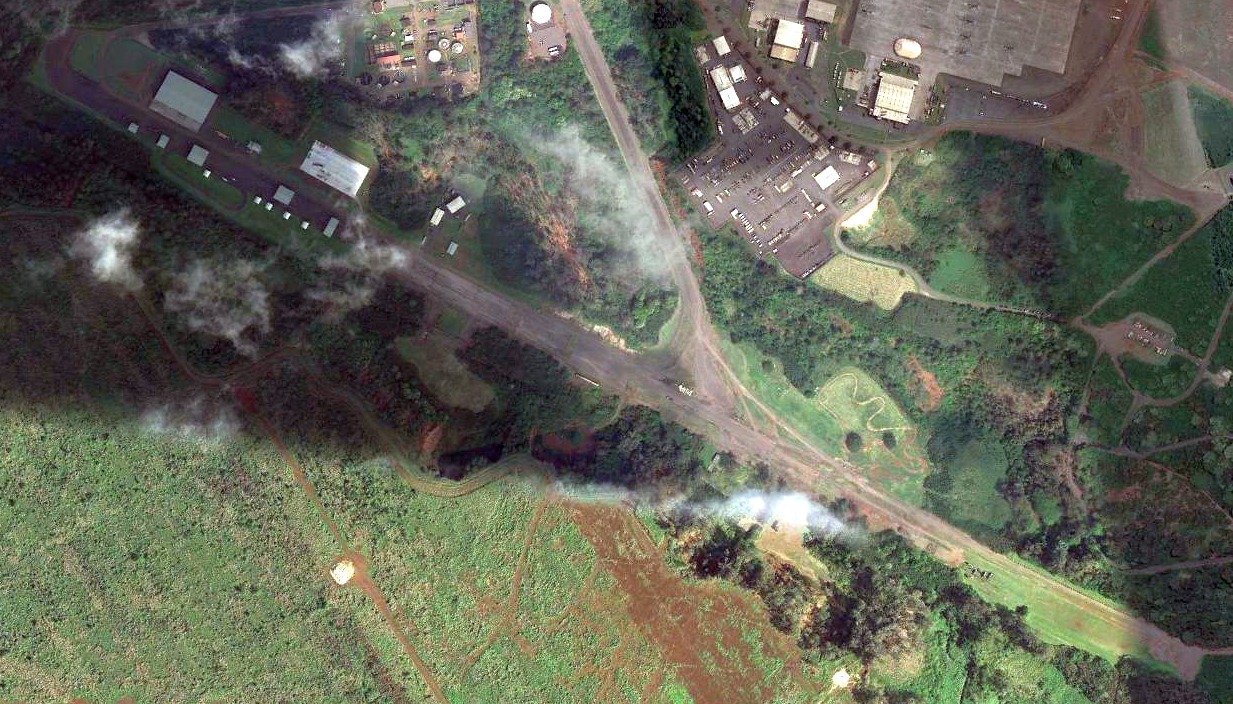
Maps for 1953, 1967 and 1983 show the end of Waieli Gulch Field connected to Kunia Bunker via a small access road across Kunia road.
An early 1960s era aerial photo depicts the airfield being used as a staging area for deploying troops & equipment.”
Jan Helsel recalled of the 1960s, “While I was stationed at Wheeler we used [the Gulch airfield] as a staging area for troop lifts.”
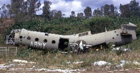
The only photo which has been located showing an aircraft at the Waiele Gulch Airfield was a 1967 photo by Nick Williams of a derelict Piasecki H-21 Shawnee.
According to the Hawaii Aviation Preservation Society, “Currently no access remains between the airfield & the bunker.
An archaeology and history study completed in 1994 simply identifies the area as Waieli Runway.
The airfield areas were examined for any evidence of artifacts.
An old World War II propeller & 10-ton aircraft jacks were found near the end of the runway.
At the present time, the Waieli Gulch Field area is still used by the Army as a military staging & training area.”
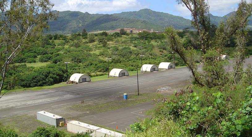
A circa 2000s photo of Quonset huts alongside the Waiele Gulch runway.
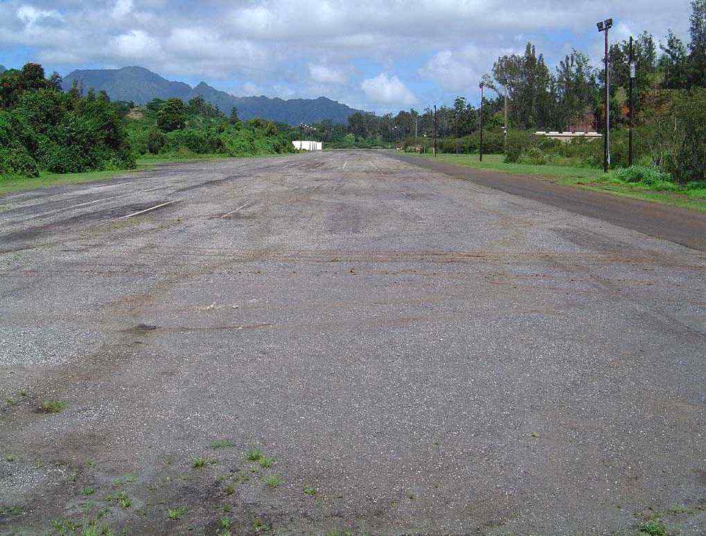
A circa 2000s photo looking along the Waiele Gulch runway.
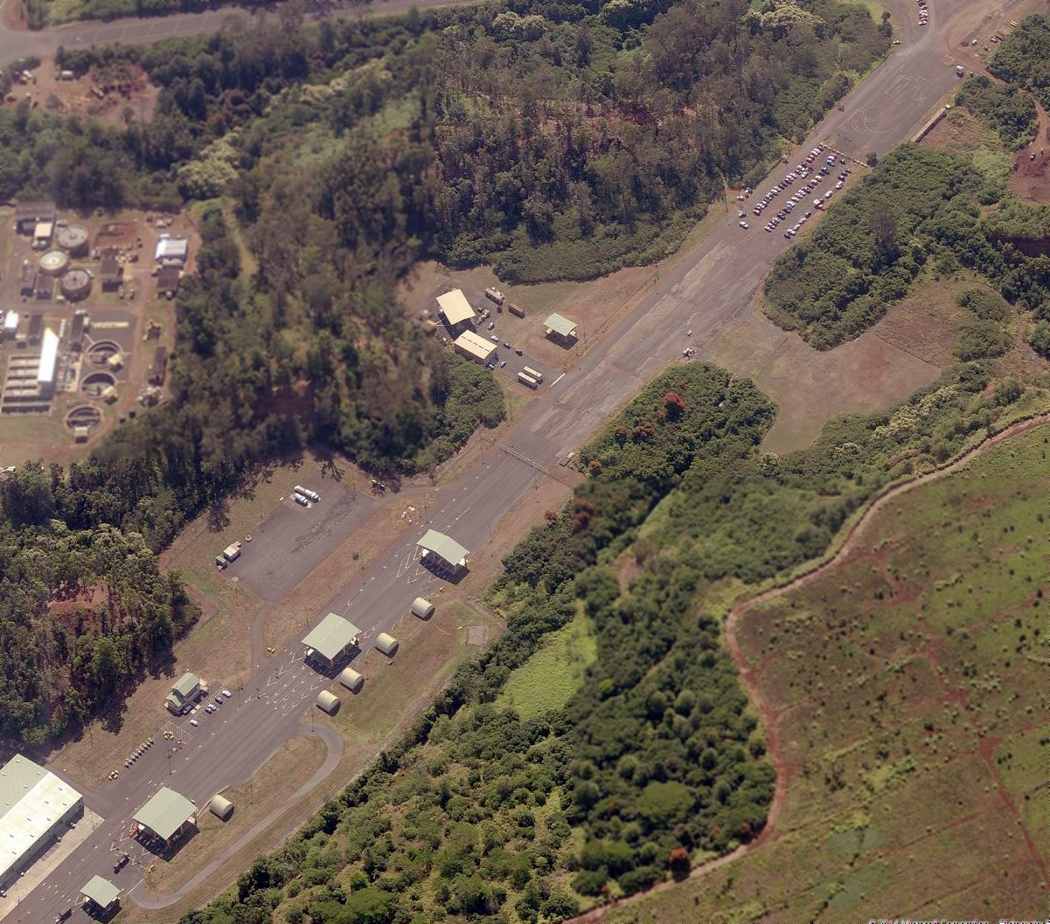
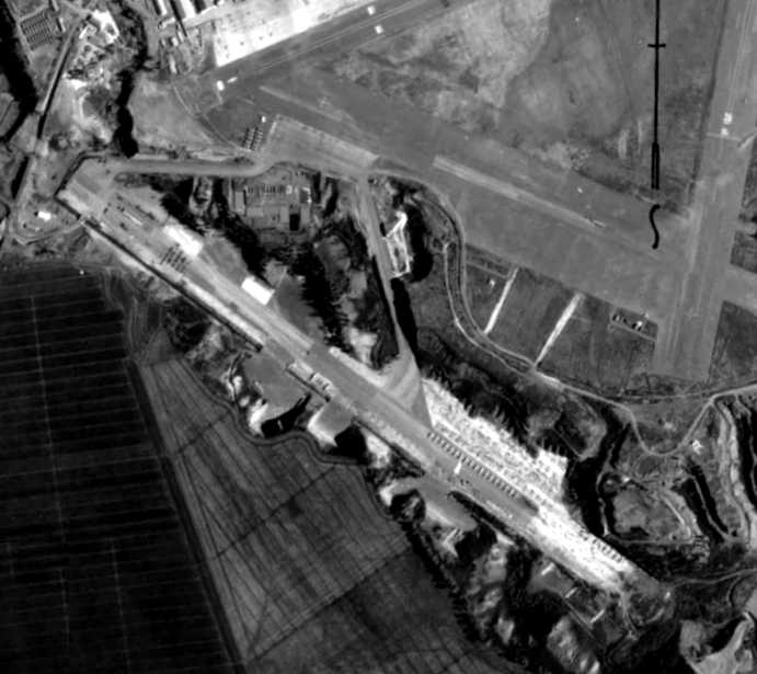
A circa 2011 aerial view looking east along the Waiele Gulch runway shows several modern structures having been built over the western end.
A 2013 aerial view showed the Waiele Gulch runway remained intact.
The site of Waiele Gulch Army Airfield is located south of the intersection of Wright Avenue & Airdrome Road.
____________________________________________________
Kahuku Army Airfield / Kuilima Air Park, Kahuku, HI
21.71, -157.97 (North of Honolulu, HI)
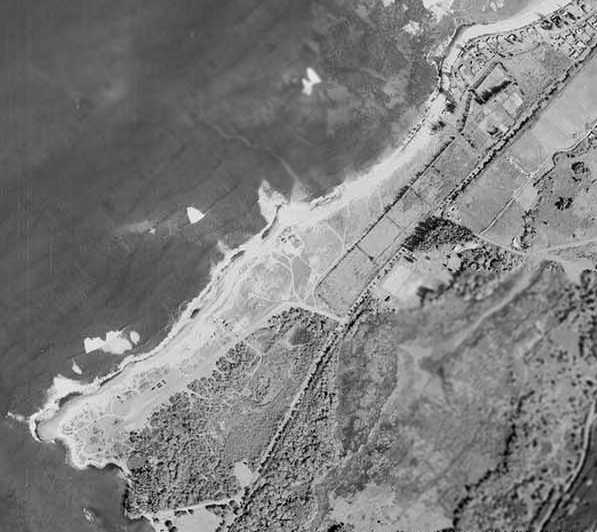
A 9/9/41 aerial view looking east at Kahuku Point Outlying Field.
A Marconi Wireless station was established in 1914 on the northern tip of Oahu
as the site for a transmitter/receiver radio station & antenna farm.
This was eventually taken over by the Radio Corporation of America (RCA).
The northern tip of Oahu Island had a total of 3 airfields in close proximity during WW2.
The date of construction of these 3 airfields has not been determined,
but it is presumed that they were all constructed early in WW2,
and were not pre-war civilian airfields.
The Kahuku Point Airfield was located at the very tip of Kahuku Point, and was evidently the most elaborate.
In 1941, Lt. Gen. Walter Short made a request to construct a pursuit field,
and the War Department directed that the base be located on the northern tip of Oahu at Kahuku Point.
Because the site was being used by the Navy as a bombing range, no further action was taken until December 1.
The old RCA administration building was converted to air base headquarters for the duration.
The earliest depiction which has been located of the Kahuku Point Airfield was a 9/9/41 aerial view.
It depicted the field as an open grass area, with what appeared to be a circular bombing target cut into the grass.
There did not appear to be any hangars or other improvements associated with the airfield.
The military reservation was named the "Kahuku Airfield Military Reservation", also known as "Kahuku Air Base".
Construction of the first of 2 runways was preceded by the creation of a supervising entity known as Field Area 13
established by Lt. Col. Theodore Wyman, Army Corps of Engineers District Engineer, on 11/25/41, by Order 101.
The engineers of the newly created field area, which occupied the old RCA wireless transmitter building,
were responsible for construction of 2 additional north shore airfields at Haleiwa & Kawaihapai (Mokuleia).
Construction of the airfield began on 12/10/41, by a civilian conglomerate known as "Hawaiian Constructors" formed in Washington, D.C., on 12/20/40.
Lt. Colonel Wyman, with the approval of the Under Secretary of War, Chief Engineer & the National Council of Defense,
signed a "cost plus fee" contract to build fortifications, aircraft warning stations, ammunition storage facilities,
and other defense projects in the Hawaiian Islands including airfields.
The Kahuku Point Airfield evidently gained a paved runway at some point between 1941-42, as an 8/20/42 aerial photo depicted a long paved runway.
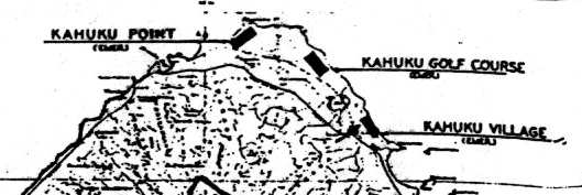
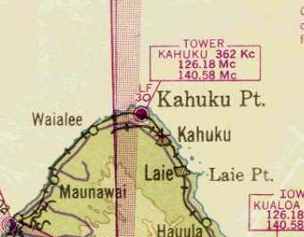
The 1943 USGS topo map (courtesy of John Voss) depicted the "Kahuku Point" Airfield,
as well as 2 others, further down the coast to the southeast: "Kahuku Golf Course" & "Kahuku Village".
All 3 of the Kahuku airfields were subtitled "Emer", and were depicted as single runways paralleling the shore.
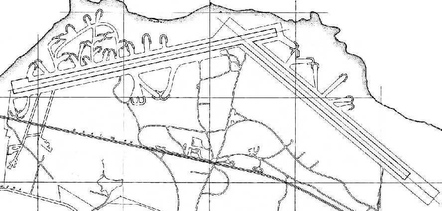
A 1943 Army Corps of Engineers plan of “Kahuku Field” (courtesy of Robert Hill & John Bennett, via John Szalay)
depicted the field as having 2 paved runways, with no less than 36 parking revetments arrayed around the runways.
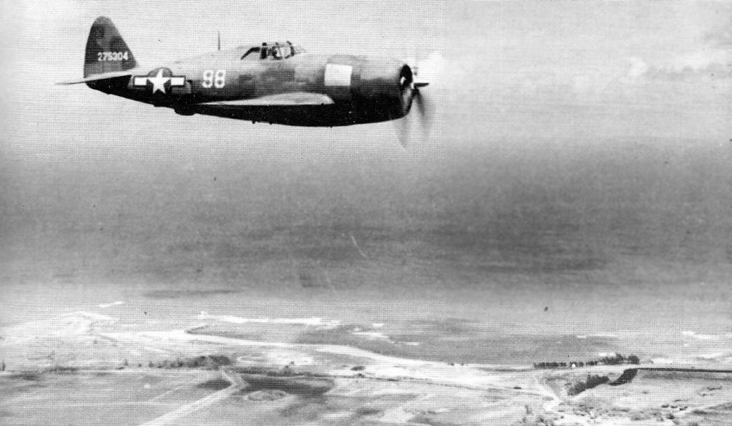
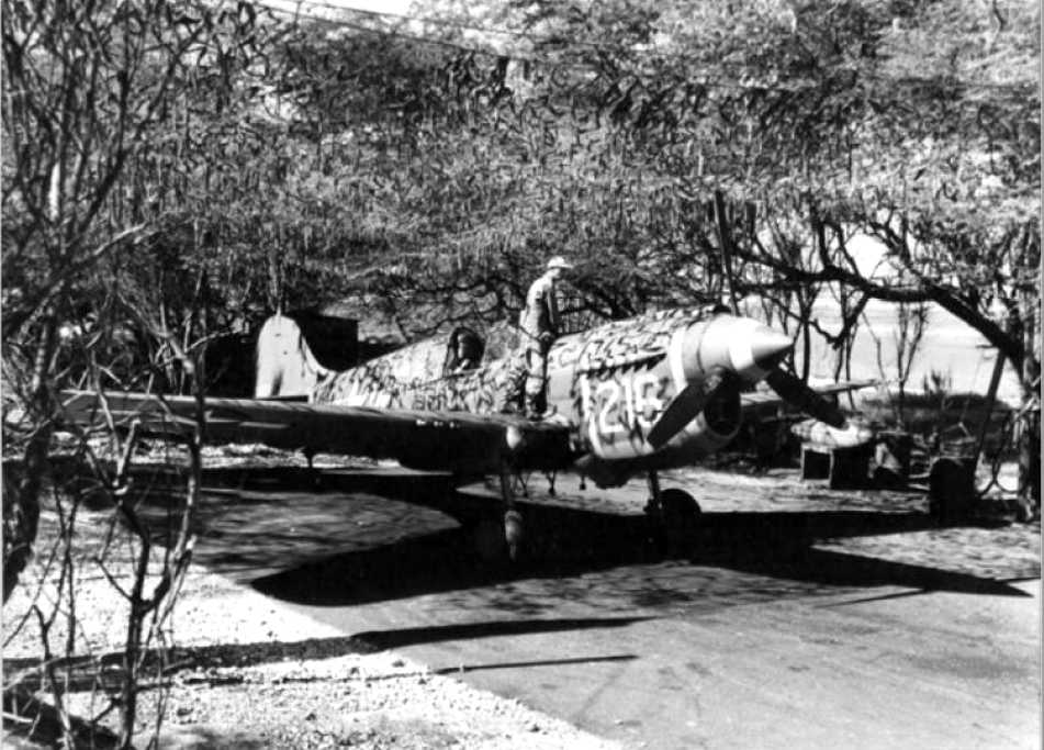
A 9/19/44 aerial view of a Republic P-47D Thunderbolt overflying Kahuku Field (courtesy of John Voss).
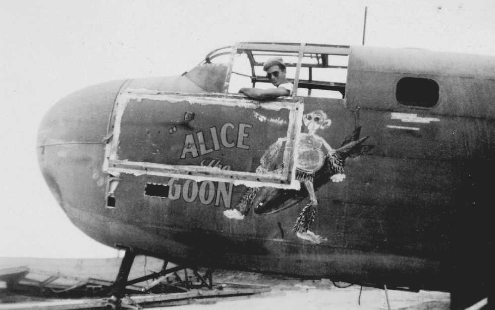
A circa 1944-45 photo of Sam Rogers in the cockpit of “Alice The Goon”, a B-25G (or B-25H, with the 75mm cannon solid nose) at Kahuku (courtesy of Sam Rogers Jr.).
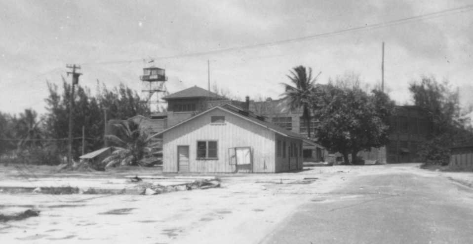
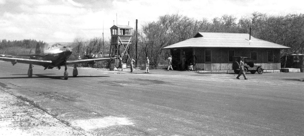
A circa 1944-45 photo by Sam Rogers of the Kahuku control tower & other buildings (courtesy of Sam Rogers Jr.).
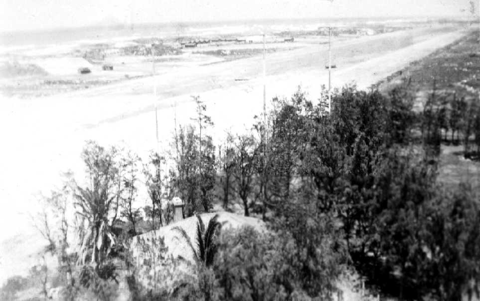
A circa 1944-45 photo by Sam Rogers of the Kahuku's runway (courtesy of Sam Rogers Jr.).
According to John Szalay, both B-24s & B-17s were based at Kahuku for short periods of time during WW2.
The April 1945 V-450 Hawaiian Islands U.S. Navy Aviation Chart (courtesy of Chris Kennedy)
depicted the airfield at Kahuku Point as having a control tower.
Also note the “cross” symbol (depicting an “Emergency Field”) to the southeast, at the location of the "Kahuku Golf Course" Airfield.
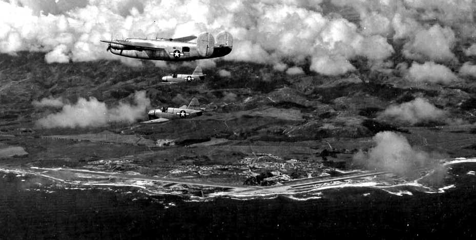
A 4/29/45 National Archives aerial view looking south at a B-24 mother ship escorting 2 rare Culver PQ-14 radio-controlled planes,
with the runways of Kahuku AAB visible below.
According to an article in the Spring 2001 AAHS Journal, “The large Tsunami that hit the Hawaiian Islands on 4/1/46, caused extensive damage to the air base,
the NE/SW runaway was within 100 yards of the shoreline and the NW/SE runway, 200 yards.”
According to a Corps of Engineers DERP FUDS report, “The wave washed over the protecting sand dunes,
rushing inland in some places to a half mile, smashing buildings, uprooting parking areas, and bringing tons of sand & debris onto the runways.
Army personnel verbally informed the Estate that their previous fear that the field was too close to the water was amply borne out.”
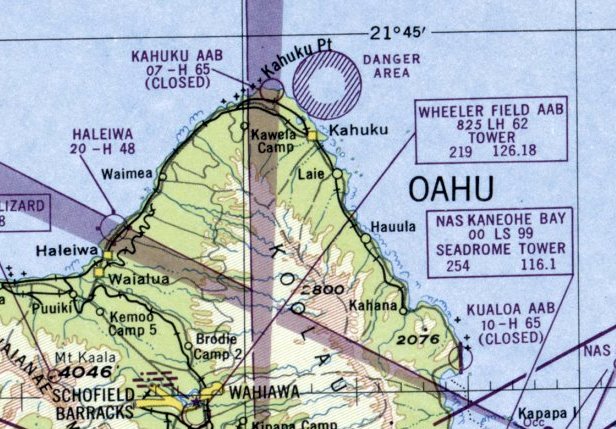
"Kahuku AAB" was depicted on the 1947 Hawaiian Islands Sectional Chart as a closed airfield, having a 6,500' hard-surface runway.
This was presumably the former "Kahuku Point" Airfield. The other 2 Kahuku airfields were not depicted at all.
According to an article in the Spring 2001 AAHS Journal, “Flight operations ceased, and the property was returned to its owners, the trustees of the James Campbell Estate
sometime between 6/12/47 - March 1948.”
According to an article in the Spring 2001 AAHS Journal,
“The formation of the U.S. Air Force on 9/18/47, saw the continued occupation of a base camp located on 10 acres of the military reservation.
The camp housed Det. B, 614th Aircraft Control and Warning Squadron which operated a GCI radar until 1/1/49,
and the 616th Aircraft Control & Warning Squadron that manned an AN/CPS-1 early warning radar unit atop nearby Punamano Hill until 12/11/48.”
No airfield at Kahuku was depicted on the August 1950 Hawaiian Islands Sectional Chart.
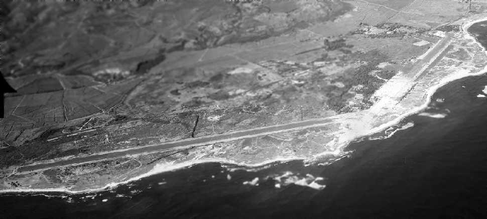
A 6/29/51 aerial view looking southwest at the Kahuku airfield (from the University of HI) showed 2 paved runways.
Walter Dick recalled, “Kahuku... I was one of the group that initiated drag racing at the Kahuku strip.
I was a 'founder' of the local hot rod club (circa 1952).
We negotiated with the local Philipino farmer leaseholder for access to the site.
We used the end of the South segment of the strip. We had to chase the cows off before we could race.
The North segment of the strip had the antenna field for the RCA short-wave transmitting site
and also served as a National Guard summer campground.
Most of the middle was covered in blowing sand then.”
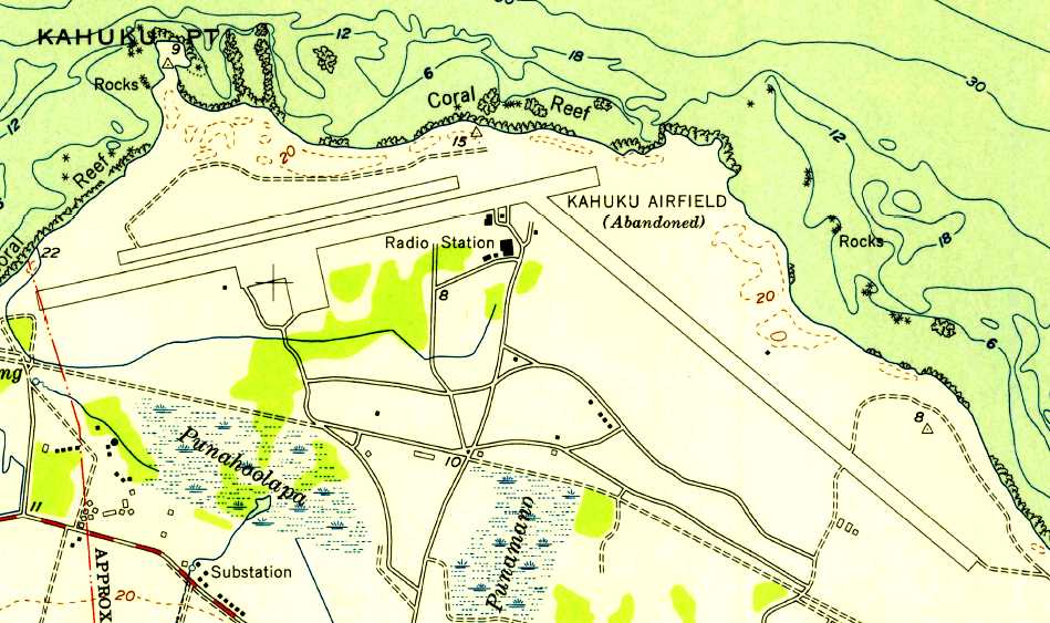
The 1954 USGS topo map depicted the “Kahuku Airfield (Abandoned) as having 2 parallel paved northeast/southwest runways,
and a 3rd paved runway oriented northwest/southeast.
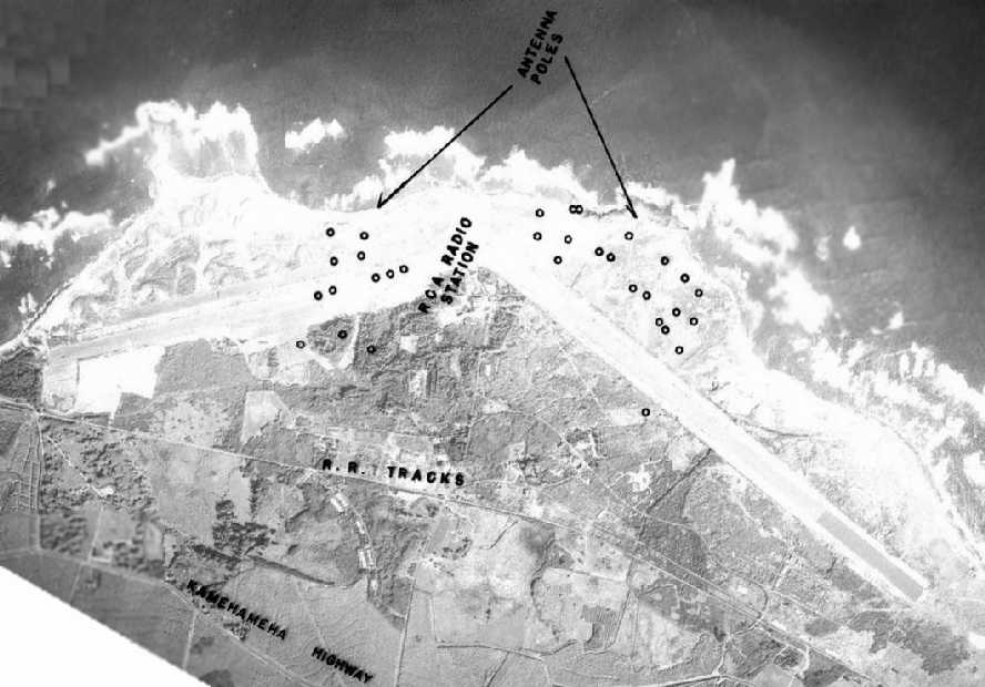
A 1955 aerial view depicted the 2 Kahuku runways, as well as the multiple antennae of the RCA radio station.
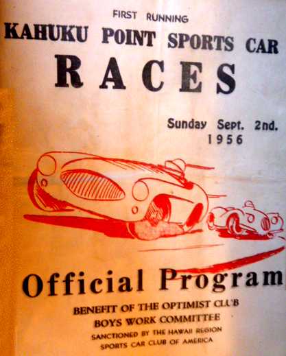
The Official Program for the 9/2/56 First Running of the Kahuku Point Sports Car Races (courtesy of Sheila Fontaine).
According to John Szalay, "In the early 1960s prior to the opening of the Campbell race course,
we used to race at Kahuku, both drag racing & the first Hawaii sports car race (Grand Prix).
I remember one long runway & a taxiway with a wide area to the south on the west end of the runway.
There were a couple of small parking spots for aircraft on the northern part (seaside)
but in the 1960s they were almost covered by blowing sand & grass."
According to an article in the Spring 2001 AAHS Journal,
“Portions of the old NW/SE runway were used for automobile drag racing in the 1950s to 1960s until operations
were relocated to the Campbell Industrial Park at Barbers Pt.”
In January 1961, the area northwest of the town of Kahuku was used as the location of the Army's OA-17 Nike missile battery,
part of a network of 4 Nike surface-to-air missile batteries in Oahu.
An undated photo of several Nike missile radar domes at Kahuku,
from the June 1964 Hawaii Guardsman.
A 1965 aerial view depicted the 2 Kahuku runways remaining intact.
No airfield at Kahuku was depicted on the December 1968 Hawaiian Islands Sectional Chart.
The Kahuku OA-17 Nike missile battery was deactivated in March 1970.
Kahuku Point was depicted as an abandoned airfield on the June 1971 Hawaiian Islands Sectional Chart (courtesy of Ron Plante).
David Falconer recalled, “When I lived on Oahu [1971-74]
I met the people that were running the RCA radio site [at the site of the Kahuku airfield].
I was told that the airfield was a reloading air strip for the bombers from the bunkers in the hills.
While they were building the airstrip the army lost a couple of bulldozers in the sand
due to the volcano tubes that ran underneath the sand.
This radio station was the one that put out the message about Pearl Harbor being bombed
and was the only communications link to the mainland.
It was built to support the B-17's that was why it had 2 long runways with asphalt & concrete.
There was a rail line that moved the bombs/ammunition from the hills to the runway.”
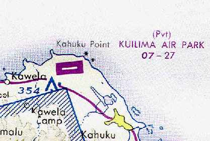
At some point between 1971-77 the former Kahuku Point airfield was apparently reused as a private civil airfield,
as that is how "Kuilima Air Park" was depicted on the December 1977 Hawaiian Islands Sectional Chart (courtesy of Chris Kennedy).
It was depicted as having a single 2,700' hard-surface runway.
Bob Gould recalled, “I've landed on one of the old abandoned runways at Kahuku Airfield in a Cherokee 6.
That was in the mid-1970s.”
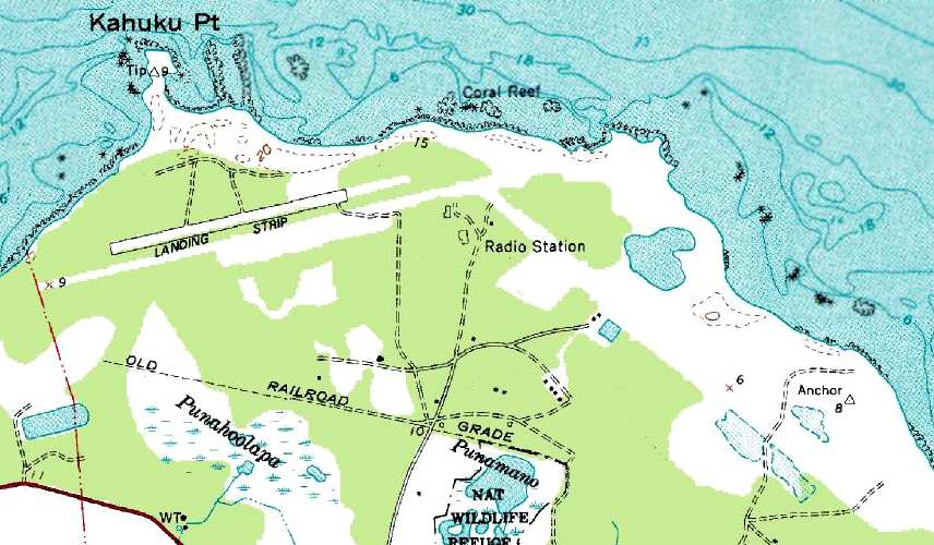
The 1983 USGS topo map depicted a single 2,800' runway
at the location of the former Kahuku Point Airfield, labeled simply "Landing Strip".
However, it also depicted much longer (5,200') cleared area resembling another runway,
running south of the "Landing Strip" to the south.
At the site of the former Kahuku Golf Course Airfield, it depicted a 6,500' long cleared area, unlabeled.
At the site of the former Kahuku Village Airfield, it depicted the "Kahuku Golf Course".
Kuilima Air Park was evidently closed at some point between 1977-93,
as it was no longer depicted on the May 1993 Hawaiian Islands Sectional Chart (courtesy of Ron Plante).
The 2000 NOAA aerial view of the site of the former Kahuku Golf Course Airfield
shows that a considerable length of the asphalt runway remains intact.
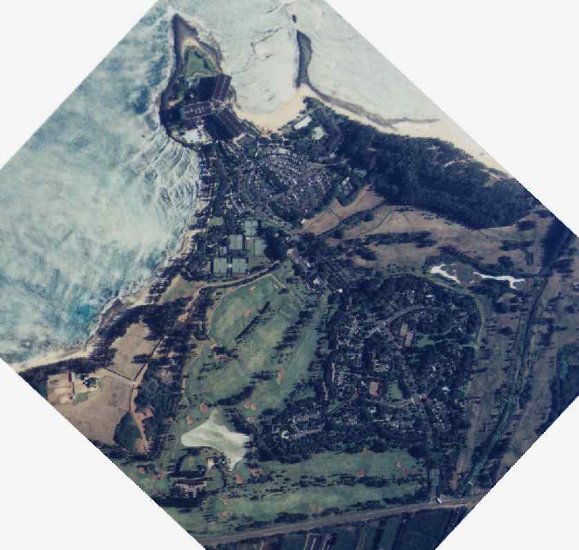
The 2000 NOAA aerial view of the site of the former Kahuku Point Airfield shows that it has been redeveloped as a hotel golf course,
and not a trace appeared to remain of the former runway.
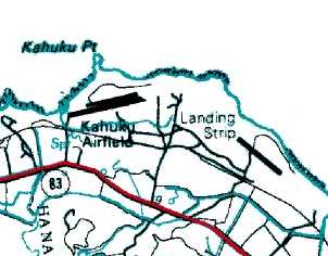
The 2001 USGS topo map depicted 2 parallel runways (2,800' & 4,200') at the site of the former Kahuku Point Airfield, labeled "Kahuku Airfield".
It depicted a single 2,800' runway at the site of the former Kahuku Golf Course Airfield, labeled "Landing Strip".
It did not depict anything at the site of the former Kahuku Village Airfield.
According to the Hawaiian Aviation History Pages, Kahuku Army Air Field is located just east of the Turtle Bay Hilton,
and the Hilton's golf course has absorbed most of one of the 2 runways.
That site also reported of "a rumor about it becoming a private airport to service the Polynesian Cultural Center for tourists from other islands."
CW2 Matt Hobbs (an Army Blackhawk pilot stationed at nearby Wheeler AAF) reported in 2004, "I fly over the old runway at Kahuku often.
It looks like there are the remnants of an old operations building or something."
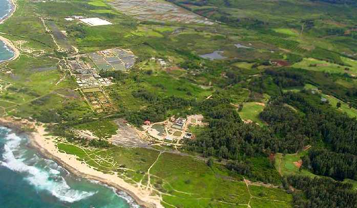
A 2004 aerial view looking southeast at the northwestern end of the former Kahuku Golf Course Airfield runway.
Ando Hiroshi reported in 2004, "The building where 2 runways merge is the original Marconi radio transmitter facility.
It's been long gone & they are building something new there.
Way back when, Marconi from Italy installed the first radio transmitter in the US with conjunction with RCA & they used to have a big antenna over there."
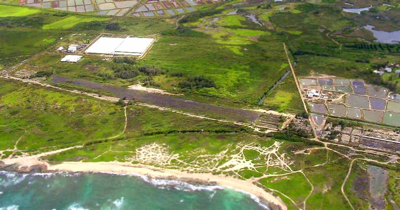
A 2004 aerial view looking south at the southeastern end of the former Kahuku Golf Course Airfield runway.
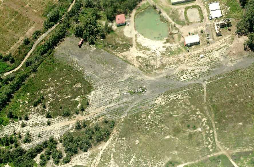
A circa 2007 aerial view looking south at the remains of the runway intersection at Kahuku.
Walter Dick reported in 2009, “The south end [of the former airfield property] is now a wildlife refuge.”
According to an article in the Spring 2001 AAHS Journal,
“The lands upon which Kahuku AAB once occupied are divided between a resort hotel & golf course, aquaculture farming,
ranching, and the 'James Campbell National Wildlife Refuge' with 2 units, Kii & Punamano.
Development of the hotel & golf course have almost obliterated all traces of the original NE/SW runway,
and aquaculture ponds cover a great portion of the NW/SE runway,
which is in an advanced state of abandonment & has been turned over to the stewardship
of the U.S. Fish & Wildlife Service as part of the Punamano Unit’s expansion.”
An 8/23/14 photo by Timothy Williamson of the ruins of the Marconi station buildngs at Kahuku.
An 8/23/14 photo by Timothy Williamson of the remains of the Kahuku runway.
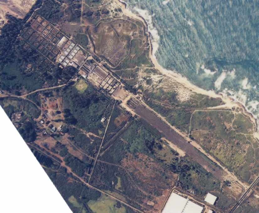
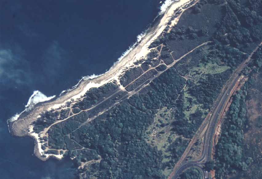
A 2019 aerial view shows remains still exist of both former Kahuku runways.
____________________________________________________
Haleiwa Fighter Strip / Haleiwa Airport, Haleiwa HI
21.6 North / 158.1 West (Northwest of Honolulu, HI)
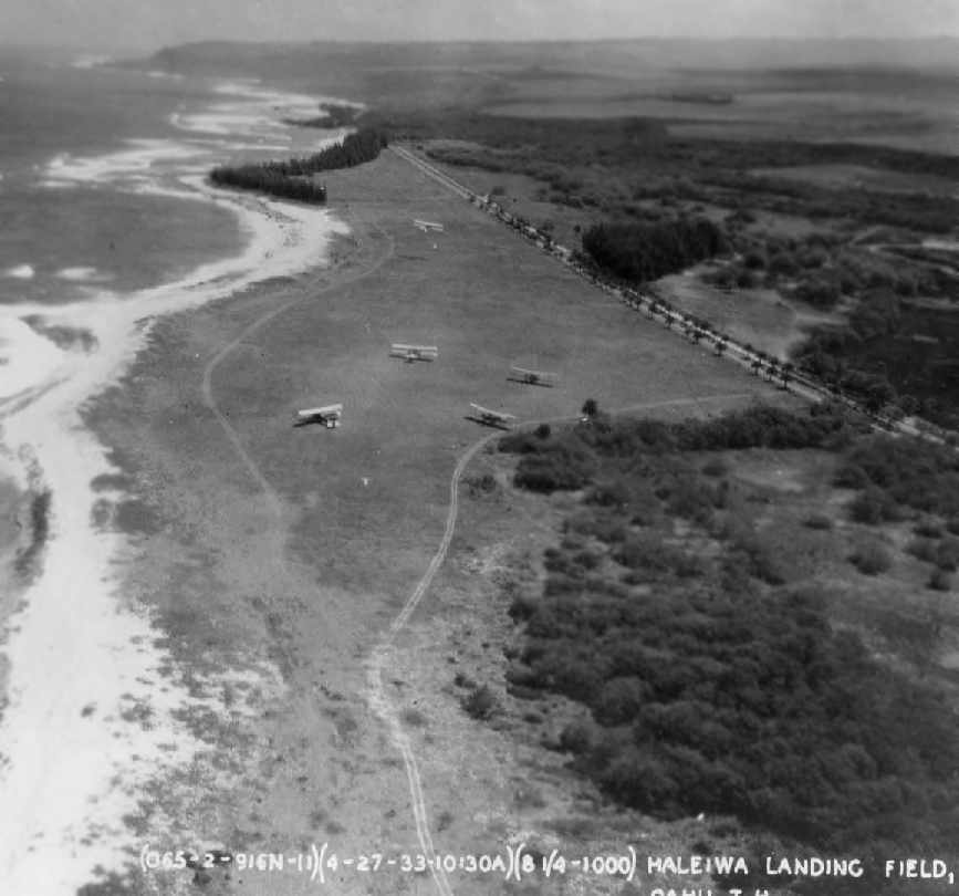
A 4/27/33 aerial view looking east at Haleiwa Airfield, (courtesy of the 15th Airlift Wing History Office, via Colin Perry of the Hawaii Aviation Preservation Society),
showing several B-6A biplanes on the field.
The date of construction of the Haleiwa airfield has not been determined.
The earliest depiction which has been located of the Haleiwa airfield was 4/27/33 aerial photo at the Hawaiian Aviation History Pages,
which depicted a group of B-6A biplanes on a modest grass field.
This obscure former military strip became famous as the only airfield from which American fighters
were able to launch to mount a defense against the Pearl Harbor Attack in 1941.
From the book "The Way It Was: Pearl Harbor, The Original Photographs" (via Tom Kramer):
"Bellows was palatial beside Haleiwa Field, which had no installations at all.
Originally used as an emergency landing field,
in 1941 it had only an unpaved landing strip & it was in use to simulate real battle conditions for gunnery training.
Those on temporary duty there had to bring their own tents & equipment.
On 7 December, the 47th Pursuit Squadron was at Haleiwa & there had its first taste of actual combat."
"The Americans took off - or tried to take off - in 3 distinct groups.
The most successful were 5 pilots from the 47th Pursuit Squadron who survived a wild ride in 2 separate cars up from Wheeler Field,
where they had spent the night, to Haleiwa Field, where their squadron was training.
Just enough aircraft were available - five P-40s & a P-36A. These 5 fliers accounted for as many as 7 aircraft.
The most successful, 2nd Lt. George Welch (4 victories), took off first & engaged the enemy over Ewa & Wahialua.
Taylor & Welch were both awarded the Distinguished Service Cross."
Walsh & Taylor's dramatic ride & takeoff was shown in "Tora, Tora, Tora",
though the strip used in the filming of that movie was up near Wheeler Field & surrounded by hills.
A 1942 aerial view looking west at Haleiwa Airfield (courtesy of the 15th Airlift Wing History Office, via Colin Perry of the Hawaii Aviation Preservation Society),
with P-40s visible parked on the field.
A 1942 aerial view of the Haleiwa Airfield (courtesy of the 15th Airlift Wing History Office, via Colin Perry of the Hawaii Aviation Preservation Society).
A WW2-era view of a P-40 fighter under camouflage netting at Haleiwa (courtesy of Ron Plante).
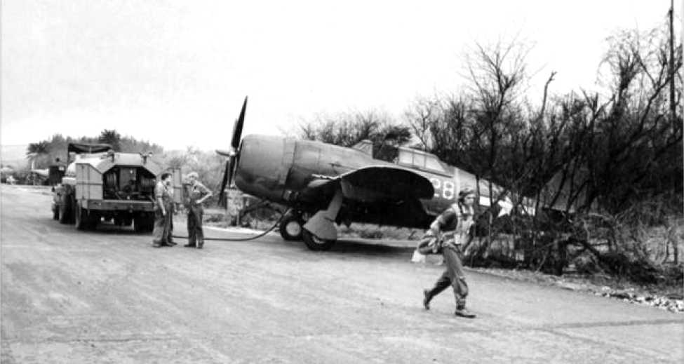
A WW2-era view of a P-47 Thunderbolt being refueled at Haleiwa (courtesy of Ron Plante).
A circa 1943-44 looking east at an A-24 & 2 PQ-8A target aircraft parked at Haleiwa.
Haleiwa Airfield, as depicted on the April 1945 V-450 Hawaiian Islands U.S. Navy Aviation Chart (courtesy of Chris Kennedy).
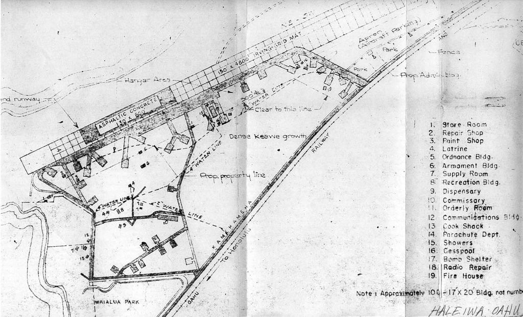
A 1946 plan depicted the Haleiwa airfield as having a single 4,400' “Irving-Grid Mat” runway, within which was a 800' “Asphaltic Concrete” inset.
The Haleiwa Airport was apparently reused after WW2 (at least for a brief period of time) as a civilian airport.
The only photo which has been located showing Haleiwa reused as a civilian airport was a July 1946 aerial view looking north (courtesy of John Voss),
which showed 9 light single-engine taildraggers (Piper Cubs?).
Q.R. Wood recalled, “I was a Pvt/Pfc in the USMC & arrived in Hawaii aboard the aircraft carrier Shangri La.
I think it was April or May 1946. I was stationed at MCAS Ewa for 2 years (almost to the day).
I spent most of my $75/90 a month to take flying lessons
from one of the flying services who had planes & buildings at the Haleiwa Airport.
As I remember it there were 7 Fixed Base Operations active during the time I was there.
I soloed there in a Piper J-3 Cub & went on to earn my Private Pilots license there too.”
"Haleiwa" was depicted as a civilian airport on the September 1947 Hawaiian Islands Sectional Chart,
which depicted Haleiwa as having a 4,800' paved runway.
Alan Rausch recalled, “My dad was an enlisted navy pilot during WWII (rare).
After the war he stayed in Hawaii, he met my mother a native from Haleiwa.
He taught flying at the Haleiwa airstrip, they had a restaurant there too, 'The Crash Inn'.
One day a plane did just that. My parents said they had the restaurant in 1947-48.
My dad taught for one of the flying schools from just after the war until about then.
My dad also said something about one of runways or part of one being metal not paved.”
The Haleiwa Airport was apparently abandoned at some point between 1948-50,
as it was no longer depicted on the August 1950 Hawaiian Islands Sectional Chart or the 1953 USGS topo map.
A 2/15/65 aerial view of the remains of the Haleiwa airfield (from the University of HI).
Former HI resident Tom Kramer reported, "The strip was made of concrete slabs when I saw it, as was the hardstand.
It did have some sort of control tower later on & the footers were there."
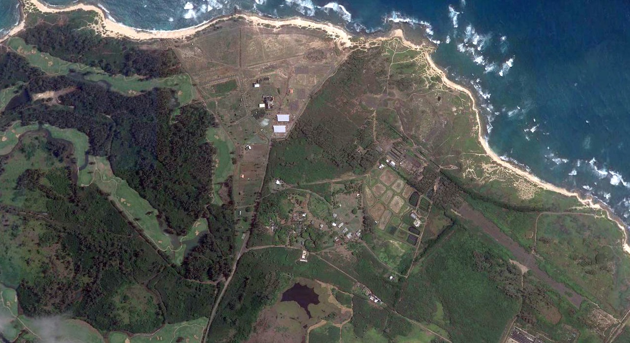
As seen in the 2000 NOAA aerial view,
the remains of the runway at Haleiwa are still recognizable.
A 2004 aerial view looking south at the former Haleiwa Fighter Strip runway.
In 2004 Marissa Guilford reported that the Hawaiian Historical Aviation Foundation
is proposing to preserve the Haleiwa Airfield & establish an air museum.
A 2005 photo by David Trojan of a building foundation which remains at the site of the Haleiwa Airfield
(courtesy of Colin Perry of the Hawaii Aviation Preservation Society).
A 2005 photo by David Trojan of the remains of asphalt runway pavement at the site of the Haleiwa Airfield
(courtesy of Colin Perry of the Hawaii Aviation Preservation Society).
A circa 2007 aerial view looking west at the remains of asphalt runway pavement at the site of the Haleiwa Airfield.
An 8/23/14 photo by Timothy Williamson looking southwest along the remains of the Haleiwa runway.
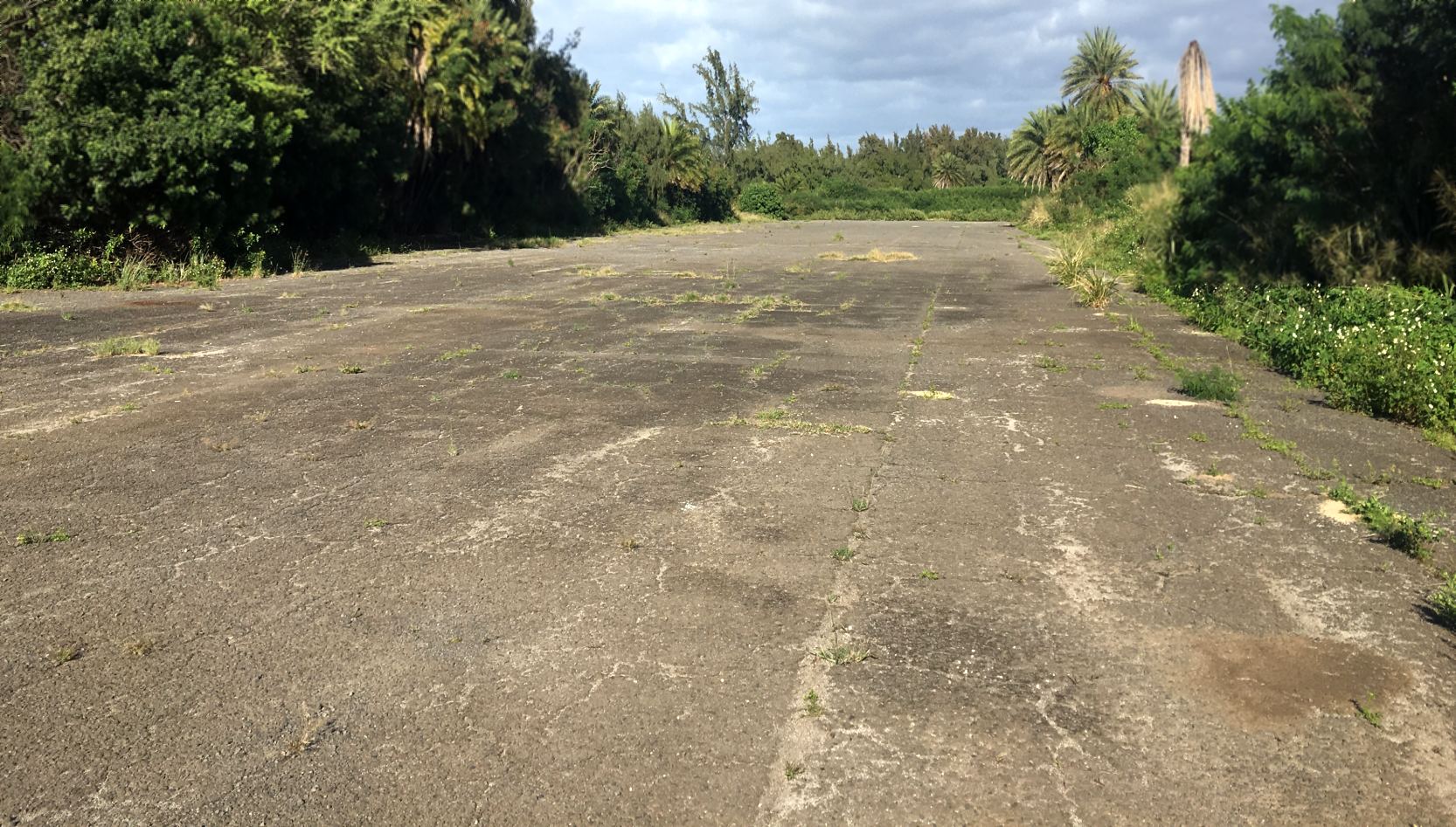
A 12/16/18 photo by Jake Moon looking along the remains of the Haleiwa runway.
Jake reported, “It looks to be in pretty much the same condition as in 2014. There were some construction barriers & a few pallets of wood that must’ve been put there recently.”
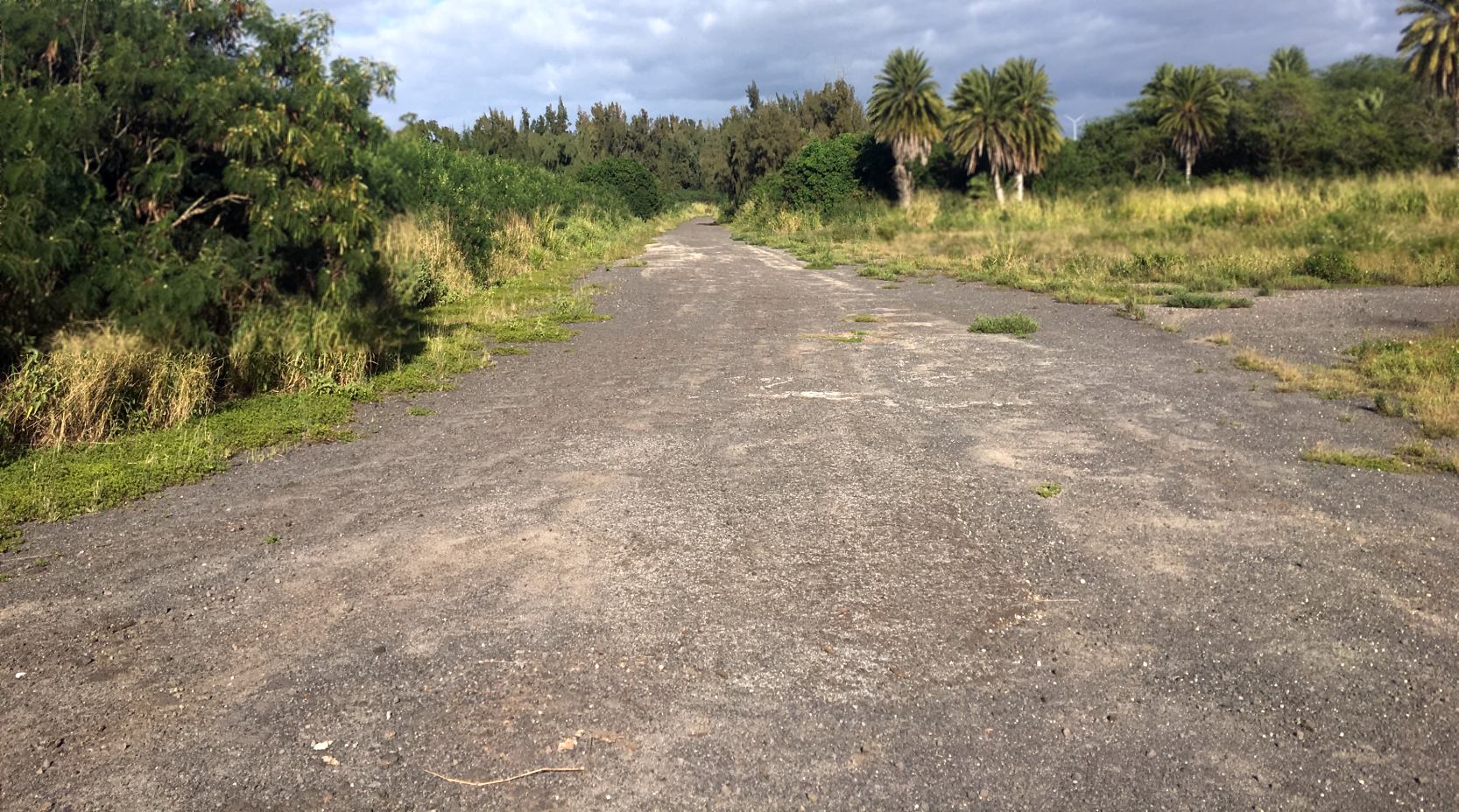
A 12/16/18 photo by Jake Moon looking along the remains of the Haleiwa runway.
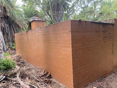
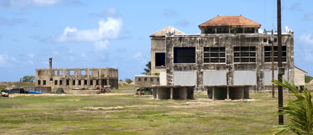
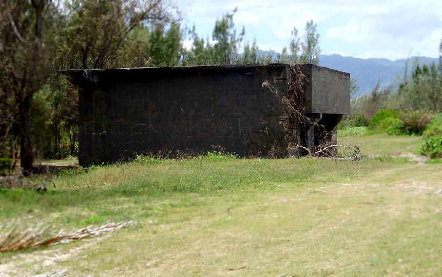
A 2023 photo by Bill Denne of “a large bunker” just inside the Haleiwa gate.
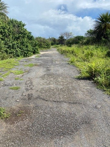
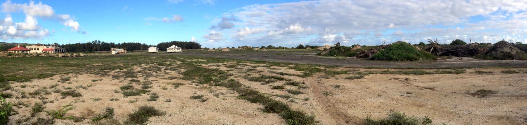
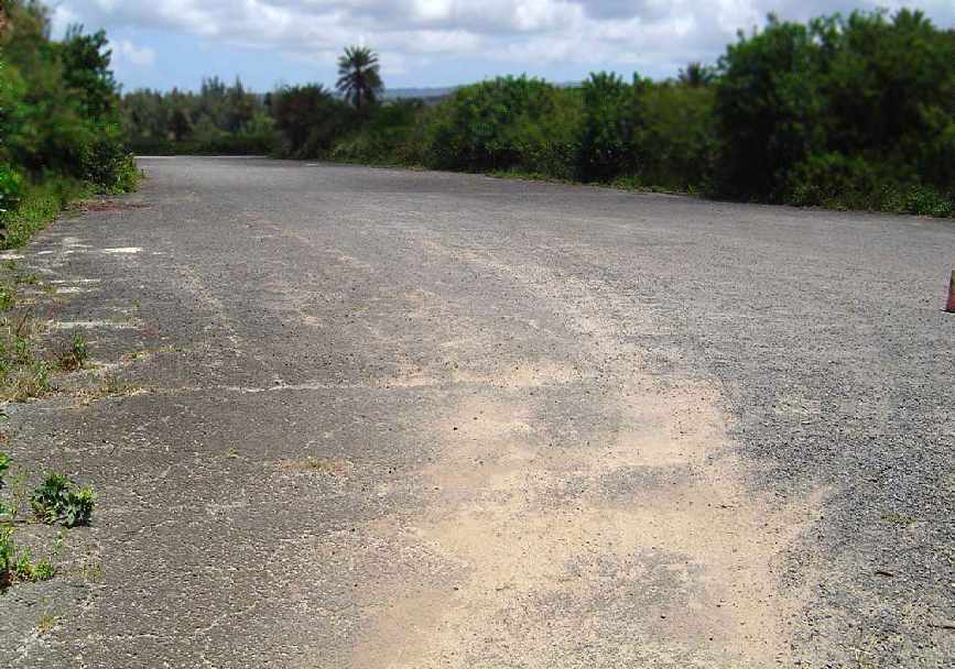
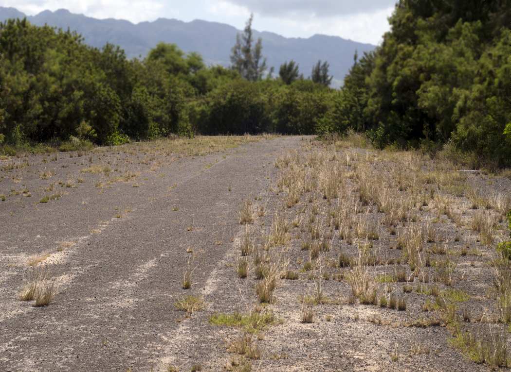
A 2023 photo by Bill Denne looking along the remains of the Haleiwa runway. Bill reported, “It is very overgrown & has homeless all over.”
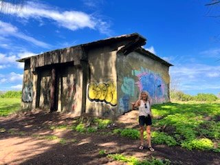
A 2023 photo by Bill Denne of one of the “Large bunkers / communications building with no entry doors on the beach north end” at the site of Haleiwa.
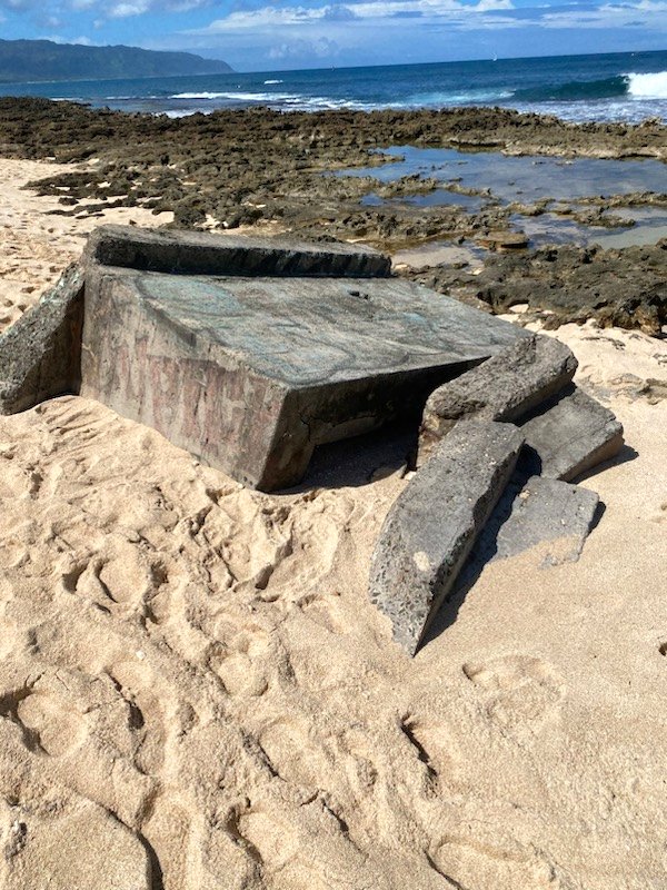
A 2023 photo by Bill Denne of what appears to be the remains of an pillbox on the beach adjacent to the Haleiwa airfield.
The site of the Haleiwa Fighter Strip is located north of the intersection of Route 83 & Kahalewai Place.
See also: "Where Were You in '42: A Guide to World War II Historical Sites in Hawaii."
____________________________________________________
Or if you prefer to contact me directly concerning a contribution (for a mailing address to send a check),
please contact me at: paulandterryfreeman@gmail.com
If you enjoy this web site, please support it with a financial contribution.
____________________________________________________
This site covers airfields in all 50 states.