Abandoned & Little-Known Airfields:
Hawaii, Southern Oahu Island
© 2001, © 2025 by Paul Freeman. Revised 10/31/25.
This site covers airfields in all 50 states: Click here for the site's main menu.
____________________________________________________
Please consider a financial contribution to support the continued growth & operation of this site.
Bellows Field / Bellows AFS (revised 12/18/23) - Kipapa Field (revised 8/2/24) - Luke Field / NAS Pearl Harbor / Ford Island NALF (revised 10/31/25)
MCAS Ewa (revised 10/31/25) - Murray-Air Kapolei Airfield (revised 4/18/15) - Waipio Peninsula Naval Reservation Airfield (added 11/17/17)
___________________________________________________
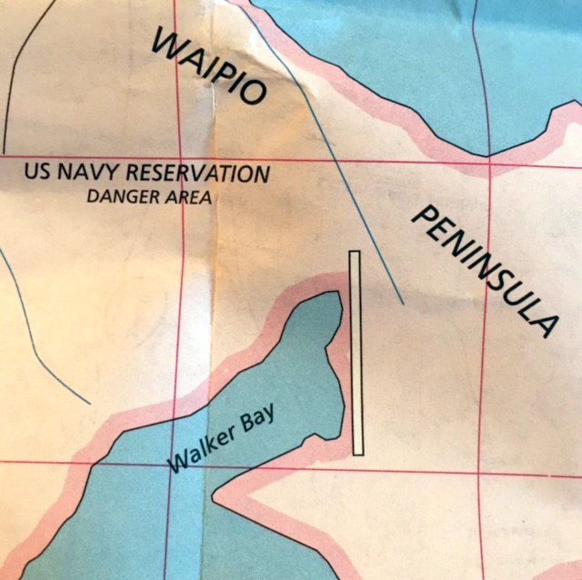
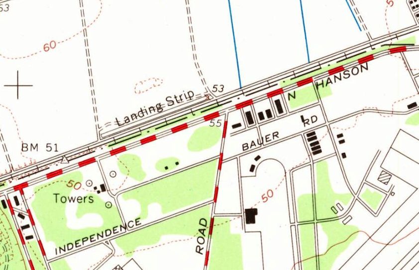
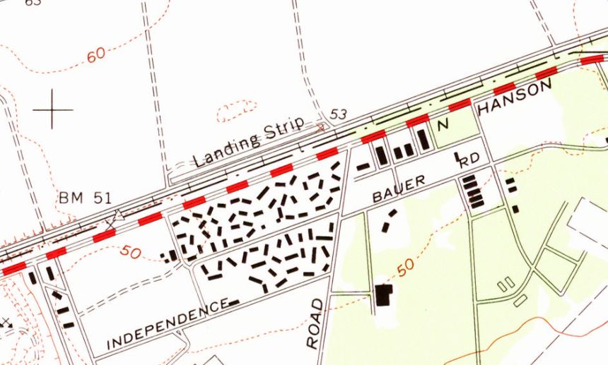
Waipio Peninsula Naval Reservation Airfield, Waipio Peninsula, HI
21.361, -157.987 (West of Honolulu, HI)
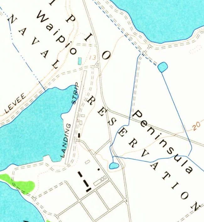
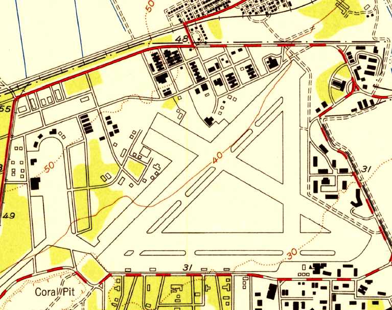
The Waipio Peninsula Naval Reservation Airfield, as depicted on the 1956 USGS topo map.
Photo of the airfield while in use has not been located.
The date of construction or purpose of this small airfield to the west of Pearl Harbor has not been determined.
According to the Library of Congress, “Waipio Peninsula was an active part of the Pearl Harbor Naval Base during WWII.
The activities that took place here were important to the success of the war efforts in the Pacific.
All the Navy functions on Waipio Peninsula contributed to victory, but the Amphibious Operating Base was the most directly involved in the Pacific island-hopping campaigns that helped win the war.
Almost all of the structures built on Waipio Peninsula during the early 1940s were temporary structures, such as tents, Quonset huts, and wooden warehouses.”
The Waipio Peninsula Naval Reservation Airfield was not yet depicted on the 1953 USGS topo map.
The earliest depiction which has been located of the Waipio Peninsula Naval Reservation Airfield was on the 1956 USGS topo map.
It depicted a single northeast/southwest runway directly along the eastern shore of the water, labeled simply as “Landing Strip”.
Three small buildings were depicted on the east side of the runway.
The Waipio Peninsula Naval Reservation Airfield was not depicted at all on the November 1957 Honolulu Sectional Chart (or later aeronautical charts).
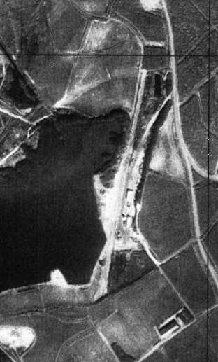
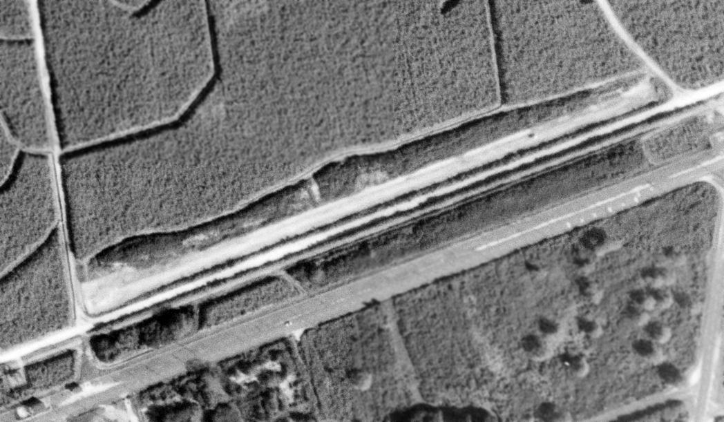
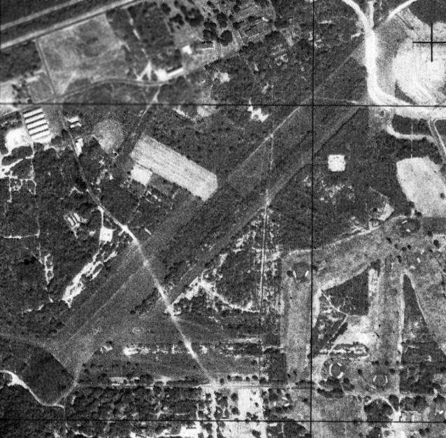
The earliest photo which has been located of the Waipio Peninsula Naval Reservation Airfield was a 1976-78 USGS aerial view.
It depicted a single northeast/southwest runway directly along the eastern shore of the water, and a few small buildings on the east side of the runway.
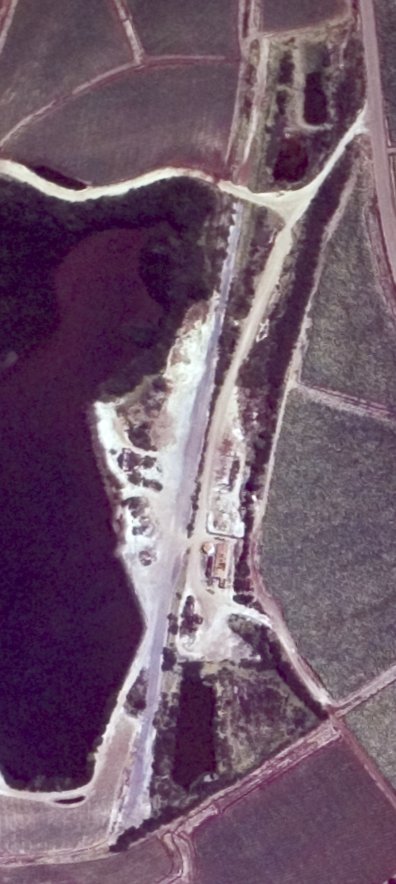
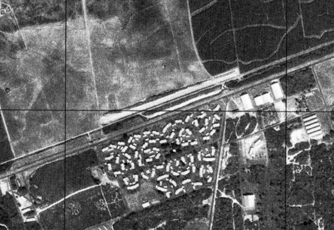
A 1985 USGS aerial view showed the Waipio Peninsula Naval Reservation Airfield's paved runway remained recognizable.
A 1998-99 road map (courtesy of Kevin Walsh) depicted the Waipio Peninsula Naval Reservation Airfield's runway, but without any label.

A 2013 aerial view looking northwest at the site of the Waipio Peninsula Naval Reservation Airfield showed a dramatic difference since 1985, with the airfield being very overgrown & barely recognizable.
Thanks to Kevin Walsh for pointing out this airfield.
____________________________________________________
Murray-Air Kapolei Airfield, Kapolei, HI
21.33, -158.06 (West of Honolulu, HI)
The earliest depiction which has been located of Murray-Air Kapolei Airfield was on the 1968 USGS topo map.
Not much is known about this former cropduster airfield, including its name or date of construction.
The Murray-Air Kapolei Airfield was evidently constructed at some point between 1962-68,
as it was not yet depicted on a 1962 USGS aerial photo, the December 1968 Hawaiian Islands Sectional Chart, or later aeronautical charts.
The earliest depiction which has been located of the Murray-Air Kapolei Airfield was on a 1968 USGS topo map,
which depicted a single northeast/southwest runway located directly adjacent to the north side of Roosevelt Avenue,
less than a half-mile northeast of NAS Barbers Point & a half-mile northwest of MCAS Ewa.
The runway was labeled simply as “Landing Strip”.
The earliest photo which has been located of the Murray-Air Kapolei Airfield was a 2/6/68 USGS aerial view.
which depicted a single northeast/southwest runway located directly adjacent to the north side of Roosevelt Avenue.
The last photo which has been located of the Murray-Air Kapolei Airfield was a 1977 USGS aerial view.
Alan Miller recalled, “The field shown as Kapolei Airfield was a cropduster strip for Murray-Air.
I flew out of the Navy flying club at Barbers Point, we did not use the Kapolei field.
There were still a few cropdusters out of there in 1978.”
The last depiction which has been located of the Murray-Air Kapolei Airfield was on the 1983 USGS topo map,
which still labeled it as “Landing Strip”.
The Murray-Air Kapolei runway was not depicted on the 1998 USGS topo map.
A 2001 USGS aerial view no longer depicted any trace of the Murray-Air Kapolei runway, with the property having been cleared.
A 2013 aerial photo showed no trace remaining of Murray-Air Kapolei Airfield, with the property having been covered by houses.
The site of Murray-Air Kapolei Airfield is located northwest of the intersection of Roosevelt Avenue & Coral Sea Road.
____________________________________________________
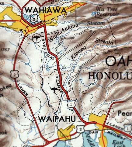
Naval Air Station Kipapa Field / Kipapa Army Airfield, Kipapa, HI
21.44, -158.02 (Northwest of Honolulu, HI)

A July 1942 aerial view of a Douglas C-47 dropping paratroopers over Kipapa Field (courtesy of Tracy White).
A careful survey was made of the entire Island of Oahu in 1940 for sites on which landing fields could be constructed.
With the exception of the Kipapa Gulch area, all level ground that might be available for airfields was either so occupied,
projects were underway for preparation of airfields, or the turbulence in the air created by the close proximity of mountain ranges precluded such development.
The Kipapa Gulch area was the only site remaining where an airfield could be constructed.
The site commonly referred to as the Kipapa Gulch area was selected because it could accommodate two 5,000' runways free from obstructions.
But 2 reasons precluded the use of the area initially.
First was that it was located about 2/3 of the distance between Pearl Harbor & Wheeler Field
which would further increase the congestion of the air over that part of the island.
Secondly, it would remove from cultivation a highly productive tract of land.
The principal objection to the use of this site, which was congestion of the air over the Pearl Harbor area,
was much less of a handicap because the site was proposed for use by the Navy for the training of carrier groups rather than as a station for Army pursuit aviation.
The use of this site by the Navy would permit the concentration of carrier-group training for Naval aviation
on the south side of the island of Oahu including Barber's Point, Kipapa Gulch, and Ford Island.
As the training from these stations would be entirely under Naval control
it lent itself to aerial traffic regulations which would be difficult to attain if large numbers of airplanes of the 2 services were intermingled.
The Kipapa Gulch area was advantageously located for occupancy of carrier-group aviation
in that the site was readily accessible to the parent vessels of the carrier groups.
It facilitated in the transfer of personnel & supplies to & from the parent vessels in Pearl Harbor.
Lastly, It was advantageous in making for ease of supervision of the training of all carrier-based Naval aviation.
But it was not until some time after the United States entered World War II that Kipapa Airfield was developed.
The date of construction of the Kipapa airfield has not been determined.
The earliest depiction which has been located of Kipapa Field was a July 1942 aerial view of a Douglas C-47 dropping paratroopers (courtesy of Tracy White),
showing Kipapa Field to have 3 paved runways.
The earliest map depiction which has been located of Kipapa Field was on a 1943 Army Airfield map, but it misspelled the field as “Kapapa”.
Kipapa means “Paving the Way” in Hawaiian. This airfield served to pave the way for many military units going overseas.
A World War II veteran said the place was just cut out of the sugarcane patch.
During the war it apparently saw little use by the Navy due to the fact that carrier aircraft were constantly deployed during the war.
The Army Air Corps became the principal user of the airfield by default.
Kipapa Field was a major transiting point for units going overseas.
Aircraft from this airfield searched & patrolled over the surrounding Pacific area, maintaining a 24-hour vigil to avert any attack.
A large number & variety of squadrons are documented to have been stationed at Kipapa Airfield during World War II.
The 5th Bombardment Group, 31st Bombardment Squadron, transferred from Hickam Field to Kipapa Field
with B-17s & B-18s on 5/23/42 until 9/9/42 when they moved to Kualoa Airfield.
The HQ 90th Bombardment Group, 321st Bombardment Squadron arrived at Kipapa Airfield on 9/12/42
from the mainland United States with B-24s & began flying their first missions by November 1942.
The 13th Air Force, 307th Bombardment Group, 370th Bombardment Squadron arrived at Kipapa Field
on 11/2/42 from the mainland United States with B-24s & flew sea-search missions between November-December 1942.
The 18th Fighter Group, 6th Fighter Squadron, moved from Kahuku Airfield to Kipapa Airfield with P-70s on 11/17/42.
The 28th Photographic Reconnaissance Squadron, 7th Air Force (attached to VII Fighter Command),
flying F-5s was based at Kipapa Airfield in July 1944.
The 38th Bomb Group, 70th Bombardment Squadron, equipped with Martin B-26 Marauders
was kept on alert with 500-pound bombs at Kipapa Field during the time that the Battle of Midway was in progress.
Other units that spent time at Kipapa Airfield included: The 302nd Fighter Control Squadron October 1944;
the 318th Fighter Group, 19th Fighter Squadron 5/30/43, flying P-40s; the 92nd Air Refueling Squadron 3/18/45, flying B-24 Liberators;
the 45th Airlift Squadron 9/9/45; the 4th Emergency Rescue Squadron June 1944;
and the 7th Air Force, 549th Combat Training Squadron 10/20/44-2/19/45,
flying P-61 Black Widow night fighters performing training & defense duties.
Many other different types of aircraft used Kipapa Field during World War II including:
P-40B, P-40F, P-70, P-61A, P-61B, and C-46D, because all were involved in accidents in the area.
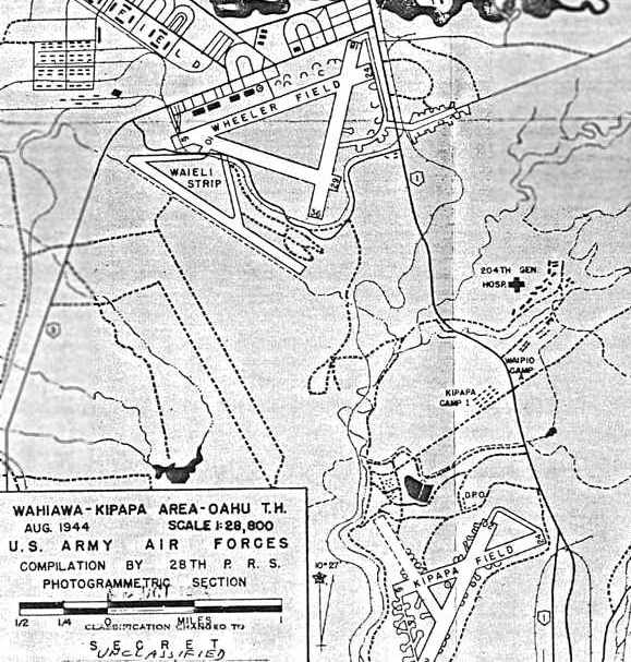
An August 1944 Army Air Forces map depicted Kipapa Field as having 3 paved runways,
with numerous aircraft dispersal pads surrounding the runways.
No buildings were depicted on the field. Note also the proximity of Wheeler Field @ Waieli Strip to the north.
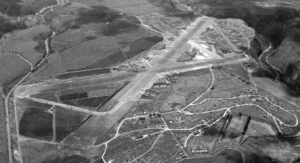
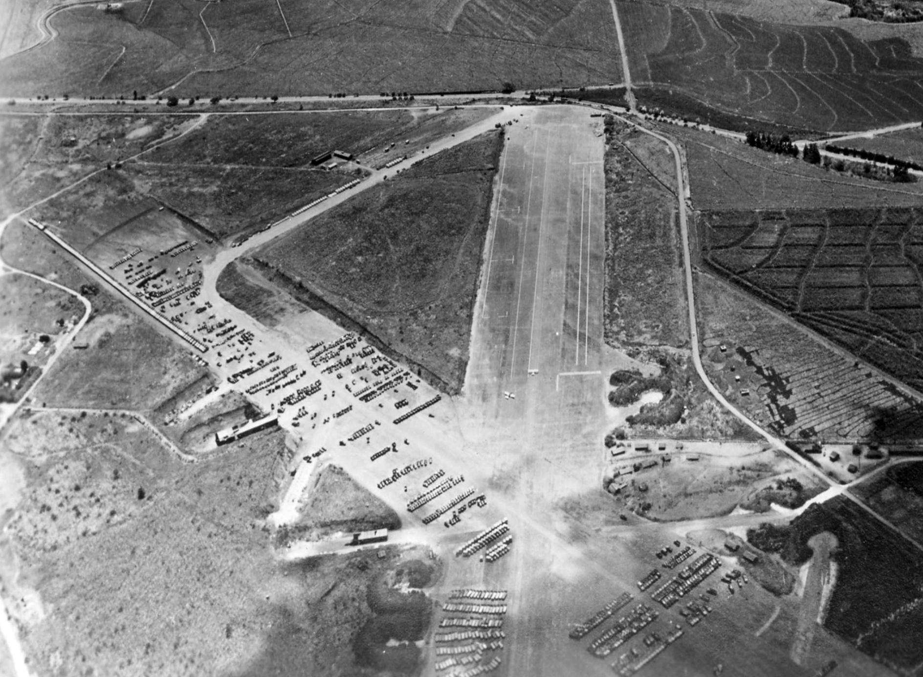
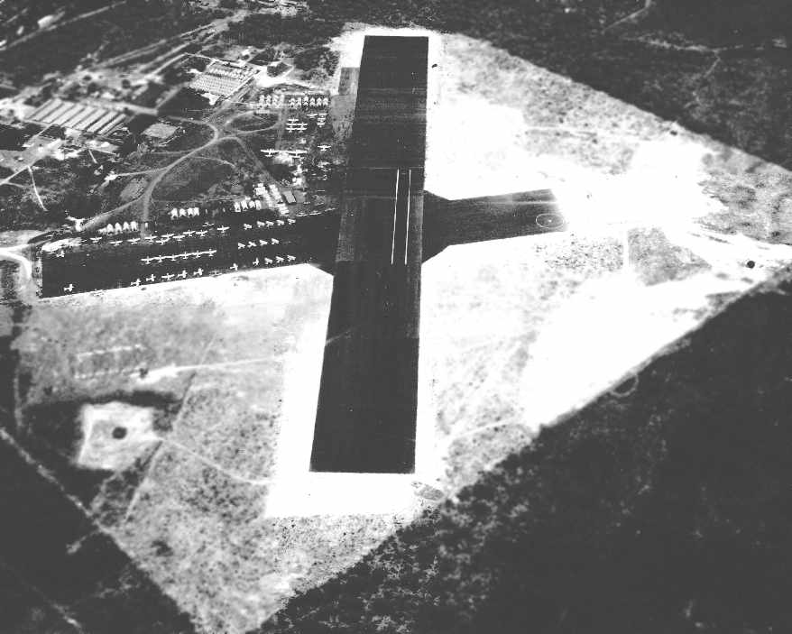
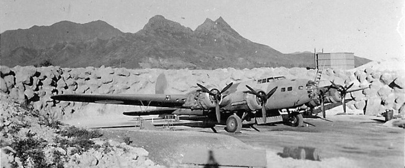
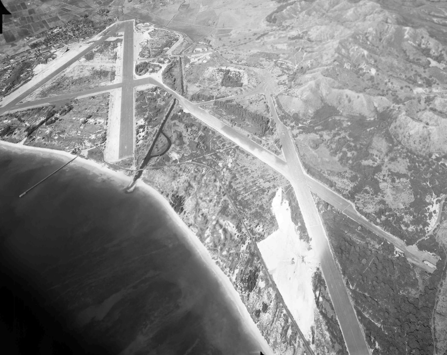
A 9/17/44 U.S. Navy aerial view looking south (courtesy of Brian Rehwinkel) depicted Kipapa Field as having 2 paved runways, with several hardened aircraft parking revetments along either side of the longest runway.
Note also the sharp drop-off of the gulch right at the far end of both runways. Brian observed, “This photo has a subject title of 'NAS Kipapa Field, Oahu, T.H.'”
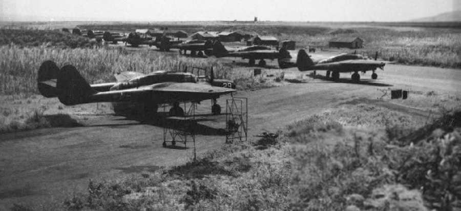
A 1945 photo of numerous Northrop P-61 Black Widow night fighters at Kipapa Field.
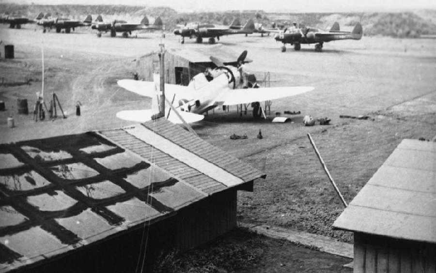
A 1945 photo of a Republic P-47 Thunderbolt undergoing maintenance at Kipapa Field, with a row of Northrop P-61 Black Widows in the background.
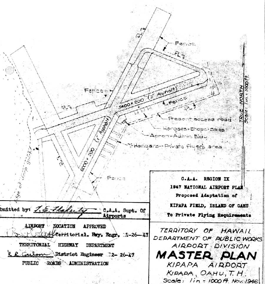
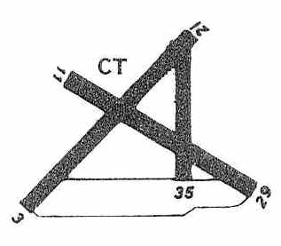
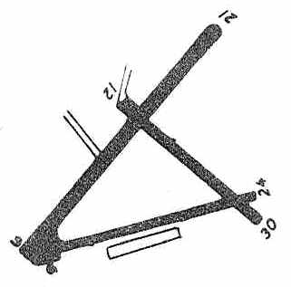
A 1947 CAA plan of a “Proposed adaption of Kipapa Field to private flying requirements”.
It depicted a 6,000' asphalt northeast/southwest runway & a 5,400' east/west runway, as well as a apron, administration building, and T-hangars.
The 3rd runway would have been partially reused as a taxiway.
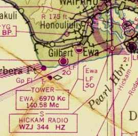
The September 1947 Hawaiian Islands Sectional Chart depicted Kipapa Field as a closed airfield having a 6,000' paved runway.
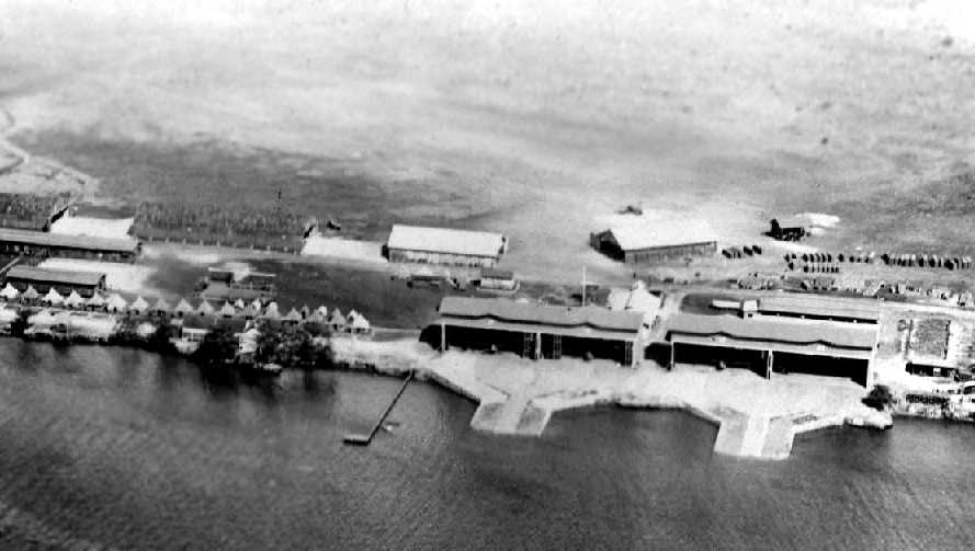
A 1948 aerial view looking east at Kipapa Field (from the Digital Archives of Hawaiʻi), showing 2 civilian single-engine general aviation aircraft on a portion of the east/west runway,
while numerous objects (military?) were stored on the northeast/southwest runway.
The August 1950 Hawaiian Islands Sectional Chart depicted Kipapa Field as a civilian airfield with a 2,900' paved runway.
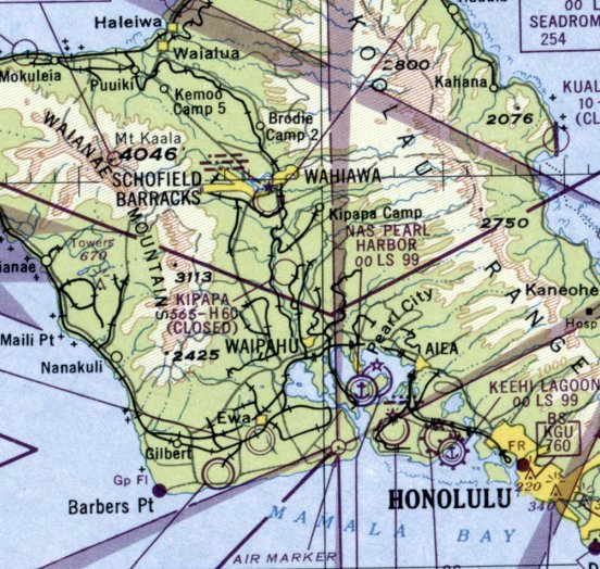
Kipapa Field was still depicted on the 1951 USGS topo map.
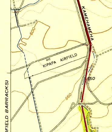
The 1954 USGS topo map only depicted “Kipapa Airfield” as occupying a small minority of the former airfield: just the northeastern half of the northeast/southwest runway.
The 1956 Hawaiian Islands Sectional Chart (courtesy of Kevin Walsh) depicted Kipapa Field as having a single northeast/southwest 1,700' paved runway.
A 1/19/59 aerial view looking northwest at Kipapa Field (from the University of HI) showed several light aircraft & small hangars along a short portion of the east/west runway.
It appears as if the former northeast/southwest runway pavement had been removed.
The last aeronautical chart depiction which has been located of Kipapa Field was on the November 1960 Hawaiian Islands Sectional Chart.
Only a short portion of Kipapa's runway was being reused, as it depicted Kipapa as having a mere 1,600' paved runway.
Kipapa Field was evidently closed (for reasons unknown) at some point between 1960-61,
as it was no longer depicted on the 1961 Honolulu Sectional Chart.
A 1961 Oahu Urban Usage Map still depicted the intersecting runways & identified it as Kipapa Airfield,
but that doesn't indicate the field was still open at that point.
A December 1962 aerial photo showed that only a small portion of Kipapa's east/west runway pavement remained intact,
but there was no sign of any recent aviation use.
According to Leslie Munro, “The Kipapa air strip was still in limited (civilian ?) use into the 1960s.”
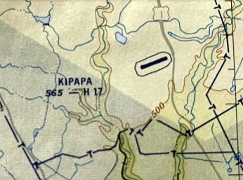
A 1967 water supply geological survey map listed Kipapa Airfield but had no other information.
The 1968 USGS topo map no longer depicted any trace of the Kipapa runways.
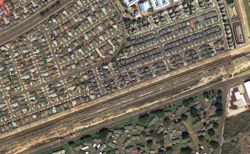
Unfortunately Kipapa Field's central location & level area made it ideal for redevelopment,
and the property became a Mililani Town housing development.
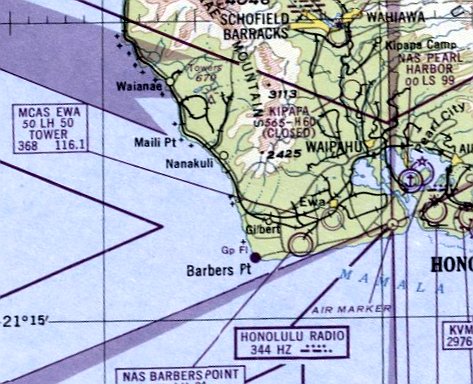
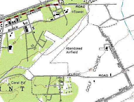
The airfield site is located south the Mililani Golf Course between Meheula Parkway & Hokuala Streets.
Mililani District Park is located near the intersection of the 2 main runways;
unfortunately, there are no indications of the site's military history.
The residents in the area would be surprised to learn that they now live on the site of an historic World War II airfield.
A 2000 USGS aerial view showed no trace remaining of Kipapa Airfield.
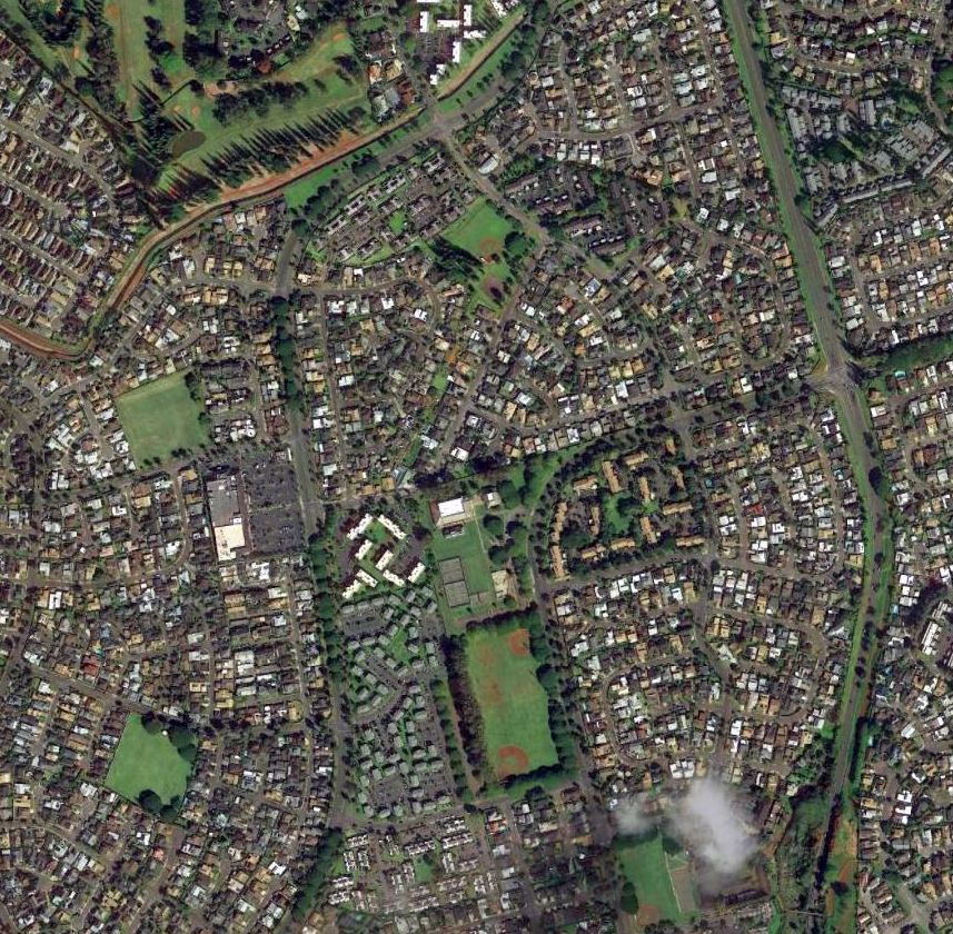
A 2013 aerial photo showed that no trace remains of Kipapa Field.
____________________________________________________
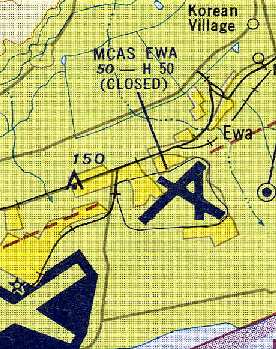
Ewa Marine Corps Air Station, Ewa, HI
21.33, -158.05 (West of Honolulu, HI)

A 1938 aerial view of a Boeing Clipper flying boat overflying the Ewa mooring mast.
The Navy secured a lease to a 700 acre tract at Ewa in the early 1930s.
There it built a dirigible mooring mast & a 1,500' oil-surfaced emergency landing field.
The earliest depiction which has been located of Ewa Field was a 1938 aerial view of a Boeing Clipper flying boat overflying Ewa,
showing a mooring mast within a circular clearing.
After the last of the Navy dirigibles were phased out (or destroyed), Ewa was made available for Marine Corps aircraft use in 1939.
The Navy purchased an additional 3,500 acres for Ewa in 1940.

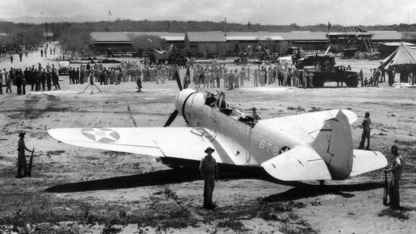
A circa 1941 National Archives photo of a Vought SB2U-3 Vindicator of VMS-2 engaged in a "Bounce Drill" (field carrier landing practice) at Ewa Field.
The Group landing signal officer in the foreground was First Lieutenant Robert Galer, later awarded a Medal of Honor at Guadalcanal.
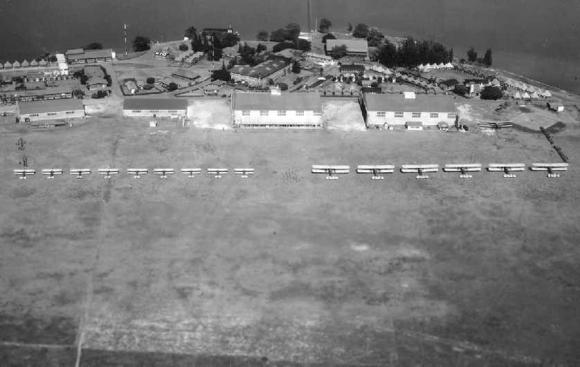
A September 1941 aerial view looking southwest at Ewa Field (courtesy of Colin Perry of the Hawaii Aviation Preservation Society).
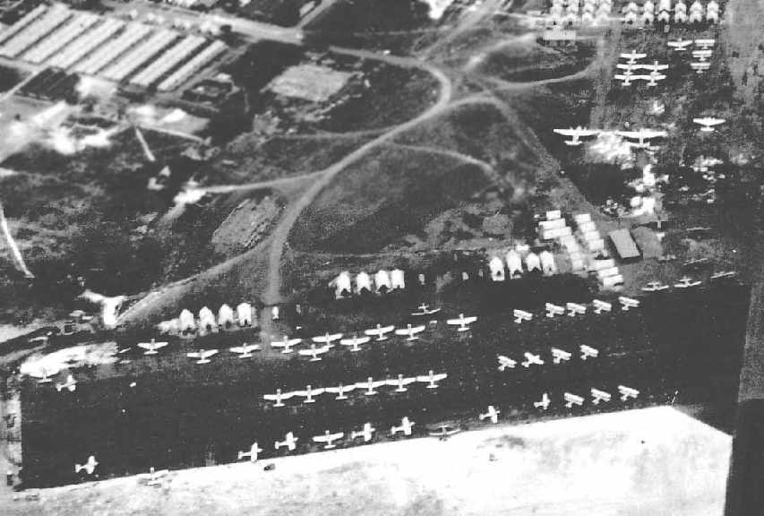
A close-up from the September 1941 aerial view of Ewa Field, showing a large number of single-engine & twin-engine aircraft, monoplanes & biplanes
(courtesy of Colin Perry of the Hawaii Aviation Preservation Society).
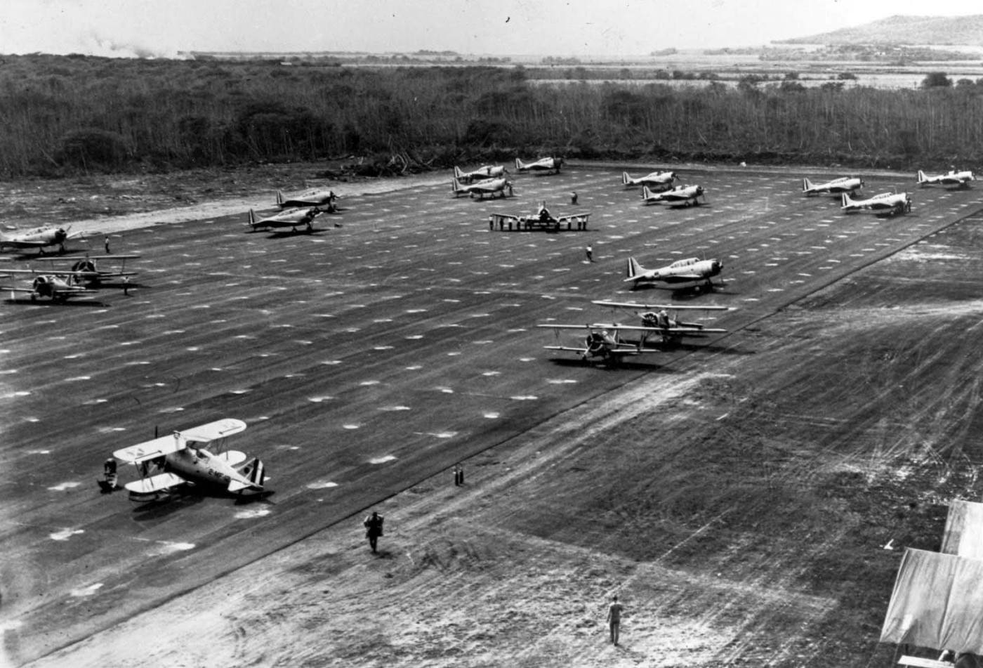
A 1941 aerial view of a variety of biplanes & monoplanes at Ewa Field (courtesy of John Voss).
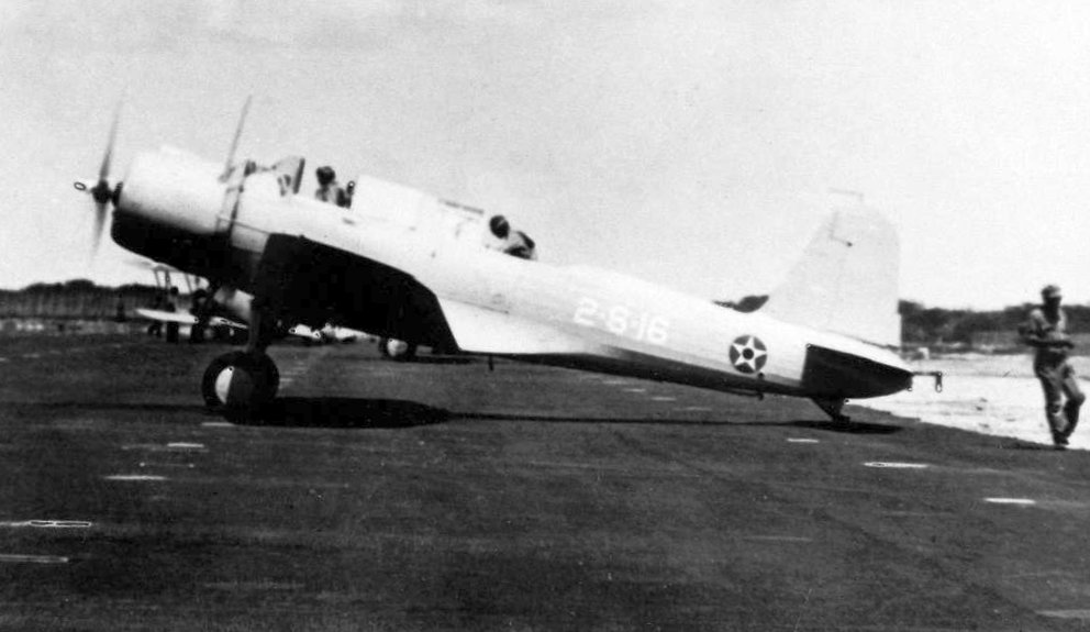
A 1941 USN photo of a Marine Corps Vought SB2U-3 Vindicator of Marine Scouting Squadron 2 (VMS-2) in pre-WW2 markings at Marine Corps Air Station Ewa.
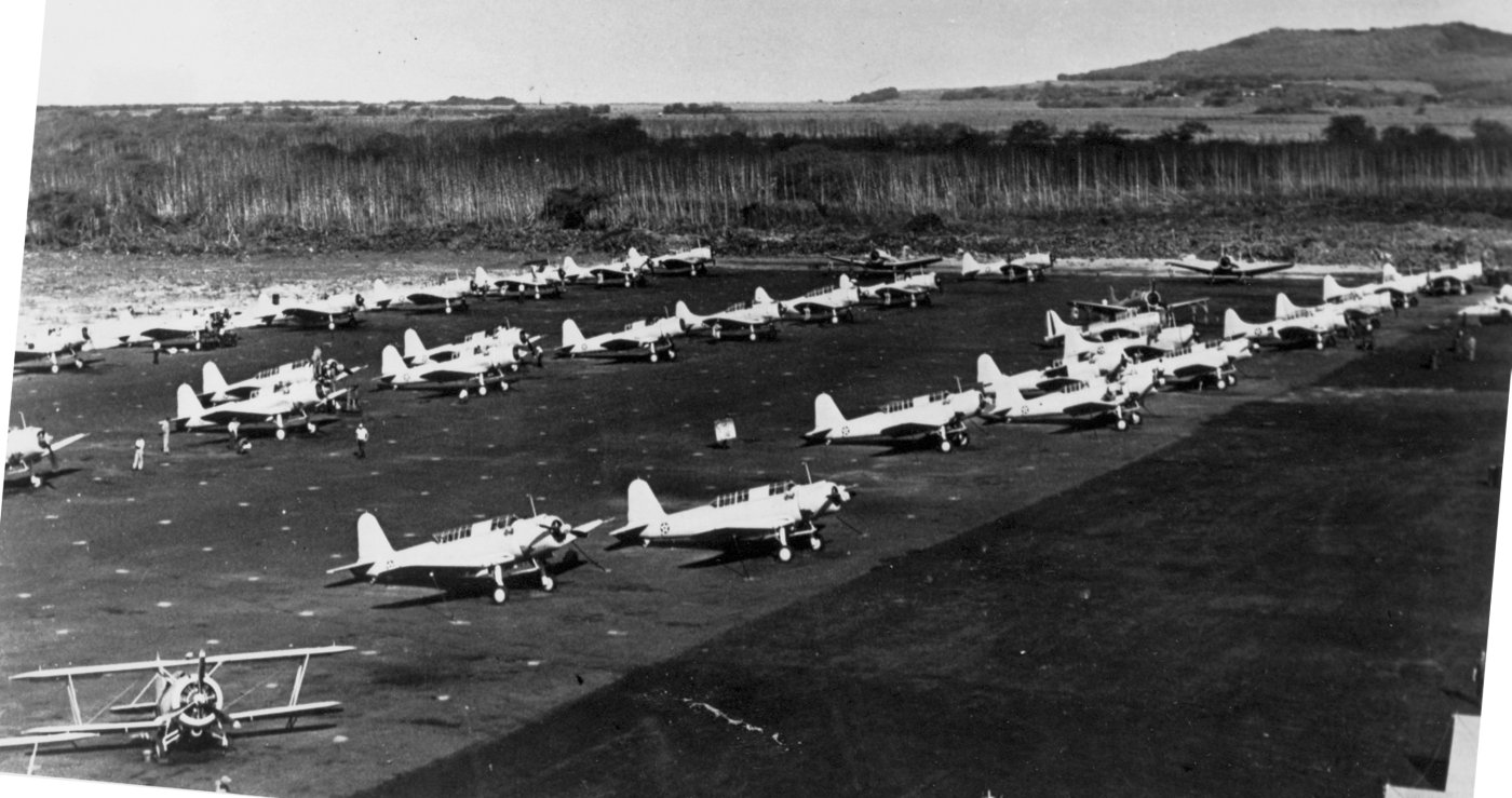
A circa 1941 aerial view of a TBD Devastator torpedo bombers & other aircraft at Ewa Field (courtesy of John Voss).
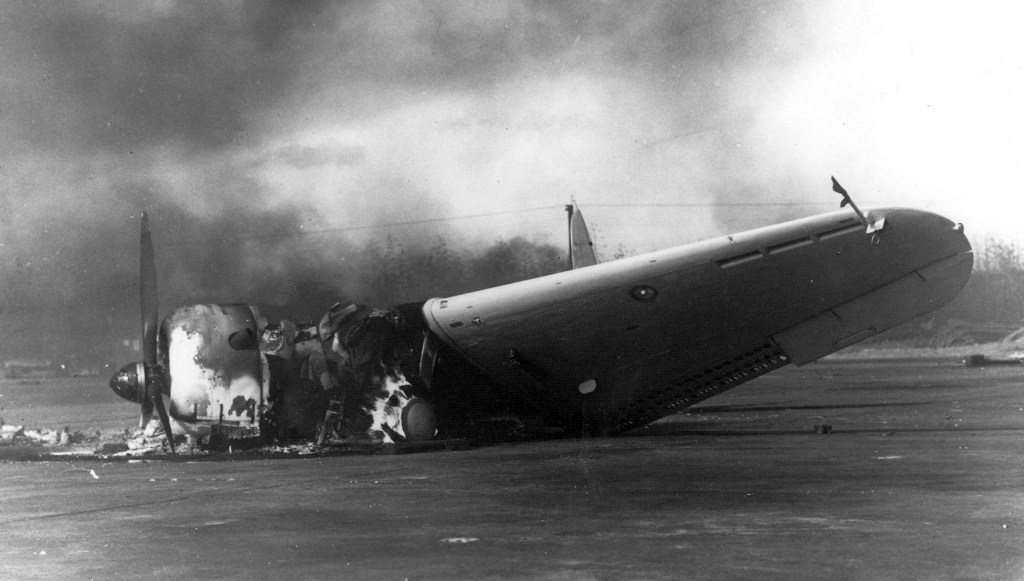
The burning wreckage of a Marine Corps Douglas SBD Dauntless dive bomber pictured at Ewa Mooring Mast Field after the Japanese attack on 12/7/41.
On 12/7/41, Japanese aircraft struck Ewa before hitting Pearl Harbor.
All Marine Corps aircraft at Ewa (a total of 48) were destroyed in the course of the attack.
By the time of the Pearl Harbor attack,
a total of 4 runways had been constructed at Ewa, along with buildings & hangars.
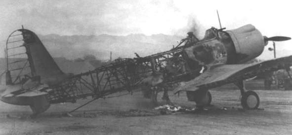
Marine guards posted around a damaged TBD Devastator torpedo bomber at Ewa Field (courtesy of John Voss).
According to John Bennett of the Coast Defense Study Group, “The aircraft was plane #8 of Squadron VT-6 (Torpedo 6) assigned to the U.S.S. Enterprise,
and it was involved in a mid-air collision with another Torpedo 6 TBD off the coast of southwest Oahu prior to the Japanese attack on Pearl Harbor.
The landed at Camp Malakole near Barbers Point & was being guarded by members of the federalized 251st Coast Artillery (AA) Regiment of the California National Guard.
The downed plane was towed to Ewa Field from Camp Malakole.”
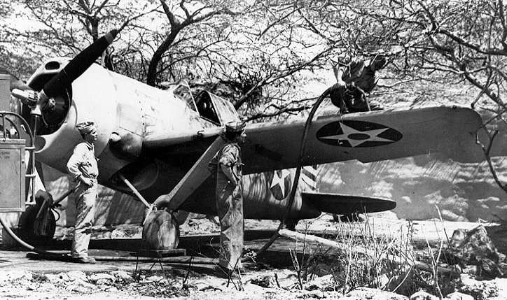
Fueling a F2A-3 Brewster Buffalo in a camouflaged revetment at Ewa in 1942.
An undated aerial view looking east at Ewa Field, “released 12/10/42” (courtesy of John Voss),
showed the field to have 4 paved runways.
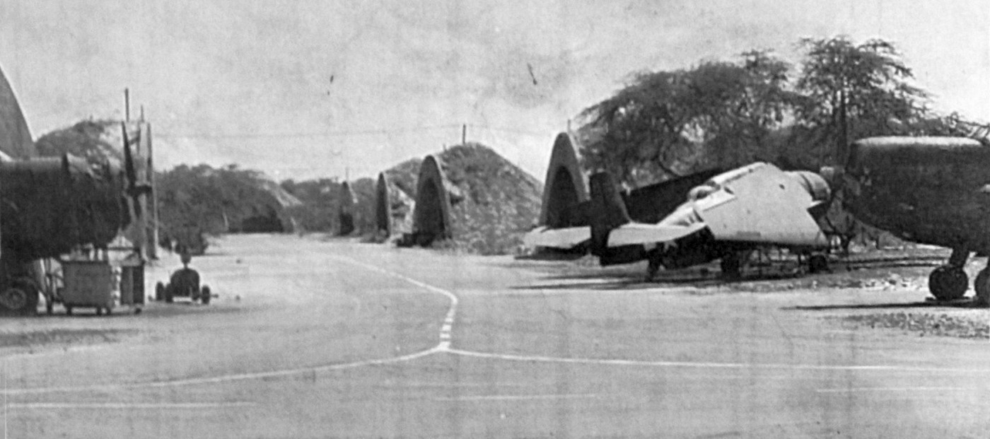
A WW2 photo of Grumman TBF Avengers parked in concrete revetment hangars at Ewa (courtesy of John Voss).
Throughout the course of WW2, Ewa served as a staging base & a training facility.
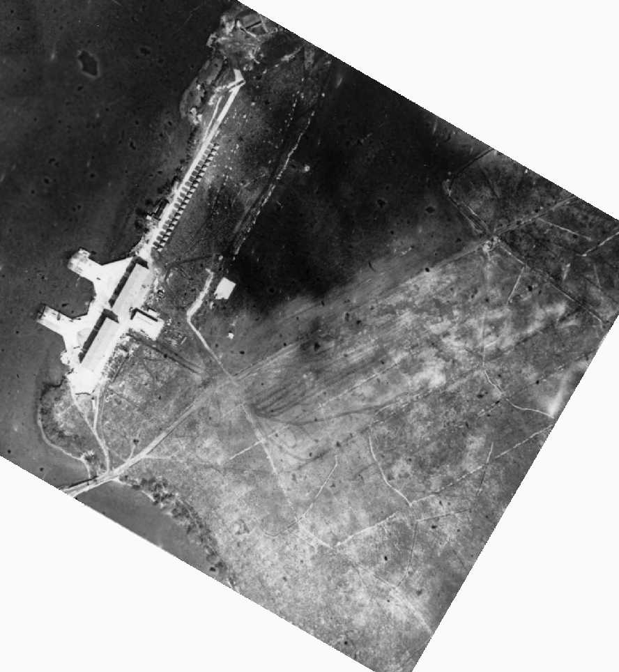
A December 1944 National Archives aerial photo of Ewa, showing large numbers of aircraft on the west & south sides of the field.
A detailed WW2-era map of the extensive facilities at Ewa Field,
showing 3 paved runways, a large paved ramp, and an elaborate quantity of aircraft revetments on the south side.
The April 1945 V-450 Hawaiian Islands U.S. Navy Aviation Chart (courtesy of Chris Kennedy)
depicted the airfield at Ewa as having a control tower.
Following WW2, Ewa continued to be used by the Marine Corps.
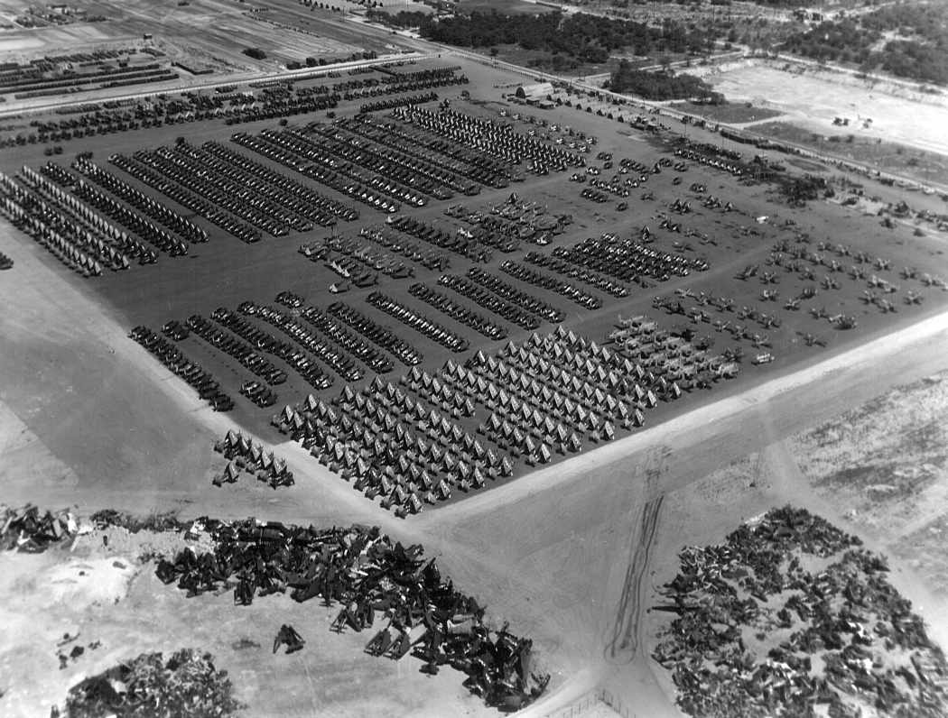
An October 1945 U.S. Navy aerial view (courtesy of John Voss) “of a massive aircraft scrapping operation underway at MCAS Ewa. Sickening... eh?”
MCAS Ewa was depicted on the 1947 Hawaiian Islands Sectional Chart (courtesy of John Voss)
as having a 5,000' hard-surface runway.
A circa 1948 photo of Grumman F7F Tigercats at MCAS Ewa by Lowell Malliett.
MCAS Ewa evidently closed at some point between 1947-50,
as it was depicted as closed on the August 1950 Hawaiian Islands Sectional Chart.
The Korean War brought a new surge of activity to Ewa,
but the jet aircraft then being introduced to the Marine Corps were increasingly unsuitable for Ewa's short runways,
and the close proximity of NAS Barber's Point ruled out any extension of Ewa's runways.
As a result, Marine aviation relocated to MCAS Kaneohe Bay,
and Ewa was declared excess & disestablished in 1952.
The airfield's property was absorbed into NAS Barber's Point.
The vast majority of the buildings of the former Marine Corps base were taken down in subsequent years.
The intact airfield of MCAS Ewa was still depicted on the 1953 USGS topo map, but the facility was unlabeled
Although it was labeled as closed, MCAS Ewa was still depicted
in the airfields diagram on the October 1954 Hawaiian Islands Sectional Chart (courtesy of Chris Kennedy).
It was shown as having 3 paved runways, with the longest being 5,000'.
The 3 paved runways of MCAS Ewa were still depicted on the 1955 Honolulu Local Aeronautical Chart (courtesy of Chris Kennedy), but the field was labeled "closed".
The longest runway was listed as 5,000'.
A 1962 aerial view still showed runway markings painted on the ends of the mostly-intact Ewa runways.
A 1967 photo by Nick Williams of the WW2 era concrete revetment hangars at MCAS Ewa.
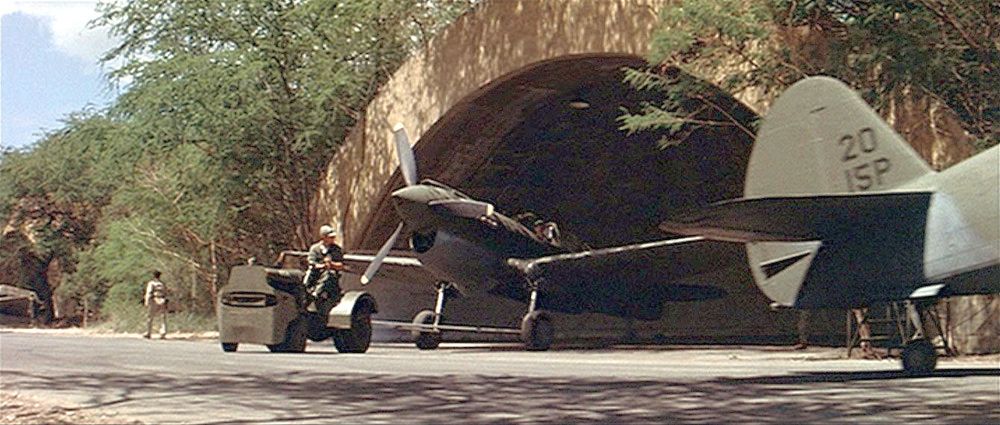
Two Curtiss P-40 Warhawks being pulled out of the concrete revetment hangars at Ewa during the filming of the 1970 movie “Tora Tora Tora” (courtesy of John Voss).
According to Tom Kramer, "I was on that site many times in the early 1970s. It was the Barbers Point NAS Golf Course.
The fairways were built around the concrete runways & taxiways.
When a ball sliced or hooked off the fairway & hit them, it went forever into the brush.
The concrete half shell hangars were still in there, hidden in the brush & I used to go back & find golf balls all over the place.
I was never able to get back in there to see if they are still there.
However, Barber's Point NAS just closed but not built over, so I would assume they still are."
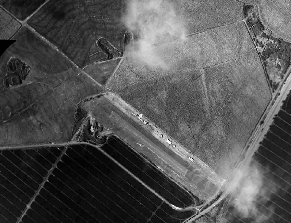
A 1977 USGS aerial photo depicted most of the runways of MCAS Ewa remaining intact, but a golf course had covered the southeast corner.
According to the 1983 USGS topo map, at that point only Ewa's northeast/southwest runway still remained largely intact,
along with much smaller lengths of 2 other runways.
According to former Barber's Point P-3 crewman Joe Krieg,
"MCAS Ewa, or what is left of it, is at the east end of the NAS Barbers Point complex.
Still visible from the air is one of the old runways."
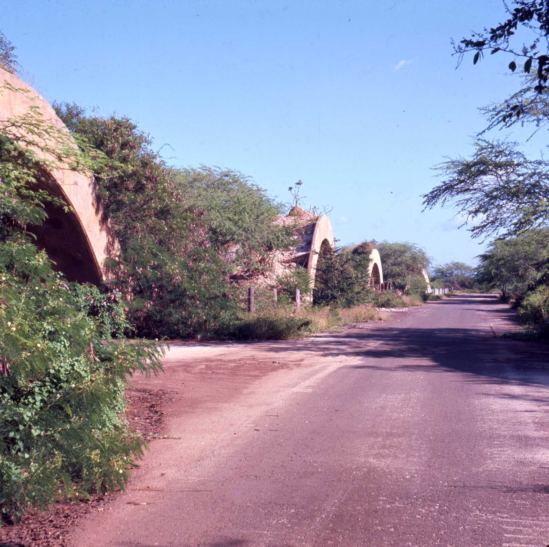
A 2003 photo by CW2 Matt Hobbs of the remains of a runway at Ewa (with a Coast Guard C-130 in the background).
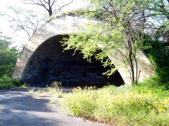
A 2003 photo by CW2 Matt Hobbs of a concrete revetment hangar which remains intact at Ewa.
CW2 Matt Hobbs (an Army Blackhawk pilot stationed at nearby Wheeler AAF) reported in 2004,
"I live in Ewa Beach, and my wife & I were driving around what used to be MCAS Ewa.
The old concrete hangars are still there, and in excellent condition.
Some are being used as horse stables, but the majority are empty.
The concrete hangars are in rows along overgrown taxiways.
I was talking to a guy who said that a guy went out there in 1999
and dragged the remains of a Douglas Dauntless out of the scrub brush out there.
Pretty amazing to think it sat out there for all of those years."
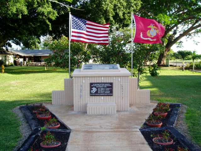
A 2003 photo by CW2 Matt Hobbs of a memorial at Ewa.
"The memorial is at the Barber's Point golf course, which remains open, although NAS Barber's Point was turned over to the state (it is now the Kalealoa Airport).
The memorial is dedicated to several Marines who lost their lives on 12/7/41, and has photos from that day."
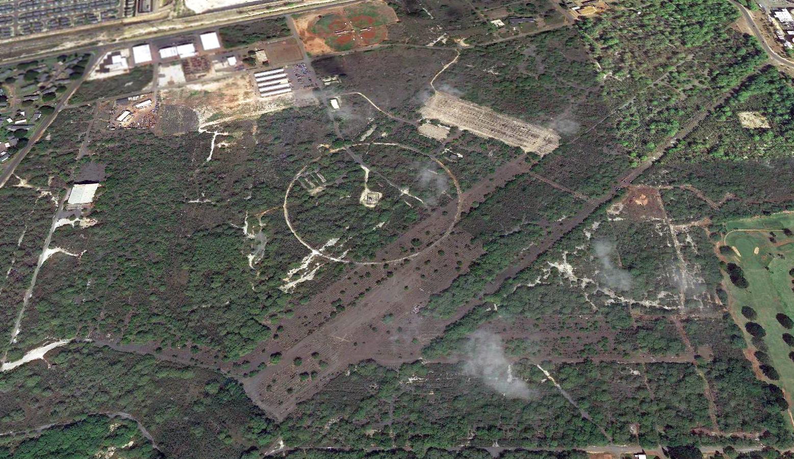
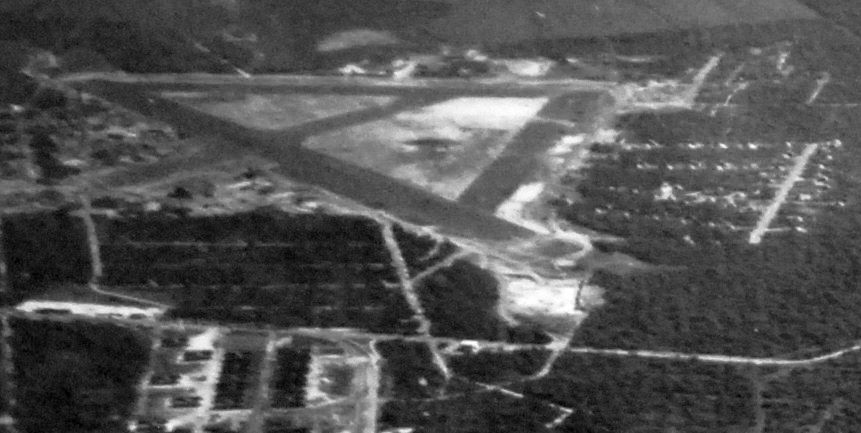
A 2013 aerial view looking north shows that asphalt pavement remains of at least 2 former runways at Ewa.
Note at least one closed-runway "X" which is still visible on the runway pavement at the bottom-center.

A 2016 (or earlier) photo of the interior of a concrete revetment hangar which remains intact at Ewa.
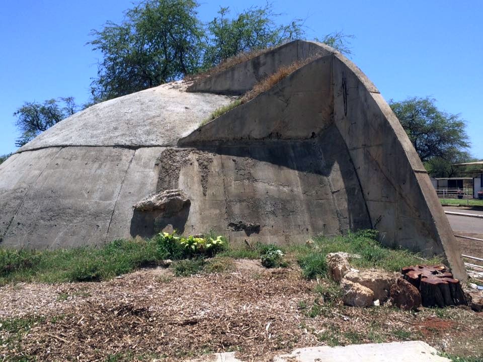
A 2016 (or earlier) photo of the back side of an Ewa concrete revetment hangar from which the earthen covering has been removed.
A 2020 photo looking east along the remains of MCAS Ewa's Runway 11.
See also: United States Marine Corps Air Stations of World War II.
____________________________________________________
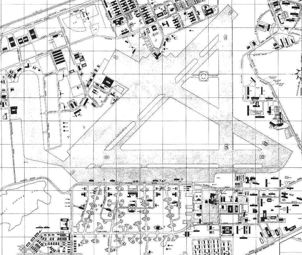
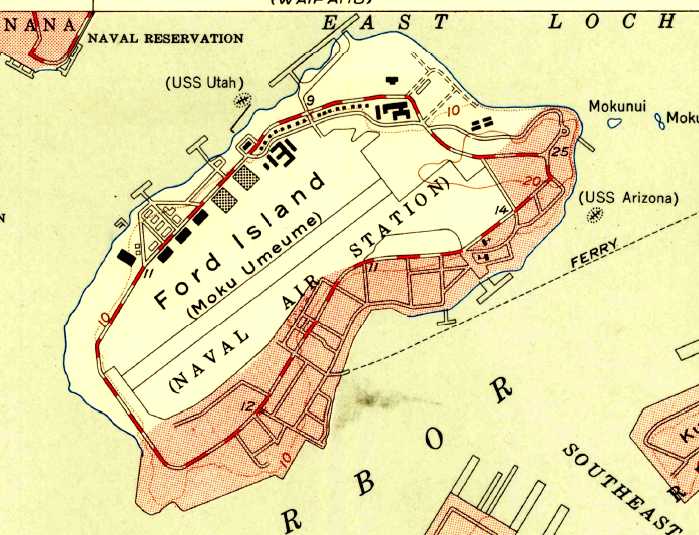
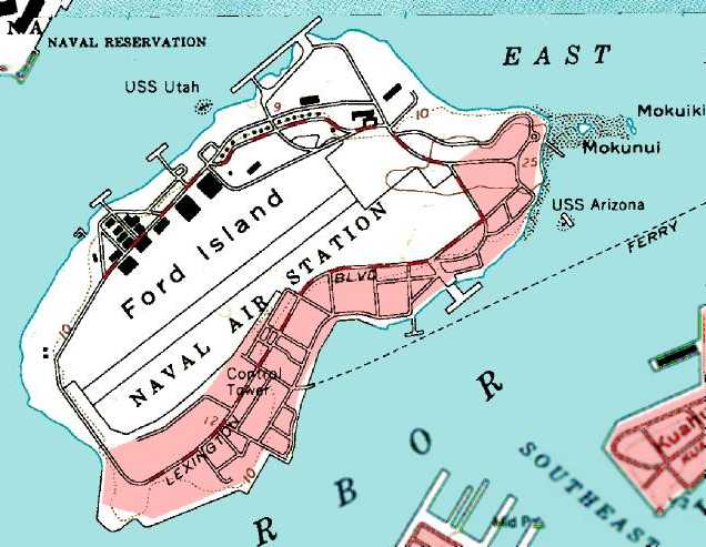
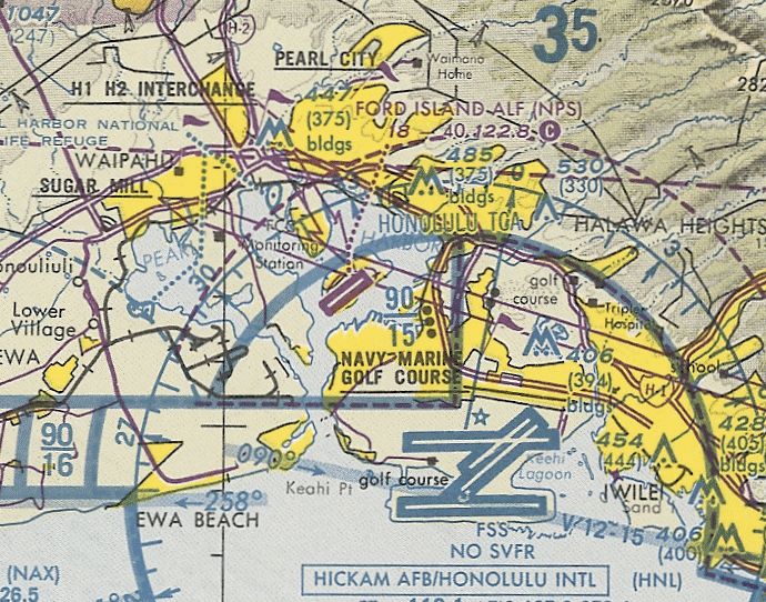
Luke Field / Naval Air Station Pearl Harbor / Ford Island Naval Auxiliary Landing Field (HVG),
Pearl Harbor, HI
21.36, -157.96 (Southwest of Honolulu, HI)
The United States acquired this island in the middle of Pearl Harbor in several parcels between 1906-18,
and an airfield was first built by the Army in 1918.
The earliest depiction which has been located of the airfield was a 12/16/18 aerial view
of the 6th Aero Squadron facility at what was originally known as the “Joint Services Flying Field” on Ford Island.
It depicted a seaplane base with 2 hangars & 2 seaplane ramps on the northwest side, a grass field to the east,
and a row of tents northeast of the hangars.
At some point the airfield was renamed Luke Field.
Navy aircraft arrived at Ford Island in 1919.
A circa 1919-21 aerial view looking north at Luke Field, showing a line of DH-4 & JN-4/6 biplanes.
Just in front of the aircraft is the field's compass rose, and at lower left are aircraft packing crates.
Ford Island's Hangar 6 was constructed in 1922.
The Navy's Air Station on Ford Island was commissioned in 1923, and the runway was completed in 1925.
A 1925 aerial view looking northeast at Ford Island,
with the Army's Luke Field having 4 hangars on the left, and the Navy having at least one seaplane hangar on the right.
A 4/18/25 aerial view looking along a long row of Army bombers & fighters at Luke Field (courtesy of Ford Lauer).
A 10/10/30 aerial view of biplane fighters & bombers (Keystones?) at Luke Field on Ford Island (courtesy of Bill Roberts).
A January 1934 aerial view looking west at Consolidated P2Y-1 of Patrol Squadron VP-10F at NAS Ford Island.
These 6 aircraft had made a record-setting non-stop flight from San Francisco to Pearl Harbor on 1/10/34, covering 2,085 NM in 24 hours.
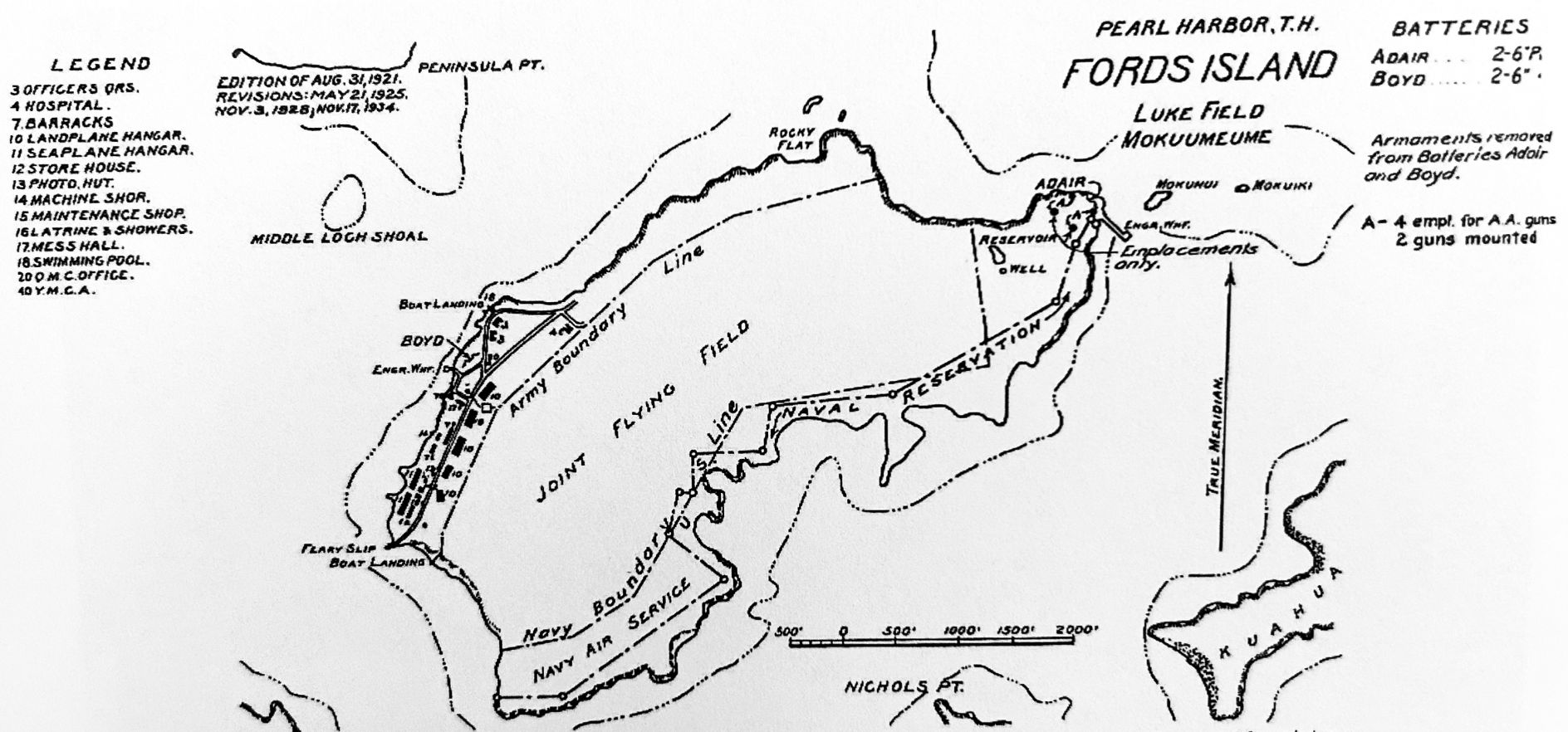
A 1934 map of Ford Island “Joint Flying Field” (from the NARA via Glen Williford) showed the “Army Boundary Line” along the northwest & the “Navy Boundary Line” along the southeast.
The Navy assumed full control of Ford Island in 1935, after the Army Air Forces moved to newly-constructed Hickam Field.
Pearl Harbor Naval Air Station at Luke Field was the headquarters of the commander of the Pacific Fleet Air Forces.

A circa 1935-40 photo of a Sikorsky Pam Am S-42 Clipper flying boat in front of a Ford Island hangar (courtesy of Kevin Walsh).
Pam Am used the NAS Ford Island facilities for flying boat operations from 1935-40.

A circa 1935-40 photo of a crowd of civilians, Navy personnel, and news media greeting the arrival of a Sikorsky Pam Am S-42 Clipper flying boat at Ford Island (courtesy of Kevin Walsh).
Construction of Ford Island's 158' control tower began in early 1941.

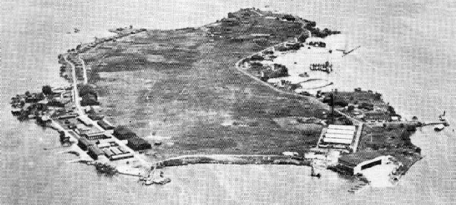
A 10/30/41 U.S. Navy aerial view looking south at Ford Island (courtesy of Brian Rehwinkel).
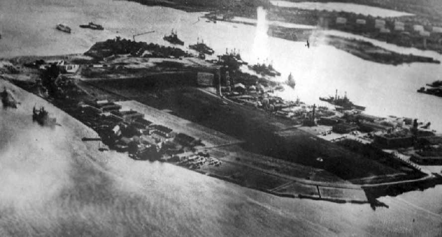
An iconic WW2 photo – A 12/7/41 aerial view looking west from a Japanese aircraft toward Ford Island, taken during the Pearl Harbor attack.
Ford Island was bombed & strafed during the 12/7/41 Japanese attack on Pearl Harbor.
"Battleship Row" is located along the north side of the island, where many battleships were attacked & sunk.
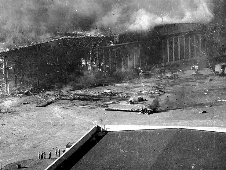
Burning planes & hangars at Ford Island, after the 12/7/41 Pearl Harbor attack.
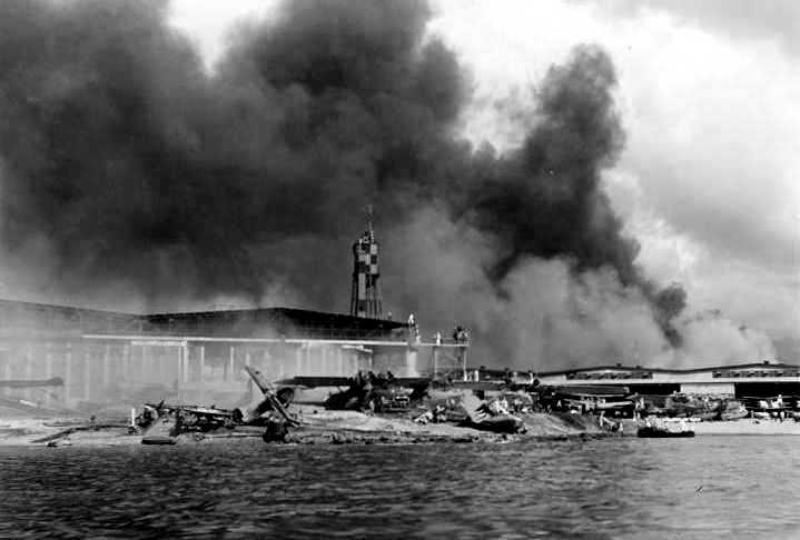
Smoke billows above the Ford Island hangars after the 12/7/41 Pearl Harbor attack.

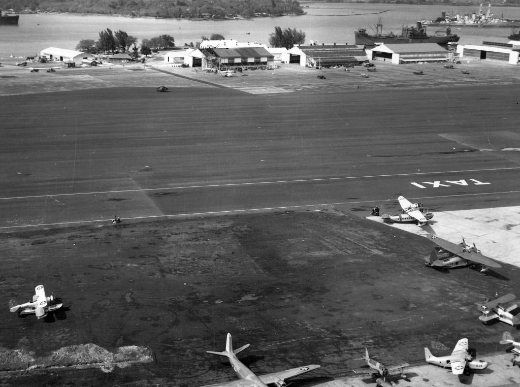
A 12/8/41 USN aerial view looking south at Ford Island, taken the day after the Japanese raid on Pearl Harbor, showing at least 7 OS2U, 2 SOC, 1 PBY-5, 1 F4F-3 and 2 TBD-1.
One of the TBDs may be Bureau #0289, which was flown by Navy Ensign Theodore Marshall, during his attempt to follow Japanese planes back to their carriers on December 7. He was awarded the Silver Star for the effort.
A 1941-42 aerial view of the Ford Island flightline, showing 3 Grumman J2F Duck amphibians, 2 Sikorsky JRS,
a Vought OS2U Kingfisher without an engine, and the tail of a rare Douglas R3D (DC-5).
Construction of Ford Island's 158' control tower was completed in 1942; it was originally painted a solid dark color.
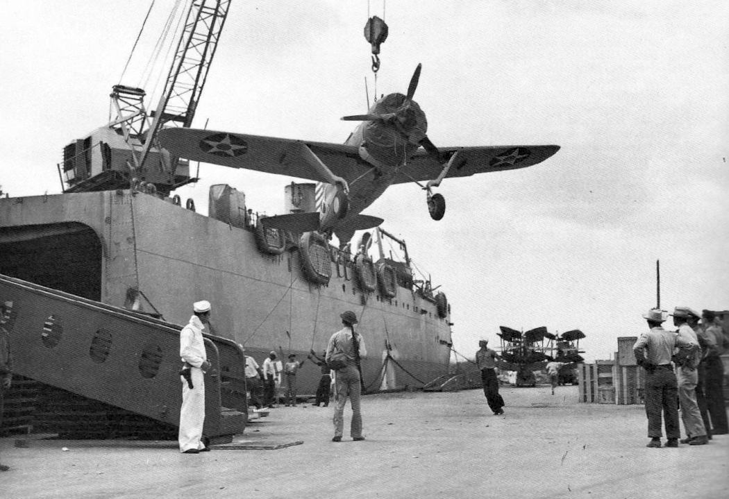
A March 1942 photo of a Brewster F2A-3 Buffalo being craned off of the USS Kitty Hawk at NAS Pearl Harbor (courtesy of John Voss).
An undated (circa 1942?) aerial view looking northwest at the southeast corner of Ford Island,
showing a large number of seaplanes on the ramp & smaller landplanes nearer the runway.

A remarkable 9/5/44 U.S. Navy aerial view of Ford Island (National Archives photo, courtesy of Brian Rehwinkel).
Brian Rehwinkel observed, “It is in stark contrast to the earlier photos of the field.
I realized (in addition to the incredible amount of construction that had taken place since the beginning of the war)
there were an unbelievable number of airplanes on this small (334 acres or so) island.
I could not count all of the planes on the island, but I counted over 1,000 planes before I stopped counting.
You can see a couple of carriers loading (or unloading) planes, but it appears many planes are being 'stored' with their wings folded.
With the exception of some photos of post-war fields that were used to store thousands of planes, I have never seen so many planes at an airfield.
It almost seems as though the island would sink under the weight of all of the planes.
It is interesting that Ford Island, a symbol of the attack on Pearl Harbor would be the site of more than 1,000 planes barely 3 years after the attack.”
A closeup from the 9/5/44 U.S. Navy aerial view of Ford Island (National Archives photo, courtesy of Brian Rehwinkel),
showing some of the thousand planes visible parked on the compact island airfield.
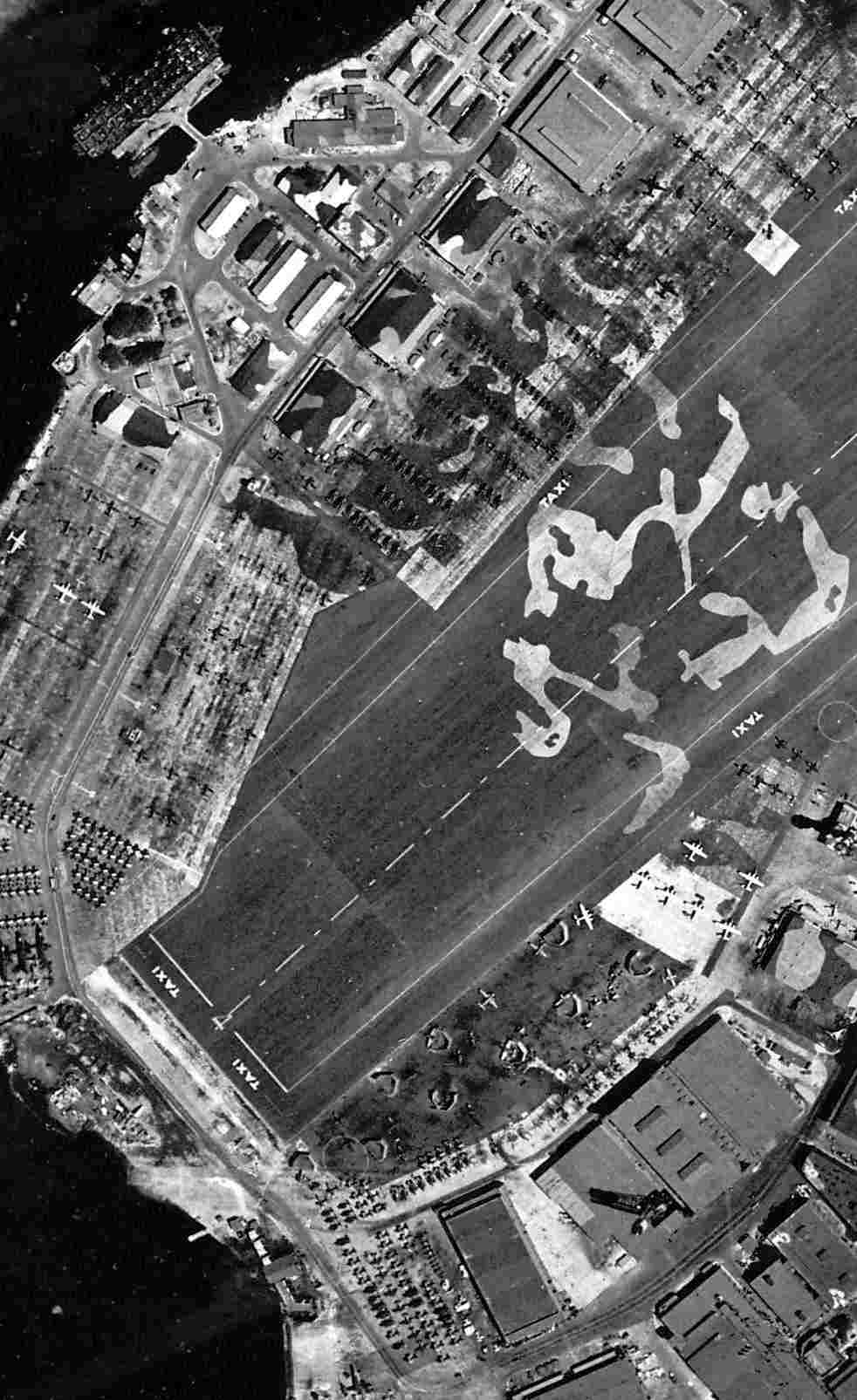
Also note the odd attempt to camouflage a small central portion of the airfield,
as if the Japanese didn't know where Ford Island was by that point!
The April 1945 V-450 Hawaiian Islands U.S. Navy Aviation Chart (courtesy of Chris Kennedy)
depicted the airfield at Ford Island as having a control tower.
"NAS Pearl Harbor" was depicted on the September 1947 Hawaiian Islands Sectional Chart as having a 4,000' hard-surface runway.
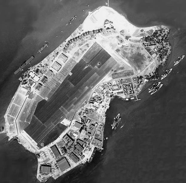
The 1953 USGS topo map depicted Ford Island Naval Air Station as having a single paved runway.
A 1/19/59 aerial view (from the University of HI) did not show any aircraft present on Ford Island.
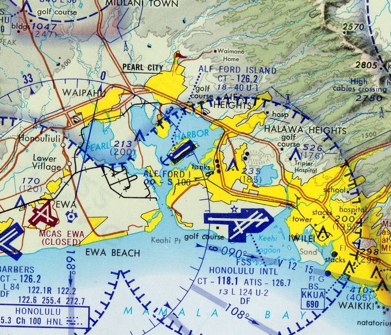
Ford Island as depicted on the 1961 Honolulu Sectional Chart (courtesy of John Voss).
The USS Arizona memorial was dedicated in 1962 just off the southeast coast of the island.
Regular military flight operations at Ford Island were ended in 1962,
as the short runway had limited the operational use of the facility.
However, the airfield continued to be used in later years for operations of light civil aircraft flown by military flying clubs.
A June 1969 photo by Nick Williams looking west at the Ford Island tower.
Nick recalled, “I was there to photograph several aircraft that were set afire during the filming of Tora! Tora! Tora!... a PBY, T-33A, and parts from either a B-50 or KC-97.”
Jay Jiudice recalled, "The view of Ford Island in Pearl Harbor reminded me of an accident one of our students had
when a flare went off in the cockpit as he was taking off from that strip.
The instructor with him managed to do a 180 & make a downwind landing,
saving the student & himself, but had to spend months in the Tripler Hospital burn unit."
On 2/20/70 the 4,500' runway at Ford Island was opened to civilian pilots for flight training operations.
The June 1972 Hawaiian Islands Sectional Chart (courtesy of Carl Buick)
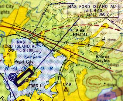
depicted ALF Ford Island as having a single 4,000' paved northeast/southwest runway.
Ford Island was depicted on the December 1977 Hawaiian Islands Sectional Chart (courtesy of Chris Kennedy)
as having a single 4,000' paved runway.
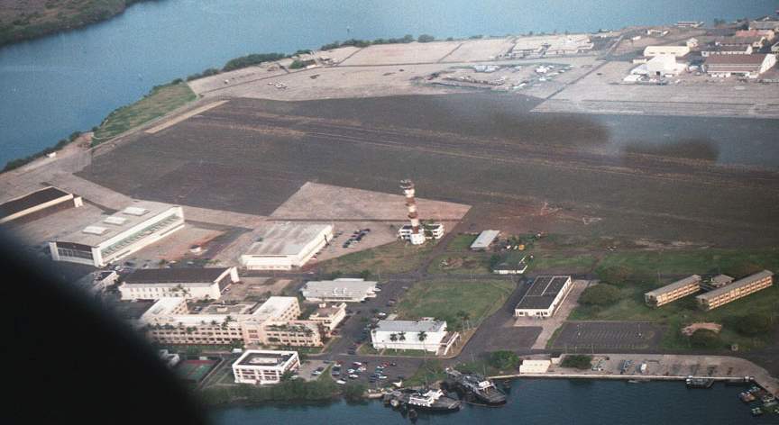
A September 1980 aerial view by Ron Plante looking north at Ford Island's Runway 4, ramp, and hangars.
Ron recalled, “I was in the right seat of a Cessna 150 back - waaaaay back - in 1980 with a guy from the Wheeler AFB flying club
and he shot some touch & goes on Ford.”
A September 1980 aerial view by Ron Plante looking northeast at Ford Island's Runway 4, tower, and hangars.
The 1981 Hawaii Airports & Flying Safety Guide (courtesy of Jonathan Westerling)
described "ALF Ford Island" as being an "ALF to Barbers Point NAS",
with civil operations permitted by prior approval of "any flight school located at Honolulu International Airport."
The airfield was said to consist of a single 4,000' paved Runway 4/22.
The 1983 USGS topo map still depicted the “Ford Island Naval Air Station”.
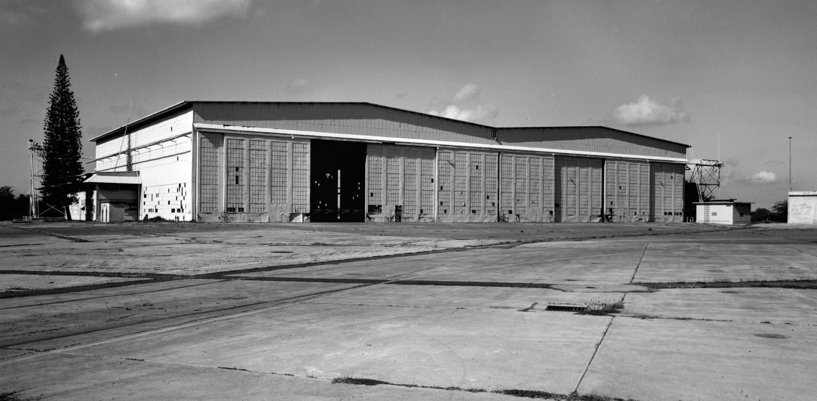
An undated Library of Congress photo of Ford Island's Hangar 6.
Ford Island's Hangar 6 was demolished in 1985, at which point it was reportedly the oldest hangar in HI.
The May 1993 Hawaiian Islands Sectional Chart (courtesy of Ron Plante)
depicted Ford Island ALF as having a 4,000' paved northeast/southwest runway.
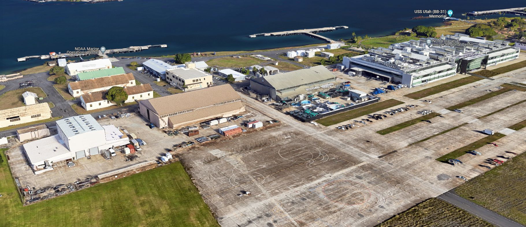
The completion of the 4,672' long Admiral Clarey Bridge in 1998 made Ford Island readily accessible to visitors for the first time.
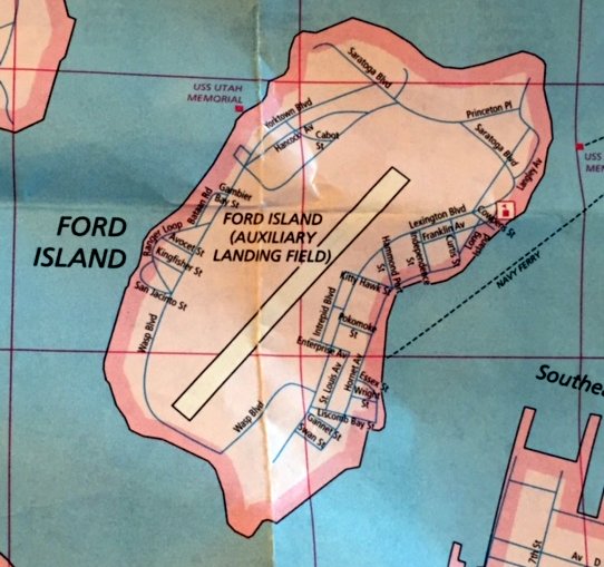
A 1998-99 road map (courtesy of Kevin Walsh) depicted Ford Island (Auxiliary Landing Field) in its final year of operation.
The Ford Island airfield was closed in 1999, a move which coincided with the acquisition of by the State of Hawaii of surplus land at Barbers Point Naval Air Station
to be used for general aviation purposes.
The Navy planned to redevelop Ford Island with a new museum, residential areas, and offices.
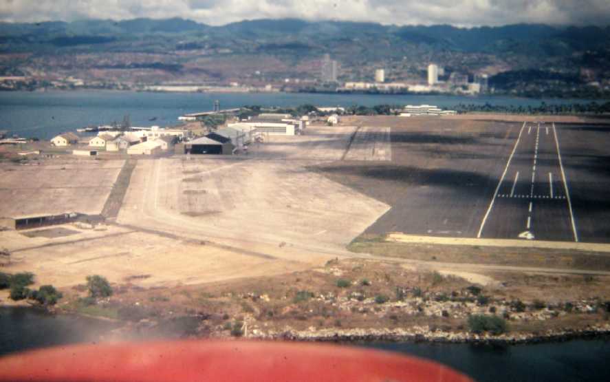
A 2000 aerial view looking north at Ford Island.
A 2001 aerial view looking northwest at Ford Island.
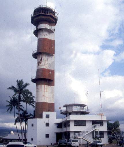
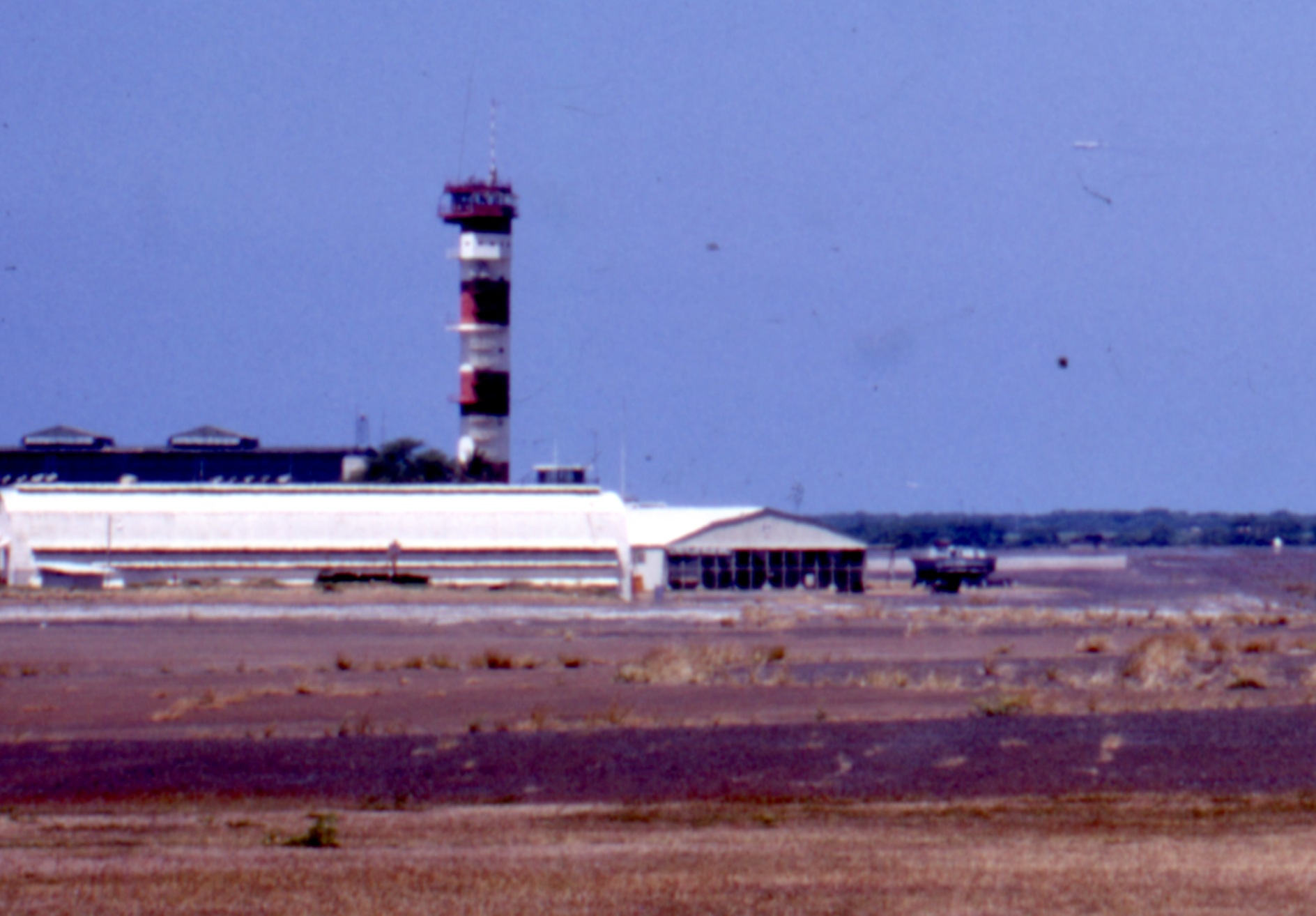
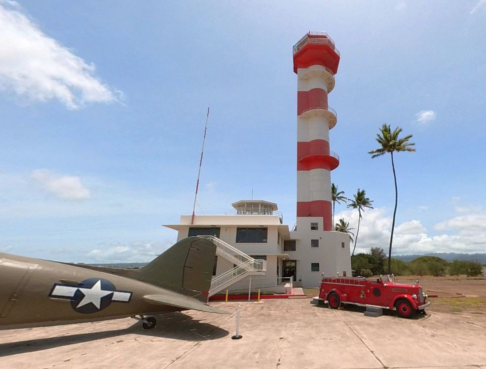
A circa 2002 photo by David Scott of the Ford Island tower.
A circa 2002 photo by David Scott of a Ford Island hangar.
Paul Perona reported in 2004 that a group called the Historic Preservation Society
is working to try to save Ford Island from redevelopment.
They are trying to change upcoming legislation so that the Navy will be released from being obligated to fully maintain the island
and hopefully get it into the hands of the National Parks Service & private museum organizations
that can put it to full use without changing it's historical nature.
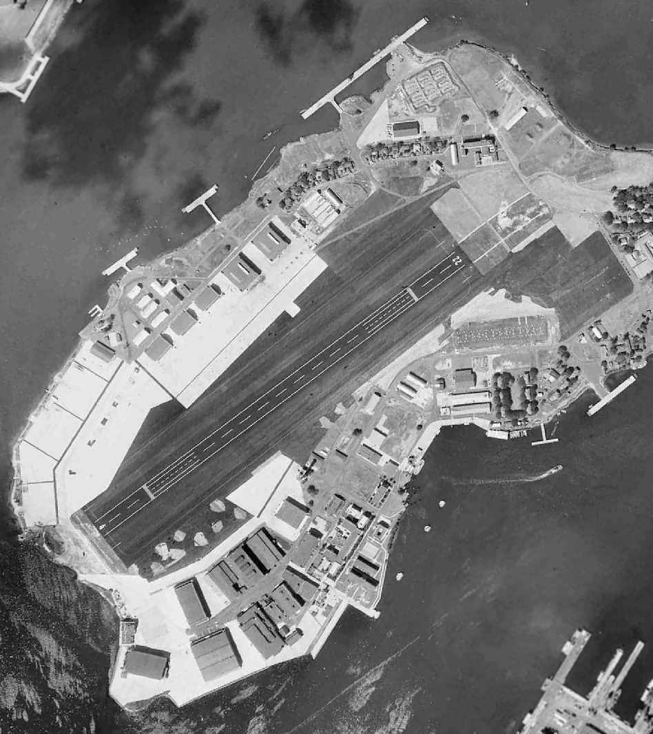
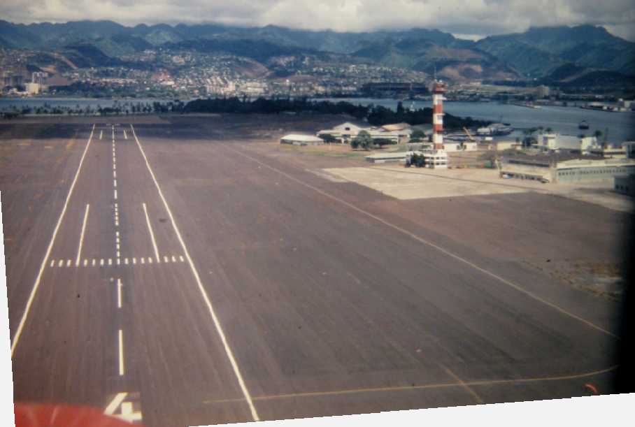
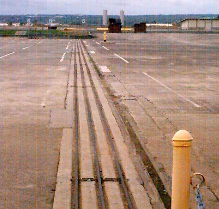
A 2005 photo by Dennis Terek looking along Ford Island's abandoned Runway 22, with the hangars & tower on the left.
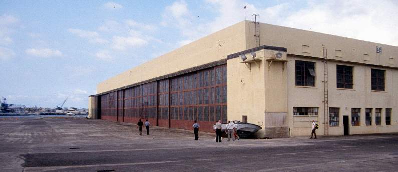
A 2005 photo by Dennis Terek of the exterior of a remaining hangar at Ford Island.
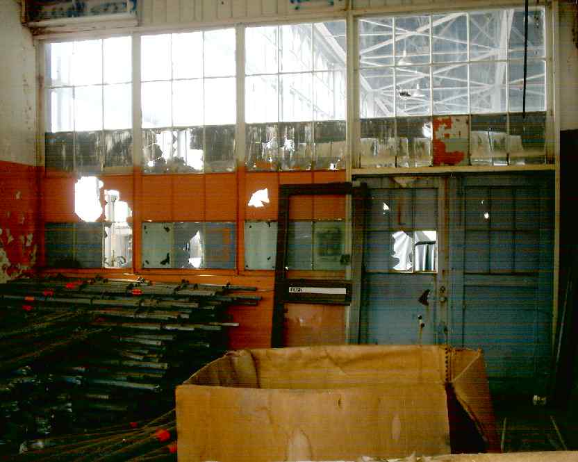
A 2005 photo by Dennis Terek of the interior of a remaining hangar at Ford Island.
A 2005 photo by Dennis Terek of the hangar door track where Ford Island's Hangar 6 used to be located.
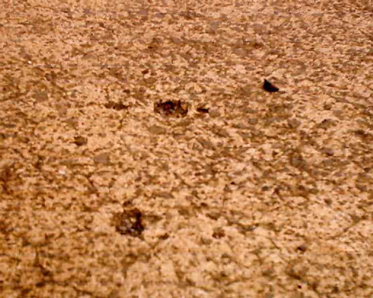
A 2005 photo by Dennis Terek of the strafe marks which remain in the flightline at Ford Island from the Pearl Harbor attack.
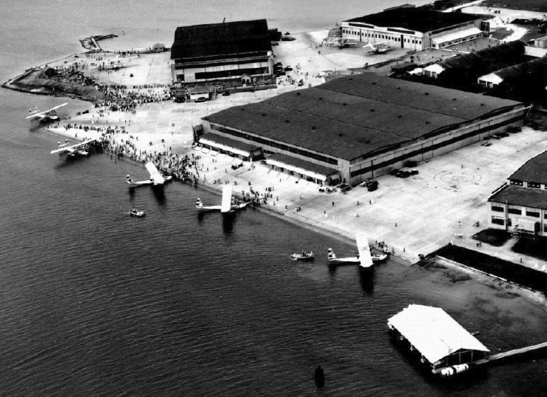
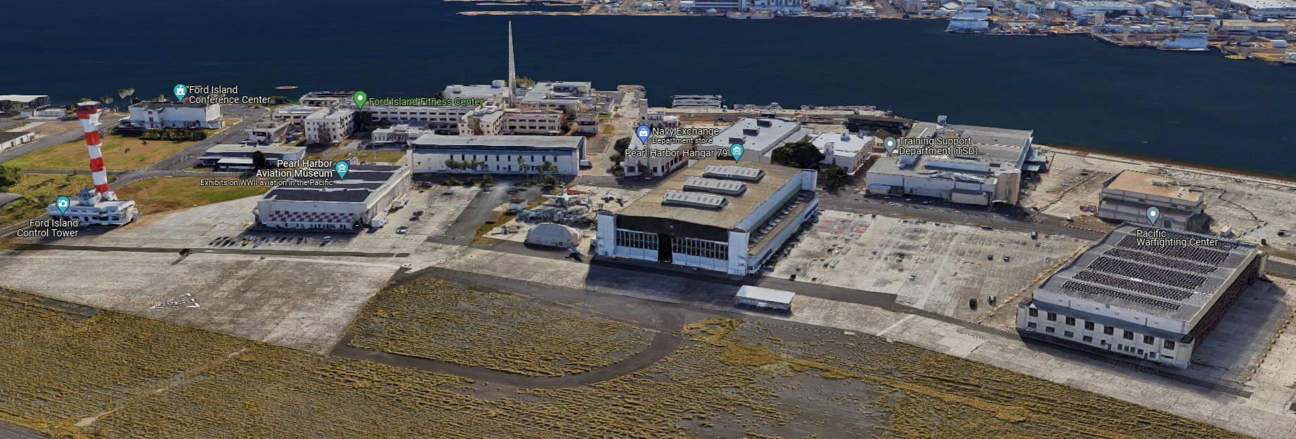
Barbara Bloom reported, “On December 7, 2006, Pacific Aviation Museum opened in the first of 3 hangars which survived the attack on Pearl Harbor.”
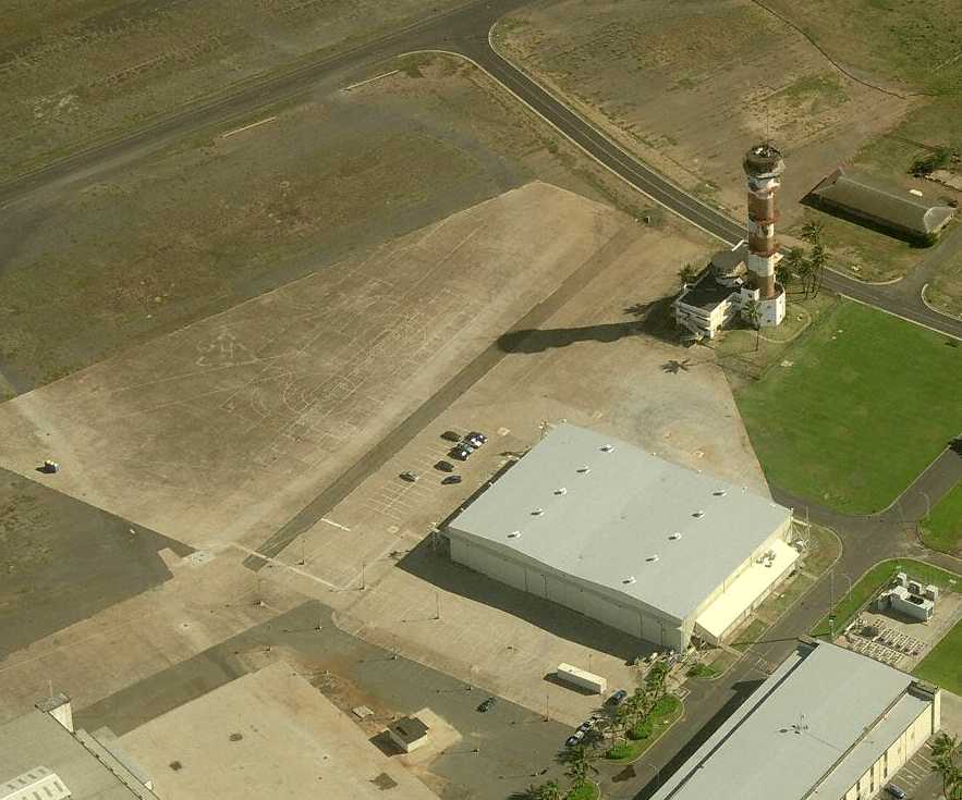
A circa 2006-2009 aerial view looking north at Ford Island showing hangars, the terminal building, and tower.
The southern end of the runway surface had been removed, but the “22” numbers are still visible at the northeastern end.
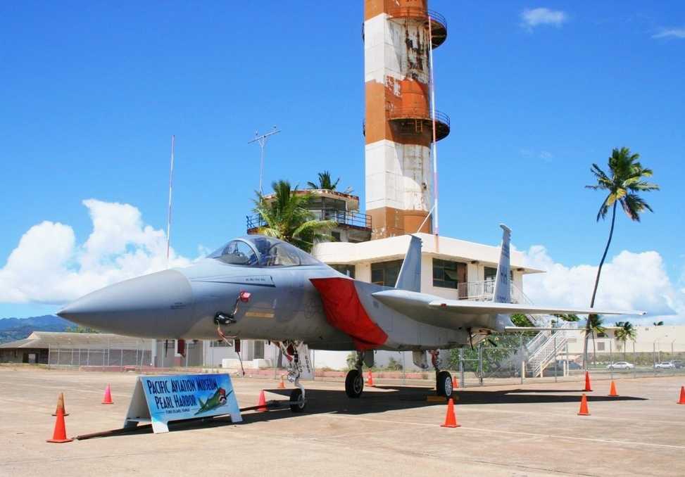
A 7/12/10 photo by Dirk Fierens of a McDonnell Douglas F-15A Eagle of the Pacific Aviation Museum, on display in front of the Ford Island tower.
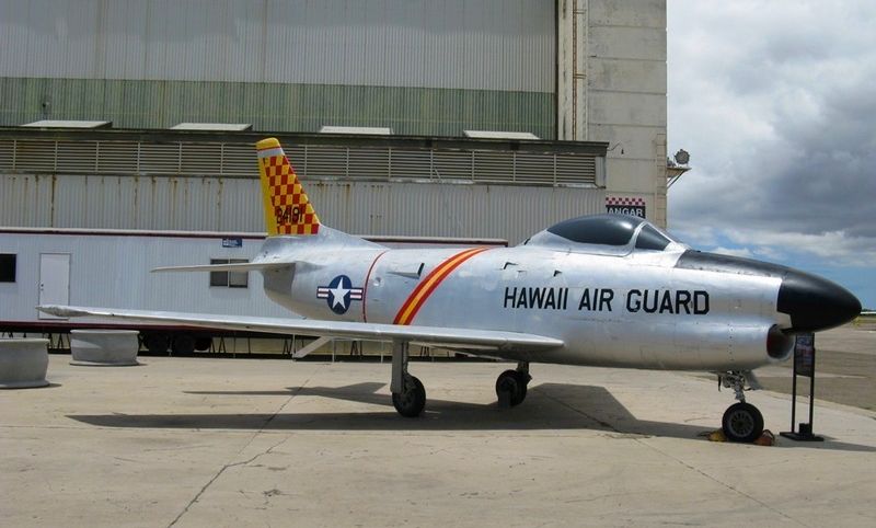
An 8/22/11 photo of a beautifully restored 1952 North American F-86L Sabre, serial #190-596, in front of the Pacific Aviation Museum hangar at Ford Island.
In 2012, Barbara Bloom reported, “Ford Island, in the heart of Pearl Harbor, is a site that many have likened to Gettysburg, Valley Forge, and the Alamo.
The 4,000’ runway, part of Naval Air Station Ford Island from 1921-61, has long been on the National Register of Historic Places.
The U.S. Navy is now proposing to cover the runway & adjoining land (a total of 28 acres) with 60,000 photo-voltaic panels
in a move that will permanently convert the nature & appearance of this hallowed ground to an industrial project.
In addition to the panels, the project will require numerous 'inverter stations' between the former runway & ramp area
and the entire photo-voltaic panel area will be surrounded by a black chain-link fence.”
Barbara
continued, “To date the [Pacific Aviation Museum] has welcomed
more than 800,000 visitors.
The museum’s mission is to educate young & old alike, honor aviators & their support personnel who defended freedom in the Pacific region,
and preserve Pacific region aviation artifacts.
The museum feels that the Ford Island runway is one such artifact.
This project is not at all in keeping with the significance of the historic Pearl Harbor battlefield.
Consider the hue & cry should a 60,000 panel photo-voltaic project be located at Gettysburg or Valley Forge.”
In 2011 the Pacific Aviation Museum restored the Ford Island tower to its original condition.
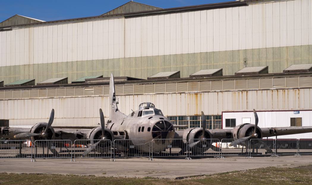
An 8/24/14 photo by Timothy Williamson of Boeing B-17E Flying Fortress, serial 41-2446, “Swamp Ghost”,
which crashed landed after being attacked in WW2, and sits outside the Pacific Aviation Museum awaiting restoration.
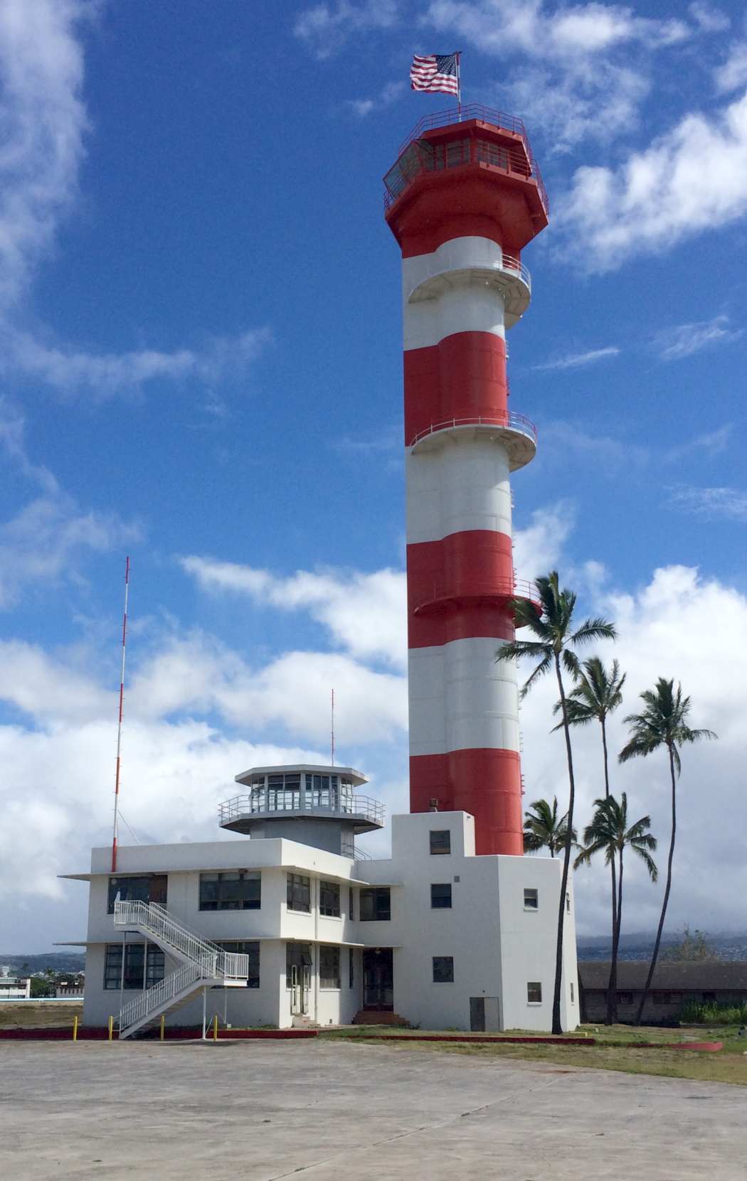
An 8/24/14 photo by Timothy Williamson of the Ford Island tower.
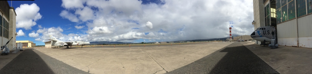
An 8/24/14 panoramic photo by Timothy Williamson of the Ford Island ramp, showing a Douglas NTA-3B Skywarrior & the nose section of a Boeing B-52E Stratofortress.
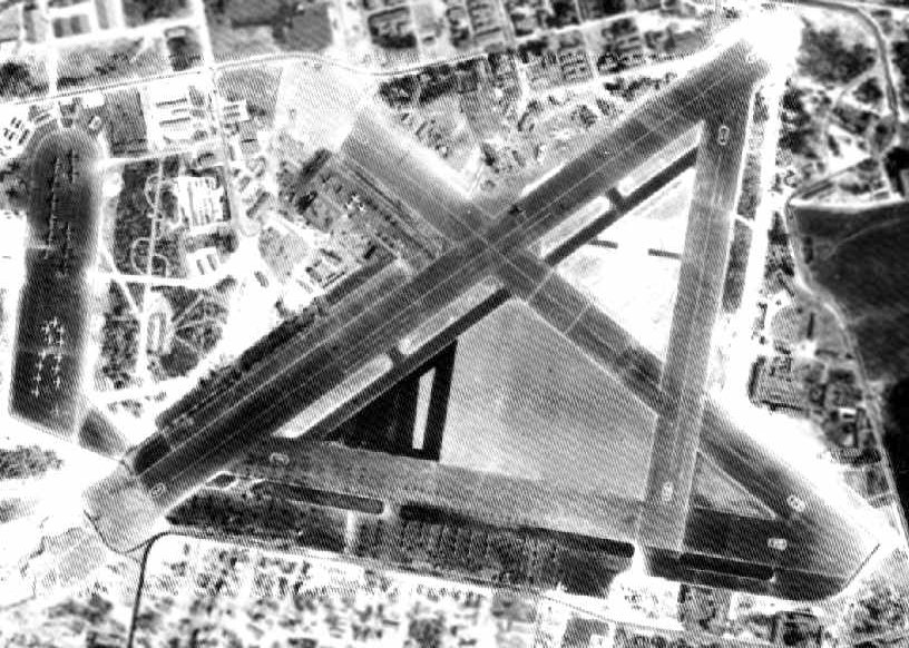
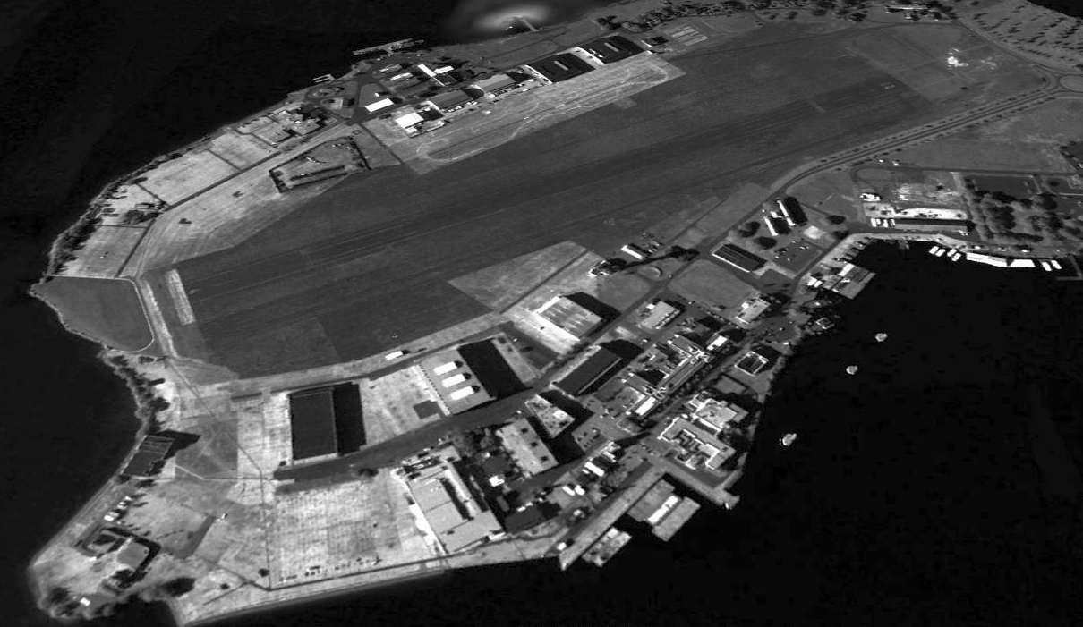
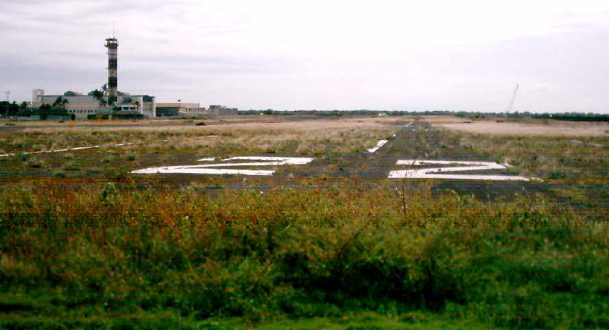
A 2015 aerial view looking north at Ford Island, showing the runway pavement had almost completely disappeared.
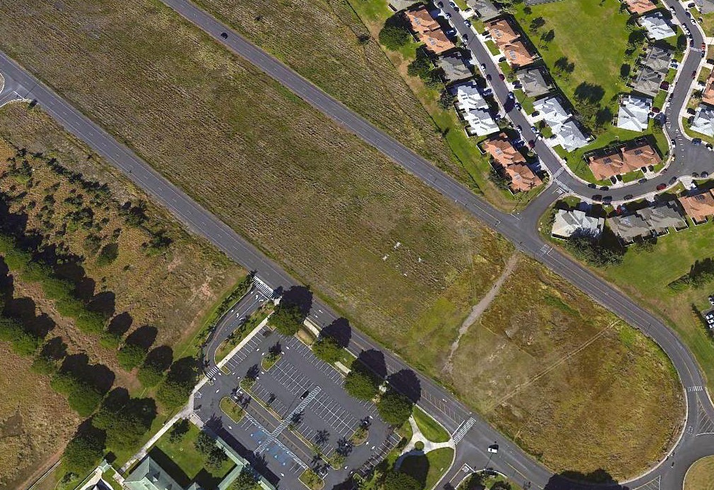
A 2015 aerial view looking west at the last remnants of Ford Island's Runway 22 markings (the white patches in the center).
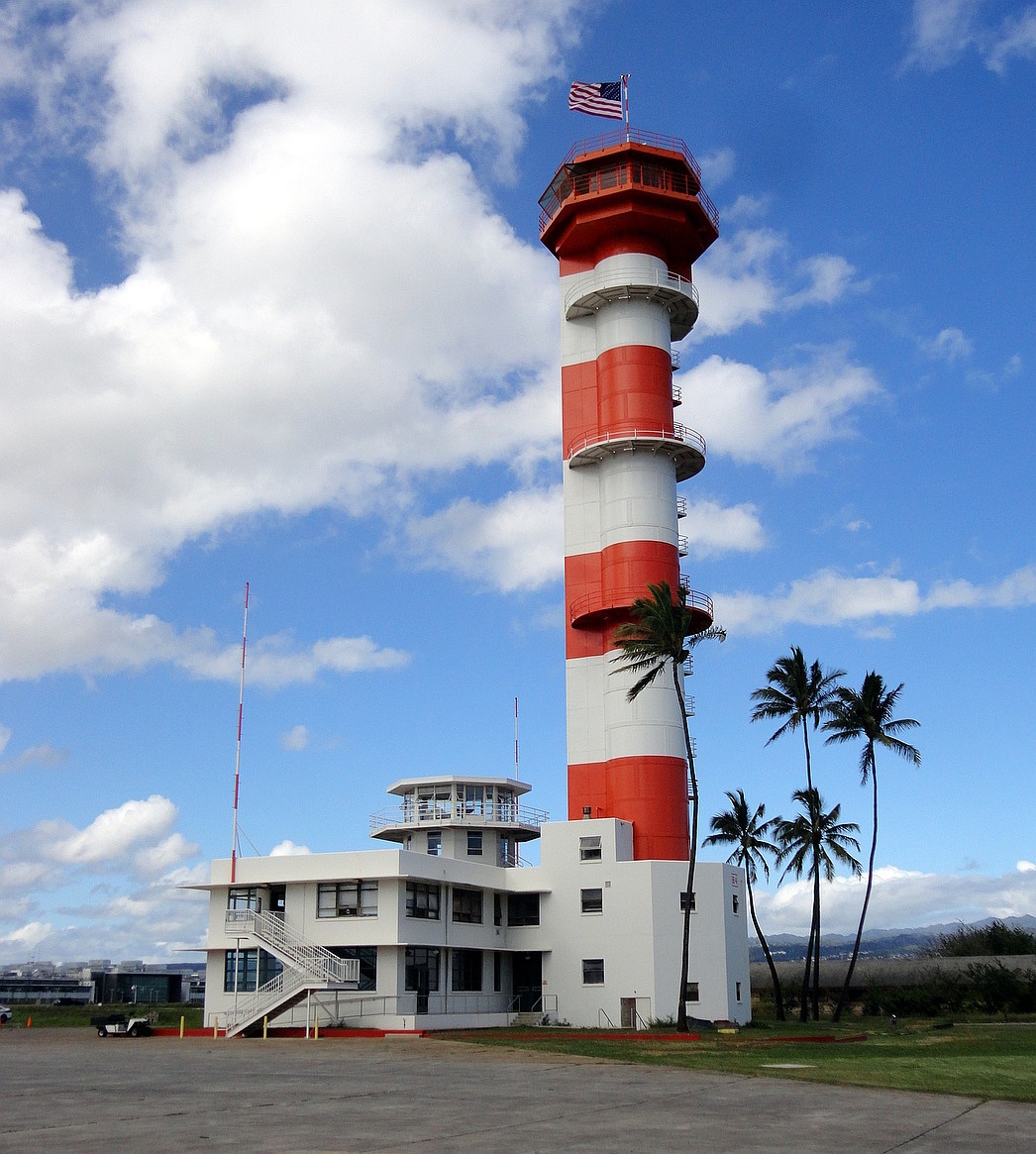
A 2/27/19 photo by Peter Lea of the Ford Island tower.
A 2022 photo looking north at a Douglas C-47 Skytrain & the Ford Island tower.
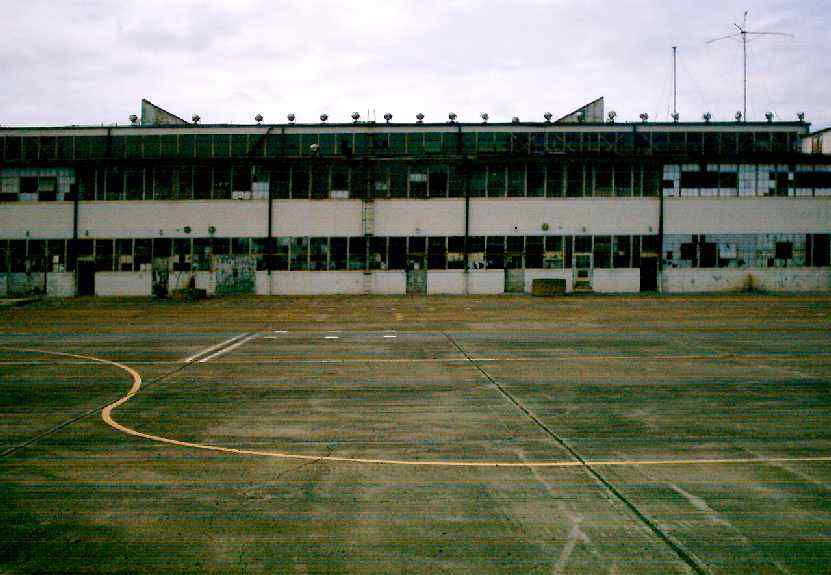
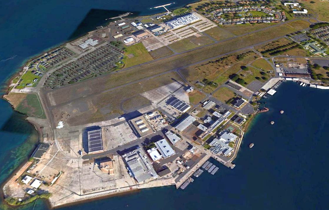
A 2023 3-D aerial image looking north at the former Army hangars on the north side of the Ford Island airfield.
A 2023 3-D aerial image looking south at the former Navy hangars on the south side of the Ford Island airfield.
____________________________________________________
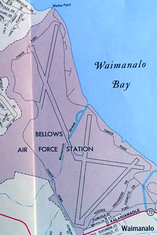
Bellows Field / Bellows Air Force Station, Walmanalo, HI
21.36, -157.72 (Northeast of Honolulu, HI)
A 1933 aerial view of the original runway at Bellows
(courtesy of the 15th Airlift Wing History Office, via Colin Perry of the Hawaii Aviation Preservation Society).
This site was established in 1917 as the Waimanalo Military Reservation, an infantry training area.
It was renamed Bellows Field in 1933.
It originally had a single asphalt runway (only 983' long), and a wooden tower.
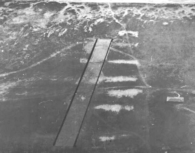
The earliest depiction which has been located of Bellows Field was a 1933 aerial view, showing a single runway
(courtesy of Colin Perry of the Hawaii Aviation Preservation Society).
A 7/26/38 aerial view depicted the single paved runway at Bellows Field.
A major construction program began at Bellows in 1941, including the construction of a new & larger runway.
A dozen P-40 Warhawk fighters were assigned to the field for training.
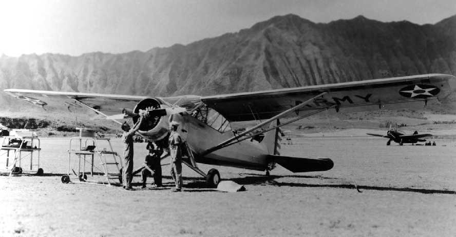
A 1941 photo of a Stinson O-49 Vigilant observation aircraft at Bellows Field, with the dramatic mountains in the background.
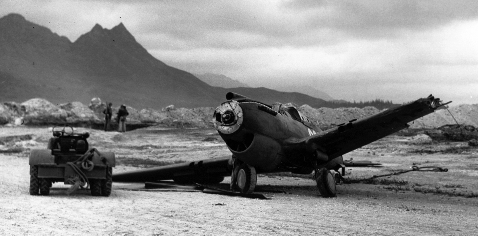
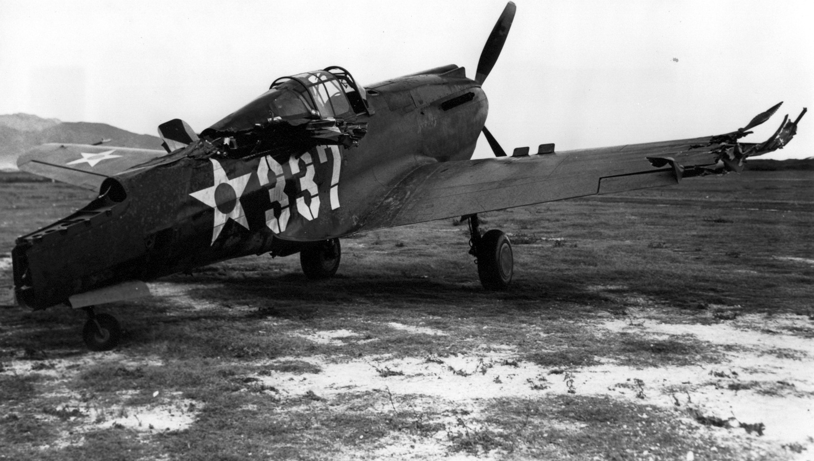
A 12/8/41 photo of a Curtiss P-40 Warhawk fighter off the side of the Bellow Field runway, after it had been damaged in the 12/7/41 attack.
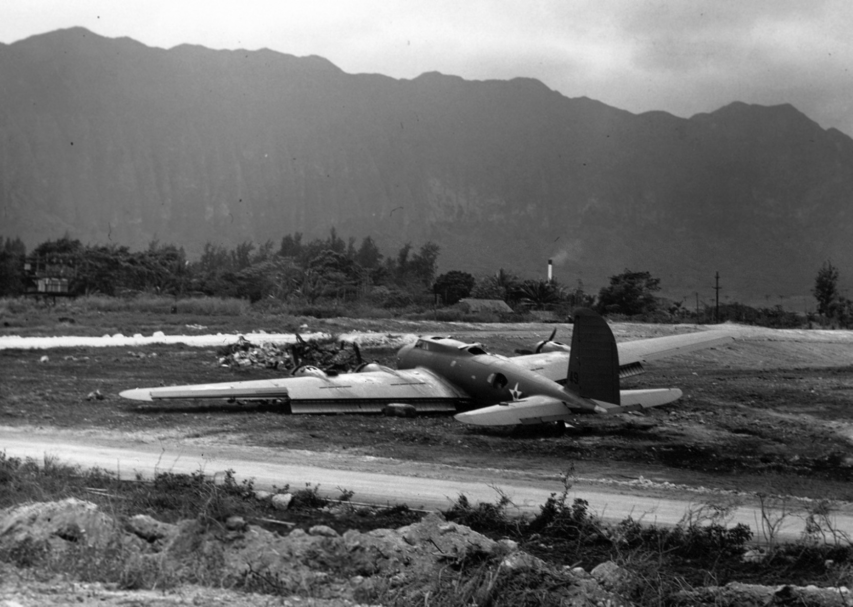
A 12/9/41 photo of a B-17C Flying Fortress bomber which had made a belly landing on a relatively short Bellows Field runway.
It was one of a dozen B-17s which had arrived from the mainland & was unable to land at Hickam Field due to the Pearl Harbor attack.
A circa 1943-43 photo of an early-model Boeing B-17D Flying Fortress bomber in a Bellows Field revetment.
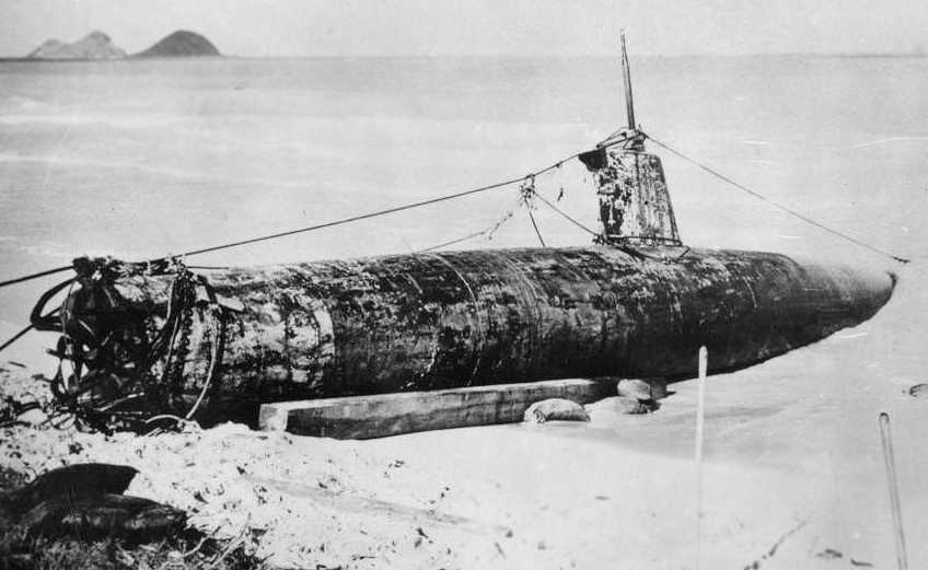
A 1941 photo of the Japanese midget submarine which was found beached on the shore at Bellows Field after the Pearl Harbor attack.
It had been launched by the I-24 mother sub & arrived off the entrance to Pearl Harbor on 12/6/41.
It was grounded off Bellows Field the next day.
Its commander, Ensign Kazuo Sakamaki, swam ashore on 12/8/41 & was captured.
The sub was 80' long, 6' in diameter, had a 46 ton displacement, and was battery-powered by a 600 hp motor.
A 1942 aerial view of Bellows Field, showing its early-WW2 single-airfield configuration
(courtesy of the 15th Airlift Wing History Office, via Colin Perry of the Hawaii Aviation Preservation Society).
A 5/7/42 photo (from the National Archives, courtesy of Ron Plante)
originally captioned “the paved taxi strip between Runways A & B at Bellows Field.”
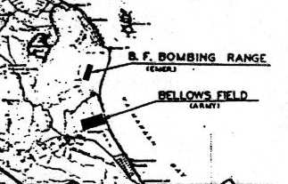
The 1943 USGS topo map (courtesy of John Voss) depicted 2 different airfields:
"Bellows Field Bombing Range (Emergency)" to the north & "Bellows Field (Army)" to the south.
The second airfield was apparently added at some point between 1942-43.
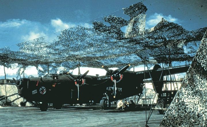
A late summer 1943 photo of Consolidated B-24 Liberator bomber 'Rapid Robin' of the 431st Bomb Squadron parked under camouflage netting at Bellows Field.
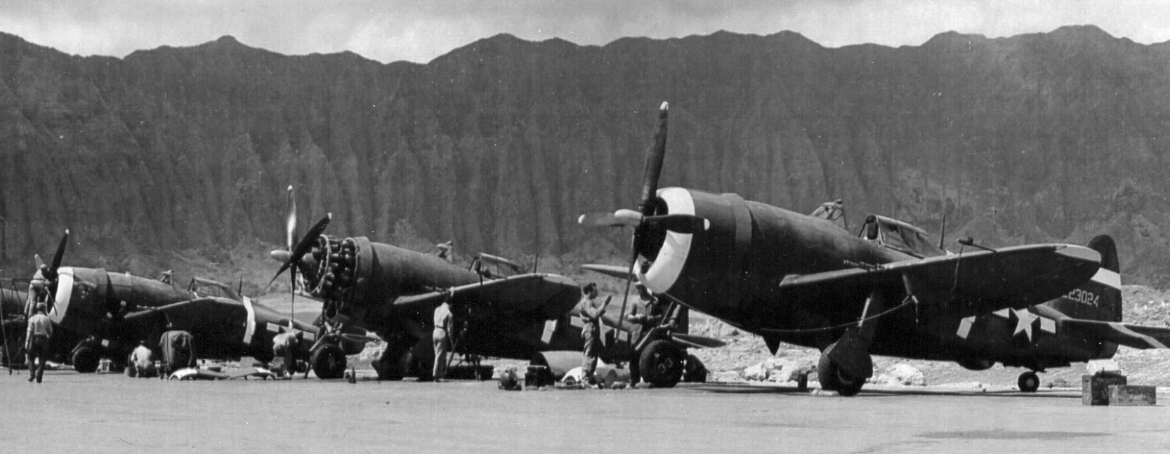
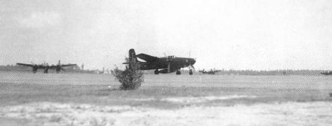
A circa 1943-45 photo of 318th Fighter Group 73rd Fighter Squadron Republic P-47 Thunderbolt fighters at Bellows Field.
From left to right are pictured Maj. Hussey's P-47 "Moonshine”, Lt. Cumpstone's #32, and Lt. Cormier's #33.
A 5/16/44 aerial view looking west at an inspection of the 73rd & 19th Fighter Squadron's Republic P-47 Thunderbolt fighters at Bellows Field.
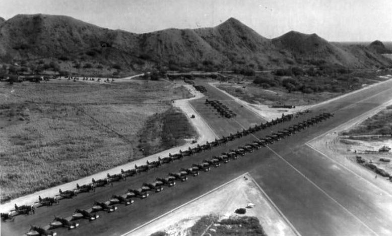
A stunning aerial photo looking southwest at Bellows Field in May 1944,
with rows of P-47s & B-25s on the runway for an inspection
(courtesy of the 15th Airlift Wing History Office, via Colin Perry of the Hawaii Aviation Preservation Society).
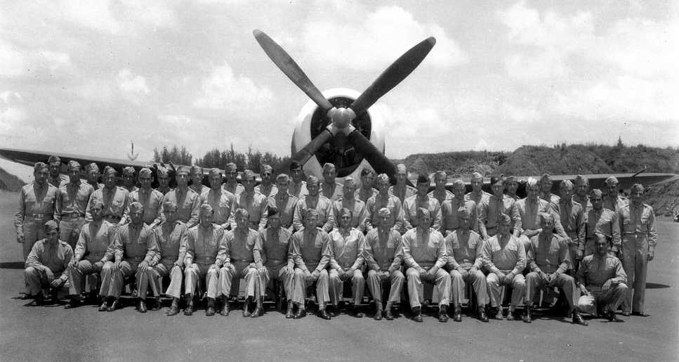
A 1944 photo of the members of the 318th Fighter Group's 73rd Fighter Squadron in front of one of their P-47 Thunderbolts at Bellows Field.
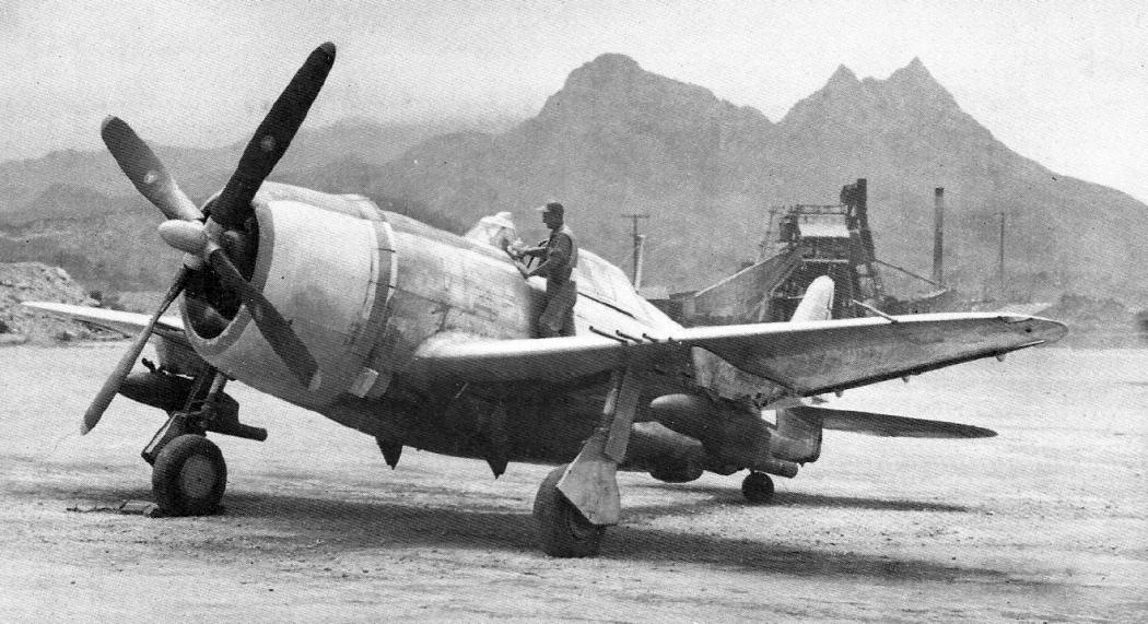
A WW2 photo of a Republic P-47D-23-RE Thunderbolt at Bellows Field (courtesy of John Voss), equipped with smoke-generating tanks mounted on the wing racks.
The April 1945 V-450 Hawaiian Islands U.S. Navy Aviation Chart (courtesy of Chris Kennedy)
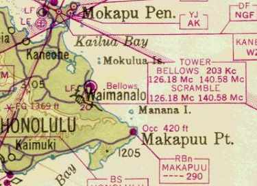
appeared to depict the Bellows as having 2 different towers (for its 2 airfields): “Bellows” & “Scramble”.
"Bellows AAB" was depicted on the 1947 Hawaiian Islands Sectional Chart (courtesy of John Voss) as having a 6,200' paved runway.
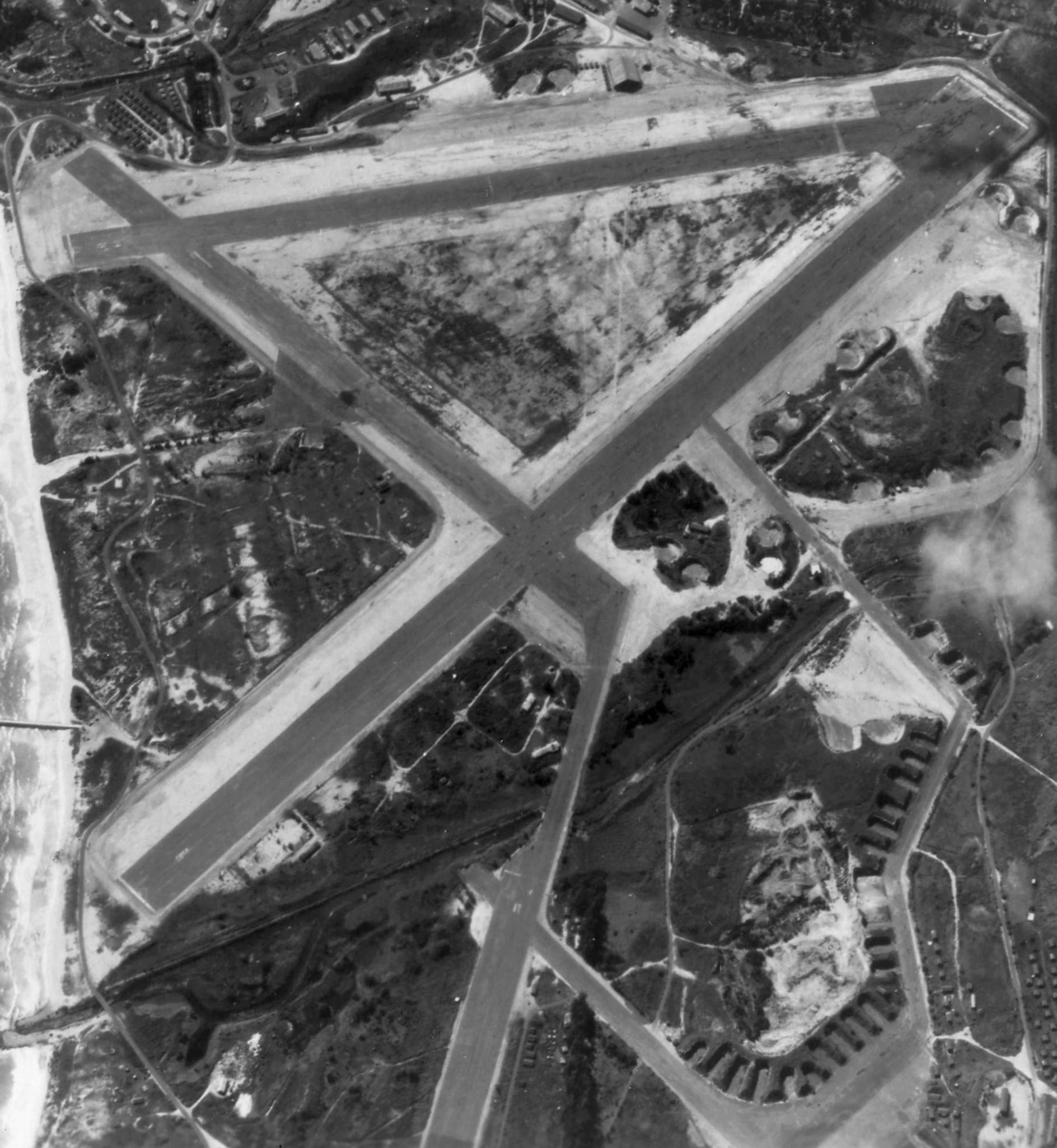
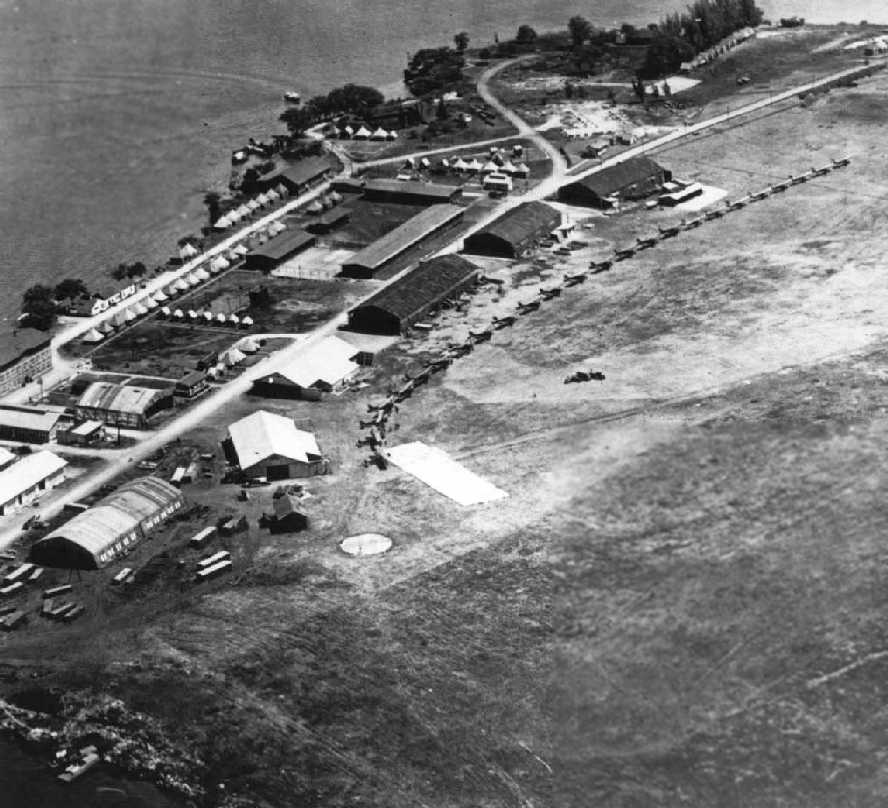
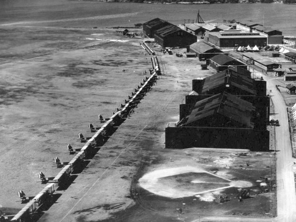
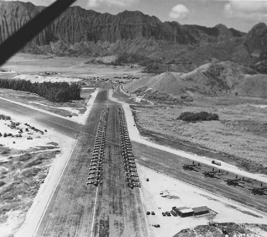
A circa 1948 aerial view looking south at the 3 runways of Bellows South Field (from the Digital Archives of Hawaiʻi).
The 1952 USGS topo map depicted Bellows Air Force Base as having 4 paved runways.
A February 1952 aerial view looking southwest at the Bellows runways (from the University of HI).
The airfields diagram on the October 1954 Hawaiian Islands Sectional Chart (courtesy of Chris Kennedy)
depicted Bellows' south field as having 3 paved runways, with the longest being the 6,290' Runway 3/21.
The 1955 Honolulu Local Aeronautical Chart (courtesy of Chris Kennedy)
depicted Bellows as having 2 distinct airfields, connected by a taxiway (most likely dictated by geographic constraints),
wiith the north Bellows airfield labeled as "(closed)".
However, the south Bellows airfield may have been used for some period during the 1950s as a civilian airfield of some type.
The 1955 Honolulu Local Aeronautical Chart labeled the south field simply as "Bellows", without any kind of military designation.
In the Aerodromes table on the chart, the type of the airfield is listed as "Ltd" - what did that mean?
The field is described as having a total of 5 runways, with the longest being a 6,290' asphalt strip.
The field was also described as "Not attended".
The runways at Bellows were eventually closed in 1958.
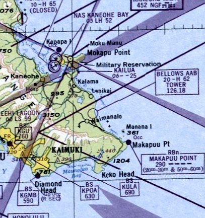
Bellows as depicted on the 1961 Honolulu Sectional Chart (courtesy of John Voss).
In March 1961, a portion of the Bellows property was used as the location of the Army's OA-32 Nike missile battery,
part of a network of 4 Nike surface-to-air missile batteries in Oahu.
The Bellows Nike battery was different from many of those on the mainland U.S.
in that the NIKE missiles at the Bellows battery were kept above ground.
The Bellows battery was also a "double" battery, having 2 rows of 12 missile launchers.
An undated photo of 8 Nike Hercules missile launchers at Bellows, with half of the missiles in covered above-ground storage,
from the September 1962 Hawaii Guardsman.
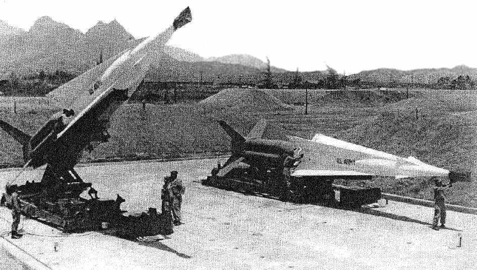
An undated photo of 2 Nike Hercules missiles on their launchers at Bellows, from the December 1963 Hawaii Guardsman.
Tim Haehnlen recalled, “In the 1960s... With respect to the Nike-Hercules site at Bellows..
adjacent to the site at the top of the Koolau mountain range during this time frame,
there were several hastily-constructed vertical rectangular buildings, each with a dome on top,
plus other structures (I lived in the area so was privy to what was happening on top of the mountains - in plain sight).
This area appeared to be a secure military reservation.
I am guessing that these were special radars related to the Nike-Hercules site for target tracking & prosecution, whether potential Soviet bombers or incoming ballistic missiles?
The site did not stay active for too many years & was deconstructed about the time that the missile battery was shut down.
I recall when they took the sides of the buildings down, inside was what appeared to be a T-shaped concrete pedestal almost as high as the building,
and if I understand the concept correctly, wonder if they were like the illuminators on a guided missile warship of the era, used to guide semi-active missiles to their targets?”
The Bellows property was renamed Bellows Air Force Station in 1968.
A 1968 street map (courtesy of Kevin Walsh) depicted Bellows Air Force Station as having 4 runways.
A 2/2/68 USGS aerial view of the remains of the Bellows Field runways.
A closeup from the 2/2/68 USGS aerial view, showing several Nike surface-to-air missiles on their launchers at OA-32 Nike Battery on the south side of the Bellows runways.
The Bellows OA-32 Nike missile battery was deactivated in March 1970.
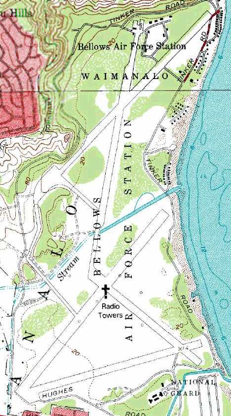
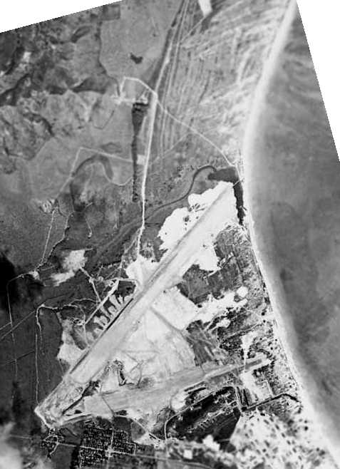
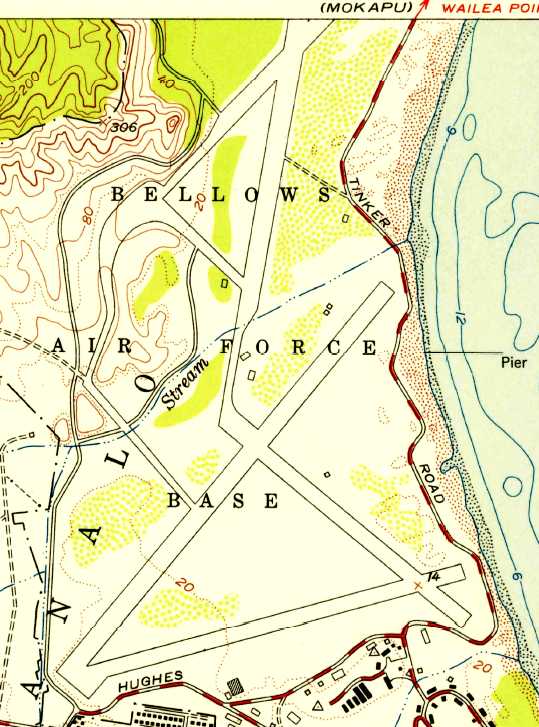
USGS topo map 1983.
In the 1980s, the H. H. Aerospace Design Company was commissioned
to study the possibility of reopening one of the Bellows airfields for general aviation use.
They concluded that it would be feasible,
but the Air Force stated that "activation of the airfield would have a negative impact on...
Marine assault training that is conducted by the Marine Corps."
The H. H. Aerospace Design Company report provided further details about Bellows:
"The 1st Marine Brigade from Kaneohe MCBH uses Bellows AFS extensively
for combat training to include simultaneous air & amphibious beach assaults.
During 1982, the Marines trained 227 days including helicopter training on 25 of those days (200 flight hours)
and amphibious training on 50 days.
The Bellows AFS training site is unique due to its proximity to Kaneohe Bay
and its beach access for the some 550 acres of training area."
The H. H. Aerospace Design Company report continued, “Bellows AFS has 5 inactive runways.
Three southern runways (6/24, 12/30, 3R/21L) and 2 northern runways (18/36 & 3L/21R).
These runways are severely deteriorated & not usable by fixed wing aircraft.
The station contains a communications transmitter facility.
There are 27 high frequency antennae, both rotatable & fixed, occupying 577 acres
[these antenna are no longer in service & have subsequently been removed].
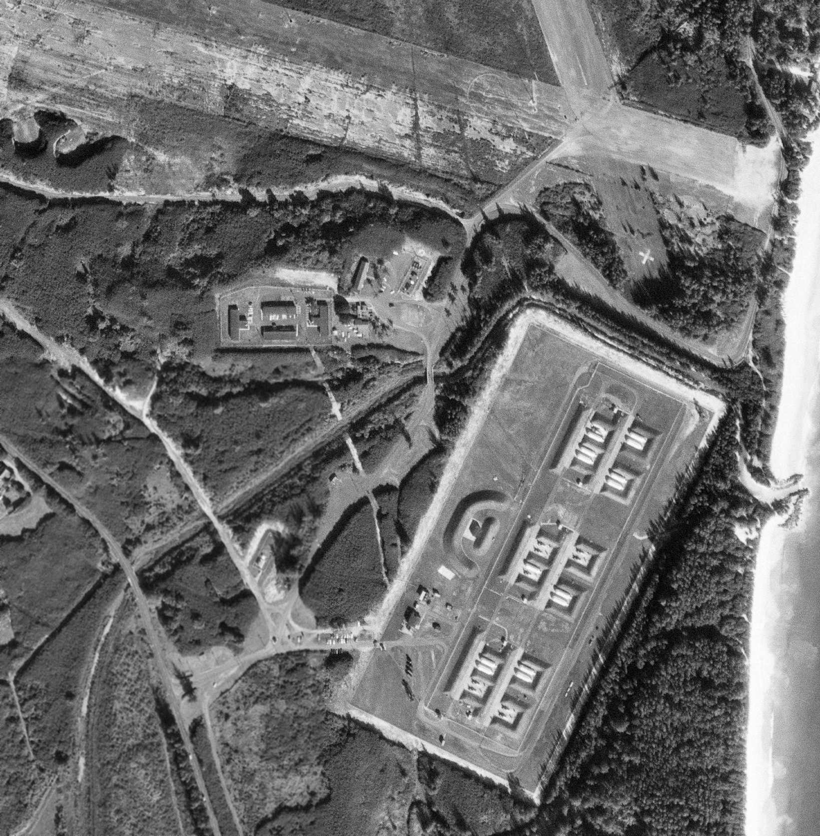
The Bellows Recreation Center is operated by Detachment 1, 15th Air Base Wing.
The center is composed of 102 beach cottages, a small exchange & a beach club.
The Recreation Center & its support facilities occupy 154 acres.
The Air Force has a license agreement with the City & County of Honolulu
to allow the general public to use approximately 54 acres of those acres for swimming, picnicking & camping.
Such use is limited to weekends & holidays."
The Bellows installation is still owned today by the Air Force, and its beaches are operated as a recreation facility for military families.
Bellows was still depicted as an abandoned airfield on recent Sectional Charts.
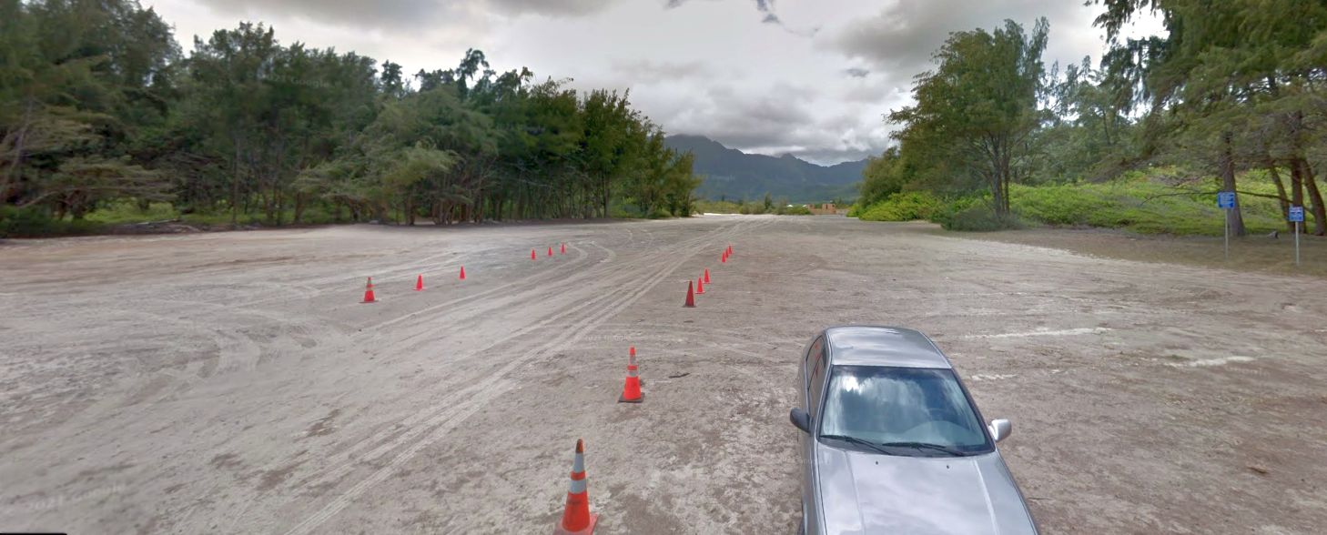
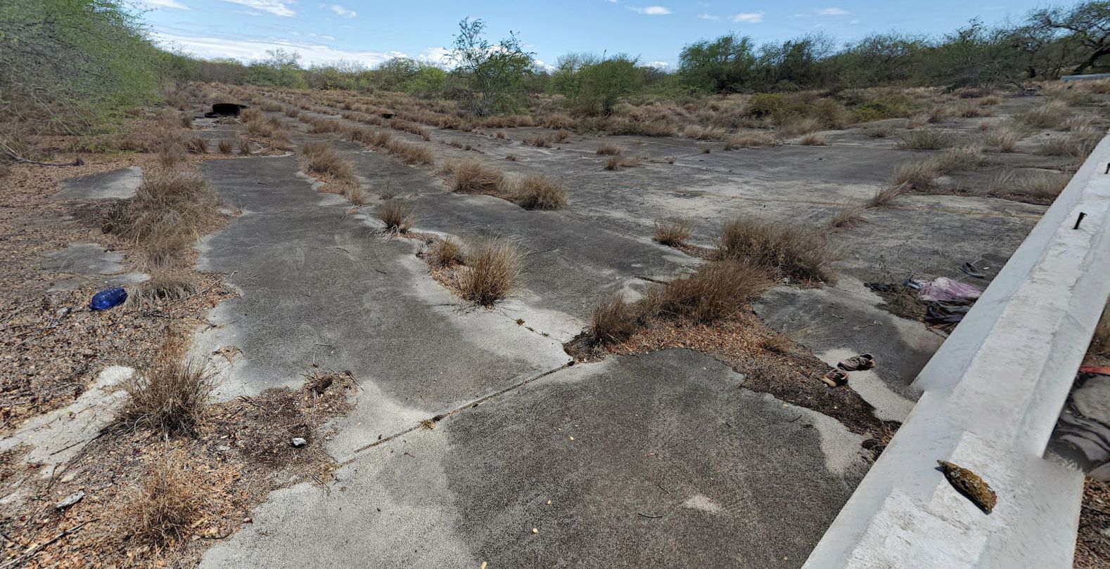
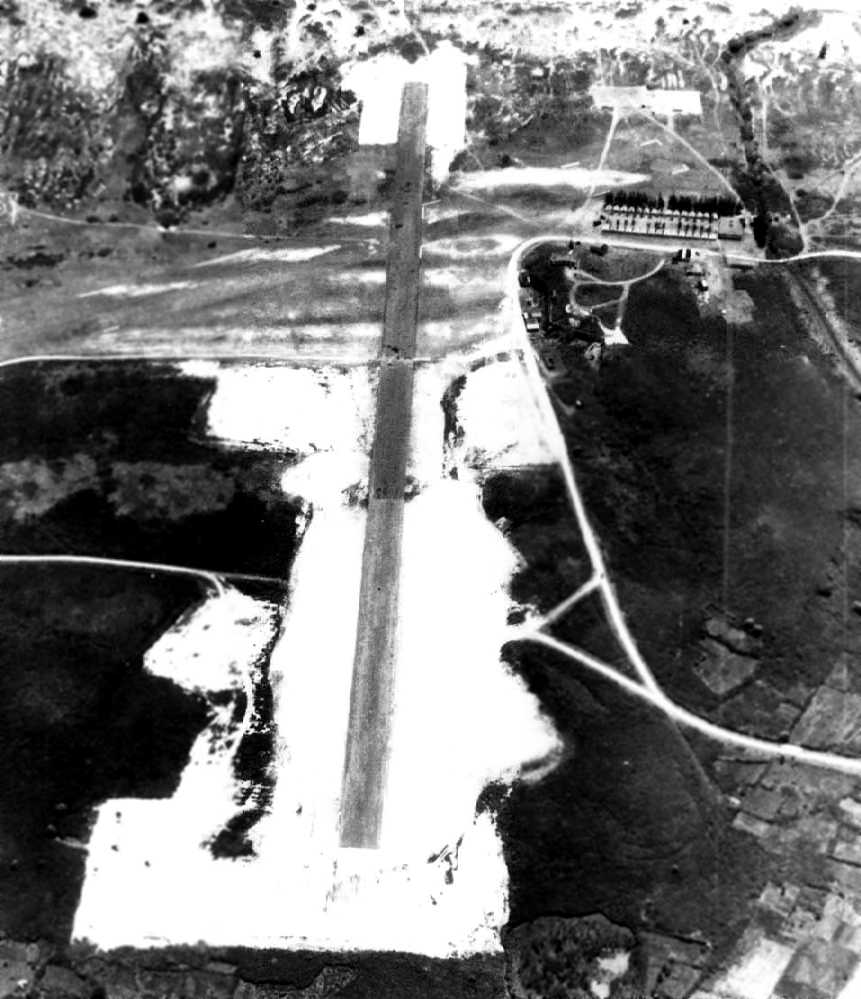
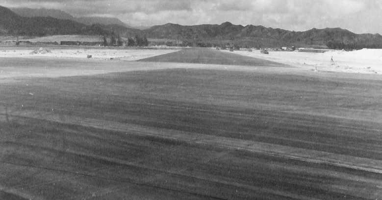
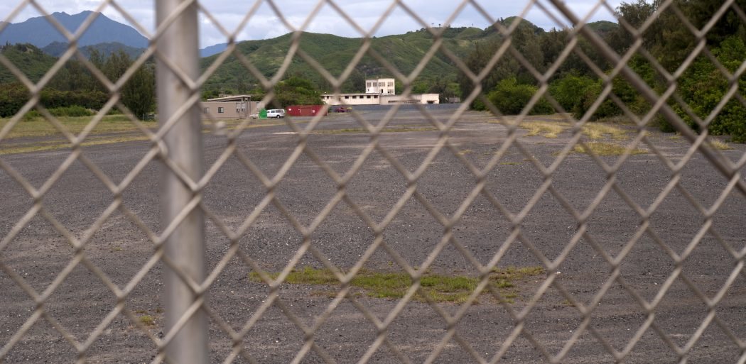
A 2011 photo looking southwest along the remains of Bellows Runway 24.
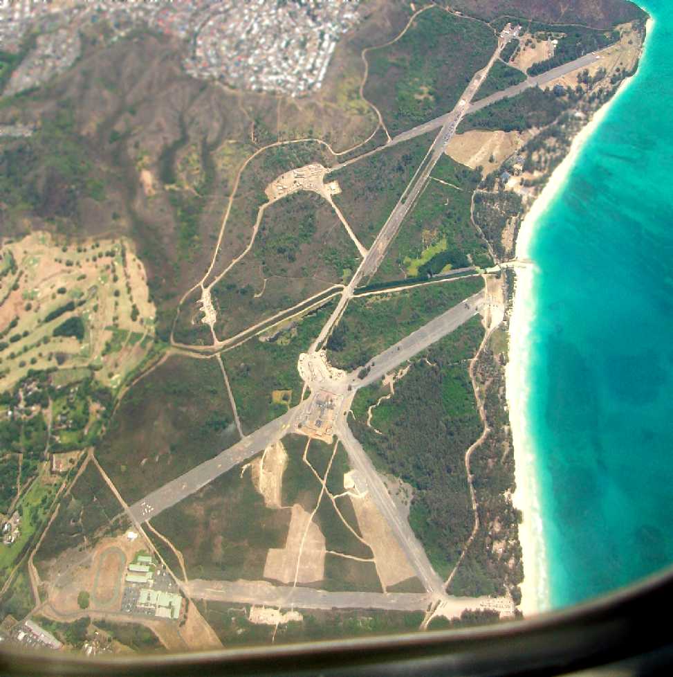
A 6/15/12 aerial view by Donald Russell looking northwest at the Bellows airfield.
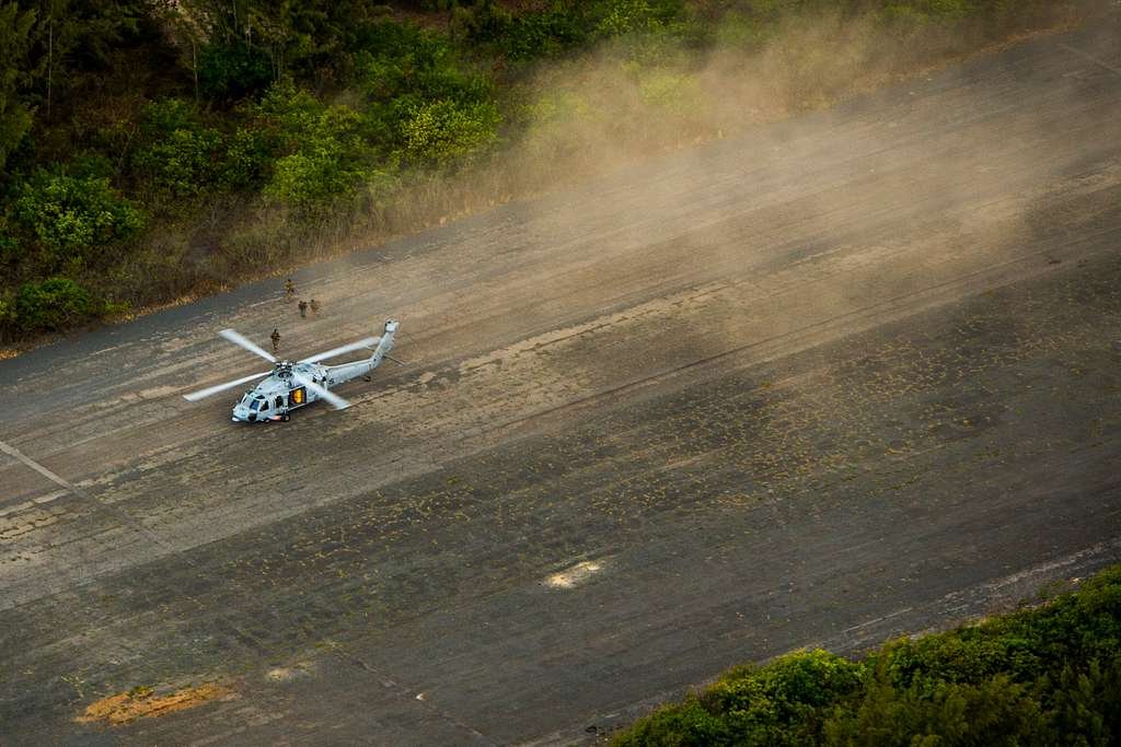
A 7/23/12 DoD photo of a Navy MH-60R Seahawk from the 4th Black Knights Squadron conducting a Search & Rescue exercise on a former Bellows Field runway.
An 8/23/14 photo by Timothy Williamson looking northwest along a Bellows runway.
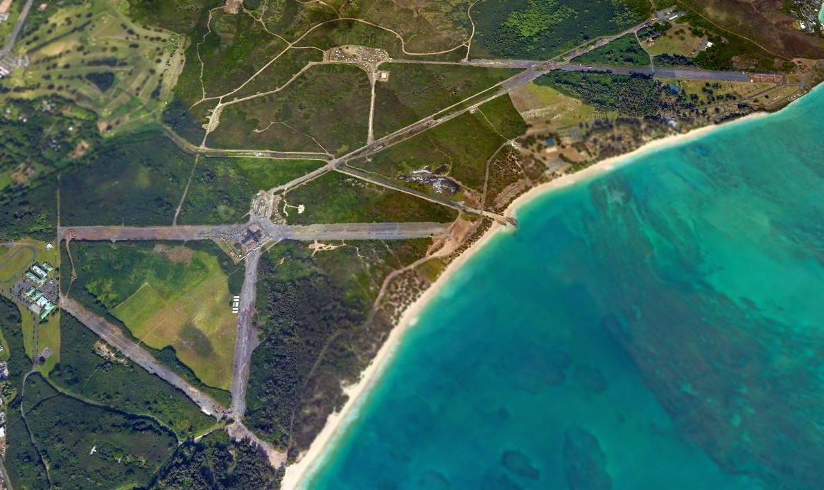
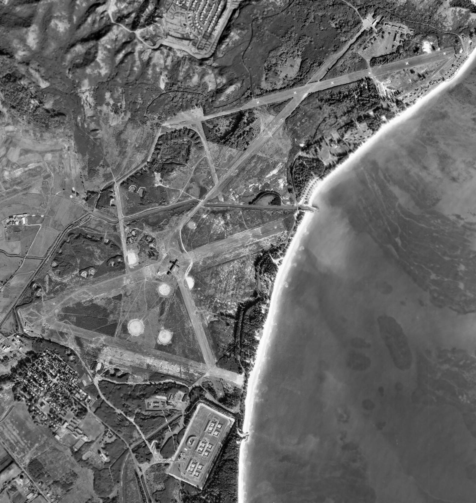
A 2015 aerial view looking northwest at the 5 former runways at Bellows Field.
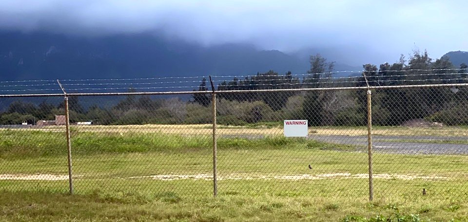
A 2023 photo by Bill Denne of the remains of a Bellows runway.
See also: http://www.bellowsafs.com/history.html
____________________________________________________
Or if you prefer to contact me directly concerning a contribution (for a mailing address to send a check),
please contact me at: paulandterryfreeman@gmail.com
If you enjoy this web site, please support it with a financial contribution.
Or if you prefer to contact me directly concerning a contribution (for a mailing address to send a check),
please contact me at: paulandterryfreeman@gmail.com
If you enjoy this web site, please support it with a financial contribution.
____________________________________________________
This site covers airfields in all 50 states.