Abandoned & Little-Known Airfields:
Western Iowa
© 2003, © 2025 by Paul Freeman. Revised 11/23/25.
This site covers airfields in all 50 states: Click here for the site's main menu.
____________________________________________________
Please consider a financial contribution to support the continued growth & operation of this site.
(Original) Ames Municipal Airport / Wearth Airport (revised 6/18/18) - Council Bluffs Airport (original location) (revised 4/18/20)
Fort Dodge Airport / Eno Airport (revised 3/9/24) - Laurens Skyways Airport (revised 3/9/24) - Linby NOLF (revised 11/10/21) - Onawa Municipal Airport (revised 11/23/25)
Orange City Airport (revised 11/23/25) - Primghar Airport (revised 9/15/22) - Sioux Center Municipal Airport (revised 3/9/24)
____________________________________________________
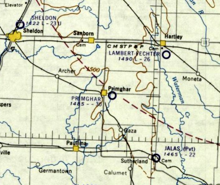
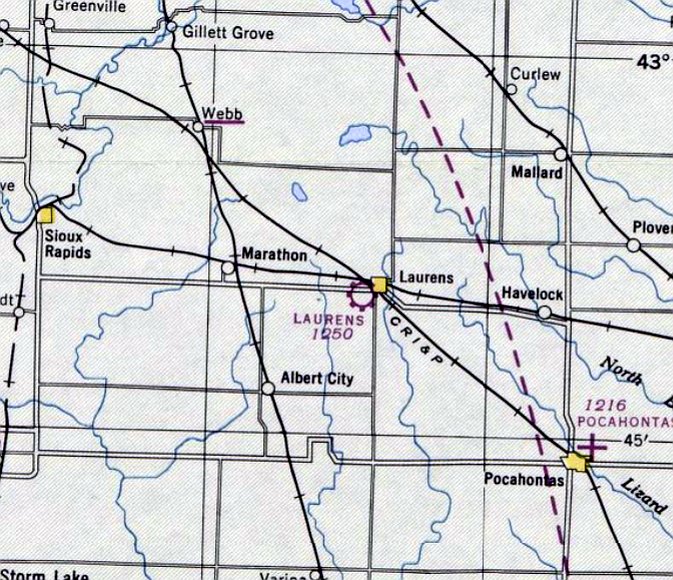
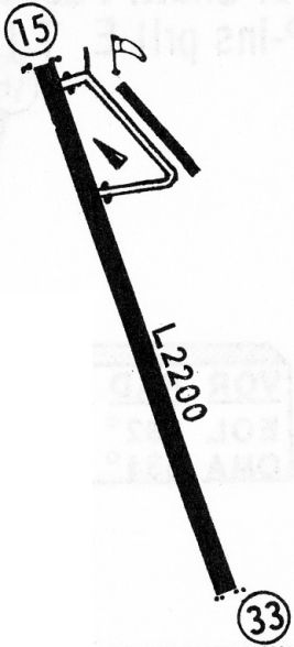
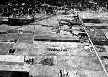
Primghar Airport (2Y0), Primghar, IA
43.078,-95.614 (Northeast of Sioux City, IA)
Primghar Airport, as depicted on the December 1960 Dubuque Sectional Chart.
Primghar Airport was not yet depicted on a 1949 aerial photo.
An article entitled “Primghar Airport Near Completion” in the 12/14/58 Des Moines Register (courtesy of Lee Corbin) said,
“The municipal airport a half mile east of here is nearing completion. A blacktop airstrip is 3,300' long, with a runway 2,400' long.”
The FAA Airport/Facility Directory data for Primghar Airport gave its activation date as April 1960.
Primghar Airport was not yet depicted on the June 1960 Dubuque Sectional Chart.
The earliest depiction which has been located of Primghar Airport was on the December 1960 Dubuque Sectional Chart.
It depicted Primghar Airport as having a 3,000' unpaved runway.
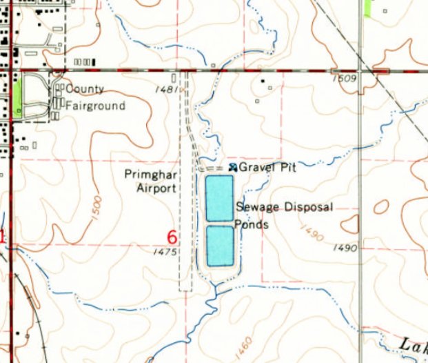
The earliest topo map depiction which has been located of Primghar Airport was on the 1964 USGS topo map.
It depicted a single unpaved north/south runway, with 1 small building on the northwest corner.
The earliest photo which has been located of Primghar Airport (and the only photo showing an aircraft at the airport) was a 1994 aerial view looking southwest.
It depicted Primghar Airport a having a single grass north/south runway, with a paved portion on the northern half, and a small hangar on the northwest corner.
One light single-engine aircraft was parked next to the hangar.
A September 2009 photo looking south showed Primghar Airport's paved Runway 17 & hangar on the northwest corner.
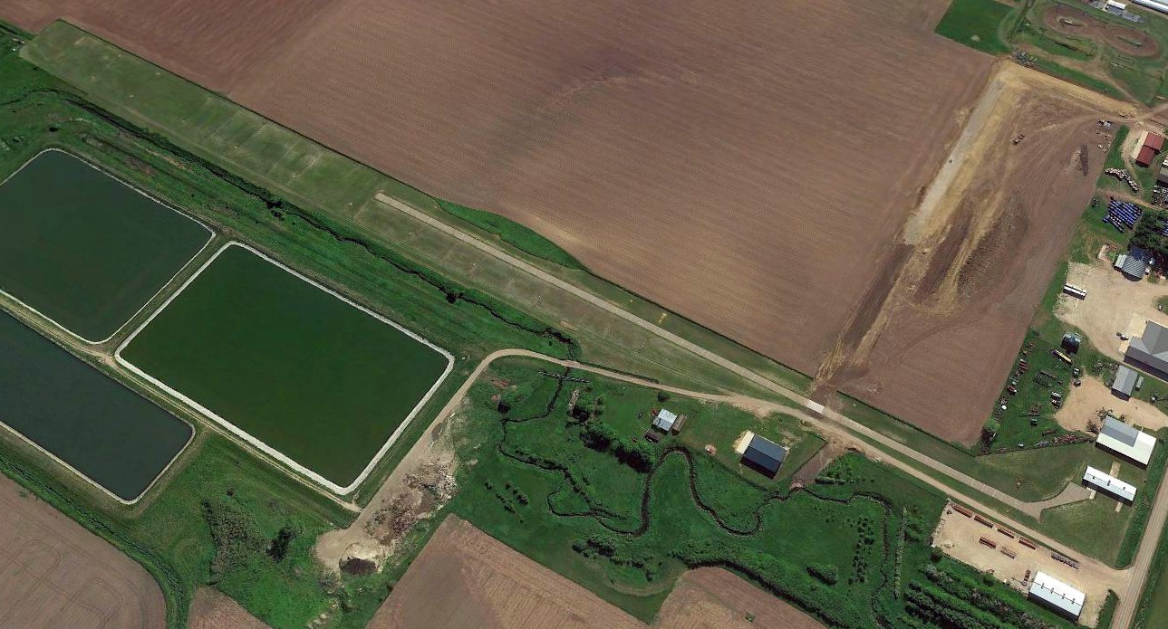
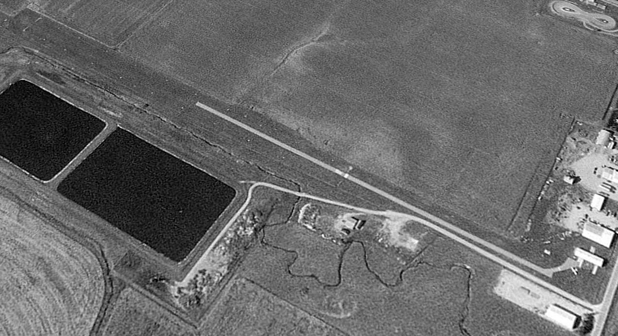
A 2015 aerial view looking southwest at Primghar Airport showed it to have a single grass north/south runway, with a paved portion on the northern half, and a small hangar on the northwest corner.
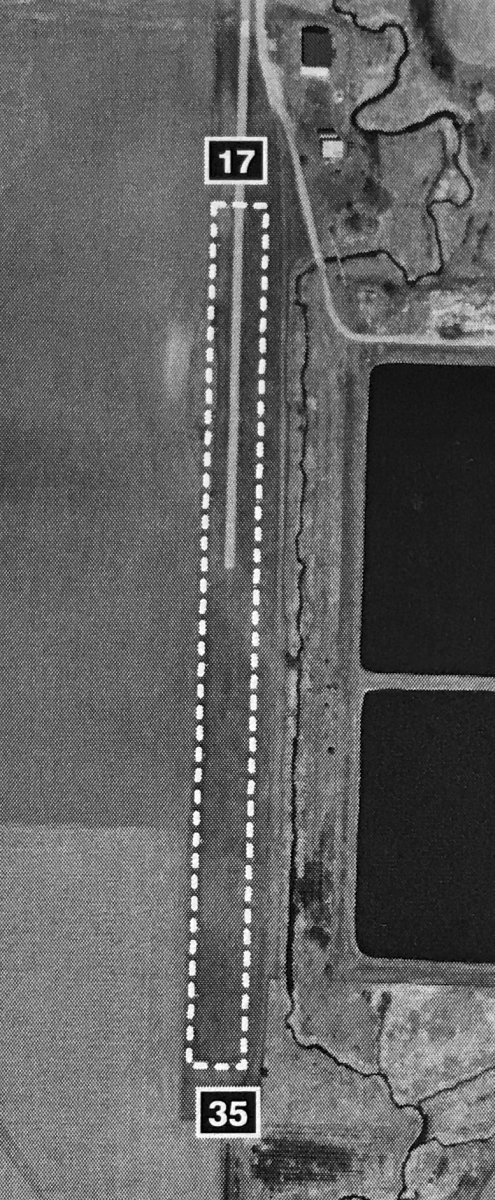
An undated aerial view of Primghar Airport from the 2019/20 IA Airport Directory (courtesy of Ron Plante).
The directory described Primghar Airport as having a 1,985' unpaved Runway 17/35.
The last aeronautical chart depiction which has been located of Primghar Airport was on the July 2019 Omaha Sectional Chart.
It depicted Primghar Airport as having a 2,000' unpaved runway.
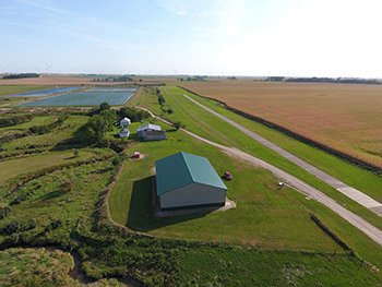
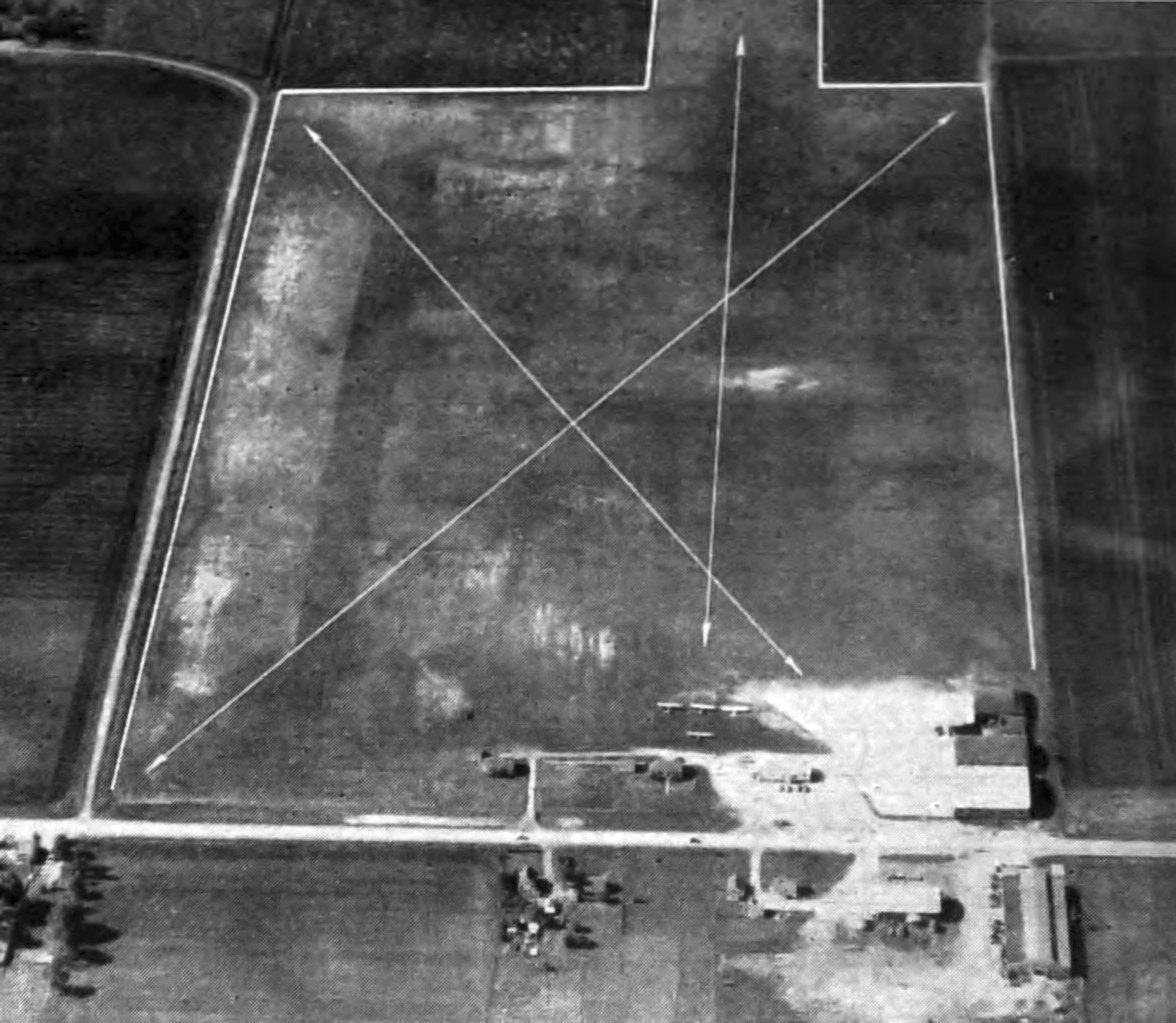
An undated (2020 or earlier) aerial view looking southwest at Primghar Airport from the IA Airport Directory (courtesy of Ron Plante).
As of 2020, the FAA Airport/Facility Directory described Primghar Airport as “Closed permanently”.
It described Primghar as having a single 1,985' turf Runway 17/35, with an 855' asphalt portion on the Runway 17 end.
The owner was listed as the City of Primghar, and the manager as Denny Logan.
As of 2020, Primghar Airport was no longer depicted on the Omaha Sectional Chart.

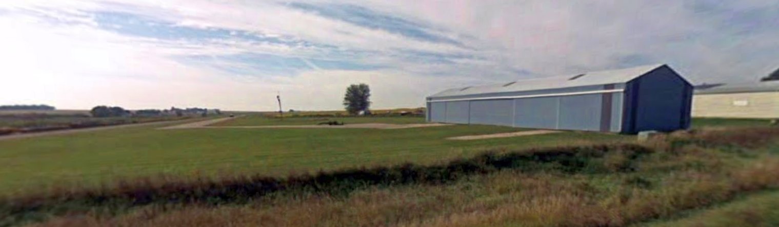
An August 2021 photo looking southwest at former Primghar Airport hangars.
Thanks to Lee Corbin for pointing out this airfield.
____________________________________________________
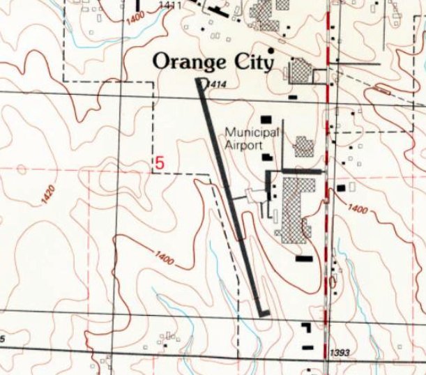
Sioux Center Municipal Airport (KSOY), Orange City, IA
43.133, -96.188 (Northwest of Des Moines, IA)
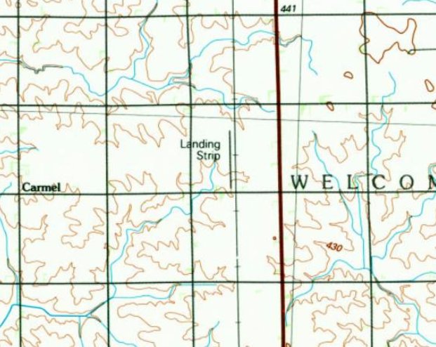
Sioux Center Municipal Airport, as depicted on the 1985 USGS topo map.
Sioux Center Municipal Airport was not yet depicted on a 1966 aerial photo.
According to its FAA Airport/Facility Directory data, Sioux Center Municipal Airport was activated in August 1972.
The earliest depiction which has been located of Sioux Center Municipal Airport was on the 1985 USGS topo map.
It depicted a single north/south runway, generically labeled as “Landing Strip”.
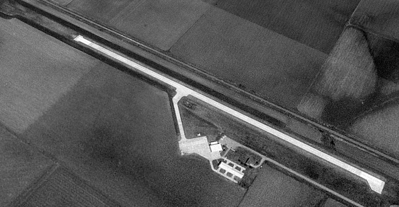
The earliest photo which is available of Sioux Center Municipal Airport was a 1994 USGS aerial view looking northeast.
It depicted Sioux Center Municipal Airport as having a single paved north/south runway, with an unpaved overrun on the north end.
A ramp & several buildings were on the west side. There were no aircraft visible on the field.
For the year ending 7/19/17, the FAA Airport/Facility Directory data described Sioux Center Municipal Airport as having a total of 14 based aircraft,
and the field was said to conduct an average of 18 takeoffs or landings per day (which seems high, possibly erroneous).
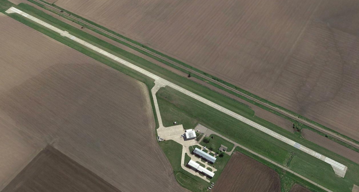
A 2017 aerial view looking northeast showed Sioux Center Municipal Airport showed the runway pavement had been lengthened to the north compared to the 1994 photo.
Two light planes were visible on the field.
According to its FAA Airport/Facility Directory data, Sioux Center Municipal Airport had a single 3,802 ' concrete Runway 18/36, “in good condition”.
Its manager was Randy Weide.
The larger Sioux County Regional Airport opened in October 2018 several miles west as a collaborative venture between Sioux Center, Orange City, and Sioux County,
at which point Sioux Center Municipal Airport was presumably closed.
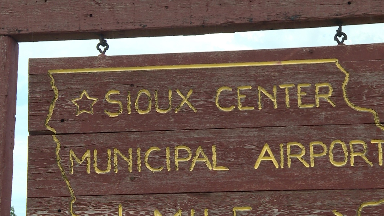
An undated (2020 or earlier) photo of the Sioux Center Municipal Airport sign.
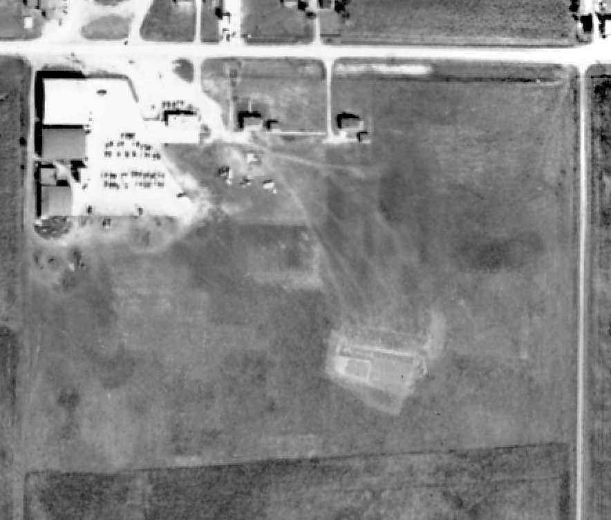
Sioux Center Municipal Airport was depicted as an abandoned airfield on the 2020 Sectional Chart.
A June 2022 photo looking north at the Sioux Center Municipal Airport hangars & runway.
Thanks to Ron Plante for pointing out this airfield.
____________________________________________________
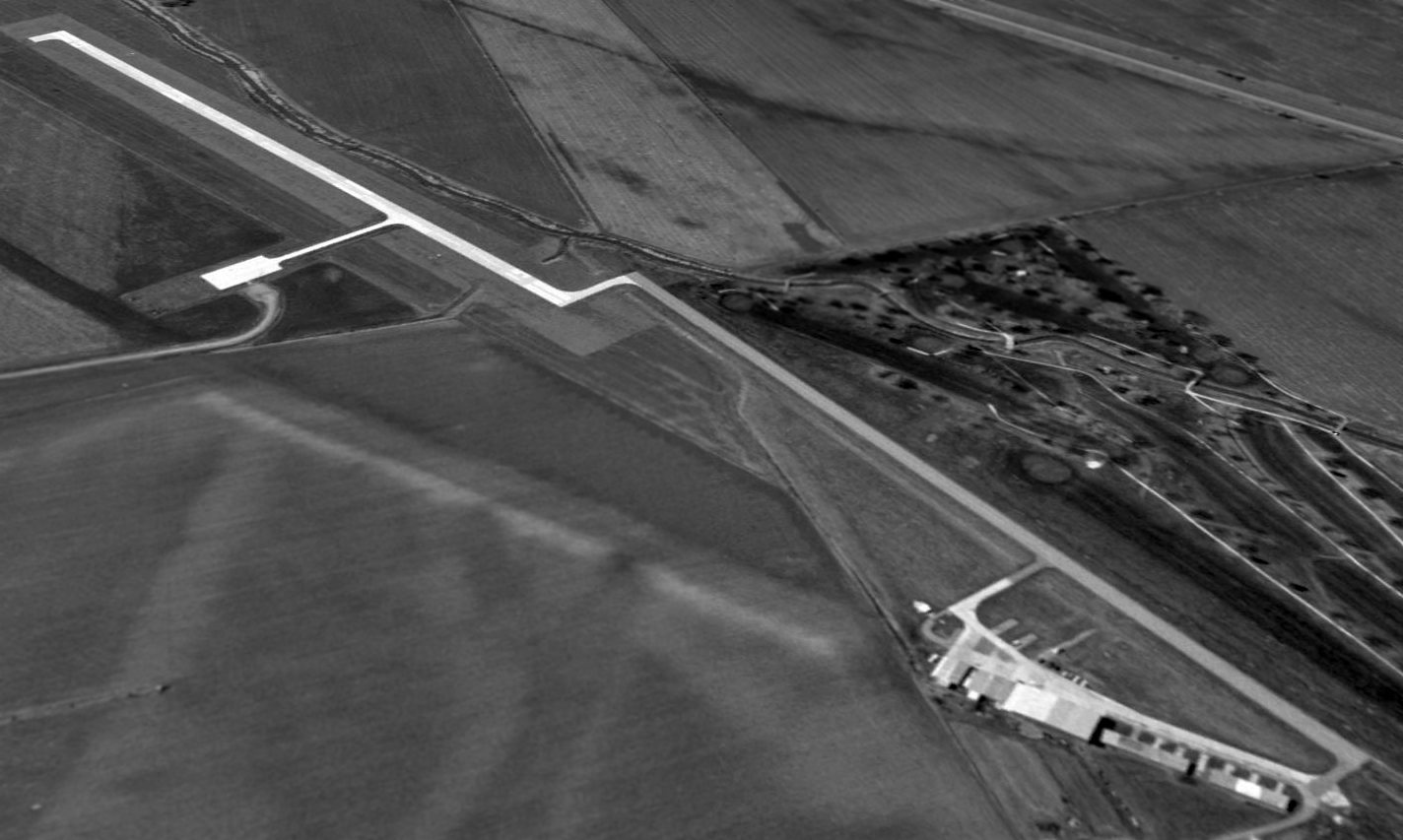
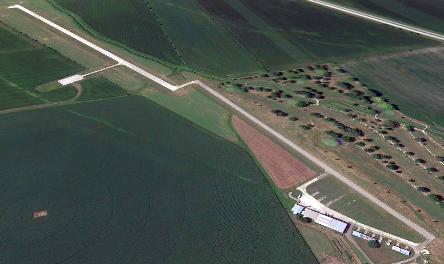
Orange City Airport (KORC), Orange City, IA
42.989, -96.062 (Northwest of Des Moines, IA)

Orange City Airport, as depicted on the May 1968 Sioux City Sectional Chart.
This small general aviation airport was evidently established at some point in 1967,
as it was not yet depicted on a 1951 aerial photo, the 1964 USGS topo map, or the November 1967 Sioux City Sectional Chart.
The earliest depiction which has been located of Orange City Airport was a 1967 aerial photo,
which appears to show the beginnings of the airport, with a single unpaved northwest/southeast runway having been newly constructed.
The earliest depiction which is available of Orange City Airport was on the May 1968 Sioux City Sectional Chart.
It depicted Orange City Airport as having a single 2,900' paved northwest/southeast runway.

The earliest photo which is available of Orange City Airport was an undated aerial view looking northwest from the 1971 IA Airport Directory (courtesy of Jonathan Westerling).
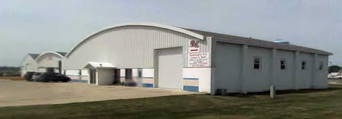
It described Orange City as having a single hard-surface 2,900' Runway 16/34, with a single arch-roof hangar on the southeast side, and to be managed by Don Schreur.
The earliest topo map depiction which has been located of Orange City Airport was on the 1985 USGS topo map.
It depicted the “Municipal Airport” as having a single paved northwest/southeast runway, with a ramp & several buildings on the east side.
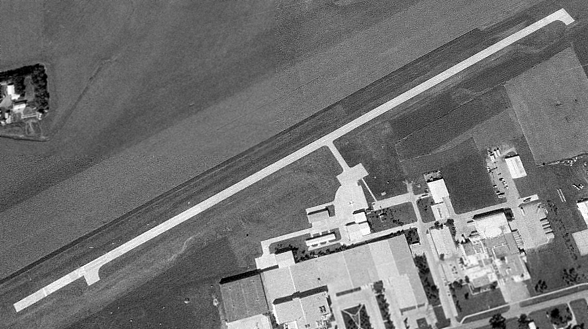
A 1994 USGS aerial view looking northwest depicted Orange City Airport as having a single paved northwest/southeast runway, with a ramp & several buildings on the east side.
One light single-engine plane was visible on the ramp.
For the year ending 6/10/15, the FAA Airport/Facility Directory data described Orange City Airport as conducting an average of 80 takeoffs or landings per week.
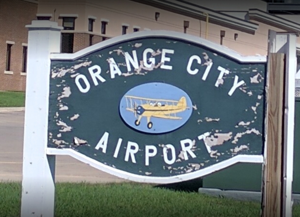
A September 2016 photo of the Orange City Airport sign.
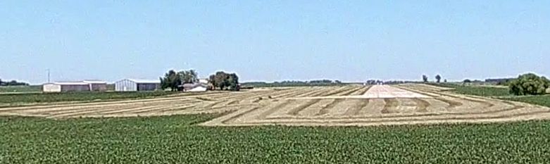
A 2017 aerial view looking northwest showed Orange City Airport in the same configuration as the 1994 photo, but there were no aircraft visible on the field.
The larger Sioux County Regional Airport opened in October 2018 several miles west as a collaborative venture between Orange City, Sioux Center, and Sioux County,
at which point Orange City Airport was presumably closed.
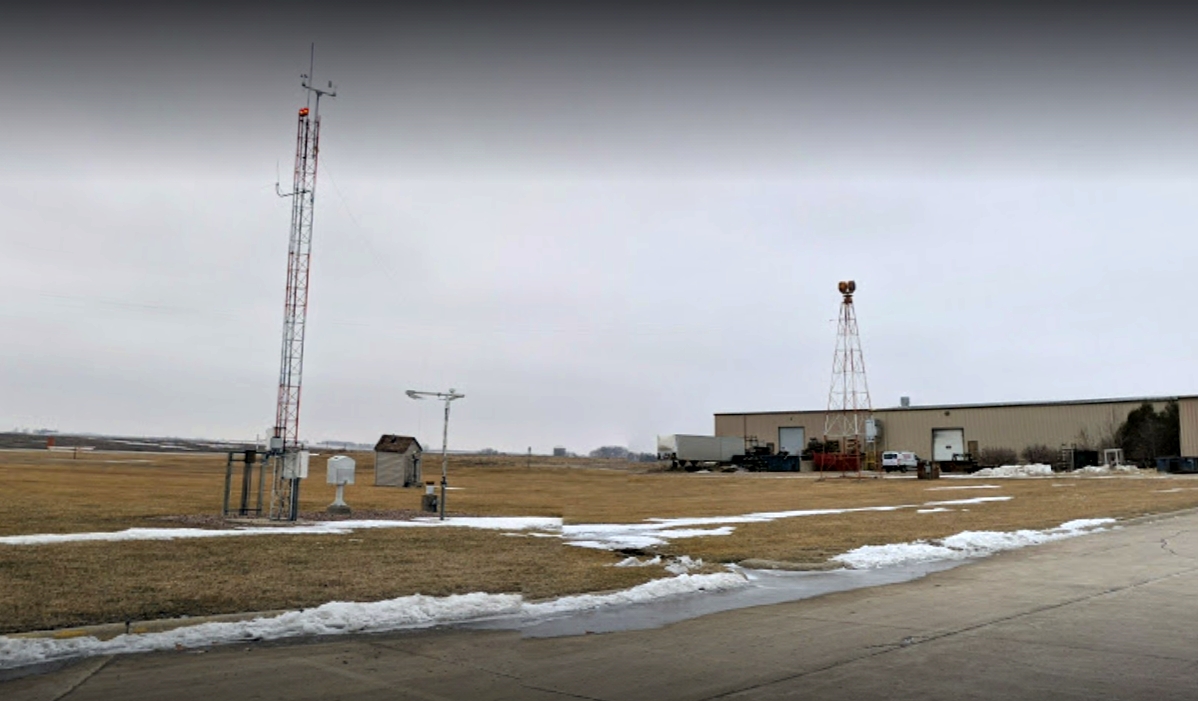
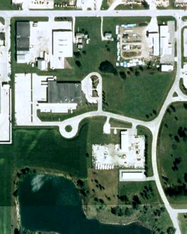
A January 2019 photo of the Orange City Airport beacon tower.
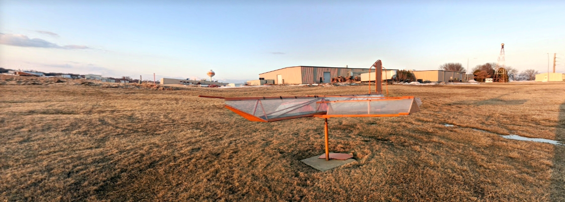
A January 2020 photo of the Orange City Airport wind direction indicator.
As of 2020, the FAA Airport/Facility Directory data described Orange City Airport as having a single 4,254' concrete Runway 16/35, “in fair condition”.
Orange City Airport was still depicted on the 2020 Sectional Chart, but labeled “Closed”.
Thanks to Ron Plante for pointing out this airfield.
____________________________________________________
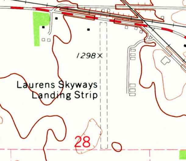
Laurens Skyways Airport, Laurens, IA
42.847, -94.864 (Northwest of Des Moines, IA)
Laurens Skyways Airport, as depicted on the December 1947 Dubuque Sectional Chart.
Laurens Skyways Airport was not yet depicted on the October 1941 Dubuque Sectional Chart.
According to an article (courtesy of Lee Corbin), Laurens Skyways was incorporated on 5/12/45 for the purpose of establishing an airport.
A portion of the Davidson farm was purchased as an airport site.
Laurens Skyways Airport was not yet depicted on the June 1947 Dubuque Sectional Chart.
The earliest depiction which has been located of Laurens Skyways Airport was on the December 1947 Dubuque Sectional Chart,
which depicted it as a commercial/municipal airport.
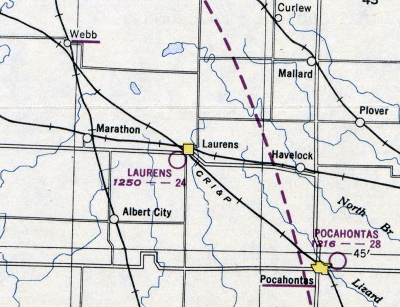
The April 1950 Dubuque Sectional Chart depicted Laurens Skyways Airport as having a 2,400' unpaved runway.
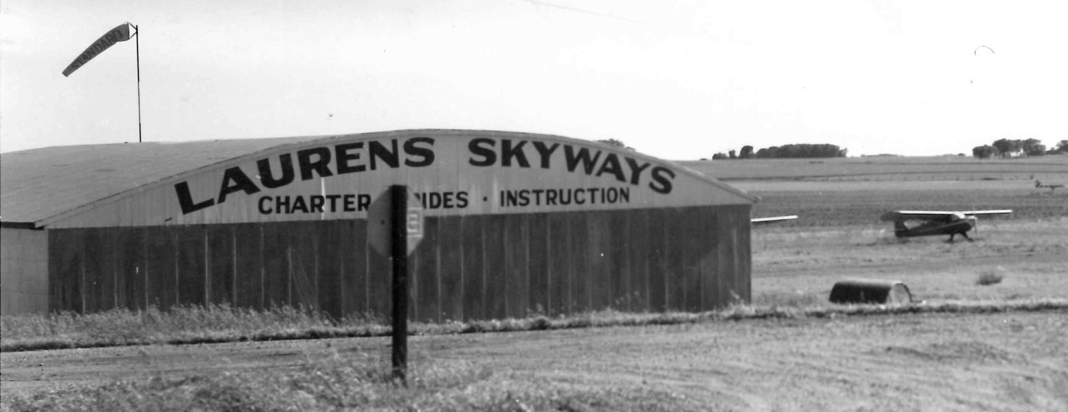
The earliest photo which has been located of Laurens Skyways Airport was a 1955 photo (courtesy of Lee Corbin) of the Laurens Skyways hangar,
with 2 light single-engine aircraft visible in the background .
The earliest aerial photo which has been located of Laurens Skyways Airport was a 4/9/68 USGS aerial view (courtesy of Lee Corbin).
It depicted Laurens Skyways as having a north/south unpaved runway, with several hangars on the northeast side.
The row of Quonset huts along the east side appeared to be related to the adjacent farm, not the airport.
The last aeronautical chart depiction which has been located of Laurens Skyways Airport was on the September 1970 Dubuque Sectional Chart,
which depicted it as having a 2,200' unpaved runway.
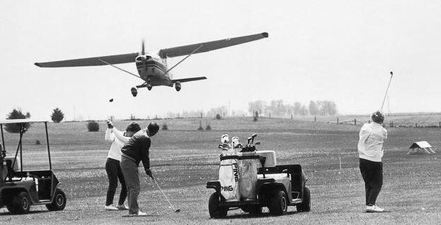
A circa 1970s photo showing a Cessna departing from Laurens Skyways Airport (courtesy of Lee Corbin),
showing the golf course which surrounded the runway.
John Thumma recalled, “As the years went on & air traffic waned at this strip the reputation was you had better buzz the runway a couple times to clear the golfers off before setting down.
My grandfather got his license & flew his neighbor's plane many times out of Laurens.”
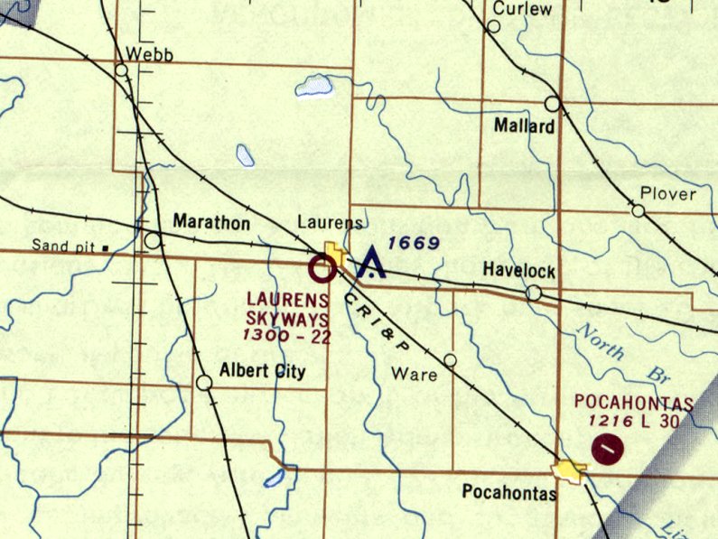
The 1971 USGS topo map (courtesy of Lee Corbin) depicted Laurens Skyways as having a north/south unpaved runway, with 3 small hangars on the northeast side.
According to John Thumma, “The airport corporation closed the airport for traffic” in approximately 2004.
Laurens Skyways Airport was no longer depicted on the 2013 USGS topo map.
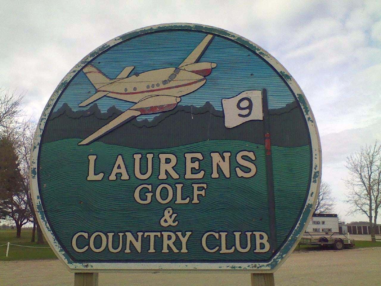
A circa 1980s-2017 photo of the sign for the Laurens Golf & Country Club (courtesy of Lee Corbin), commemorating the site's history as an airport.
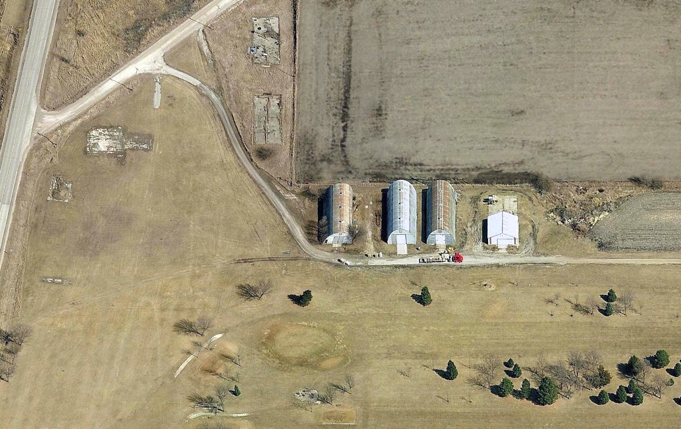
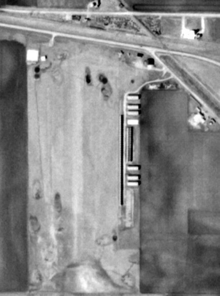
A circa 2010-2016 aerial view looking east at the hangar foundations on the northeast end of the site of Laurens Skyways Airport.
The row of Quonset huts along the east side appeared to be related to the adjacent farm, not the airport.
A 2016 aerial view looking southwest at the site of Laurens Skyways Airport.
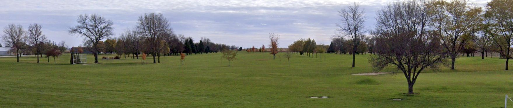
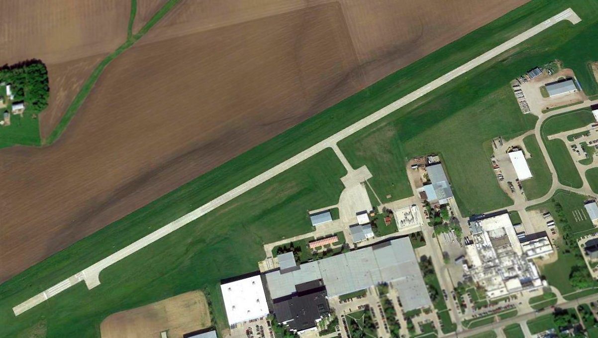
A November 2021 photo looking south along the former Laurens Skyways Airport runway, now a golf course.
The site of Laurens Skyways Airport is located southwest of the intersection of 440th Street & Airport Road, appropriately enough.
Thanks to Lee Corbin for pointing out this airfield.
____________________________________________________
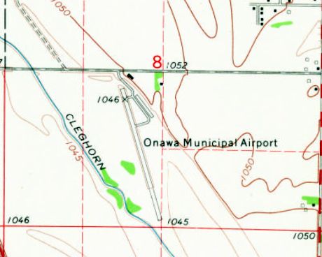
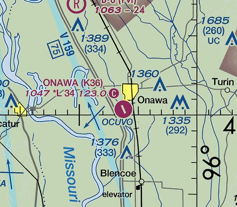
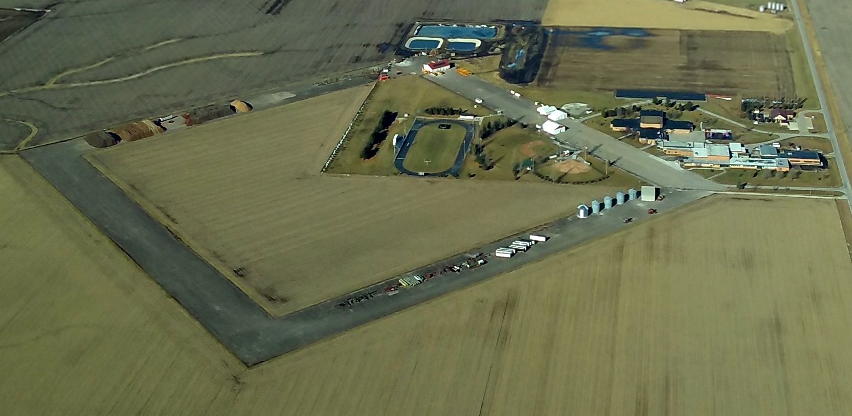
Onawa Municipal Airport (K36), Onawa, IA
42.0, -96.1 (North of Omaha, NE)
Onawa Municipal Airport, as depicted on the 1955 USGS topo map.
Onawa Municipal Airport was not yet listed among active airfields in the 1952 IA Airport Directory (courtesy of Lee Corbin).
The earliest depiction which has been located of the Onawa Municipal Airport was on the 1955 USGS topo map.
Onawa Municipal Airport was not yet depicted on the December 1957 Des Moines Sectional Chart.
The earliest aeronautical chart depiction which has been located of Onawa Municipal Airport was on the June 1958 Des Moines Sectional Chart.
It depicted Onawa as having a 2,400' unpaved runway.
According to its FAA Airport/Facility Directory Data, Onawa Municipal Airport was activated in April 1959.
The 1968 Flight Guide (courtesy of Bob Levittan) depicted Onawa Municipal Airport
as having a 2,200' paved Runway 15/33, with a ramp & 1 building on the northeast side.
The 1969 USGS topo map depicted Onawa Municipal Airport as having a single northwest/southeast runway, with a ramp & 1 building on the north side.

The earliest photo which has been located of Onawa Municipal Airport was an undated aerial view looking northwest from the 1971 IA Airport Directory (courtesy of Jonathan Westerling).
It described Onawa as having a single asphalt 2,865' Runway 15/33, and to be operated by Simpson Aircraft.
A 2000 aerial view looking southwest showed Onawa Municipal Airport's runway had been curiously replaced by a runway of the same length, but located to the south of the existing runway.
A 2012 aerial view looking southwest showed Onawa Municipal Airport remained intact, though without any aircraft visible nor other signs of recent aviation use.
The only aeronautical chart depiction which has been located of Onawa Municipal Airport was on the 2015 Sectional Chart.
It depicted Onawa as having a 3,400' paved northwest/southeast runway.
As of 2015, the FAA Airport/Facility Directory Data described Onawa Municipal Airport
as having a single 3,400' concrete Runway 15/33.
The owner was listed as the City of Onawa, and the manager as Bradley Hanson.
It was said to have only 3 based aircraft, and to conduct an average of 62 takeoffs or landings per month.
Onawa Airport was slated to be closed on 7/1/15, due to low usage & budget cuts.
Lance Garlock reported in 2016, “The Onawa Airport has been sold to the Onawa Racing & Events Center
and will be turned into a drag strip raceway & an event center for outdoor concerts & gatherings.
I believe it became official in May 2016.”
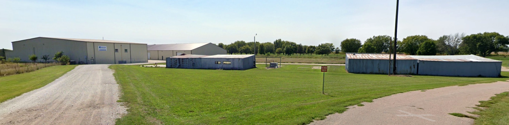
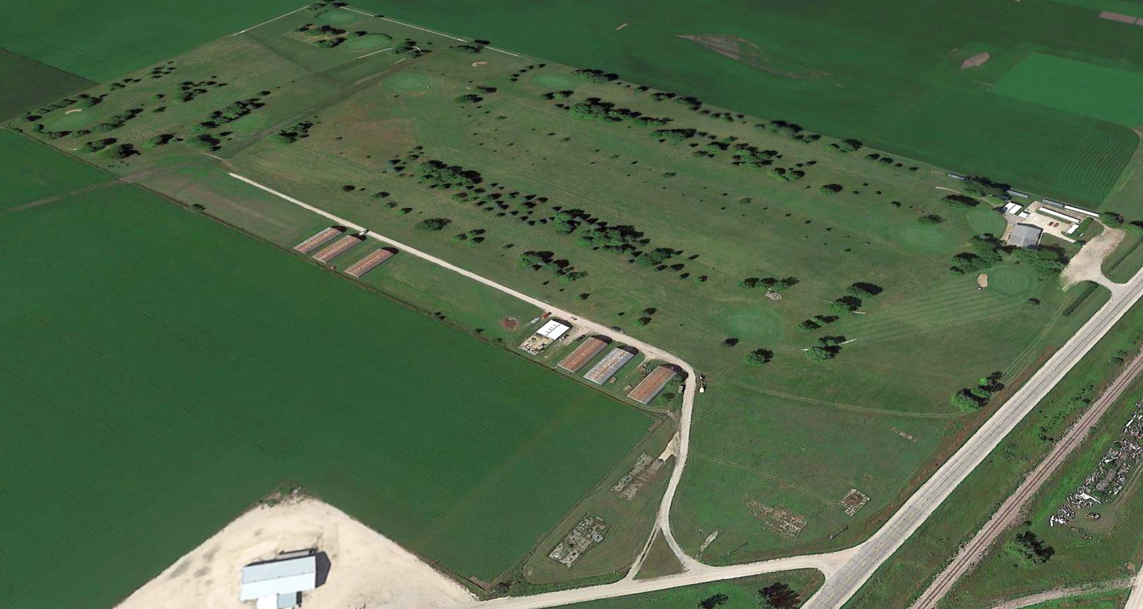
A September 2021 photo looking southwest at the Onawa Municipal Airport hangars.
Onawa Municipal Airport is located southwest of the intersection of 10th Street & 235th Street.
Thanks to Marty Maisel for pointing out this airfield.
____________________________________________________
Fort Dodge Airport / Eno Airport, Ft Dodge, IA
42.5, -94.13 (Northwest of Des Moines, IA)
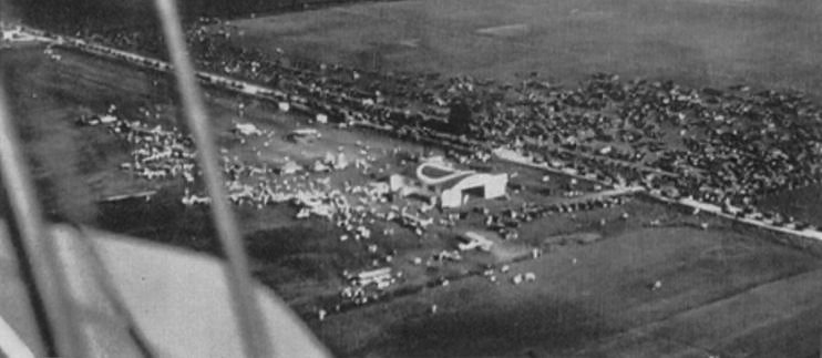
An undated aerial view of the Fort Dodge Airport from the 1929 Fort Dodge High School Yearbook (courtesy of Christopher Brame),
presumably showing the airport's dedication festivities.
No airport was depicted at this location on the 1923 USGS topo map.
According to an article in the 11/18/07 issue of The Messenger, “In 1929, the Eno Airport was opened on 200 acres south of East Lawn Cemetery.
This is the area on the south side of Business U.S. Highway 20.”
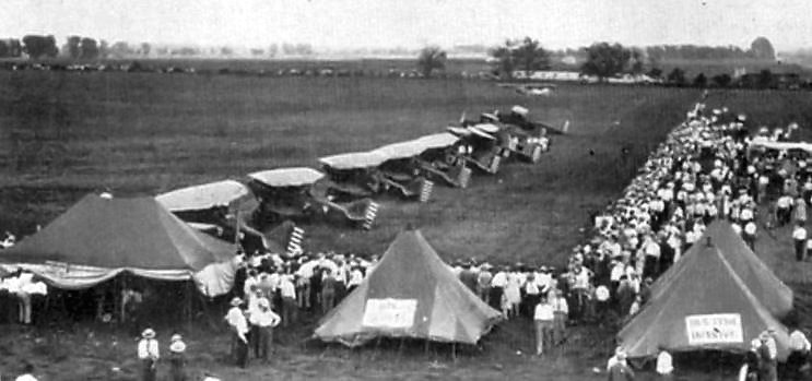
An undated photo of Army biplanes at the Fort Dodge Airport from the 1929 Fort Dodge High School Yearbook (courtesy of Christopher Brame),
presumably showing the airport's dedication festivities.
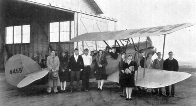
An undated photo of a group in front of a biplane & hangar at the Fort Dodge Airport from the 1929 Fort Dodge High School Yearbook (courtesy of Christopher Brame).
The location & layout of the Fort Dodge Airport as depicted in the 5/14/29 Commerce Department Airway Bulletin (courtesy of Mike Denja).
It described Fort Dodge as a commercial airport, owned by the Ft. Dodge Chamber of Commerce, and operated by the IA Airways Corporation.
It was said to consist of a 80 acre L-shaped sod field, having 4 runways, the longest being the 2,850' northwest/southeast strip.
A hangar & building were depicted on the southwest corner.
The earliest aeronautical chart depiction which has been located of Fort Dodge Airport was on the September 1936 Dubuque Sectional Chart.
A 1939 USDA aerial photo (from the ISU GIS system) depicted Eno Airport as having 3 unpaved runways,
with several small buildings on the north side of the field.
A 9/20/43 aerial view looking west from the 1945 AAF Airfield Directory (courtesy of Scott Murdock)
depicted Eno Airport as a grass landing area with a few small buildings on the north side.
The 1945 AAF Airfield Directory (courtesy of Scott Murdock) described Eno Airport
as a 100 acre rectangular property containing 4 sod runways (with the longest being a 2,200' north/south strip).
The field was said to have 3 hangars, the largest being a 100' square concrete structure (under construction).
Eno Airport was described as being owned & operated by private interests.
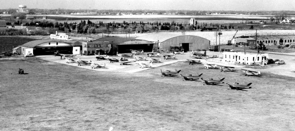
A circa 1940s aerial view looking northwest at Eno Airport (courtesy of Roger Natte via Gordon Westphal).
From left the buildings are: hangar, brick office, hangar, National Guard hangar, and a restaurant operated by Mattie Rasch.
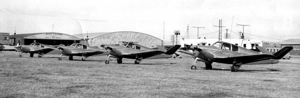
A circa 1940s photo of 4 Beech Bonanzas at Eno Airport (courtesy of Roger Natte via Gordon Westphal).
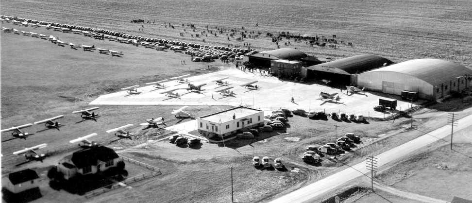
A circa 1940s aerial view looking southwest at Eno Airport (courtesy of Roger Natte via Gordon Westphal)
appeared to depict a fly-in, with dozens of light aircraft & hundreds of cars.
The last photo which has been located showing Eno Airport while open
was an undated aerial view looking south from the 1952 IA Airport Directory (courtesy of Lee Corbin).
It depicted Eno as having a rectangular grass airfield, with a few small buildings & several light aircraft on the northwest side.
The date of closure of Eno Airport has not been determined,
but according to an article in the 11/18/07 issue of The Messenger, “The current airport north of the city was dedicated on 10/4/52”,
at which point Eno Airport was presumably closed.
A 1953 USDA aerial photo (from the ISU GIS system) appeared to depict Eno Airport after its closure.
The hangars appeared intact, but there were no aircraft visible on the field.
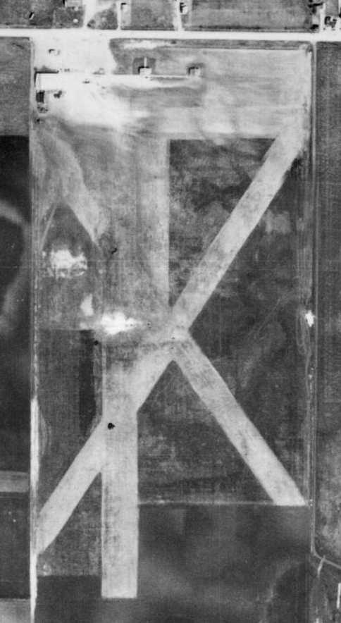
The individual runways were no longer recognizable, but the area remained clear.
Eno Airport was no longer depicted on the 1966 USGS topo map,
nor listed among active airports in the 1968 Flight Guide (courtesy of Bob Levittan).
A 9/25/95 USGS aerial photo showed that the former hangars still remained standing on the site of Eno Airport,
but the southern end of the runway area had been covered by several ponds.
According to an article in the 11/18/07 issue of The Messenger, “Aircraft parking & runways were in the approximate area of Menards & the new post office.
Reminders of this airport remain today in the form of the rounded roof buildings used by G&K Uniform Services
along with the small yellow & white houses just east of Slumberland Furniture.”
A circa 2005-2010 photo looking southwest at the former Eno Airport hangars.
A 6/20/09 aerial photo showed that the former hangars still remained standing on the site of Eno Airport,
but the southern end of the runway area had been covered by several ponds.
As of 2010, maps labeled the site of Eno Airport as being the location of “G&K Services”.
A September 2022 photo looking southwest at the former hangars which remain on the northwest corner of the Eno Airport site.
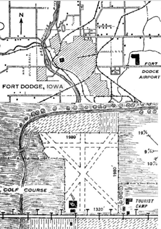
The site of Eno Airport is located southwest of the intersection of Route 20 & Midway Boulevard.
Thanks to Gordon Westphal for pointing out this airfield.
____________________________________________________
(Original) Ames Municipal Airport / Wearth Airport, Ames, IA
42, -93.61 (North of Des Moines, IA)
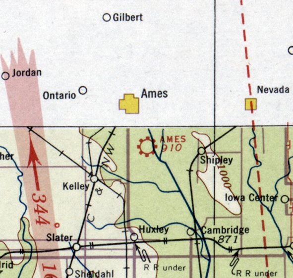
The original Ames Municipal Airport, as depicted on the September 1934 Des Moines Sectional Chart.
The first airport for the town of Ames was located south of the town, on the east side of Duff Avenue (Route 69).
An article entitled “6,000 Attend Ames Airport Opening” ran in the 5/21/28 Gazette (courtesy of Bill Grasha).
The Airport Directory Company's 1933 Airports Directory (courtesy of Chris Kennedy) described Ames Airport as consisting of a 1,320' square sod field,
with a hangar marked with “Ames” on the roof.
The earliest depiction which has been located of the Ames Airport was on the September 1934 Des Moines Sectional Chart,
which depicted Ames as a municipal/commercial field.
Ames Airport was listed in The Airport Directory Company's 1938 Airports Directory (according to Chris Kennedy).
A 1939 USDA aerial photo (from the ISU GIS system) depicted Ames as having 3 unpaved runways, oriented north/south, east/west, and northwest/southeast.
A cluster of small buildings was visible along the northwest corner of the field, and at least one plane was visible.
The Ames Airport evidently was closed (for reasons unknown) at some point between 1939-41,
as no airport in Ames was listed in The Airport Directory Company's 1941 Airports Directory (according to Chris Kennedy).
At some point between 1938-41, the airfield at this location was evidently reopened as “Wearth” Airport,
as that is how it was labeled on the May 1941 Des Moines Sectional Chart (courtesy of Chris Kennedy).
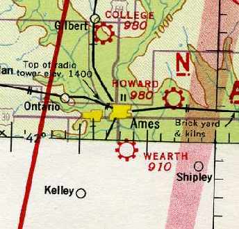
The last depiction which has been located of the Wearth Airport
was on the June 1942 Dubuque Sectional Chart (courtesy of Chris Kennedy).
The Wearth Airport was evidently replaced (for reasons unknown) at some point between 1943-43
by the larger Ames Airport on the opposite (western) side of Duff Avenue,
as only the new Ames Airport on the west side of the road
was depicted on the August 1943 Dubuque Sectional Chart (according to Chris Kennedy).
A 1953 aerial photo showed that buildings had covered the western portion of the original Ames Airport site,
but the eastern portion was still open.
Ames Airport was no longer depicted on the 1960 USGS topo map.
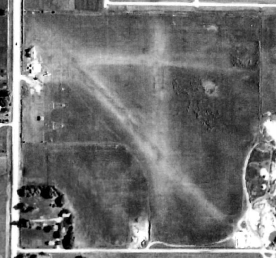
A 1970s USDA aerial photo (from the ISU GIS system) showed that the eastern portion of the original Ames Airport site was still open.
A 1990 USGS aerial photo of the site of Ames/Wearth Airport showed that the majority of the site had been covered by housing,
but it appeared as if at least one of the 1930s-vintage airport buildings remained standing, on the northwest corner of the site.
A 2016 aerial view showed the site of Wearth Airport to be covered by housing & other buildings.
The site of the Ames/Wearth Airport is located northeast of the intersection of Route 69 & Crystal Street.
Thanks to Chris Kennedy for pointing out this airfield.
____________________________________________________
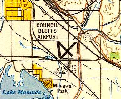
Council Bluffs Airport (original location), Council Bluffs, IA
41.22, -95.84 (Southeast of Omaha, NE)
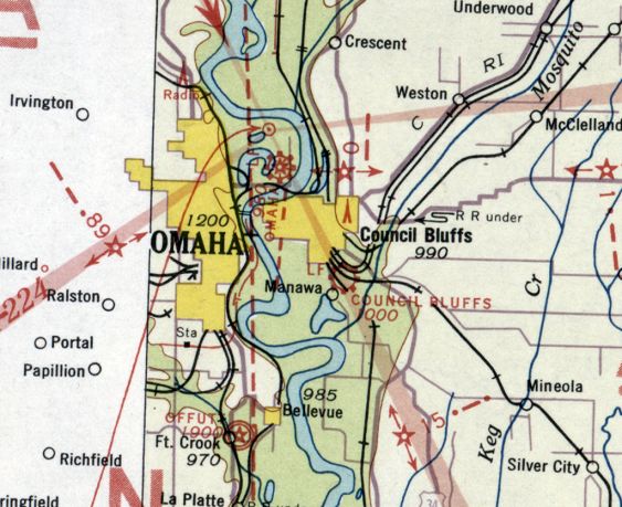
Council Bluffs Municipal Airport, as depicted on the September 1934 Des Moines Sectional Chart.
According to the website for the present-day Council Bluffs Airport,
in 1929 the Aero Club negotiated an option to buy a 200-acre site from the Grenville Dodge estate,
to replace a previous airport located a mile to the west.
The site had been inspected by Government Airport Specialist, Marshall Hoppin,
who approved the location due to the drainage ability of the soil, its potential for grass,
and the availability of bus & street car service, water & power, in addition to a hard surface road planned for construction.
On 6/29/29 the City Council adopted a resolution approving construction of a municipal airport.
It approved the tentative location in Section 7, Township 74, Range 43, in Pottawattamie County as requested by the Aero Club.
The vote was unanimous.
Approval of plans & specifications for the Council Bluffs Airport by the Iowa Board of Railroad Commissioners
was filed with the Council on 7/8/29.
The Council took the first step on 1/27/30,
when it authorized by resolution the execution of airport certificates to the estates of N.P. & G.M. Dodge
in the amount of $40,000 for property purchased by the City for its airport.
The Action was followed by the passage of an ordinance on 2/10/30,
providing for the creation of a Municipal Airport Commission.
The City Council adopted a resolution for airport improvements on 3/24/30, and opened bids that same date.
All bids were subsequently referred to the city engineer & the Airport Commission
for review & recommendation to Council.
Those recommendations came on April 1, and the Council authorized a contract with Boyne Construction Company
for complete drainage with slag backfill, grading and construction of runways.
The runway, 2,600' long & 200' wide, would be constructed oriented northwest/southeast
with an option for the construction of a northeast/southwest runway.
Also authorized was a contract with Flynn Electric Company for a complete lighting system.
During the summer of 1932 the Council Bluffs Municipal Airport was opened.
The earliest directory listing of the Council Bluffs Airport which has been located
was in The Airport Directory Company's 1933 Airports Directory (courtesy of Chris Kennedy).
It described the Council Bluffs Airport as consisting of a rectangular 200 acre sod field
with 2 cindered runways measuring 2,600' north/south & 1,500' northwest/southeast.
A hangar was said to have “Council Bluffs” marked on the roof.
The earliest depiction of the Council Bluffs Airport which has been located
was on the September 1934 Des Moines Sectional Chart.
The Council Bluffs “Municipal Airport”, as depicted on a circa 1930s map (courtesy of Michael Sciortino)
which hung on the wall (as of 2006) in the Public Works Department at Council Bluffs City Hall.
It depicted the “Municipal Airport” as a rectangular plot of land,
with 3 buildings (hangars?) in the northwest corner.
A 1938 USDA aerial photo of the Council Bluffs Airport (from the ISU GIS system).
It depicted the field as having 3 unpaved runways, oriented north/south, northeast/southwest, and northwest/southeast.
A cluster of hangars was visible along the west side, alongside of which were visible several planes.
A circa 1940 photo of 3 monoplanes & a biplane in front of a Council Bluffs Airport hangar (from the Council Bluffs Library).
With the outbreak of WW2, the Council received a telegram on 12/8/41
from Army Lt. Col. D.F. Hunter in which he requested that properly authorized police officers
be stationed at the airport to ground all planes except those on government duty & that the officers remain there 24 hours / day.
The mayor & chief of police were instructed to comply. The future of the airport became uncertain.
By February 1942, many smaller airports in Southwest Iowa had discontinued operations
because they lacked the financial backing to meet the Civil Aeronautics Administration's regulations.
Planes based at some of them were flown to the Council Bluffs airport for operation
since the Council Bluffs field was probably second in the State to receive government approval.
Council Bluffs had complied with regulations that airports for private flying either be approved or abandoned.
Pilots were required to register on the field & be cleared by a clearance officer before making any kind of flight.
A 24-hour guard was maintained & the airport sufficiently lighted.
Because the Airport remained dry, while Eppley Airfield was covered with water during a major flood,
50 U.S. Army cadets stationed at Creighton University began receiving their flight training at Council Bluffs.
Over 30 planes were now based at the Council Bluffs field.
In addition, the Civil Air Patrol Courier Service operated 3 flights each day from the field.
The April 1944 US Army/Navy Directory of Airfields (courtesy of Ken Mercer)
described Council Bluffs Airport as having a 3,800' runway.
The 1945 AAF Airfield Directory (courtesy of Scott Murdock) described Council Bluffs Municipal Airport
as a 220 acre rectangular property containing 3 sod runways (with the longest being a 3,650' northwest/southeast strip).
The field was said to have 3 hangars, the largest being a 80' x 60' concrete structure.
Council Bluffs Municipal Airport was described as being owned & operated by the City of Council Bluffs.
On 11/13/45, the Council took a series of steps to insure the construction of a hangar.
By 4/14/47, the Council was faced with their own flood problem.
The Airport Commission requested the City take immediate action to correct flood conditions at the airport.
Flood conditions were a result of a break in the dike of Mosquito Creek drainage ditch, which occurred in June, 1946.
The Chamber of Commerce also wrote to the City Council, asking that conditions at the airport be corrected.
A petition bearing 236 signatures was received.
The Council subsequently directed the Airport Commission to develop corrective plans
and submit them to the city attorney & city engineer.
At the close of 1947, the Council received copies of the Airport Development Plan
for the Omaha-Council Bluffs metropolitan area.
The plan had been previously approved by the City Aeronautics Administration,
the mayors of cities & the chairman of the Village Board, of Papillion, Nebraska.
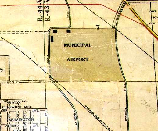
The Council Bluffs Airport, as depicted on a 1948 USAF Target Complex Chart (courtesy of Chris Kennedy).
The airfield layout of Council Bluffs Municipal,
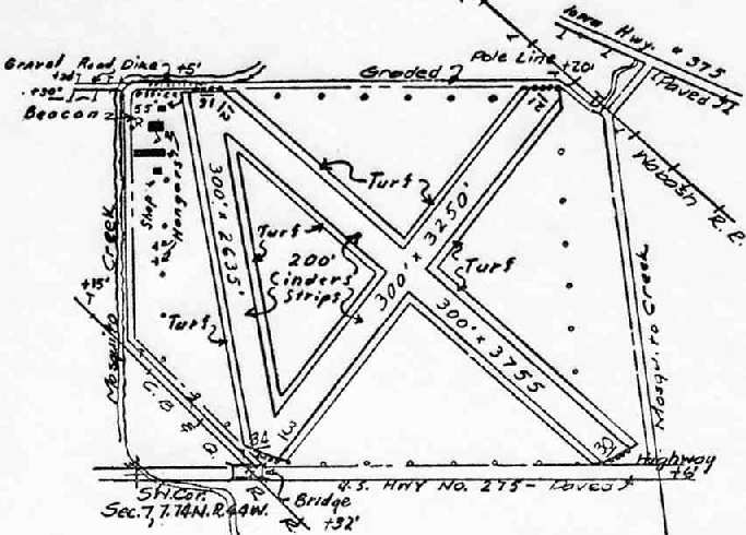
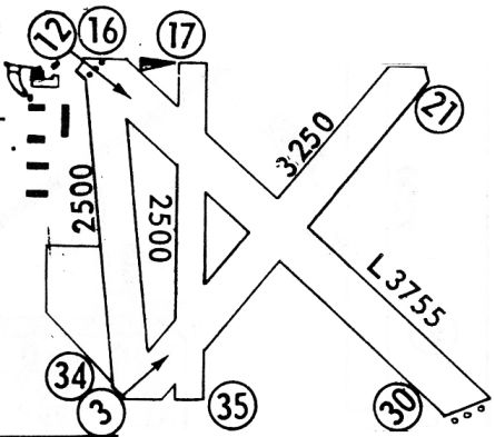
as depicted in the 1948 IA Airport Directory (courtesy of Chris Kennedy).
The directory depicted Council Bluffs Municipal as having 3 turf runways,
with the longest being the 3,755' Runway 12/30.
Several hangars were depicted at the northwest corner of the field.
The operators were listed as Aero-Marine Inc. & Pollitt Aircraft,
and the manager was listed as Donald Bowen.
A 1950 aerial photo depicted 2 aircraft visible parked on the field.
Mark Miller recalled, “My father learned to fly at Council Bluffs airport in the early 1950s in a Taylorcraft
that he had recovered while working weekends for Rollie Nelson, an A&E who had a shop on the airport.
The airport Fixed Base Operator was Harry McCandless, who eventually built a new administration building & had a banner towing business, and also skydiving on the field.
I grew up as an airport kid helping my Dad, Edward Miller, who enjoyed working and rebuilding antique aircraft.
He restored a Waco UPF-7 when I was under 5, and later a Luscombe & a 1934 Fairchild C8C, which I helped with in Jr. & Sr. High.
He also purchased a 1933 UIC Waco in pieces, but never was able to restore it.”

An aerial view looking east at Council Bluffs Municipal (Pottawattamie County), from the 1952 IA Airport Directory (courtesy of Chris Kennedy).
The directory depicted Council Bluffs Municipal as having 3 turf runways, with the longest being the 3,755' northwest/southeast strip.
Several hangars were depicted at the northwest corner of the field.
The operators were listed as McCandless Flying Service & Pollitt Aircraft, and the manager was listed as Harry McCandless.
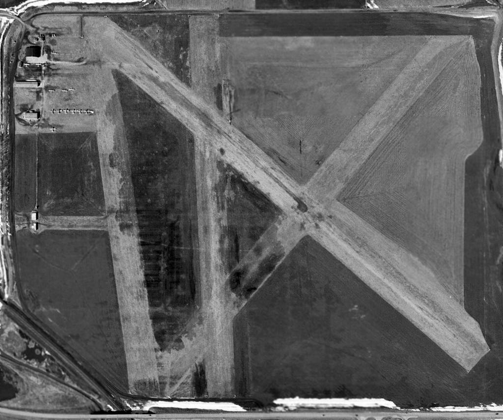
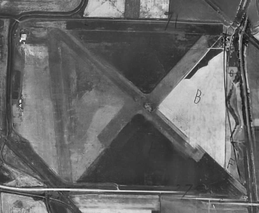
The last photo which has been located of the Council Bluffs Municipal Airport was a 3/29/52 USGS aerial view.
It depicted 13 single-engine aircraft on the northwest corner of the field.
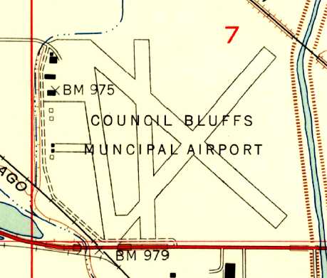
The 1956 USGS topo map depicted Council Bluffs Municipal Airport as having 3 runways, a ramp & several buildings at the northwest corner of the field.
The 1962 AOPA Airport Directory described Council Bluffs Airport as having 3 turf runways, with the longest being the 3,755' Runway 13/31.
The operator was listed as McCandless Flying Service.
The Aerodromes table on the 1965 Des Moines Sectional Chart (courtesy of Chris Kennedy) described Council Bluffs Municipal Airport as having 4 runways,
with the longest being a 3,755' "cinders & turf" runway.
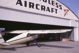
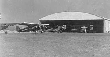
A circa 1965-66 photo (courtesy of Mark Miller) of his father Edward Miller's Luscbome in front of the McCandless Aircraft hangar at the original Council Bluffs Airport.
The last aeronautical chart depiction which has been located of the original Council Bluffs Airport was on the September 1967 Des Moines Sectional Chart.
It depicted the field as having a 3,700' unpaved runway.
At some point in 1967 the original Council Bluffs Airport was replaced by a larger Council Bluffs Municipal Airport, a few miles to the northeast,
as the original field was no longer depicted on the November 1967 Des Moines Sectional Chart.
The last depiction which has been located of the original Council Bluffs Airport as an active airfield was in the 1968 Flight Guide (courtesy of Bob Levittan).
It depicted Council Bluffs Municipal Airport as having 4 unpaved runways, with the longest being the 3,755' Runway 12/30.
A ramp & several buildings were depicted on west side of the field.
According to Dick Davis, one of the last planes “to land at the old [Council Bluffs] airport
was a DC-6 that was bound for Omaha's Eppley Airport 9 miles Northwest in bad weather & mistook Council Bluffs.
The next day launch was also colorful.”
Mark Miller recalled, “The reason that the old Council Bluffs Airport closed & moved to it's present location
was due to the federal government taking part of the southern airport land for the Interstate 29 & 80 interchange.
Those based at the old airport had about a year notice of closure, and we barely finished the Fairchild to fly it off of the field.”
By the time of the 1970 USGS topo map, the site of the original Council Bluffs Airport had been covered by a new intersection of Interstate 29 & Route 92,
but 6 airport buildings were still depicted along the northwest side.
Only 2 airport buildings were still depicted on the 1977 USGS topo map.
A 1990 USGS aerial photo of the site of the original Council Bluffs Municipal Airport.
It appears as if at least 2 original airport buildings were still remaining standing at the northwest corner of the site.
the "ghosted" outline of at least 2 runways were still recognizable.
However, it appeared as if the larger of the 2 remaining airport buildings (on the northwest corner of the site)
had been removed at some point between 1990-2002.
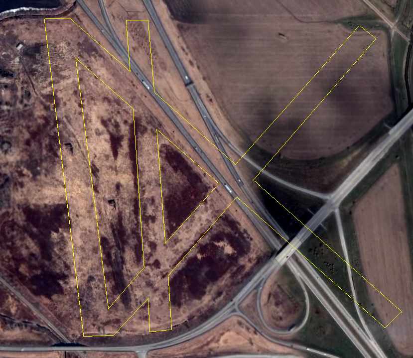
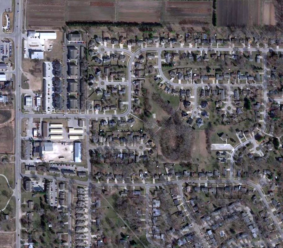
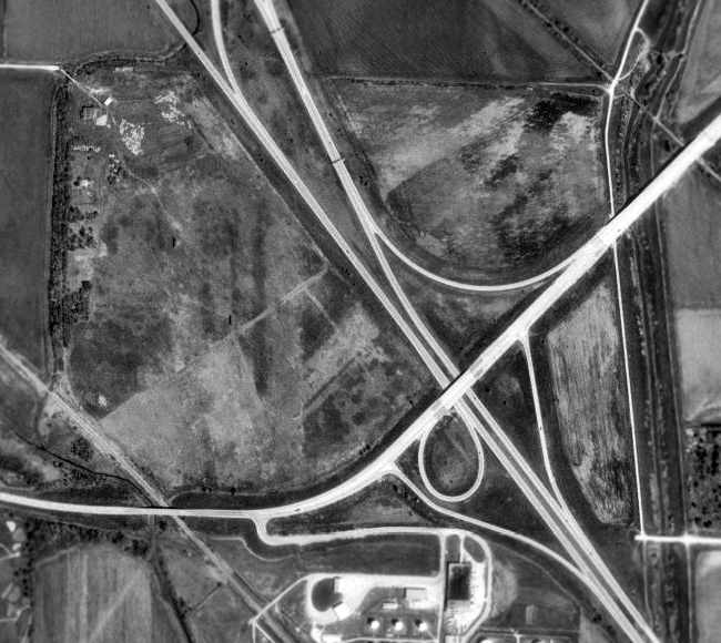
A 2006 aerial view of the site of the original Council Bluffs Airport, annotated by Chris Kennedy to show the location of the 5 former runways.
It appeared as if one small building remained on the northwest corner of the site.
Dick Davis reported in 2006, “Council Bluffs' original airfield is under construction for another Big Box shopping area.”
A circa 2006 aerial view showed that the ground on the northwest corner of the site of the former airport had been newly scraped clean,
with the former building having been removed, eliminating any trace of the original Council Bluffs Airport.
The site of the original Council Bluffs Airport is located west of the intersection of Interstate 29 & Route 92.
Thanks to Chris Kennedy for pointing out this airfield.
____________________________________________________
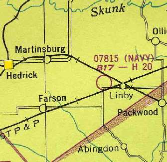
Linby Naval Outlying Landing Field, Pekin, IA
41.154, -92.166 (Southeast of Des Moines, IA)
A 4/26/43 plat for OLF # 07815 / Auxiliary Field #6 (Ottumwa) (courtesy of Brian Renhwinkel).
No airfield at the eventual site of Linby NOLF was yet depicted on a 1937 aerial photo
or the March 1942 Des Moines Sectional Chart.
This airfield was one of 15 satellite airfields used during WW2 by Naval Air Station Ottumwa,
which conducted primary flight training from 1942-47.
Brian Rehwinkel reported, “According to information I gathered at the National Archives,
the field was originally planned to be more extensive - the mat would have been much larger.
The plans were scaled down 'due to the excessive costs involved in completing the hard surface runways originally planned'
and the final result was what you see today - four 2,000’ x 200’ concrete runways.
The field was acquired in February 1943.
The construction of the runways took place in 1943 - probably during the summer.
The site consisted of approximately 360 acres.
It was acquired from several land owners for approximately $67,000
and the final costs for construction (I found another figure) was approximately $392,000.”
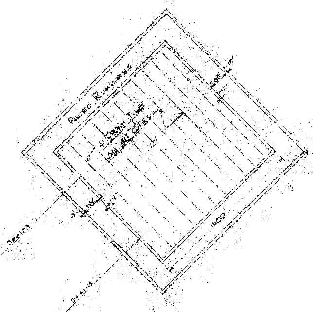
The earliest depiction which has been located of the field was a 4/26/43 plat
for OLF # 07815 / Auxiliary Field #6 (Ottumwa) (courtesy of Brian Renhwinkel).
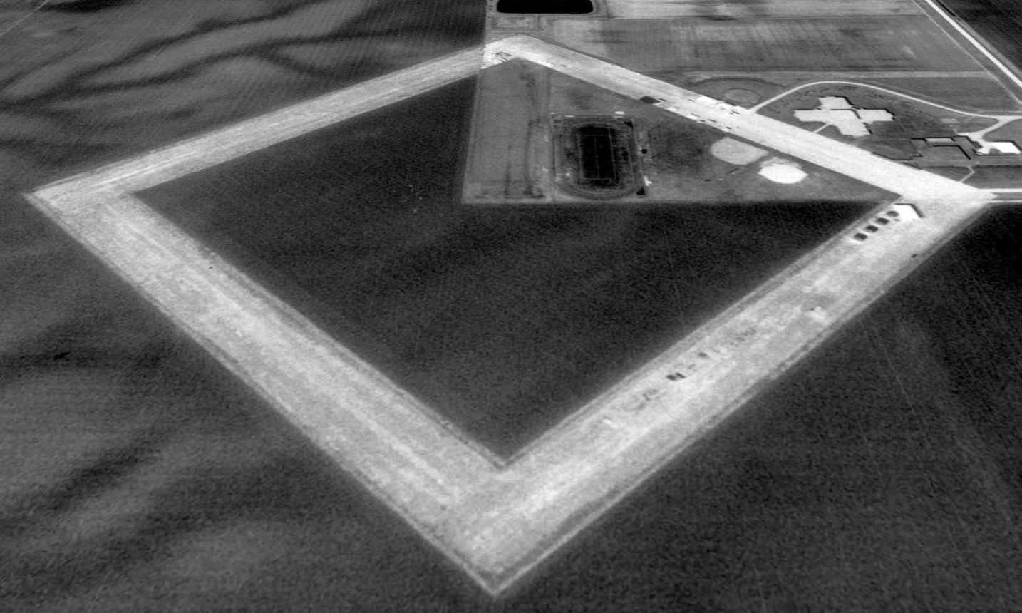
It depicted the field as having 4 paved runways, oriented in a square.
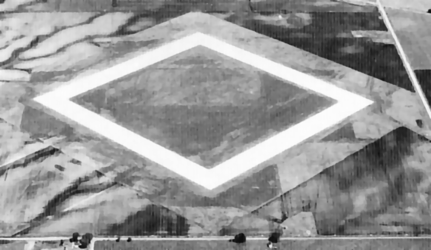
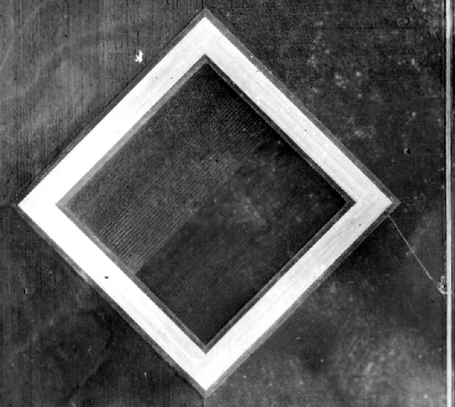
The earliest photo which is available of the Linby airfield was a 1943 aerial view looking north (courtesy of Dan Quinn).
It depicted Linby as having 4 concrete runways in a diamond shape.
There were no ramps or hangars, but there did appear to be a very small building next to the road on the east side.
According to Brian Rehwinkel, “The plat plan doesn’t show too much detail,
but it does have 'dotted' lines depicting the 4” drainage tiles laid out to evacuate water from the site.
Drainage was apparently a pretty big deal at this field.
According to an August 1943 project report from the Navy’s Bureau of Yards & Docks, 17,720 linear feet of drain was laid at the field.”
It was not listed among active airfields in the 1944 US Army/Navy Directory of Airfields (courtesy of Ken Mercer).
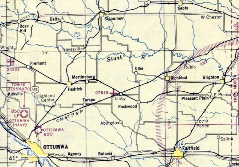
The earliest aeronautical chart depiction of the Linby airfield which has been located was on the March 1944 Des Moines Sectional Chart.
It was labeled simply as auxiliary airfield "07815", which indicated the bearing (075 degrees) & distance (15 miles)
of the auxiliary field from the parent Naval Air Station, Ottumwa.
What was known at the time as Navy Field 07815 was still depicted as an active airfield on the 1948 Des Moines Sectional Chart (courtesy of Chris Kennedy).
A 1951 aerial view (from the ISU GIS system) depicted Linby as having 4 concrete runways in a diamond shape.
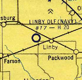
The Linby airfield was evidently closed by the military at some point between 1948-55.
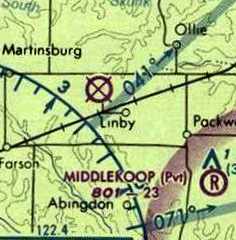
Although "Linby OLF (Navy)" was depicted as an active airfield on the June 1955 Des Moines Sectional Chart (courtesy of Chris Kennedy),
the remarks on the Aerodromes table on the chart said "Closed".
The full name in the table was given as "Linby OLF 17 (Navy)", and the field was described as having 4 runways, with the longest being an 1,998' concrete strip.
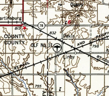
The 1957 USG topo map labeled the Linby airfield as “OLF No. 17”.
The Linby airfield was depicted as “Abandoned airfield” on the December 1960 Des Moines Sectional Chart.
The Linby airfield was no longer listed among active airports in the 1968 Flight Guide (courtesy of Bob Levittan).
A ramp & several buildings were depicted on west side of the field. The Pekin Community School was eventually built along the eastern edge of the abandoned runways.
Amazingly, the 4 concrete runways were not depicted at all on the 1978 or 1980 USGS topo maps.
Kevin Hadley recalled, "I am a graduate of Pekin Community School District attending all 13 years graduating in 1979.
The original High School was built on the airfield & began classes in the fall of 1961.
It is local legend that the airfield had very little use due to wind currents causing landing problems.
Hence the field was sold shortly after WW2 to the newly consolidated Pekin School district.
As I remember, the sale required the runways not be removed
as the government wanted the availability to use the airstrips at some point in the future.
While a student at Pekin, another student used to land on the airstrip to attend baseball practice.
And, I never remember us having a parking problem!"
Strangely the 1981 USGS topo map depicted the Pekin Community School but made no depiction whatsoever of the 4 concrete runways.
A 1990 USGS aerial view looking north showed the school which had been built around the northeastern portion of the Linby runways.
The former Linby airfield, as depicted as an abandoned airfield on the 2003 Sectional Chart.
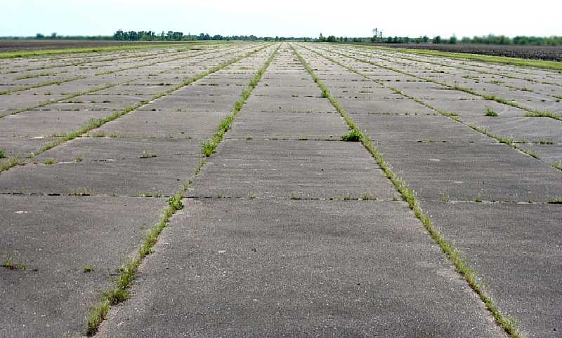
A May 2010 photo by Mike Legeros looking along the pavement of the former Linby airfield.
A 12/23/18 aerial view by Nick Paxton looking north showed the Linby runways remained intact.
The site of Linby NOLF is located west of Birch Avenue, one mile south of the town of Pekin.
Thanks to Chris Kennedy for pointing out this airfield.
____________________________________________________
Or if you prefer to contact me directly concerning a contribution (for a mailing address to send a check),
please contact me at: paulandterryfreeman@gmail.com
If you enjoy this web site, please support it with a financial contribution.
____________________________________________________
This site covers airfields in all 50 states.