Abandoned & Little-Known Airfields:
Southwestern Idaho
© 2002, © 2026 by Paul Freeman. Revised 2/15/26.
This site covers airfields in all 50 states: Click here for the site's main menu.
____________________________________________________
Please consider a financial contribution to support the continued growth & operation of this site.
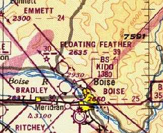
Aircraft Service Company Airfield / Bradley Field (revised 2/15/26) - Boise Air Park (revised 3/8/24) - Booth Field / Boise Airport (original location) (revised 6/16/19)
Floating Feather Airport (revised 1/1/17) - Glider Air Park (revised 3/8/24)
Green Meadow Airport / Campbell Airpark / Dovell Airport / Gem Heliport / Stone Airport / Major Airport / Strawberry Glenn Airport (revised 7/1/18)
Walker Field / Caldwell Municipal Airport (revised 10/6/18)
____________________________________________________
Booth Field / Boise Airport (original location), Boise, ID
43.603, -116.198 West (South of Downtown Boise, ID)
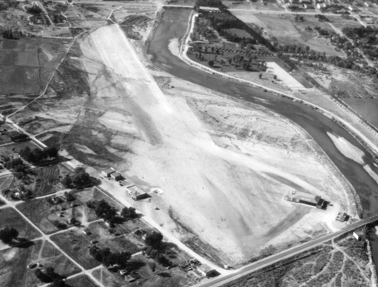
A 9/27/32 aerial view looking northwest at the original location of Boise Airport (courtesy of Blain Green).
According to Wikipedia, “In 1926 the first municipal airport in Boise named Booth Field was built on a gravel bed where the Boise State University campus now stands.
The first commercial airmail flight in the United States passed through this airfield on 4/26/26, carried by Varney Airlines.
Varney Airlines began operating out of Boise in 1933, later merging with National Air Transport to become United Airlines.
The airfield also played host to Charles Lindbergh's Spirit of St. Louis on 9/4/27.”
The earliest photo which has been located of the original Boise Airport was a 9/27/32 aerial view looking northwest (courtesy of Blain Green).
It depicted Booth Field as having 2 unpaved runways in an “X” orientation, with a hangar & terminal building (painted with “Boise” on its roof) on the southeast side,
and another hangar on the northeast side.
The Boise River formed the northern border of the airport.
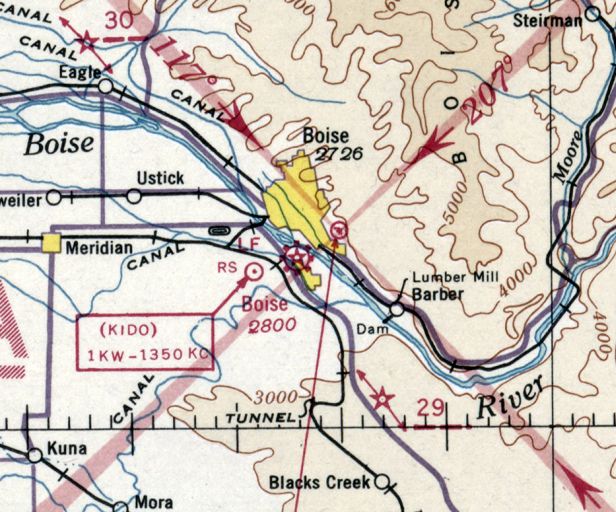
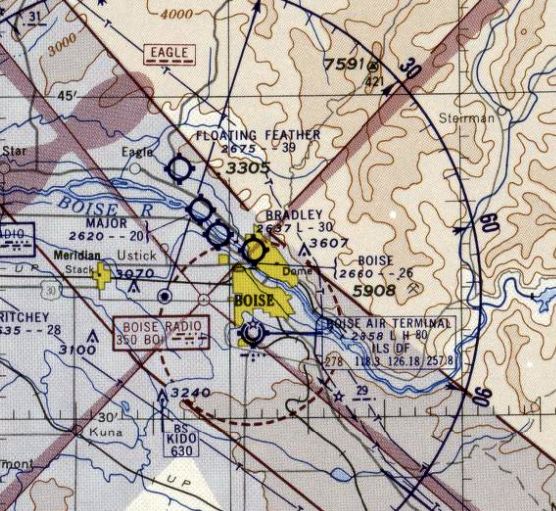
The earliest aeronautical chart depiction which has been located of the original Boise Airport
was on the January 1936 Boise Sectional Chart.
According to Wikipedia, “In 1936 Boise began buying & leasing land” for a replacement airport, a few miles to the south.”
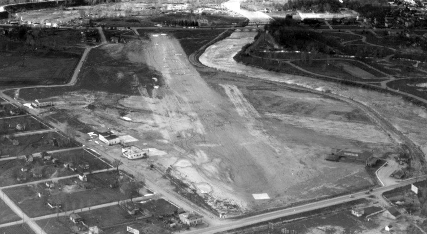
A 3/25/38 aerial view looking northwest at Booth Field (courtesy of Blain Green)
showed that another hangar had been added to the southwest side of the airport at some point between 1932-38.
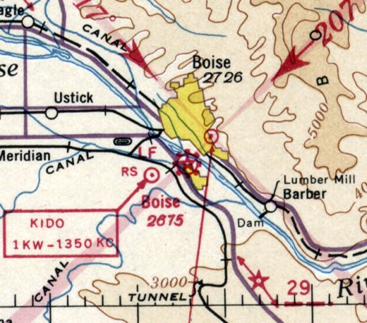
The last aeronautical chart depiction which has been located of the original Boise Airport was on the May 1938 Boise Sectional Chart.
The larger Boise Airport (also known as Gowen Field) opened in 1938, at which point the original Boise Airport (Booth Field) presumably ceased operations.
The original Boise Airport was no longer depicted on the September 1940 Boise Sectional Chart,
by which point only the replacement Boise Airport (Gowen Field) was depicted.
The site of Booth Field was reused as the campus of Boise Junior College, with the arch-roof former hangar reused at first as a gym.

A 1940 aerial view looking northwest at the site of Booth Field (courtesy of Lee Corbin)
showing the former hangar in the foreground, and a football stadium having been built over the airfield.
The 1954 USGS topo map showed the campus of Boise Junior College covering the site of the original Boise Airport,
with Bronco Stadium occupying the eastern portion of the airport site.
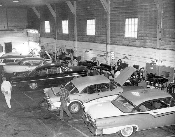
A 1958 photo of the interior of the former Booth Field hangar (courtesy of Lee Corbin), reused for an auto shop class.
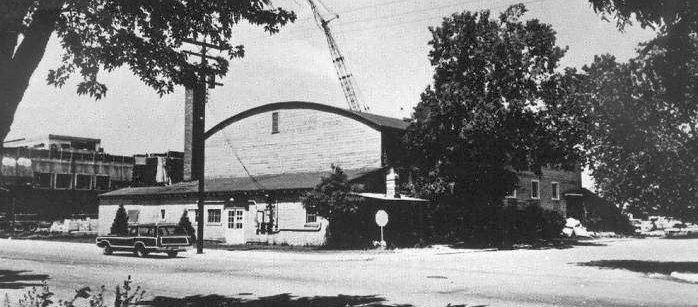
The last photo which has been located showing any trace of Booth Field was a June 1971 photo (courtesy of Lee Corbin) of the former hangar.

A 2016 aerial view shows the site of the original Boise Airport is today the campus of Boise State University, occupied by Taco Bell Arena & Albertsons Stadium.
Thanks to Blain Green for pointing out this airfield.
____________________________________________________
43.715, -116.297 West (Northwest of Downtown Boise, ID)
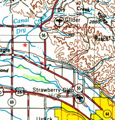
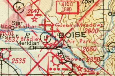
Glider Air Park, as depicted on the 1976 USGS topo map.
This small general aviation airport was evidently established at some point between 1971-76,
as it was not yet depicted on the 1967 Boise Sectional Chart (courtesy of Chris Kennedy)
nor on the 1971 USGS topo map.
The earliest depiction which has been located of Glider Air Park was on the 1976 USGS topo map.
Jay Camp (former Boise Airport ATC) recalled, “That property was once owned by the Terteling family.
They own the Terteling Company headquartered in Boise.
The older Terteling son was interested at one time in designing & building his own experimental aircraft. So he had that runway & the hangar with 2 outbuildings built.
He hired an aeronautical engineer & started production. But alas it didn't get off the ground, so-to-speak.”
According to Rick Bier, “Glider Air Park was located in a very poor location with hills on the north, south & east.
It was in the bottom of draw coming out of the foothills. It was a strictly one-way strip.
Sailplanes took off to the west via catapult & landed to the east.
The prototype for the Eagle agricultural plane [which first flew in 1977] was built in a hangar at the Glider Air Park.”
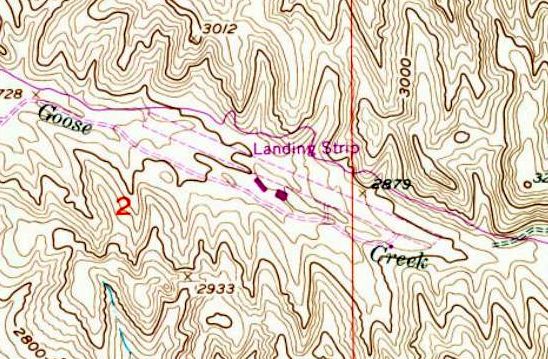
The 1979 USGS topo map depicted Glider Air Park as a single unpaved northwest/southeast runway,
labeled simply as “Landing Strip”, squeezed very uncomfortably close by canyon walls on both sides.
Two small buildings were depicted on the south side.
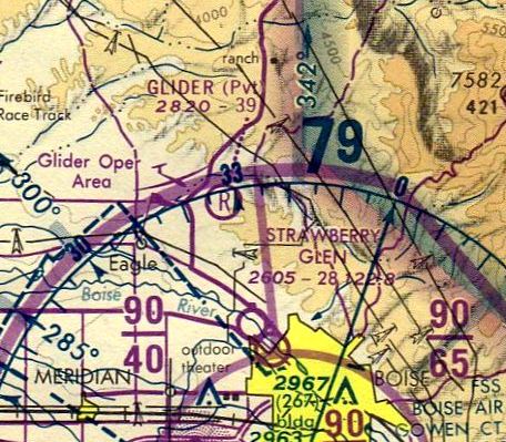
The only aeronautical chart depiction which has been located of Glider Air Park was on the April 1980 Salt Lake Sectional Chart (courtesy of Mitchell Hymowitz).
It depicted “Glider” as a private airfield having a 3,900' unpaved runway.
Jay Camp recalled, “For one reason or another (taxes owed to Ada County, I believe had a part in it)
the property of this airpark (2,700 acres roughly encompassing area between Old Horseshoe Bend road on the west,
Hill Road to the south, Seamans Gulch on the east side & Dry Creek Rd on the north) was turned over to Ada County.
More than likely in the mid- to late-1980s.”
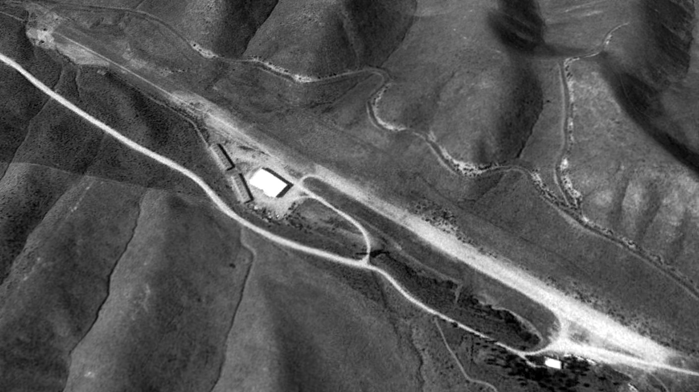
The only photo which has been located showing planes at Glider Air Park was a 1992 aerial view looking northwest.
Four light single-engine planes were visible parked at the southeast corner of the unpaved runway.
Glider Air Park was evidently closed (for reasons unknown) at some point between 1980-93,
as it was no longer depicted on the November 1993 Salt Lake City Sectional Chart (courtesy of Ron Plante) nor on the 1998 USGS topo map,
and a 1998 aerial photo showed a road having been built across the runway.
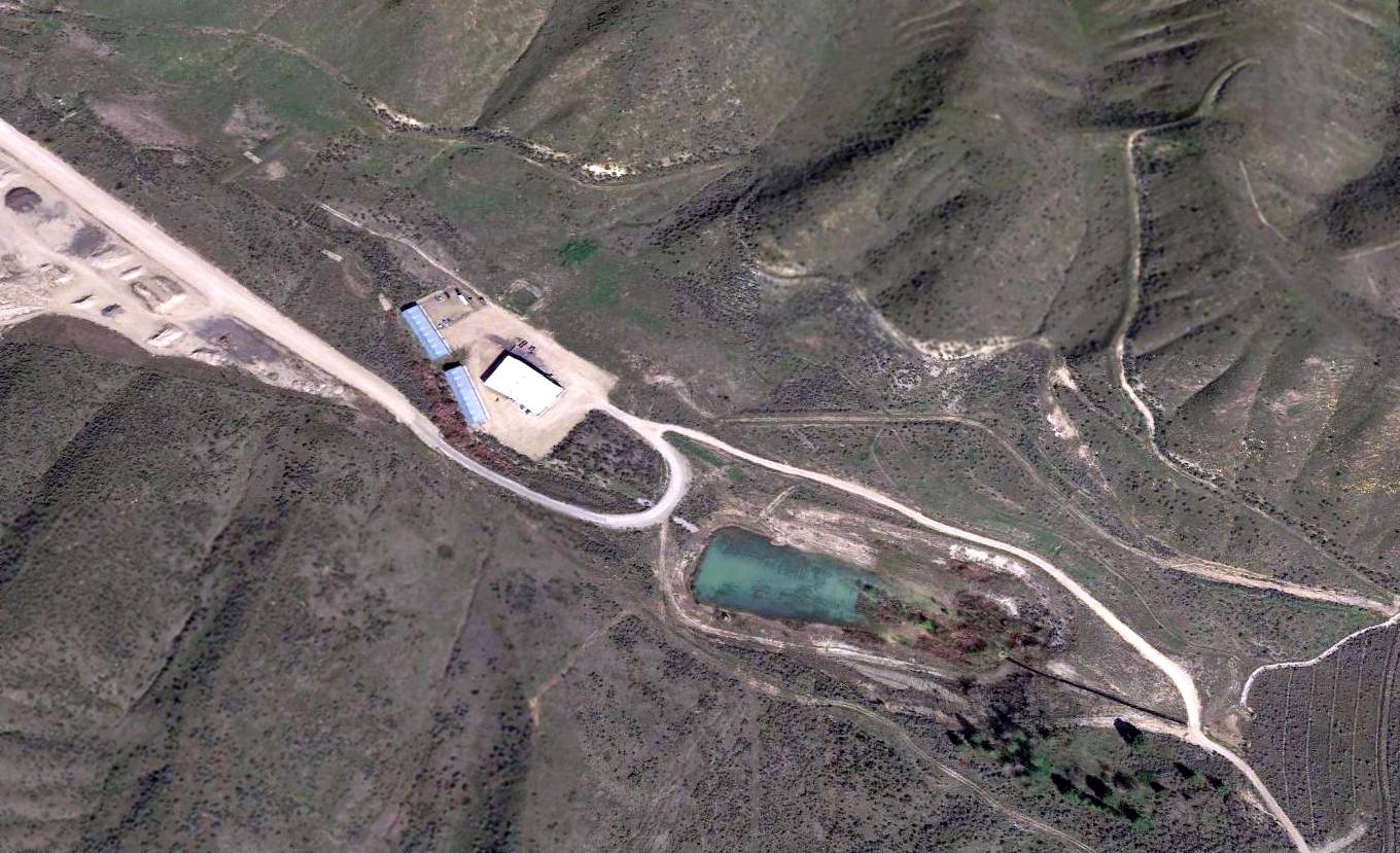
A 2016 aerial view looking northeast at the site of Glider Air Park. The runway has been completely removed, along with the hangar which previously stood at the southeast end.
Jay Camp reported in 2018, “Currently this airpark is now in the Ada County Solid Waste Landfill property.
Those building have various uses now. But the former hangar was actually done really nicely.
It had the open-space hangar for aircraft (of course), back rooms for parts, engine assembly & small offices.
It would be an asset to any FBO on a small airport today.”
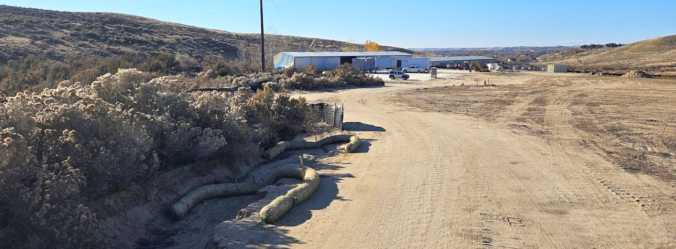
A 2023 photo of the buildings on the south side of the Glider Air Park site.
The site of Glider Air Park is located at the eastern terminus of West Goose Creek Road.
Thanks to Rick Bier for pointing out this airfield.
____________________________________________________
43.63, -116.23 (Northwest of Downtown Boise, ID)
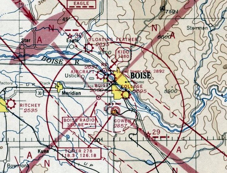
Boise Air Park, as depicted on the May 1946 Boise Sectional Chart.
This small general aviation airport was one of several (up to 5) which were located at one point within the Boise area.
Boise Air Park was evidently established at some point between 1945-46 (like hundreds of other small airports in the US post-WW2 aviation boom),
as it was not yet depicted on the May 1945 Boise Sectional Chart
nor listed among active airfields in the 1945 AAF Airfield Directory (courtesy of Scott Murdock).
The earliest depiction which has been located of Boise Air Park was on the May 1946 Boise Sectional Chart.
Boise Air Park, as depicted on the 1947 ID Aeronautical Chart (courtesy of Bob Pearson).
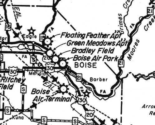
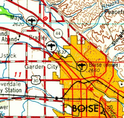
Boise Air Park (and 4 other Boise area airports) as depicted on a circa 1948 ID Airports Map (courtesy of Jeff Anderson).
A 1949 Boise street map (courtesy of Jeff Anderson) depicted Boise Air Park as having a single unpaved northwest/southeast runway on the east bank of the river,
with a single building on the east side.
The earliest photo which has been located of Boise Air Park was a 1949 aerial view (courtesy of Don Watts).
It depicted Boise Air Park as having a single unpaved northwest/southeast runway, with a few buildings & some light aircraft along the southeast side.
The last photo which has been located of the Boise Air Park
was an August 1952 aerial view looking north from Wayne White's “A History of Aviation in Idaho 1940-1970” (courtesy of Jeff Anderson).
It depicted Boise Air Park as having a single northwest/southeast runway, along which were visible a total of 34 light aircraft.
The 1954 USGS topo map did not depict Boise Air Park, which may indicate that it was closed by that point.
The last aeronautical chart depiction which has been located of the Boise Air Park was on the April 1955 Boise Sectional Chart.
It depicted Boise as having a 2,600' unpaved runway.
Boise Air Park was evidently closed (for reasons unknown) by 1956, as it no longer depicted on the March 1956 Boise Sectional Chart.
Boise Air Park was closed by 1958, as that is how it was depicted on the 1958 USGS topo map.
A 1992 USGS aerial photo did not show any trace of the Boise Air Park,
with the northern half having been covered by a pond, and the southern half remaining open land.
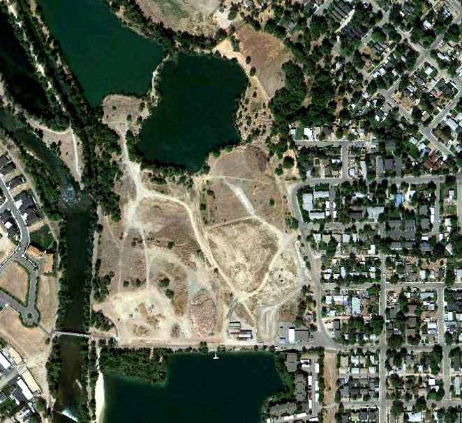
A 9/1/10 aerial photo did not show any trace of the Boise Air Park,
with the northern half having been covered by a pond, and the southern half remaining open land.
Jay Camp reported in 2015, “Boise Air Park was located where the new Ester Simplot Park is currently being built, between Quinns Pond & Veterans Park.
The southeast end of what appears to be Runway 33 was located somewhere around Idaho River Sports building.”
The site of Boise Air Park is located west of the terminus of Hester Street.
____________________________________________________
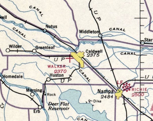
Walker Field / Caldwell Municipal Airport, Caldwell, ID
43.67, -116.71 (West of Boise, ID)
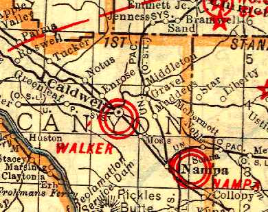
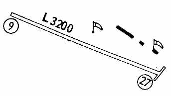
Walker Field, as depicted on the 1930 Rand McNally Air Trails Map (courtesy of Chris Kennedy).
According to Caldwell Industrial Airport Commission member Mack Kreizenbeck, “The first [Caldwell] runway
was grubbed off a large unused field West of town by Weber Appel (an Idaho barnstorming pilot)
with the permission of M.L. Walker (landowner).
Webb also built a hangar & spent the winter of 1926 building & repairing planes as Caldwell Flying Service.”
Mack continued, “Caldwell City purchased the Walker parcel & combined it with George Crookham's
parcel for 160 acres total in 1928 to be used as a municipal airport.
Varney Air Lines (predecessor of United Air Lines) used Caldwell's Airport when the Boise Airport was fogged in.
Webb's hangar & 4 aircraft were destroyed by fire on 5/22/29.
Afterwards he moved his operation to Floating Feather Airport outside of Boise.”
The earliest directory listing of Walker Field which has been located
was in the November 1929 Standard Oil of CA Airplane Landing Fields of the Pacific West (courtesy of Chris Kennedy).
It described Walker Field as a commercial airport having a 4,300' east/west runway.
According to Mack Kreizenbeck, “There were no official operators on the field between 1929-39.”
The earliest depiction of Walker Field which has been located
was on the 1930 Rand McNally Air Trails Map (courtesy of Chris Kennedy).
The Airport Directory Company's 1933 Airports Directory (courtesy of Chris Kennedy)
described Caldwell Walker Municipal Airport as consisting of a 160-acre square loam landing area,
having 4 runways, with the longest being the 3,500' northwest/southeast strip.
The earliest aeronautical chart depiction which has been located of Walker Field was on the January 1936 Boise Sectional Chart.
It depicted Walker as an auxiliary airfield.
The Airport Directory Company's 1937 Airports Directory (courtesy of Bob Rambo).
It described Caldwell Walker Municipal Airport as having a 2,640' square loam landing area,
with a building on the southeast side of the field.
According to Mack Kreizenbeck, “The field came to life when the Civilian Pilot Training program,
sponsored by the College of Idaho & Civil Aeronautics Administration, began.
Some 126 students went through the program.”
The earliest photo which has been located of the Caldwell Municipal Airport
was a 9/27/43 aerial view looking north from the 1945 AAF Airfield Directory (courtesy of Scott Murdock).
It depicted Douglas Airport as having 2 unpaved runways.
The April 1944 US Army/Navy Directory of Airfields (courtesy of Ken Mercer)
described Caldwell Airport as having a 3,200' unpaved runway,
with hangars on the south & east sides of the field.
The 1944 Boise Sectional Chart (courtesy of Chris Kennedy) depicted Caldwell as a municipal airport.
The 1945 AAF Airfield Directory (courtesy of Scott Murdock) described Caldwell Municipal Airport
as a 160 acre square property within which were two 3,200' unpaved runways, oriented northeast/southwest & northwest/southeast.
The field was said to have 4 hangars, the largest of which was an 80' square concrete & wood structure.
Wardwell Municipal Airport was described as being owned & operated by the Town of Douglas, and to operated by the Civil Aeronautics Administration.
The September 1949 Great Salt Lake World Aeronautical Chart (courtesy of Donald Felton)
depicted Caldwell as having a 2,400' unpaved runway.
Apparently the runway at Caldwell was paved at some point between 1949-53,
as the 1953 Boise Sectional Chart (courtesy of Chris Kennedy)
described Caldwell as having a 2,400' hard-surface runway.
A 7/22/53 USGS aerial photo showed Caldwell as having a northwest/southeast runway.
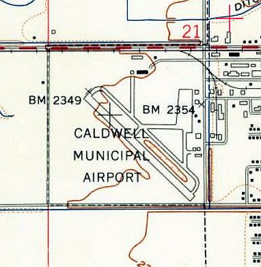
The 1958 USGS topo map depicted Caldwell Municipal Airport
as having a northwest/southeast paved runway with a ramp on the east side.
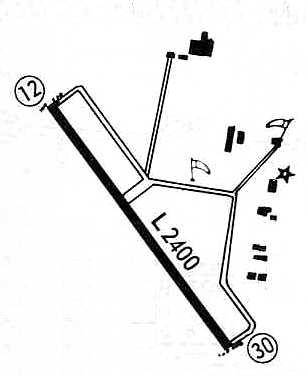
A 1967 airport directory (courtesy of Chris Kennedy) depicted Caldwell as having a single 2,400' paved Runway 12/30,
with taxiways leading to several hangars along the east side of the field.
The last aeronautical chart depiction which has been located of Caldwell Airport was on the May 1969 Boise Sectional Chart.
It depicted Caldwell as having a 3,00' paved northwest/southeast runway.
According to Mack Kreizenbeck, “This airport was closed in 1975
and [replaced by a new airport] 2 miles southeast, named the Caldwell Industrial Airport.
This move was due to safety as the Caldwell Hospital had been built close to the end of Runway 12.
Several hangars were moved to the new location.”
Caldwell Municipal Airport was presumably closed upon the opening of the new airport.
Caldwell Municipal Airport was depicted as an abandoned airfield on the April 1980 Salt Lake Sectional Chart (courtesy of Mitchell Hymowitz),
which instead depicted the new Caldwell Industrial Airport to the southeast.
Caldwell Municipal Airport was still depicted on the 1986 USGS topo map, even though it had evidently been closed already for a decade.
Stan Siewert reported about Caldwell Municipal Airport, “The runway was used informally as a drag strip in the early 1980s.
It was abandoned but mostly intact.”
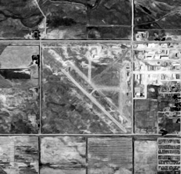
A 1992 USGS aerial view looking north showed much of the runway & parallel taxiway of Caldwell Municipal still existed.
However, an industrial facility had been built over the northeast corner of the former airport property,
and a new road had been built over the former runway,
running to the road along the west side of the property.
It does not appear as if any of the original airfield buildings or hangars remain standing.
A circa 2006 aerial view showed that several buildings had covered the northwest runway segment,
leaving the runway segment on the southeast end as the only recognizable trace at the site of the former airport.
Mack Kreizenbeck reported in 2008, “Many of the old airport buildings, hangars
and terminal building remain today [after having been relocated from the airport site]
and are being used for other purposes.”
A 2015 aerial view looking north showed that several other buildings had been built over the site of the former Caldwell Municipal Airport,
with only traces of the southeast end of the runway still recognizable.
The site of Caldwell Municipal is located southeast of the intersection of Route 19 & Farmway Road.
____________________________________________________
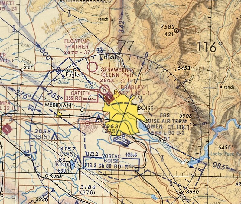
Floating Feather Airport, Eagle, ID
43.7, -116.312 (Northwest of Boise, ID)
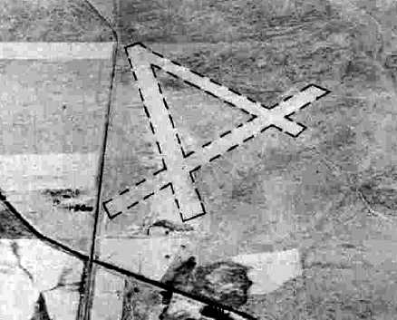
An 8/23/43 aerial view looking north from the 1945 AAF Airfield Directory (courtesy of Scott Murdock)
depicted Floating Feather Airport as having 3 unpaved runways.
Floating Feather Airport was evidently established at some point between 1940-43,
as it was not yet depicted on the September 1940 Boise Sectional Chart.
The earliest depiction which has been located of Floating Feather Airport
was an 8/23/43 aerial view looking north from the 1945 AAF Airfield Directory (courtesy of Scott Murdock).
It depicted Floating Feather Airport as having 3 unpaved runways.
The April 1944 US Army/Navy Directory of Airfields (courtesy of Ken Mercer)
described Floating Feather Airport as having a 3,800' unpaved runway.
The earliest aeronautical chart depiction which has been located of Floating Feather Airport was on the April 1944 Boise Sectional Chart.
According to Marian Woods, her father-in-law Bill Woods was a “back-country pilot & owner of the Floating Feather Airport.
The airport burned in WWII when a plane crashed... the plane was a bomber.
Bill trained many pilots for the war.
His mechanic was Evelynn, one of the first female airplane mechanics in the U.S.”
The 1945 AAF Airfield Directory (courtesy of Scott Murdock) described Floating Feather Airport
as a 240 acre rectangular property within which were 3 earth runways, the longest being the 3,800' NNW/SSE strip.
The field was said to not have any hangars, and to be privately owned & operated.
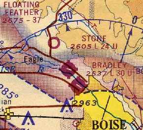
Floating Feather Airport (and 4 other Boise area airports) as depicted on a circa 1948 ID Airports Map (courtesy of Jeff Anderson).
The September 1949 Great Salt Lake World Aeronautical Chart (courtesy of Donald Felton)
depicted Floating Feather Airport as having a 3,900' unpaved runway.
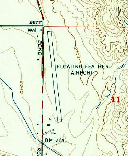
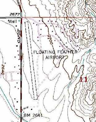
The 1953 USGS topo map depicted Floating Feather Airport as having a single northwest/southeast runway
with a few small buildings on the southwest side.
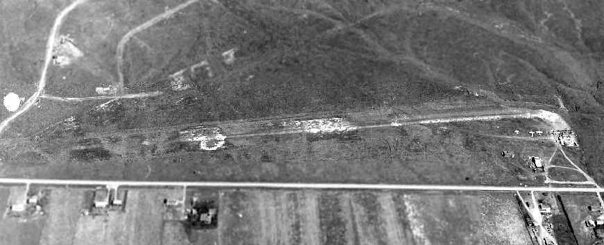
A 1960 aerial view looking east at Floating Feather Airport (from the ID DOT Department of Aeronautics, via William Womack).
It depicted the field as having a single unpaved runway,
with a small building & several 20 light aircraft on the southwest side of the field.
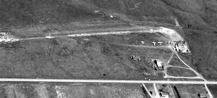
A closeup from the 1960 aerial view looking east at Floating Feather Airport (from the ID DOT Department of Aeronautics, via William Womack),
showing at least 6 light aircraft on the field.

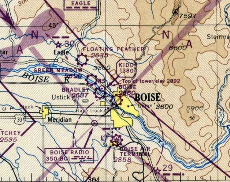
Floating Feather was still depicted as a public-use airport on the May 1971 Salt Lake Sectional Chart (courtesy of Ron Plante),
with a 3,700' unpaved runway
A 1971 aerial photo showed one light aircraft parked on the southwest side of Floating Feather Airport.
Floating Feather was still depicted on the 1979 USGS topo map,
but that does not necessarily prove that the field was still operating at that point.
It was depicted as having a single north/south runway.
Floating Feather Airport was no longer depicted on the April 1980 Salt Lake Sectional Chart (courtesy of Mitchell Hymowitz).
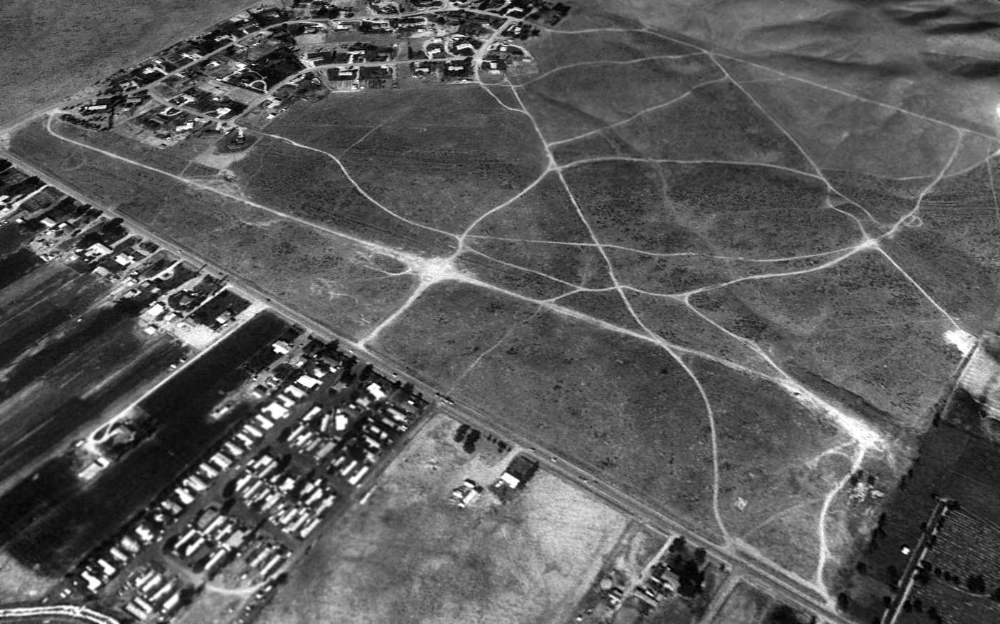
Floating Feather Airport was apparently closed at some point between 1991-92, as a 1992 USGS aerial view looking northeast shows that the airport buildings had been removed.
The runway remained intact but deteriorated.
A 1998 USGS aerial view shows that houses had been built over the site of Floating Feather Aiport.
Jay Camp reported, “I [was] ATC from BOI, and also was their airspace/procedures specialist for BOI.
I was the guy that had Floating Feather Airport removed from the VFR sectional sometime around 1999-2001.”
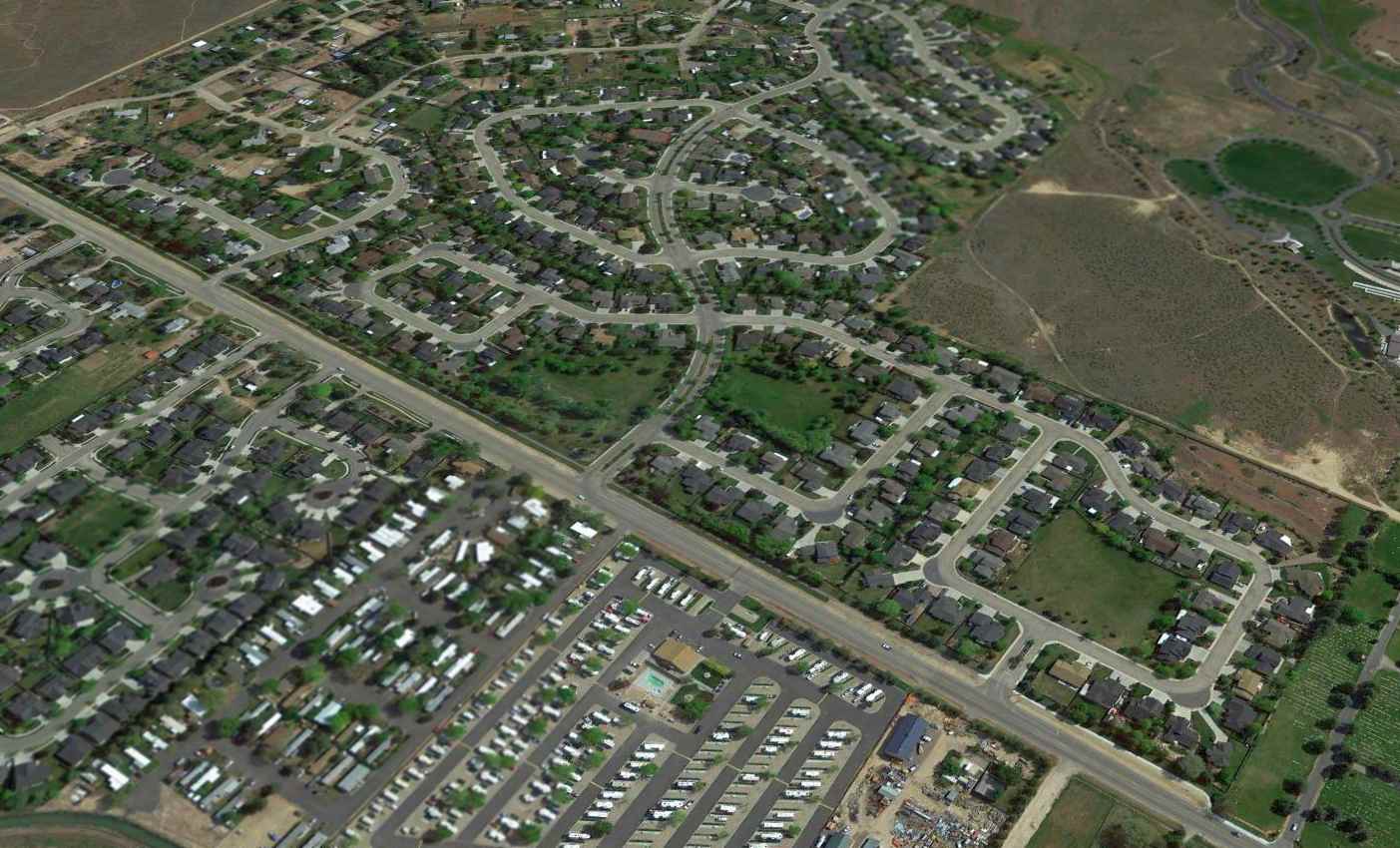
A 2015 aerial view looking northeast showed no trace remaining of Floating Feather Airport.
The site of Floating Feather Airport is located northeast of the intersection of Route 55 & East Floating Feather Road.
____________________________________________________
Green Meadow Airport / Campbell Airpark / Dovell Airport / Gem Heliport /
Stone Airport / Major Airport / Strawberry Glenn Airport (S65), Boise, ID
43.67, -116.29 (Northwest of Downtown Boise, ID)
"Green Meadows" Airport, as depicted on the 1947 ID Aeronautical Chart (courtesy of Bob Pearson).
This small general aviation airport apparently went through numerous names throughout the course of its 3 decades.
No airport at this location was listed among active airfields in the 1945 AAF Airfield Directory (courtesy of Scott Murdock)
not depicted on the April 1946 Boise Sectional Chart.
According to David Field (referencing the FAA's airport inspection file), “The airport was constructed in 1946. It was owned by Theodore Thomas & W. A. Spivey.
Ownership changed frequently.”
The earliest depiction of an airfield at this location which has been located was on the 1947 ID Aeronautical Chart (courtesy of Bob Pearson),
which labeled it as "Green Meadows" Airport.
Green Meadow Airport was not yet depicted on the May 1947 Boise Sectional Chart.
Green Meadows Airport (and 4 other Boise area airports) as depicted on a circa 1948 ID Airports Map (courtesy of Jeff Anderson).
Green Meadow Airport as depicted on the May 1948 Boise Sectional Chart, which depicted "Green Meadow" as a commercial or municipal airport.
It was evidently renamed to “Major Airport” at some point between 1948-52,
as David Field (referencing the FAA's airport inspection file) reported,
“In 1952 it was reported as Major Airport, owned by H. W. Major, Major Aircraft & Engine Service.”

A 1952 FAA diagram (courtesy of David Field) depicted Major Airport as having a single 2,000' turf & bare Runway 9/27.
A shop building was depicted on the northeast side of the field.
The 1953 USGS topo map depicted Major Airport as having a northwest/southeast runway, with 2 small buildings on the east side.
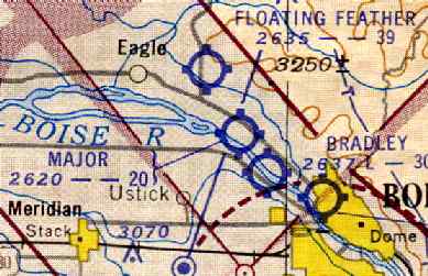
"Major" Airport was depicted on the 1953 Boise Sectional Chart (courtesy of Chris Kennedy)
as having a 2,000' unpaved runway.
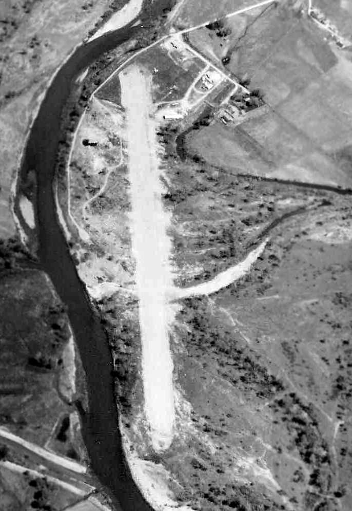
A circa 1950s aerial view looking northwest at Major Airport (from the ID DOT Department of Aeronautics, via William Womack).
It depicted the field as having a single unpaved runway,
with a few small buildings & a few light aircraft on the northwest side of the field.
According to David Field (referencing the FAA's airport inspection file), in 1958 it was reported under the name of “Campbell Airpark”,
in 1959 as “Dovell Airport”, and in 1960 as “Gem Heliport”.
A 1962 aerial view looking northwest at Stone Airport (from the ID DOT Department of Aeronautics, via William Womack).
It depicted the field as having a single paved runway, with a building & over 20 light aircraft on the northeast side of the field.
According to David Field (referencing the FAA's airport inspection file), in 1963 the airfield was reported as “Stone Airport... owned by Stone Aviation.
[It was] reported to have 2 Fixed Base Operators.”
The 1967 Flight Guide (courtesy of Chris Kennedy) depicted “Stone" Airport as having a single 3,200' Runway 9/27,
with 3 buildings along the northeast side of the field.
The field was also said to have helicopter activity.
The 1967 Boise Sectional Chart (courtesy of Chris Kennedy) \depicted "Stone" Airport as having a single 2,400' paved runway.
According to David Field (referencing the FAA's airport inspection file), in 1969 Strawberry Glen Airport was owned by Jack Hoke, Helicopters Inc.
At some point between 1967-71, the field was apparently renamed again, this time to "Strawberry Glenn Airport",
but its status was changed to a private airfield.
The 1971 ID Airport Directory (courtesy of Robert Pearson)
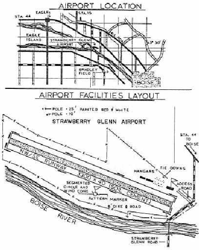
depicted Strawberry Glenn Airport as having a single 3,000' "soil/cement" runway, oriented northwest/southeast.
Three hangars were located north of the east end of the runway.
The field was described as a "helicopter repair station", operated by Helicopters Inc.
According to David Field (referencing the FAA's airport inspection file),
“In 1972 the airport was reported to be reopened. It was proposed to be extended to 3,300'.”
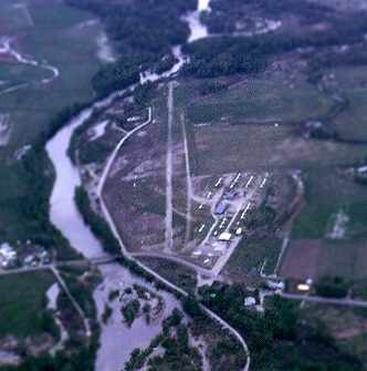
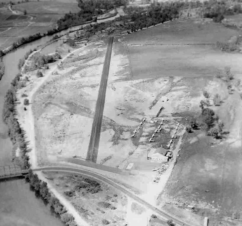
A 1973 aerial view looking northwest at Strawberry Glenn Airport (from the ID DOT Department of Aeronautics, via William Womack).
It depicted the field as having a single paved runway,
with several buildings & a large number of light aircraft on the northeast side of the field.
Ponderosa Aero Club was formed in 1974 at Strawberry Glen Airport.
Wayne Hamilton reported, "Greg Poe, an aerobatic show pilot,
received his initial training at Strawberry Glen according to his website."
According to David Field (referencing the FAA's airport inspection file),
“In 1975 it was reconstructed after a flood. It was reported to have 74 based aircraft.”
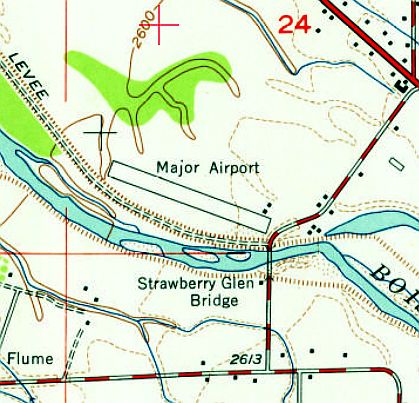
Strawberry Glen Airport, as depicted on the 1976 USGS topo map.
According to David Field (referencing the FAA's airport inspection file),
“In 1977 it was inspected because there was a runway length discrepancy between various records.
It was agreed that the runway should be reported as 2,600' long.”
The 1977 Flight Guide (courtesy of Chris Kennedy)
depicted Strawberry Glenn as having a single 2,600' Runway 10/28.
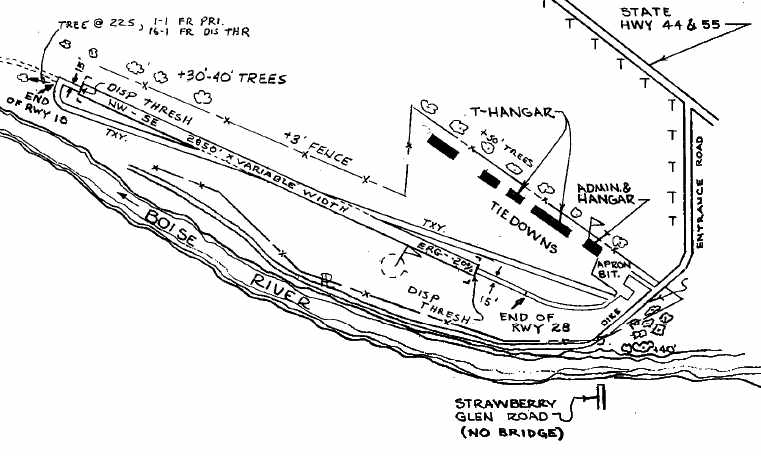
A 1978 FAA diagram (courtesy of David Field) depicted Strawberry Glenn Airport as having a single 2,850' asphalt treated runway.
An apron with several T-hangars was depicted on the northeast side of the field.
The runway was still depicted on the 1979 USGS topo map,
but it was labeled simply as "Landing Strip",
which may indicate that the field was closed by that point.
The last aeronautical chart depiction which has been located of Strawberry Glen Airport was on the April 1980 Salt Lake Sectional Chart (courtesy of Mitchell Hymowitz).
It depicted Strawberry Glen as having a 2,800' unpaved runway.
According to David Field (referencing the FAA's airport inspection file), “In 1980 it was acquired by 'The Riverside Group' & abandoned effective 9/26/80.”
Strawberry Glenn Airport was definitely closed by 1981, as it was no longer depicted at all on the 1981 USGS topo map.
A 1992 USGS aerial photo showed the site of Strawberry Glenn Airport had been covered over by homes, with not a trace remaining of the airfield.
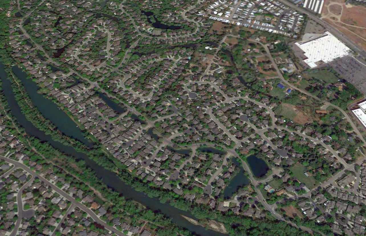
A 2015 aerial view looking northwest showed no trace remained of Strawberry Glenn Airport.
The site of Strawberry Glenn Airport is located northwest of the intersection of North Strawberry Glenn Road & West Riverside Drive.
____________________________________________________
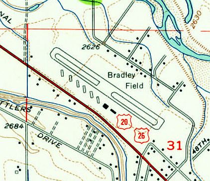
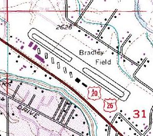
Aircraft Service Company Airfield / Bradley Field, Boise, ID
43.64, -116.26 (North of downtown Boise, ID)
Aircraft Service Company Airfield, as depicted on the April 1946 Boise Sectional Chart.
This airfield was not yet depicted on the May 1945 Boise Sectional Chart.
According to "A History of Aviation in Idaho" (courtesy of Robert Pearson),
Bradley Field was built by the Aircraft Service Company, which had previously operated from College Field.
Due to expansion needs, in 1945 the Aircraft Service Company purchased the old Goodman Ranch on Highway 20,
approximately 2 miles northwest of Boise, for the purpose of building a replacement airport.
The new airport was named for Jack Bradley, President of the Aircraft Service Company.
Construction of Bradley's 3,000' x 400' runway was done by the Morrison Knudsen Company.
John Bradley recalled, My father [Jack Bradley] started Bradley Field & I worked there as gas boy & took flying lesson's there in my youth.”
The Haire Publishing Company's 1945 Airport Directory (courtesy of Chris Kennedy)
described an “American Service Airport”, located 3 miles west-northwest of Boise,
which would appear to be the same airport as Bradley Field.
It was described as being operated by the American Service Company,
with the manager listed as Phil Cox.
The field was said to be 270 acres in size, and to have a single 3,000' gravel northwest/southeast runway,
along with a 120' x 80' hangar.
The earliest depiction which has been located of the Aircraft Service Company Airfield was on the April 1946 Boise Sectional Chart.
It generically labeled the field as “Aircraft”, depicted as a commercial/municipal airport.
Completion of the initial construction at Bradley Field was reportedly made during the summer of 1946.
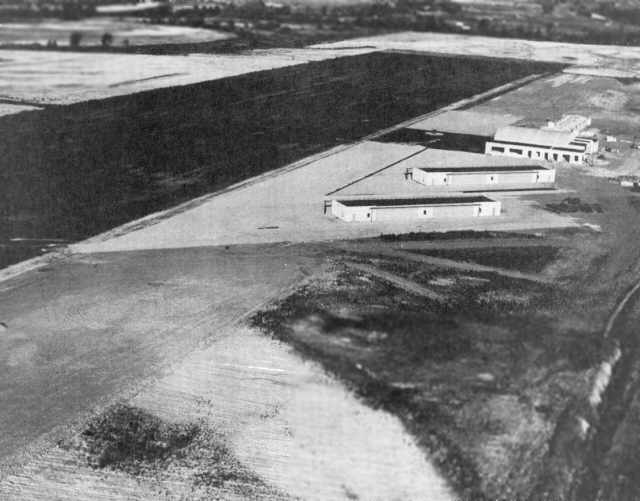
The earliest photo which has been located of Bradley Field was a July 1946 aerial view looking east (courtesy of Robert Pearson),
taken while the field was nearing completion.
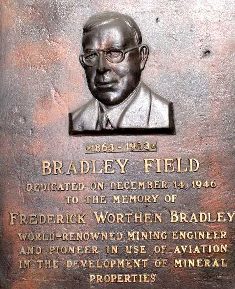
Bradley Field was dedicated on 12/14/46 to Frederick Bradley (a 2008 photo by John Bradley of a historic plaque).
John observed, Frederick Bradley was “my grandfather whom the airport is dedicated to.
They had mines in Idaho & in the winter they were only accessible by air at times.
So that is how they got into the flying business.”
-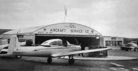
A circa 1946-50 photo (courtesy of John Bradley) of a Navion in front of an Aircraft Service Company hangar at Bradley Field.
John recalled, “They had gambling in Idaho at that time & the airport had slot machines,
so believe that is only time the airport turned profit, It was just way ahead of it's time.”
The Aircraft Service Company achieved national recognition as a sales distributor for the North American Navion.
The company's volume made it a national sales leader for Navion aircraft in the 1946-47 period.

A circa 1946-50 photo (courtesy of John Bradley) of a Grumman amphibian being refueled at Bradley Field.
The 1947 ID Aeronautical Chart (courtesy of Bob Pearson) depicted Bradley as a commercial/municipal airport.
Bradley Field (and 4 other Boise area airports) as depicted on a circa 1948 ID Airports Map (courtesy of Jeff Anderson).
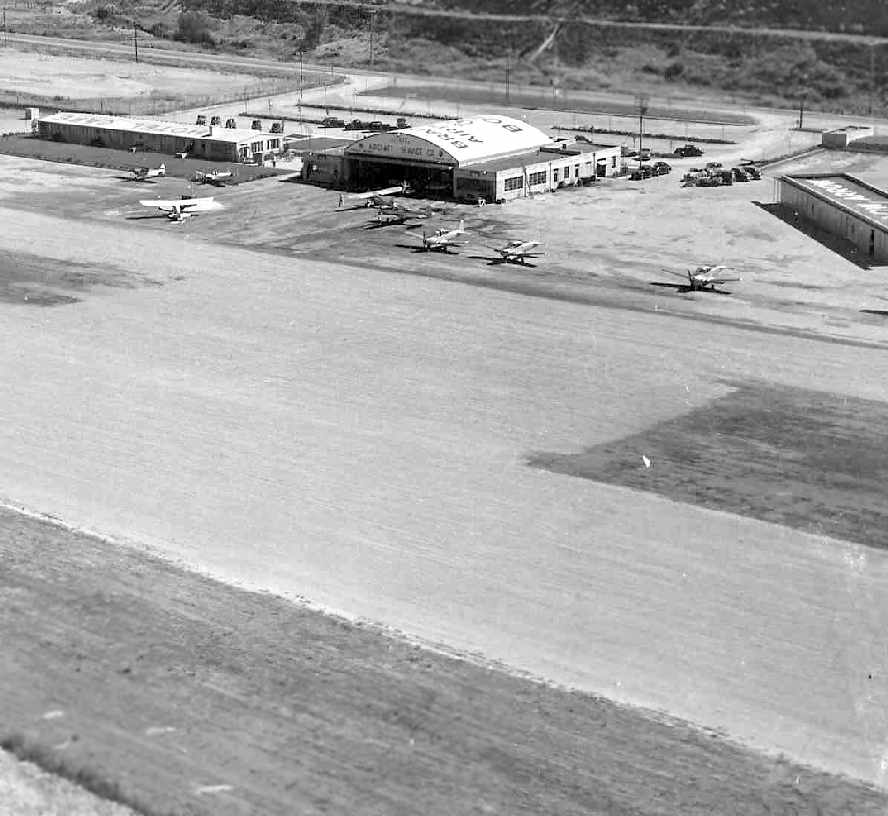
An undated aerial view looking north at Bradley Airport (courtesy of Robert Pearson).
An undated photo of crowds looking at a Bell 47 helicopter in front of a hangar of the Aircraft Service Company at Bradley Airport (courtesy of Robert Pearson).
The September 1949 Great Salt Lake World Aeronautical Chart (courtesy of Donald Felton)
depicted Bradley as having a 3,000' unpaved runway.
A 7/22/53 USGS aerial view depicted Bradley Field as having a single northwest/southeast runway, with a row of hangars along the west side.
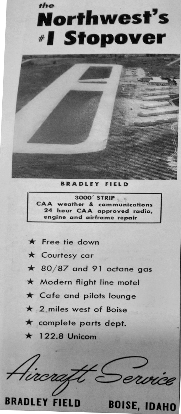
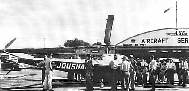
A September 1954 advertisement for Bradley Field, “The Northwest's #1 Stopover” (courtesy of Michael Dennis).
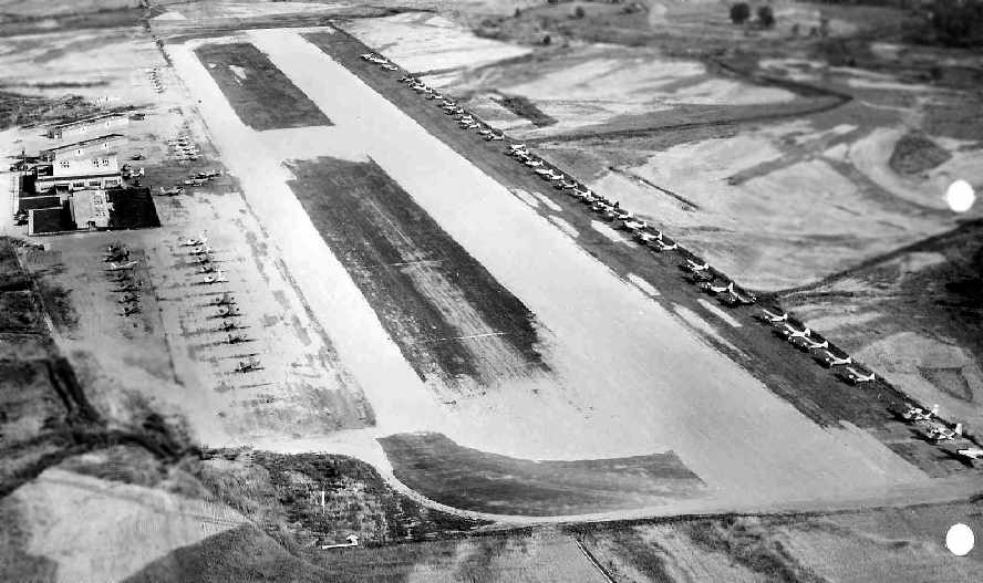
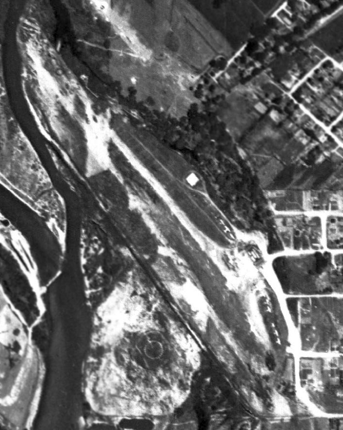
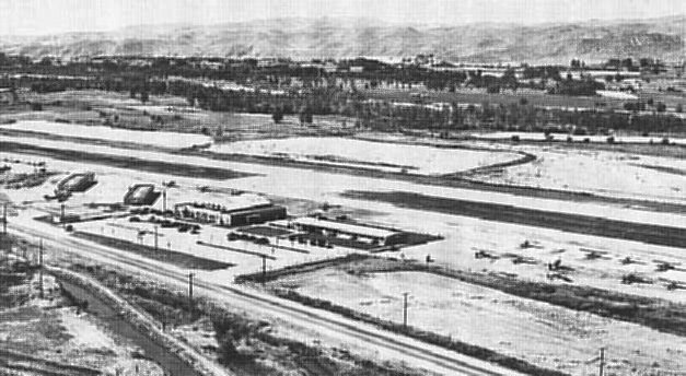
A circa 1950s aerial view looking west at Bradley Field (from the ID DOT Department of Aeronautics, via William Womack),
with a huge number of light aircraft on both sides of the field.
A closeup from the circa 1950s aerial view looking west at Bradley Field (from the ID DOT Department of Aeronautics, via William Womack).
The 1953 Boise Sectional Chart (courtesy of Chris Kennedy)
described Bradley Field as having a 3,000' unpaved runway.
The 1953 USGS topo map depicted Bradley Field as having a northwest/southeast runway & a parallel taxiway along the southwest side.
A row of hangars was located along the southwest side of the taxiway.
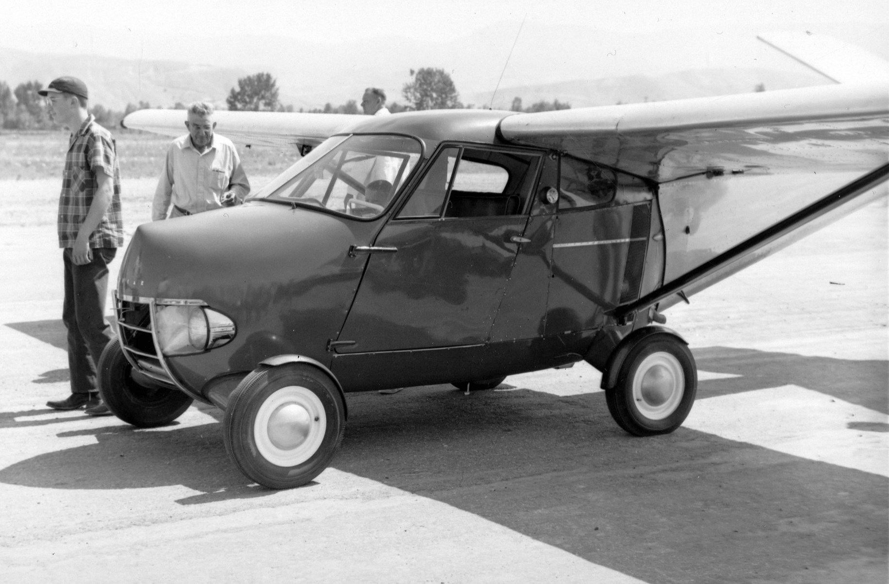
A 1961 photo of a rare 1954 Taylor Aerocar at Bradley Field.
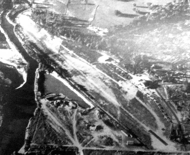
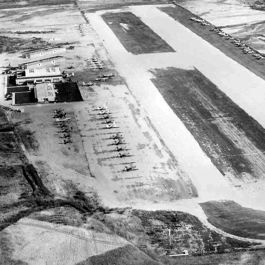
A circa 1960s aerial view looking south at Bradley Field (from the ID DOT Department of Aeronautics, via William Womack).
A circa 1960s aerial view looking south at Bradley Field's hangar (from the ID DOT Department of Aeronautics, via William Womack),
with 3 Navions & several taildraggers on the ramp.
The building on the left was marked “Hotel Cafe” on its roof.
Bradley Field apparently gained a paved runway at some point between 1953-67,
as the 1967 Boise Sectional Chart (courtesy of Chris Kennedy) depicted the field as having a single 3,000' paved runway.
The last aeronautical chart depiction which has been located of Bradley Field was on the May 1971 Boise Sectional Chart (courtesy of Ron Plante).
It depicted Bradley as having a single 3,000' paved runway.
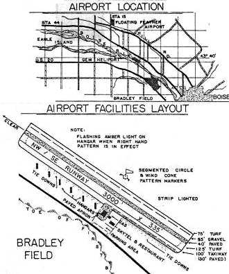
The 1971 ID Airport Directory (courtesy of Robert Pearson) depicted Bradley Field as having a single 3,000' paved runway,
with a paved parallel taxiway along the southwest side.
A row of hangars was located along the southwest side of the taxiway, and the "Skytel & restaurant" were located next to a paved apron.
The manager was James Sparks.
However, the end was near for Bradley Field, as the remarks said, "Future status undetermined at this time.
Future expansion as a reliever airport."
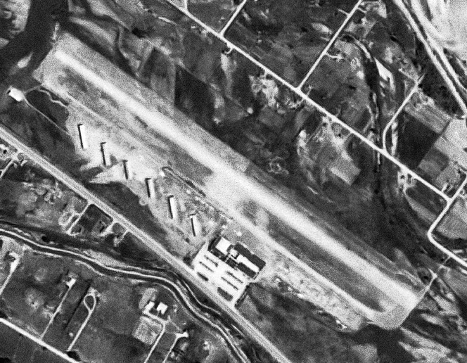
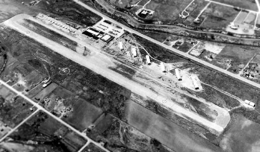
The last photo which has been located showing Bradley Field still in operation was a 7/12/71 USGS aerial view.
Bradley Field appeared to be quite healthy, with over 2-dozen light aircraft visible parked outside.
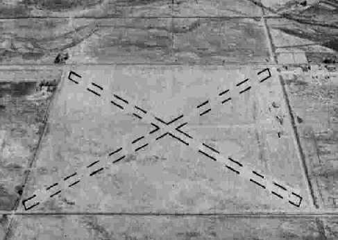
Unfortunately, instead of being expanded, Bradley Field was closed in 1973. Its last operator was Capital Flying Service.
Bill Scherer recalled, “I painted the Xs on the runways, [as the] manager of Capital Flying Service at that time.”
Bradley Field was still depicted on the 1979 USGS topo map,
even though it had apparently already been closed for 6 years by that point.
Bradley Field was depicted as an abandoned airfield on the April 1980 Salt Lake Sectional Chart (courtesy of Mitchell Hymowitz).
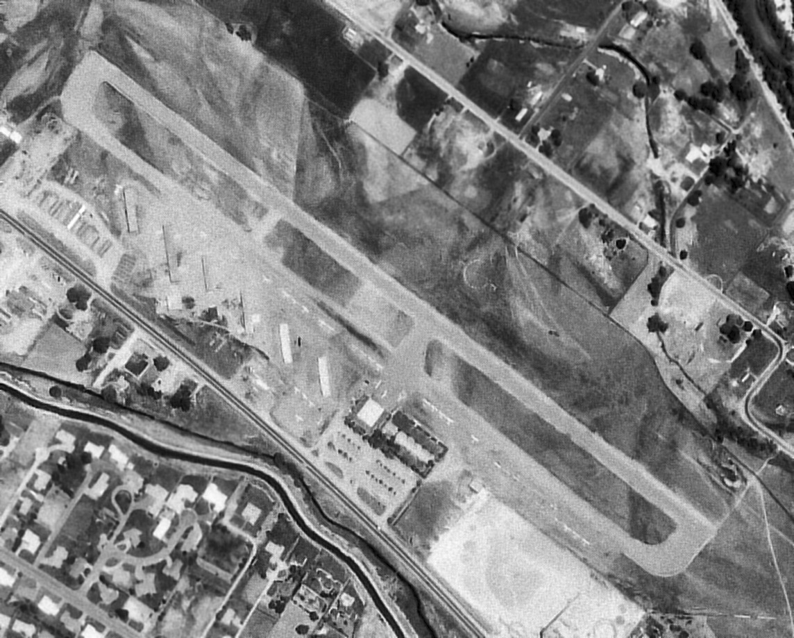
A 1992 USGS aerial view looking north showed that the western & eastern portions of the Bradley Field runway & taxiway remained -
two streets (Sawyer Avenue & 52nd Street) had been built over the middle portion of the airfield.
What appeared to be several small hangars also still remained erect, on the west side of the field.
Jim Lyons reported in 2005 that the Vineyard Church occupies 22 acres of the former airport property,
and is looking for further information on the property's history.
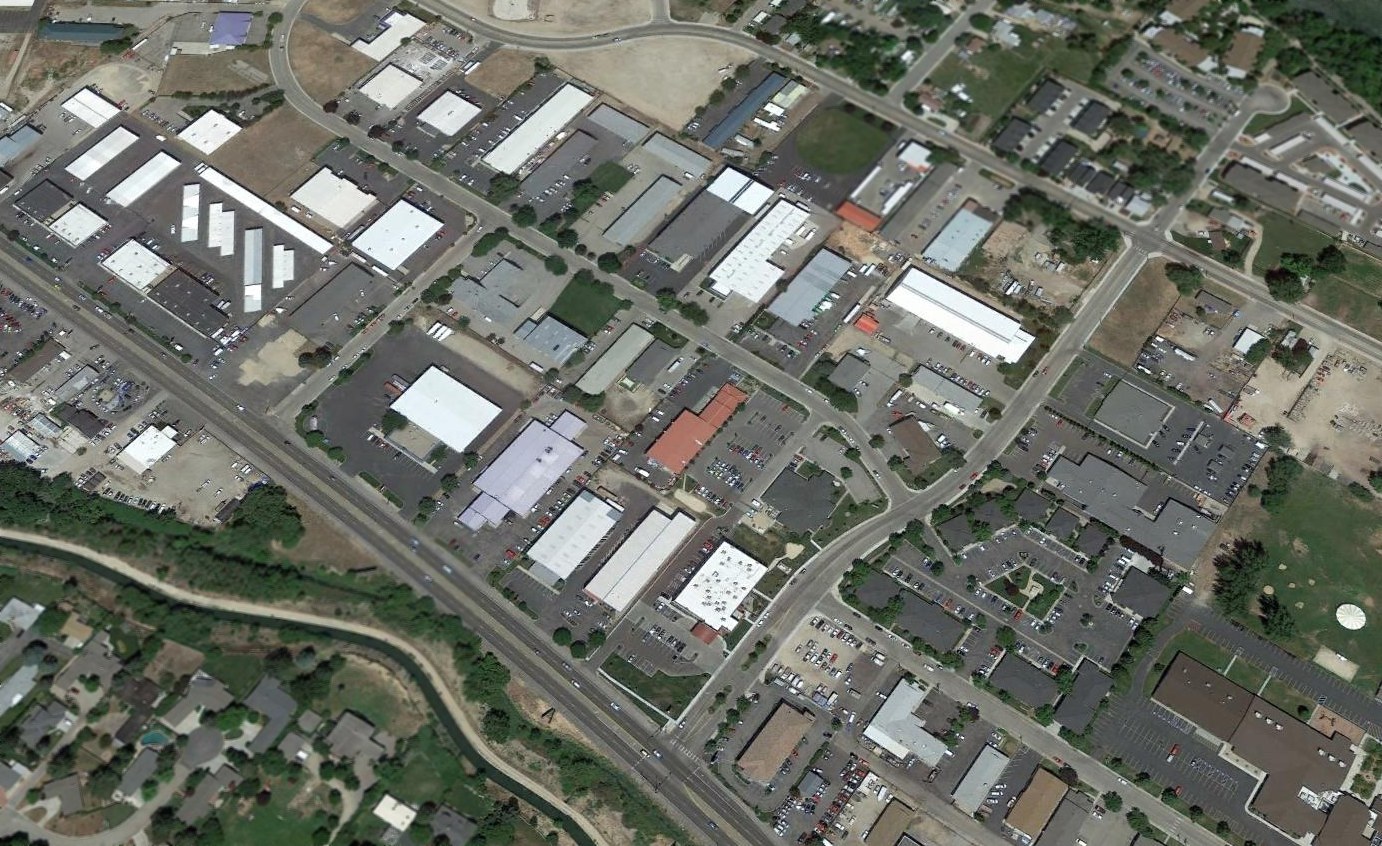
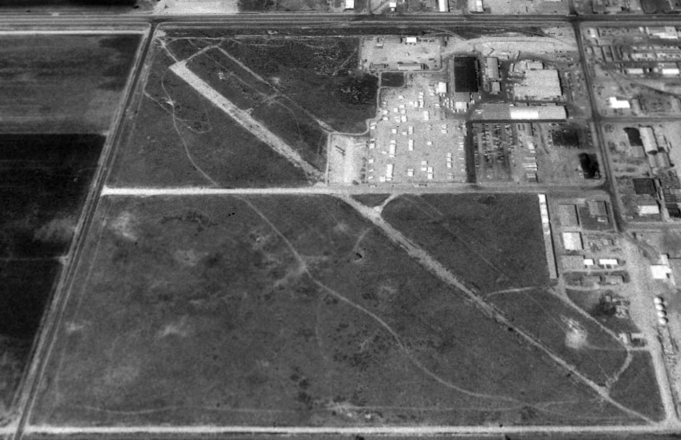
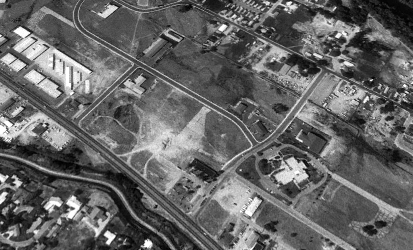
A 2017 aerial view looking north showed that additional buildings had covered the remaining traces of Bradley Field's runway.
However, several 60 year-old hangars still remained intact, on the west side of the field (top-left of photo).

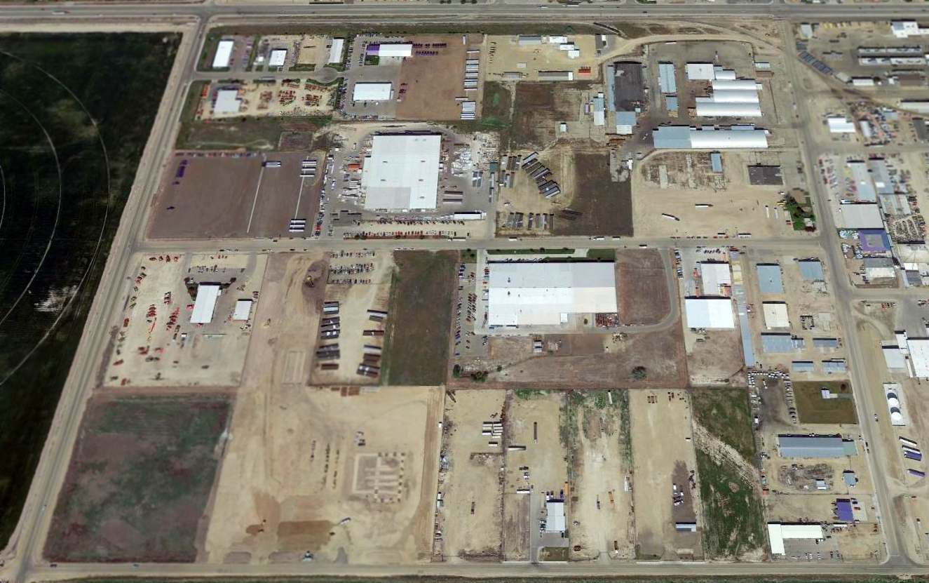
A 2025 3-D aerial image looking northeast at several of the 60+ year-old former hangars which remain on the west side of the Bradley Field site, reused by Boise Lockaway Storage.
The site of Bradley Field is located northwest of the intersection of West Chinden Boulevard & 52nd Street.
____________________________________________________
Or if you prefer to contact me directly concerning a contribution (for a mailing address to send a check),
please contact me at: paulandterryfreeman@gmail.com
If you enjoy this web site, please support it with a financial contribution.
____________________________________________________
This site covers airfields in all 50 states.