Abandoned & Little-Known Airfields:
Illinois: Central Chicago area
© 2004, © 2026 by Paul Freeman. Revised 3/12/26.
This site covers airfields in all 50 states: Click here for the site's main menu.
Please consider a financial contribution to support the continued growth & operation of this site.
Checkerboard Field / Maywood Airmail Field / Hines Field (revised 9/26/24) - Eagle Flying Field / Elmhurst Airport / Elmhurst Greer College Airport (revised 9/24/23)
Sky Haven Airport (revised 9/7/25) - Meigs Field (revised 3/12/26) - Sky-Line Airport / Mitchell Field (revised 11/29/22)
____________________________________________________
Meigs Field (CGX), Chicago, IL
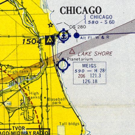
41.86, -87.61 (East of Downtown Chicago)
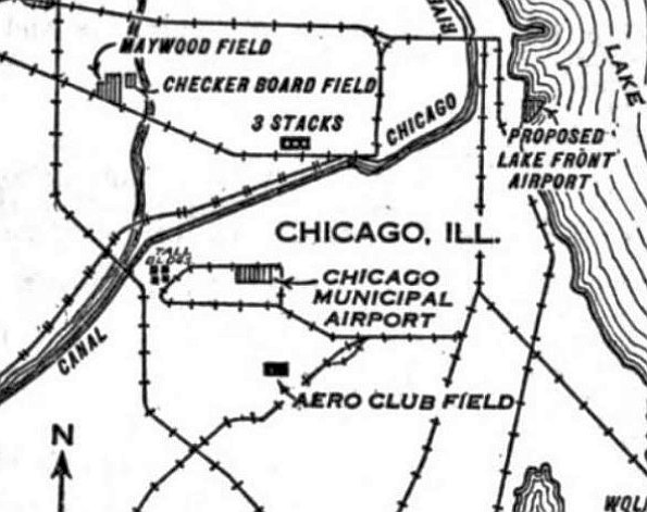
“Proposed Lake Front Airport”, as depicted on the 6/29/28 Commerce Department Airway Bulletin (courtesy of Mike Denja).
Plans for a lakefront airport for the city of Chicago go back to at least 1916,
when Edward Bennett (co-author of Burnham & Bennett's Master Plan of Chicago) first proposed airport on Chicago's lakefront.
In a 1916 letter, Bennett proposed, "The lakefront appears to offer a site naturally adapted for [airport] terminal facilities.
A site on the lakefront would appear also to be more conveniently placed
than any other large area available within a short distance of the central business district."
In 1920, the Chicago public approved a bond referendum to pay for construction of Chicago's lakefront.
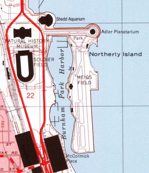
Construction began on Northerly Island in 1922, the same year that Mayor William Hale Thompson advocated locating the downtown airport there.
By the late 1920s consensus had grown. The South Park Commission had voted to place Chicago's downtown airport on Northerly Island.
The business community concurred.
The Chicago Association of Commerce, in it's 1928 publication "Chicago - The Aeronautical Center" declared that:
"The city of Chicago has recently taken steps that are expected to lead
to an early agreement between the city, the South Park Commissioners & other parties
to the Lake Front Improvement Ordinance of 1919 which will make it possible for the South Park Commissioners
to proceed with the actual construction of the airport."
The earliest depiction which has been located of what would eventually become Meigs Field
was the depicted of the “Proposed Lake Front Airport” on the 6/29/28 Commerce Department Airway Bulletin (courtesy of Mike Denja).
When the Great Depression hit in 1929, many grand civic plans were put on hold.
The plan for Chicago's downtown airport was postponed but construction began on the first island, named Northerly Island.
A Planetarium was to be constructed on this island as well as an Aquarium on the Shore.
Then, in a bold move to pull itself up by its bootstraps, Chicago decided to host a world's fair.
In 1933, the Century of Progress fair opened on Chicago's lakefront, built on Northerly Island & the south lakefront.
Aviation was a theme of the fair, with aircraft of all types featured.
The arrival of Italo Balbo's aerial flotilla to the fair was commemorated
with a monument that still stands in Burnham Park across the harbor from Meigs Field.
Blimps and airplanes plied the skies over the fair; one attraction featured seaplane rides in Sikorsky S-38s owned by Pal-Waukee Airport.
Shortly after the fair closed in 1934, plans were made once again for a lakefront airport.
The Chicago City Council and Illinois State Legislatures passed resolutions to create the airport
and plans were advanced for as many as 3 runways for the airport.
Yet the combination of a poor economy, uncertainty over world events,
and mixed civic feelings over the use of the lakefront for an airport delayed construction.
In 1941, a report of the Chicago Aero Commission recommended once again that the downtown airport be located on or near Northerly Island.
Finally, in 1946, the years of waiting ended.
The decision to build an airport on Northerly Island was finalized, a long term lease with the Chicago Park District was signed, and construction begun.
The size of Northerly Island in 1946 was not sufficient to accommodate the advances in aircraft & airport designs since construction of the original landfill,
so the Illinois state legislature granted an additional 24 acres of lake bottom, nearly 1/3 of Meigs' current area, for construction of an airport.
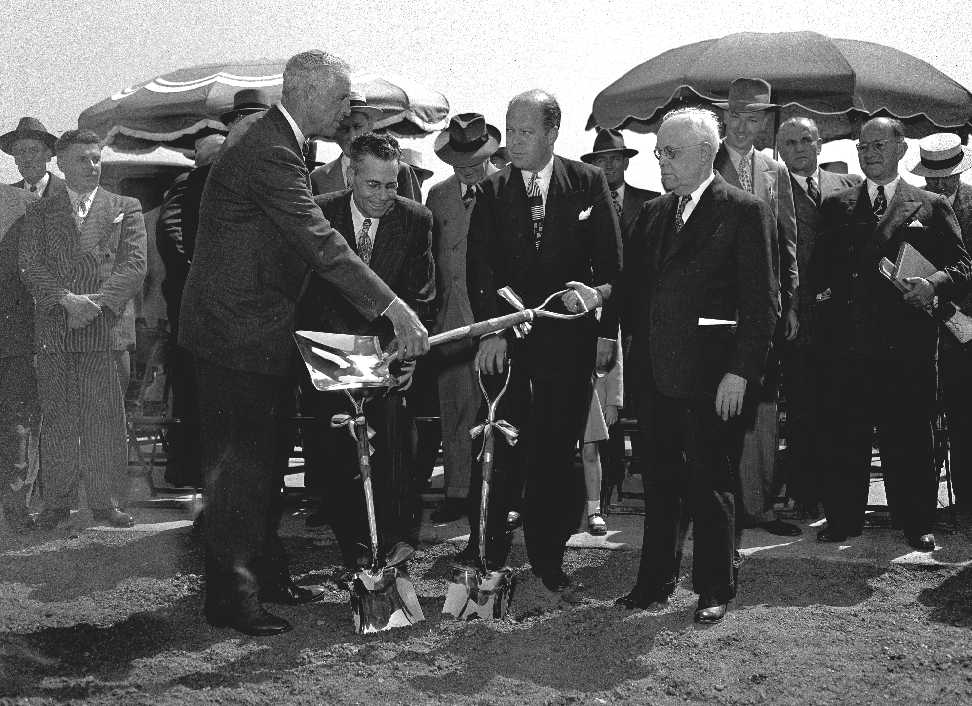
A 1947 photo (courtesy of Mark Hess) of what was evidently the Meigs Field groundbreaking ceremony.
A circa 1947 aerial view looking northwest at Meigs Field,
showing the ramps & taxiways having been built, bult the runway still under construction.
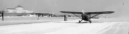
A 1947 photo of a Stinson (possibly Model 108) landing at Meigs, on what appears to be a runway still under construction.
An aerial view of the Grand Opening of Meigs, from the 12/11/48 issue of the Chicago Herald-American.
Meig's construction took over 2 years, culminating with a grand opening on 12/10/48.
Despite sub-freezing temperatures, the opening was attended by nearly 100 aircraft, including over 75 Flying Farmers.
The celebration was attended by many city & aviation leaders,
including Mayor Kennelly, Merrill Meigs, and Stuart Symington, Secretary of the Air Force.
Festivities included the dropping of 51 glass bottles containing store gift certificates into Chicago's harbor
from a Cessna 170 flown by Mr. & Mrs. John Wilson of Lockport, IL.
According to the Chicago Tribune, the best speech of the day was made by Lee Talladay, a Flying Farmer.
"I didn't expect when I got up & milked the cows at 4 o'clock this morning
to be rubbing elbows over lunch with the brass hats from Washington & the tycoons from Chicago's State Street stores.
But that just shows what can happen when aviation really comes into its own
as it has in this small instance of Chicago's lake front strip," said Talladay.
An aerial view looking southeast at Meigs Field soon after its opening in 1948.
A 1948 photo (courtesy of Mark Hess) of a large number of aircraft & spectators at Meigs Field.
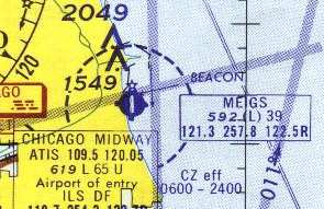
The earliest aeronautical chart depiction which has been located of Meigs Field was on the December 1948 Chicago Sectional Chart.
Note that it depicted the airport under its original name of “Lakefront” Airport, with a 2,800' paved runway.
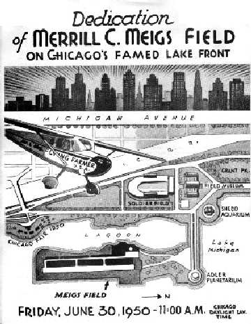
A poster promoting the 6/30/50 Dedication of Meigs Field.
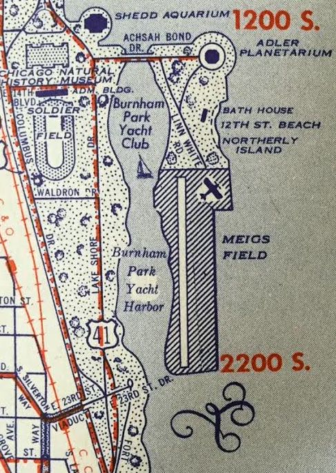
A 1950 map (courtesy of Kevin Walsh) depicted Meigs Field as having a single north/south runway.
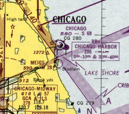
The November 1950 Chicago Sectional Chart depicted Meigs Airport as having a 2,800' paved runway.
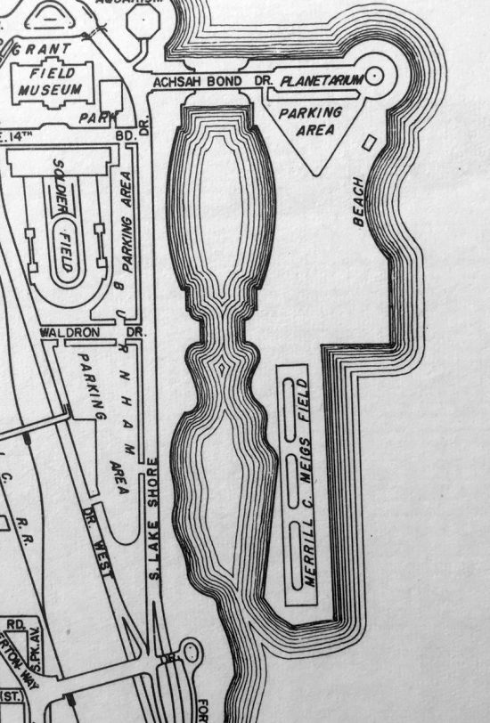
A 1951 street atlas (courtesy of Kevin Walsh) depicted Meigs Field as having a single north/south runway.
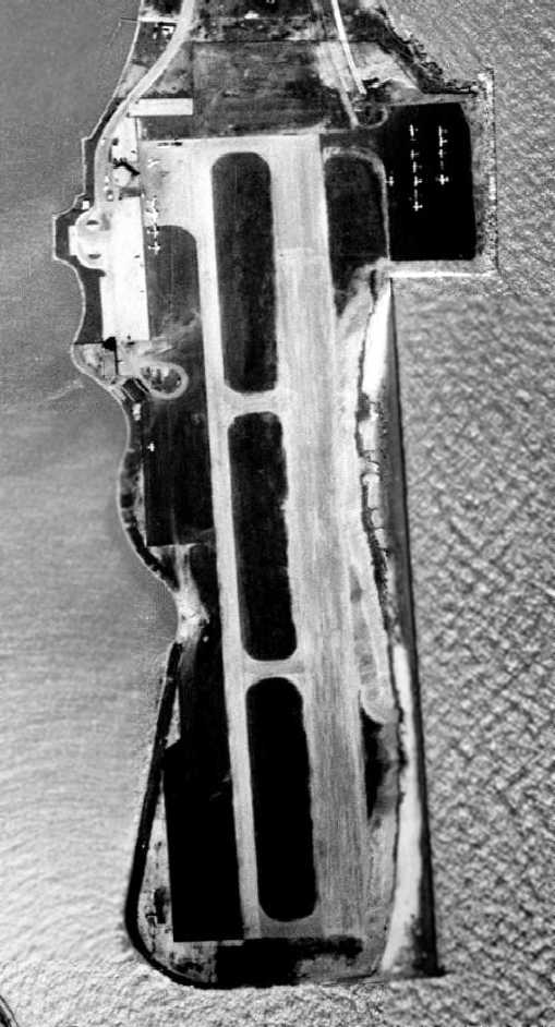
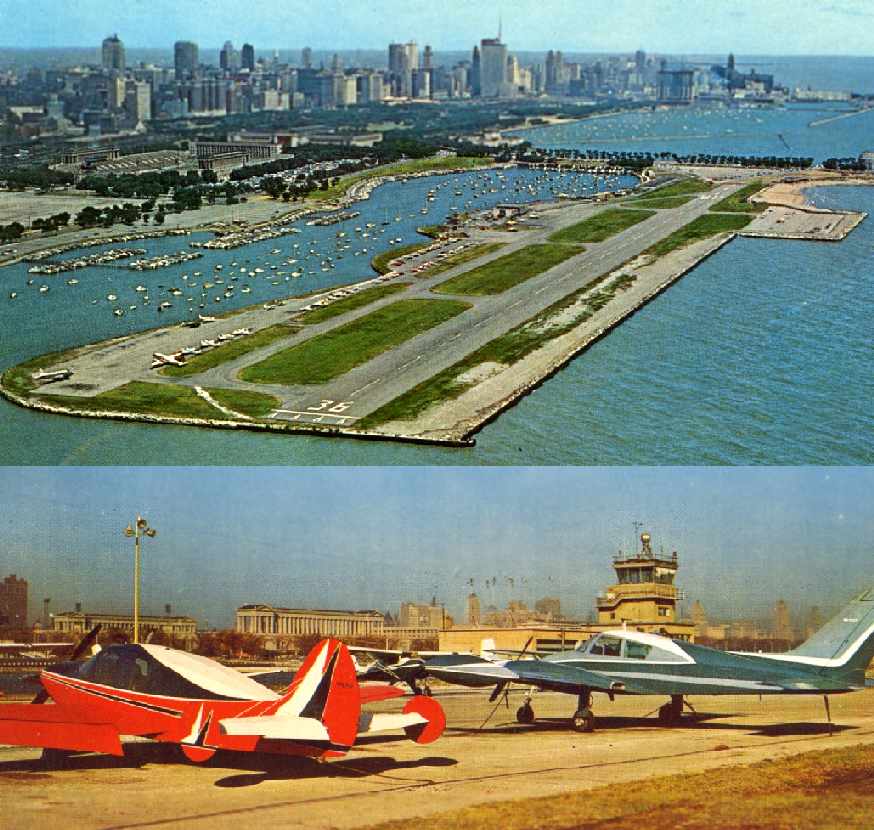
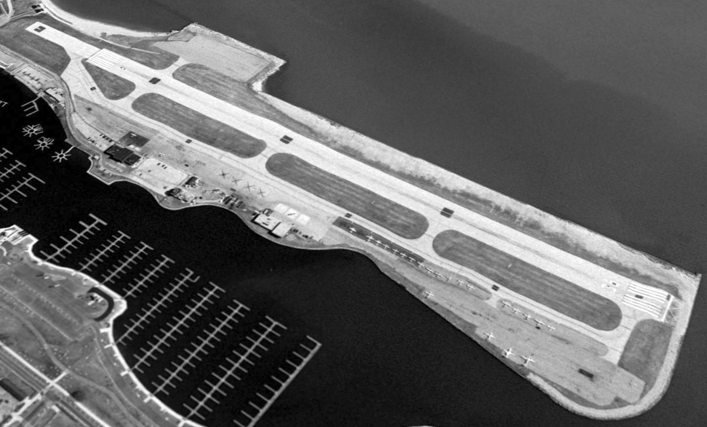
A 1952 aerial view depicted Meigs with its original 2,800' runway.
Five planes were parked in front of the terminal on the northwest side, and another 10 planes were parked on a ramp on the northeast side.
The 1953 IL Airport Directory (courtesy of Lee Corbin) depicted Meigs Field as having a single north/south paved 2,800' runway.
The 1953 USGS topo map depicted Meigs with its original 2,800' runway.
In 1955, Meigs' single runway was extended from 2,800' to its ultimate length of 3,900'.
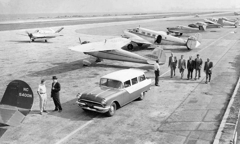
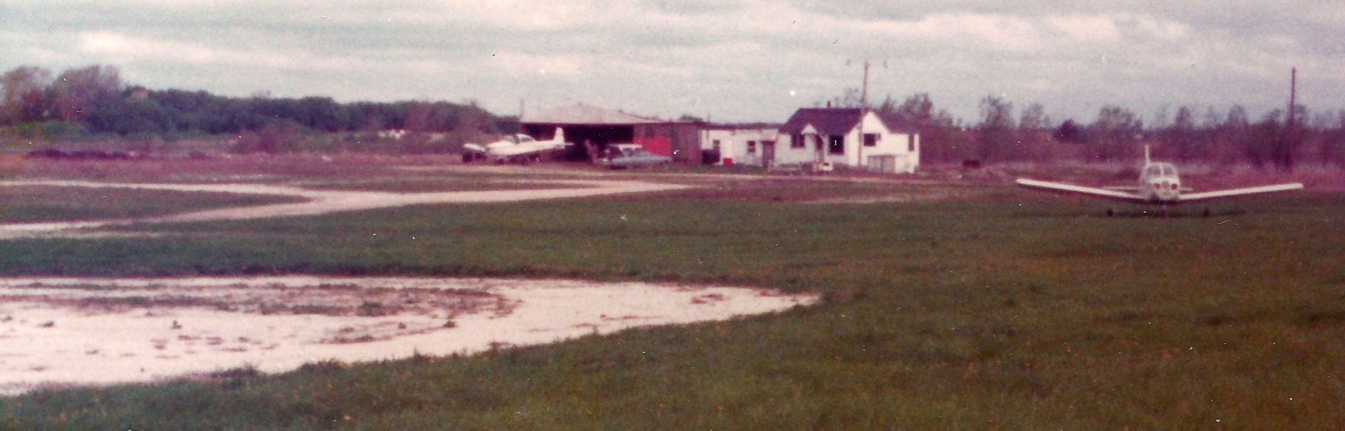
A 1955 photo of a variety of business aircraft at Meigs Field.
An undated aerial view of Meigs Field from the 1956 IL Airport Directory (from the University of IL, courtesy of Daniel McGill).
It depicted Meigs as having a 3,710' paved north/south runway.
The 1956 Chicago Local Aeronautical Chart (courtesy of Tim Zukas) depicted Meigs Airport as having a 2,800' paved runway.
A 1956 aerial view (courtesy of Mark Hess) looking northwest at Meigs Field.
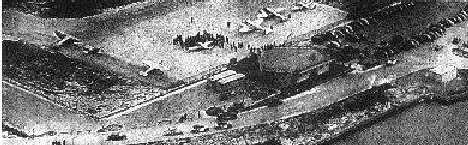
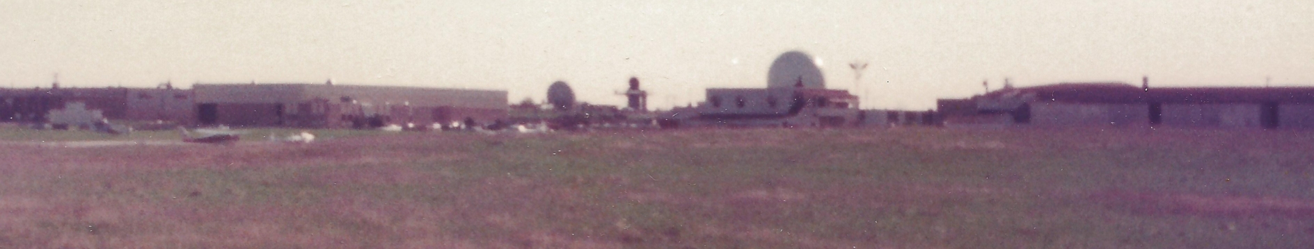
A 10/1/59 aerial view (courtesy of Mark Hess) looking southwest at s busy Meigs Field ramp,
showing dozens of general aviation & business aviation aircraft.
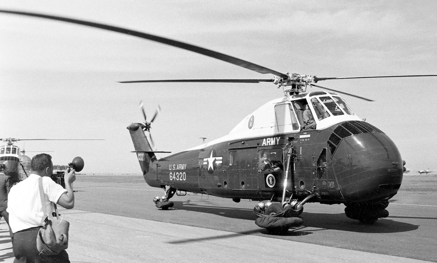
A 7/26/60 photo by Ed Clark of President Dwight Eisenhower's Army Sikorsky VH-34 at Meigs Field.
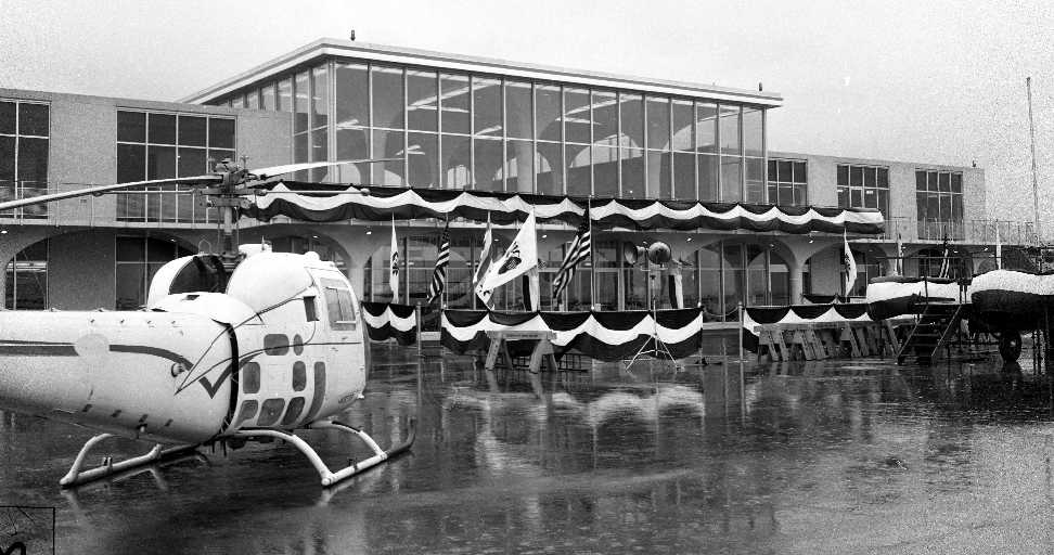
A 10/19/61 photo (courtesy of Mark Hess) of a Bell 47 in front of the new Meigs terminal building, presumably decorated for its dedication.
Mayor Richard Daley dedicated a new Meigs Field passenger terminal building in 1961.
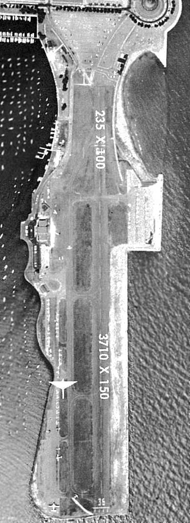
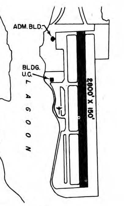
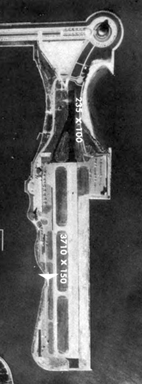
A circa 1961 aerial view from the 1962 IL Airport Directory (courtesy of Jonathan Westerling)
depicted Meigs' newly lengthened runway, measuring 3,710' with a 235' paved overrun.
It also showed a large number (dozens) of aircraft parked on the field.
The operators were Butler Aviation & Chicago Helicopter Airways, and the manager was listed as William O'Brien.
The June 1962 Chicago Sectional Chart (courtesy of William Pagett) depicted Meigs as having a single 3,300' paved runway.
In 1962, an expansion of the airport was proposed, including a 5,000' runway & additional aircraft parking on the east side, but no action was taken.
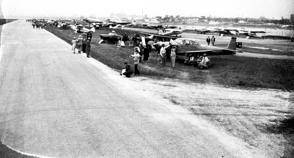
Two undated postcard photos (courtesy of Benton Bullwinkel) of Meigs Field (the top photo had a date of 1964 on the back).
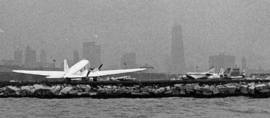
A mid-1960s photo of a Douglas DC-3 at Meigs Field.
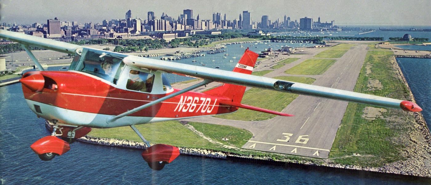
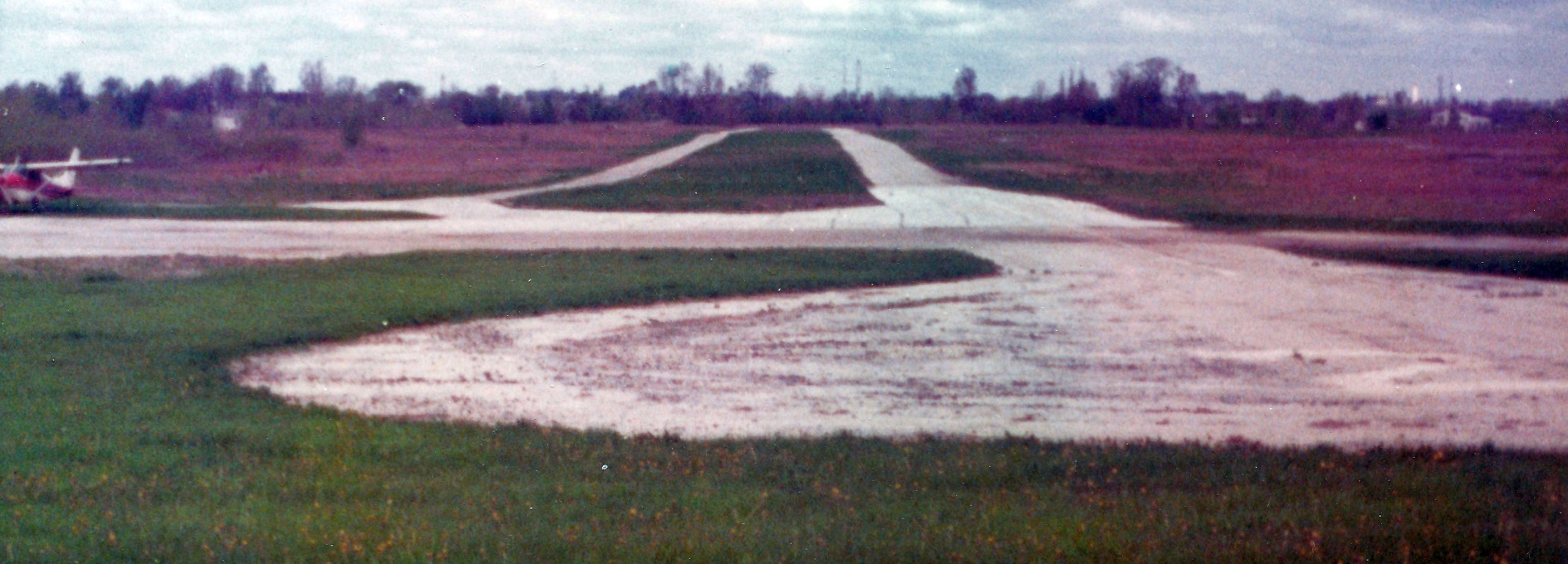
A circa 1964-77 aerial view looking northwest at a Cessna 150 having just departed from Meigs Field's Runway 18, from a Cessna 150 brochure (courtesy of Alex Hauzer).
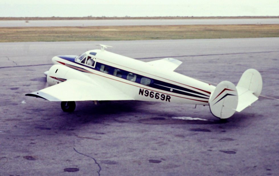
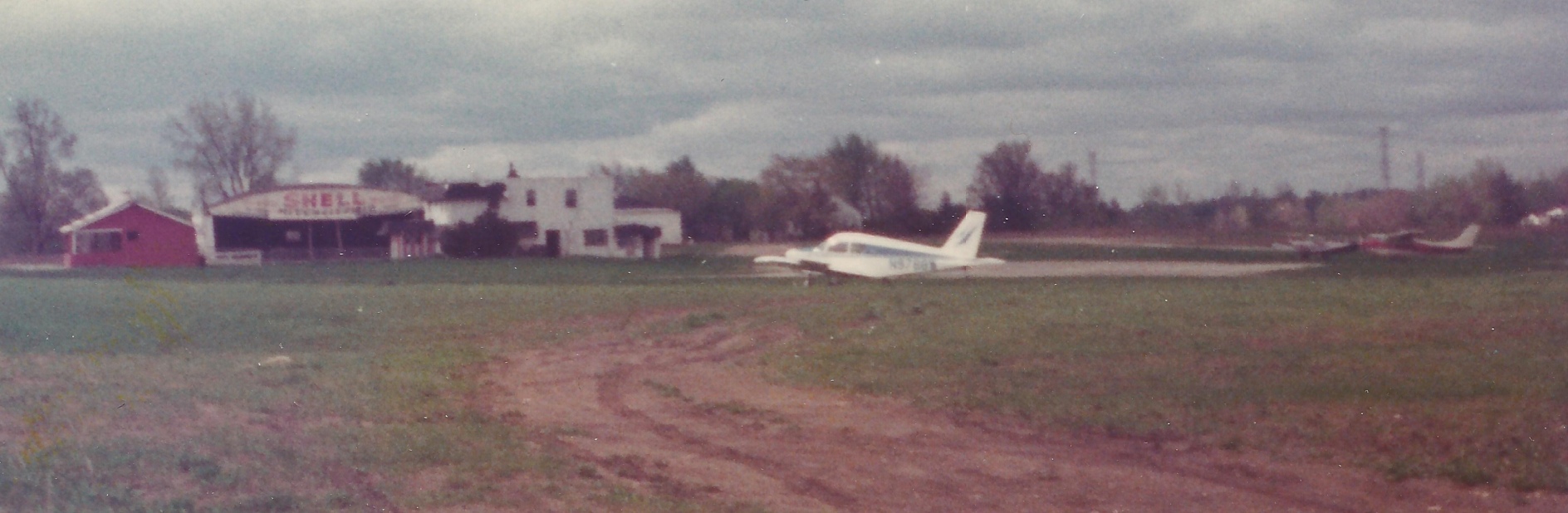
A 9/24/66 photo of a Beech G18S, N9669R, of the Clark Equipment Company at Meigs Field.
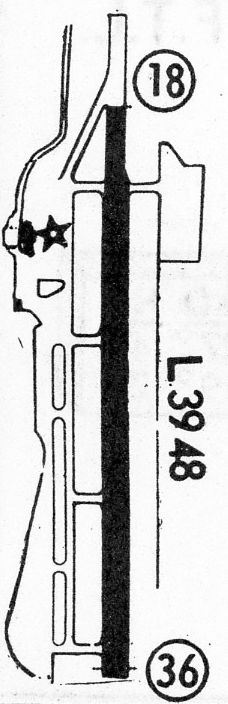
The 1968 Flight Guide (courtesy of Robert Levittan) depicted Meigs Field as having a 3,948' paved Runway 18/36.
The 1969 Chicago Sectional Chart depicted Meigs as having a single 3,900' paved runway.
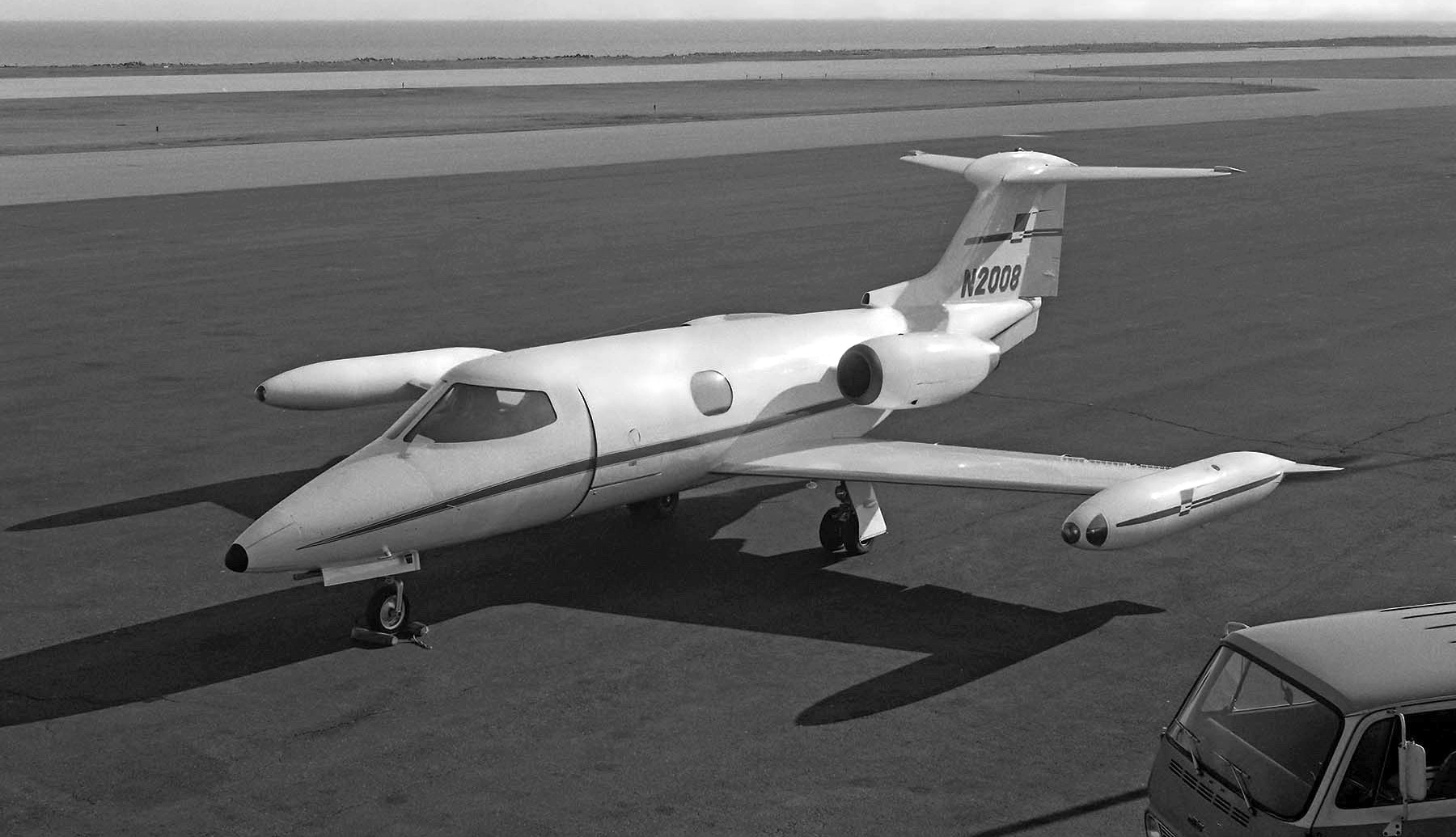
A 12/31/71 photo by Neil Aird of pretty Lear Jet 23 N2008 C/n 23-003 at Meigs Field.
In 1972, Mayor Richard Daley proposed Meigs' closure (what would ultimately become the first of many proposals),
but he backed down when threatened with the loss of federal FAA funding.

A 6/9/73 USGS aerial view depicted over 40 aircraft at Meigs Field, including 2 helicopters & 1 jet.
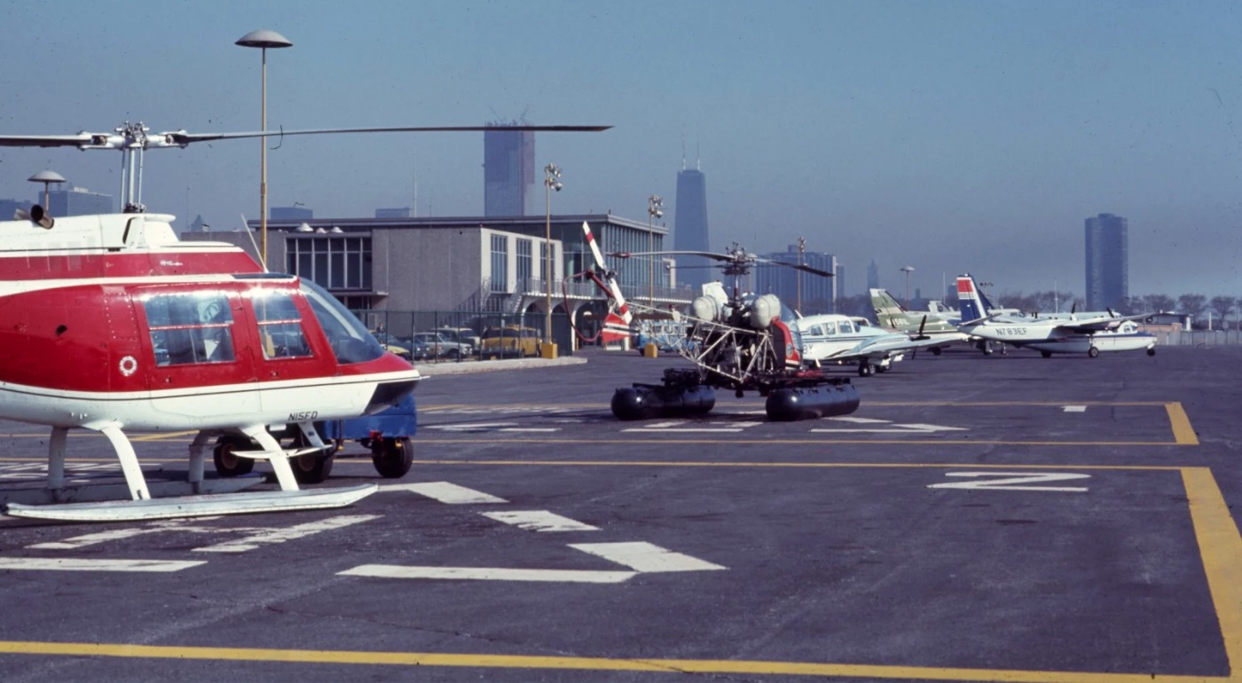
A circa 1973-74 photo by Bob Coveney looking north at Meigs Field, showing a Bell Jet Ranger, Bell 47, and several light aircraft.
Bob recalled, “We'd stop here for fuel on the way back from the Nike missile sites that were south of Chicago.”
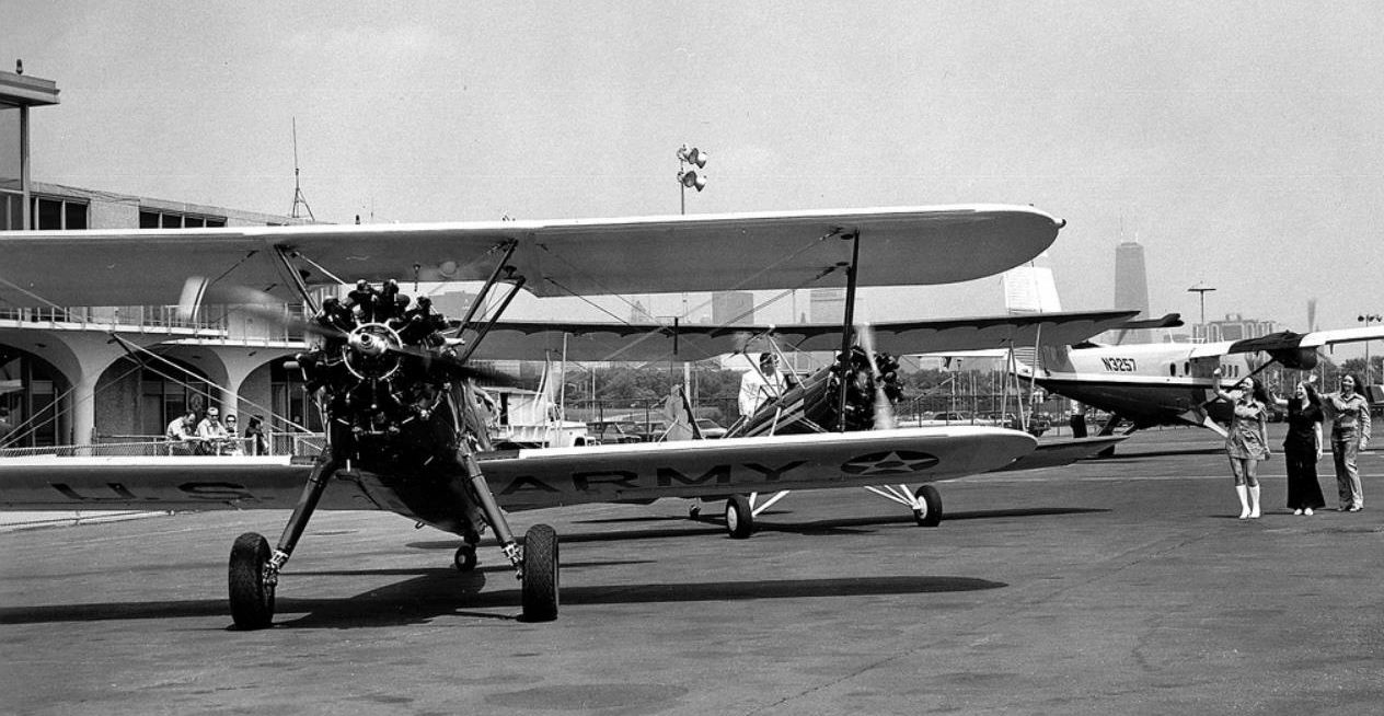
A 1970s photo of 2 vintage biplanes at Meigs Field.
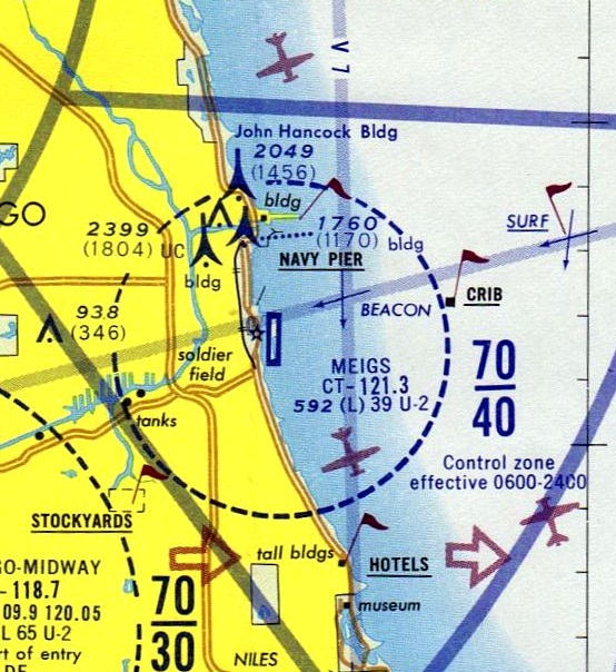
The May 1973 Chicago Terminal Aeronautical Chart (courtesy of Mitchell Hymowitz) depicted Meigs as having a 3,900' paved runway.
In 1980, Mayor Byrne proposed Meigs' closure for the 1992 World's Fair, another proposal which fortunately was not carried out.

The amazing computer graphics, circa 1980, showing Meigs Field as depicted in Sublogic's original Flight Simulator, which was produced for early home computers.
Meigs became widely known to computer aviators over the world, as it was the default takeoff location for the original Flight Simulator (and remained that way for decades of later releases of the software).

A 7/28/84 photo of the Chicago Fire Department's N441FD, a 1961 Bell UH-1B, serial #371, at Meigs Field.

An undated aerial view of Meigs from the 1988 IL Airport Directory.
In 1989 the City of Chicago accepted FAA funding for Meigs,
along which Mayor Daley signed a grant agreement pledging to seek purchase or lease extension of the airport property to 2009.
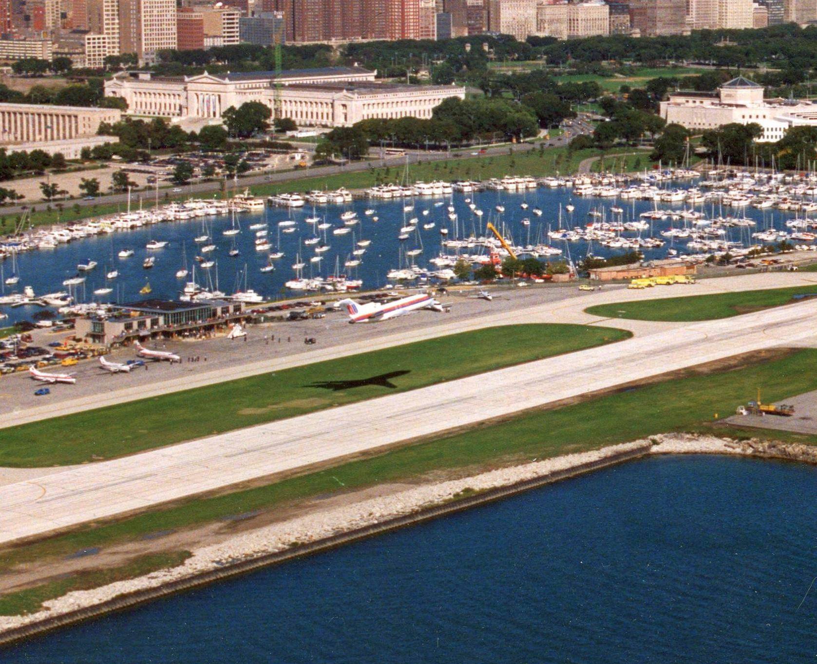
A 9/28/92 photo of the pre-landing flyby over the Meigs runway of the largest plane to land at Meigs Field: a Boeing 727 that was donated from United Airlines to the Chicago Museum of Science & Industry
which made its final landing at Meigs, on its way to be transported to the museum to become an exhibit.
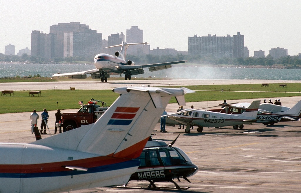
A 9/28/92 photo of the sporty landing of the largest plane to land at Meigs Field: the donated United Boeing 727.
It was notable because Meigs' runway was somewhat shorter than that used typically by a 727, but the lightly-loaded jet did not require all of the runway.
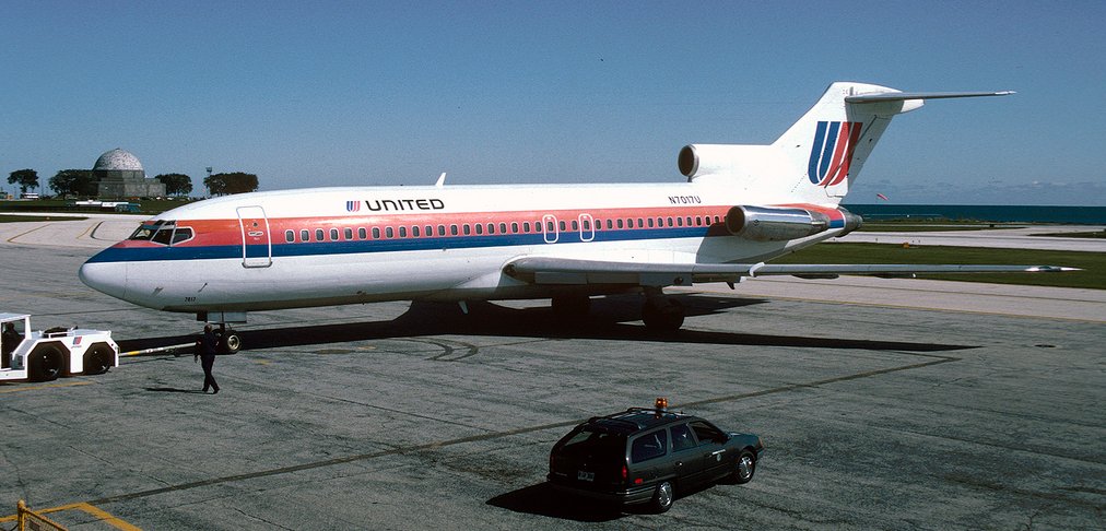
A 9/28/92 photo of the largest plane to land at Meigs Field: the donated United Boeing 727 after its landing.
The 727 was then barged off the airport, prepared for exhibit & eventually further barged to the museum.
In 1992, the City Department of Aviation published its intent to close Meigs Field in its annual report.
What a progressive & supportive Department of Aviation.
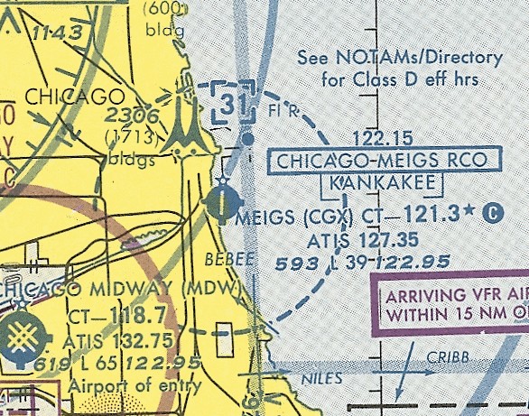
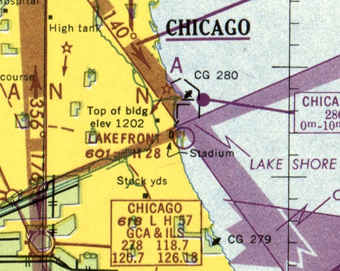
The last aeronautical chart depiction which has been located of Meigs Field was on the October 1993 Chicago Sectional Aeronautical Chart (courtesy of Ron Plante).
It depicted Meigs as having a 3,900' paved runway.
The threat to close Meigs was carried out in September 1996, when the Park District & Department of Aviation closed Meigs (for the 1st time).
A sad day for Chicago-area aviators, and a very bad precedent for aviation in general.
However, within 2 months, the State Legislature voted to reopen the airport under state control.
In January 1997, Governor Edgar & Mayor Daley struck a bargain:
Meigs would reopen for 5 years, with the City retaining control of the airport.
The agreement did not require the airport to close at the conclusion of the 5 year period.
Meigs was given a new lease on life when in reopened in February of 1997.
In February 1998, Meigs received its first instrument approach procedure,
ending Chicago's reign as only major American city without an instrument approach procedure to its nearest downtown airport.
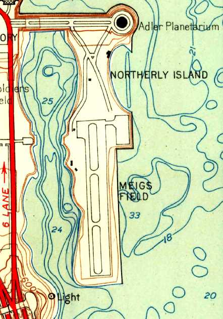
Meigs Field, as depicted on the 1998 USGS topo map.
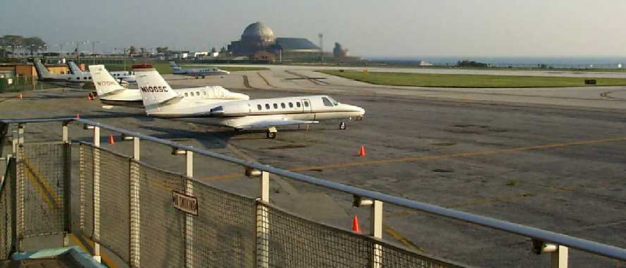
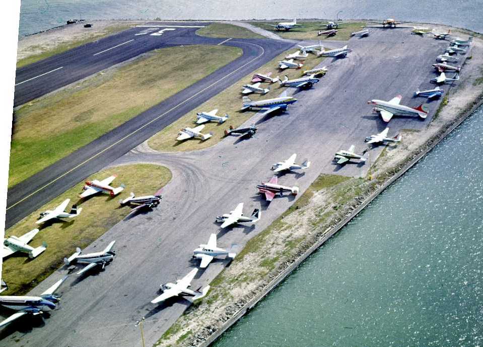
A November 1998 view looking northeast at the Meigs ramp, showing 3 Cessna Citation jets & 2 Beech King Airs.
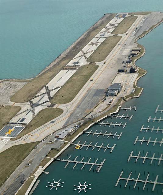
A 1999 USGS aerial view looking northeast, showing Meigs only 4 years before it was closed again.
Note the presence of over 2-dozen aircraft on the ramp, but that the runway had been shortened to 3,500', with the northern threshold moved by 500'.
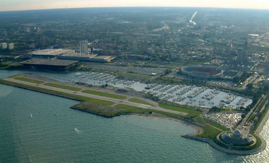
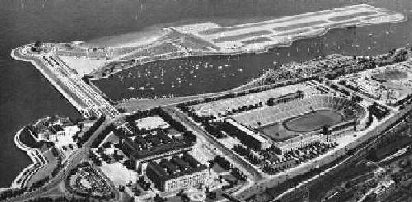
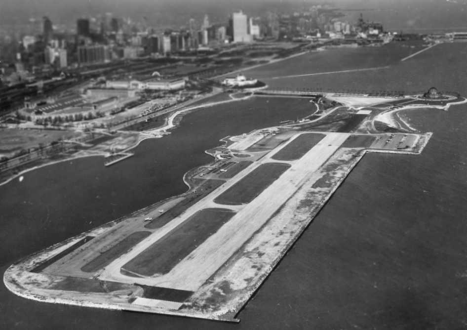
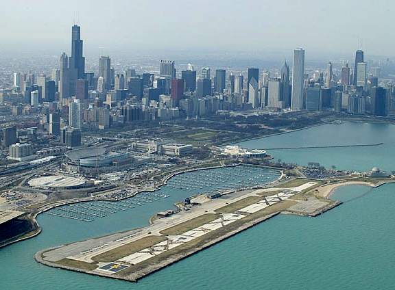
A beautiful September 2001 aerial view of Meigs by Dave Sims.
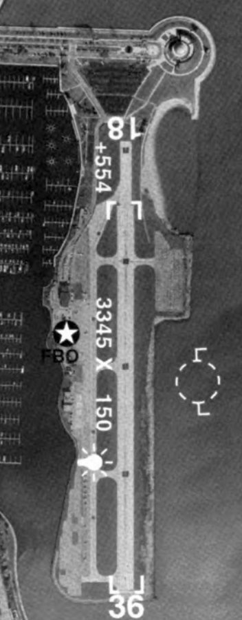
An undated aerial view of Meigs Field from the 2002 IL Airport Directory (from the University of IL, courtesy of Daniel McGill).
It depicted Meigs as having a 3,345' paved Runway 18/36.
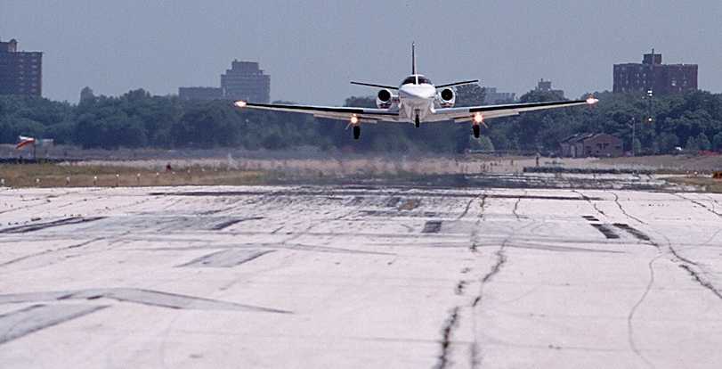
A 7/2/02 photo of a Cessna Citation II landing at Meigs Field by Zach Gollman.
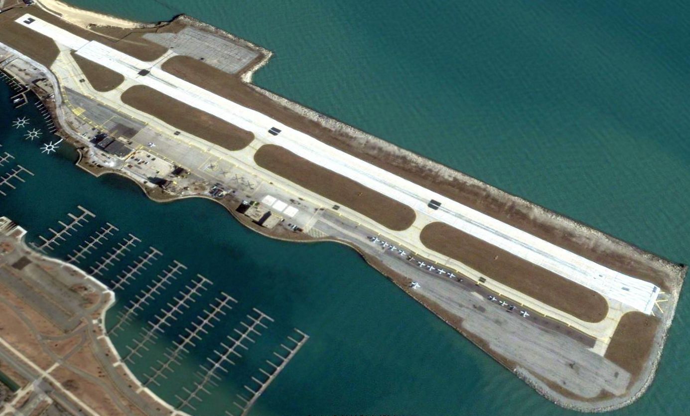
The last photo which has been located showing Meigs while still in operation was a 12/30/02 aerial view looking northeast, showing a large number of aircraft on the ramp.
The photo was taken only 3 months before the airport was destroyed in the middle of the night by the city's own government.
In its last years, it was estimated that Meigs Field contributed a minimum of 1,500 jobs & $57.3 million annually to the local economy.
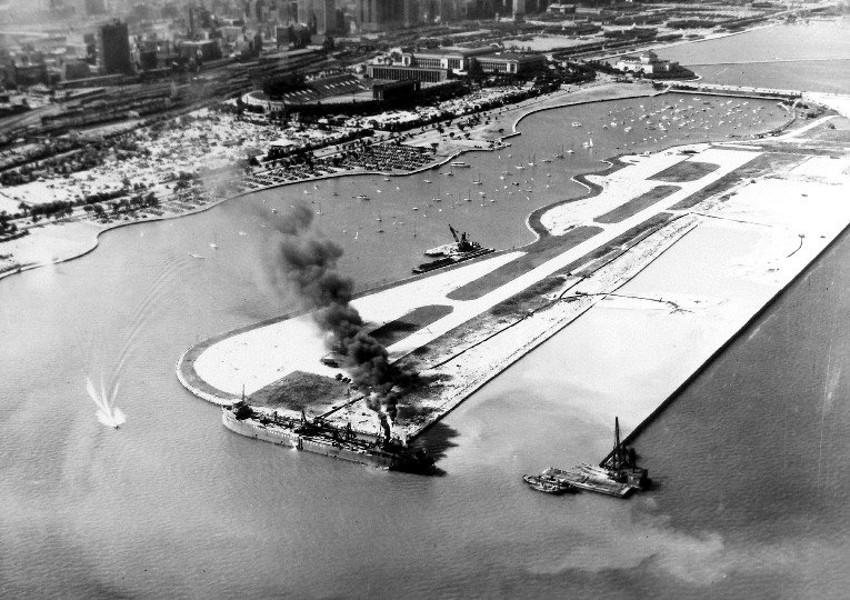
A 2003 aerial photo looking southeast at the destruction of Meigs Field - carried out in the middle of the night by order of Mayor Daley in 2003.
A 2003 aerial photo looking northwest at the destruction of Meigs Field - carried out in the middle of the night by order of Mayor Daley in 2003.
An outrage!
The above photos should sicken the stomach of anyone who believes in elective democracy & the rule of law.
On the night of 3/31/03, under the cover of darkness & without any prior public notification,
the Mayor of Chicago, Richard Daley, sent in city bulldozers with police escort to destroy only runway at Meigs Field,
a publicly-owned general aviation airport.
All aircraft based at the field were stranded,
and the public (including rent-paying owners of aircraft based at Meigs) were barred entrance to the property.
Daley had wanted to close the airport for years, even though it served as a desperately-needed reliever airport,
diverting business & private aircraft traffic away from already-choked O'Hare & Midway Airports.
Many municipalities would love to have such an airport with millions of dollars of paid-for aviation infrastructure,
yet Daley decided that he should destroy the infrastructure owned by his constituents.
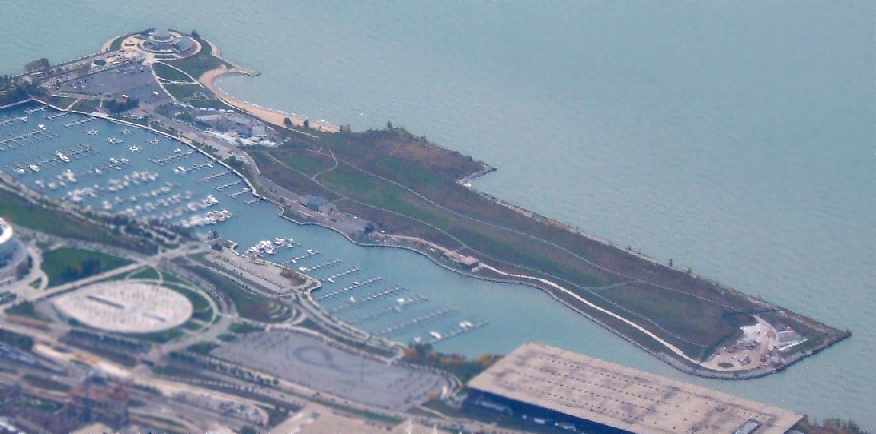
A 2005 aerial photo by Ron Plante – showing that all of the publicly-paid-for runway infrastructure at Meigs Field has been completely destroyed.
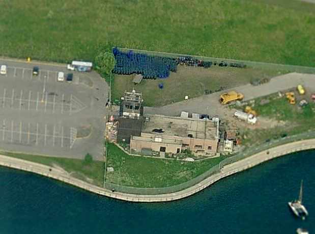
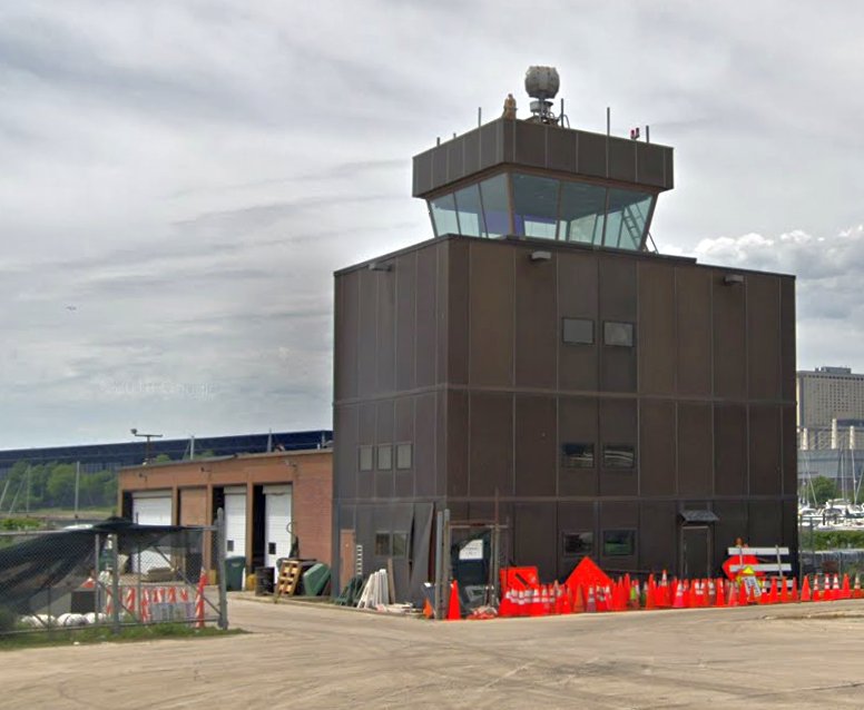
A circa 2006 aerial view looking east at the former Meigs Field control tower.
A circa 2006 aerial view looking east at the former Meigs Field terminal building.
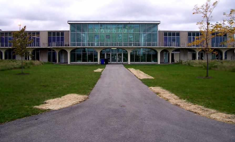
An April 2006 photo by Tobias Rad looking west at the former Meigs Airport terminal building.
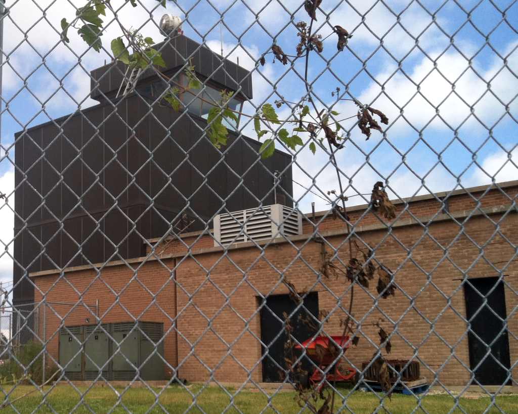
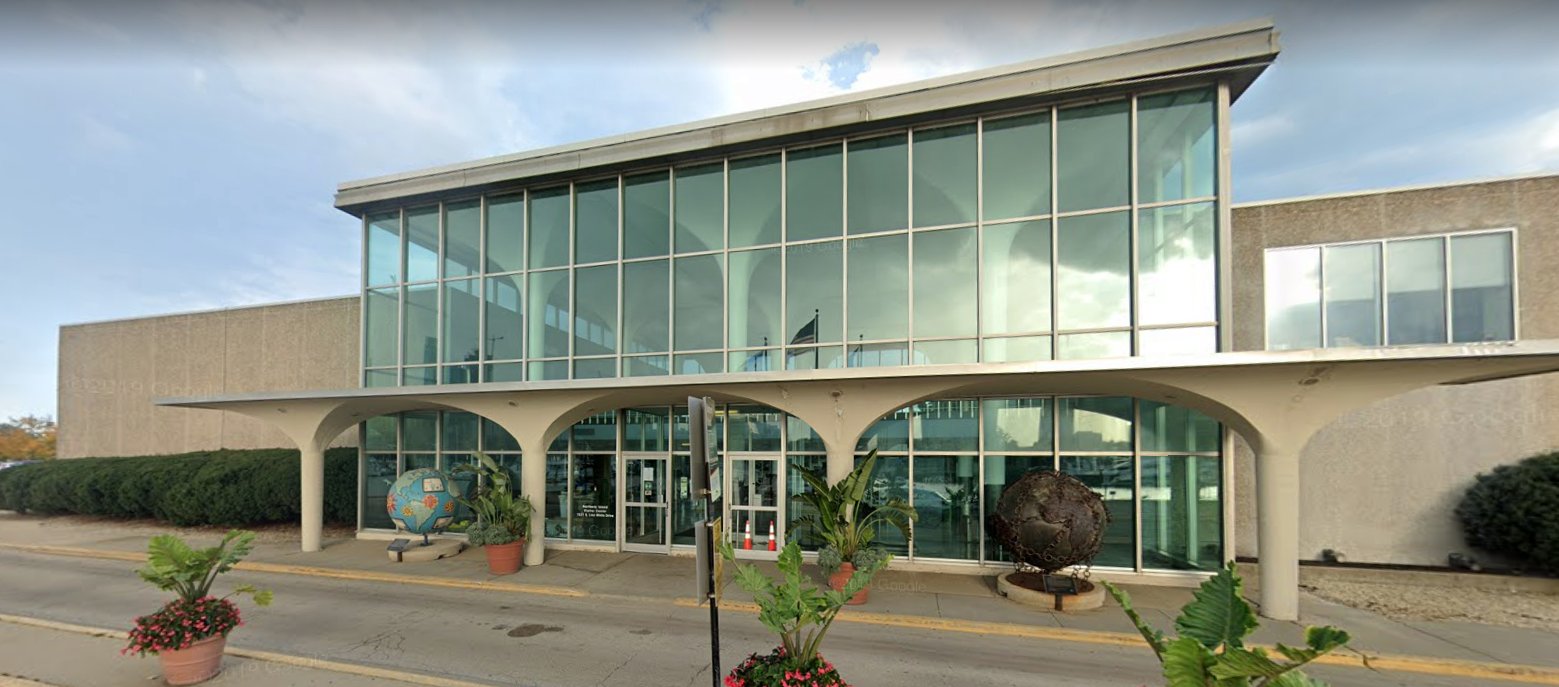
An August 2013 photo by Kevin Raab looking northeast at the former Meigs Field control tower.
Kevin reported, “The the old control tower is not open to the public.”
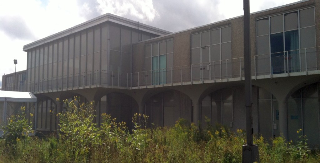
An August 2013 photo by Kevin Raab looking southwest at the former Meigs Field terminal building.
Kevin reported, “Most of the land where the runway & taxiways used to be is fenced off & a park/wildlife area of some sort is currently under construction.
I was unable to find any signage anywhere commemorating the picturesque little airport that once was there.”
An August 2013 photo by Kevin Raab of the interior of the former Meigs Field terminal building.
Kevin reported, “The old terminal building is partially open to the public.”
Marty Coddington reported, “I was always a crusader for airports. Once they are gone...
The CGX thing still has me angry. Mayor Daily Sr. must be rolling in the grave. He was very proud & protective of CGX.”
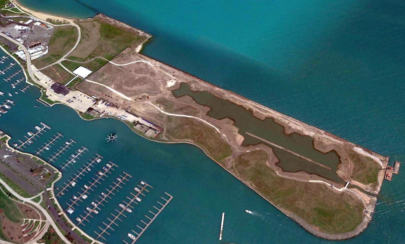
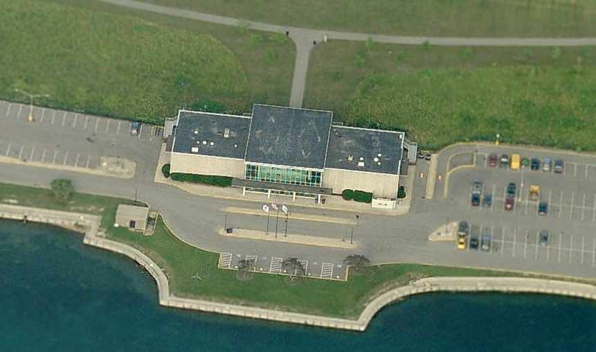
A 2015 aerial view looking northeast at the site of Meigs Field shows that an amazing amount of tax dollars have been spent to completely remove the airport infrastructure,
and therefore eliminate any chance that the site would once again be able to serve as an airport.
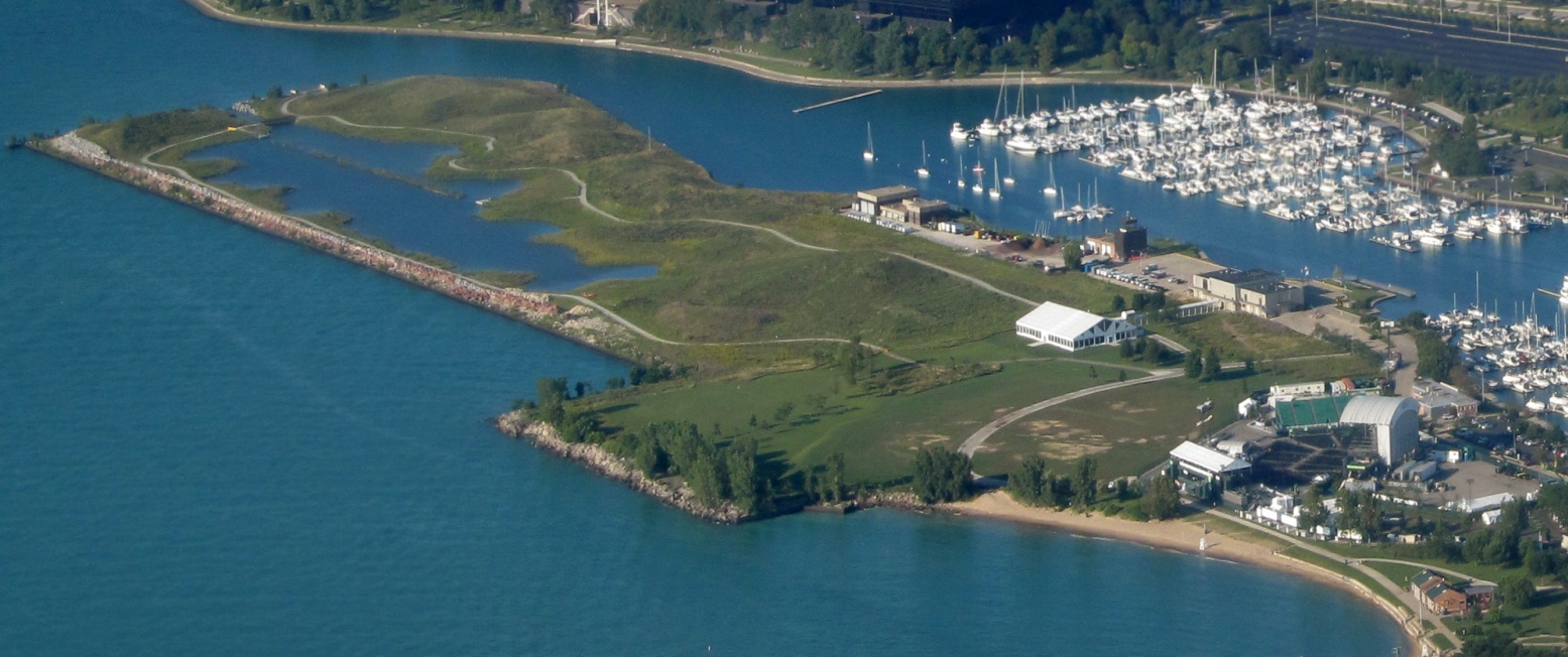
A 7/31/17 aerial view looking southwest at the sad site of Meigs Field by Graeme Smith, showing the terminal & control tower which remain from this once vital airport.
Graeme observed it was the “first time I have ever flown through this actual airspace for real – as opposed to countless times on most versions of Microsoft Flight Simulator!
I had to actually follow airspace rules on Sunday – as opposed to just flying around!”
A June 2018 photo looking southwest at the former Meigs Field control tower & fire station.
A June 2018 photo looking northeast at the former Meigs Field terminal building.
The history of Meigs, and details of the fight to reopen the field,
has been covered in great detail at the web site of The Friends of Meigs Field.
____________________________________________________
Sky Haven Airport, Franklin Park, IL
41.939, -87.906 (Southwest of Chicago O'Hare International Airport, IL)
Sky Haven Airport, as depicted on the January 1942 Chicago Sectional Chart.
Sky Haven Airport was established by local pilot Ira Eylea & his wife, who leased the former farm property in 1939 (according to a historical plaque on the site).
Sky Haven Airport was not yet depicted on a 1939 aerial photo or the February 1940 Chicago Sectional Chart.
The earliest depiction which has been located of Sky Haven Airport was on the January 1942 Chicago Sectional Chart.
It depicted Sky Haven as a commercial/municipal airport.
Sky Haven Airport was home to a Civil Air Patrol unit.
Ira Eylea & his wife operated Sky Haven Airport until it was sold to Dick Lloyd in 1946 (according to a historical plaque on the site).
Sky Haven Airport was not yet depicted on the 1946 USGS topo map.
The 1946 Chicago Sectional Chart depicted Sky Haven as a commercial/municipal airport.
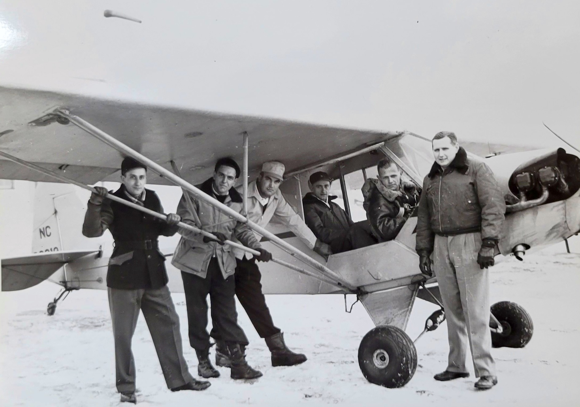
The earliest photo which has been located of Sky Haven Airport was a 1/12/47 photo of Dick Lloyd (who owned & ran the airport) along with others in front of a Piper Cub (courtesy of Norm Nissen).
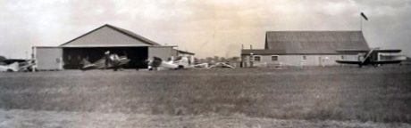
A circa 1940s photo (courtesy of Mark Elyea) looking east at a rare Culver Cadet in front of the Sky Haven Airport hangar, with Wolf Road beyond.
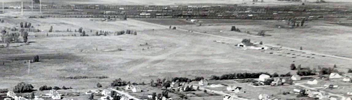
A 1951 aerial view depicted Sky Haven Airport as having a dozen light single-engine aircraft parked near a hangar & another building, on the east side of an unpaved airfield.
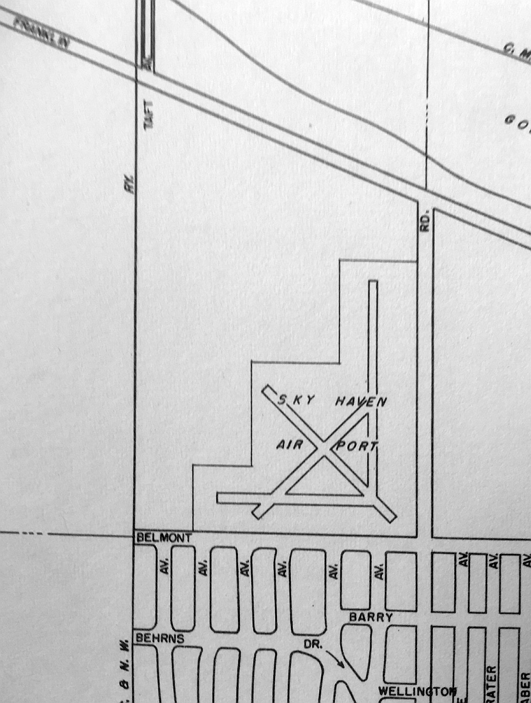
A 1951 street atlas (courtesy of Kevin Walsh) depicted Sky Haven Airport as having 4 runways.
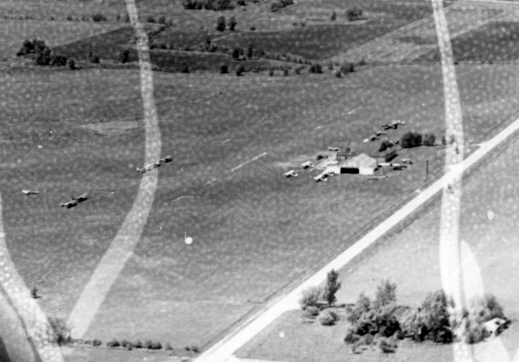
A 1952 aerial view looking northeast (courtesy of Norm Nissen) depicted Sky Haven Airport as having over a dozen light aircraft parked near a hangar & another building on the east side of an unpaved airfield, with at least 3 runways perceptible.
The last photo which has been located of Sky Haven Airport was a 1954 aerial view looking northwest (courtesy of Norm Nissen).
It depicted Sky Haven Airport as having over a dozen light aircraft parked near a hangar & another building on the east side of an unpaved airfield.
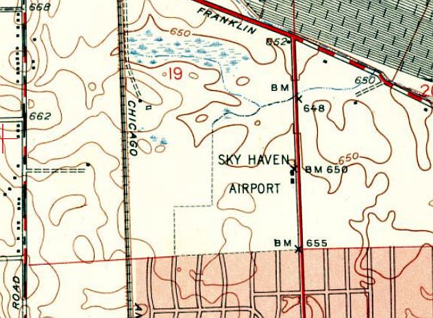
The 1953 USGS topo map depicted Sky Haven Airport as an irregularly-shaped property outline, with 2 small buildings on the east side.
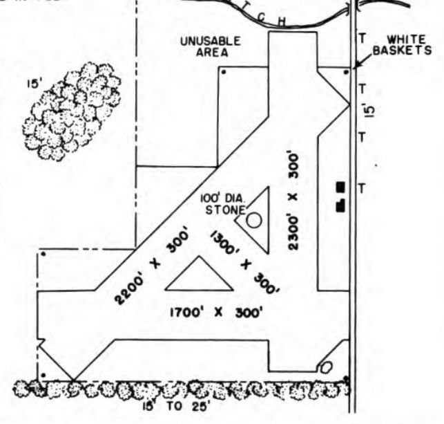
The 1953 IL Airport Directory (from the University of IL, courtesy of Daniel McGill)
depicted Sky Haven Airport as having 3 runways, with the longest being the 2,300' north/south strip.
Two small buildings were depicted on the east side.
The last depiction which has been located of Sky Haven Airport was on the December 1954 Chicago Sectional Chart.
It depicted Sky Haven as a commercial/municipal airport.
Note the awkward proximity of Chicago O'Hare Airport, located less than 3 miles to the north.
Sky Haven Airport closed in 1955 due the tremendous growth of Chicago O'Hare Airport, located less than 3 miles to the north (according to a historical plaque on the site).
Sky Haven Airport was no longer depicted on the June 1955 Chicago Sectional Chart.
A 1961 USGS aerial photo depicted the Tri-State Tollway & several buildings covering the site of Sky Haven Airport.
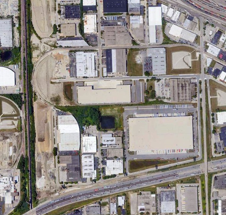
A 2018 aerial photo did not show any trace remaining of Sky Haven Airport.

A 9/7/25 photo by Norm Nissen of a historical plaque emplaced in April 2025 in Westdale Park, near the site of Sky Haven Airport.
The site of Sky Haven Airport is located west of the intersection of the Tri-State Tollway & Wolf Road.
____________________________________________________
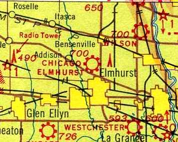
Eagle Flying Field / Elmhurst Airport / Elmhurst Greer College Airport, Elmhurst, IL
41.926, -87.962 (Southwest of Chicago O'Hare International Airport, IL)
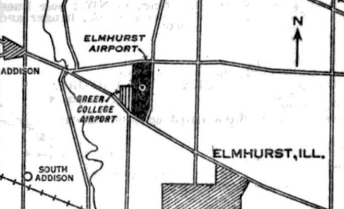
“Elmhurst Airport” & the adjacent “Greer College Airport”, as depicted on the 7/7/30 Commerce Department Airway Bulletin (courtesy of Mike Denja).
According to the Elmhurst Historical Museum, “Elmhurst Airport, originally covering 160 acres,
was located between Lake Street & Grand Avenue & between Church Road & Route 83.
It started when Chicagoan Joe James landed his biplane on a tract of land in north Elmhurst in 1923.
James & Elmhurst resident Fred Bouchard founded & operated the 'Eagle Flying Field' until James left in 1929.
That same year, the Elmhurst Airport was incorporated.
The airport had flight schools, commercial & private planes & support services.
The Elmhurst Press carried ads & articles about the airport.
One 1929 ad encouraged readers to join the 'Humming Bird' flying club, offering free flight instruction.”
The earliest depiction which has been located of Elmhurst Airport was on the 7/7/30 Commerce Department Airway Bulletin (courtesy of Mike Denja),
which depicted “Elmhurst Airport” & “Greer College Airport” as 2 separate adjacent airports.
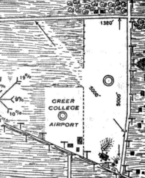
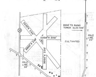
The 7/7/30 Commerce Department Airway Bulletin (courtesy of Mike Denja) depicted Elmhurst Airport as a north/south field measuring 5,000'.
It was described as a 160 acre turf field, with 1 wood & metal 90' x 75' hangar on the south side.
It was said to be a commercial field owned by Daniel Schroeder & operated by the First National Air Service Inc.
The smaller Greer College Airport was also depicted adjacent to the southwest side of Elmhurst Airport.
The earliest aeronautical chart depiction which has been located of Elmhurst Airport was on the 1930 Chicago Sectional Chart,
which labeled it as “Elmhurst Greer College” Airport.
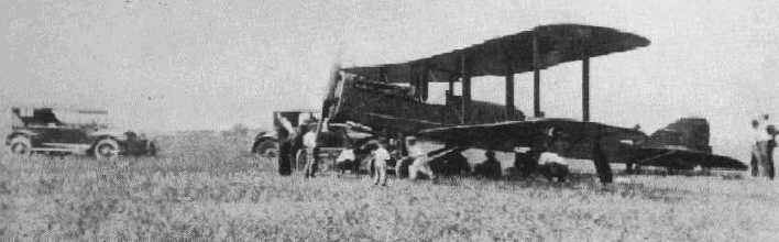
A circa 1930s photo of an unidentified biplane at Elmhurst Airport.
The Elmhurst Historical Museum continued, “The airport had 2 grass runways.
There were no runway lights until the last years of the airport's operation,
so pilots making night landings had to judge their distance by 2 flares that marked the end of the runways.
One of the major challenges to pilots flying into & out of the Elmhurst Airport
was a radio tower situated just east of the airport & aligned with one of the runways.”
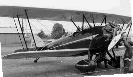
A circa 1930s photo of an unidentified biplane at Elmhurst Airport.
The March 1937 Chicago Sectional Chart (courtesy of Chris Kennedy) depicted “Chicago Elmhurst” as a commercial/municipal airport.
The earliest aerial photo which has been located of Elmhurst Airport was a 9/7/39 IL State Geological Survey aerial view.
It depicted Elmhurst as having 3 grass runways, with several hangars along the south side.
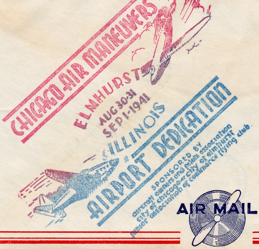
A postmark commemorating the 8/30/41 Elmhurst Airport Dedication (courtesy of Kevin Carruth).
According to the Elmhurst Historical Museum, “With the approach of World War II,
the Civil Aeronautics Administration created a program that was a cooperative effort
between colleges that offered ground study & airports that offered flight instruction in order to fast-track civilians into military service.
Both Elmhurst College & Wheaton College partnered with Elmhurst Airport in this program.
A local unit of the Civil Air Patrol used Elmhurst Airport as a recruiting station.”
A 9/26/43 aerial view looking north from the 1945 AAF Airfield Directory (courtesy of Scott Murdock)
depicted Elmhurst Airport as an open grass area.
The 1945 AAF Airfield Directory (courtesy of Scott Murdock) described Elhmust Airport
as a 100 acre rectangular property having 3 sod runways, the longest measuring 2,700' northwest/southeast.
Elmhurst was said to have 4 hangars (the largest being a 76' x 40' metal structure),
and to be owned & operated by private interests.
According to the Elmhurst Historical Museum, “Tufts-Edgecumbe Co. became the main business & manager of Elmhurst Airport in 1945.
It operated planes, improved the runways, and built training facilities.
It offered civilian classes, flying lessons, sales, and service.”
The 1946 Chicago Sectional Chart depicted Elmhurst as a commercial/municipal airport.
According to Moody Aviation, “In 1946, Moody Aviation began, setting up operations at Elmhurst Airport near Chicago.
In the beginning, courses included Morse code, meteorology, and photography.
In 1950, Moody Aviation transferred operations to Wooddale Airport”
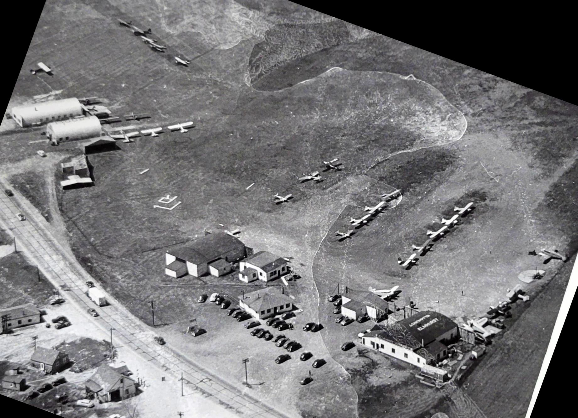
A circa 1950s aerial view looking north depicted over 30 light single-engine & twin-engine aircraft parked near the Elmhurst Airport hangars (courtesy of Norm Nissen).
A 4/8/52 USGS aerial view depicted Elmhurst Airport with dozens of light aircraft parked on the south side of 3 unpaved runways.
The 1953 IL Airport Directory depicted Elmhurst Airport as having 3 turf runways, with the longest being the 3,200' northwest/southeast strip.
A row of small hangars was depicted along the south side, and the manager was listed as George Edgecumbe.
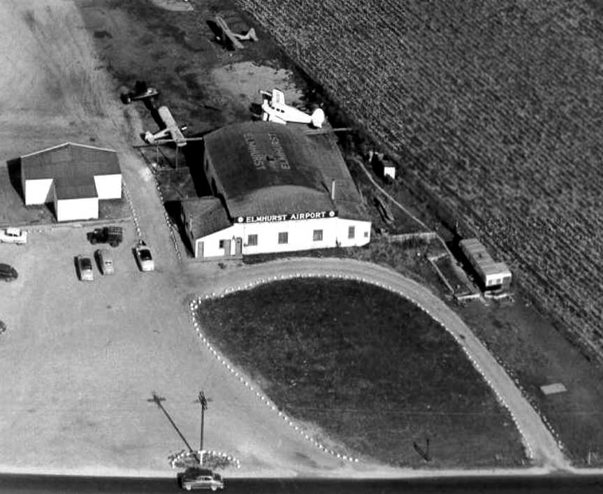
A 1953 aerial view looking north at Elmhurst Airport with Lake Street in the foreground,
showing a hangar marked with Elmhurst Airport on the roof & the back, a T-hangar, and 5 planes.
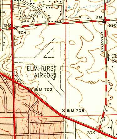
The last map depiction which has been located showing Elmhurst Airport still in operation was on the 1953 USGS topo map.
It depicted Elmhurst as having 4 unpaved runways. It did not depict any buildings on the airport.
Paul Hasz recalled, “In 1953, my parents moved to Oakdale Woods which was across from Elmhurst Airport.
Tthe main buildings were on Lake Street, but a small fixed base operator had an office on Grand Avenue.”
Dave Menard recalled, “Elmhurst Airport... I do not recall any paved runways.
I shot a beautiful Ryan ST there in the summer of 1955.”
A November 1955 USGS aerial view depicted Elmhurst Airport as having dozens of light aircraft parked on the south & north sides of 3 unpaved runways.
The last aeronautical chart depiction of Elmhurst Airport which has been located was on the 1956 Chicago Local Chart.
It depicted Elmhurst as having a 3,000' unpaved runway.
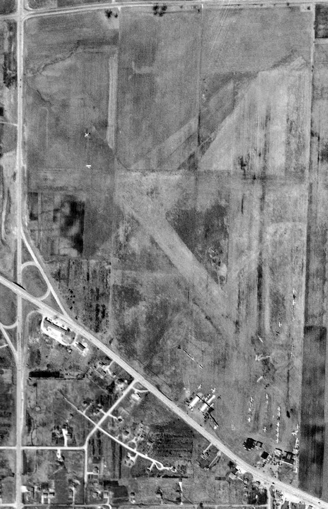
The last photo which has been located of Elmhurst Airport was an undated aerial view from the 1956 IL Airport Directory (from the University of IL, courtesy of Daniel McGill).
It depicted Elmhurst Airport perhaps at its peak of popularity, with dozens of light aircraft parked on the south & north sides of 4 unpaved runways.
According to the Elmhurst Historical Museum, “Tufts-Edgecumbe remained managers of the airport until the airport closed in 1956
when the owners of the property failed to renew the lease.”
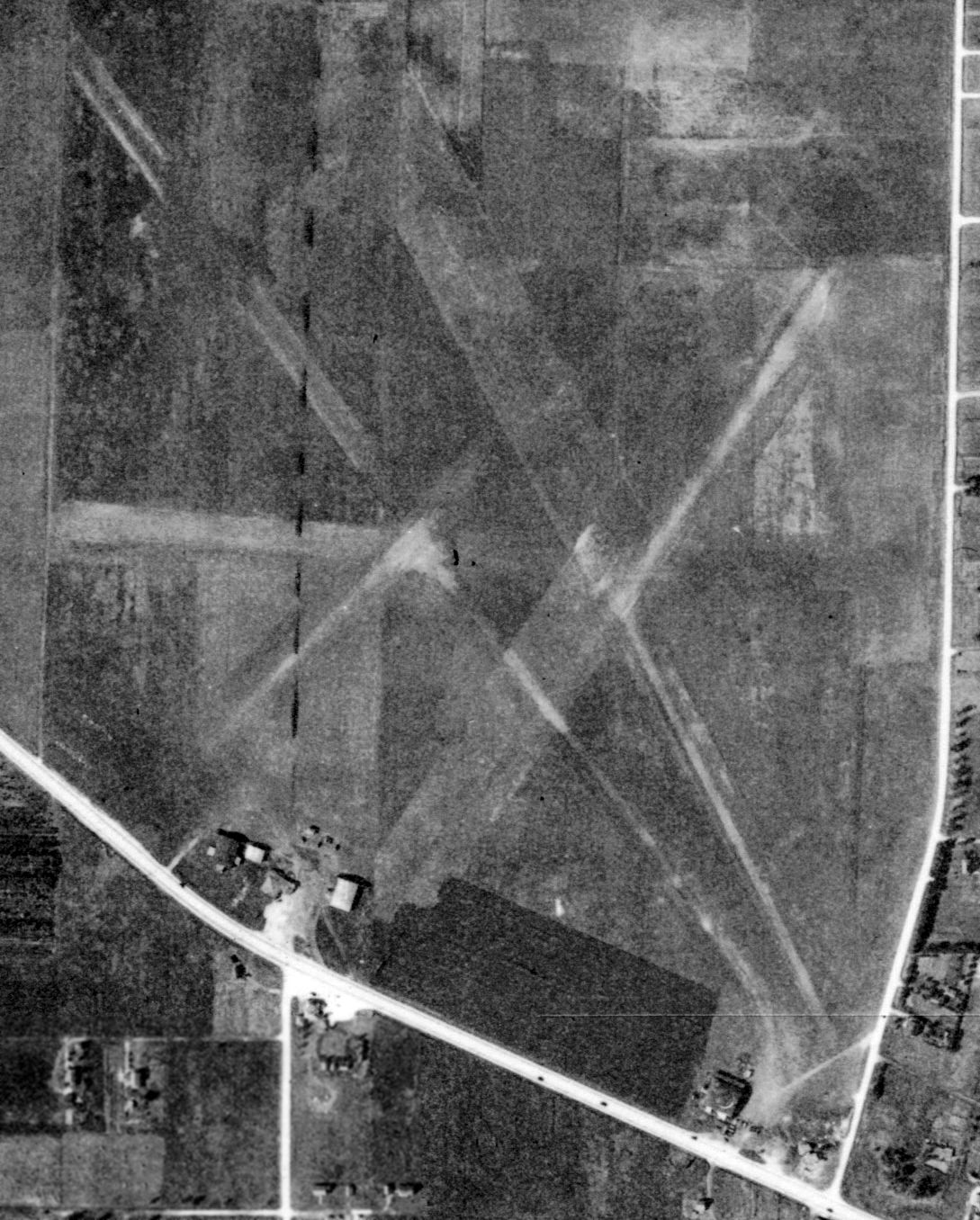
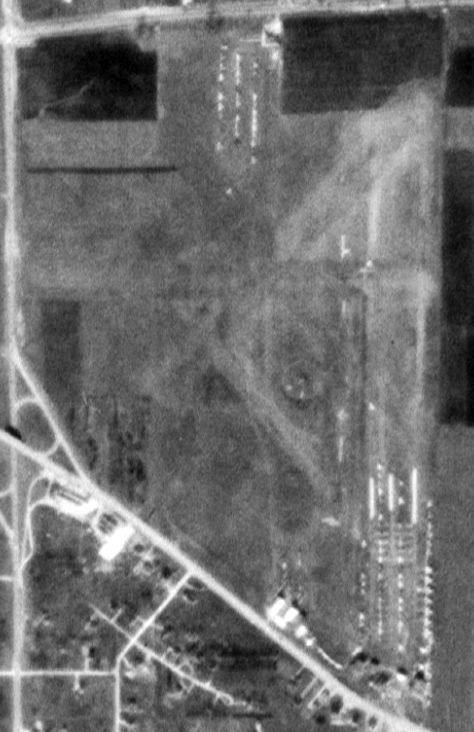
A 1962 aerial photo showed that the Elmhurst airfield remained clear,
and several hangars remained standing along the south side, but there was no sign of any aviation activity.
The 1963 USGS topo map no longer depicted Elmhurst Airport.
A 1974 aerial photo showed that at some point between 1962-74
a large number of commercial buildings had been constructed over the Elmhurst Airport site,
and the hangars had been removed, erasing any trace of the airport.
According to Marilyn Fornell, the Elmhurst Airport property “became the Caterpillar plant.”
According to the Elmhurst Historical Museum, “The property is now part of Elmhurst's industrial park.”
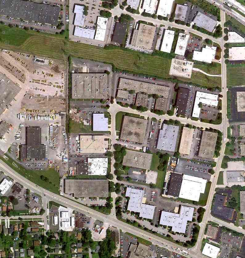
A 7/1/10 aerial photo did not show any trace remaining of Elmhurst Airport.
____________________________________________________
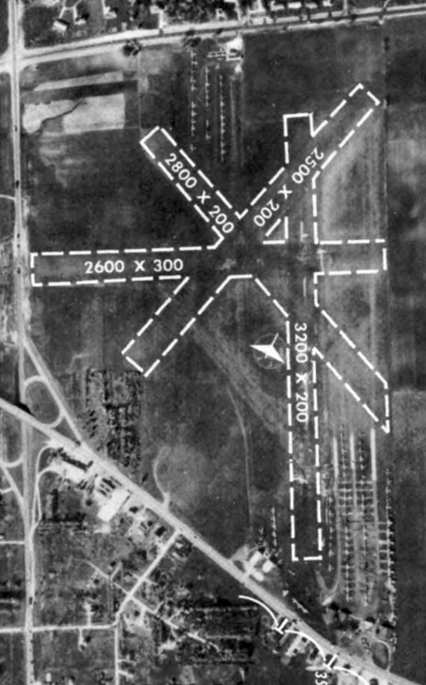
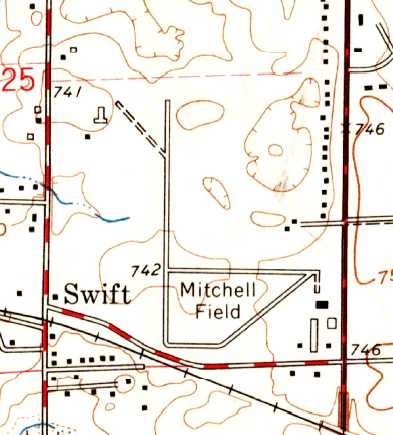
Sky-Line Airport / Mitchell Field, Lombard, IL
41.92, -88.04 (Southwest of Chicago O'Hare International Airport, IL)
A 1946 aerial view depicted Mitchell Field as having 3 grass runways.
This general aviation airport was originally built out in the open lands before Chicago grew up & consumed it.
No airfield at this location was yet listed among active airfields in the 1945 AAF Airfield Directory (courtesy of Scott Murdock).
Gregg Maryniak reported, “Nicholas Selig’s book Lost Airports of Chicago, details some of the earliest announcements about Mitchell Field
going back as far as 1946 when it was referred to in an advertisement as Sky-Line Airport.
Later advertisements for Mitchell Field mention Sky-Line Incorporated at the airport
and talk about the start of land-based based training at Mitchell Field as a spin-off of training at the Chicago Seaplane Base.”
Gregg Maryniak reported, “Mitchell Field was started by K. T. Mitchell & George C. Snyder, and began operations in 1946.”
The earliest depiction of Mitchell Field which has been located was a 1946 aerial view.
It depicted Mitchell as having 3 grass runways, with a hangar, a few small buildings, and 7 light aircraft on the east side of the field.
Mitchell Field was not yet depicted on the December 1946 Chicago Sectional Chart.
The earliest aeronautical chart depiction of Mitchell Field which has been located was on the June 1947 Chicago Sectional Chart.
It depicted Mitchell Field as having a 2,400' unpaved runway.
Stormy Hunter reported, “Mitchell Field was listed in the 1948 Chicago & Suburbs Telephone Directory (which I own).
The listing reads: 'Mitchell Field... Columbine Avenue... Lombard-115.'”
The 1954 IL Airport Directory (from the University of IL, courtesy of Daniel McGill)
depicted Mitchell Field as having 3 gravel runways, with the longest being the 2,800' north/south strip.
Four small buildings were depicted on the southeast side.
In 1955 the remains of a Stearman-Hammond Y aircraft (originally designed in circa 1934 as part of a contest to design a "flivver" low cost aircraft)
were located in the home of Carl Dahlin on the perimeter of Mitchell Field, and shipped to the Smithsonian Institution in Washington.
The 1956 Chicago Local Aeronautical Chart (courtesy of Tim Zukas) depicted Mitchell Field as having a 2,800' unpaved runway.
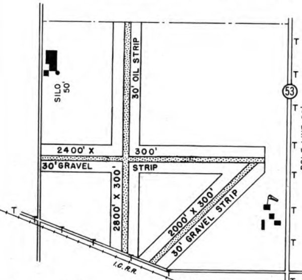
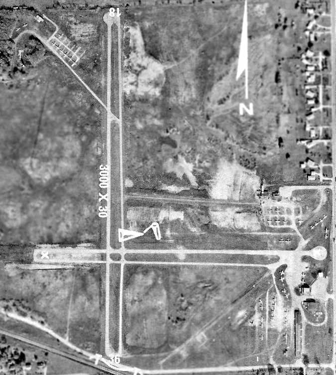
Mitchell Field, as depicted on the 1958 USGS topo map.
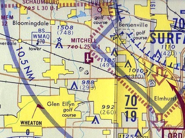
Gregg Maryniak reported, “Mitchell Field was located in DuPage County which was still mostly farmland in the 1950s & early 1960s. I grew up about a mile Northwest of the airport.
My parents had a couple of acres near Army Trail Road & our neighbors were either farmers or people who, like my folks, had built their own pre-suburban homesteads.
We were close enough to Mitchell Field to routinely see pattern traffic consisting mainly of Cubs, Champs, Tri-Pacers, Cessnas, Luscombes and Ercoupes along with the occasional Bonanza.
World War Two-era trainers like Texans & SNJs were not uncommon & other 'large' aircraft included such business models as Beech 18s & twin Cessnas & Piper Apaches.
One lovely Summer evening my little brother & I watched an overflight of a pair of beautiful yellow Stearman biplanes from our bikes & said to each other, 'Someday, that will be us!'”
Gregg continued, “Ruth Mitchell ran the Kitty Hawk Restaurant on the field & reportedly also operated a beauty salon in the same building according to Nicholas Selig, author of Lost Airports of Chicago.
Sometime around 1960, my aunt Irene took me to this restaurant to watch the planes & have a soft drink.
The interior of the restaurant was fairly dark & it looked like a bar room.
There was some outside seating along the West side of the building & we watched planes landing & taking off on Runway 18 on a busy Sunday afternoon.”
The 1960 Jeppesen Airway Manual (courtesy of Chris Kennedy) depicted Mitchell Field as having 3 unpaved runways, with the longest being the 2,590' Runway 18/36.
The airport property had roughly doubled since 1946, with the addition of land on the north side of the field for the new Runway 18/36.
The 1960 IL Airport Directory (courtesy of David Brooks) depicted Mitchell Field as having a total of 3 gravel & oiled runways,
with the longest being the 3,000' north/south strip.
Dozens of light aircraft were visible parked alongside some small hangars on the southeast corner of the field,
along with a few aircraft parked on the northwest corner of the field.
The manager was listed as K. T. Mitchell, and the operators were listed as K. T. Mitchell, George Snyder (Snyder Helicopter Service), and Dick Lloyd (Lloyd Flying Service).
Within the next year one of Mitchell's runways was evidently closed, and the remaining 2 runways were paved,
as the Aerodromes table on the December 1961 Chicago Sectional Chart (according to Chris Kennedy)
described Mitchell as having 2 paved runways, with the longest being 2,590'.
Marie Lloyd Montagne reported that her “first husband, Richard (Dick) Lloyd was the owner & operator of the Lloyd Flying Service.”
She recalled that his flying service moved from “Elmhurst Airport to Mitchell Field in Lombard.”
Stormy Hunter recalled, “In the 1960s, my grandfather Joseph Tucker owned a 1960 Mooney M20A, and later sold it, and bought a 1966 Mooney M20C.
He kept these planes at Mitchell Field & frequently used to take me with him when he went there.
He didn't always go flying, he sometimes just went to hang out in the pilot's lounge & shoot the bull with the other plane enthusiasts.
He'd always introduce me as his grandson & I felt very important as I shook hands with all these pipe-smoking friends of Grandpa Joe's.
The airport had a swimming pool, which I remember was always half-full of stagnant water & dead leaves.
There was also a small restaurant which had a swinging wooden screen door with a huge 'Dr. Pepper' thermometer on it.
There was a pool table inside, and also a jukebox, which was filled with Jack Scott, Duane Eddy, Nat King Cole & the like.”
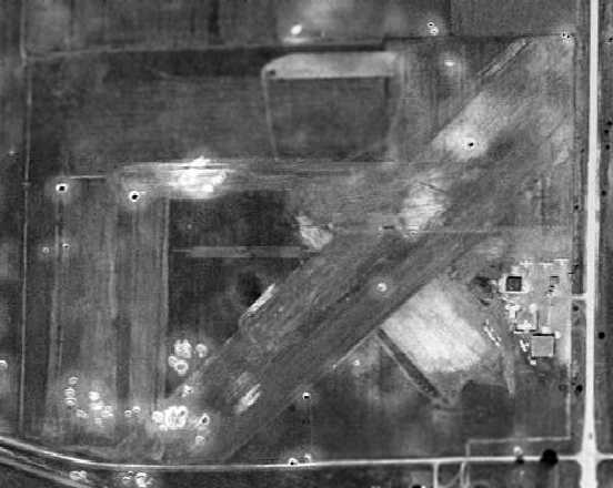
The 1962 USGS topo map depicted Mitchell Field as having 3 paved runways or taxiways, and several buildings on the southeast side.
In an aerial view of Mitchell Field from the 1962 IL Airport Directory (courtesy of David Brooks),
the official length of the primary north/south runway had been reduced to 2,450',
even though the runway visually looked identical to how it appeared in the earlier photo.
The northeast/southwest runway had been converted to a taxiway, along both sides of which were parked numerous aircraft.
The runway surface of the 2 remaining runways was described as bituminous.
The manager was listed as K. T. Mitchell,
and the operators were listed as K. T. Mitchell, George Snyder (Snyder Helicopter Service), and Dick Lloyd (Lloyd Flying Service).
A 1962 or later photo of Matt Gunsch's 1950 415-G Ercoupe at Mitchell Field.
Brad Sherman recalled, "I lived on the west edge & played on the property frequently. I also would wash planes for quarters with some of my friends.
I saw several crashes while out playing. Only one fatal one. Others were just 'dashboard faces'… ugh, not pretty.
The trees on the northwest corner hid several wrecked or abandoned planes that we used to play in. It might have been where the Stearman was found.
Us kids would set the swamp at the end of the east/west runway on fire in autumn to clear it for that winter's ice skating… big fun.
Watching the fire trucks come from a safe vantage point & put it out after just enough reeds had been burned for a hockey rink.
We built some incredible tree houses in the trees & had campouts. It was really fun to live next to a small but busy airport in the pre-9/11 days."
Brad continued, "It was packed with planes up until the final days. Lot of EAA guys I think, couple of 'breezies', things like that.
A restaurant called the Kitty Hawk.. several vintage aircraft.
My neighbor's dad had an AT-6 Texan there & a BT-13, an Aeronca Champ, and a beautiful Cessna 195.
He flew stunts in the air show & would know a lot about the field… a former TWA pilot.
The field had a yearly air show that was fun. Local acrobatic pilots & tours."
Dave Menard recalled, “I have a soft spot for Mitchell Field as that is where I got my first 2 rides in an aircraft, with a good old Piper Cub being the first one.
My father used to repair aircraft radios in our basement & then take them back out to the airport to put back in.
I recall calling O'Hare Tower for radio checks & the thrill when they answered me!
The Nike ground-to-air missile site just across Route 53 from the airport [southeast of Mitchell Field]...
When one turned base to final coming in from the east,
it was usually over the site with the missiles in different states of erection which were impressive to say the least.”
The 1963 Chicago Local Aeronautical Chart (courtesy of David Brooks) depicted Mitchell field as having a 2,500' hard-surface runway.
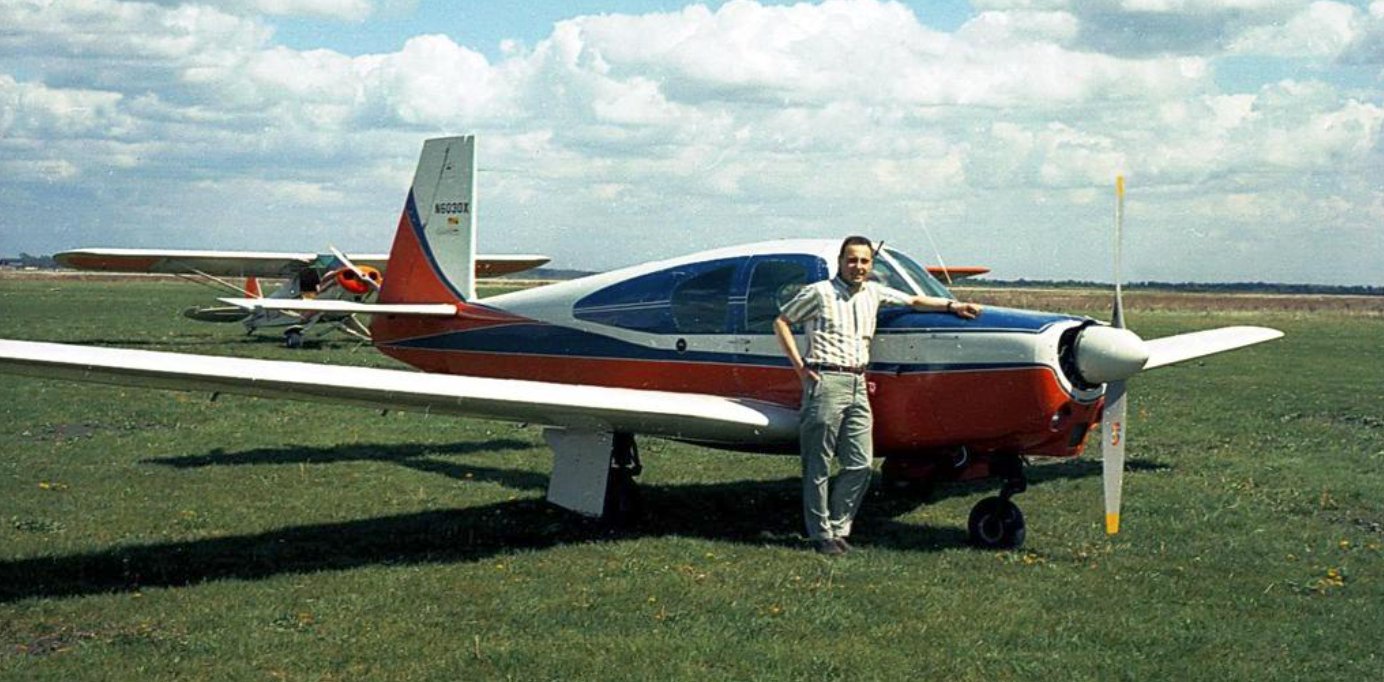
An April 1963 photo of Joe Tucker in front of N6030X Mooney M20A at Mitchell Field.
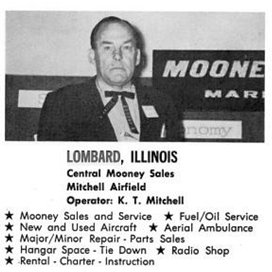
An advertisement for Mitchell Airfield's Central Mooney Sales from the July 1963 Flying Magazine (courtesy of Gregg Maryniak).
The 1964 IL Airport Directory (according to Gregg Maryniak) listed K.T. Mitchell’s wife Ruth Mitchell as Mitchell Field manager.
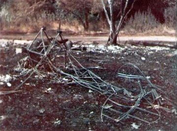
An August 1967 photo (courtesy of Steve Dietz) of the wreckage of his father's (Carroll Dietz) Pitts Special at Mitchell Field.
Steve Dietz recalled, “Mitchell Field.. my Dad (Carroll Dietz) had a Pitts Special that burned in an August 1967 barn fire on the northwest side of the airport
along with a Smith Miniplane & Thorpe T18 from EAA Chapter 101.”
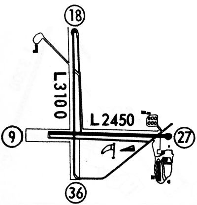
The 1968 Flight Guide (courtesy of Robert Levittan) depicted Mitchell field as having 2 paved runways: 3,100' Runway 18/36 & 2,450' Runway 9/27.
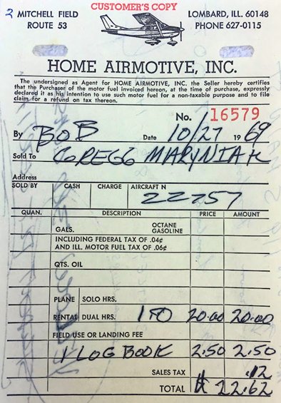
The 10/28/69 invoice from Gregg Maryniak's first full flying lesson at Mitchell Field.
Gregg Maryniak recalled, “I learned to fly at Mitchell Field & flew from there from 1969-73.
The Kitty Hawk Restaurant had closed by the time I started taking flying lessons in the Fall of 1969.
The airport was an important part of the General Aviation scene in the Chicago area and, as in all of aviation, the people involved are extremely interesting.
The relationships between airports, aviation businesses & the people who ran them is important to understanding the history of individual airports.
[Mitchell Field was where] I had soloed on a sunny cold Friday afternoon on 3/6/70.”
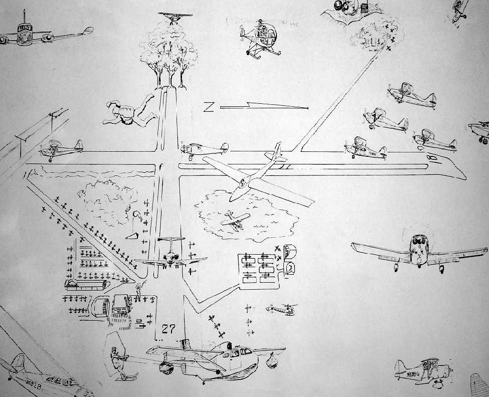
A small portion of a huge undated (pre-1974) poster by Carol Wagner (courtesy of Marty Coddington) entitled “Mitchell Field, Sunday Afternoon”.
Gregg Maryniak observed, “Although this wonderful mural is a caricature, it captures the flavor of a busy weekend at Mitchell Field., a very busy place in its heyday during the 1960s.
Taking a close look at the elements of this work triggered some memories for me & I hope that it will encourage others to offer their memories & explanations.
The Seabee (and a theory about the water skier and kite): Starting at the bottom of the drawing we have a Republic Seabee pulling a water skier/kite.
Mitchell Field had at least 2 Seabees based on the field. They were customarily parked along the Fullerton Avenue Extension near the threshold of Runway 36.
As a kid, I assumed that every airport had a gaggle of these exquisite aircraft, but I now know that Mitchell had a higher than normal concentration.
This might well have been due to fact that one of the airport founders (George Snyder,) had managed the Chicago Seaplane Base at Navy Pier.
While I am engaging in conjecture, let me offer a possible explanation for the water skier.
A popular vacation destination for Midwestern folks is the town of Wisconsin Dells, located Northwest of Madison, WI.
I remember seeing dozens of billboards along the highways between Chicago & Central Wisconsin for Wisconsin Dells attractions.
Many of these were for the Tommy Bartlett Water Show which featured water skiing stunts.
Tommy Bartlett was a Seabee owner & pilot. He had used his amphibious aircraft to rescue a group of boaters who had overturned & were in serious danger of drowning in Lake Calumet.
This Seabee story was probably well known to the Chicago aviation community in the 1960s & the artist may have memorialized it in this work by including the water skier.”
Gregg continued, “The Swimming Pool: Above the Seabee’s right wingtip & immediately to the left of the runway numbers for Runway 27
you see a depiction of the little red shack that became the FBO office in the late 1960s & beneath it the swimming pool & diving board.
Others have commented on their memories of the pool being filled with leaves & other debris.
I have no recollection of the pool which was long gone by the time I took flying lessons in 1969
but you can see it between the little building & Route 53 if you look carefully at the aerial photos of the airport.”
Gregg continued, “The Bell 47 Helicopter: Above the left wingtip of the Seabee is a Bell 47, the first widely successful commercial helicopter.
George Snyder famously taught in these & kept one at his nearby home.”
Gregg continued, “Lloyd Flying Service: Just above the Bell we see the square patterned tie-down area used by Dick Lloyd’s Flying Service.
His operation featured a little cottage-style office building with a hangar just behind it to the West.
These features first appear in the aerial photos of the 1960 IL Airport Directory.
If your near vision is really good, you can see that the artist added the word Lloyd to the hangar.”
Gregg continued, “The Floatplane in the puddle: While there was a big puddle from time to time in the location depicted here
(which was possibly the result of grading the land for fill for other areas of the airport),
I don’t believe that there were any opportunities for pure floatplanes (as opposed to amphibian planes like the Seabee) to operate at Mitchell.
I think the artist was just having some fun while emphasizing the existence of the low spot.”
Gregg continued, “The Sailplane over the puddle: I think the Sailplane is a fanciful artifact if one is talking about normal Mitchell Field operations.
I don’t believe gliders were ever a normal presence at Mitchell.”
Gregg continued, “The Northwest taxiway: At the tail of the sailplane we see a taxiway leading to the Northwest.
This led uphill to a tie-down area for a dozen planes & the barn used by the EAA which was destroyed by fire.
Although my parents were supportive of my flying & appeared to not mind me flying alone
the embarrassing truth was that they would not permit me to drive a car solo for about 8 months after I had soloed in a Cessna.
This meant that I often rode my bike to the airport.
In order to minimize exposure to traffic on Army Trail Road (minimal in those days) & Route 53 (already dangerous in those days),
I would go South on Swift Road from Army Trail Road & access the airport from the West.
I would then take this taxiway & get to the FBO on Route 53 via the taxiways of Runways 18/36 & 9/27.
I remember that there was a very early (pre Omni-Vision/no rear view window) Cessna 150 that I used to stop & admire that was parked in the Northwest tie-downs.“
Gregg continued, “The Brantly Helicopter: Above the North-pointing arrow on the drawing we see a Brantly B2 helicopter.
These always reminded me of 'sugar cone' style ice cream cones with a hemispheric scoop for a canopy.
An advertisement in the December 1963 Flying Magazine listed the Mitchell Flying Service as a Brantly Helicopter Dealer.”
Gregg continued, “The Trees at the Threshold of Runway 9: Brad Sherman recalls playing in & around the trees which were quite close to Swift Road.
Though they were a consideration for planes using the East/West runway, they were fairly far from the end of the runway & I don’t remember them as being particularly high or troublesome.”
Gregg continued, “Wires alongside the IL Central Railroad Tracks at the threshold for Runway 36:
I recall hearing about planes interacting with the wires alongside the railroad tracks & the artist’s inclusion of the wires speaks to their importance.
They are depicted as being 30' high at the threshold in the IL Airport Directories.
The Southwest corner of the airport property was near the railroad track crossing at Swift Road & is shown on maps of that era as if it were a town or village called Swift.
I believe that there was a railroad stop there at one time, possibly for farmers to load milk or other produce.
About 3 miles West of the airport along those same railway tracks was a hamlet known as Cloverdale.
Cloverdale featured an old-time General Store called Tedrahns with a pair of ancient gas pumps out front.
I remember being in that store & hearing people excitedly talking about a plane flipping over after catching its landing gear on the wires.
Tthere were no serious injuries from that accident, but I remember later as a young pilot, paying attention to those wires when landing to the North.”
Gregg continued, “Twin-engine Cessna 310: There were a number of twin-engine aircraft based at Mitchell.
The Cessna 310 with its distinctive wingtip fuel tanks & sleek lines was the most modern of the planes flown by the main character in the popular television show Sky King.”
Gregg continued, “The Fullerton Avenue extension along the South side of the airport:
The drawing suggests a roadway that runs alongside the tracks & nearly touches the threshold of Runway 36.
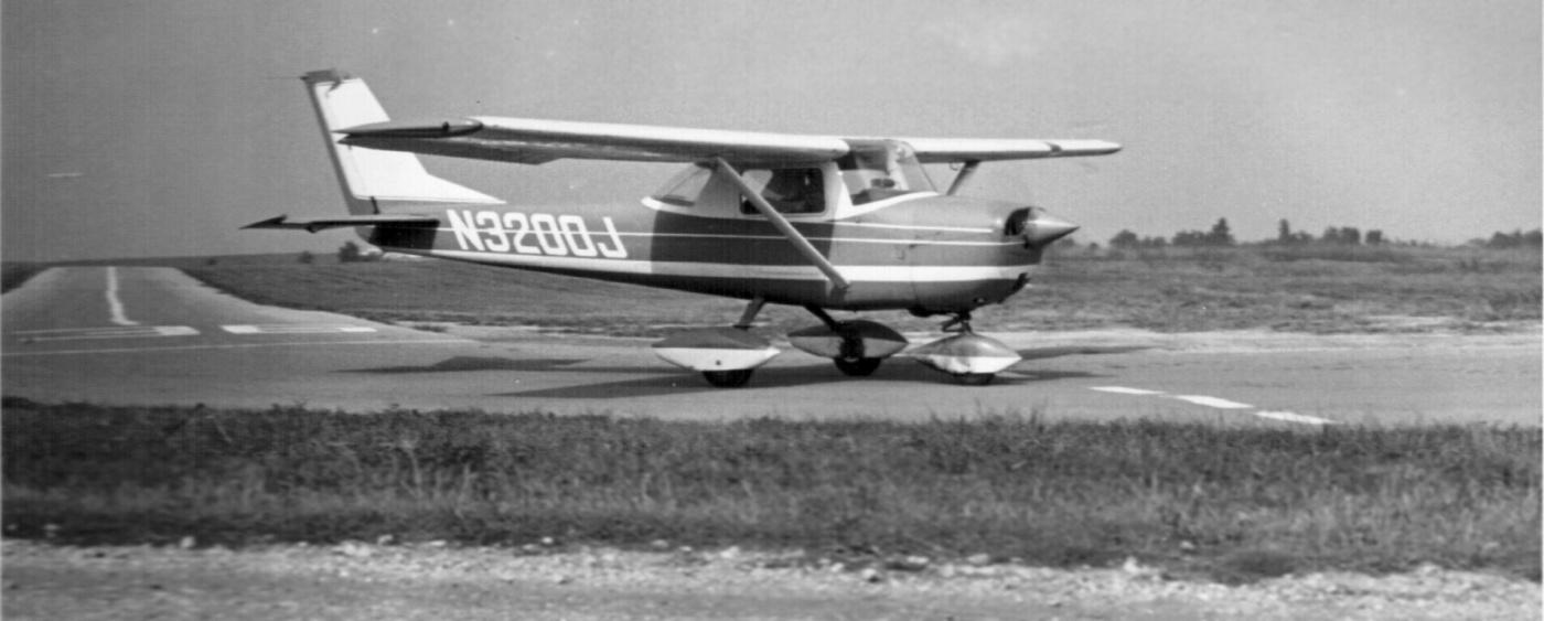
Such a road did exist. And as you can see from the photo of the Cessna 150 [N3200J] taxiing off the end of Runway 18 with a plane lined up to land visible in the distance,
the roadway came within perhaps half a wingspan’s distance from the runway.
There were no fences or other barriers separating this public road from the airport.
I remember my parents parking on the Fullerton extension & positioned so that my brothers & I could both watch the planes land & take off & also see them taxi past.
I recall seeing several shiny Silvaire Luscombes (which looked pretty cool to me) taxi past on one Sunday afternoon visit.”
Gregg continued, “Southeast quadrant of the airport: This part of the drawing is an accurate depiction of the main parking & ramp area of the airport.
The Southwest/Northeast taxiway was originally a runway. Just above the fanciful water skier & kite is the building that contained the Kitty Hawk Restaurant.
Just South of that was the main hangar decorated with the Shell logo, airport name & field elevation.
There was also a long hangar oriented North/South which I recall as having signs for Beechcraft sales & service.”
Gregg continued, “The Jet on Runway 9/27: To the best of my knowledge, Mitchell Field did not have any jet traffic at all.
Runway 9/27 was only 2,000' long so my guess is that the inclusion of a jet I taking off from that runway in the mural was purely fanciful. There certainly was business traffic at Mitchell.
The largest planes that I can recall seeing in regular operation were twins like the Aero Commander, at least one of which was based on the field.”
Gregg continued, “Runway 18/36: The long runway at Mitchell was the North/South Runway 18/36.
The meaning of the flock of aircraft over the threshold of Runway 18 (and the plane above diving down) is unclear.
It may simply be that the artist was portraying how busy the field felt on weekends.
The Cub-like aircraft headed for the wires is similarly mysterious. Its tail seems high so as to suggest that it is taking off & not landing.
Just behind & above that plane a skydiver is depicted.
I recall that there were some skydiving exhibitions during the airshows over the years, but I never saw any & certainly skydiving was not generally conducted from the field.”
Gregg continued, “The homebuilt airplane on the lower-right:
Mitchell Field & the pioneering EAA Chapter 101 based in Addison IL were well-known elements in the experimental aircraft movement.
I remember my amazement at seeing my first homebuilt experimental aircraft at Mitchell during the early 1960s during one of the air show / airport exhibition events.
Many of those exhibited in the early days were of the Wittman Tailwind type.”
Gregg continued, “There were also some biplanes whose small size seemed well matched to me (I was perhaps 10 years old at the time).
These homebuilt craft struck me as really small when seen alongside some of the WW2-era trainers & a P-51 Mustang that was also exhibited.
While shopping for some home improvement supplies with my parents shortly after this exhibition, I remember entertaining the notion of constructing my own plane.
Decades after I became a pilot, I had a meeting with Tom Poberezny, who at that time (the late 1990s) was President of the Experimental Aircraft Association.
The purpose of the meeting was to invite the EAA to become a supporting organization of the XPRIZE Foundation which had announced a $10 Million prize for the first private human spaceflight.
When I sat down with Tom at EAA headquarters in Oshkosh & he asked me about my flying history, he visibly brightened when I told him that I had grown up near & learned to fly at Mitchell Field.
He recounted pleasant memories of visiting Mitchell Field & EAA Chapter 101 on trips with his father Paul Poberezny.
It was very clear that he and the EAA held the Chapter in very high esteem.
The rich history of experimental aircraft at Mitchell Field is almost certainly part of the reason that these aircraft are represented in the mural.”
Gregg continued, “The mystery of the Spirit of St. Louis shown at mid-field:
Finally, what was the point of showing Charles Lindbergh’s Spirit of St. Louis aircraft on Runway 18 near its intersection with the East/West runway?
Until recently, I had thought that this was just a whimsical inclusion by the artist, perhaps to suggest that almost everybody visited Mitchell Field sooner or later.
After all, the Spirit of St. Louis is arguably the most famous plane in the world.
The number of airports in America doubled & the number of pilots in America tripled in the year after Lindbergh won the Orteig Prize (after which we modeled the original XPRIZE in 1996).
I came across some information that suggests another possibility (and which theory, even if wrong, provides an excuse to disclose additional information on this co-founder of Mitchell Field).
A Chicago Tribune story from 1991 about Snyder’s induction into the IL Aviation Hall of Fame,
revealed that Snyder had provided a checkout to Charles Lindbergh in the P-39 Aircobra fighter during the Second World War.
Perhaps the artist was aware of this connection between Lindbergh & Snyder who was a key person in the history of the airport.”
A 1971 photo by Marc Stancy looking north at a Cessna 150 taxiing at the south end of Mitchell Field's Runway 36.
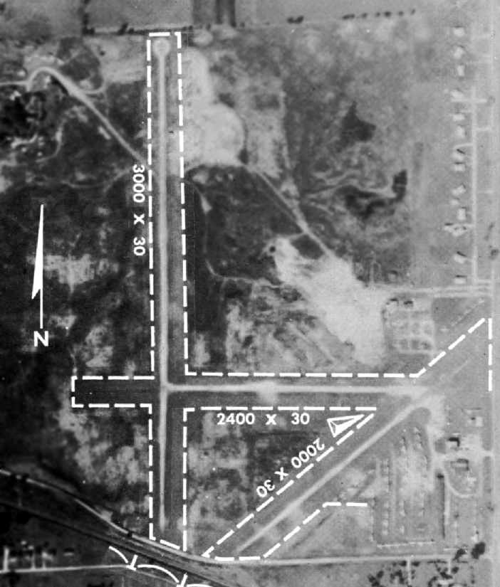
The last aerial photo of Mitchell Field which has been located was an aerial view from the 1972 IL Airport Directory (courtesy of Bill Pagett).
The directory depicted the field as having a single 3,000' bituminous Runway 18/36, along with a closed crosswind east/west runway.
Dozens of light planes were visible parked on the northwest & southeast sides of the field.
The operator was listed as Addison Aviation, with the airport manager being Joe Luppino.
The last depiction of Mitchell Field as an active airport which has been located
was on the May 1973 Chicago Terminal Aeronautical Chart (courtesy of Mitchell Hymowitz).
It depicted Mitchell as having a 2 paved runways, with the longest being 2,500'.
Gregg Maryniak recalled, “After getting my pilot’s license, one spring morning on the way to class in early 1973,
I pulled my nearly-new American luxury car (a 1972 Ford Pinto with a working heater!) over to the West side of Route 53 at Mitchell Field.
I took a series of photographs with an inexpensive camera, which may be the last ones taken of the airport before it closed.
There were 4-5 planes still located on the field that day. The FBO office in the red shack was deserted, fueling service had ended & those last few planes were awaiting relocation.
I walked over to the old hangar, which had been unused for some years with the roof propped up by timbers.
As I walked back to my car, I observed a few other autos on the field which I took to be from people preparing to move these last aircraft to a new home.”
A March-April 1973 photo (Copyright by Gregg Maryniak, used with permission) looking west down Mitchell Field's Runway 27.
Gregg Maryniak recalled, “The [runway number] 2 is faintly visible in the circular turnaround area that permitted planes to use every bit of runway for takeoff. Notice that there were no X’s painted on the runway.
Despite the X’s that were ‘Photoshopped’ onto the pictures of this runway in the IL Airport Directories this runway remained in operation until the airport closed.
I was standing a few feet West of Route 53 when I took this picture. Also note the trees which lined the East side of Swift Road beyond the end of the runway.”
A March-April 1973 photo (Copyright by Gregg Maryniak, used with permission) looking northwest at Mitchell Field's Lloyd Flying Service office & hangar.
Gregg Maryniak recalled, “This was the office building & hangar that had originally housed the Lloyd Flying Service operation (and briefly the main office of the airport at the end of 1969 and the first few months of 1970).
The folks in the car in front of the hangar appear to be working on the Navion seen with its canopy partly open.”
A March-April 1973 photo (Copyright by Gregg Maryniak, used with permission) looking south at Mitchell Field, taken from the Lloyd Flying Service driveway.
Gregg Maryniak observed the picture shows “the southeast buildings including the red shack, the main hangar and the Kitty Hawk restaurant building.
In addition to the Piper Cherokee & the red Cessna, under magnification one can see a silver Ercoupe behind the Cessna.”
A March-April 1973 photo (Copyright by Gregg Maryniak, used with permission) looking northeast at Mitchell Field,
taken from the Fullerton Avenue Extension just east of the threshold for Runway 36, showing the adjacent Nike radomes.
Gregg Maryniak recalled, “We see 2 small & one huge radome for the Nike missile site on the horizon.
Chicago, like many US large cities was surrounded by a network of Nike surface-to-air missile launchers designed to protect the city from nuclear weapons dropped from 'over the Pole' bomber aircraft.
The surface-to-air missiles were located southeast of the radomes & I (fortunately) never saw them in their elevated pre-launch configuration.
Just below the big radome we can see the west side of the Kittyhawk Restaurant building (which seems to have a West-facing veranda).
To the right we see the long low hangar that once had Beechcraft dealership signs. Under magnification, the red & white Cessna & the twin rudders of the Ercoupe from the previous photo can be clearly seen.”
Brad Sherman recalled, Mitchell Field "was closed around 1973.”
Gregg Maryniak reported, “Why did Mitchell Field close in 1973? There are several theories on what caused Mitchell Field to cease operations in 1973.
My own surmise about the timing of the closure of Mitchell Field is that it is probably related to the acquisition of land for what became Illinois 355, the Tollway that today covers the north/south runway.
My reason for thinking this is that a few months after I took the final photos of the airport in approximately April of 1973
some massive excavation completely recontoured Army Trail Road between its intersection with Route 53 & Swift Road in anticipation of the I-355 project.
It would be some years before the Ace Hardware warehouse industrial park work was started, so that would not have directly triggered the 1973 closure.
And as discussed, there had already been a contingency plan to operate the airport with only the north/south runway had Ace Hardware been the forcing function.
The DAVEA school was far enough North to have permitted continued airport operations - at least using the east/west runway.
So I think it most likely that the principal reason for the timing of the closure was that the airport land was acquired for highway construction in advance of the actual road construction.
The overall timeline for I-355 was pushed back multiple times over the years.
I recall driving past the closed airport for a few years after it had closed but before any other use was made of the land.”
Brad Sherman recalled, "DAVEA school was built on the northwest corner.
Governor James Thompson came out & dug the first shovel of dirt. I always thought of it as the first shovel of the airport's burial.”
Mitchell Field was definitely closed by 1974, as it was no longer depicted on the 1974 Chicago Sectional Chart (according to David Brooks).
A 1974 aerial view showed that the site of the Mitchell Field runway had been scraped clean,
and construction for Route 355 (which would eventually go right through the airport property) was approaching from the north.
An undated photo (Copyright by Gregg Maryniak, used with permission) of a fragment of Mitchell Field's north/south runway.
Greg reported, “On one of those post closure drive-bys, possibly around 1974 & years before the I-355 Tollway obliterated the last traces of the North/South Runway,
I stopped at the threshold of Runway 36 alongside the extension of Fullerton Avenue.
I noticed that the runway surface was breaking up, possibly due to people driving on the old pavement.
I picked up a loose fragment of the runway centerline with its underlying asphalt & retained it as a souvenir of where I had soloed on a sunny cold Friday afternoon on 3/6/70.”
By the time of a 1998 USGS aerial photo, Mitchell Field had been completely obliterated,
with a major freeway (355) running right through where the field was located.
As seen in the 2002 USGS aerial photo, not a trace appears to remain of Mitchell Field.
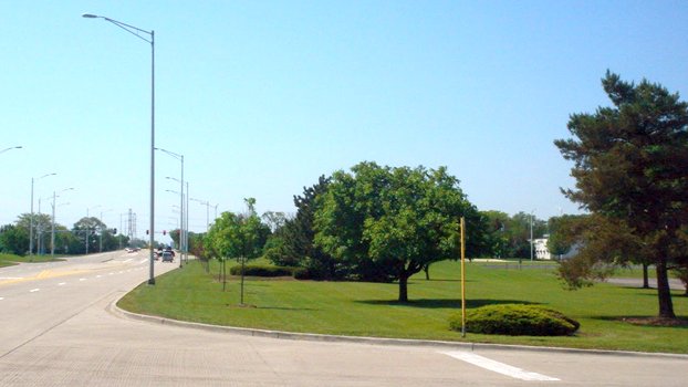
A Summer 2008 photo (Copyright by Gregg Maryniak, used with permission) looking south along Route 53 at the site of Mitchell Field.
Gregg Maryniak reported, “The grassy area in the foreground is approximately the location of the little Red Shack & swimming pool.
The traffic light in the distance is the intersection with Fullerton Avenue. The cross street in the foreground is Mitchell Court.”
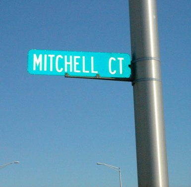
A Summer 2008 photo (Copyright by Gregg Maryniak, used with permission) of the only remaining indication of Mitchell Field: the sign for Mitchell Court.
The site of Mitchell Field is located south of the intersection of Route 355 & Army Trail Boulevard.
____________________________________________________
Checkerboard Field / Maywood Airmail Field / Hines Field, Broadview, IL
41.858, -87.84 (Northwest of Chicago Midway Airport, IL)
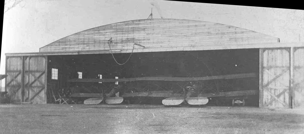
A 1920 photo of 2 biplanes inside Checkerboard Field's first Air Mail hangar (courtesy of Nancy Pope).
In 1919, a company called Society Brand Clothes bought land on the east side of First Avenue between Roosevelt & Cermak Roads, (in what now is Miller Meadow),
according to the website of the Loyola University Health System.
The airfield was opened by David Behncke & Bert Russell, according to the Franzosenbusch Heritage Society.
A metal hangar was constructed, and 2 planes were purchased to deliver the company's clothes to towns outside the Chicago area.
Each plane, painted with a checkerboard design, carried large signs advertising Society Brand Clothes.
Since these were the only planes using the field, it was called Checkerboard Flying Field.
Also in 1919, the U.S. Post Office Department extended its air mail service from Cleveland to Chicago.
In the beginning, the mail planes used a portion of Grant Park as a landing field.
However, winds from Lake Michigan made landing precarious, so a new location had to be found.
Maywood's Checkerboard Field was chosen.
The first air mail hangar was built on Checkerboard Field in January 1920, according to the caption of a photo of the hangar (courtesy of Nancy Pope).
A 1922 aerial view hangars at Checkerboard Field (courtesy of Nancy Pope).
According to the photo's caption, “After the first hangar burned down, individual stalls were built for plane storage.”
Bud Sherman recalled, “I taught at Morton East High School in Cicero. A few of the old teachers had been students at Morton in the 1920s.
According to them in the 1920s the students in the Industrial Arts Department built an airplane.
They used special machines in the wood shop to bend the wood into the appropriate shapes.
They flew the airplane from Checkerboard Field. How they got there from the school was a question I never thought to ask. It must be at least a distance of 8 miles.
Eventually there was a crash. There were no injuries to personnel, fortunately. However, the school board promptly canceled the program before injures would occur.”
In 1923, a new field was built on the west side of First Avenue, south of Roosevelt Road,
on the grounds of Edward Hines Memorial Hospital.
The new Checkerboard Air Mail Field received Chicago's air mail from Cleveland and Omaha,
and Maywood was the main repair & overhaul center for the entire air mail service, which continued to expand to other cities.
It was also called Maywood Air Mail Field at this time.
In 1923, Behncke sold the field to Wilfred Yackey, a former military and airmail pilot.
From 1923 until Yackey's death in an airplane crash,
the Yackey Aircraft Company & Checkerboard Field were the center of aircraft manufacturing activities in the Chicago area.

A 9/15/24 photo of boy scouts in front of a the US Army World Flyers plane which was fogged-in at the Maywood Airmail Field (courtesy of Lee Corbin).
On 4/15/26, Charles Lindbergh, the chief pilot for Robertson Aircraft Corporation's Chicago-to-St. Louis airmail route
took off from Maywood on the service's inaugural flight to St. Louis.
As Charles Lindbergh later wrote in Apples of Knowledge, "It took me 2.75 hours to reach St. Louis, including stops at Peoria & Springfield, Ill.
Hurtling through the air at 90 miles an hour behind my mail sacks, I thought of the 2 MPH oxcart travel of my father's boyhood."
Lindbergh's Chicago-to-St. Louis trips sometimes were plagued by bad weather or aircraft failure.
Already a 2-time member of the "Caterpillar Club", a group of pilots who had the distinct honor of owing their lives to parachutes,
he insisted that each pilot on his air mail route be equipped with a parachute in case of emergency.
Five months after his inaugural flight, Lindbergh became a 3-time member of the Caterpillars.
He described his September 1926 flight from St. Louis that didn't quite make it to Maywood in his book, "We".
"The fog extended from the ground up to about 600 feet... at no time, however, was I able to locate the exact position of the field,
although I understand that the searchlights were directed upward
and 2 barrels of gasoline burned in an endeavor to attract my attention."
When his fuel ran out, about 30 miles from Checkerboard Field, Lindbergh was forced to parachute from his plane.
However, he had neglected to cut the switches to the plane's engine.
With less weight, the small amount of fuel left in the line drained to the carburetor, and the plane continued to fly.
"The plane was making a left spiral of about a mile diameter, and passed approximately 300 yards away from my 'chute, leaving me on the outside of the circle.
I was undecided as to whether the plane or I was descending the more rapidly & glided my 'chute away from the spiral path of the ship as rapidly as I could.
The ship passed completely out of sight, but reappeared in a few seconds, its rate of descent being about the same as that of the parachute.
I counted the 5 spirals, each one a little further away than the last, before reaching the top of the fog bank."
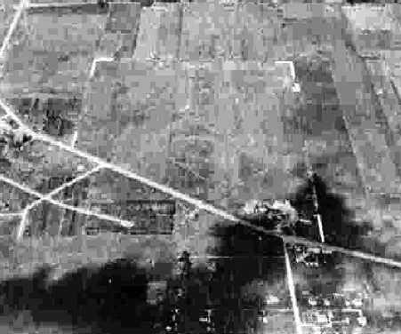
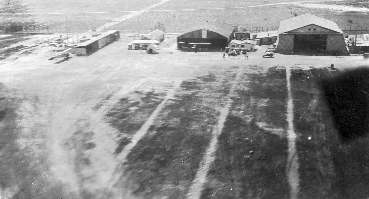
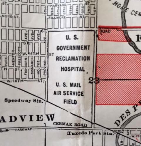
A 9/16/27 aerial view looking northwest at the “U.S. Mail Field, Maywood” (courtesy of Mike Denja)
showed 3 hangars along the southeast side of 2 unpaved runways, with a long factory building seemingly forming a significant obstacle to the west.
In 1927 Checkerboard Field lost its air mail contract due primarily to 2 events.
The U. S. Mail Service started contracting the airmail flights to private companies.
One of the stipulations was that private facilities must be used by the private air mail companies,
but Maywood Air Field was a public field owned by the Village of Maywood.
Furthermore, Wilford Yackey, who ran the Maywood field, died while performing acrobatics in one of his company's monoplanes.
A wing snapped off after a series of dazzling maneuvers & he died in the crash.
Without his enthusiasm & effort the air mail service ceased to use the former Checkerboard Field.
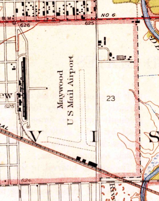
The earliest map depiction which has been located of Checkerboard Field was on the 1928 USGS topo map,
which depicted “Maywood U.S. Mail Airport” as having 2 unpaved runways with 3 buildings along the south side.
The 6/29/28 Commerce Department Airway Bulletin (courtesy of Mike Denja) depicted Maywood Field & Checker Board Field as separate adjacent airfields.
Maywood / Checkerboard Field was not yet depicted on the August 1932 Chicago Sectional Chart.
The 1933 USGS topo map depicted “Maywood U.S. Mail Airport” in an unchanged fashion.
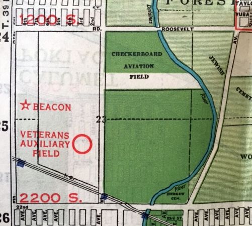
A 1933 Rand-McNally map (courtesy of Kevin Walsh) depicted “Checkerboard Aviation Field”
along with the adjacent “Veterans Auxiliary Field” & a beacon to the west.
By 1933 the field was evidently renamed as Hines Field, as that is how it was depicted on the July 1933 Chicago Sectional Chart.
The Airport Directory Company's 1933 Airport Directory (courtesy of Chris Kennedy)
described Hines as a commercial airfield, having 2 cinder runways in an "L" shape: 2,300' north/south & 1,900' east/west.
The field was said to have hangars at the south end, and hospital buildings to the west & northwest.
The Department of Commerce's 1934 Airport Directory (courtesy of Chris Kennedy) described "Hines Field" as the "old air-mail field".
The description of the airfield configuration was identical to that in the 1933 directory.
Bruce Lathrop recalled, "My father remembers watching airmail planes take off & land at the old airport north of Cermack & west of First Avenue.
The airport was located south of Hines Veterans Hospital."
from the IL Air Photo Imagebase (courtesy of Bruce Lathrop).
But it is not apparent if the airfield was no longer in operation at this point.
The last depiction of Hines Field as an active airfield which has been located was on the February 1940 Chicago Sectional Chart.
It depicted Hines as an auxiliary airfield.
Hines Field was evidently closed at some point between 1940-42,
as it was no longer depicted at all on the January 1942 Chicago Sectional Chart or on subsequent aeronautical charts.
A 1944 map (courtesy of Kevin Walsh) still depicted the “U.S. Mail Air Service Field”, even though it was no longer in use by that point.
The 1945 USGS topo map depicted an unlabeled clearing in the place of the airfield,
but still depicted the 3 buildings along the south side.
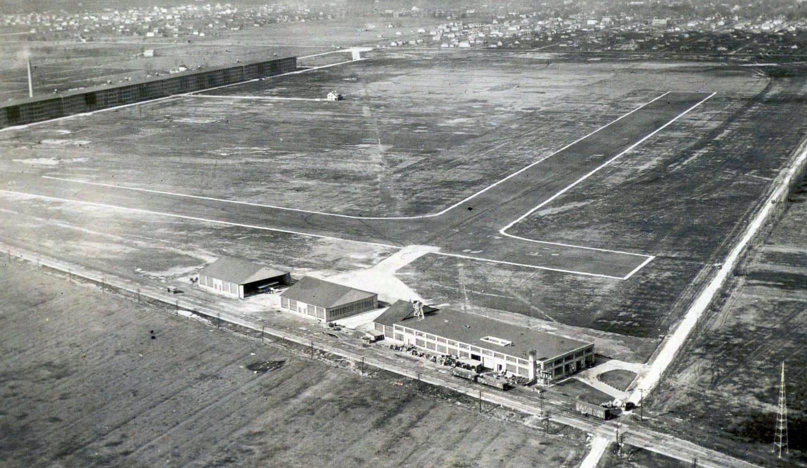
A 1951 aerial view showed that the area of the runways had been covered with buildings at some point between 1938-51.
A 1951 street atlas (courtesy of Kevin Walsh) still depicted the “Landing Field”, even though it had ceased to exist by that point.
David Bossert reported, “I visited the old Checkerboard Airfield site [in about 2002].
The city had installed a plaque that commemorates the airfield, and briefly describes its history.”
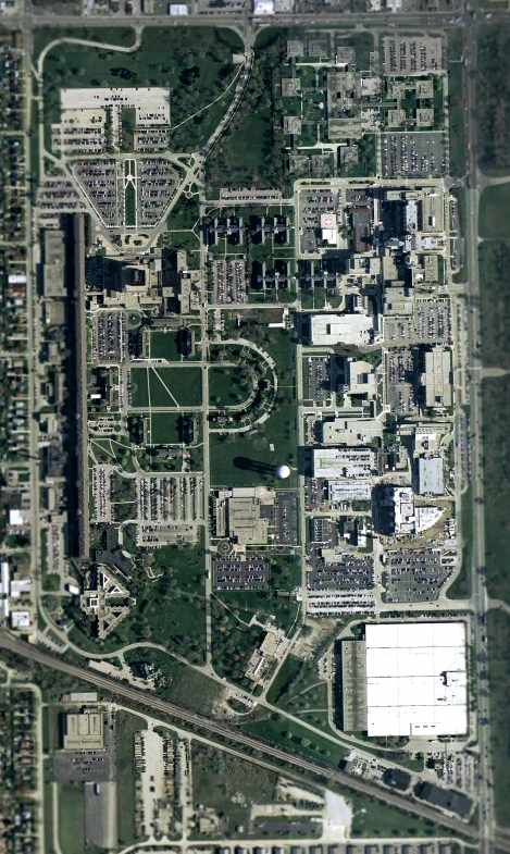
An April 2004 USGS aerial photo shows that the site of the former Hines Field has been thoroughly covered over by buildings.
However, the 2 original air mail service hangars still remained standing -
the 2 dark colored buildings at the southeast corner of the site.
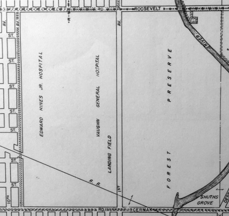
The site of Hines Field is occupied by the Hines Veterans Hospital & the Loyola Medical Center.
The runway that Lindbergh used on his first flight from Maywood to St. Louis
ended near the present location of the Loyola Lifestar helipad & the new emergency medical building.
John Donat reported in 2005, “The original air mail service hangars from the Hines Airfield exist,
and are in use by the Veterans Hospital for storage & repair of X-Ray equipment.
The buildings are listed in the Illinois historical buildings list.”
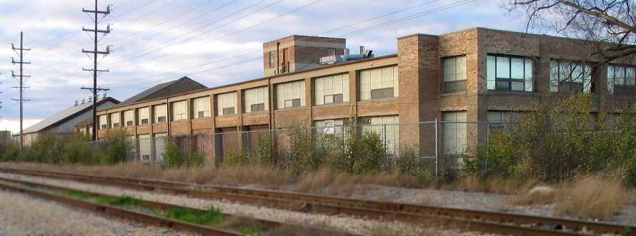
A 2005 photo by David Bossert at the Hines Field site of the “The east building... a very long, brick, 2-story, industrial looking with a flat roof.”
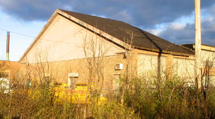
A 2005 photo by David Bossert at Hines Field of the western portion of the east building,
which “has a pitched roof & looks like it was a former hangar, with the hangar doors replaced by a huge brick wall on the west end.”
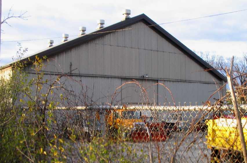
A 2005 photo by David Bossert at Hines Field of “The western building... a pretty large hangar made of corrugated steel,
with hangar doors on the east & west ends.”
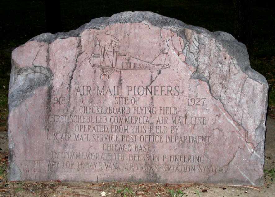
A 2005 photo by David Bossert of the “commemorative monument located in the Miller Meadows Forest Preserve,
which borders the east side of Hines Veterans Hospital.
The monument is located 200 ft south of the park entrance off Roosevelt Road, east of First Avenue.
Although the monument claims it marks the site,
the monument is actually located more than a quarter mile east of the most northeast corner of the old field.”
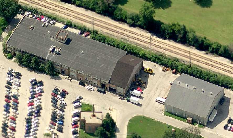
A circa 2006 aerial photo looking south at the 2 original air mail service hangars at the southeast corner of the Hines Field site.

A July 2012 photo by George Slad at Hines Field “of the north side of the southeast-most structure (former hangar & airmail building.”
George reported, “I spoke with a couple of employees in the building & they were familiar with some of the history of the building & area as it mentioned in new-hire training.”
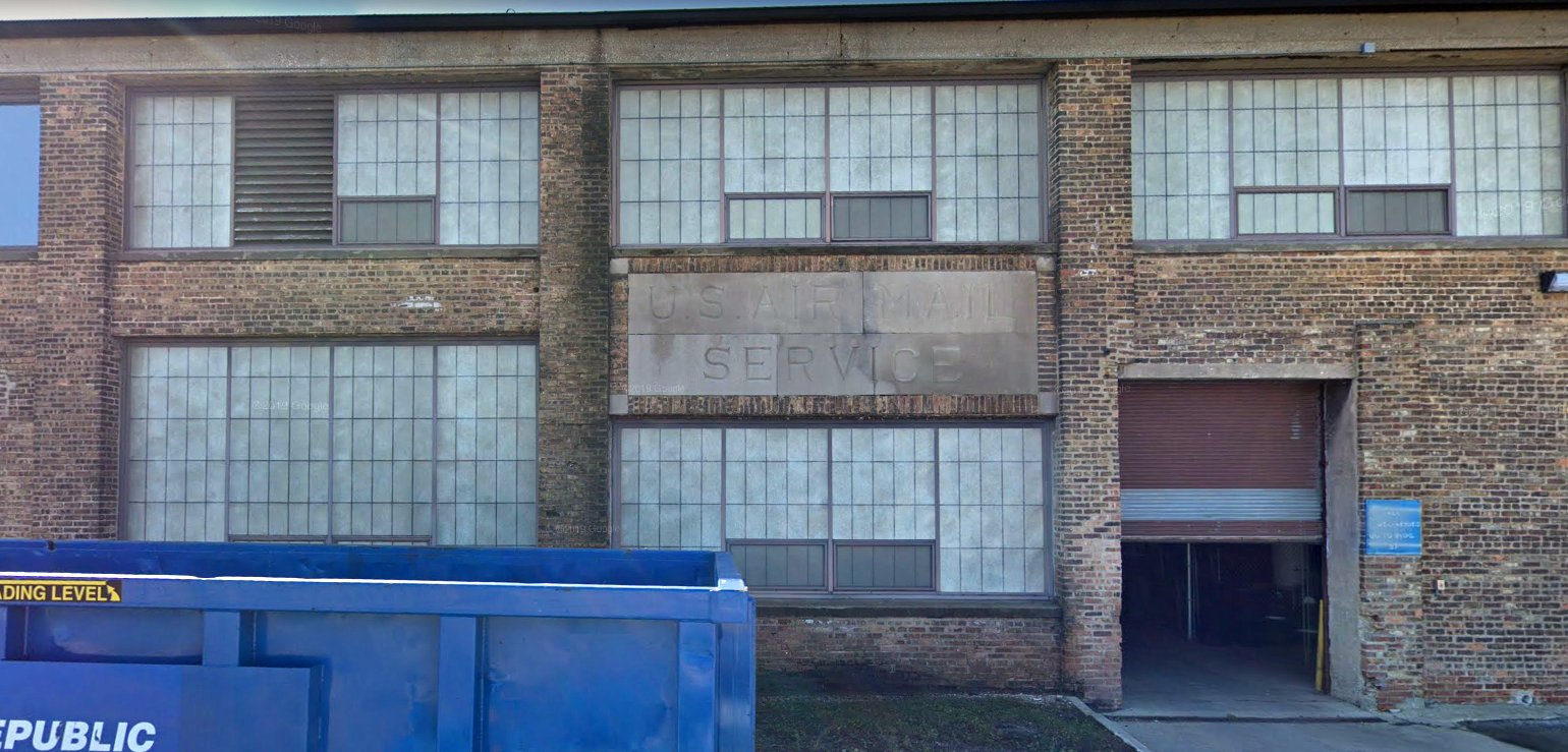
An October 2018 photo looking south at the “U.S. Air Mail Service” legend on the north side of the southeast-most structure (former hangar & airmail building) at the Hines Field site.
The site of Hines Field is located north of the intersection of Tripp Avenue & Air Mail Road.
____________________________________________________
Or if you prefer to contact me directly concerning a contribution (for a mailing address to send a check),
please contact me at: paulandterryfreeman@gmail.com
If you enjoy this web site, please support it with a financial contribution.
____________________________________________________
This site covers airfields in all 50 states.