Abandoned & Little-Known Airfields:
Central Kansas
© 2002, © 2026 by Paul Freeman. Revised 3/13/26.
This site covers airfields in all 50 states: Click here for the site's main menu.
____________________________________________________
Please consider a financial contribution to support the continued growth & operation of this site.
Allen Airpark/ Allen Landing Field (revised 7/14/20) - Arkansas City Airport / Haines Landing Field (revised 3/13/26) - Cassoday Intermediate Field (revised 3/13/26)
Great Bend Airport (1st location & 3rd location) (revised 1/27/20) - Great Bend Airport (2nd location) (added 6/8/13)
Huntoon Airport (added 7/17/20) - Hutchinson NAS / Yoder Commercial Airport / Sunflower Gliderport (revised 2/18/23) - Newton Airport (1st location) (added 9/4/17)
Pottawatomie Airport (revised 1/27/20) - Sterling Airport (revised 6/29/22) - Strother South Aux AAF #5 / Winfield – Arkansas City #5 / Strother #2 (revised 2/9/17)
Topeka Airport (original location) (revised 3/13/26) - Walker AAF / Victoria-Pratt Airfield (revised 9/6/24)
____________________________________________________
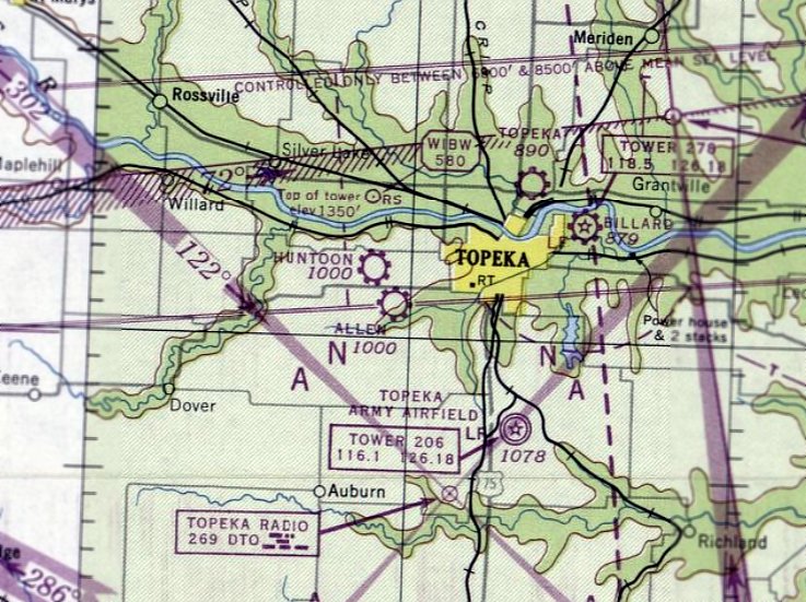
Topeka Airport (original location), Topeka, KS
39.102, -95.659 (West of Kansas City, MO)
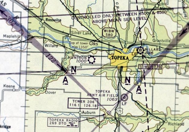
Topeka Airport, as depicted on the September 1947 Kansas City Sectional Chart.
The original location of Topeka Airport was 2 miles north of the center of the town.
Topeka Airport was evidently established at this location at some point in 1947,
as it was not yet depicted on the March 1947 Kansas City Sectional Chart.
According to Jason Bahr, Topeka Airport was built by George Hersh's grandfather.
The earliest depiction which has been located of Topeka Airport at this location was on the September 1947 Kansas City Sectional Chart.
It depicted Topeka as a commercial/municipal airport.

The earliest photo which has been located of Topeka Airport was a 9/4/48 USGS aerial view.
It depicted 6 light single-engine aircraft parked near some small hangars on the northwest side of a north/south grass runway.

The only ground-level photo which has been located of Topeka Airport was a 1948 photo (courtesy of George Hersh) of a 2-bay hangar with an adjacent office building, labeled “Topeka Airport”, with 2 Piper Cubs parked in front.

The 1949 KS Airport Directory depicted Topeka Airport as having a single 2,600' turf northeast/southwest runway.

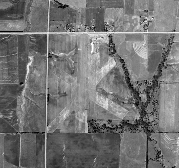
The last photo which has been located of Topeka Airport was a 6/26/50 USGS aerial view, which showed Topeka Airport as having 3 unpaved runways.

The earliest topo map depiction which has been located of Topeka Airport was on the 1951 USGS topo map.
It depicted Topeka Airport as a north/south rectangular property outline, with several small buildings on the north side.

The last aeronautical chart depiction which has been located of Topeka Airport was on the January 1957 Kansas City Sectional Chart.
It depicted Topeka Airport as having a 2,600' unpaved runway.
Topeka Airport was evidently closed (for reasons unknown) at some point in 1957,
as it was no longer depicted on the June 1957 Kansas City Sectional Chart.
The 1960 USGS topo map continued to depict Topeka Airport in the same fashion as the 1951 topo map.
Jason Bahr reported of Topeka Airport, “at least one person had memory of still seeing planes flying from there in the 1960 timeframe.”
A 1970 aerial photo showed the Topeka Airport hangars remained standing, but houses had been built over the runway.
The 1971 USGS topo map no longer depicted Topeka Airport, instead showing residential streets on the site.
A 1985 aerial photo showed the Topeka Airport hangars remained standing.
A 1991 aerial photo showed the Topeka Airport hangars had been removed at some point between 1985-91, erasing the last trace of this little airport.

A 2023 aerial view shows no trace remains of the original Topeka Airport.
Thanks to Jason Bahr for pointing out this airfield.
____________________________________________________
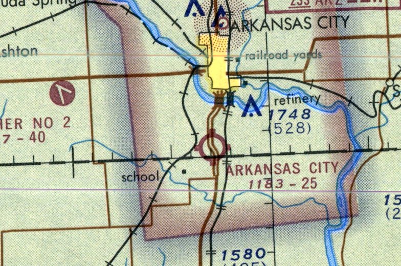
Arkansas City Airport / Haines Landing Field, Arkansas City, KS
37.0118, -97.035 (Southeast of Wichita, KS)
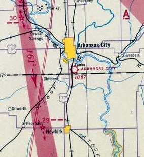
Arkansas City Airport, as depicted on the 1941 Sectional Chart (courtesy of Jonathan Westerling).
The first airport for the town of Arkansas City was located south of the town, along the state line.
The earliest depiction which has been located of Arkansas City Airport was on the 1941 Sectional Chart (courtesy of Jonathan Westerling),
which depicted Arkansas City as a commercial/municipal airport.
The February 1944 Wichita Sectional Chart (courtesy of Chris Kennedy) depicted Arkansas City as a commercial/municipal airport.
The 1948 Haire Airport Directory (courtesy of Jonathan Westerling) described Arkansas City Airport as having 3 unpaved runways,
and listed the manager as L.E. Pickett.
Arkansas City Airport, as depicted on the 1949 Wichita Sectional Chart (courtesy of Chris Kennedy).
The 1949 KS Airport Directory depicted Arkansas City Airport as having 4 unpaved runways, with the longest measuring 2,750' northeast/southwest.
Arkansas City Airport, as depicted on the 1950 Wichita Sectional Chart (courtesy of Chris Kennedy).
The earliest photo which has been located of Arkansas City Airport was a 1956 aerial view.
It depicted Arkansas City Airport as having a single grass north/south runway,
with a small hangar & 1 light single-engine plane on the northwest side.
The 1965 USGS topo map depicted Arkansas City Airport inexplicably as “Haines Landing Field”, which is not a name used on aeronautical chart depictions.
It was depicted as having a single unpaved north/south runway, with a few small buildings on the northwest & north sides.
A 1967 airport directory (courtesy of Jonathan Westerling) depicted Arkansas City Airport as having a single 2,013 turf Runway 17/35, with a few small buildings on the northwest side.
The last aeronautical chart depiction which has been located of Arkansas City Airport was on the 1971 Sectional Chart (courtesy of Jonathan Westerling),
which depicted Arkansas City as having a 2,500' unpaved runway.
The last listing which has been located of Arkansas City Airport was in the 1971 Airmen's Information Manual (courtesy of Jonathan Westerling).
Arkansas City Airport may have been closed (in an official capacity) at some point between 1971-79,
as it was no longer depicted on the 1979 USGS topo map.
The last photo which has been located showing an aircraft at Arkansas City Airport was a 1981 aerial view.
It depicted Arkansas City Airport as having a single grass north/south runway,
with a small hangar & 1 light single-engine plane on the northwest side.
A 1996 aerial view showed the Arkansas City Airport runway & hangar remained intact,
but there were no aircraft on the field or other indications of recent aviation use.
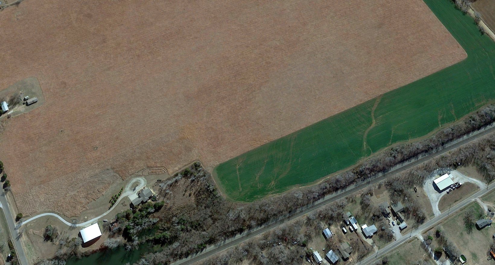
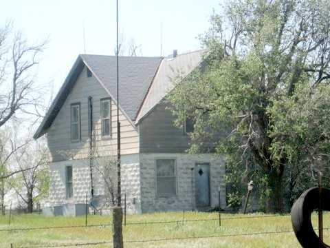
A 2017 aerial view looking southeast at the Arkansas City Airport site showed no trace remaining of the runway, but the hangar remained at the northwest corner (bottom-left) of the site.
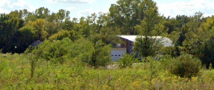
A September 2021 photo looking southwest showed the hangar remaining at the northwest corner of the Arkansas City Airport site.
Thanks to Jonathan Westerling for pointing out this airfield.
____________________________________________________
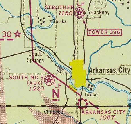
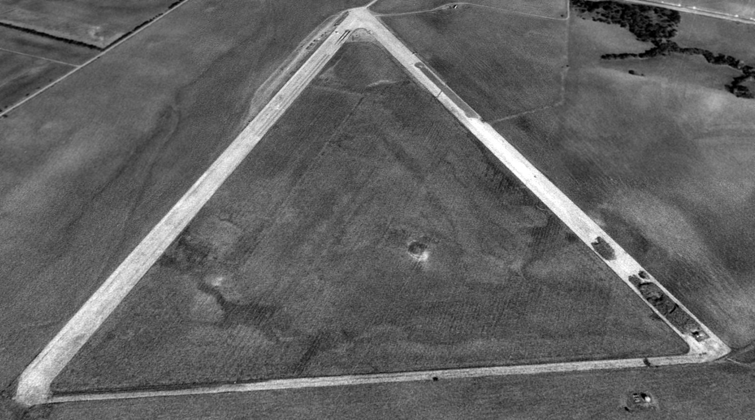
Strother South Auxiliary Army Airfield #5 /
Winfield – Arkansas City #5 / Strother #2, Arkansas City, KS
37.05, -97.16 (Southeast of Wichita, KS)
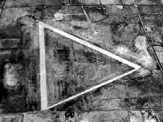
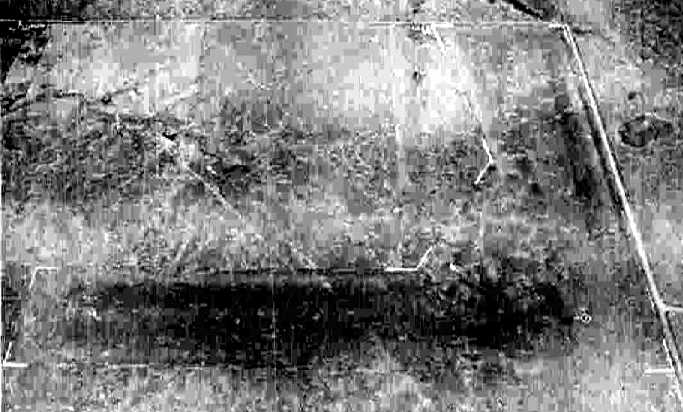
A 10/15/43 aerial view looking north at “Strother Field Auxiliary #5 (South Field)”
from the 1945 AAF Airfield Directory (courtesy of Scott Murdock).
The Army Air Force acquired this 655 acre site in 1942 to build one of 5 satellite airfields for Strother AAF (9 miles northeast),
which provided basic flight training as part of the 70,000 Pilot Training Program.
The Army constructed two 4,000' concrete runways, one concrete taxiway, a stage house,
a crash truck station, a control tower, and a surface drainage system.
A 5/15/43 AAF list of airfields of the Gulf Coast Training Center (courtesy of Ron Plante)
listed South Auxiliary as one of 4 satellite fields of Strother Field, but did not specify any runway configuration.
The earliest depiction which has been located of this airfield
was a 10/15/43 aerial view in the 1945 AAF Airfield Directory (courtesy of Scott Murdock).
It depicted “Strother Field Auxiliary #5 (South Field)” as having 2 concrete runways connected by a taxiway.
The earliest aeronautical chart depiction of this field which has been located was on the February 1944 Wichita Sectional Chart (courtesy of Chris Kennedy).
It depicted “South #5 (Aux)” as a military airfield.
Note, however, that this chart's location of the airfield may have been somewhat erroneous,
as the airfield was depicted to the southeast of Geuda Springs,
whereas every subsequent chart depicted this airfield to the southwest of Geuda Springs.
The 1945 AAF Airfield Directory (courtesy of Scott Murdock) described “Strother Field Auxiliary #5 (South Field)”
as a 640 acre square property having 2 concrete 4,000' runways (oriented north/south & northwest/southeast),
within a 5,260' x 4,190' turf all-way landing field.
The field was said to not have any hangars, to be owned by the U.S. Government, and to be operated by the Army Air Forces.
Strother “South #5 (Aux)” was still depicted on the March 1945 Wichita Sectional Chart (courtesy of Chris Kennedy).
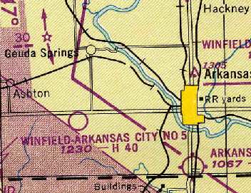
The airfield was declared surplus in 1946 & was conveyed to the cities of Arkansas City & Winfield in 1948.
In the post-WW2 years, the name of this airfield went through a confusing series of changes.
It was depicted as "Winfield-Arkansas City #5" on the 1949 Wichita Sectional Chart (courtesy of Chris Kennedy).
It was listed as "Winfield-Arkansas City Municipal #2" in the 1949 KS Airport Directory (courtesy of Chris Kennedy).
It was depicted as having two 4,000' concrete runways, connected by a taxiway, forming a triangle.
Two taxiways on the northern end of the field led to a group of small buildings & one larger building (a hangar?).
The operator was listed as Walter Grant.
It was labeled as "Strother #2" on the USAF edition of the 1950 Wichita Sectional Chart (courtesy of Chris Kennedy).
The 1965 USGS topo map depicted “Strother Air Field #2” as having 2 paved runways & a connecting taxiway.
The 1968 Flight Guide (courtesy of Robert Levittan) depicted “Strother Aux. #2” as having 2 paved runways, taxiways, and a few small buildings on the north side.
“Strother #2” was still depicted as an active civil airfield on the 1971 Wichita Sectional Chart (courtesy of Vince Granato).
It was depicted as having 2 paved runways, with the longest being 4,000'.
Strother #2 was apparently closed as an airfield at some point between 1974-75.
The North/South runway was subsequently reused as a drag strip, named the Mid-American Dragway.
Dave Law recalled, "A friend of mine used to race at the drag strip in the mid to late 1970s.
I asked him when the airport was closed & he thought it was about 1974 or 1975.
The owner of one of the auto parts stores in Arkansas City was able to lease the property & opened it as a drag strip about that same time.
The operator was a former NHRA mechanic & was able to attract some big name racers to the venue."
A 1991 USGS aerial view looking northwest at the remains of Strother #2.
According to a 1992 Army Corps of Engineers report,
the Northwest/Southeast runway was being used by the State of Kansas Asphalt Recycling Program to store asphalt debris.
None of the original military buildings remained at the site.
Strother #2 was still depicted as an abandoned airfield on the 1998 World Aeronautical Chart.
Dave Law reported in 2003, "The drag strip closed this past summer."
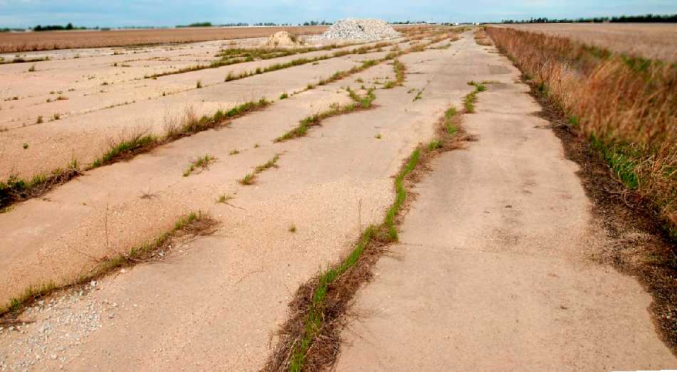
An April 2010 photo by Josh Ream looking northwest along the Strother runway.
Josh observed, “You can just make out the drag strip buildings at the north end of the field.
Strother is currently a drag strip, and the strip has opened & closed several times over the years, from folks who have lived here for some time.”
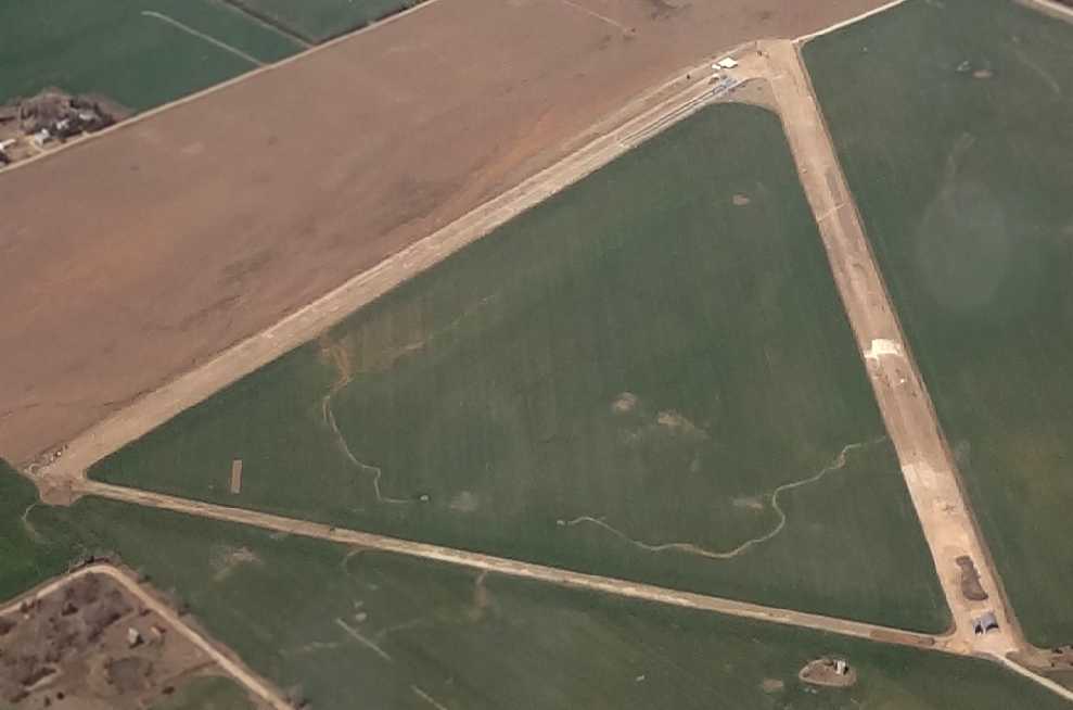
A 3/20/13 aerial view by David Ulane looking northwest at Strother #2 from 4,000'.
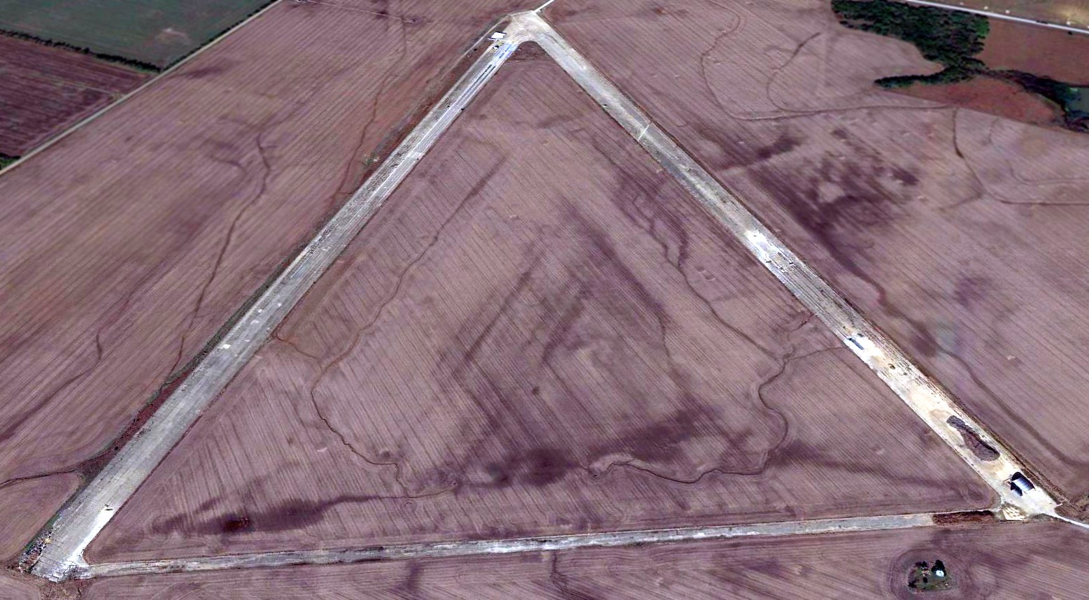
A 2014 aerial view looking northwest at the remains of Strother #2.
____________________________________________________
39.042, -95.778 (West of Kansas City, MO)
Huntoon Airport, as depicted on the March 1946 Kansas City Sectional Chart.
This short-lived small general aviation airport to the west of Topeka was evidently established at some point between 1945-56
(like hundreds of other small airports in the American post-WW2 aviation boom),
as it was not depicted on the May 1945 Kansas City Sectional Chart.
The earliest depiction which has been located of Huntoon Airport was on the September 1947 Kansas City Sectional Chart.
It depicted Huntoon as a commercial/municipal airport.
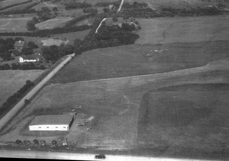
The only photo which has been located of Huntoon Airport was an undated aerial view looking east, showing cars parked in front of a hangar next to a grass airfield (courtesy of Jason Bahr).
The photo was reportedly from the 1950s, but the cars look earlier (1930s or 40s).
The last aeronautical chart depiction which has been located of Huntoon Airport was on the September 1947 Kansas City Sectional Chart.
It depicted Huntoon as a commercial/municipal airport.
Huntoon Airport was evidently closed (for reasons unknown) at some point between 1947-48,
as it was no longer depicted on the September 1948 Kansas City Sectional Chart.
A 1948 aerial view showed the foundation of the Huntoon Airport hangar, on the northwest corner of the property,
and faint traces were recognizable of the north/south runway orientation.
The 1952 USGS topo map did not depict Huntoon Airport.
A 1970 aerial view still showed the foundation of the Huntoon Airport hangar, but no trace remained of the runway.
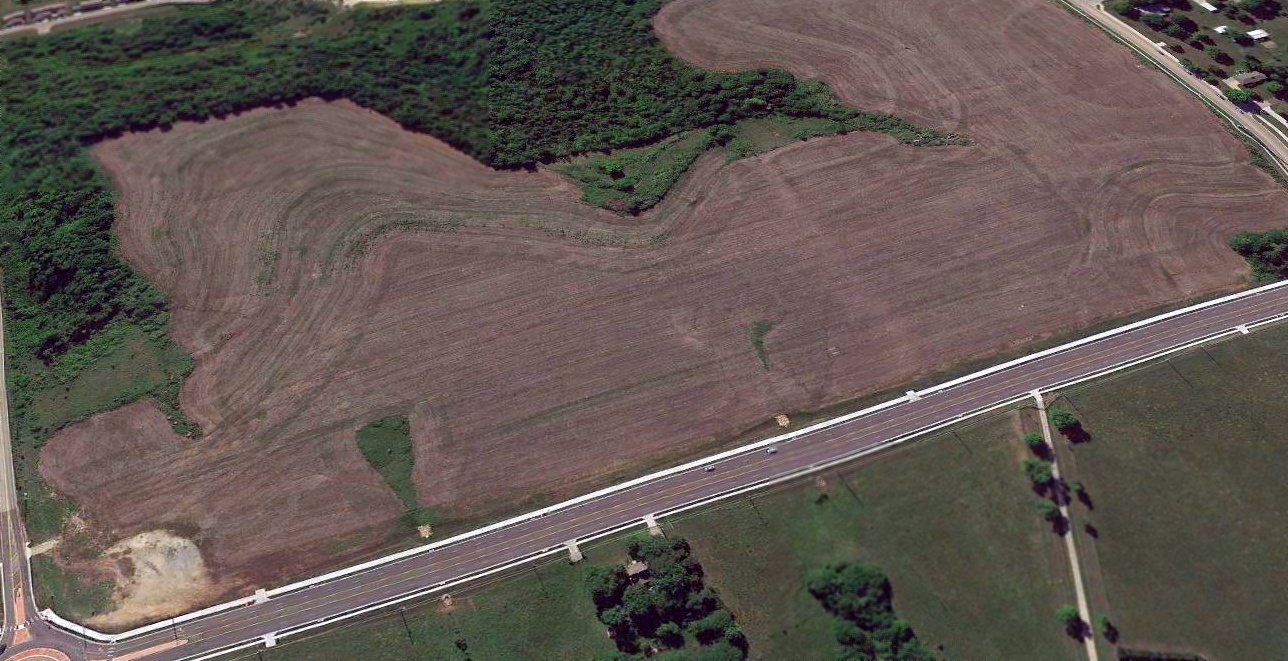
A 2018 aerial view looking southeast showed no trace of Huntoon Airport, with the land remaining clear,
but no trace remaining of the hangar foundation, other than a gravel parking lot at the northwest corner (bottom-left).
Thanks to Jason Bahr for pointing out this airfield.
____________________________________________________
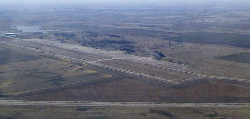
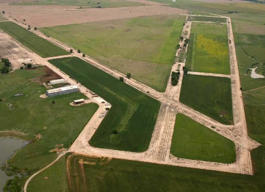
Allen Airpark / Allen Landing Field (TPB), Topeka, KS
39.025, -95.758 (West of Kansas City, MO)
Allen Airpark, as depicted on the September 1947 Kansas City Sectional Chart.
Allen Airpark was evidently established at some point in 1947,
as it was not yet listed among active airfields in the 1945 AAF Airfield Directory (courtesy of Scott Murdock)
nor depicted on the March 1947 Kansas City Sectional Chart.
The earliest depiction which has been located of Allen Airpark was on the September 1947 Kansas City Sectional Chart.
It depicted Allen as a commercial/municipal airport.
According to a postmark, Allen Air Park opened on 9/26/48.
According to Bert Allen's obituary, Allen Airpark was operated by John & Bert Allen.
According to its FAA Airport/Facility Directory data, Allen Airpark had an activation date of 1/1/50.
The earliest photo which has been located of Allen Airpark was a 9/9/48 USGS aerial view (courtesy of Jason Bahr).
It depicted Allen Airpark as having 3 unpaved runways, with 3 small buildings (hangars?) on the northeast side, and a 4th possibly under construction.
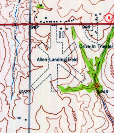
The 1952 USGS topo map depicted “Allen Landing Field” as having 3 unpaved runways, with 4 small buildings on the northeast side.
The last aeronautical chart depiction which has been located of Allen Airpark was on the February 1969 Kansas City Sectional Chart.
It showed that Allen Airpark had gained a 2,300' paved north/south runway at some point between 1952-69.
The 1970 USGS topo map showed that the number of runways at Allen Airpark had decreased to two,
with the north/south runway having been paved, but the former unpaved northwest/southeast runway was no longer depicted.
According to Kristopher Crook, “I was looking through a 1973 Official Airline Guide & am able to confirm that the commuter air service, Allen Aviation,
was indeed based out of Allen Airpark, as their headquarters address is that of the airport.
However, they did not operate scheduled services from there, those flew to/from Phillip Billard Field to Lawrence & Kansas City International using Piper Cherokee 6 aircraft.
The planes were maintained at Allen, ferried after their last arrivals at Billard to Allen in the evening,
and flown back to Billard in the early morning to begin the scheduled services.”
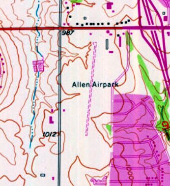
The last depiction which has been located of Allen Airpark was on the 1975 USGS topo map.
The number of runways had decreased again to only one: a paved north/south runway.
Allen Airpark was evidently closed at some point between 1975-83,
as the 1983 USGS topo map depicted residential streets covering the property.
Yet another one of hundreds of small American general aviation airports lost to suburban housing development.
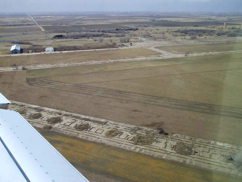
A 1991 aerial photo showed that houses & commercial buildings covered the site of Allen Airpark, but one former hangar remained standing on the northeast side.
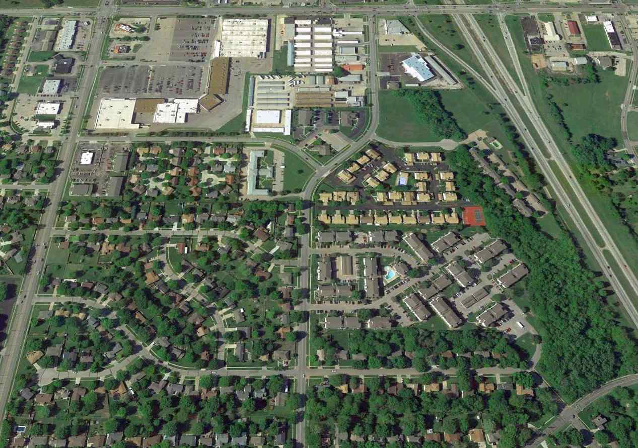
A 2015 aerial view looking north showed a former hangar remained standing on the northeast side of the site of Allen Airpark.
Kristopher Crook reported in 2015, “I have been told that the hangar is extant, but repurposed.”
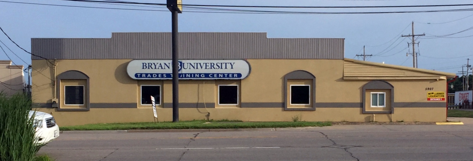
A 6/24/18 photo by Tom Wait of the former Allen Airpark hangar, reused as the Bryan University Trades Training Center.
The site of Allen Airpark is located southwest of the intersection of Interstate 470 & 21st Street.
Thanks to Kristopher Crook for pointing out this airfield.
____________________________________________________
Pottawatomie Airport, Manhattan, KS
39.186, -96.554 (West of Topeka, KS)
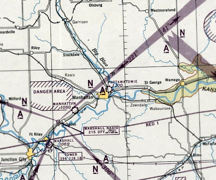
Pottawatomie Airport, as depicted on the September 1945 Salina Sectional Chart.
Photo of airport while in use has not been located.
Pottawatomie Airport was not yet depicted on the March 1944 Salina Sectional Chart.
According to Dan Linn, “Pottawatomie Airport... opened around 1944.”
The earliest depiction which has been located of Pottawatomie Airport was on the September 1945 Salina Sectional Chart.
It depicted Pottawatomie as a commercial/municipal airport.
The September 1947 Salina Sectional Chart (courtesy of Dan Linn) described Pottawatomie Airport as having 3 sod runways, with the longest being the 3,000' northeast/southwest strip.
The field was said to office service, gasoline, major & minor repairs, hangar, and tie-down, and the manager was listed as L. W. Henderson.
According to Dan Linn, “During 1947-50 the following aircraft were observed [at Pottawatomie Airport]:
Small flight training on GI Bill, using 4 J-3 Cubs, 2 Ercoupes, 1 108 short-tail Stinson Station Wagon.
Privately owned: one 125 HP Globe Swift, one 85 HP Culver V, one 1946 Aeronca Champion, one Piper L4/J3 Cub (my own aircraft).
All aircraft were tied-down as only one small service hangar was located at the northeast corner of the field.
Tie-downs & fuel plus the office [were located] at the south end of the field.
The north/south runway was bare with clumps of grass collecting dust with the result [being] excessive use, causing a very rough surface.”
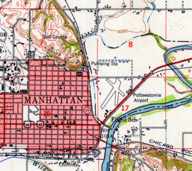
The 1947 USGS topo map depicted Pottawatomie Airport as having 3 runways, with several small buildings on the northeast & east sides,
and another cluster of small buildings (labeled “Flight School”) on the south side.
The last depiction which has been located of Pottawatomie Airport was on the October 1951 Salina Sectional Chart.
It depicted Pottawatomie as having a 3,000' unpaved runway.
Pottawatomie Airport was evidently closed at some point between 1951-52,
as it was no longer depicted on the April 1952 Salina Sectional Chart.
According to Dan Linn, “Pottawatomie Airport... closed, as Manhattan City was built entirely east over it.”
The 1958 USGS topo map no longer depicted Pottawatomie Airport, with the site instead being a blank area.
A 1981 aerial photo showed houses & other buildings having been built over the western, southern, and eastern portions of the Pottawatomie Airport site,
but the middle of the airfield site was an open grass field.
A 2014 aerial view showed no trace of Pottawatomie Airport, with buildings covering the site.
Thanks to Dan Linn for pointing out this airfield.
____________________________________________________
Newton Airport (1st location), Newton, KS
38.067, -97.352 (Northwest of Wichita, KS)
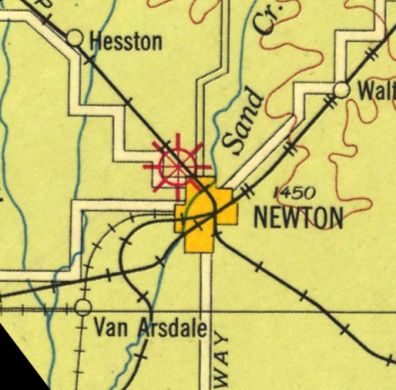
The original Newton Airport, as depicted on the 1927 Airway map (courtesy of John Goerzen).
Photo of airport while in use has not been located.
The original airport for the town of Newton was adjacent to the northwest side of the town.
According to John Goerzen, “A man named Tangeman owned a golf course (the 'golf links' according to the paper),
and around 1927 the city of Newton purchased it, because of all the planes that were landing there.
They turned it into a real airport.”
The earliest depiction which has been located of Newton Airport was on the 1927 Airway map (courtesy of John Goerzen).

The last aeronautical chart depiction which has been located of the original Newton Airport was on the February 1943 Wichita Sectional Chart.
It depicted Newton Airport as a commercial/municipal airport.
According to John Goerzen, “The city bought land east of the city & moved the airport there.”
The original location of Newton Airport to the northwest was replaced by Wirt Field, built to the east of the town,
as only Wirt Field was depicted on the February 1944 Wichita Sectional Chart.
A 1956 aerial photo showed no recognizable trace of an airport at the site of the original Newton Airport on the northwest side of the town.
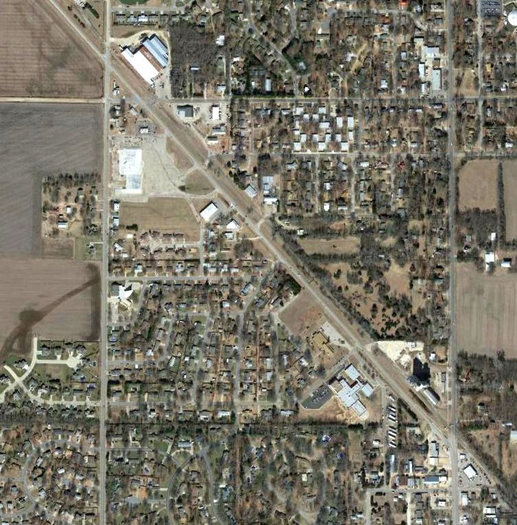
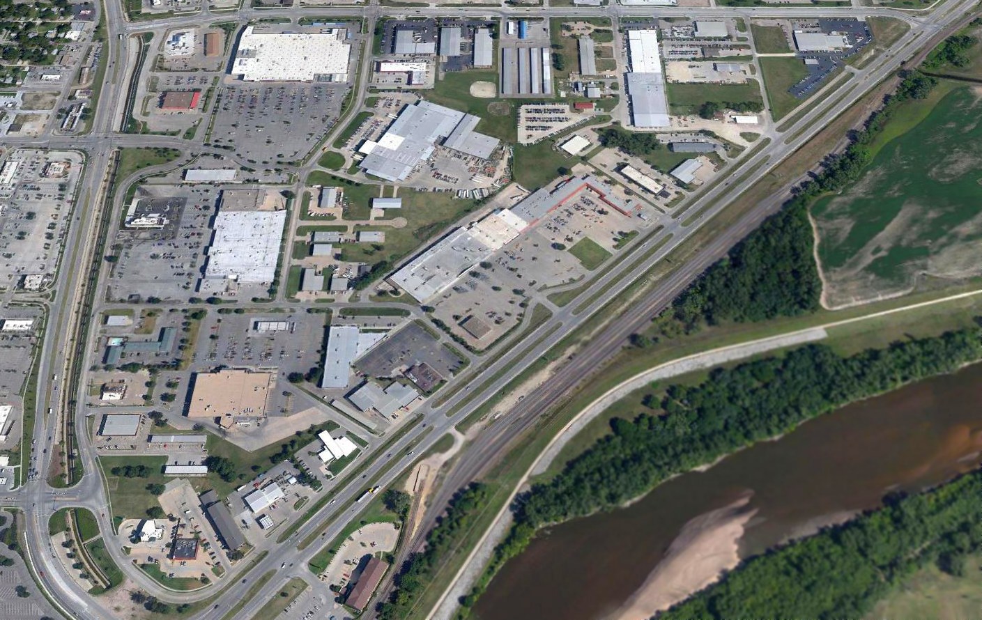
Although the precise location of the original Newton Airport has not been determined, a 2017 aerial photo showed no recognizable trace at the general location.
The site of the original Newtown Airport is located roughly northwest of the intersection of North Main Street & Old Highway 81.
Thanks to John Goerzen for pointing out this airfield.
____________________________________________________
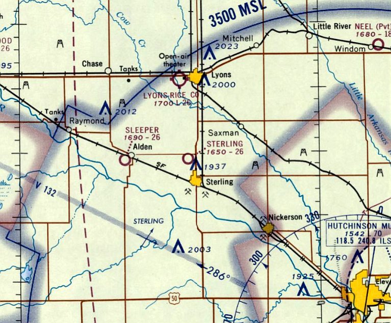
Sterling Airport, Sterling, KS
38.32, -98.22 (Northwest of Wichita, KS)
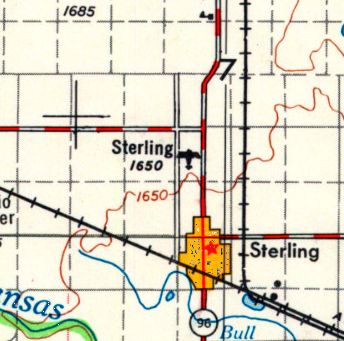
Sterling Airport, as depicted on the 1955 USGS topo map.
Photo of airport while in use has not been located.
This small general aviation airport was evidently established at some point between 1945-55,
as it was not yet listed among active airports in the 1945 AAF Directory (courtesy of Scott Murdoch).
The earliest depiction which has been located of Sterling Airport was on the 1955 USGS topo map.
Sterling Airport was not yet depicted on the December 1960 Salina Sectional Chart.
The earliest aeronautical chart depiction which has been located of Sterling Airport was on the April 1965 Salina Sectional Chart.
It depicted Sterling Airport as having a 2,600' unpaved runway.

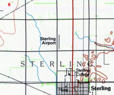
The most detailed depiction which has been located of Sterling Airport was on the 1967 USGS topo map.
It depicted Sterling Airport as having a single unpaved north/south runway with 1 small building on the southeast side.
The last depiction which has been located showing Sterling Airport in operation was on the 1985 USGS topo map.
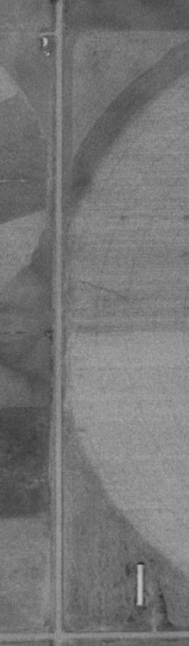
Sterling Airport was evidently closed at some point between 1985-91,
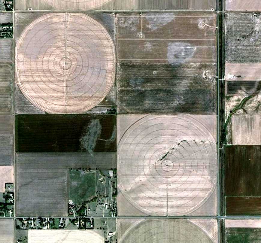
as a 1991 aerial photo showed the runway had been covered by a circular-irrigation farm field.
The hangar remained intact on the southeast side, though.
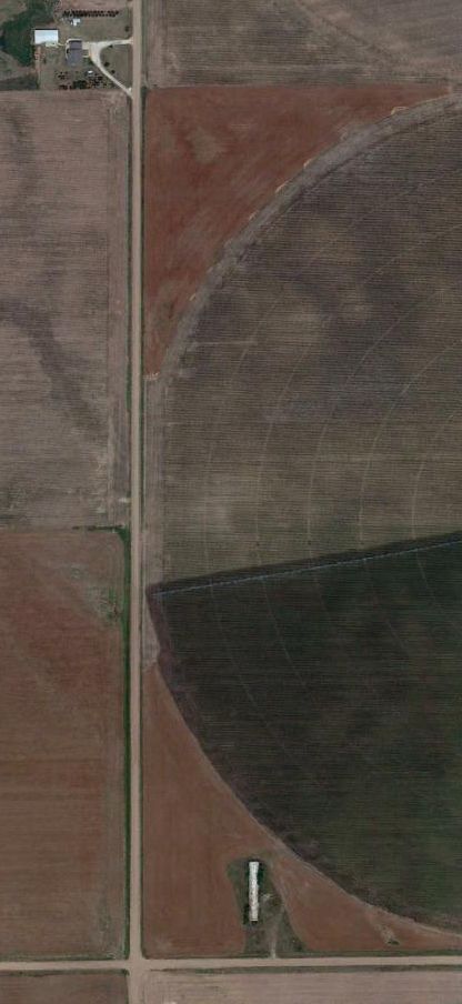
A 2011 aerial view showed no change at the site of Sterling Airport,
with the runway area covered by a circular-irrigation farm field, but the hangar remaining on the southeast side.
A closeup from the 2011 aerial view shows the letters “Sterling” are still visible on the former Sterling Airport hangar.
The site of Sterling Airport is located northeast of the intersection of Avenue U & 15th Road.
____________________________________________________
Great Bend Airport (1st location & 3rd location), Great Bend, KS
38.39, -98.76 (Northwest of Wichita, KS)
The original Great Bend Airport, as depicted on the 1930 Commerce Department Airway Bulletin (courtesy of Phillip Schulz).
Photo of airport while in use has not been located.
The municipal airport for the City of Great Bend has gone through a series of no less than 4 different locations since 1928.
Phillip Schulz reported that the first location of Great Bend Airport “was dedicated in the fall of 1928.”
The earliest depiction which has been located of the original Great Bend Airport
was on the 1930 Commerce Department Airway Bulletin (courtesy of Phillip Schulz).
It depicted a 74 acre T-shaped field located one mile north of the city limits.
It described Great Bend Airport as having 2 sod runways, oriented 2,600' north/south & 2,050' east/west.
A single 55' x 50' frame hangar was said to have “Great Bend” painted on it.
The field was described as being owned by the city, and operated by the Chamber of Commerce.
The earliest aeronautical chart depiction which has been located of the original Great Bend Airport was on the December 1933 Salina Sectional Chart.
It depicted Great Bend as a commercial/municipal airport.
The last aeronautical chart depiction which has been located of the original Great Bend Airport was on the July 1941 Salina Sectional Chart.
It depicted Great Bend as a commercial/municipal airport.
According to Phillip Schulz, the original location “must have closed around 1941”,
and was replaced by the 2nd location of Great Bend Airport, 5 miles west of town.
The July 1942 Salina Sectional Chart no longer depicted any airfields in the Great Bend vicinity
However, this location of the Great Bend Airport returned to use very soon.
According to Phillip Schulz, “The Army Air Forces required Great Bend close the #2 airport due to the proximity to the AAF [which had been established in 1942-43].
The city then leased ground north of Great Bend on the same land where the Airport #1 was located.
[Great Bend Airport] Number 3 was in the shape of a T. It was called Great Bend's New Airpark.”
The hangar at Airport #3 was “built at the end of 1943 - early in 1944. [Airport] Number 3 was in full operation in 1944.”
Great Bend Airport #3 was not depicted on the March 1944 Salina Sectional Chart.
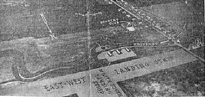
A circa 1944 illustration looking southwest at the 3rd location of Great Bend Municipal Airport,
as published by the KS League of Municipalities (courtesy of Phillip Schulz).
It depicted 2 runways in a T-shape, with 3 buildings along the southwest side.
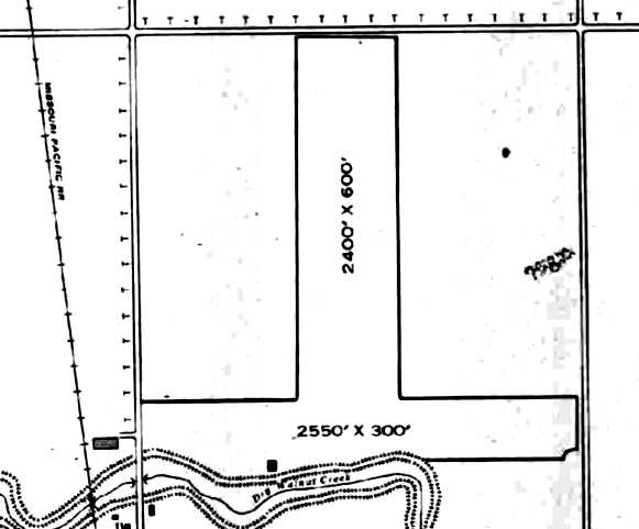
The earliest airfield directory listing which has been located of the 3rd location of Great Bend Airport was in the 1945 AAF Airfield Directory (courtesy of Scott Murdock).
It described Great Bend Municipal Airport as a 50 acre T-shaped property having 2 bare runways, oriented 2,550' east/west & 2,400' north/south.
A single 95' x 39' concrete block hangar was depicted along the southwest side. The field was said to be owned & operated by private interests.
The earliest aeronautical chart depiction which has been located of Great Bend Airport #3 was on the September 1945 Salina Sectional Chart.
It depicted Great Bend as a commercial/municipal airport.
Bob Mullen recalled, the first Great Bend Airport “is the airfield where my dad taught guys to fly using their GI Bill from 1945-48.
I spent a lot of time in [the hangar] as a youngster & got to ride with him on flights over the area.”
According to Phillip Schulz, “Number 3 closed when the city bought the Great Bend Army Airfield in 1946 for $1.”
However, it may have remained open for a few years longer, as it continued to be depicted on aeronautical charts.
The last aeronautical chart depiction which has been located of Great Bend Airport #3 was on the March 1949 Salina Sectional Chart.
It depicted Great Bend as having a 2,600' unpaved runway.
Great Bend Airport #3 was evidently closed at some point in 1949,
as it was no longer depicted on the October 1949 Salina Sectional Chart or in the 1949 KS Airport Directory.
No airfield was depicted at this location on the 1960 USGS topo map.
A 10/12/11 aerial view did not show any obvious trace of the 1st & 3rd location of Great Bend Airport.
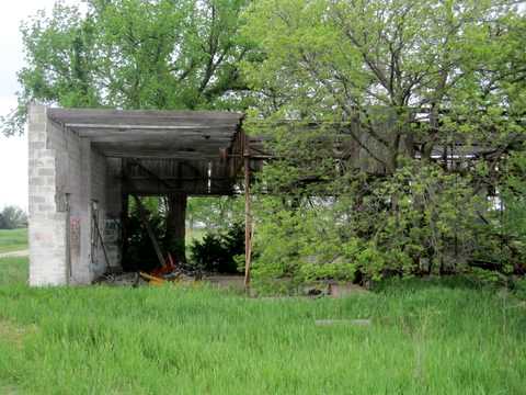
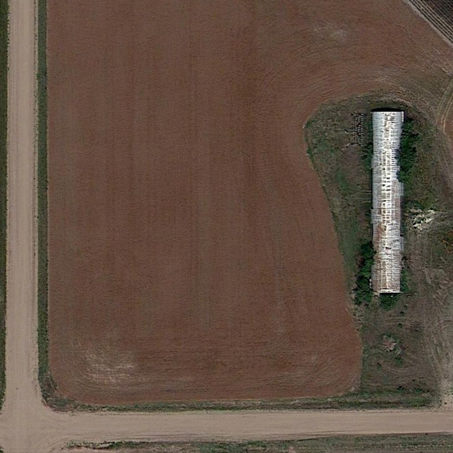
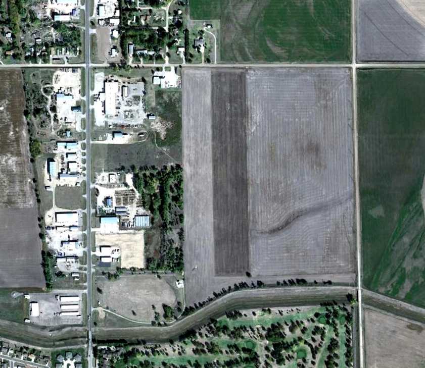
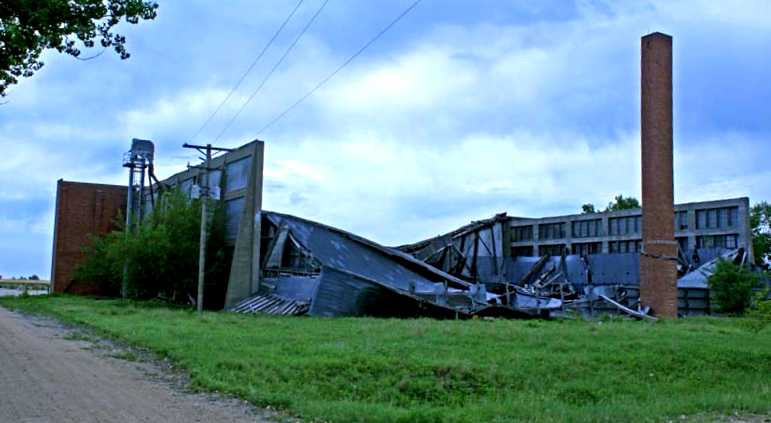
A 2013 photo by Phillip Schulz, who observed “A 3-stall hangar still stands on this site today.
The remaining hangar on [Airport] #3 is just north of the current Great Bend Golf Course.”
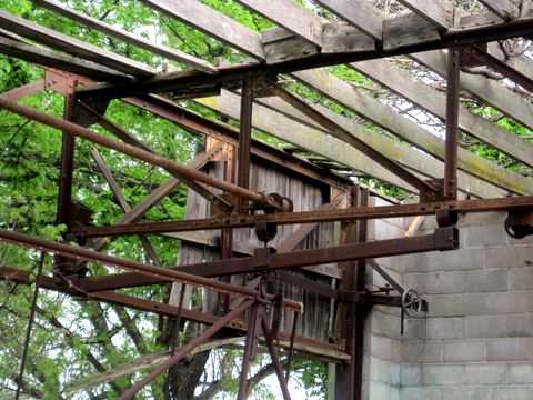
A 2013 photo by Phillip Schulz, who observed “The door system on this hangar is just amazing.
Three stalls with the doors going up into tracks, operated by steel cables running through all those pullies.”
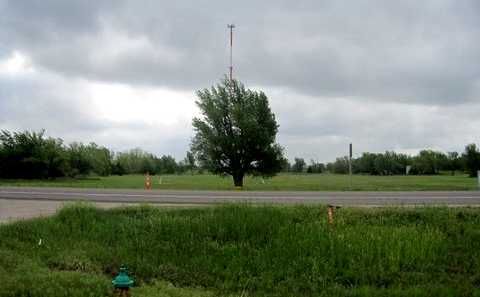
A 2013 photo by Phillip Schulz, “Looking east down the former east/west runway of Airport #3.
The standing hangar is the little white spot in the trees to the right.
The tall cell tower is in the center of the former north/south runway of Airport #3.”
A 5/16/17 photo by Bob Mullen of the exterior of the remaining hangar at the site of the original Great Bend Airport.
A 5/16/17 photo by Bob Mullen of the interior of the remaining hangar at the site of the original Great Bend Airport.
A 5/16/17 photo by Bob Mullen of the pulley system inside the remaining hangar at the site of the original Great Bend Airport.
The site of the 1st & 3rd location of Great Bend Airport is located southeast of the intersection of North Main Street & Northeast 20 Road.
____________________________________________________
Great Bend Airport (2nd location), Great Bend, KS
38.36, -98.89 (Northwest of Wichita, KS)
A 1991 USGS aerial photo of the site of the 2nd location of the Great Bend Airport.
Photo of airport while in use has not been located.
According to Phillip Schulz, after the closing of the original location of Great Bend Airport in 1941,
“the city went 5 miles west of Great Bend & built an airport & hangar.
The city purchased a couple of limestone barns & tore them down & hauled the limestone blocks to the airport for the construction of the hangar.
The city paid $140 for the limestone in 1942.”
The July 1942 Salina Sectional Chart did not depict any airfields in the Great Bend vicinity
This location of the Great Bend Airport was in use for an extremely short period of time, however.
According to Phillip Schulz, Great Bend Airport “Number 2 was 3/4 of mile northwest of the Great Bend Army Airfield that was established in late 1942 & 1943.
The Army Air Forces required Great Bend close the #2 airport due to the proximity to the AAF.”
Great Bend Airport #2 was not depicted on the March 1944 Salina Sectional Chart.
No airfield was depicted at this location on the 1961 USGS topo map.
A 10/12/11 aerial view did not show any obvious trace of the 2nd location of Great Bend Airport.
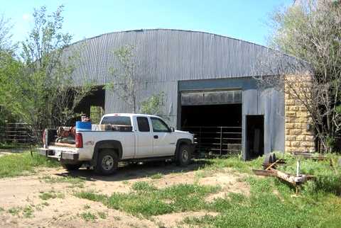
A 2013 photo by Phillip Schulz of the “Front of Hangar on [Great Bend Airport] #2, some 300' north of the farm house / office.
The hangar is in great shape after some 70 years.
The hangar on Number 2 is 1.75 miles northwest from the center of the current Great Bend Airport (KGBD).”
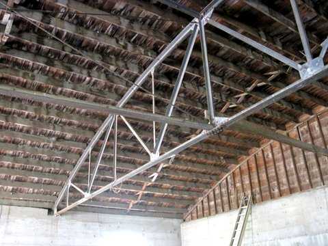
A 2013 photo by Phillip Schulz of the interior of the hangar at the 2nd location of Great Bend Airport.
Phillip observed, “You wonder how they came up with these 60' trusses during wartime.”
A 2013 photo by Phillip Schulz “looking south down what was the original runway.
The hangar is in the trees on the left.”
A 2013 photo by Phillip Schulz of the “farm house used as the office for Airport #2.”
The site of the 2nd location of Great Bend Airport is located at the intersection of Northeast 140th Street & Northeast Flinthills Road.
____________________________________________________
Cassoday Intermediate Field, Cassoday KS
38.03, -96.62 (Northeast of Wichita, KS)
The 1928 Commerce Department Airway Bulletin (courtesy of Jonathan Westerling) depicted Cassoday Intermediate Field as having 2 unpaved runways in an L-shape.
Jonathan Westerling reported, “The government established the Dallas to Kansas City airway between 1925-28 to guide pilots safely across the central US.
At strategic places along the airway, they built 'Intermediate' airfields, equivalent to modern day rest areas for pilots to land at if needed.
One of these intermediate airfields was in the tiny town of Cassoday, KS.
An 8/19/27 Airway Bulletin announced the opening of the Dallas – Kansas City airway.
On this bulletin is the first reference to Cassoday as a newly built 'Class C' intermediate field.”
Jonathan continued, “The 1928 Bulletin #5 (courtesy of David Brooks) incorrectly spelled it as 'Cassody'.
Later that year, the government published an aeronautical bulletin about the airfield which identified it as Site #41 along the airway.
The bulletin further detailed the field as being operated by the Department of Commerce & having 2 grass runways in an 'L' formation 2,600 feet long.
In the northwest corner of the airfield was a 2-million candlepower 24 inch rotating beacon which rotated at 6 RPM.
The newly-built field had few amenities (no fuel, repairs, or telegraph) but did have nighttime lights around the boundary of the airfield.”
Jonathan continued, “By 1931, the starting point of the airway had been changed from Dallas to Amarillo,
and this resulted in a renumbering of the airfields & beacons.
Cassoday changed from Site #41 to Site #34
and, according to the 1931 Bulletin #2 (courtesy of David Brooks) the beacon was upgraded with course lights & a weather teletype (FSS) station was installed on field.
According to 'Airways' (Dale Heister, 1978), the Cassoday FSS was commissioned in February of 1931.”
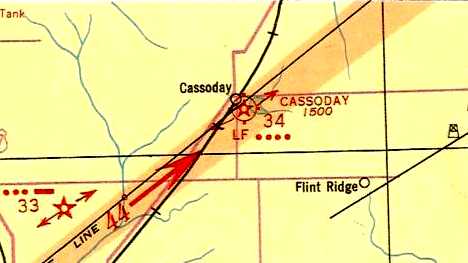
The earliest aeronautical chart depiction which has been located of Cassoday Intermediate Field
was on the 1933 Wichita Sectional Chart (courtesy of Jonathan Westerling), showing the Cassoday Intermediate Field & its associated airway.
Jonathan Westerling reported, “According to the 1934 Airport Directory Company guide,
the government added emergency fuel on field & the runways had been extended to 3,270’ in length.
This runway extension required relocating the east/west runway so that it intersected with the south end of the north/south runway instead of the north end.
This realignment of the runway configuration left the beacon isolated from the airfield,
so it was moved (or a new one was built) approximately 2,000’ west in the northwest corner of the north/south runway.”
Jonathan continued, “According to the 1938 Bulletin #2, a low frequency radio beacon was added on the site (callsign KCBW at 332 Khz).”
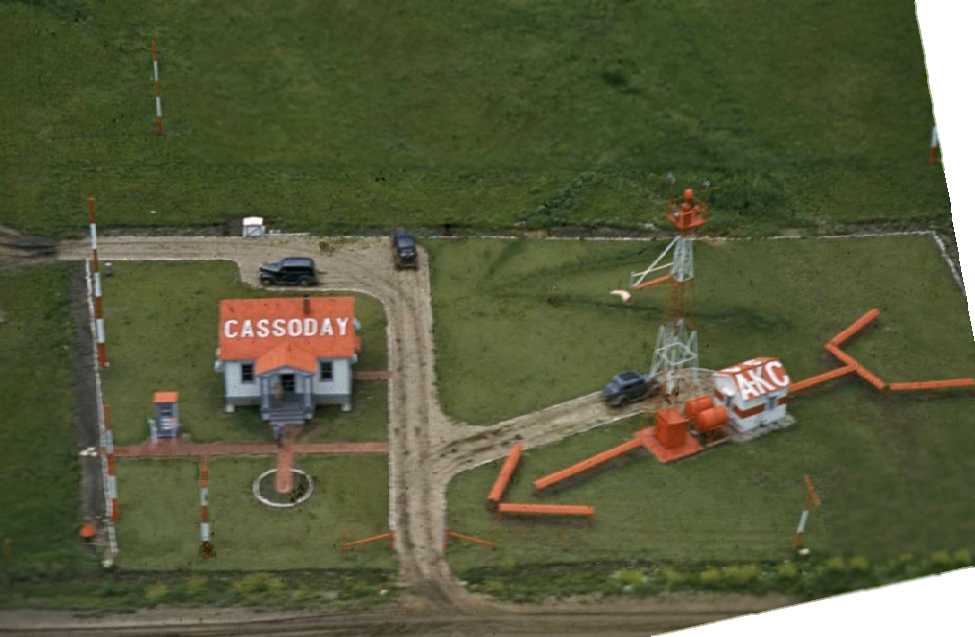
Jonathan Westerling observed, “One of the most detailed photos of a 'modern' airway beacon is this 1940 aerial photo (by David Scheram) of Cassoday.
The radio towers, beacon, and illuminated windsock are supplemented by a sizable building (complete with a front porch!) housing the equipment.”
Jonathan Westerling reported, “The airfield remained mostly unchanged throughout WWII.”
A 10/13/43 aerial view looking north at Cassoday Intermediate Field from the 1945 Army Air Forces directory (courtesy of Scott Murdoch)
showed the revised layout, with the east/west runway at the south end of the field.
Jonathan Westerling observed, “Interestingly, the 1945 AAF Directory (courtesy of Scott Murdoch) listed the airfield as being under private ownership.”
Jonathan continued, “The last mention of the Intermediate Airfield at Cassoday was in the 1947 Directory of Airfields.”
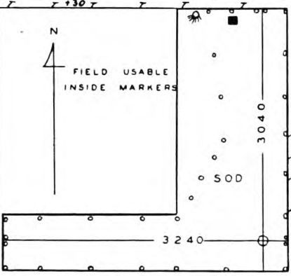
The 1949 KS Airport Directory depicted Cassoday Intermediate Field as having 2 sod runways, measuring 3,240' east/west & 3,030' north/south.
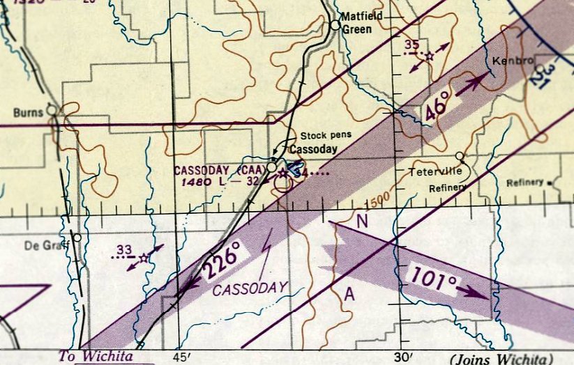
The last depiction which has been located of Cassoday Intermediate Field was on the April 1950 Salina Sectional Chart.
It depicted “Cassoday (CAA)” as having a 3,200' unpaved runway & Airway Beacon #34.
Cassoday Intermediate Field was evidently closed at some point in 1950,
as it was no longer depicted on the October 1950 Salina Sectional Chart,
nor listed among active airfields in the 1951 Directory of Airfields (according to Jonathan Westerling).
Cassoday Intermediate Field was no longer depicted on the 1955 USGS topo map,
and there was no recognizable trace of an airfield on the 5/4/66 USGS aerial photo.

A 9/5/11 aerial view did not appear to depict any trace of Cassoday Intermediate Field.
The site of Cassoday Intermediate Field is located at the intersection of Northeast 140th Street & Northeast Flinthills Road.
____________________________________________________
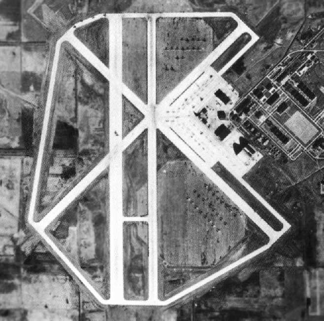
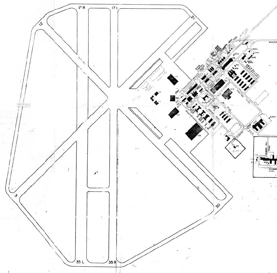
Hutchinson Naval Air Station / Yoder Commercial Airport /
Sunflower Gliderport (SN76), Yoder KS
37.93, -97.91 (South of Hutchinson, KS)

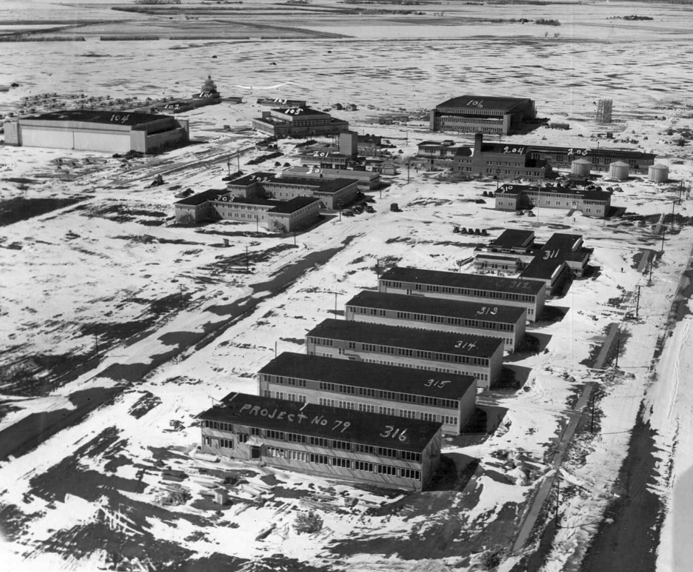
A 6/30/43 plan of the "US Naval Air Station Hutchinson, Kansas" (courtesy of Ron Plante).
More than 2,500 acres were chosen as the site for the Hutchinson Naval Air Station in 1942,
according to “Survey Report of World War II Air Bases in Kansas” by Susan Ford.
NAS Hutchinson was not yet depicted on the September 1942 Wichita Sectional Chart.
Construction for NAS Hutchinson began in October 1942.
An additional 3,900 acres were leased for up to 20 auxiliary landing fields.
Hutchinson was constructed to provide primary training for the Naval Air Reserve.
Until the station was completed, the Navy made temporary use of the town's municipal airport (located east of the town).
NAS Hutchinson was commissioned at the end of 1942.
The first training planes used were N2S-3s & N2S-4s, which were later replaced by N2S-5s.
The earliest depiction which has been located of NAS Hutchinson
was a 6/30/43 plan of the "US Naval Air Station Hutchinson, Kansas" (courtesy of Ron Plante).
The runways of NAS Hutchinson were depicted on the weside side, which partially overlaid 2 octagonal landing mats.
Another set of 4 much smaller runways, labeled "graded & sodded runways", were depicted on the east side.
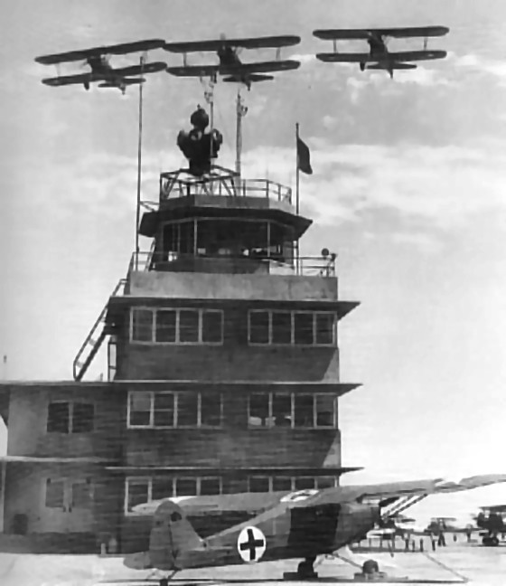
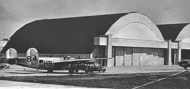
Three Stearman trainers overfly the Hutchinson tower in 1943,
with the station's Piper HE-1 hospital plane in the foreground (National Archives photo).
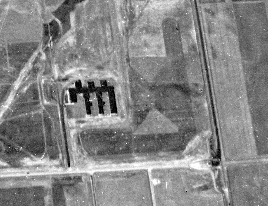
An August 1943 US Navy aerial view looking north at the small set of 3 grass runways on the east side of NAS Hutchinson (from the National Archives, courtesy of Brian Rehwinkel).
Brian Rehwinkel observed, “Regarding the set of runways, I suspect those runways were temporary runways used while the airfield was under construction.
The Navy used the existing Municipal airport while the station was under construction, but I think they wanted to have a landing field at the air station as well.
They were probably around 1,200' in length - enough room for those N2S trainers.
By the time this picture was taken, the field is obviously not in use, and a building has been built on a portion of the field.
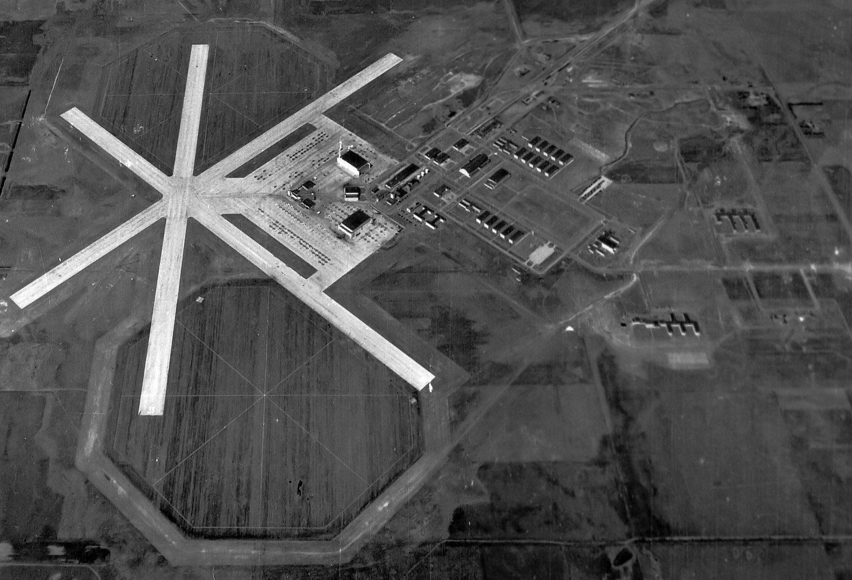
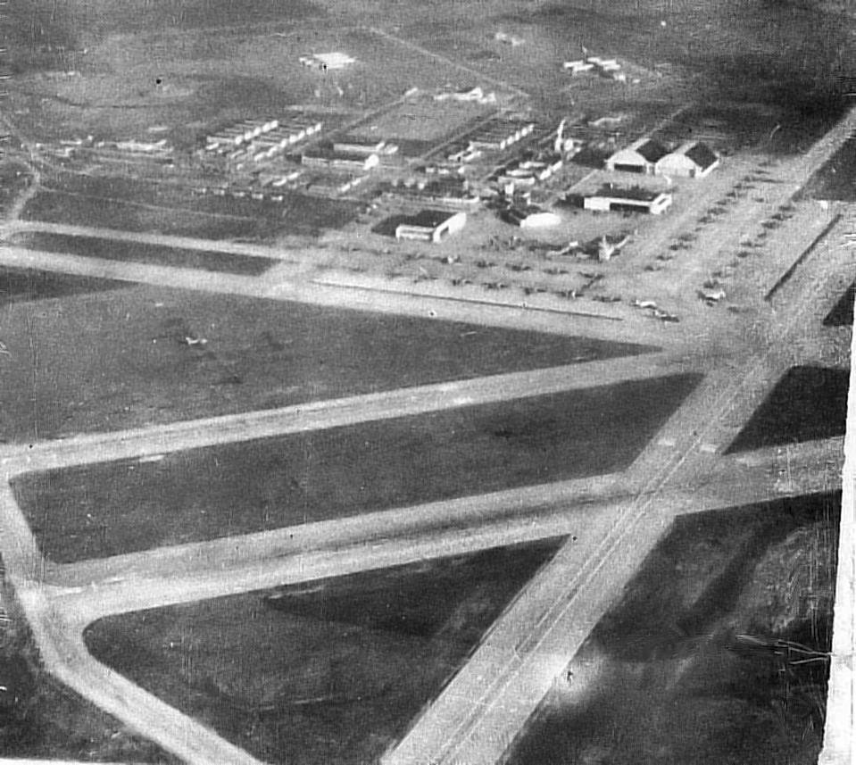
A 10/8/43 US Navy aerial view looking north at NAS Hutchinson (from the National Archives, courtesy of Brian Rehwinkel).
Brian Rehwinkel observed, “NAS Hutchinson in its original configuration... You can see the three 5,000' runways & the 2 octagonal landing mats.
In addition, you can see the large number of aircraft – probably N2S3 trainers – on the parking ramps.”
A 10/18/43 US Navy aerial view looking east at NAS Hutchinson (from NAS Hutchinson instructor pilot Lt. Ray Torley, courtesy of Roger Kubeck).
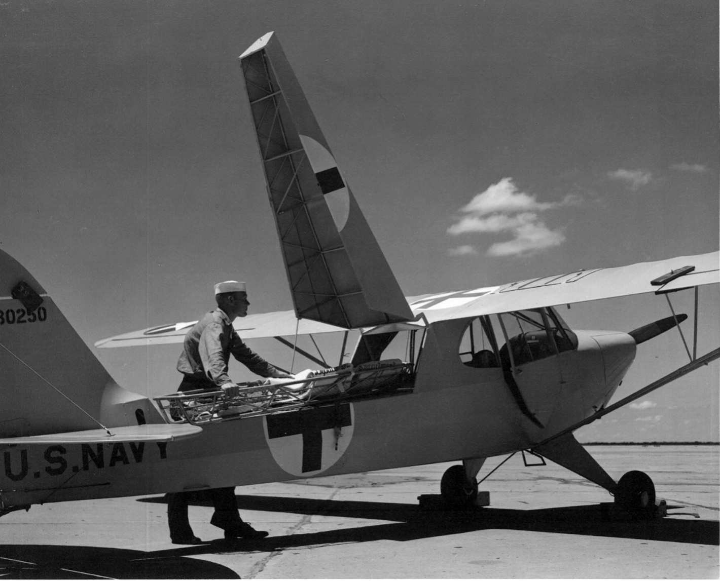
A circa 1943 photo of a Piper NE-1 ambulance version of the Cub being loaded at NAS Hutchinson (from NAS Hutchinson instructor pilot Lt. Ray Torley, courtesy of Roger Kubeck).
A circa 1943 photo of hangars & buildings at NAS Hutchinson (from NAS Hutchinson instructor pilot Lt. Ray Torley, courtesy of Roger Kubeck).
Brian Rehwinkel reported, “When the decision was made to transfer this station from primary training to operational training, the landing fields were dramatically changed.
The 5,000' runways & the 2 landing mats would not work for the PB4Y (the Navy’s version of the B-24) aircraft that would take over the station.”
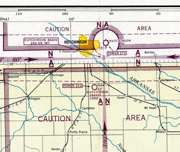
The earliest aeronautical chart depiction which has been located of NAS Hutchinson was on the February 1944 Wichita Sectional Chart.
It depicted "Hutchinson (Navy)" as having a control tower.
In 1944 Hutchinson acquired another school, training crews of PB4Y-1 Liberator bombers.
At its wartime peak, Hutchinson had a complement of over 5,000 personnel.
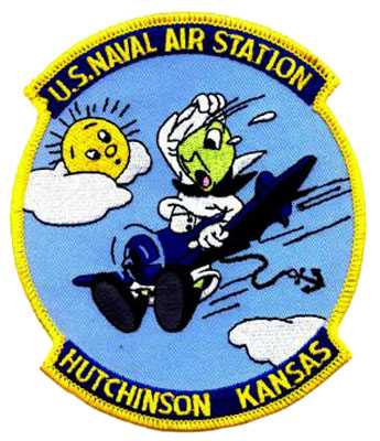
An undated patch for NAS Hutchinson.
The 1944 US Army/Navy Directory of Airfields (courtesy of Ken Mercer) described NAS Hutchinson as having a 5,000' hard-surface runway.
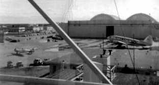
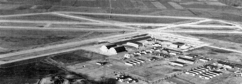
An undated (circa 1940s?) aerial view looking east at Hutchinson, with many aircraft on the ramp.
During WW2, Hutchinson had at least 3 satellite airfields: Hutchinson NOLF #1 (4 miles NE),
Newton NOLF (3 miles N of Newton), and Searcy NOLF (near Stillwater, OK).
Other sources indicate that Hutchinson had as many as 18 auxiliary fields at one point during WW2.
A 1945 aerial view of Hutchinson (National Archives photo).
An undated (WW2-era) photo by Bob Zimmerman of a PB4Y-1 Liberator being refueled at Hutchinson (courtesy of Steve Arthur).
"This double hangar was located south of the control tower & on the east side of the flight line & the doors faced to the south.
Today, the only remnants of the hangars are bits of foundation, rebar, and the steel tracks that the doors rode in."
Hutchinson NAS was disestablished at the end of WW2.
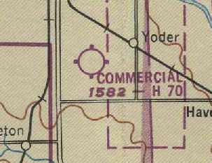
At some point between 1945-49, the former Hutchinson airfield was reused as a civilian airfield, named "Commercial" Airport,
as depicted on the March 1949 Wichita Sectional Chart (courtesy of Chris Kennedy).
It was depicted as having a 7,000' hard surface runway.
The NAS Hutchinson airfield was abandoned (once again) at some point within the next year,
as nothing at all was depicted at its location
on the October 1950 USAF Wichita Sectional Chart (according to Chris Kennedy).
Cleland McBurney recalled, “The base was surveyed in 1951 by my father who was a Navy Civil Engineer Corps officer
and certified to the Navy Department that the facilities could be reopened with minimal repair.”
NAS Hutchinson was reactivated in 1952 for multiengine training, with P4Y2 Privateers.
A 1952-53 photo by Bob Craig, “looking southeast from the tower, [at] the large hangar, R4D, SNJ, and in the background an F6F.
There were two F6Fs that were used more for fun.
I was stationed there from September 1952 until December 1953. I was a control tower operator.”
A 1953-54 photo by Cleland McBurney “of one of our PB4Y2s on the wash rack on the south ramp” of Hutchinson.
Cleland McBurney recalled, “I was stationed there in PB4Y-2 training in 1953-54.
The main purpose of stationing the PB4Y-2 Privateer there
was for the purpose of the Navy's advanced training for multi-engine pilots.
The French Navy had a very few of their cadets & officers under the same training.
Several were good friends of mine.
The large wooden hangars were still used when I flew out of there,
and I recall standing personnel inspection in them in the winter out of the cold.
They were large enough to handle several PB4Y-2s at a time.
In addition of the Privateers, the Navy also had a training squadron of P2V-3 Neptunes.
In 1953-54 when I trained there, the Neptunes were the current patrol planes being used in the fleet,
and the Privateers were being phased out.
When I finished training there in 2/28/54 I received my commission as ensign & received my wings of gold as a Naval Aviator.”
NAS Hutchinson was depicted on the June 1954 USAF Wichita Sectional Chart (courtesy of Chris Kennedy).
Tom Dailey recalled, "In the 1950s… training took place with PB4Y2 Privateers.
My Uncle William was stationed there during that time.
Bill often spoke of having to work on those Privateers in the winter wind, and freezing his hands as only a Kansas Winter can do.
Oil would turn into sludge, and as 'airy' as a PB4Y2 is (I know), they weren't very warm, either."
A 1954 picture of Dan Downing in front of a T-33 at an airshow at Hutchinson, with the control tower & an AT-6 in the background.
"I was 5 years old then & don't remember much, but I do remember the Blue Angels were there!
That's probably about the time the airplane bug bit me!"
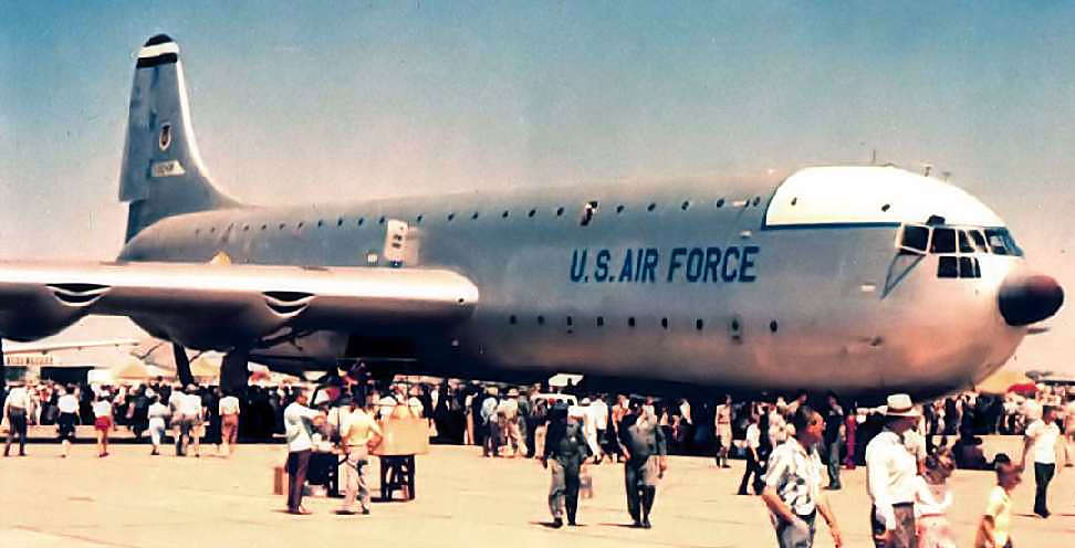
A mid-1950s photo by Richard Swett of the sole prototype of the massive Convair XC-99 transport at a NAS Hutchinson airshow.
Allan Richardson recalled, “I went to an advanced school & studied some of the true multi-engine electronic simulators made by ERCO.
I taught these at my final duty station, which was in Hutchinson - a strange place for a Navy Base in the geographic center of the USA.
I ended up teaching in P2V-7 Operational Flight Trainer trailers. They did an amazing job of simulating a P2-V.
They were a ball to teach & challenging to maintain.”
According to William Gilliland, the Kansas National Guard's 117th Fighter Interceptor Squadron
flew F-80 Shooting Stars out of Hutchinson Naval Air Station in 1957.
William recalled, “The Navy moved out in 1958, and the base soon thereafter became Hutchinson Air National Guard Base.
Also in 1958, we made the transition to B-57 Canberras (of which, we would fly in various forms for the next 20 years),
with the mission of photo reconnaissance.”
A circa 1958-59 photo of a Martin B-57 Canberra
of the Kansas Air National Guard's 177th Tactical Reconnaissance Squadron (courtesy of William Gilliland) at Hutchinson.
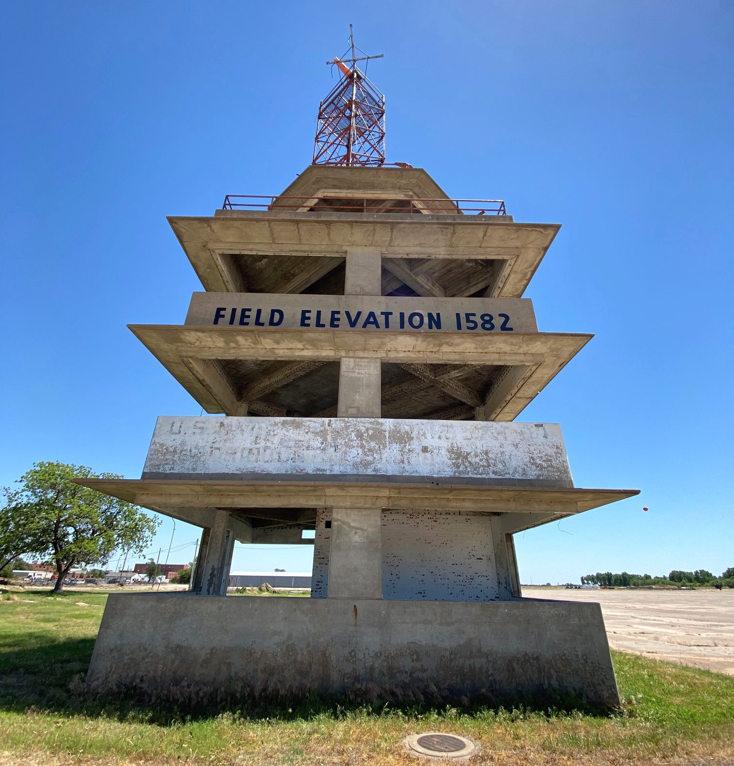
William observed, “If you look closely enough, you’ll find part of the Hutchinson Naval Air Station printing on the tower,
and I can’t image the Air Guard leaving that there for long.”
An 11/2/59 "Strategic Air Command, Wichita, Kansas, McConnell AFB, Base Layout Plan, Hutchinson A.S." (courtesy of Ron Plante).
Ron observed, “Presumably this reflects Air National Guard use.”
The miniature airfield depicted on the 1943 plan was no longer depicted at all.
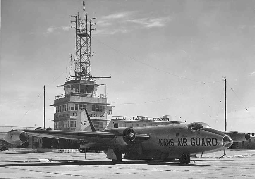
“Hutchinson (NG)” was depicted on the December 1959 Salina Sectional Chart (courtesy of Ron Plante)
as having 4 paved runways, with the longest being 7,000'.
A circa 1959-60 aerial view looking west at Hutchinson Air National Guard Base (courtesy of William Gilliland).
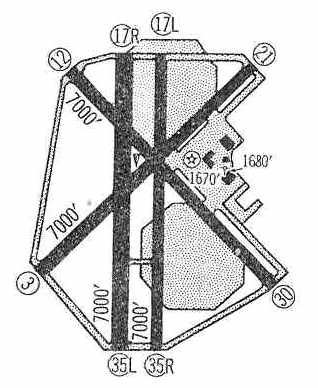
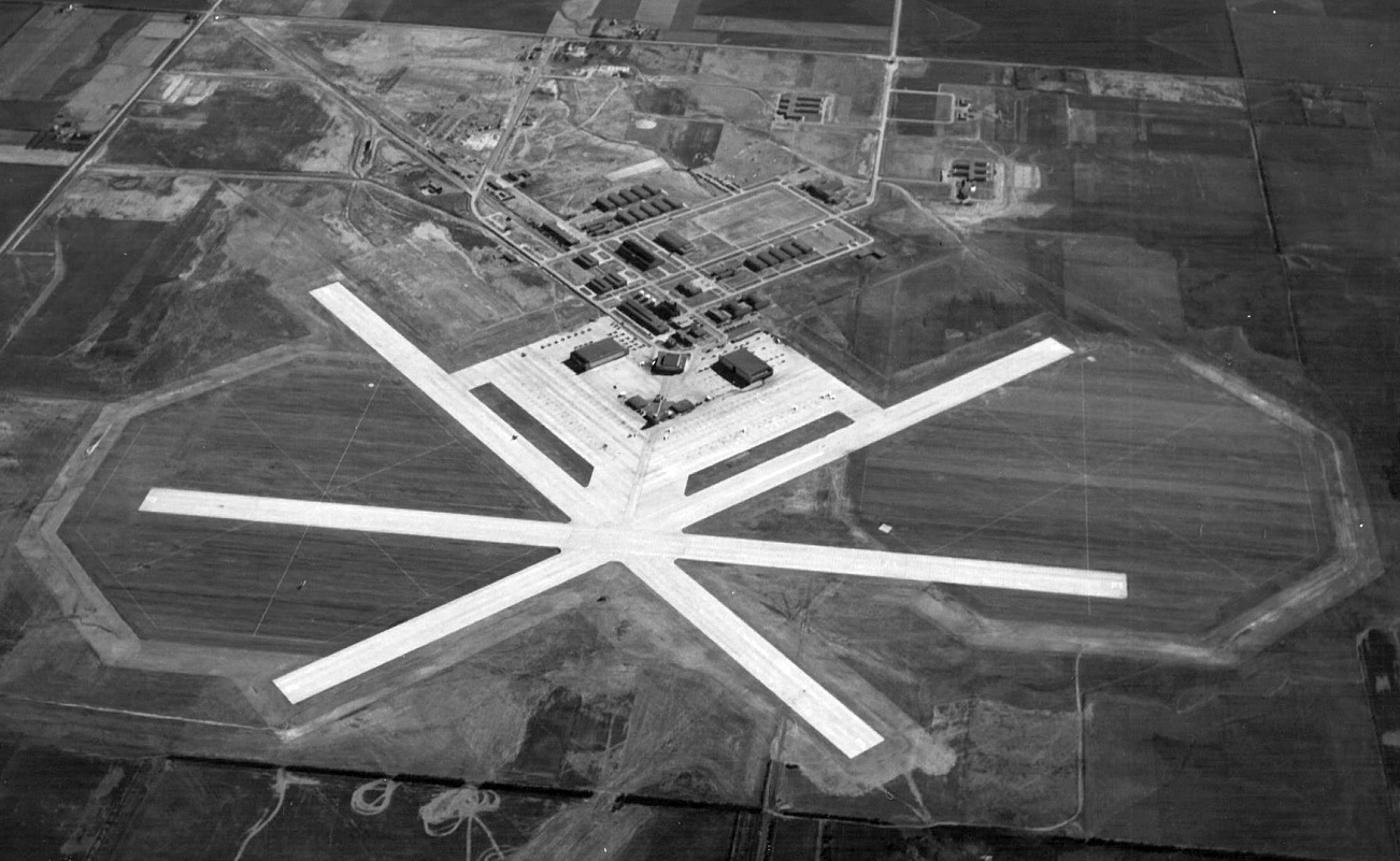
"Hutchinson ANG" was depicted in the 1960 Jeppesen Airway Manual (courtesy of Chris Kennedy)
as having a total of four 7,000' paved runways,
as well as numerous taxiways, the two large octagonal landing mats, a large ramp, and several hangars.
The airfield continued to be labeled "Hutchinson ANG"
on the May 1962 Wichita Sectional Chart (courtesy of Chris Kennedy) & the 1966 USGS topo map.
Kevin Knoll recalled, “I went to grade school in Hutchinson in the 1960s while my dad was with the 190th KANG at Sunflower.
One memorable Saturday, age 5, Dad took me on a tour.
We went up to the tower, I got a ride in a fire truck, and I got to ride along in the C-47 they taxied out for a maintenance run. Different times.”
Steve Hurst recalled, “Once following a very heavy snow storm, the station's helo landed at the end of our street to pick up the station Commanding Officer.
He lived in our neighborhood & couldn't get out the base due to the heavy snow.
The other memory is from early 1960s when the field was home to a KANG RB-57 squadron.
My next door neighbor's son, I went with him & his father, a maintenance chief, to watch a practice night photo run with 'flash bulb' -like flares fired from the bottom of the aircraft.
Starting the RB-57 required the insertion of a large black powder shell into a chamber in the engine.
When fired the blast provided the initial thrust to start the engine. From the outside it looked the engine blew up with A LOT of black smoke.”
Norman Bos recalled, “I graduated from Hutchinson High School in 1967.
One of my fondest memories of that time was the flyover of 12 RB-57s in tight formation as they left Hutchinson for Forbes in Topeka.
The sound was deafening at their low altitude as they flew over the town to salute their goodbye. I was sorry to see them go, but enthralled at their formation.”
According to William Gilliland, “The Air National Guard's 117th Tactical Reconnaissance Squadron (becoming the 190th TRG upon expansion in 1962)
was the sole operator of the base until 1967, when we were transferred to Forbes Field in Topeka.
The base at Hutchinson was closed at that time.
The State of Kansas considered it for a possible prison site, but that fell through.”
The Hutchinson airfield was labeled "Hutchinson ANG (Closed)" on the June 1968 Wichita Sectional Chart (courtesy of Chris Kennedy)
and the 1971 Wichita Sectional Chart (courtesy of Vince Granato).
At some point between 1971-74,
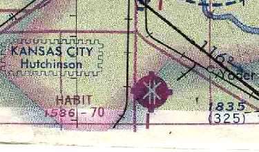
the former Hutchinson airfield was apparently reopened (once again) as civilian airfield, named "HABIT" Airport,
as that is how it was labeled on the May 1974 Wichita Sectional Chart (courtesy of Chris Kennedy).
According to Dan Downing (who grew up in Hutchinson), H.A.B.I.T. was the Hutchinson Air Base Industrial Tract,
"where Hutchinson used the large hangar buildings to attract businesses such as Collins Industries,
Bella Vista Manufactured Homes, Eaton Metal Tanks, Pioneer Seeds, etc.
Many of the large wooden structures burned to the ground at various times in the late 1960s & 70s."
Tom Dailey recalled, "In 1974, I was at Hutch' for a weekend of SCCA racing.
Per my Uncle's descriptions... the wind NEVER quit, and the rain was pretty intense as well.
Having been in the US Navy as a Radioman, I'll not forget the smells, sights, and sounds of the old terminal building... late at night.
We slept in the crew-ready quarters and about 0300 I couldn't sleep...
got up and just sat out in the briefing area…
you could almost hear the clipboards being shuffled, the clink of parachute harnesses,
and the chatter of aircrews preparing for an early-morning navigation mission.
It was very eerie, indeed.
Most of the stenciled notices were still on the bulkheads (walls),
and that good old lead-based Navy grey paint was intact and in good shape.
It was a trip back in time."
Kevin Knoll recalled, “Sunflower had a commercial skydiving operation, Sky Sports, operating there from about 1975-84. I started jumping there in 1977.”
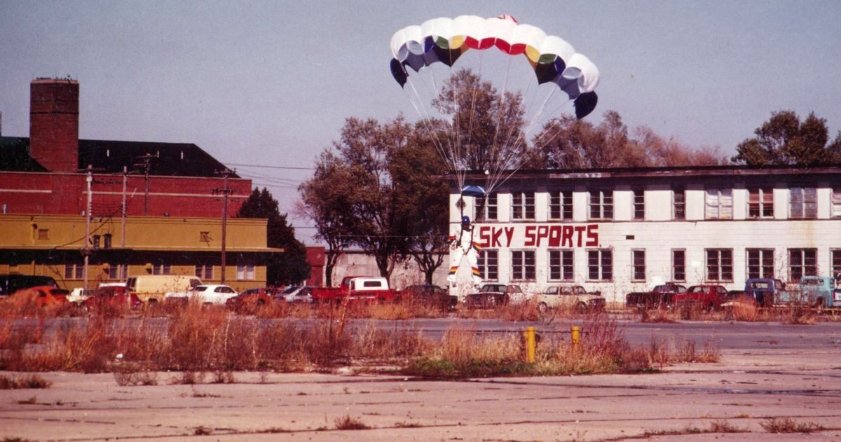
A circa 1981-84 photo by Kevin Knoll of a parachutist landing in front of the Sky Sports building at Hutchinson.
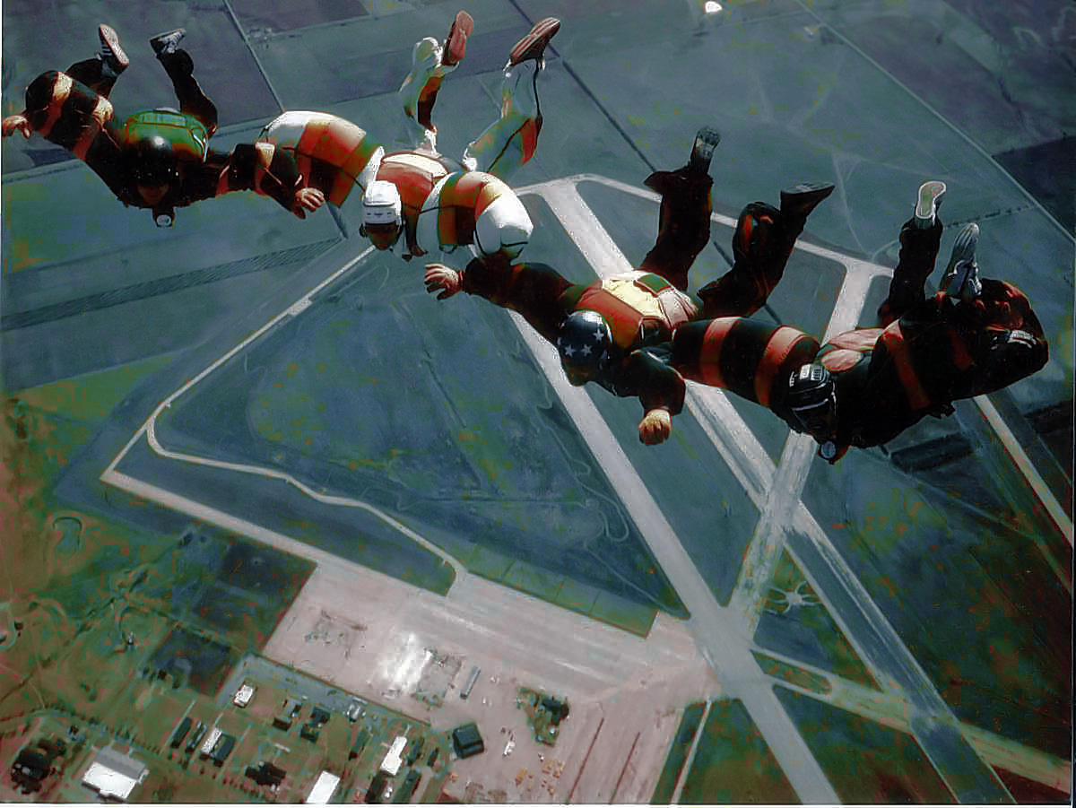
A circa 1981-84 photo by Kevin Knoll of skydivers free-falling over Hutchinson.”
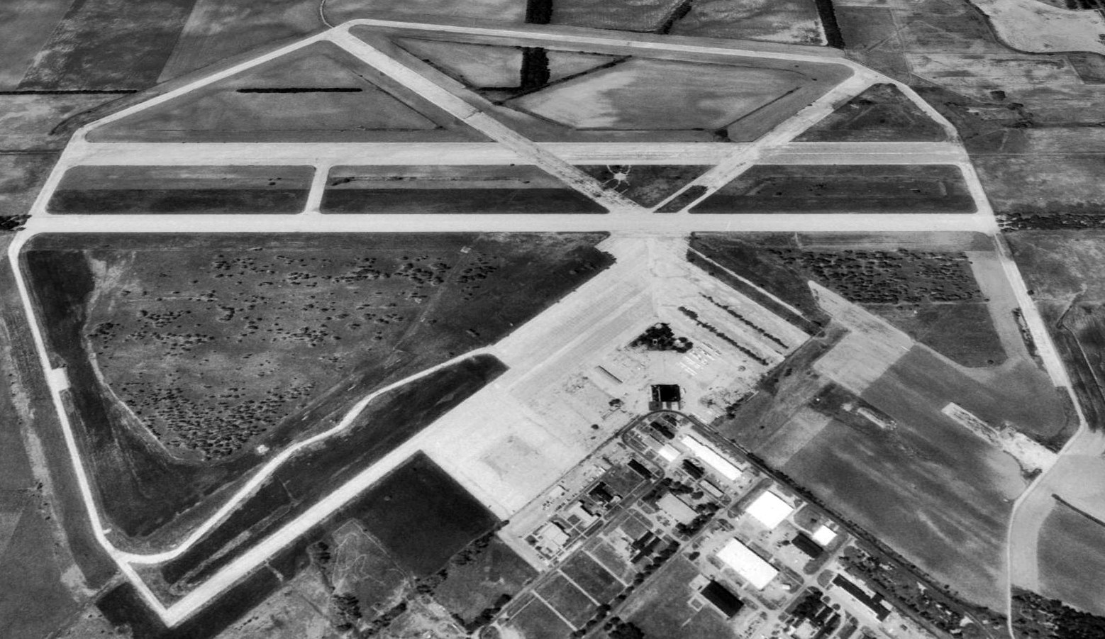
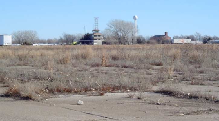
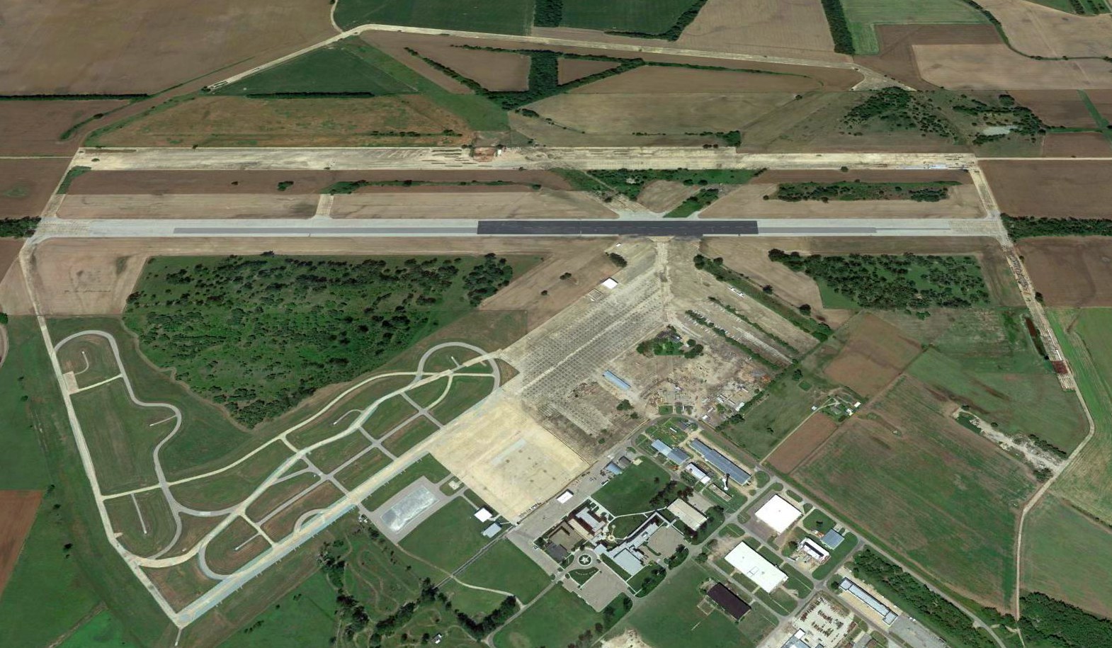
A 1992 USGS aerial view looking west showed that Hutchinson's remaining pavement on the former Runways 3/21 & 12/30 had been removed.
Runway 17L/35R appeared to be the only runway to still be maintained.
The pavement of Runway 17R/35L remained intact, but in significantly worse condition.
By 1998, the Hutchinson airfield was being operated as a private glider airport, the "Sunflower Gliderport",
which is ironic, given the airfield's large size.
Steve Arthur reported in 2003 that "Currently the base serves as an industrial park for Collins Industries
on the east side of the base (they make ambulances & school buses)
as well as the Kansas Law Enforcement Training Center on the west side.
The runway is used for emergency vehicle training."
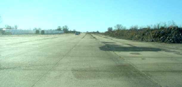
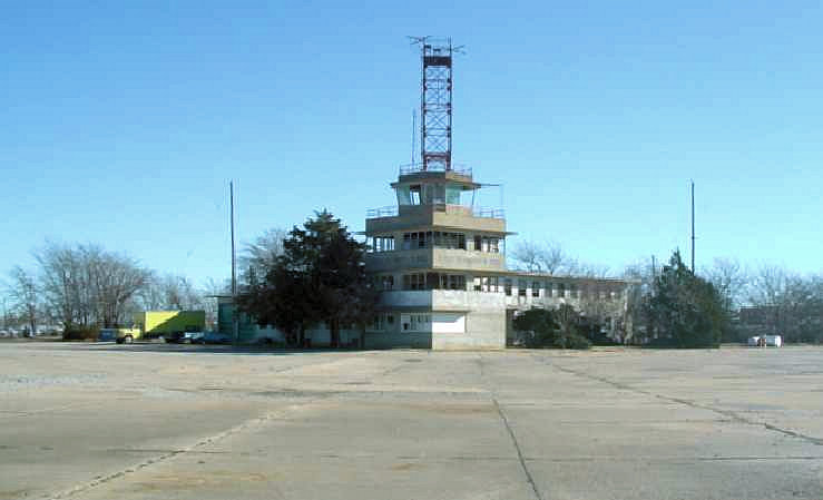
A 2003 photo by Terry Martin of the remains of a runway at Hutchinson.
A 2003 photo by Terry Martin of the former control tower & other buildings which remain standing at Hutchinson.
A 2003 photo by Terry Martin of the former control tower which remains standing at Hutchinson.
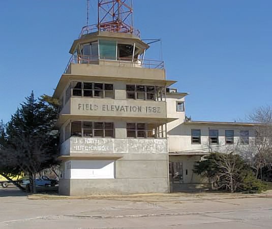
A 2003 photo by Terry Martin of the former control tower which remains standing at Hutchinson.
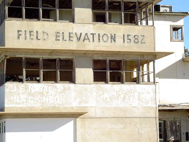
A 2003 photo by Terry Martin of the former control tower which remains standing at Hutchinson.
Terry Martin recalled, "My dad was stationed at NAS Hutchinson.
While visiting family last week [in 2003] that still lives in Hutchinson we visited the old air base.
What a site. The tower is still standing, but most of the windows are missing,
and the ceiling & floors are in bad shape.
The present owner told us it was OK to look around so we did."
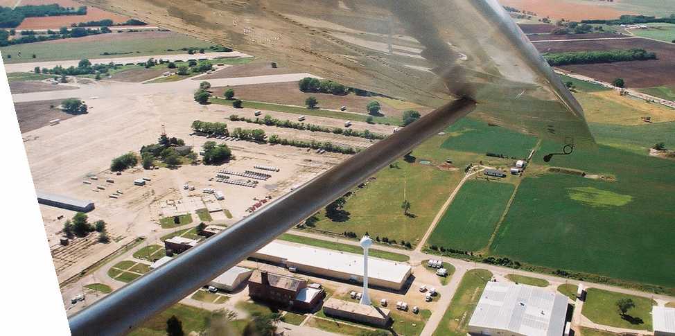
A May 2004 aerial view by Randy Colby looking west at the Sunflower Gliderport, taken from a Schweizer 2-33 glider.
Laura Laster reported in 2004 that "Sunflower Field" was described in a book called "Ghosts of the Air" by Martin Caidin.
J. Godwin reported in 2004, "Of the base itself most of the buildings have been razed
except for the Link Trainer, parachute packing, commissary, tower, and administration buildings.
The large hangar foundations are still there.
I found the steps that once led up to the pool building still in good shape.
An ambulance conversion business has built their factory right on top of the old foundation."
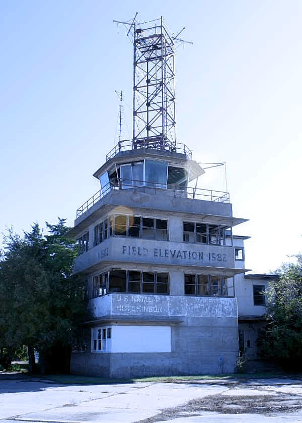
A 9/15/08 photo by Susan Ford of the former NAS Hutchinson control tower.
A 2012 photo by Josh Peach of the NAS Hutchinson control tower.
Josh observed, “From what I could see here, the condition had deteriorated a lot from the pictures from 2008. The tower had just one window pane in it.”
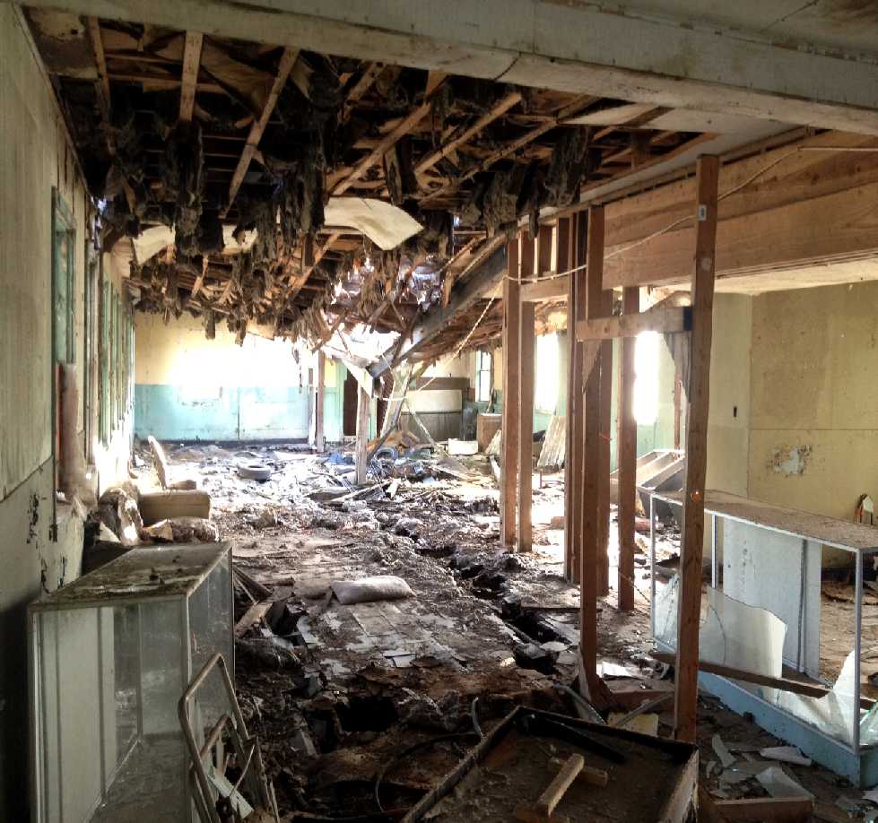
A 2012 photo by Josh Peach of the interior of the NAS Hutchinson control tower.
Josh observed, “Inside the first floor, I think this used to be office space. But the roof is caved in about halfway back & is being held up with a couple 2 x 4s.”
A 2015 aerial view looking west at Hutchinson showed Runway 17L/35R was the only runway still maintained.
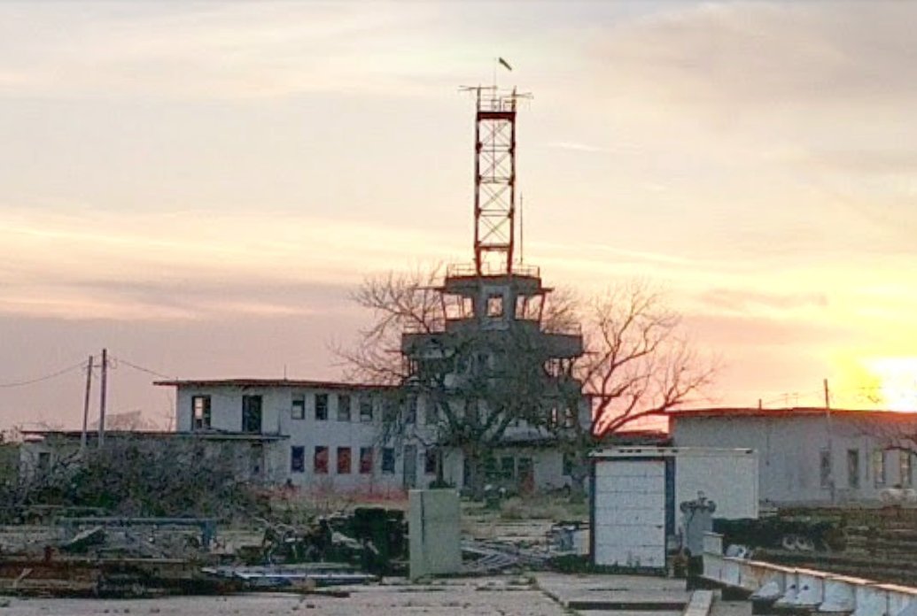
An April 2017 photo looking west at the sad state of the NAS Hutchinson control tower.
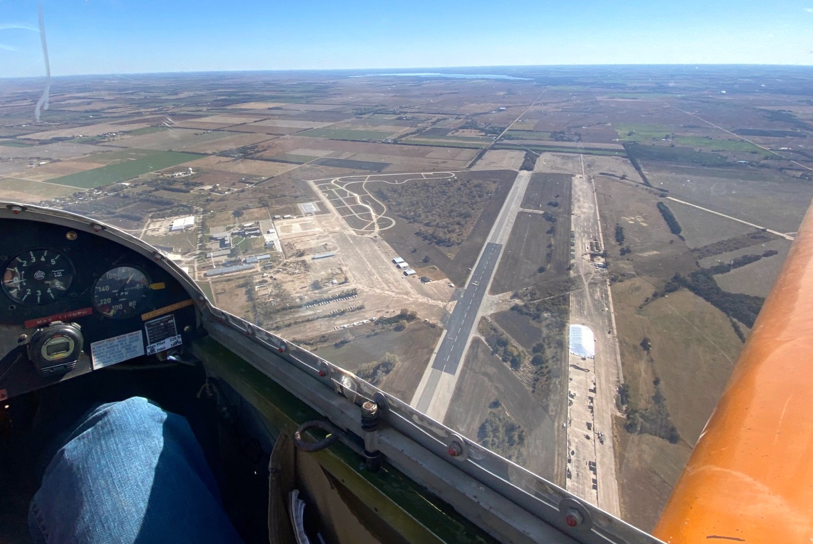
A 2020 aerial view looking south at Sunflower Gliderport by Zachary Wilkinson, taken from a Schweizer SGS 1-26D glider.
Zachary Wilkinson reported, “At the Sunflower Gliderport, the Kansas Soaring Association uses a small upkept portion of the old east runway & ramp for our gliderport operations.
On the west runway, local farmers store and dry grain in season. There is also a portion used for drag races.”
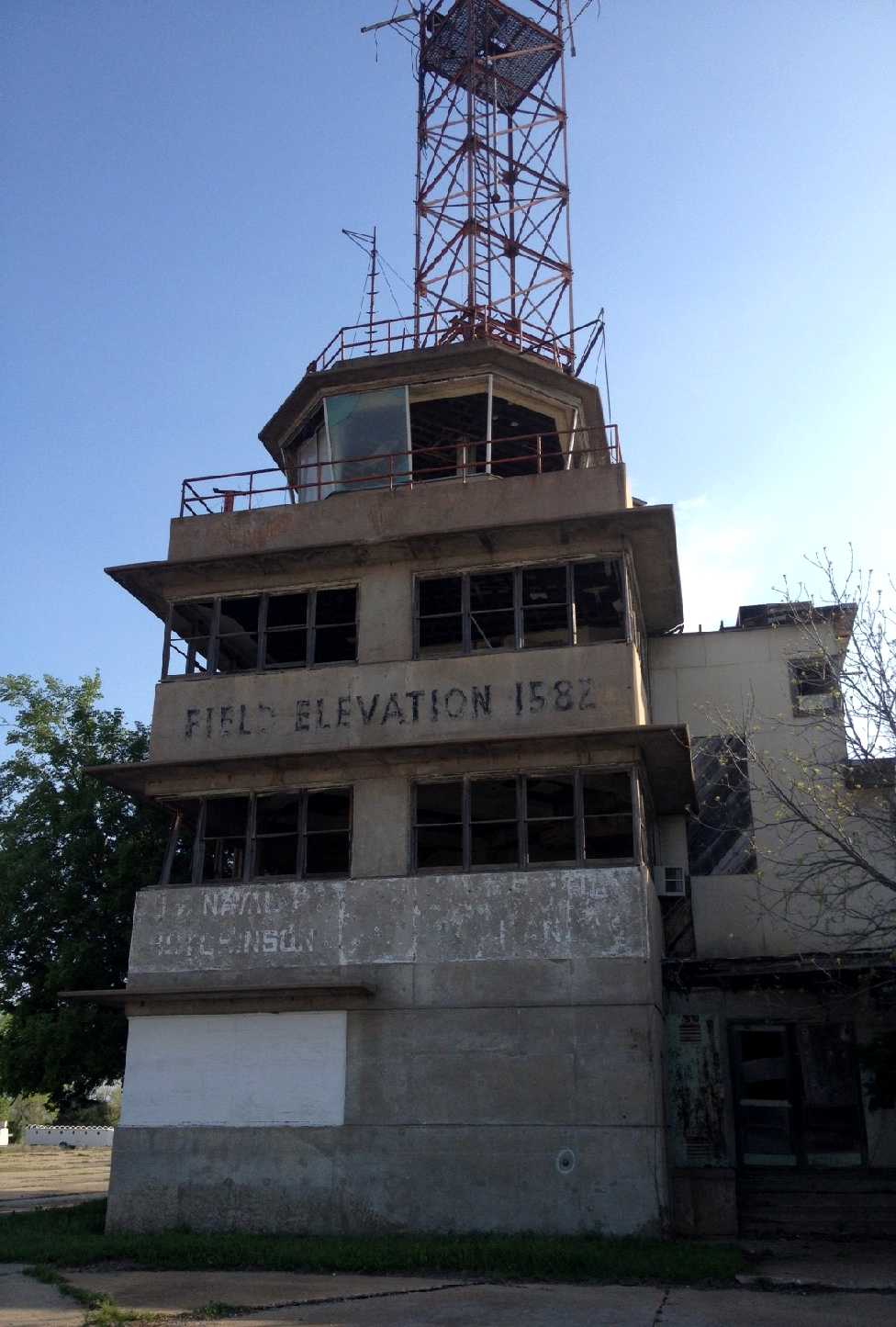
A 2020 photo by Zachary Wilkinson of the remains of the NAS Hutchinson control tower, showing that everything except the concrete structure had been removed at some point between 2012-2020.
Zachary Wilkinson reported, “The old tower is standing strong but the dilapidated surrounding structure has been removed because of the safety hazard.
There are plans to one day renovate it into a clubhouse of sorts with a simple bar & some sleeping accommodations.”
A January 2023 photo by Dave Noordeloos of the remains of the NAS Hutchinson control tower.
____________________________________________________
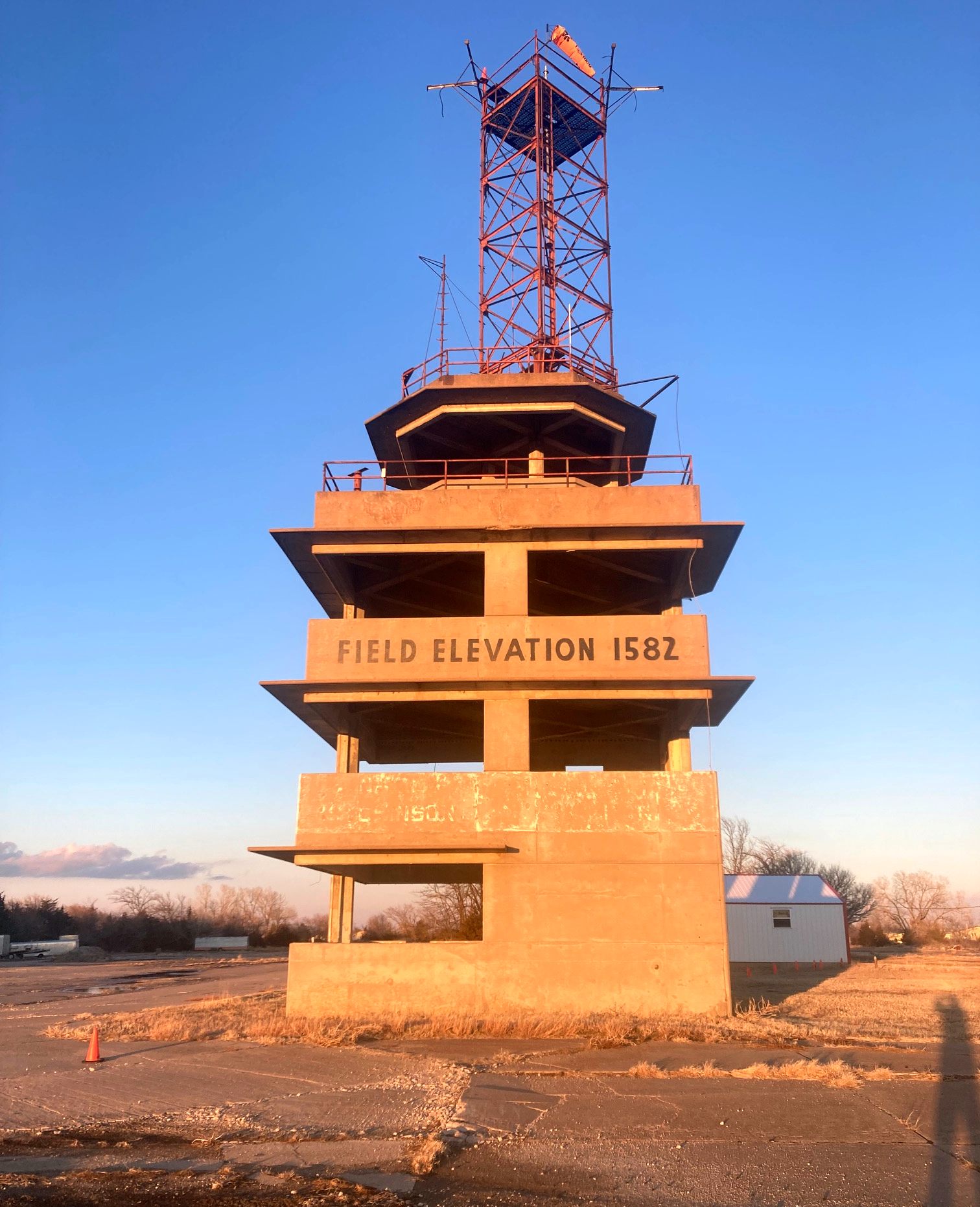
Walker Army Airfield / Victoria-Pratt Airfield, Walker KS
38.893, -99.096 (Northwest of Wichita, KS)
Walker AAF, as depicted on the February 1943 8M Regional Aeronautical Chart (courtesy of Chris Kennedy).
A total of 1,888 acres of land were purchased from local owners & leased from the nearby Union Pacific Railroad
to constructed a satellite field to assist Smoky Hill AAF (in Salina, KS)
in the training of heavy bomber crews, primarily B-17s & B-24s.
Construction began on 9/14/42. Originally, the field had one hangar.
Three runways were constructed, each measuring 8,000' x 150', along with a 375' x 300' apron.
It was known for a time as Hays-Walker Airfield.
Walker was further expanded in 1943 to encompass a total of 1,888 acres,
to prepare for its new mission as one of 4 fields in Kansas intended to train B-29 bomber crews.
The earliest aeronautical chart depiction of Walker AAF which has been located
was on the February 1943 8M Regional Aeronautical Chart (courtesy of Chris Kennedy).
Four additional hangars were added in 1943,
bringing the base to its ultimate complement of 5 hangars.
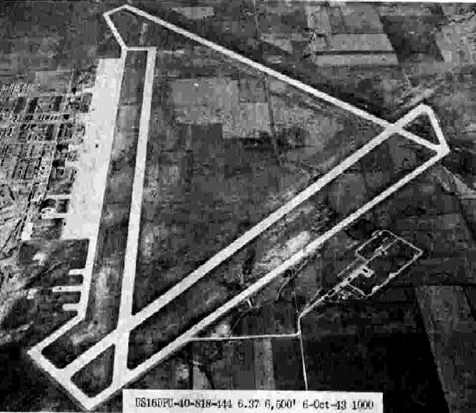
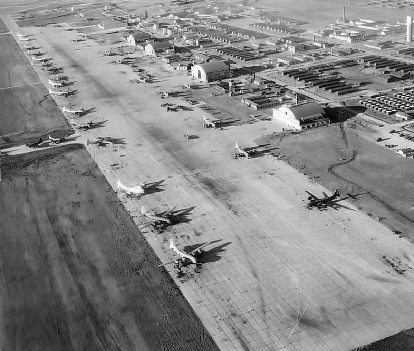
The earliest photo which has been located of Walker AAF
was a 10/6/43 aerial view looking north from the 1945 AAF Airfield Directory (courtesy of Scott Murdock).
It depicted Walker as having 3 paved runways, a huge paved ramp, and several hangars.
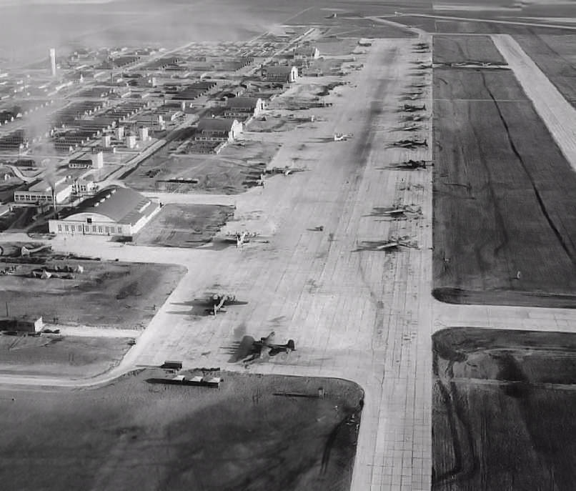
A circa 1944 aerial view looking north along the Walker ramp (courtesy of Keith Goetz)
showed large numbers of B-29s & 5 large hangars.
A circa 1944 aerial view looking southwest along the Walker AAF ramp (courtesy of Keith Goetz),
showing large numbers of B-29s, 5 large hangars, and the control tower.
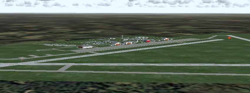
A recreation of the WW2-era configuration of Walker AAF via Flight Simulator scenery created by Robert Pearson.
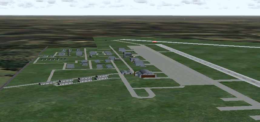
A recreation of the WW2-era configuration of Walker AAF via Flight Simulator scenery created by Robert Pearson.
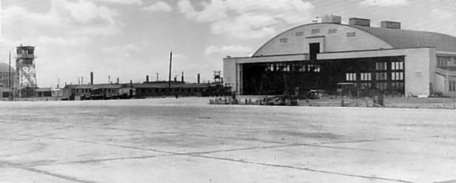
A WW2-era view of a Walker hangar & control tower (courtesy of Keith Goetz).
The 1944 US Army/Navy Directory of Airfields (courtesy of Ken Mercer)
described Walker AAF as having a 6,800' hard-surface runway.
Walker AAF was still depicted as an active airfield
on the March 1945 Salina Sectional Chart (courtesy of Chris Kennedy).
The 1945 AAF Airfield Directory (courtesy of Scott Murdock) described Walker AAF
as a 1,760 acre irregularly-shaped property having 3 concrete runways.
The field was said to have 5 concrete hangars, the largest being a 202' x 145' structure.
The field was said to be owned by the U.S. Government & operated by the Army Air Forces.
In 1946 Walker was put on inactive status,
and was transferred to the District Engineers, Kansas City.
It was later known to the Air Force as Victoria Air Force Auxiliary Field,
although apparently no Air Force personnel were assigned there in the post-war period.
The hangars were used for grain storage & the runways for drag racing during the 1940s & 1950s.
From 1948-1952, crop-dusting planes were stored in the old Maintenance hangar.
It was labeled as "Victoria AF" on the March 1949 Salina Sectional Chart (courtesy of Chris Kennedy)
and the June 1954 USAF Salina Sectional Chart (courtesy of Chris Kennedy),
both of which depicted the field as having a 8,000' hard surface runway.
In December of 1958 the government held an auction to sell the many acres of the former airfield.
It was purchased by Don & Ida Pratt.
A 5/25/59 USGS aerial view depicted the massive aviation infrastructure which remained at the site of Walker AAF.
Two Walker AAF hangars burned down in 1959.
By the time of the April 1965 USAF Salina Sectional Chart (courtesy of Chris Kennedy),
"Victoria-Pratt" was depicted as a private airfield.
All three runways were depicted on the chart,
but the Aerodromes table said that only one 8,000' concrete runway was used,
and the remarks said: "Private. North/South only runway open. Use caution."
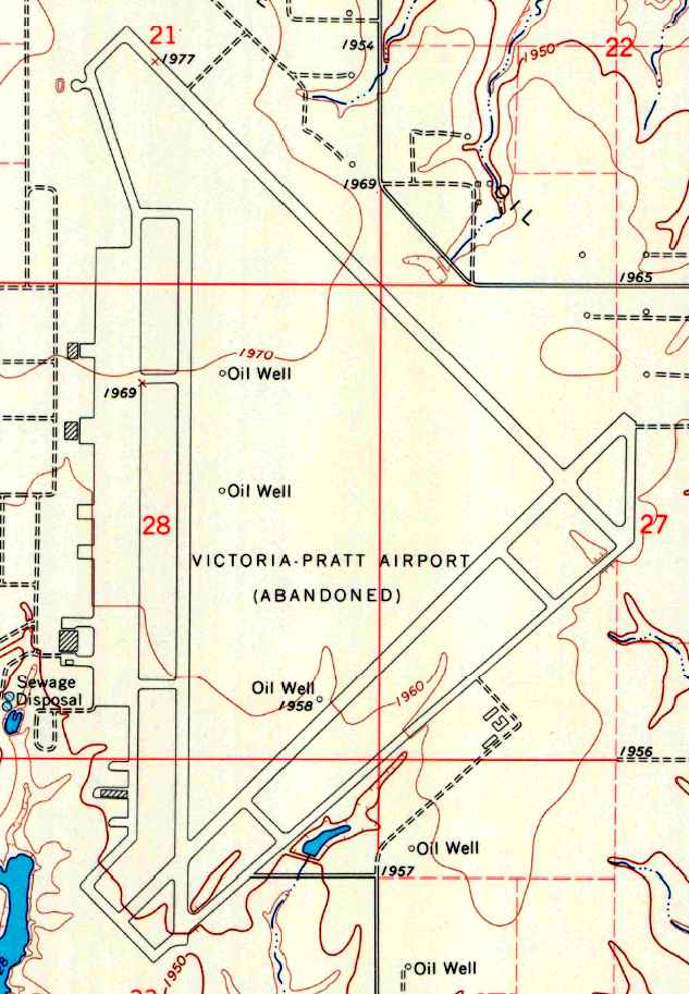
The 1967 USGS topo map depicted the “Victoria-Pratt Airport (Abandoned)”
as having 3 paved runways, taxiways, a ramp, and 3 hangars.
The former Maintenance hangar burned down in 1967.
The Victoria-Pratt Airfield was apparently abandoned at some point between 1965-68,
as nothing was depicted at this location on the September 1968 Salina Sectional Chart (according to Chris Kennedy)
and it was not listed among active airfields in the 1968 Flight Guide (courtesy of Robert Levittan).
It was depicted as an abandoned airfield
on the 1971 Wichita Sectional Chart (courtesy of Vince Granato).
In 1971, the Air Force leased the NE/SW runway for a study dealing with explosive cratering.
However, the current owner of the site has said the study had been done shortly after WW2.
The craters are still visible & vegetation & trees have voluntarily grown in the crater holes.
Keith Goetz confirmed, “The runways were bombed in the early 1970s.
We live less than 2 miles away & listened to the explosions every day when I was a freshman in high school.”
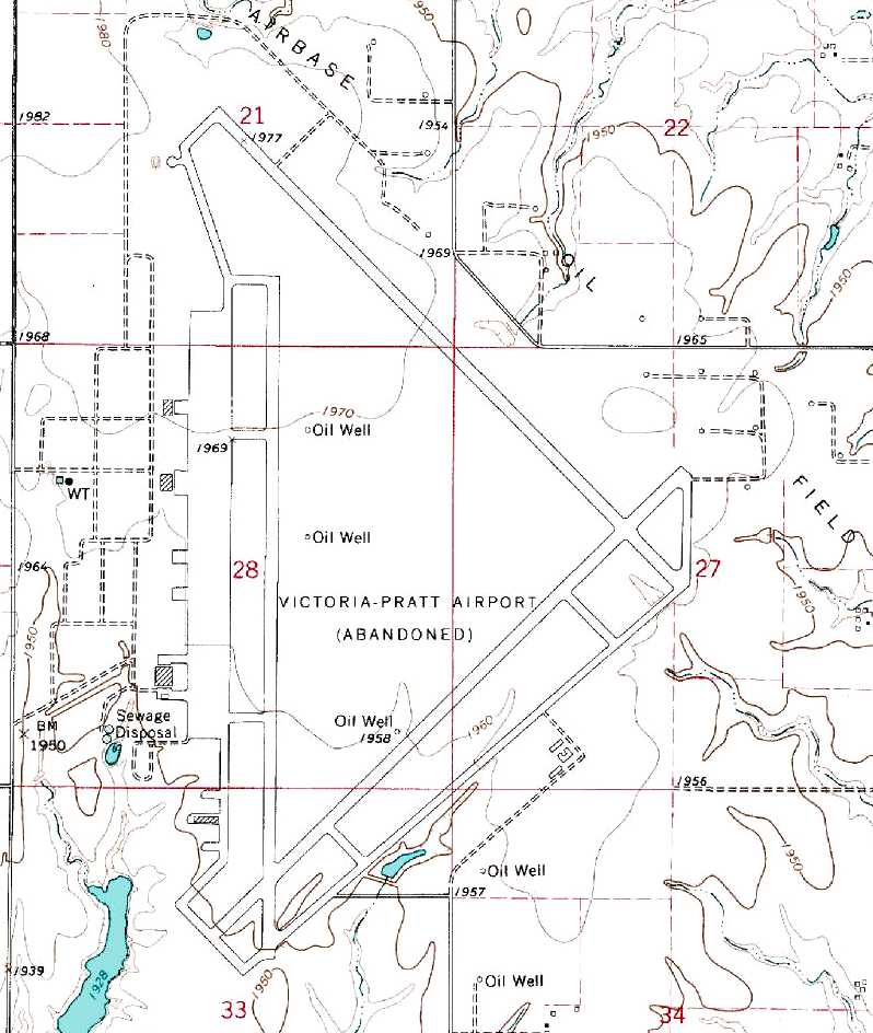
The 1981 USGS topo map depicted the “Victoria-Pratt Airport (Abandoned)”
as having 3 paved runways, taxiways, a ramp, and 3 hangars.
The Walker property was sold in 1991 to Wilfric Karlin for around $2 million.
In 1992 government personnel and property owner Wilfric Karlin performed a walkover.
It was determined there was still hazardous waste left behind from the Army,
with 0.30 & 0.50 caliber casings & bullets found on the former target range at the north end of the site.
The sewage treatment system in the southwest part of the field was still present although inoperable.
All pollution was cleaned up with government funds reserved for such operations after the walkover.
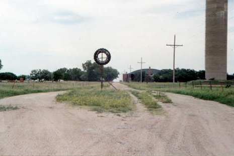
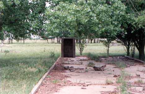
A 2001 photo by Steve Arthur of what was previously the main entrance gate of Walker AAF.
The grassy area in the middle of the photo is where the gate shack stood.
The base headquarters was located just beyond the water tower & to the right.
The road which leads into the base was designated "B" street.
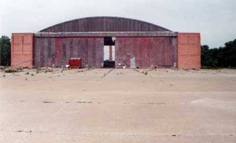
A 2001 photo by Steve Arthur looking west at the front of Hangar "B".
"If you look close, you'll notice a speck in a blue shirt to the right side of door opening
and near the large sheet of metal, that speck is me.
To give you an indication as to how large these hangars are, I'm six foot two inches tall.
I was told that these hangars were capable of housing two B-29s.
Walker also had a maintenance hangar which was capable of housing four B-29s.
The maintenance hanger no longer stands due to a senseless act of arson.
Two other of Walker's hangars have met the same fate in recent years."
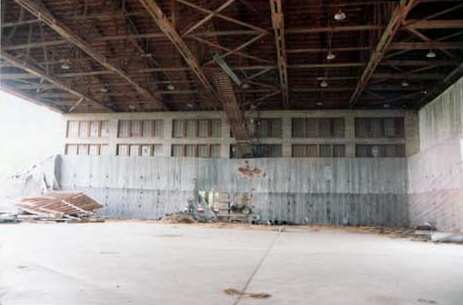
A 2001 photo by Steve Arthur of the interior of Hangar B.
The majority of the buildings on Walker were either of wood frame or poured concrete construction.
What little brick that was used, was of lower quality & was known as 'War Brick'.
When Walker & the other B-29 bases were constructed,
it was under the assumption that they would not be needed more than five years.
Fifty six years later most are still standing."
which was used to secure the sensitive Norden bombsights.
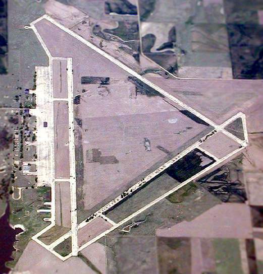
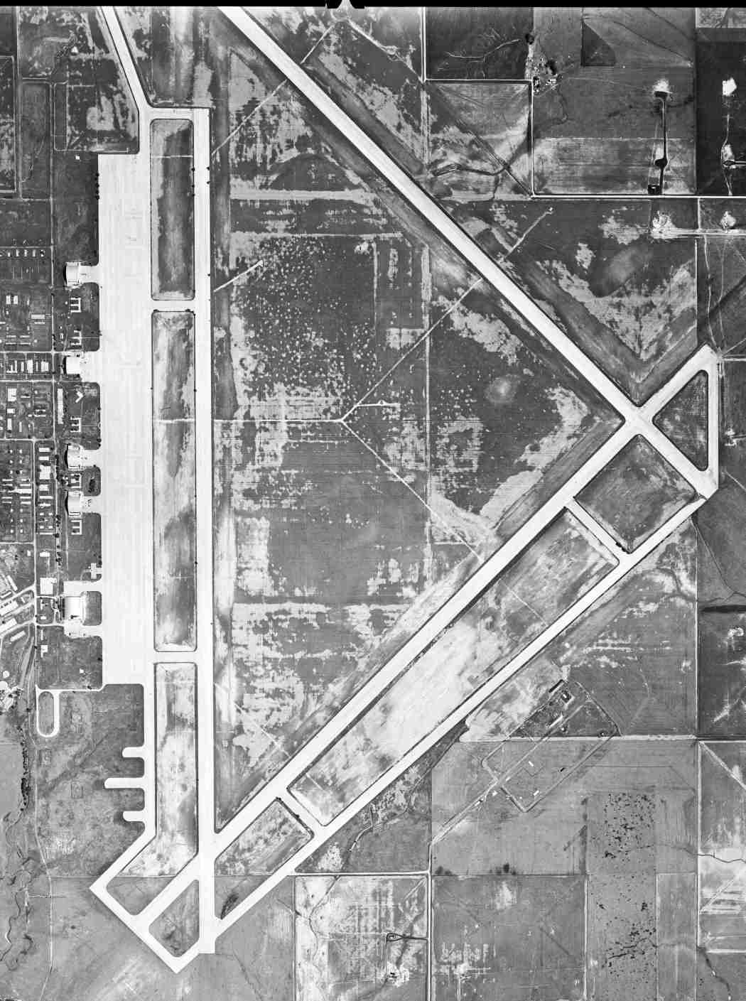
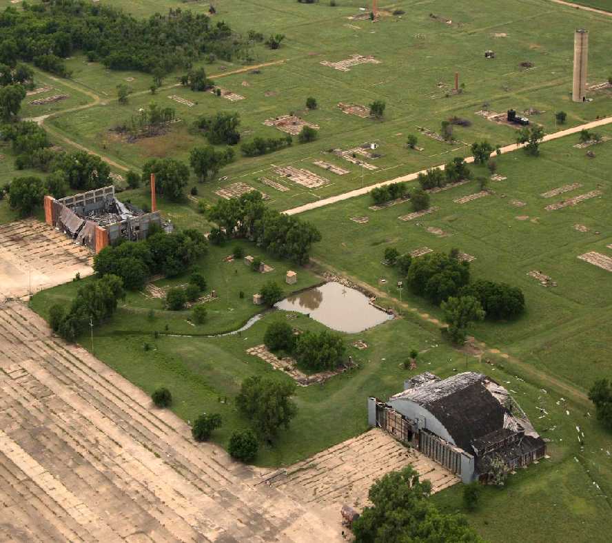
A 2002 aerial view looking north at Walker AAF.
A 2002 aerial view by Dan Wright looking southwest at the the ramp & remaining hangars at Walker AAF.
A 2002 aerial view by Dan Wright looking northwest at the craters on the NE/SW runway.
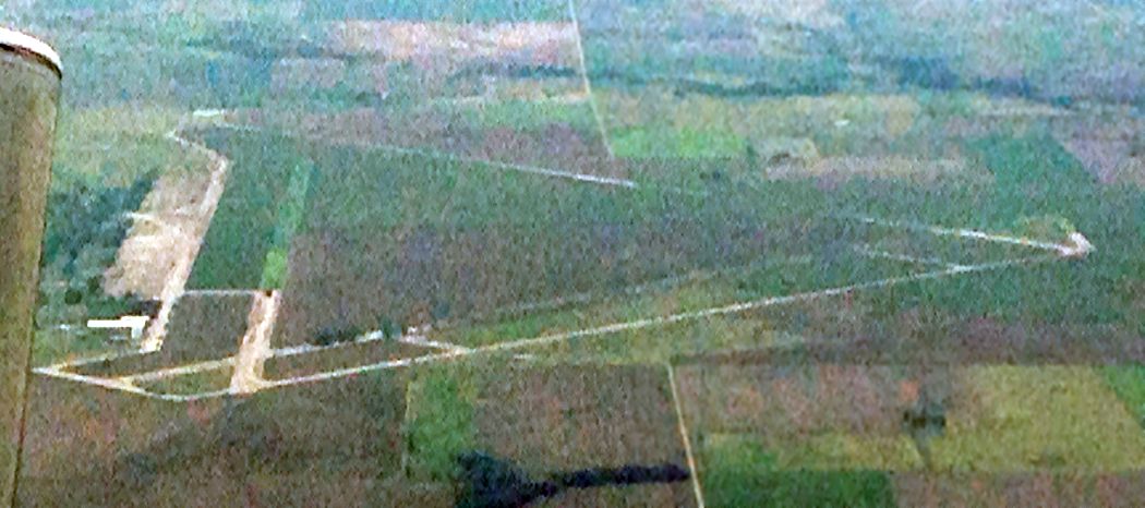
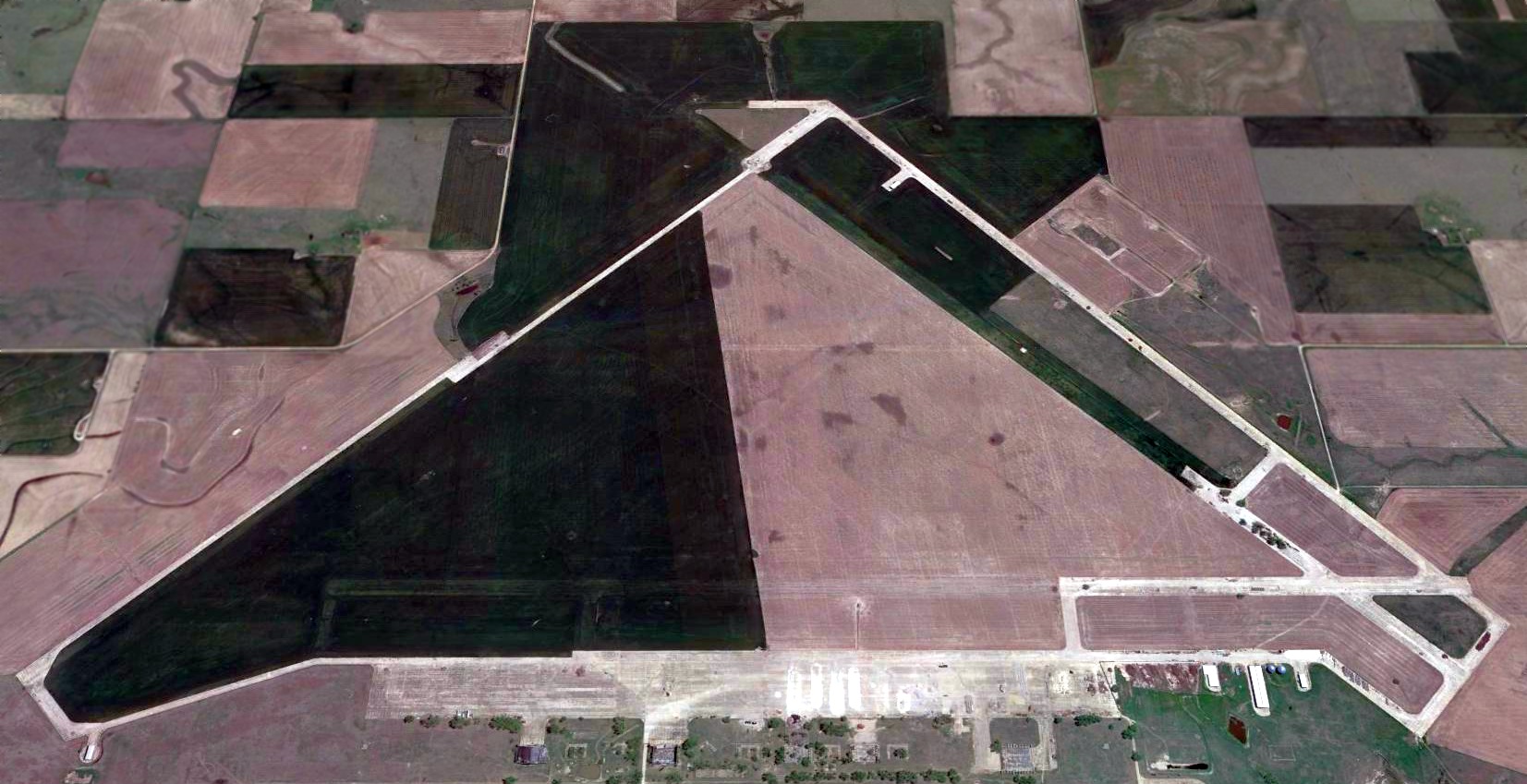
Walker is a very large airfield to be completely abandoned:
consisting of 3 runways (each approximately 8,800 ft long),
taxiways & a large paved ramp area, all still in very good condition
(except for the aforementioned test craters in the NE/SW runway).
Two original military hangars still stand alongside the ramp.
The site is presently used for agricultural purposes.
Walker resident Keith Goetz reported in 2008, “As of a few months ago,
they've started grinding up the runways & selling the aggregate for such things as driveways.
The hangars collapse a little more everyday, and it is a shame it was never preserved.”
A 6/23/08 photo by Susan Ford of the ruins of a Walker hangar.
A 6/4/09 aerial view by John English looking northeast at the massive Walker runways, taken from a “mighty 152”.
A 6/4/09 aerial view by John English looking southwest at the remains of 2 Walker hangars.
An August 2014 aerial view by Steve looking south at the remains of Walker AAF. Steve observed, “Most runway surfaces & hangars are gone.”
A 2016 aerial view looking east at the remains of Walker AAF.
The ramp pavement & a portion of 2 runways & several taxiways remain, but the majority of the runway pavement has been removed.

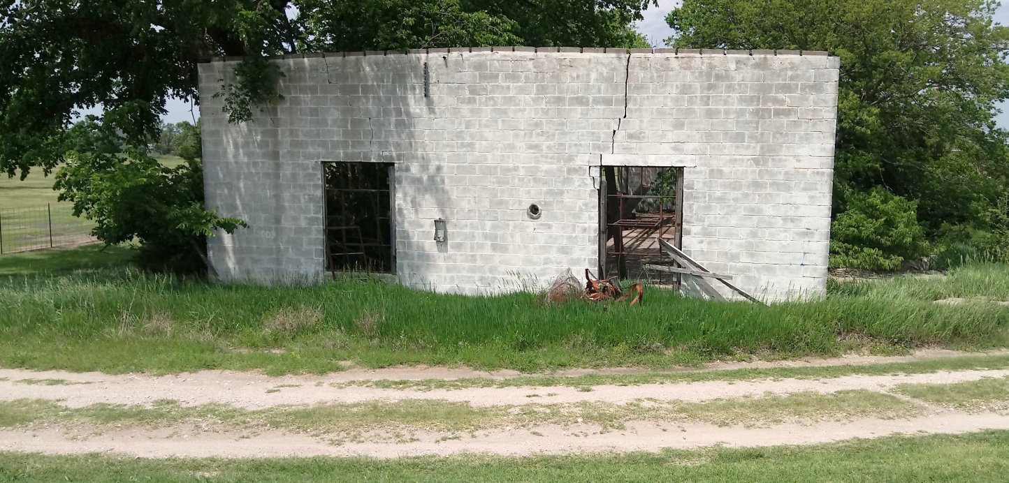
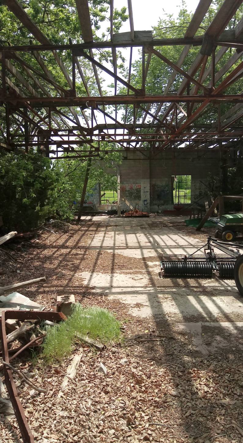
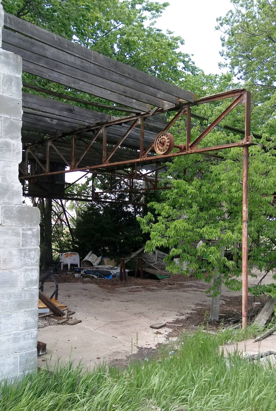
An August 2024 photo by David Jafray of the ruins of a Walker hangar.

An August 2024 photo by David Jafray of the ruins of a Walker hangar.
____________________________________________________
Or if you prefer to contact me directly concerning a contribution (for a mailing address to send a check),
please contact me at: paulandterryfreeman@gmail.com
If you enjoy this web site, please support it with a financial contribution.
____________________________________________________
This site covers airfields in all 50 states.