
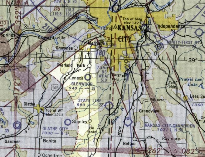
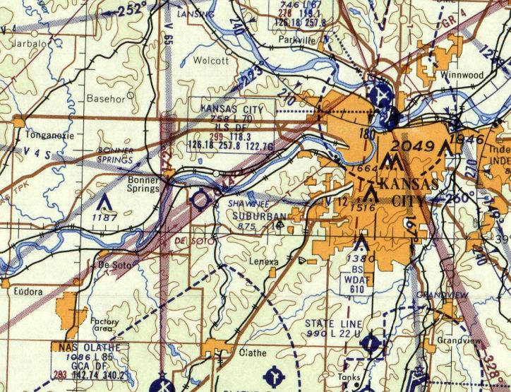
Abandoned & Little-Known Airfields:
Eastern Kansas
© 2002, © 2026 by Paul Freeman. Revised 2/15/26.
This site covers airfields in all 50 states: Click here for the site's main menu.
____________________________________________________
Please consider a financial contribution to support the continued growth & operation of this site.
Coffeyville Municipal Airport (original location) (revised 2/8/21) - Coffeyville Aux AAF #3 / Independence Aux AAF #3 / Edna Municipal (revised 2/8/21)
Conard Field / Intermediate Field Site 42B (revised 2/1/21) - Dempsay Farm Airport (revised 9/7/24) - Gilmore Airport (revised 9/8/22)
Glenwood Airport (revised 1/15/24) - Kansas City Suburban Airport / Bonner Springs Airport (revised 9/9/25)
Sweeney Airport / Fairfax Airport / Fairfax AAF (revised 2/15/26) - State Line Airpark (revised 1/15/24)
____________________________________________________
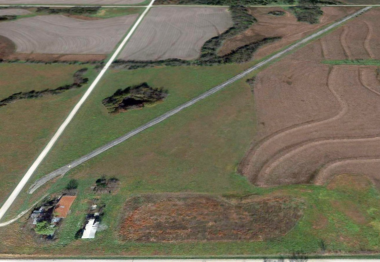
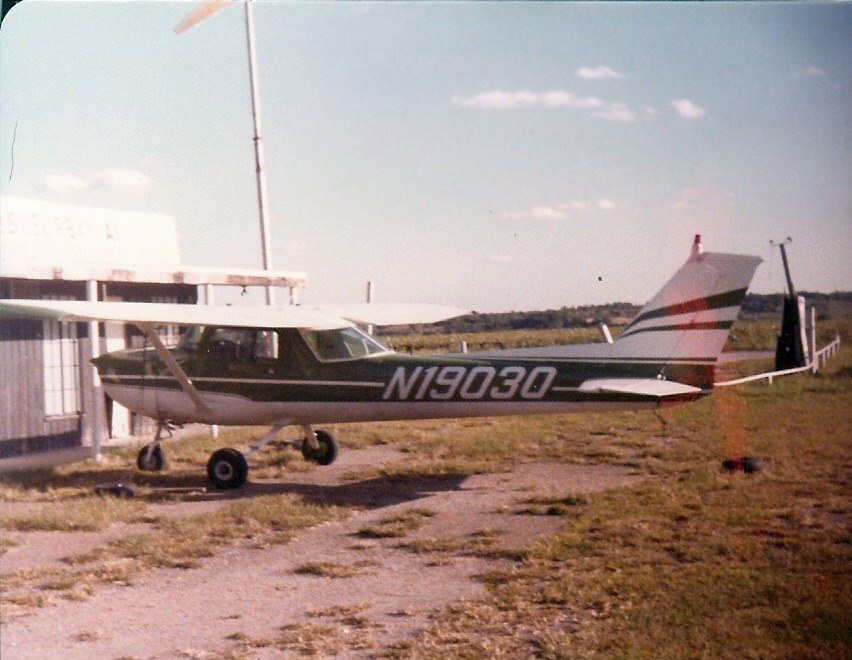
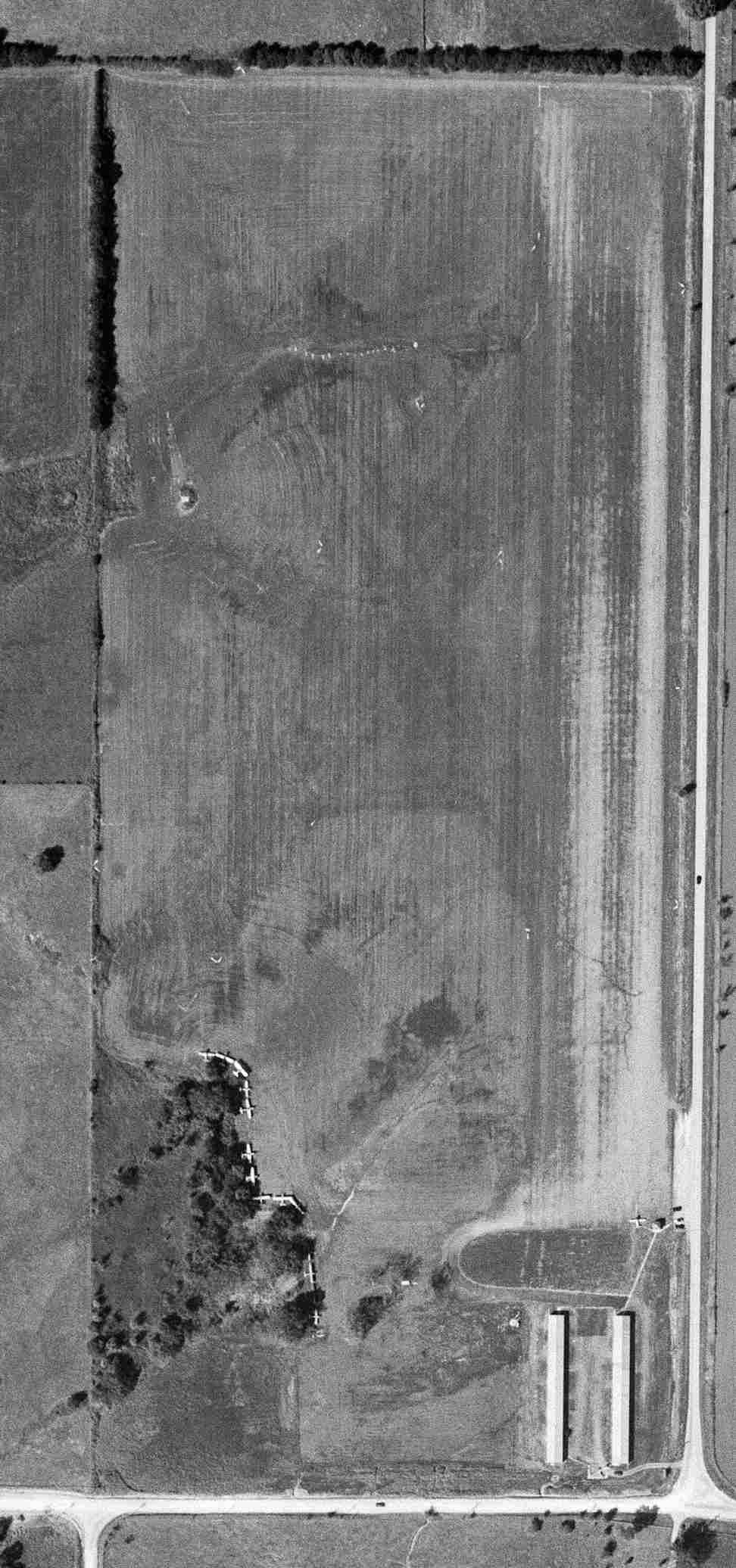
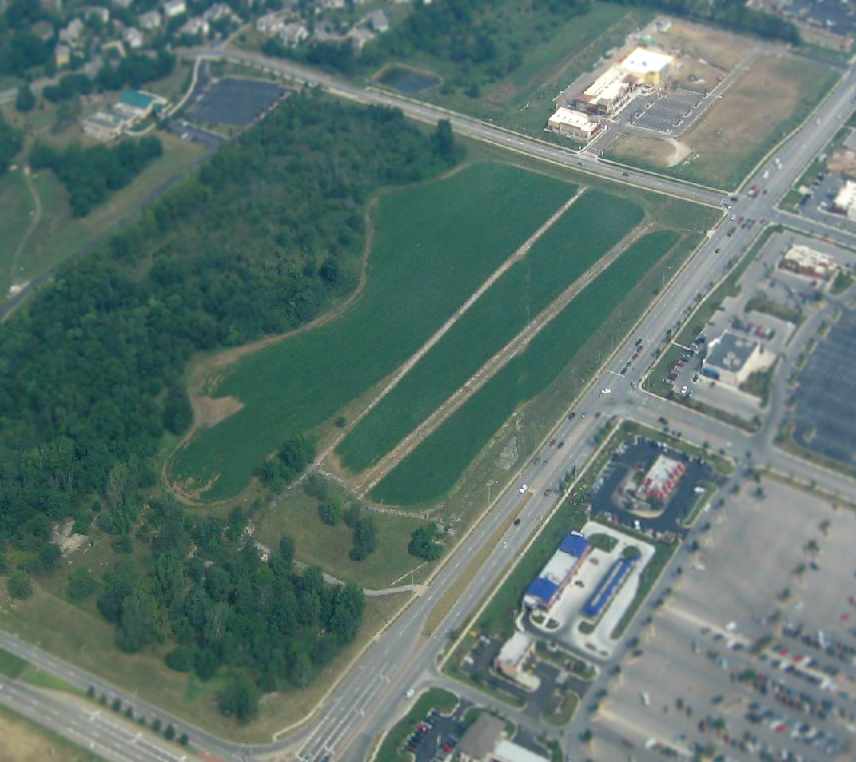
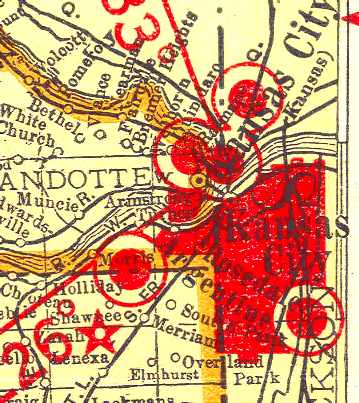
Dempsay Farm Airport, Rantoul, KS
38.542, -95.104 (Southwest of Kansas City, MO)
Dempsay Farm Airport was simply depicted as “Landing Strip” on the 1983 USGS topo map.
This airfield was evidently established at some point between 1964-81,
as it was not yet depicted on a 1959 aerial photo or the 1964 USGS topo map.
The earliest depiction which has been located of this airfield was a 1981 aerial photo.
It depicted 3 grass runways, with at least 4 aircraft parked near some buildings on the east side.
The 1983 USGS topo map depicted a single unpaved northeast/southwest runway, labeled simply as “Landing Strip”.
According to their website, Dodson International Parts, Inc. was founded in 1984.
Located immediately across the road from this airfield, Dodson eventually grew to be a major aircraft parts recycling/sales firm, which has dismantled over 3,000 aircraft.
Dennis Boykin recalled, “Dempsay Farm Airport is the home of Dodson International.
Originally founded in Ottawa, KS, Dodson outgrew that space & bought the farm in Rantoul to expand.
Rantoul's not listed on any Sectionals so as to not attract traffic. The runways almost never are used for takeoff - airplanes go there to become parts for other planes.”
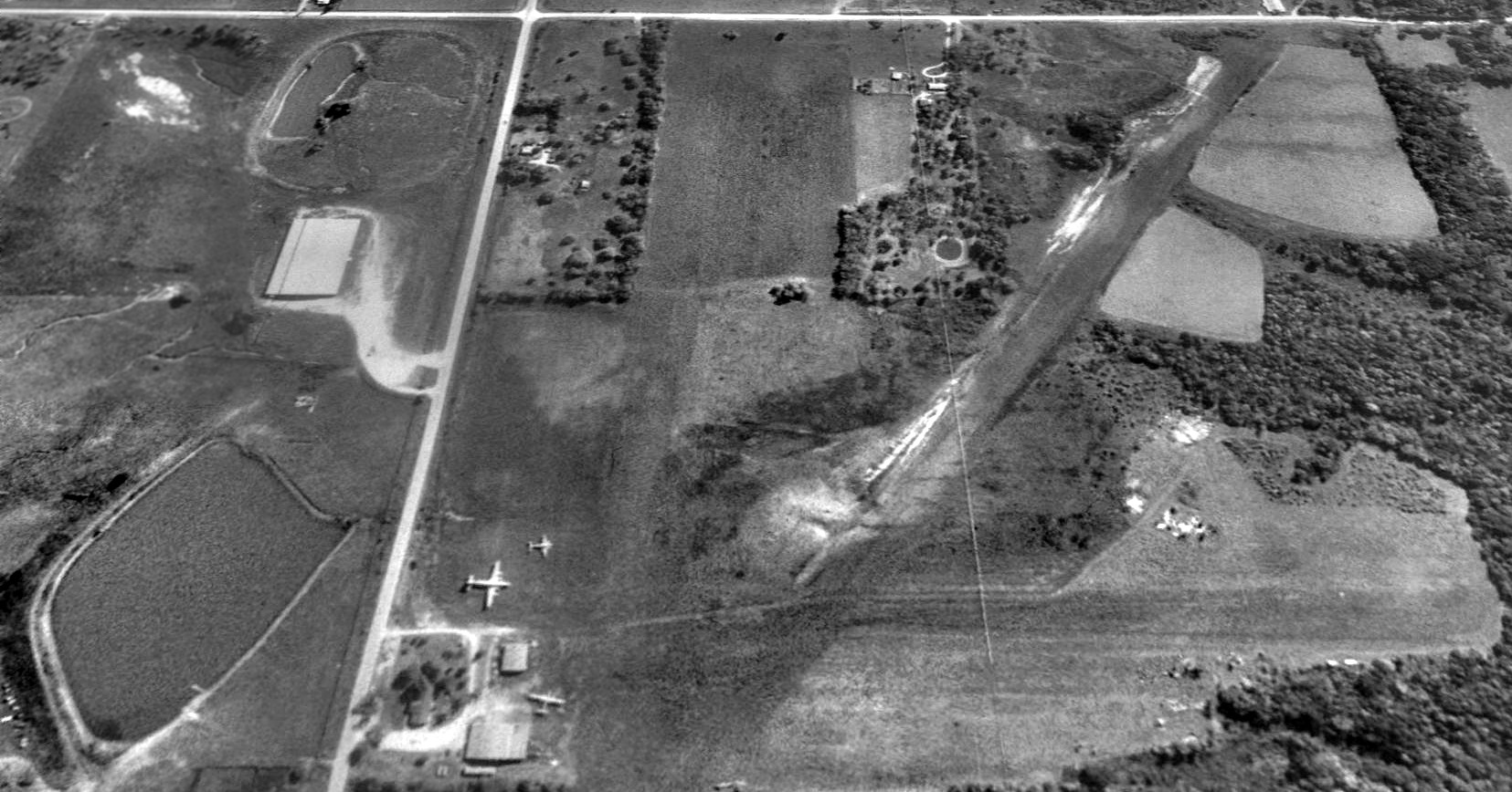
The earliest photo which has been located of the Dempsay Farm Airport was a 1991 USGS aerial view looking south.
The airfield consisted of 3 grass runways, the longest being the 3,000' northeast/southwest strip.
Three aircraft were visible on the northeast side of the airfield, including one large 4-engine transport (model unknown).
No airfield at this location was depicted on the 1993 Kansas City Sectional Chart.
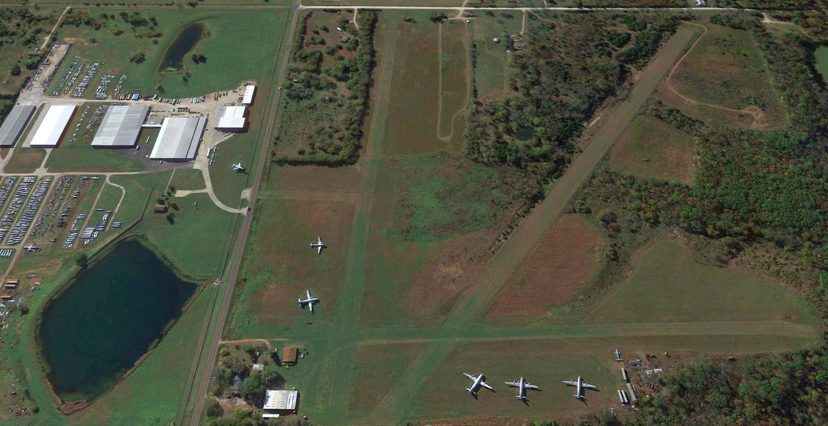
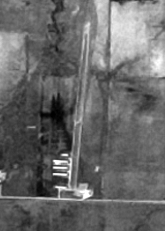
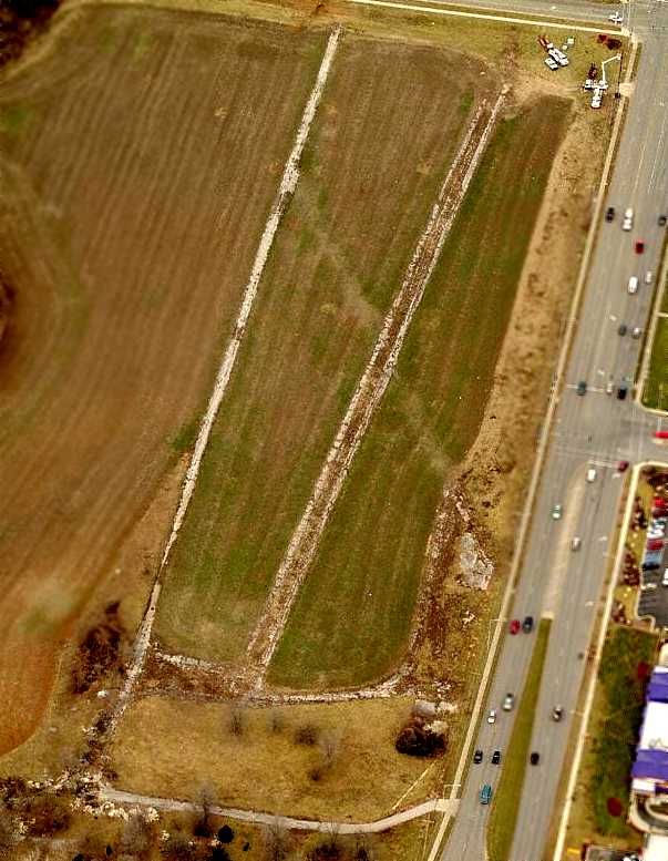
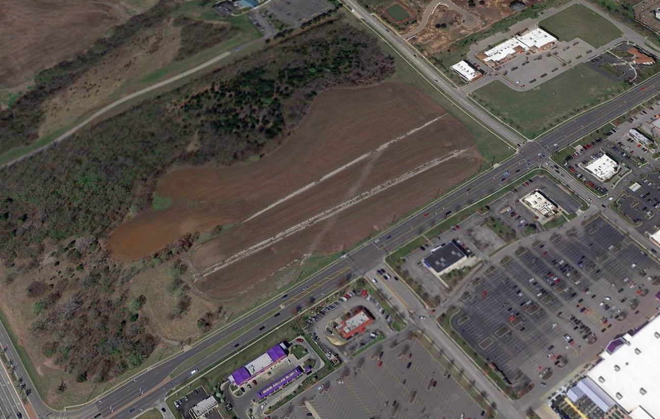
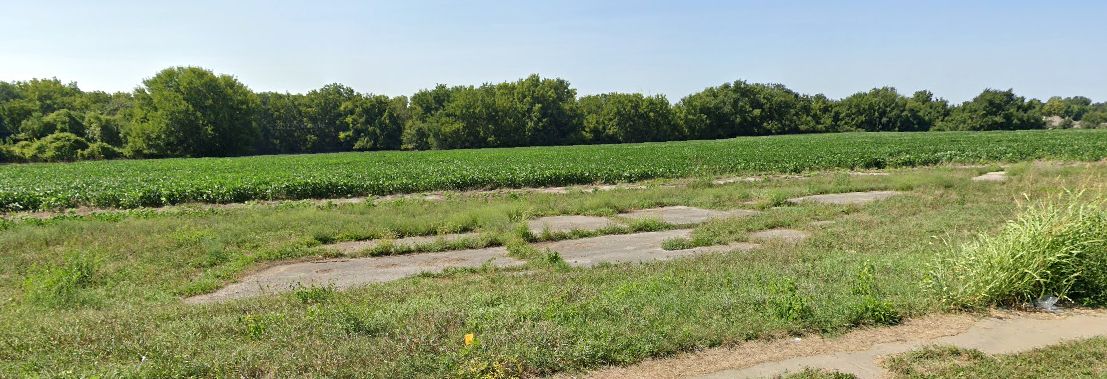
A 2016 aerial view looking south at the Dempsay Farm Airport showed the runway configuration remained the same.
The number of large 2-engine & 4-engine transports parked on the airfield had increased to 5,
and hundreds of aircraft fuselages were visible across the street to the east.
A Lockheed JetStar was visible mounted on a pole across the street from the airfield.
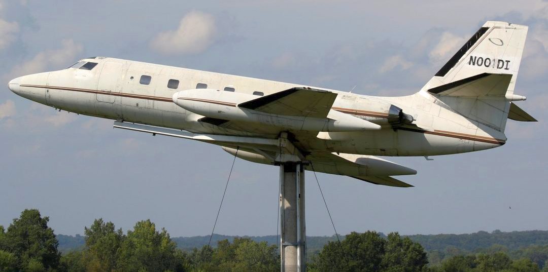
A 2018 or before photo of a Lockheed JetStar mounted on a pole across the street from Dempsay Farm Airport.
As of 2018, no airfield at this location was depicted on aeronautical charts, or registered with the FAA.
Will Hazen reported in 2018, “The field's official name was Dempsay Farm Airport.
The aircraft stored on site include 3 former Central Air Services & USAF C-54/DC-4s (N816D 1944 C-54E, N67061 1945 C-54, and N96454 1942 C-54D-DC).
All their registration certificates were canceled in early 2018.
Also on site is a Lockheed Lodestar built in 1940 with wings and engines off, which is visible in the aerial view, N555H, whose registration certificate just recently expired (latter part of June).
Closest to the road lies a DC-3 N37737, built in 1944, with a certificate canceled in 2009.
This aircraft flew for roughly 10 years with British European Airways.
The aircraft next to the DC-3 is an ex-USAF Convair C-131B, N43941, which still holds its valid registration until 8/31/18.
The field used to house at least 2 yellow crop dusters, but I didn't see them on my last trip out earlier this month.”

A 2024 photo looking northwest at the DC-3 & variety of other aircraft at Dempsay Farm Airport.
Thanks to Lee Corbin for pointing out this airfield.
____________________________________________________
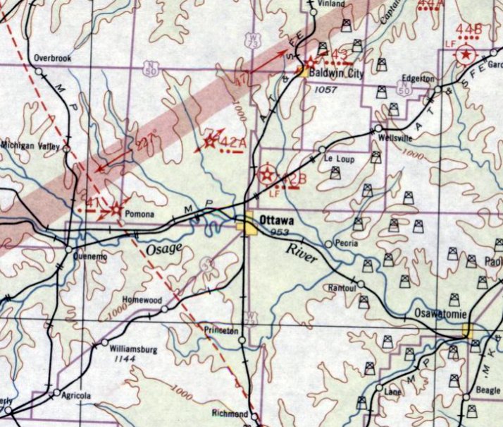
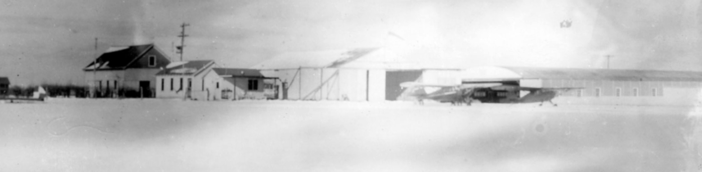
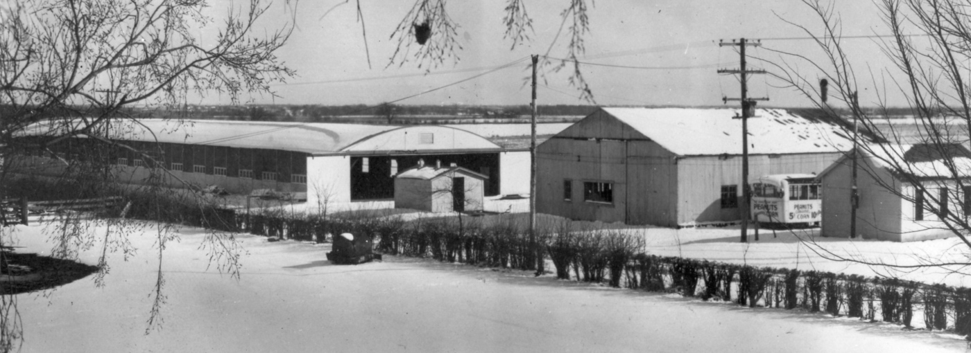
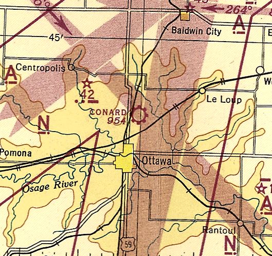
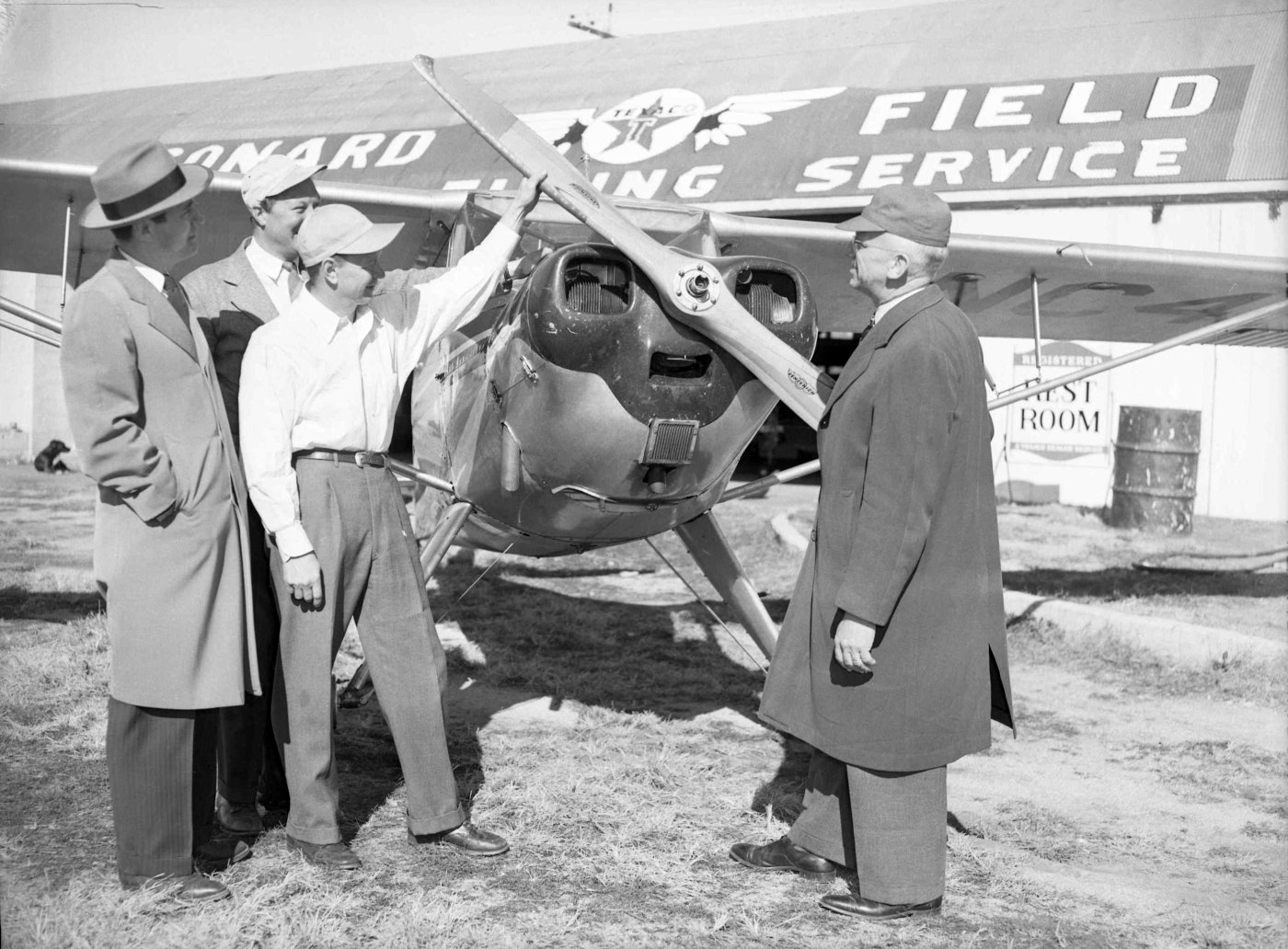
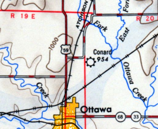
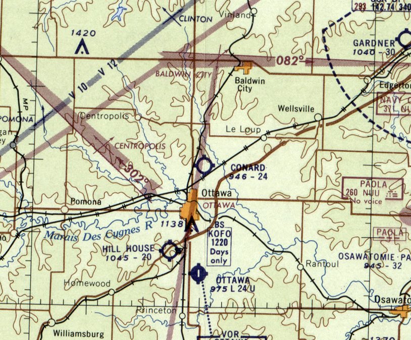
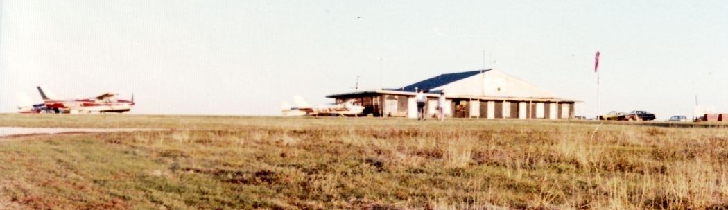
Conard Field / Intermediate Field Site 42B, Ottawa, KS
38.664, -95.243 (Southwest of Kansas City, MO)
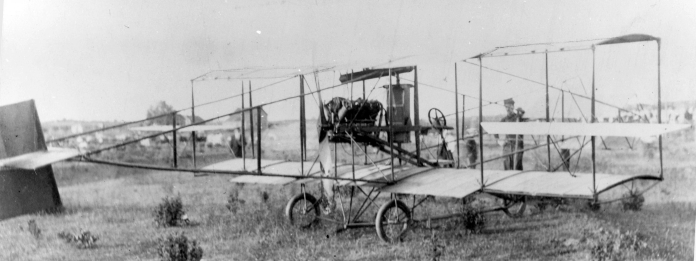
A 1911 landing at Conard Field of an unidentified biplane on a Trans-Continental trip (courtesy of the Franklin County Historical Society, via Will Hazen).
According to the Franklin County Historical Society (courtesy of Will Hazen),
“This farm of 1,000 acres was purchased in 1869 by the Conard brothers.
Conard Air Field was established by John, and is known as one of the oldest landing strips in Kansas.
The first transcontinental plane trip in 1911 stopped at the field.
In 1922 Conard Field was officially designated by the US Department of Commerce as one of 50 national emergency landing fields in the US for airmail carriers (it was designated #50).
When that happened the federal government added lighting & a beacon light.
The Conards were hired by the government & were responsible for putting out flares in bad weather & smudge pots on the runway if there would be an emergency landing.
Both John Conard & his wife were weather observers.”
According to the 1932 “Descriptions of Airports & Landing Fields in the United States” (according to Will Hazen),
Conard Field was designated Department of Commerce Intermediate Field Site 42B along the Amarillo - Kansas City Airway.
It consisted of a 63 acre sod property, having 2 runways, with the longest being 2,640'.
On 4/20/32, the Ottawa Herald (courtesy of Will Hazen) said that 2 planes had landed at Conard the night before.
Both were of the NAT division of United Air Lines.
The first was a Chicago to KC flight but KC was fogged in.
The second was a mail flight grounded because of fog.
The earliest aeronautical chart depiction which has been located of Conard Field was on the June 1932 KS City Sectional Chart,
which depicted Conard as Commerce Department Site 42B.
On 4/20/32, the Ottawa Herald (courtesy of Will Hazen) said that the Federal government stopped using Conard in 1933 as an emergency field.
However on 7/2/33 Conard Field was reopened in cooperation with the Ottawa Chamber of Commerce, with Paul Gaynor hired as the manager.
A 7/2/33 postmark had a drawing of an airplane & was marked “7/2/33 / Ottawa, Kansas / Conard Air Port”.
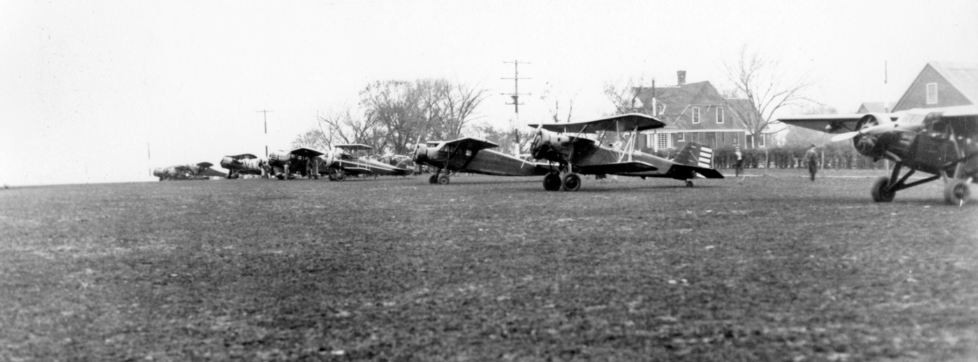
An 11/15/34 photo of a variety of biplanes & monoplanes at Conard Field (courtesy of the Franklin County Historical Society, via Will Hazen).
Conard Field was not yet depicted on the May 1939 KS City Sectional Chart.
During WWII, Conard Field was used for a training program for the military run by Gaynor, with classes taught by Ralph Robertson,
run under auspices of the Civil Aviation Administration War Training Service.
According to Paul Gaynor, the only building there was a “shack next to the rotating beacon that had the numerals 50 emblazoned” on it.
Gaynor then moved in a shed from 8th & Willow in Ottawa to use as a hangar. Then a classroom & office were built.
At the height of the program there were 8 Aeroncas used to train the pilots -parked outside, with the shed/hangar not having enough room.
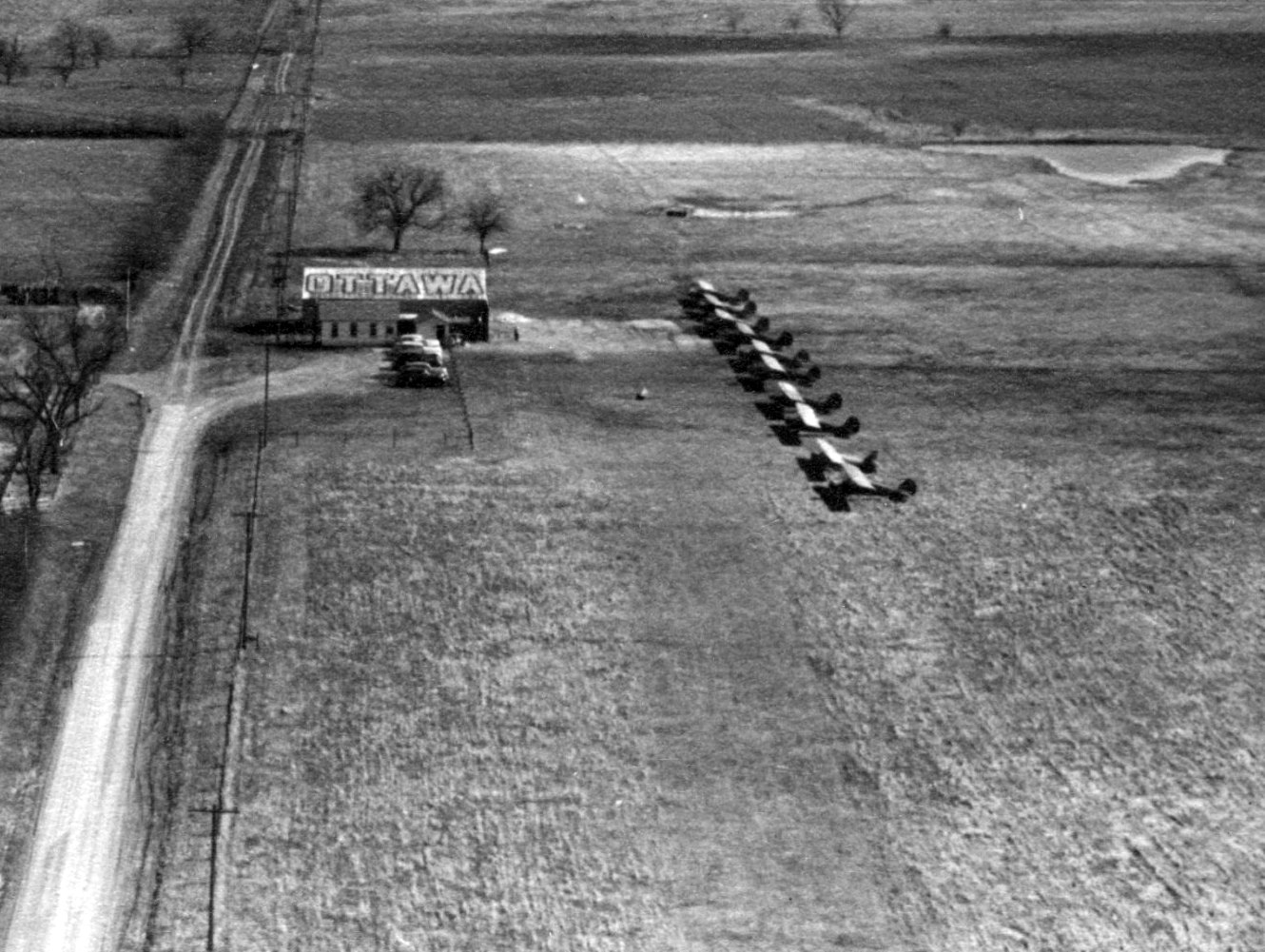
A 1942 aerial view looking east at Conard Field (courtesy of the Franklin County Historical Society, via Will Hazen),
showing a row of high-wing single-engine light planes parked on a grass airfield south of a single hangar marked “Ottawa”.
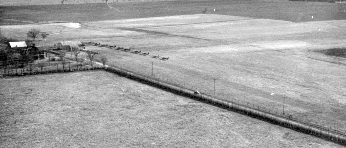
A 1942 aerial view looking southeast at Conard Field (courtesy of the Franklin County Historical Society, via Will Hazen).
A circa 1942 photo of Conard Field (courtesy of the Franklin County Historical Society, via Will Hazen).
The city of Ottawa helped finance an addition to the field.
Representatives sent to Gravois Mills, Mo bought an old boat storage building, took it apart & moved it to Conard where it was reassembled.
But just about the time they finished, the government canceled the training program, approximately in the mid-1940s.
A circa mid-1940s photo of Conard Field (courtesy of the Franklin County Historical Society, via Will Hazen). Will Hazen noted, “The big building had been moved in.”
Dan Linn recalled, “During 1943 I was in high school in Lawrence KS.
Having secured a 30 minute unsatisfactory instruction training flight in a Aeronca Defender airplane at the Lawrence Airport where I worked part time, I learned about the north Ottawa field.
Inquires resulted in my learning that I could secure some flight training at Ottawa.
Starting 7/21/43 I secured a free ride on a morning southbound bread truck, which got me near Conard Field just the sun was lighting the eastern sky (that's early dad).
Then I walked about 1/3-1/2 mile to a waiting 65 HP Aeronca 'Bug Eyed' Chief Aeronca.
Following a 30 minute training flight, walked to the highway & hitchhiked back to Lawrence for my first class.
This exercise repeated 7/21, 23, and 24, which included 5 flights of 30 minutes each, the final was a trip back to Lawrence.
My log book was signed by P.H. Gaynor 79854-41, as my instructor. He was the best, as I may relate later.
At that time there was only one Aeronca Chief on the field. There were no runways, as there was only a sod field.
The small building was not of sufficient size for any airplanes. I have no memories of light towers on the field.”
Dan continued, “As you may remember the 1939 'Bug Eyed' Chiefs were such that you sat low, with your eyes just above the bottom of the side window.
Also forward visibility was limited until the tail was raised. About the third 30 minute training flight started with the instructor saying 'You take off yourself today Dan.'
We entered the airplane as it faced south. Yours truly rapidly advanced the throttle to full.
I noticed that we were nearing a small pond, just as I was told calmly 'You should add some right rudder.'
After complying I noticed that there was a bob wire fence off to our left.
Next my attention was drawn to the fact that the grass was going straight back from the front to the rear under the left tire.
This view was rapidly changed with the grass coming from about 45 degree left!
With that occurred a slight skipping to the left along with the controls feeling light more like they had been in flight the day before!
Quick as a wink, I looked forward, neutralized the rudder & commenced a flight to the north!
The barn followed by the house sliding by before the undersigned uttered something like 'Probably should look forward sooner during takeoffs in the future.'”
The March 1944 KS City Sectional Chart (courtesy of Ron Plante) depicted Conard Field as a commercial/municipal airport.
After the war, a new airport was in the process of being built south of town.
Conard was used for training for returning Gis & leased to pilots who ran flying services, gave lessons, etc.
A circa 1940s photo of a gathering in front of a plane at Conard Field (courtesy of the Franklin County Historical Society, via Will Hazen).
Conard Field, as depicted on the 1947 USGS topo map.
In the mid 1950s, Conard Field was used by the National Guard to store its one plane.
According to Clara May Sexton's obituary (courtesy of Will Hazen),
She helped Earl Sexton run Ottawa flying Service at Conard Field Airport & ran a small cafe there, noted for her pies.”
A 1955 aerial photo showed no trace of aviation activity at the site of Conard Field.
The large hangar seen in 1940s photos had evidently been removed.

The last depiction which has been located of Conard Field was on the 1956 USGS topo map.
It depicted “Conard Airport” as T-shaped property outline, with a small building on the north side.
A 5/15/57 Ottawa Herald article said that both Mr. & Mrs. Conard were dead & that the land that had comprised the airfield had been divided between heirs.
The last aeronautical chart depiction which has been located of Conard Field was on the January 1960 Kansas City Sectional Chart,
which depicted Conard as a commercial/municipal airport with a 2,400' unpaved runway.
Conard Field was evidently closed at some point between 1960-69, as it was no longer depicted on the February 1969 Kansas City Sectional Chart.
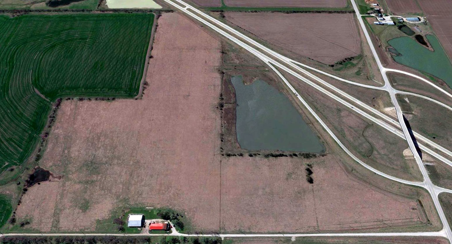
A 2016 aerial view looking south showed no recognizable trace of Conard Field.
Will Hazen noted in 2017, “The outline of both runways is still visible, and when the US 59 bypass was constructed recently, it cut through the southwest corner of the north/south runway.
I don’t think any of the present buildings could be original buildings.”
The site of Conard Field is located southeast of the intersection of Reno Road & Montana Road.
Thanks to Will Hazen for pointing out this airfield.
____________________________________________________
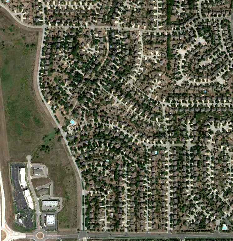
Glenwood Airport, Overland Park, KS
38.954, -94.674 (Southwest of Kansas City, MO)
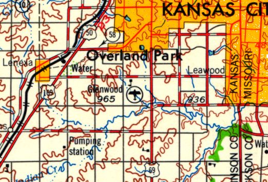
Glenwood Airport, as depicted on the September 1948 Kansas City Sectional Chart.
Photo of the airport has not been located.
This small short-lived general aviation airport to the southwest of Kansas City was evidently established at some point between 1947-48,
as it was not yet depicted on the September 1947 Kansas City Sectional Chart.
The earliest aeronautical chart depiction which has been located of Glenwood Airport was on the September 1948 Kansas City Sectional Chart.
It depicted Glenwood Airport as having a mere 1,800' unpaved runway.
The earliest photo which has been located of Glenwood Airport was on a 1948 aerial photo.
It depicted Glenwood Airport as having a rectangular grass airfield, with a small hangar on the north side.
There were no aircraft visible on the field.
Glenwood Airport was not depicted on the 1950 USGS topo map.
The last aeronautical chart depiction which has been located of Glenwood Airport was on the May 1952 Kansas City Sectional Chart.
It depicted Glenwood Airport as having a mere 1,800' unpaved runway.
Glenwood Airport was evidently soon closed (for reasons unknown), at least officially,
as it was no longer depicted on the June 1953 Kansas City Sectional Chart
or the June 1954 Kansas City Local Aeronautical Chart (courtesy of Mac Hayes).
Glenwood Airport may have continued to see some aviation use after its official closure,
as a 1955 aerial view depicted 4 light single-engine aircraft parked around the small hangar on the north side.
The field had a single north/south unpaved runway.
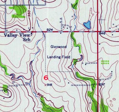
The 1957 USGS topo map depicted “Glenwood Landing Field” as a rectangular property outline with 1 small building on the north side.
A 1959 aerial photo depicted residential streets and houses being built over the Glenwood Airport property.
The hangar had been removed, leaving no trace of the little airport.
One of hundreds of small American general aviation airports lost to suburban housing development.
Glenwood Airport, as depicted on the 1961 USGS topo map.
The last depiction which has been located of Glenwood Airport was on a 1962 street map (courtesy of Ken Hammond).
It depicted Glenwood Airport as a rectangular property outline.
The 1963 USGS topo map depicted residential streets covering the Glenwood Airport property.
A 2015 aerial view looking north showed no trace remaining of Glenwood Airport.
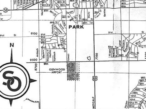
The site of Glenwood Airport is located southeast of the intersection of West 95th Avenue & Lowell Road.
Thanks to Ken Hammond for pointing out this airfield.
____________________________________________________
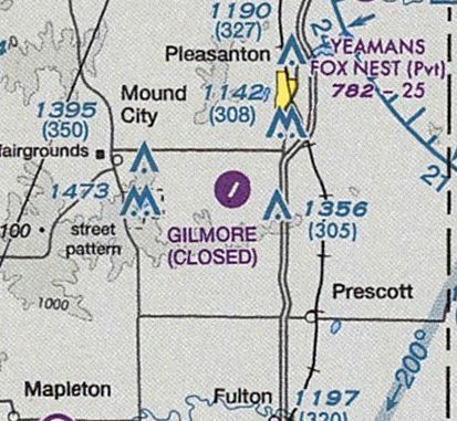
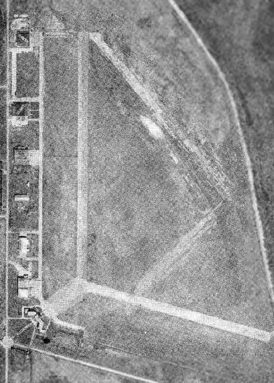
Gilmore Airport (57K), Pleasanton, KS
38.13, -94.75 (South of Kansas City, MO)
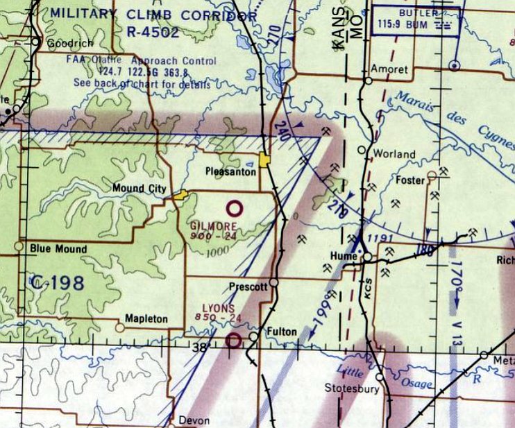
Gilmore Airport, as depicted on the February 1965 Kansas City Sectional Chart.
No airfield was yet depicted at this location on a 5/6/57 USGS aerial photo (courtesy of Dallam Oliver-Lee) or the 1958 USGS topo map.
According to its FAA Airport/Facility Directory data, Gilmore Airport was established in 10/1960.
Gilmore Airport was not yet depicted on the December 1960 Kansas City Sectional Chart.
The earliest depiction which has been located of Gilmore Airport was on the February 1965 Kansas City Sectional Chart.
It depicted Gilmore as having a 2,400' unpaved runway.
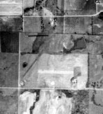
The earliest photo which has been located of Gilmore Airport was on a 1971 USDA aerial photo (courtesy of Dallam Oliver-Lee).
It depicted the field as having a single northeast/southwest runway.
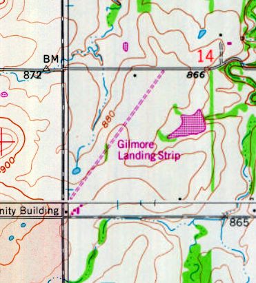
The 1978 USGS topo map depicted Gilmore Landing Strip as an unpaved northeast/southwest runway.
A 10/2/81 USGS aerial photo (courtesy of Dallam Oliver-Lee) depicted Gilmore Airport as having 2 small buildings at the southwest corner.
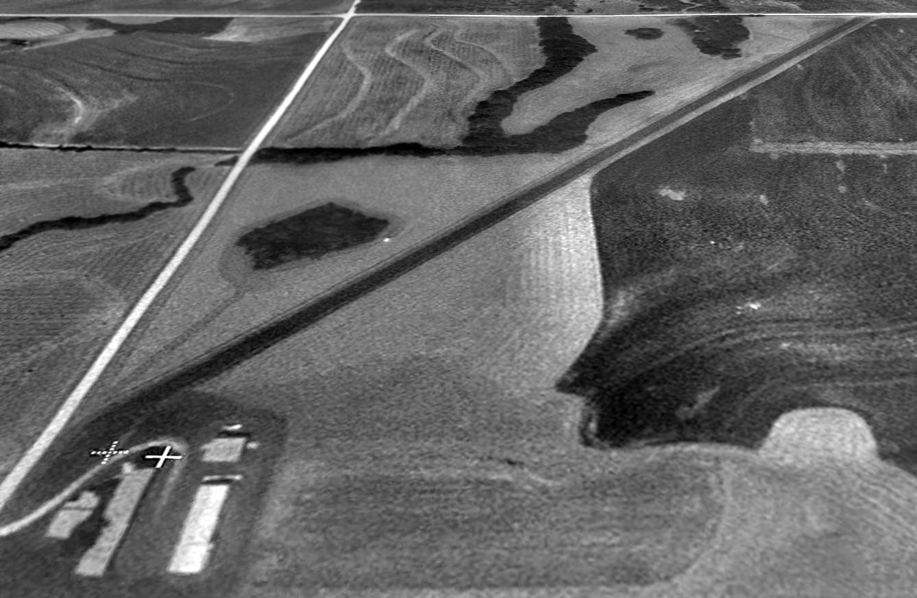
A 1992 USGS aerial view looking north at Gilmore Airport.

A 7/20/12 aerial photo (courtesy of Dallam Oliver-Lee) depicted Gilmore Airport as remaining intact,
but with no aircraft visible or any other sign of recent aviation usage.
Gilmore Airport was evidently closed at some point in 2013,
as the May 2013 Kansas City Sectional Chart (courtesy of Dallam Oliver-Lee) labeled the field as “Gilmore (Closed).”
As of 2013, its FAA Airport/Facility Directory data listed Gilmore Airport's owner as “David Gilmore, Trust”,
and its manager as David Lamb, Linn County Clerk.
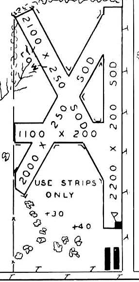
The field was described as having a single asphalt 2,870' Runway 3/21, with “tall weeds growing in runway pavement cracks”.
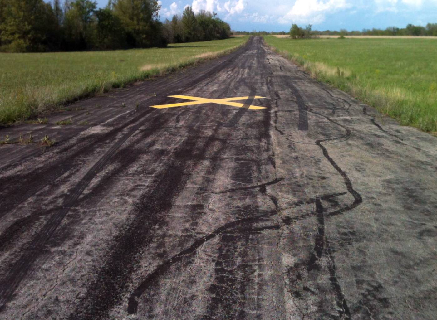
A 2014 photo by Ken Lewis looking northeast along the Gilmore Airport runway, showing the closed-runway “X” marking.
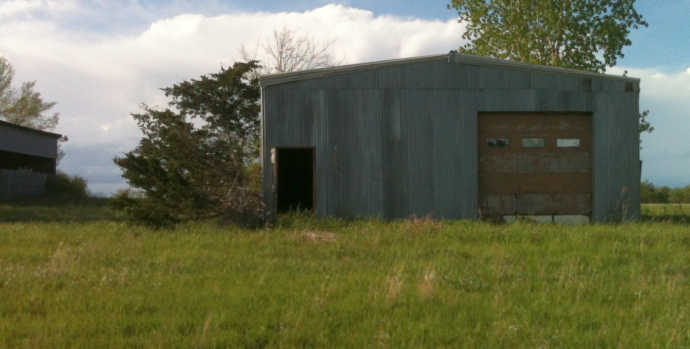
A 2014 photo by Ken Lewis of an abandoned Gilmore Airport hangar.
A 2016 aerial view looking north at the remains of Gilmore Airport.
Riss Suttom reported in 2018, “Gilmore... It is right down the road.
It appears the runway even though marked closed has had some maintenance applied as I saw no visible cracks in the surface. The building are quite dilapidated.”
Gilmore Airport is located northeast of the intersection of East 700th Road & Read Road.
Thanks to Dallam Oliver-Lee for pointing out this airfield.
____________________________________________________
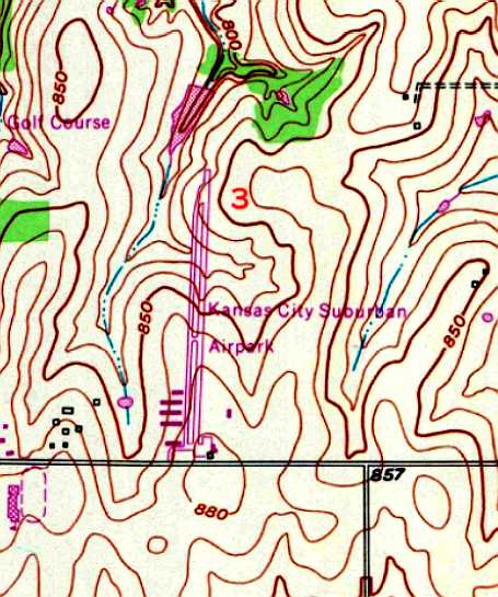
Kansas City Suburban Airport / Bonner Springs Airport (4K2), Shawnee, KS
39.037, -94.85 (Southwest of Kansas City, MO)
Kansas City Suburban Airport, as depicted on the June 1959 Kansas City Sectional Chart.
According to an article by Caroline Boyer entitled “West Shawnee neighborhood once contained an airport” in the 2/11/04 Shawnee Dispatch,
“John Feilbach described the grass runway he created on his farm in the late 1940s to fly his plane.”
Feilbach recalled, "I just had this old Aeronica airplane that I used to fly, and it wasn't long before others came along wanting to fly there.”
One thing led to another & before we knew it, we had more planes than we could take care of, so we started an airport."
The article continued, “Located between Johnson Drive & 47th Street where the Woodsonia neighborhood now sits,
the Kansas City Suburban Airport was developed on the Feilbach farm.
John Feilbach, owner, started the airport with Bob Scott, owner of the Acme Sign Company, and Frank Jones, a TWA pilot.
Feilbach remembered the airport coming together in 1955.”
A 1955 aerial photo showed no airfield yet at the location.
Kansas City Suburban Airport was not yet depicted on the January 1959 Kansas City Sectional Chart.
The earliest depiction which has been located of Kansas City Suburban Airport was on the June 1959 Kansas City Sectional Chart.
It depicted the field as having a mere 1,800' unpaved runway.
The earliest photo which has been located of Kansas City Suburban Airport was a 1959 aerial photo.
It depicted the field as having 2 unpaved runways, 3 hangars along the southwest side, and 3 light single-engine aircraft on the southeast side.
A circa 1950s-60s aerial view looking northeast (courtesy of the Monticello Historical Society)
depicted Kansas City Suburban Airport as having 2 unpaved runways, with several hangars & a total of 6 aircraft visible on the field.
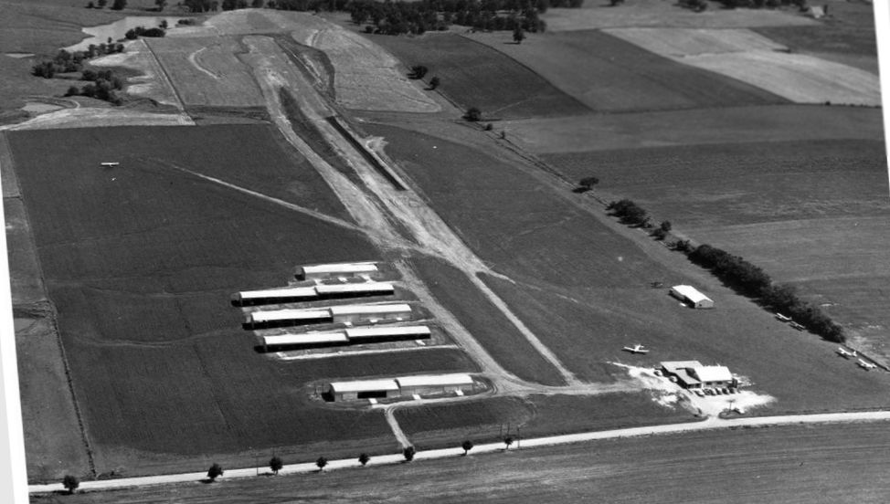
A 1961 aerial view (courtesy of Mark Hess) depicted Kansas City Suburban Airport during the paving of its runway.
A total of 6 single-engine planes were visible on the field, along with several rows of T-hangars.
According to the Caroline Boyer article, “For the more than 20 years that the airport was open,
it housed up to 60 planes, mostly from Kansas City, some being business planes & some for weekend pilots.
The airport was recognized locally by many names & was sometimes referred to as the Bonner Springs Airport,
as the area was not annexed into Shawnee until 1971.
Though many of its Monticello neighbors may have found it something of a nuisance,
the airport brought visitors from all over Kansas City to the little community in rural Johnson County.”
Kansas City Suburban Airport was not yet depicted on the 1963 USGS topo map.
The article continued, “The airport was made up of hangers, an office building & tie-down areas.
The 3,000' dirt runway, which was surfaced with blacktop in 1964,
ran from the north to the south at about the location of present-day Hilltop Road, with gravel taxi strips.”
The article continued, “Carl Holthaus was training for his pilot's license in the 1960s
and would fly into the airport as he learned landing technique.”
"A lot of people landed there that came out of the bigger airports in downtown Kansas City
to learn how to land at smaller airports with shorter runways," Holthaus said.
According to the Caroline Boyer article, “Several different part-time flight instructors worked at the airport, working on commission.
Bob Watson, the first black accepted by the Federal Aviation Administration as a general aviation operation inspector,
issued pilot licenses out of the airport for about 6 years.
Feilbach, a member of the Flying Farmers Association & the Civil Air Patrol,
used his Cessna 210 at Christmas time to fly people over the Plaza lights.
He would make several trips from dusk until midnight, taking 3 passengers a trip for $5 / person.
Also around Christmas time for a few years, Santa would parachute into the airport out of Scott's plane, which was often used by skydivers.”
The article continued, “Feilbach would fly Agricultural Stabilization & Conservation Service officials
to take aerial photos of Johnson County farms & was able to get an aerial photo of the airport.
But not everything ran smoothly in the airport's early years.
Scott, known as Scotty, was the only one of the owners with business experience.
Jones, as a TWA pilot, had little time for the airport, and Feilbach was never quite sure what was going on.
The breakdown of the airport's management in 1964 was recorded by Emalou Laible, wife of Bob Laible, the airport's 2nd owner.”
"Actual management of the airport thus ended up in Scotty's hands, and he wasn't happy about it," Emalou wrote.
The article continued, “With customer complaints, a slow mechanic, a leaky roof and very little money being made, it was time for a new owner.
Bob Laible had been storing his plane at the airport since 1960 when Scott approached him about taking over.
When Laible helped out the slow mechanic by repairing the wings of one of the airport planes, Scott saw in him the new airport manager.”
"Here, he knew, was a man who not only knew flying but also was surprisingly experienced in aircraft maintenance," Emalou wrote.
When Laible was passed over for a promotion at Bendix, he was easily talked into taking over the risky venture in June of 1964.
"We ran it for 13 years, and it was the most interesting & exciting 13 years that airport was run," Laible said.
According to the Caroline Boyer article, “The first thing the Kansas City couple did to beef up business was run an ad in The Kansas City Star,
advertising Cessna Day, where visitors could take airplane rides for a penny a pound.
The ad brought people from Lawrence to Kansas City for Cessna Day, 7/26/64.”
"Three airplanes flew all day, starting at noon flying & flew clear until dark," Laible said.
According to the Caroline Boyer article, “Other operations began under Laible's management.
He was a Cessna dealer from 1964-67, and operated Kansas City Air Transport with 2 other pilots from 1965-67.
Laible even helped the FBI track down a stolen plane that had crash-landed at the airport in the late 1960s.”
The August 1965 Kansas City Sectional Chart (courtesy of Ron Kunse) depicted Kansas City Suburban Airport as having a single 2,900' paved northwest/southeast runway.
A 1966 aerial photo depicted Kansas City Suburban Airport
as having a paved north/south runway, with 5 hangars along the southwest side.
According to the Caroline Boyer article, “Laible became a licensed pilot instructor in 1968,
not long after Watson had left for a job with the Federal Aviation Administration in 1966.
Laible said he made more than 30,000 takeoffs & landings as an instructor,
and he had students who lived anywhere from Shawnee to Lansing.
He called the flight school Kansas City Suburban Flight, Inc., 'The happy place to fly'.”
According to the Caroline Boyer article, “Ruth Bitikoffer of Kansas City & her husband got their pilot's licenses at the airport in 1968,
and continued to fly out of the airport for several years.”
"My family still lived out west of Monticello towards De Soto so we were out there all the time,
and we were always looking at different airports, so I think we just decided to try them out," Bitikoffer said.
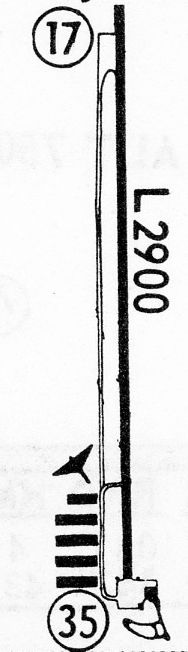
The 1968 Flight Guide (courtesy of Robert Levittan) depicted Kansas City Suburban Airport
as having a single paved 2,900' Runway 17/35 with parallel taxiway, and a ramp & several small buildings on the south side.
According to the Caroline Boyer article, “Trouble began for the Liables with their new landlords not too long after the Feilbachs sold the land around 1970.
Laible said the new owners wanted to get more money out of the airport, and they weren't making that much in the first place.”
"We made beaucoup money for Cessna, finance companies, and insurance companies, but none for us," Bob said.
The 1970 USGS topo map depicted Kansas City Suburban Airport
as having a single paved north/south runway with parallel taxiway, and a ramp & several small buildings on the south side.

A 10/2/70 USGS aerial view depicted Kansas City Suburban Airport as having a single paved north/south runway with parallel taxiway, 5 hangars on the southwest side, and a dozen light single-engine aircraft on the southeast side.
The last aeronautical chart depiction which has been located of Kansas City Suburban Airport was on the 1973 Kansas City Sectional Chart.
It depicted Kansas City Suburban Airport as having a single 2,900' paved north/south runway.
According to the Caroline Boyer article, “The airport's troubles forced another change in management in 1976.
Laible sold the gasoline concession that year to Paul Zimmer, one of the new landowners, and John McNay was hired to run the airport.”
A 5/1/78 USGS aerial view (courtesy of Lee Corbin) depicted Kansas City Suburban Airport
as having a single paved north/south runway with parallel taxiway, and a ramp & several small buildings on the south side.
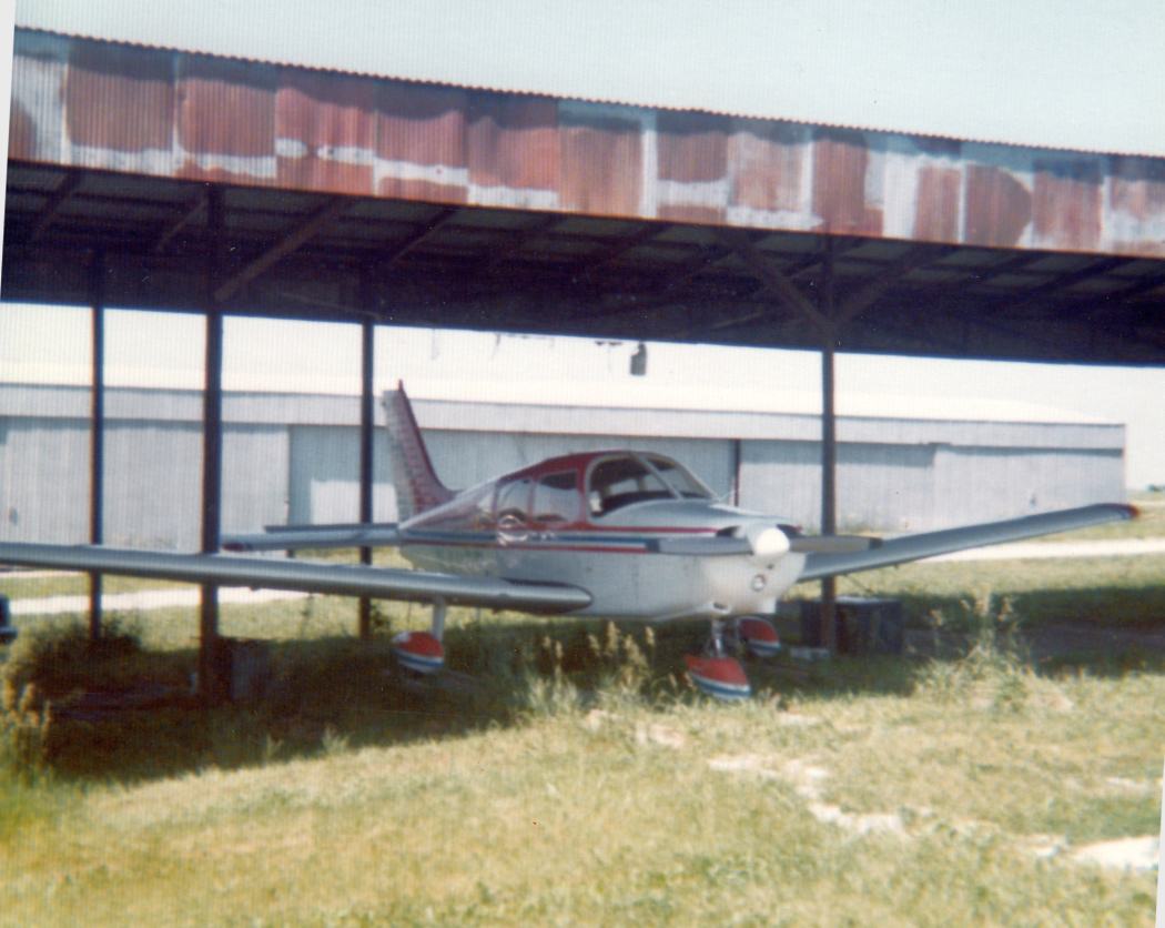
A 1978 photo by Howard Beck of a Cessna 150 that he flew parked on the west side of the KS City Suburban Airport office building.
Howard recalled, “I flew from KC Suburban as a student pilot in the mid- to late-1970s. Bob Liable was my main instructor.”
Dave Wewers recalled, “I was in a partnership on an airplane based at this airport -
I flew out of Suburban from about December of 1978 until right before the airport closed in 1980.”
A 1979 picture by Dave Wewers looking east-southeast at Kansas City Suburban's “FBO building/maintenance hangar.
You can even pick out the fuel pumps on the right edge.
The building was located on what would now be the northeast corner of Johnson Drive & Hilltop Drive.”
A 1979 picture by Dave Wewers of Kansas City Suburban, showing “the airplane in which I owned a half-interest.
We were in an open hangar; as you can see in the background there was a mix of closed & open hangars on the southwest side of the airport.”
According to the Caroline Boyer article, “The field was sold to Hoyt Farms in 1979.
On 7/29/79, a tornado destroyed the hangars & office building.
The Laibles, who still stored their planes at the airport, heard about the tornado on the news while on vacation at the Lake of the Ozarks.
When the Laibles returned to the airport, they found that they had gotten lucky.”
"It left all of daddy's airplanes," Laible's daughter Deborah Herbert said. "It kind of blew all of the others away, but his were spared."
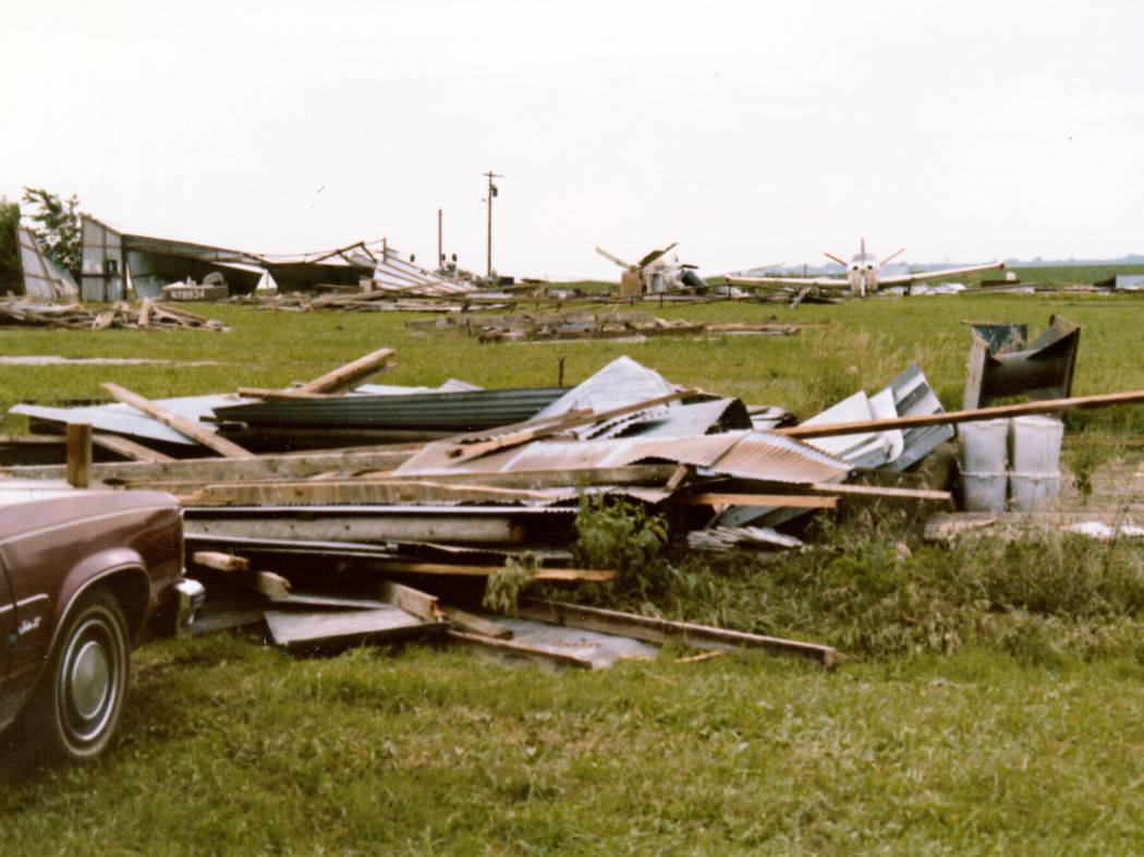
A 1979 picture by Dave Wewers of Kansas City Suburban, showing “what our hangar looked like after the storm that occurred in July 1979.
Fortunately, the other owner was out of town with the airplane!
Unfortunately, the storm sealed the fate of the airport, although it was probably destined to be developed for housing anyway.”
According to the Caroline Boyer article, “Though the hangars & office were never rebuilt,
pilots continued to use the runway for about another year.
The airport officially closed in the summer of 1980, and the land was eventually sold to J.C. Nichols for development.”
Kansas City Suburban Airport was depicted as an abandoned airfield on the 1982 Kansas City Sectional Chart.
Kansas City Suburban Airport was still depicted on the 1983 USGS topo map as having a single north/south runway.
The 1984 USGS topo map no longer depicted Kansas City Suburban's runway, but the hangars were still depicted.
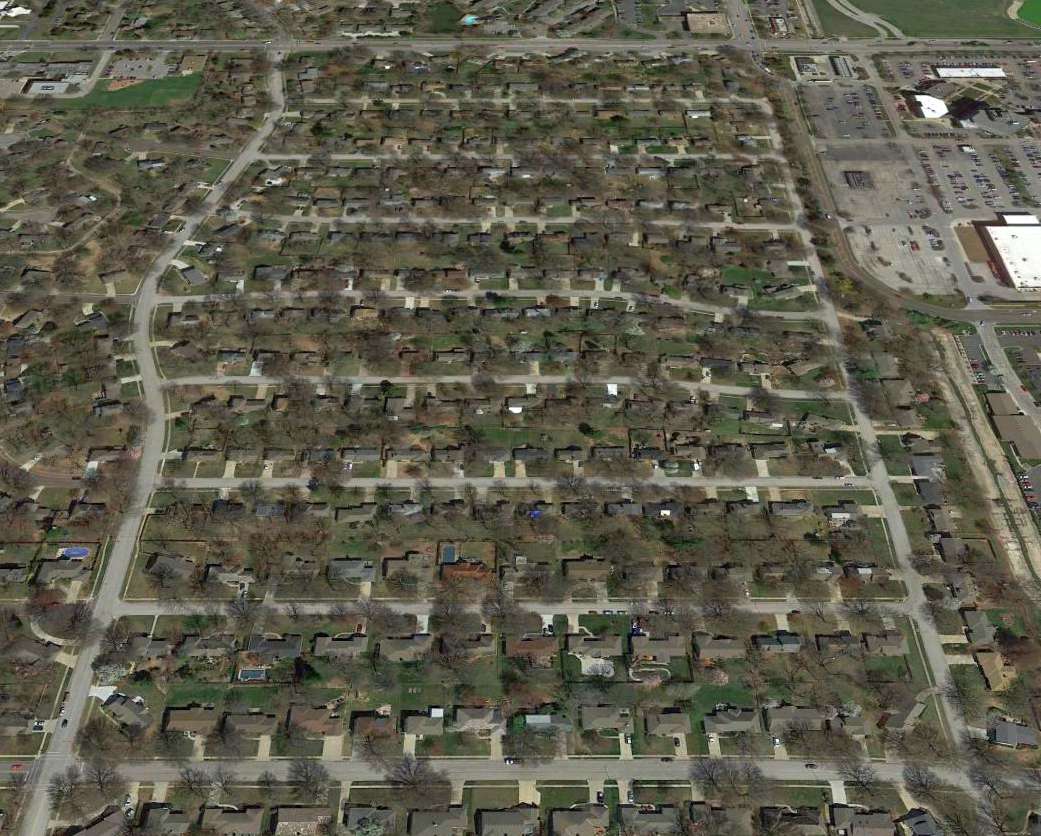
A 1991 USGS aerial photo showed newly-constructed streets & houses covering the site of the airport.
According to the Caroline Boyer article, “The airport now only lives on in memory, as the land is completely covered by rows of houses.
Laible pointed out that there is something of the airport that remains, according to some information his daughter got from a friend who lives in Woodsonia.”
"There's a runway there yet," Laible said. "You just have to dig down about 6 inches."
A 9/2/12 aerial view showed no trace remaining of Kansas City Suburban Airport.
The site of Kansas City Suburban Airport is located north of the intersection of Johnson Drive & Woodsonia Drive.
____________________________________________________
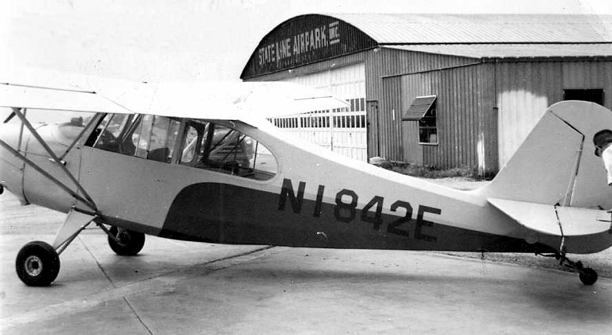
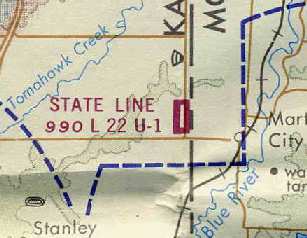
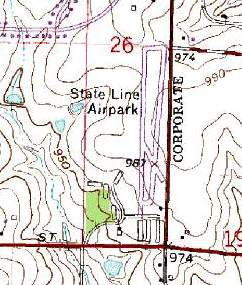
State Line Airpark (3KC), Leawood, KS
38.89, -94.609 (West of Kansas City, MO)
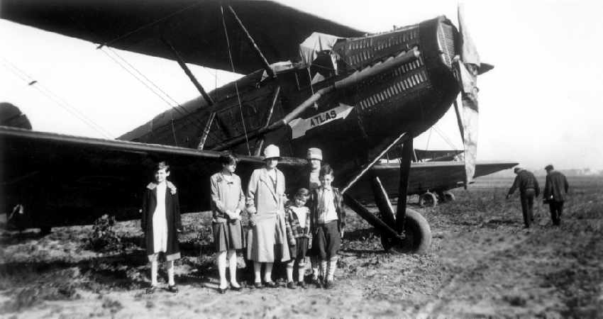
An October 1928 photo (courtesy of Noah Dunker) of an unidentified biplane at State Line Airpark.
This general aviation airport was located directly along the Kansas/Missouri border (thus the name),
with the eastern boundary of the airport property being State Line Road.
The date of construction of State Line Airpark is unknown.
The earliest depiction of the field which has been located was the above October 1928 photo of a biplane at the field (courtesy of Noah Dunker).
Noah reported, "My grandparents lived less than 1/4 mile north of the airfield."
He said of his grandmother, "She recalled that there were no buildings & that it was little more than a smoothed-over strip in a field."
State Line was not yet depicted on Kansas City Sectional Charts from June 1932 - March 1946, the 1939 USGS topo map,
or listed among active airfields in the 1945 AAF Airfield Directory (courtesy of Scott Murdock).
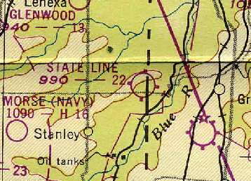
The earliest chart depiction of State Line Airpark which has been located was on the September 1946 Kansas City Sectional Chart.
It depicted State Line as a commercial airport.
According to John Shields (referencing obituaries), “Murl Johnston & his brother Alva Leroy Johnston, a TWA pilot, owned the airport from 1946-63.”
The earliest aerial view which has been located of State Line Airpark was a 9/25/48 USGS aerial view.
It depicted State Line as having a single unpaved north/south runway, with 2 rows of hangars on the southeast side,
and a total of 14 single-engine aircraft parked around the trees on the southwest edge.
The 1949 KS Airport Directory (courtesy of Chris Kennedy)
described State Line Airpark as having 4 sod runways, with the longest being the 2,200' north/south strip.
Three buildings (hangars?) were situated on the southeast corner of the field.
The airport was said to offer repairs & fuel, 6 the manager was listed as M. L. Johnston.
The 1949 Kansas City Sectional Chart (courtesy of Chris Kennedy)
described State Line as having a 2,200' unpaved runway.
John Shields recalled, “I learned to fly at State Line in 1951, where I worked as a lineboy,
up through flight instructor, 1951-53, before joining the Naval Aviation Cadet program.
My boss at the time was Murl Johnston”, the joint owner of State Line Airpark.
Charles Haus recalled, “I flew out of State Line & knew Merle & his brother, who flew for TWA.”
The June 1954 Kansas City Local Aeronautical Chart (courtesy of Mac Hayes) depicted State Line Airpark as having a 2,200' unpaved runway.
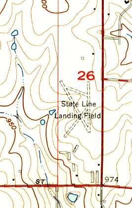
The 1957 USGS topo map depicted “State Line Landing Field” as having 3 unpaved runways, with several buildings along the south side.
A circa late-1950s – early 1960s photo of the Aeronca in which Katie Reitmayer's grandfather flew his first solo flight,
in front of a hangar marked “State Line Airpark Inc.”
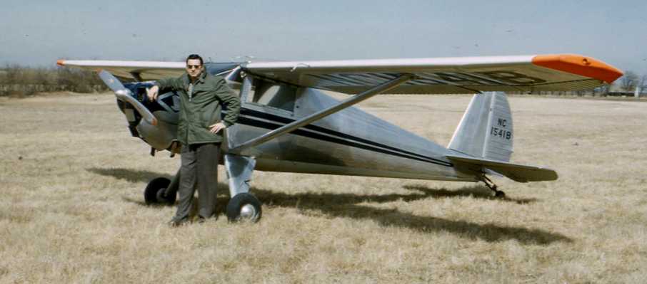
A circa 1960s photo by Jim Bolas of N1541B, a 1955 Luscombe 8A Silvaire at State Line Airpark.
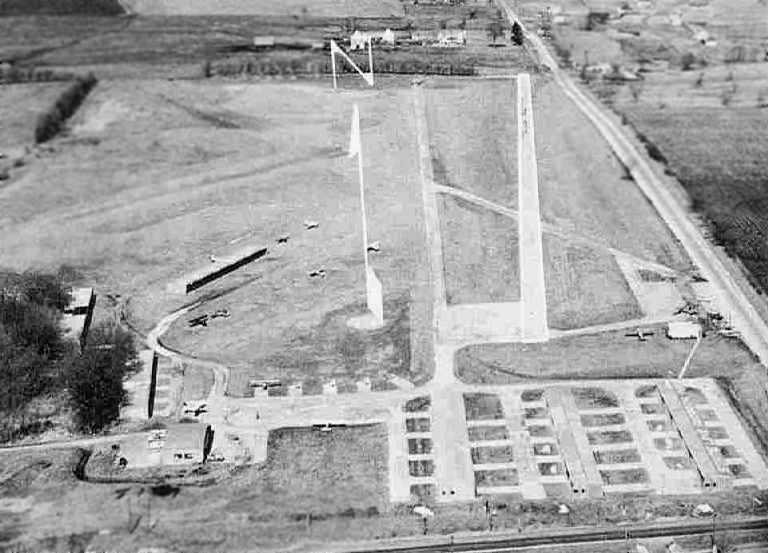
An aerial view looking north at State Line Airpark, from a circa 1957-61 MO Airport Directory (courtesy of Chris Kennedy).
State Line had evidently gained a paved runway at some point between 1949-61,
as the field was depicted as having a 2,200' hard-surface Runway 17/35, along with 2 shorter turf runways.
Several rows of hangars were depicted on the south side of the field,
including some which stood directly under the final approach to the field's primary runway
The field was said to offer fuel, hangars, tiedowns, and major repairs.
The 1962 AOPA Airport Directory described State Line Airpark as having a 2,200' concrete Runway 18/36,
a 2,000' turf & concrete Runway 14/32, and a 2,000' turf Runway 4/22.
The operator was listed as Murl Johnston.
The directory erroneously listed State Line Airpark in its Missouri section.
According to John Shields (referencing obituaries), Murl Johnston & his brother, Alva Leroy Johnston owned State Line Airpark until 1963.
John reported, “All I have heard, from one old pilot, who responded to my ad in the KC Star,
was that some guy named Fisher had the airport after the Johnstons,
but that the operation was 'not well-run'”.
According to Ron Schauble, “State Line Airport had several operators after Johnson, several of short duration.
One of these was Bill Stutesman, who had been operating at Hillside Airport.
Don Fisher took it over in 1965.
He built this into a thriving operation, and he remained until the end.
During Don’s operation the flight school was built up to include large ground school classes & a complete flight training program.
The Johnsons had used primarily Aeronca 7AC Champs as trainers.
At one time there were probably 20 of them.
Many of these succumbed to hard landings by students learning how to land a tailwheel aircraft.
For a while these were stashed around the airport wherever they would be out of the way.
The instrument trainer in 1964 was an 11AC Champ with fight instruments in a separate panel above the instrument panel.
In the fall of 1964 two new Cessna 150s were added.
A new Cessna 172 was added shortly thereafter.
There was an active charter service & aircraft sales operation.
State Line had numerous highly experienced & colorful pilots employed for a number of years.
Ken Fairchild had been a TWA pilot.
He had also flown open cockpit biplane fighters for at least one South American country.”
Ron continued, “I learned to fly there in 1964-65, instructed there in 1967-68,
and continued to fly out of there until its close.
My father kept one of several airplanes in a T-hangar until the end.”
The August 1965 Kansas City Sectional Chart (courtesy of Ron Kunse)
depicted State Line Airpark as having a single 2,200' paved north/south runway.
Ron continued, “Shortly after passenger operations moved [from Fairfax Airport] to MCI,
Don Fisher inaugurated a scheduled commuter service between State Line & International.”
State Line Airpark, as depicted on the July 1973 Kansas City Sectional Chart (courtesy of Chris Kennedy).
Arne Klepinger recalled, “State Line Airport... I was there working & learning to fly there in 1974-75, aged 17.
Don Fisher was running it, including a Part 135 operation from KCI, Richards Gebraur, and State Line Airports.
The operation used a Cherokee 6 & Aero Commander 520.
I was there the day the Commander crash landed on the runway; no one was injured. Fischer did not have a good reputation.
The runway was very narrow, maybe 30', and very poorly lit.
The north end had a tall tree, and the runway was high in the middle so a pilot couldn’t see the other end, which caused some excitement.
Si Royce had an East/West grass strip maybe a mile north of State Line, and was great guy. He regularly flew his Twin Bonanza, Stearman, and Decathlon, into State line.
I have many fond memories of learning to fly there, with Toni C, Ken B, and mechanics Dwayne L, and Chuck.”
Joe Moylan recalled of State Line Airpark, “I soloed here in 1976.”
The 1979 Flight Guide (courtesy of Chris Kennedy) depicted State Line Airpark as having a single 2,200' paved Runway 18/36,
as well as 2 unpaved runways to the west.
According to Senior Airport Planner Brad Weisenburger, "There were a few hangars all at the far southern end.
The ground falls away from the runway end at the south by about 10 feet.
As the story goes, a pilot could land & then taxi straight in to the hangar on the south.
The hangars were not an obstruction because the roof line was below the runway end elevation."
Weisenburger said that FAA records show that the State Line Airpark was closed in 1982.
The 1983 Kansas City Sectional Chart depicted State Line Airpark as an abandoned airfield.
Jim Foulk recalled, “As a child in the mid-1980s I played many soccer games at the airport after it was closed.
We played just west of the main runway & the parents would park
on the runway & taxiway depending on what side you team was on.
The pavement was in really bad shape at the time & is more than likely the reason for it to close.”

A 1991 USGS aerial view looking northwest showed the abandoned State Line Airpark site,
with the runway & taxiway remaining intact though deteriorated. The hangars & buildings at the south end appeared to have been removed.
Arne Klepinger recalled, “The airport sat empty for many years, maybe as late as the early 1990s. Very sad to see it go to more houses & malls.”
Noah Dunker recalled, "My grandparents lived less than 1/4 mile north of the airfield.
In the early- and mid-1990s, long after it had shut down,
my grandfather would take me to the old, blighted runways to launch our model rockets.
The site offered ample acreage to keep our rockets away from traffic & homes."
State Line Airpark was still depicted on the 1995 USGS topo map, even though it had been closed by that point for 13 years.
According to Brad Weisenburger, the State line Airpark property remained in row crops until 2002.
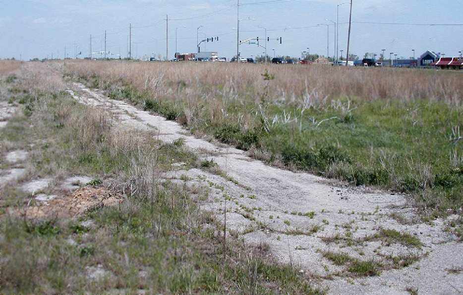
A 2003 photo by Brad Weisenburger looking northeast from the former apron area
along the remains of Runway 18/36 at State Line Airpark,.
He reported the property was in the process of being developed.
He observed, “There are not any remaining buildings, only some piles of rocks & concrete."
State Line Airpark was no longer depicted at all (even as an abandoned airfield) on 2003 aeronautical charts.
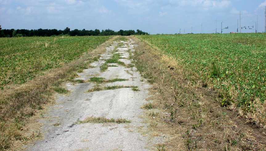
A 2005 photo by Noah Dunker, looking north along the pavement remains of the runway at the site of State Line Airpark.
Noah reported, “133rd Street was built & cut through the old runway.”
An August 2007 aerial view by Joe Moylan looking northwest at the site of State Line Airpark
shows that a majority of the the pavement of Runway 18/36 remains intact.
A circa 2008 aerial view looking north shows that a majority of the the pavement of State Line's Runway 18/36 remained intact.
The path of Runway 14/32 was also still apparent.
A 2016 aerial view looking northwest showed that a building had covered the northern portion of the State Line Airpark site,
but the middle portion of the paved runway & taxiway remained intact.
A 2022 photo looking northwest at the remains of the State Line Airpark ramp pavement.
Jim Stephens reported in 2025, “The State Line Airport property has been regraded back to mostly the original airport state in preparation for development on the south end of the property.
It was sad seeing it in such a state, as some of my earliest memories of aviation was seeing aircraft in & out of the airport when it was operating.
It had become quite overgrown up to about August 2025 & is now cleared back to dirt but graded in such a state as when the airport was there.
The original road at the south end of the airport was Kansas 150 (Missouri 150) which connected eastern Jackson County with US 69 in Kansas.
For a long time a single grave of a young girl was across [Route] 150 in-line with the north/south runway.”
The site of State Line Airpark is located northwest of the intersection of State Line Road & West 135th Street.
____________________________________________________
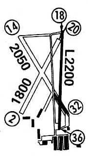
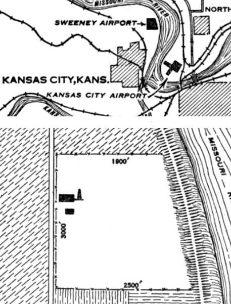
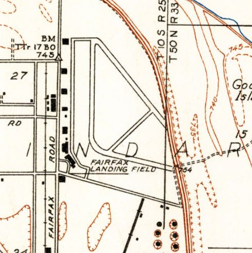
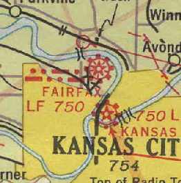
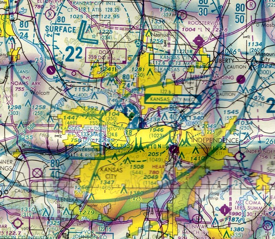
Sweeney Airport / Fairfax Airport / Fairfax Army Airfield (KCK), Kansas City, KS
39.15, -94.6 (Northeast of Kansas City, MO)
Sweeny Airport, as depicted on the 7/17/28 Commerce Department Airway Bulletin (courtesy of Jonathan Westerling).
This airfield was located along the banks of the Missouri River,
just across the river from the present-day Kansas City Downtown Airport.
This property was first used for aviation in 1921, when it was said to have been used for an American Legion air meet.
Operating under a lease, E.J. Sweeny put up a single hangar-workshop holding approximately 6 planes & started a flying school.
In 1925 the field became known as the Sweeny Airport.
The earliest depiction of Sweeny Airport which has been located
was on the 7/17/28 Commerce Department Airway Bulletin (courtesy of Jonathan Westerling).
It depicted Sweeny Airport as a rectangular field measuring 3,000' north/south, with 2 buildings along the west side.
In 1928 the field was taken over by Wood Brothers Corporation & named Fairfax Airport.
Thousands of people from all over the United States gathered to witness the dedication of the Fairfax Airport in 1929.
The crowd was reported to be one of the largest ever to visit an airport in the Midwest.
Various types of aircraft manufactured at the airport & in use there were on display for the opening.
The first plane for a new air mail & passenger line of the Universal Aviation Corporation, arrived at Fairfax from St. Louis in 1929.
The Mayor of Kansas City christened the ship with bottle of Missouri River water.
The plane was a Fokker Super Universal five-passenger cabin plane with 2 pilots.
It had mail & baggage compartments & a wash room, and was powered with a 400-horsepower Wasp engine.
Air mail coming to Kansas City in the 1920s was postmarked Kansas City, Kansas,
because it was flown into the airport & then trucked to Missouri.
The 1929 Rand McNally Standard Indexed Map with Air Trails of KS (courtesy of Chris Kennedy)
described Fairfax as a commercial field operated by the Fairfax Airport Company.
The field was described as measuring 3,000' x 2,500'.

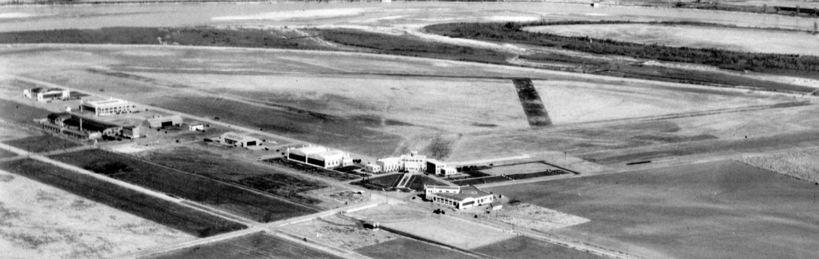
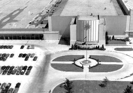
A 1929 of the formal gardens in front of the Fairfax Municipal Airport Terminal building (courtesy of Kevin Walsh).
Beds of brightly-colored tulips, petunias, and roses were planted in geometric patterns as an aid to aviators.
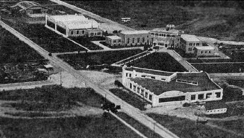
A 1930 postcard of Fairfax Municipal Airport, with the administration building in the lower photo (courtesy of Rex Ricks).
A 1930 Curtiss-Wright Flying Service aerial view looking northeast at Fairfax Airport (courtesy of Noah Rechtin).
A circa 1930s Kansas Emergency Relief Commission aerial view looking southeast at Fairfax Airport (courtesy of Noah Rechtin).
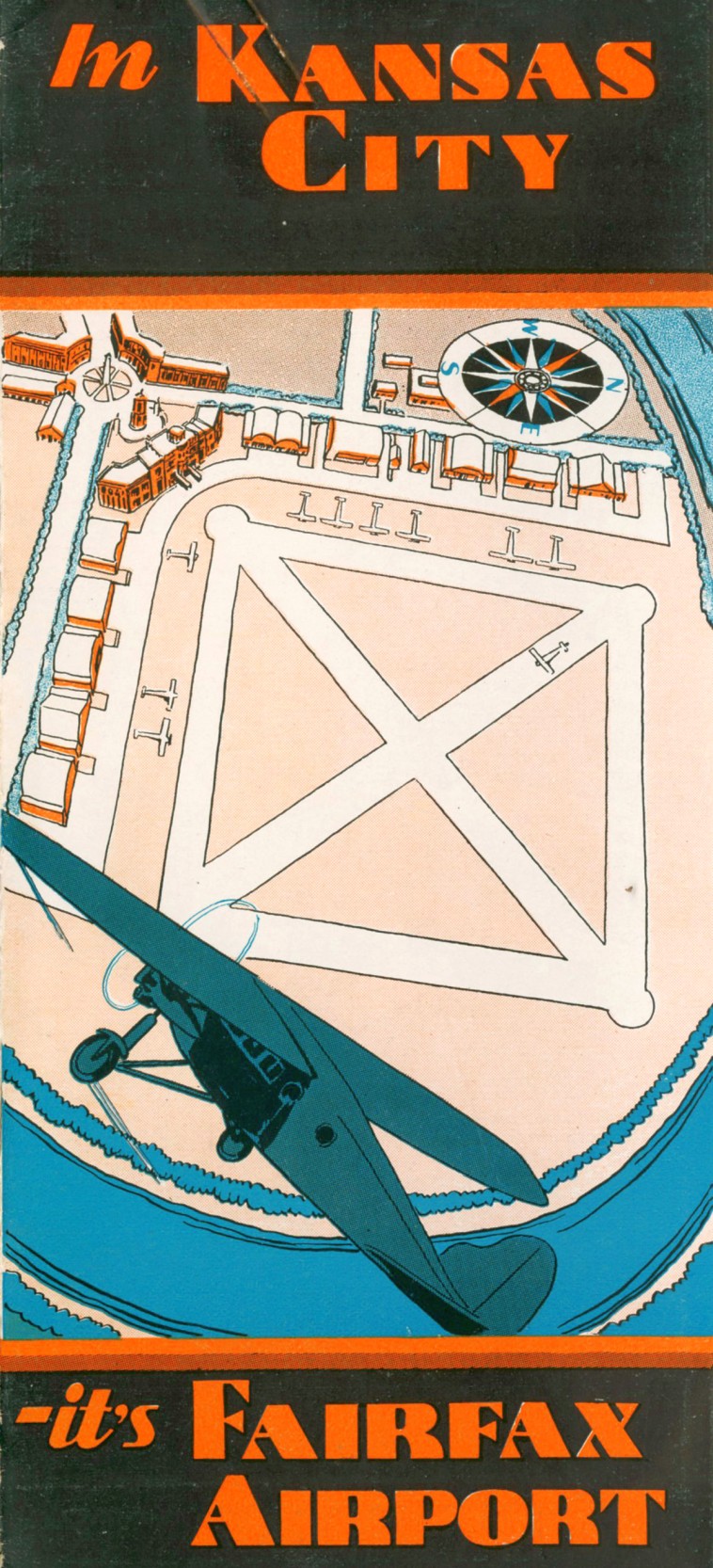
The cover of a 1932 (or earlier) booklet promoting Fairfax Airport (courtesy of Tom Heitzman).
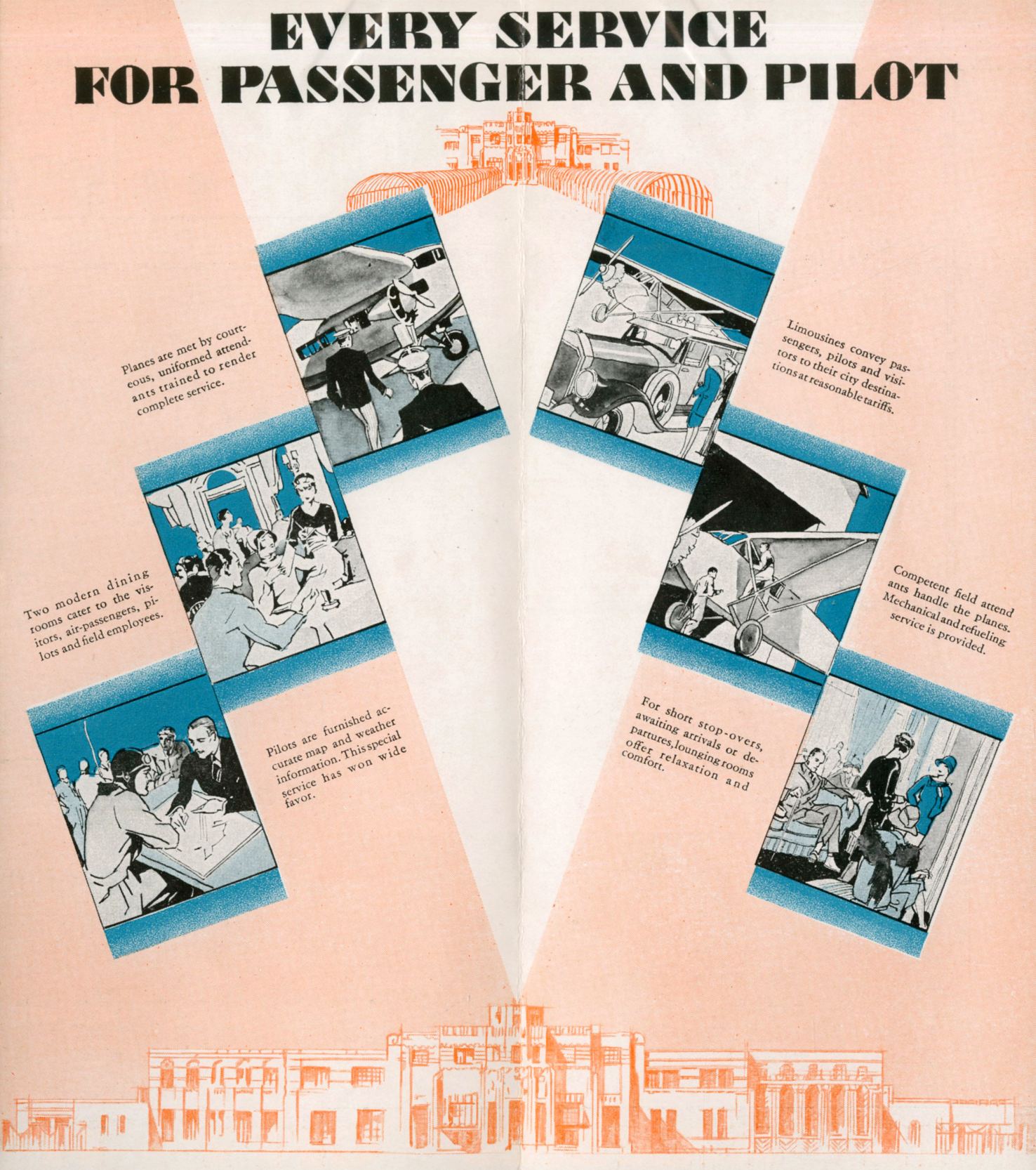
The description of passenger & pilot services from a 1932 (or earlier) booklet promoting Fairfax Airport (courtesy of Tom Heitzman).
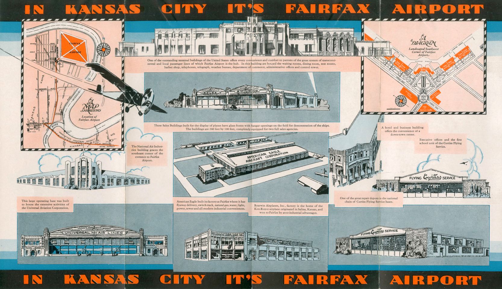
The description of Fairfax Airport buildings from a 1932 (or earlier) booklet (courtesy of Tom Heitzman).
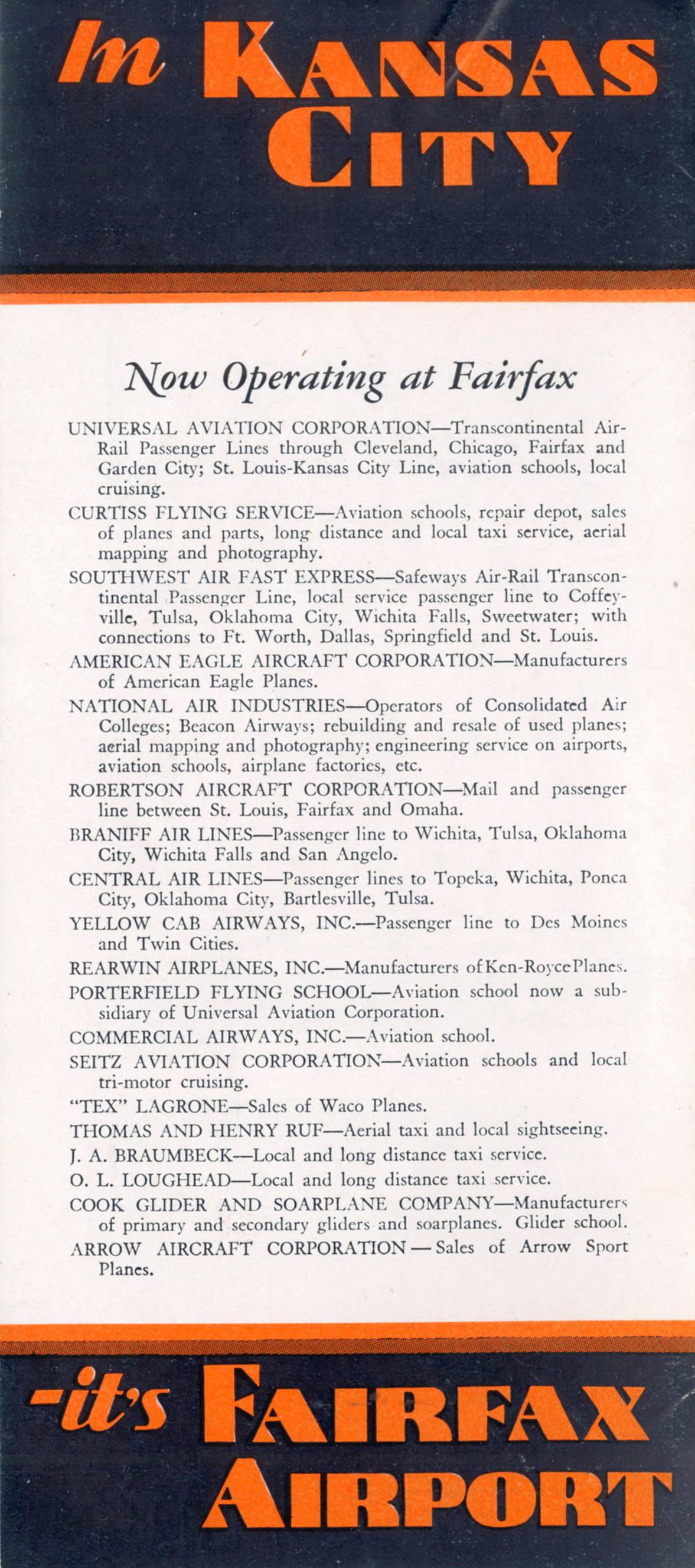
The list of businesses at Fairfax Airport from a 1932 (or earlier) booklet (courtesy of Tom Heitzman).
The earliest aeronautical chart depiction which has been located of Fairfax Airport was on the June 1932 Kansas City Sectional Chart.
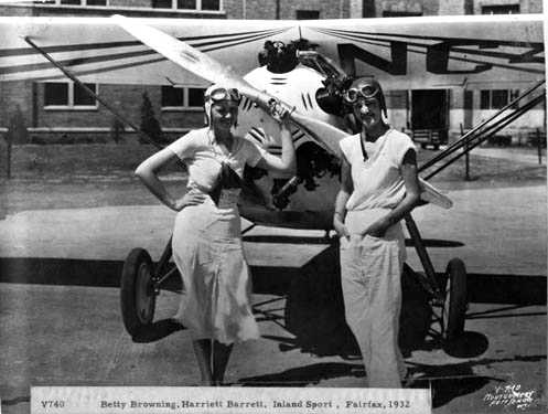
A 1932 photo of aviators Betty Browning & Harriett Barrett in front of an Inland Sport airplane at Fairfax Airport.
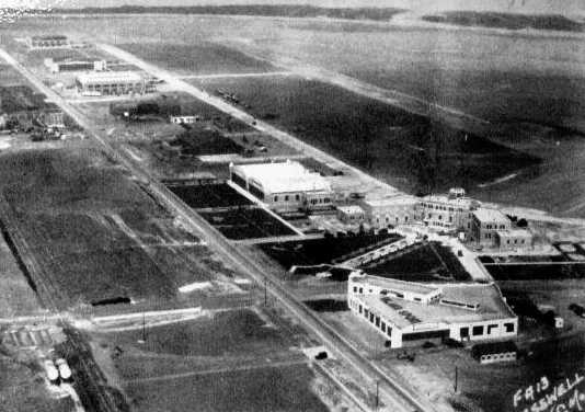
An aerial view of the terminal building & hangars at Fairfax Airport,
from The Airport Directory Company's 1933 Airport Directory (courtesy of Chris Kennedy).
The directory described Fairfax Airport as having a total of 4 asphalt runways,
with the entire field measuring 5,400' x 2,400'.
The aerial photo in the directory pictured a substantial two-story terminal building with control tower on top,
and several large arch-roofed hangars.
The manager was listed as R. F. Craig.
The operators were listed as American Airways, Inc., (schedule mail & transport service),
American Eagle Lincoln Corporation (manufacture & service), Ben Gregory (commercial operator),
B. F. Flanery (commercial operator), Braniff Airways, Inc. (schedule mail & transport service),
Curtiss-Wright Flying Service (repairs, sales, service),
Fred Kane (commercial operator), Rearwin Airplanes, Inc. (school, manufacture, and service),
U.S. Airways, Inc. (schedule mail & transport service), and W.H. Ellis (commercial operator).
The 1935 USGS topo map depicted Fairfax Landing Field as having 3 runways, with a row of hangars along the west side of the field.
A circa 1930s aerial view looking northeast at Fairfax Airport,
from Kansas City's Airline History Museum (courtesy of Ron Plante).
An aerial view looking east at Fairfax Airport,
from The Airport Directory Company's 1938 Airport Directory (courtesy of Chris Kennedy).
It described Fairfax Airport as having a total of 4 asphalt runways,
with the longest being 2,700'.
Charles Haus recalled, “I learned to fly with the Eddie Fisher Flying Service at Fairfax in a Waco RNF & soloed in 1938.”
In 1940 Kansas City was selected as the location of a additional Government-owned plant
to produce North American B-25 Mitchel twin-engine bombers.
A front-page headline in the Kansas City Times of 12/7/40, read “BIG BOMBER PLANT FOR CITY.”
The plant was to be operated by North American Aviation.
The construction site was a 75-acre alfalfa field adjoining Fairfax Airport
North American’s president, James Kindelberger, noted in a telegram:
“Have inspected Fairfax site and it is okay. Airport small but suitable for immediate needs with improvements.”
Prompt action allowed survey work to began in December 1940,
and in January 1941 the War Department & North American signed the necessary contracts.
Muskogee Iron Works of Muskogee, Oklahoma, won the bid to supply approximately 5,000 tons of structural steel.
In February the Kansas City, Kansas, government purchased Fairfax Airport,
which satisfied an AAC requirement for free use of the airport to test the completed bombers.
The federal government subsequently financed airport improvements to accommodate such testing.
From its Inglewood, California, headquarters & home plant,
North American submitted a preliminary list of needed equipment and machinery for Kansas City.
Federal officials bought just over 85 acres from the Kansas City Industrial Land Company,
which constituted the land for the plant & the right-of-way between the site & the airport.
Fairfax Airport, as depicted on the January 1941 Kansas City Sectional Chart (courtesy of Chris Kennedy).
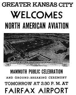
A poster announcing the ground-breaking ceremony for the Fairfax B-25 factory on 3/8/41.
The groundbreaking ceremony occurred on 3/8/41.
North American Aviation president James Kindelberger & Kansas governor Payne Ratner
were among more than 5,000 participants & spectators in attendance.
Within days the first graders, tractors, and pile drivers arrived on site, and 50 men started work.
The firm of McDonald, Tarleton, and Patti of Saint Louis and Kansas City won the general contractor bid
and shared responsibility for the construction with the U. S. Army Corps of Engineers.
A Pittsburgh, Pennsylvania, firm was awarded the contract for sheet steel for the roof & sidewalls.
By the end of March the initial foundation piles were driven and being filled with concrete, and the first structural steel began to arrive.
Washington approved the list of machines & production equipment & assigned a high priority to the procurement.
By April workmen were using 5 pile drivers; they poured concrete caps atop the piling clusters,
which set the foundation lines, and started the concrete walls.
They laid the floor with sand, then gravel, and finished with a top layer of reinforced concrete.
At this time approximately 400 men were on the job constructing the plant.
The plant had the USAAF code of “NC”, and North American’s Plant Code NAA-K.
The factory superstructure would comprise 14 single-story bays of 50' width & 1,050' length,
along with a final assembly bay 32' high, 200' wide, and 750' in length.
On 4/7/41, the crew erected the first structural steel, and within a week they had assembled 2 bays and part of a 3rd.
By month’s end the skeleton of 10 bays was complete, and sheet steel workers began to deck the roof.
In May construction of the last of the 14 standard-width bays & the final assembly bay began.
That same month Kindelberger stated that the first aircraft parts from California,
where B-25 assembly was already under way, were being prepared for shipment.
H. V. Schwalenberg, the newly appointed Kansas plant manager,
announced that a dozen key men from North American in California would arrive soon to facilitate the start of operations.
An additional 140 skilled men were training as supervisors & also were slated to join the Kansas City staff.
At the end of June 1941 the plant was approximately 70% complete, and the awaited parts began to arrive.
The AAC & North American signed contract W535 AC 19341 for the purchase of 1,200 B-25D aircraft
(the D suffix denoted planes to be built in Kansas City).
In early July North American employees began constructing jigs -
frames into which individual pieces are joined together to make a plane’s component parts in a prompt, consistent manner.
Also in July plant construction crews completed the structural steel erection,
and began to fit large sliding doors in the north end & east wall of the final assembly bay.
The completed aircraft could be rolled out these doors in preparation for initial flight tests.
The AAC now controlled Fairfax Airport under a 50-year lease with the local government;
construction crews were enlarging & improving the airport.
When the work was finished, the field contained 4 concrete runways, each
150' wide with a mean length of 5,725'.
Construction workers, now numbering nearly 500, completed the sheet steel siding & connected underground electrical service.
In September they hung fluorescent lighting & completed the first major jig.
Subcontractors gradually installed equipment & machinery in the large plant.
Auto companies joined the airplane industry by making some parts & sub-assemblies:
Fisher Body of General Motors, primarily the Memphis, Tennessee, division, supplied the Kansas City plant.
In mid-October 1941 the plant was 91% complete, and AAF representatives moved into their offices.
Three B-25s were in production in November, the principal assemblies for which had been shipped from Inglewood.
Employees of North American’s Kansas division then numbered about 600
and were expected to increase to 10,000 when production reached its peak.
Built as a “blackout “ building, the plant had no windows,
and steel canopies & a 1'-thick concrete wall sheltered its doors.
One-foot-thick concrete formed the curtain walls as well.
The exterior paint, roof treatment, and concrete apron color were designed to blend into the landscape.
Floor space was more than 1,000,000 square feet, and unlike most buildings of the time, it was air-conditioned.
The complex also comprised 5 small ancillary structures, such as a power house & police quarters.
The government’s cost for the materials, labor, equipment, and machinery totaled well over $11,000,000.
Charles Haus recalled of Fairfax Airport, “The the US Navy had a reserve base at the north end of the field near the Rearwin factory.
The Navy also used this as an E-base where they gave new cadet applicants time in Consolidated NP trainers.
I went through that E-base training in mid-1941 before going to Pensacola.”
In August 1941 Kindelberger had announced that the plant dedication would take place when the 1st bomber was completed,
which he had expected to occur at the end of the year.
Officials planned an elaborate 3-day dedication to start on 1/9/42, including an open house.
But these plans changed soon after the Japanese attack on Pearl Harbor, 12/7/41, and U.S. entry into the war.
Officials thought it best to focus on production, so a conservative ceremony was held on 12/23/41,
to mark completion of the 1st bomber to roll from the plant.
An aerial view of Fairfax Airport from The Airport Directory Company's 1941 Airport Directory (courtesy of Chris Kennedy).
It described Fairfax Airport as having 2 asphalt runways: 2,640' north/south & 1,800' east/west.
The first B-25 came off the line on 12/23/41.
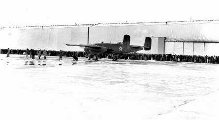
A 1/3/42 photo of the first B-25D Mitchel bomber built at Fairfax preparing for its test flight,
with factory workers gathered behind to witness the event.
Production initially moved slowly.
During the first 4 months of 1942, the AAF accepted 11 from the Kansas plant.
It took time to coalesce a new work force & to receive the remainder of the machinery orders.
In addition, assemblers encountered early Fisher Body parts that did not fit & thus required rework.
These teething issues delayed aircraft production & acceptances.
Nonetheless the Fairfax flightline was teeming with B-25s undergoing alterations.
Early operational reports necessitated the modification of some Mitchells to meet the special circumstances & needs of their end-users.
Certain equipment or armament was added, removed, or exchanged,
and special preparations for specific weather destinations were accomplished.
Other changes prepared aircraft bound for service with allies, such as the British & Russians.
Because such alterations could not reasonably be effected in the just-started assembly process,
they were performed on a select number of aircraft after their initial test flights.
Many planes on the flightline had been built in Inglewood & flown to Kansas City for these modifications.
In May 1942 work started on the foundation of a modification center -
a dual hangar to be built on the southeast edge of Fairfax Airport expressly for facilitating aircraft alterations.
Because construction workers needed steel for military items, timber frames were largely used in the construction of the center.
By October workers completed the modification center,
but the ever increasing volume of work meant that some alterations continued to be performed outdoors on the airport apron.
Subsequently a west extension & several outbuildings were added to the modification center.
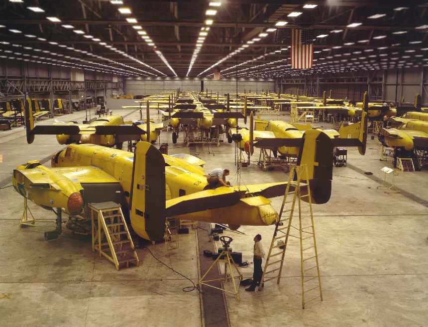
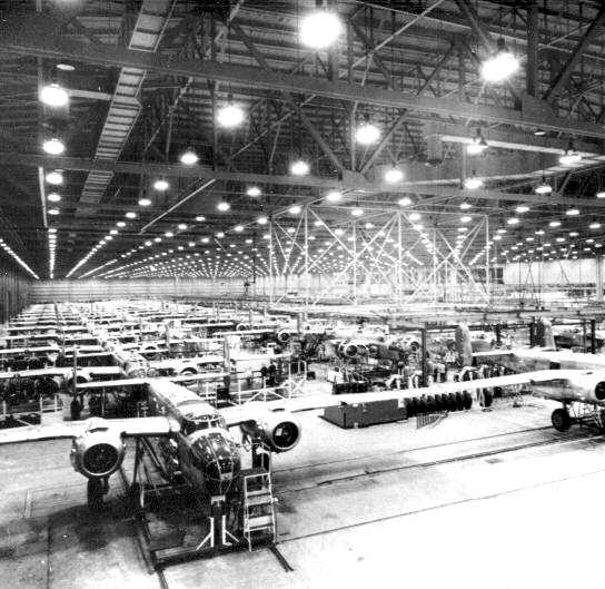
An October 1942 photo by Alfred Palmer of B-25 Mitchel bombers
undergoing assembly at North American Aviation's Kansas City plant at Fairfax Airport (US Library of Congress photo).
A 1942 photo by Alfred Palmer of a B-25 Mitchel bomber being towed after undergoing assembly at North American Aviation's Kansas City plant at Fairfax Airport.
Yet another significant plan involving North American’s Kansas City facility commenced in 1942.
The Boeing B-29 - a new, long-range, heavy bomber - was destined to be an important weapon in the Pacific theater.
A consortium, which included Boeing Aircraft Company, set up a committee to plan for the new plane’s production,
and several companies contracted to build the B-29.
In addition to North American Aviation; Boeing of Wichita; Bell Aircraft of Marietta, Georgia;
and Glenn L. Martin in Omaha, Nebraska, received such contracts.
Charged with building 200 planes, North American decided that the Kansas City plant
could produce the B-29 in conjunction with the Mitchell.
In July an addition for this purpose was begun on the east side of the bomber plant.
Because the new bomber was appreciably larger than the B-25, the addition needed to be expansive.
The “high bay,” as it was known, added 370,000 square feet of floor space.
It measured 350' & 1,060' in length; the height was twice that of the existing, final assembly bay.
With the high bay construction under way, and much of the B-29 engineering & equipment procurement in progress,
the AAF reversed its earlier decision.
A memo from Major General Oliver Echols to General Henry Arnold read in part:
“Since the B-25 has apparently become a more useful plane than was anticipated,
in that it not only seems to be a reasonably good medium bomber, but also, with gunnery modifications,
will lend itself to support of ground troops.
It is believed that circumstances will require the maximum number of these planes that we can build.”
As a result the AAF canceled North American’s B-29 contract but continued the plant addition & tool orders,
with the plan to increase B-25 production.
The plant addition was completed in March 1943, and by that summer the high bay was incorporated into the assembly process.
The Fairfax plant had a peak employment of 24,329 in October 1943.
The next 94 Mitchells to be completed at Fairfax were in various stages of assembly
and were shipped to the Kansas City plant or to Fisher Body, but the completed assemblies were finalized at Kansas City.
Starting with shipment 101, workers performed approximately 45% of the manufacture at Kansas City,
with Fisher Body & other subcontractors completing the remainder.
Problems in receiving machined parts of sufficient quality & quantity caused North American to shift more of the fabrication to the Kansas division.
As it evolved, the bomber plant undertook approximately 62% of the manufacture.
Fisher Body’s contribution would average 29%, including such parts as outer wing panels & fuselage side panels.
The remaining content was composed of government furnished equipment, such as engines, propellers, wheels, tires, and instruments.
What had started as a simple assembly plant had grown into a veritable manufacturing facility.
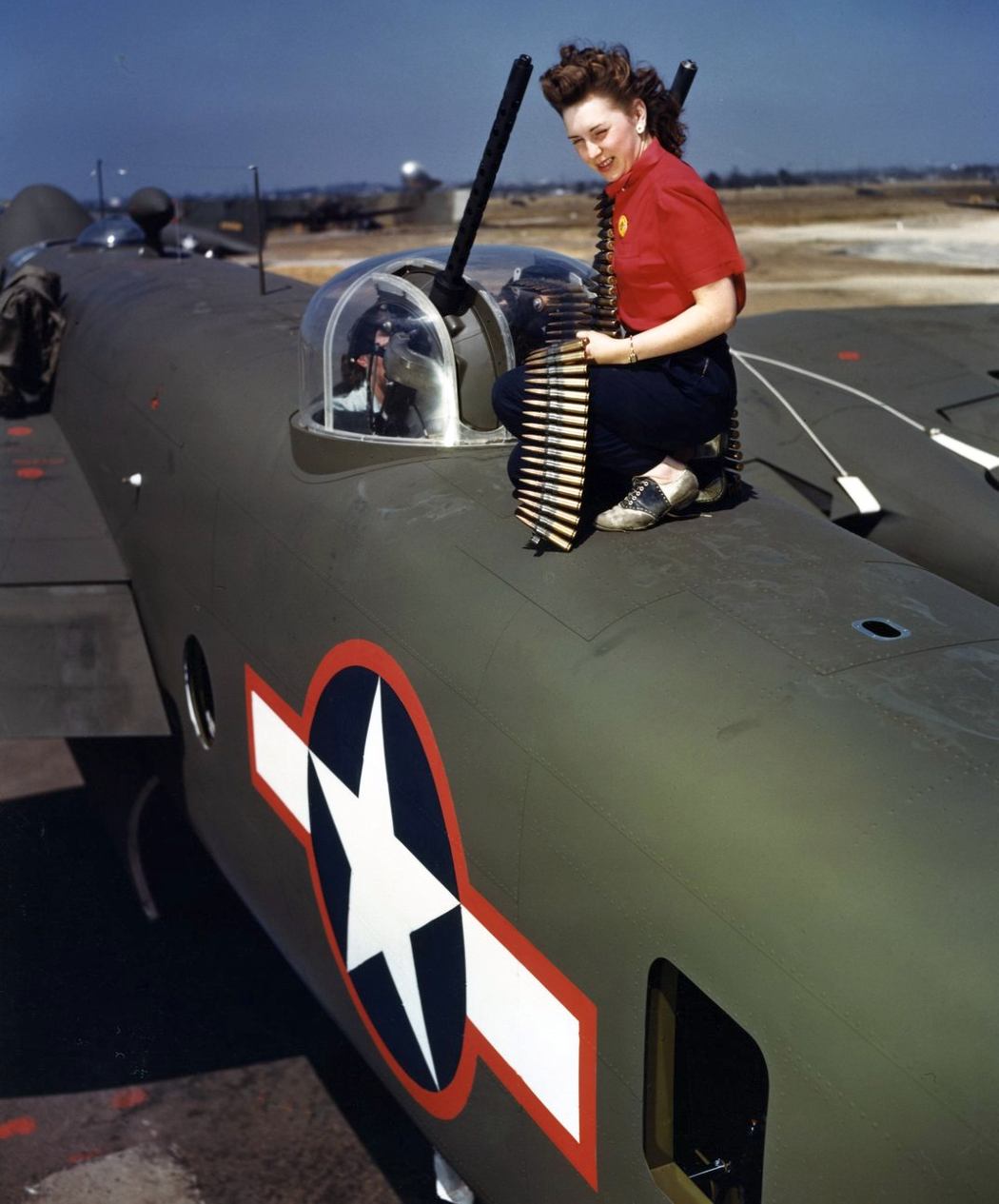
A 1941-44 photo of a female worker at the Fairfax plant loading .50 caliber ammunition into a B-25’s top turret.
Each gun was test-fired with a minimum of 25 rounds.
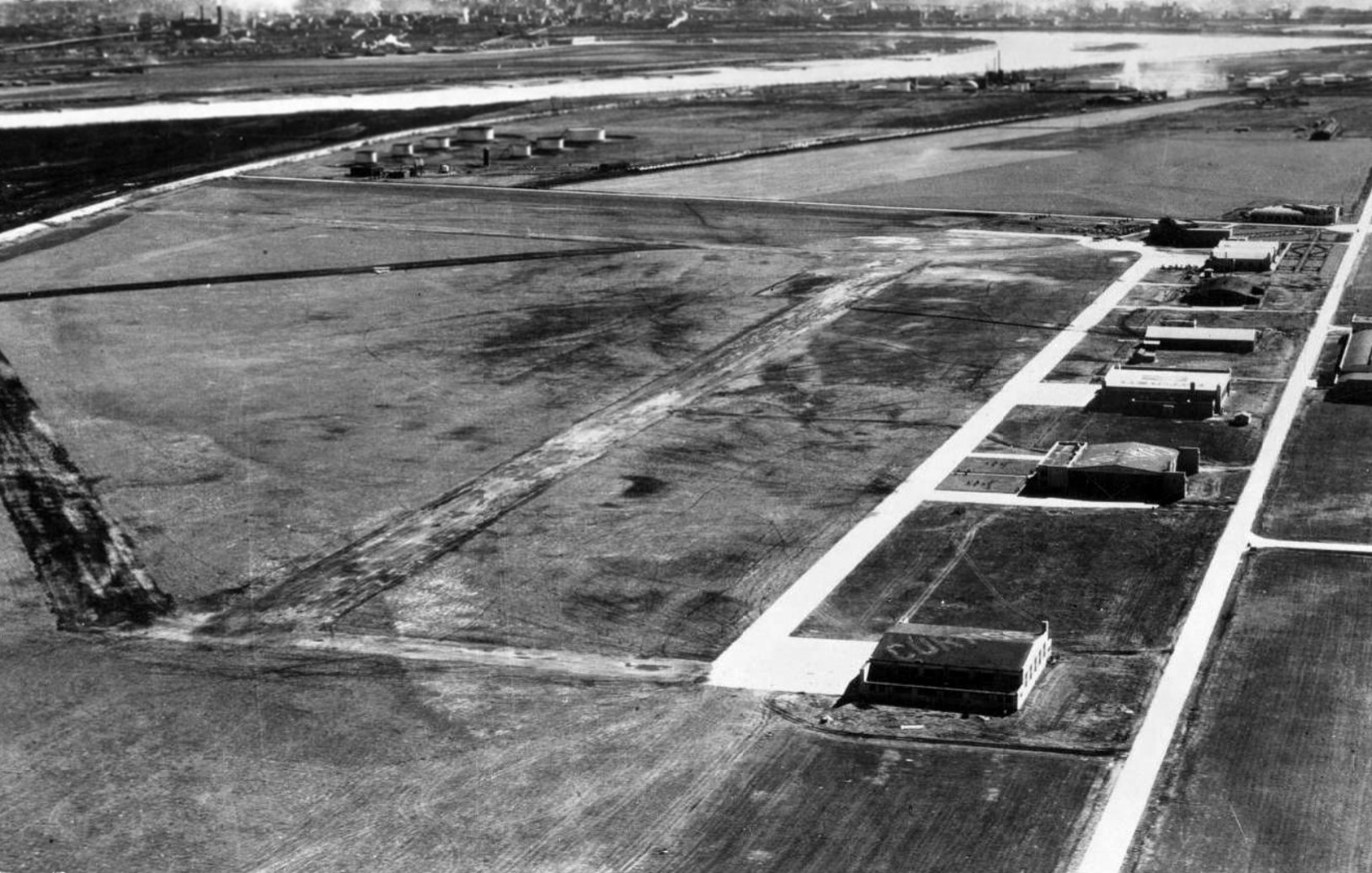
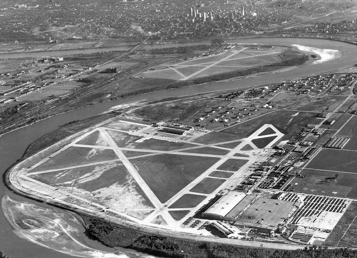
A 1941-45 aerial view looking north at Fairfax Airport,
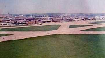
with the North American factory at top-left, and the Modification Center at the right, surrounded by dozens of military aircraft.
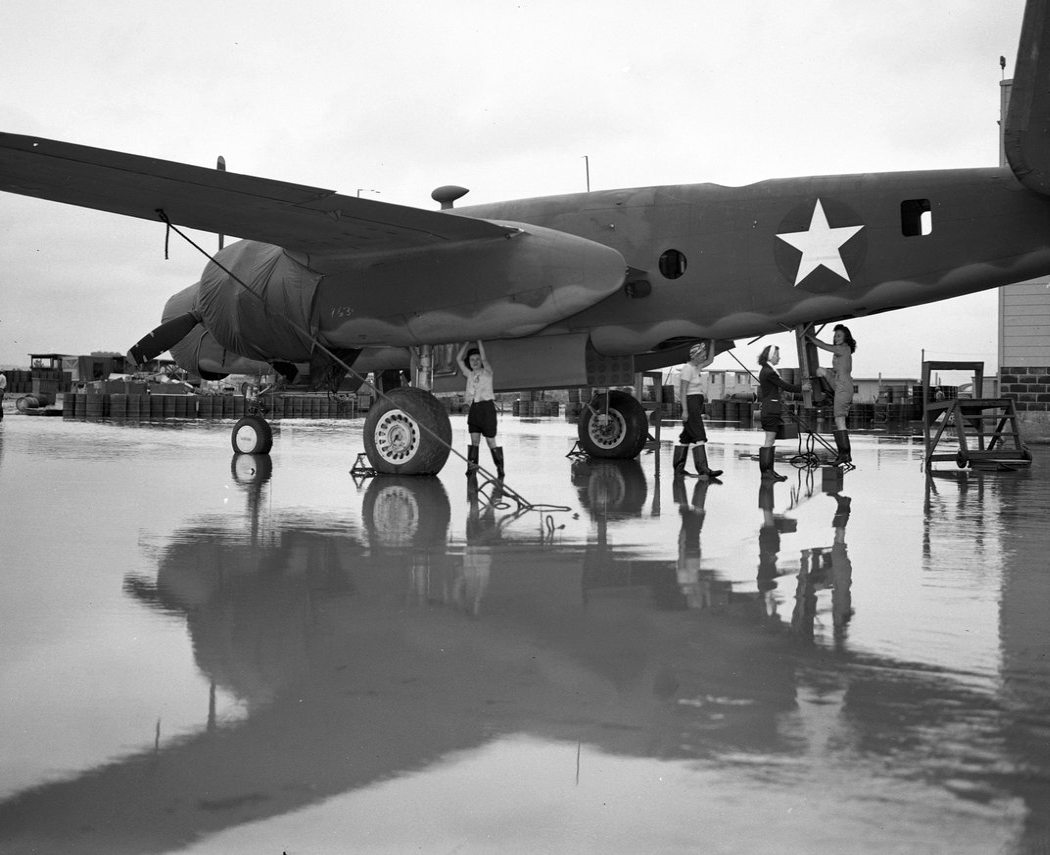
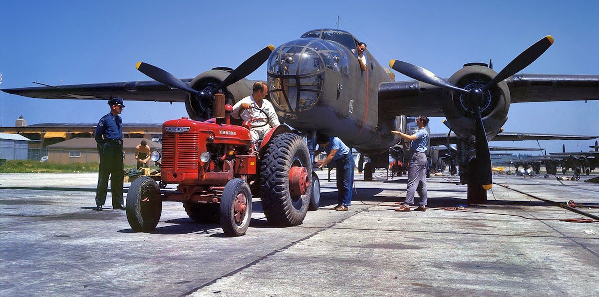
A 1941-44 photo of an all-female crew of mechanics continue working at Fairfax Airport in spite of floodwaters from the adjacent Missouri River flowing onto the ramp.
Each crew, consisting of a crew chief & 3-5 mechanics, was responsible for 3 planes.
In March 1944 the last of the B-25D models moved down the assembly line, and production began on a new model.
The B-25J incorporated several improvements.
Armor protection was added for the cockpit,
and the bottom turret was no longer installed, for it had proven too slow & awkward to operate in combat.
The top turret was moved forward to give more front firepower.
Package machine guns were added below the cockpit, 4 on each side.
Some J models received a solid nose instead of the glass enclosure nose;
in this solid nose 8 machine guns were placed, making a possible total of 18 machine guns per plane.
Effective 7/7/44, North American ceased production of the B-25 at the Inglewood plant and focused on building the P-51 fighter.
Its Dallas facility also was primarily involved in the production of the P-51 as well as the AT-6 trainer.
Thus, from mid-1944 the Kansas City plant was the sole source of B-25s.
Since the plant operation was running at such a high pitch, modifications were incorporated into the assembly process.
As a result, the modification center was closed in October, and thereafter it was used as an adjunct to the final assembly line.
The Air Technical Service Command & the Air Transport Command also operated from the field during WW2.
A 1940s era aerial view of the main entrance of the Fairfax bomber factory.
The initial final assembly bay can be seen here stretching out behind the central entrance.
The high bay, completed in March 1943, is just visible at the top right.
A circa 1940s aerial view looking southeast at Fairfax Municipal Airport, showing the close proximity of Kansas City Municipal Airport across the river, and the Kansas City skyline in the background.
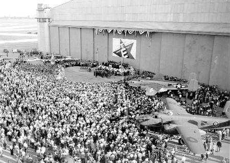
Three B-25 bombers are pictured in front of a hangar at the Fairfax plant,
as factory employees are gathered to receive the Army–Navy E Award, given to them on 10/6/44, for excellence in production.
In January 1945 the Kansas City plant set a production record:the AAF accepted 315 aircraft.
For the next 3 months production remained high while a new venture began.
The Lockheed P-80 was America’s first operational jet fighter.
North American offered its Kansas City plant to augment Lockheed’s production, and the War Department approved.
In February 1945 two Lockheed representatives came to Kansas City to liaison with North American engineering & production staff,
and in April Lockheed shipped a P-80 to the bomber plant for study.
While work began on building jigs for the new plane, workmen cleared space for P-80 production in the high bay,
and the B-25 assembly line was shortened.
The test flight office scheduled 4 pilots to fly to Lockheed in California to check out on the jet.
War news overtook the schedule, however.
The Germans capitulated on 5/7/45, and at the end of the month, the AAF made large cuts in plane production,
particularly in short-range types not suited to the Pacific theater.
Kansas management received its P-80 cancellation order & released 1,500 employees.
The B-25 schedule was expected to be complete in December,
therefore average monthly employment gradually dropped for the first 6 months of the year.
War news again changed the plans.
The Japanese surrendered on 8/14/45, and the next day the B-25 contract was terminated.
A total of 6,608 B-25 Mitchells were built at Fairfax - more half of the 10,000 B-25s built during war.
In his farewell message to the employees, Harold Raynor said, “Men and women of North American Aviation.
The day we have been fighting for since 12/7/41 has come at last.
The world is finally freed of the fear of aggression & we can now go back to our peacetime pursuits.”
At that time North American’s Kansas division had approximately 7,600 employees.
In little more than a week the firm laid off 4,680.
The remaining workers dealt with paperwork, finished special projects & spare parts for the AAF,
and completed work on the planes ready to leave final assembly & those on the flight line,
and began the job of preparing the machines, tools, materials, and parts for disposition.
The federal government’s Reconstruction Finance Corporation (RFC) set up a depot in the Fairfax district
to sell machinery, tools, and similar material to peacetime industries and the public and thereby partially recoup the government’s war costs.
Some of the bomber plant items were sent to the depot, while others were transferred for government use elsewhere.
Such materials as aluminum sheet & steel goods went to reclamation centers,
and spare airplane parts were dispatched to maintenance depots.
Seventy-two incomplete but flyable B-25s were accepted under the contract & flown elsewhere for sale to the public.
During this demobilization the federal government classified the plant, modification center, and associated properties as available for lease.
Transcontinental & Western Air leased the modification center, whose first use would be in servicing its airliners.
According to Bill Flett, “Trans World [Airlines] had a large hangar at Fairfax
and did heavy overhaul for the aircraft operated in domestic operations.
This was from about mid 1940s to late 1950s.
My dad hired on at TWA in the fall of 1945 & spent a few of those early years testing aircraft coming out of maintenance at Fairfax.
They’d take them up, fly them around & check them out, then return to the old Downtown Airport & put them back into the line.”
On 11/7/45, it was announced that General Motors had signed a 5-year lease for the former bomber plant.
By December 1 the plant was essentially cleared of all aircraft production matter,
and automobile industry personnel began setting up shop.
In October 1946 the U.S. Air Force terminated its lease on Fairfax Airport, and the city of Kansas City, Kansas, regained control of the facility.
After that the field once again reverted to civil use as Fairfax Municipal Airport.
The reconverted bomber factory finished its first automobile in June 1946,
and for the next 40 or so years it produced Buicks, Oldsmobiles, and Pontiacs.
A 1946 aeronautical chart from Kansas City's Airline History Museum (courtesy of Ron Plante)
depicted Fairfax Airport as having 4 paved runways.
An aerial view looking southwest at Fairfax Airport from the cover of the book “Fairfax Industrial District”,
published by the Union Pacific Railroad (courtesy of Rex Ricks).
It depicted several aircraft on the ramp of the Modification Center on the south side of the field.
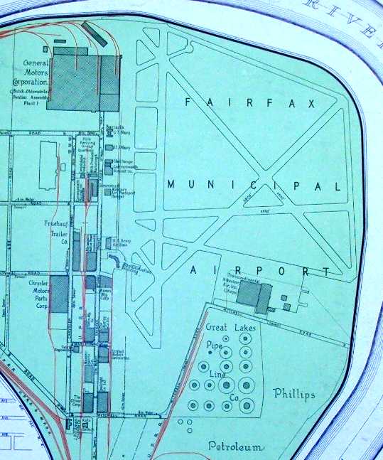
A map of Fairfax Airport from the book “Fairfax Industrial District”, published by the Union Pacific Railroad (courtesy of Rex Ricks),
showing the GM Buick, Oldsmobile, Pontiac Assembly Plant at the northwest, the TWA hangar at the southeast,
and several Navy & Army hangars.
Undated photos from the book “Fairfax Industrial District”, published by the Union Pacific Railroad (courtesy of Rex Ricks),
showing the GM assembly plant, TWA hangars, and airport terminal.
After WW2, Commonwealth Aircraft Company's first post-war production run
of their Skyranger (a light single engine general aviation aircraft)
was almost hand-made at Fairfax Airport,
before the production line was transferred in 1946 to the former Columbia Aircraft factory in Valley Stream, NY.
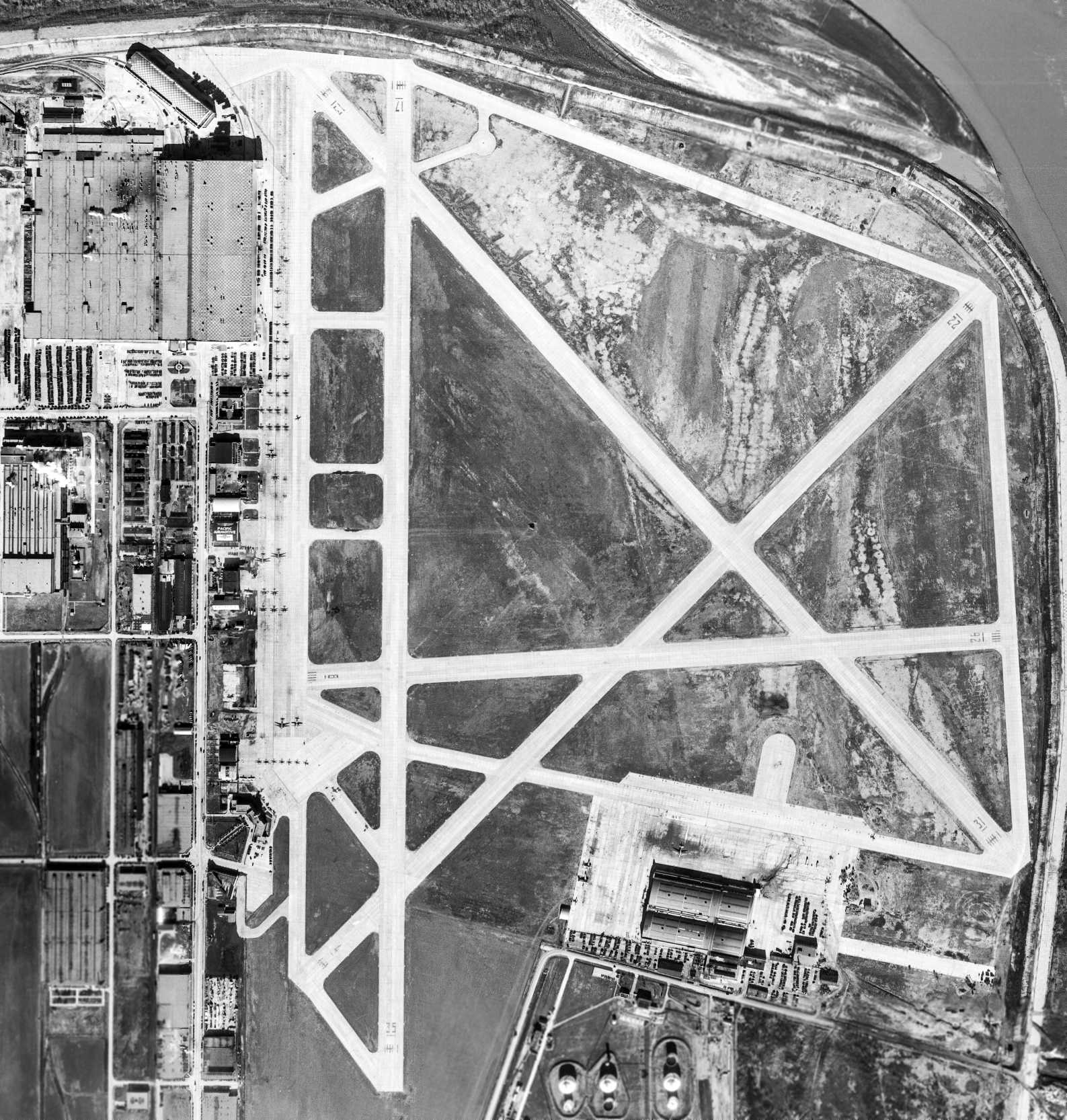
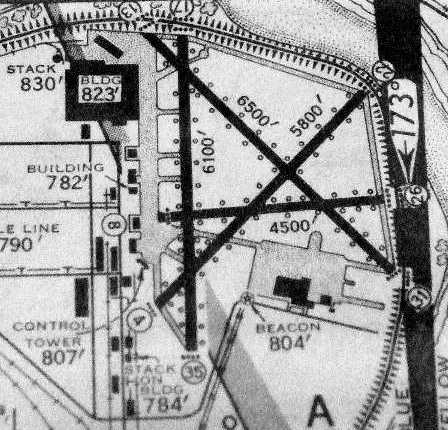
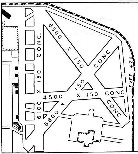
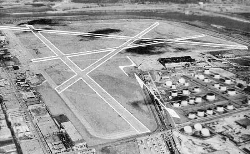
A 12/5/47 USGS aerial view depicted Fairfax Municipal Airport as having 4 concrete runways.
The B-25 factory was seen on the northwest corner, and the B-25 modification center was seen on a ramp on the southeast side of the field.
A large number of aircraft (single-engine & some larger twin-engine, type undetermined) were parked on the west ramp, and a few on the southeast ramp.
The 1949 KS Airport Directory (courtesy of Chris Kennedy)
depicted Fairfax Municipal Airport as having 4 concrete runways,
with the longest being the 6,500' northeast/southwest strip.
A row of buildings (hangars?) were depicted along the ramp on the west side of the field.
The former B-25 factory was depicted on the northwest corner,
and the former B-25 modification center was depicted on a ramp on the south side of the field.
The airport was said to offer repairs & fuel, and the manager was listed as William Green.
In 1950 Mid-Continent Airlines got a lucrative contract to deliver airmail on the North Central Route #106,
operating out of Fairfax.
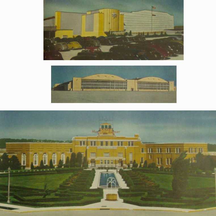
A 1950 postcard of Fairfax Municipal Airport (courtesy of Rex Ricks).
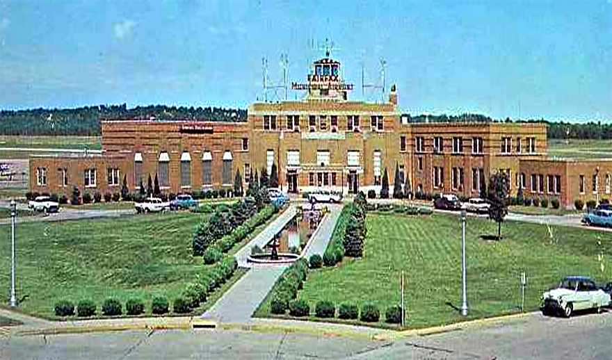
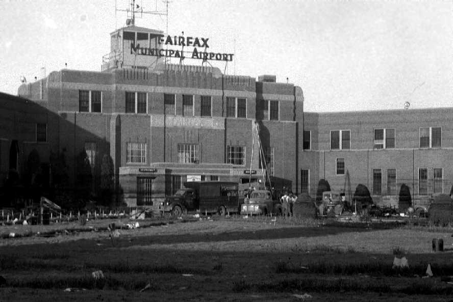
A circa 1950 photo of the terminal building & control tower of Fairfax Municipal Airport.
In the Great Flood of 1951, TWA's Fairfax overhaul base was destroyed.
A 1951 aerial photo (from the Kansas City Library, courtesy of Chris Kennedy)
showed that the Fairfax Airport property was completely covered by floodwaters.
A 1951 photo by Ray Lewis (courtesy of Jim Lewis) showing the Fairfax control tower in the aftermath of the flood.
Jim observed, “You can still see the water lines on the main building after the flood.”
A 1951 photo by Ray Lewis (courtesy of Jim Lewis) showing the wrecks of several unidentified aircraft at Fairfax in the aftermath of the flood.
According to Jim, his father Ray “was an engineer who designed 20mm cannon shells for the Navy in WWII.
He worked for the West Bend Aluminum Company & flew to Fairfax often during the war & well after.”
According to Bill Flett, “The airport property flooded & caused quite a bit of damage.
Fortunately all but a few aircraft were flyable & able to be moved out in time.”
In order to keep TWA in the metropolitan area,
Kansas City, Missouri, built a new airport for TWA away from the river in rural Platte County.
That airport, originally called Mid-Continent Airport, was to become Kansas City International Airport.
Following the 1951 flood, Mid Continent Airlines & its airmail operations also relocated to the Mid-Continent Airport.
During the Korean War the former bomber factory was utilized in a dual role of manufacturing automobiles & F-84F Thunderstreak aircraft.
This was the only time that aircraft & auto production have been run down parallel lines simultaneously.
General Motors produced 599 F-84Fs at Fairfax – where these the only jet fighters built by GM?
The June 1954 Kansas City Local Aeronautical Chart (courtesy of Mac Hayes)
depicted Fairfax Airport as having 4 paved runways, with the longest being 6,700'.
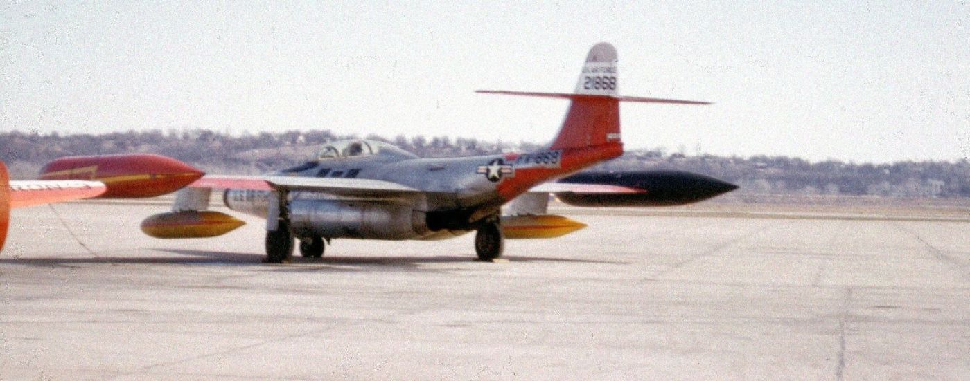
A 1955 photo by Mac Hayes of a Northrop F-89 Scorpion fighter at Fairfax Airport.
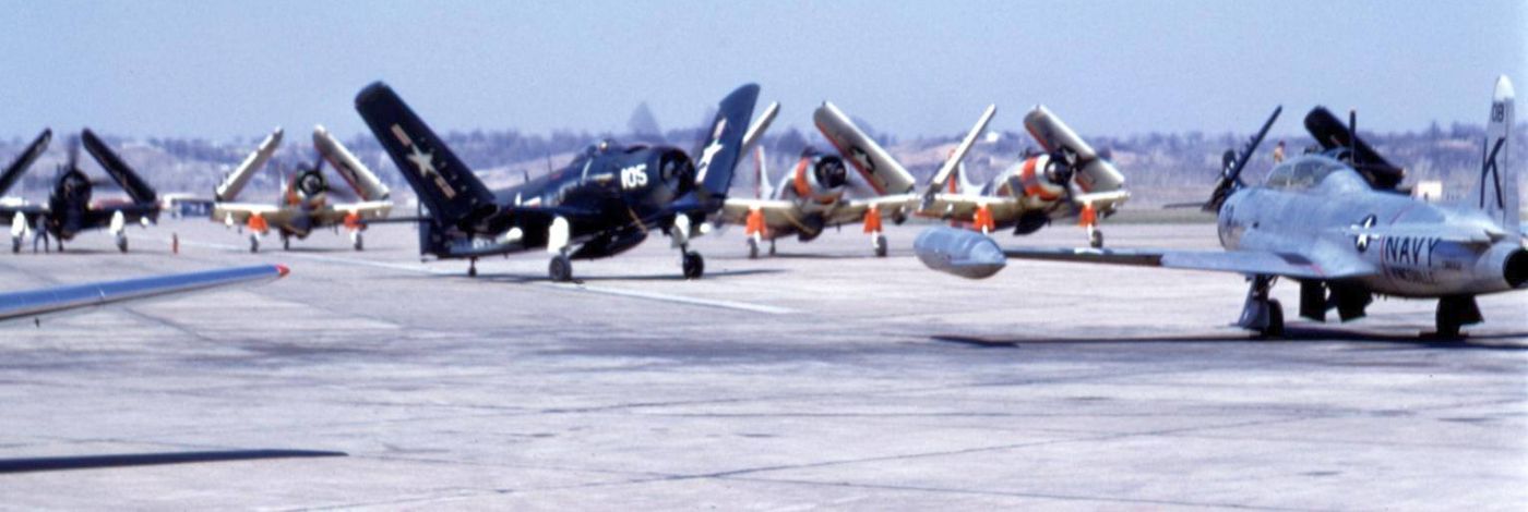
A 1956 photo by Mac Hayes of Douglas AD Skyraiders & a Lockheed TV-2 Shooting Star at Fairfax Airport.
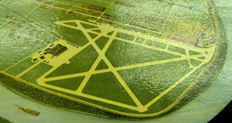
An aerial view looking northeast at Fairfax Airport, from a circa 1957-61 MO Airport Directory (courtesy of Chris Kennedy).
The field was described as having 4 concrete runways, with the longest being a 6,500' northwest/southeast strip.
A row of hangars & buildings was depicted on the west side,
and the former B-25 modification facility was still standing on the southeast side of the field.
The field was said to offer fuel, hangars, tiedowns, and major repairs.
In 1960 General Motors purchased the Fairfax plant.
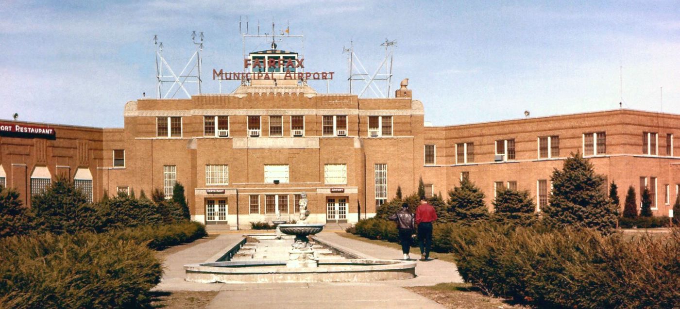
A 1960 photo by Mac Hayes of the Fairfax Airport terminal building & control tower.
A 1961 aerial view by Mac Hayes looking northeast at Fairfax Airport.
A 1961 photo by Mac Hayes of a civilian North American P-51 Mustang & a Culver Cadet at Fairfax Airport.
A 1962 photo by Mac Hayes of the Fairfax Airport ramp, showing 2 Vultee BT-13s or BT-15s, a yellow North American T-6 Texan, and numerous other general aviation aircraft.
 A
1962 photo by Mac Hayes of a Piper TriPacer & an Erco Ercoupe on
the Fairfax Airport ramp.
A
1962 photo by Mac Hayes of a Piper TriPacer & an Erco Ercoupe on
the Fairfax Airport ramp.
According to Mark Ingram, starting in at least the early 1960s
"the old terminal on the west side of the airport was home to the FAA General Aviation District Office."
Ron Schauble recalled, “I worked at Eddie Fisher's Service the summer of 1964, and instructed at Wilson's in 1968-69.
There was a very large searchlight on the top of the Fairfax control tower.
Early aircraft did not have adequate taxi lights, probably because they were all tail wheel & once the tail sat down the landing lights were not much good for taxi.
The tower operators would keep the spotlight just ahead of the aircraft while it taxied. I had them do it for me several times just to try it out.
There was an underground fuel storage tank near the hangars by the tower. The fuel floated on water.
To fill the gas trucks we would turn on the water supply & float the gasoline up and out of the overhead supply into the tank of the truck.
Several of the corporate aircraft there in the 1960s were Howard 350 or 500 Lockheed Hudson bomber conversions.
One pilot never got an instrument rating. He said if the weather was bad enough to use instruments they shouldn't be flying.”
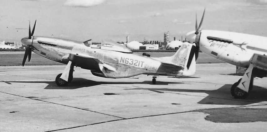
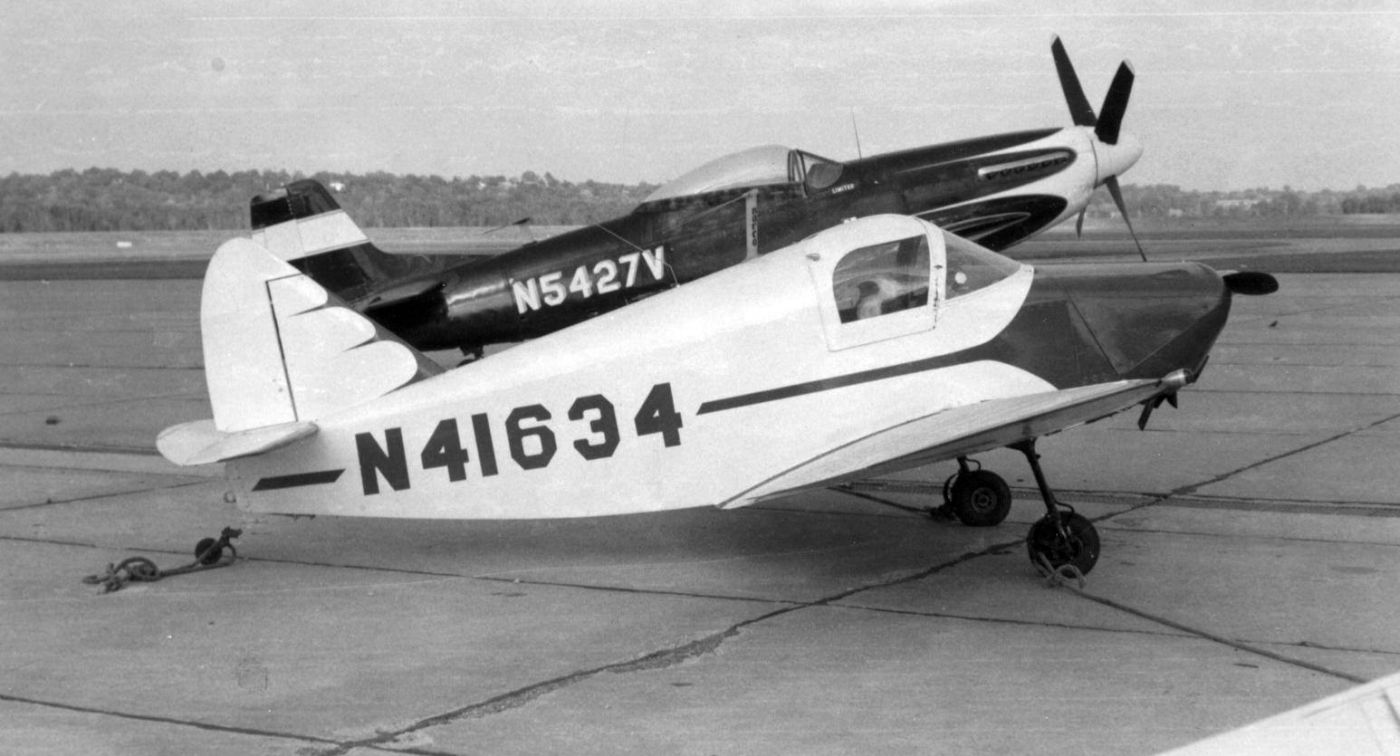
A circa 1965-66 photo of 2 surplus P-51 Mustangs at Fairfax Airport.
Ron Schauble recalled, “The 2 P-51s beonged to Eddie Fisher. Eddie acquired, or at least started flying, the silver P-51 then.
It may have been sitting in the hangar before that. The white one was the one Eddie flew the most.
The name on it is 'Maggie', named after his wife.”
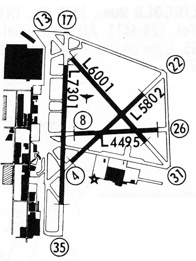
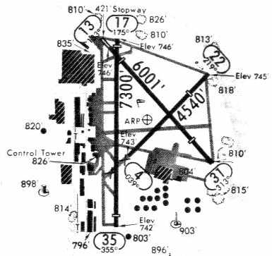
The 1968 Flight Guide (courtesy of Robert Levittan) depicted Fairfax Municipal Airport as having 4 paved runways (with the longest being the 7,301' Runway 17/35),
along with numerous taxiways, ramps, and buildings.
The January 1973 Kansas City Sectional Chart depicted Fairfax Airport as having 4 paved runways, with the longest being 7,300'.
A 5/15/75 USGS aerial view depicted Fairfax Municipal Airport as having 4 concrete runways.
The former B-25 factory was seen on the northwest corner, and the former B-25 modification center was seen on a ramp on the southeast side of the field.
A large number of aircraft (single-engine & some larger twin-engine, type undetermined) were parked on the west ramp, and a few on the southeast ramp.
A 1981 airport diagram (courtesy of Eric James)
depicted Fairfax Municipal Airport as having 3 paved runways (with the longest being the 7,300' Runway 17/35),
along with numerous taxiways, ramps, and buildings.
Fairfax Municipal Airport was listed among active airfields in the 1982 AOPA Airport Directory (courtesy of Ed Drury),
which described the field as having 3 concrete runways (the primary runway, 17/35, was 7,301'),
and listed the operators as Meisinger Beechcraft, Air Cargo Terminals, and Central Aviation Services.
The last aeronautical chart depiction which has been located of Fairfax Airport was on the 1982 Kansas City Sectional Chart.
It depicted Fairfax Airport as having 4 paved runways, with the longest being 7,300'.
In 1985 GM announced its plans to build a new auto assembly plant on the Fairfax Airport property & closed the former airport.
Soon after, the WW2-era aircraft modification center was razed.
The last flight out of Fairfax Airport was made at midnight, 3/31/85.
For Hugh "Holly" Hollinger his midnight flight from Fairfax Municipal Airport had a special meaning.
Which was the reason he scheduled it for exactly midnight.
As Hollinger opened the throttles wide on his twin Cessna 402 at exactly midnight
his wheels were on the concrete runway at least a few seconds into the new day April 1.
For Holly that also meant that it had been 45 years to the day when he took for his first solo flight off Fairfax.
Hollinger estimated that he had flown more than 20,000 hours off Fairfax, mostly for his employer, Tobin Construction Company.
As the rubber tires of Hollinger's Cessna 402 lifted off the concrete runway at 11:59:59pm, the airport formally closed its runways behind him
Fairfax Airport was closed on 4/1/85.
Automobile production at the former bomber plant ceased in May 1987, and in 1989 GM tore down the original airplane factory.
The massive facility that had been a setting of such importance during World War II was completely gone.
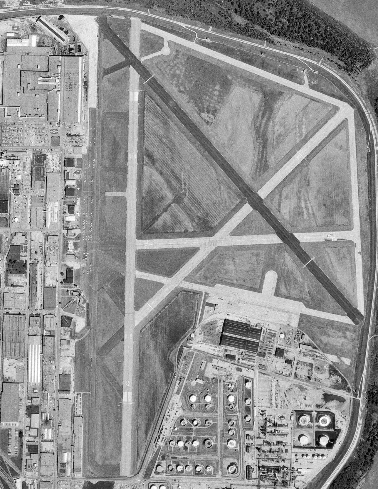
General Motors constructed a much larger factory, its Fairfax Assembly Plant, right in the center of the former runways,
eventually covering much of the former airfield.
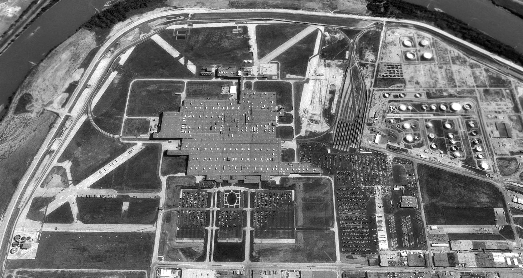
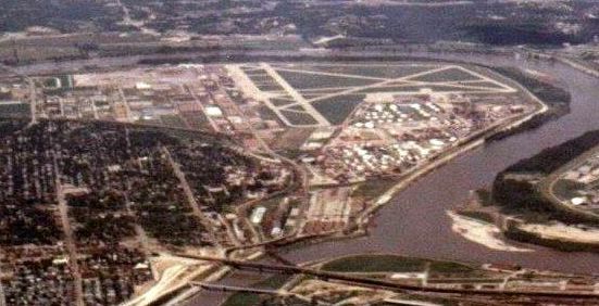
As seen in a 1991 USGS aerial view looking east, portions of 5 paved runways, taxiways & a ramp still existed at the site of Fairfax Airport,
while the factory covered the center of the former airfield.
All of the former airfield buildings (including the aircraft factory, hangars & airport terminal on the west side of the property)
had evidently been removed at some point between 1981-91.
Fairfax Airport was no longer depicted on the 1982 Kansas City Sectional Chart.
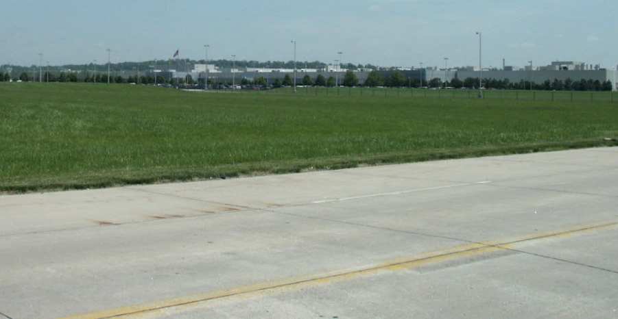
A 2002 photo by Tim Tyler of the GM factory which occupies the site of Fairfax AAF.
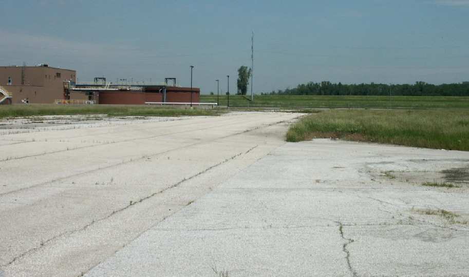
A 2002 photo by Tim Tyler of a portion of remaining airfield pavement from Fairfax AAF.
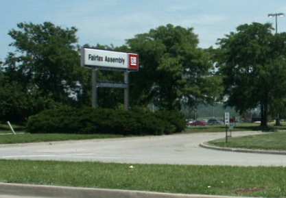
A 2002 photo by Tim Tyler of the entrance sign of GM's Fairfax Assembly plant which occupies the site of Fairfax AAF.
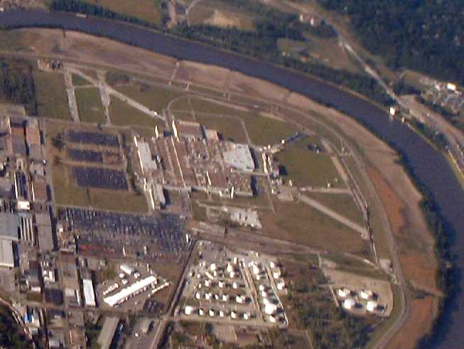
A 2007 aerial view looking north at the site of Fairfax Airport, showing the remaining portions of 4 paved runways.
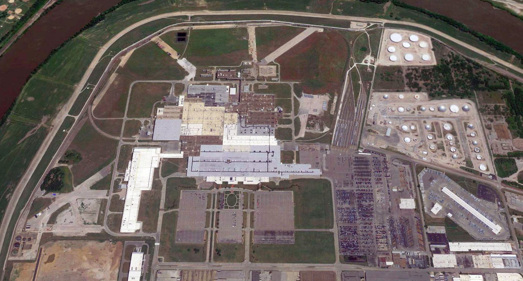
A 2017 aerial view looking east at the site of Fairfax Airport, showing the remaining portions of 4 paved runways.
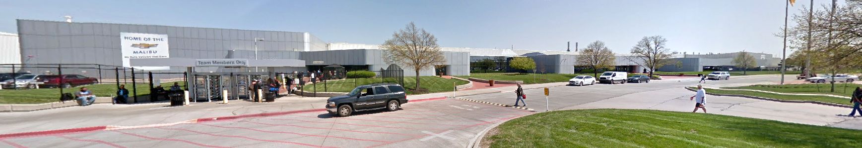
A 2017 photo looking southeast at GM's Fairfax Assembly plant which occupies the site of Fairfax AAF.
See also: The Kansas City Kansan, 5/5/85.
____________________________________________________
(Original) Coffeyville Municipal Airport, Coffeyville, KS
37.06, -95.64 (Southeast of Wichita, KS)
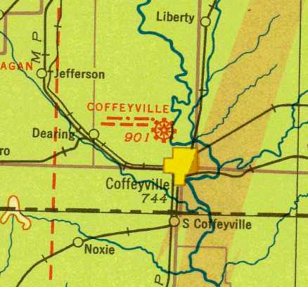
The original Coffeyville Municipal Airport was depicted as a commercial/municipal airport on the August 1934 Tulsa Airway Chart.
The original municipal airport for the town of Coffeyville was located on the northwest side of the town.
According to Chris Decker, “It was constructed as a Works Progress Administration project & dedicated in 1933 as Pfister Park Airport.”
The airport's hangar was also constructed by the WPA in 1933, according to the Coffeyville Aviation Heritage Museum.
The earliest depiction of the original Coffeyville Municipal Airport which has been located was on the August 1934 Tulsa Airway Chart.
It depicted Coffeyville as a municipal/commercial airport.
According to Chris Decker, “It was a hub with a terminal for N.A.T. Safeway & TWA Airlines until 1935.”
According to Cary Finder, “The Coffeyville Airport was designated by the Post Office Department on 8/1/36
for use as of 9/1/36 as a stop point on the airmail route AM-26 between Kansas City & Tulsa OK.”
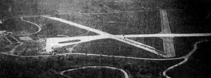
An aerial photo looking north at at the original Coffeyville Municipal Airport from The Airport Directory Company's 1937 Airport Directory (courtesy of Bob Rambo).
It described Coffeyville as a 172 acre sod field, with three 2,800' crushed rock runways.
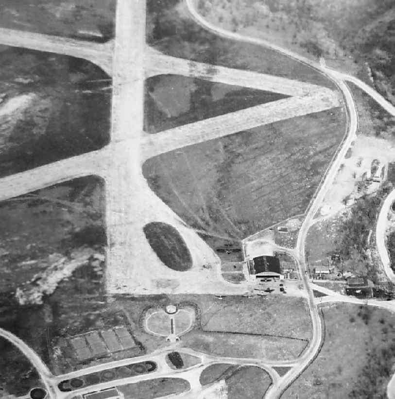
An undated aerial view looking north at the original Coffeyville Municipal Airport, showing a hangar & several aircraft (courtesy of Chris Decker).
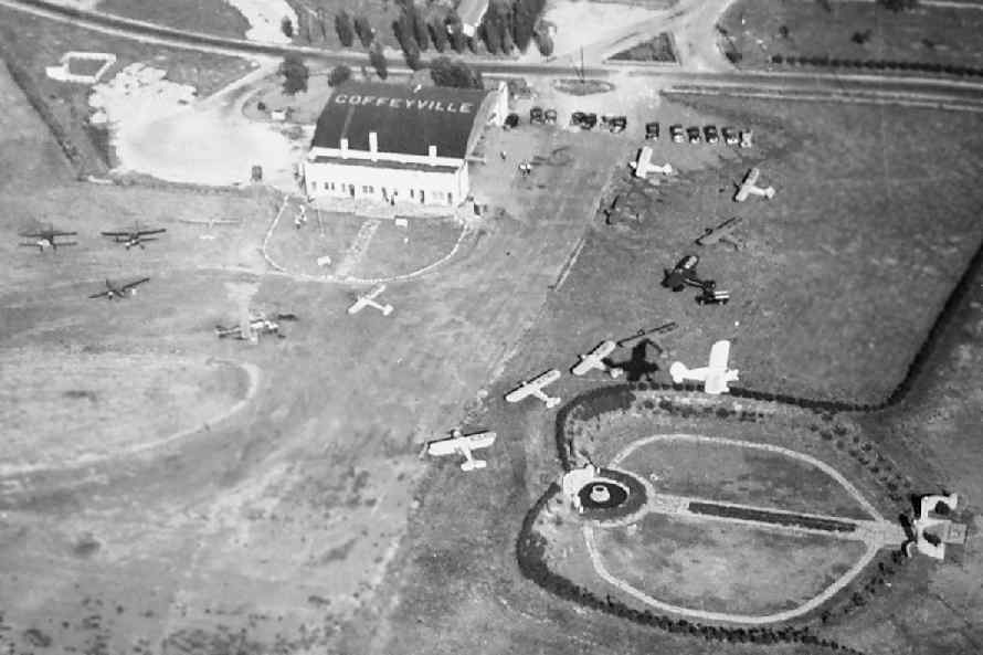
An undated aerial view of looking east at the original Coffeyville Municipal Airport, showing a hangar & 17 single-engine aircraft (courtesy of Chris Decker).
The April 1944 US Army/Navy Directory of Airfields (courtesy of Ken Mercer)
described the Coffeyville Airport as having a 2,700' hard-surface runway.
It indicated that Army flight operations were conducted, along with “intensive training”.
When the former Coffeyville Army Airfield (located to the northeast of Coffeyville) was relinquished by the military for civilian use,
some civilian flight operations relocated there from the
The original Coffeyville Municipal Airport was depicted as “Coffeyville #2” on the 1947 USGS topo map.
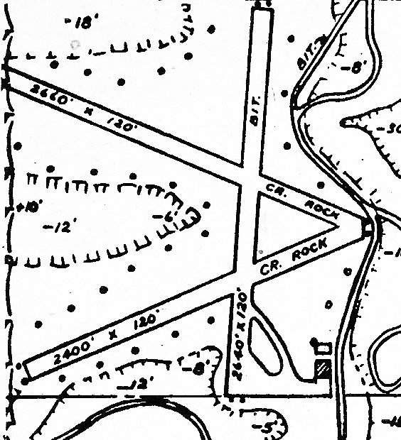
The 1948 KS Airport Directory (courtesy of Chris Leonard) depicted the original Coffeyville Municipal Airport as having 3 runways,
with the longest being the 2,660' southeast/northwest crushed rock strip, and having 2 small buildings on the southeast side.
The manager was listed as J.H. Lightstone.
The original Coffeyville Municipal Airport was depicted as “Coffeyville #2” on the 1949 USGS topo map.
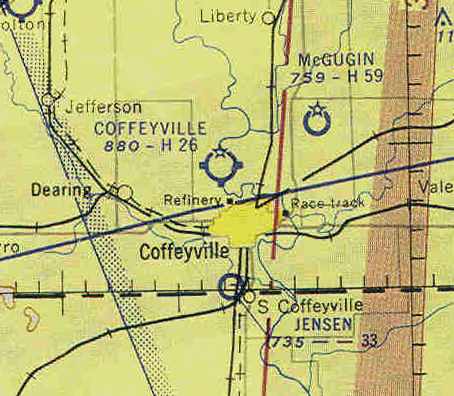
The last aeronautical chart depiction which has been located of the original Coffeyville Municipal Airport was on the December 1955 Tulsa Sectional Chart (according to Chris Kennedy).
Note that the former Coffeyville AAF (to the northeast) was also depicted as a civilian airport, named “McGugin”.
The original Coffeyville Municipal Airport was evidently closed at some point between 1955-56,
as it was no longer depicted on the December 1956 Tulsa Sectional Chart.
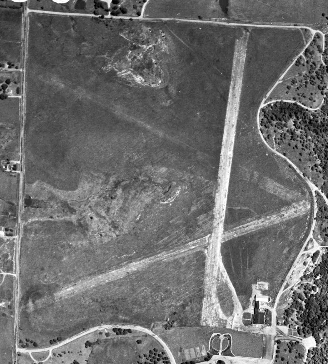
The last photo which has been located of the original Coffeyville Municipal Airport was a 5/11/58 USGS aerial view.
The field had a total of 3 runways (fairly deteriorated compared to earlier photos), and a few small hangars on the southeast side.
There were no aircraft visible parked outside.
The original Coffeyville Municipal Airport was no longer depicted at all on the 1959 USGS topo map.
The original Coffeyville Municipal Airport (also known as the Big Hill Airport)
was closed in 1960, according to the Coffeyville Aviation Heritage Museum.
The 1991 USGS aerial photo showed that the original Coffeyville Airport's hangar still existed,
although all traces of the paved runways had been removed, with their area having been reused as a park.
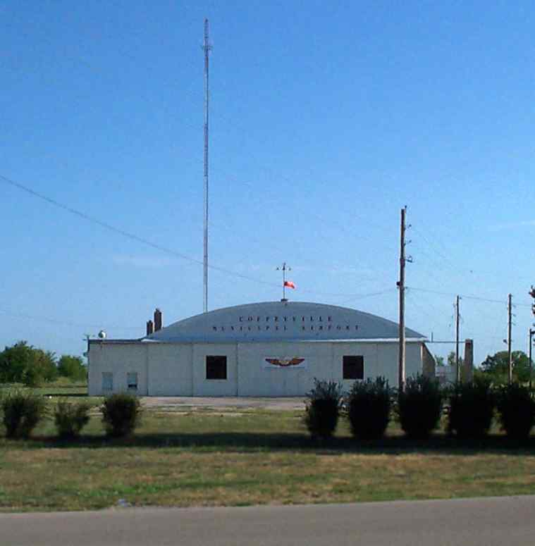
A 2005 photo Chris Decker of the hangar which remains from the Coffeyville Municipal Airport.
Chris Decker reported in 2005, “It had three 3,500' runways that were asphalted at some point.
Some residual of the runways can be found in the area,
however, the terrain has changed & it would not be possible to land an aircraft in the area.
Currently, the only thing that remains are several of the support buildings & the large hangar.
The main hangar houses the Coffeyville Aviation Heritage Museum.”
Dedicated to early aviation & pioneer pilots of the area, the Aviation Heritage Museum features memorabilia from the Coffeyville Air Base,
a Funk airplane & Breezy, owned by Joe Funk & donated to the museum, plus many other displays.
The museum is housed the original airport's 1933 hangar.
Kevin Patrick reported, “A [Republic] F-84F which used to be on Route 60 in Peoria AZ was dismantled & moved to Coffeyville KS in 2006.”
Chris Leonard reported, “Emil Roesky of the Aviation Heritage Museum was instrumental in acquiring & getting displayed” Coffeyville's F-84F.
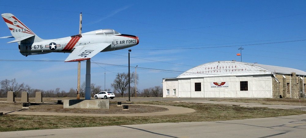
A 3/22/14 photo of a Republic F-84F mounted on a pylon in front of the original Coffeyville hangar.
A 2015 aerial view looking north showed the site of the original Coffeyville Airport was no longer recognizable as a former airfield,
but the hangar remained on the southeast corner, and note the F-84F fighter mounted on a pylon at bottom-right.
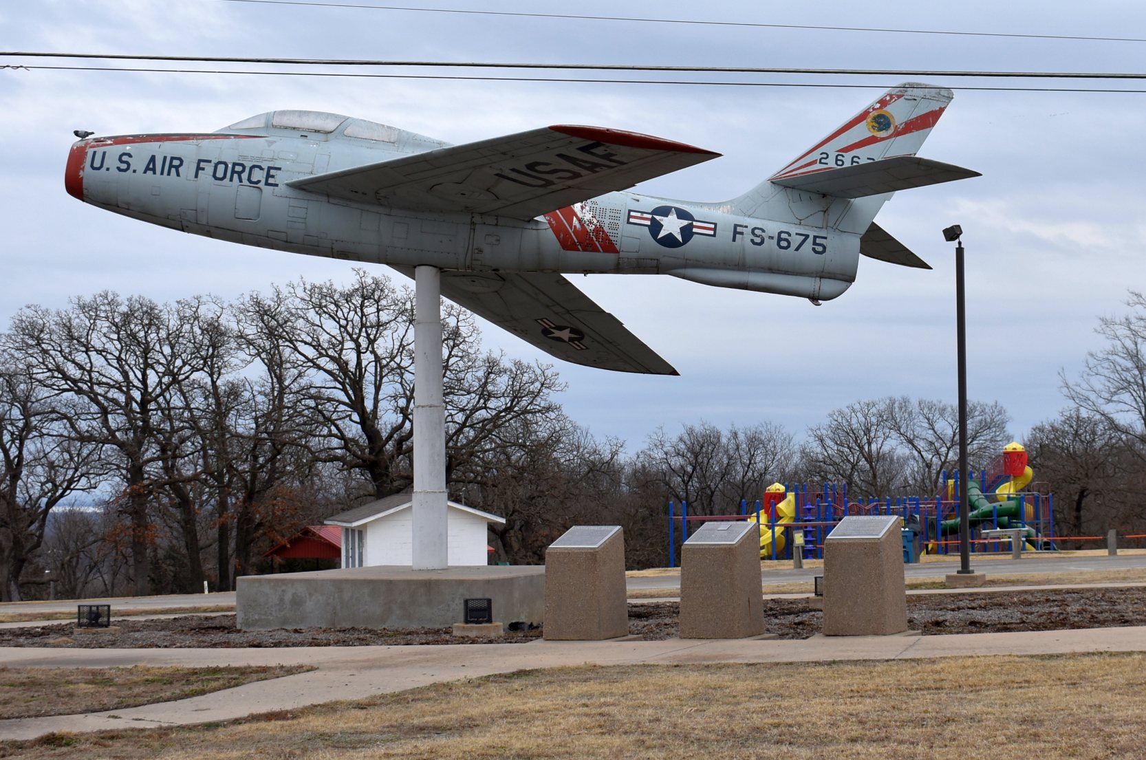
A 2/28/21 photo by Chris Leonard of a Republic F-84F mounted on a pylon in front of the original Coffeyville hangar.
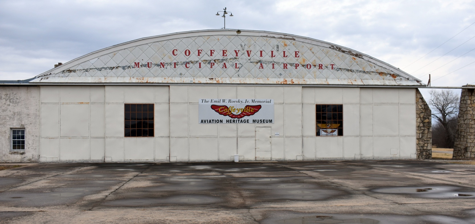
A 2/28/21 photo by Chris Leonard of the former Coffeyville Municipal Airport hangar, now the site of the Emil Roesky Memorial Coffeyville Aviation Heritage Museum.
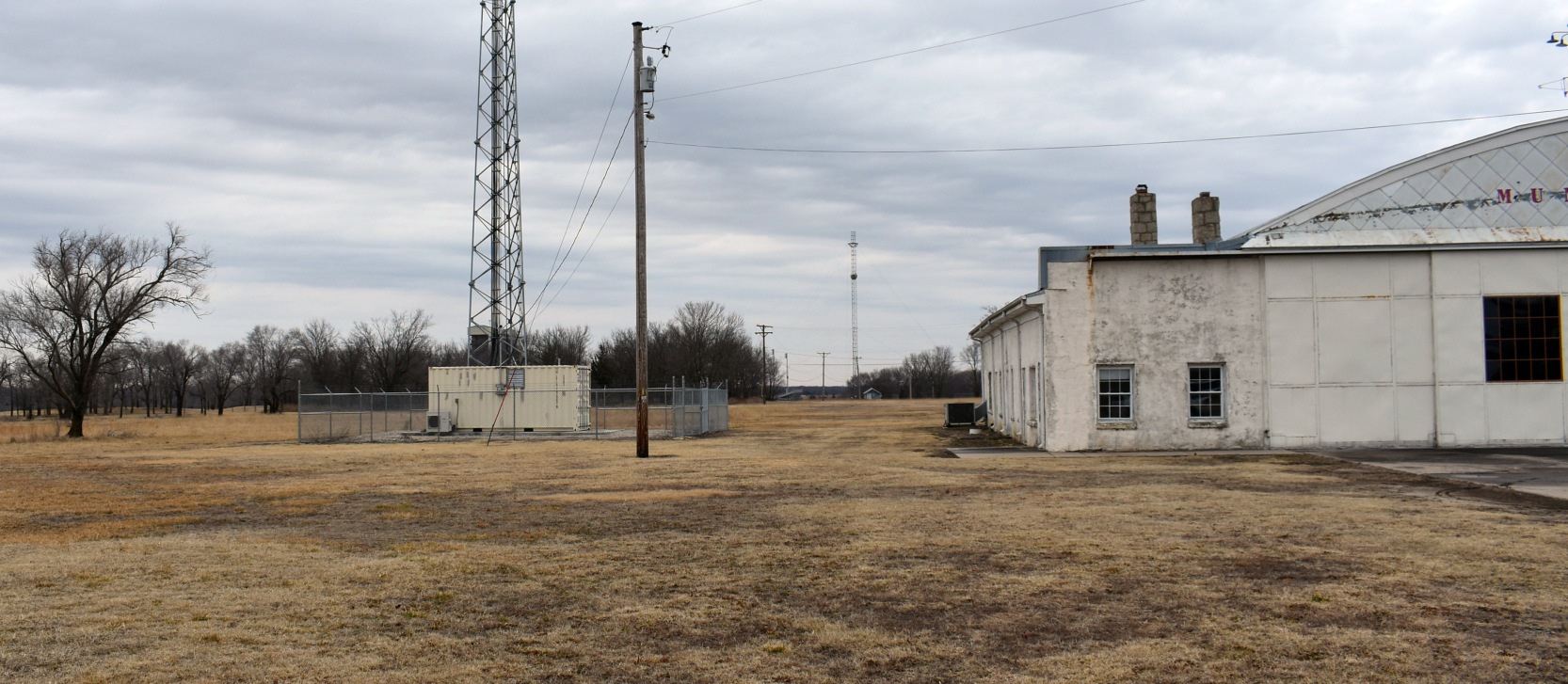
A 2/28/21 photo by Chris Leonard looking north along the site of Coffeyville Municipal Airport's Runway 35.
Chris reported, “The City erected their radio tower & another utility pole to stop the local pilots from using the strip after the airport closed.”
The site of the original Coffeyville Municipal Airport is located northwest of the intersection of North Buckeye Street & Valley View Drive.
____________________________________________________
Coffeyville Auxiliary Army Airfield #3 /
Independence Auxiliary Army Airfield #3 / Edna Municipal Airport, Edna, KS
37.13, -95.35 (Southeast of Wichita, KS)
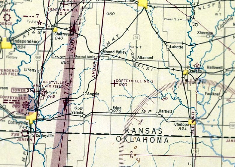
"Coffeyville #3", as depicted on the March 1944 Tulsa Sectional Chart.
Photo of the airfield while in use has not been located.
This field was built during WW2 as one of 5 satellite airfields used by Independence AAF (located to the west)
and one of 4 satellite airfields used by Coffeyville AAF (located to the southwest).
Coffeyville Aux #3 was not yet depicted on the July 1942 Tulsa Sectional Chart.
According to Chris Decker, “It was built in early 1942.”
A 5/15/43 AAF list of airfields of the Gulf Coast Training Center (courtesy of Ron Plante)
described Coffeyville Auxiliary #3 as having 3 concrete 4,000' runways.
The earliest depiction of the Coffeyville Aux #3 airfield which has been located
was on the March 1944 Tulsa Sectional Chart (courtesy of Chris Kennedy).
The April 1944 US Army/Navy Directory of Airfields (courtesy of Ken Mercer)
described "Coffeyville AAF Aux #3" as having a 4,200' hard-surface runway.
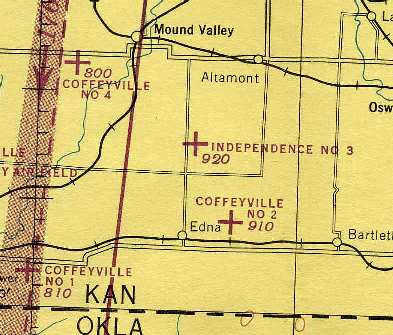
At some point between 1944-45, the airfield had evidently been renamed to "Independence #3",
after another auxiliary airfield (“Coffeyville #2”) had been constructed nearby to the southeast,
as depicted on the 1945 Tulsa Sectional Chart (courtesy of Chris Kennedy).
The date of closure of the Independence Aux #3 airfield by the military has not been determined,
but Independence AAF & Coffeyville AAF were placed on standby status in 1945,
at which point their auxiliary airfields were most likely closed.
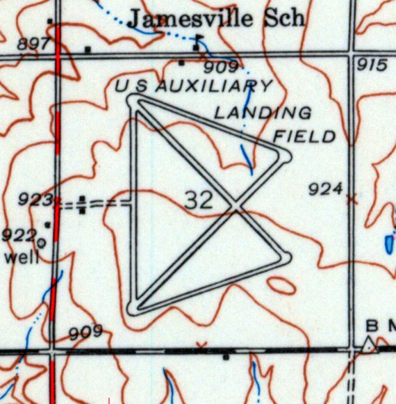
The Edna airfield was depicted as “U.S. Auxiliary Landing Field” on the 1946 USGS topo map.
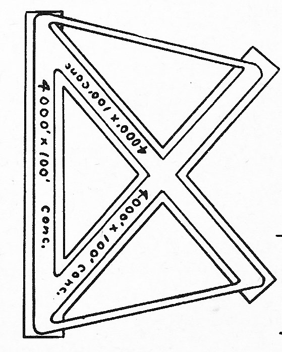
At some point between 1946-48, the Independence Aux #3 airfield was relinquished by the military & was reused as a civilian airport,
as that is how “Edna Municipal Airport” was listed in the 1948 KS Airport Directory (courtesy of Chris Leonard).
It depicted Edna as having three 4,000' concrete runways, with 2 connecting taxiways.
The airport was described as not having service, and the manager was listed as E.O. Thompson.
The 1949 KS Airport Directory (courtesy of Chris Kennedy) depicted Edna Municipal Airport as having three 4,000' concrete runways, with 2 connecting taxiways.
The airport was described as not attended, and the manager was listed as the Mayor of Edna.
Edna Municipal Airport was described in the 1962 AOPA Airport Directory
as having 3 paved runways, and the operator was listed as the City of Edna.
Edna Airport was depicted on the October 1976 CG-20 World Aeronautical Chart (courtesy of Chris Kennedy)
as having 3 paved runways, with the longest being 4,000'.
Edna Municipal Airport was described in the "Low Use" section of the 1979 Flight Guide as having a single 4,000' paved Runway 17/35.
Edna Municipal Airport apparently closed (for reasons unknown) at some point between 1979-82,
as it was not listed among active airfields in the 1982 AOPA Airport Directory.
According to Edna resident Ed Baker, "The airfield here is in private ownership now.
It's owned by Beachners now, a large construction & grain elevator company out of Erie, KS.
When I was a kid I used to drag race up there.
The city of Edna… the deal with the Federal Government was if they would maintain the airstrip for so many years then they would own it.
I helped repair it when I was a kid too. I don't know what happened but the Feds took it back & put it up for auction.
Can't remember just when but 1982 would have been close."
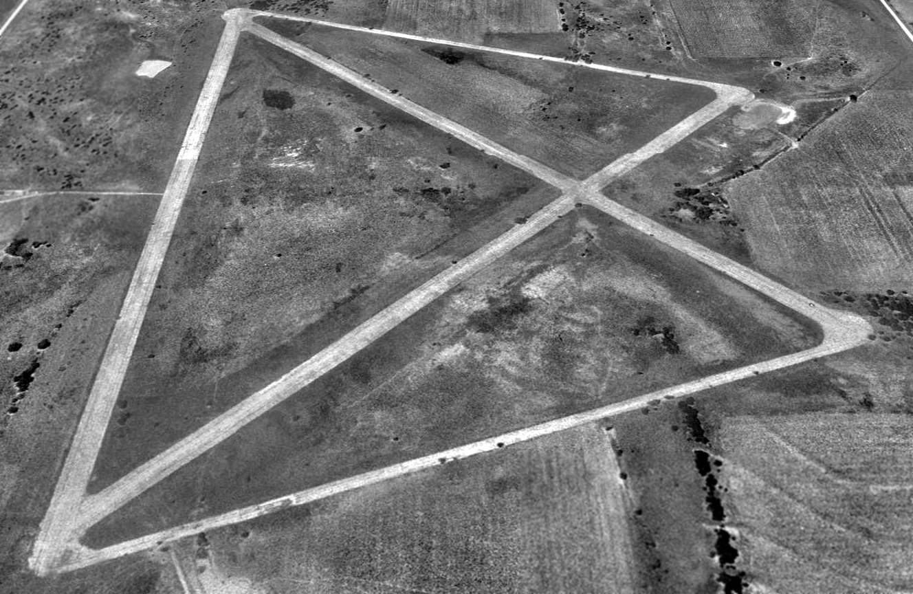
The earliest photo which has been located of Coffeyville Aux #3 was a 1992 USGS aerial view looking north.
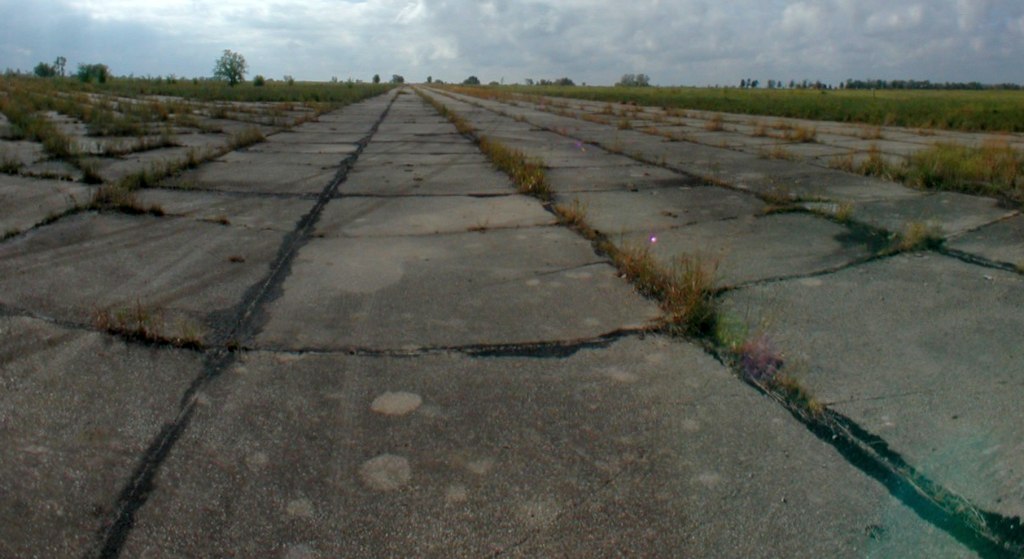
An October 2001 photo by Terry Calloway of the remains of the Edna runways.
Terry reported, “I have used this field for practicing aerobatics.
It is a great site with reference points, close to Coffeville and I can always have it for an emergency landing if needed.
I drove out there a few years ago & walked around. After taking a look I was sure landing on a road would be much safer.”
Edna was still depicted as an abandoned airfield on 2002 aeronautical charts.
Chris Decker reported in 2005, “The field is about a 1/4 mile off the road in all directions.
Unfortunately it can not be seen from the road due to the land being excavated to a level above the roadway to make it level.
If you know what your looking at you can pick out the berms that make up the corners of the runways.
I spoke with the folks that live directly south of the north/south runway.
They had farmed the property until Beachners bought it.
They stated that the runways are still there although the northwest/southeast & northeast/southwest diagonal runways
were in bad shape in locations due to heaving in the concrete.
I could also see from the road that there were several large piles of concrete
that I believe were at the northeast intersection of the runway that runs northeast/southwest.
These folks said the the north/south runway was the only one that was maintained by the City of Edna.
They said they thought you could still land on the north/south runway if you had to,
however, they said there are often obstructions on the runways.
Interestingly, They said the Army National Guard Unit out of Owasso, OK
had used the airfield on several occasions the last couple of summers,
to practice night operations & night-vision equipment.
They said there had been helicopters flying in every night for over a month without lights on last summer,
when someone finally called the sheriff to find out what was going on.
The neighbors thought drug runners were coming in & out... nope, just the Army.”
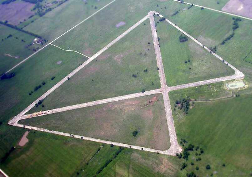
A May 2005 aerial photo by Tom Kramer, looking northwest at Coffeyville Aux #3 from 8,000'.
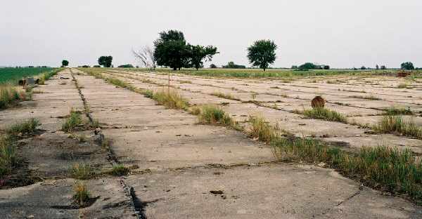
A 2005 photo by Robert Pearson, looking at the intersection of the North/South & Northeast/Southwest runways.
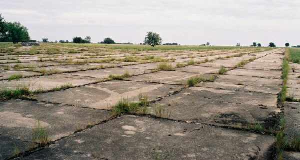
A 2005 photo by Robert Pearson, looking at the intersection of the North/South & Northwest/Southeast runways.
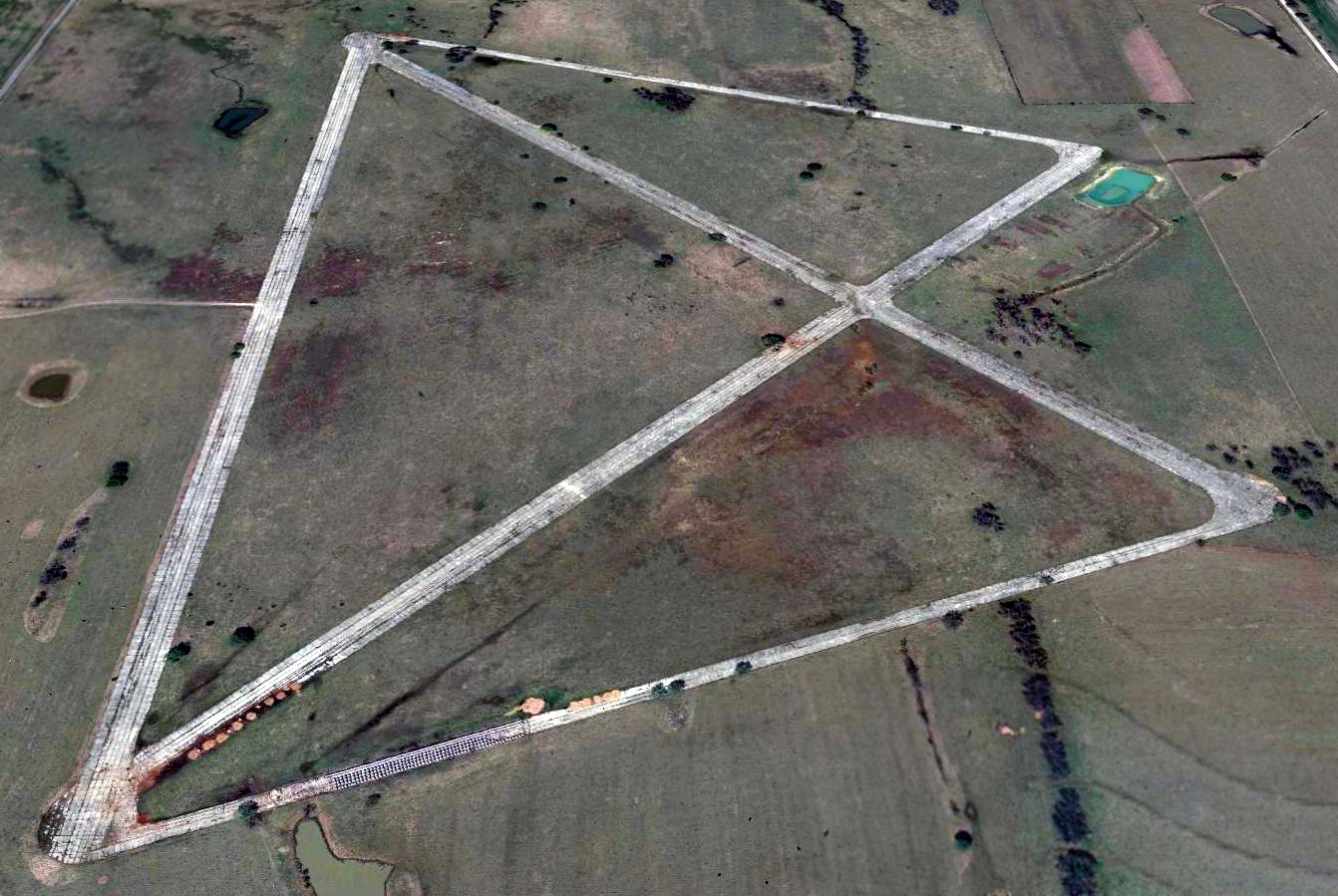
A 2015 aerial view looking north at the remains of Coffeyville Aux #3.
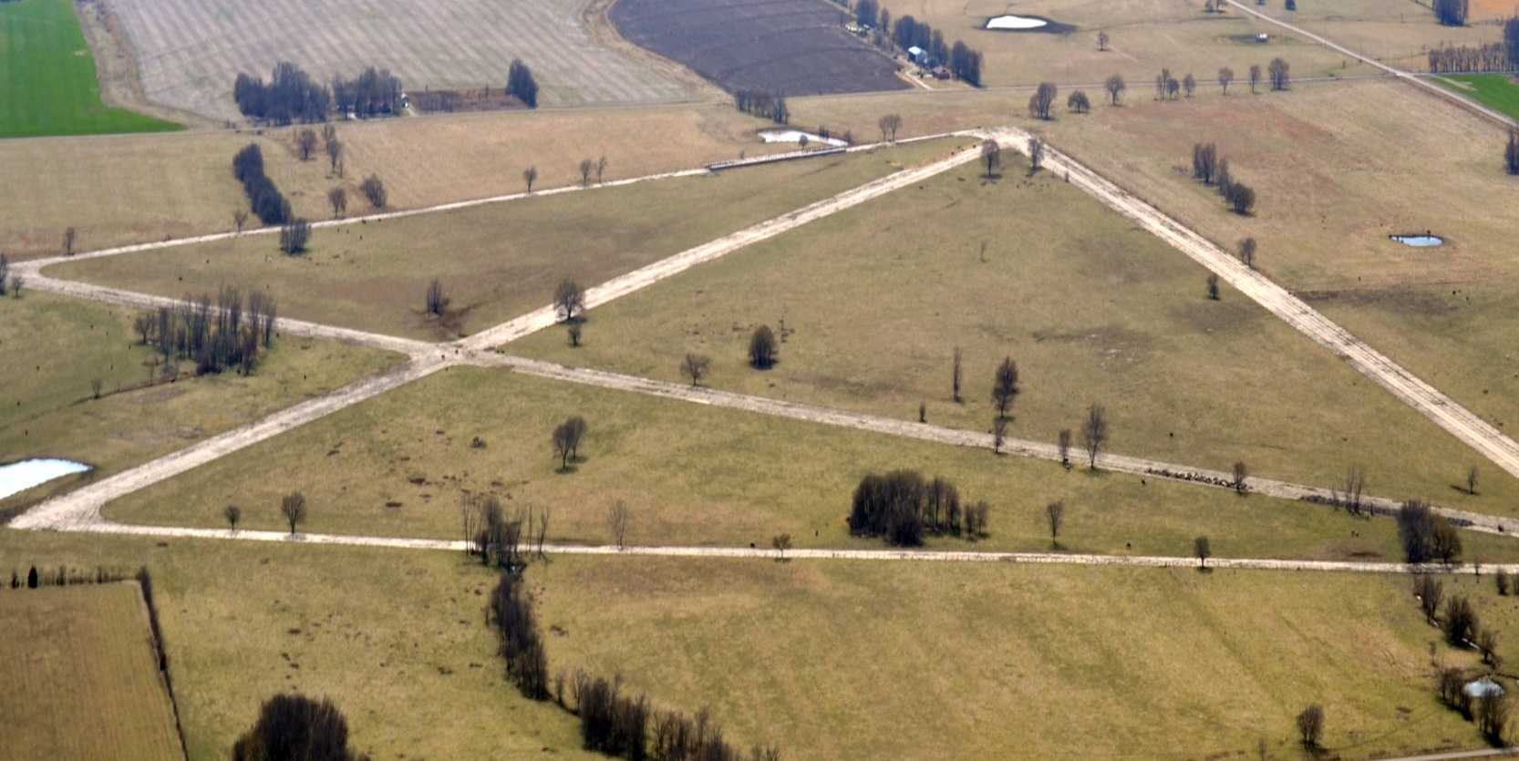
A 3/4/16 aerial photo by Chris Leonard looking southwest at Coffeyville Aux #3 from a 1947 Stinson.
Coffeyville Aux #3 is located in the section between County Road 9,000 & 10,000, west of KS Highway 101, approximately 3.5 miles north of Edna.
____________________________________________________
Or if you prefer to contact me directly concerning a contribution (for a mailing address to send a check),
please contact me at: paulandterryfreeman@gmail.com
If you enjoy this web site, please support it with a financial contribution.
____________________________________________________
This site covers airfields in all 50 states.