Abandoned & Little-Known Airfields:g th
Northern Louisiana
© 2002, © 2025 by Paul Freeman. Revised 1/21/25.
This site covers airfields in all 50 states: Click here for the site's main menu.
____________________________________________________
Please consider a financial contribution to support the continued growth & operation of this site.
Hodges Airfield (revised 1/21/25) - Lucien Airport (revised 9/12/19) - Olla Airport (added 4/15/21) - Ruston Municipal Airport (revised 5/17/23) - Shreveport Airport (added 6/10/06)
Stovall Airport / Shreveport Airpark (revised 5/27/13) - Texaco Airport / Riverside Airport (revised 1/21/25)
____________________________________________________
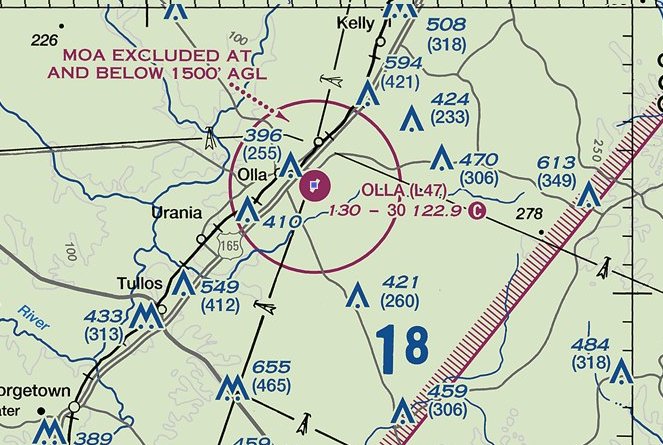
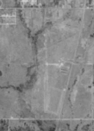
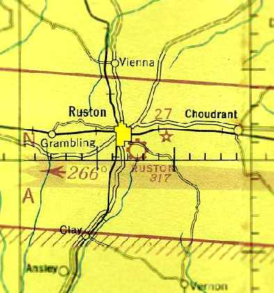
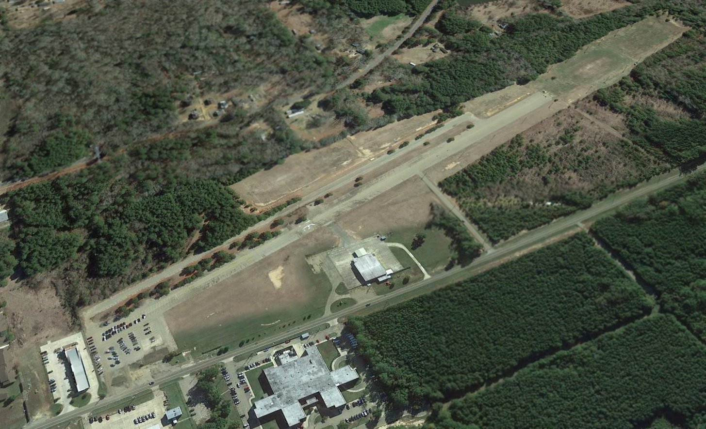
31.896, -92.218 (Southeast of Shreveport, LA)
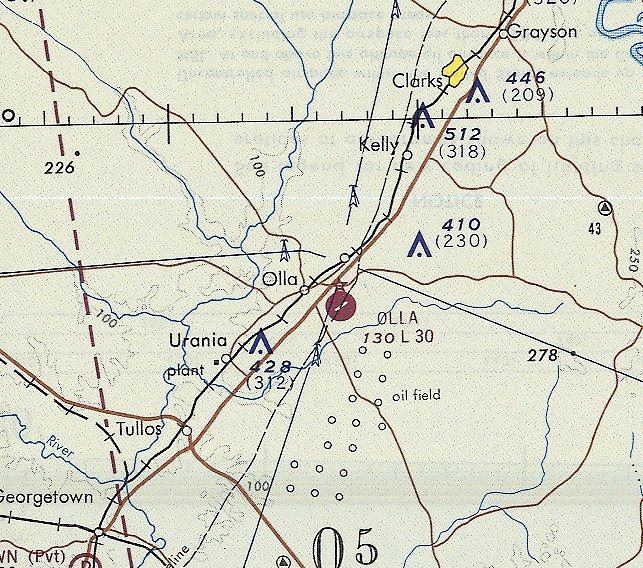
Olla Airport, as depicted on the September 1970 Houston Sectional Chart (courtesy of Ron Plante).
This general aviation airport was not yet depicted on a 1956 aerial photo.
According to David Cummings, Olla Airport “was created in the early 1960s.”
Olla Airport was not yet depicted on the September 1967 Beaumont Sectional Chart.
The earliest depiction which has been located of Olla Airport was on the September 1970 Houston Sectional Chart (courtesy of Ron Plante).
It depicted Olla Airport as having 1 paved 3,000' northeast/southwest runway.
Olla Airport was not yet depicted on the 1975 USGS topo map.
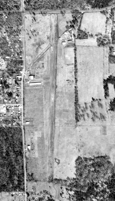
The earliest photo which has been located of Olla Airport was a 1981 aerial view.
It depicted Olla Airport as having 1 paved northeast/southwest runway, with a ramp & a small building on the northeast side.
There were no aircraft visible on the field.
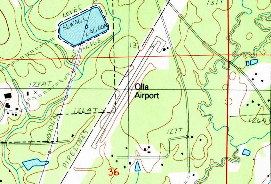
The earliest topo map depiction which has been located of Olla Airport was on the 1984 USGS topo map (courtesy of Lee Corbin).
It depicted Olla Airport as having 1 paved northeast/southwest runway, with a ramp & 2 small buildings on the northeast side.
David Cummings recalled, “In Olla Airport's heydays of the 1980s & 90s there was 12 planes based there; 2 flights / week by LA Pacific’s Lear Jet supplying their nearby Urania Plywood Plant with company needs.
Further Donation‘s by LA Pacific for maintenance to hangar & their assistance as the Olla Pilots coming together to construct the Olla pilot’s building was paramount.
So, with that said, it’s A very sad thing to see the demise of the Olla Airport as it follows the many airports in Louisiana that has bend closed. Thank you for you website of “Airport Memories.”
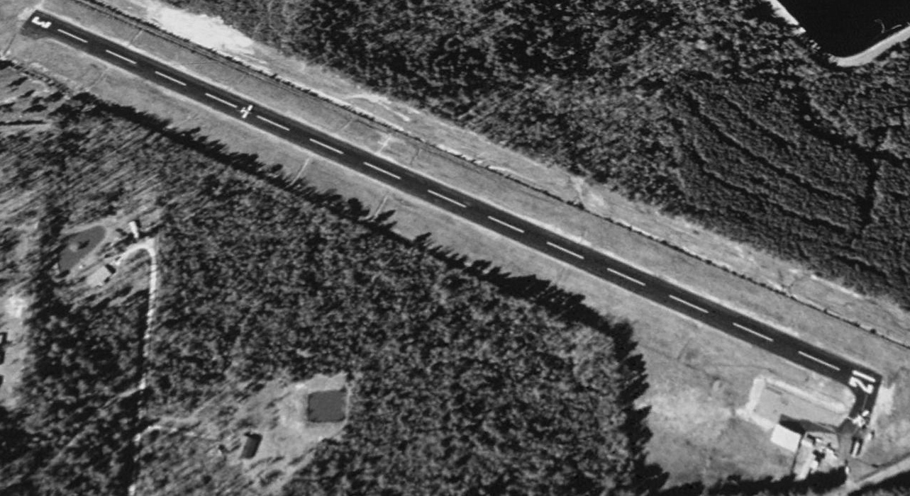
The earliest photo which is available of Olla Airport (and the earliest photo showing aircraft on the field) was a 1994 aerial view looking west.
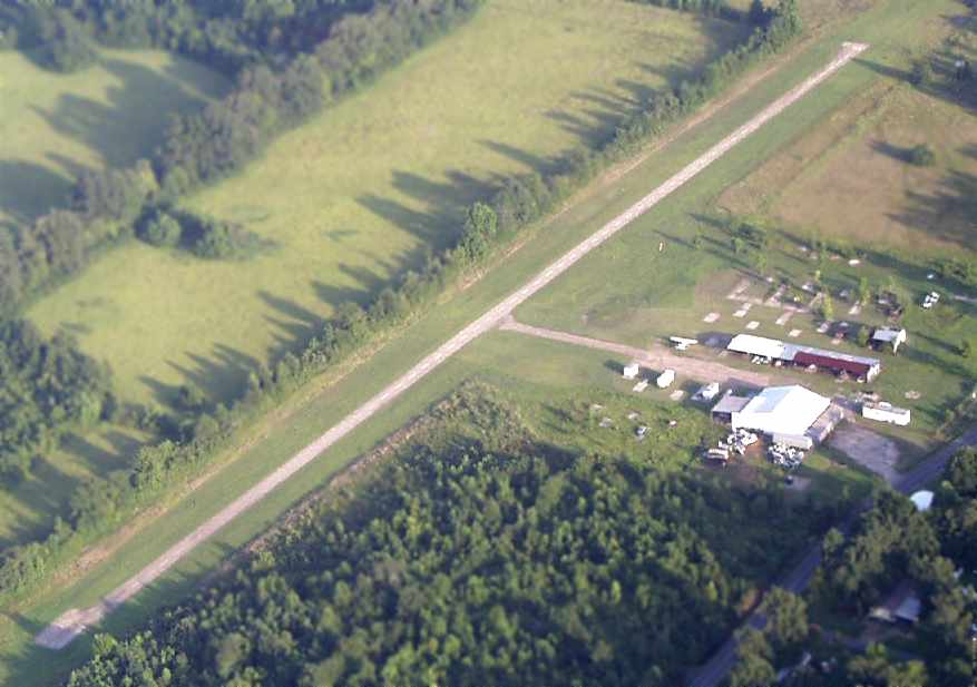
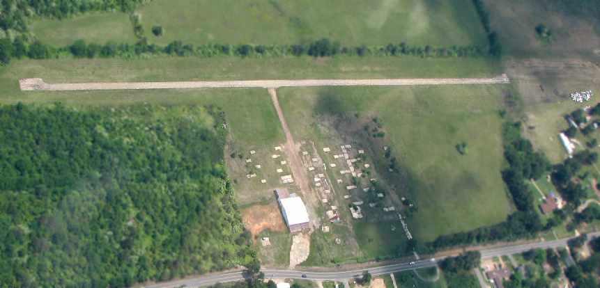
It depicted Olla Airport as having 1 asphalt Runway 3/21, with a ramp & a few small buildings on the northeast side.
One light single-engine aircraft was visible on the runway, and another on the ramp.
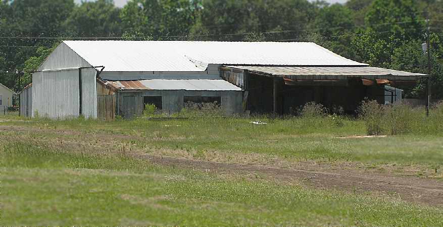
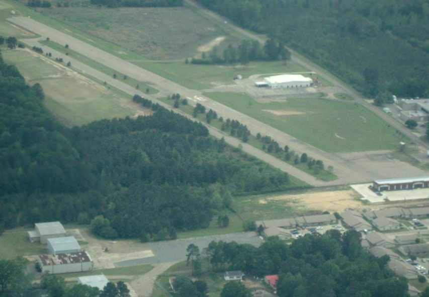
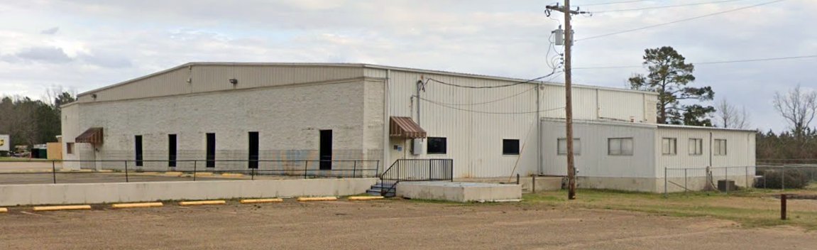
A July 2014 photo looking west at Olla Airport (courtesy of Lee Corbin) showed 1 Piper single-engine aircraft parked under a shade hangar on the northeast side of the paved runway.
For the year ending 2/4/19, the FAA's Airport/Facility Directory said Olla Airport conducted an average of 71 takeoffs or landings per week.
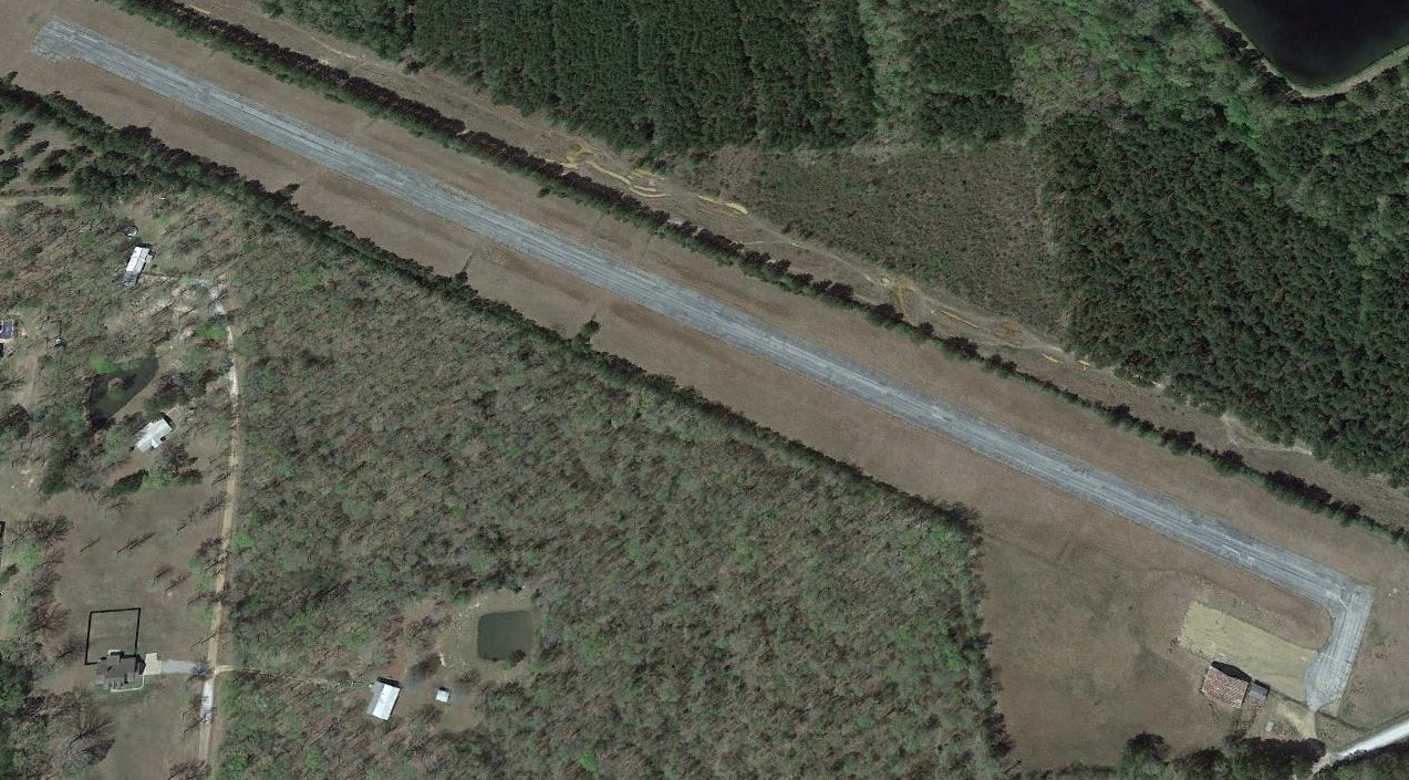
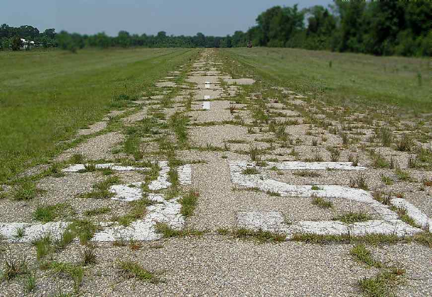
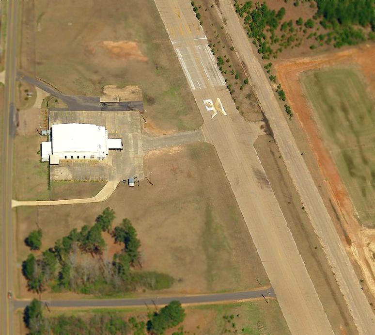
A 2019 aerial view looking west showed Olla Airport remained intact, but the runway numbers had faded to be almost unreadable.
The last aeronautical chart depiction which has been located showing Olla Airport still in operation was on the 2020 Houston Sectional Chart (courtesy of Lee Corbin).
It depicted Olla Airport as having 1 paved 3,000' northeast/southwest runway.
According to David Cummings, Olla was closed “in August 2020.
Due to the lack of interest & education of the LaSalle Parish Police Jury, the airport was closed even though private & commercial use of the airport was ongoing.
The local newspaper was very inaccurate in its article announcing L47’s closure announcement.
No attempt was offered by the paper nor Parish Police Jury nor it’s legal representatives to correct the inaccuracies
and questionable monetary mishandling of monies produced by the commercial use fees & LA state funding obtained throughout the years of operations at Olla.
Department of Aviation authorities & documents can attest to the questionable administration of L47 by the LaSalle Parish Police Jury & related individuals.
Donation of property to the airport in the 1990s (by Louisiana Pacific) & other donors were supposed to revert to the donors
if air operations or sale of the property ever came about; that has not happened as of yet.
Even a call to the Louisiana Pacific Land department informing them that closure of the airport came about in 2020; no reply was ever received.
So much can be achieved when people come together for a greater cause... that never happened for L47 for long;
many of the voters were led to believe their taxes would be lowered; they were not, they were simply absorbed into the tax monster & distributed out to other tax projects.”
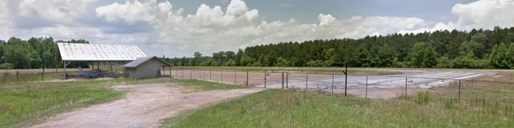
The FAA's Airport/Facility Directory described Olla Airport in 2021 as “Airport closed permanently”.
It said the field was owned by Olla Urania Tullos Standard, and managed by Jefrey Lasiter.
Olla Airport was described as having a single asphalt 3,010' Runway 3/21, “in poor condition”, and to have 1 single-engine based aircraft.
David Cummings reported, “In sadness of having made my last flight out of Olla yesterday [1/28/22] after having been based & hangared (hail/sun-shade hangar) there for 24 years.
I was able to remain there after airport closure while doing work on my close friend N7772C.”
Thanks to Lee Corbin & James Simms for pointing out this airfield.
____________________________________________________
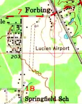
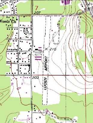
Lucien Airport (F33), Shreveport, LA
32.39, -93.74 (Northwest of Baton Rouge, LA)
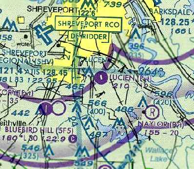
Lucien Airport, as depicted on the September 1947 Shreveport Sectional Chart.
This general aviation airport was evidently established at some point between 1946-47,
as it was not yet depicted on the September 1946 Shreveport Sectional Chart (courtesy of Chris Kennedy).
The earliest depiction which has been located of Lucien Airport was on the September 1947 Shreveport Sectional Chart.
It depicted Lucien as a commercial/municipal airport.
According to Robin Elston, “Lucien was originally owned by Jim Clark. He sold ownership at some point to Ray Harvey.”
The Civil Aeronautics Administration's August 1948 Airman's Guide (according to Chris Kennedy)
described Lucien as having 2 unpaved runways, with the longest being 3,100'.
The 1955 USGS topo map depicted Lucien Airport as having a single unpaved north/south runway,
with a few small buildings on the north end of the field.
The earliest photos which have been located of Lucien Airport were two 1961 photos of Al Elston & his Aeronca Chief (courtesy of Robin Elston).
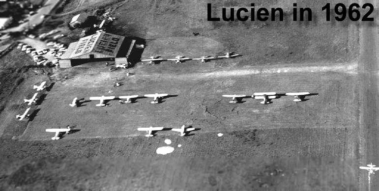
A 1962 aerial view looking north at the Lucien Field hangar, with 18 planes on the field (courtesy of Rick Shelton).
The 1966 Shreveport Sectional Chart (courtesy of John Price)
depicted Lucien as a public-use airport having a 3,000' unpaved runway.
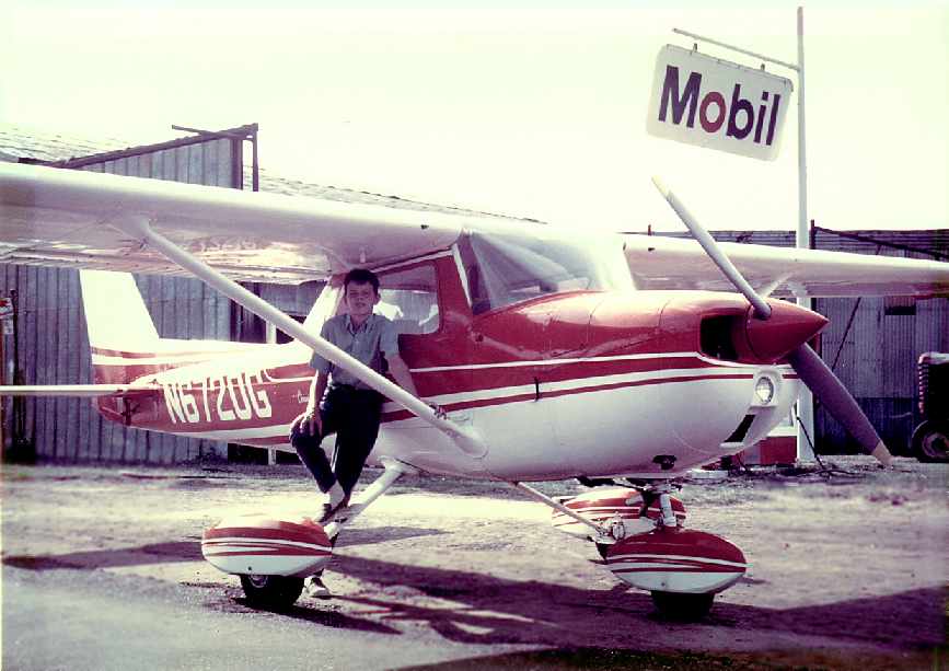
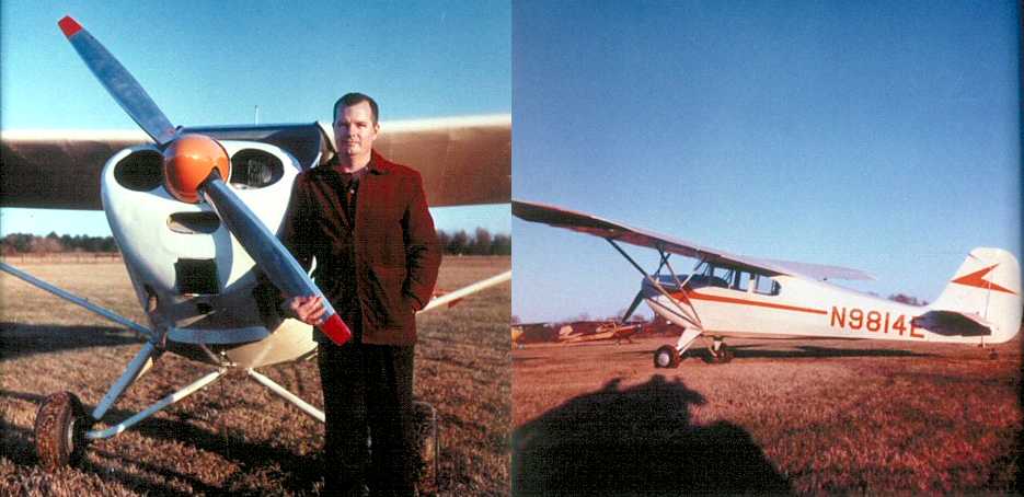
A 1967 photo looking northwest at Robin Elston at age 11 after a flight with his dad in Cessna 150 N6720G at Lucien Airport,
with the hangar visible in the background.
Robin recalled, “I have fond memories of my childhood flying with my dad in his Aeronca Chief & my uncle's Ercoupe out of Lucien.”
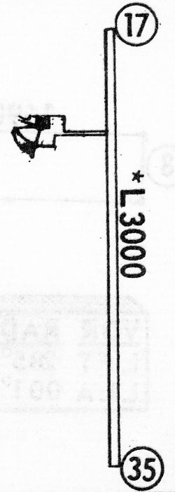
The 1968 Flight Guide (courtesy of Robert Levittan) depicted Lucien Airport as having a single unpaved 3,000' Runway 17/35,
with a taxiway leading a ramp & a building on the west side.
A 2/12/69 USGS aerial view depicted Lucien Field as having a single north/south runway.
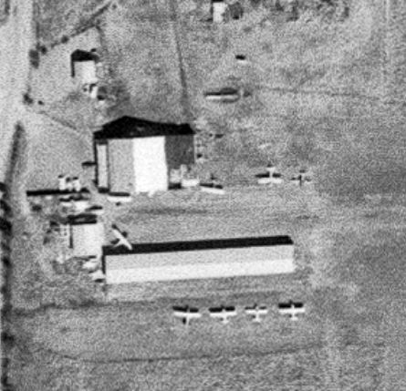
A closeup from the 2/12/69 USGS aerial view depicted a total of 8 light single-engine planes parked around the Lucien Field hangars.
The FAA's January 1972 Airman's Guide (according to Chris Kennedy) described Lucien as having a single unpaved 3,000' Runway 17/35.
Lucien Airport was still depicted as a public-use airport in 1976 AOPA Airport Directory (according to Chris Kennedy).
The status of Lucien Airport evidently changed to a private field at some point within the next year,
as that is how it was depicted on the May 1977 Memphis Sectional Chart (according to Chris Kennedy).
The 1982 AOPA Airports USA Directory (according to Chris Kennedy)
described Lucien as having a 1,925' blacktop runway (with an additional 625' of turf).
Ken Harris recalled, “I learned to fly at Lucien Field back in 1986….
Ray Harvey owned & operated the airport. Making a living renting a several Cessna 150s & a Cessna 172 mostly to people taking flying lessons.
I owned my own Skyhawk. Those long rows were not hangars but simply roofs under which I, and others, rented space to park our airplanes.
I asked Mr. Harvey who Lucien Field was named after & he told me, 'Lucien Marineaux'.
Mr. Harvey’s son worked there & he was an Airframe & Powerplant Mechanic as well.
I have fond memories of that airfield. I hated to see it close.”
A 1989 USGS aerial view looking northwest showed that Lucien Field had gained a considerable number of hangars at some point between 1969-89.
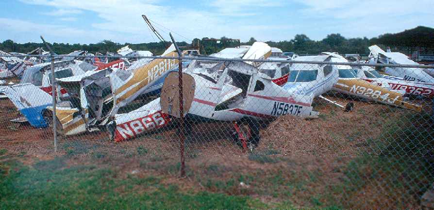
A 1990 photo by Robin Elston looking east from the northwest corner of the hangar at the aircraft salvage yard.
According to Robin, “Ray Harvey was an aircraft salvage dealer as well as an A&P
building a beautiful C172 (N738KM) out of this mess.”
Robin Elston recalled, “An anecdote about Ray's airplanes:
I wish I had a picture of his other work in progress, a C152 built from several planes, it looked it!
I suppose N738KM looked similarly before it's paint job.
The 152 was bare aluminum, red, maybe a yellow door, tail numbers in black electrical tape (N666LS).
He asked if I minded the number saying one of the young female students wouldn't fly it.
I figured the Lord's going to take me when my time is up regardless of the tail number.
I took it around the pattern intending to depart, however landing when the alternator light came on.
As I taxied back to the hangar he walked out asking 'What's the matter?'
Explaining the light, he reached through the window, flipped the master off, back on and whacked the panel with his palm.
The light went out & he said you're good to go.
The flight went without further incident except for a minor hiccup from the engine
as I departed Runway 35 toward some 70 foot pine trees.”
The 1992 USGS topo map depicted Lucien Airport as having a single unpaved north/south runway,
with several hangars along the west side.
A May 1992 aerial view by Robin Elston,
looking back north “at Lucien after departure from Runway 17 in Cessna 172 N738KM to wander around Northern Louisiana.”
A 1992 photo by Robin Elston looking northwest at the Lucien hangar (the same perspective as the 1967 photo).
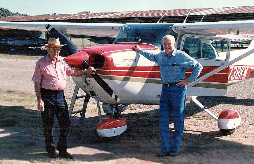
A 1992 photo by Robin Elston of Ray Harvey & Al Elston.
Robin observed, “Here's the Cessna & it's builder in the hat on the left (Ray Harvey) and my dad on the right in jeans (Al Elston).
After I preflighted we took a leisurely flight around north Louisiana,
I have not before or since flown a 172 with such glass smooth controls & perfect trim,
I suspect that Ray is among a dwindling number of old school craftsmen that can do such things.”
Rick Shelton recalled, “If it was not for Ray Harvey I would not had the chance to get my Private Pilots License.
He would let me work around the field, cutting grass, pumping gas & such.
I worked for hours in N666LS and N8945 and N738KM.
My roommate had his old Cessna 172 out there also.”
A 1994 aerial view by Carl Hennigan depicted only a single plane parked outside at Lucien.
A tornado hit Lucien Airport in 1996, resulting in the removal of all of the hangars except for the 2 largest,
and the destruction of the Cessna 172 N738KM & Cessna 152 N666LS that Ray Harvey had rebuilt.
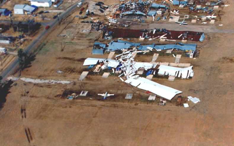
A 1996 aerial view looking north at the Lucien Field hangar (courtesy of Rick Shelton),
showing the damage to hangars & planes from the 1996 tornado .
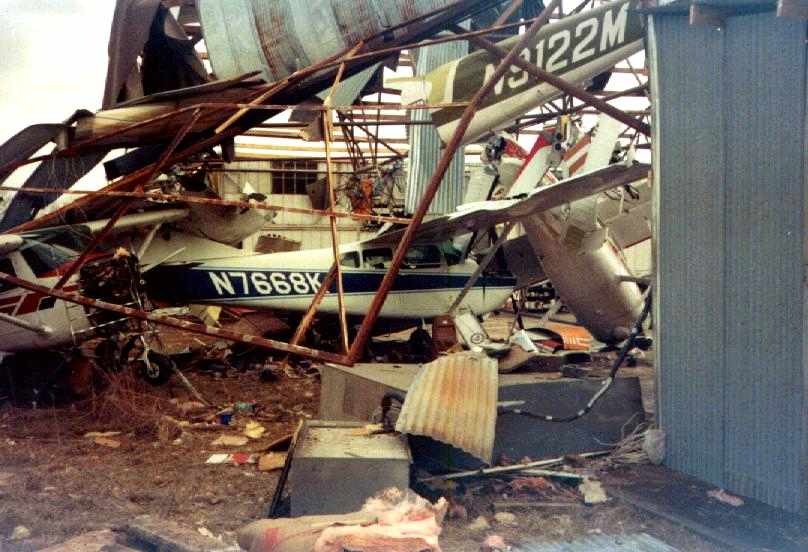
A 1996 photo of the awful wreckage of 4 Cessnas inside a Lucien Field hangar (courtesy of Rick Shelton)
as a result of the 1996 tornado.
The FAA's Steve Broman reported, “Lucien.. went from public to private in 2001.”
A March 2002 USGS aerial view looking northwest at Lucien Airport, with 2 intact planes still visible on the field (along with the scrap pile).
Note the decided lack of buildings compared to the 1992 photo (due to damage from a 1996 tornado).
The last aeronautical chart depiction which has been located of Lucien Airport as an active airfield
was on the April 2004 Memphis Sectional Chart (courtesy of Chris Kennedy).
It depicted Lucien as a private field having a single 1,900' paved runway.
The last photo which has been located showing aircraft at Lucien Field was a July 2004 aerial view by Carl Hennigan, taken “shortly before Lucien closed looking southeast.
A few of the salvaged aircraft remain on the north side of the main hangar.”
One intact plane sat in between the runway & the hangars.
The FAA's Steve Broman reported, “Lucien.. was removed entirely from the FAA database in 2006
when we received word it was no longer being used as an airstrip.”
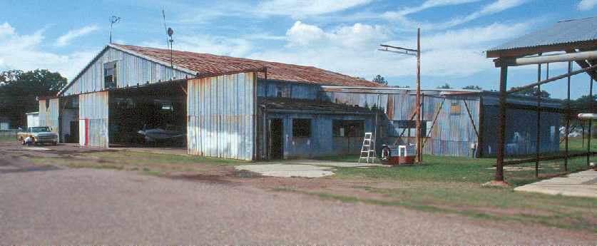
A June 2006 photo by Robin Elston looking northwest at the Lucien hangar.
Robin observed, “Note the new sheetmetal & lack of other structures, the result of the tornado in 1996.
It was clearly abandoned. Sad to see it make the transition to a memory.”
A June 2006 photo by Robin Elston looking north along the remains of Lucien's Runway 35.
Robin reported, “Obviously the property gets mowed.
In my drive to the other end I couldn't get off the ground, I guess Chevys don't do that.”
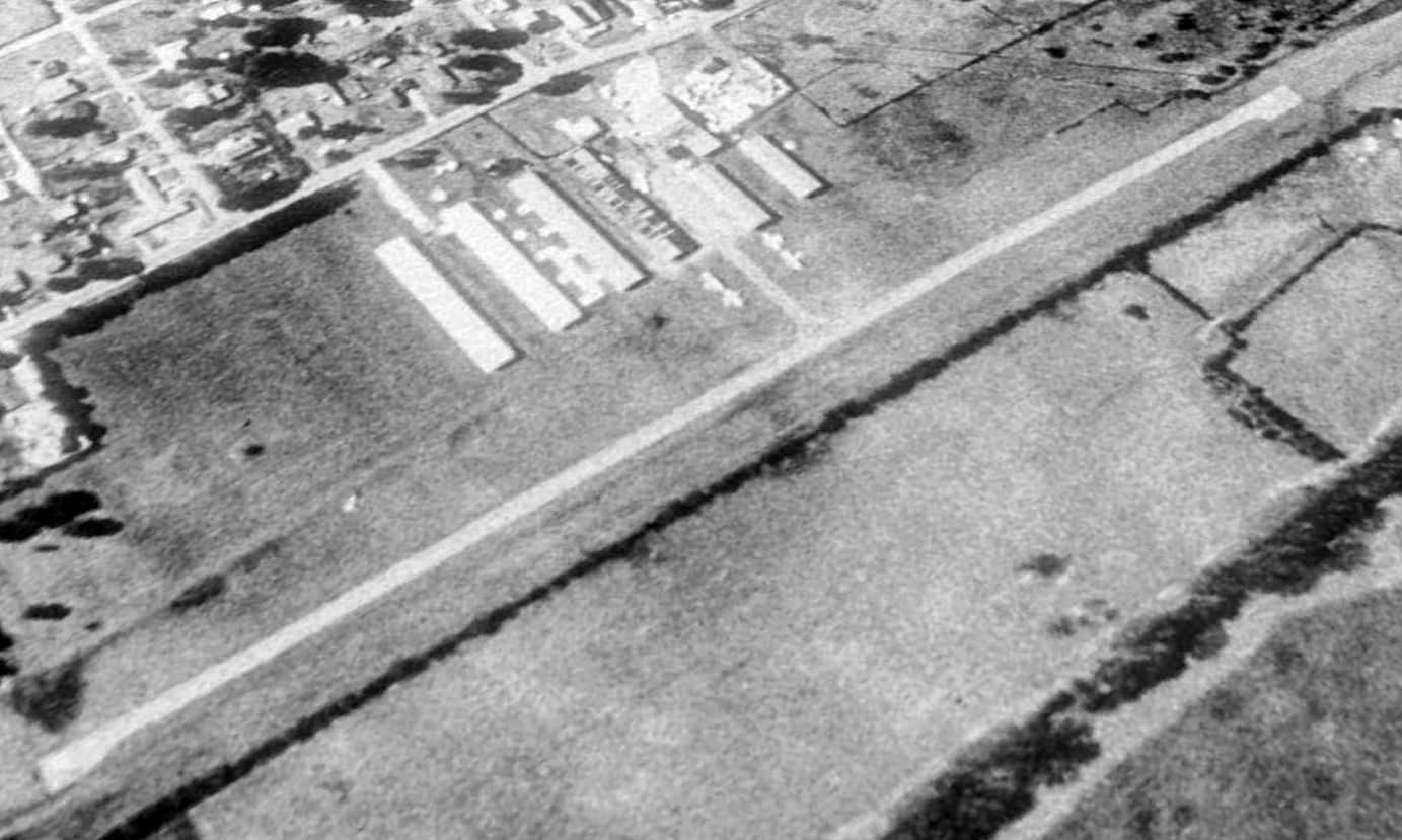
A May 2007 aerial view by Carl Hennigan looking east at Lucien Airport.
Note that in comparison to the 2004 aerial photo, there is only 1 hangar remaining.
Carl observed, “The aircraft salvage area was on the north side of the main hangar.
This is the light brown rectangular area just north (to the left of the main hangar).
From the air it appears to be fresh dirt. I suspect that this area may have been considered contaminated & the top layer was replaced with new soil.”
Many cement pads remain on the south side of the main hangar. These were once part of the rows of general aviation hangars.”
Lucien Airport was no longer depicted on aeronautical charts nor listed among the FAA Airport/Facility Directory as of 2007.
Rick Shelton reported in 2010, “We have a boom in natural gas in this area in the past few years & they are setting up to drill on the F33 [Lucien Airport] site.”
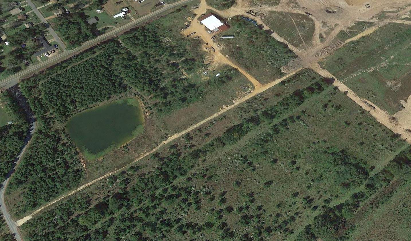
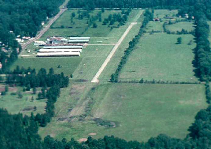
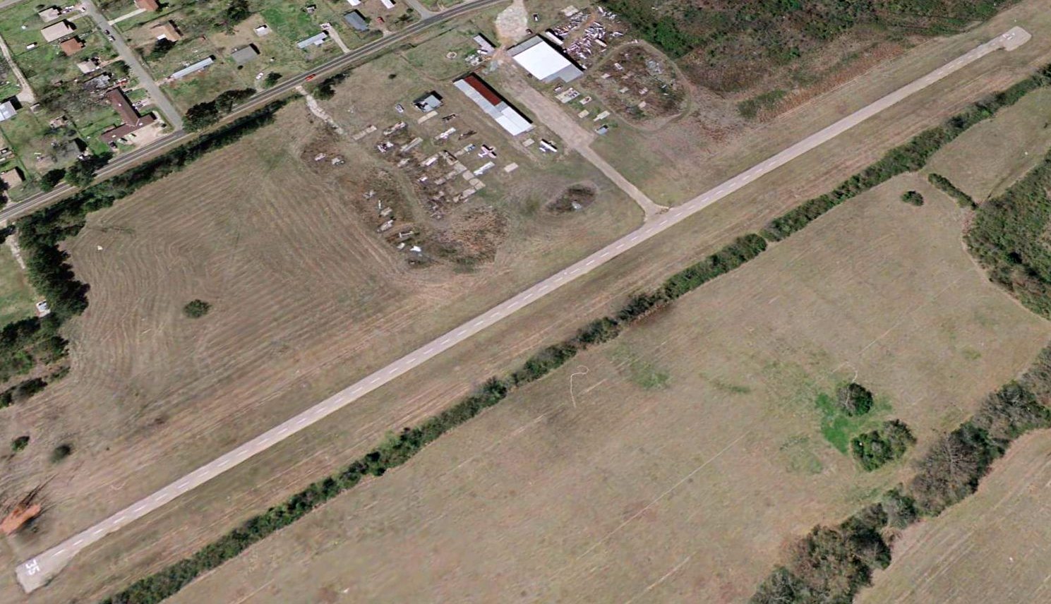
A 2016 aerial view looking northwest at the site of Lucien Airport shows that the runway pavement has been removed, but the main hangar remained erect.
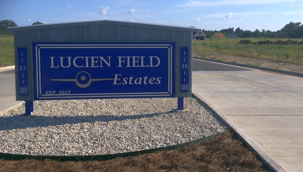
A 2017 photo by Steve W of the sign for “Lucien Field Estates” at the site of Lucien Field.
Steve reported, “It's being turned into a housing development. I was happy to see they kept the name. The hangar is still standing, way in the back of the photo.”
The site of Lucien Airport is located southeast of the intersection of Wallace Lake Road & East Flourney Lucas Road.
____________________________________________________
Texaco Airport / Riverside Airport, Shreveport, LA
32.48, -93.7 (Northwest of Baton Rouge, LA)
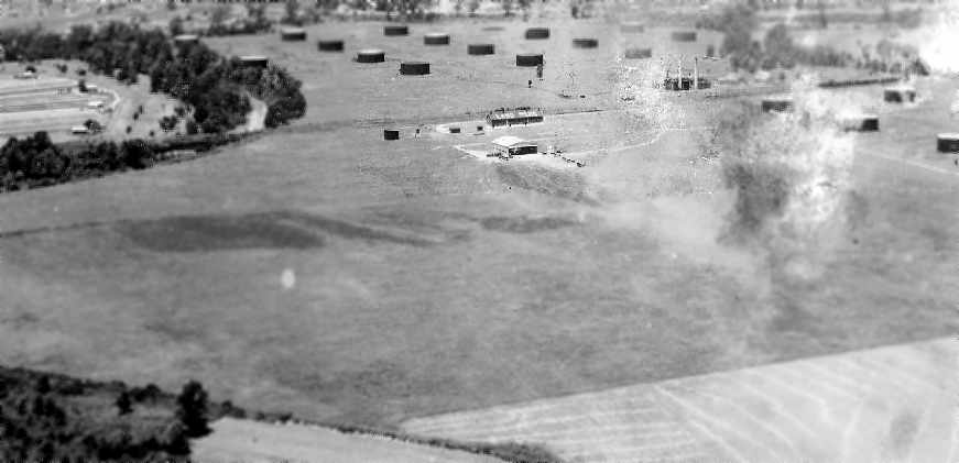
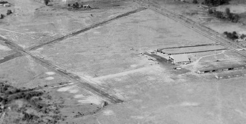
A 6/1/1930 aerial view looking northwest at Texaco Airport (courtesy of Carl Hennigan).
The Texaco oil storage tanks were visible behind the airfield.
According to Carl Hennigan, “In 1930 the Texaco Airfield was opened on the southern side of Shreveport.
Its name was derived from its close proximity to the Texaco oil storage facility.”
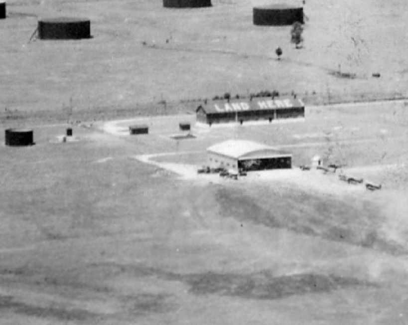
A close-up from the 6/1/1930 aerial view looking northwest at Texaco Airport (courtesy of Carl Hennigan),
showing several hangars (one painted “Land Here” on the roof), with several planes in front of the field.
According to Carl Hennigan, “Airmail flights were inaugurated from this airfield in October of 1930,
but its commercial use would eventually lose out to the city's newer & larger Shreveport Municipal Airport
(also called the Shreveport Downtown Airport).”
The 1931 Civil Aeronautics Administration Airfield Directory (courtesy of David Brooks)
described Texaco as a commercial airport consisting of an iregularly-shaped 200 acre sandy loam field, measuring 3,670'' x 3,230'.
The field was said to have facilities for servicing aircraft, day only.
The Texaco Airport may have been gone through a period of closure,
as no airfield was depicted at this location on the 1934, 1942, or 1944 Shreveport Sectional Chart (courtesy of Carl Hennigan),
nor was any airfield at this location listed among active airfields
in the Haire Publishing Company's 1946 Airfield Directory (courtesy of David Brooks).
A circa 1940s aerial view of the Texaco Airport (courtesy of Carl Hennigan). Several planes were visible on the field.
At this point the Texaco oil storage tanks north of the airfield had been removed, leaving the circular patterns on the ground (which dates the photo to post-WW2).
The former Texaco Airport was evidently reopened at some point between 1946-48 as the “Riverside” Airport,
as that is how it was listed in the Haire Publishing Company's 1948 Airport Directory (courtesy of David Brooks).
The field was said to have 2 unpaved runways: 2,000' north/south & 1,800' east/west.
Riverside was described as a commercial field, offering a hangar, fuel, repairs, and training.
The manager was listed as K.R. Bailey.
The earliest aeronautical chart depiction which has been located of Riverside Airport was on the February 1949 Shreveport Sectional Chart (courtesy of Chris Kennedy).
It depicted Riverside as a commercial/municipal airport.
The last aeronautical chart depiction which has been located of Riverside Airport
was on the 1952 Shreveport Sectional Chart (according to David Brooks).
The last directory listing which has been located of Riverside Airport was in the 1953 Aviation Week Airport Directory (courtesy of David Brooks).
It described Riverside as a commercial field, having 2 unpaved runways: 2,300' north/south & 1,700' east/west.
The field was said to offer fuel, repairs, and training. The manager was listed as H.A. Dickerson.

The last aeronautical chart depiction which has been located of Riverside Airport was on the February 1954 Shreveport Sectional Chart.
It depicted Riverside as having a 2,300' unpaved runway.
Riverside Airport was evidently closed (for reasons unknown) at some point in 1954,
as it was no longer depicted on the September 1954 Shreveport Sectional Chart.
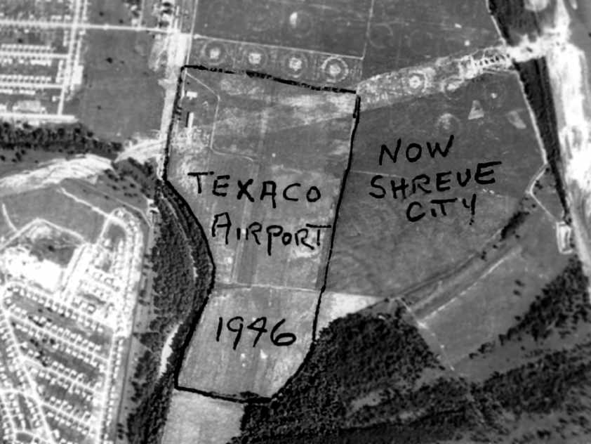
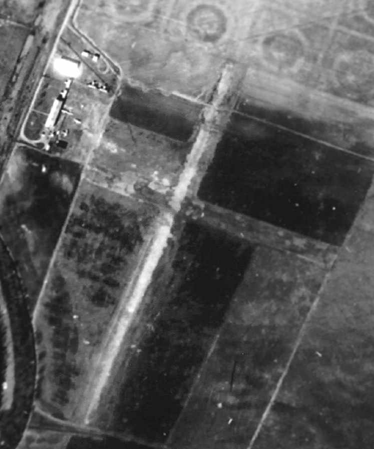
This aerial view of the former Texaco Airport property (courtesy of Carl Hennigan) was labeled as “1946”, but instead it was evidently taken at some point in 1954 or later,
as it shows the Shreveport Barksdale Highway being constructed through the center of the former airport, with the Red River Bridge under construction.
By the time of the 1955 USGS topo map, the former Texaco Airport was no longer depicted.
There was no remaining trace of Texaco Airport still perceptible in the 1998 USGS aerial photo.
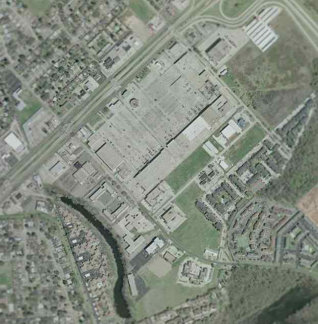
A 2002 USGS aerial photo no longer showed any trace of Texaco Airport.
The site of Texaco Airport is located south of the intersection of Shreveport Barksdale Highway & Knight Street.
____________________________________________________
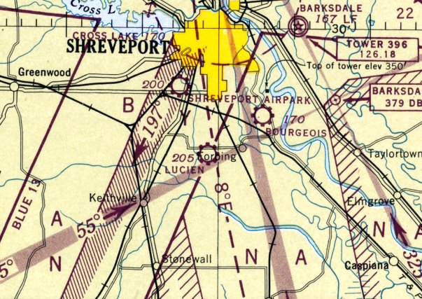
Stovall Airport / Shreveport Airpark, Shreveport, LA
32.45, -93.78 (Northwest of Baton Rouge, LA)
A circa 1930s aerial view looking northeast at Stovall Airport (courtesy of Carl Hennigan), with Mansfield Road visible along the top-right.
According to Carl Hennigan, “Stovall Airport was one of the earliest airports to operate in the Shreveport area.
It was built around 1924. Stovall Airport may have originally been called Steere Field when it was built in 1924.”
A circa 1930s aerial photo (courtesy of Carl Hennigan) depicted Stovall Airport as having 2 runways, 2 rows of T-hangars, and a larger hangar.
A closeup of the hangars at Stovall Airport from a circa 1930s aerial view (courtesy of Carl Hennigan) showed a dozen light aircraft.
For reasons unknown, Stovall Airport was not listed or depicted at all in The Airport Directory Company's 1933 Airport Directory,
the 1934 Shreveport Sectional Chart, The Airport Directory Company's 1938 Airport Directory,
the 1938 & 1941 Shreveport Sectional Charts, The Airport Directory Company's 1941 Airport Directory,
or the 1942 & March 1943 Shreveport Sectional Charts (according to Chris Kennedy).
Shelby Criswell reported that in 1942 his great grandfather Lambros "Brodie" Carros was a flight instructor at Stovall Airport.
Stovall Field, as depicted on a 5/20/43 aerial view looking north
from the 1945 AAF Airfield Directory (courtesy of Scott Murdock).
The earliest chart depiction which has been located of Stovall Airport was on the 1944 Shreveport Sectional Chart (courtesy of Carl Hennigan).
It depicted Stoval as a commercial/municipal field.
The Haire Publishing Company's 1945 Airport Directory (courtesy of Chris Kennedy) described Stovall Field as a “class 2” facility,
owned by Ralph Brandon & operated by Clifton Stovall.
The field was said to consist of 4 sod strips, with the longest being the 2,700' northeast/southwest strip.
The field was also said to have 2 hangars, and to offer charter, training, repairs, and fuel.
According to Carl Hennigan, “Stovall Airport... served private aircraft & crop dusters well into the 1940s.”
The Haire Publishing Company's 1946 Airport Directory (courtesy of David Brooks)
described Stovall Field as a “class 2” airfield, owned by George McMurray & operated by Clifton Stovall.
The field was said to consist of a 72-acre irregularly-shaped parcel,
having 4 all-way sod strips, with the longest being the 2,600' northeast/southwest strip.
Stovall was described as having 2 hangars, and offering repairs, fuel, training, and charter.
At some point in 1946 the airport was evidently renamed Shreveport Airpark,
as that is how it was labeled on the September 1946 Shreveport Sectional Chart (courtesy of Chris Kennedy).
According to Carl Hennigan, “Some pilots use to call it the Sunset Acres Airport”
[as Sunset Acres was the name of the local neighborhood].
The Haire Publishing Company's 1948 Airport Directory (courtesy of David Brooks)
described Shreveport Airpark as having 3 unpaved runways, with the longest being the 5,000' north/south strip.
It was said to be a privately-owned airfield, offering hangars, fuel, repairs, training, charter, and sales.
The manager was listed as Kirby Shaw.
The last chart depiction which has been located of Shreveport Airpark was on the February 1949 Shreveport Sectional Chart (courtesy of Chris Kennedy).
The last photo which has been located of Shreveport Airpark was on a 11/16/49 aerial photo.
It depicted the field as having 2 runways, with some buildings along the east side.
Shreveport Airpark was evidently closed (for reasons unknown) at some point between 1949-50,
as it was no longer listed among active airfields in the December 1950 USAF Pilot's Handbook,
nor depicted on the August 1950 Shreveport Sectional Chart (according to Chris Kennedy) or the 1966 USGS topo map.
There was no remaining trace of the former Stovall Airport still perceptible in the 1998 USGS aerial photo.
As seen in the 2002 USGS aerial photo, the site of Stovall Airport does not bear any recognizable trace of the airfield.
The site of Stovall Airport is located southwest of the intersection of Hollywood Avenue & Mansfield Road.
____________________________________________________
(Original) Shreveport Airport, Shreveport, LA
32.47, -93.83 (Northwest of Baton Rouge, LA)
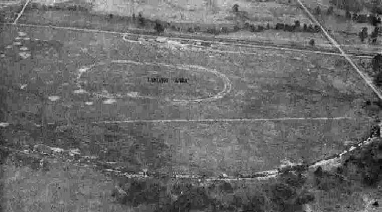
An undated (circa 1929) aerial view looking east at Shreveport Airport (courtesy of Carl Hennigan).
According to Carl Hennigan, “Opening in 1928 was the Shreveport Airport.
It was located about 5 miles west of the city & was operated by the Shreveport Airways Company Inc.
The Shreveport Airport was also called the Shreveport-Greenwood Airport,
as it's northern boundary was formed by Greenwood Road.”
An undated (circa 1929) aerial photo of Shreveport Airport (courtesy of Carl Hennigan)
depicted the field as having a square grass landing area with a single hangar on the northeast corner.
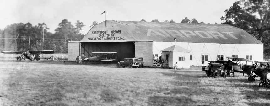
An undated (circa 1929) photo looking northwest at the hangar at Shreveport Airport (courtesy of Carl Hennigan),
showing a monoplane & several biplanes.
According to Carl Hennigan, the tenure of the original Shreveport Airport was rather short-lived,
due to the opening of the Shreveport Municipal Airport on an adjacent plot of land to the south.
The original Shreveport Airport was evidently closed by 1934,
as it was not depicted at all on the 1934 or 1942 Shreveport Sectional Charts.
There was no remaining trace of the original Shreveport Airport still perceptible in the 1998 USGS aerial photo.
As seen in the 2002 USGS aerial photo, the site of the original Shreveport Airport does not bear any recognizable trace of the airfield.
The site of Shreveport Airport is located south of the intersection of Greenwood Road & Monkhouse Drive.
The present-day Shreveport Regional Airport is located just on the other side of Interstate 20 to the south.
____________________________________________________
31.38, -93.39 (Northwest of Baton Rouge, LA)

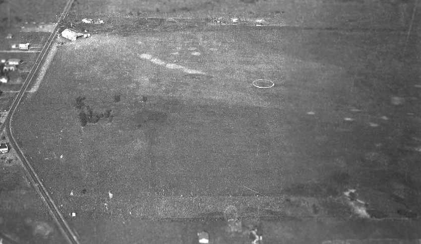
Hodges Airfield, as depicted on a 2/17/62 USGS aerial view.
This private airfield may have been constructed at some point between 1950-52,
as it was not yet depicted on the February 1950 Beaumont Sectional Chart.
The earliest depiction which has been located of the Hodges Airfield was on a 2/17/52 USGS aerial view.
It depicted 2 unpaved perpendicular runways.
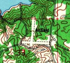
The earliest topo map depiction which has been located of the Hodges Airfield was on the 1954 USGS topo map.
It depicted 2 unpaved perpendicular runways, labeled simply as “Airfield”.
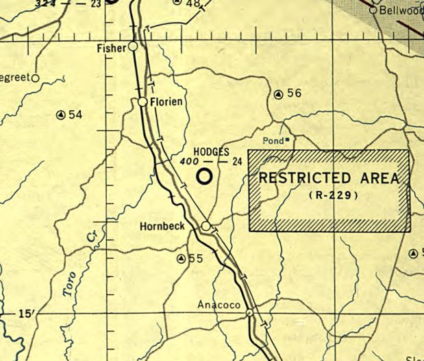
The earliest aeronautical chart depiction which has been located of Hodges Airfield was on the February 1955 Beaumont Sectional Chart.
It depicted Hodges as having a 2,400' unpaved runway.
The earliest directory listing which has been located of the Hodges Airfield was in the 1962 AOPA Airport Directory.
It described Hodges as having a single 2,400' asphalt Runway 18/36,
along with the remarks: "Caution: Private airstrip, emergency use only. Do not use E-W sod strip."
The operator was listed as Hodges Gardens [which is still is still in operation, described as the largest privately owned botanical gardens in the US].
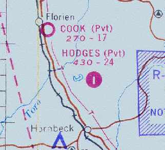
The last aeronautical chart depiction which has been located showing Hodges Airfield still open was on the September 1967 Beaumont Sectional Chart (courtesy of Chris Kennedy).
It depicted Hodges as a private airfield, and the Aerodromes table described the field as having 2 runways, with the longest being a 2,400' asphalt strip.
It was still labeled "Hodges" Airfield on the 1973 USGS topo map,
but was labeled simply "Landing Strips" on the 1985 & 1996 USGS topo maps
(which typically indicates that the airfield was no longer operational by that point).
Hodges Airfield was evidently closed by 1998, as it was depicted as an abandoned airfield on the 1998 World Aeronautical Chart.

A 1994 USGS aerial view looking north showed the cleared area of Hodges Airfield's 2 runways was still intact,
and the pavement of the former Runway 18/36 remained intact as well, with the closed runway "X" markings still plainly visible.

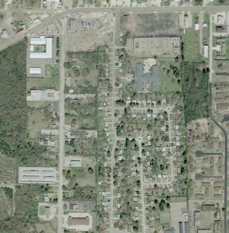
A 2023 aerial view looking north showed the Hodges Airfield to remain in fine condition.
The Hodges Airfield is located southwest of the intersection of Hodges Loop & Plainview Road.
____________________________________________________
Ruston Municipal Airport (RSN), Ruston, LA
32.51, -92.63 (East of Shreveport, LA)
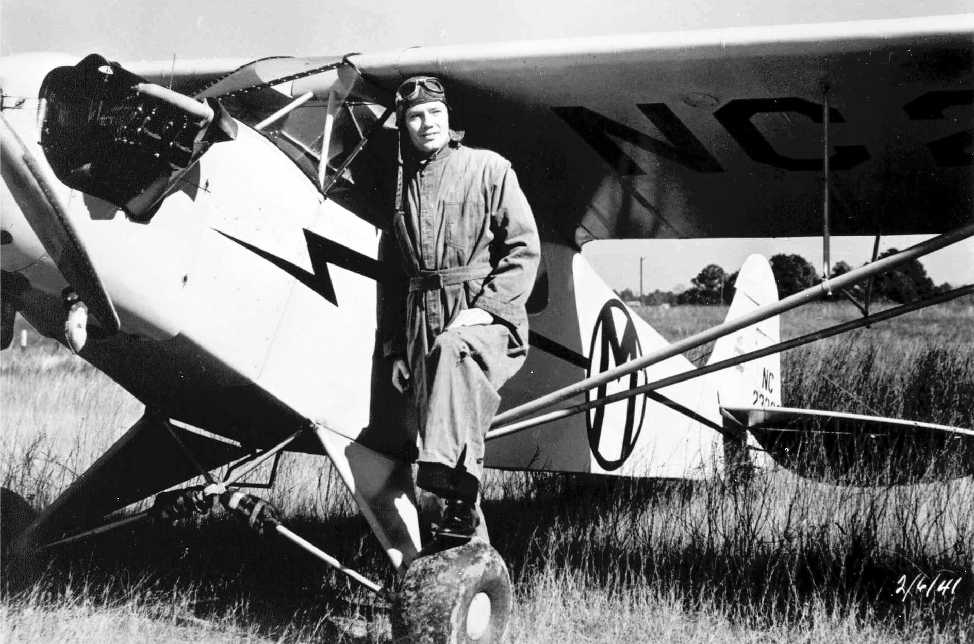
A 2/6/41 photo of Savery Lewis Stuckey in front of a Piper Cub presumably at Ruston Airport (courtesy of Mark Stuckey).
According to Savery "Sam" G. Stuckey, “The Ruston Municipal Airport came into being
mostly due to my father's (Savery L. Stuckey) diligence & enthusiasm.
The airport originally was a cow pasture designated
as a Civilian Aeronautics Administration emergency airfield along U.S. Skyway One.
The property was fenced with fence posts painted black & yellow.
The beacon light was part of the U.S. Skyway One visual identifiers.
The Town of Ruston purchased 44 acres of land in 1930.”
According to Savery L. Stuckey, “I guess it was in the 1930s that Barnstormers began to fly into Ruston.
One of them was Reggie Robins flying a tri-motored Ford airplane which could carry 14 passengers at a time.
An instructor, named Norman 'Pop' Wise, started coming into Ruston in a Piper Cub in the 1930s.
He was also a barnstormer.”
According to Sam Stuckey, “I have no information on when the Ruston property was actually designated as a CAA emergency airfield,
but I have childhood memories of those black & yellow fence posts from about 1938 when I was age 4.”
Sam Stuckey continued, “The Town of Ruston purchased an additional 15 acres... in 1945.
In October 1945, my dad received his instructor rating.”
However, inexplicably, the Ruston Municipal Airport was not yet depicted at all
on the 1945 Shreveport Sectional Chart (courtesy of John Voss).
According to Savery L. Stuckey, “In December 1945 I went to the Mayor
and asked him if he would lease me the land the City had purchased so I could start an airport,
for $1 a year if I would start a flight school & work toward building an airport.
He did lease it to me for 10 years, with option to renew. I renewed the lease 2 times.
All that time I operated a Flight School until 1968. I think I taught around 1,000 people to fly.”
According to Sam Stuckey, “The first paved runway was 1,500' long & was completed in 1946,
thanks to the donated equipment & expertise of the T. L. James Company, home-based in Ruston.
Mr. G. W. 'Bill' James & his brother Floyd James were two of my dad's first students,
and the obvious benefits of aviation in their heavy construction business added motivation to get a good runway established quickly.”
The earliest aeronautical chart depiction of Ruston Municipal Airport which has been located
was on the September 1946 Shreveport Sectional Chart (courtesy of Chris Kennedy).
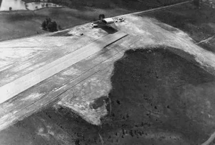
A 1946 aerial view (courtesy of Sam Stuckey) looking northwest at the north end of Ruston Municipal Airport.
Visible was the 1st hangar (which could hold 9-10 small aircraft), the administration building, a small paved ramp,
and portions of the paved Runway 16/34 & turf Runways 9/27 & 3/21.
The administration building had been erected using mostly scrap materials
and included a small office, 2 restrooms, a lounge area, and a small covered porch.
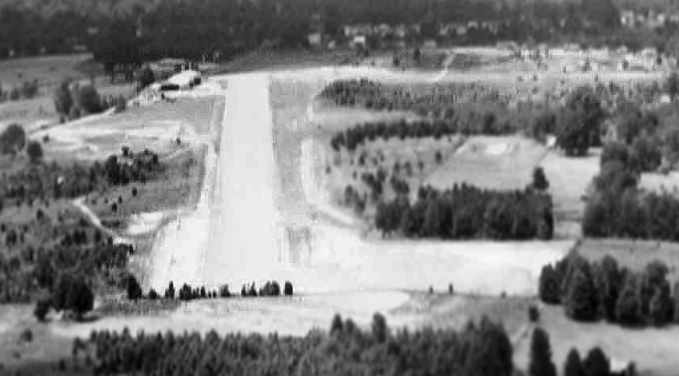
A circa 1947-48 aerial view (courtesy of Sam Stuckey) looking north along Ruston's Runway 34.
The T.L. James Company hangar (which housed their company aircraft) is visible adjacent to the original hangar.
According to Sam Stuckey, “Both photos show some of the 2 turf runways
that were used occasionally when winds did not cooperate:
a 9/27 runway along the north property line was about 1,000' long,
and another turf runway aligned approximately 3/21 was about the same length.
Neither of these turf runways were used very often,
but yours truly spent a lot of Farmall Cub tractor time keeping them tidy.”
A 1949 aerial view showed Ruston to have a single northwest/southeast runway,
with a few small buildings on the northwest side.
Sam Stuckey continued, “In the late 1940s & throughout the 1950s the Ruston Airport was quite busy -
on many days there would be 6 or 7 birds in the traffic pattern at the same time.
The flight program was approved for veterans using the G.I. Bill for college,
and ultimately led to the establishment of the LA Tech Professional Aviation Program.”
A circa 1950-51 photo (courtesy of Mark Stuckey) of Savery Lewis Stuckey & members of the Key Club
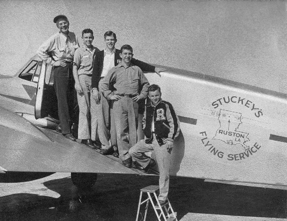
on top of a Stuckey's Flying Service Cessna T-50 presumably at Ruston Airport.
The 1951 USGS topo map depicted the “Municipal Airport” as having a single paved northwest/southeast runway,
with a few small buildings along the west side of the field.
Sam Stuckey continued, “Sometime around 1952-54 an additional 2,000' of paved runway was added onto the south end,
making the paved part 3,466' long.
A beacon light & runway strip lights were added in the 1950s.”
The 1962 AOPA Airport Directory described Ruston Municipal as having a single 3,500' paved runway.
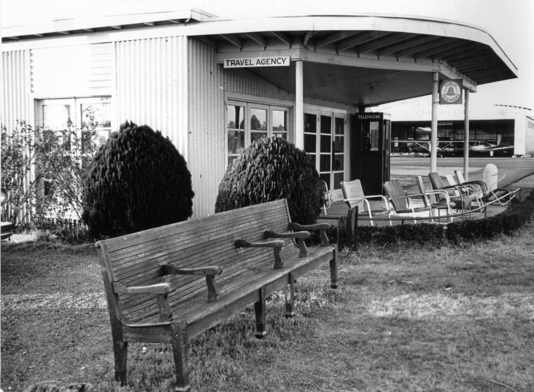
A 1964 photo by John Wood of the Ruston Airport office, from his book “Come to Beautiful Ruston: A Wonderful Place to Live”.
John reported in 2015, “Many small airports have chairs lined up parallel with the runway, as seen here, so pilots' landing performance can be graded by the peanut gallery.
The ‘travel agency’ in the foreground is now a church, and the hangar in the background is gone.”
According to Sam Stuckey, “My dad served as the City's airport manager & as the Fixed Base Operator until 1968.
He sold his assets to a group known as Lincoln Services Inc., which was a section of the T. L. James Company.
This was done in 1968.”
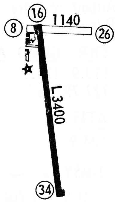
The 1968 Flight Guide (courtesy of Robert Levittan) depicted Ruston Airport as having a paved 3,400' Runway 16/33 & an unpaved 1,140' Runway 8/26.
Several buildings were depicted on the west side.
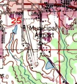
The 1968 USGS topo map depicted the Ruston Municipal Airport as having a single paved northwest/southeast runway,
with a few small buildings along the west side of the field.
Robert Carona recalled, “I flew out of the Ruston Airport from September 1969 until March 1978.
We lived in a house located in a field just east & about center of the airport on Moores Dairy Road, we could see the airplanes taxiing around from our back yard.
I remember seeing & talking to Sam Stuckey around the airport. Every one called him Mr. Stuckey.
I started my aviation career at LA Tech in 69 & graduated from Professional Aviation in 73.
After graduation I went to work at Lincoln Services as a flight instructor & charter pilot.
Lincoln Services used T.L. James on Twin Bonanzas & Baron aircraft in our charter operations;
at the time they had 2 Twin Bonanzas, a Beech Baron & a King Air.
I worked a Lincoln Services from 1973-76 then went to work for Lamar Haddox Construction flying a Navajo Chieftain out of Ruston until 1978.”
A new terminal building was constructed at Ruston in 1969, according to Sam Stuckey.
Sam Stuckey continued, “After the sale Dad continued to work at the airport for Lincoln Services, Inc. until 1970.
My mom died in February 1970, and he officially 'retired' shortly after her death.”
Sam Stuckey continued, “Sometime in the 1970s the name was changed to Ruston Flying Service.
Another 500' [to the length of the paved runway] were added sometime in the 1970s.
Also added in the 1970s was a larger T. L. James Company hangar, located south of the beacon light.”
The 1972 Flight Guide (according to Chris Kennedy) described Ruston
as having a 3,466' paved Runway 16/34 and an 1,140' turf Runway 8/26.
According to Sam Stuckey, “In the 1970s the City organized the Ruston Airport Authority,
a 5-member board, to look after growing airport needs.
The Mayor & the Airport Authority asked my dad to be the City's airport manager again in 1979.”
A 1980 airport directory (courtesy of Steve Cruse) of Ruston Municipal
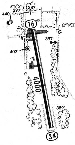
showed that Runway 14/34 had reached what would be its ultimate length of 4,000',
with a parallel taxiway along the east side.
A total of 3 hangars were depicted on paved ramps
along the western, northwestern, and northeastern sides of the runway.
The 1982 AOPA Airport Directory (courtesy of Ed Drury)
described Ruston as having a single 4,000' asphalt Runway 16/34,
and listed the operator as Ruston Flying Service.
According to Sam Stuckey, “VASI lights were added in the 1980s.”
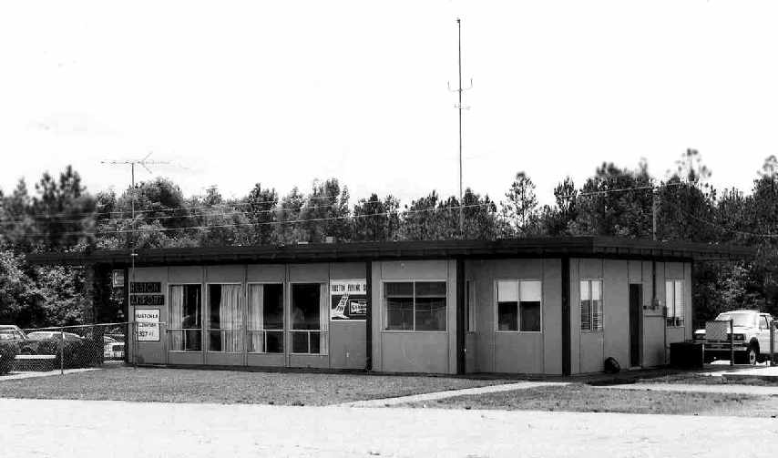
A circa 1980s photo (courtesy of Sam Stuckey) of the Ruston terminal building.
According to Sam Stuckey, his father served as the Airport manager “until his death in 1987 from a stroke at age 82.”
In its later years, Rston Airport was used primarily by Louisiana Tech University's Department of Professional Aviation
and a few local businesses.
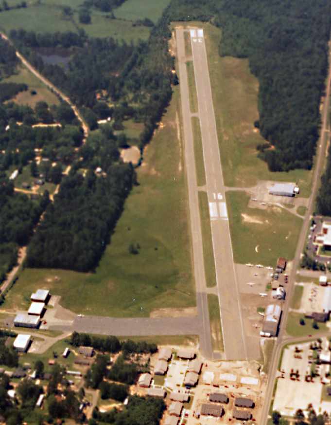
The last photo which has been located showing Ruston Municipal Airport still in operation was a 1994 aerial view by Carl Hennigan looking south,
showing at least 9 light aircraft parked on the field.
According to Sam Stuckey, “The need for a new airport was driven by the existing airport location (essentially in town)
and the inability to acquire additional real estate to extend the runway any further.
My dad had some input into the new airport layout, but did not live to see it become a reality.
When the new airport was dedicated in 1995,
the airport authority & the mayor wanted the name to be the Ruston Regional Airport
and would not allow my dad's name to be part of it.
However, there were some good friends in Ruston who finally convinced the City & Airport Authority
to dedicate the terminal building at the new airport with my dad's name, and that was accomplished in 2005.
One of the 2 low-frequency radio beacons serving the new airport is the Stuckey beacon.”
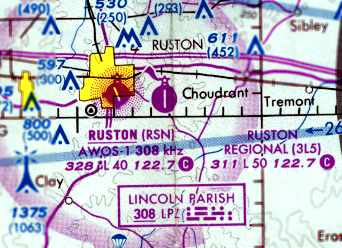
The last aeronautical chart depiction of Ruston as an active airport which has been located
was on the 1995 Memphis Sectional Chart (courtesy of David Brooks).
It depicted Ruston Municipal (RSN) as having a single 4,000' paved runway.
Note that it also depicted the newer Regional Airport (3L5) to the east, which eventually replaced the original field.
Ruston Municipal Airport was evidently closed at some point between 1995-97,
as a 1997 USGS aerial view looking southeast showed the runway marked with closed “X” symbols.
The Ruston Municipal Airport property is currently used by the Ruston Police Department for vehicle chase training,
and what was once the main operations building now houses a church.
Ruston Municipal Airport was still depicted as an abandoned airfield on 2002 & 2005 Sectional Charts.
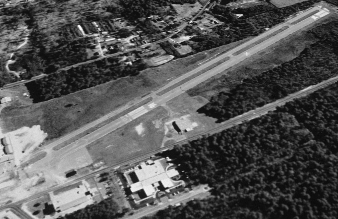
A circa 2002-2005 aerial view looking north at the former hangar on the west side of the Ruston Airport site, as well as the north end of former Runway 16/34.
Mark Stuckey reported of Ruston, “When I drove onto the strip in November 2007,
the strip & taxiway were being used as parking for the soccer fields that border them (you can see them in the pics, especially on the approach end of [Runway] 34).
The white hangar building is now a church.
My friend in town indicated that there has been a discussion of a strip mall going up there, as well as perhaps some public housing.”
Mark Stuckey reported in 2008, “When I drove by, I saw a new single-story office building (red building), but no other new construction.”
A 2008 aerial view by Mark Stuckey looking southeast at Ruston Airport, showing the runway & hangars to remain largely intact.
A 2013 photo looking southwest at 3 former hangars on the northeast side of the Ruston Municipal Airport site.
A 2014 aerial view looking southeast shows the majority of the former Ruston Municipal Airport runway remains intact, along with the largest hangar,
but portions of the runway on both ends have been removed.
A 2013 photo looking southeast at the former hangar on the west side of the Ruston Municipal Airport site.
As of 2023, street maps label the former hangar on the west side of the Ruston Municipal Airport site as the Church of God in Christ.
Thanks to Tim Traylor, USAF, for information about Ruston.
____________________________________________________
Or if you prefer to contact me directly concerning a contribution (for a mailing address to send a check),
please contact me at: paulandterryfreeman@gmail.com
If you enjoy this web site, please support it with a financial contribution.
____________________________________________________
This site covers airfields in all 50 states.