
Abandoned & Little-Known Airfields:
Southeastern Massachusetts
© 2002, © 2026 by Paul Freeman. Revised 3/7/26.
Acushnet Airport (revised 8/17/24) - Brigg's Field / Eastham Airport / Nauset Airport (revised 1/5/26) - Cashen's Airfield / Bascom Field (revised 11/5/22)
Chatham Naval Air Station (revised 9/28/22) - Clifton Field (revised 4/11/24) - Fall River Municipal Airport (revised 2/1/26) - Falmouth Airport / Coonamessett Airport (revised 2/1/26)
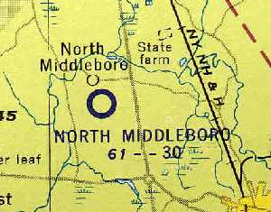
Fisher Field (revised 3/7/26) - New Bedford Fairhaven Airport (added 10/25/19) - No Man's Land Navy Airfield (revised 11/5/22) - North Middleboro Airpark / Middleboro Airport (revised 2/2/26)
North Truro AFS Heliport (added 3/11/23) - (Original) Providence Airport (revised 5/7/17) - Rochester-Marion Airport (added 1/7/20)
Round Hill Airport (revised 11/5/22) - Skymeadow Airport (revised 9/12/20) - Wilkins Airport (revised 8/17/24)
____________________________________________________
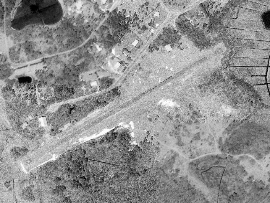
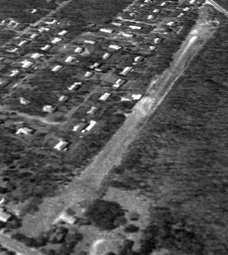
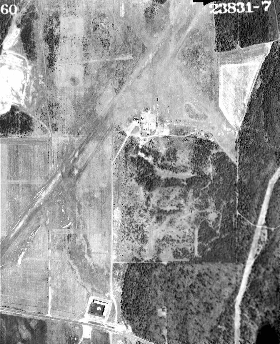
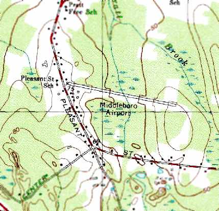
Fisher Field, Middleborough, MA
41.874, -70.843 (Southeast of Boston, MA)
Fisher Field, as depicted on the 1979 USGS topo map.
This rural general aviation airport was evidently constructed at some point between 1961-71,
as it was not yet depicted on a 1961 aerial photo.
Fisher Field was not depicted at all on Sectional Charts from 1965-2018.
The earliest photo which has been located of Fisher Field was on a 1971 aerial photo. It depicted 2 grass runways, with a small hangar on the east side,
and 1 light single-engine plane on the west side.
The earliest depiction which is available of Fisher Field was on the 1979 USGS topo map.
It depicted a single unpaved northwest/southeast runway, labeled generically as “Landing Strip”.

The 1994 USGS topo map depicted Fisher Field as a a single northwest/southeast runway, labeled generically as “Landing Strip”.

The earliest photo which is available of Fisher Field was a 1995 aerial view looking west.
It depicted a grass northwest/southeast runway, with a 1 light single-engine plane & a small hangar on the east side.

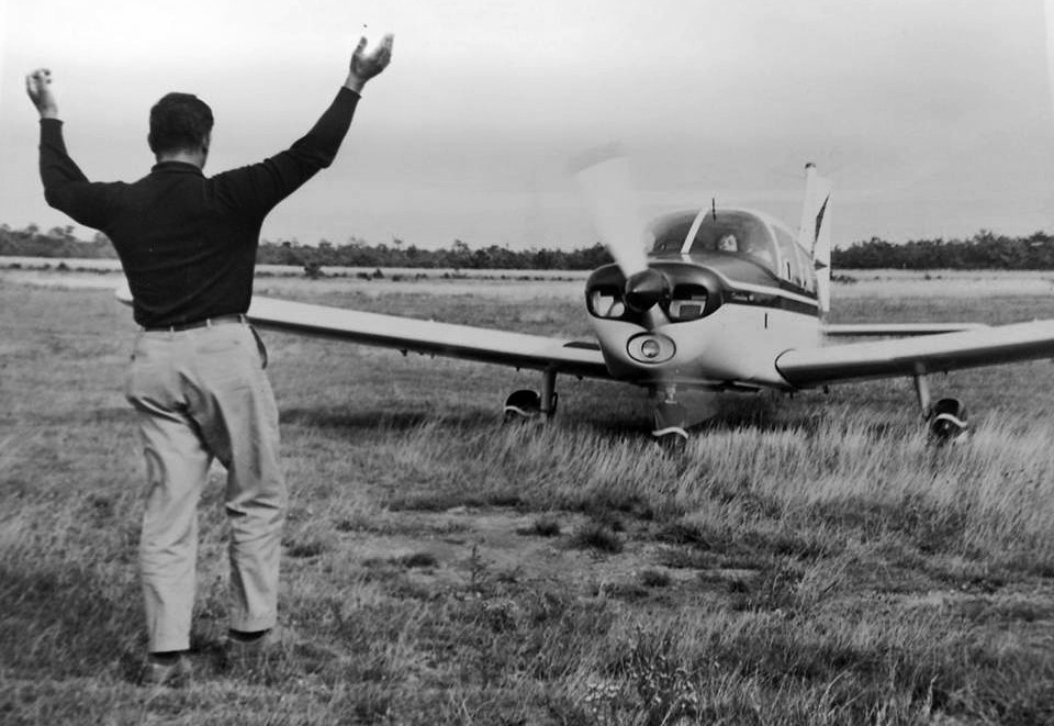
A circa late 1990s / early 2000s photo of Norman Neff in his Challenger II ultralight at Fisher Field (courtesy of Cody Johnson).
Cody Johnson recalled, “My grandfather used to fly out of Fisher Field until 2005. It was mostly ultralights & experimental aircraft.”

A circa late 1990s / early 2000s photo of a man & an unidentified ultralight at Fisher Field (courtesy of Cody Johnson).

A 2015 photo of ultralight Papa's Toy at a Fisher Field fly-in.

A 2015 photo of experimental Red Max II N43436, a Team Mini Max 15600R a Fisher Field fly-in.

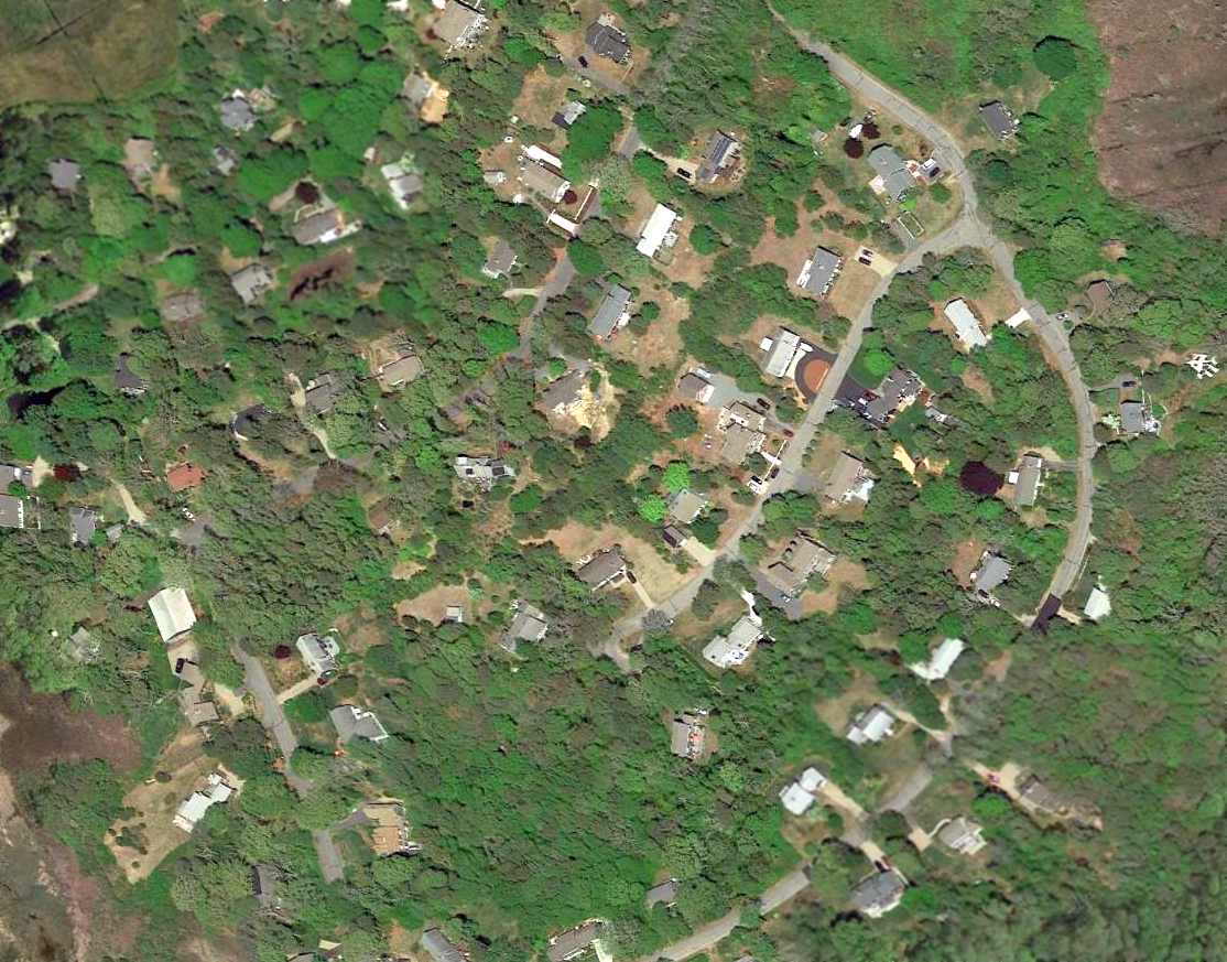
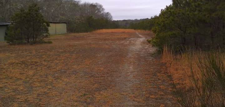
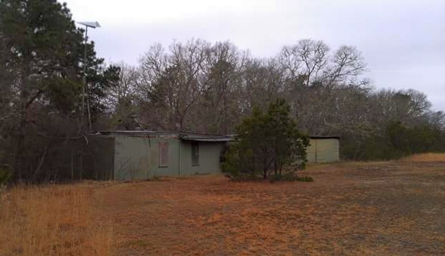
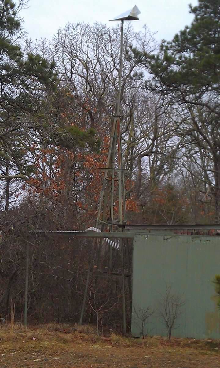
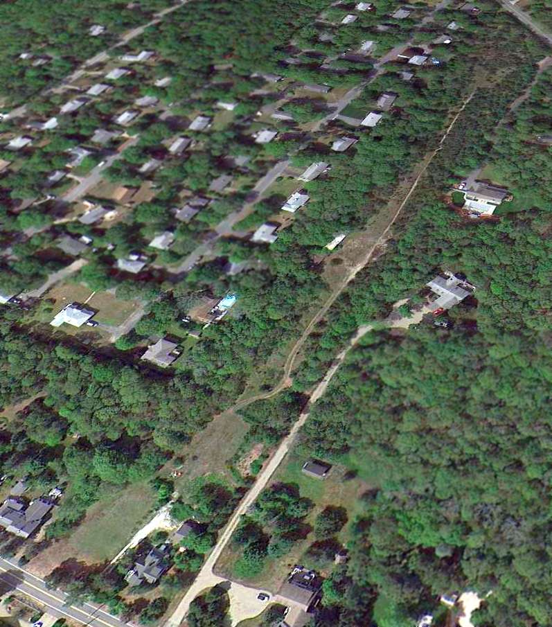
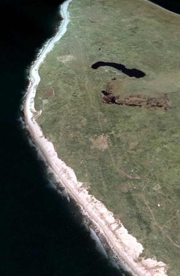
A 2015 aerial view looking west at Fisher Field, presumably shortly before its closure.
A 2016 aerial view showed solar panels had been installed adjacent to the southwest side of Fisher Field's runway at some point between 2015-16, presumably at the point of its closure.

A 2025 aerial view looking west showed that Fisher Field remained intact, but without any sign of aviation use.
Thanks to Cody Johnson for pointing out this airfield.
____________________________________________________
North Truro Air Force Station Heliport, North Truro, MA
42.03, -70.051 (Southeast of Boston, MA)
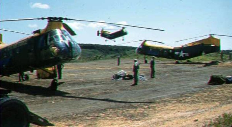
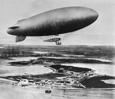
A circa 1956 picture by Charles Rowland of 3 Piasecki H-21 Shawnee helicopters operating from the North Truro AFS Heliport to provide logistical support to the offshore Texas Tower 2 radar installation (courtesy of Thomas Page).
North Truro Air Force Station was one of the first of 24 stations of the permanent Air Defense Command radar network.
On 12/2/48 the Air Force directed the Army Corps of Engineers to proceed with construction of this & 23 other sites around the periphery of the United States.
The 762nd Aircraft Control & Warning Squadron began operations at North Truro in 1951.
North Truro AFS was the operational parent station for Texas Tower 2 offshore in the Atlantic Ocean starting in May 1956.
At some point between 1948-56, North Truro AFS gained a heliport to provide logistical support to the offshore Texas Tower 2 radar installation.
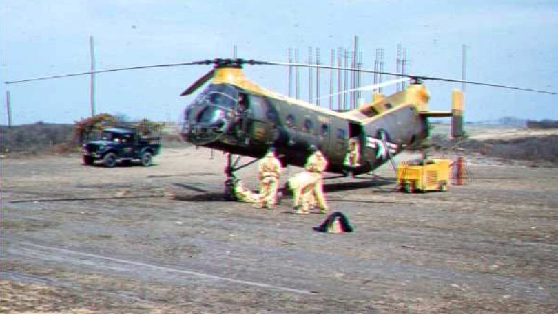
A circa 1956 picture by Charles Rowland of a Piasecki H-21 Shawnee helicopter operating from the North Truro AFS Heliport to provide logistical support to the offshore Texas Tower 2 radar installation (courtesy of Thomas Page).
The North Truro AFS Heliport was not depicted on 1957/60/65 Boston Sectional Charts.
The logistical support of the Texas Tower 2 offshore was transferred from North Truro AFS to Otis AFB in January 1963,
which may have been the end of use of the North Truro AFS Heliport.
In 1969 North Truro Air Force Station was the location of Operation Have Horn, the launching of sounding rockets under project Nike Hydac.
On completion of the operation in 1970, the hardware was returned to the White Sands Missile Range.
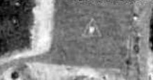
A 1971 aerial view showed the triangular heliport marking on the North Truro AFS Heliport.
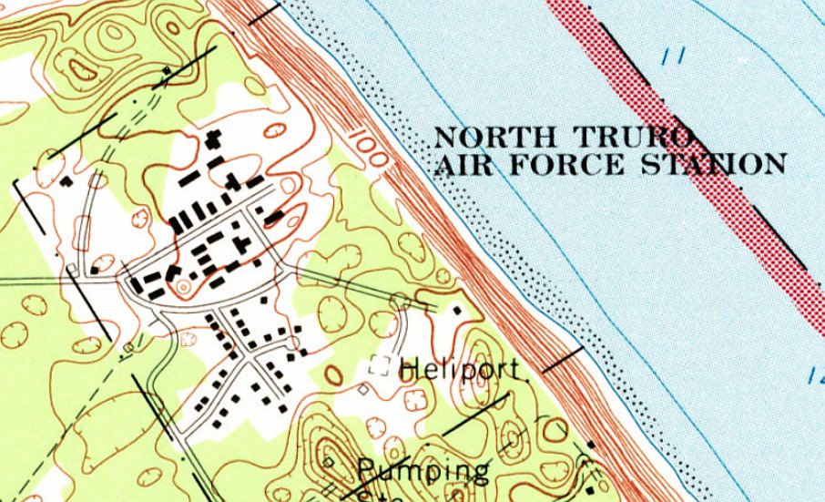
The 1972 USGS topo map labeled the North Truro AFS “Heliport”.
Thomas Page recalled of North Truro AFS, “I was stationed there from August 1979 - September 1981.”
After the end of the Cold War, in 1994, the Air Force closed down operations at North Truro,
and most of the land was transferred to the National Park Service, but a small portion remained as an FAA long-range radar site.
NTAFS was given to the Cape Cod National Seashore & is now being redeveloped into the Highlands Center.
A 2021 aerial view showed the North Truro AFS Heliport remained recognizable as a rectangular asphalt patch.
Thanks to Thomas Page for pointing out this airfield.
____________________________________________________
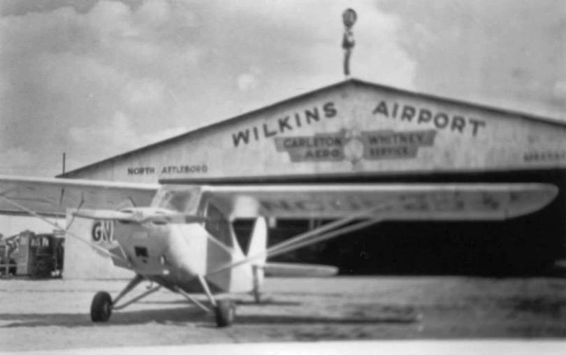
Wilkins Airport, North Attleboro, MA
42.007, -71.304 (Southwest of Boston, MA)
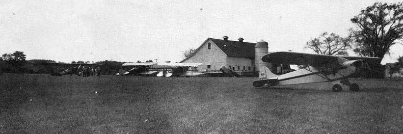
A September 1940 photo of a Piper Cub, 2 biplanes, and another plane in front of a barn at Wilkins Airport (courtesy of Max Sarazin).
Planes reportedly started landing on the Wilkins' family Seven Elms Dairy Farm at some point in the 1930s.
However, Wilkins Airport was not depicted on Boston Sectional Charts from 1933/35/37/39 or the 1940 USGS topo map.
The earliest depiction which has been located of Wilkins Airport was a September 1940 photo of a Piper Cub, 2 biplanes, and another plane in front of a barn (courtesy of Max Sarazin).
Wilkins Airport was still not depicted on Boston Sectional Charts from 1941 through November 1944.
Wilkins Airport reportedly closed during WW2, then reopened under the management of Russ Carlton & Loyd Whitney after the war.
Max Sarazin recalled, “Sometime before 1945 Russ Carleton & Lloyd Whitney rented flat farmland from Mr. Wilkins
at & up to the southeast corner of Routes 106 & 152 to establish Carleton Whitney Aero Service.
The rectangular lot allowed runways of approximately 1,900'.”
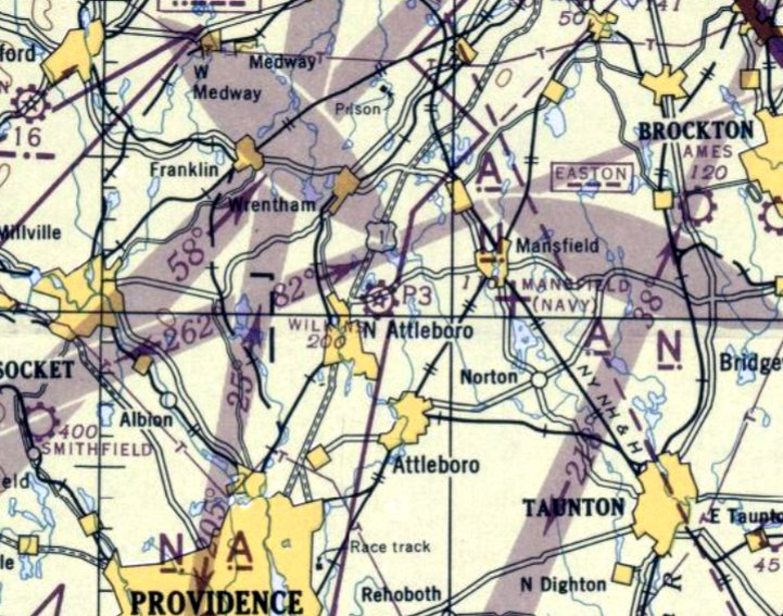
The earliest aeronautical chart depiction which has been located of Wilkins Airport was on the June 1945 Boston Sectional Chart.
It depicted Wilkins as a commercial/municipal airport.
Max Sarazin recalled, “It was probably 1946 that Walt Main, a civilian flight instructor at a military base during the big war bought the rights to the operation with wife Marie as operations manager.
'Fun' Revelto with an assistant was A&E mechanic. It may have been Jimmy Hopkins who later became the head mechanic.
Walt Main II & Red Beach became Flight Instructors relieving Walt of that duty.”
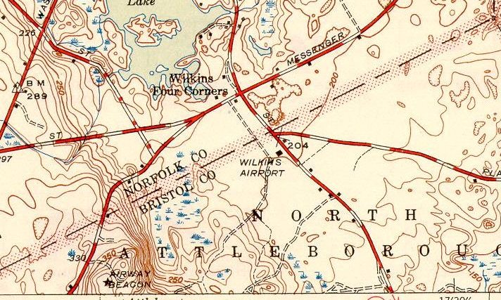
The earliest topo depiction which has been located of Wilkins Airport was on the 1946 USGS topo map.
It depicted Wilkins Airport as a label without a property boundary, with a single building on the northeast side.
An Airway Beacon was depicted off the airport property on a hill to the southwest.
Max Sarazin recalled, “Wilkins Airport... many pilots were trained there, [including] me. I first flew out of there on 4/14/47.”
A 2021 photo by Max Sarazin of his Carleton Whitney Aero Service interwoven wings awarded upon his 1947 solo flight.
A circa 1940s photo of an Aeronca Champ in front of a Wilkins Airport hangar (courtesy of Max Sarazin).
A circa 1940s photo of Max Sarazin & an Aeronca Champ at Wilkins Airport.

A 1957 photo of Max Sarazin of his Aeronca 7AC Champ at Wilkins Airport.
Max Sarazin recalled, “In 1957 or thereabouts, Jimmy Hopkins married Ruth Wilkins to get control of the airport, but not the operation, which moved out to Mansfield Airport.
Wilkins Airport operated by Jim & Ruth didn't survive too well.”

The last aeronautical chart depiction which has been located of Wilkins Airport was on the November 1960 Boston Sectional Chart.
It depicted Wilkins as having a mere 2,000' unpaved runway.
A 1961 aerial photo depicted Wilkins Airport as a rectangular grass airfield with a northwest/southeast grass runway, with 2 hangars on the east side.
There were no aircraft visible on the field.
The 1964 USGS topo map depicted an empty clearing at the site of Wilkins Airport.
Wilkins Airport was evidently closed at some point between 1960-65,
as it was no longer depicted on the September 1965 Boston Sectional Chart.
A 4/1/77 USGS aerial photo map depicted a clearing & several buildings at the site of Wilkins Airport.
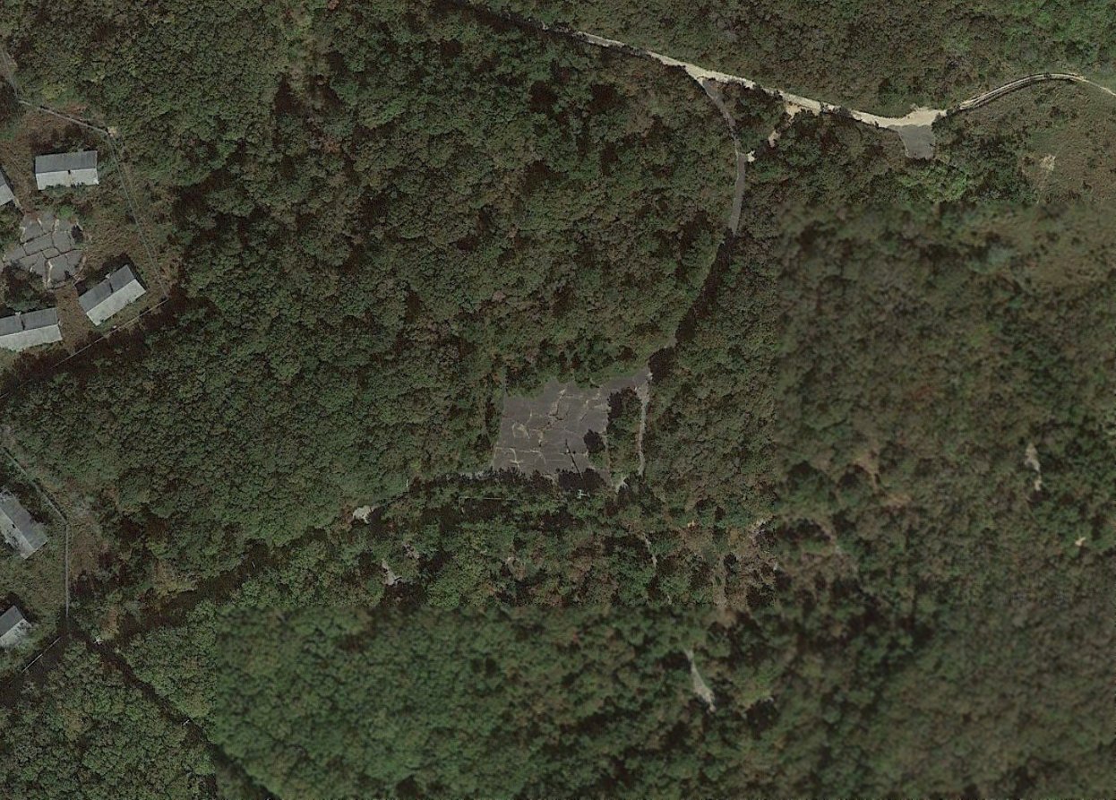
A 2019 aerial view looking northeast showed the overall property outline of the former Wilkins Airport remained recognizable, roughly 60 years after the airport's closure.
Thanks to Max Sarazin for pointing out this airfield.
____________________________________________________
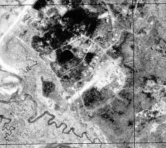
Rochester-Marion Airport, Rochester, MA
41.731, -70.827 (South of Boston, MA)
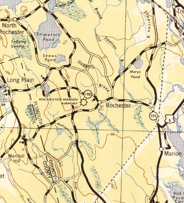
Rochester Marion Airport, as depicted on the 1942 USGS topo map (courtesy of Matthew Foster).
Not much is known about this small airport, including its purpose, reason for closure, or its inexplicably brief lifespan of possibly less than a year.
It was apparently only ever depicted on 1 topo map & 1 aeronautical chart.
Rochester Marion Airport was not yet depicted on the 1941 USGS topo map.
The earliest reference which has been located to Rochester Marion Airport was in the 1941 Airport Directory Company Airport Directory (courtesy of Jonathan Westerling).
It described Marion-Rochester as a commercial airport, having a 1,300' rectangular sod field & a hangar.
The earliest depiction which has been located of Rochester Marion Airport was on the 1942 USGS topo map (courtesy of Matthew Foster).
It depicted the airport as being adjacent to the west side of Rochester, but did not depict any other details.
Rochester-Marion Airport was not yet depicted on the November 1943 Boston Sectional Chart.
The 1943-44 Directory of Airfields (courtesy of Jonathan Westerling) listed Rochester-Marion Airport.
The only aeronautical chart depiction which has been located of Rochester-Marion Airport was on the May 1944 Boston Sectional Chart.
It depicted Rochester-Marion Airport as an auxiliary airfield.
Rochester Marion Airport may have been closed (for reasons unknown) within 1944,
as it was no longer depicted on the November 1944 Boston Sectional Chart, nor on the 1944 USGS topo map.
No sign of a former airfield was recognizable at the site of Rochester Marion Airport on a 1961 aerial photo.
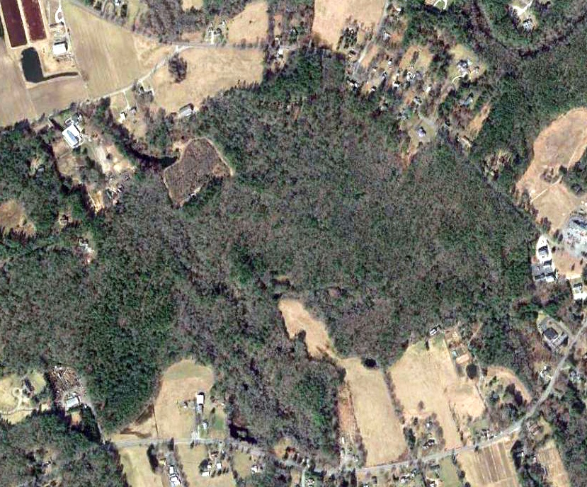
A 2018 aerial view did not show any trace recognizable of Rochester-Marion Airport.
Thanks to Matthew Foster for pointing out this airfield.
____________________________________________________
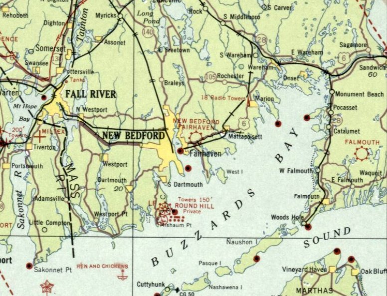
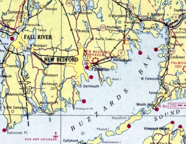
New Bedford Fairhaven Airport, Fairhaven, MA
41.647, -70.879 (South of Boston, MA)
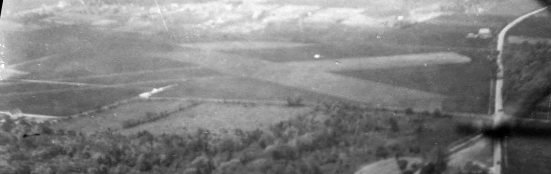
A 1929 aerial view looking southwest at Fairhaven Airport showed it to have 2 grass runways in an X-shape.
According to “Three Generations of Oldens Continue Their Legacy of Flight” by M.L. Baron,
“Fairhaven was the Southeastern MA main hub for airplane traffic.
Sound Airways, Inc. provided a valuable service from the mainland to the islands of Martha's Vineyard & Nantucket for passengers & freight.
The small airline company was owned by Ike Dawson, of The Dawson Brewery fame, and operated by Fairhaven resident & pilot Henry Olden.
His name was synonymous with New Bedford, Fairhaven, Acushnet Airport as it was officially called at one time.
The airport was once located off Pontiac Street in Acushnet, but the pilots had difficulty with its small muddy fields.
It was eventually relocated to a large, more stable field along the west side of Mill Road & the north side of Route 6.
In 1929, Sound Airways (named after the island sounds of Martha's Vineyard, Nantucket and Long Island) purchased the 85+ acre parcel.”
The earliest depiction which has been located of Fairhaven Airport was a 1929 aerial view, which showed it to have 2 grass runways in an X-shape.
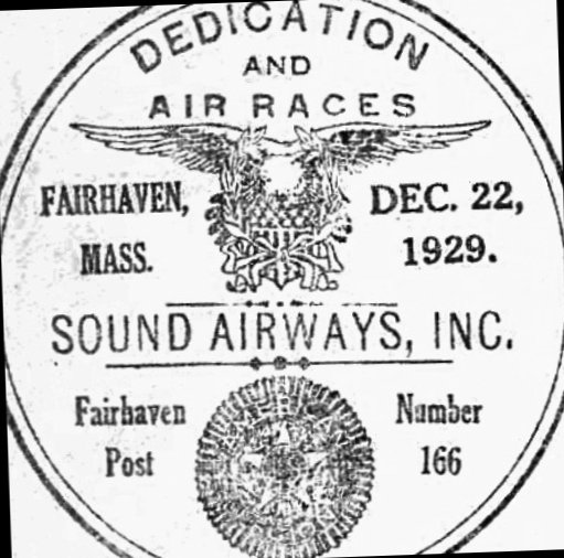
A postmark commemorating the 12/22/29 dedication of Fairhaven's Sound Airways.
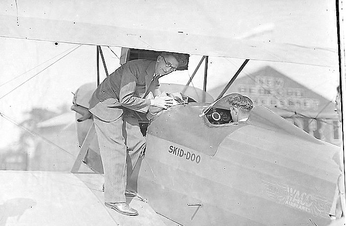
A circa 1929-37 photo of 2 unidentified men & a Waco biplane at Fairhaven Airport,
with a hangar painted “New Bedford Fairhaven” in the background.
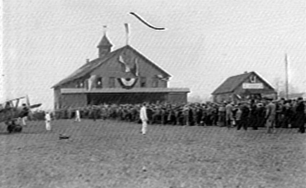
A circa 1929-37 photo of a large crowd of spectators, a biplane, a hangar, and a smaller building at Fairhaven Airport.
According to “Three Generations of Oldens Continue Their Legacy of Flight” by M.L. Baron, “Over 25,000 attended the 1930 Air Show. More than three dozen aircraft were on display at Fairhaven.”
Baron continued, “In less than 3 years [after its 1929 founding], financial troubles brought about by the depression brought the field to an almost idle standstill.
Although still used as an airfield,it never again had the splendor & excitement that came with Sound Airways & the flight training school.”
The earliest aeronautical chart depiction which has been located of Fairhaven Airport was on the March 1933 Boston Sectional Chart.
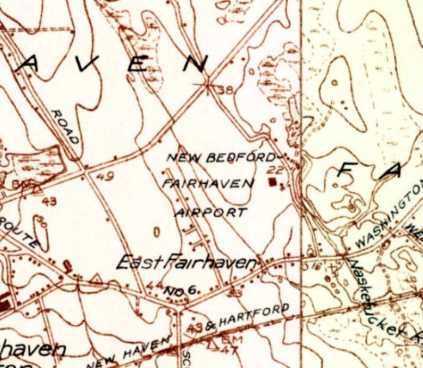
The only topo map depiction which has been located of Fairhaven Airport was on the 1936 USGS topo map.
It depicted “New Bedford Fairhaven Airport” without any property borders & with a building (a hangar?) on the east side.
The last aeronautical chart depiction which has been located of Fairhaven Airport was on the October 1937 Boston Sectional Chart.
Fairhaven Airport was evidently closed (for reasons unknown) at some point between 1937-38,
as it was no longer depicted on the May 1938 Boston Sectional Chart.
Fairhaven Airport was no longer depicted on the 1941 USGS topo map, but the building on the east side of the field was still depicted.
According to “Three Generations of Oldens Continue Their Legacy of Flight” by M.L. Baron,
in the mid-1940s the former Fairhaven Airport property was sold to a farm dairy.
A 1961 aerial photo showed the area of Fairhaven Airport remained an open field, with the hangar remaining intact on the east side.
A 1971 aerial view depicted the site of Fairhaven Airport in an unchanged fashion.
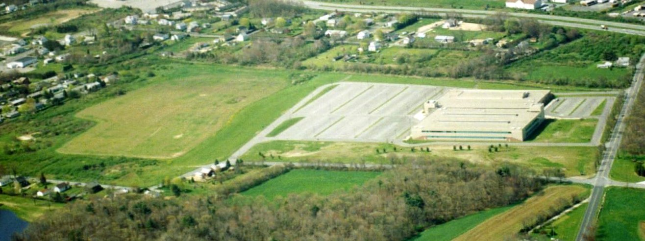
A 1994 aerial view looking southwest showed an industrial building & its parking lot had been built over the northern portion of the Fairhaven Airport site.
The former hangar had evidently been removed at some point between 1971-94,
but its foundation was possibly still visible (the light colored feature on the left edge of the photo).
Thanks to Ron Janard for pointing out this airfield.
____________________________________________________
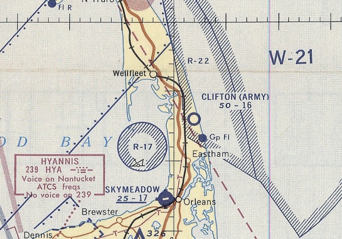
Orleans Airport / Skymeadow Airport, Orleans, MA
41.79, -70.01 (Southeast of Boston, MA)
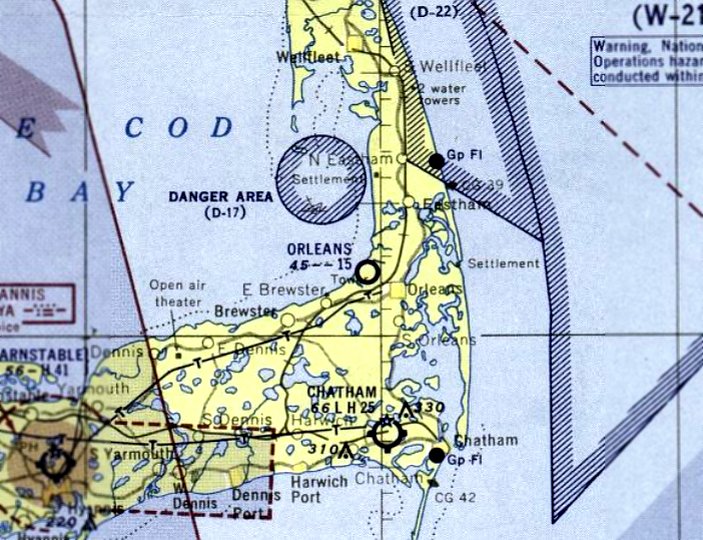
Orleans Airport, as depicted on the December 1953 Boston Sectional Chart.
This small general aviation airport on Cape Cods was evidently established at some point in 1953,
as it was not yet depicted on the 1946 USGS topo map or the May 1953 Boston Sectional Chart.
The earliest depiction which has been located of Orleans Airport was on the December 1953 Boston Sectional Chart.
It depicted Orleans Airport as having a 1,500' unpaved runway.
It was still depicted as Orleans Airport on the November 1954 Boston Sectional Chart.
At some point in 1954-55 it was evidently renamed Skymeadow Airport,
as the 1954 Airports & Business Flying Directory (courtesy of Jonathan Westerling) described “Skymeadow Airport – Orleans Airport”
as having a 1,700' unpaved strip, and listed the manager as Willard Ketchen.
It was depicted as Skymeadow Airport on the May 1955 Boston Sectional Chart.
The earliest photo which has been located of Skymeadow Airport was a 1955 aerial view (courtesy of Jack Grainger),
which showed Skymeadow Airfield at top-right, with Rock Harbor in the foreground.
Bill Quinn recalled flying out of Skymeadow Airport to take the first images of the collision of the MS Stockholm & passenger liner SS Andrea Doria in 1956.
Charlene Ketchen Wallace, recalled, Sky Meadow Airport... My father Will Ketchen first ran this airport back in the 1950s.
He & Doug Hoff were in partnership. My dad & mom ran the airport for several years.
There was a dirt road which ran down the side of the runway towards the salt marsh.
There was also a large hangar in our yard. The opening of the hangar faced the runway & the back was on our driveway.
I enjoyed being at it when I was just a little girl.”
Skymeadow Airport was reportedly run by Hunter Craig, a former WW2 Marine Corsair pilot.
The last directory entry which has been located of Skymeadow Airport was in the 1956 Airman's Guide (courtesy of Jonathan Westerling).
The last aeronautical chart depiction which has been located of Skymeadow Airport was on the November 1960 Boston Sectional Chart.
It depicted Skymeadow Airport as having a 1,700' paved northeast/southwest runway.
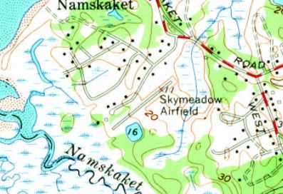
The earliest topo map depiction which has been located of Skymeadow Airport was a 1962 USGS topo map.
It depicted Skymeadow Airfield as having a single paved northeast/southwest runway.
Skymeadow Airport was evidently closed at some point between 1960-64, as it was listed as Abandoned in the 1964 Airman's Guide (courtesy of Jonathan Westerling).
Skymeadow Airport was not depicted on the 1965/68/70 Boston Sectional Charts.
David Keith recalled, “Skymeadow Airport has a special place in my memory.
I took my Private Pilot checkride in the Brockton Flying Club Cessna 172, N3718S, at Skymeadow, on 4/14/67.
Airport Manager Willard Ketchen, who had a craggy & imposing visage, was the check pilot.
I was on my best behavior, because I certainly didn’t want to be chewed out by this man. He wrote 'Pvt Pilot Flt Check OK', so I guess he was pleased!”
A 1971 USGS aerial view depicted Skymeadow Airport as having a single paved northeast/southwest runway,
painted with 3 closed-runway “X” symbols & the word “Private”.
One hangar was located each at the northwest & northeast ends, with 4 light single-engine aircraft parked around the northeast hangar.
Jack Grainger recalled, “I got my Private [Pilot's License] at Sky Meadow.”
A 3/25/73 USGS aerial view depicted Skymeadow Airport as having a single paved northeast/southwest runway, painted with 3 closed-runway “X” symbols.
One hangar was located each at the northwest & northeast ends. There were no aircraft visible on the field.
Mark Clifton recalled, “Sky Meadow Airfield... an airport in Orleans that my father used to keep his plane at back in the 1970s.
It was located near Skaket Beach (very close to the Captain Linnell House/restaurant) in Orleans.
We would enter the airport off Captain Linnell Road.
I recall as a child the field being in very poor shape (runway) along with a small hangar that was run-down.
His first plane was a Piper Cub that he flew out of that airport for years.”
Skymeadow Airport was evidently closed at some point between 1971-77,
as a 4/1/77 aerial view showed 2 residential streets having been built, one over each end of the runway.
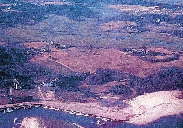
A 3/23/82 aerial view showed that houses had covered the site of Skymeadow Airport, but the hangar on the northwest side of the runway remained intact.
A 1984 aerial view looking north at the site of Skymeadow Airport (courtesy of Bernie Siryk) showed the alignment of the runway remained recognizable.
A 2015 aerial view showed no obvious sign of the former Skymeadow Airport, but the light-colored larger building on the west side is a former hangar.
Bernie Siryk reported in 2015, “The hangar still exists as does the small home that served as the airfield's office.”

An October 2019 photo (courtesy of Joe Boruch) looking west at the former Skymeadow Airport hangar.
Joe Boruch reported in 2020 from a drive past the Skymeadow Airport site that the former hangar remains standing.
The site of Skymeadow Airport is located north of the intersection of Captain Linnell Road & Skymeadow Drive.
Thanks to Bernie Siryk for pointing out this airfield.
____________________________________________________
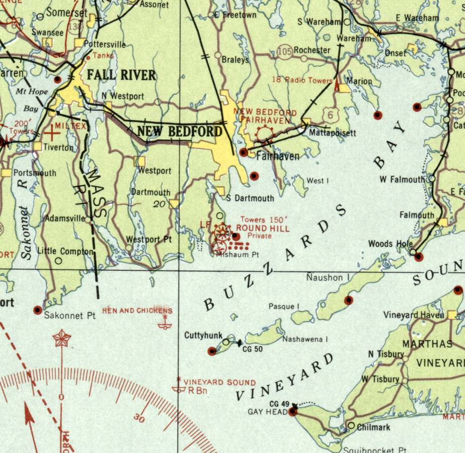
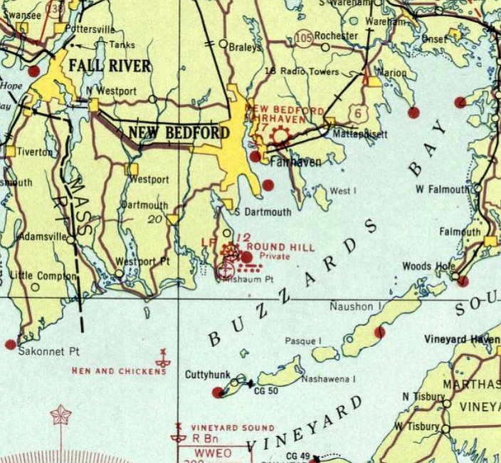
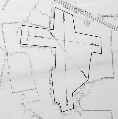
Round Hill Airport, Round Hill, MA
41.542, -70.94 (South of Boston, MA)
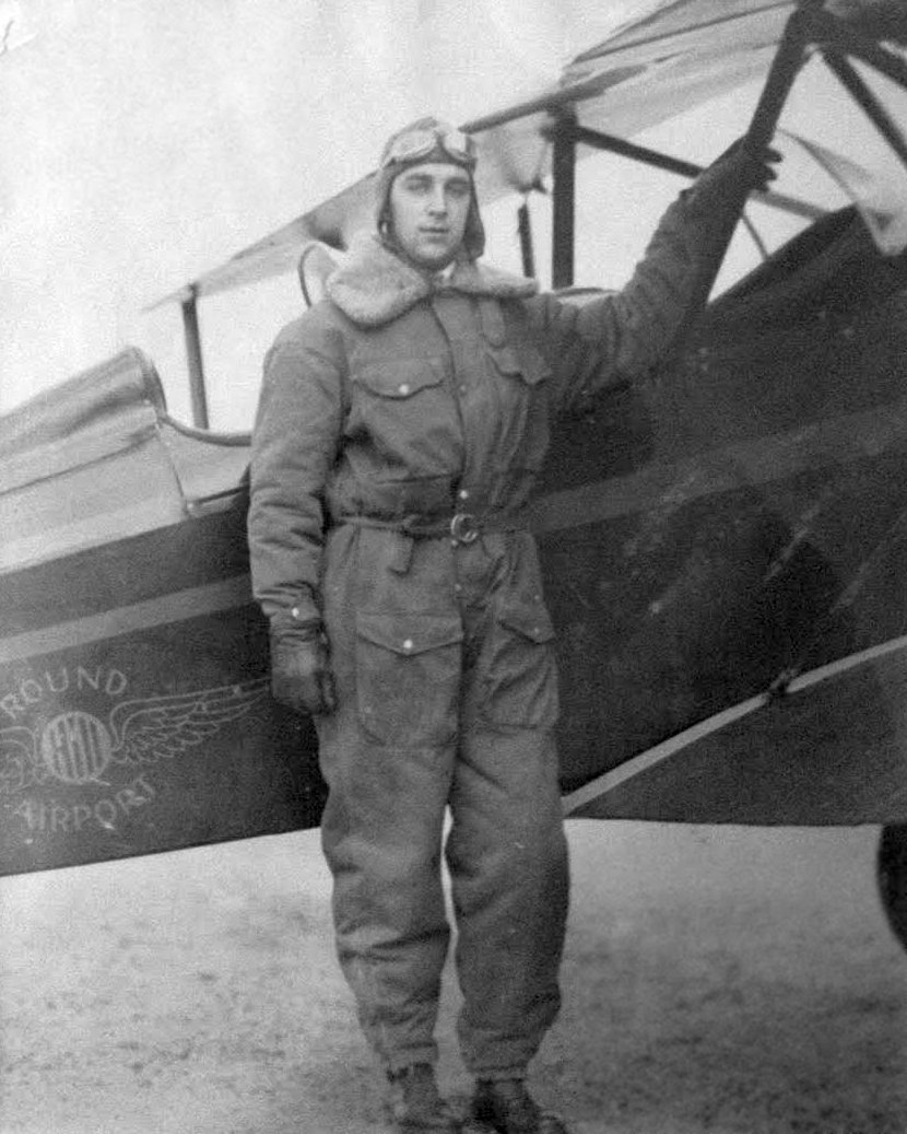
A circa late-1920s – 1932 photo of Phillip Mostrom in front of a biplane with the “Round Hill Airport” logo (courtesy of his grandson Kurt Fischer).
According to an article entitled “Saltmarsh restoration project eyed for site of former Round Hill airport runways” in the 11/8/09 South Coast Today (courtesy of David Gray),
Herbert "Bert" Hill's decision to practice land his plane on multimillionaire Col. Edward Green lawn in 1927 caused deep ruts to the lush, green grass,
but also spurred Green's interest in aviation & the development of the airport.
The airport was constructed one year later in 1928 & Hill became its manager & also ran a flight school there.
As part of the construction, Green moved buildings & constructed a hangar to house airplanes.
To build the airport, the Colonel used more than 170,000 cubic yards of topsoil from local farms
and sand pumped from Buzzards Bay to fill-in a natural saltwater marsh for his runways.
Green's private airport at Round Hill was one of the finest in the country, with finely manicured grass runways & flood lights
and huge neon tubes atop the mansion that served as a beacon to fliers such as Charles Lindbergh,
Eddie Rickenbacker, Jimmy Doolittle and William Randolph Hearst Jr., all of whom landed there.
The airport was one of the many attractions Green had at Round Hill, which included the whaler Charles W. Morgan,
a blimp, a seaplane ramp, several research buildings, a whaling village, a blacksmith shop.
While residents of Salter's Point, Mishaum Point & Nonquit did not like the airport because of the noise during takeoffs & landings,
local residents saw it as a catalyst for economic development in the region.
Fifteen-hundred people attended its dedication in 1928
and were entertained with "a spectacular air show" by Lt. William Leonard, the chief test pilot for the Alliance Aircraft Corporation.
Leonard performed an outside loop, a falling leap drop, a half roll & then circled the airfield upside down.
The earliest photo which has been located of Round Hills Airport
was a circa late-1920s – 1932 photo of Phillip Mostrom in front of a biplane with the “Round Hill Airport” logo (courtesy of his grandson Kurt Fischer).
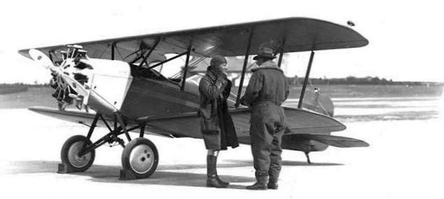
An undated photo of two men in front of an unidentified biplane at Round Hill Airport.
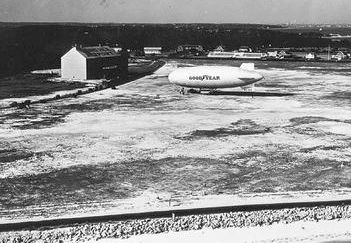
An undated photo of the Goodyear dirigible Mayflower, on loan to MIT, seen during testing to map the radiation patterns of various antenna arrays at Round Hill Airport (courtesy of MIT Museum).
In 1932 Lindbergh landed at Round Hill, after receiving word that his kidnapped son was hidden on a boat near the Elizabeth Islands.
Lindbergh was accompanied by 3 passengers, including an FBI agent, but the tip about his son's whereabouts proved to be a hoax.
The earliest aeronautical chart depiction which has been located of Round Hill Airport was on the March 1933 Boston Sectional Chart.
It depicted Round Hill Airport as a private airfield with a beacon.
Roberta Hill (Bert Hill's daughter) flew her solo flight from Round Hill at age 14 in 1936.
She said "This airport put to shame even the military airports.
It was probably better equipped than any military airport because he had unlimited money to do it.”
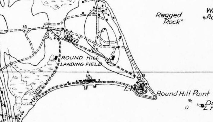
“Round Hill Landing Field”, as depicted on the 1936 USGS topo map.
The last aeronautical chart depiction which has been located of Round Hill Airport was on the September 1936 Boston Sectional Chart.
It depicted Round Hill Airport as a private airfield with a beacon.
Round Hill Airport owner Edward Green died in 1936 & the airport reportedly closed that same year.
Round Hill Airport was no longer depicted on the October 1937 Boston Sectional Chart.
The Round Hill property was badly damaged in the 1938 Hurricane, which tore up the beach road & destroyed the hangar.
The last depiction which has been located of Round Hill Airport was on the 1942 USGS topo map.
According to Wikipedia, “In 1948, twelve years after the Colonel's death, his sister Sylvia Green, his heir,
donated the entire property to the Massachusetts Institute of Technology (MIT), which used the 240-acre estate for educational & military purposes until 1964.
MIT erected a giant antenna atop a 50,000-gallon water tank on the site.
Another was erected nearby for research towards the Ballistic Missile Early Warning System.
The giant dish antenna stood as a local & marine navigational landmark until the current owners of the site, the Bevelaqua family, demolished it in 2007.”
According to an article entitled “Saltmarsh restoration project eyed for site of former Round Hill Airport runways” in the 11/8/09 South Coast Today (courtesy of David Gray),
“Dartmouth & other agencies are planning to use federal Superfund money to recreate the portion of the former 15-acre, salt marsh on town property”,
previously the site of Round Hill Airport.
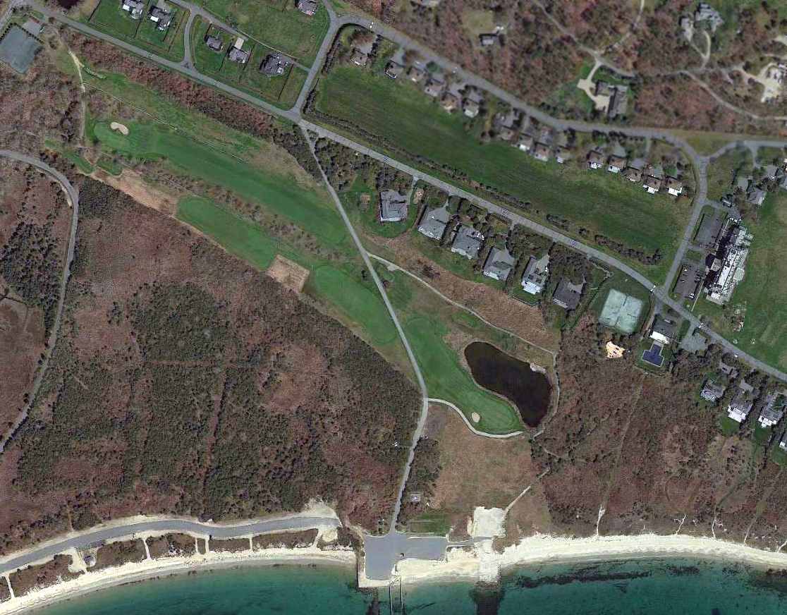
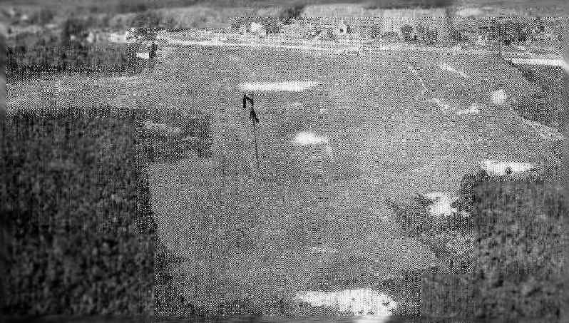
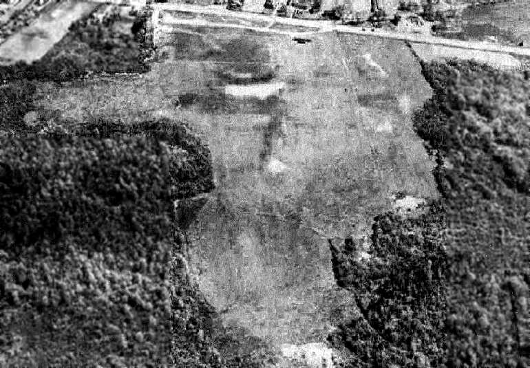
A 2013 aerial view showed the majority of the Round Hill Airport site remained clear.
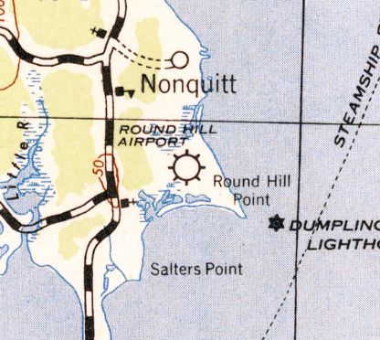
The site of Round Hill Airport is located south of the intersection of Round Hill Beach Drive & Club House Drive.
____________________________________________________
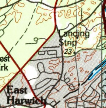
Cashen's Airfield / Bascom Field / East Harwich Airport, East Harwich, MA
41.712, -70.014 (Southeast of Boston, MA)
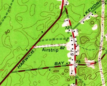
Cashen's Airfield was labeled simply as “Airstrip” on the 1961 USGS topo map.
Cashen's Airfield was not yet depicted on the 1949 USGS topo map.
John Nichols recalled, “There was a private airport in East Harwich in the 1950s.
I worked at Chatham Airport [in the] summer of 1956, and a guy who lived in East Harwich used to fly over from there to get fuel.”
Jared Fulcher recalled, “The airstrip in East Harwich was owned by a man named Ralph Cashen & was known locally as 'Cashen's Airfield'.
When I was a kid, I used to wonder what this field was.”
Stu Brennan recalled, “In the mid-1950s, I can remember my Uncle telling me there was a private airport just down the street from his house.
He even pointed it out driving past one day, but there were no planes to be seen, just an opening in the trees... Cashen's Airfield.”
However Paul Worcester reported, “This property has always been owned by the Bascom Family & still is today [2017].
The airfield portion was only leased to Mr. Cashen while he was alive.”
The earliest depiction which has been located of Cashen's Airfield was on the 1961 USGS topo map,
which depicted a single east/west unpaved runway, labeled simply as “Airstrip”.
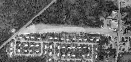
The only photo which has been located showing Cashen's Airfield while it was in operation was a 3/25/73 USGS aerial view.
It depicted East Harwich Airport as having a single east/west unpaved runway, with some small hangars (& possibly some light aircraft) along the edges.
Cashen's Airfield was not depicted on 1970s/80s/90s NY Sectional Charts.
A local resident reported, “The Cashen's Airfield was still being used in the mid-1990s by ultralight pilots.
I recall driving by there & seeing a bunch of rescue workers responding to an ultralight crash that attempted landing/takeoff from there.”
The 1994 USGS topo map still depicted Cashen's Airfield as having a single east/west runway.
A 1995 USGS aerial view looking southwest at Cashen's Airfield showed the runway remained clear.
Paul Worcester reported, “I believe the airfield was listed in the airport directory as the East Harwich Airport up until approximately 1997-98.”
A 2012 photo by Jared Fulcher looking west along the remains of the Cashen's Airfield runway & the hangar along the south side.
A 2012 photo by Jared Fulcher looking southwest at the Cashen's Airfield hangar.
A 2012 photo by Jared Fulcher looking west at the wind direction indicator mounted atop a tower behind the Cashen's Airfield hangar.
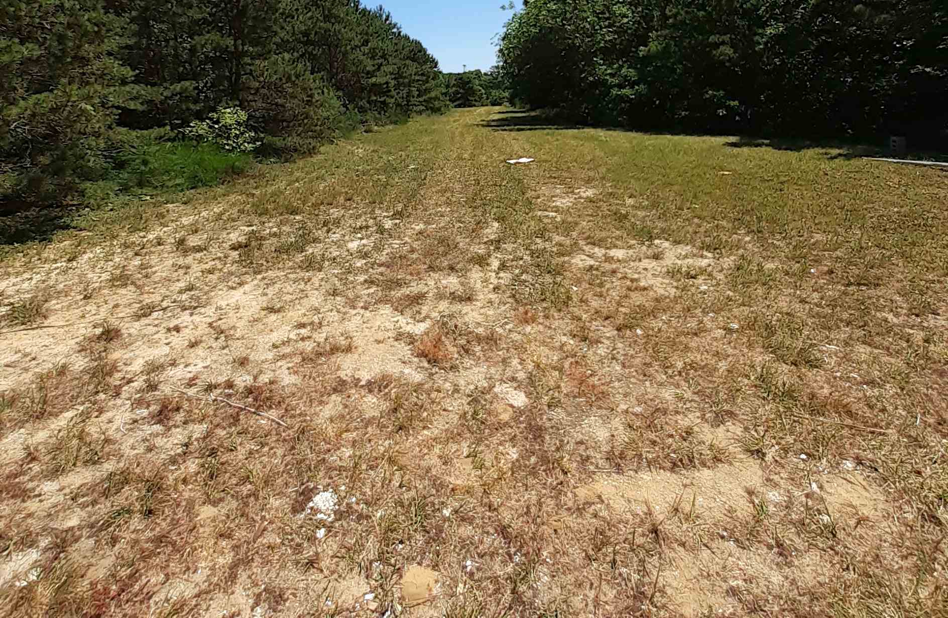
A 2014 aerial view looking southwest at Cashen's Airfield showed the runway was overgrown but still recognizable,
and at least one small former hangar among the trees.
Jared Fulcher reported in 2015, “Several years ago I went to an estate sale at a home accessed via a driveway parallel with Cashen's Field.
I took this opportunity to cut through a path to the field.
I was fortunate enough to traverse the field all the way to Route 39 at the far end.
The ramshackle hangars & windsock still stand.
I'm not sure if the property is still in the Cashen family, but I think it may be as it has never been developed.
The field is still there, though slightly overgrown with scrub pines.
The entrance to this field is best viewed from Church Street, where the open field can be partially seen behind a private home.”
A 7/9/22 photo by Jared Fulcher looking along the former Cashen Airfield runway.
Jared observed, “The scrub pines have grown up a little more, but the center of the field is still fairly open.”
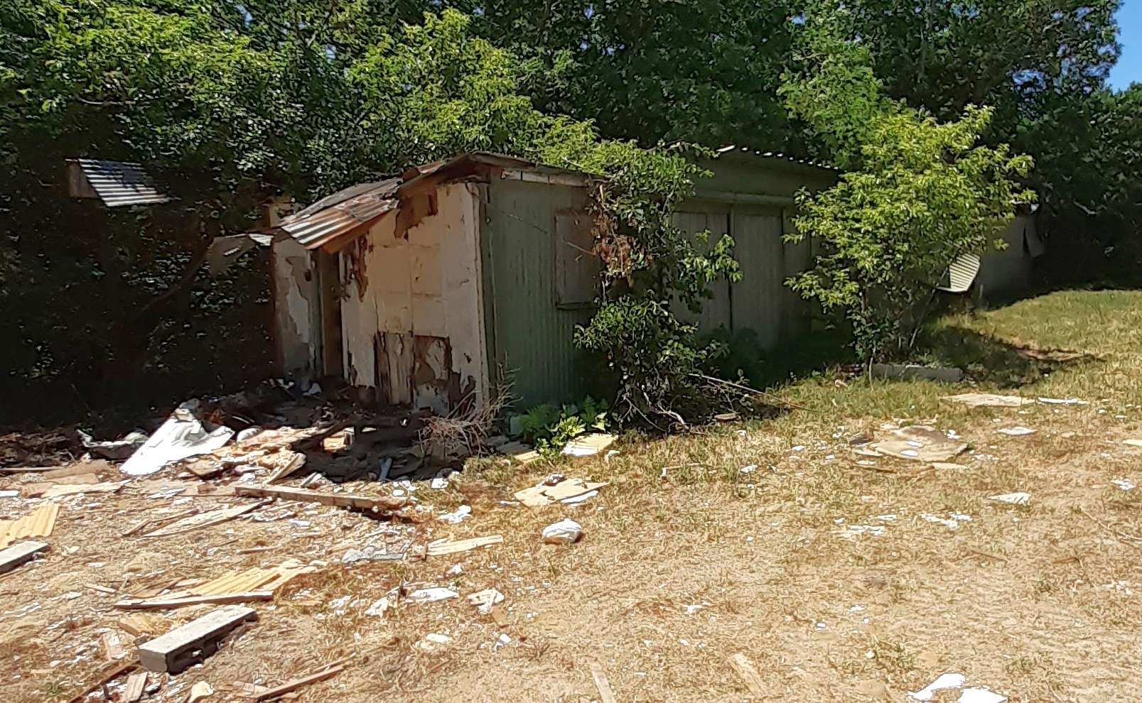
A 7/9/22 photo by Jared Fulcher of the ruins of the former Cashen Airfield hangar.
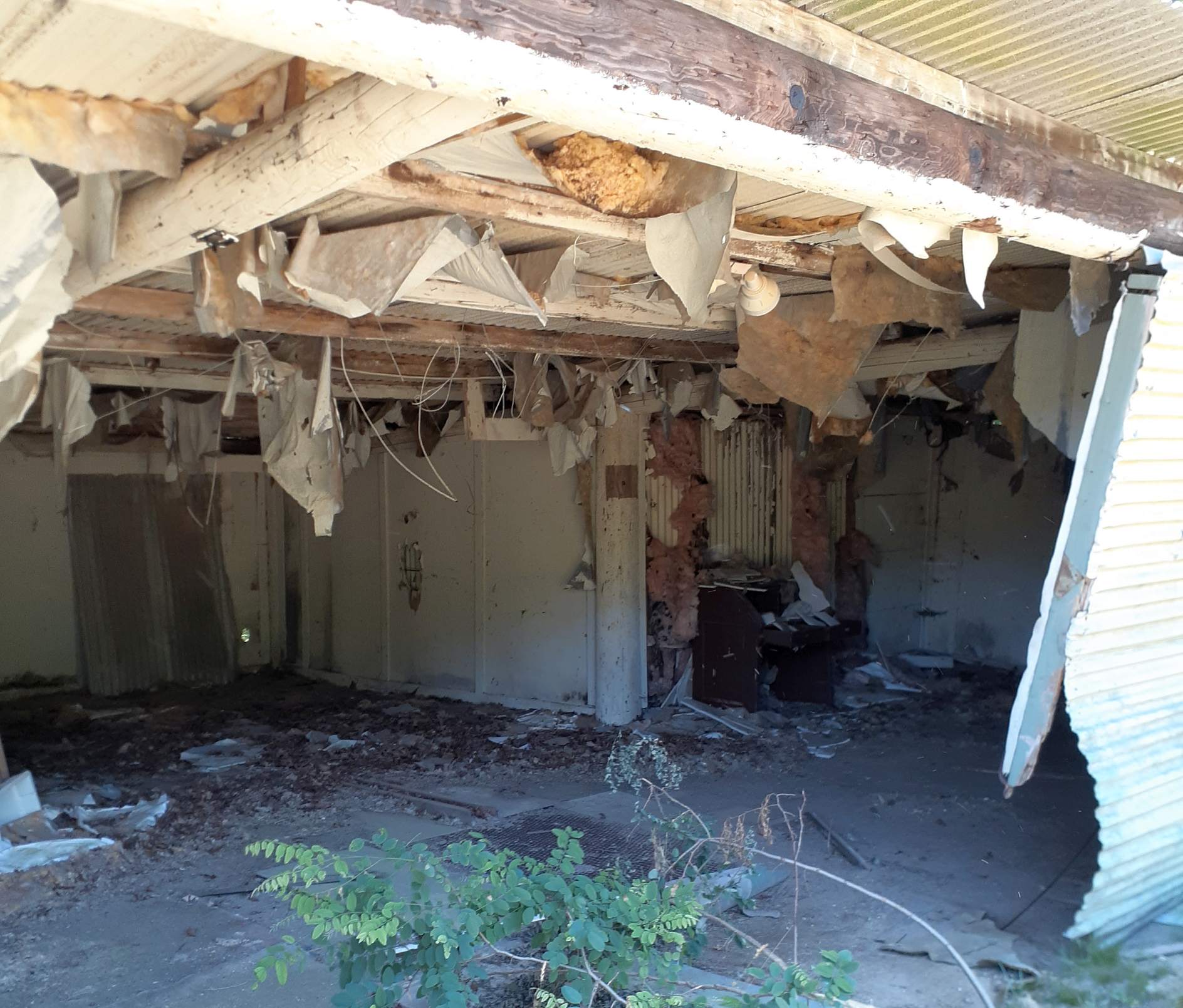
A 7/9/22 photo by Jared Fulcher of the interior of the former Cashen Airfield hangar.
Jared observed, “The hangar is under demolition & much was exposed to the elements.”
A 7/9/22 photo by Jared Fulcher of the former Cashen Airfield wind direction indicator tower.
Jared Fulcher reported in 2022, “About 15 years ago [2007] I found that a subdivision plan had been filed for the land, but to this day nothing further has occurred.”
The site of Cashen's Airfield is located east of the intersection of Orleans-Harwich Road & Williamsburg Avenue.
Thanks to John Nichols for pointing out this airfield.
____________________________________________________
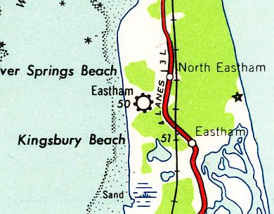
Brigg's Field / Eastham Airport / Nauset Airport, Eastham, MA
41.851, -69.992 (Southeast of Boston, MA)
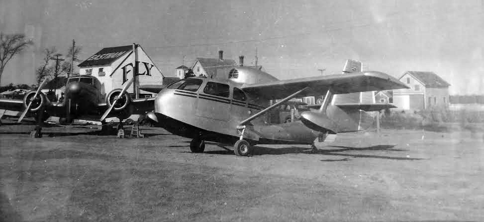
A circa 1940s photo of a Cessna T-50 & Republic SeaBee at Eastham Airport (from the 1869 Schoolhouse Museum in Eastham, courtesy of Joe Guzzo).
Eastham Airport was not yet depicted on a 1938 USGS aerial photo nor on the 1946 USGS topo map or the July 1946 Boston Sectional Chart.
According to the article “Takeoff at the Eastham Airfield” by Parker Mumford in the 12/31/25 Provincetown Independent (courtesy of Ron Plante),
“Farmer George Wiley leased the land where the airfield was established, according to the transcript of a talk given by the late Kenelm Nickerson Collins at the Methodist Church for the Eastham Historical Society in 1997.
The airfield’s founders were two veteran Air Force pilots, Provincetown native Mike Diogo & Chicagoan Wally Michevsky.
Collins said that they bought 2 light planes & leased a Cessna passenger craft, then established a 1,200' runway.
The airport must have become popular fast: the Cape Codder credits them with building 2 runways: 1,800' & 1,500'.”
“It went over like gangbusters right away,” Collins said of the airfield.
“George Nickerson had a PT-13 from the war, Charlie Atwood had a 40 hp Piper Cub, Sumner Eddy had a Stinson Voyager, someone else had a WACO biplane.
At one time there were 13 aircraft” in town, Collins said in his speech.
Parker’s most vivid memory of the airfield comes from a snowy winter night, when a flight out of the Quonset Point Naval Air Station in Rhode Island had to make an emergency landing in Eastham.
To light the way for the lost pilots, her father’s friends drove their cars to the airfield & aimed their headlights at the runway.
“My father went & called everybody he knew,” she says. “He said, ‘Go on up there, put the car lights on to light up the field.”
The landing was a success, but the plane was badly damaged. The airfield’s staff had to remove its wings & load it onto a truck to drive it back to Rhode Island.
The 3-5 stranded aviators spent the night at her family’s house. “They were very nice,” she says. “They sent my mother a beautiful lamp once they got out.”
Airmen caught in storms weren’t the only unusual arrivals Eastham’s airfield received. Santa Claus made yearly visits, too.
Saint Nick in an airplane was already a New England tradition by the time Eastham’s airport opened.
Aviators dressed as Santa Claus would visit New England’s most isolated lighthouses with Christmas gifts such as newspapers, magazines, and coffee for their keepers.
It’s unclear why Santa would have flown to Eastham, since the town’s lighthouse wasn’t nearly as isolated as some of the others on the Eastern Seaboard.
But photographs from the time show he was well received. Children gathered in droves around his airplane to pose for photographs & accept gifts.
Collins’s speech offers a third story about the airfield. It concerns Eastham’s George Duffy, who flew fighter planes off aircraft carriers during the war.
Duffy was moving a torpedo bomber to Naval Air Station Squantum in Quincy when a friend bet him he couldn’t land & take off from Eastham during the trip. Duffy accepted the challenge & landed the bomber in Eastham.
“You could hear him in South Wellfleet,” Collins said. As Duffy took off, the wake turbulence broke 2 windows in the airfield’s administration building, and his wheels clipped a stand of pine trees at the end of the runway.
Duffy’s officer reprimanded him for an unauthorized landing when he saw bits of pine in the bomber’s wheel wells.
After the war, Duffy was a regular at the airport. Beyle writes that Duffy would give local boys flights to Provincetown & back if they helped him wash his plane.
A circa 1940s photo (from the 1869 Schoolhouse Museum in Eastham, courtesy of Joe Guzzo) showed a Cessna T-50 & a Republic Seabee amphibian in front of a building (presumably the airport office) marked “Eastham” & “Fly”.
Jack Grainger recalled, “I actually worked on the T-50 Cessna shown in the picture. I installed a new throttle cable... in the winter!”

A circa 1940s photo of George Duffy (at left) & other former WW2 pilots in front of a a Cessna T-50 & the Eastham Airport office (courtesy of Ron Plante).
According to FAA registration records, Cessna T-50 Bobcat N53207 was registered to Eastham Air Service from 1946-49.
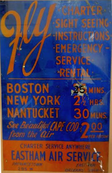
A circa 1940s advertisement for Eastham Air Service (from the 1869 Schoolhouse Museum in Eastham, courtesy of Joe Guzzo)
touted charter, sightseeing, instruction, emergency service, and rental.
George Handel recalled, “A guy named Wally owned the T-50, and flew it regularly to Boston.
He was killed in a traffic accident, and service to Boston then ceased.
My dad used to take me to the airport some nights when Wally was returning from Boston,
and he, along with several others, would shine their car lights on the runway for Wally to land.
I was probably about 7 years old then (1947). I loved it.”
According to Joe Guzzo, Eastham Airport was also known as Brigg's Field.
The only aeronautical chart depiction which has been located of Eastham Airport was on the January 1949 Boston Sectional Chart (courtesy of Ron Plante),
which depicted Eastham as having a mere 1,900' unpaved runway.
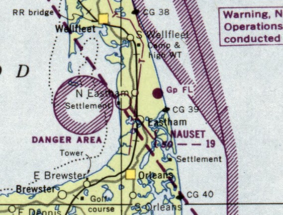
Eastham Airport was evidently renamed Nauset Airport at some point between 1949-50,
as that is how it was labeled on the January 1950 Boston Sectional Chart.
Nauset Airport was presumably closed at some point between 1950-53,
as it was no longer depicted on the May 1953 Boston Sectional Chart.
According to the article “Takeoff at the Eastham Airfield” by Parker Mumford in the 12/31/25 Provincetown Independent (courtesy of Ron Plante),
Eastham Airport “closed because it didn’t make enough money to sustain itself.”
The only topo map depiction which has been located of Eastham Airport was on the 1958 USGS topo map,
which depicted Eastham as a commercial/municipal airport.
The last photo which has been located of Eastham Airport was a 5/1/60 USGS aerial view,
which depicted Eastham as having 2 unpaved northeast/southwest runways.
Eastham / Nauset Airport not depicted on the 1962 USGS topo map.
A 1996 USGS aerial photo showed houses covering the site of Eastham Airport, with no recognizable trace of an airport.
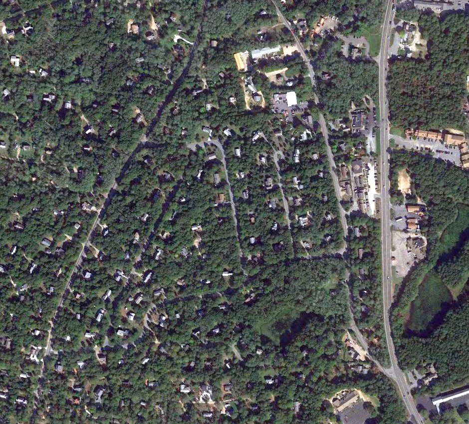
A 2016 aerial view of the location of Eastham Airport / Brigg's Field, showing the houses which occupy the site, with no recognizable trace of an airport.
The site of Eastham Airport is located on Runway Lane, appropriately enough.
Thanks to Joe Guzzo for pointing out this airfield.
____________________________________________________
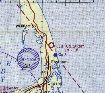
41.88, -69.97 (Southeast of Boston, MA)
Clifton Field, as depicted on the May 1959 Boston Sectional Chart.
Camp Wellfleet was used by the Army as an anti-aircraft training center from 1942-44.
A small airfield was established in the woods directly west of the beach, used by aircraft conducting target operations.
After World War II Camp Wellfleet was used as a training center for guardsmen & reservists.
The 548th Antiaircraft Artillery Battalion used Camp Wellfleet as a 75mm gun firing range from 1954-56.
According to an article entitled “'Clifton Field', the South Wellfleet Airport?” by Noel Beyle in the 7/2/96 issue of The Cape Codder (courtesy of Dick Whittle),
“Clifton Field as located in the woods to the south of the Cape Cod National Seashore headquarters near Marconi Beach,
on land once used by the military called Camp Wellfleet.
The airstrip was a 1,600' runway made out of sand & gravel that was originated & engineered by Don Clifton of Orleans.
According to Mr. Clifton, who worked at Camp Wellfleet when it was an Army base,
he was learning to fly at the time so he bulldozed a landing strip out in the woods near the Camp.
The Army apparently knew it existed, but not quite what it was all about.
And local pilots from towns on the Lower Cape used it often.”
Clifton Field was not yet depicted on the November 1958 Boston Sectional Chart.
The earliest depiction which has been located of Clifton Field was on the May 1959 Boston Sectional Chart.
It depicted “Clifton (Army)” as having a mere 1,600' unpaved runway.

An undated aerial view looking southeast at Clifton Field.
A 5/1/60 USGS aerial view depicted Clifton Field as having a single unpaved east/west runway.
In 1961, Camp Wellfleet was declared excess & conveyed to the Interior Department by President Kennedy to establish the Cape Cod National Seashore.
The Cape Codder article continued, “After the [National] Seashore took over the property,
attempts were made to get the first Superintendent (Robert Gibbs) to open the strip back up & pave it.
He was receptive to the idea, and Clifton Field appeared headed for permanence, but nothing ever came of it.”
The last aeronautical chart depiction which has been located of Clifton Field was on the 1965 Boston Sectional Chart.
It depicted “Clifton (Army)” as having a 1,600' unpaved runway.
Clifton Field was no longer depicted on the March 1967 Boston Sectional Chart.
The 1972 USGS topo map depicted the rectangular clearing of the runway, but did not label the airfield.
According to an article entitled “'Clifton Field', the South Wellfleet Airport?” by Noel Beyle in the 7/2/96 issue of The Cape Codder (courtesy of Dick Whittle),
“Today the field is still out there, although a resurgence of pine trees has curbed any use in recent years.”
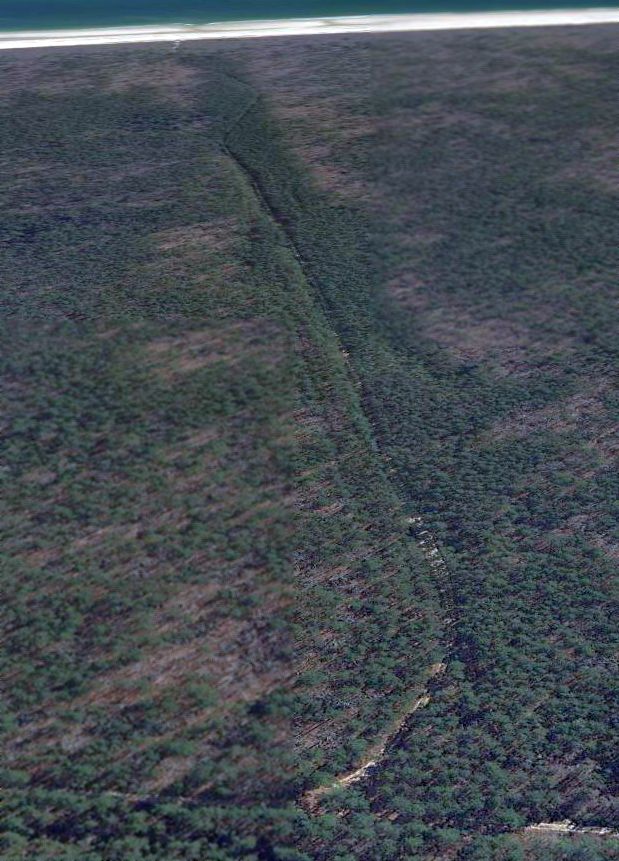
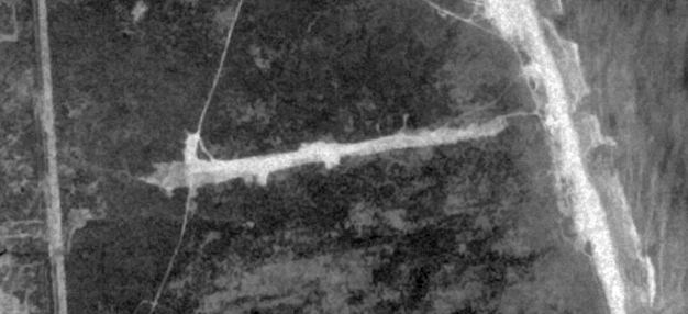
A 3/11/12 aerial view looking east showed the path of Clifton Field's runway is still recognizable through the surrounding trees.
An 11/3/19 photo by Jared Fulcher looking along the remains of Clifton Field's runway.
The site of Clifton Field is located at the southern terminus of Old Kings Highway.
Thanks to Dick Whittle for pointing out this airfield.
____________________________________________________
Chatham Naval Air Station, Chatham, MA
41.72, -69.96 (South of Boston, MA)
A Summer 1919 aerial view looking west at a Navy B-class airship flying over Chatham NAS.
In the early days of the First World War, as German U-Boats began to get more emboldened by their successes,
it became apparent to many that the United States would soon enter the war.
As a result, the Department of the Navy planned 6 new Naval Air Stations on the East Coast.
Chatham Naval Air Station was planned to occupy 36 acres on Nickerson Neck, next to Pleasant Bay.
Before the United States even entered World War I, construction of Chatham Naval Air Station was beginning.
The original plans called for living quarters for officers & enlisted men, hangars, a gas holder, boat house,
hospital, pigeon loft, repair shops, garage & assorted storage & maintenance buildings.
Pipes were laid in trenches & the nearest fresh water source was 3.5 miles away.
By October 1917, the barracks & mess hall were ready for furniture & galley equipment. The resulting structures could handle about 100 men.
That same month, the flag pole was placed & 3,000 people were in attendance for its first raising.
In November, the United States entered the war. In December, the skeleton of the blimp hangar was finished & wooden slats were soon covering them.
Concrete was then set to be poured for the hangar floors. This was complicated by the fact that it was one of the coldest winters that year.
As a result, the concrete was poured & protected by tar paper & hot sand. The base was commissioned on 1/6/18.
By then, many buildings were ready for occupancy & by mid-March, four Curtiss R-9s were delivered to the Chatham train station.
They were assembled & the first flight was made by Lt. McKitterick on March 25.
In July, 4 Curtiss HS-1L flying boats were delivered to the depot & trucked to the base.
These aircraft were so urgently needed that they were put into service almost immediately.
The addition of these aircraft increased the time available to patrols from dawn to dusk.
Two patrol areas, aptly named Areas A & B were then created: Area A was to the north while Area B was to the south.
Planes always went in pairs with one plane carrying a radio transmitter. The plane with the transmitter was required to radio in a location every 10 minutes.
Both planes carried 2 homing pigeons for emergency communication with the base, and the birds had been trained for either the north patrol or the south patrol.
Thus they could not be transferred from one area to another.
Planes were equipped with emergency rations & water for 3 days, a flashlight, flare pistol with red & green cartridges, a sea anchor, life preservers, signal book & local charts.
Patrols took place at 1,000' with the purpose to protect the shipping in a defined area.
Often the planes would circle around a ship for hours while looking for U-Boats after picking up the vessel in a predetermined location.
While the 2 planes were out on patrol, 2 other planes & their fliers were on standby at the station, ready to assist should a plane radio in a distress call.
If the planes & men could get airborne within seven minutes, they were considered to be within the acceptable range of response time.
Eventually blimps were used to help in the patrol process.
With their cruising speed of 35 mph & a range of 900 miles, they were a useful asset in the patrols.
The earliest dated photo which has been located of Chatham NAS was a Summer 1919 aerial view looking northwest at a Navy B-class airship overflying the station.
One of highlight's of the station's service was when a report came in of the shelling of nearby Nauset Beach.
Nine Curtiss HS-2Ls were dispatched to bomb the submarine that had already sunk 5 ships & was proceeding to start shelling Orleans.
Either the resulting bombs were duds or they missed, and the U-boat got away.
A 1918 USN aerial view looking west at the extensive aviation facilities at Chatham (from the MA Digital Commonwealth),
showing at least 4 flying boats on the ramp in front of the hangars in the foreground, and the airship hangar at the top-left.
A circa 1918-20 photo of a Navy B-class airship flying over Chatham NAS (courtesy of Roger Pinel).
A circa 1918-20 photo of a blimp (model unidentified) inside the Chatham blimp hangar (courtesy of the Atwood House Museum in Chatham).
According to the 4/8/17 Capecod.com article “Hidden Cape Cod – A Chatham Naval Air Station That Used to Exist” by Christopher Setterland,
“With the war over the Naval Air Station became expendable. In May 1920 the station was preparing to be closed.
160 men were transferred to other bases while 10 were left behind to guard the property.
In 1922 Washington D.C. labeled the Chatham Naval Air Station as inoperative, effectively ending its tenure in service.”
According to the book “Wings Over Cape Cod” by Joseph Buckey (courtesy of Roger Pinel),
an auction was held on 6/29/22 of surplus assets at Chatham,
including 3 HS flying boats which had been stored inside one of Chatham's hangars since 1920.
According to the 4/8/17 Capecod.com article “Hidden Cape Cod – A Chatham Naval Air Station That Used to Exist” by Christopher Setterland,
“The Naval Department would purchase the base [in 1923] & in 1924 the process of removing the structures on the property began.
Some of the lumber from buildings would become parts of new homes; some even went to repair damage at the famed Chequesset Inn in Wellfleet in 1928.”
Chatham saw some brief aviation re-use in 1930,
when the Goodyear blimps Defender & Mayflower operated from Chatham, as well as the commercial blimp Neponset.
According to the 4/8/17 Capecod.com article “Hidden Cape Cod – A Chatham Naval Air Station That Used to Exist” by Christopher Setterland,
“The dirigible hangar was removed in 1933.”
Chatham NAS was not depicted on the March 1933 Boston Sectional Chart.
According to the 4/8/17 Capecod.com article “Hidden Cape Cod – A Chatham Naval Air Station That Used to Exist” by Christopher Setterland,
“By 1938 the base had been completely dismantled save for the concrete foundations strewn across the 36 acres.”
A 10/29/39 USN aerial view looking east (from the MA Digital Commonwealth) showed showed the ramps & hangar foundations as the only remaining traces of NAS Chatham.
Chatham was removed from consideration for bases re-activated in the pre-WW2 buildup.
Nothing was depicted at the Chatham NAS site on the 1942 USGS topo map or subsequent topo maps.
The Chatham NAS property was finally sold to private parties in 1948, and to a contractor in 1956 who eventually covered the site with houses.
A circa 1950s aerial view looking west (courtesy of Roger Pinel) showed the ramps & hangar foundations remaining from NAS Chatham.
Housing was built over the site of Chatham NAS at some point between the 1950s & 1979.
In 1979, a stone memorial was placed at the end of Strong Island Road to commemorate the NC-4 flight.
In the 1980s, two PBYs retraced the famous flight that passed by the station.
A 1995 USGS aerial view looking west showed a house had been built over Chatham's seaplane ramp, and other housing covered the remainder of the site.
An August 2000 aerial view looking west (courtesy of Roger Pinel) showed Chatham's seaplane ramp remained recognizable (although with a house on top of it).
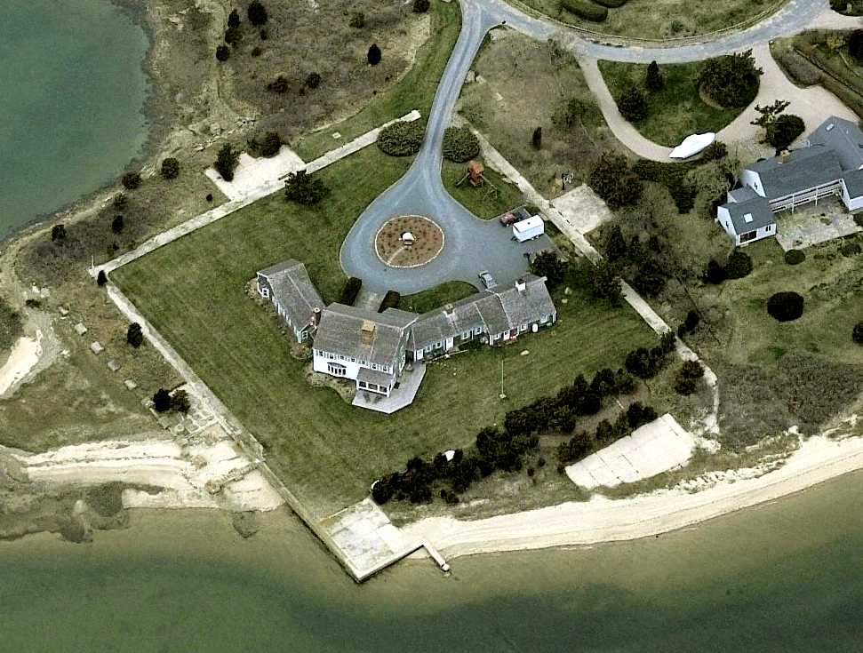
A circa 2010 aerial view looking west at the house built on top of Chatham's seaplane ramp.
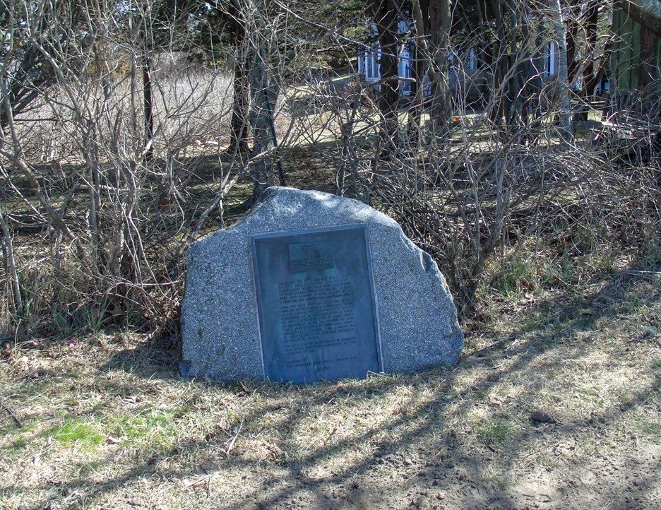
A 2017 photo of a historical marker commemorating Chatham NAS (courtesy of Thomas Page).
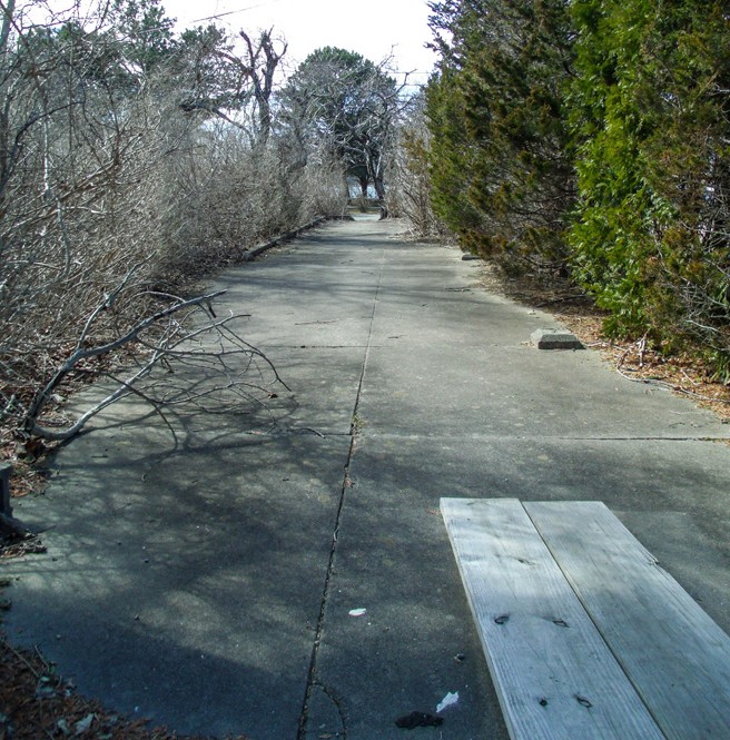
A 2017 photo of concrete foundations which remain from Chatham NAS (courtesy of Thomas Page).
The site of Chatham NAS is located at the eastern terminus of Eastward Road.
See also:
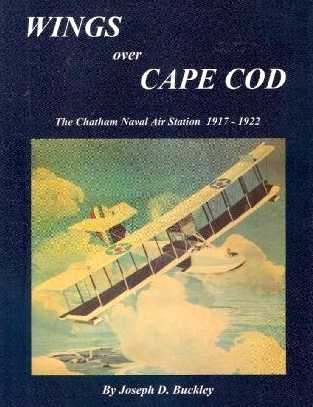
Wings Over Cape Cod by Joseph Buckley
____________________________________________________
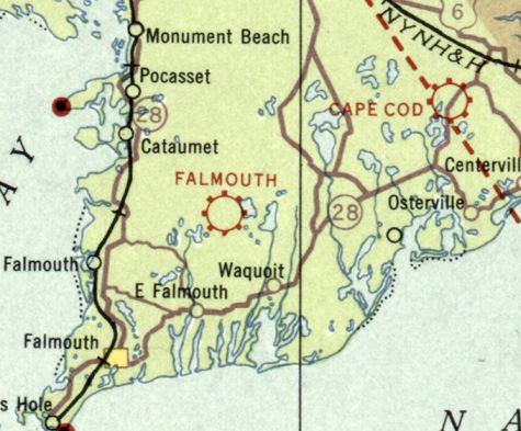
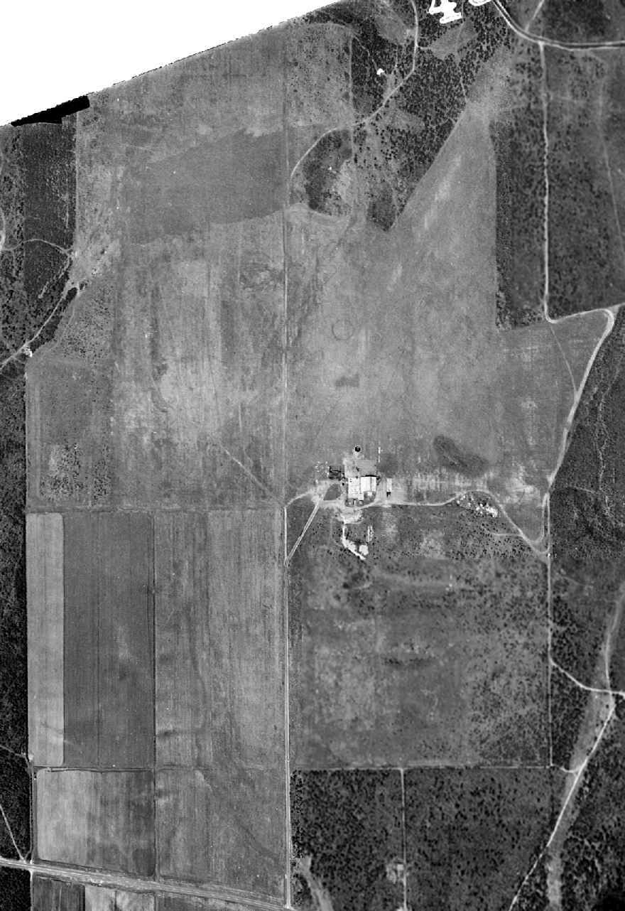
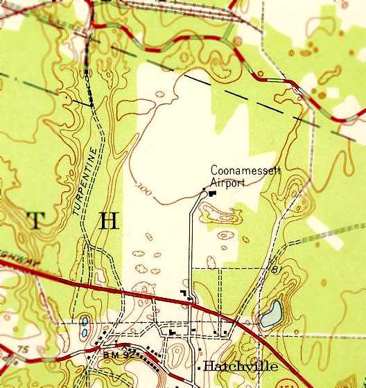
Falmouth Airport / Coonamessett Airport, Hatchville, MA
41.64, -70.56 (South of Boston, MA)
Falmouth Airport, as depicted on the March 1933 Boston Sectional Chart.
This general aviation airport was located adjacent to the south side of Camp Edwards (later to be Otis AFB).
According to Les Garrick (author of “Historic Hatchville”), “Opposite Ranch Road on the north side of Coonamessett Road
the Coonamessett Ranch Company developed the small Coonamessett Airport during 1928-29.
It had a grass runway, fuel depot, and an office but no control tower.
In addition, seaplanes could use Coonamessett Pond near the Coonamessett Inn.
The Town of Falmouth leased the airport in 1930-31, and it grew steadily under the management of George Cluett & Guy Hamm.
On the east side of Ranch Road were 3 cottages & the so-called aviation apartments, presumably rented to pilots who used the resort’s airport.”
The earliest airport directory reference which has been located of Falmouth Airport
was in the 1931 Pilots' Handbook (courtesy of Jonathan Westerling).
It described Falmouth Airport as being located 6 miles northeast of the town of Falmouth,
and having a 2,000' x 1,800' airfield area.
By 1933 the Coonamessett Ranch Company had established a resort adjacent to the airport,
including an 18-hole golf course, clubhouse, polo field, tennis courts, and riding stable.
The earliest depiction which has been located of Falmouth Airport was on the March 1933 Boston Sectional Chart,
which depicted Falmouth as a commercial/municipal airport.
The 1937 MA Airport Directory (courtesy of Jonathan Westerling)
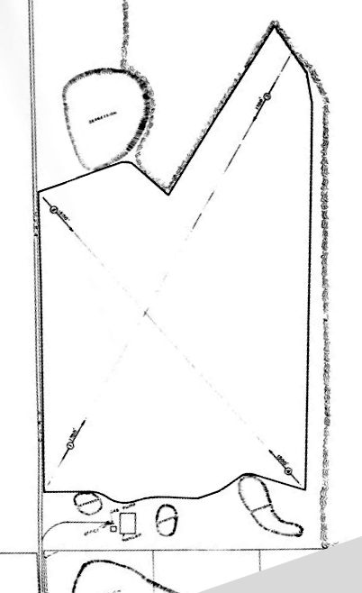
depicted Falmouth Airport as an irregularly-shaped property having unpaved runways in an X-shape, with 2 small buildings on the south edge.
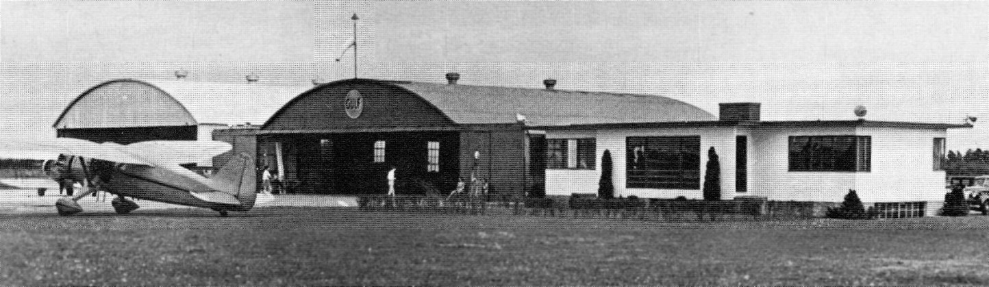
The earliest photo which has been located of the Falmouth/Coonamessett Airport was a circa 1930s/40s view of a Stinson Reliant in front of the Coonamessett Airport hangars & office building.
According to Les Garrick (author of “Historic Hatchville”), “In 1939, against the wishes of the Town of Falmouth, which had invested heavily
in improving Coonamessett Airport for a municipal facility, the airport remained private.
As part of the new war measures, civilian aviation up to 40 miles from the coastline was banned, and many small airports were closed.
In 1942, Coonamessett Airport operator Guy Hamm was managing Cape Aircraft Company
and training 24 student pilots when he learned that the airport would close on August 15.
He relocated to another field farther inland.
Nevertheless, the Civil Air Patrol was given permission by the Falmouth selectmen
and the town’s aviation committee to use the airport for the duration of the war, after runway improvements were completed.”
The earliest depiction topo map depiction which has been located of Falmouth Airport was on the 1943 USGS topo map (courtesy of Kevin Rutherford).
It depicted Falmouth Airport as having 2 small buildings in the middle of an open clearing.
According to Les Garrick (author of “Historic Hatchville”), “The airport was idle after the CAP left in 1944.”
The 1945 Boston Sectional Chart (courtesy of John Voss) depicted Falmouth as an auxiliary airfield.
However, Falmouth was not listed among active airfields in the 1945 AAF Airfield Directory (courtesy of Scott Murdock).
According to Les Garrick (author of “Historic Hatchville”), “After the war, Coonamessett Airport became a political football.
In 1946 it was leased for a year to Robert Kincart, to serve the needs of the Coonamessett Club, which meant restricted flying.
However, much work would be required to obtain Civil Aeronautics Board approval for the field’s operation.
Despite the lease, Kincart was denied a permit to operate the field by the Falmouth Board of Appeals for 3 reasons:
because of the proximity to Otis field on the MMR operated by the Navy;
because the airport was in a single residence district not a business district; and that the public would not be substantially served.”
Les continued, “Needing an active municipal airport not encumbered by restrictions imposed by the U.S. Navy based at the MMR,
the Town of Falmouth canceled its lease arrangement with the Coonamessett Ranch Company
and in July of 1946 moved to the new airport in Teaticket, a few miles to the east.
Soon Coonamessett Airport had new managers: George Pinto & Robert Draper. They started a flight training school in August 1947.
At the time, the field was equipped for night use & planes could take off & land from any compass direction.
In August 1948 members of National Guard & Officers reserve corps units received flight training there.”
The earliest aerial photo which has been located of the Falmouth Airport was a 1950 aerial view (from the Falmouth GIS system, courtesy of Kevin Rutherford)
showed the field to have an open grass area with a circular airfield symbol in the center, with the predominant runway appearing to be northeast/southwest.
A hangar & a few smaller buildings sat along the southeast side, near which were 2 light single-engine aircraft.
A 5/7/50 photo of the Harvard Flying Club & a Cessna T-50 at Coonamessett Airport.
At some point between 1945-53, Falmouth Airport was evidently renamed Coonamessett Airport, as that is how it was depicted on the 1953 USGS topo map.
It continued to depicted the field as 2 small buildings in the middle of an open clearing.
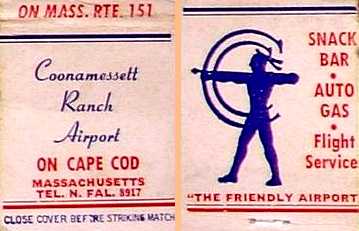
An undated matchbook from the “Coonamessett Ranch Airport”, proclaimed as “The Friendly Airport”.
According to Les Garrick (author of “Historic Hatchville”), “By 1955 the airport had 3 unpaved runways, the longest northeast at 4,500',
with strip lighting on the northeast/southwest runway only (the common wind direction).
All instrument flights were under control of Otis Air Force Base.
In 1958 the Division of Fish & Wildlife purchased from the Coonamessett Associates 1,562 acres of woodland & grassland north of Route 151 as well as the small airport.”
The last aerial photo which has been located showing aircraft at Coonamessett Airport was a 1960 aerial view (from the Falmouth GIS system, courtesy of Kevin Rutherford).
Compared to the 1950 photo, the primary runway had been extended further to the southwest, but what appears to be a baseball stadium had been built adjacent to the south entrance of the airport.
At least 9 light single-engine aircraft were visible on the ramp.
A 1960s photo of Coonamessett Airport owner/manager George Pinto guiding the National 99's Womans's Flying Club President Louise Smith's Piper into the Coonamessett Airport parking area.
According to Les Garrick (author of “Historic Hatchville”), “Unfortunately for Mr. Pinto, the airport would not be compatible with wildlife management practices.
Executive Air Services, Pinto’s company, was evicted on 6/1/61.
Pinto, nevertheless, argued that his lease with the Coonamessett Ranch Company ran until 1965.”

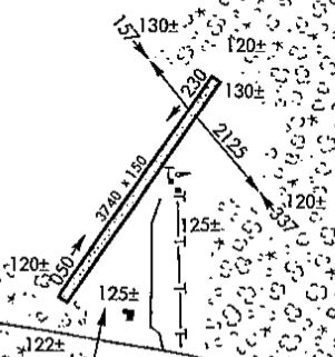
An undated aerial view from the 1965 MA Airport Directory (courtesy of Jonathan Westerling)
depicted Falmouth-Coonamessett Airport as having 2 paved runways: 3,740' Runway 5/23 & 2,125' Runway 16/34.
The Manager was listed as George Pinto, and Clauson's Inn & Cottages was said to be adjacent to the airport.
Coonamessett Airport evidently continued in operation for a few years after the property sale,
as the 1965 Boston Sectional Chart depicted Coonamessett Airport, with a 3,700' unpaved runway.
The last depiction which has been located showing Coonamessett as an active airport was in a 1967 Airport Directory (courtesy of Jonathan Westerling).
It depicted “Coonamessett-Falmouth Municipal Airport” as having a single unpaved 3,740' northeast/southwest runway,
with a few small buildings on the southeast side.
Coonamessett Airport was reportedly closed in 1968.
A 1968 aerial view (from the Falmouth GIS system, courtesy of Kevin Rutherford) no longer showed any aircraft on Coonamessett Airport,
and the hangar had been removed at some point between 1960-68.
Coonamessett Airport was no longer listed among active airports in the 1976 AOPA Airports USA Directory (according to Jonathan Westerling).
The clearing of the former Coonamessett Airport runway area was still depicted on the 1979 USGS topo map,
but the property was no longer labeled.
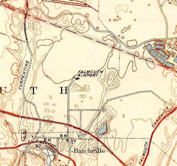
The site of Coonamessett Airport was labeled “Crane State Wildlife Management Area” on the 1994 USGS topo map.
The outlines of several grass runways were still apparent in the 1995 USGS aerial photo,
along with a rectangular foundation of a former building (hangar?).
Jeffrey Geibel reported in 2003, “Ironically, this site is now used for Cape Cod radio-controlled [model] airplane meets.”
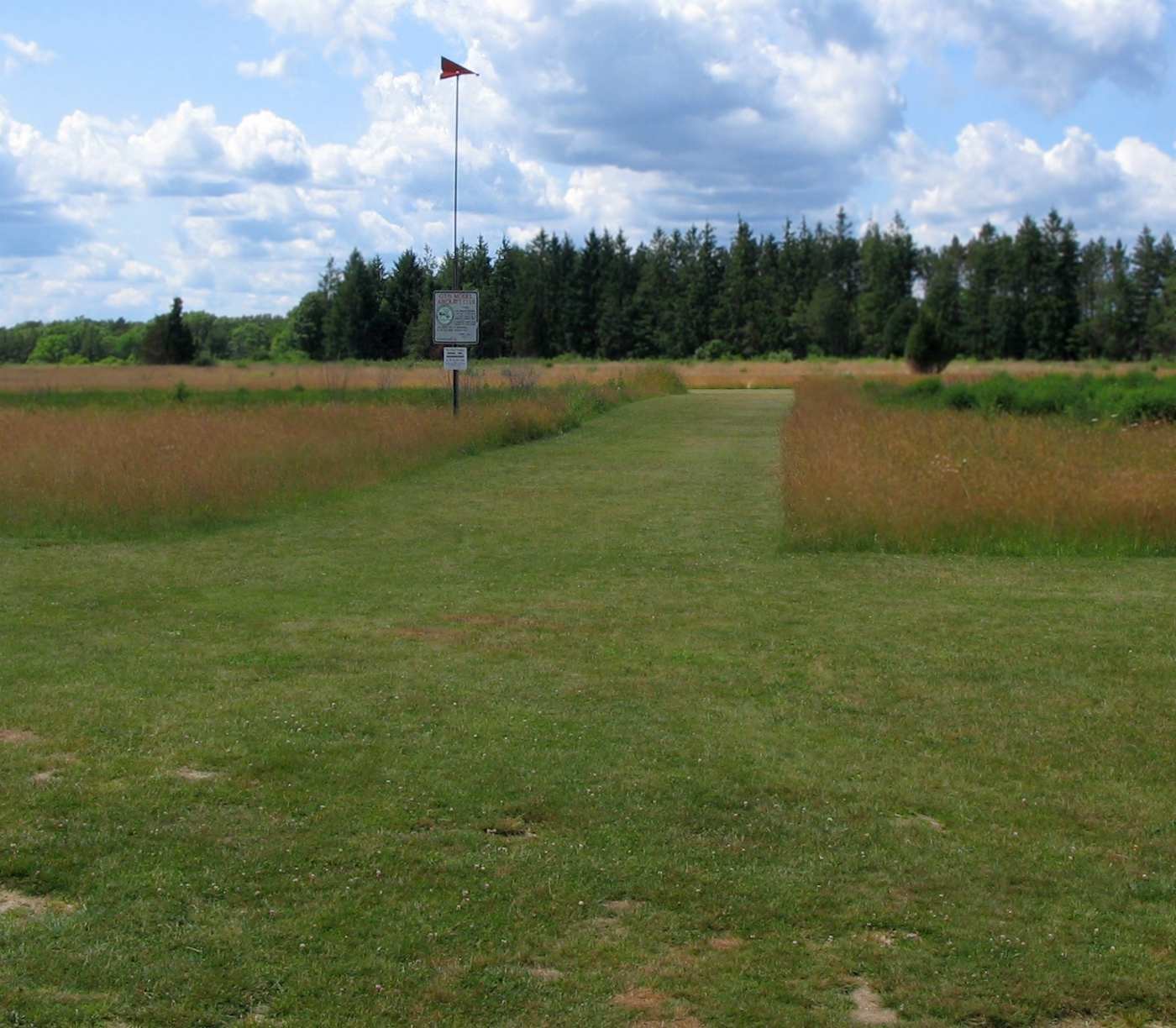
A 2007 photo by Les Garrick of the site of Coonamessett Airport, reused as the flying field for the Otis Model Aero Club Of Cape Cod.
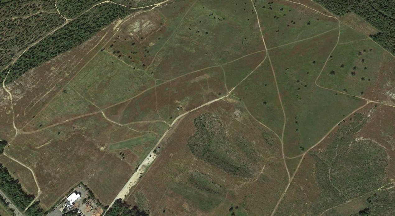
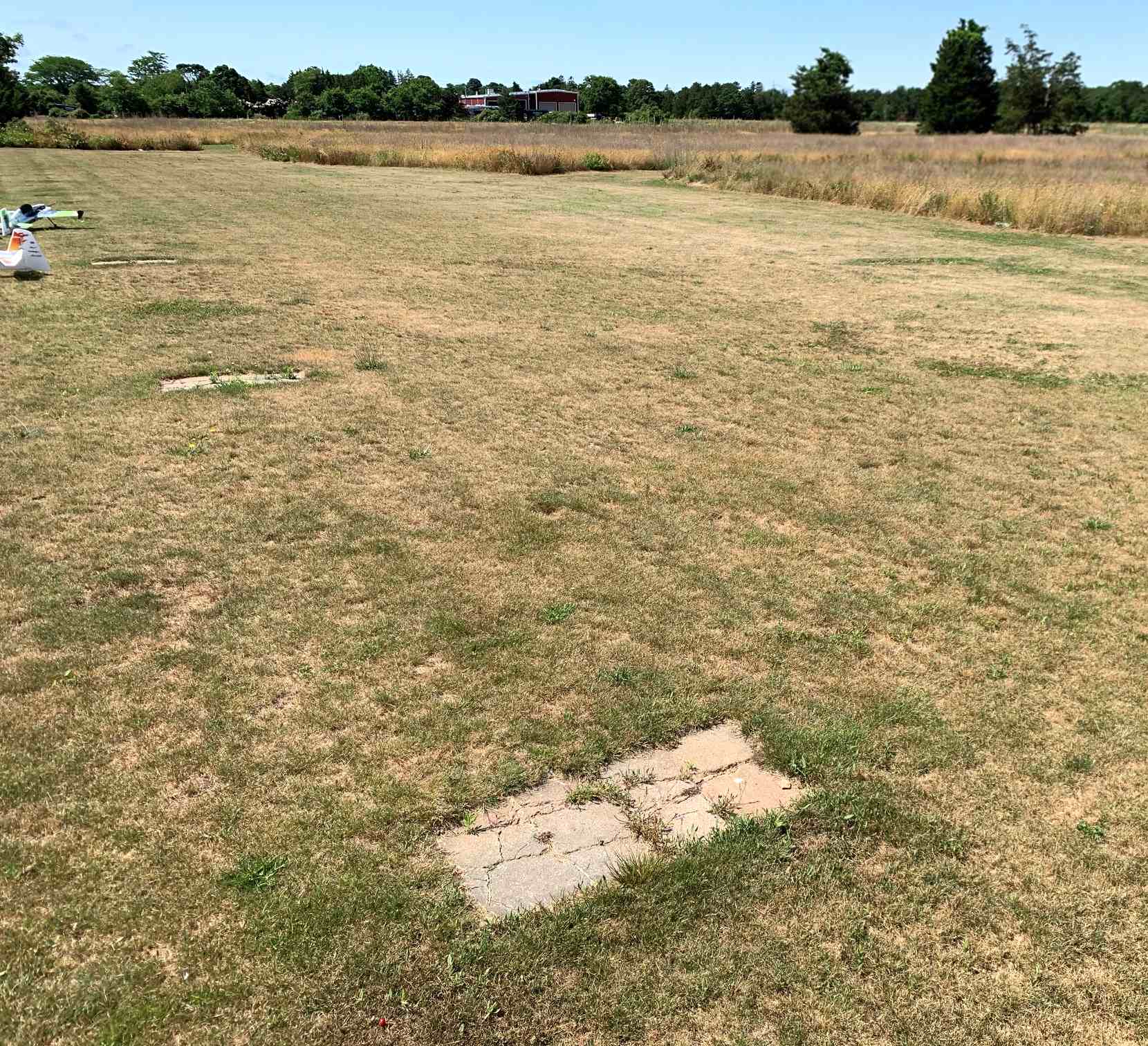
A 2018 aerial view looking northwest at the site of Coonamessett Airport showed the recognizable alignment of 2 former grass runways,
as well as a rectangular concrete foundation of at least one building just south of the runway intersection.
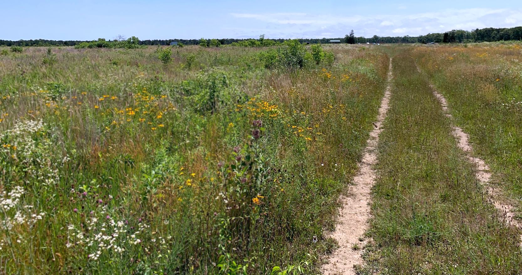
A 7/7/20 photo by Kevin Rutherford of the site of Coonamessett Airport.
Kevin reported, “I noticed a few things have changed. At some point [from 2007-2020], it appears as though the model airplane field has been relocated to the south, closer to Route 28.”
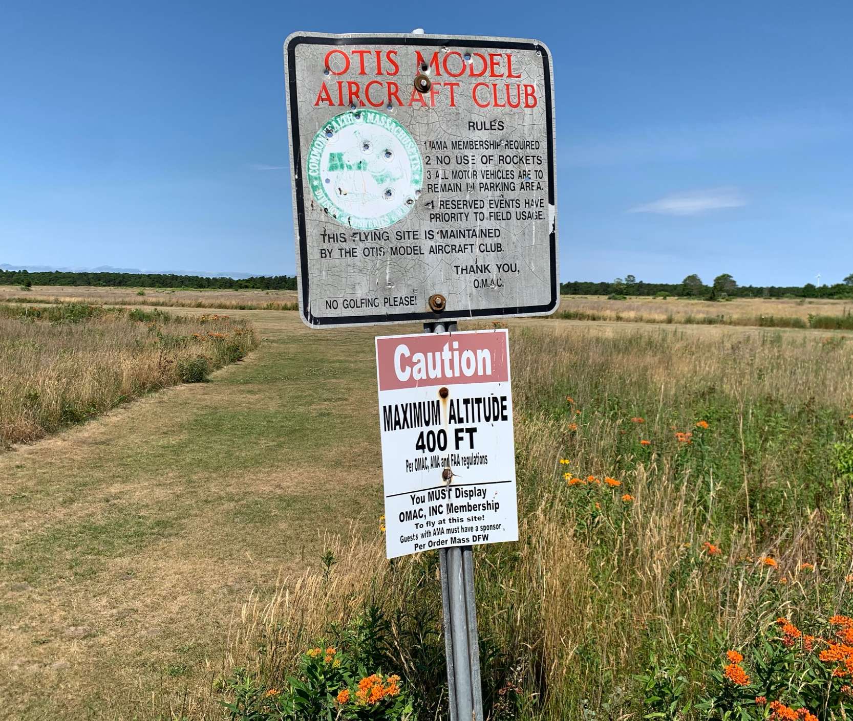
A 7/7/20 photo by Kevin Rutherford of the Otis Model Aircraft Club sign at the site of Coonamessett Airport.
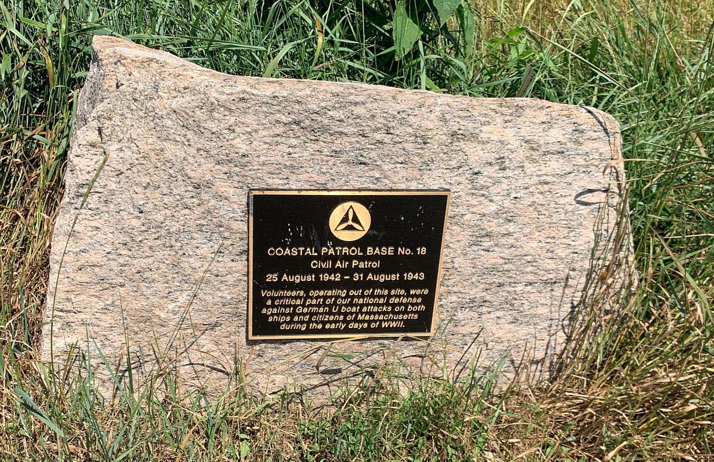
A 7/7/20 photo by Kevin Rutherford of the CAP Coastal Patrol Base #18 marker at the site of Coonamessett Airport.
A 7/7/20 photo by Kevin Rutherford of concrete remains at the site of Coonamessett Airport.
The site of Coonamessett Airport is located north of the intersection of Route 151 & Ranch Road.
____________________________________________________
Acushnet Airport, Acushnet, MA
41.68, -70.894 (South of Boston, MA)
The Acushnet Airport, as depicted on the November 1958 Boston Sectional Chart.
This short-lived little general aviation airport apparently lasted only 7 years or less.
According to Pam Nault, the Acushnet Airport was “built, owned, and operated” by her father-in-law, Raymond Nault.
“It was cleared from the middle of a woods, near a blue stone quarry. He says he began clearing it about 1952.”
The Acushnet Airport was not depicted on the May 1955 Boston Sectional Chart nor on the 1958 USGS topo map.
The earliest depiction which has been located of Acushnet Airport was on the November 1958 Boston Sectional Chart.
It depicted Acushnet as having a mere 1,700' unpaved runway.
According to Acushnet Airport owner Raymond Nault, “It was in operation until about 1958-59.”
The June 1959 Boston Local Aeronautical Chart (courtesy of Chris Kennedy)
depicted Acushnet as a public-use airfield, having a 1,700' unpaved runway.
Acushnet Airport was evidently closed (for reasons unknown) at some point between 1959-60,
as it was no longer depicted on the November 1960 Boston Sectional Chart.

The earliest photo which has been located of the Acushnet Airport was a 1961 aerial view.
It depicted Acushnet as having a single grass north/south runway, with one small hangar on the east side. No aircraft were visible on the field.
The Acushnet Airport was no longer depicted on the 1969 USGS topo map.
A 1971 aerial photo showed Acushnet's runway remained clear, but the hangar had been removed at some point between 1961-71.
The 1995 USGS aerial photo showed the Acushnet runway area had been dug up for a gravel pit, leaving no trace of Acushnet Airport.
A 5/1/10 aerial view showed a gravel pit covering the site of Acushnet Airport.
The site of the Acushnet Airport is located at the southern terminus of Wing Lane.
____________________________________________________
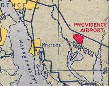
(Original) Providence Airport, Seekonk, MA
41.78, -71.3 (Southeast of Providence, RI)
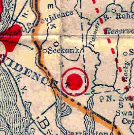
The original Providence Airport, as depicted on the 1929 Rand-McNally Air Trails Map of Massachusetts (courtesy of Chris Kennedy).
The original municipal airport for the town of Providence, RI was actually located just over the state line in Massachusetts.
The date of construction of Providence Airport has not been determined.
The earliest depiction which has been located of the original Providence Airport
was on the 1929 Rand-McNally Air Trails Map of Massachusetts (courtesy of Chris Kennedy).
It described Providence as a commercial airport, operated by "Providence - Fall River Air Trp., Inc.".
The field was said to be 2,000' x 1,500' in size.
The March 1933 Boston Sectional Chart depicted Providence as a commercial/municipal airport.
The original Providence Airport was depicted as an irregularly-shaped outline on the 1934 Navy Aeronautical Chart (courtesy of Chris Kennedy).
The 1937 Massachusetts Committee for Aeronautics Progress Report (courtesy of Jonathan Westerling)
described Providence Airport as a commercial airport, consisting of an irregularly-shaped 82 acres,
with a sod all-way landing area, with the longest distance being 1,400' east/west.
The field was said to have 2 hangars, the largest being a 90' x 40' steel structure.
An aerial view looking north at Providence Airport from The Airport Directory Company's 1938 Airports Directory (courtesy of Chris Kennedy).
The directory described Providence as a commercial airport, located 6.5 miles southeast of Providence.
It was said to consist of an irregularly shaped sod field, measuring 1,900' north/south x 1,500' east/west.
The aerial photo in the directory depicted a single hangar on the northwest corner of the field,
which was said to have "Providence Airport" painted on the roof.
A 1939 aerial photo depicted the Providence Airport as having an airport marker circle,
and several planes on the field (according to Chris Kennedy).
A circa 1943 aerial view looking north at the Providence Airport from the 1945 AAF Airfield Directory (courtesy of Scott Murdock)
depicted the field as having 2 grass runways.
Providence Airport was described by the 1944 US Army/Navy Directory of Airfields (courtesy of Ken Mercer) as having a 1,900' unpaved runway.
The 1945 AAF Airfield Directory (courtesy of Scott Murdock) described Providence Airport
as a 103 acre irregularly-shaped field with an all-way sod landing area measuring 1,650' NNE/SSE by 1,300' east/west.
Two hangars were depicted on the north side of the field, measuring 60' x 40' & 46' x 34'.
The field was described as privately owned & operated.
The last aeronautical chart depiction which has been located of the original Providence Airport
was on the January 1950 Boston Sectional Chart.
It depicted Providence as having a mere 1,700' unpaved runway.
The 1951 USGS topo map (courtesy of Chris Kennedy) labeled the Providence Airport site simply as "Airport".
No runways were depicted - the airport was simply depicted as an irregularly shaped outline,
with the single hangar & a few smaller buildings along the north side of the field.
A 1951 aerial photo (from the RIGIS at the University of Rhode Island, courtesy of Chris Kennedy) depicted Providence Airport as having 2 unpaved runways,
and 2 single-engine light planes were visible on the northwest side of the field.
Providence Airport was closed at some point between 1951-54,
as it was no longer depicted on the November 1954 Boston Sectional Chart (according to Chris Kennedy).
A 1963 aerial view showed that the site of the original Providence Airport remained clear, but abandoned.
The 1995 USGS aerial photo of the site showed that it had been redeveloped at some point between 1963-95 as an industrial park,
with no recognizable trace remaining of the original Providence Airport.
As seen in a 2002 USGS aerial photo, not a trace remained of the original Providence Airport.
The site of the original Providence Airport is located southwest of the intersection of Route 6 & Industrial Way.
____________________________________________________
No Man's Land Navy Airfield, No Man's Land Island, MA
41.25, -70.82 (Southwest of Martha's Vineyard, MA)
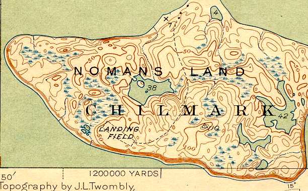
The No Man's Land Airfield, as depicted on the 1943 USGS topo map (courtesy of Kevin Rutherford).
No Man's Land is a small, uninhabited island located 3 miles southwest of the southwest tip of Martha's Vineyard.
The Navy began using No Man's Land as a practice bombing range in 1943.
The No Man's Land airfield was evidently established at some point in 1943,
as it was not yet depicted on the November 1943 Boston Sectional Chart.
The earliest depiction which has been located of the No Man's Land Airfield was on the 1943 USGS topo map.
It depicted a single northwest/southeast unpaved “Landing Field” on the southwest side of the island.
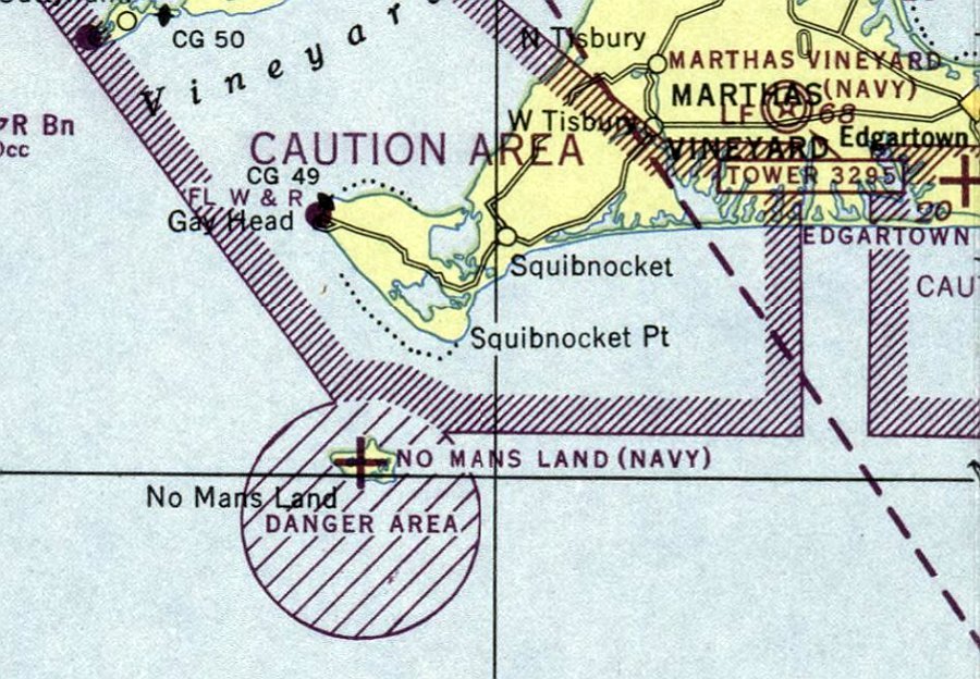
The earliest aeronautical chart depiction which has been located of the No Man's Land Airfield was on the May 1944 Boston Sectional Chart.
It depicted “No Mans Land (Navy)” as an auxiliary airfield, surrounded by the circular “Danger Area” for the bombing range.
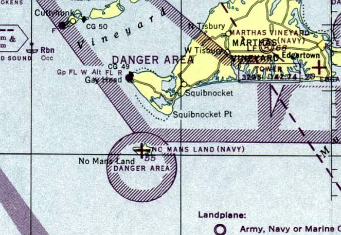
The last aeronautical chart depiction which has been located of the No Man's Land Airfield was on the December 1945 Boston Sectional Chart.
It depicted “No Mans Land (Navy)” as an auxiliary airfield.
No Mans Land was not listed among active airfields in the 1945 AAF Airfield Directory (courtesy of Scott Murdock).
It is not known if the airfield merely served as a bombing target, or if it was actually used by Navy aircraft.
The No Man's Land airfield was apparently abandoned at some point between 1945-46,
as it was no longer depicted on the July 1946 Boston Sectional Chart.
Also note the bomb target circle just northwest of the runway.
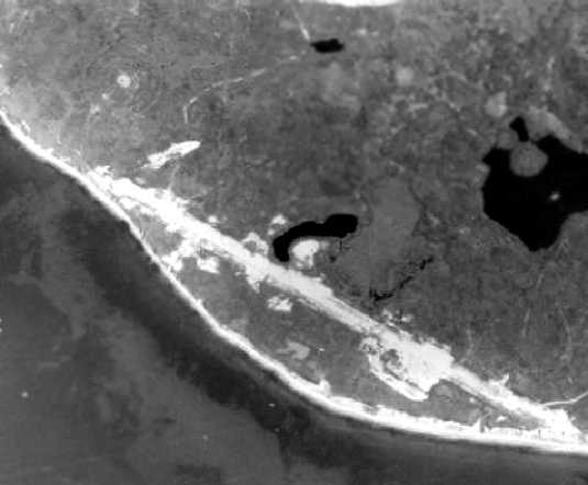
The Navy continued to use No Man's Land island for bombing practice until 1996.
It was also used for radar-scored bomb practice by B-52 bombers.
The Navy transferred No Man's Land island to the US Fish & Wildlife Service in 1998, for use as an unstaffed wildlife refuge.
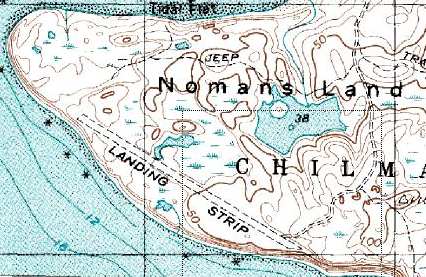
As depicted on the 1989 USGS topo map, the No Man's Land Airfield consisted of a single 3,300' runway.
There were no indications of any buildings or other airfield facilities.
The 1989 topo map includes the notations: "Military Reservation. Restricted Area. US Navy Air to Ground target.
Ordnance expenditure authorized 7 days a week."
By the time of the 1995 USGS aerial photo, the former No Mans Land Airfield was hardly recognizable at all.
In a 2007 aerial view looking northwest along the path of the former No Mans Land Airfield runway, showing it to be barely recognizable.
See also:
http://www.efane.navfac.navy.mil/envirn/Nomans/default.htm
http://www.state.ma.us/dep/bwsc/files/RandR/NLI/nlitmap.htm
____________________________________________________
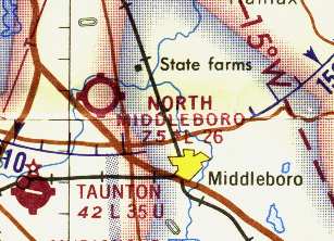
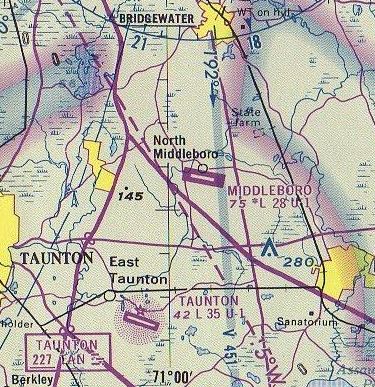
North Middleboro Airpark / Middleboro Airport (9B0), North Middleboro, MA
41.925, -70.976 (South of Boston, MA)
North Middleboro, as depicted on the 1959 Boston Local Aeronautical Chart (courtesy of Chris Kennedy).
Photo of the airfield while open is not available.
This small general aviation airfield was evidently constructed at some point between 1954-59,
as it was not yet depicted at all on the November 1954 Boston Sectional Chart (according to Chris Kennedy) nor on the 1957 USGS topo map.
The earliest depiction of North Middleboro which has been located was on the 1959 Boston Local Aeronautical Chart (courtesy of Chris Kennedy).
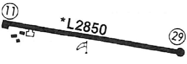
It depicted North Middleboro as having a 3,000' unpaved runway.
The 1960 Jeppesen Airway Manual (courtesy of Chris Kennedy)
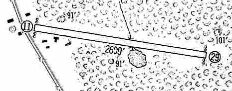
depicted North Middleboro as having a single 2,600' unpaved Runway 11/29,
with several small buildings along the west end of the runway.
The earliest photo of North Middleboro which has been located was a 1960 aerial view.
It depicted North Middleboro as having a single unpaved east/west runway.
Three single-engine aircraft were parked around a small building on the southwest side.
North Middleboro Airpark was described in the 1962 AOPA Airport Directory
as having a 3,000' sod runway (9/27), and the operator was listed as C. Lewis.
The 1964 USGS topo map depicted a single unpaved northwest/southeast runway, labeled simply as “Landing Strip”.

The earliest photo which is available of Middleborough Airport was an undated aerial view from the 1965 MA Airport Directory (courtesy of Jonathan Westerling).
It depicted Middleborough as having a 2,500' northwest/southeast runway, with a few small buildings & 3 light aircraft on the southwest side.
The Manager was listed as Chester Lewis.
The Aerodromes table on the reverse side of the 1965 Boston Sectional Chart (courtesy of John Voss) listed the field as North Middleboro,
and described it as having a single 2,600' turf runway.
North Middleboro was depicted as having a 2,600' unpaved runway on the 1968 Boston Sectional Chart (courtesy of Chris Kennedy).
At some point between 1968-71 the runway was apparently paved,
as a 1971 aerial photo depicted North Middleboro as having a single paved runway,
with a total of 22 light aircraft parked on either side of the west end of the runway..
The July 1975 Boston Terminal Aeronautical Chart (courtesy of Mitchell Hymowitz) depicted Middleboro as having a 2,800' paved runway.
The 1977 USGS topo map depicted “Middleboro Airport” as having a single paved runway.
The 1982 AOPA Airport Directory (courtesy of Ed Drury) described Middleboro Airport as having a single 2,850' asphalt Runway 12/30,
and included the note: "swimming pool at field".
The November 1983 Flight Guide (courtesy of Matt Elia) depicted Middleboro Airport as having a 2,850' paved Runway 11/29, with a ramp & 3 small buildings on the southwest side.

The last aeronautical chart depiction which has been located of Middleboro Airport was on the December 1986 NY Sectional Chart.
It depicted Middleboro as having a 2,900' paved runway.
Middleboro Airport was apparently closed at some point between 1986-1992,
as it was no longer depicted at all on the December 1992 Boston Terminal Aeronautical Chart (courtesy of Gwen Shafer),
and it was depicted simply as "Landing Strip" on the 1994 USGS topo map.
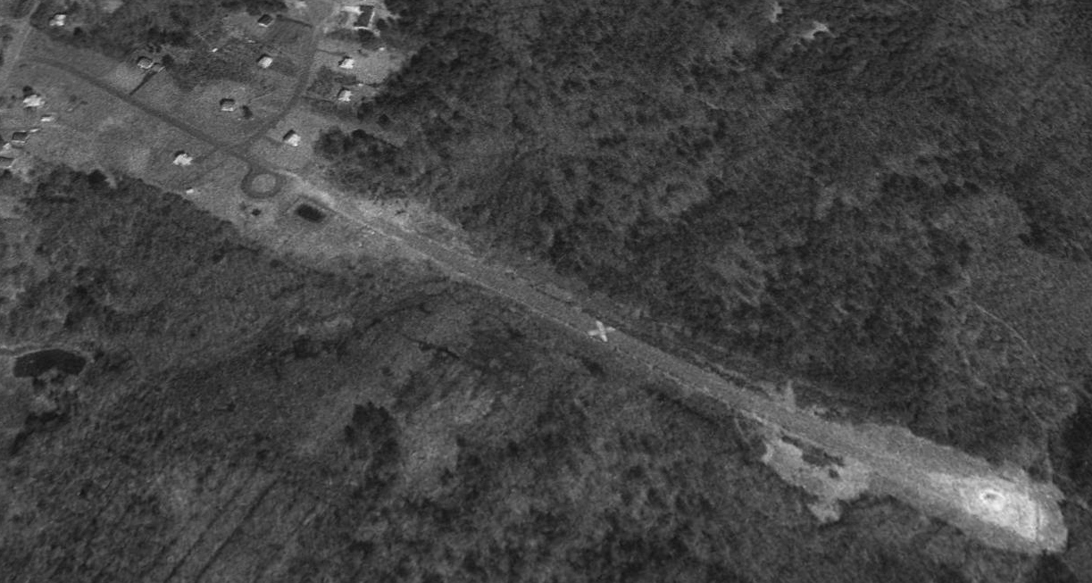
A 1995 USGS aerial view looking northwest depicted the western half of the Middleboro Airport runway as having been converted into Otis Pratt Lane, and several houses had been built.
The eastern half of the runway remained relative undisturbed, including a closed-runway "X" plainly visible.
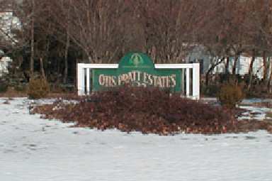
A 2002 photo by Jonathan Westerling of the entrance sign to Otis Pratt Estates, the site of the former airport.
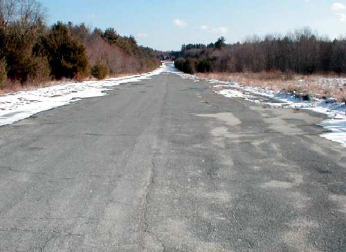
A 2002 photo by Jonathan Westerling looking east along the remaining length of the former runway at North Middleboro.
Jonathan reported that the western half of the former runway had been removed,
while the remainder of the former runway had been reused as a driveway for the 2 houses built towards its eastern end.
"It has been unaltered, and still has discernible yellow lines down the middle.
I wonder if the homeowners need to announce their intentions over Unicom when they leave their garage?"
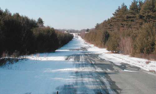
A 2002 photo by Jonathan Westerling looking west along the remaining length of the former runway at North Middleboro.
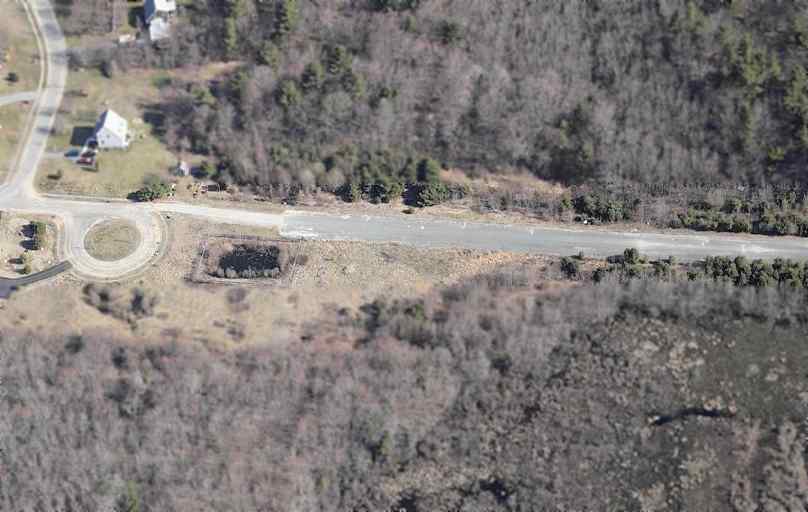
A circa 2005 aerial photo looking north at the western end of the remaining runway at North Middleboro.
A 2018 aerial view looking northwest along the former North Middleboro runway.
Thanks to Peter Kodis for pointing out this airfield.
____________________________________________________
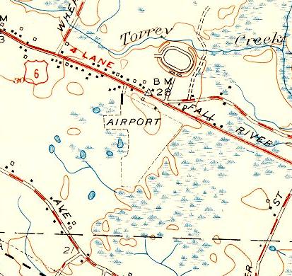
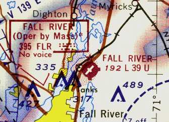
Fall River Municipal Airport (FLR), Fall River, MA
41.754, -71.112 (South of Boston, MA)
A November 1947 aerial view looking north-northeast at the site of Fall River Municipal Airport.
Fall River Airport was apparently built at some point between 1943-47,
as it was not yet depicted on the 1943 USGS topo map.
A November 1947 aerial view looking north-northeast appeared to show Fall River Municipal Airport under initial construction,
with a northeast/southwest clearing having been constructed for the eventual runway.
Fall River Airport was not yet depicted on the 1949 Boston Local Aeronautical Chart (courtesy of Tim Zukas).
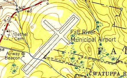
The earliest topo map depiction of Fall River Airport which has been located was on the 1951 USGS topo map.
It depicted “Fall River Municipal Airport” as having 2 perpendicular paved runways,
with a ramp & an airway beacon at the southwest corner of the field.
The earliest chart depiction which has been located of Fall River Airport
was on the June 1953 Hudson River World Aeronautical Chart (according to Chris Kennedy).
The May 1955 Boston Local Aeronautical Chart (courtesy of Graeme Smith)
depicted Fall River as having a 3,900' hard surface runway.
The earliest photo of Fall River Airport which has been located was a 1961 aerial view.
It depicted Fall River as having 2 perpendicular paved runways,
with a ramp, a few small buildings, and 2 single-engine aircraft on the southwest corner of the field.
Fall River Airport was described in the 1962 AOPA Airport Directory as having 2 paved runways,
and the operator listed as Narragansett Airways.
The Aerodromes table on the reverse side of the 1965 Boston Sectional Chart (courtesy of John Voss)
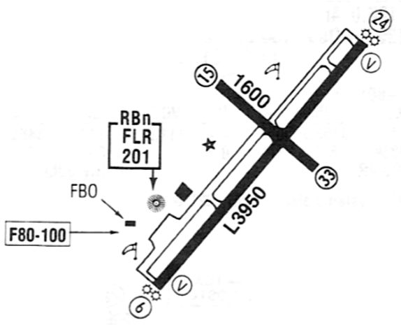
described the field as having 2 runways, with the longest being a 3,950' bituminous concrete strip.

An undated aerial view from the 1965 MA Airport Directory (courtesy of Jonathan Westerling)
depicted Fall River Airport as having 2 paved runways: 5,005' Runway 6/24 & 1,735' Runway 15/33.
Several hangars & several light aircraft were on the southwest side.
The Manager was listed as Robert Wood, the Fixed Base Operator was listed as Fran Air Service, and Butler Plastics Company was said to be located on-airport.
The 1968 Boston Sectional Chart (courtesy of Chris Kennedy) depicted Fall River Airport,
as well as the Fall River NDB beacon, located just west of the airport.
A 1971 aerial view depicted a dozen light aircraft parked on the Fall River Airport ramp.

A circa 1973 photo of Joe O'Connell & a Piper Cherokee at Fall River Municipal Airport (courtesy of Timothy Cataldo).
Timothy Cataldo recalled, “I used to fly with my Uncle Joe out of Fall River Municipal Airport after work at Captain O’Connell’s Boatyard to Martha’s Vineyard where we’d have dinner with the family, sleep over, and then fly back for work the next day.”
The November 1983 Flight Guide (courtesy of Matt Elia) depicted Fall River as having a 2 paved runways, with an FBO & one other building on the west side.
Steven Katz recalled, “Fall River Airport... I did some pilot training there in the mid-1980s & worked a few summers on the ramp driving the fuel truck, washing airplanes & various other gopher tasks.
In the mid-1980s there where actually 2 Fixed-Base Operators on the field.
The smaller of the 2 operated out of the building closer to the 24 end of the long runway.
The larger operation was called Fall River Airways & was owned by 2 partners both of whom were also flight instructors.
The daily management was done by one of the owner's brother. They occupied a trailer & a small building next to the main hangar just off the parking lot.
The small building was a pilots lounge for visitors & the local aircraft owners/pilots; the trailer was offices & classrooms.
Fall River Airways was responsible for the VHF advisory, sold fuel (100LL & auto gas), and parked transients.
On the field there as also a banner-towing operation that was not connected to Fall River Airways, but for which one of the partners also flew.”
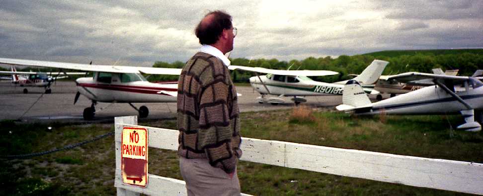
A 1990 photo depicted several Cessnas at Fall River.
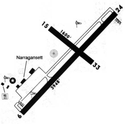
The 1993 Jeppesen Airport directory depicted Fall River as having 2 paved runways: 3,948' Runway 6/24 & 1,600' Runway 15/33.
A parallel taxiway ran the length of Runway 6/24, and a paved ramp sat at the southwest end, with several hangars.
The operator was listed as Narragansett Aircraft.
The last aeronautical chart depiction which has been located of Fall River Airport was on the December 1993 Boston Sectional Chart (courtesy of Ron Plante).
It depicted Fall River Airport as having 2 paved runways, with the longest being 3,900'.
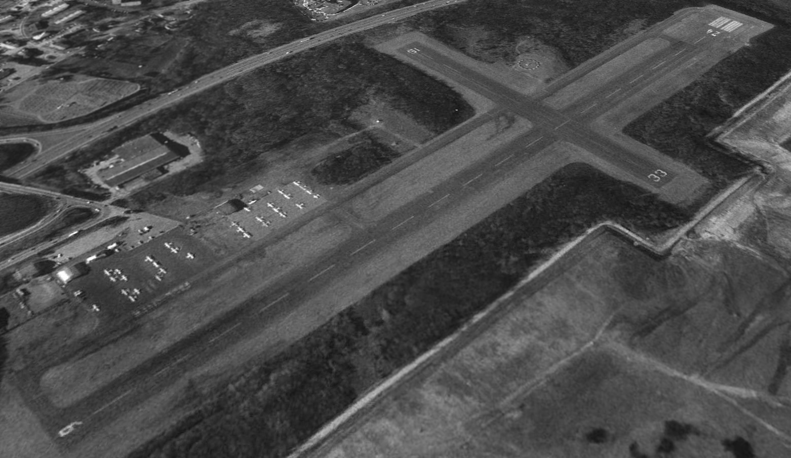
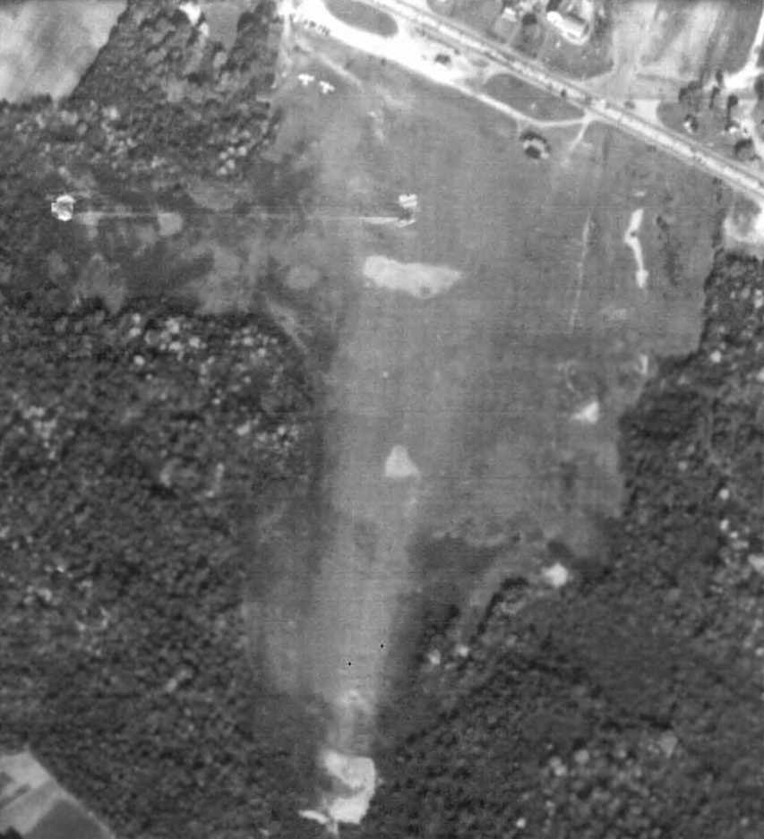
A 1995 USGS aerial view looking north at Fall River Airport (taken shortly before the field's closure) showed it to be quite well used,
with a total of 33 light aircraft visible parked on the ramp.
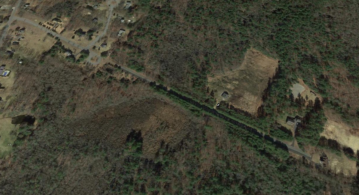
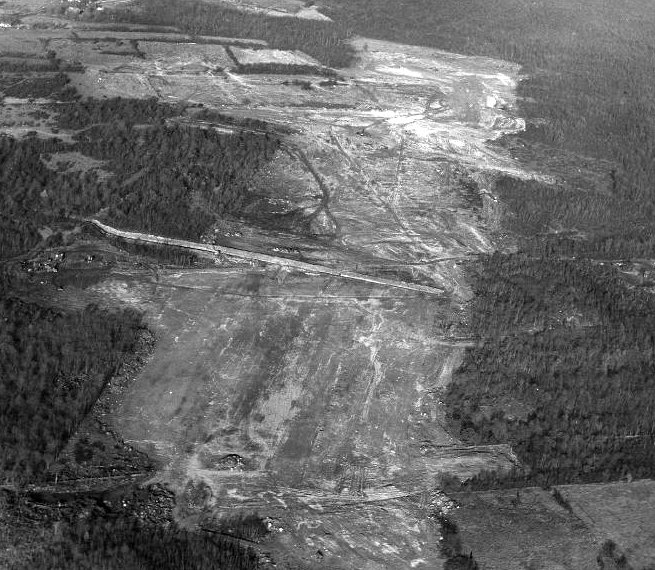
According to Pete Kodis, the Fall River Airport was closed because the city built a large landfill adjacent to the east side of the airfield.
The landfill got so high & the resultant population of seagulls got so thick that the FAA deemed the airport unsafe for use.
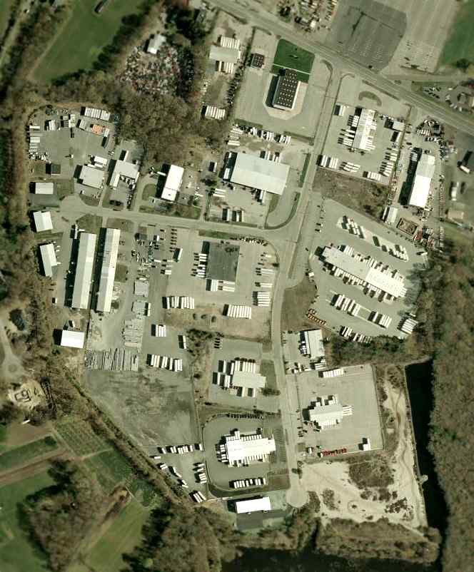
The state decided to make the New Bedford Airport a regional airport, and the Fall River Airport would become an industrial park.
It was closed at some point between 1995-98.
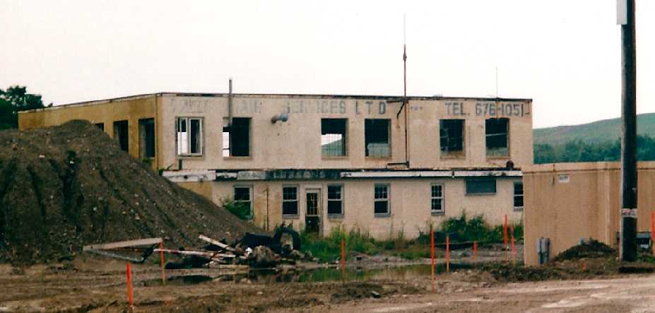
An August 2000 photo by Steve Brazao of the rear of an abandoned Fall River Airport hangar.
Steve recalled, “The airport had been closed for a while,
but the industrial park really hadn't grown that much yet so the main hangar was still standing & the runway mostly intact.”
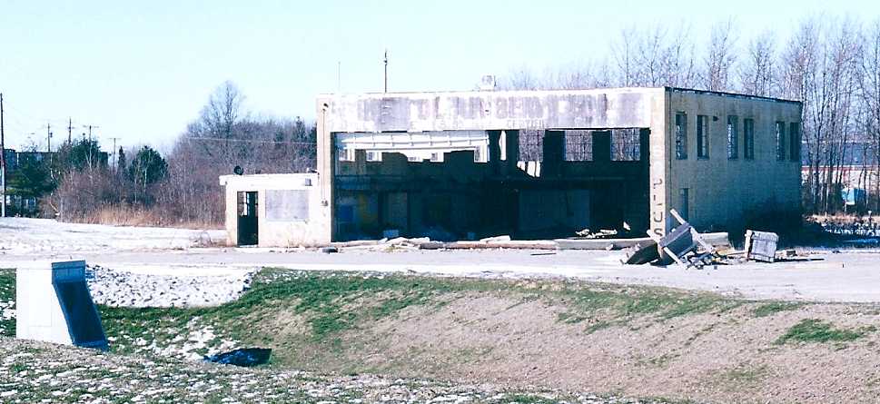
A December 2000 photo by Steve Brazao of the front of an abandoned Fall River Airport hangar.
Steve recalled, “There used to be another smaller FBO a few hundred feet south of this hangar,
but it was basically nothing more than a double-wide trailer & a ramp. By 2000, I think those were gone.
My grandfather was a lifetime Fall River resident & often took us to the airport to watch the airplanes take off & land, so it was very sad to see the airfield go.
I wish I had taken more pictures!”
A December 2000 photo by Steve Brazao of a maintenance schedule board “in the small office attached to the hangar” at Fall River.
A 12/30/01 aerial view showed 2 large commercial buildings had been built over the western portion of the site of Fall River Airport,
with portions of the 2 runways still remaining intact on the eastern side, along with the VASI light system.
![]()
A Summer 2003 photo by Peter Kodis of the former airport beacon which remains standing at Fall River.
A Summer 2003 photo by Peter Kodis of the Runway 24 VASI approach-slope guidance lighting which remains at Fall River.
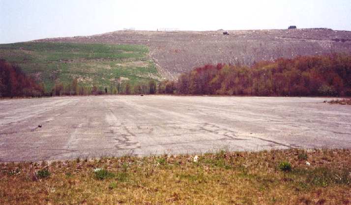
A 2003 photo by Peter Kodis of the remains of Runway 15, which now runs right into a massive landfill hill.
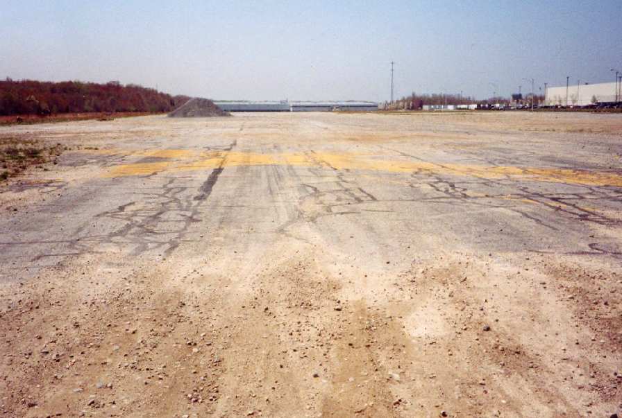
A Summer 2003 photo by Peter Kodis of the closed-runway "X" markings are still visible on the former Runway 24.
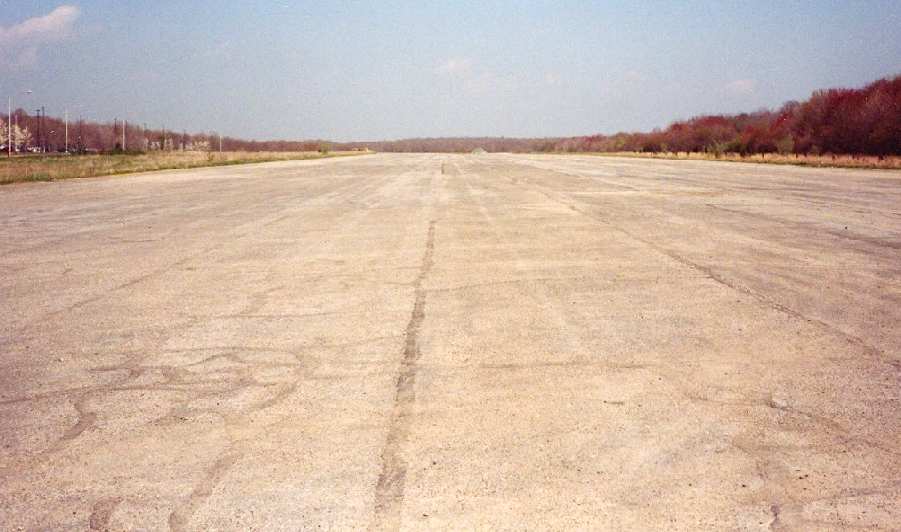
A 2003 photo by Peter Kodis looking north, the former Runway 6 still appears remarkably intact.
![]()
A circa 2006 aerial view looking east at the former Fall River airway beacon.
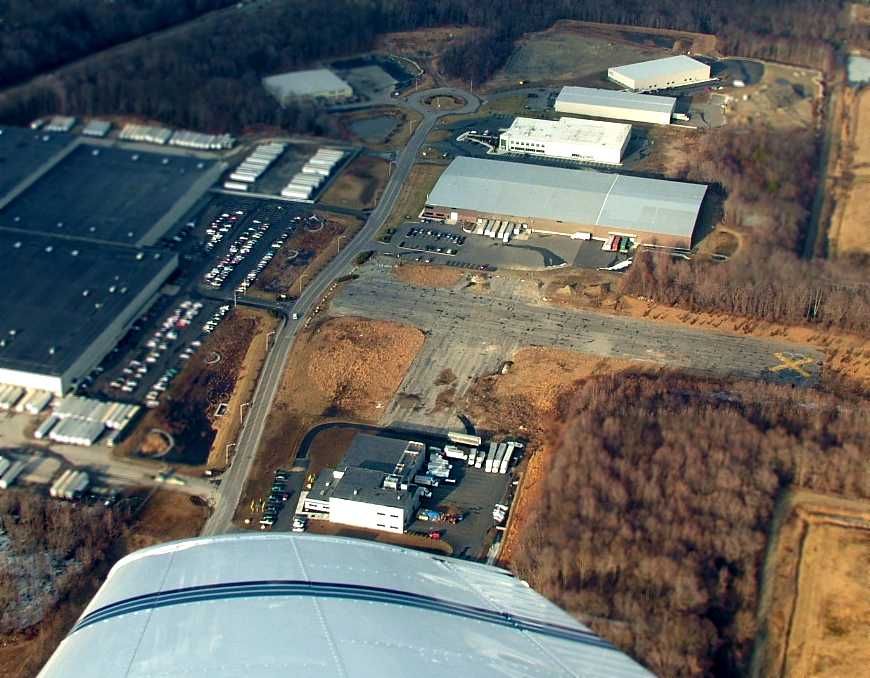
A February 2009 aerial view by Dan Fields looking north at the remains of the 2 runways at Fall River.
Dan observed, “We were doing traffic watch flying in the area & this is what FLR looked like from 1,500' above ground level.”
![]()
A 2014 photo by Doug Fortnam of the former Fall River Airport beacon, which still operates from a Dunkin Donuts parking lot.
Doug reported, “The Fall River Industrial Park is built on the site of the Fall River Airport.
I was surprised to see that the old airport beacon is still there & it now resides in the Dunkin Donuts parking lot!
The beacon still rotates white-white at night.”
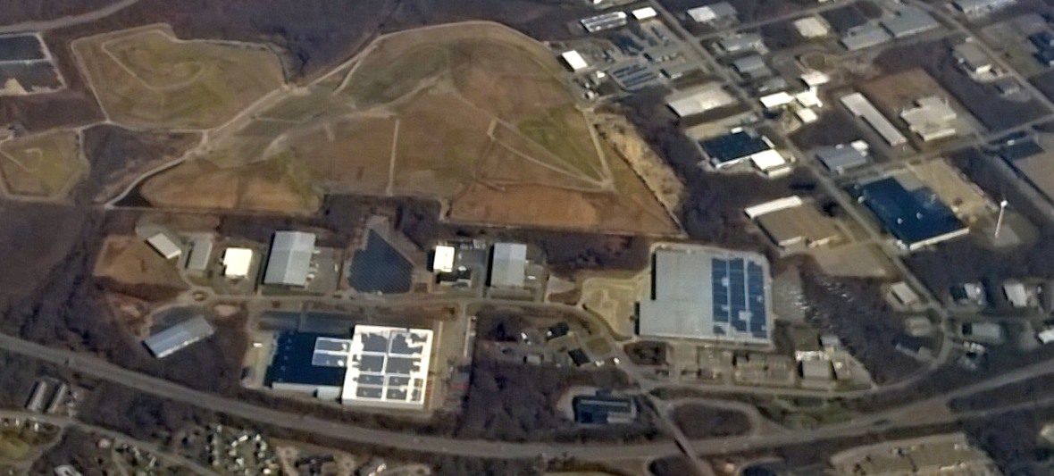
A 4/12/15 aerial view by Graeme Smith looking east at the site of Fall River Airport.
Graeme reported, “The entire area of the runways is now under the landfill or the Industrial Park to the south.
The only small part of a runway [remaining is a portion of] Runway 15 [left of center].
The Airport beacon next to the Dunkin Donuts has recently been restored.
It was briefly lit till the FAA stopped it because it might be taken for a real airport beacon (which of course – it is!).”
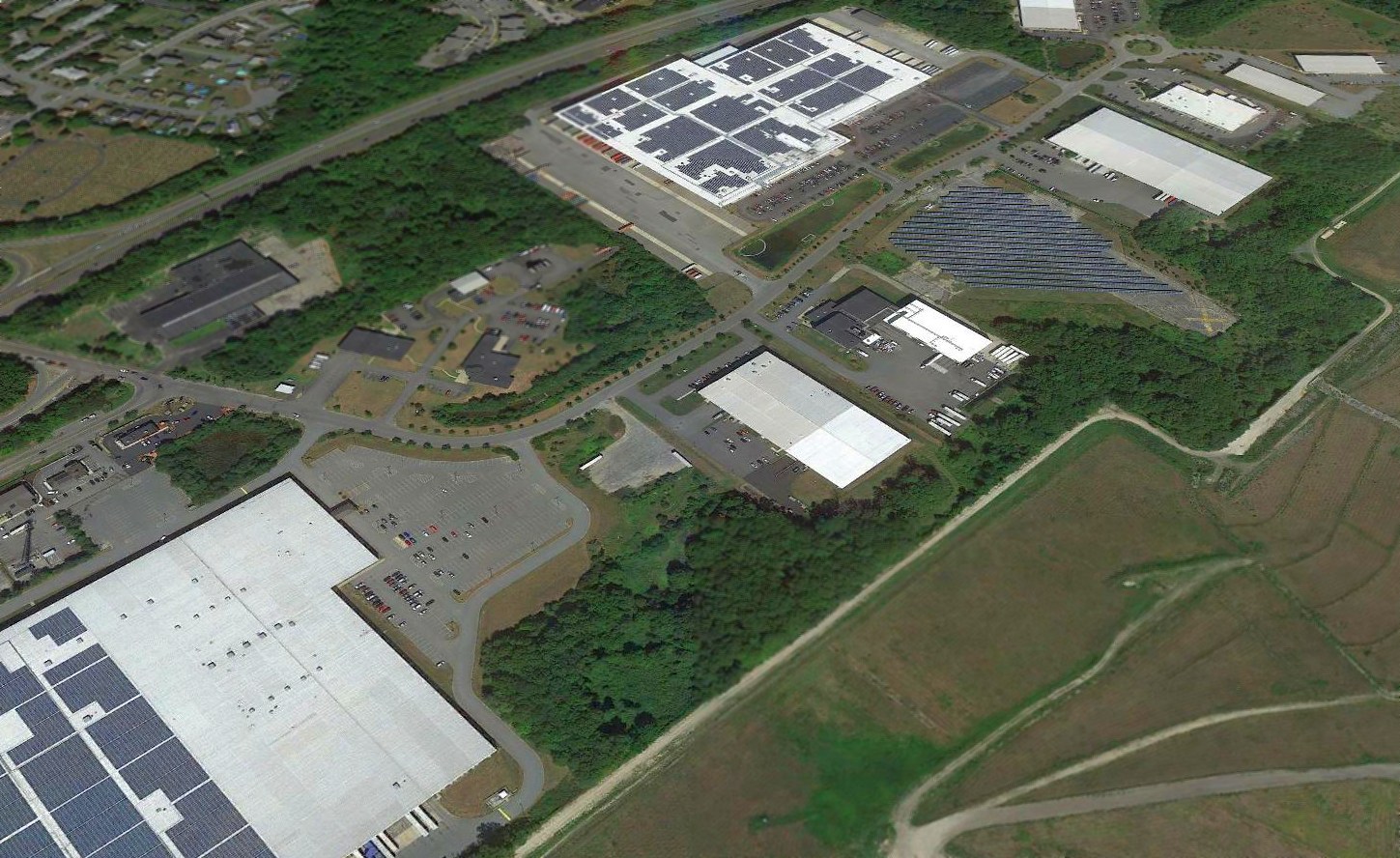
A 2016 aerial view looking north at the site of Fall River Airport shows the property to be unrecognizable as a former airport,
but a close examination reveals portions of the pavement of Runways 6/24 (middle of photo) & 15/23 (top-right), including a yellow closed-runway “X” symbol still visible.
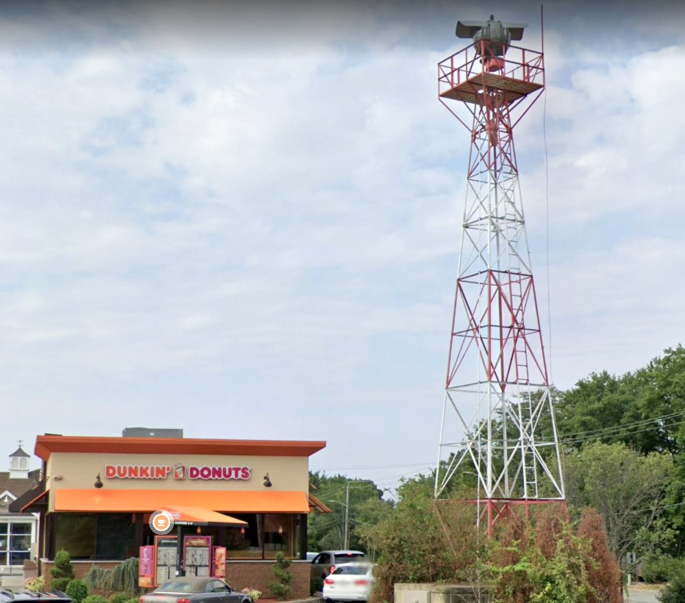
The incongruous sight of a 2019 photo of the former Fall River Airport beacon, which sits directly in front of a Dunkin Donuts.
____________________________________________________
Or if you prefer to contact me directly concerning a contribution (for a mailing address to send a check),
please contact me at: paulandterryfreeman@gmail.com
If you enjoy this web site, please support it with a financial contribution.
____________________________________________________
This site covers airfields in all 50 states.