
Abandoned & Little-Known Airfields:
Western Massachusetts
© 2002, © 2025 by Paul Freeman. Revised 10/29/25.
This site covers airfields in all 50 states: Click here for the site's main menu.
____________________________________________________
Please consider a financial contribution to support the continued growth & operation of this site.
Atwood Airport (added 6/9/23) - Bowles Agawam Airport (revised 3/18/25) - Hatfield-Pilgrim Airport (revised 1/16/23)
Springfield Airport (revised 6/10/23) - Valley Airport / Palmer Metropolitan Airport (revised 10/29/25)
____________________________________________________
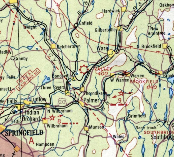
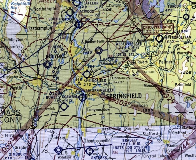
Valley Airport / Palmer Metropolitan Airport (PMX / 13MA), Palmer, MA
42.224, -72.312 (Northwest of Boston, MA)
A circa 1931 photo of Al Tobiasz piloting a Kinner Standard biplane after landing at the family farm which would eventually become Palmer Metropolitan Airport (courtesy of his grandson Michael Domnarski).
Michael Domnarski reported, “My grandfather was Alexander Tobiasz; he & his brother turned the family farm into what became the Palmer Airport in the 1930s.
Al was the driving force behind the airport in its glory years from the 1930s through the 1980s, and if one was connected with Palmer, you certainly knew of 'Ole Toby' as he was nick-named.
He was well-known in the aviation community.”
The earliest depiction which has been located of this airfield was a circa 1931 photo (courtesy of Michael Domnarski) of Al Tobiasz piloting a Kinner Standard biplane after landing at the family farm
which would eventually become Palmer Metropolitan Airport .
This airport was not yet depicted on the May 1935 Albany Sectional Chart.
The earliest aeronautical chart depiction which has been located of this airport was on the August 1936 Albany Sectional Chart, which depicted “Valley” as a commercial airport.
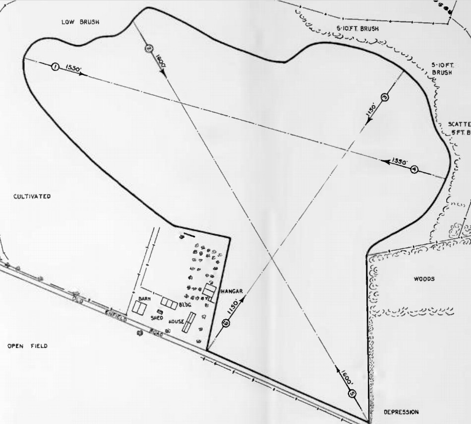
The 1937 MA Airport Directory (courtesy of Jonathan Westerling) depicted Valley Airport as a 47 acre irregularly-shaped property having a sod & gravel all-way field, measuring 1,600' southeast/northwest.
The field was said to have 1 wooden 70' x 50' hangars on the southwest side.
It was owned by John Tobias, and operated by Haberg Flying Service.
It was still depicted as Valley Airport on the July 1938 Albany Sectional Chart.
The 1938 Airway Bulletin (courtesy of Jonathan Westerling) described Valley Airport as an L-shaped property having 3 sod & gravel runways, with the longest being 2,100' northeast/southwest.
The airport was renamed Metropolitan Airport at some point between 1938-40,
as that is how it was depicted on the January 1940 Albany Sectional Chart.
According to its FAA Airport/Facility Directory data, Metropolitan Airport had an activation date of April 1940.
The 1941 Airport Directory Company Directory (courtesy of Jonathan Westerling) described Metropolitan Airport as a 50 acre irregularly-shaped property
having 3 sod & gravel runways, with the longest being 2,000' northeast/southwest.
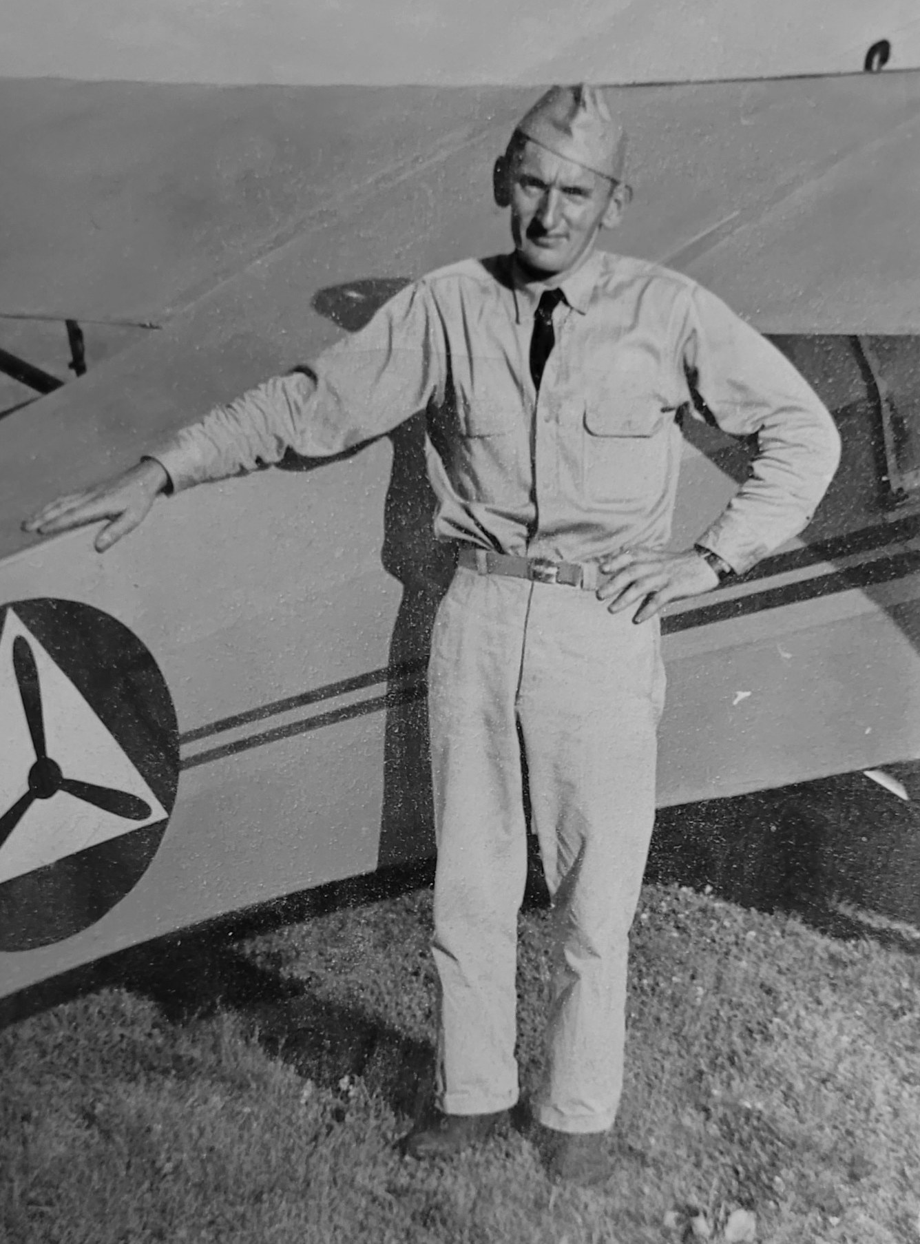
A circa 1942 photo of Civil Air Patrol officer Al Tobiasz posing in front of a CAP Piper presumably at Metropolitan Airport (courtesy of Michael Domnarski).
The earliest aerial photo which has been located of Metropolitan Airport was a circa 1943-45 aerial photo looking north from the 1945 AAF Airfield Directory (courtesy of Scott Murdock).
The directory described Metropolitan Airport as a 125 acre rectangular property having a sod & gravel all-way field, measuring 1,850' east-southeast/west-southwest.
The field was said to have 2 wooden hangars, the largest measuring 80' x 52', and to be owned & operated by private interests.
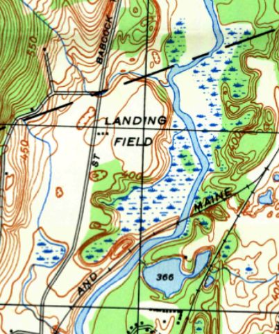
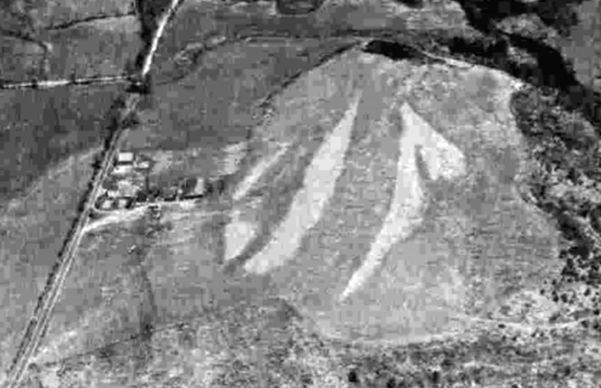
The 1947 USGS topo labeled Metropolitan Airport simply as “Landing Field”.
It depicted an open unpaved field, with 3 small buildings along the west side.
The 1948 Haire Airport Directory (courtesy of Jonathan Westerling) described Metropolitan Airport as having an 1,800' paved northeast runway.
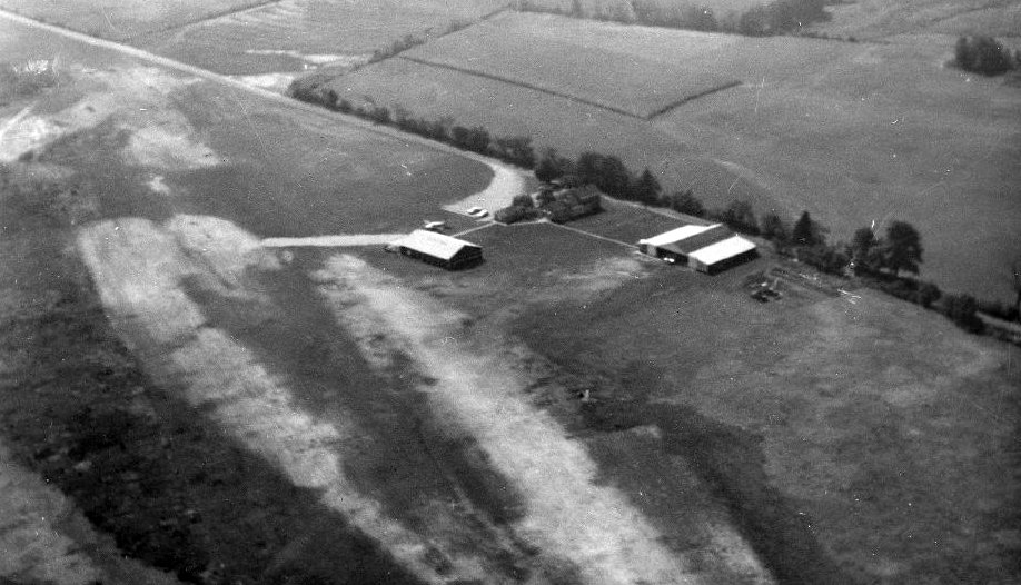
An undated aerial view looking southwest at Palmer Airport (from the MA Aeronautics Commission)
depicted the field as having 2 hangars & 1 plane on the west side of a grass airfield.

A circa 1965 photo of Al Tobiasz & his Cessna 182 at Palmer Airport (courtesy of Michael Domnarski).
The 1965 MA Airport Directory (courtesy of Jonathan Westerling) depicted Palmer Airport as having a single unpaved northeast/southwest runway, with a few small buildings & 10 light aircraft on the west side.
The Manager was listed as Alexander Tobiasz, and the Fixed Base Operator as New England Aviation.
A 3/9/66 USGS aerial photo depicted Metropolitan Airport as having a single paved northeast/southwest runway,
with a few small buildings & 5 light aircraft (including 1 twin-engine) along the west side.
Michael Domnarski reported, “Palmer was famous for the 'dog-leg' at the southern end of Runway 22.”
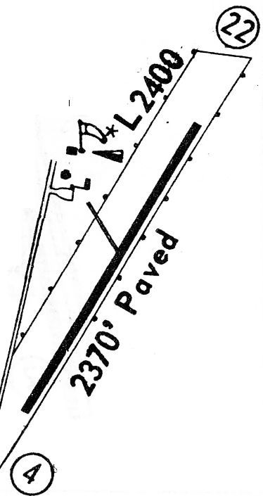
The 1968 Flight Guide (courtesy of Robert Levittan) depicted Metropolitan Airport as having a single paved 2,370' Runway 4/22,
with taxiways leading to a few small buildings along the west side.
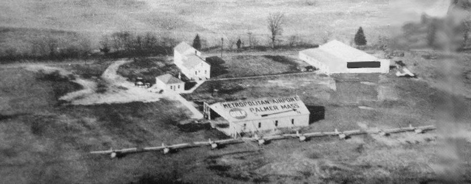
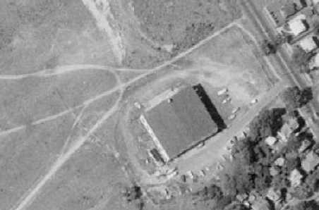
A circa 1960s-70s aerial view looking west at Palmer Metropolitan Airport (courtesy of Dean Charron), showing a row of single-engine planes in front of a hangar.
The 1969 USGS topo map depicted Metropolitan Airport as having a single paved northeast/southwest runway,
with taxiways leading to a few small buildings along the west side.
Linc Reed-Nickerson observed, “The curve at the south end of the airport came with an extension of the runway, which was built on an abandoned section of the Boston & Maine railway.
The entire airport was built on the former right of way. I landed there once in the late 1960s when I was building time & attempting to land at every MA airport.”
A 1970 photo of Dean Charron in front of N6729S (a 1967 Cessna 150H) & a hangar at Palmer Metropolitan Airport.
Dean recalled, “I had just returned from my Private Pilot License cross-country flight to PWM & back.
The airplane was Robert's Aviation primary trainer. I was 16 & I passed my Private Pilot's License a short time after.”
A circa 1976 photo of PMX Airport Manager Al Tobiasz & a Piper Cub on the Palmer north ramp (courtesy of Michael Domnarski).
Michael Domnarski reported, “This was the family business & I grew up at the airport. My first job was as a line-boy there in the 1970s.
Ours was a 'flying family' & my brother & I are both pilots as well as my son.”
As of 1981, Robert's Aviation was still operating at Palmer Metropolitan Airport (according to a letter courtesy of Dean Charron).
Michael Domnarski reported, “My grandfather Alexander Tobiasz provided flight instruction & managed the field until he sold the property in 1987.
After he sold the property, it was a long, steady downward spiral until the airport ceased to exist. Needless to say, it’s sadly missed in our family.”
Drew Lyons recalled, “Palmer Metropolitan Airport was the first trip I took after earning my Private Pilot's License in the mid- to late-1990s.
A week after passing my checkride I flew Worcester to Palmer in a Piper Warrior. It was a cool little airport & remember it having a slight hook in one end of the runway.”
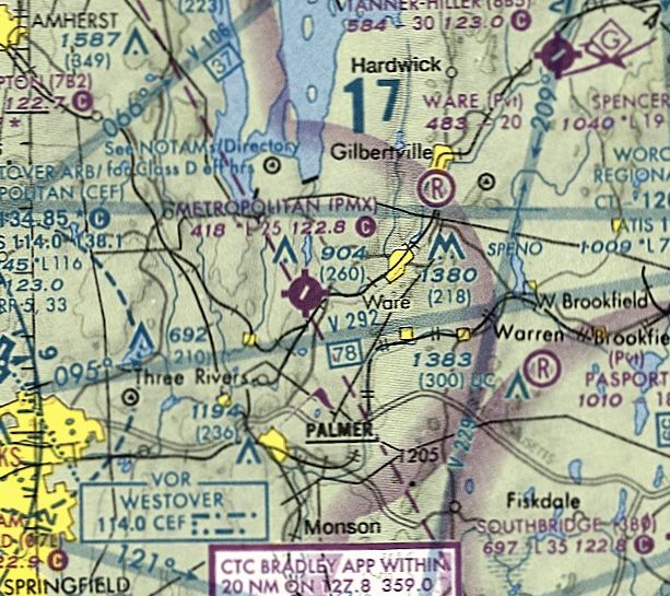
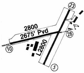
The last aeronautical chart depiction which has been located of Metropolitan Airport was on the May 2001 NY Sectional Chart (courtesy of Ron Plante).
It depicted Metropolitan Airport as having a 2,500' paved northeast/southwest runway.
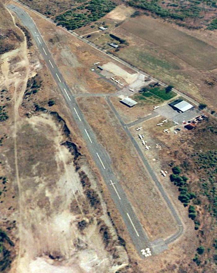
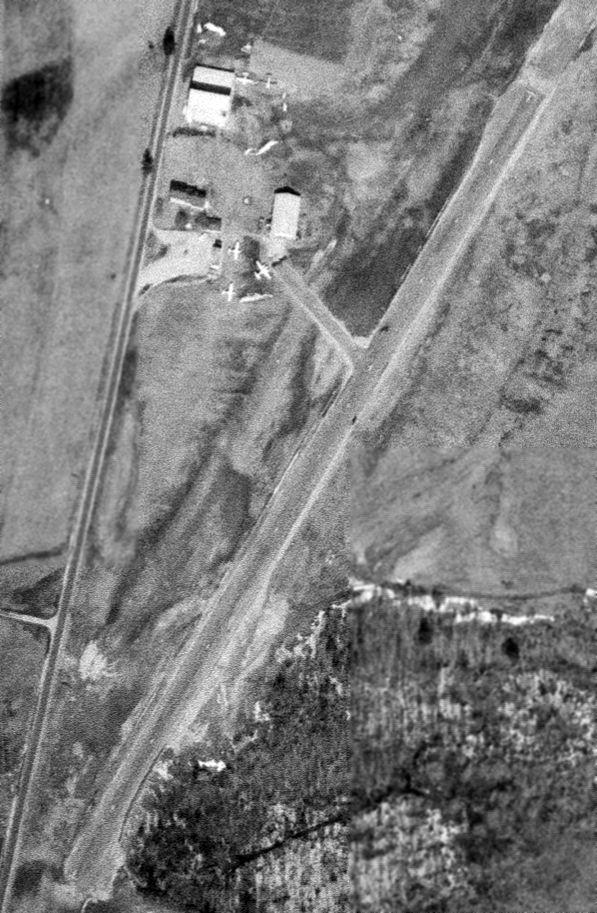
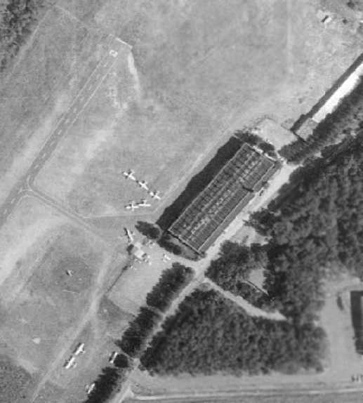
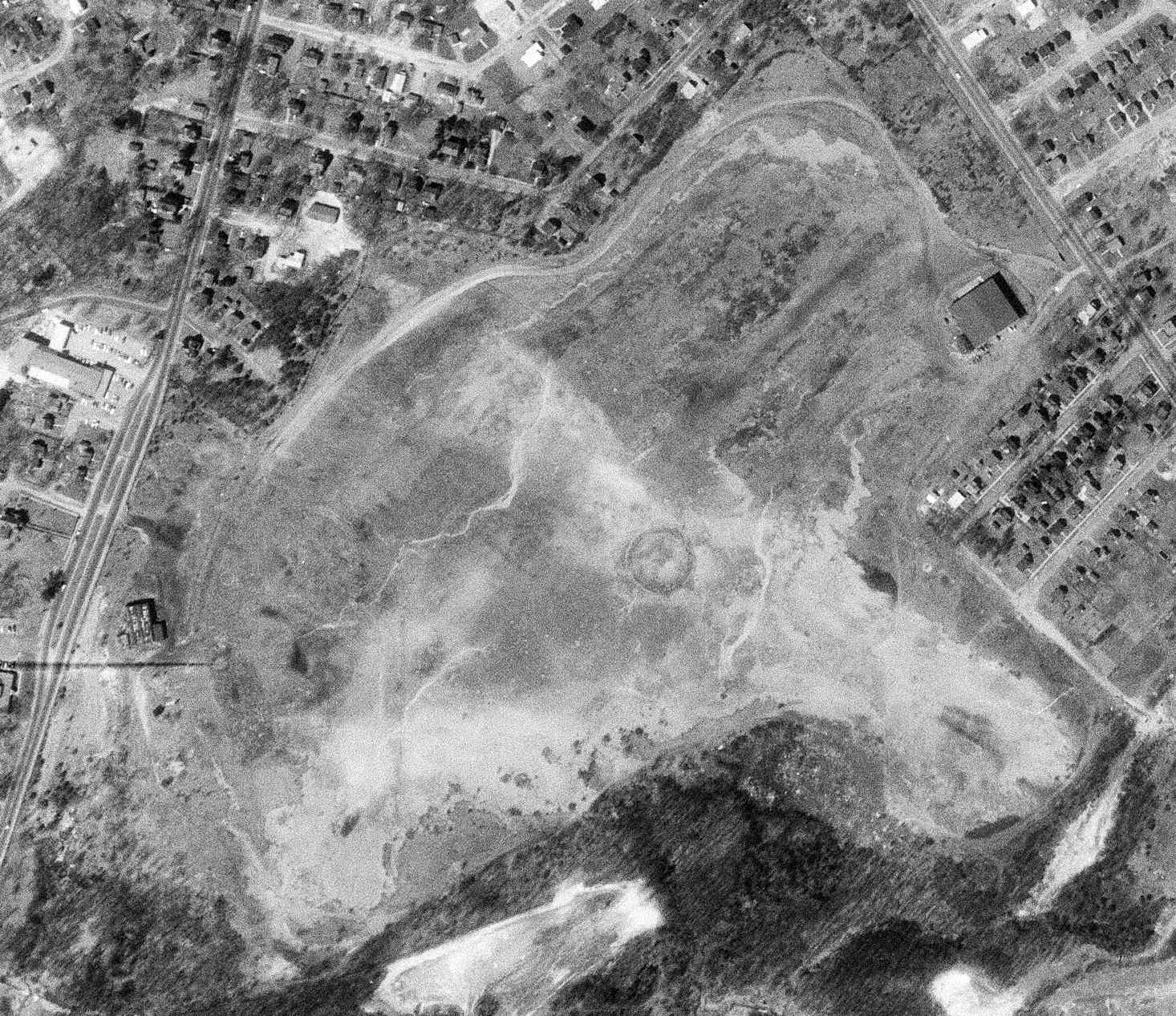
A 3/31/02 aerial view looking southwest showed Metropolitan Airport perhaps at its zenith of popularity,
with 14 single-engine aircraft visible on the field.
As of 9/1/03, Metropolitan Airport's FAA Airport/Facility Directory data listed it as conducting an average of 22 takeoffs or landings per day.
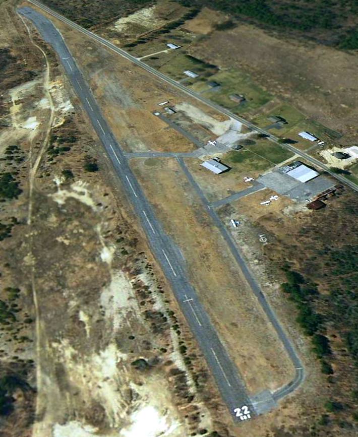
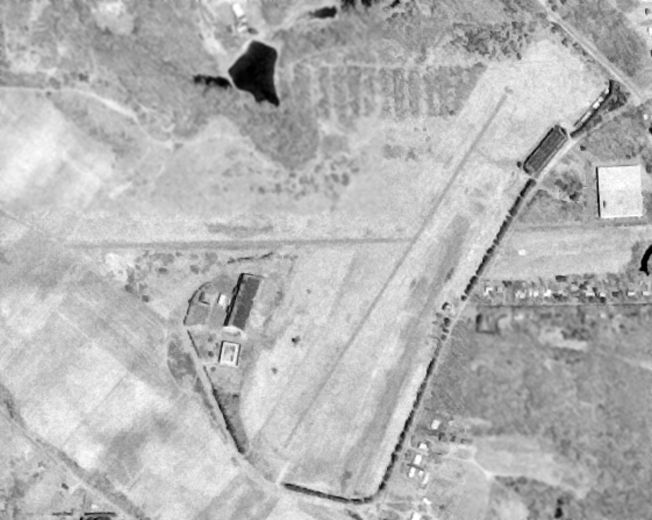
The last photo which has been located showing aircraft based at Metropolitan Airport was a 5/31/05 aerial view looking southwest.
Only 5 single-engine aircraft were still visible on the field.
Metropolitan Airport evidently was closed at some point between 2005-2007,
even though it continued to be used for ultralight aircraft operations.
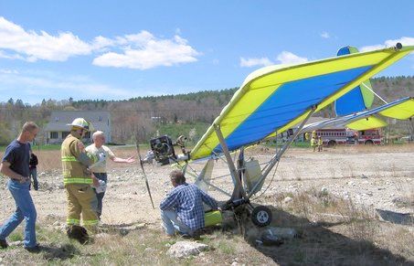
A 5/4/07 photo of an ultralight which made an emergency landing “in a rocky field at the former Palmer Metropolitan Airport” after experiencing an engine failure.
An article said “a section of the former airport is used by the Silver Wings Ultralight Club.”
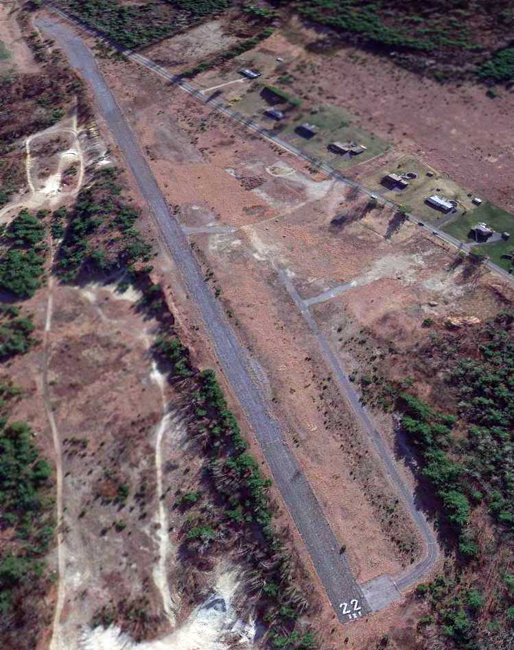
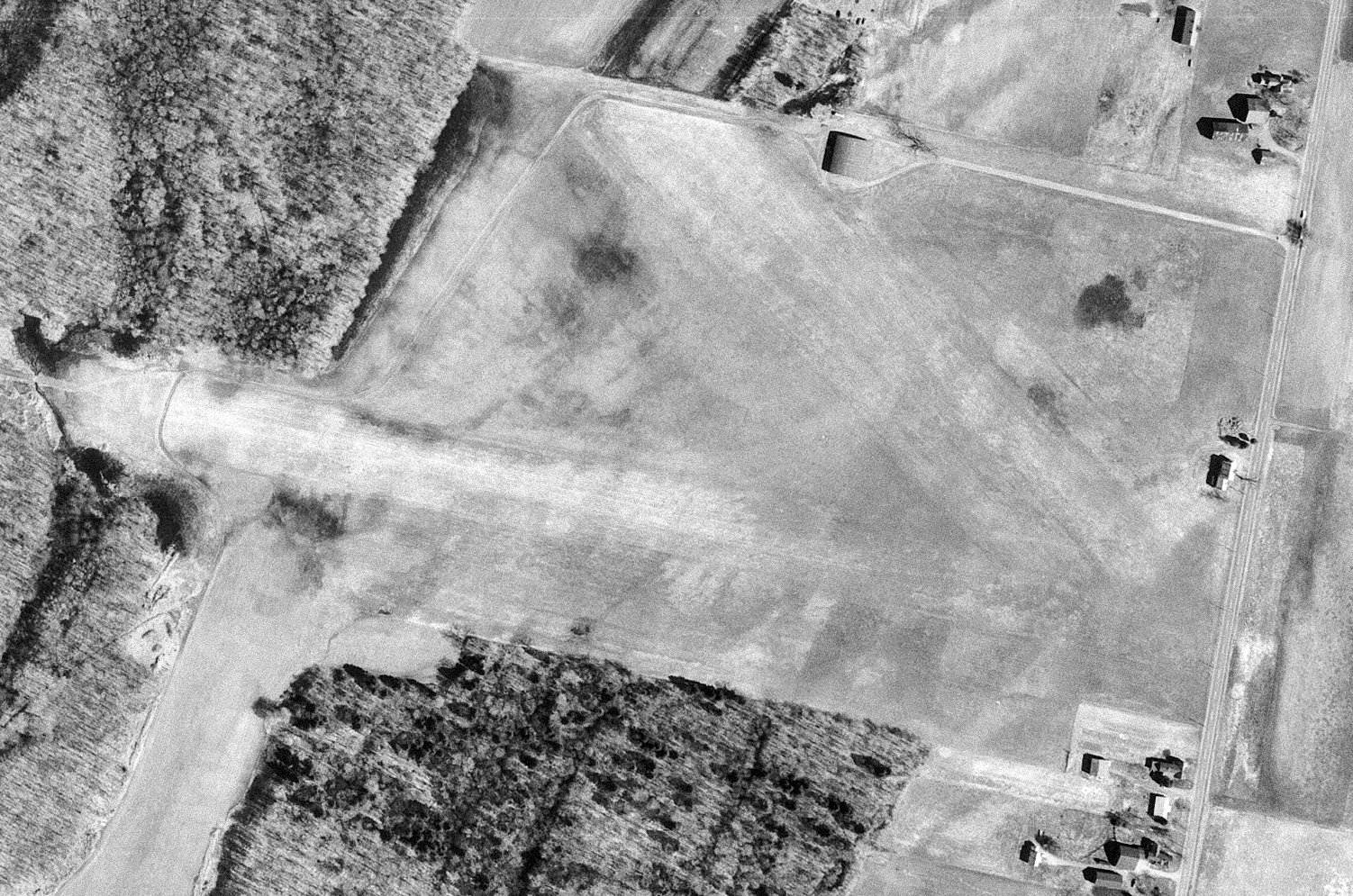
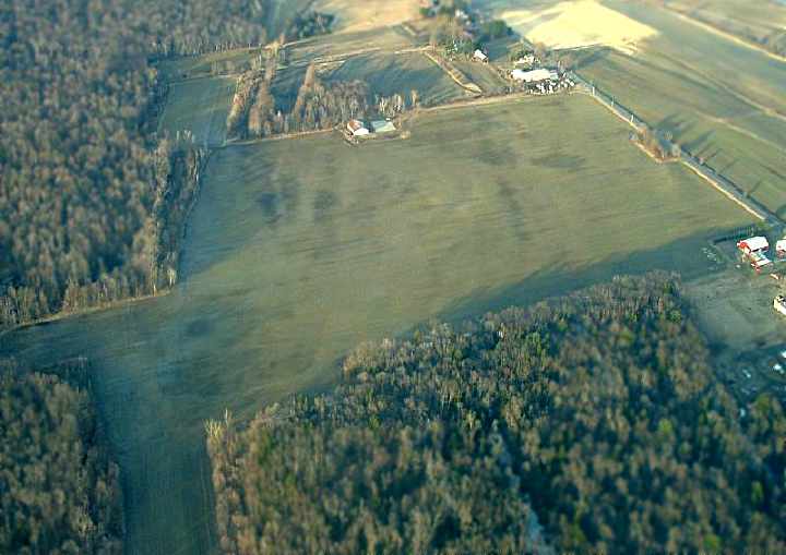
A 3/29/12 aerial view looking southwest shows a sad comparison to the earlier photos,
with all of Metropolitan Airport's hangars having been removed, even though the runway & taxiway pavement remained intact.
As of 2013, Metropolitan Airport's FAA Airport/Facility Directory data listed it as a private airfield owned by Jenjill LLC, and listed its Manager as Stephen Lazer.
The field was said to have a single 2,475' asphalt Runway 4/22, “in poor condition”, with “alligator cracks w/ potholes & debris.”
The field was said to have 24 based aircraft, but the remarks included “Owner desires airport not be charted”.
As of 2013, street maps showed multiple residential lots having been laid out all throughout the Metropolitan Airport property.
Gaspilot reported in 2013, “The Palmer Airport Association ran it for 7 or 8 years.
When it went into foreclosure we tried to buy it but we couldn't get over the hurtle of the banks & lawyers.”
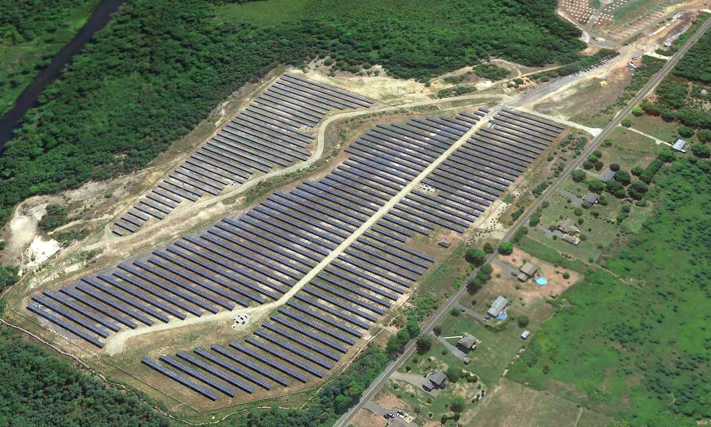
A 2016 aerial view looking southeast showed a solar energy farm covering the site of Palmer Metropolitan Airport, with only the southern portion of the runway remaining intact.
Thanks to Ric Carfagna for pointing this out.
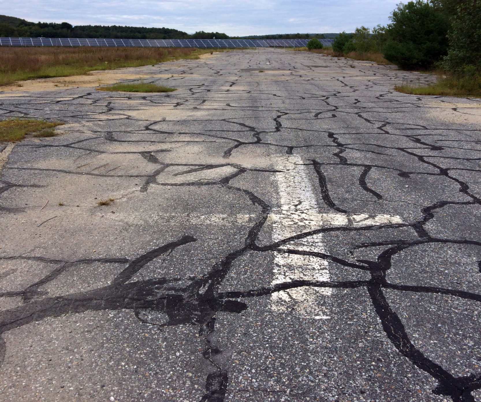
A 9/1/18 photo by Alex TD, at the site of Palmer Metropolitan Airport, “looking northeast on what remains of Runway 4/22,
with the [runway number] 4 still intact, and the solar panels covering most of the field visible in the background.”
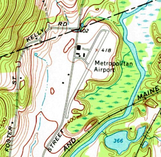
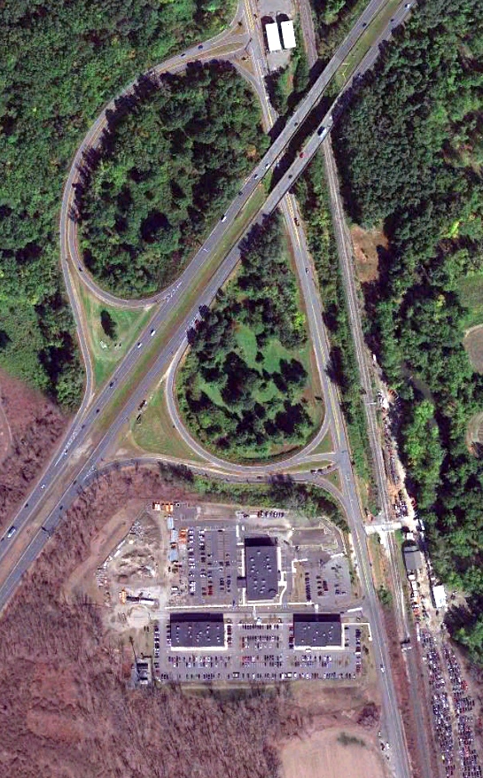
The site of Palmer Metropolitan Airport is located east of the intersection of Babcock Tavern Road & Foster Road.
Thanks to Gaspilot for pointing out this airfield.
____________________________________________________
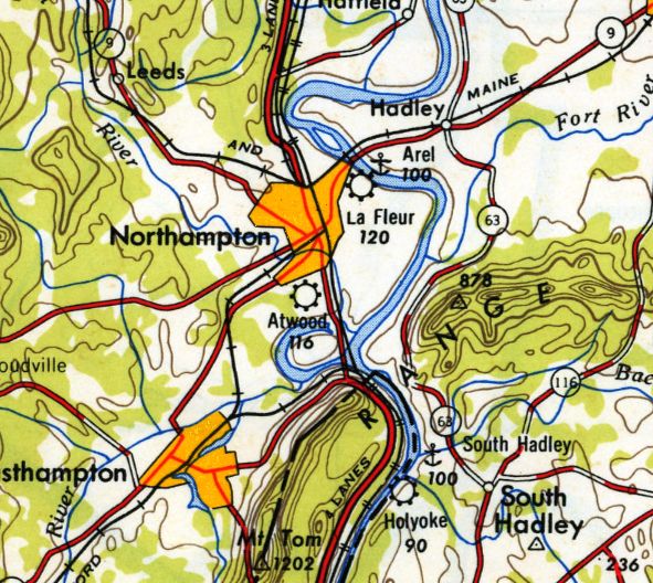
Atwood Airport, Northampton, MA
42.305, -72.623 (West of Boston, MA)
Atwood Airport, as depicted on the January 1947 Albany Sectional Chart.
This small general aviation airport was evidently established at some point between 1946-47,
as it was not yet depicted on the July 1946 Albany Sectional Chart.
The earliest depiction which has been located of Atwood Airport was on the January 1947 Albany Sectional Chart.
It depicted Atwood as a commercial/municipal airport.
Atwood Airport, as depicted on the 1948 USGS topo map.
The November 1953 Albany Sectional Chart depicted Atwood Airport as having a 2,200' unpaved runway.
The earliest photo which has been located of Atwood Airport was a 1958 aerial view.
It depicted Atwood having a single grass northwest/southeast runway, with 8 light single-engine aircraft & several hangars along the east side.
The last aeronautical chart depiction which has been located of Atwood Airport was on the November 1960 Albany Sectional Chart.
It depicted Atwood Airport as having a 2,800' unpaved runway.
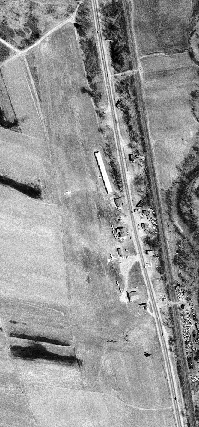
The earliest photo which is available of Atwood Airport was a 1962 USGS aerial view.
It depicted Atwood Airport in the same physical configuration as the 1958 photo, but with 7 light single-engine aircraft visible parked on the field.
A September 1963 photo by Tom Hildreth of a 1946 Aeronca 11BC inside one of the Atwood Aircraft open-sided shelters.
Tom Hildreth recalled, “Atwood Airport was located south of Northampton adjacent to US Route 5. The runway ran parallel to Route 5.
I took my first aircraft ride there around 1963 in a Piper Tri-Pacer for $5.”
Atwood Airport was evidently closed (for reasons unknown) at some point between 1963-65,
as it was no longer depicted on the November 1965 Albany Sectional Chart.
Tom Hildreth recalled, “I think the [Atwood] Airport property became part of the grounds for a hotel that was erected there in the 1966 timeframe.”
A 1971 aerial photo showed no trace remaining of Atwood Airport, with a highway interchange having covered the site.
A 2018 aerial view showed no trace remaining of Atwood Airport.
Thanks to Tom Hildreth for pointing out this airfield.
____________________________________________________
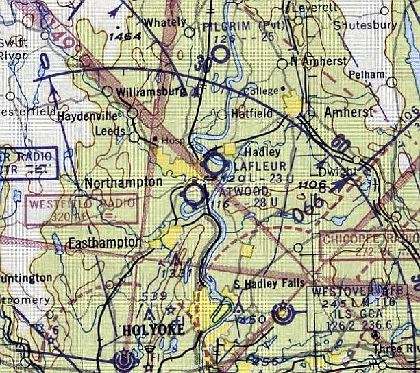
Hatfield-Pilgrim Airport (MA03), Hatfield, MA
42.421, -72.594 (West of Boston, MA)
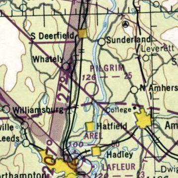
Pilgrim Airport, as depicted on the January 1950 Albany Sectional Chart.
This small general aviation airport was evidently established at some point between 1946-50,
as it was not yet depicted on the July 1946 Albany Sectional Chart.
The earliest depiction which has been located of the Pilgrim Airport was on the January 1950 Albany Sectional Chart.
It depicted Pilgrim Airport as having a 2,500' unpaved runway.
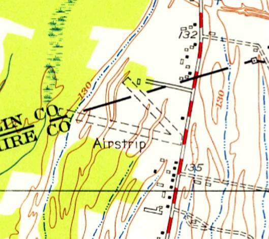
The 1955 USGS topo map depicted Hatfield-Pilgrim Airport as having 2 unpaved runways, labeled simply as “Airstrip”.
Hatfield-Pilgrim Airport was not yet listed among active airfields in the 1960 Jeppesen Airway Manual (according to Chris Kennedy).
The earliest directory listing of the Hatfield-Pilgrim Airport which has been located was in the 1962 AOPA Airport Directory.
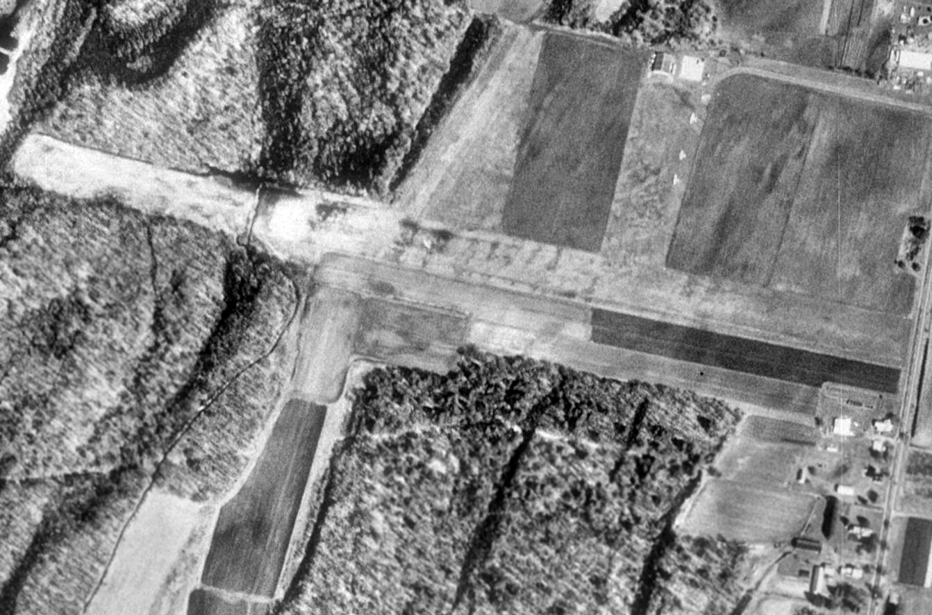
The earliest photo which has been located of Hatfield-Pilgrim Airport was a 4/21/62 USGS aerial view.
It depicted the field as having 2 grass runways, with a small hangar on the north side.
According to Brent Cichy, “Pilgrim Airport... was run by Rodger Atwood.”
The July 1964 Albany Sectional Chart (courtesy of Chris Kennedy)
depicted Hatfield-Pilgrim as a public-use airport having a 3,100' unpaved runway.
An undated aerial photo in the 1965 MA Airport Directory (courtesy of Jonathan Westerling) depicted Hatfield Airport as having 2 unpaved runways, with 2 small hangars & 7 light aircraft on the north side.
The Manager was listed as Stanley Hunt, the Fixed Base Operator as Montague Airways, and the field was said to have a snack bar.
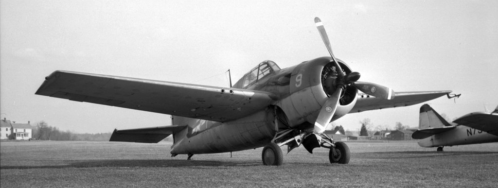
A 3/19/65 photo by Tom Hildreth of a Grumman FM-2 Wildcat operated by the Damn Yankee Air Force at Pilgrim Airport.
Tom Hildreth reported, “For a years in the 1960s, the Damn Yankee Air Force flew from Pilgrim Airport.
There was this Wildcat & a T-6 Texan, and perhaps others I didn’t photograph.”
Ken Sherman recalled, “I earned my private pilot’s license at Pilgrim Airport 1966-67.
It was a hand-to-mouth operation with one small Quonset hut heated by a pot-bellied stove.
I couldn’t afford a car so I had to drive my Lambretta motor scooter in the dead of winter to & back, a 10-mile round trip.
By the time I got to the airport I was so cold I couldn’t feel my legs so I had to sit on the stove until feeling returned.
Instruction was $14/hour, solo $10/hour. The school had 2 Cessna 150s, both of which had seen better days.
I flew with both instructors, Fran Balboni, who owned the place, and Jim O’Connell, a UMass accounting professor with whom I became good friends.”
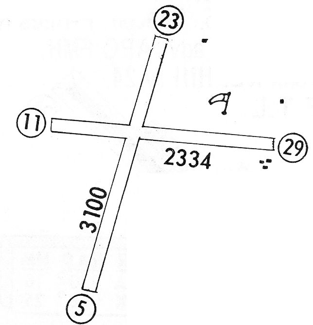
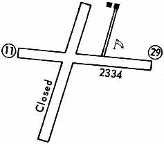
The 1968 Flight Guide (courtesy of Robert Levittan) depicted Hatfield-Pilgrim
with a considerably different runway configuration compared to the 1955 topo map,
with 2 unpaved runways: 3,100' Runway 5/23 & 2,334' Runway 11/29.
Several small buildings were depicted on the east side of the field.
A 1971 aerial view depicted Hatfield-Pilgrim Airport as having 2 grass runways.
Two small hangars were located northeast of the runway intersection, around which were visible 7 light aircraft.
The 1972 Flight Guide (courtesy of Chris Kennedy)
depicted Hatfield-Pilgrim as having 2.334' Runway 11/29, as well as a closed crosswind runway.
Two buildings were depicted to the northeast of the runway intersection.
Ken Sherman recalled, “In 1973 I revisited Pilgrim.
Little had changed, except that the hangar had collapsed under snow in 1969,
crushing the airplanes inside & leaving no hangar for private aircraft.
I flew in the area as a CFI from 1973–75 & often visited Pilgrim.”
Hatfield-Pilgrim Airport was still open as of the time of the 1992 USGS aerial photo,
as it depicted 4 light single-engine aircraft parked south of the hangars (on the northeast side of the field),
as well as another aircraft at the runway intersection.
On 10/15/93, a homebuilt Schlappi RV-3, N669CP, piloted by Dale Schlappi, collided with terrain while landing at Hatfield-Pilgrim Airport.
The airplane was substantially damaged, and the pilot received minor injuries.
The report described the field as having a 2,200' turf Runway 11/29.
The 1993 Jeppesen Airport Directory described Hatfield-Pilgrim as having a single 2,200' turf Runway 11/29.
Scoot Dunn said, “My instructor went through his old logbooks
and according to his notes, Hatfield Pilgrim was closed in the fall of 1996.”
However, Hatfield-Pilgrim Airport was still depicted as an active public-use airport
on the December 1997 NY Sectional Chart (courtesy of Chris Kennedy).
It was depicted as having a 2.600' unpaved runway.
Hatfield-Pilgrim Airport was evidently closed (for reasons unknown) at some point between 1997-2000,
as a 2000 USGS aerial photo showed no aircraft on the field, which otherwise remained intact.
Ken Sherman recalled, “The last time I visited was about 2000, at which time it had become an ultralight field with no supporting activities.
The airport had been built on an oxbow of the Connecticut River & had the habit of flooding every spring.
It was shortly after that that the field was delisted & returned to its pre-aviation status as a crop field.
One more airport we couldn’t afford to lose.”
According to Scott Dunn, “My instructor believes that it was closed by 2001 at the latest.”
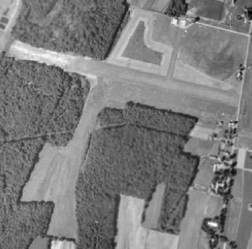
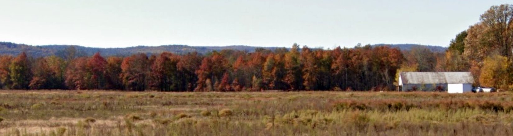
An April 2005 aerial photo by Scott Dunn, looking northeast at the remaining hangar at the former Hatfield-Pilgrim Airport.
A March 2006 aerial photo by Scott Dunn, looking north at the former Hatfield-Pilgrim Airport.
Scott observed, “The site has changed little since its active days, but the entire airfield area is now planted with crops.”

A 2014 aerial view of the site of Hatfield-Pilgrim Airport shows the hangar remains standing, and the runways remain clear.
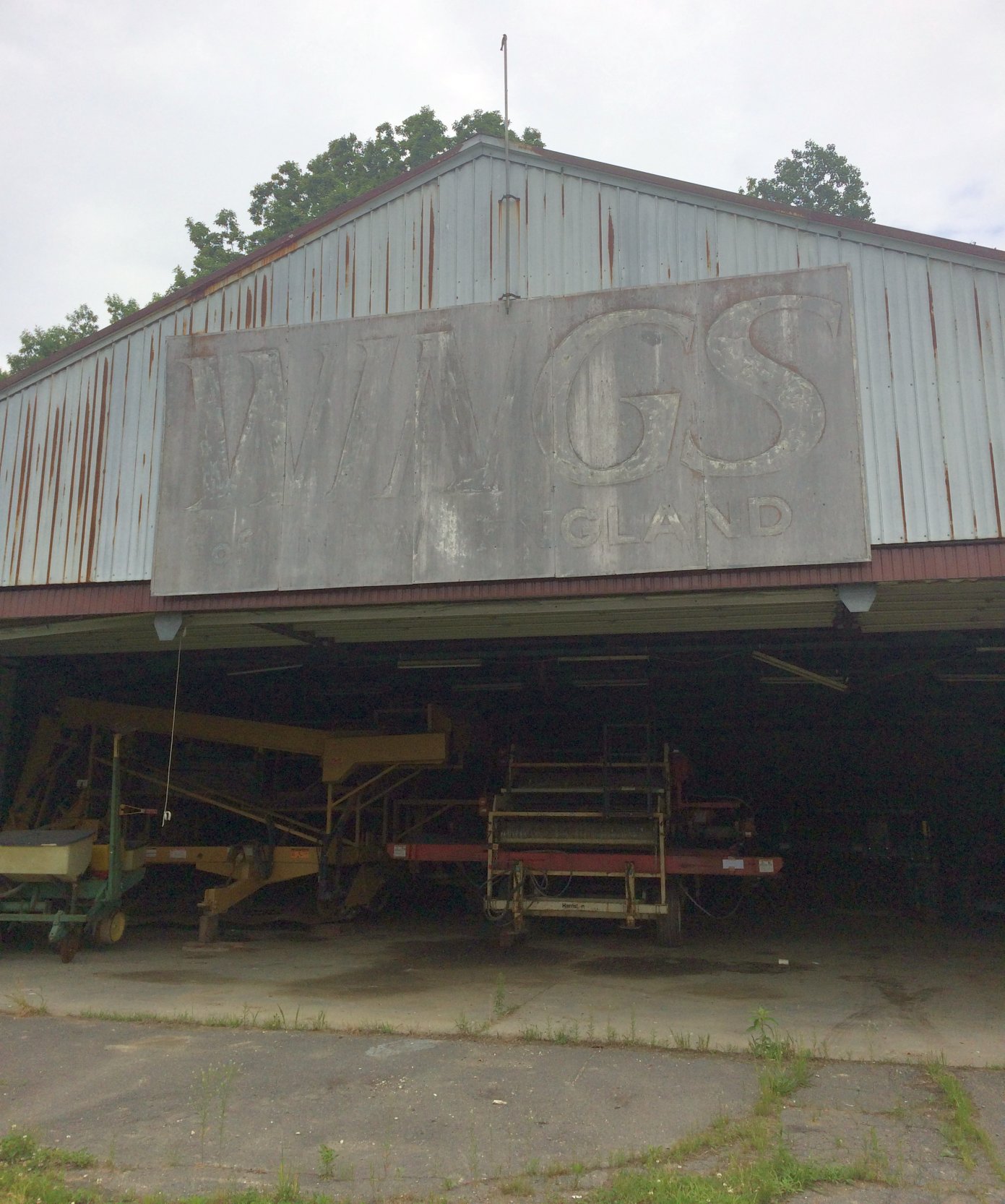
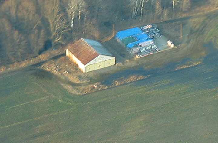
A 6/4/18 photo by Dale Wunderlich of the hangar which remains at the site of Hatfield-Pilgrim Airport.
Dale reported, the sign on the hangar “reads 'Wings of New England'. There are no other signs of aeronautical operations around. It is currently being used for farming operations.
The plowed field shows no signs of its former life as an airstrip. The plowing has been done with shallow drainage draws perpendicular to the main strip, and would make for a bumpy ride.”
An October 2019 photo looking west at the former hangar which remains at the site of Hatfield-Pilgrim Airport.
The site of Hatfield-Pilgrim Airport is located northwest of the intersection of Main Street & Depot Road.
____________________________________________________
Bowles Agawam Airport (7B0), Agawam, MA
42.05, -72.65 (West of Boston, MA)
The location of Bowles-Agawam Airport, as depicted on the 10/7/29 National Air Tour Souvenier Banquet program (courtesy of Tom Heitzman).
The earliest depiction which has been located of Bowles-Agawam Airport
was on the 10/7/29 National Air Tour Souvenier Banquet program (courtesy of Tom Heitzman).
Jack Minnix recalled, “The Springfield Newspapers were owned by the Bowles family who owned the airport.
They had a 'corporate' airplane & it was based there.”
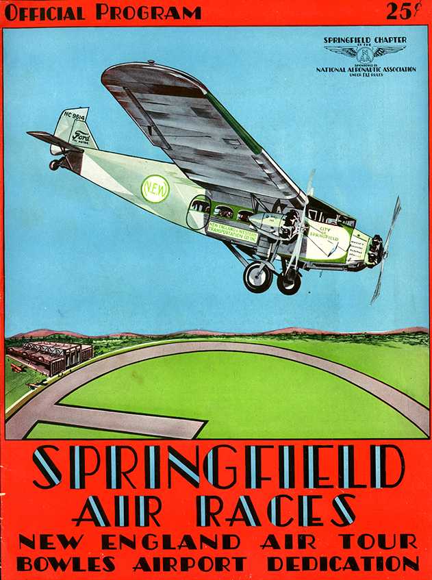
The cover of the 5/30/30 program for the “Springfield Air Races”,
held to commemorate the “Bowles Airport Dedication” (courtesy of Tom Heitzman).
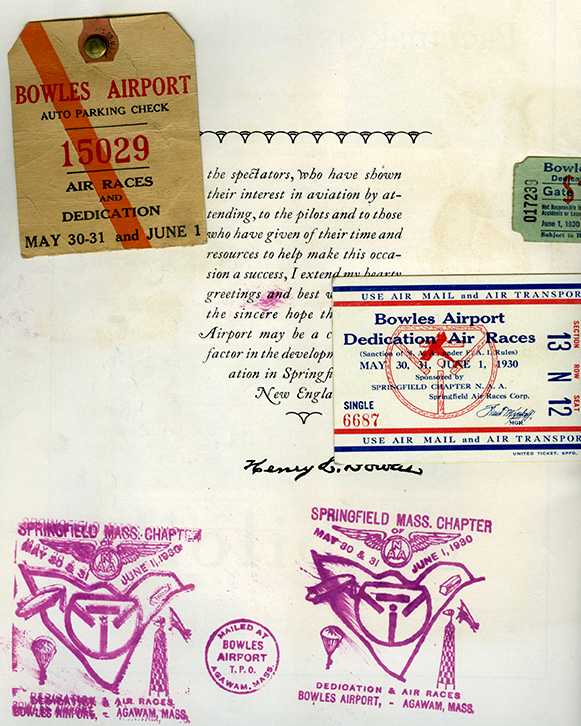
The inside cover of the 5/30/30 program for the “Springfield Air Races”
held to commemorate the “Bowles Airport Dedication” (courtesy of Tom Heitzman).
Tom reported, “A local kid attended this event & gathered the stuff he attached to the inside cover as well.
It included a 5/30/30 postmark commemorated the dedication & air races at Bowles Airport,
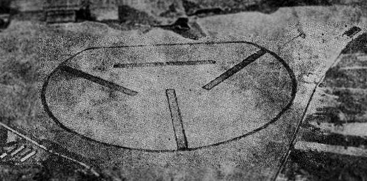
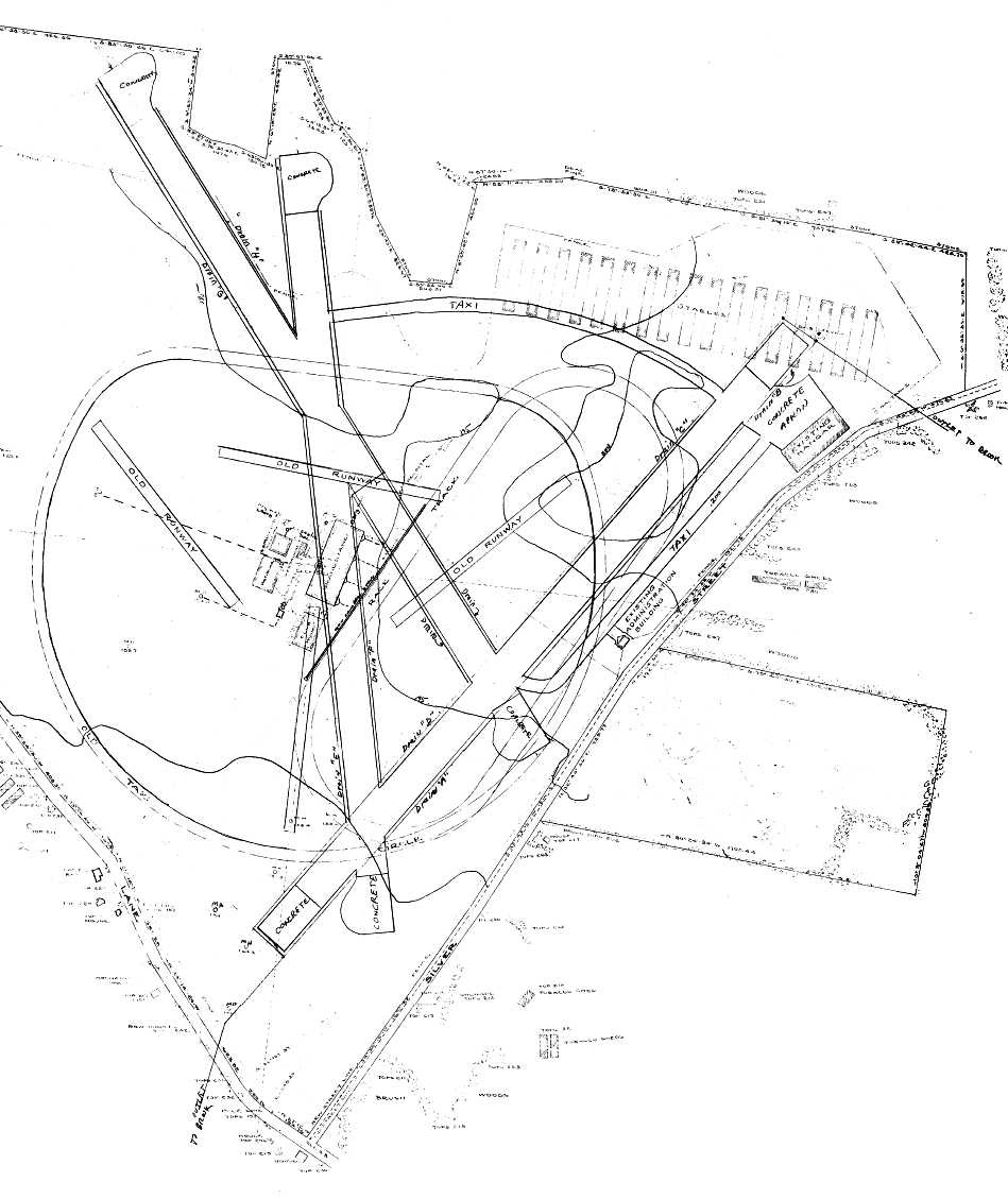
which featured a diagram of the field's unusual configuration of 4 runways within a circular perimeter.
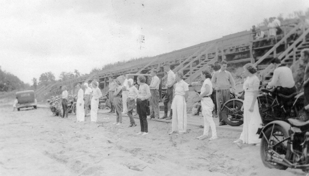
A 1930 photo (courtesy of Matt Lawlor) of spectators at watching the air races held to dedicate the wooden grandstands built on a hillside overlooking Bowles Agawam Airport
which had been built for the airport's 1930 dedication & the 1931 Army air maneuvers.
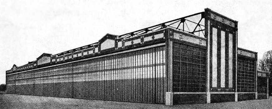
An undated photo of a “huge hangar” at Bowles Agawam Airport,
from an advertisement for the Standard Manufacturing Company (courtesy of Harry Doherty).
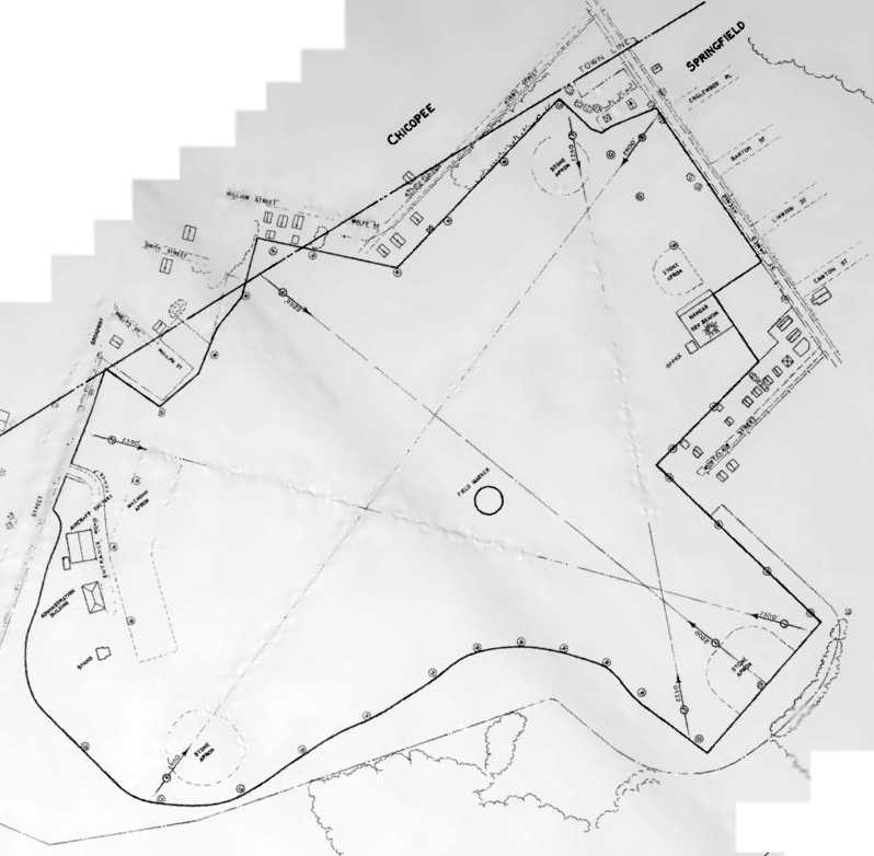
The location & layout of the Springfield Airport
as depicted on the 5/5/31 Department of Commerce Airway Bulletin (courtesy of Jonathan Westerling).
It depicted the field as having four 1,000' runways contained within a circular perimeter track,
with 2 buildings along the eastern edge of the field.
Jonathan remarked, “I still can’t believe the impressiveness of this layout. Must have been a modern miracle in its day.”
An aerial view by Robert Selff of a mass gathering of well over 100 biplanes of the United States Army Air Corps Eastern Air Arm on 5/26/31
to commemorate the grand opening of Bowles Field (courtesy of Matt Lawlor).
The aerial photo depicted the unusual layout of the field,
with 4 grass runways contained within a circular outline.
Also depicted was a hangar & a multi-story terminal building.
An aerial view looking north at Bowles Field, possibly taken during the same 5/26/31 Army Air Corps gathering (courtesy of Lowell Scott).
A 2/3/18 photo by Matt Lawlor of a souvenir ribbon from the 1931 Army Air Corps flight into Bowles Airport.
A scheduled air service operated out of Agawam for approximately a year, circa 1931.
A 9/2/31 Hartford Courant newspaper article (according to Jonathan Westerling) proclaimed “American Airways Leases Space At Bowles Airport”.
A circa 1930s photo of an Agawam Cicada in front of a hangar at Bowles Airport.
According to Matt Lawlor, “The 'Cicada' ended up meeting a sad end when its pilot clipped the top of the hangar at Bowles following his return from the 1932 National Air Races.
The plane mostly ended up on top of the hangar & exploded killing the pilot Lt. Frank Lynch.”
Jack Minnix recalled, “Jimmy Doolittle flew the GeeBee R1 from that hangar [Bowles' large hangar]
to the Cleveland Air Races in 1932 (and he won with it).
I think it was his first flight ever in the airplane.”
An aerial view looking north at Bowles-Agawam
from the Airport Directory Company's 1933 Airports Directory (courtesy of Chris Kennedy).
The directory described Bowles-Agawam Airport as having quite an unusual runway configuration:
four 1,000' macadam runways, circled by a 2,500' taxi strip.
A single hangar was depicted on the northeast corner of the field.
The manager was listed as Garry Hermann, and the operator was Springfield Airlines.
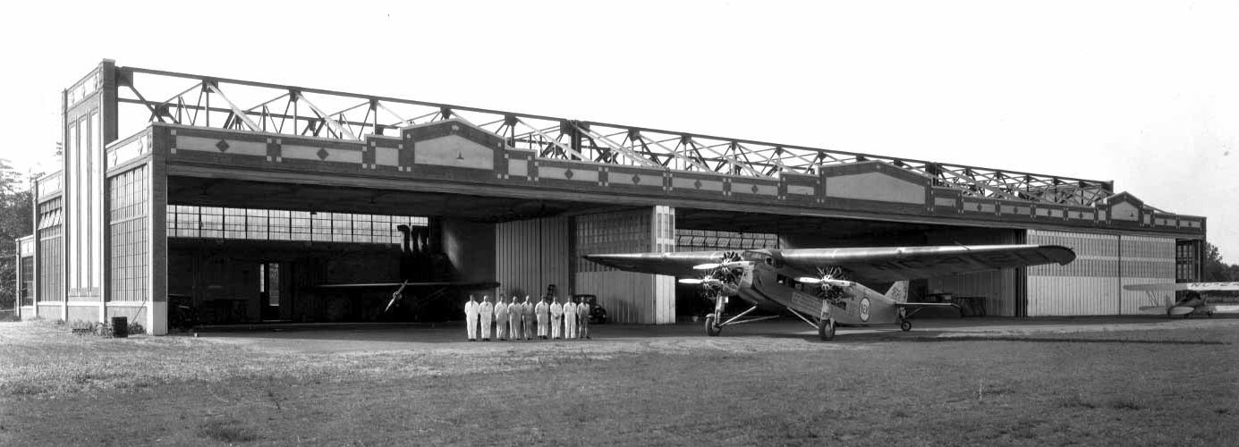
A circa 1930s photo of a Ford Tri-Motor & crew in front of the Bowles Agawam hangar (courtesy of Matt Lawlor).
According to Matt Lawlor, “New England & Western Air Transportation Airline (NEW) operated out of Springfield during the 1930s
but Springfield lacked sufficient hangar space for their fleet of Ford Tri-Motors so they were housed at Bowles-Agawam Field.”
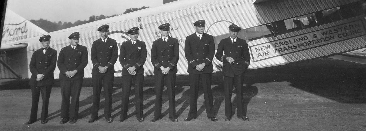
A circa 1930s photo of a New England & Western Air Transportation Airline crew in front of their Ford Tri-Motor at Bowles Agawam Airport (courtesy of Matt Lawlor).
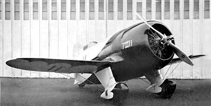
An undated photo of the Gee Bee R-1, taken at Bowles Agawam Airport,
According to Edwin More, the photo “was taken at Bowles/Agawam as I recognize the doors to the hangar.”
A 6/13/33 Hartford Courant newspaper article (according to Jonathan Westerling) said that Bowles Agawam Airport was “begging for a buyer.”
The earliest aeronautical chart depiction which has been located of Bowles-Agawam Airport
was on the June 1933 Albany Sectional Chart.
The 1934 Navy Aeronautical Chart (courtesy of Chris Kennedy) depicted Bowles-Agawam Airport as triangular-shaped.
The Agawam Bowles Airport may have been closed (for reasons unknown, but presumably related to the Great Depression) in 1934,
as it was not listed at all in the 1934 Commerce Department Aeronautical Bulletin (according to Jonathan Westerling).
According to Jonathan Westerling, “The owners of the private airfield had apparently come on hard times with the depression.
With no takers, the property was sold in foreclosure in 1935”, as described in a 6/2/35 Hartford Courant newspaper article (according to Jonathan Westerling).
An article in the New London Day (according to Jonathan Westerling) described how the buyer of the foreclosed property
sought to capitalize on a 1934 Massachusetts state law which legalized pari-mutuel betting on horse racing.
The new owners quickly turned the airport into a horse racing track, spending a million dollars on its construction.
Dean Quarrell reported, “Bowles Field closed as an airport in the early or mid 1930s.
A horse racing track called Agawam Park was superimposed on it, adding the grandstand, and converting the hangar to stables.”
A 1935 program described the races at Agawam Park.
Seabiscuit won the Springfield Handicap at Agawam in track record time in 1935.
A 1943 United Press article (according to Jonathan Westerling) described that the residents of Hampden County
outlawed betting on horse racing at Agawam Park by referendum in the November 1938 election & the racetrack was forced to closed its doors.
Agawam Bowles Airport was not listed among active airfields
in the 1938 Commerce Department Aeronautical Bulletin (according to Jonathan Westerling).
The 1938 USGS topo map depicted the open area of the airfield, but it was not labeled at all.
Strangely, the 4 runways within the circular outline depicted in the 1933 photo were no longer depicted at all.
Were these runways removed at some point?
Overall, this appears to show that the airport was no longer operating in 1938.
The 1938 topo map did depict the hangar & terminal building along the road on the east side of the field, however.
An October 1940 plan of “Proposed reconstruction & Redevelopment of Bowles-Agawam Airport (courtesy of Richard Starodoj)
depicted the 4 “old runways”, taxi circle, hangar, administration building, and the grandstand in the center.
However, inexplicably it did not depict any planned new construction.
Richard reported, “These plans came from the City of Springfield which apparently had a hand in running the airport.”
A November 1940 aerial view (from the MA Aeronautics Commission) looking northwest showed the grandstand & racetrack of Agawam Park occupying the former airport property,
and the elaborate Bowles Agawam hangar on the north side (right side of picture).
A January 1941 plan of “Proposed reconstruction & Redevelopment of Bowles-Agawam Airport (courtesy of Richard Starodoj)
still depicted the hangar & administration building,
but all of the features in the center of the property (the runways, taxi circle, and grandstand) were gone.
A 1943 United Press article (according to Jonathan Westerling) described that the after being idle for 5 years,
the city of Springfield recommended returning the property to aviation use as a municipal airfield in 1943.
The Bowles Agawam Airport was presumably reopened at some point between 1943-44,
as the 1944 US Army/Navy Directory of Airfields (courtesy of Ken Mercer)
described Bowles Agawam as having a 4,500' unpaved runway.
The 1945 USGS topo map still did not label the site as an airfield, which is inexplicable.
In addition to the original hangar & terminal building,
it also depicted a group of new buildings along the western edge of the airfield, which were apparently a grandstand.
According to Edwin More, “The grandstand was built for horse racing & operated only one season.”
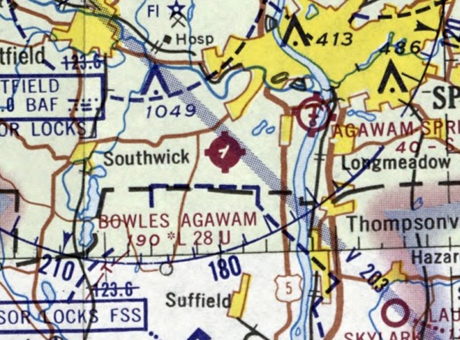
The January 1945 Albany Sectional Chart (courtesy of Chris Kennedy)
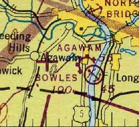
depicted both the Bowles Airport (with an auxiliary airfield symbol) as well as Agawam Airport & Seaplane Base (along the river).
The 1950 Albany Sectional Chart (courtesy of Mike Keefe)
described Bowles Agawam as having 3 runways, with the longest being 4,000'.
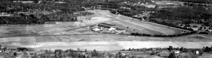
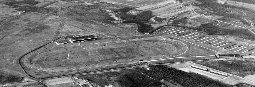
A circa late-1950s aerial photo looking southeast at Bowles Agawam Airport, showing the hangar & terminal building in the background,
and a grandstand facing the runways (courtesy of Harry Doherty).
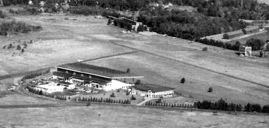
A closeup from the circa late-1950s aerial photo of the hangar, terminal building, and grandstand (courtesy of Harry Doherty).
Dean Quarrell reported, “In the 1950s, space in the grandstand was rented out to commercial & industrial firms,
or at least one such, an engineering company called Associated Engineers.
My Dad worked for AE in the 1950s & I recall visiting his office in the grandstand, which I thought was just too cool for words.”

A 4/15/57 USGS aerial photo showed Bowles Agawam Airport to have 2 runways, with 8 light aircraft on the east side.
The 1962 AOPA Airport Directory described Bowles Agawam Airport as having 2 asphalt runways: 2,775' Runway 4/22 & 1,735' Runway 10/28.
It listed the operator as New England Aero Tech, Inc.
A 1962 plan (courtesy of Richard Starodoj) depicted a proposal to rebuilding Bowles into a much-larger airport.
Richard reported, “These plans came from the City of Springfield which apparently had a hand in running the airport.”
The notes on the plan said “Race track buildings, stables, race track, old taxi circle, and old runways to be removed.”
In their place, 2 much-larger concrete runways (over 4,000' long), taxiways, and an apron were proposed to be added.
Apparently, this proposal was never carried out, for reasons unknown.
Edwin More recalled, “I earned my Private Ticket at the Bowles/Agawam Airport in the 1960s. It has quite a history.
Charlie Lucas was the manager & FBO for decades when it was owned by the Springfield Newspapers.
He told me that he was there for 30 years with only 30 day leases.
For a while he operated a mechanics school.
When I was flying there in Cessna 140s, Northamption Aviation out of LaFleur Airport had a satellite instruction operation there.”
Ross Roberts recalled, “I grew up just down the street from the airport & spent many hours as a youngster hanging around the 'huge hangar' & watching planes come & go.
It used to get particularly busy (and interesting) when the crop dusters were around spraying the local truck farms.
The administration building was always a source of interest & as youngsters we explored it though
the owners of the field weren't very happy about us being in the building due to its age, disrepair and the potential for injury...
but 14 year old male curiosity & adventure often overcame those adult concerns.
In fact during the summer of 1963 I worked as a line boy for a small charter flying & banner towing company, Trans-Air, Inc.,
run by John Lizek which had offices located in the hangar.
My Dad had restored a 1947 Taylorcraft & had it hangared at Bowles for many years
until the field was closed & sold for development much to his (and my own) dismay.
As a youngster my Dad used to ride out from Springfield & fly model planes in the far corner of the field beyond where the Grandstand was located.”
Jack Minnix recalled, “I worked for the Springfield Newspapers from 1964-69.
Sometimes in the winter, we had to go over to shovel snow off the roof of the grandstand there so it would not collapse.
As far back as I can recall, there was no racing going on - I always knew it as an airport,
so I am assuming that the racing took place either before or right after WWII.”

An undated aerial view from the 1965 MA Airport Directory (courtesy of Jonathan Westerling)
depicted Agawam Airport as having 2 paved runways: 2,275' Runway 5/23 & 1,735' Runway 10/28.
The hangar & several light aircraft were on the east side, and the former grandstand on the west side.
The Manager was listed as Charles Lucas, the Fixed Base Operators were listed as Trans Air & NE Aero Tech School, and the field was said to have a snack bar & restaurant.
The 1967 Albany Sectional Chart (courtesy of Mike Keefe) described Bowles Agawam as having 2 runways, with the longest being a 2,775' asphalt strip.
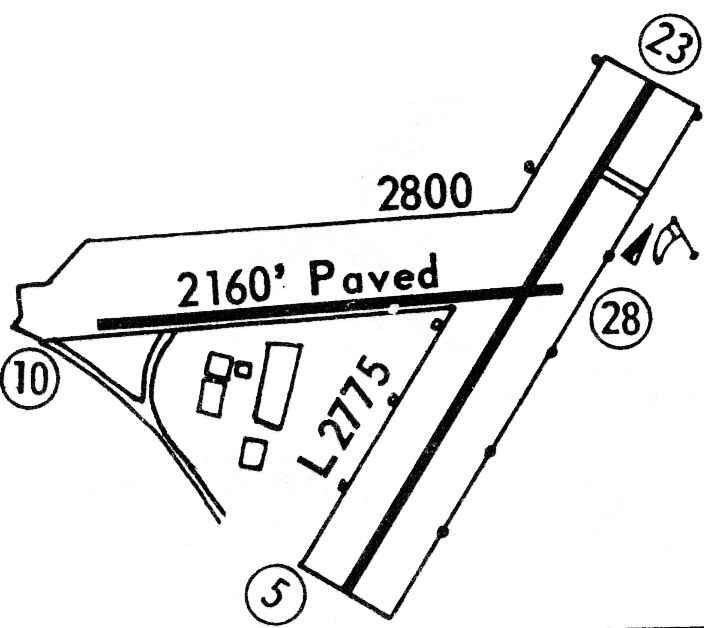
The 1968 Flight Guide (courtesy of Robert Levittan) depicted Bowles Airport as having 2 paved runways: 2,275' Runway 5/23 & 2,800' Runway 10/28, of which 2,160' was paved.
Several buildings were depicted to the southwest of the runway intersection.
Jack Minnix recalled, “The big hangar there was an imposing structure.
I remember a friend had a Cessna 172 hangared in it & he gave me one of my first airplane rides in 1970.
The terminal building at Bowles Airport remained on the field as long as I can remember but it was always closed up & obviously abandoned.”
The last aeronautical chart depiction which has been located of Bowles Agawam Airport was on the February 1970 Albany Sectional Chart.
It depicted Bowles Agawam as having 2 runways, with the longest being a 2,800' paved strip.
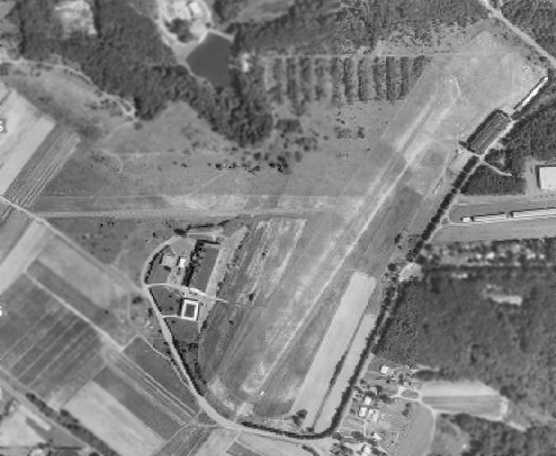
The last photo which has been located showing Bowles Agawam Airport still in operation was a 1971 aerial view.
It showed that the 40-year-old hangar & terminal building still remained standing on the east side of the field, as well as the grandstand on the west side.
A closeup from the 1971 aerial view, showing the hangar & 10 light planes on the northeast side of the field.
Jack Minnix recalled, “I did fly into Bowles many times in the 1970s.
It was a nice little active field with mostly single-engine aircraft.
I know there was a Baron that was based there as well & a Twin Beech.
The guy who owned the Baron was Ray Lucia & he used to land it on Runway 23,
assuming the winds cooperated, let it roll out to the end of the runway, attach it to a garden tractor & tow it off the airport property.
He took it through a break in those trees you can see in the late-1950s aerial view,
turned left onto that road that came from the grandstand to Silver Street,
across Silver Street and into his lumber yard to either tie it down or maybe he had a shed for it.
I think you can see the lumber yard or at least buildings where it was later on the extreme right side of the photo, about middle (vertically).”
The 1977 USGS topo map depicted Bowles Agawam as having 2 runways of roughly equal length.
It also depicted hangars & other buildings.
Ed Provost recalled, “Bowles Agawam... I can assure you that no aircraft operated out of that field after the summer of 1977.
I began working at a company nearby in Agawam that fabricated large deep-water floatation collars for the offshore oil drilling industry.
As we got busier & began looking for additional manufacturing space, in the early 1970s,
we rented the large, heated floor space on the ground level beneath the old grandstand building.
Our R&D lab, where I worked, was also relocated there, where I worked from 1974-80, at which time we were forced to vacate to 'allow for further development'.
Being an aircraft buff myself, I often sat outside & ate my lunch when weather allowed, watching single engine planes take off & land.
When the aircraft suddenly fell silent, I was told that the hangars & aircraft were going the same route as the grandstand & other buildings.
I was told this by one of our (older) engineers who was a former instructor in the Army Air Corps, and flew his Taylorcraft in & out of that field on occasion.
Sure enough, it wasn't long before I saw large X's being painted at the ends of the runways.”
The last photo which has been located of the Bowles Agawam Airport was a 4/17/80 USGS aerial view.
It showed that the 40-year-old hangar & terminal building still remained standing on the east side of the field,
as well as the grandstand on the west side, but there did not appear to be any aircraft on the field.
According to Matt Lawlor, “Apparently following the hangars' destruction in 1981
several of the Art Deco architectural pieces were donated to the Smithsonian & the EAA Museum in Oshkosh, though I have yet to find pictures of them.”
Jack Minnix recalled, “I flew up there from Teterboro one time in 1981 to see my mother who was living in Agawam.
When I called her to meet up with us on arrival, she said that she thought Bowles was closed; I told her that could not be.
Sure enough when I got up to the area and called Unicom, no answer.
Finally another aircraft came on & said that Bowles had closed a few months before.
This would have been the fall of 1981, so I think it closed in the summer of 1981.
It could have been as late as 1982 but definitely not after that.”
However, Bowles continued to be listed as an active airport in the 1982 AOPA Airport Directory (courtesy of Ed Drury).
It described Bowles Agawam as having a 2,775' asphalt Runway 5/23 & a 2,675' asphalt Runway 10/28.
The operator was listed as Lukas Aircraft Corp.
Curiously, Bowles continued to be depicted as an active airport in the 1985 Flight Guide (courtesy of Jonathan Westerling).
It described Bowles Agawam Airport as having a 2,800' paved Runway 5/23 & a 2,675' paved Runway 10/28.
A total of 8 buildings were depicted on the southwest & northeast sides of the field.
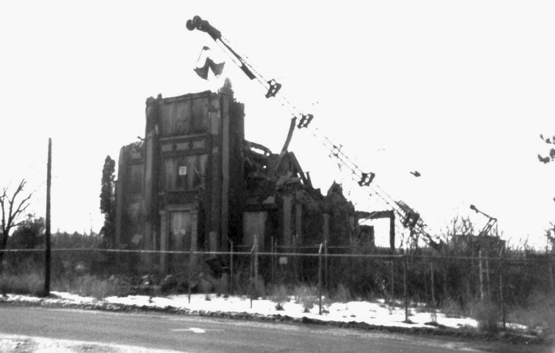
A sad sight for anyone who appreciates aviation history: a circa 1980s-90s photo of the demolition of the Bowles Airport Administration Building, to make way for an industrial park.
According to Matt Lawlor, "The first new development of the field didn't start till the late 1980s & early 1990s."
By the time of the 1990 USGS aerial photo, the site had been completely redeveloped, with not a trace of the former airport appearing to remain.
Richard Starodoj of ECS reported in 2008, “We have been located in the industrial park at the former Bowles since 1990.
Our building is immediately west of the old 'large' hangar. The Millenium Press building is located where the hangar was.
There was still a small piece of asphalt from the old taxiway between our building & Northup Electric when we first moved here in 1990.”
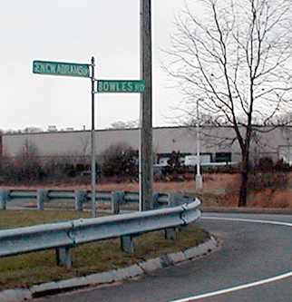
A 2003 photo by Jonathan Westerling: "A photo of the only 'relic' from the airport - [a street sign for] Bowles Road, which now runs through the site."
Jonathan Westerling visited the site of the Agawam-Bowles Airport in 2003.
"Unfortunately , I was unable to discover any aeronautical remains from the airport which had once been there.
It is evident that the whole property was dug up so that drainage could be installed
when the area was turned into an industrial park.
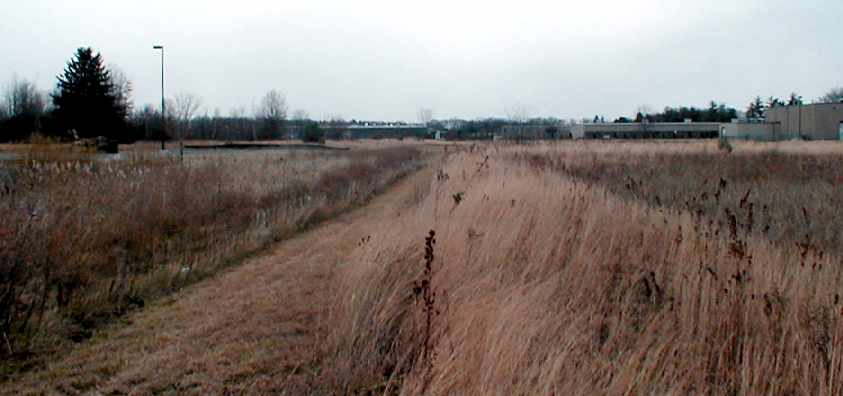
I did find some pieces of asphalt in the ground here [along the orientation of the primary runway],
but there is no way to tell if these came from the actual runway."
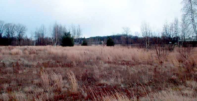
A 2003 photo by Jonathan Westerling, "Looking east along the orientation of the crosswind runway at Bowles."
A 2003 photo by Jonathan Westerling, "Looking north along the orientation of the primary runway at Bowles.
Note that the clearing to the right is a drainage ditch which was dug after the runway had been torn up."

A 2016 aerial view showed no trace remains of Bowles Airport.
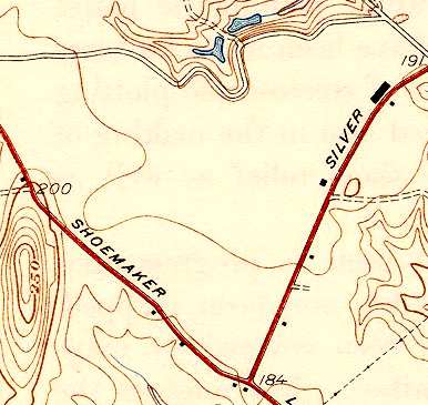
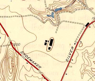
The site of Bowles Agawam Airport is located north of the intersection of Shoemaker Lane & Silver Street.
The name of the field lives on, as one of the new streets which covers the site of the airfield is named Bowles Road.
____________________________________________________
Springfield Airport, Springfield, MA
42.14, -72.58 (West of Boston, MA)
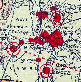
Springfield Airport (the red circle at the upper-right),
as depicted on the 1929 Rand-McNally Air Trails Map of Massachusetts (courtesy of Chris Kennedy).
The date of construction of the Springfield Airport has not been determined.
The earliest depiction which has been located of Springfield Airport
was on the 1929 Rand-McNally Air Trails Map of Massachusetts (courtesy of Chris Kennedy).
It described Springfield as a commercial airport, operated by the Springfield Airport Company.
The field was said to consist of a 3,000' x 3,000' area.

A circa 1920s sign used at various Curtiss Flying Service airports, this one to promote Curtiss Flying Service, Springfield Airport (courtesy of Tom Heitzman).
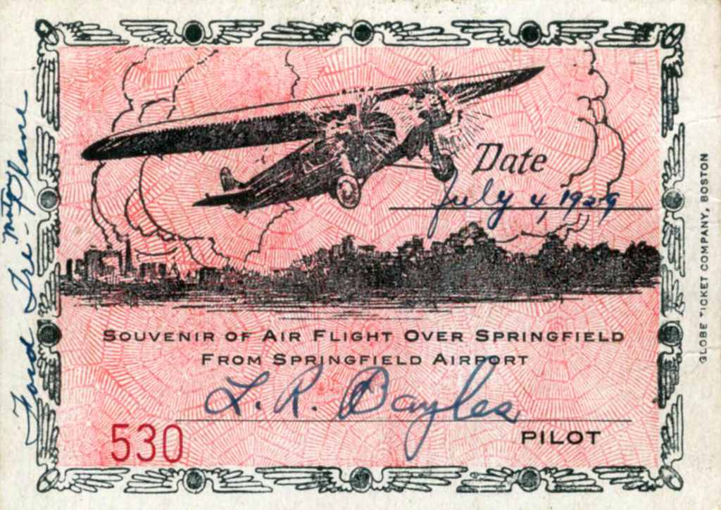
A certificate commemorating a 7/4/29 flight from Springfield Airport (courtesy of Tom Heitzman).
Note the certificate was signed by Lowell Bayles, who would go on to win the 1931 Thompson Trophy at the National Air Races.
Perhaps the greatest 'claim to fame' for the Springfield Airport came when it was home to the Granville Brothers,
the creators of the famous & outrageous "Gee Bee" series of racing planes in the 1920s & 30s.
Searching for adequate facilities to manufacture their biplane,
the Granvilles contacted the chamber of commerce of Springfield in 1929,
and on July 6 finalized plans to locate at the airport there.
Hoping to attract backers to finance production of their Gee Bees,
they entered their first air meet at Springfield on July 10.
Here they met the 4 Tait brothers, James, Harry, Frank and George,
owners of Springfield's biggest ice cream & dairy business, as well as developers of the Springfield airport.
George Tait handed Granny a check for $1,000
and told him to come back after he had put "a real engine" in their plane.
A few weeks later, Granville Brothers was incorporated,
building planes in an abandoned dance pavilion formerly named the Venetian Gardens at the Springfield airport.
Hard times descended on the Granvilles.
Ed & Mark rented an attic room and lived on beans which they purchased by the case.
In the fall of 1929, few men had the money to purchase anything as frivolous as a personal airplane
and the new corporation was on the verge of collapse
when the All America Flying Derby was organized & sponsored by American Cirrus Engines, Inc.
This was to be the longest air race held in the world at the time -
a 5,541-mile course that took the contestants from Detroit to Texas, west to California, and back to Detroit.
All the entries were powered by one of the engines manufactured by the sponsor, either the Cirrus or Ensign engine.
Eighteen entries competed in this event and the Granvilles were among them.
The engineering team, spearheaded by Bob Hall, had produced the Model X,
a trim little low-wing monoplane finished in black & white,
powered by an American Cirrus engine supercharged by a Roots blower to develop 110 hp at 2100 rpm.
The Model X was flown by Lowell Bayles, a quiet, slim bachelor who was flying as copilot on the Fords
the Tait's owned & operated between Boston, Springfield and Albany.
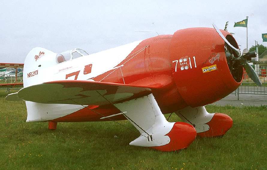
A 1996 photo of a replica of the Gee Bee R-2.
The location of Springfield Airport, as depicted on the 10/7/29 National Air Tour Souvenier Banquet program (courtesy of Tom Heitzman).
The location & layout of the Springfield Airport
as depicted on the 2/28/30 Department of Commerce Airway Bulletin (courtesy of Jonathan Westerling).
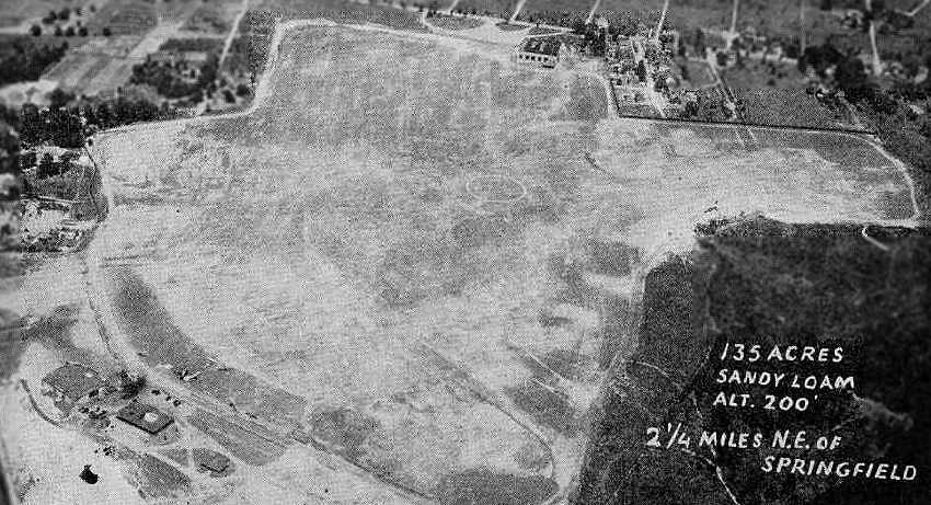
It described the field as consisting of a 140 acre irregularly-shaped sandy field, with 2 brick & wood hangars.
Springfield was characterized as a commercial field, owned by Harry Tait, and operated by the Springfield Airport & Aeronautical School.
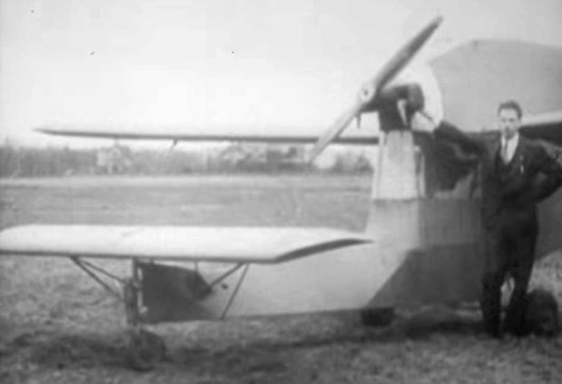
The earliest photo that has been located of the Springfield Airport was a 1931 photo of Zantford Granville
in front of his bizarre looking canard Granville Ascender at Springfield Airport (from a video courtesy of Jonathan Westerling).
The earliest aerial photo that has been located of the Springfield Airport
was an aerial view looking northeast from the Airport Directory Company's 1933 Airports Directory (courtesy of Chris Kennedy).
The directory described Springfield Airport as consisting of an irregularly-shaped 125-acre sandy field.
Two hangars were depicted on the southwest side of the field, with another larger hangar on the northeast side.
The airport manager was Edmund Fisher.
The operators were listed as the Axtman-Spooner Flying Service, Balturn Aviation School,
Brinton-Bayles Flying Service, Commuter Air Service, Inc.,
Dashwood Radio Service, Granville Brothers Aircraft Company, and Inter-City Airlines, Inc.
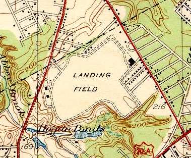
The 1933 USGS topo map labeled Springfield Airport simply as "Landing Field".
It was depicted as an irregularly-shaped field,
with a single building (a hangar?) along the east side of the field,
and 2 smaller buildings along the west side of the field.
The earliest aeronautical chart depiction which has been located of Springfield Airport
was on the June 1933 Albany Sectional Chart.
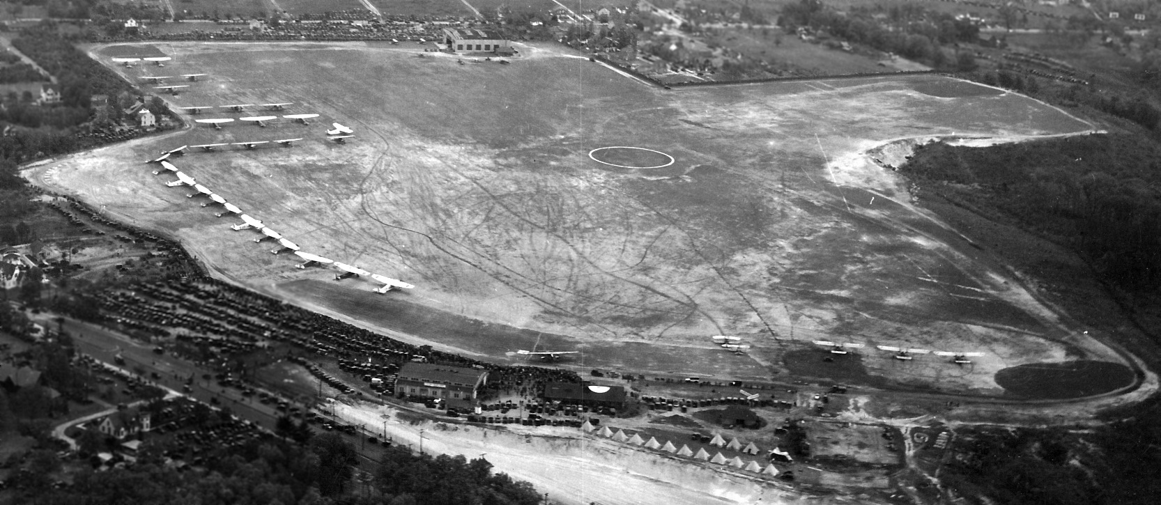
A circa 1930s aerial view looking northeast at Springfield Airport during a mass gathering of aircraft & spectators (courtesy of Lowell Scott).
Jim Malone recalled, “l was born in Springfield in 1934, and spent many days of my youth at & around the airport.
There were air shows performed there on Sunday's in the late 1930s & early 1940s.
I walked there with my parents & sister. We would crane our necks upward to watch the loops, rolls & spins.
People were still in awe of aviation at that time. I watched an autogyro land & take off.
I went for a ride in the 'Tydol Flying A' blimp. The following day the blimp was severely damaged by a wind storm.
Most of the planes at the airport were Piper Cubs, and Aeronca Scouts, but there others: a Beech Staggerwing, an Aerocoupe, a couple of Stearmans among them.
Sky writers operated from there. They were fairly frequent then. Blimps with advertising light panels also frequented the airport; the Tydol was one.”
An aerial view looking southeast at Springfield Airport,
from the Airport Directory Company's 1937 Airports Directory (courtesy of Bob Rambo).
The directory described Springfield Airport as consisting of an irregularly-shaped sandy field,
with hangars & buildings to the north, northeast, and west.
The 1937 “Progress Report of the Committee For Aeronautics of the Commonwealth of MA” (courtesy of Jonathan Westerling)
depicted Springfield Airport as an irregularly-shaped 120 acre sod field,
within which the longest landing distance was 2,900' northeast/southwest.
It was described as a commercial airport, owned by Harry Tate Interests & Liberty Realty Company,
and operated by Springfield Airport & Aeronautical School Inc.
Two hangars & an administration building were depicted on the west side of the field.
Chuck Lupien recalled, “I lived on Hungry Hill, a section in Springfield, and within walking distance of the field.
Only a short trek north on Liberty Street.
My mother worked at Hogan's Liberty Ice & Fuel Company, which was even closer to the airport when I stopped in from Glenwood School & Van Sickle schools to see her.
The first airplane ride in my life was there, in a Piper Cub, at around 8 years old.
My buddy & I were hanging around the building where the pilots were & one offered to take us for a ride. It was the thrill of our life.
And my mother didn't even know it until I got home. Such events wouldn't happen today. But this was in the very early 1940's.”
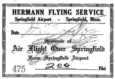
A Hermann Flying Service certificate commemorating a September 1942 flight from Springfield Airport (courtesy of Terri Colelli).
Terri Colelli reported, “My mom, who is 92 years old, recalls the flight as if it took place recently.
She & 2 friends went to the airport together but got to fly in separate planes, which all took flight around the same time.
My mom recalled that she was able to see her girlfriend in the air & wave to her!
It appears that they paid $2/person. The pilot (first name Stan) signed the ticket in the wrong place.”
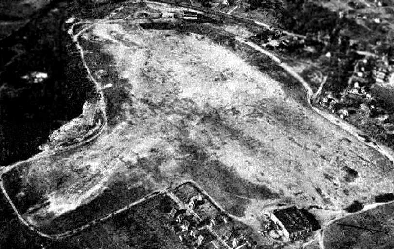
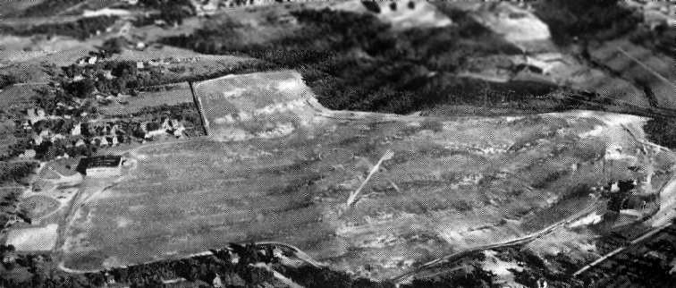
A 10/27/42 aerial view looking west at Springfield Airport from the 1945 AAF Airfield Directory (courtesy of Scott Murdock)
depicted the field as an open grass area with a hangar on the east side.
The 1944 US Army/Navy Directory of Airfields (courtesy of Ken Mercer)
described Springfield Airport as having a 2,600' unpaved runway.
The 1945 AAF Airfield Directory (courtesy of Scott Murdock) described Springfield Airport
as a 167 acre irregularly-shaped field with a loam & sod all-way landing area, with the longest dimension being 2,550' northeast/southwest.
The field was said to have a single 138' square concrete hangar,
and to be privately owned & operated.
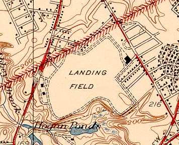
Springfield Airport was still labeled simply as "Landing Field" on the 1946 USGS topo map.
The last aeronautical chart depiction which has been located of Springfield Airport was on the November 1953 Albany Sectional Chart.
It depicted Springfield Airport as having a 2,400' unpaved runway.
Springfield Airport was apparently closed (for reasons unknown) at some point between 1953-54,
as it was no longer depicted by the time of the May 1954 Albany Sectional Chart.
A 4/1/57 USGS aerial view showed Springfield Airport remained intact, but there were no aircraft visible or other signs of recent use.
One hangar remained each on the west & east sides.
According to Harry Doherty, at the eastern end of the airport property, “in the mid-1960s there was still a hangar there
and the building was used by the Basset Boat Company.
On the outside of the this hanger you could still see the lettering 'Springfield Airport' painted across the top.”
A 1967 aerial view showed that the west end of the Springfield Airport property had been redeveloped as the Springfield Plaza shopping center,
but the hangar remained standing on the east end.
According to Ed Holda, “The Springfield Airport became the site of the Springfield Plaza.
One of the airport buildings, taller than other parts of the mall and referred to as 'the tower' was incorporated into the plaza at one time.”
A 1971 aerial view showed the former Springfield Airport hangar which remained standing on the east side of the field.
A clue as to the former role of the property could still be seen on the 1979 USGS topo map,
on which a survey marker named "Springport" could still be seen.
A 1995 aerial photo showed the former Springfield Airport hangar on the east side of the field was evidently removed at some point between 1971-95.
Harry Doherty recalled in 2005, “My father donated the original beacon from Springfield Airport
to the Bradley Air Museum in CT.”
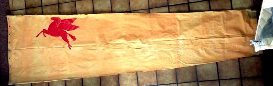
A 2013 photo by Tom Heitzman, who reported, “I just purchased purchased the last windsock used at Springfield Airport when it closed in the early 1950s.
It was brought to Agawam airport by the FBO Wally Hagberg when he transferred his operation there.
The manager of the field was selling some other fuel besides Mobil & wouldn't use it.”
A 2016 aerial view showed no trace remaining of Springfield Airport.
The site of Springfield Airport is located south of the intersection of Broadway Street & Saint James Avenue.
____________________________________________________
Or if you prefer to contact me directly concerning a contribution (for a mailing address to send a check),
please contact me at: paulandterryfreeman@gmail.com
If you enjoy this web site, please support it with a financial contribution.
____________________________________________________
This site covers airfields in all 50 states.