Abandoned & Little-Known Airfields:
Eastern Maryland
© 2002, © 2025 by Paul Freeman. Revised 8/23/25.
This site covers airfields in all 50 states: Click here for the site's main menu.
____________________________________________________
Please consider a financial contribution to support the continued growth & operation of this site.
Barren Island Airfield (revised 2/16/25) - Carroll Airport (added 6/4/21) - Castle Marina Airport (revised 10/14/20) - Gill Airport / Scheeler Field (revised 8/23/25)
Hebron Airport / Del-Mar-Va Airport (revised 12/3/17) - Horn Point Aerodrome (revised 6/28/25) - Talisman Farm (revised 2/16/25) - Tred Avon Airport / Webb Airport (revised 6/28/25)
____________________________________________________
38.95, -76.26 (East of Annapolis, MD)
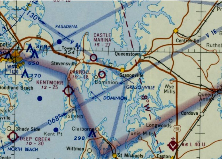
Carroll Airport, as depicted on the April 1965 Washington Sectional Chart.
Photo of the airport while open has not been located.
This little general aviation airport on Kent Island was evidently established at some point between 1960-64,
as it was not yet depicted on the July 1960 Washington Sectional Chart or the 1961 USGS topo map.
The earliest depiction which has been located of Carroll Airport was on the 1964 Washington Sectional Chart.
It described Carroll Airport as having an 1,800' turf runway, but listed the field as “Closed Until Further Notice field soft.”
The earliest depiction which is available of Carroll Airport was on the April 1965 Washington Sectional Chart.
It depicted Carroll Airport as having an 1,800' unpaved turf runway.
Ray Stinchcomb reported of 2 Piper J-3 landings he logged at Carroll Airport after round-trips from Lee Airport: 7/6/66 in N98224 & 7/18/66 in N70255.
Ray recalled, “I’m pretty sure that they had a snack bar or something to fly in & have lunch.”
The last depiction which has been located of Carroll Airport was on the March 1967 Washington Sectional Chart.
It depicted Carroll Airport as having a 2,000' unpaved turf runway.
Carroll Airport evidently lasted less than a decade, and was closed (for reasons unknown) at some point between 1967-71,
as it was no longer depicted on the 1971 Washington Sectional Chart nor the 1973 USGS topo map.
The precise location of the former Carroll Airport has not been determined.
A 1982 aerial view did not show anything recognizable as a former airfield.
A 2019 aerial view did not show anything recognizable as a former airfield at the general location of Carroll Airport.
____________________________________________________
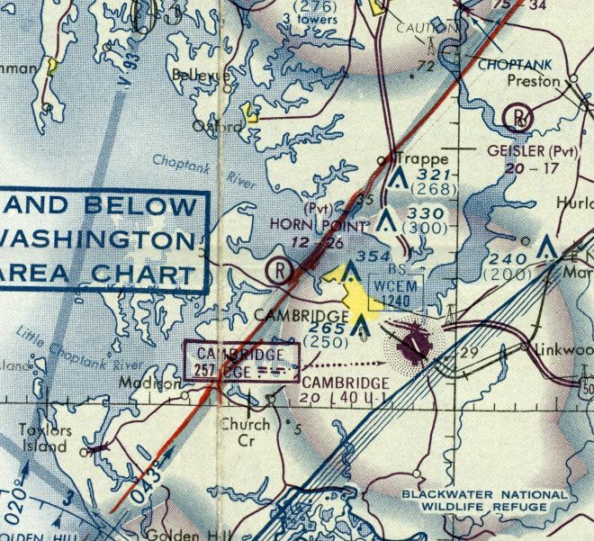
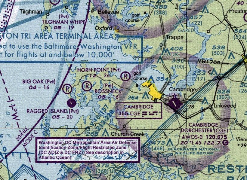
Horn Point Aerodrome (MD18), Cambridge, MD
38.588, -76.138 (Southeast of Washington, DC)
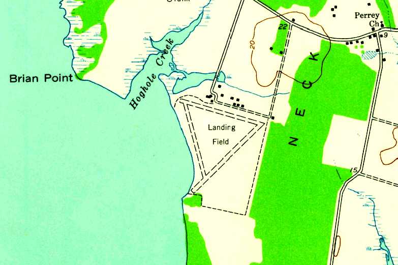
Horn Point Aerodrome, as depicted on the 1942 USGS topo map.
Horn Point Aerodrome was not yet depicted on the 1929 USGS topo map.
According to Fred Kelso, “Horn Point Aerodrome... was built in 1937 by Francis DuPont, who had inherited the Horn (or Horn's) Point Farm,
as a private landing strip for his Chesapeake Bay hunting lodge.”
The earliest depiction which has been located of Horn Point Aerodrome was on the 1942 USGS topo map.
It labeled an open area generically as “Landing Field”, with 1 hangar on the west side.
The Horn Point Aerodrome was not depicted on Washington Sectional Charts from the 1950s thru 1971.
According to Fred Kelso, “The property remained private until 1968, when the family gave it to the City of Cambridge, MD. The City gave it to the State in 1971.
Starting in 1971 the Potomac Antique Aero Squadron (PAAS) held its Antique Airplane Fly-In at Horn Point Aerodrome.
The fly-ins would continue on an annual basis at Horn Point for 44 years.
According to Fred Kelso, “The hangar was for many years used as the Dorchester (County) Heritage Center, and housed aviation memorabilia, among other local items.”
According to its FAA Airport/Facility Directory data, Horn Point Aerodrome was activated in March 1974.
Fred Kelso noted “I'm guessing the airfield first shows up in the FAA records in 1974 upon being re-opened sometime between 1971-74 for public use.”
The earliest aeronautical chart depiction which has been located of Horn Point Aerodrome was on the 1976 Washington Sectional Chart (courtesy of Jonathan Westerling).
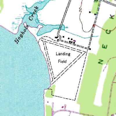
It depicted Horn Point as a private airfield having a 2,600' unpaved runway.
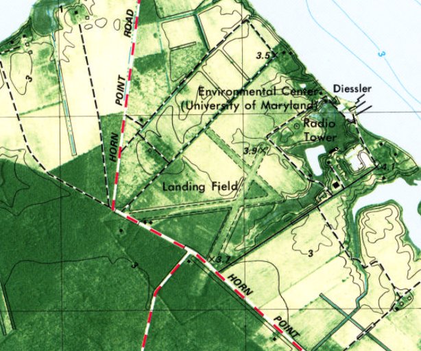
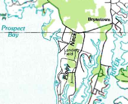
The 1982 USGS topo map depicted Horn Point Aerodrome as having 3 unpaved runways, generically labeled as “Landing Field”.
Gwen Shafer recalled, “In 1986 I flew in to the Antique Fly In at the Horn Point Aerodrome.
It was a grass strip built on top of gravel to ensure good drainage. A lovely runway. My impression was that it is rarely open as an airport.”
Fred Kelso reported, “The glowing praise for the 3-runway grass field is testament to the wealth of the DuPont family and their love of aviation.”
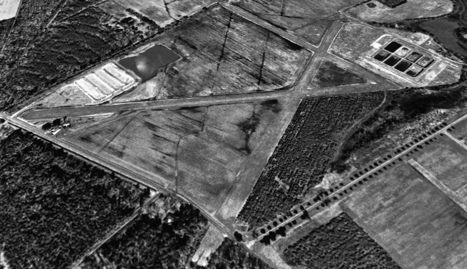
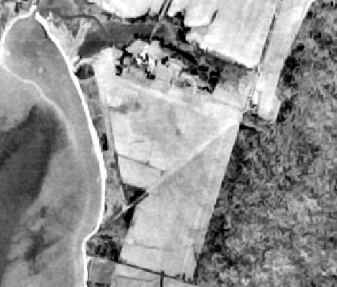
The earliest photo which has been located of Horn Point Aerodrome was a 1994 USGS aerial view looking north.
It depicted Horn Point Aerodrome as having 3 grass runways, with a few small buildings on the west side.
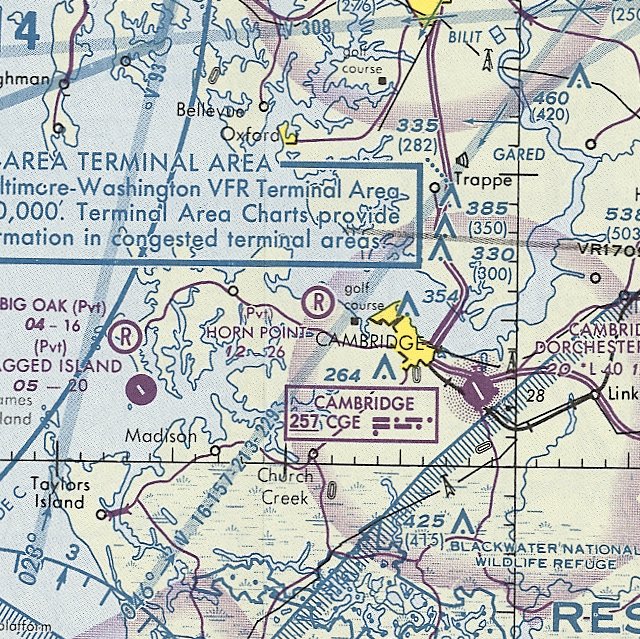
The March 1994 Washington Sectional Chart depicted Horn Point as having a 2,600' unpaved runway.
The last aeronautical chart depiction which has been located of Horn Point Aerodrome was on the 2008 Washington Sectional Chart (courtesy of Jonathan Westerling).
It depicted Horn Point as having a 2,600' unpaved runway.
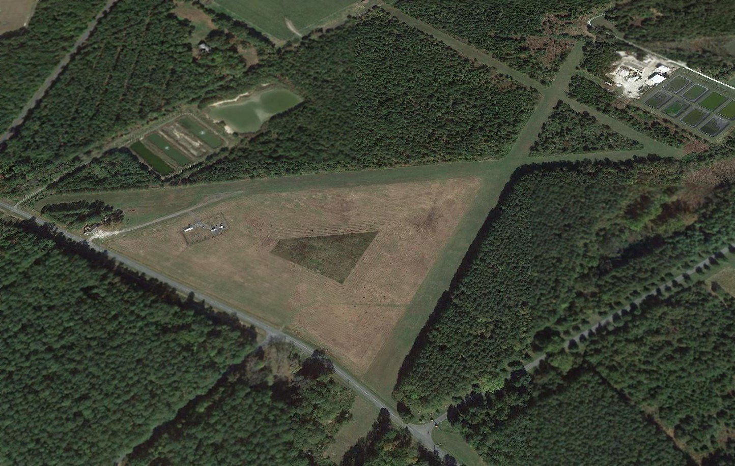
A 2013 aerial view looking north depicted Horn Point Aerodrome as remaining intact, including its 3 grass runways & the small buildings on the west side.
The Potomac Antique Aero Squadron (PAAS) held its last Antique Airplane Fly-In at Horn Point Aerodrome in 2015,
before moving subsequent Fly-Ins to Massey Aerodrome.
At the end of its lifespan, Horn Point Aerodrome's FAA Airport/Facility Directory data indicated it was owned by the University of MD, with the manager listed as Jeff Miley.
It was said to have 3 turf runways, with the longest being 2,650' Runway 9/27.
Horn Point Aerodrome was evidently closed at some point between 2015-2016, as it was no longer depicted on the 2016 Washington Sectional Chart.
Fred Kelso reported in 2019, “The farm now houses The University of MD Center for Environmental Science (UMCES) Horn Point Lab, a sprawling center of ecological study.”
Thanks to Gwen Shafer for pointing out this airfield.
____________________________________________________
Barren Island Airfield, Barren Island, MD
38.34, -76.26 (Southeast of Washington, DC)
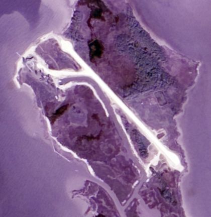
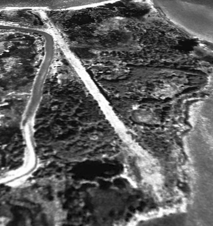
A 9/23/72 USGS aerial view of Barren Island Airfield.
Barren Island is a tiny island on the east side of the Chesapeake Bay,
best known for suffering increasing erosion which is making the island disappear.
A hunting lodge was built on Barren Island in 1929 using materials scavenged from the Caswell Hotel demolition in Baltimore, and barged over from Solomons Island.
The Barren Island Airfield was not yet depicted on a 1957 aerial view.
Maryland state Comptroller Louis Goldstein bought both Barren Island & its hunt club from for $55,000 in the early 1960s.
“I got the guns & all”, he said gleefully. He didn’t keep it for long, and subsequent owners were faced with the rapid erosion of the island’s west face.
At some point between 1957-72 a single unpaved northwest/southeast runway was built across the northern end of the runway,
presumably to provide fly-in access to the hunting lodge.
The earliest depiction which has been located of the Barren Island Airport was a 9/23/72 USGS aerial photo.
It depicted Barren Island Airfield as having a single northwest/southeast runway,
with turnaround pads at each end, and taxiways at either end leading to a few small buildings.
According to Richard Wilson, “I know Barren Island [Airfield] was there & still operational during the 1970s.
I was an airport brat & wanted to fly down there after the 'Pilots Preflight' magazine article that was around 1975 - but never got in there.
It was sort of an exclusive place for the 'high rollers'.”
The 1978 USGS topo map did not yet depict any airfield on Barren Island, nor did the 1976/78/81/89/94 Washington Sectional Charts.
Dawn King recalled, “My husband was a pilot employee for the company James Jackson Associates in 1981. He flew for them in VA & MD, and Mr. Jackson owned the island.
They flew between properties he owned in Frederick MD, Easton MD, Richmond VA & Barren Island.
They flew frequently in that spring of 1981. Jeffrey flew into the strip at Barren Island for Mr. Jackson & his guests.
Jeffrey flew a Skymaster & Cessna 310 into that airstrip many times.
He & I stayed at the hunting lodge for maybe a week once as temporary caretakers (but we took a small boat over).
Jeffrey thinks he was probably the last pilot to fly into that airstrip on Barren Island in mid-1981.”
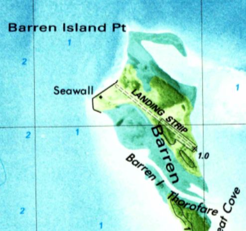
The 1984 USGS topo map depicted Barren Island Airfield as a single unpaved northwest/southeast runway, labeled simply as “Landing Strip”.
A 4/7/94 USGS aerial view looking northwest showed the Barren Island runway to remain quite distinct.
Barren Island's hunting lodge still stood in 2001, but by the following year only its foundation remained.
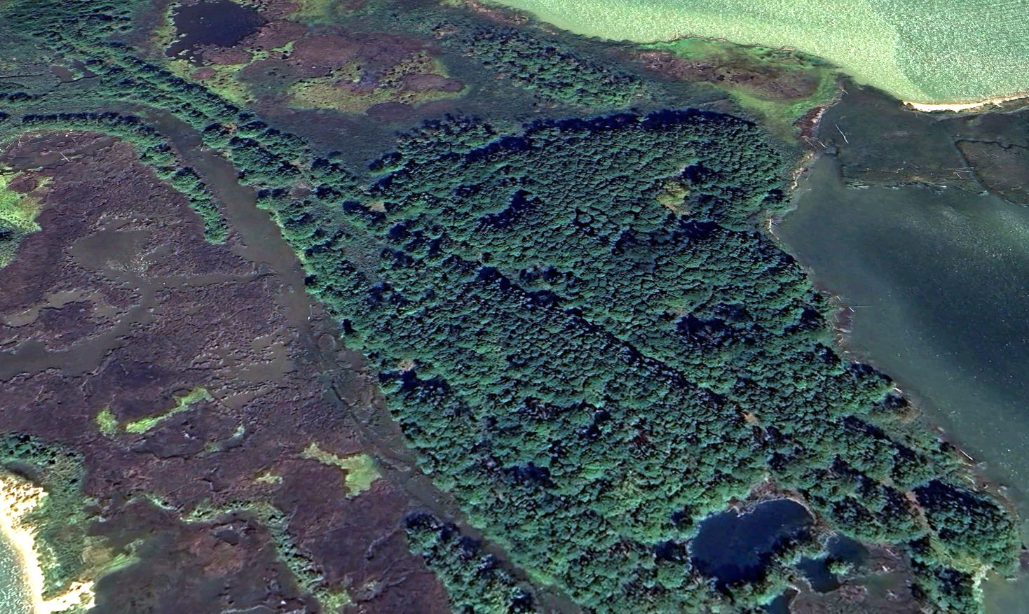
A 2024 aerial view looking north showed the Barren Island runway to be overgrown still barely recognizable.
Thanks to Richard Wilson for pointing out this airfield.
____________________________________________________
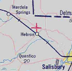
Hebron Airport / Del-Mar-Va Airport, Hebron, MD
38.43, -75.68 (Southeast of Washington, DC)
Hebron Airport, as depicted on the 1929 "Rand McNally Standard Map of MD with Air Trails" (courtesy of Chris Kennedy).
This small airport apparently operated for a mere 2 years.
According to the book "Maryland Aloft" by Preston, Lanman, and Breilhan,
"Hebron Airport was established in 1928 by Starlighters, Inc., a group whose president was Major Charles Bayer.
Its opening day was celebrated on Labor Day of that year, with exercises that included a well-attended air show.
The program for the event explained that the new facility would exploit the Eastern Shore as a 'Flyer's Paradise',
offering such services as passenger flights, instruction, and aerial surveys.
The operators announced a strong stand for safety, stating that pilots who offered passenger rides should be referred to them for evaluation."
The book continued, "The airport boasted assets that included a hangar, and Aero-Club building, a club house for field personnel,
and 'one of the longest runways to be founding in any aviation field, a runway a mile & 3/8ths in length'.
Although identified as Hebron Airport by lettering on a barn roof,
the facility was also known by the name of Del-Mar-Va Airport & by variants of that designation."
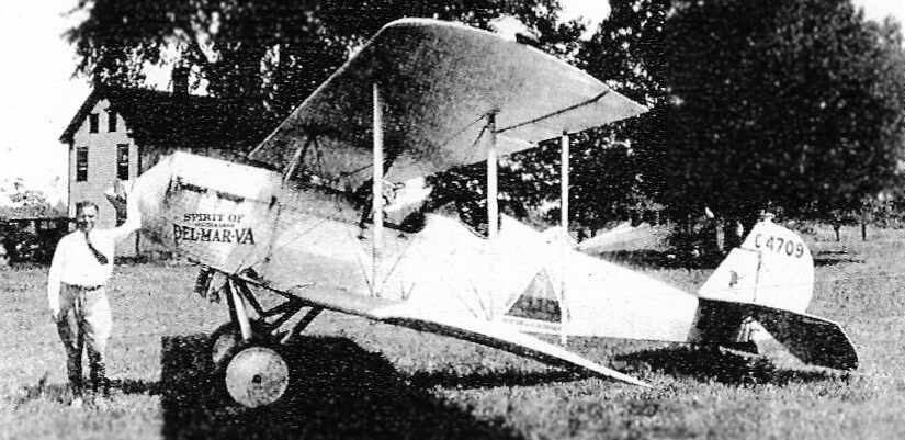
A 1930 photo of of Colonel Bayer with his American Eagle biplane at the Hebron Airport
(courtesy of the Mardela Springs Historical Society, via Joe Collins).
According to the book "Maryland Aloft" by Preston, Lanman, and Breilhan,
"John Scott reported that the airport's closing on 3/8/30 was followed by a legal dispute among its founders.”
The 1931 Commerce Department Descriptions of Airports & Landing Fields (courtesy of David Brooks)
described Del-Mar-Va Airport as a commercial airport consisting of a 250 acre irregularly-shaped sod field measuring 4,725' x 3,696'.
According to the book "Maryland Aloft" by Preston, Lanman, and Breilhan,
"Most listings after 1931 described it as an auxiliary facility rather than a commercial one."
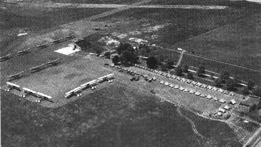
A 1932 photo of Keystone bombers & a tented camp of the Army Air Corps 59th Bomb Group at the Hebron Airport (note the intersecting runways in the background).
Photo courtesy of the Dundalk-Patapsco Neck Historical Society, from the book "Maryland Aloft".
Hebron Airport, as depicted on the May 1932 J-18 Washington D. C. Airway Map (courtesy of Chris Kennedy).
According to the book "Maryland Aloft" by Preston, Lanman, and Breilhan, “Airport directories continued to list Del-Mar-Va as late as 1933.”
The Hebron / Del-Mar-Va Airport was evidently closed (for reasons not determined) at some point between 1933-34,
as it was no longer listed in the 1934 Commerce Department Descriptions of Airports & Landing Fields (courtesy of David Brooks)
nor depicted on the 1935 Washington Sectional Chart.
No airport in Hebron was listed among active airfields in the 1945 AAF Airfield Directory (courtesy of Scott Murdock).
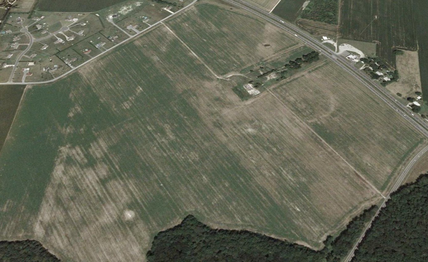
A 2005 aerial view looking north showed the airfield area of the former Hebron Airport was still intact.
Most remarkably, the features in the center of the photo (the tree-lined road leading to the concrete ramp & hangar foundation at the end of the road)
were unchanged from their appearance in the 1932 photo at the top of this entry.
This is amazing, considering that this little airport apparently only operated for a very brief period of time - a mere 2 years.
Annette Abbott reported in 2006 about the old Hebron Airport site, “The home that once stood here was torn down last year.
It sounds like they are planning to build a shopping center here so the airfield will no longer be. I hate to see it go.”
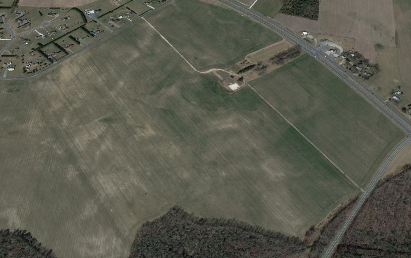
A 2013 aerial view looking north showed the Hebron Airport site remained unredeveloped, with the concrete ramp & hangar foundation remaining visible.
The site of Hebron Airport is located northwest of the intersection of Route 50 & Route 347.
____________________________________________________
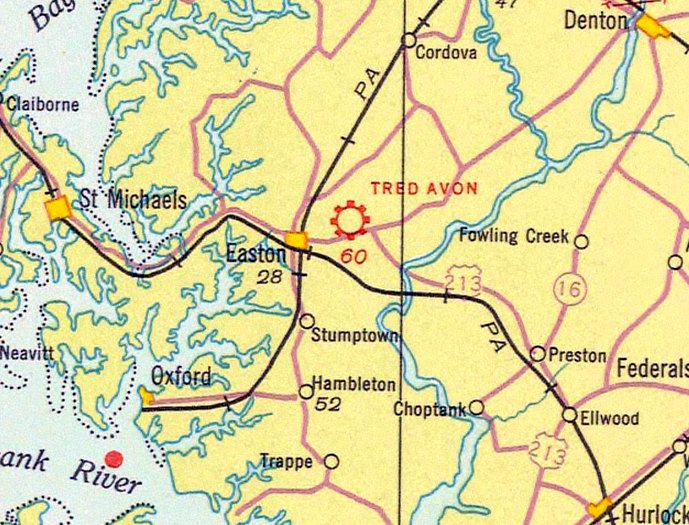
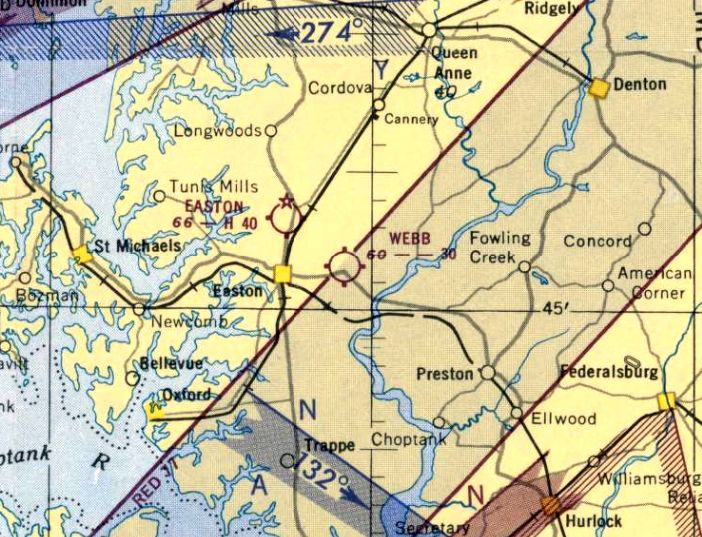
Tred Avon Airport / Webb Airport, Easton, MD
38.78, -76.02 (East of Annapolis, MD)
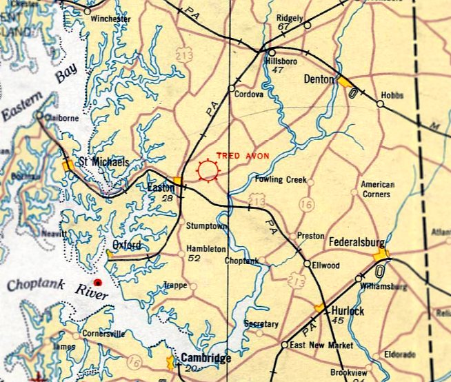
Tred Avon Airport, as depicted on the May 1932 Washington Sectional Chart.
According to an article in the 10/17/02 issue of the Star Democrat (courtesy of Carey Dorset),
Webb Airport was built in 1930 by Dorsey Webb on his farm at Dover Road & Black Dog Alley.
It replaced the airfield at Ratcliffe Manor (Talbot County's first airstrip), which had become too small.
This airfield was also known as Tred Avon Airport.
According to Will Webb, “Webb Airport was owned by my grandfather, Dorsey Webb.
He owned a crop duster & went barnstorming frequently.
According to his son, William Webb (my father), Dorsey flew at various air shows & took people up for rides in his plane.”
Like all airports in the days before formal air traffic control & accurate charts,
its name was printed on the hangar roof, along with an arrow pointing north.
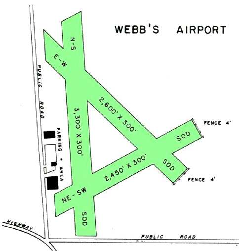
Webb Airport boasted 3 grass runways, the longest about 3,500'.
Thanks to fires in clay pots, nighttime takeoffs and landings were possible.
A local legend says that Dosey Webb wanted an airport on his farm to transport bootleg whiskey.
The earliest official listing which has been located of Tred Avon Airport
was in the 1931 Commerce Department Descriptions of Airports & Landing Fields (courtesy of David Brooks).
It described Tred Avon as a 170 acre triangular sod field having 4 mowed runways, the longest measuring 3,400' east/west.
The earliest depiction of Tred Avon Airport which has been located was on the May 1932 Washington Sectional Chart.
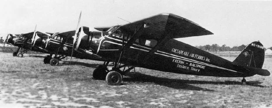
An undated photo of 3 Stinsons of Chesapeake Air Ferries Inc. at Webb Field (courtesy of Carey Dorset).
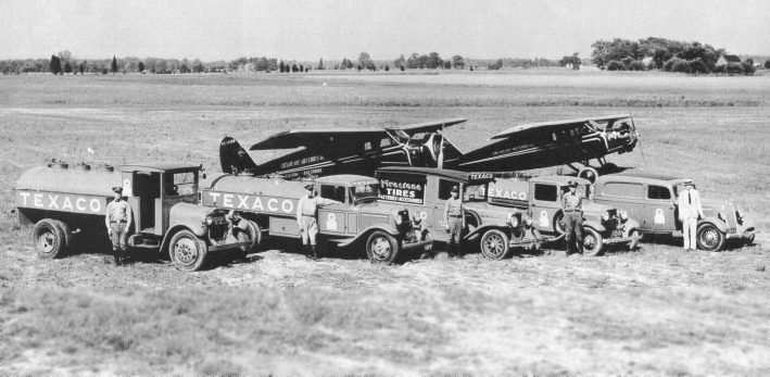
A 1930s photo of 2 Stinsons of Chesapeake Air Ferries at Webb Field.
Malcolm & Steve Hathaway moved their flying service from Ratcliffe Manor to Webb Airport,
and renamed the company Chesapeake Air Ferries.
The company obtained a "certificate of convenience" in 1933 to conduct scheduled passenger & cargo flights within MD.
According to the book "Maryland Aloft" by Preston, Lanman, and Breilhan,
"A directory issued for 1933 showed an aerial view of the 175-acre airport.
The unpaved airfield was triangular in shape, its longest runway measuring 3,500'."
The 1935 Washington Sectional Chart depicted Tred Avon Airport as a commercial/municipal airport.
A 1937 aerial view of Tred Avon Airport, from the Dallin Aerial Survey Collection,
courtesy of Barbara Hall of the Hagley Museum & Library, Wilmington, DE.
A 1937 closeup of the hangar & ramp at Tred Avon Airport, from the Dallin Aerial Survey Collection,
courtesy of Barbara Hall of the Hagley Museum & Library, Wilmington, DE.
The Airport Directory Company's 1938 Airport Directory (courtesy of David Brooks) described Tred Avon as a commercial airport,
having 3 sod runways, of which the longest was the 2,600' northwest/southeast strip.
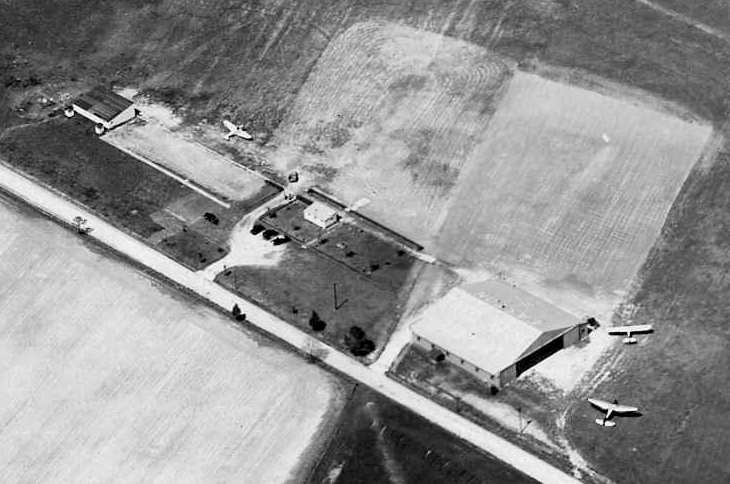
A circa 1940 aerial view looking northeast at Webb Airport, showing 2 hangars & 15 single-engine light aircraft.
The large hangar had “Webb's Airport” painted on its roof.
Webb & Malcolm Hathaway ran flying services at Webb Airport until Hathaway joined the Navy at the outbreak of WW2.
It was depicted as "Tred Avon" Airport on the 1940 & 1942 Washington Sectional Charts (courtesy of Mike Keefe).
According to the book "Maryland Aloft", Webb Airport was closed for the duration of the war in 1942,
like many civilian airports within 100 miles of the coast.
Furthermore, it was replaced as Easton's primary airport by the newly constructed Easton Airport,
which was built by the Army in 1942 as a practice & emergency field, and turned over to the Town of Easton after the war.
Webb Airport was not depicted on the 1942 USGS topo map, the 1944 Washington Sectional Chart (courtesy of Mike Keefe),
or the 1945 Annapolis AAF Aeronautical Approach Chart (courtesy of Mike Keefe), or the 1945 USGS topo map.
However, Webb Airport was apparently reopened at some point between 1945-46,
as both Webb Airport & Easton Airport were depicted as active airfields on the 1946 Washington Sectional Chart (courtesy of Mike Keefe).
The 1947 Washington Sectional Chart depicted Webb as having a 3,300' unpaved runway.
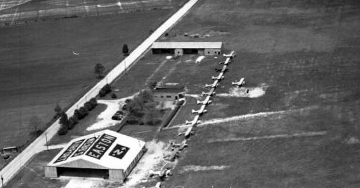
"Webb's Airport" was depicted as an active field in the 1950 MD Airport Directory (courtesy of Stephen Mahaley).
It depicted Webb's as having 3 sod runways, with the longest being a 3,300' north/south runway running parallel to the east side of Black Dog Aly.
A ramp was located along the west side of the field, with 3 buildings (hangars?).
The last aeronautical chart depiction which has been located of Webb Field was on the January 1952 Washington Sectional Chart.
It depicted Webb as having a 3,000' unpaved runway.
However, a May 1952 newspaper article reported that Webb Airport was being "plowed up for agricultural development",
although the owner would retain a 600' landing strip for private use.
It was doubtful that this remaining private strip ever saw any further use,
as no airfield was depicted at the location on the July 1952 Washington Sectional Chart or the 1961 USGS topo map.
According to the book "Maryland Aloft", as of 2002 the remaining airfield buildings at the site of Webb Airport were owned by Norris Taylor,
while the farmland once occupied by the runways was the property of Cecil Gannon.
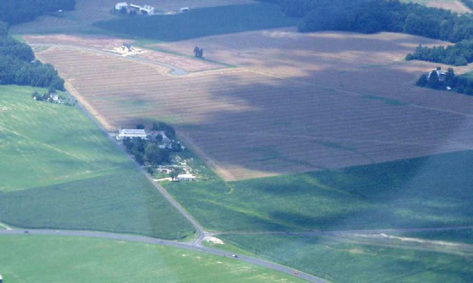
A 2003 aerial photo by Carey Dorset looking north at the site of Webb Field.
The cluster of building from the airport still remain, on the east side of Black Dog Aly.
Also, the outline of at least 2 runways are still quite recognizable in the field immediately to the right of the buildings.
The site of Webb Airport is located on the northeast corner of Kingston Road & Black Dog Aly, two miles east of Easton.
____________________________________________________
Castle Marina Airport (0W6), Kent Island, MD
38.983, -76.291 (East of Annapolis, MD)
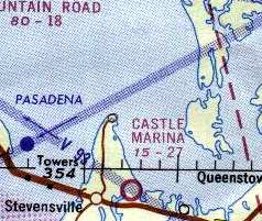
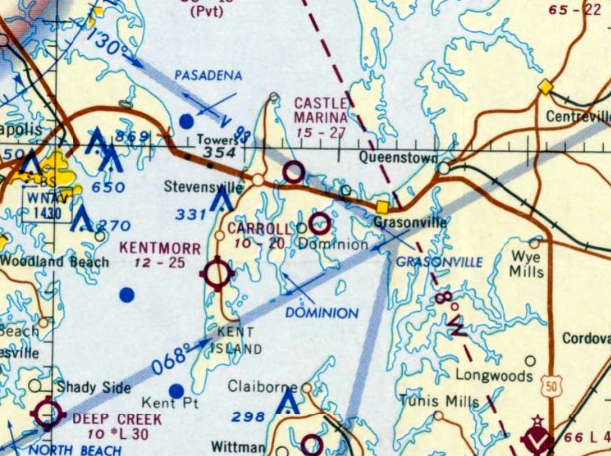
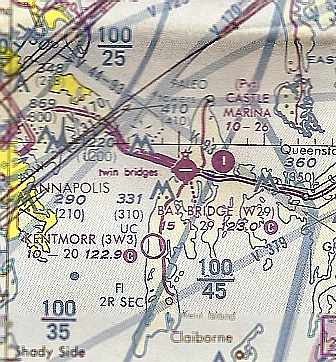
Castle Marina Airport, as depicted on the 1964 Washington Sectional Chart (courtesy of John Voss).
Photo of the airport while open has not been located.
This airport on Kent Island, just east of the Maryland Bay Bridge,
was originally constructed as part of the adjacent Castle Marina.
Castle Marina Airport was apparently built at some point between 1963-64,
as it was not depicted on a 2/3/60 USGS aerial photo,
nor on the 1963 Washington Local Aeronautical Chart (courtesy of Mike Keefe) nor the 1963 USGS topo map.
The earliest depiction which has been located of Castle Marina Airport was on the 1964 Washington Sectional Chart (courtesy of John Voss).
The chart's Aerodromes table described Castle Marina Airport as having a single 2,700' turf runway.
The 1967 Washington Sectional Chart (courtesy of Mike Keefe) described Castle Marina Airport in the same manner.
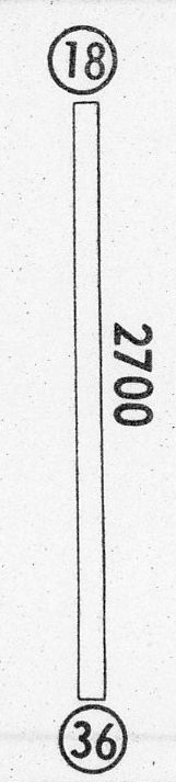
The 1968 Flight Guide (courtesy of Robert Levittan) depicted Castle Marina Airport as having a single unpaved 2,700' Runway 17/36,
and the field was said to be unattended.
The runway at Castle Marina was evidently paved at some point between 1968-72,
as the 1972 Washington Sectional Chart (courtesy of Mike Keefe) depicted the field as having a 2,700' paved runway.
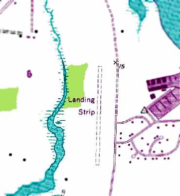
The 1973 USGS topo map depicted the Castle Marina “Landing Strip” as a single unpaved north/south runway.
Richard Wilson recalled, “Castle Marina - I went in there too.
No problem for the narrow gear on a Cessna, Cub, or Tripacer.
But a low-wing Beech or Piper with the wide stance - you only had about a foot of runway on either side of you - it was tight.”
The 1982 AOPA Airport Directory (courtesy of Ed Drury)
described Castle Marina as having a 2,700' asphalt Runway 18/36, which was a mere 20' wide!
On the 1987 MD Aeronautical Chart, Castle Marina Airport was still depicted as a public-use airport.
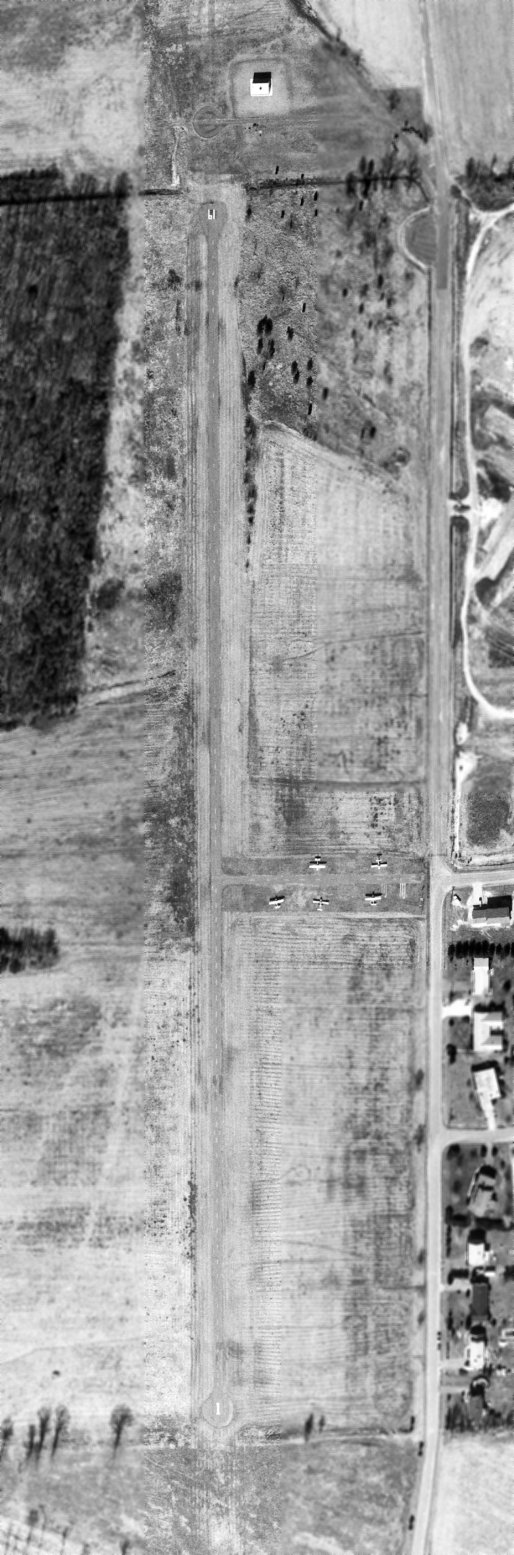
The only photo which has been located showing Castle Marina Airport in operation was a 3/1/90 USGS aerial view.
It consisted of a single paved Runway 1/19, with 5 light single-engine aircraft parked on the east side.
There were no hangars or other buildings located at the airport.
The status of Castle Marina Airport had changed to a private field by the time of the March 1993 Washington Sectional Chart (courtesy of Carl Taylor).
Castle Marina Airport was closed at some point between 1993-98, as It was no longer depicted on the 1998 World Aeronautical Chart.
According to Daniel Wroe, the Castle Marina Airport "was supposed to be a draw for the development,
but as things normally go the non-aviation NIMBYs [Not-In-My-Back-Yard] sort of killed it.
There used to be a guy over there who had a Cessna 150 in his yard, but I think that's gone.
Lots of folks who trained in the area knew the strip
because it was a great place for simulated engine-out practice when departing Runway 11 at Bay Bridge."
Greg Samonds reported in 2005, “The runway of Castle Marina sits out in the middle of a field marked off by a no trespassing sign.
It's condition has further deteriorated from it's condition as shown by the 1998 USGS aerial photo.
The concrete is broken up throughout the length of the runway & there is tall grass growing through the pavement the entire way.
One end is extremely overgrown & engulfed in bushes. The runway is even more thin in this part, barely as wide as a car.
In it's current state, the runway at Castle Marina is completely unusable.”
Michael Denest reported in 2006, “The field is overgrown but the funny thing is that the Maryland Department of Transportation still has the highway signs up for the airport!”
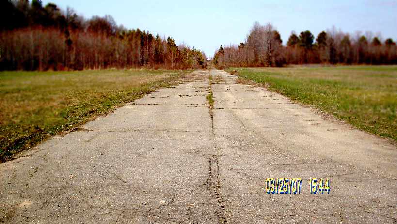
A 2007 photo by Lars Mulford at the site of the Castle Marina Airport, “taken from the middle of the runway looking North.
As the runway enters the woods it deteriorates markedly, completely disappearing in sections with only muddy depressions remaining.
The airfield is still there, although deteriorated. It is quite a narrow strip.
The signs [previously observed] regarding the state of Maryland are no longer there, and development is encroaching on the field from the west.
We rode our bikes along the access & runway.”
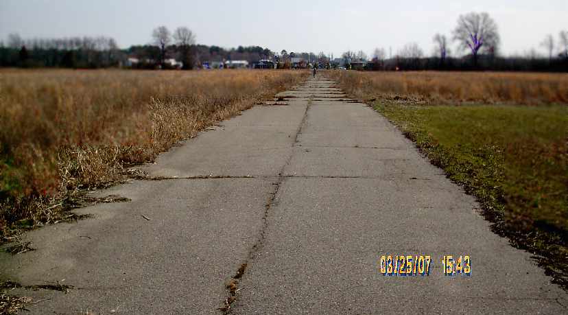
A 2007 photo by Lars Mulford “taken from the middle of the runway looking South.
The terminus of the runway occurs within site of the Cross Island Trail. You can see it from the CIT bike trail if you look closely.
As to how long it will remain there is a good question, for if you look upon the southern stretch of the runway as it passes through open field,
significant development is taking place to the West.”
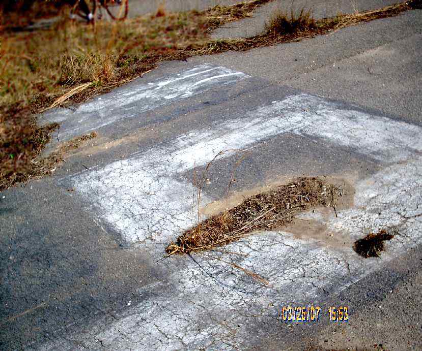
A 2007 photo by Lars Mulford of “the Northern terminus of the runway.
There are still visible runway markings here & the runway designation appears to be 19.”
Lars also reported that a “cul-de-sac [has been] built adjacent to the Northern terminus. The building to the right is actually a mausoleum.”
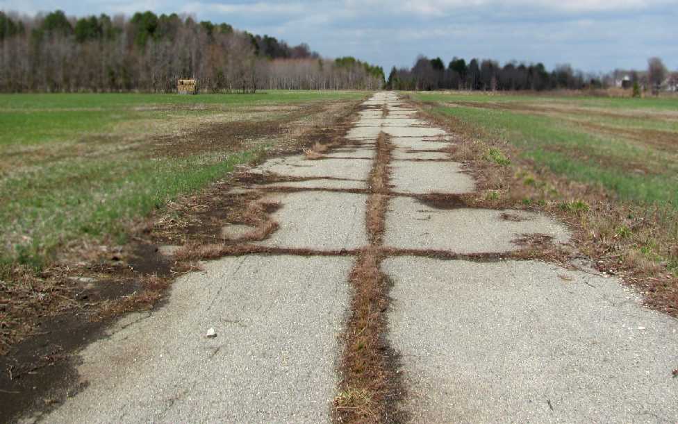
A 3/4/12 photo by Lars Mulford looking along the remains of the Castle Marina runway.
Lars reported, “The runway has deteriorated markedly in the 5 years between now & then [his last visit].
The section of runway that passes through the forest is now completely engulfed with very little traces of paved surfaces remaining.
It was a muddy bog when we were there 3/4/12. The remaining section of runway that runs South is deteriorating rapidly with the runway edges now broken up nearly along it's length.
Gaps in the paved surfaces have been pushed further open by weeds & other nuisance plant growth. This airfield is well & truly abandoned.
All former signs marking ownership are now gone. The chain that closed off the runway access road is now down & has been for some time.
The access road itself is busted up along much of its length, with the portion meeting Castle Marina Road now being a peaty, boggy mess.
We ponder how much longer it will remain even remotely recognizable for what it once was, as development of some of the surrounding properties is underway.
This old airfield is sitting on one of the VERY few undeveloped plots of land on Kent Island. Sad to say, but it's likely just a matter of time.
The housing crash likely forestalled its development up until now. If the market picks up steam again, I think we'll have but pictures to remember what once was...”
A 2014 aerial view looking northwest at the remains of Castle Marina Airport
shows the paved runway remains intact though deteriorated, and with trees having grown up to the edge of the pavement on the northern third.
Mike Catron reported in 2017, “They are finally moving ahead with the long-litigated community on the property that formerly had Castle Marina Airport.
I noticed a pile of asphalt or concrete there that was from the former runway.”
A 1/20/18 aerial view by Pete Meyer looking northwest at the remains of Castle Marina Airport runway.
A 1/20/18 aerial view by Pete Meyer looking southwest at the remains of Castle Marina Airport runway.
A 10/4/20 aerial view by Mike Davidson looking north at the site of Castle Marina Airport, with the property being redeveloped.
The site of Castle Marina Airport is located west of the intersection of Castle Marina Road & Anchor Lane.
____________________________________________________
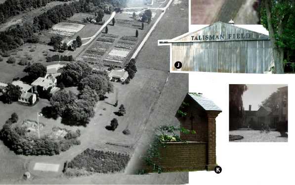
Talisman Farm Airfield, Bryantown, MD
38.93, -76.2 (East of Annapolis, MD)
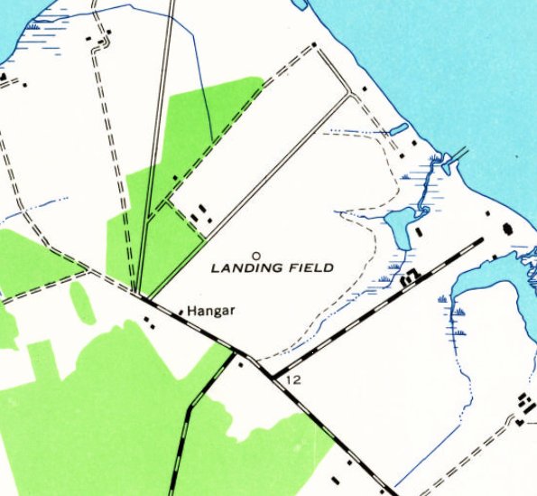
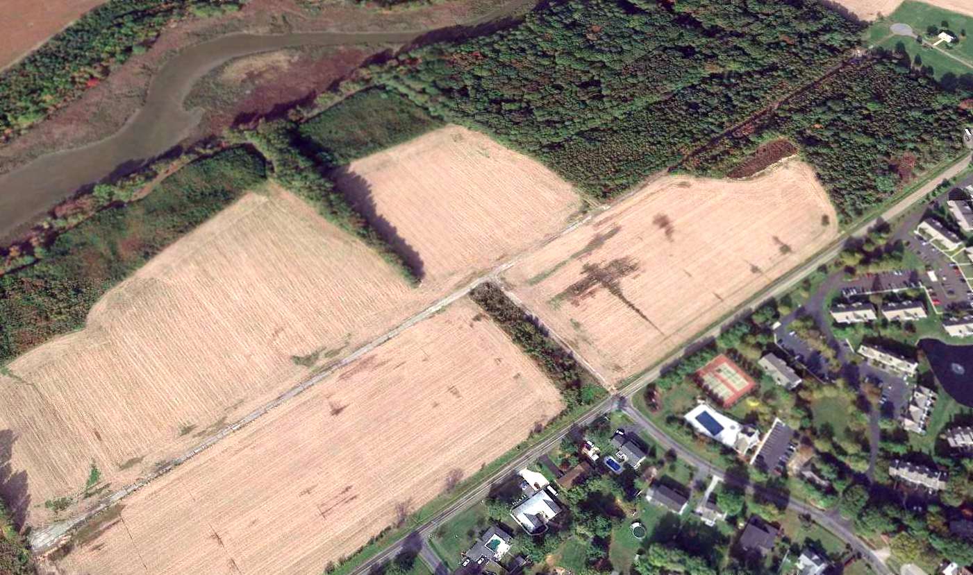
The 3 runways of Talisman Farm were labeled as “Landing Field” on the 1942 USGS topo map.
This private airfield is located along the eastern shore of the Chesapeake Bay.
According to resident Daniel Wroe, "My friend's grandfather bought the place in the 1920s to evade the 'new' NY income tax...
similar to the way the DuPonts did with Horn Point.
He originally commuted in either an S-38 or S-39 [Sikorsky flying boats].
He later put in the strips (three 2,000' in triangle pattern) and commuted in the company Ford Trimotor."
According to a 2008 real estate advertisement for Talisman Farm, “It was originally established in the early 1930s by Arthur H. Kudner Sr.,
who is remembered as a publishing giant & founder of Erwin, Wasey and Company Ad Agency.
He was a celebrated aviator. His love of aviation was the driving factor in the development of Talisman Farm Airfield.
Kudner's love of flying & that of good friends coupled with Talisman Farm's rejuvenating qualities,
opened the estate to visitors such as Tom McKnew, President of National Geographic Society
Gene Tunney, the world heavyweight-boxing champion from 1926-1928,
New York Governor Averill Harriman, Red Curtice, President of General Motors & Roy Howard, President of United Press International.“
No airfield was depicted at the site was listed in Commerce Department Descriptions of Airports & Landing Fields from 1931-38,
nor depicted on Washington Sectional Charts from 1940/42/44/45/46/48/49/57/64/70.
The earliest depiction which has been located of the Talisman Farm Airfield was on the 1942 USGS topo map.
It depicted the 3 runways, labeled simply "Landing Field".
According to Daniel Wroe, "At some later point, I think there may have been a Lockheed twin,
WW2 was a string of various Beech 18/AT-11/C-45s on 'off the books' loan from the company.”
According to Daniel Wroe, "Newman (of Easton fame) landed once with a Corsair.”
The earliest photo which has been located of the Talisman Farm Airfield was a 2/3/60 USGS aerial view.
It depicted the field as having 3 grass runways.
According to Daniel Wroe, "There was a company Beech 18 based until the 1970s gas crisis.”
The 3 runways of Talisman Farm were labeled as “Landing Field” on the 1983 USGS topo map.
The 1989 USGS topo map also depicted the 3 Talisman Farm runways, labeled simply "Landing Field".
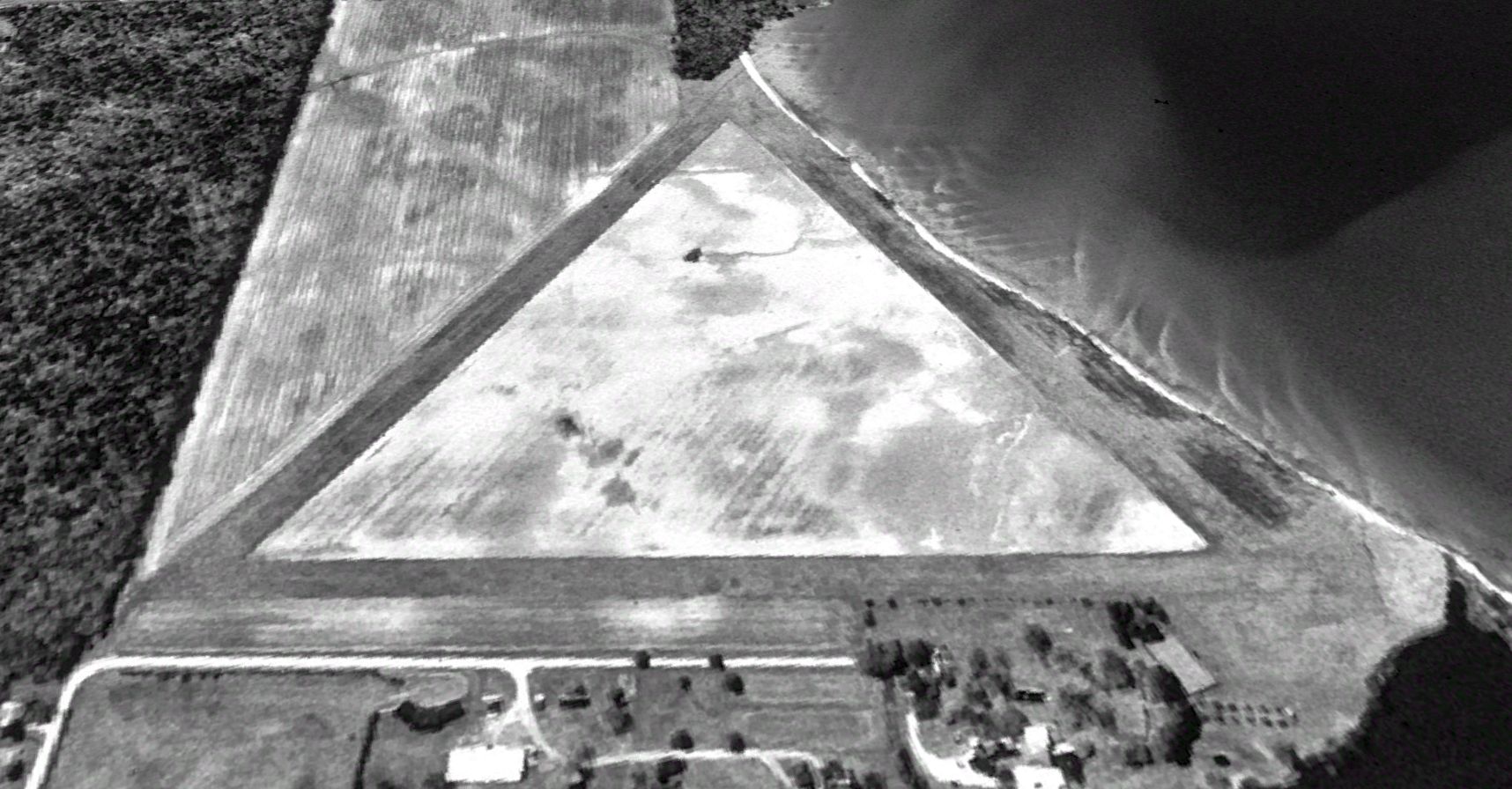
A 1992 USGS aerial view looking southwest depicted Talisman Farm as having 3 unpaved runways.
The Talisman Farm airfield was not depicted at all on aeronautical charts from 1993 or 2003.
Daniel Wroe reported in 2006, “The strip became sort of active in the last 10 years as my buddy got into ultralights, and now general aviation.
There are something like 25 aircraft projects (10 of my own) stashed in various building around the farm...
and only one barely flyable one in the whole lot.
We are part of the local Quad Cities Challenger kitplane dealership,
and we have a demo pig cobbled together out of part from 2 planes.
He also has a TriPacer project nearing completion (for 6 years now)
and I have a Colt re-engine nearing completion (for 4 years now).
The farm has hosted a couple very successful fly-ins (85 planes at one),
but a couple minor (non-fly-in) accidents, and the death of a good friend of ours while testing an ultralight
prompted them to close the field to all except those with pilot/insurance info & liability waiver on file.
Too bad, it is an amazing place & Art has worked to make it the ultimate shade-tree aviation site."
Daniel Wroe reported in 2006, “Several of us on the farm are aviation nuts.
Unfortunately, projects outnumber flyable aircraft (7) by about 5:1, but we do our best.
With the exception of a DoJ training project which is currently operating from the farm,
only farm residents are allowed to base there.
Others can occasionally fly in with prior permission & submission of a signed waiver.
Due to a complicated series of events, almost entirely out of the control of my friend Art,
the future of the farm and the airstrip are in jeopardy of development.
Also in jeopardy is about 2 miles of undeveloped and un-hunted shoreline
that provides refuge for many thousands of waterfowl, and breeding area for horseshoe crabs.
I'm not a radical on the tree-hugger thing, but I have been thinking a lot about what could soon be lost.
Monetary value can't continue to be the only final test of the importance of a thing.”
The 1,100 acres of Talisman Farm (including the airfield) were advertised for sale in 2008, for the tidy sum of only $19 million.
The airfield was described as having 3 runways,
yet a 2008 aerial view showed that the shoreline along the southern portion of the northwest/southeast runway had eroded away almost the entire width of the runway.
In any case, it was hoped that a buyer would continue the operation of this historic Maryland airfield.
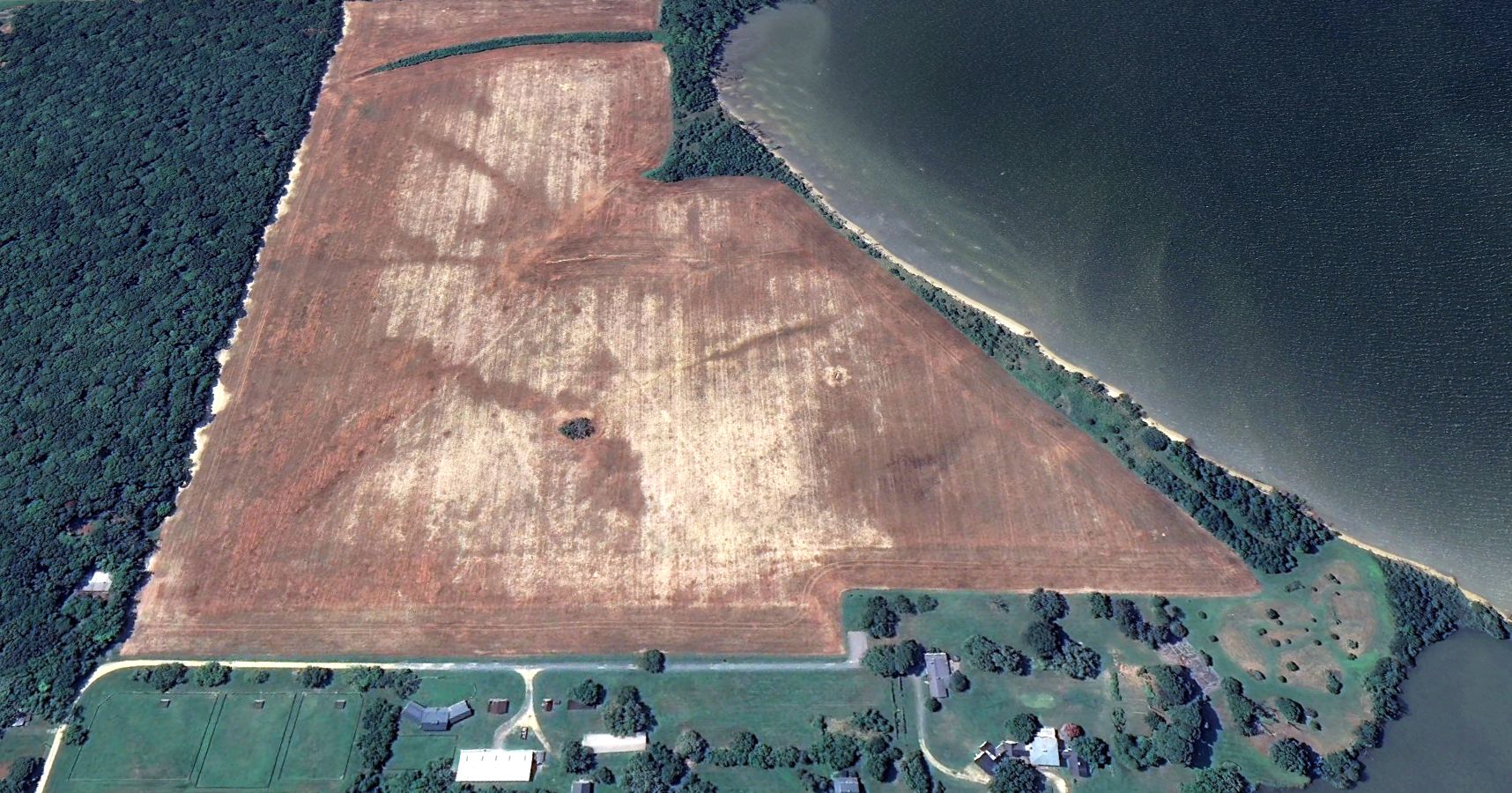
A 2024 aerial view looking southwest showed the triangular layout of the Talisman Farm Airfield was still recognizable, but the runways were no longer maintained.
The Talisman Farm Airfield is located south of the intersection of Perry's Corner Road & Talisman Farm Road.
____________________________________________________
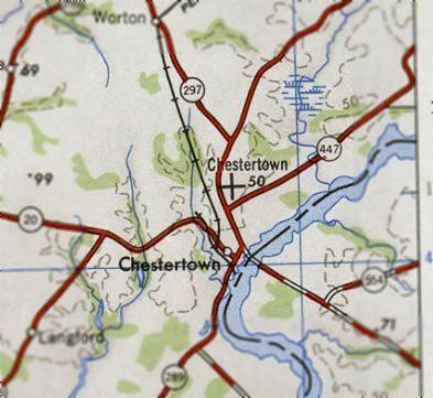
Chestertown Airport / Gill Airport / Scheeler Field (0W7), Chestertown, MD
39.23, -76.07 (East of Baltimore, MD)
Chestertown Airport, as depicted on the 1946 USGS topo map.
No airfield at this location was yet listed in the 1938 Commerce Department Descriptions of Airports & Landing Fields (courtesy of David Brooks)
nor depicted on the 1943 USGS topo map or the October 1946 Washington Sectional Chart.
According to the book "Maryland Aloft" by Preston, Lanman, and Breilhan,
this small general aviation airport was built in 1946 by developer Henry Gill.
"A November 1946 newspaper article reported that students at Washington College
were eager to use the new field to keep up flying skills learned during the war,
and one Ercoupe owner planned to commute there from his residence near Baltimore.
The article described the airport as having an aluminum hangar large enough for 4 airplanes, and 3 long runways."
It was depicted as Chestertown Airport on the 1946 USGS topo map.
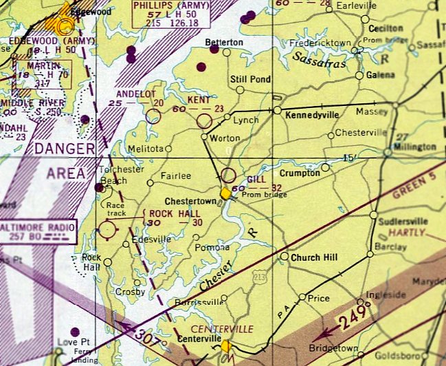
The earliest aeronautical chart depiction which has been located of Gill Airport was on the April 1947 Washington Sectional Chart.
It depicted Gill as having a 3,200' unpaved runway.
The runway had evidently been shortened somewhat by the time of the 1951 Washington Sectional Chart (courtesy of Mike Keefe),
which described "Gill Airfield" as having a single 1,450' unpaved runway.
The field was apparently closed for some time, as the Aerodromes table on the 1951 Sectional
included the remarks, "Closed. Not Maintained."
The 1951 USGS topo map depicted Gill Airfield as having 3 runways.
The February 1961 Washington Local Aeronautical Chart (courtesy of Scott Kimball) depicted Gill as having a 2,800' unpaved runway.
The 1962 AOPA Airport Directory described Gill Airfield as having a single 2,800' sod Runway 4/22,
and listed the operator as Walker Eliason.
The 1964 & 1970 Washington Sectional Charts described the field as having a single 3,000' turf runway.
By the time of the 1982 AOPA Airport Directory (courtesy of Ed Drury), the runway at Gill had been shortened to only 2,100'.
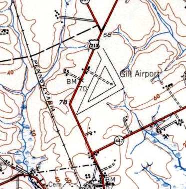
At some point the airfield was renamed Scheeler Field.
It was still listed as Gill Airfield in the 1982 AOPA Airport Directory, but the USGS topo map from the same year depicted it as Scheeler Field.
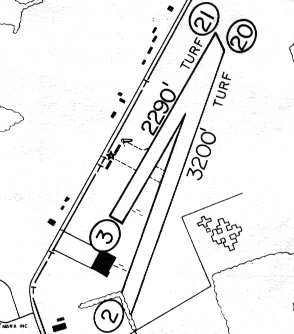
The 1983 MD Airport Directory depicted Scheeler Field as having a 3,220' turf Runway 2/20 & a 2,290' turf Runway 3/21.
The operator was listed as Kent Flying Service, and the manager was listed as A.L. (Buzz) Harris.
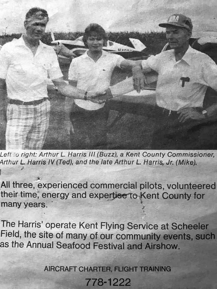
A circa 1980s advertisement for Scheeler Field's Kent Flying Service (courtesy of Matt Harris) featured 3 generations of the Harris family.
Matt Harris reported, “My dad is Ted, his dad is Buzz, his dad was Mike.”
The end of Scheeler Field began in 1992, when Wal-Mart announced it had bought the property for $1.4 million.
They proposed to divide the property into 3 parcels & build one of their stores in the middle section.
The 1993 Jeppesen Airport Directory described Scheeler Field as having a single 3,400' turf Runway 2/20.
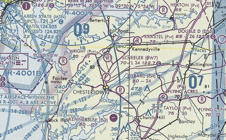
The last aeronautical chart depiction which has been located of Scheeler Field was on the March 1994 Washington Sectional Chart (courtesy of Ron Plante).
It depicted Scheeler as a public-use airport having a 3,400' unpaved runway.
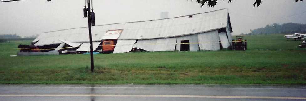
A 1994 photo by Phyllis Keefe of the remains of Scheeler Field's main hangar after having collapsed during a storm.
Steve Keefe recalled, “At the time, my wife’s parents lived across the street from the airfield & a strong storm came through the evening before this photo was taken.
My wife recalls very strong winds and a 'sound like a train' as they headed to the basement of their house.
The ‘train’ sound is usually associated with a tornado but there was no indication of its path.
It was dark when the storm was over & my wife & her family did not realize the hangar had collapsed until the next morning.
There were several planes in the hangar at the time. The hangar was eventually torn down.”
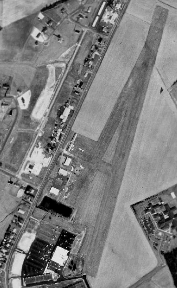
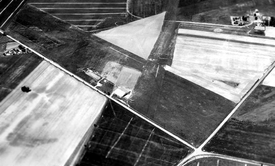
The 1994 USGS aerial photo was taken only 2 years before Scheeler Field's closure.
There were still a total of 4 aircraft visible parked on the field, but several buildings had already been built over the southern portion of the airfield property,
and closed runway "X" markings were visible on both ends of Runway 3/21.
JF Mergen recalled, “Chestertown Airport... my flight instructor took me there from Baltimore Martin State Airport to practice soft-field operations approximately in 1995 before the field was closed to operations.
The Walmart construction was started less than a year later.”
Scheeler Field was finally closed in 1996, leaving Kent County without a single public-use airport.
As of 1999, years of legal speed bumps had kept Wal-Mart from building on the Scheeler site.
The 2002 Washington Sectional Chart no longer depicted Scheeler Field.
A 2005 aerial photo showed the Scheeler Field hangars & aircraft were gone, along with the northern portion of the runway.
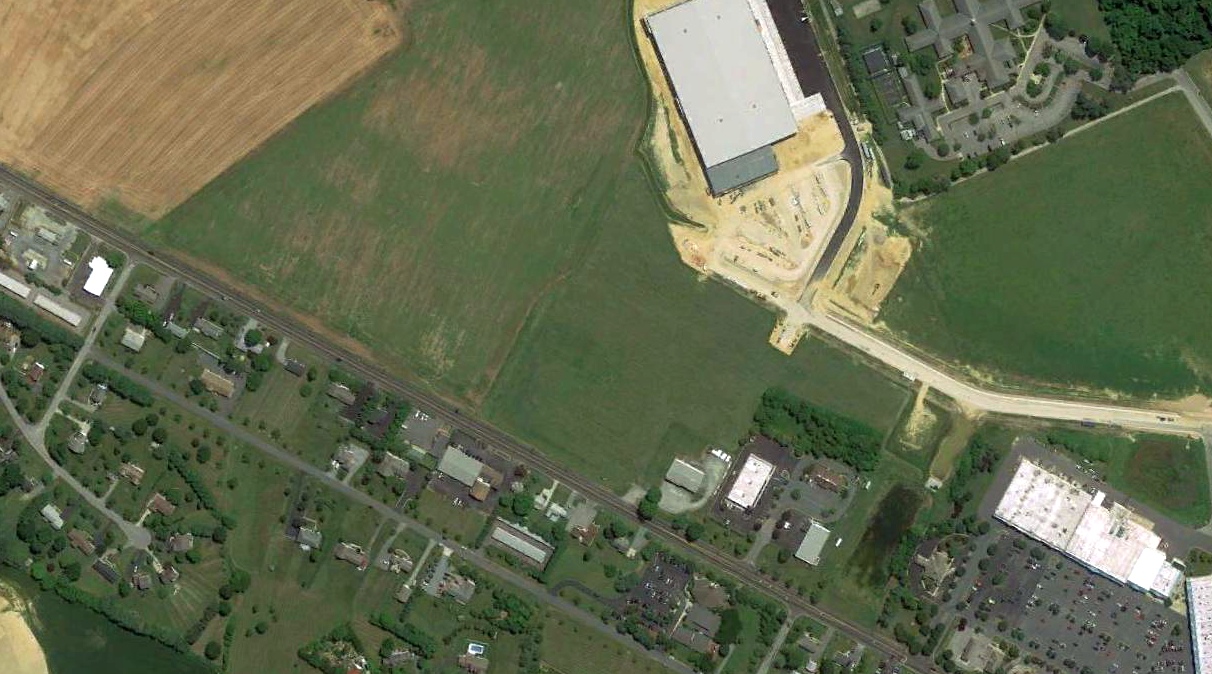
A 2018 aerial view looking northeast showed no recognizable trace remaining of Scheeler Field.
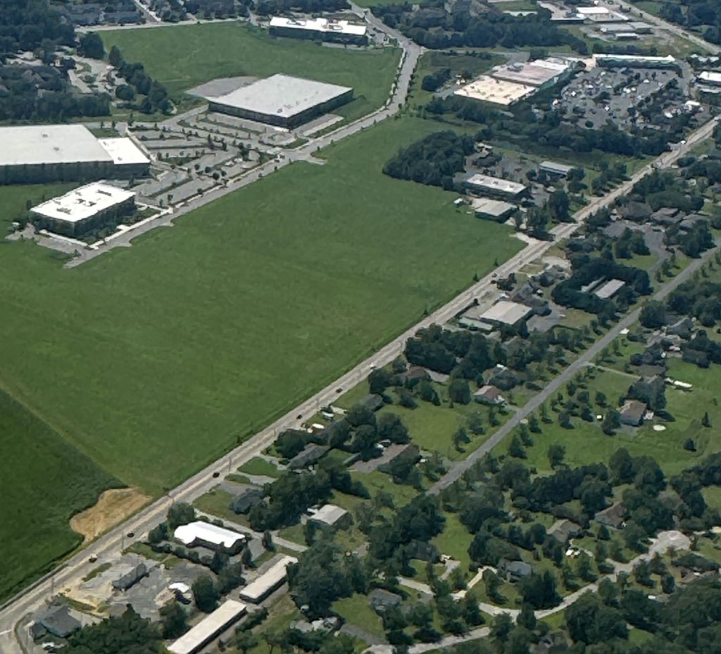
An 8/23/2 aerial view by J.F. Mergen looking southeast at the Scheeler Field site.
Scheeler Field is located north of the intersection of Route 213 & Scheeler Road, appropriately enough.
____________________________________________________
Or if you prefer to contact me directly concerning a contribution (for a mailing address to send a check),
please contact me at: paulandterryfreeman@gmail.com
If you enjoy this web site, please support it with a financial contribution.
____________________________________________________
This site covers airfields in all 50 states.
For the site's main menu: Home