Abandoned & Little-Known Airfields:
Maryland: Frederick area
© 2002, © 2025 by Paul Freeman. Revised 11/24/24.
This site covers airfields in all 50 states: Click here for the site's main menu.
____________________________________________________
Please consider a financial contribution to support the continued growth & operation of this site.
Brunswick Airport (revised 1/15/24) - Fort Detrick Army Airfield (revised 1/15/24) - Stevens Airport (revised 2/18/22) - Southern Cross Airport (revised 8/7/23)
Taneytown Airport (revised 2/9/20) - Woodbine Airport / Woodbine Gliderport (revised 11/24/25)
____________________________________________________
Brunswick Airport, Brunswick, MD
39.309, -77.622 (Northwest of Washington, DC)
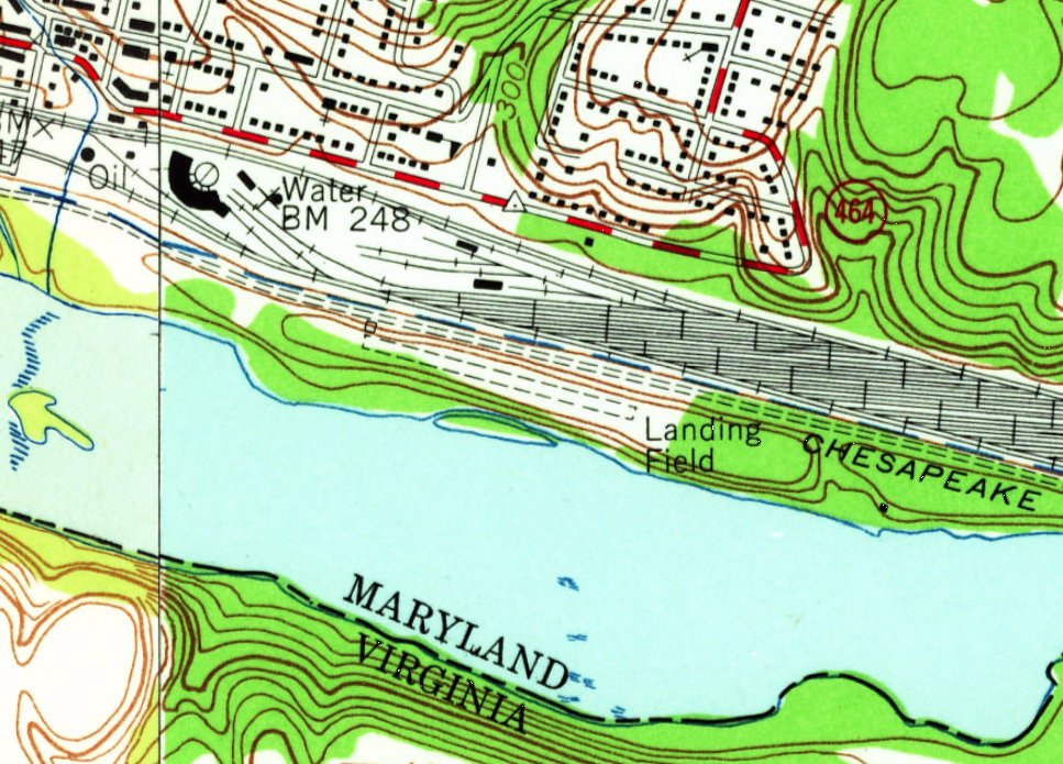
Brunswick Airport, as depicted on the 1955 USGS topo map.
Not much is known about this small general aviation airport located on a narrow spit of land along the Potomac River,
including its name, date of construction, owner/operator, or date of closure.
David Zwolak reported, “Ed Waters, at the Brunswick historical museum, believed that the airfield was either encouraged, or begun, by a couple of doctors in town that had their own private aircraft.
They needed a place to fly & tie-down. So apparently they prevailed on the city or B&O [Railroad] to make the land available for their use.”
Brunswick Airport was not depicted on the 1947 Washington Sectional Chart, the 1951 Washington Local Aeronautical Chart, or the 1953 USGS topo map.
The earliest depiction which has been located of Brunswick Airport was on the 1955 USGS topo map.
It depicted a single unpaved northwest/southeast runway, labeled generically as “Landing Field”, with one small building on the northwest corner.
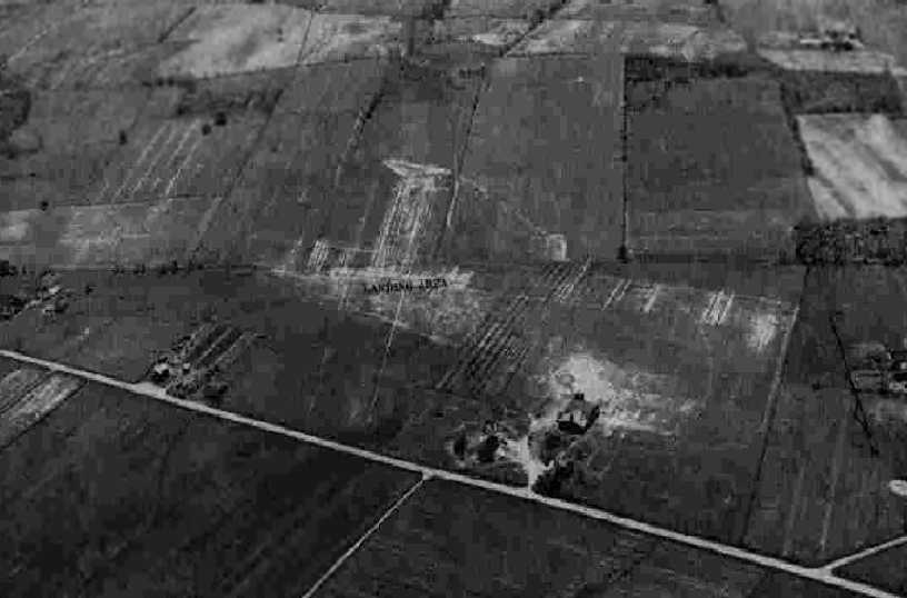
The only photo which has been located showing an aircraft at Brunswick Airport was a 1955 aerial view.
It depicted a single unpaved northwest/southeast runway, with 2 T-hangars & 1 light single-engine aircraft on the northwest corner.
David Zwolak reported, “Ed Waters recalled as a child that he sat on the hills overlooking the city & watched airplanes takeoff & land at this airfield, in the mid- to late-1950s.”
According to a document from brunswickmdhistory.com (courtesy of Norman Cornelius),
Brunswick's Airfield operated from circa 1956-64, as the home of the Brunswick Flying Club, and had a 3,000' grass runway.
Licensed pilots at Brunswick were Bill Care, Bill Weaver, Jimmy Ridgeway, Donald Hess, and Dr. Pruit.
Student pilots were Charley Halley, Dutch Halley, and Bruce Porter.
Seven aircraft were parked at Brunswick: the flying club's Taylorcraft & Aeronca, Bill Care's Luscombe, Charley Halley's Aerocoupe, Jimmy Ridgeway's Aerocoupe, Bill Weller's Aeronca, and the CAP's L-16.
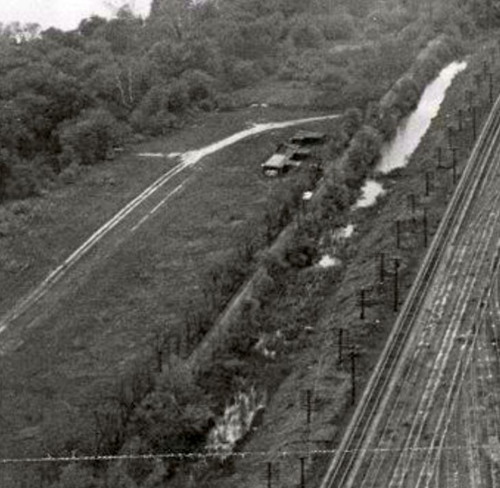
A circa 1956 aerial view by Jimmy Ridgeway looking west (courtesy of Norman Cornelius, from brunswickmdhistory.com) depicted Brunswick Airport as having a single unpaved northwest/southeast runway, with 3 T-hangars on the northwest side, just south of the train tracks.
Brunswick Airport was still not depicted on the 1956 Washington Local Aeronautical Chart.
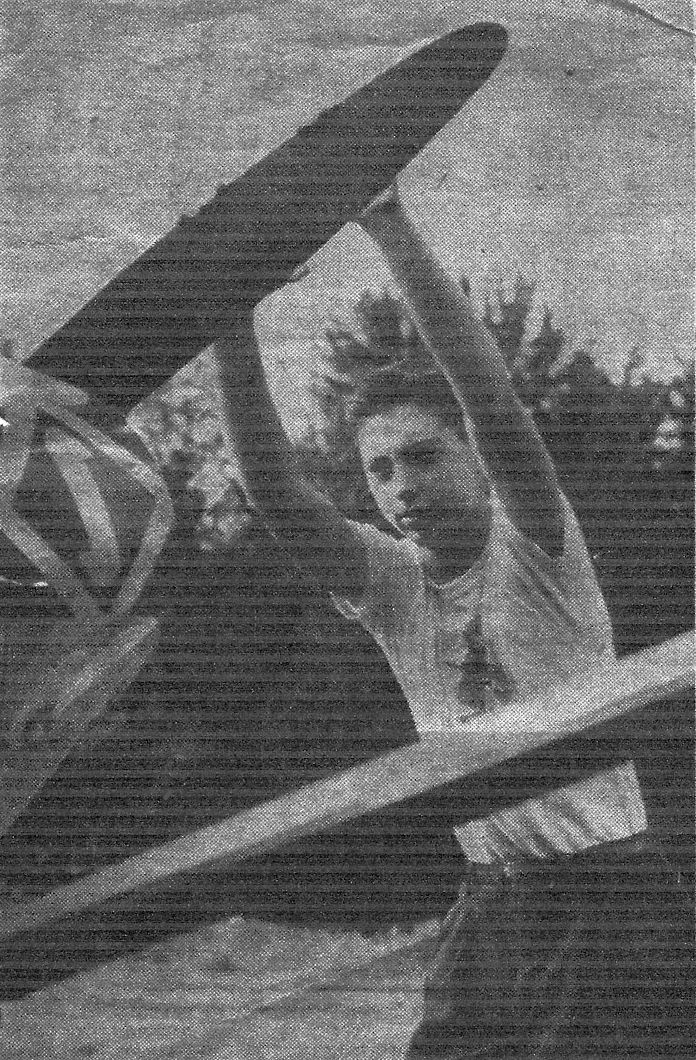
An undated picture from a 7/58 newspaper article (courtesy of Norman Cornelius) of newly-licensed 17 year old pilot Richie Care hand-propping a plane at Brunswick Airport.
The caption described how William had obtained his Private Pilot's License via the training of the Brunswick Flying Club.
Bill Ayres was his instructor & Richard Green his flight inspector.
A circa 1950s photo (courtesy of Norman Cornelius) of Beacht, Hedges, Webber, and Barger at Brunswick Airport.
A circa 1950s photo (courtesy of Norman Cornelius) of John Hedges on the Brunswick Airport runway.
A circa 1950s photo (courtesy of Norman Cornelius) of a Luscombe at Brunswick Airport.
A 12/4/59 USGS aerial view depicted Brunswick Airport's unpaved northwest/southeast runway as remaining intact, along with possibly both T-hangars (at top-left), but there did not appear to be any aircraft on the field.
Brunswick Airport was evidently closed (for reasons unknown) at some point between 1955-70,
as the 1970 USGS topo map depicted a sewage disposal facility on the northwest portion, and a campground on the southeast portion.
A 1974 USGS aerial view depicted the sewage treatment facility covering the site of Brunswick Airport's hangars.
A circa 1970s aerial view (from the collection of Keith Yanky, courtesy of Todd Crone) looking southeast showed the sewage treatment facility covering the site of Brunswick Airport's hangars,
but the majority of the runway remained clear.
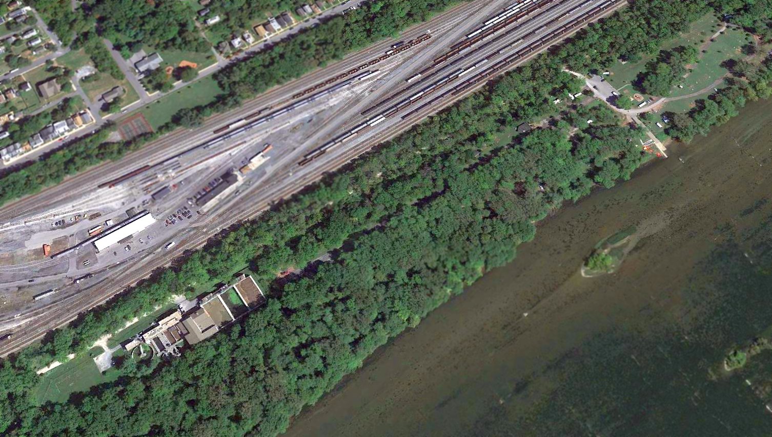
A 2015 aerial view looking northeast showed the site of Brunswick Airport to be unrecognizable as a former airfield,
with the sewage treatment facility on the northwest portion (bottom-left), and a campground on the southeast portion (top-right).
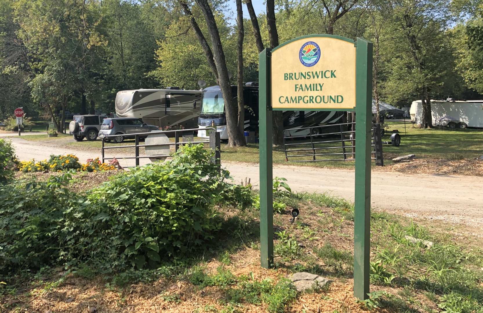
A 9/22/19 photo by Paul Freeman of the entrance sign for Brunswick Family Campground, the site of Brunswick Airport.
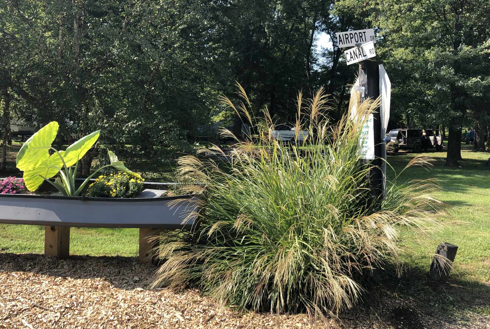
A 9/22/19 photo by Paul Freeman at the sign for the Brunswick Family Campground's Airport Drive. How many people who stay at the campground realize the significance of the road name?
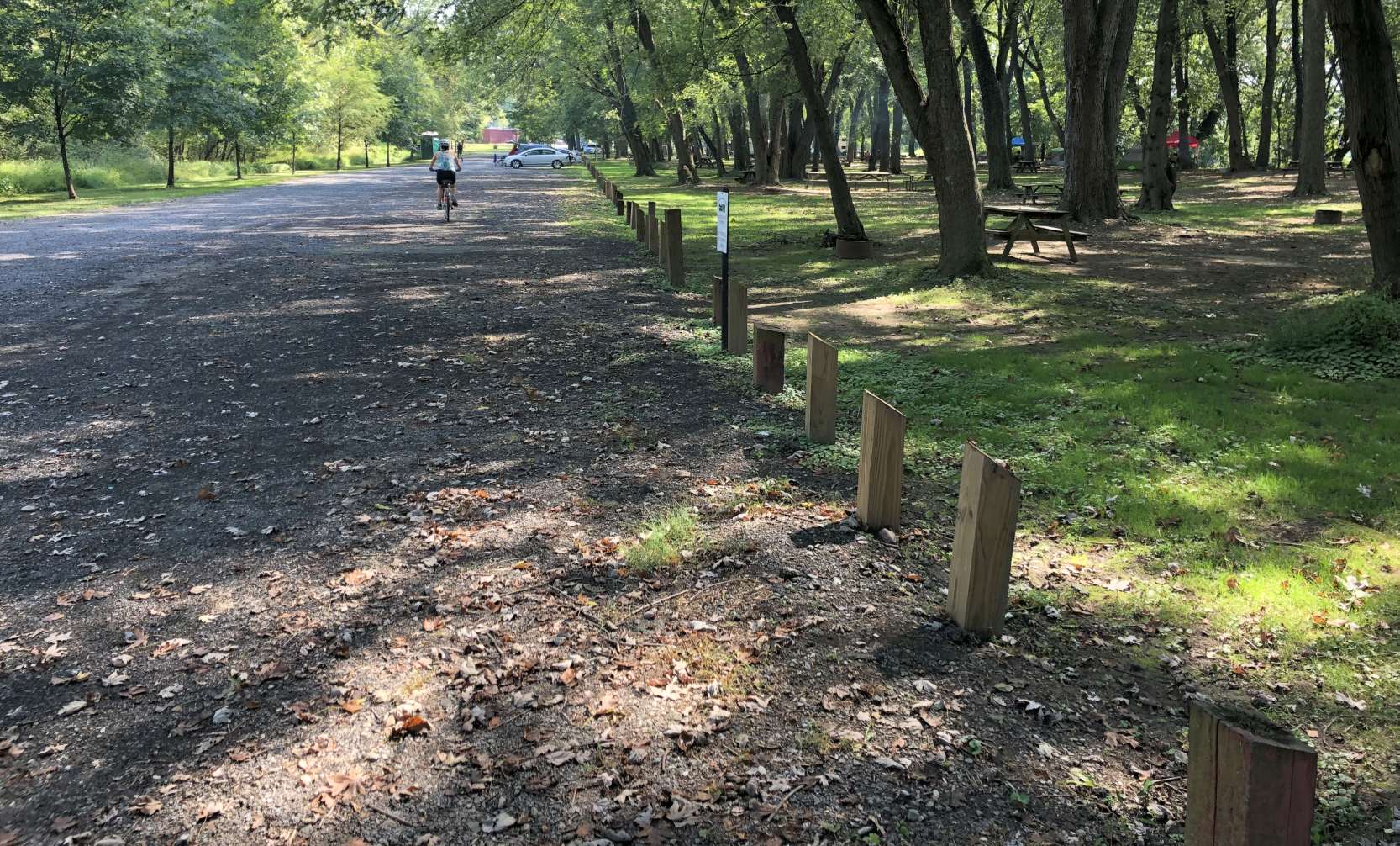
A 9/22/19 photo by Paul Freeman looking southeast along the former alignment of the Brunwick Airport runway, now reused as the Brunswick Family Campground's Airport Drive.
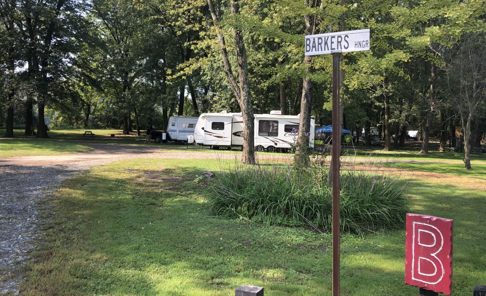
A 9/22/19 photo by Paul Freeman of another clue at the site of Brunswick Airport: a road sign at the Brunswick Family Campground for “Barker's Hangar”.
Was Barker the name of the Brunswick Airport operator?
Thanks to David Zwolak for pointing out this airfield.
____________________________________________________
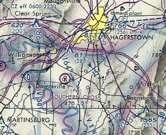
Southern Cross Airport, Downsville, MD
39.55, -77.8 (South of Hagerstown, MD)
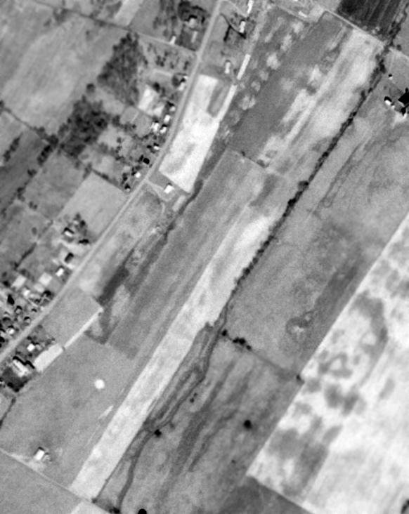
A 3/14/74 USGS aerial view of Southern Cross Airport.
Photo of the airport while in use has not been located.
This small general aviation airport may have been established at some point between 1971-74,
as it was not yet depicted on the 1971 USGS topo map.
The earliest depiction which has been located of Southern Cross Airport was a 3/14/74 USGS aerial view,
which depicted a single grass northeast/southwest runway, with one small hangar at the southwest corner.
The earliest aeronautical chart depiction which has been located of Southern Cross Airport
was on the 1976 Washington Sectional Chart (courtesy of Jonathan Westerling).
It depicted Southern Cross as a private airfield having a 2,100' unpaved runway.
Gordon Stewart recalled, “On 10/30/77, I went static line skydiving at Southern Cross with about two dozen others.
An old patched-together olive-drab De Havilland Beaver was our jump plane. My first flight.
The only airport building was a metal Quonset hut.”
Ron Plante recalled, “My 1st & only visit to this strip was around 1980 while visiting my family in nearby Hagerstown.
All I recall seeing is a trailer for the parachute club & 1 jump plane, maybe a Cessna 182. It was a lousy day, not even IFR.”
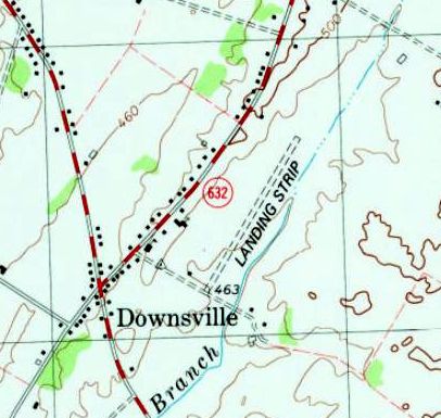
The 1979 USGS topo map depicted Southern Cross Airport as a single unpaved northeast/southwest runway, labeled simply as “Landing Strip”.
The last aeronautical chart depiction which has been located of Southern Cross Airport
was on the September 1981 Washington Sectional Chart (courtesy of Ron Plante).
It depicted Southern Cross as a private airfield having a 2,100' unpaved runway.
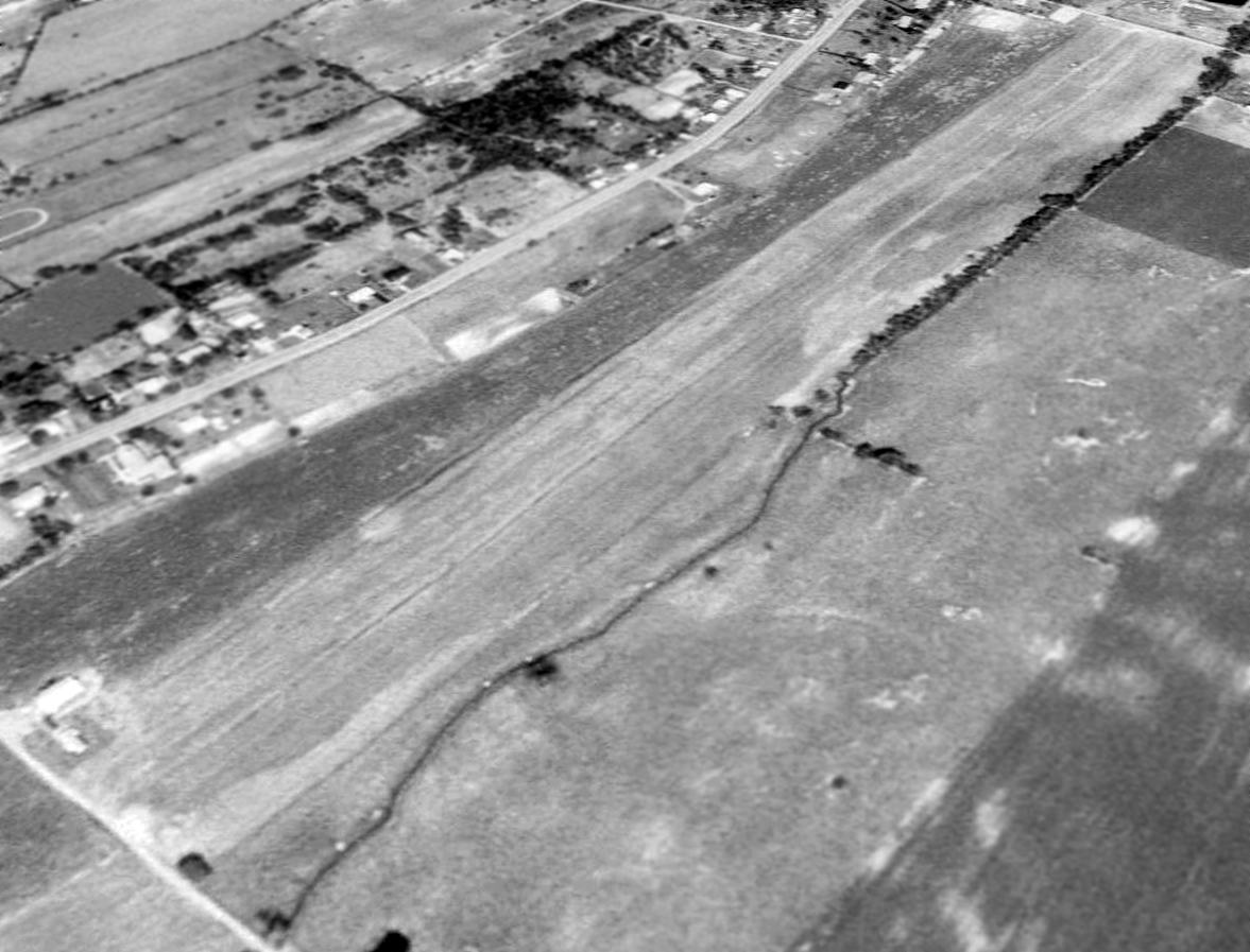
A 1988 aerial view looking north depicted Southern Cross as having a single grass northeast/southwest runway, with one small hangar at the southwest corner.
Southern Cross Airport was evidently closed (for reasons unknown) at some point between 1981-89,
as it was no longer depicted on the 1989 Washington Sectional Chart (courtesy of Jonathan Westerling).
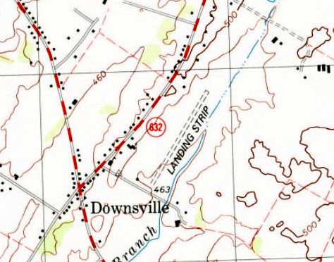
The last map depiction which has been located of Southern Cross Airport was on the 1997 USGS topo map,
which depicted a single unpaved northeast/southwest runway, labeled simply as “Landing Strip”.
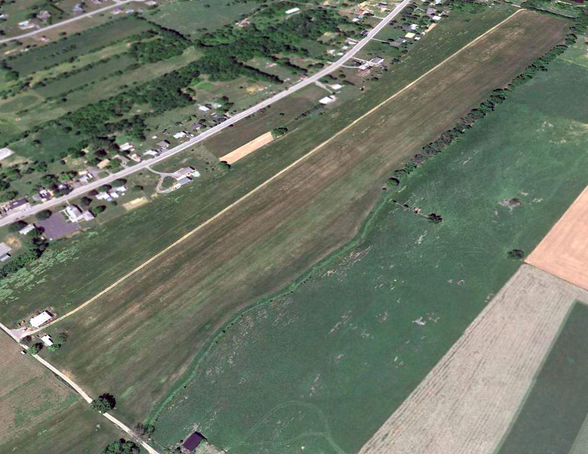
A 2013 aerial view looking north at showed the Southern Cross Airport runway & hangar remained intact, though without any sign of recent aviation usage.
Southern Cross Airport is located east of the intersection of Downsville Pike & Willoughby Drive.
Thanks to Ron Plante for pointing out this airfield.
____________________________________________________
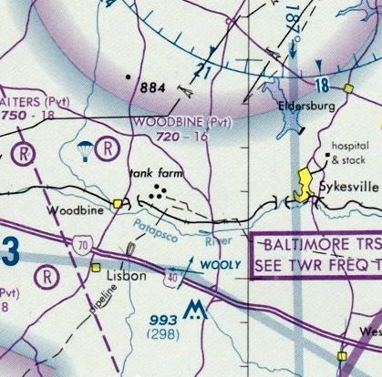
Woodbine Airport / Woodbine Gliderport (MD78), Woodbine, MD
39.38, -77.07 (Northeast of Frederick, MD)
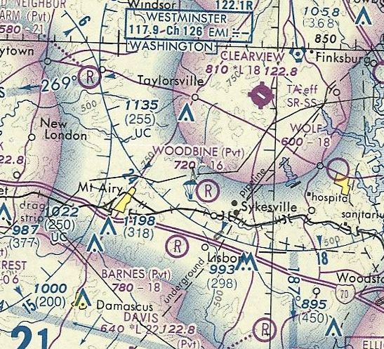
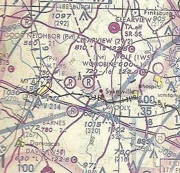
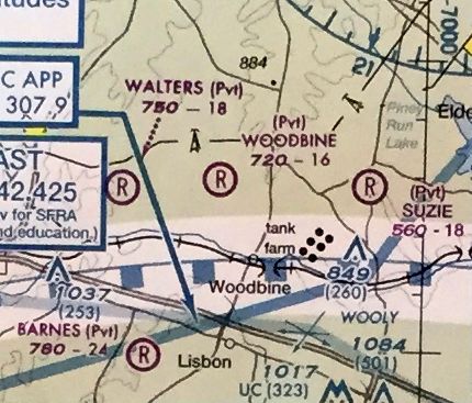
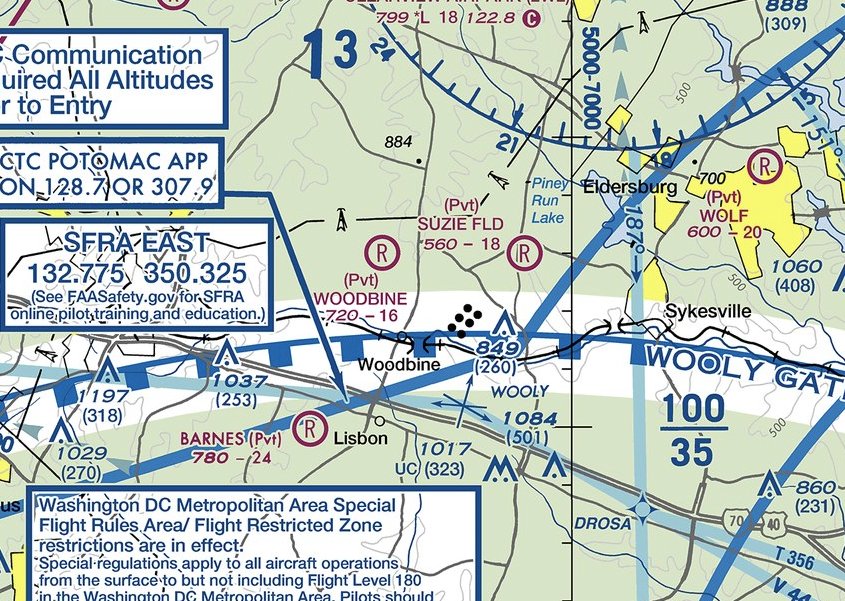
Woodbine Gliderport, as depicted on the 1978 Washington Sectional Chart (courtesy of Jonathan Westerling).
This small rural general aviation airport was evidently established at some point between 1958-78,
as it was not yet depicted on a 1958 aerial photo.
Bob Ostman recalled, “Woodbine Airport... It was in operation as a parachute drop zone from sometime in the 1960s.
I skydived there from the mid-1970s to the mid-1980s when it became a gliderport.
It was the best spot on earth for a number of years for many people who showed up every weekend to skydive.
We had a Cessna 206 & a 172, then a 1952 DeHavilland Beaver. Believe me, none of us ever jumped out of a perfectly good aircraft.
It was in operation as a parachute drop zone until it closed in the late-1980's at the request of the complaining neighbors.”
Woodbine Gliderport was not yet depicted on 1971/76 Washington Sectional Charts.
The earliest aeronautical chart depiction which has been located of Woodbine Gliderport was on the 1978 Washington Sectional Chart (courtesy of Jonathan Westerling),
which depicted it as a private airfield having a 1,600' unpaved runway & a parachute dropzone.
Peter Doerr recalled, “Bay Soaring started flying out of Woodbine around 1980, about the time the skydiving operation ceased operations.
Bay Soaring was a commercial operation, not a club like most glider operations. The owner was Gerry Gaudet.
Bay Soaring was also a distributor of Grob sailplanes. I believe they were one of the first.”
The earliest photo which has been located of Woodbine Gliderport was a 1981 aerial view.
It depicted a single grass northeast/southwest runway, with a small hangar & 5 light single-engine aircraft on the northwest side.
The September 1981 Washington Terminal Chart (courtesy of Ron Plante) depicted Woodbine Gliderport as a private airfield having a 1,600' unpaved runway.
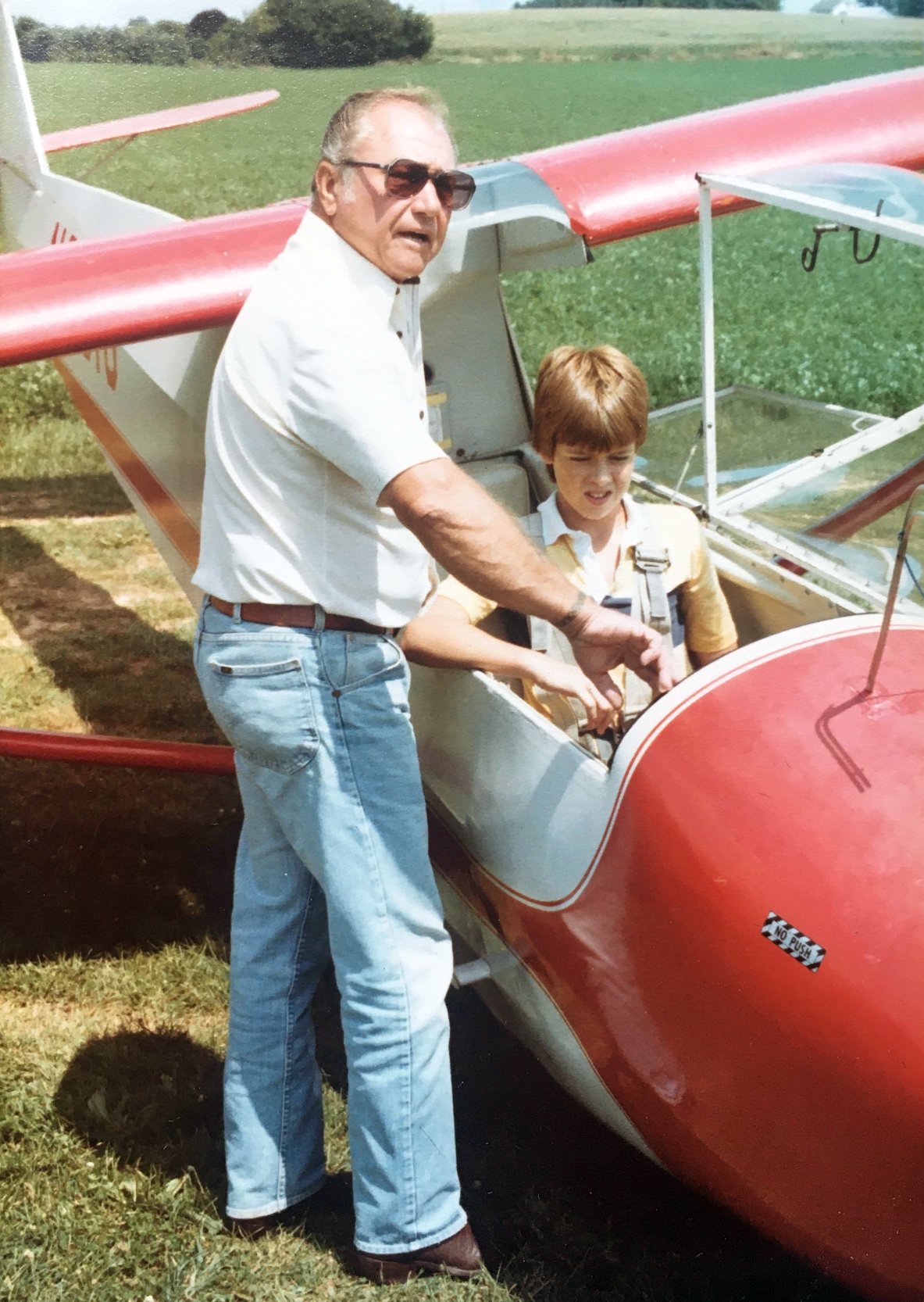
The earliest photos which are available of Woodbine Gliderport were a series of 8/11/82 photos by Jim Blanchard.
This photo shows pilot Merritt & Dennis Blanchard preparing to fly in N65818, a Schweizer STS 2-33A.
Jim Blanchard recalled, “I remember the name 'Bay Soaring', so I may have seen that advertised when I was looking into getting rides on a glider.”
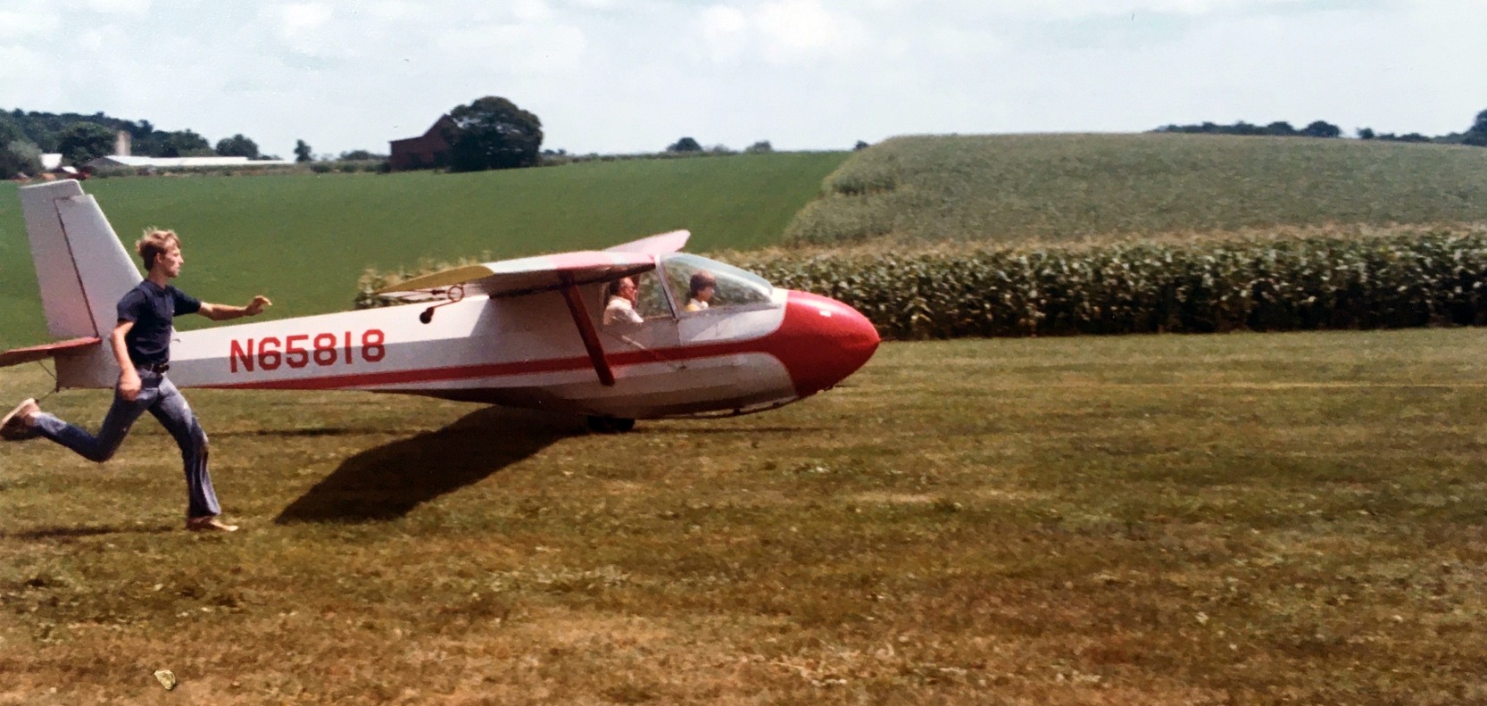
An 8/11/82 photo by Jim Blanchard of pilot Merritt & Dennis Blanchard taking off in N65818, a Schweizer STS 2-33A.
Jim Blanchard recalled, “The airstrip was oriented generally north/south, so we took off headed south & landed the other way.”
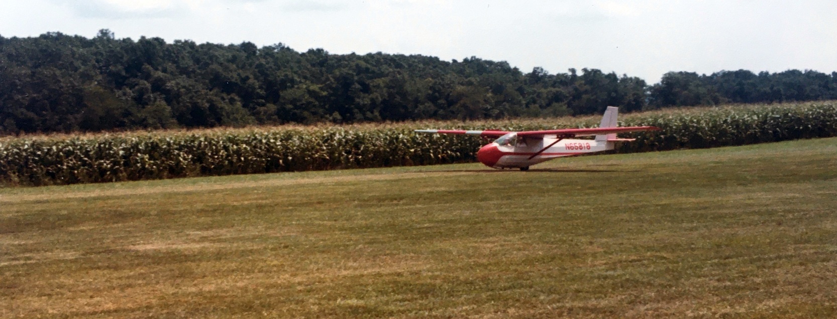
An 8/11/82 photo by Jim Blanchard of pilot Merritt & Dennis Blanchard landing in N65818, a Schweizer STS 2-33A.
Peter Doerr recalled, “I worked at Bay Soaring in 1982-85 to pay for glider lessons while I was in high school.
The soaring conditions were pretty good during the summer.
It wouldn’t be unusual for people to take off mid-morning & return around 6 or 7 in the evening.
One day 3 guys went off together in single-seat Sweitzer 1-26s, fly to Front Royal, VA & back.
They used CB radios hooked to car batteries to talk back & forth.
At times a lucky pilot would find mountain wave & ride it up to 10,000' or more.
One time a guy found some wave, rode it up to 12,000', then returned to land & pick up an altitude recorder to earn a soaring badge.
When he went back to where he found the wave the first time it was gone.”
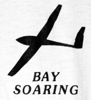
The logo on a Bay Soaring t-shirt (courtesy of Peter Doerr).
Peter Doerr recalled, “It was pretty common for gliders to run out of lift & have to land off-airport in a field.
The wings were made to be easily removed & reinstalled without an A&P for easy trailering.
I went on a few of those recoveries. The property owners were always friendly.”
Peter continued, “The best of times at Bay Soaring was the mid-1980s.
Everyone would fly all day, then retire to the Woodbine Inn for crabs, beer, and flying stories (mostly lies!).
The Woodbine Inn even had glider pictures on the walls during that time.
In 1983 or 1984 Gerry was able to get Derek Piggott to come & talk soaring. He was famous as a stunt pilot in the move 'The Blue Max'.
Around 1984 some of the neighbors started a court case to shut down the operation.
I remember the stress seemed to get to Gerry in 1984, he was always taking a lot of Tums.”
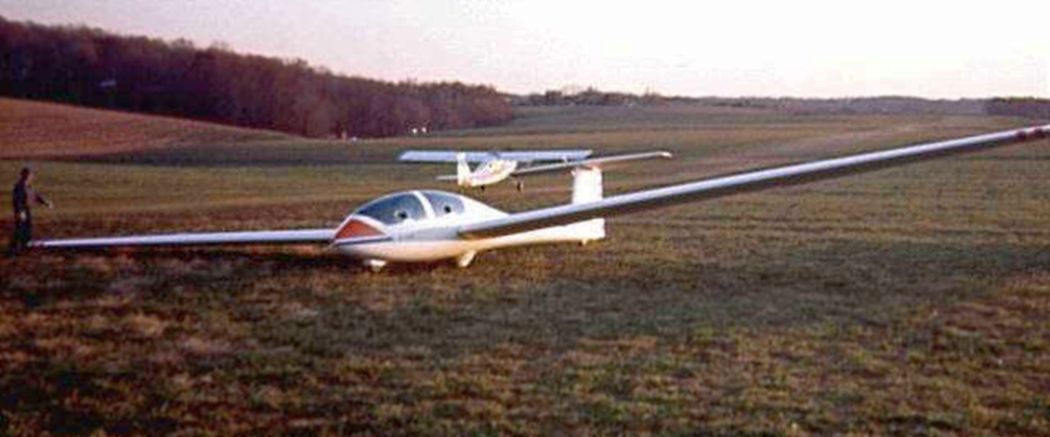
A January 1985 photo by Peter Doerr of a Grob 103 glider & a towplane at Woodbine Gliderport.
The March 1987 Washington Sectional Chart (courtesy of Kevin O'Reilly)
depicted Woodbine Gliderport as a private airfield having a 1,600' unpaved runway.
Woodbine Gliberport, as depicted on the 1989 USGS topo map.
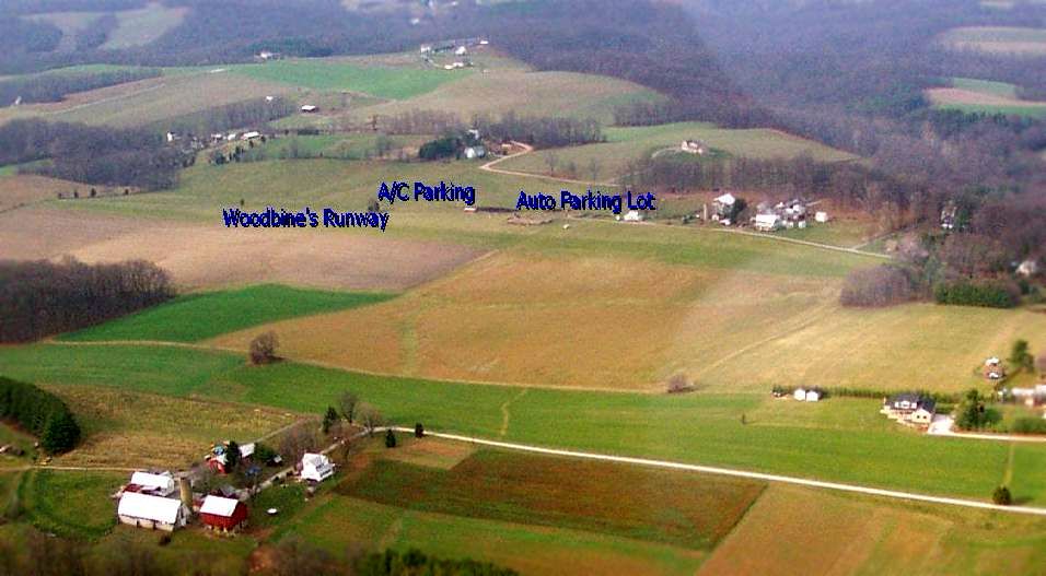
A November 1989 aerial view by Peter Doerr looking northwest at Woodbine Gliderport.
According to Peter Doerr, the Bay Soaring “office... was burned down in the late 1980s by a disgruntled line boy.”

An advertisement for Soaring Adventures of America at Woodbine which appeared in the 12/11/90 Baltimore Evening Sun (courtesy of Jim Blanchard).
Peter Doerr recalled of the Woodbine arson case, “The case actually made it to the Supreme Court in 1990, who refused to hear it & returned it to local court.
Bay Soaring filed for bankruptcy in 1991 due to the endless litigation.”
According Jim Blanchard, the Saoring Society of America at Woodbine advertisements appeared until 12/15/91, “So it looks like they used Woodbine for 2 years.”
The March 1993 Washington Sectional Chart depicted Woodbine as a private airfield having a 1,600' unpaved runway.
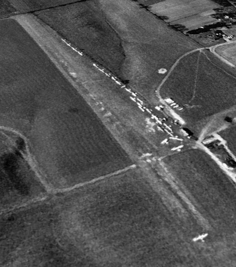
The last photo which has been located showing aircraft at Woodbine Gliderport was a 1995 USGS aerial view looking southwest.
It showed an amazing total of no less than 22 aircraft on the little airfield, including 1 on the runway.
Peter Doerr recalled, “Bay Soaring had a few accidents during it’s time.
In March 1997 an accident finally led to the shutdown of operations at Woodbine.”
A 2001 aerial view looking west showed Woodbine Gliderport devoid of any aircraft.
A 5/27/07 photo by Peter Doerr of Woodbine Gliderport.
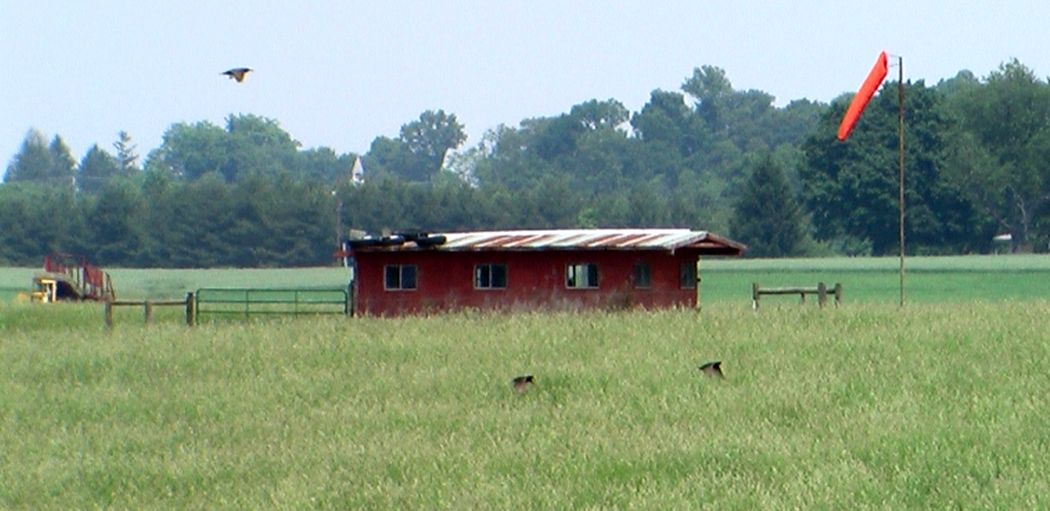
A 5/27/07 photo by Peter Doerr of Woodbine Gliderport, showing “the remains of Bay Soaring. The red building was the pilot break room.
There used to be another building next to it that was the office, but it was burned down in the late 1980s by a disgruntled line boy.”
The last aeronautical chart depiction which has been located of Woodbine Gliderport was on the February 2009 Washington Terminal Chart,
which depicted Woodbine as a private airfield having a 1,600' unpaved runway.
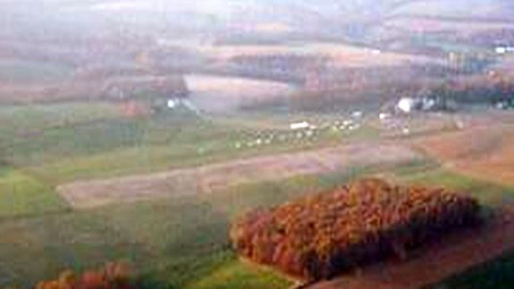
A 2010 aerial view looking southwest showed Woodbine Gliderport's runway remained distinct, but there were no aircraft on the field.
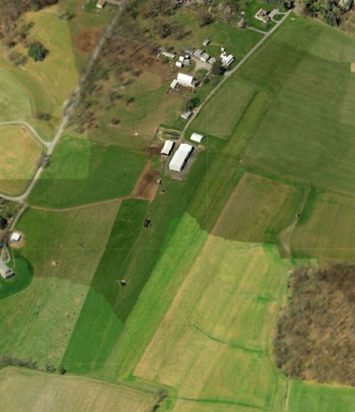
A circa 2011 aerial view looking north at Woodbine Gliderport showed the runway remained distinct, but there was no sign of any recent aviation usage.
However, Bob Ostman reported in 2014, “There are no longer any aircraft on the field or landing there.
The area is becoming populated & most people there never knew there was an airfield there.”
As of 2014, Woodbine Gliderport was no longer depicted on aeronautical charts,
yet it was still listed with the FAA Airport/Facility Directory as a private airfield, owned by Michael Harrison.
The field was said to have a single 1,650' turf Runway 3/21, and to have 4 based single-engine aircraft.
Woodbine Gliderport still was not depicted on the July 2016 Washington Sectional Chart.
Woodbine Gliderport may have been reopened at some point between 2016-17,
as it reappeared on the July 2017 Washington Sectional Chart.
The 2022 Washington Terminal Chart depicted Woodbine Gliderport as a private airfield having a 1,600' unpaved runway.
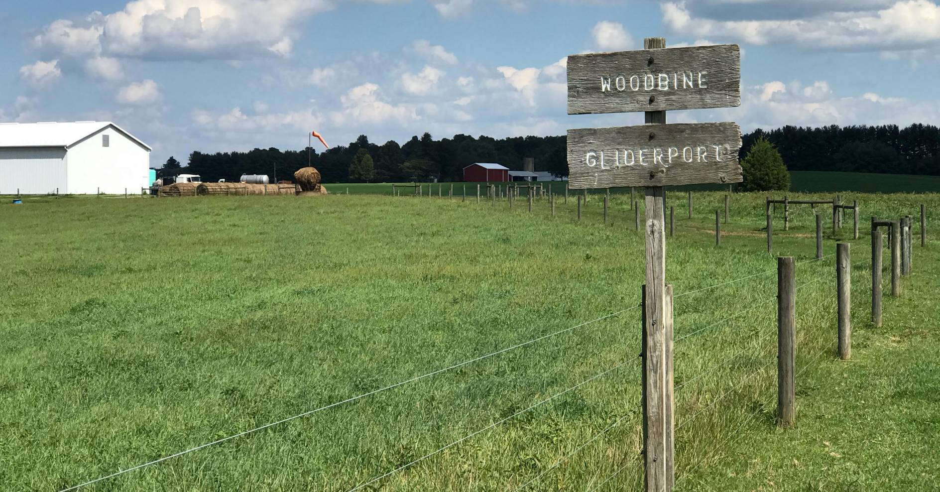
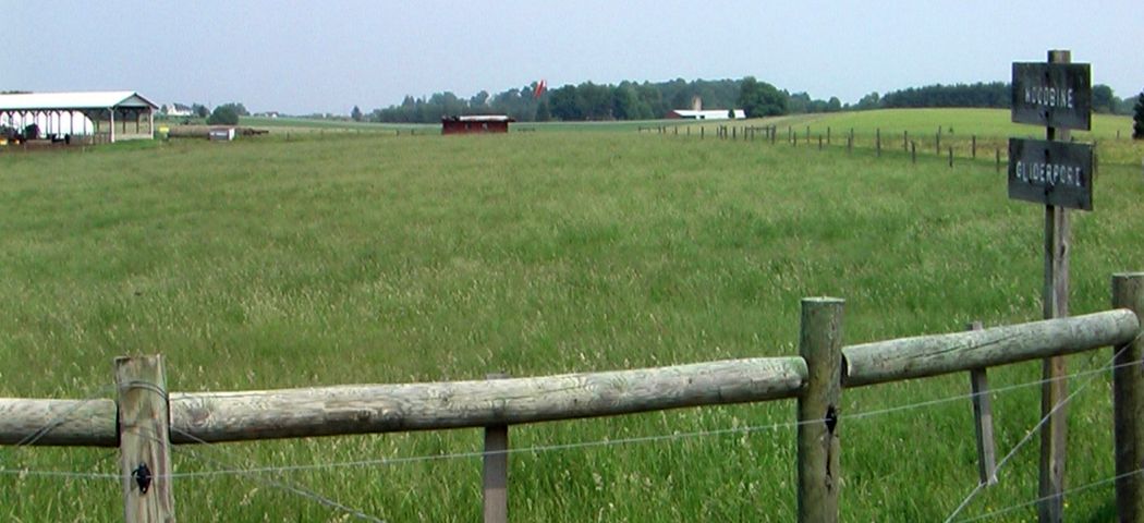
An 8/19/23 photo of the Woodbine Gliderport sign & windsock.
The photographer reported, “Kinda depressing. Marker is misplaced; address is confusing.
The neighbor I talked to on the phone (the tree service at the marker location) didn't offer an opinion (as a NIMBY-ist might), but only observed he hadn't seen a glider pulled out of there for several years.
There may yet be a crop duster operating out of here. There's a big wind sock, but no other obvious aviation presence.
Given that so many Maryland farms have produced their final crop (of houses) I'm pessimistic there would be enough business to keep a single operator going.
Looking at the NIMBY rants posted by neighbors, they seem to expect dusters to maneuver like airliners. All in all, the cards seem stacked against MD47.
Gliderwise, even grimmer prognosis: phone is disconnected, no online presence, no signage on the main road.
One worn plank sign well off the back lane. A neighbor said he's not seen a glider towed from here in years. I find no ADS-B activity. At this point only vestiges.”
The site of Woodbine Gliderport is located at the southern terminus of Fleming Road.
____________________________________________________
Taneytown Airport, Taneytown, MD
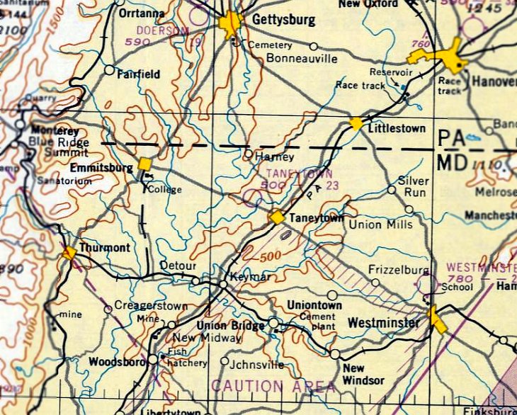
39.68, -77.21 (Northeast of Frederick, MD)
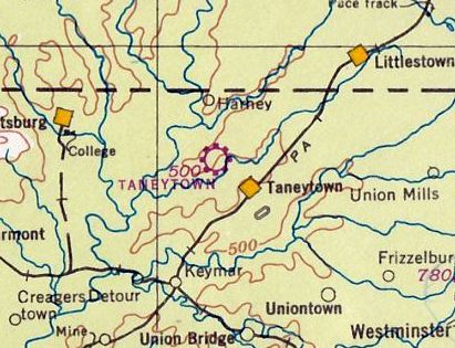
Taneytown Airport, as depicted on the November 1941 Washington Sectional Chart.
This short-lived general aviation airport was evidently established at some point between 1940-41,
as it was not yet depicted on the September 1940 Washington Sectional Chart
nor listed among active airfields in The Airport Directory Company's 1941 Airport Directory (according to Chris Kennedy).
The earliest depiction which has been located of Taneytown Airport was on the November 1941 Washington Sectional Chart.
Sheldon Shealer reported that he had a picture of his father in front of a Piper J-3 Cub,
“in front of a hangar at Taneytown Airport dated September 1942.”
The earliest photo which has been located of Taneytown Airport
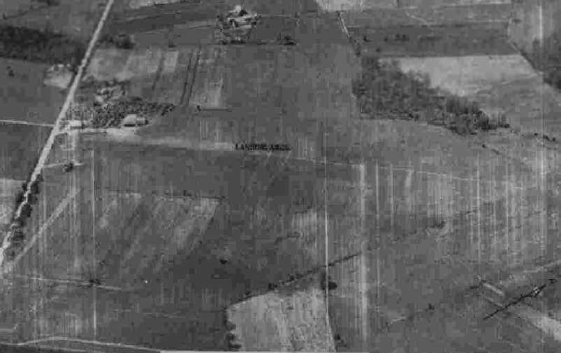
was a circa 1942-43 aerial view looking west from the 1945 AAF Airfield Directory (courtesy of Scott Murdock).
It depicted Taneytown as having a open grass landing area with a hangar on the southwest side.
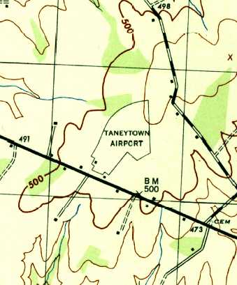
The 1944 USGS topo map depicted Taneytown Airport as an irregularly-shaped outline with a small building on the southwest side.
The May 1944 Washington Sectional Chart (courtesy of Ron Plante)
depicted Taneytown Airport as a commercial/municipal airport.
The 1945 AAF Airfield Directory (courtesy of Scott Murdock) described Taneytown Airport
as a 110 acre irregularly-shaped property within which were 2 sod runways, measuring 2,000' northeast/southwest & 1,600' northwest/southeast.
The field was said to have 2 hangars: 60' square wood & metal, and 45' x 35' cinder block.
The field was said to be privately owned & operated.
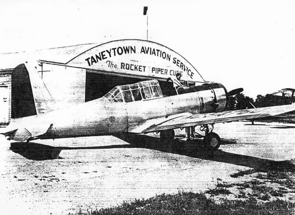
The only photo which has been located showing an aircraft at Taneytown Airport
was an undated (circa late 1940s?) photo of a surplus Vultee BT-13 in front of the Taneytown Aviation Service hangar.
An undated (circa 1940s?) aerial view looking northeast at the the former Taneytown Airport hangar.
The last aeronautical chart earliest depiction which has been located of Taneytown Airport was on the July 1950 Washington Sectional Chart.
It depicted Taneytown as having a 2,300' unpaved runway.
The Taneytown Airport was evidently closed (for reasons unknown) at some point in 1950,
as it was labeled as “Closed” in the 1950 MD Airport Directory (courtesy of Steven Mahaley).
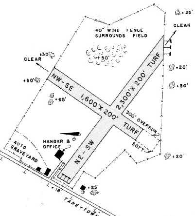
The field was depicted as having 2 turf runways: a 2,300' northeast/southwest strip & a 1,600' northwest/southeast strip.
An office & hangar were depicted on the west side of the field.
Taneytown Airport was no longer depicted at all on the January 1951 Washington Sectional Chart or the 1953 USGS topo map.
A 10/19/59 USGS aerial photo showed the site of Taneytown Airport, with the hangar visible at bottom-left.
According to a 12/6/12 Carroll County Times article, “Chaz Walls’ father bought the space on Taneytown Pike in 1986, and it was called Martell’s Used Auto Parts.
In July 1995, Walls took over, hence the name change [Chaz's Used Auto Parts & Towing] of the business.”
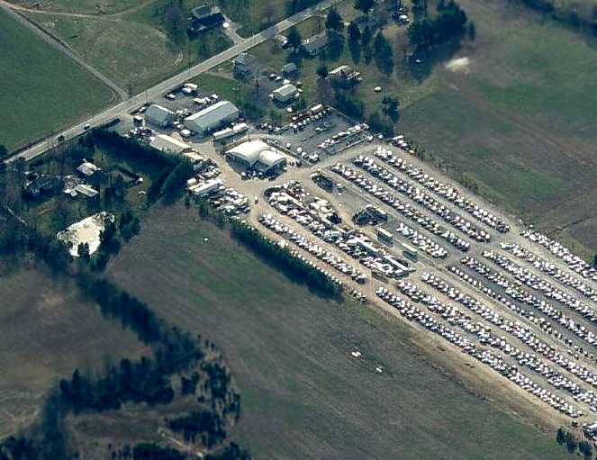
A circa 2008 aerial view looking southwest at the site of Taneytown Airport
shows that the 60+ year old arch-roof hangar remained standing.
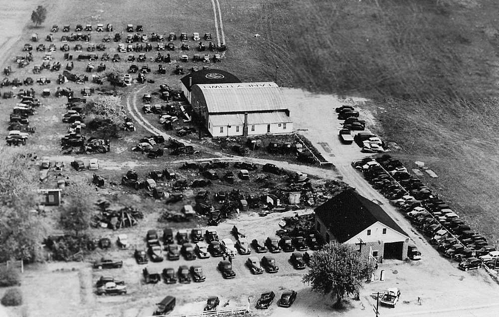
The majority of the property has been reused as an auto junkyard.
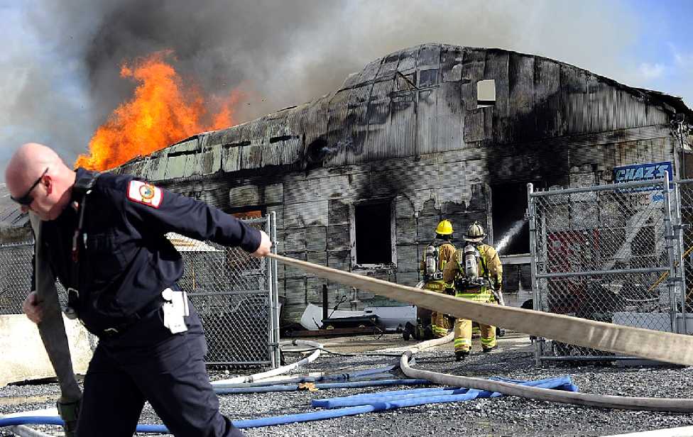
A 12/5/12 photo of the fire that destroyed the former Taneytown Airport hangar, caused by an accident at Chaz's Used Auto Parts & Towing which occupied the building.
Owner Chaz Walls said, “It’s really a shame to lose that building because it was a really a big icon.
It has a lot of good history behind it. My whole family’s upset about it.”
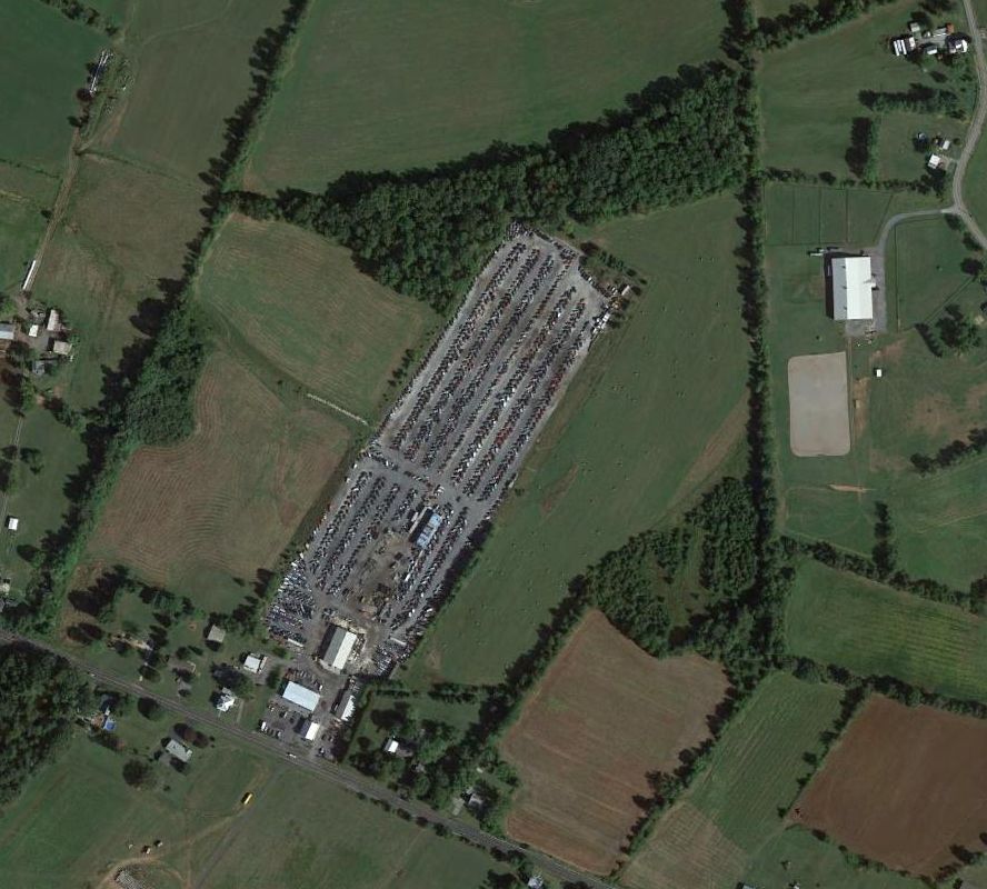
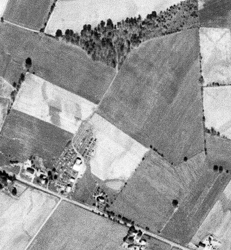
A 2015 aerial view shows no trace remaining at the site of Taneytown Airport.
The site of Taneytown Airport is located northwest of the intersection of Taneytown Pike & Frenchmans Drive.
____________________________________________________
Stevens Airport, Hansonville, MD
39.51, -77.41 (North of Frederick, MD)
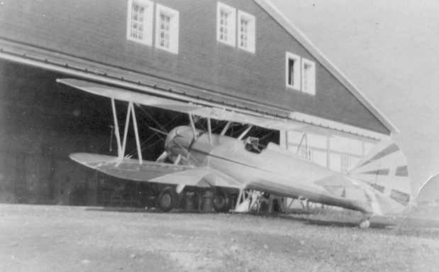
A 5/13/41 photo of a Waco with a 165 Continental engine at Stevens Airport (courtesy of Howard Stevens).
According to Howard Stevens, Stevens Airport was started & operated by his father, Howard L. Stevens.
Stevens had previously (circa 1938) operated a flight school at Rutherford Field in Baltimore.
According to the fantastic book "Maryland Aloft" by Preston, Lanman, and Breilhan,
Howard Stevens acquired the farm property in 1942 & built the airfield the same year.
"He operated the Stevens Flying Service, offering charter service, aircraft sales, fuel, repairs, and a lunch room."
Stevens Airport was not yet depicted on the November 1942 Washington Sectional Chart.
A circa 1942-43 aerial view looking southwest at Stevens Airport from the 1945 AAF Airfield Directory (courtesy of Scott Murdock)
depicted the field as an open grass landing area.
A 1943 photo from the Library of Congress of 2 unidentified aircraft at Stevens Airport.
The monoplane in the foreground is the plane in which flight student Walter Spangenberg
had made his first solo flight at Stevens Airport.
A 1943 photo from the Library of Congress of 2 aircraft (note the Civil Air Patrol insignia on the wingtip at the right) inside the hangar at Stevens Airport.
Outside the hangar is Walter Spangenberg, two was taking flying lessons at Stevens Airport.
A 1943 photo by Esther Bubley (Office of War Information) of Greaseball, a mascot at Stevens Airport, with a Piper Cub in the background.
Stevens Airport was in fact Frederick County's only airport from the period of 1943-49
(after Detrick Field was closed in 1943 until Frederick Municipal Airport was opened in 1949).
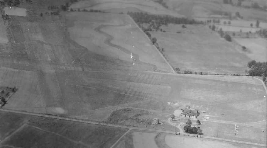
A 1943 aerial view (courtesy of Howard Stevens) depicted Stevens Field
as having 2 grass runways & a single hangar on the northeast corner of the field (with "Stevens" painted on the roof).
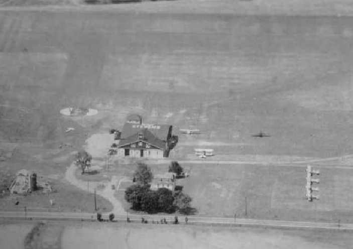
A close-up of Stevens airport's hangar from the above 1943 aerial view (courtesy of Howard Stevens).
A total of at least 7 aircraft (including one biplane) were depicted parked around the hangar.
The earliest chart depiction of Stevens Airport which has been located
was on the May 1943 Washington Sectional Chart (courtesy of Chris Kennedy).
It depicted Stevens as a commercial/municipal airport.
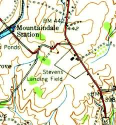
The earliest topo map depiction of Stevens Airport which has been located was on the 1943 USGS topo map.
It depicted “Stevens Landing Field” as a rectangular property outline with a few buildings on the north side.
The 1944 US Army/Navy Directory of Airfields (courtesy of Ken Mercer)
described Stevens Airport as having a 2,800' unpaved runway,
and indicated that Navy flight operations were conducted from the field.
The 1945 AAF Airfield Directory (courtesy of Scott Murdock) described Stevens Airport
as a 140 acre irregularly-shaped property within which were 2 sod runways, measuring 2,800' northeast/southwest & 2,400' NNW/SSE.
The field was said to have a single 80' square concrete block hangar,
and to be privately owned & operated.
A 9/9/48 photo of a silver & red Stearman (used for stunts, with a Lycoming 300 engine)
in front of the north side of Stevens Airport's hangar (courtesy of Howard Stevens).

Strangely, Stevens Airport was still depicted in the 1950 MD Airport Directory (courtesy of Steven Mahaley), but was labeled "closed".
The field was depicted as having 2 turf runways: a 2,800' northeast/southwest strip & a 2,350' northwest/southeast strip.
An office & two other buildings sat on the north side of the field, along the west side of Route 15.
Curiously, a large swimming pool was depicted directly under the southwest end of the primary runway.
The last depiction which has been located of Stevens Airport was on the January 1950 Washington Sectional Chart.
It depicted Stevens as having a 2,800' unpaved runway.
Stevens Field was apparently closed (for reasons unknown) at some point in 1950,
as it was no longer depicted on the July 1950 Washington Sectional Chart or the 1953 USGS topo map.
A 12/4/59 USGS aerial view showed no recognizable trace of Stevens Field.
According to the book "Maryland Aloft", historic sites surveyor Janet Davis reported that the office building attached to the east side of the hangar
was most likely added in the 1960s.
Brian Fisher recalled, “Stevens Airport... my father worked here for a good portion of his career when it was Sire Power now known as Select Sires.
After the sale of the airport it was converted into cow barns for use by a company called Sire Power
which is an artificial insemination facility based out of Tunkanock PA.
That is what it remained up until about 1990 when the property was sold to the Lynfields who turned it in to what it is now.
The shorter office portions of the main hangar where added on as offices
and the small portion that has 2 large doors on it was added on as a sawdust storage area.
When my father worked there, the inside of the hangar was largely unchanged
as the original roof & floor where still there with the addition of individual cow pens & slide open doors to allow outside grazing.
The large swimming pool that is depicted in the map is actually not a swimming pool
but is a very large pond that I used to fish in quite a bit as a kid.
I know this because I remember stories that I was told of how someone drowned in it many years ago from swimming after working at the airport.
The person cramped up & drowned as a result.
You can still see the pond in one of the overhead maps. It is shrinking & is quite overgrown.”
By 1992, Janet Davis reported that the former hangar had been adapted for use as a cow barn.
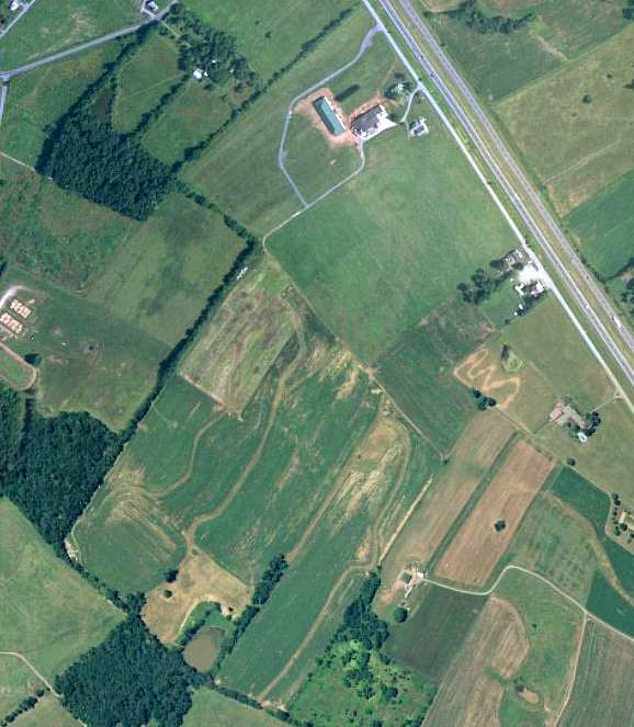
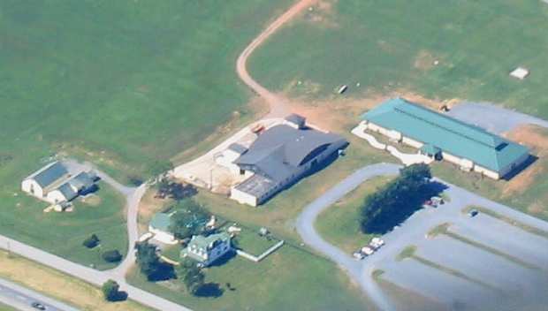
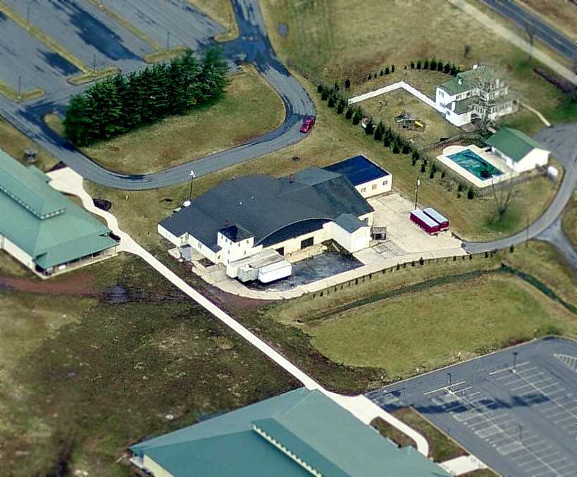
A circa 2000 aerial photo of the site of Stevens Airport.
The former hangar at the top-center, and the 2 former grass runways were still clear & undeveloped.
According to John Clifford, a bar called "Mel's Airport Inn" operated for some period of time in a building along the west side of Route 15,
along the eastern side of the former airport property.
He said that "There is a large what looks like a barn/hangar with a tower attached behind the restaurant."
Just to the northwest of the hangar is a new-construction building, the Lynfield Event Complex, which hosts weddings, meetings, etc.
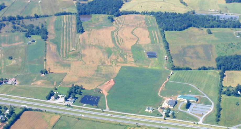
A 2003 aerial view by Paul Freeman, looking west at the site of Stevens Airport.
A 2003 close-up by Paul Freeman of the former hangar (center of photo) of Stevens Airport.
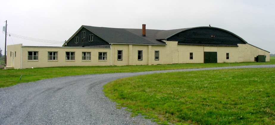
A 2003 photo by Paul Freeman of the back of the former hangar of Stevens Airport.
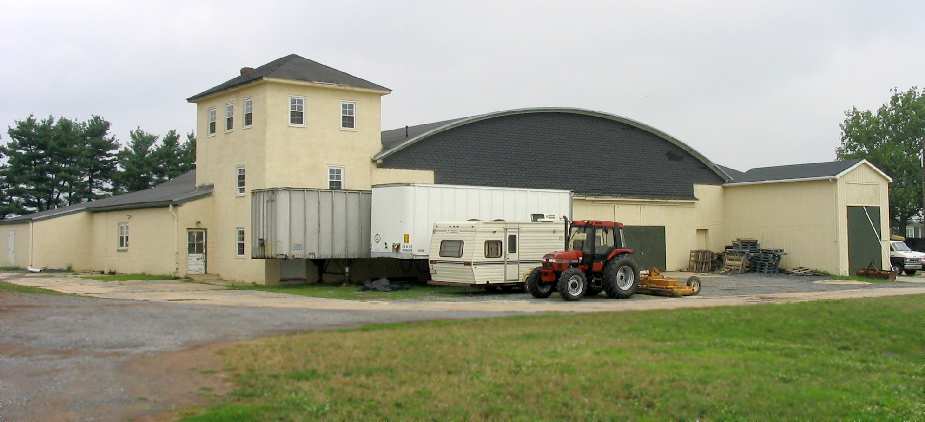
A 2003 photo by Paul Freeman of the front of the former hangar of Stevens Airport.
Paul Freeman flew over the site of Stevens Airport
and visited the site at ground-level in 2003.
Although the former runways are no longer recognizable as a airport from the air,
a closer inspection does reveal the former hangar,
which has an arched roofline quite indicative of a hangar.
An employee of the Lynfield Event Complex confirmed that the site was an airport "in the 1940s",
and added that the hangar was later reused to hold cattle.
It is presently being used to store supplies for the event complex,
and the hangar appears to be well maintained.
Even though the site is no longer an airport,
it is nice to see that the business using the property
has found a use for the hangar which will justify its continued upkeep.
The 3-story masonry "control tower" on the corner of the former hangar
is somewhat more elaborate than what would be expected for a fairly small civil airport of the 1940s.
Patrick Benda reported in 2004 that "someone is building a church right on the field where the runways were.
I guess a church might be better than a Wal-Mart.
I was nursing a dream of buying the property one day & bringing the old airfield to life.
Sad to say it became another victim of the sprawling of the City of Frederick; it breaks my heart.
The hangar is still there & well maintained (I love to visit it as the architecture is quite beautiful)."
Paul Freeman drove by the site of Stevens Airport in 2005,
to find that the former hangar still existed, maintained in very good condition.
A large new building (part of the Lynfield Event Complex, and used by a church)
has been built to the south of the hangar, over the northeast end of the former northeast/southwest runway.
A circa 2007 aerial view looking north at the former Stevens Airport hangar.
Brian Tetter reported in 2009 that “Frederick Christian Fellowship Church purchased the property from the Lynfield Event Complex earlier this year.
We are using the 2 new buildings on the property as our church.
We would very much like to renovate the hangar at some time; it is not in the best shape anymore.”
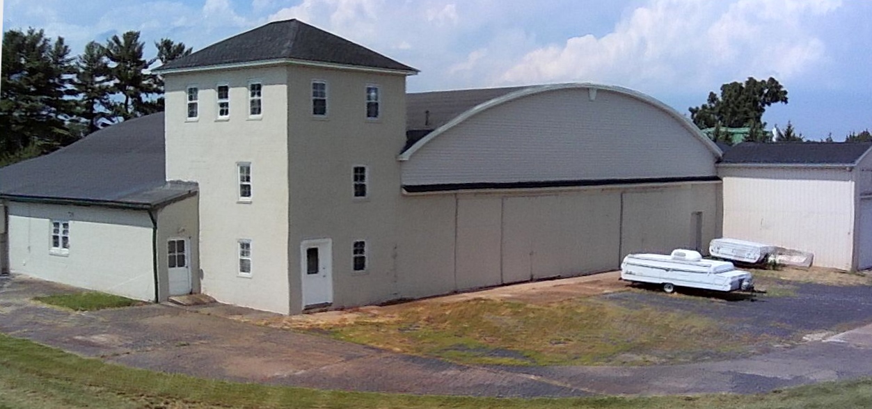
A 7/4/17 drone aerial photo by Paul Freeman looking north at the front of the former hangar of Stevens Airport, now reused by the Frederick Christian Fellowship Church.
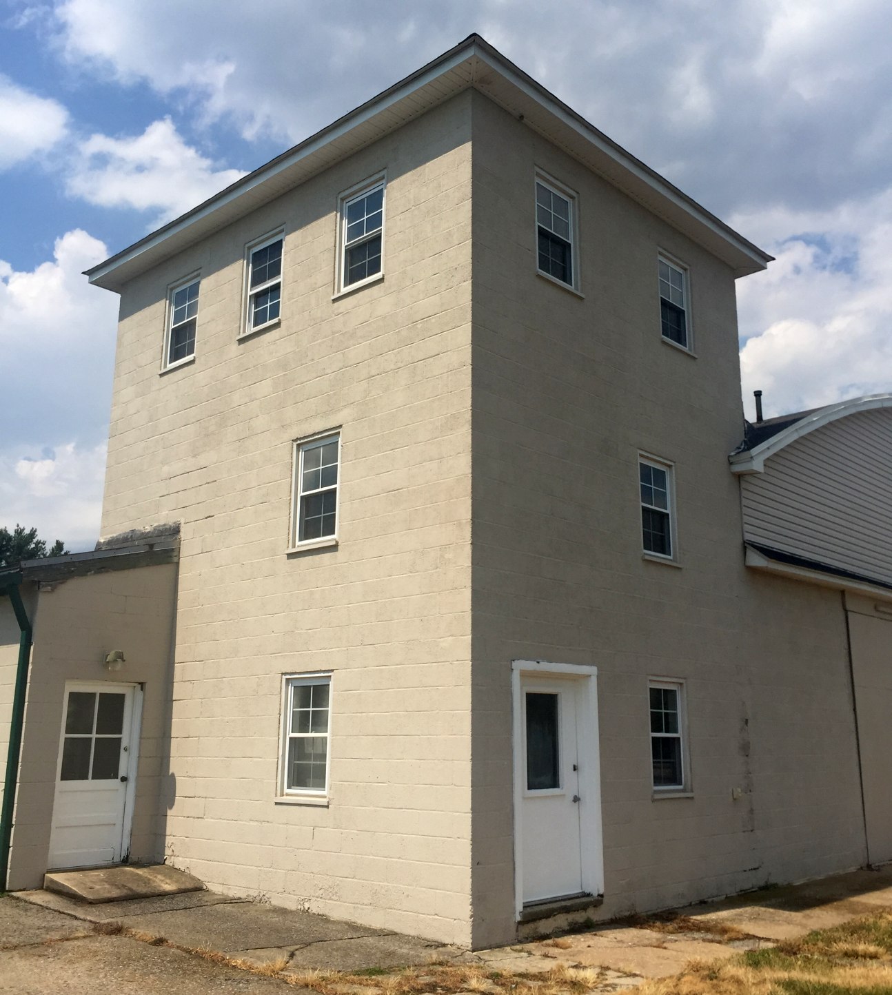
A 7/4/17 photo by Paul Freeman looking north at the former observation tower attached to the former hangar of Stevens Airport.
The site of Stevens Airport is located on the west side of Route 15, south of Mountaindale Road, five miles north of Frederick.
____________________________________________________
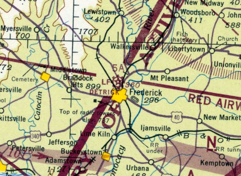
Fort Detrick Army Airfield / Intermediate Field 5A, Frederick, MD
39.43, -77.43 (Northwest of Frederick Municipal Airport, MD)
The Fort Detrick Army Airfield, as depicted on the 1928 Washington D. C. - Uniontown Airway Map.
The earliest depiction which has been located of an airfield at this location was on the 1928 Washington D. C. - Uniontown Airway Map.
It depicted an auxiliary airfield on the west side of Frederick.
According to the book "Maryland Aloft", "On 7/29/29, Frederick municipal authorities purchased 92 acres at this site,
then on the northwestern edge of their city.
Three days later, they leased it to the federal government to become an Intermediate Landing Field,
one of several such facilities that the Department of Commerce was establishing along the Washington-Cleveland Airway.
Officially, these fields were for use in case of emergencies between airports, rather than for regular operations.
Communities were eager to see them built, however, seeing the program as a chance to create an airport."
The book continued, “Among the first landings at Intermediate Field 5A was made by a biplane dubbed the 'Queen of Frederick County',
and the facility continued to be used by local aviators.
The airfield had 2 sod runways, configured as a 'L'.
The northeast/southwest runway was 2,650', while the northwest/southeast strip measured 1,900'."
In 1931, Maryland Adjutant General Reckord obtained permission to have the 104th Aero Squadron
of the 29th Division (Maryland National Guard) hold its 2-week encampments at the Frederick airport.
The airport had 3 stone block buildings, which served as the tower, a snack bar & latrine.
The grass runway was situated almost west to east with a dogleg north.
West 4th Street (now Rosemont Avenue) marked the western boundary.
West 7th Street was the eastern boundary, where a tree-lined entrance greeted the National Guardsmen.
The 104th came equipped with its American-made DeHaviland O-38 Observation biplanes, JN-4 "Jennies".
The squadron surgeon, then Capt. Frederick Louis Detrick,
a distinguished teaching surgeon at Johns Hopkins University Hospital, suffered 3 heart attacks & died in 1931.
So great was the respect & admiration for Dr. Detrick that the unit unanimously voted
to name the air field "Detrick Field" during that 1931 encampment.
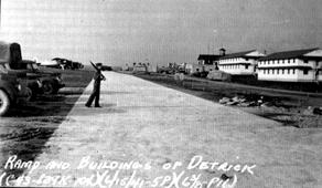
An undated view of the ramp & buildings at the Fort Detrick airfield.
An undated view of JN-4 Jenny biplanes at the Fort Detrick airfield.
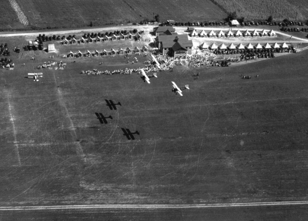
An 8/13/31 aerial view of a formation of 3 O-38s of the MD National Guard's 104th Observation Squadron overflying Detrick Field, with another biplane on the ground.
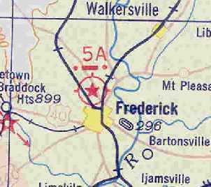
The earliest aeronautical chart depiction which has been located of Intermediate Field 5A
was on the May 1932 J-18 Washington D. C. Airway Map (courtesy of Chris Kennedy).
The 1932 Frederick Yearbook highlighted the first encampment: "Plane from Frederick airport is ‘shot down' in mimic battle over Hagerstown."
An airshow would be staged for the city at the conclusion of each encampment.
Many residents have recounted how they flew for the first time in one of the 104th Aero Squadron's observation aircraft.
The squadron supported infantry maneuvers from Pennsylvania to Virginia,
and took photographs, which later became the basis for maps, and other land-use documents.
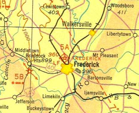
The Fort Detrick airfield was labeled "Frederick" on the 1935 Washington Sectional Chart.
Three bombers are known to have landed at Detrick Field.
A Ford Tri-Motor was on display & gave rides in the late 1930s.
An eight-engine Barling Bomber was photographed on the grass tarmac in 1933.
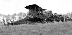
On May 25, 1939, a B-17 bomber being shuttled from the West Coast was forced down due to engine trouble.
It stopped nose up in the ditch adjacent to the trolley tracks on West 4th Street.
Pulled from the ditch & refueled, it took off without incident the next morning.
A week earlier on May 19, the first Air Mail was received & dispatched from Detrick Field in conjunction with National Air Mail Week.
The Airport Directory Company's 1937 Airports Directory (courtesy of Bob Rambo)
listed the Frederick Airport as the "Department of Commerce Intermediate Site 5A" airport, along the Washington-Cleveland Airway.
It was described as having 2 sod runways, with the longest being a 2,650' northeast/southwest strip.
In 1938, Detrick Field was removed from the list of emergency air fields, but in 1939 the Federal Government renewed its lease.
With WW2 looming, Detrick Field became home for a Cadet Pilot Training Program.
It built a large hangar (Building S-201) and a series of wooden, pre-fabricated cantonment structures for barracks & administrative buildings.
Among those buildings still standing are the former Noncommissioned Officers Club (Building T-115),
the former infant care center (Building T-116), Strough Auditorium (T-611), Post Exchange complex (T-713),
Post Library & other support offices including Inspector General & Equal Employment Opportunity offices (T-501),
Community Activities Center (Building S-718), and Building 719, which now houses Company B, 4th Light Armored Infantry Battalion, U.S. Marine Corps Reserve.
Construction also included the concrete tarmac.
Now called Hamilton Street, it runs parallel to Military Road across from Buildings S-10, 11 & 12, the control tower complex.
Steel bars embedded in the concrete tarmac allowed the pilots to secure their aircraft with ropes each night.
Hamilton Street still runs directly to the old hangar, where it is covered in asphalt, but most of it remains as it was.
It is used primarily for parking.
Quartermaster Corps soldiers from Fort Ritchie, some 26 miles north near Sabillasville, MD,
were assigned to Detrick Field & kept the facilities operating in the years immediately preceding the onset of WW2.
It was depicted as "Frederick" Airport on the 1940 Washington Sectional Chart (courtesy of Mike Keefe).
The MD National Guard's 104th Observation Squadron was based at Detrick after being mobilized on 2/3/41.
The last photo which has been located of Detrick Field was a 4/2/41 aerial photo, which depicted Detrick as having a small paved strip on the edge of a grass airfield,
with a row of buildings, and one larger building under construction. No aircraft were visible on the field.
It was depicted as "Detrick" on the 1942 Washington Sectional Chart (courtesy of Mike Keefe).
The last airplanes departed Detrick Field in January 1942 after the Pearl Harbor attack.
All aircraft & pilots in the 104th & Cadet Pilot Training Program were reassigned after the Declaration of War
to conduct anti-submarine patrols off the Atlantic Coast.
But that wasn't the end of Detrick Field's aviation history.
Irving Shuffler provided extensive information that was verified by the Office of the Chief of Military History
about the 2nd Bombardment Wing being at Detrick Field.
The 2nd Bombardment Squadron, U.S. Army Air Corps, was reestablished in February 1942 & its colors brought to Detrick Field,
which had been virtually abandoned save for the skeleton crew from the Quartermaster Corps.
Between February & September 1942, a cadre of soldiers with the squadron completely organized the reconstituted unit,
ordering all supplies, equipment & personnel.
It had no organic aircraft assigned to Detrick Field.
The last aeronautical chart depiction which has been located of Detrick Field was on the November 1942 Washington Sectional Chart.
It depicted Detrick as a civilian airport, and with Commerce Department Airway Beacon 5A.
According to the book "Maryland Aloft", "In 1943, the federal government acquired Detrick Field for $50,000,
and the city began plans to establish an airport at a different location [the present-day Frederick municipal airport, which opened in 1949].
Adding additional property, the Army converted the former airfield into a Chemical Warfare Service base that was designated Camp (later Fort) Detrick."
The Detrick Airfield was no longer depicted on the November 1943 Washington Sectional Chart.
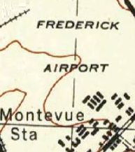
Curiously, the 1944 USGS topo map still labeled the Detrick Airfield as “Frederick Airport”.
By 1944, Detrick was no longer listed among active airfields in the 1944 US Army/Navy Directory of Airfields (courtesy of Ken Mercer).
The only remnants of Detrick Field's role in aviation are the Blockhouse Tower,
the hangar now used by the Directorate of Engineering & Housing, Hamilton Street,
and the wooden buildings, the latter destined to be razed in the near future.
The grass runway is only visible on Blue & Gray Field.
The parade field was dedicated in 1985 to the memory of the 29th (Blue & Gray) Division soldiers from Frederick
who died during & immediately after the Normandy Invasion on D-Day.
Today, Fort Detrick is designated as an emergency landing site for the Presidential helicopter
should an on-board health emergency be experienced en route to nearby Camp David.
Fort Detrick saw a return aircraft visitor after a 49 year gap.
Steve Van Kirk recalled, “I flew my 1943 Fairchild PT-23 in both 1991 & 1992 Armed Forces Day events.
I keep my plane at KFDK & each time, I practiced an hour or so to be able to land & takeoff in 600'.”
During the 1992 Armed Forces Day Open House, a 1940s-vintage North American T-6 Texan trainer also landed at Fort Detrick.
It flew in over the helipad & quickly touched down in the grass behind the supply warehouse.
There was just enough room for the landing & subsequent takeoff.
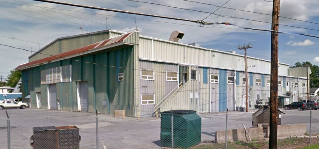
A circa 2013-2018 photo looking east at the former Detrick Field hangar, converted to house offices.
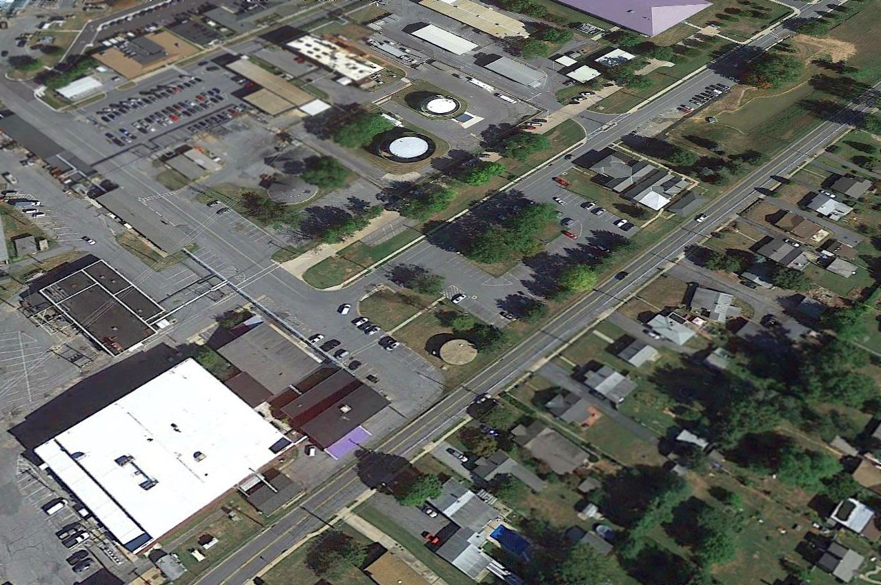
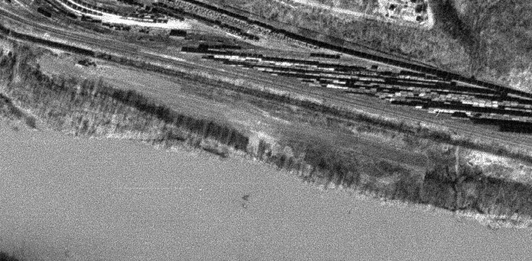
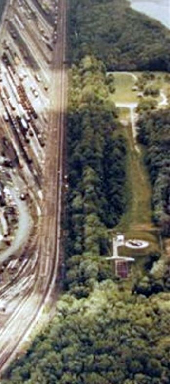
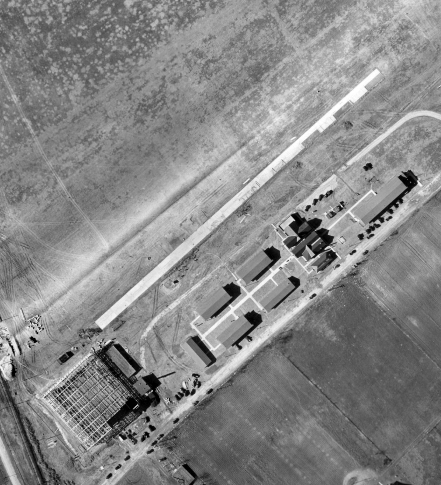
A 2015 aerial view looking north at the remaining elements of Detrick Field.
Wayde Minami observed that the former Detrick Field runway has been reused as Hamilton Street (the tan colored strip running diagonally from bottom-left to top-right).
He reported, “I'm told it's actually used more as a parking lot than a street, and you can still see tiedown points on it.
Parallel to the runway is Porter Street, and you can see the original operations building is still there.
At the bottom-left is a large white square building bordered by Beasley Drive – the hangar that was built in 1941.”
See also:
http://www.dcmilitary.com/army/standard/6_10/local_news/7344-1.html
____________________________________________________
Or if you prefer to contact me directly concerning a contribution (for a mailing address to send a check),
please contact me at: paulandterryfreeman@gmail.com
If you enjoy this web site, please support it with a financial contribution.
____________________________________________________
This site covers airfields in all 50 states.
For the site's main menu: Home