Abandoned & Little-Known Airfields:
Maryland, Northern Prince George's County
© 2002, 2023 by Paul Freeman. Revised 8/7/23.
This site covers airfields in all 50 states: Click here for the site's main menu.
____________________________________________________
Please consider a financial contribution to support the continued growth & operation of this site.
For a suburban community, Prince George's County has a remarkable aviation heritage.
A total of 11 airfields within the county are profiled on this web site (many of which have historic value).
Unfortunately, the county's proud aviation heritage is not very widely known.
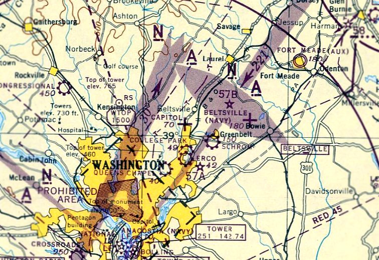
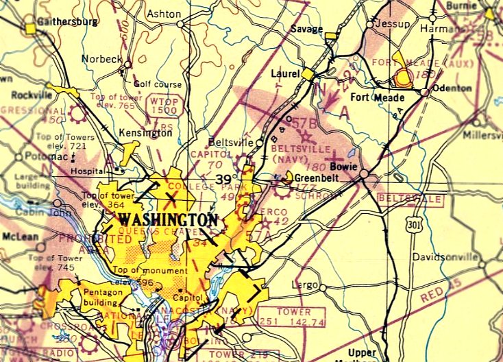
Capitol Airport (2nd location) (revised 2/21/20) - Intermediate Field 57B / Beltsville Airport (revised 8/7/23)
Prince George's Industrial Airpark (added 7/28/14) - Schrom Airport (revised 2/21/20)
____________________________________________________
Prince George's Industrial Airpark, Bowie, MD
38.88, -76.735 (East of Washington, DC)
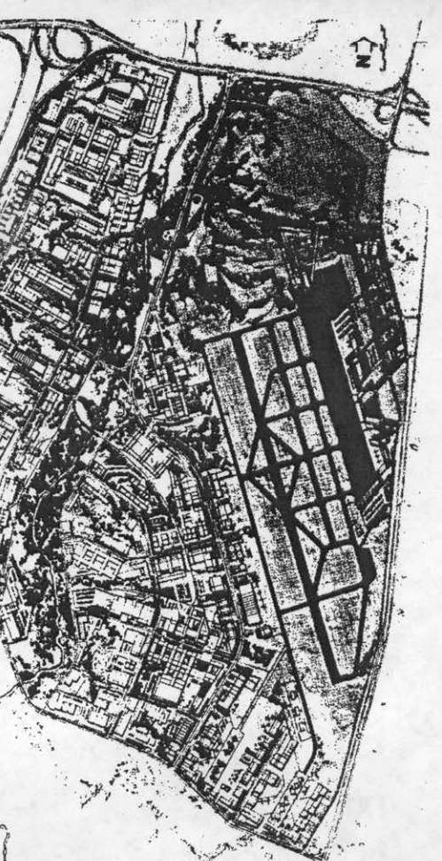
The proposed layout of Prince George's Industrial Airpark, as depicted in the January 1971 AOPA Pilot magazine.
This is the story of a general aviation airport which was abandoned before construction was even complete,
located southwest of the intersection of Routes 301 & 214, at the time an undeveloped rural area.
The Prince George's Industrial Airport was an early 1970s proposal for an integrated complex of an airport with a 5,000' runway,
aviation school, industrial facilities, and a fly-in headquarters building for the Aircraft Owners & Pilot's Association (AOPA),
which at the time was located in the non-airport facility of the Bethesda Air Rights Building.
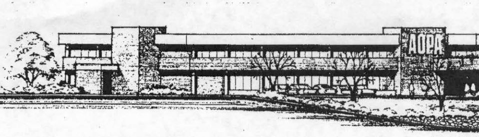
A depiction of the proposed AOPA headquarters building at Prince George's Industrial Airpark, as depicted in the January 1971 AOPA Pilot magazine.
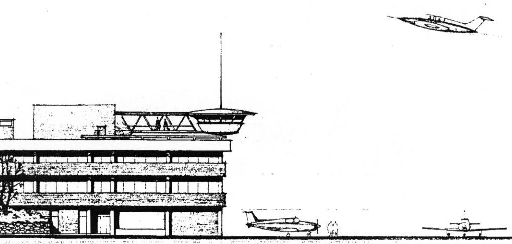
A depiction of the fanciful proposed AOPA headquarters building at Prince George's Industrial Airpark, as depicted in the January 1971 AOPA Pilot magazine.
According to Bill Long, “The Prince George's County Industrial Park never materialized.
This failure was a result of strenuous opposition by Bowie residents who opposed the airport after learning that the 5,000' runway, then under construction,
would eventually be extended to over 7,000' accommodate business jets.
The airport construction was terminated just before paving of the graded runway was to begin.
The runway was subsequently used by remote control aircraft modelers for years later.”
Dennis Boykin observed, “The industrial park that sits there now
appears to have been built on the graded property where the first 5,000' [of runway] would have gone.”
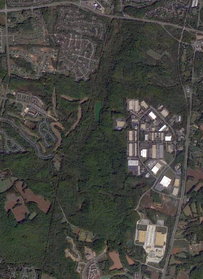
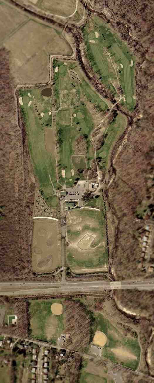
A 10/12/12 aerial photo showed that an industrial park occupies the southern portion of the Prince George's Industrial Airpark site,
while the northern portion remains completely undeveloped.
____________________________________________________
Capitol Airport (2nd location), College Park, MD
39.005, -76.935 (Northeast of Washington, DC)
The second location of Capitol Airport, as depicted on the December 1945 Washington Sectional Chart.
Another airfield named "Capitol" had operated at a different site in Bladensburg (6 miles to the south), from prior to 1933 until prior to 1942.
This 2nd location of Capitol Airport (in College Park) was not yet depicted
on the June 1945 Washington Sectional Chart or the 1945 USGS topo map.
At some point in 1945, Capitol Airport apparently reopened at this site in College Park,
as that is where it was depicted on the December 1945 Washington Sectional Chart.
It was depicted as an auxiliary airfield.
The only photo which has been located showing Capitol Airport in operation was a 1945 aerial view (from the National Archives, courtesy of Oscar Gregory).
It depicted the field as having a single unpaved north/south runway.
Oscar Gregory observed, “In the middle of the photo you can see what looks like a dirt road [oriented northeast/southwest].
At the [northeast] end is a hangar with an airplane parked outside & another plane on that road.”
Capitol Airport was owned by Horace Thompson, according to Keith Lippincott, who spoke to Doug Thompson (the son of Horace Thompson).
“It was a grass field & had a single hangar. It was accessed from Metzerott Road.”
According to Doug Thompson, Capitol Airport was owned by his father (Horace “Tailspin Tommy” Thompson) & his uncle (Wendell “Gene” Miller.

“Capital” Airport, as depicted on the 1946 USGS topo map.
The last aeronautical chart depiction which has been located of Capitol Airport was on the October 1946 Washington Sectional Chart.
It depicted Capitol as a commercial/municipal airport.
Apparently the Capitol Airport at this location in College Park lasted no more than 3 years.
It was apparently closed at some point between 1946-47,
as no airfield was depicted at this location on the April 1947 Washington Sectional Chart or the 1949 USGS topo map.
The white building at center appears to be the former hangar, but there were no aircraft visible.
According to Keith Lippincott, who spoke to Doug Thompson (the son of Horace Thompson), “It was cut in half by the extension of Greenbelt Road.
They moved again to what is now Freeway Airport but sold it soon after relocating.”
A 1957 aerial photo showed the rectangular north/south outline of the former Capitol Airport property, bisected by the new Greenbelt Road,
but did not show any specific remnants of the former airport.
According to Keith Lippincott, Capitol Airport “was located on land which is now Acredale Park & Paint Branch Golf Course.”
Neither the 1979 or 1982 USGS topo nor the 1988 USGS aerial photo
show any recognizable trace which remained at the site of Capitol Airport.
As seen in the 2002 USGS aerial photo, no trace remains at the location of the Capitol Airport in College Park.
However, the shape of the property of the Paint Branch Golf Course is a narrow north/south outline,
which would seem to indicate that the former airfield had a runway oriented north/south.
The site of the 2nd location of Capitol Airport is located along University Boulevard (Greenbelt Road), just west of Route 1.
____________________________________________________
38.99, -76.88 (Northeast of Washington, DC)
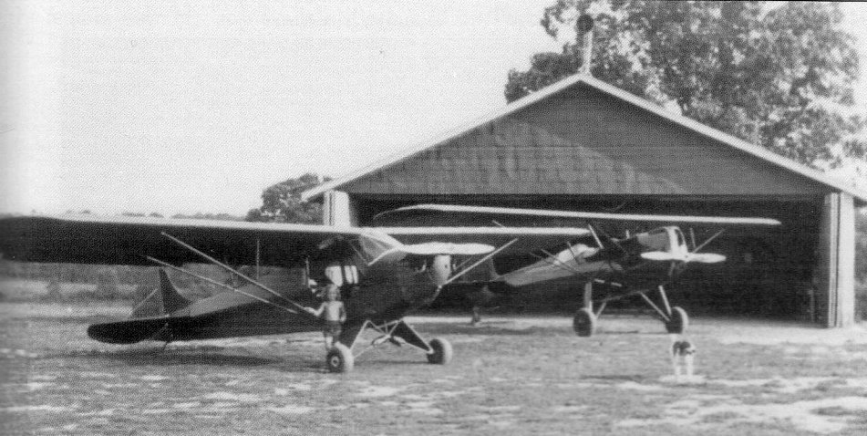
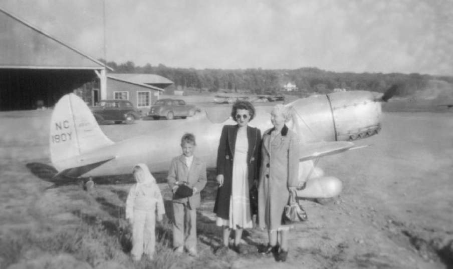
A circa 1930s photo (from the Greenbelt Museum, courtesy of Karl Ginter) of a Piper Cub & an unidentfied parasol high-wing monoplane in front of a hangar at Schrom Airport.
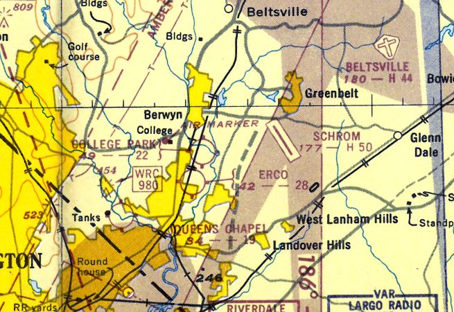
This fairly substantial general aviation airport was located in Greenbelt, south of what was then Route 430.
Curiously, Schrom Airport was located in close proximity to 3 other airports,
with College Park Airport being only 2.5 miles southwest, ERCO Field only 3 miles southwest, and Beltsville Airport only 3.5 miles to the northeast.
According to the interpretive panel which sits today at the site of the former airport (courtesy of Jill St. John of the Greenbelt Museum),
civil engineer William Schrom built a chicken farm on this land in the 1890s.
His son, Frederick ("Fritz") Schrom, built an airport on his family’s farm in 1928.
According to the book "Maryland Aloft" by Preston, Lanman, and Breilhan, Fritz Schrom was described as a "flight-crazy farm boy."
The earliest depiction which has been located of Schrom Airport was a 1938 aerial photo.
However, it did not yet show any recognizable trace of an airfield, just a farm.
Roanne Guest Fenbert recalled, “I have my father's fight log from 1939-40 when he took flying lessons beginning at the age of 19.
He [John F. Guest, Jr.] was taught primarily by FW Schrom 25367.
There are only 2 other signatures: W.A. Hoke 34163, and K.F. Scribner 38763.
I have my father's student pilot certificate with Schrom's signature on the back certifying his first solo fight.
My father said he used to deliver Old Man Piper's planes for him & said he flew for the Department of Agriculture.”
The Civilian Pilot Training Program used Schrom Airport actively in the late 1930s to train student pilots,
many of them from the nearby University of MD.
In the airport’s heyday in 1940, more than 50 planes called the field home,
and 120 pilots, mechanics, and instructors flew, worked, and trained here.
Schrom Airport still was not yet depicted on the January Washington Sectional Chart.
The earliest aeronautical chart depiction which has been located of Schrom Airport was on the April 1940 Washington Sectional Chart.
It depicted Schrom as a commercial/municipal field.
According to the book "Maryland Aloft", a 1941 Civil Aeronautics Administration bulletin described Schrom Field as consisting of 60 acres,
with 2 gravel & dirt runways (measuring 2,400' & 1,900'), and 3 hangars.
Schrom was depicted as a commercial airport on the 1942 Washington Sectional Chart (courtesy of Mike Keefe).
However, according to local historian Mary Williamson, Schrom Airport was temporarily closed in 1942,
due to wartime security restrictions, like many other small civil airports along the east coast during the war.
A 9/29/43 aerial view looking west at Schrom Airport from the 1945 AAF Airfield Directory (courtesy of Scott Murdock)
depicted the field as having a single grass runway.
Schrom Field was not depicted on the 1944 Washington Sectional Chart (courtesy of Mike Keefe).
Fritz Schrom was still serving with the Army Ferrying Command in 1944,
when easing of security restrictions allowed his wife to reopen the airport.
It was used during this period as a training center for the Civil Air Patrol.

Schrom Airport, as depicted on the 1945 USGS topo map.
Several buildings were depicted, but runways or property outline.
Schrom was depicted as a commercial/municipal airport on the December 1945 Washington Sectional Chart.
The 1945 AAF Airfield Directory (courtesy of Scott Murdock) described Schrom Airport
as a 35 acre irregularly-shaped field with a single 2,215' northwest/southeast asphalt runway.
The field was said to have 3 hangars, and to be privately owned & operated.
A history of the Mid-Atlantic Soaring Association said that a predecessor group,
the Washington Soaring Club, operated in 1946-1948 at Schrom Airport.
The club had 3 Pratt-Read gliders & a Laister-Kauffmann glider, flown by 8 active members. The club disbanded "after a few years".
A 1948 photo of the Desque family in front of a Ryan STA at Schrom Airport (courtesy of Jill St. John, of the Greenbelt Museum).
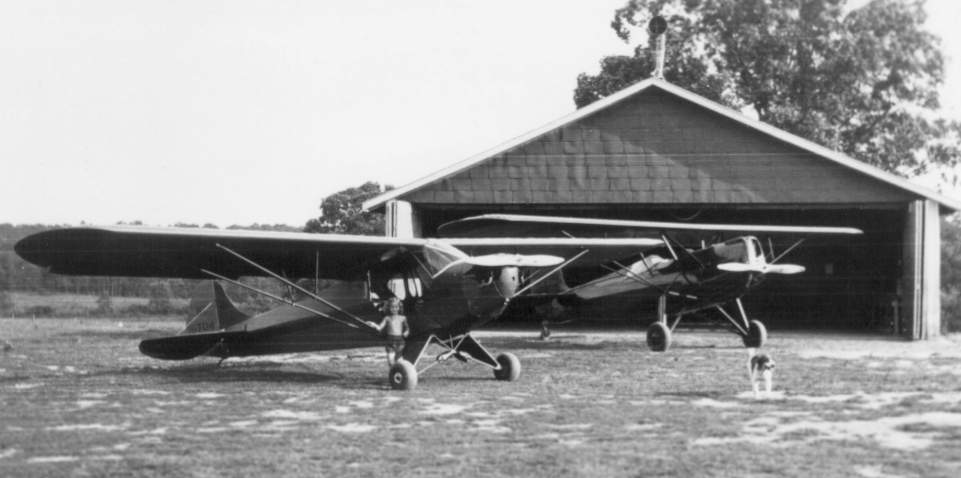
An undated photo of a Piper Cub & a Fairchild 22 in front of a hangar at Schrom Airport (courtesy of Jill St. John, of the Greenbelt Museum).
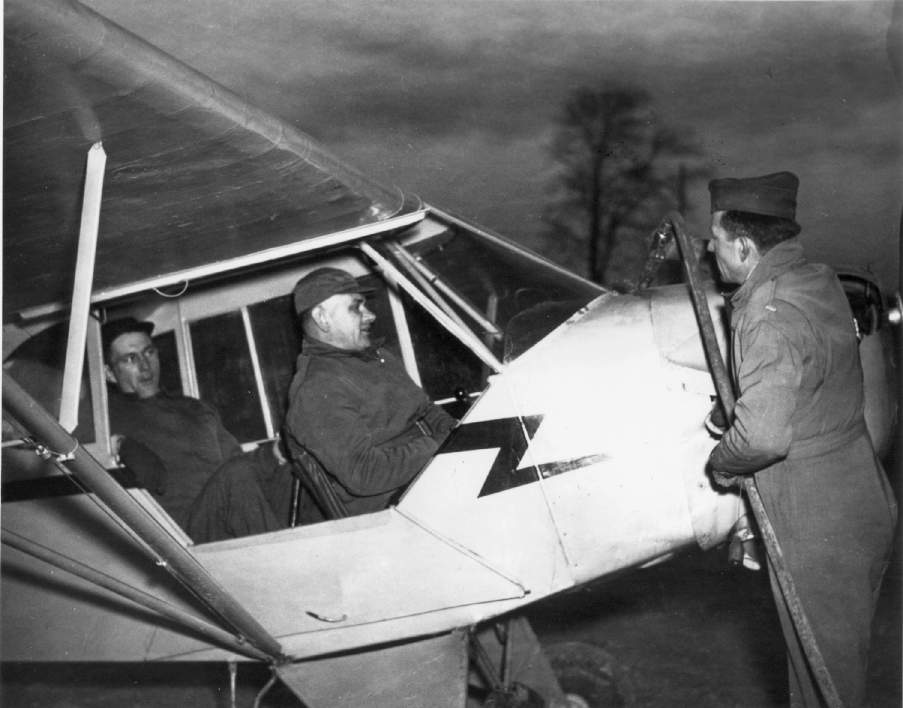
An undated photo by Don O'Reilly of Schrom Airport owner Fritz Schrom refueling a Piper Cub (courtesy of Jill St. John, of the Greenbelt Museum).
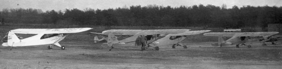
A 1940s panorama of several Piper Cubs parked at Schrom Airport (courtesy of Jill St. John, of the Greenbelt Museum).
The runway at Schrom was paved in 1949.
The 1949 Washington Sectional Chart (courtesy of Mike Keefe) described Schrom as having a 5,000' hard-surface runway.
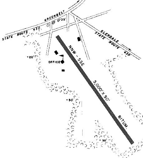
The 1950 MD Airport Directory (courtesy of Stephen Mahaley) depicted Schrom as having a 5,000' north-northwest/south-southeast bituminous runway,
which is quite remarkable for a general aviation airport in 1950 (particularly one which doesn't exist anymore!).
The runway orientation would later run parallel to the Washington Beltway, which had not yet been built in 1950.
An office & 3 other small buildings (at least 1 of which was a hangar) sat on either side of the north end of the runway.
Barbara Ann Schrom recalled, “My father was William Schrom Jr., son of William Schrom Sr., owner of the farm & Schrom Airport.
And of course, my crazy fly-by-the-pants Uncle was Fritz Schrom whom I heard endless flying stories about from my father William.
My Dad used to ride shotgun with Uncle Fritz & they would have to fly down low at night in order to count the lamp post lights along the streets of Washington D.C.
to help navigate their way back through College Park and to the airstrip back on the farm in Greenbelt.
What fantastic flights they must have had back in the day.”
The 1951 USGS topo map depicted Schrom Airport as having a paved runway.
The last aeronautical chart depiction which has been located of Schrom Airport was on the 1951 Washington Local Aeronautical Chart (courtesy of Tim Zukas).
It depicted Schrom as having a 5,000' paved runway.
Unfortunately, Schrom Airport closed a mere 3 years after the runway was paved.
According to the book "Maryland Aloft", "as described in paper by Karin Thiessen, Schrom's desire to improve the airport
conflicted with his neighbors' wish to maintain their town's 'green belt'."
[That is ironic, given that Schrom Airport predated the adjacent planned community of Greenbelt.
But that kind of thinking still results in small airports getting closed by pressure from new neighbors, even 50 years later!]
"Residents objected to his ambitious plans, including an air freight depot,
which they saw as promoting unwanted noise & road construction."
[Once again - how ironic, given that within a few years this property would be
adjacent to the intersection of the new Washington Beltway & the Baltimore-Washington Parkway -
no noise or road construction from them, right?]
Schrom Airport was apparently closed "in about 1952" (according to "Maryland Aloft").
The Baltimore-Washington Parkway was built adjacent to the site of Schrom Field in 1954,
which no doubt helped to seal the fate of the little general aviation airport.
It was not depicted on the 1955 Washington Local Aeronautical Chart (courtesy of Mike Keefe).
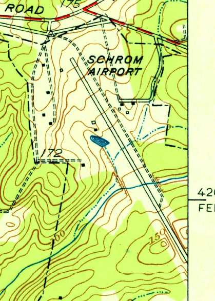
A 1957 aerial photo of the site of Schrom Field showed the field remained mostly intact for a few years after it had been closed.
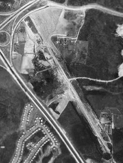
A 1965 aerial photo of the site of Schrom Field showed the remains of the field's single paved northwest/southeast runway.
The clover-leaf intersection of the newly-built Washington Beltway & Baltimore-Washington Parkway was visible on the northwest corner of the property.
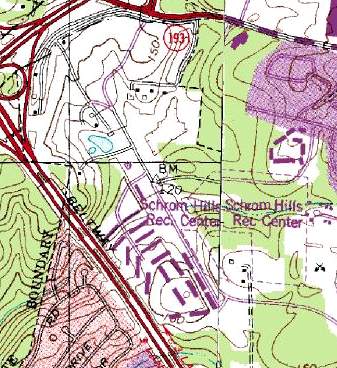
As can be seen on the 1979 USGS topo map, Hanover Parkway was built on an alignment that passes directly over part of the former Schrom Airport runway.
The City of Greenbelt acquired 43 acres of land on the southeast end of the site of Schrom Airport for the Schrom Hills Recreation Center in 1986.
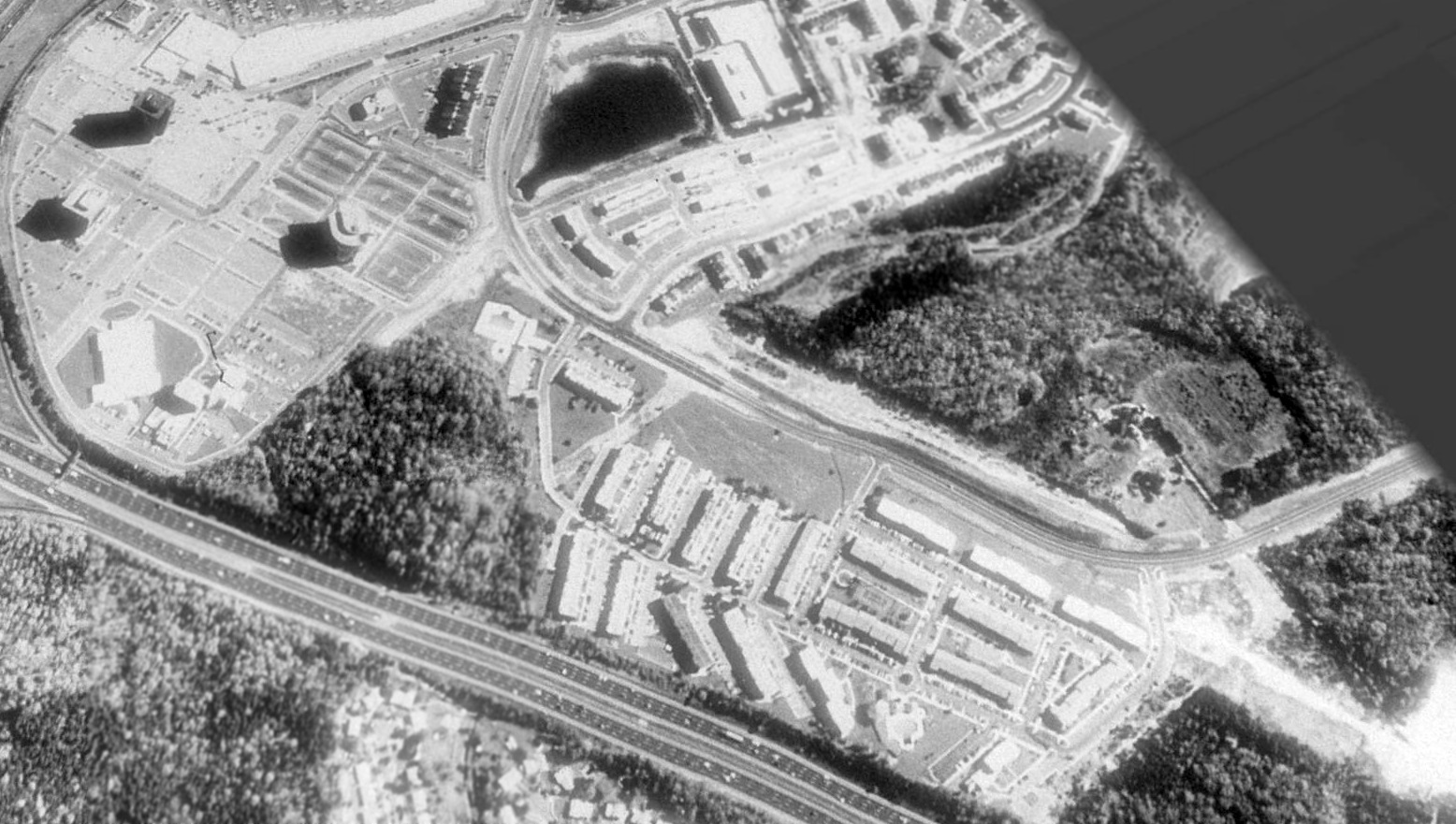
A 1989 USGS aerial view looking northeast showed traces of the southern end of the former Schrom Airport runway were still apparent (bottom-right of photo).
The Schrom Hills Recreation Center was completed in 1991 on the southeast end of the site of Schrom Airport.
An interpretive panel at the Recreation Center recounts the history of Schrom Airport.
An office complex with several high-rise towers & the Greenway Shopping Center was built over the northern end of the site of Schrom Airport.
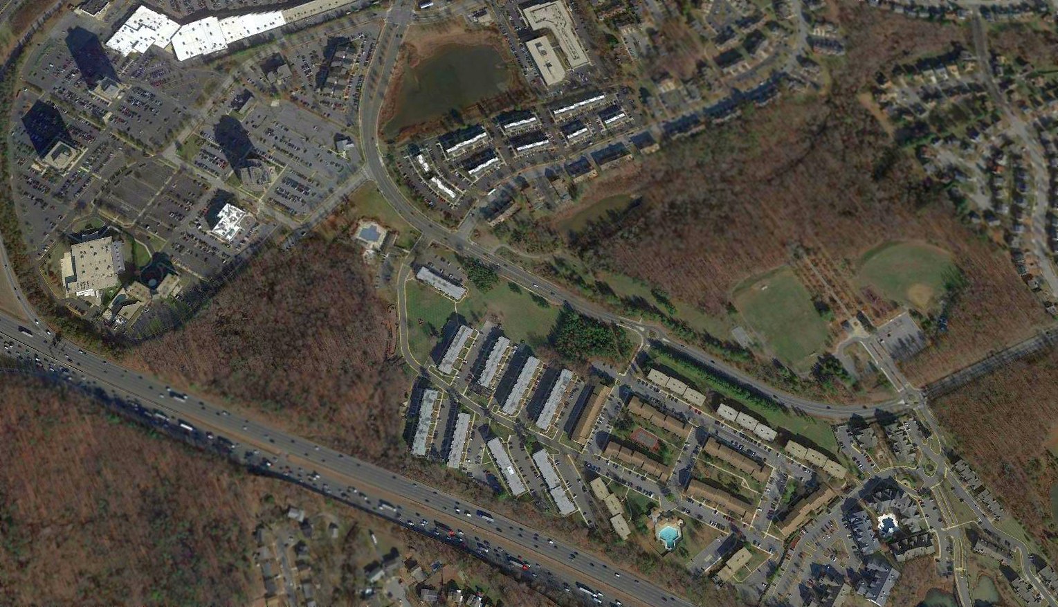
A 2016 aerial view looking northeast shows that no trace of Schrom Airport (other than a historical sign) remains, of an airport that once boasted an almost-mile-long paved runway.
The site of Schrom Airport is located east of the intersection of the Capital Beltway & the Baltimore-Washington Parkway (295).
____________________________________________________
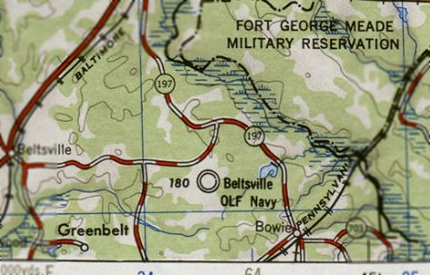
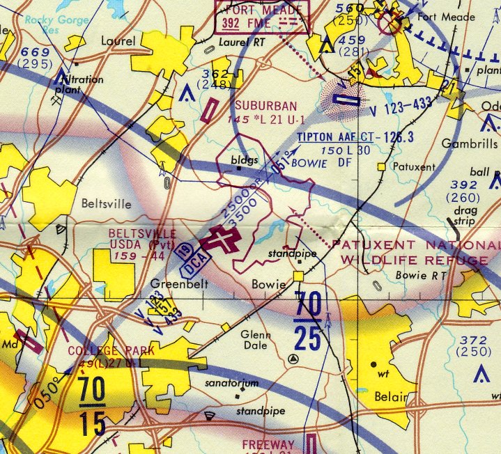
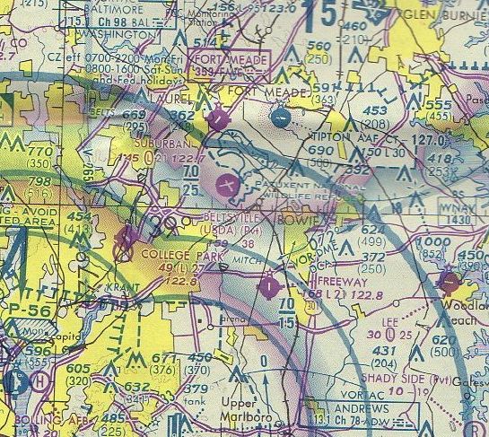
Intermediate Field 57B / Bowie Airport / Beltsville Airport (KBVL, 2W1), Beltsville, MD
39.027, -76.825 (Northeast of College Park, MD)
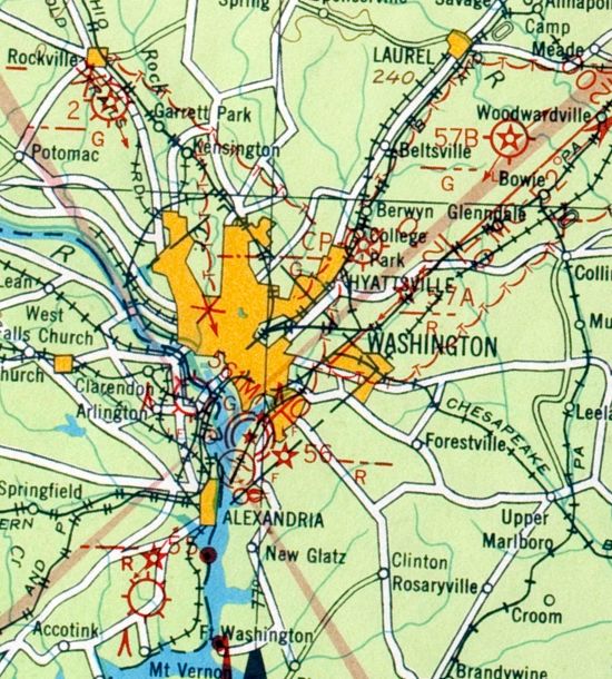
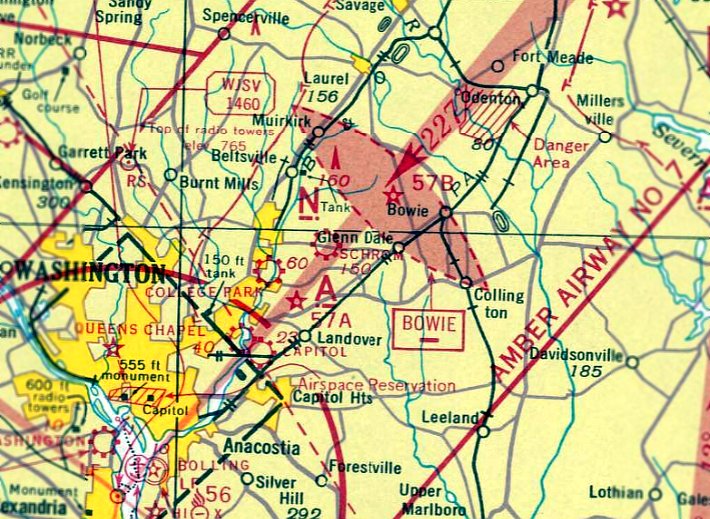
Intermediate Field "57B", as depicted on the 1929 Washington – New York City Air Navigation Map #3.
This obscure airport in the Washington suburbs has had a confusing history.
According to the book "Maryland Aloft" by Preston, Lanman, and Breilhan,
the Beltsville Airport appears to have originated as one of the Department of Commerce's network of Intermediate Landing Fields,
which were constructed starting in the 1920s for the emergency use of commercial aircraft along airways between major cities.
The earliest depiction which has been located of Intermediate Field 57B was on the 1929 Washington – New York City Air Navigation Map #3.
A January 1931 Airway Bulletin listed an Intermediate Field 57 in Beltsville, located 3 miles northwest of Bowie.
The field was said to comprise of a 3,000' x 500' rectangular sod field, along with a rotating beacon & course light.
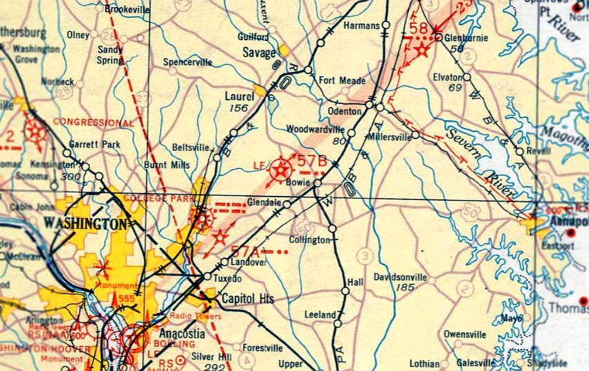
Intermediate Field "57B" was depicted on the May 1932 Washington Sectional Chart.
The 1935 Washington Sectional Chart labeled Intermediate Field 57B as "Bowie".
Beltsville Intermediate Field continued to be listed in the Airway Bulletins until 1935.
The Beltsville Intermediate Field evidently was abandoned at some point between 1935-36, as it was not depicted on a 1936 aeronautical chart.
Many other Intermediate Fields also met the same fate, as the increasing reliability of commercial aircraft,
coupled with the development of more elaborate airports generally made them unnecessary.
A 1938 aerial photo of the Beltsville Intermediate Field depicted the site as having 2 grass runways, oriented almost directly north/south & east/west.
There did not appear to be any buildings at the field.
The 1939 Washington Sectional Chart (courtesy of Chris Kennedy) depicted an Airway Beacon 57B at the site, but no airfield.
The Beltsville airfield had a second life starting in 1941,
when the Roosevelt Administration announced appropriation for the Works Progress Administration
to construct an airfield at Beltsville's Agricultural Research Center (which by then occupied the area surrounding the old Beltsville Intermediate Field).
The Civil Aeronautics Administration also contributed toward the cost of the new facility,
whose purpose was to train units of the District of Columbia National Guard & the Naval Reserve.
A tract of 186 acres was acquired from the Forrest Service for the project.
In 1942, the Civilian Conservation Corps provided labor to clear the land & prepare the site for its wartime role.
It has been reported that the Beltsville Airfield was actually constructed to serve as a wartime point of evacuation for President Roosevelt,
if that ever became necessary.
No airfield at Beltsville was yet depicted on the 1942 Washington Sectional Chart (courtesy of Mike Keefe).
According to Brian Rehwinkel, Beltsville was one of several outlying fields
used to support primary flight training at Naval Reserve Aviation Base Anacostia during WW2
(the others being Hyde, Hybla Valley, Cheltenham, Nottingham, and Riverside).
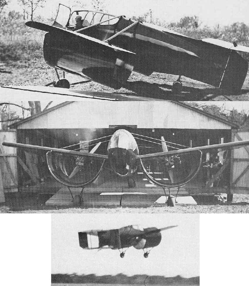
A 1943 photo of the Custer Channel Wing CCW-1 aircraft being flown at Beltsville Airport (courtesy of Joel Custer).
An interesting chapter in the history of the Beltsville Airfield came in 1943,
when the exotic Custer Channel Wing CCW-1 experimental aircraft was flown at the field.
This was described in an article by Walter Boyne in the 5/77 issue of Airpower Magazine (courtesy of Joel Custer).
“The CCW-1 was later [1943] flown in demonstration for the military at the Beltsville MD airport,
where gruff, hard boiled Brigadier General W.E. Gilmore was excited enough to authorize a test program.
Custer recalls that Gilmore actually phoned Orville Wright, who was in Washington at the time,
urging him to come out and witness the new development.”
An article in the 5/47 issue of Popular Mechanics Magazine provided further description of the Custer flights at Beltsville.
“While most experiments with the wing have been in wind tunnels and laboratories,
a test ship flew more than 100 hours over a government field at Beltsville MD using 75-horsepower engines.
The engines & propellers were mounted on metal supports extending across the upper rear section of each channel.
During those first test flights the plane, weighing only 1,785 pounds with pilot, was held to a top speed of 60 mph.
Takeoffs & landings were made under 100 feet, upwind, downwind, and crosswind.”
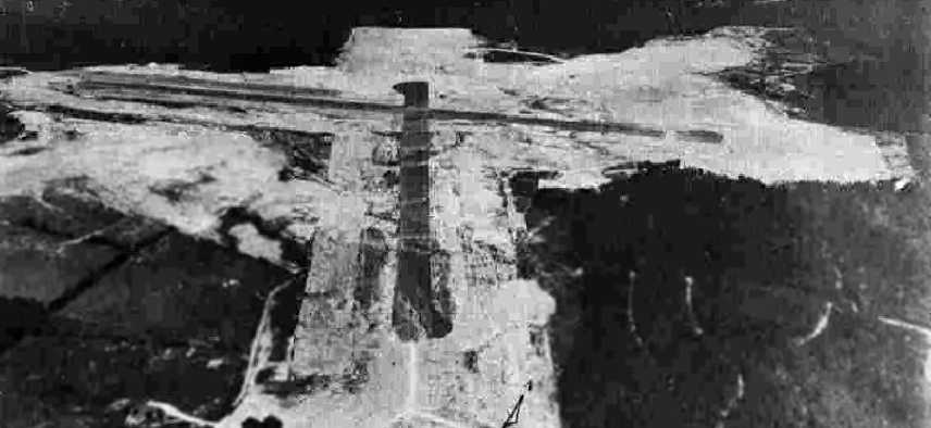
A 9/24/43 aerial view of the “Anacostia NAS Auxiliary (Beltsville Outlying Field)”
from the 1945 AAF Airfield Directory (courtesy of Scott Murdock) depicted the field as having 2 asphalt runways.
The Beltsville airfield was still not depicted at all on the 1944 Washington Sectional Chart (courtesy of Mike Keefe).
The 1944 USGS topo map depicted “Beltsville Airport” as having 2 paved runways.
The November 1944 Washington Sectional Chart labeled the field as "Beltsville (Navy)".
This agrees with other sources which indicate that it served as an Outlying Landing Field for Anacostia Naval Air Station during WW2.
The 1945 AAF Airfield Directory (courtesy of Scott Murdock) described the “Anacostia NAS Auxiliary (Beltsville Outlying Field)”
as a 421 acre irregularly-shaped field within which were 2 asphalt 3,960' runways, oriented north/south & east/west.
The field was said to not have any hangars or offer services,
to be owned by the U.S. Government, and to operated by the Army Air Forces & Navy.
Bill Needham recalled, "My dad Lt. William Needham was the operations officer at NAS Anacostia.
On 5/17/45 he took off in a Lockheed Lodestar with a co-pilot & nine passengers to instruct the co-pilot in instrument flying.
However the cloud cover was below minimums, so they decided to proceed to the Beltsville Auxiliary Airport to do one engine 'Bounces',
which we call 'touch & go's' today.
As they executed their first 'bounce' they lost the good engine when they were about 100' off the deck.
The nine passengers scrambled off & my dad & his co-pilot Commander Foley were trapped inside unconscious.
One of the passengers, an enlisted man, went back inside to rescue the pilots.
As he was inside the plane it caught fire & he was only able to pull out the co-pilot, Commander Foley.
My dad was burned to death while still trapped inside."
A 5/24/45 U.S. Navy aerial view looking south (courtesy of Brian Rehwinkel) depicted Beltsville Airport as having 2 asphalt runways,
but there did not yet appear to be any buildings at the site.

A closeup from the 5/24/45 U.S. Navy aerial view of Beltsville Airport (courtesy of Brian Rehwinkel),
showing a single low-wing single-engine aircraft on the runway turnaround pad.
According to the book "Maryland Aloft", a 1946 airport directory described Beltsville as having a 4,000' runway,
and indicated that Navy flight operations were conducted at the field.
“Beltsville OLF Navy”, as depicted on the 1946 USGS topo map.
After military use of the airport had ceased, the Civil Aeronautics Administration wished to take over the airport,
but the Department of Agriculture was granted control of the property.
A May 1947 newspaper article reported that "the Department of Agriculture had abandoned the facility
due to the persistent bird hazard to aircraft operations there."
However, Beltsville Airport apparently continued to be used for various purposes.
According to a paper by Karin Thiessen, these included testing for pesticides & crop dusting,
local university flying club activities, and Reserve Officer Training Corps flight instruction.
"Beltsville (Navy)" was described on the 1949 Washington Sectional Chart (courtesy of Mike Keefe)
as having a 4,400' hard-surface runway.

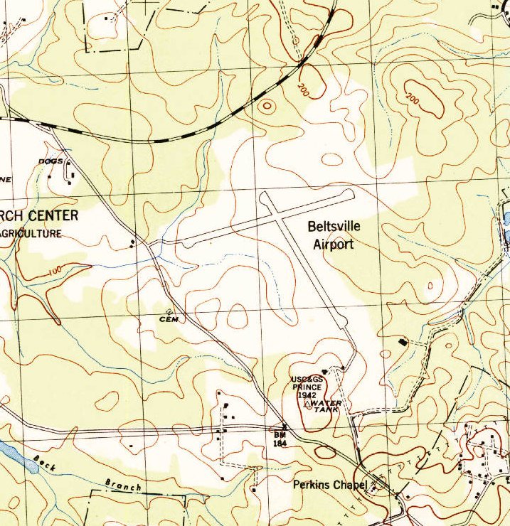
"Beltsville Landing Field" was depicted on the 1949 USGS topo map
as having 2 paved runways, with a single building northwest of the runway intersection.
The 1951 Washington Local Aeronautical Chart (courtesy of Tim Zukas)
depicted Beltsville Airport as having 2 paved runways, with the longest being 4,400'.
Beltsville Airport was described on the 1951 Washington Sectional Chart (courtesy of Mike Keefe)
as having 2 runways, with the longest being a 4,400' hard-surface strip.
The remarks in the Aerodromes table said, "Open to government aircraft."
Henry Retzer recalled, “I worked around & on the airfield for about 30 years.
I began work at the USDA's Beltsville Agricultural Reseach Center in October 1956.
The project I was assigned to had a storage shed in the woods off the south end of the runway
and I would drive there along the edge of the runways.
I could see 2 TBM torpedo bombers parked by the hangars with their wings folded but never dared to go there.
Later I found out one was flown by the Forest Service's Insect Lab (BFIL) on spraying experiments. The other was a parts pane.
The spray tank was located in the torpedo compartment.”
It was listed as "Beltsville (US Dept. of Agriculture)" on the 1960 Washington Sectional Aeronautical Chart, with the note "Official business only."
It was described as having 2 paved runways (the longest being 4,400'),
although the ENE/WSW runway was described as "pavement broken".
The 1960 Jeppesen Airway Manual (courtesy of Chris Kennedy)
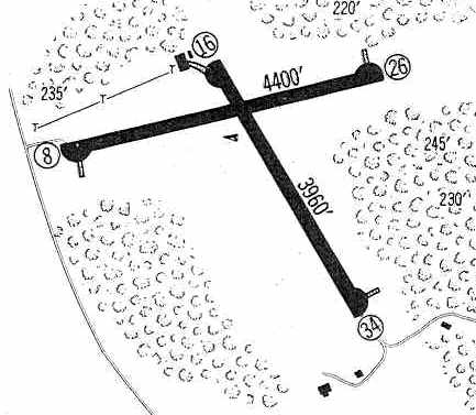
depicted Beltsville Airport as having 2 paved runways: 4,400' Runway 8/26 & 3,960' Runway 16/34.
A taxiway from the end of Runway 16 led to a single building (a hangar?).
Beltsville Airport was listed among active airports in the 1962 AOPA Airport Directory,
under the name of "Beltsville (Government)", with a 4,400' paved runway, and the operator listed as the US Department of Agriculture.
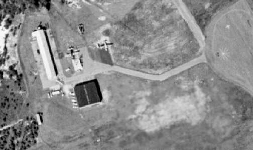
A closeup from a 1963 aerial view showing 2 planes at Beltsville Airport,
parked next to the building on the northwest side of the field.
The last photo which has been located showing (manned) aircraft at Beltsville Airport was a 9/24/64 USGS aerial view (courtesy of Dallam Oliver-Lee).
It depicted 2 light planes parked next to the building on the northwest side of the field.
Merton Meade recalled, “We snuck into Beltsville many times just to land on the nice grass.
We never got caught... there was seldom anyone there.”
Henry Retzer (former USDA agricultural engineer) recalled, “In 1965 the TBMs were gone & BFIL moved out west,
their hangar was taken over by the Animal & Plant Health Inspection Service.
Their pilots supervised spraying contracts down south with Cessna 180s & other aircraft
whose inspections & overhauls were done here.
In the winter the hangars were crammed with planes.
There was constant pressure from other agencies & defense contractors, even private flying clubs, to use the airfield.
There often was a strange aircraft sitting there after a weekend of touch & go landings.
When NASA began activities at Goddard SFC in the 1960s
there was great activity at the field, it was common to see C-47s there.
I remember a Bendix man experimenting with a drone tried to run me off,
but I pointed out I worked there & he was visiting.”

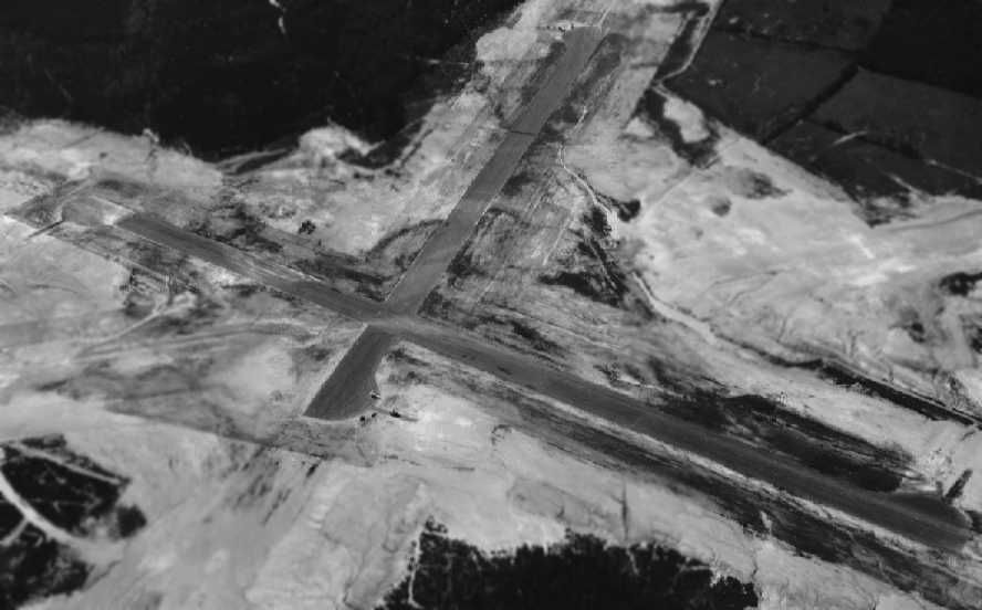
A 1965 aerial photo of the Beltsville Airport showed the 2 paved runways, and a single hangar northwest of the runway intersection.
Note also the appearance of a octagonal clearing to the southwest, presumably for the NASA antenna site.
It was labeled as "Beltsville (USDA)" on the September 1965 Washington Local Visual Navigation Chart
and the 1967 Washington Sectional Chart (courtesy of Mike Keefe).
Steven Fritz recalled landing at Beltsville Airport in 1967: “One day early in my learning, I was scheduled to fly with my regular instructor, but he was late.
I’d already soloed & I worked as a lineman at the airport, so I had access to the keys. I decided to try a few landings while I waited for my instructor.
The airport was Suburban Airport in Laurel, Maryland, a little slash in a fairly dense area of forest at the time.
When I rose above the trees, the aircraft began to bounce wildly. The wind on the ground did not seem so bad, but it was very strong & gusty at treetop level, the branches flailing crazily.
I struggled to make my way around the landing pattern & stay on the ground. As I approached the ground to land, the aircraft was bouncing around a lot.
At treetop level, just as I was approaching a landing, the wind whipped around a bend in the treeline & the aircraft went crazy. I added power & climbed back above the trees.
It was very bumpy there but the aircraft was controllable. I went around and tried another landing, with the same results.
After a third, equally unsuccessful approach, I headed for nearby Beltsville Agricultural Research Center’s airport, where the FBO from Suburban Airport had a trailer that served a a base for a contract to train Air Force ROTC students.
At the time Beltsville Airport was an abandoned field last used during World War II to train Army pilots. It was huge, no trees anywhere near any of the 3 runways to create a chaotic burble as I neared the ground.
I landed into the wind at Beltsville, the gusts bounced me up & down but not wildy side to side like they had at Suburban.
Aside from being a bit bumpy, the landing was successful. I taxied in, shut down, tied down the airplane, and went into the trailer to call my instructor & confess my sins.
There were two AFROTC students inside with Harold, the instructor who ran the ROTC contract. I told them all what had happened, why I was there, then called Mac, my instructor, to come get me.
A few days later I ran into Harold. He told me that, after I left Beltsville, one of the ROTC students said to no one in particular, 'I’m glad I’m not that guy.' (Meaning me.)
Harold asked him what he meant. He told Harold that he’d be ashamed to admit he couldn’t handle the conditions at Suburban that had driven me to land at Beltsville.
That led to a lengthy discussion about bold pilots (of which there are many) and old pilots (of which there are fewer).
Even then, when my skills were, shall we say, limited, I knew better than to risk my life doing something I was aware I couldn’t handle. Doing so wouldn’t be courageous, it would just be foolhardy.”
Will McGuffin recalled, "I made my first landing with my instructor at the USDA airstrip at Beltsville", in the late 1960s.
"As to how we were able to use the USDA strip at Beltsville,
I can't remember if [my instructor] Jerry Rochez had to phone ahead for permission or if we just flew up there for me to make my first landing attempts.
I do remember that the only other aircraft there during one of our practice sessions was a crop duster, which made sense.
Otherwise, it was deserted except for my repeated passes trying not to flare out 15 feet above the asphalt.
Actually I did OK the second time we went up there. Apparently Jerry usually took his students up there for touch & go stuff.
There was no other traffic at any of the times we were there."
Gary Hendrickson recalled, “In 1969, when I was working for NASA at Goddard Space Flight Center,
I was in charge of maintaining & operating a couple of mobile satellite tracking trailers.
We kept them at the Beltsville USDA airport, parked along the north side, west end, of the east/west runway.
On days when I planned to spend the full day working at the trailers, I would fly my Cherokee from Friendship Airport (now BWI) down to Beltsville,
instead of driving (even though it was only a 20 minute flight, it was a lot more fun than driving!). I'd also use this airport for touch & go's.”
Tony Vallillo recalled, “The old Beltsville Airport (which used to be called KBVL, at least that’s what I have in my logbook)
was used for a while in the late 1960s & early 1070s for pilot training for AF ROTC cadets from Catholic University in Washington DC.
In that era, the AF offered a Flight Instruction Program (FIP) for ROTC cadets who passed the flying physical & had an interest in going to pilot training after graduation.
This was a 35 hour program which for all practical purposes was a private pilot course.
When I was a senior at CU, the FIP was handled under contract with Suburban Air Service at Suburban airport in Laurel.
But since that was very small rather challenging airport & not well suited for primary flight training,
an agreement of some kind had apparently been reached with the USDA to use BVL for most of our training.
That building at the northwest end of the runway was our line shack & that was where we briefed & debriefed.
The airplanes were flown over from Suburban by the instructors & we cadets showed up at BVL for our flying.
It was not until well after solo that we started doing some training over at the airport at Laurel.
As far as I know, we were the only ones flying out of BVL at that time, except for whatever USDA was doing there, which we were never privy to.”
The September 1972 Washington Terminal Chart (courtesy of Carl Buick) depicted "Beltsville (USDA)"
as a private airfield having 2 paved runways, with the longest being 4,400'.
According to Angelo Vacchio, "Beltsville Airport was still in use in 1972.
I know because I landed there & was chased off - 'government use only' I was told.
I remember seeing a DC-3 there in 1974 when it landed for some reason; it was gone in 2 days.
Pilots used to buzz it & shoot go-arounds there & approaches but never landed.
If you go there & look by the old water tower you can find large holes on the sides of the runway.
They were used for anti-aircraft guns.
There is supposed to be a DC-3 that crashed there in the woods but I never found it.
I do not know when it crashed but I knew people who looked at it."
Greg Stover recalled, “I learned of the Beltsville Airport while attending training as a Special Agent with the U.S. Secret Service in 1976
and completed specialized driver training courses on the old airport facility.
In late 1977 I was hired as a Special Agent/Pilot with the U.S. Fish & Wildlife Service, Division of Law Enforcement, in Glen Burnie
to take over flight duties for the previous Special Agent/Pilot.
Due to Beltsville's proximity to our Washington Office & our very active Filed Offices in Cambridge & Salisbury,
I met with the USDA folks at Beltsville in late 1977 & received their blessing to station our 1955 Cessna 180 Skywagon at Beltsville.
The USDA pilots were flying Beech Barons out of Beltsville at that time
and they later obtained a Cessna Agwagon with an integrated LORAN system for precision application missions.
USDA pilots Tim Roland & Richard "Dick" Dyer were extremely good to me for the years that we based our Cessna 180 there.
I used to refuel our Skywagon at Suburban Airport a few miles away from Beltsville before finally moving operations over to the Fort Meade AAF several years later.”
The last aeronautical chart depiction which has been located showing Beltsville Airport still open was on the 1979 Washington Sectional Chart
It depicted "Beltsville (USDA)" as a private airfield having 2 paved runways.
The length of the longest runway had been reduced to 3,800'.
Dan Enig recalled, “Beltsville Airfield... In the late 1970s it was used by the Metropolitan (DC) Police for drivers training.
We would drive onto the end of the east/west runway (this runway was not active) from Springfield Road,
stop at the active runway, check for aircraft, cross to the eastern end & use that area for our driver training.
For lunch we came back to the west side where just off the runway to the north there was a building we used for our lunch breaks.
I'm not sure when MPDC started & stopped using the airfield for drivers training but I do know that they used it in 1978-79.
Every day we went out there our instructors would remind us to stop before crossing the active runway & scan for aircraft.
Never saw any there but we always expected to see at least one.”
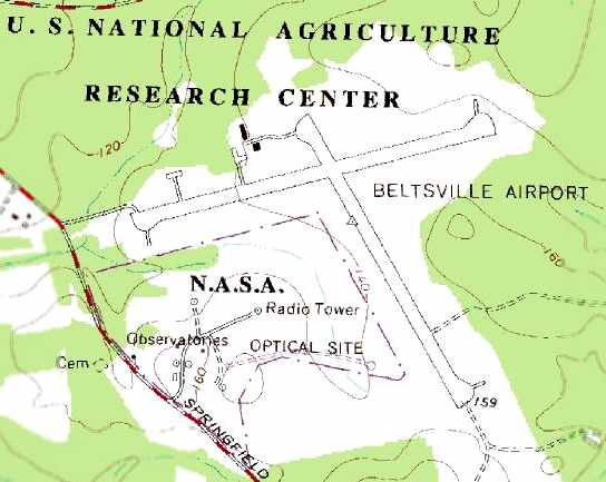
The 1979 USGS topo map depicted the 2 paved runways of the Beltsville Airport,
as well as 2 buildings just northwest of the runway intersection.
Beltsville Airport was still depicted as an active airfield on the 3/19/81 Washington Sectional Chart (according to Tom Beamer).
According to Henry Retzer, “By the 1980s BARC's director decided the airfield was more of a liability
since no research was being done there.
He had the runways plowed up with a bulldozer & the rubble hauled away.”
Gary Hendrickson recalled, “Much of the reason for its closing is that the NASA site on the same property was used for optical satellite tracking,
since the location was fairly distant from any populated/developed areas, so it was fairly dark at night.
The NASA people complained that aircraft & their lights interfered with the optical tracking equipment, and that's part of the reason that the airport was eventually closed.
This could have continued to be a very beneficial airport in this area.”
Beltsville Airport was was depicted as closed on the 8/3/81 Washington Sectional Chart (according to Tom Beamer).
Richard Peters remarked, “I worked for RS Systems in Beltsville between 1985-87.
We used the Beltsville Airport for all our drone testing & flight development.
At that time, the runways were still there, albeit in very poor condition - especially the east/west one.
We used the North/South runway for most of our test flying.
Some of our target drones were in pretty good size: 10’ long or larger. We’d show up there probably 2 afternoons a week.
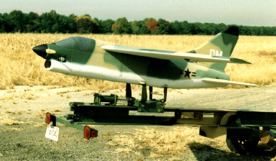
A 1985-87 photo by Richard Peters of an RS Systems A-7D Corsair drone on a launcher at Beltsville Airport.
Richard recalled, “This was on the North/South runway & the plane is facing towards the south end for the launch.”
Richard Peters recalled, “I can remember that it was about the time we were wrapping up operations there that they started to tear up the runways.
They would do little pieces at a time.
They started at the Southern end & bulldozed the first 100'.
They then made a few piles out of the rubble & it sat for months. Then they came back & did a little more.
It was more than a year before the runway was all but unusable due to their destruction efforts.
When we were using the airport, the hangars were used as surplus for office equipment.
Things that made it into these buildings were noted,
and other labs within the USDA had a chance to claim them for their use before ultimately ending up in some government auction.”
Richard continued, “It’s a crying shame that we citizens close down these valuable resources & historic places of our nation.
I wish Beltsville Airport was still open to the public.
I’d would love to use it for the first flights of the plane I’m building right now.
If we don’t save these airports, the goal of flight for the common person will end.
Think back to the 1950s & 1960s.
Every other magazine was totting the line that by the 1990s we’d all be flying our cars to work.
Well, if there are is no longer a good collection of general aviation flying,
people will not have a mindset to push ahead to the next level - flight for the masses.
It’s already begun. When was the last time you saw Popular Science lead the cover with a story about the future flying cars?
In the 1950s it was all the rage.”
Henry Retzer recalled of Beltsville Airport, “The last time I went by in 1989, there was corn growing on the west end of the runway.”
Paul Freeman flew remote controlled aircraft from the Beltsville Airport runways as part of
a class from the University of Maryland's Aerospace Engineering Department in the early 1990s.
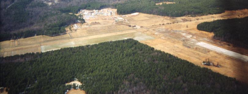
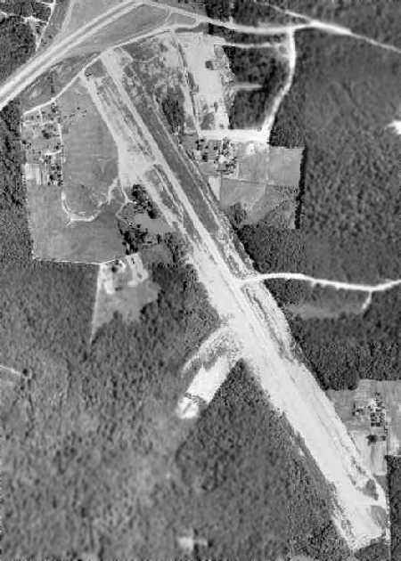
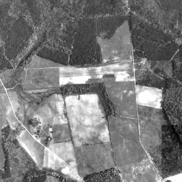
A January 2001 aerial view by Paul Freeman looking north at the former Beltsville Airport.
According to David Kindig (whose company performed work at the Beltsville Agricultural Research Center in 2006),
“I have heard (anecdotally) that furniture from the Hart Building was stored at the Beltsville Airport
after the 2001 anthrax attacks, and was decontaminated there.”
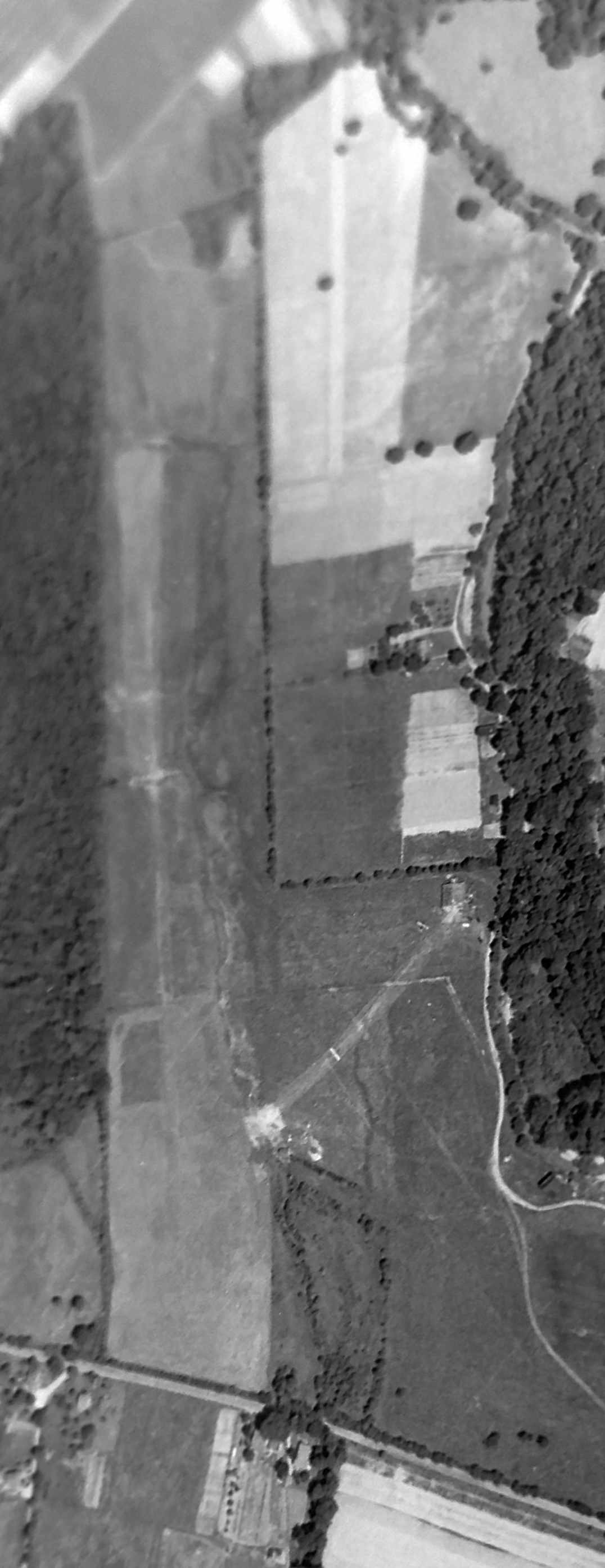
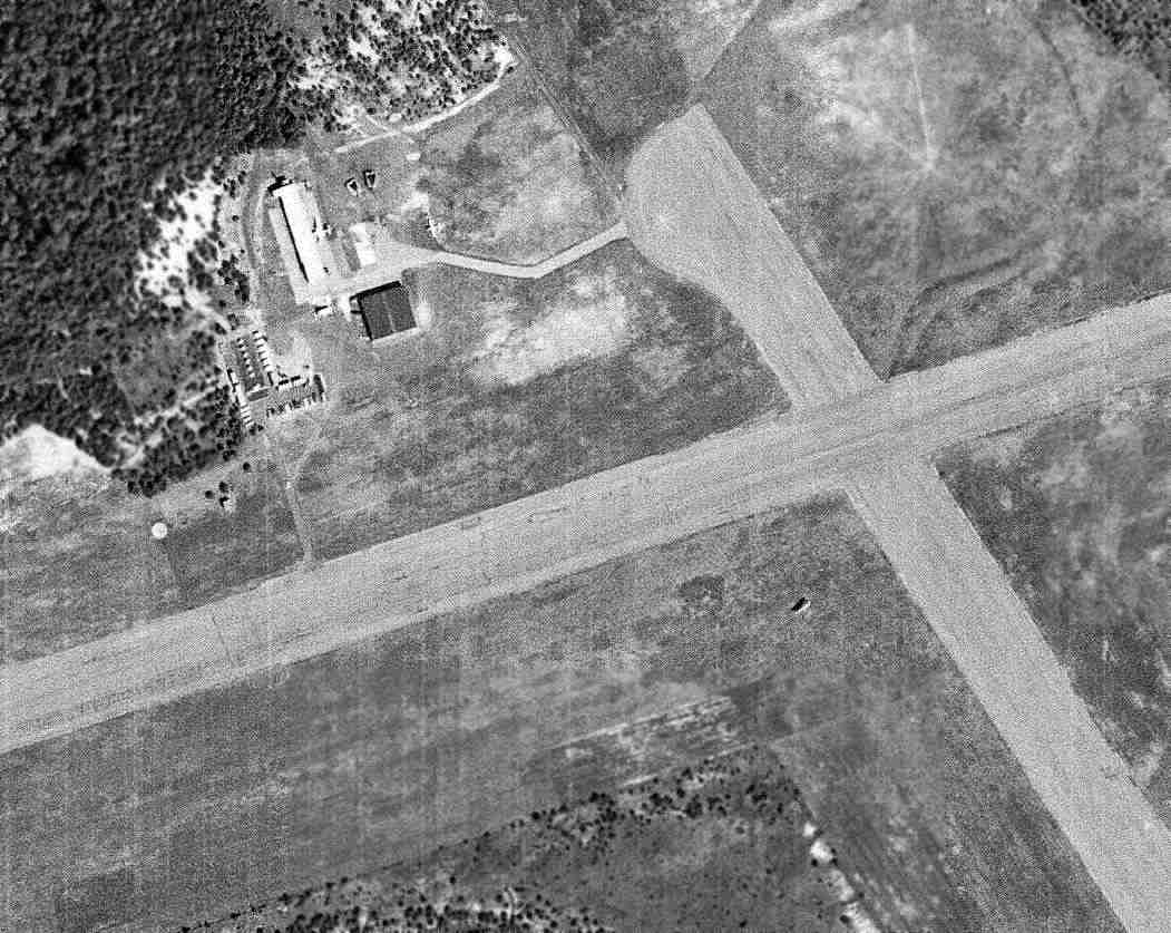
As of 2003, the partially dug-up remains of 2 paved 4,400' runways still exist.
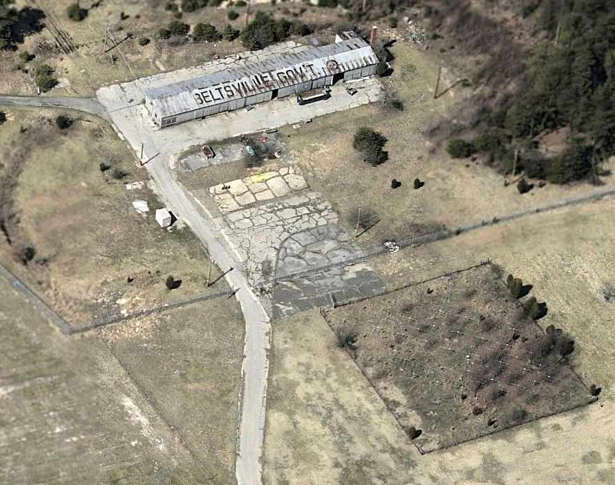
A circa 2005 aerial view looking west at the former Beltsville Airport hangar, which still has “Beltsville Gov't” painted on the roof.
A paved ramp still remains, along with what appears to be the foundation of another former hangar.
David Kindig reported in 2006, “The runways today are still there, although they are 'dug up' in some spots.
It appears that the surrounding property is being used for a small composting facility,
and for agricultural research (orchards... I think they are peach & cherry trees primarily.”
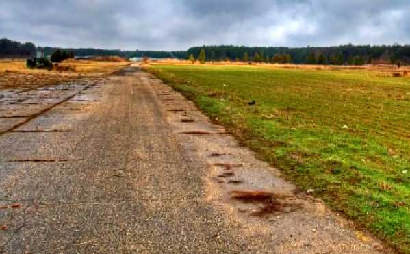
A 12/21/08 photo looking along the runway pavement at Beltsville Airport.
Russell Dyrland, the Administration Manager of the Patuxent Research Refuge, reported in 2012,
“Old Intermediate Field 57B Beltsville Airport is part of USDA Beltsville Agricultural Research Center & the U.S. Fish and Wildlife Service Patuxent Research Refuge.”
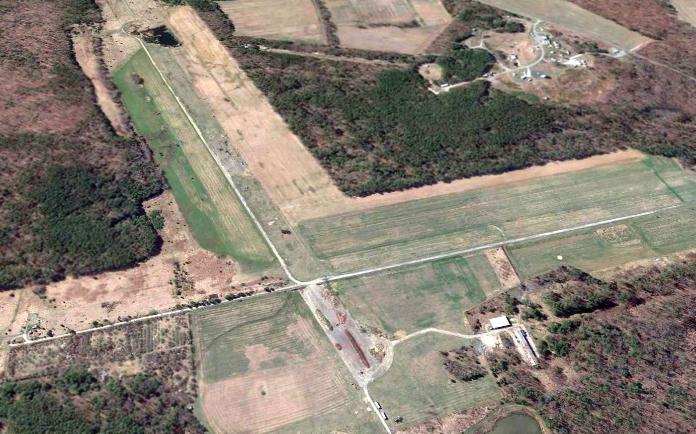
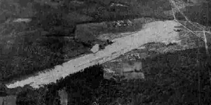
A 2015 aerial view looking south at the remains of Beltsville Airport showed that a small amount of pavement down the center of each runway still remained,
along with the hangar at bottom-right.
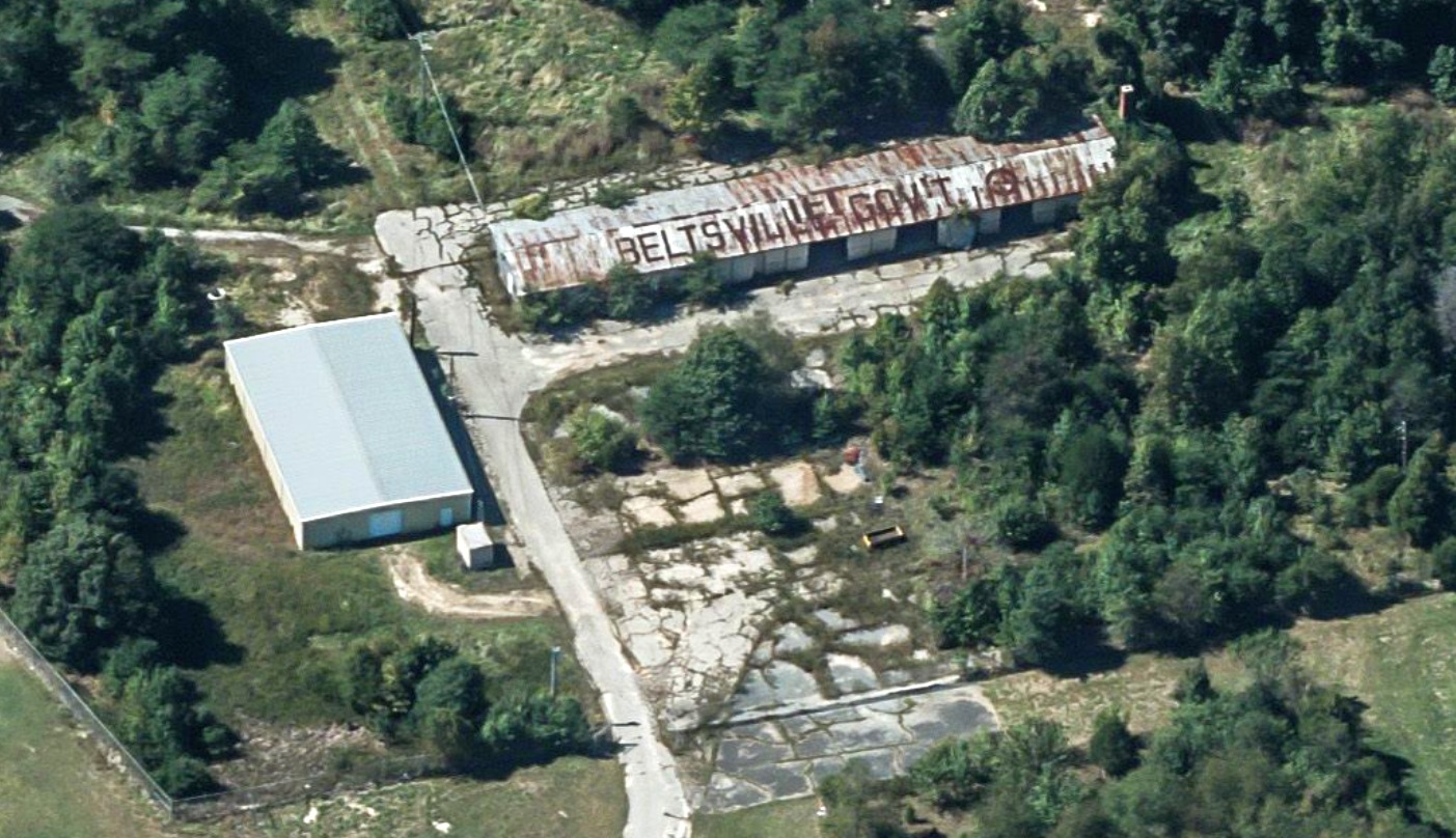
A pre-2022 aerial view looking west at the former Beltsville Airport hangar, which still has “Beltsville Gov't” painted on the roof.
A post-airport building was evidently added to the south at some point between 2005-2022.
____________________________________________________
Since this site was first put on the web in 1999, its popularity has grown tremendously.
If the total quantity of material on this site is to continue to grow,
it will require ever-increasing funding to pay its expenses.
Therefore, I request financial contributions from site visitors,
to help defray the increasing costs of the site
and ensure that it continues to be available & to grow.
What would you pay for a good aviation magazine, or a good aviation book?
Please consider a donation of an equivalent amount, at the least.
This site is not supported by commercial advertising –
it is purely supported by donations.
If you enjoy the site, and would like to make a financial contribution,
you
may use a credit card via
![]() :
:
Please consider checking the box to make a monthly donatation.
For a mailing address to send a check, please contact me at: paulandterryfreeman@gmail.com
If you enjoy this web site, please support it with a financial contribution.
please contact me at: paulandterryfreeman@gmail.com
If you enjoy this web site, please support it with a financial contribution.
____________________________________________________
This site covers airfields in all 50 states.
For the site's main menu: Home