Hanks Abandoned & Little-Known Airfields:
Northern Maine
© 2002, © 2024 by Paul Freeman. Revised 3/9/24.
This site covers airfields in all 50 states: Click here for the site's main menu.
____________________________________________________
Please consider a financial contribution to support the continued growth & operation of this site.
Estcourt Station Airport (revised 3/9/24) - Milford Air Force Auxiliary Airfield (revised 3/9/24)
____________________________________________________________________________
Estcourt Station Airport, Estcourt Station, ME
47.44, -69.15 (North of Bangor, ME)
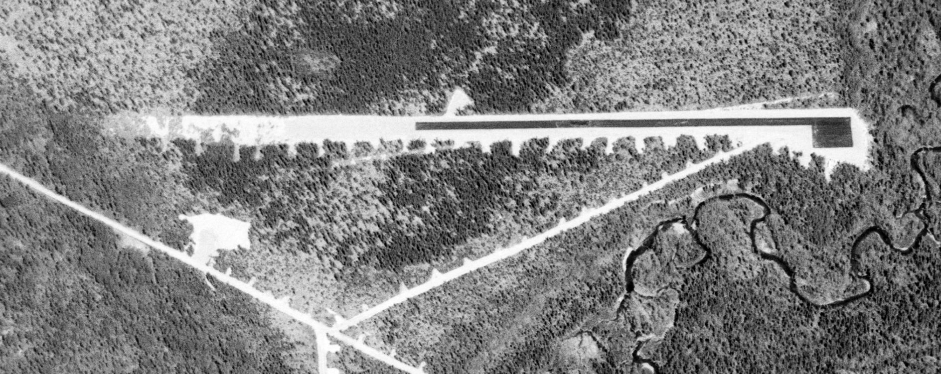
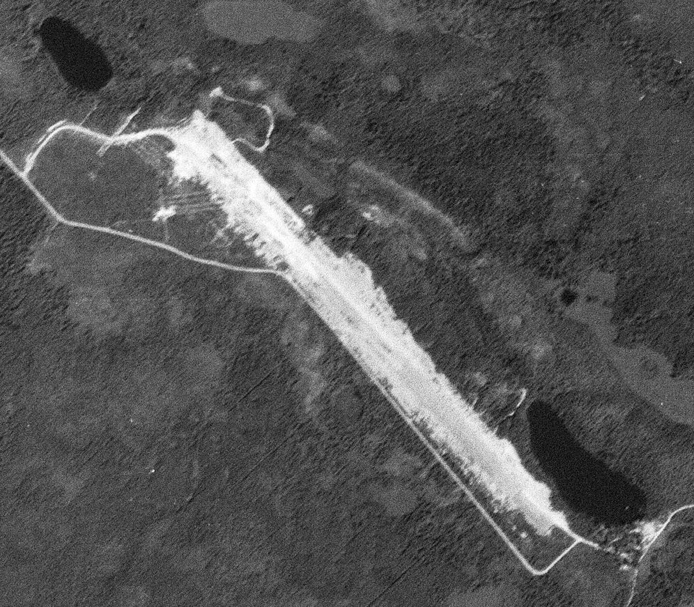
The Estcourt Station Airfield, as depicted on a 5/27/82 USGS aerial photo.
Photo of the airfield while in use has not been located.
Not much is known about this airfield, including its name.
It has the distinction of being the northern-most airport in Maine, being located a mere 900' from the Canadian Border.
The Estcourt Station Airport was evidently established at some point between 1960-85,
as it was not yet depicted on the 1956 USGS topo map or a 1960 USGS aerial photo.
The February 1969 Aroostook Sectional Chart only depicted a seaplane base at Estcourt, but not airport.
The earliest depiction which has been located of Estcourt Station Airport was a 5/27/82 USGS aerial photo.
It depicted a single asphalt east/west runway, with a small asphalt ramp on the southeast side, and an unpaved overrun on the west side.
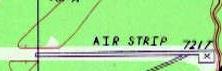
The earliest topo map depiction which has been located of Estcourt Airport was on the 1987 USGS topo map,
which depicted a single paved east/west 2,600' paved runway, generically labeled “Air Strip”, with an additional unpaved 1,800' overrun on the west side,
and a small paved ramp on the southeast side.
Dean Wilber explained the purpose of the Estcourt Airport:
“The airstrip at Estcourt Station looks identical to the one located off the Ragmuff Road near Chesuncook Lake, beyond the middle of nowhere.
They both have the small shed & a big tank. My grandparents lived near the one on Ragmuff.
They told me that the airstrip was built in the 1980s when there was a huge outbreak of Spruce Budworm in Maine.
The airstrip was where planes were loaded with pesticides to spray (crop dust) the forests & kill the budworms.”
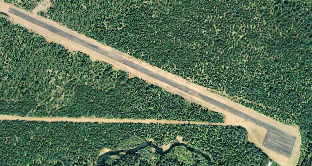
The earliest photo which has been located of the Estcourt Station Airport was a 6/24/06 aerial view looking northwest.
It depicted the field as having single paved east/west paved runway, with a small paved ramp on the southeast side, with an unpaved overrun on the west side.
There did not appear to be any buildings at the airfield.
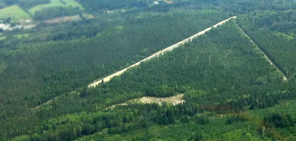
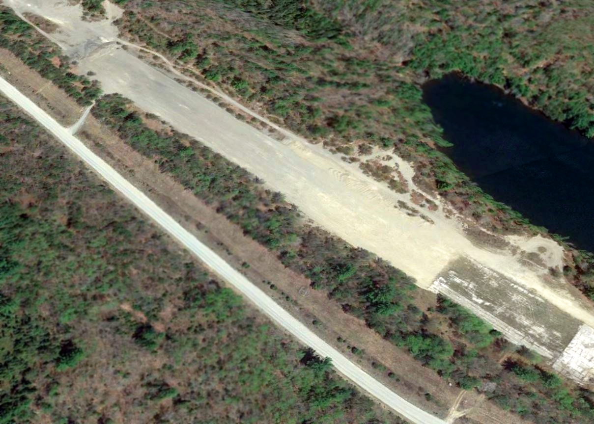
An August 2012 aerial view looking northeast at Estcourt Station Airport by Ron Denning (courtesy of Mike Denning).

An August 2012 photo by Ron Denning (courtesy of Mike Denning) of their 1956 Cessna 172, showing a water tank & small shed next to the Estcourt Station runway.
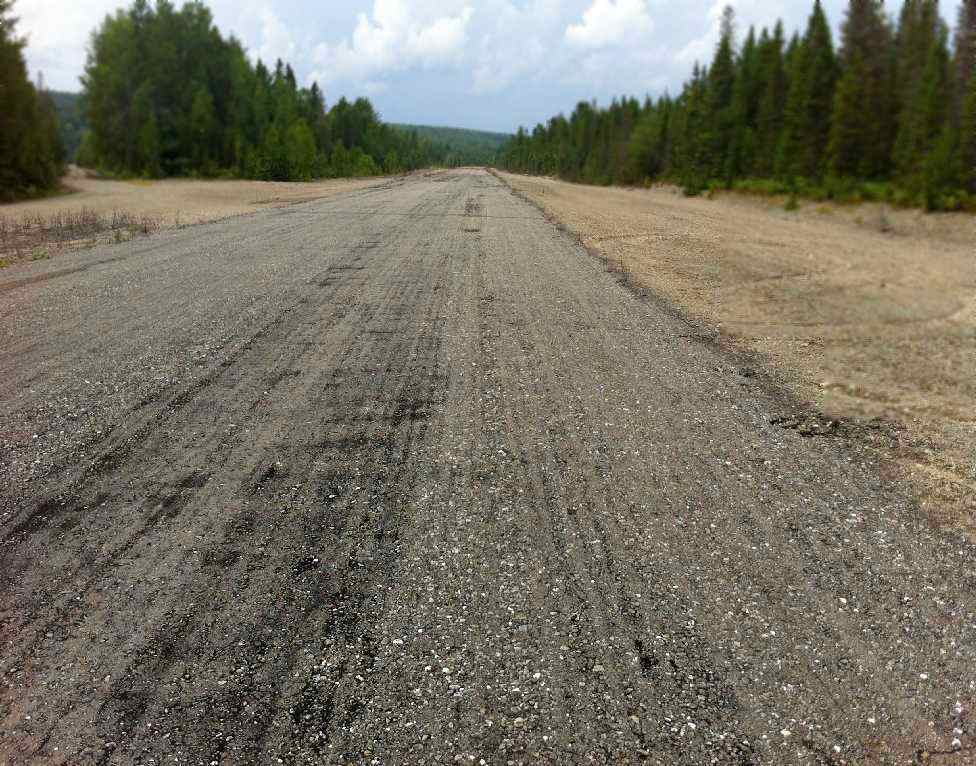
An August 2012 photo by Ron Denning (courtesy of Mike Denning) looking along the Estcourt Station runway.
Mike reported, “The runway surface is asphalt that seems to have been made on site with the local gravel. The rocks in the asphalt are fairly large.
The condition is in the lower-fair range, there are some bad spots at about the half-way point.
Overall the whole paved area of the runway & parking area has a soft feeling under foot.
When the Border/Customs agency was contacted in Estcourt prior to the trip the agent we spoke with said that the runway is still used occasionally, by who he did not know.
From the end of the paved runway westbound it is approximately 4 miles to the Canadian border.
From the paved end of the runway eastbound the border is approximately 0.25 miles.
We approached from the southwest & landed eastbound keeping well away from the river that depicts the border.
Takeoff was westbound with an immediate left turn that also kept us away from the border.”
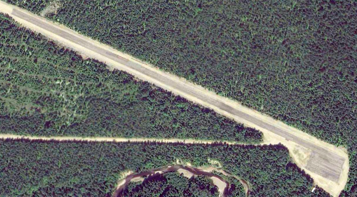
A 2015 aerial view looking northwest showed the Estcourt Station Airport to remain unchanged compared to the 2006 photo.
Estcourt Station Airport is located at the eastern terminus of Airport Road, appropriately enough.
Thanks to Patrick Therrien for pointing out this airfield.
__________________________________________________________________________
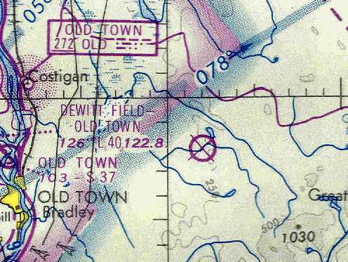
Milford Air Force Auxiliary Airfield, Milford, ME
44.98, -68.47 (Northeast of Bangor, ME)
Milford Air Force Auxiliary Airfield, as depicted on a 8/20/51 USGS aerial view.
No airfield was yet depicted at this location on the April 1940 Lewiston Sectional Chart or a 9/26/42 USGS aerial photo.
According to Pete Noddin of the Maine Aviation Historical Society,
“This strip & the adjacent buildings on Pickerel Pond were constructed in 1942
as the administrative support area for the Bangor (Dow AAF) Precision Bombing Range
which was located in an open bog just south of the airstrip.”
Gus LeBlanc recalled, “My uncle John was stationed at Dow AFB (now Bangor International) as a SAC commander.
I was also told by my uncle John that the field was used during WW2 to train medium bomber pilots on short-field landings & takeoffs.
He also indicated that the site was used briefly towards the end of the war
to temporarily house some German POWs due to the camp in Aroostook County being full.”
No airfield at all was depicted at this location on the January 1945 or April 1946 Lewiston Sectional Chart.
According to Pete Noddin, “After WW II, when Dow AAF was reactivated by the 14th Fighter Group,
the bombing range did not meet current safety clearance requirements.
It operated under a waiver & was used by F-47N & F-84B aircraft as a bombing/strafing range until 1948.
At that time a new range was opened near Deblois Maine.”
The earliest depiction of this field which has been located was an 8/20/51 USGS aerial photo.
It depicted an unpaved northwest/southeast runway, with some unidentified features on the northwest side, possibly relating to its use as a bombing/strafing range.
According to Pete Noddin, “The bombing range portion of the property was sold as surplus in 1952.
When SAC began occupying Dow AFB in 1953, with the 506th Strategic Fighter Wing,
the buildings, pond and strip were used as an aircrew survival training facility.
This use appears to have ended sometime in the 1957-58 era.”
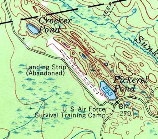
The earliest topo map depiction which has been located of Milford Air Force Auxiliary Airfield was on the 1957 USGS topo map.
It depicted a single 2,500' runway, oriented northwest/southeast, labeled “Landing Strip (Abandoned)”.
The property was also labeled “U.S. Air Force Survival Training Camp”.
Gus LeBlanc recalled, “The Pickerel Pond airstrip... I grew up in Old Town
and in the 1960s & 1970s spent a lot of time at the airstrip & surrounding area.
At that time the remnants of the Air Force survival school still existed on the site.
There was a building which housed school personnel
and there was a 'slide for life' structure with a cable which led to the pod & had a trolley slide on it.
My uncle John was stationed at Dow AFB (now Bangor International) as a SAC commander.
He took me out to the facility on several occasions.
The original bombing range in the bog south of the field...
When I spent time out there in the 1960s & 1970s the remains of the range still existed.
In the middle of the bog was a large pyramid structure (bombing target) mad of wood.
Unknown to many there was also a spotting tower in the tree line west of the bog.”
Gary Small recalled of this airfield, “I discovered it while going to the University of Maine in nearby Orono about 1974 or 75.
I was exploring the network of logging roads in the area east of Old Town, and burst out of the woods onto this old airstrip.
It is literally in the middle of the woods, miles from the nearest town.
As I remember, the strip was either paved or concrete, although it was broken up & weeds small trees were coming up.
I was told that it was an auxiliary or emergency field for Dow Air Force Base in nearby Bangor.
At the time, the National Guard was using it as a training area.”
This field was depicted as an abandoned airfield on the October 1976 Halifax Sectional Chart (courtesy of Chris Kennedy).
On the 1988 USGS topo map, the runway was no longer depicted at all (even though the clearing around the former runway was still depicted),
and the site was no longer labeled as having any military connection.
Gus LeBlanc recalled, “The spotting tower in the tree line west of the bog... I visited the area about 1991 & the tower was still there.”
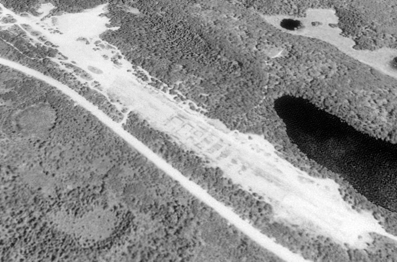
A 1992 USGS aerial view looking north showed Milford's abandoned runway was still quite recognizable, although somewhat deteriorated.
Bill Robichaud visited the site of the Milford airfield in 2006. He reported, “Its condition seems to be unchanged.
There were many 'No Trespassing' signs along the roadside, which the airfield runs parallel to, so I did not enter the site.
However I was able to see down its length, the pavement seems to be quite broken up, but not unrecognizable as an airstrip.
There was a truck parked on the southern end of the strip,
though the Maine Youth Fish & Game camp gate was open (located on the other side of Pickerel Pond),
so it may have been one of their vehicles.”

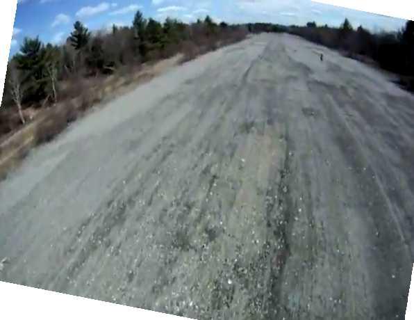
A 2008 photo by David Dauphinee looking along the abandoned runway at Milford.
David reported, “It is largely unchanged from the update from 2006.
The pavement is broken up & missing in some places with weeds growing through. In many places, paint is still evident.
It was easily accessed by taking Studmill Road east from Route 2 in the Milford/Greenbush area.
I drove straight through the open gate for the youth conservation camp on Pickerel Pond & then walked up a small hill to my left.
Visitors should use caution as the site is clearly used by several hunters for target practice (shell casings everywhere).”
Gus LeBlanc reported in 2008, “The remnants of the Air Force survival school... are now used by the Maine Youth Fish & Game Association.”
A still from a 4/26/12 video by Brian Barainca taken from his radio-controlled model aircraft, on short final to the runway at Milford.
Brian is visible on the top-right on the runway.
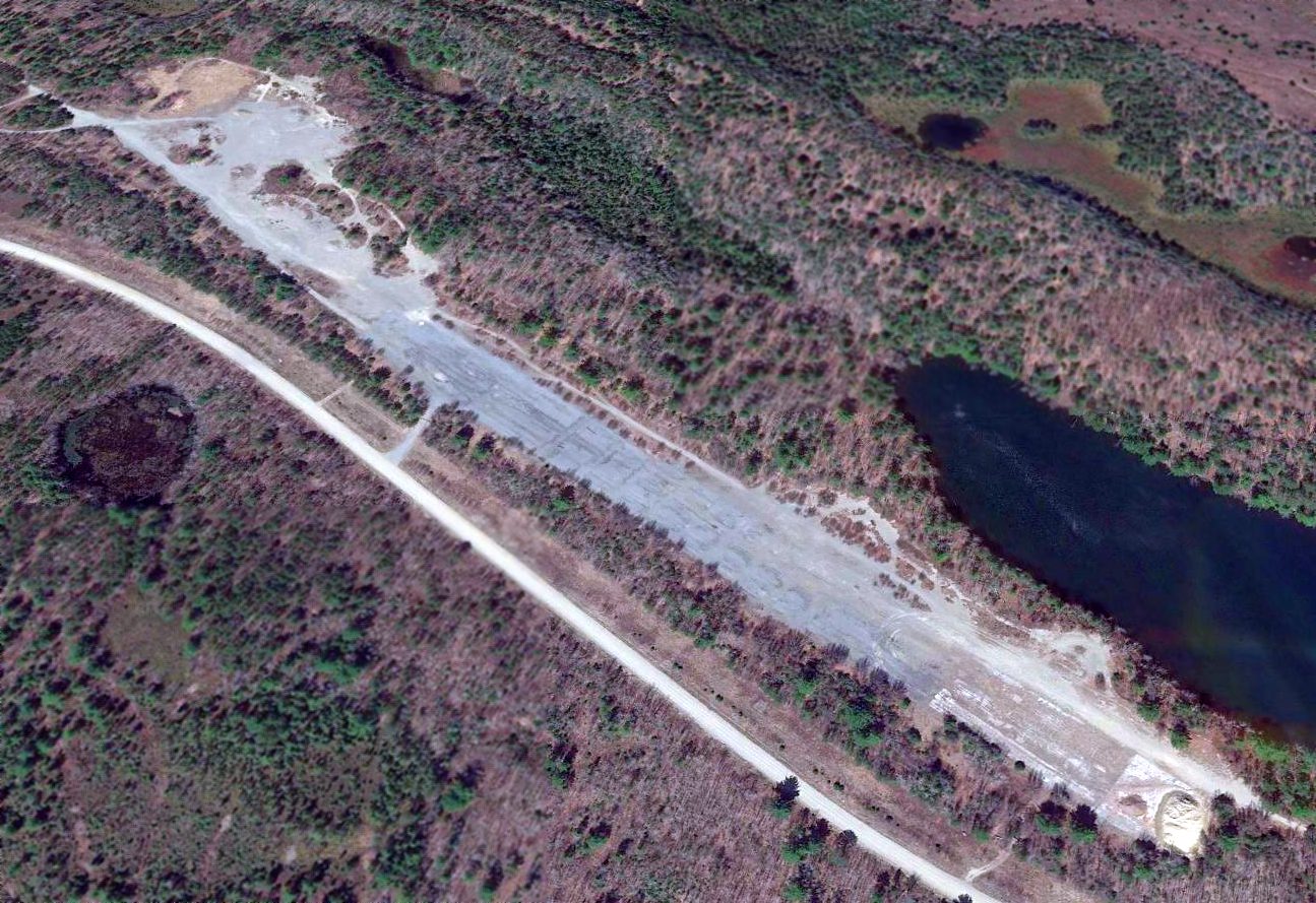
A 2016 aerial view looking north depicted the remains of the Milford runway.
A May 2018 aerial view (courtesy of Jeff Lombardo) of the remains of the Milford runway.
Jeff Lombardo observed, “It showed the most broken pavement on the northwest part of the runway had been graded back to gravel,
while about 400' of asphalt remains in the southeast portion, which was in the best shape & where the remnants of the old buildings are most visible.”
The site of the Milford airfield is located southeast of the intersection of County Road & St. Regis Road, 9 miles east of Milford, ME.
____________________________________________________
Or if you prefer to contact me directly concerning a contribution (for a mailing address to send a check),
please contact me at: paulandterryfreeman@gmail.com
If you enjoy this web site, please support it with a financial contribution.
____________________________________________________
This site covers airfields in all 50 states.
For the site's main menu: Home