Abandoned & Little-Known Airfields:
Southern Maine
© 2002, © 2026 by Paul Freeman. Revised 3/20/26.
This site covers airfields in all 50 states: Click here for the site's main menu.
____________________________________________________
Please consider a financial contribution to support the continued growth & operation of this site.
Andover Airport (revised 10/13/24) - Casco Bay NAAF (revised 10/6/18) - Fernald Field (revised 4/27/21) - Limerick Yarn Mills Airport/ Limerick Airport (revised 10/6/18)
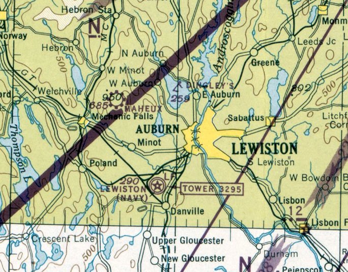
Greenlaw Airport / Maheux Airport (Auburn) (revised 10/6/18) - Maheux Airport (Minot) / Maheu Airport (revised 10/6/18) - Port Of Maine Airport / Port O' Maine Airport (added 4/3/19)
(Original) Portland Airport / Scarborough Airport (revised 11/18/20) - St. Croix Airport (revised 1/18/21) - Twitchell Airport & Seaplane Base (revised 3/20/26)
____________________________________________________________________________
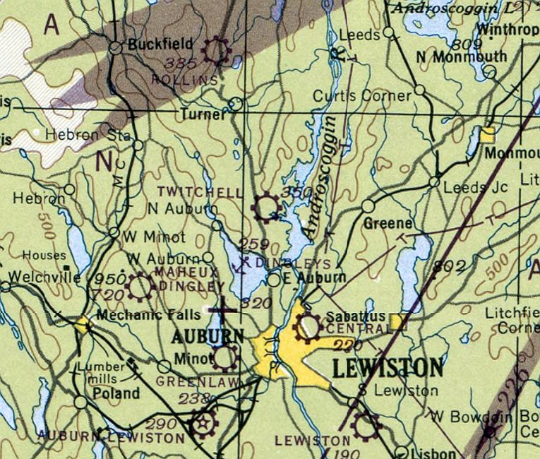
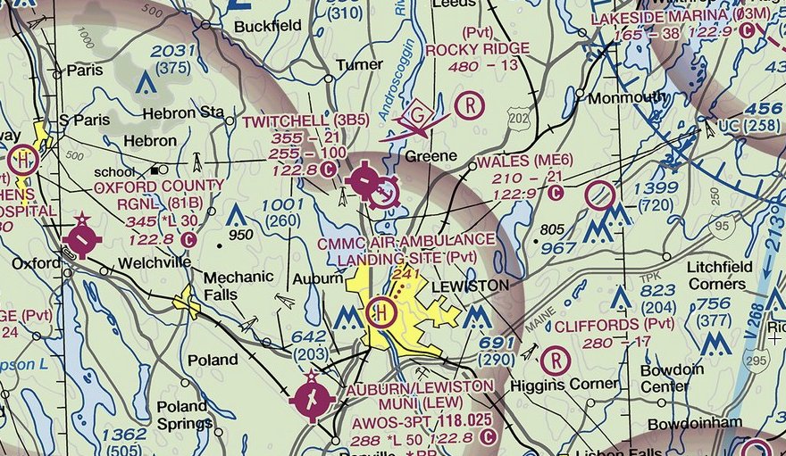
Twitchell Airport & Seaplane Base (3B5), Turner, ME
44.189,-70.233 (Northeast of Portland, ME)
Twitchell Airport, as depicted on the July 1947 Boston Sectional Chart.
According to its FAA Airport/Facility Directory data, Twitchell Airport was activated in December 1946.
However, Twitchell Airport was not yet depicted on the January 1947 Boston Sectional Chart.
The earliest depiction which has been located of Twitchell Airport was on the July 1947 Boston Sectional Chart,
which depicted Twitchell as a commercial/municipal airport.
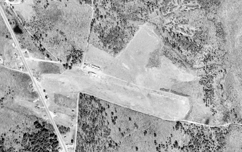
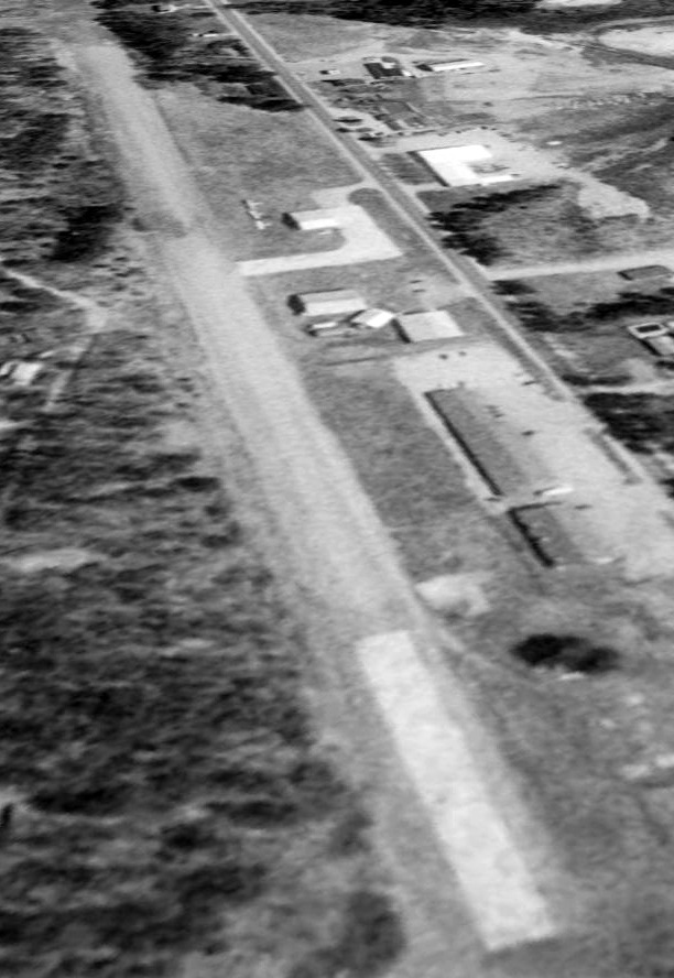
The earliest photo which has been located of Twitchell Airport was a 4/22/53 USGS aerial view.
It depicted Twitchell Airport as having a single northwest/southeast unpaved runway, with 3 light single-engine planes parked near some small hangars on the northwest side.
One light single-engine floatplane was seen on the Androscoggin River at the seaplane base to the southeast.
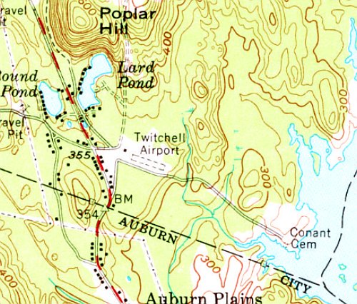
The earliest topo map depiction which has been located of Twitchell Airport was on the 1956 USGS topo map.
It depicted Twitchell Airport as having a single northwest/southeast unpaved runway, with 1 small building on the northwest side.
The seaplane base to the southeast was not yet depicted.
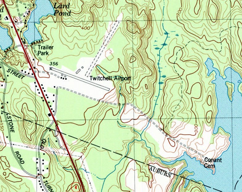
The 1979 USGS topo map showed Twitchell Airport's primary runway had been paved, and it had gained a crosswind northeast/southwest unpaved runway, along with several small buildings on the north & south sides.
But the seaplane base to the southeast still was not depicted.
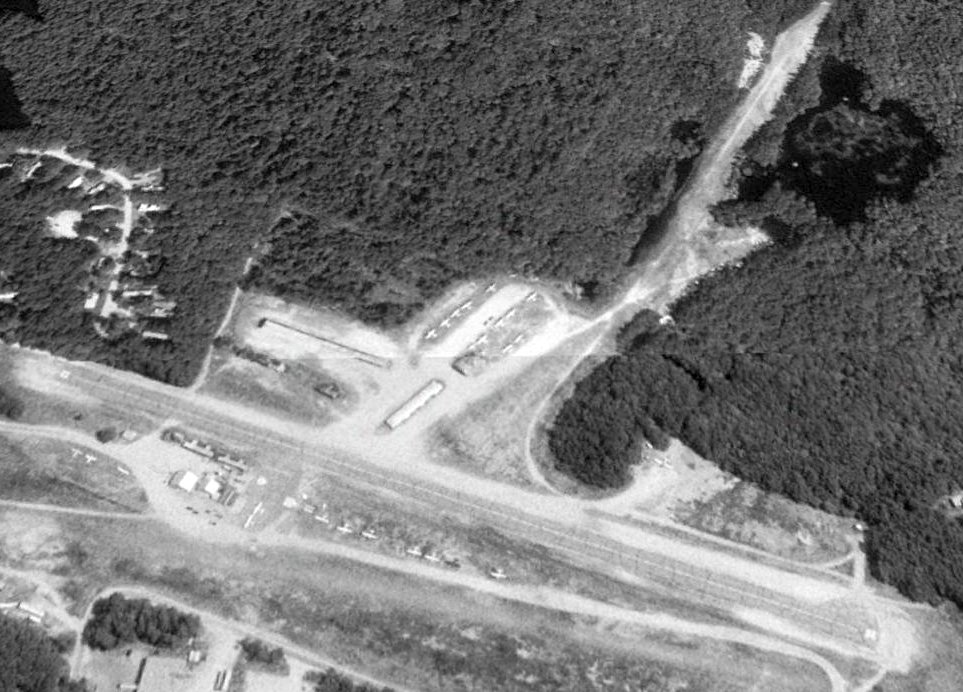
A 1997 USGS aerial view looking north depicted Twitchell Airport as having a single northwest/southeast paved runway & an unpaved crosswind northeast/southwest runway.
Two-dozen light single-engine planes were visible on the field, among the small hangars.
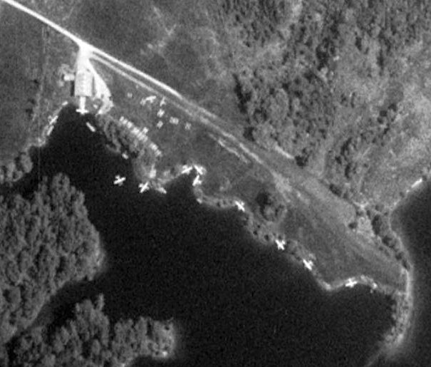
A 1997 USGS aerial view depicted 13 light single-engine floatplanes at the Twitchell Seaplane Base.
According to the Twitchel Airport website, Dale Twitchell retired in February 2019, at which point Dirigo Aerospace Solutions,
owned
& operated by husband & wife team Kate & Mark McGhee,
began managing the airport & seaplane base.
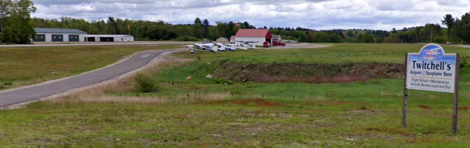
A June 2019 photo looking east depicted a row of planes, hangars, and the Twitchell's Airport & Seaplane Base sign.
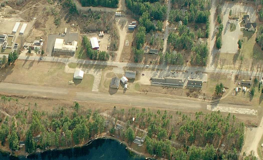
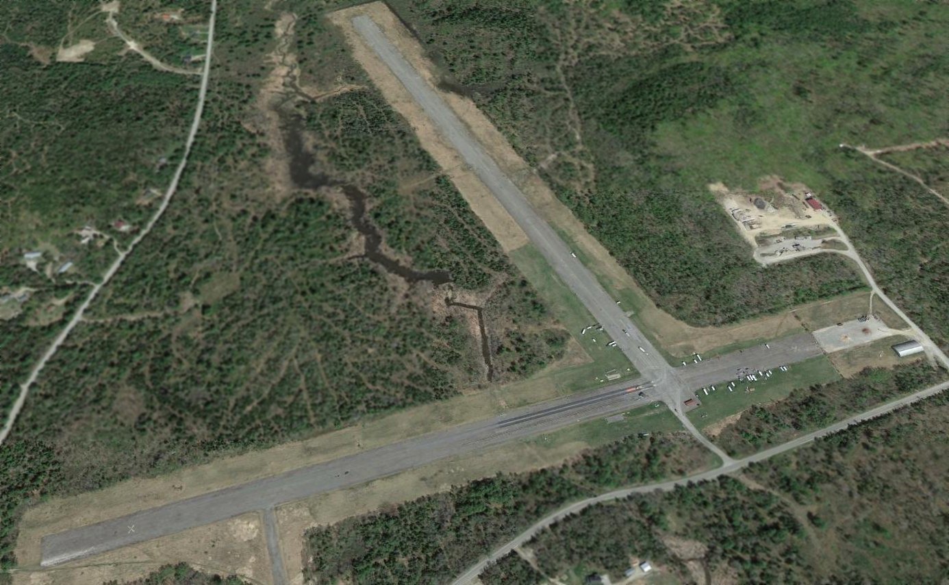
A 2021 aerial view looking north depicted Twitchell Airport as having a single Runway 12/30 & an unpaved crosswind northeast/southwest runway.
The number of planes visible on the field had decreased to 11.
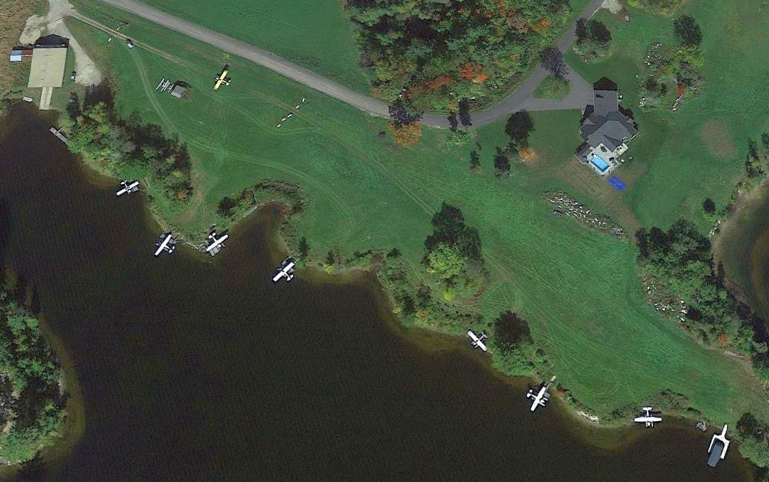
A 2021 aerial view looking north at the Twitchell Seaplane Base depicted 8 light single-engine floatplanes along the Androscoggin River.
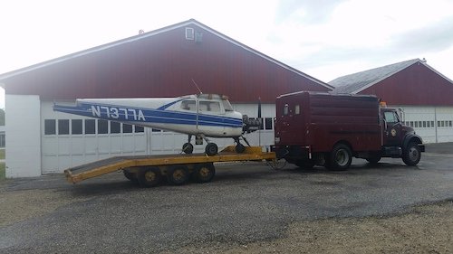
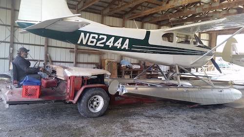
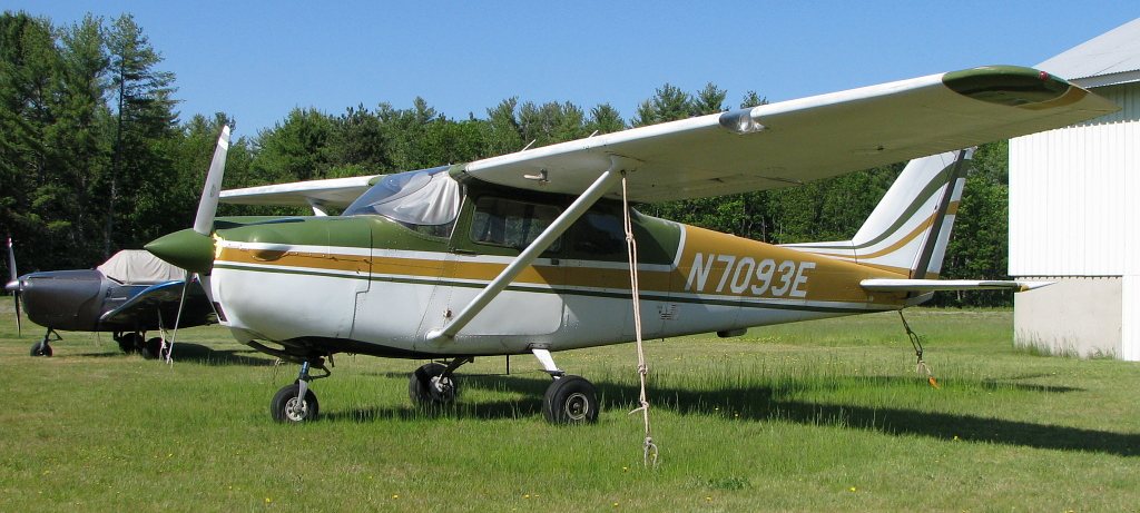
A 2022 or earlier photo of a Cessna 172 on a trailer in front of Twitchell Airport hangars.
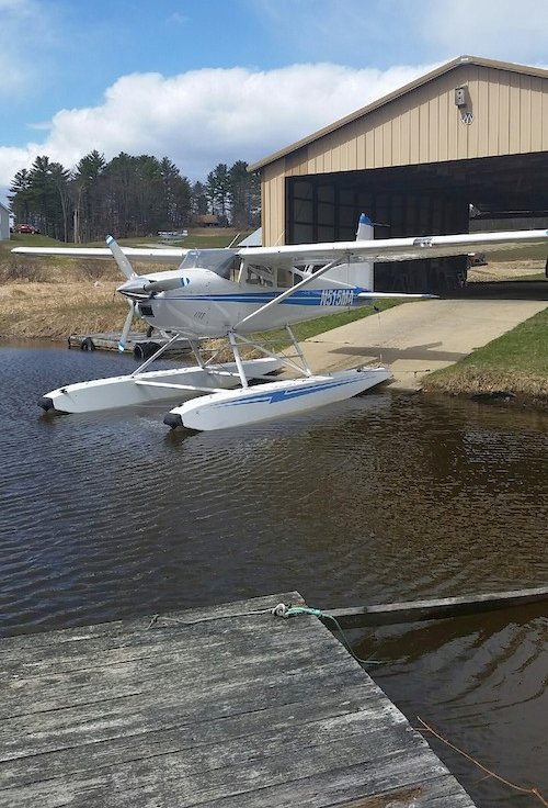
A 2022 or earlier photo of a Cessna 182 floatplane at the Twitchell Seaplane Base.
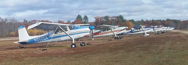
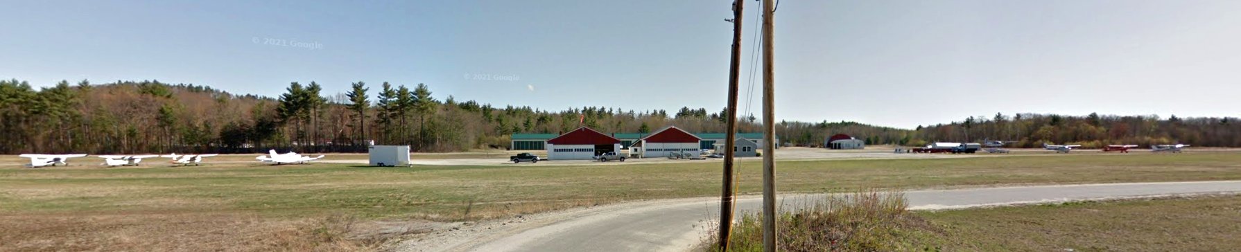
A 2022 or earlier photo of a row of Cessnas at Twitchell Airport.
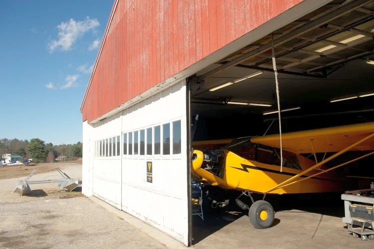
A 2022 or earlier photo of a Piper Cub inside a Twitchell Airport hangar.
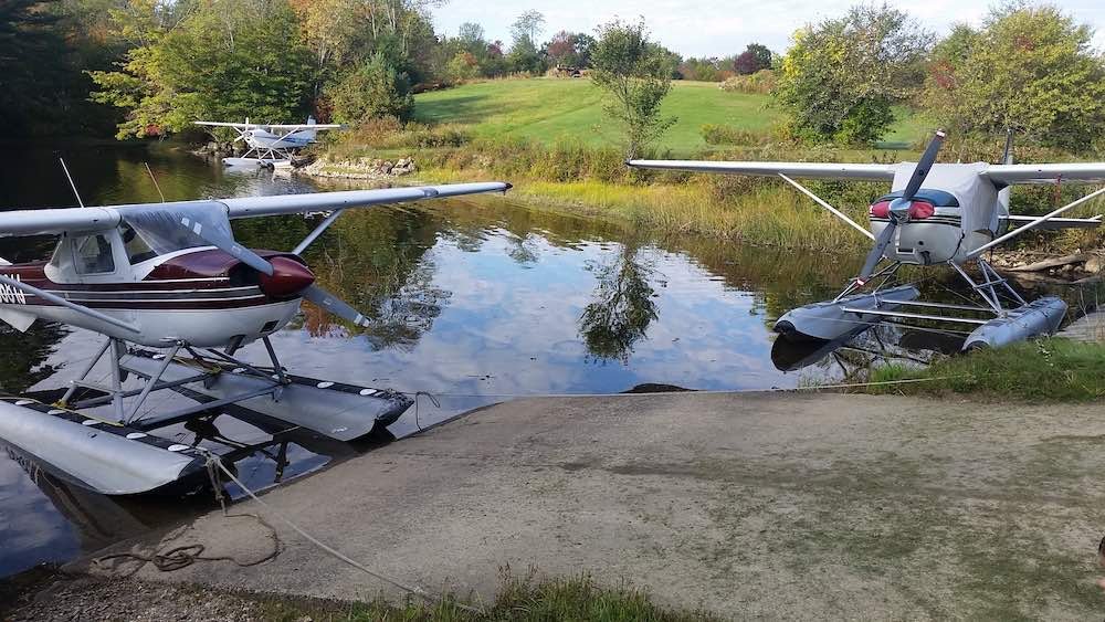
A 2022 or earlier photo of Cessna floatplanes at the Twitchell Seaplane Base.
A 2022 or earlier photo of a Cessna floatplane inside a Twitchell Airport hangar.
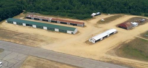
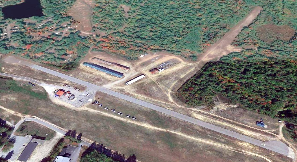
A 2022 or earlier aerial view looking north at the Twitchell Airport hangars.
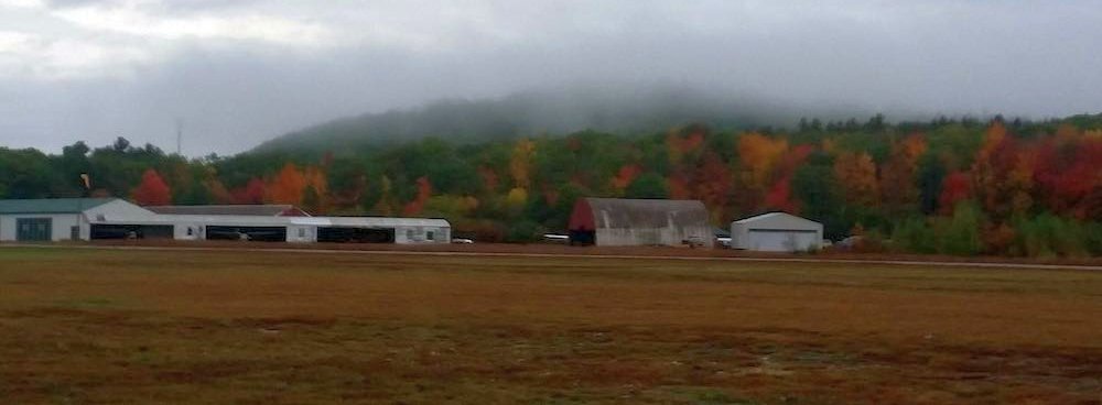
A 2022 or earlier photo looking northwest at the Twitchell Airport hangars.
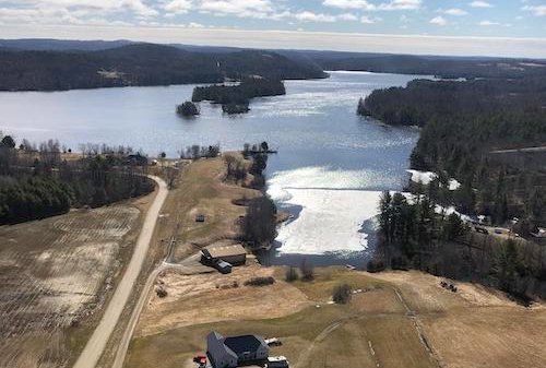
A 2022 or earlier aerial view looking southeast at the Twitchell Seaplane base.
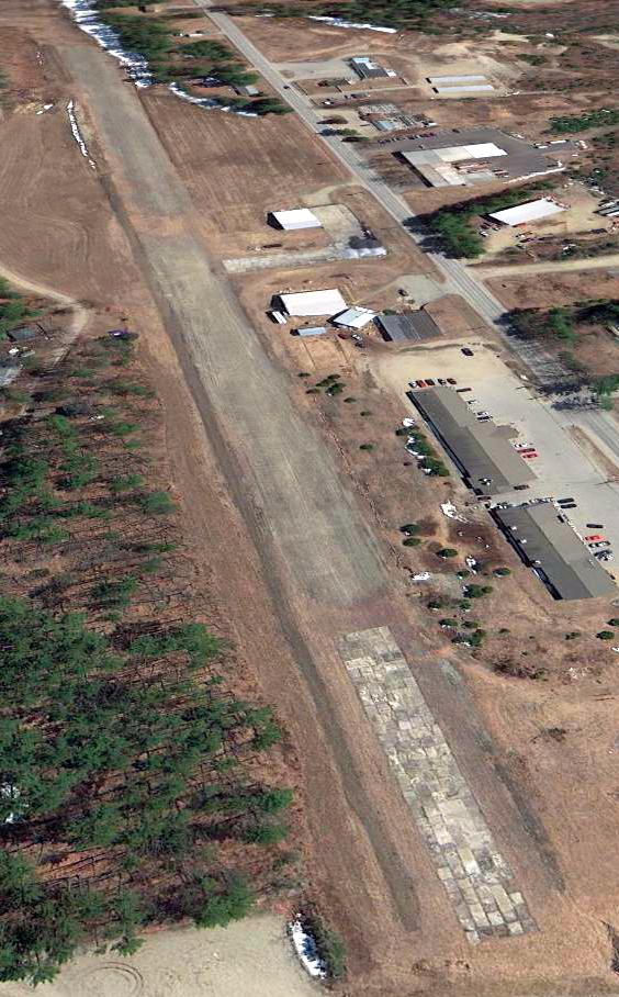
The 2022 Boston Sectional Chart depicted Twitchell Airport as having a single northwest/southeast paved 2,100' runway,
and the Twitchell Seaplane Base as having a 10,000' water landing area.
An April 2022 photo looking northeast depicted planes & hangars at Twitchell Airport.
An article entitled “Twitchell Airport property in Turner under contract to be sold” in the 11/7/22 Sun Journal (courtesy of Ron Plante) spelled out the unfortunate end for Twitchell Airport:
“Twitchell Airport, the last in Maine that is privately-owned & commercially operated, will cease operation at the end of the month after 76 years.
The land owners, Kurt & Kelvin Youland, have decided to sell the roughly 145 acres the airport & seaplane facilities share, including hangar space & docks.
A self-storage facility will reportedly be built on the property.
The airport has been managed by Dirigo Aerospace Solutions since 2019,
which is owned by husband & wife team Kate & Mark McGhee, who took over the role from Dale Twitchell when he retired.”
“The entire aviation community has been affected by this, because Twitchell’s is such an iconic, historic place,” Kate McGhee said.
The loss will primarily be felt by recreational pilots with small planes & seaplanes who live in the area or have second homes or cabins in Maine.
McGhee estimates that means at least 75-100 pilots will have to find a new airport to call home.
Twitchell’s was also the only place in the Northeast to rent a seaplane solo,
and McGhee adds Twitchell’s has been the only on-the-water fuel stop for seaplanes to refuel south of Greenville, until one gets to Rhode Island.
Twitchell’s also offered maintenance & repair of small & commercial airplanes, sold fuel, offered flight instruction, plane rentals & leased hangar space.
McGhee said the Maine Warden Service would fuel up its seaplanes used in search & rescue and other operations at Twitchell’s.
At least 40 planes were based at Twitchell’s, McGhee said, with outside tie-downs for a few dozen more.
In addition, they did 50-75 seaplane float-to-tire conversions, swapping out the floats for tires at the beginning & end of each season.
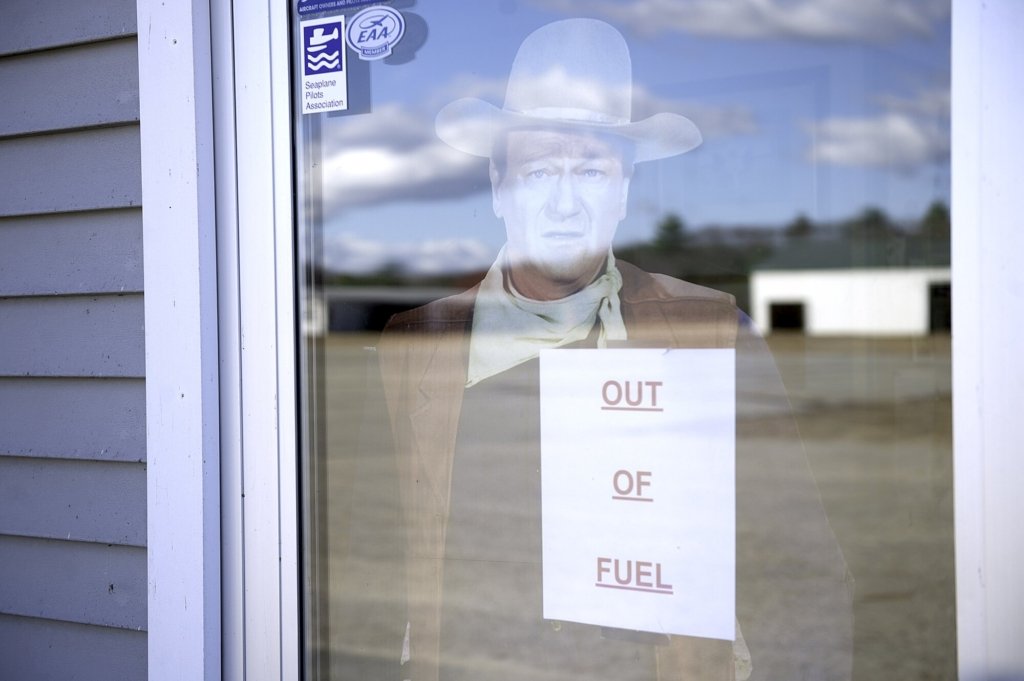
A 10/31/22 photo by Daryn Slover of a sign on a window Monday at Twitchell Airport, advised the business is out of fuel.
Operators say they have not been selling fuel for airplanes since the middle of October as they prepare to close permanently.
Kate McGhee said they were notified they have to vacate the property by the end of November,
which means collecting many years worth of equipment, tools & support vehicles & finding a new home for it all.
They will also have to relocate their business, which is something they are talking about with other airports.
“Oh, I’m heartbroken,” McGhee said about the closure.
“You know, it is difficult at this point to even be here right now, because there are so many people who already started taking their planes away and everything.”
The McGhees have dedicated themselves to the airport since they took over management of the facility, working seven days/week, 365 days/year to keep the it running.
Both of them fly planes, and Mark has 35 years of experience as a certified airplane mechanic & commercial pilot, skills that are in high demand.
However, starting a mature business from scratch will be a challenge.
McGhee said there was an organized effort to purchase the property to keep it as an airport by local pilots & non-pilots in the community, but it was not successful.
Thanks to Ron Plante for pointing out this airport.
__________________________________________________________________________
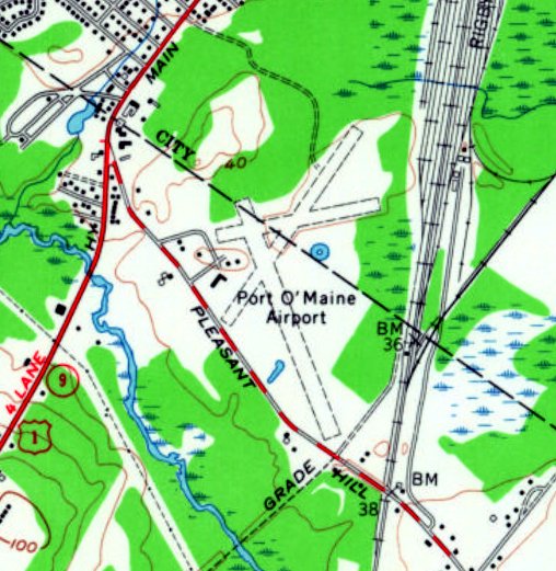
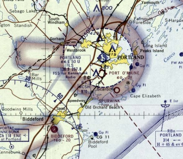
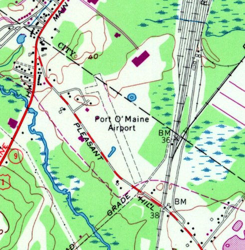
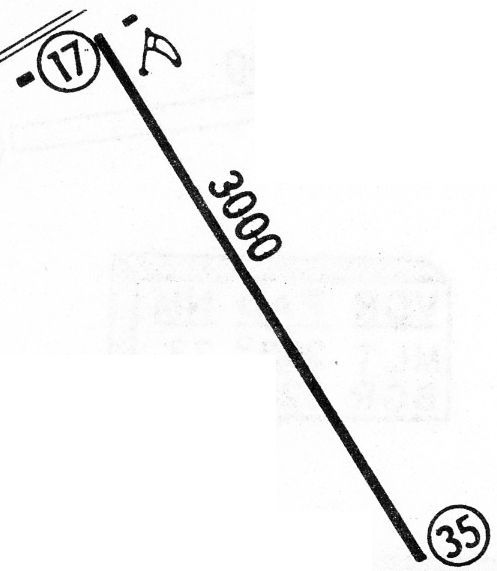
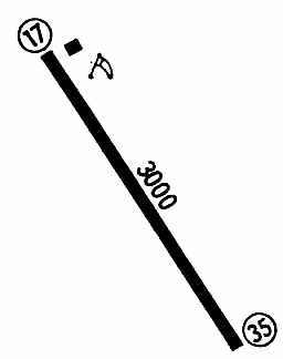
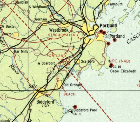
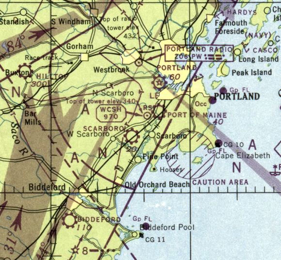
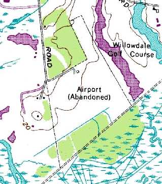
Port Of Maine Airport / Port O' Maine Airport, Scarborough, ME
43.609, -70.306 (Southwest of Portland, ME)
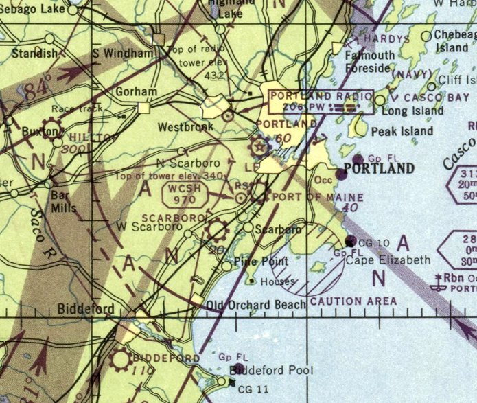
Port Of Maine Airport, as depicted on the July 1966 Boston Sectional Chart.
According to Tim Sullivan, “Port O' Maine Airport [was] founded in 1940 by Harold Troxel, formerly Sagadahoc Dairy Farm.”
However, Port O' Maine Airport was not yet depicted on the 1941 or 1942 Boston Sectional Charts,
or the 1941 or 1942 USGS topo maps.
According to Tim Sullivan, “Operations shut down during WW2, which prevented private flights 50 miles from the coast.”
According to Tim Sullivan, “Port O' Maine Airport... started back up after the war.”
The earliest depiction which has been located of Port Of Maine Airport was on the July 1946 Boston Sectional Chart.
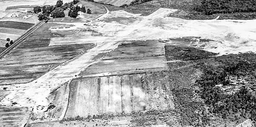
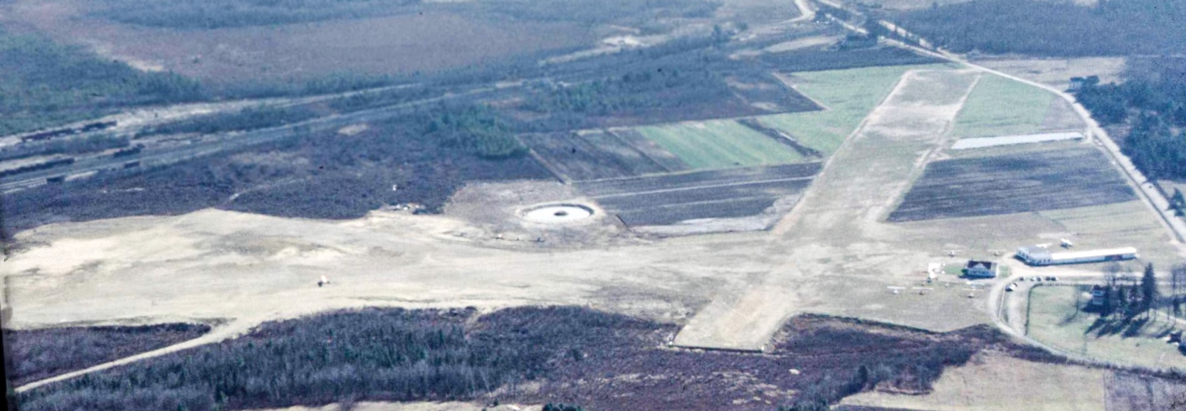
The earliest photo which has been located of Port Of Maine Airport was a 1947 aerial view looking north.
It depicted Port Of Maine Airport as having 2 unpaved runways, with some small buildings along the northwest side.
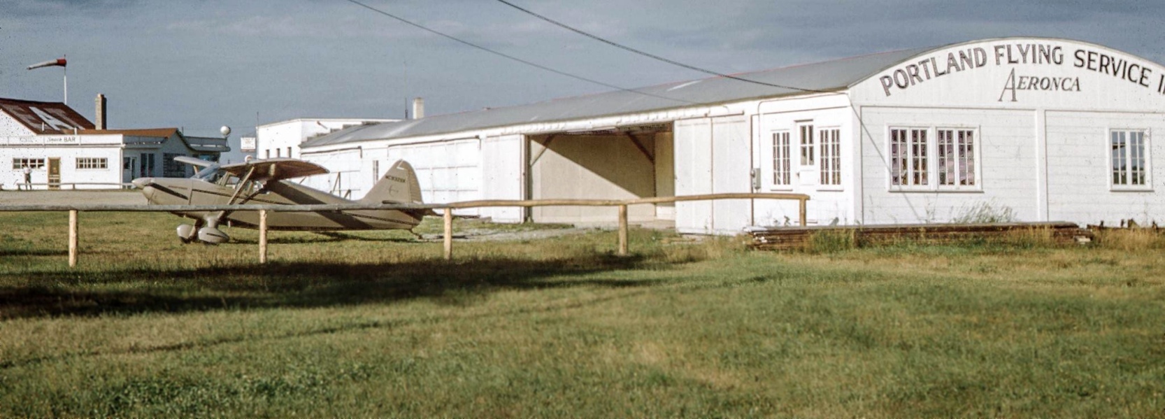
A 1950 photo by Henry Pollard looking east at his Stinson in front of Port Of Maine Airport's Portland Flying Service hangar, with the Snack Bar visible in the background.
A 1950 aerial view by Henry Pollard looking south at Port Of Maine Airport, showing 3 unpaved runways, with several buildings & a number of light planes on the west side.
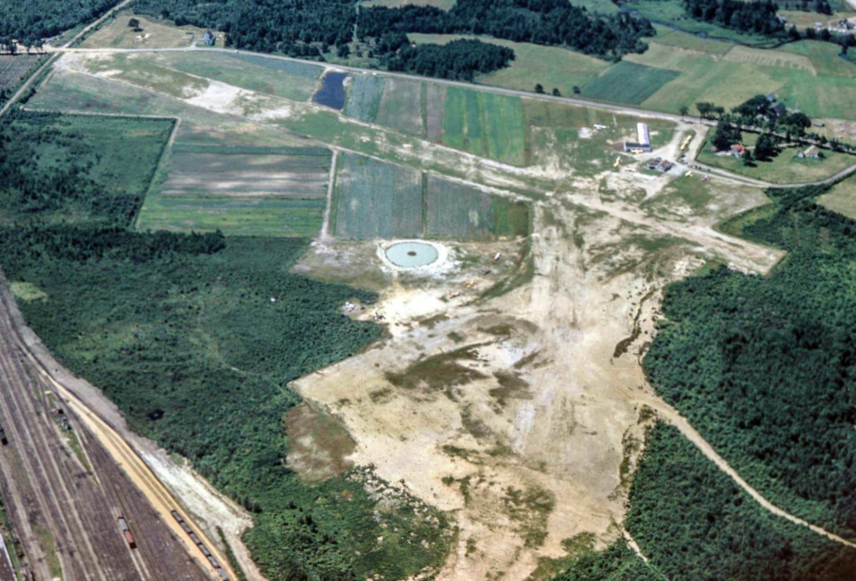
A 1951 aerial view by Henry Pollard (courtesy of Tim Sullivan) looking southwest at Port O' Maine Airport, showing 3 unpaved runways, with several buildings & a number of light planes on the west side.
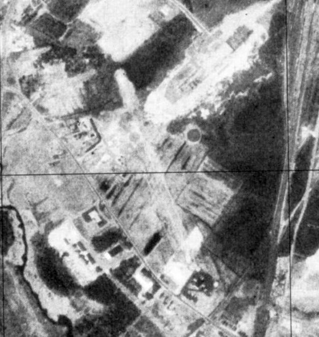
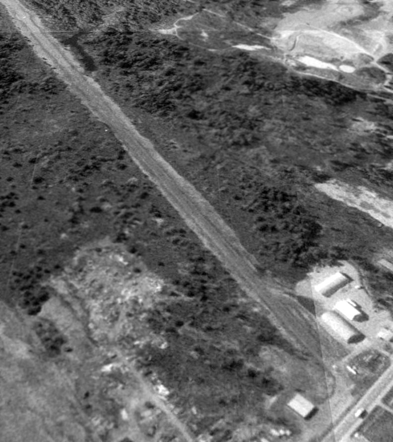
The last photo which has been located showing Port O' Maine Airport still in operation was a 1956 aerial view, which depicted 2 light aircraft parked on its west side.
The 1957 USGS topo map depicted Port O' Maine Airport as having 3 unpaved runways, with several small buildings on the west side.
According to Tim Sullivan, “Portland Flying Services was sold to Nathan Lake, Jr and others in 1962.
According to Tim Sullivan, “The airport closed around 1965.”
The last aeronautical chart depiction which has been located of Port O' Maine Airport was on the September 1966 Boston Sectional Chart.
It depicted Port O' Maine as having a 2,800' unpaved runway.
Port O' Maine Airport was evidently closed (for reasons unknown) at some point between 1966-67,
as it was no longer depicted on the 1967 Boston Sectional Chart.
Port O' Maine Airport was still depicted on the 1970 USGS topo map, even though it may have been closed already for 3 years by that point.
The number of runways had decreased to only 1 (oriented northwest/southeast),
with a large building having been built over the eastern portion of the former crosswind runways.
A 1970 aerial view showed Port O' Maine Airport's northwest/southeast runway remained clear,
and the airport hangars may have remained intact on the west side, although a few other buildings had been built nearby.
A 1975 USGS aerial view showed Port O' Maine Airport's northwest/southeast runway remained clear,
and the airport hangars may have remained intact on the west side.
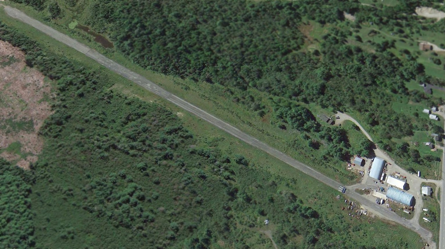
A 1998 aerial photo showed no recognizable trace of Port O' Maine Airport,
with the hangars having been removed, and other buildings having been built over the former airfield.
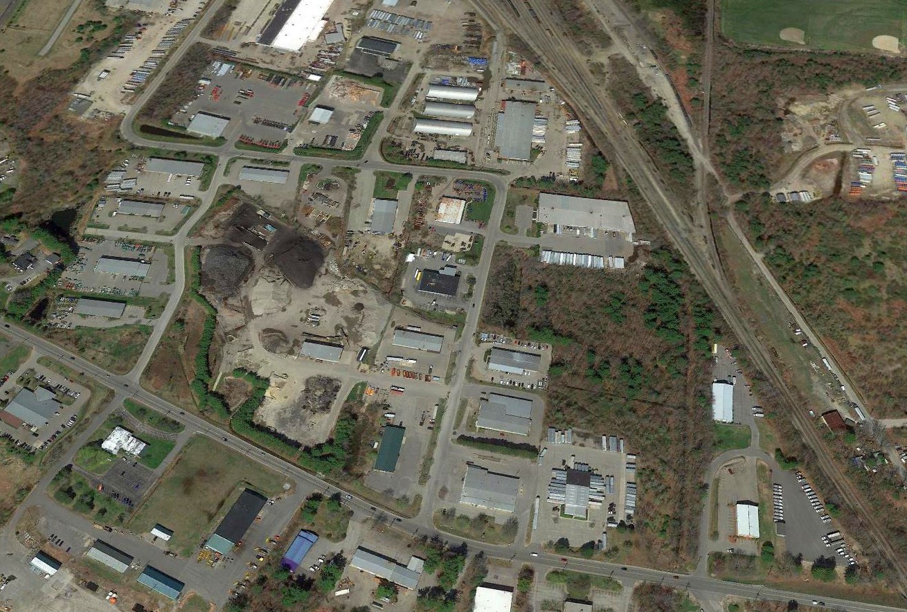
A 2013 aerial view looking northeast showed no recognizable trace of Port O' Maine Airport.
The site of Port O' Maine Airport is located east of the intersection of Pleasant Hill Road & Gibson Road.
Thanks to Tim Sullivan for pointing out this airport.
__________________________________________________________________________
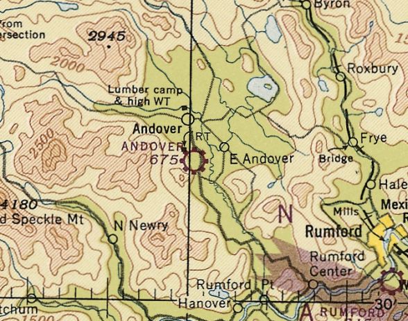
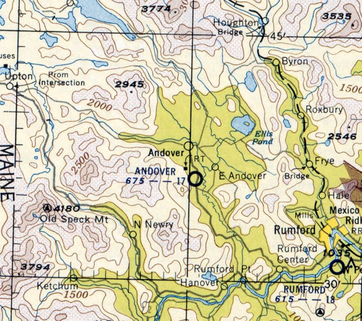
44.6, -70.74 (Northwest of Portland, ME)

Andover Airport, as depicted on the June 1944 Lewiston Sectional Chart.
Photo of the airport while in use has not been located.
This small general aviation airport was evidently established at some point between 1943-44,
as it was not yet depicted on the December 1943 Lewiston Sectional Chart.
The earliest depiction which has been located of Andover Airport was on the June 1944 Lewiston Sectional Chart.
It depicted Andover as an auxiliary airfield.
The July 1947 Lewiston Sectional Chart (courtesy of Ron Plante) depicted Andover as a commercial/municipal airport.
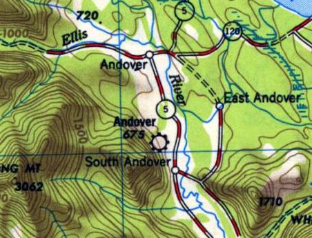
The 1950 USGS topo map depicted Andover as a commercial/municipal airport,
located on the west side of Route 5, south of the town of Andover.
The last aeronautical chart depiction which has been located of Andover Airport was on the May 1955 Lewiston Sectional Chart.
It depicted Andover Airport as having a mere 1,700' unpaved runway.
Andover Airport was evidently closed (for reasons unknown) at some point between 1952-56,
as it was no longer depicted on the 1956 USGS topo map nor on the May 1960 Lewiston Sectional Chart.
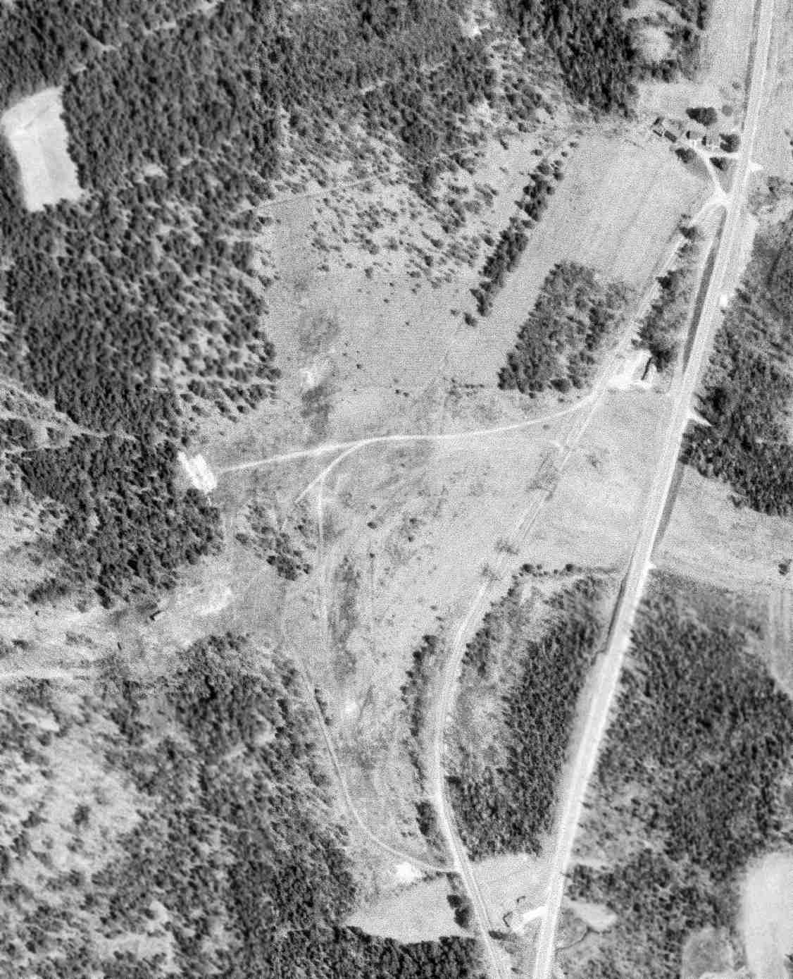
The only photo which has been located of Andover Airport was a 5/5/65 USGS aerial view. It depicted a clearing on the west side of Airport Road, with several possible unpaved runways.
But there were no aircraft visible on the field, or any other indication of recent usage.
A 1997 aerial photo showed no recognizable trace of Andover Airport.
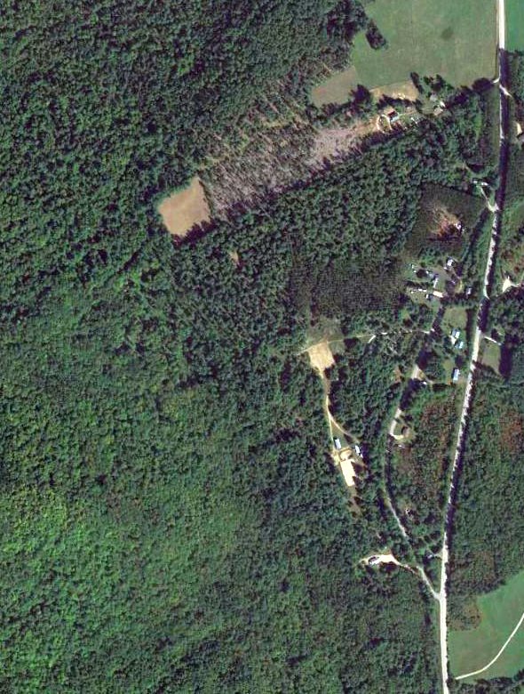
A 2013 aerial photo showed no recognizable trace of Andover Airport.
Deb Cayer reported in 2015, “A neighbor (Jim Coolidge) just uncovered a cement airport marker.
It's located just off Airport Road where I'm told there was once an airstrip.
It had been buried for years by a softball or baseball group that built a field on the site.
Luckily a long-time resident remembered playing trucks there on the circle.
He took his 11 year old son out as a history project & dug it up very carefully with a flat shovel.”
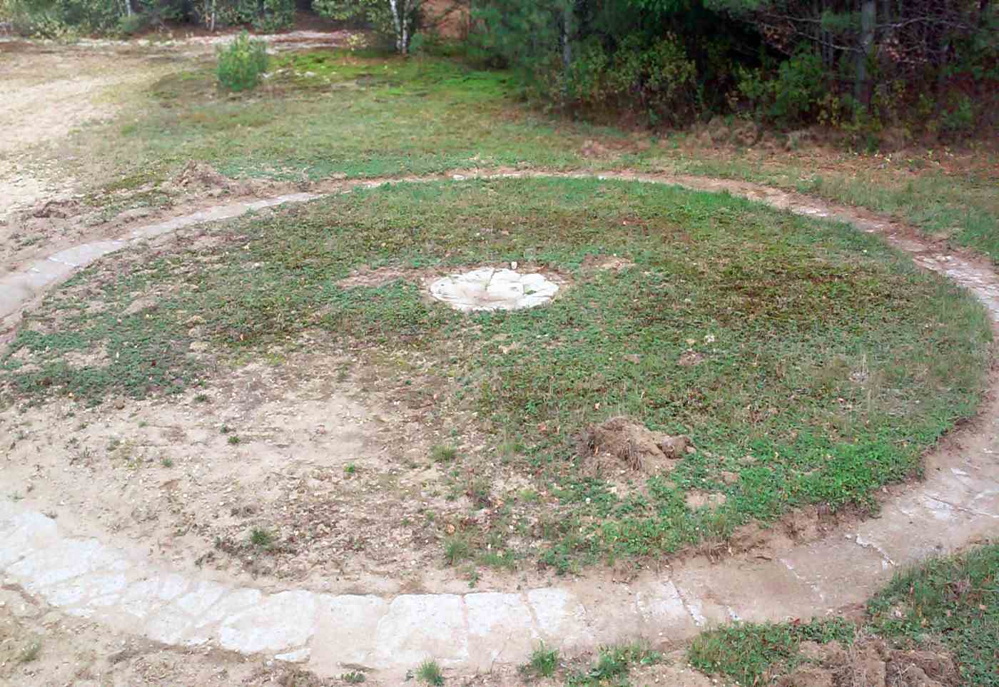
A 9/21/15 photo by Deb Cayer of the unearthed circular stone airport marker at the site of Andover Airport.
The site of Andover Airport is located west of Airport Road, appropriately enough.
Thanks to Deb Cayer for pointing out this airport.
__________________________________________________________________________
Limerick Yarn Mills Airport / Limerick Airport, Limerick, ME
43.7, -70.78 (West of Portland, ME)
Limerick Yarn Mills Airport, as depicted on the January 1949 Boston Sectional Chart (courtesy of Ron Plante).
Limerick Yarn Mills Airport was evidently established at some point between 1948-49,
as it was not yet depicted on the July 1948 Boston Sectional Chart,
The earliest depiction which has been located of Limerick Yarn Mills Airport was on the January 1949 Boston Sectional Chart (courtesy of Ron Plante),
which depicted it as having a mere 1,500' unpaved runway.
According to Norm Bisson, “The airstrip was built by Dana Smith of Limerick.
He built the strip for his aircraft mechanic School, Air-Tech. The school was in the hangar. Dana built that as well.
Dana was a well-known aircraft mechanic. He was also an FAA mechanic examiner. He tested me for my A&P.
Dana also built a replica Wright Vin Fix airplane which he flew both locally & at some northeast aviation events.”
According to Dana Smith's obituary (courtesy of Norm Bissson), Dana founded & operated Air-Tech Aviation Maintenance School in Limerick for 28 years.
The last aeronautical chart depiction which has been located of Limerick Yarn Mills Airport was on the January 1953 Boston Sectional Chart.
It depicted Limerick Yarn Mills Airport as having a 1,500' unpaved runway.
Limerick Yarn Mills Airport was evidently closed (for reasons unknown) at some point in 1953,
as it was no longer depicted on the May 1953 Boston Sectional Chart.
Dorinda Cox reported, “I am Dana Smith’s eldest daughter. We moved to Limerick on my 7th birthday in May 1969.
I grew up on that airfield & helped my dad do everything from scraping paint off the floor of the first Air-Tech building before the school opened,
to gluing & nailing gussets on the trusses when we later built the hangar & finished many a yard of the concrete that covers the apron in front of the hangar & the end of the airfield.
My Mom was the director of admissions of the school (she ran the place!). My brothers helped Dad more than I did.
I flew frequently with my dad growing up - he loved flying in New England because he could always find a grass airstrip on which to land.
He also was fond of flying on floats in the summer in Maine. He was a brilliant airplane mechanic & pilot & had a passion for restoring old airplanes.
It seems he always had a project going on - whether it be an old Waco, a Curtiss pusher or a Cub. My personal favorite was a 1933 Stinson SR-JR.
Later in his life built several post Wright flyer replicas that actually flew. His pet project was the Vinn-Fizz.”
No airfield was depicted in Limerick on the March 1970 Boston Sectional Chart nor on the 1973 USGS topo map.
After several decades, the airfield in Limerick was evidently reestablished in the same location at some point in the 1970s,
although the reestablished Limerick Airfield was evidently not depicted on aeronautical charts.
Steve St. Saviour reported, “I talked to my father, and found out the Limerick airport became operational sometime before 1977.
That was his graduation year, and he attended an event at the airfield. He said it was nearly-new then.”
Limerick Airport was labeled simply as “Landing Strip” on the 1983 USGS topo map.
It depicted a single unpaved 2,300' southeast/northwest runway with a few small buildings on the south side.
The earliest photo which has been located of Limerick Airport was a 1998 USGS aerial view looking southeast,
showing 3 single-engine planes sitting next to a hangar on the south side of the runway.

A 5/25/10 photo by Kevin Porter looking northwest along Limerick's runway.
Kevin reported, “I've done some digging in local libraries & I haven't been able to find much information.
Current Sectionals don't depict the airport, despite the fact that it appears to be active.
The airport is currently a gravel strip, 1,200'-1,500' in length, perhaps 50' wide.
There is a small building which may be a hangar on site, and a paved concrete ramp area.”
A 5/25/10 photo by Kevin Porter of an Ercoupe & Cessna 175 parked in the grass at Limerick.
A circa 2010-2014 aerial view looking south at Limerick Airport showed 1 single-engine planes sitting next to a hangar on the south side of the runway.
Note that the eastern end of the runway appeared to have been paved, whereas the majority of the runway appears to be gravel.
According to Norm, “The patchwork appearance of the paved runway section was due to Dana having a local cement company drop off any leftover cement.
During my exam we had to stop a couple times so Dana could run out & show the truck where to drop. Then he would spread the cement out.”
Dorinda Cox reported, “My Mom sold the property in 2012.
Sadly, my healthy, fit, athletic father passed away in 2013 after battling Alzheimers. He was 78.”
According to Norm, Limerick Airport founder “Dana [Smith] passed away in 2013.
He was a good man. His school must have closed at some earlier date.”
A 4/7/13 aerial view looking southeast showed the deteriorating pavement on the eastern end of the runway.
There were no aircraft visible parked outside.
A 2014 photo by Steve St. Saviour looking northwest along the Limerick runway.
Steve reported, “The airstrip is well known among the locals of the town.
There are 2 airplanes that still takeoff/land there every now & then (an Ercoupe & a Cessna 175), but I think they are just local townsmen.
I did happen to talk to one a few years ago, and he invited me to fly up in my Super Viking, but I never had the chance.
I heard rumors of some legal incident (an accident) causing the airstrip to become un-public, but that's just heresay, and I can't verify it.
The airstrip appears to be dirt, not in terrible condition.”
A 2014 photo by Steve St. Saviour at a Limerick hangar.
Steve reported, “There is one easily-identifiable hangar; there may be more, but I did not search around much.”
Limerick Airport is located north of the intersection of Central Avenue & Hillcrest Avenue.
__________________________________________________________________________
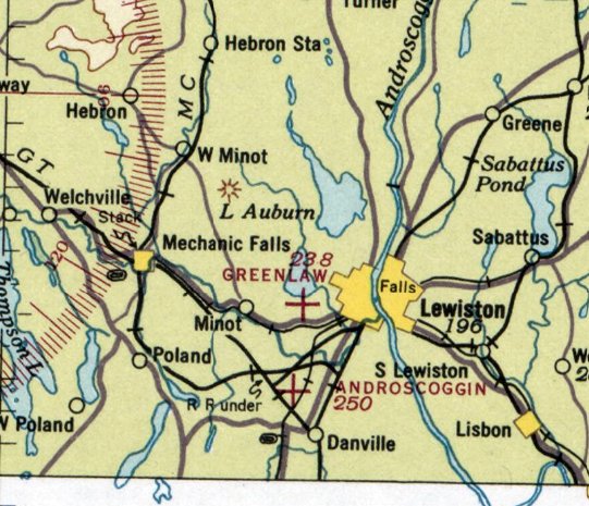
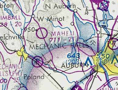
Greenlaw Airport / Maheux Airport (Auburn), Auburn, ME
44.09, -70.27 (North of Portland, ME)
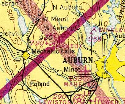
Greenlaw Airport, as depicted on the June 1936 Lewiston Sectional Chart.
Photo of the airport while open has not been located.
Greenlaw Airport was evidently established at some point between 1933-36,
as it was not listed among active airfields in The Airport Directory Company's 1933 Airport Directories (according to Chris Kennedy).
This little general aviation airport was owned by Roland Maheux.
Clarence Dargie recalled, “Roland Maheux was a very interesting character.
He never had a flying lesson in his life.
He bought what I believe was a Heath Parasol at age 16, climbed into it & taught himself to fly.
He opened his airport during the 1930s. He kept his first airplane in a farm field south of Taylor Pond.”
The earliest depiction which has been located of Greenlaw Airport was on the June 1936 Lewiston Sectional Chart.
It depicted Greenlaw as an auxiliary airfield.
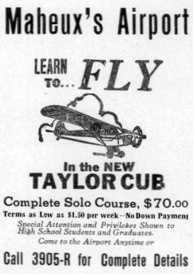
Greenlaw Airport was evidently renamed Maheux's Airport at some point between 1936-37,
as that is how it was advertised in the 1937 Lewiston High School yearbook (courtesy of Chris Brame).
The Airport Directory Company's 1941 Airport Directory (courtesy of Chris Kennedy)
described Maheux Airport as a commercial field, located 1 mile west of Auburn.
The field was said to be rectangular, having a single 1,200' runway,
with buildings to the east & west, including a hangar.
The Maheux Airport may have been temporarily closed at some point between 1941-42
(like many other small civilian airport near the coasts, due to wartime security concerns),
as it was not depicted at all on the February 1942 or December 1943 Lewiston Sectional Charts.
The Maheux Airport in Auburn evidently reopened at some point in 1944,
as it was listed among active airfields in the April 1944 US Army/Navy Directory of Airfields (courtesy of Ken Mercer).
It described the Maheux Airport in Auburn as having a 1,200' unpaved runway.
The June 1944 Lewiston Sectional Chart (courtesy of Chris Kennedy) depicted the Maheux Airport in Auburn as an auxiliary airfield.
Note that this 1944 chart also depicted the new Maheux Airport, a few miles to the northwest (in Minot).
The September 1944 Boston Sectional Chart continued to depict the Maheux Airport in Auburn as an auxiliary airfield.
Clarence Dargie recalled of the original Maheux Airport, “Other pilots started using it
and it developed into an airport which was later bought by Wilfred Charest, aka, The Butcher.
Maheu had already opened the new Maheux Airport in Minot before selling the Taylor Pond one to Charest.
Rumor had it that bad blood developed between Charest and Maheu over some shady aspects of the airport sale.
The single grass runway ran north & south... about 1,200' long.
There was an office building & a couple of hangars.
The field was owned by Wilfred Charest, a butcher by trade who owned a butcher shop in Auburn.
Thus, the field was more popularly known as The Butcher's.
It was an outlaw field that played host to every misfit pilot in the area,
most of whom had been banned from other local airports for dangerous & unorthodox behavior.
In fact, Roland Maheu cautioned us students
that any of us he caught landing at the Butcher's would be grounded for a month.
I never landed there but did fly in the vicinity to observe the antics of that wild bunch
and one day watched as someone in a Waco UPF-7 did low altitude loops over the center of the field
as airplanes were landing in both directions.
A few days later, one of the Butcher's Boys, as they were known,
was killed in a Stearman along with his passenger when he crashed into the pond
while doing slows rolls on final approach to the runway.”
The original Maheux Airport in Auburn was evidently closed at some point between 1944-45,
as it was no longer depicted at all on the July 1945 Lewiston Sectional Chart (courtesy of Chris Kennedy).
At some point between 1945-46 the original Maheux Airport in Auburn was evidently reopened under the name of Greenlaw Airport (once again),
as that is how it was depicted on the July 1946 Boston Sectional Chart.
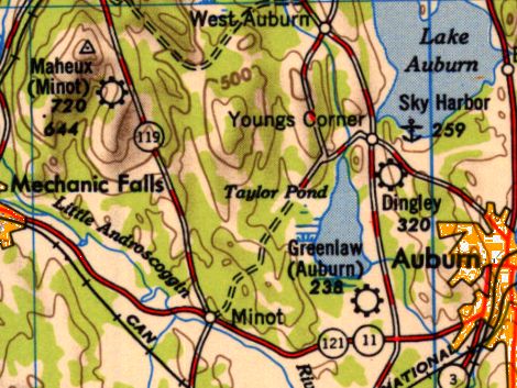
“Greenlaw (Auburn)” Airport, as depicted on the 1950 USGS topo map.
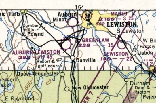
The last depiction which has been located of Greenlaw Airport was on the January 1950 Boston Sectional Chart.
It depicted Greenlaw Airport as having a mere 1,500' unpaved runway.
In a 1953 aerial photo, no recognizable trace of Greenlaw Airport was still recognizable.
Greenlaw Airport was evidently closed at some point between 1950-55, as it was no longer depicted on the May 1955 Boston Sectional Chart.

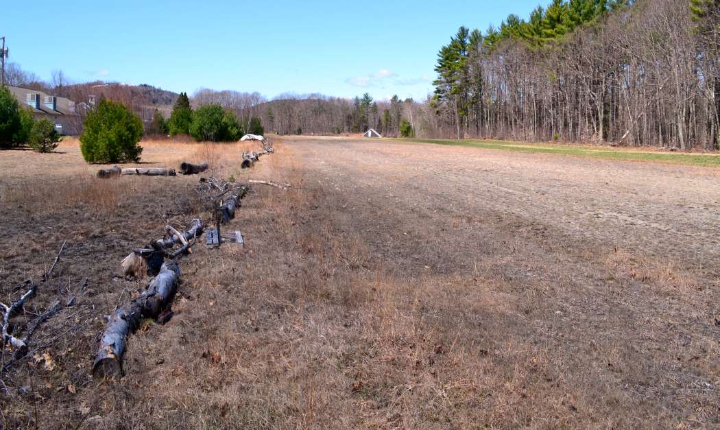
In a 2004 aerial photo, the former Maheux Airport workshop building was visible in the center of the photo.
No recognizable trace of the airfield clearing was still visible.
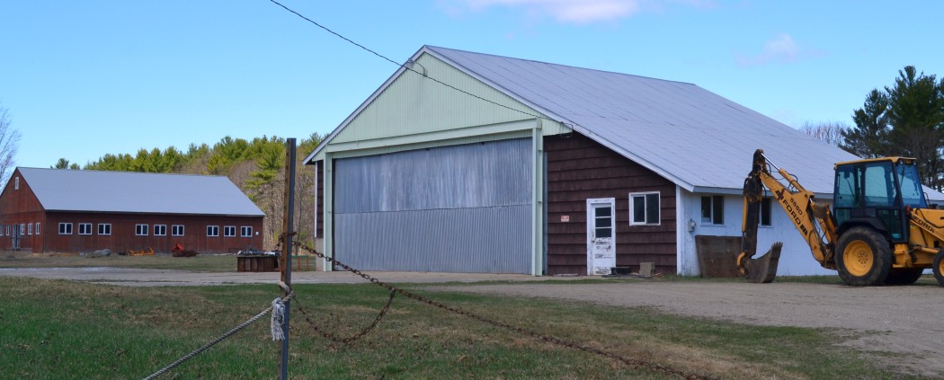
A 2006 photo by Norman Houle “of the old airport workshop on the west side of the old Airfield, it is now owned by Columbia River Corp.
Their address is 389 Stevens Mill Rd., Auburn.”
The site of the Maheux Airport in Auburn is located west of the intersection of Stevens Mills Road & Hotel Road.
__________________________________________________________________________
Maheux Airport (Minot) / Maheu Airport, Minot, ME
44.14, -70.35 (North of Portland, ME)
The second location of the Maheux Airport (northwest of Minot) was depicted as a commercial airport on the December 1943 Lewiston Sectional Chart.
Photo of the airport while open is not available.
This little general aviation airport replaced the original Maheux Airport in Auburn.
The Maheux Airport in Minot was evidently established at some point in 1943,
as no Maheux Airport was depicted on the February 1942 & December 1942 Lewiston Sectional Charts (according to Chris Kennedy).
The earliest depiction which has been located of the Maheux Airport in Minot was on the December 1943 Lewiston Sectional Chart.
It depicted the Maheux Airport in Minot as a commercial airport.
The April 1944 US Army/Navy Directory of Airfields (courtesy of Ken Mercer)
described the Maheux Airport in Minot as having an 1,800' unpaved runway.
Clarence Dargie continued, “I learned to fly in Maine in 1946 at Maheu's Airport in West Minot.
It was listed as a 1,200' (obviously measured with a stretchable rubber tape) grass runway
running north & south on top of a ridge that sloped down toward the valley floor to the west.
As a result, we had a built-in crosswind from the west.
To the east were woods, to the south, the ground went downhill rather steeply
and was covered with much brush, juniper bushes, etc.
On the north was an apple orchard.
We had an office/club house building, one maintenance hangar and three or four T-hangars.
It was my favorite spot in the world and I spent many, many happy hours there, just hanging out and flying as often as I could.”
Clarence Dargie recalled of Roland Maheu, “He was the most skillful aerobatic pilot I have ever seen.
In a stock J-3 Cub modified only by hanging a stunt prop on it, he could do square loops off the ground,
roll the airplane on takeoff (although the manufacturer's flight manual warned pilots not to attempt to roll a J-3) etc.
Flying solo, he would kill the engine, trim the airplane into a shallow glide,
turn the ignition back on when it quit windmilling, get out & prop the engine,
his right foot jammed between the tire & the wheel strut,
holding on the the right cabane strut down near the panel with his left hand.
In this manner, he could swing his body alongside the engine cowl & reach the prop in whatever position it stopped.
He would then prop the engine back into life & climb back in and continue his routine.
The FAA stopped him from doing that stunt after he had performed it at 57 airshows by the summer of 1947.”
The airport's spelling was still listed as “Maheux” on the December 1948 Lewiston Sectional Chart (courtesy of Chris Kennedy).
The 1950 USGS topo map depicted the “Maheux (Minot)” Airport.
The earliest photo which has been located of the Maheux Airport in Minot was a 1953 aerial photo.
It depicted the field as having a single northwest/southeast grass runway, with a hangar & 7 single-engine aircraft along the east side.
By the time of the May 1954 Lewiston Sectional Chart (according to Chris Kennedy), the spelling of the airport was depicted as “Maheu”.
It described the field as having a single 2,100' turf runway.
Clarence Dargie recalled of Roland Maheux, “His name was originally spelled Maheux,
but he dropped the x because it was too confusing to many folks.”
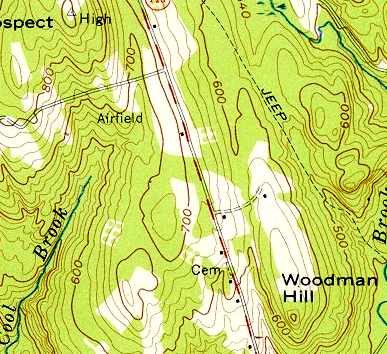
Maheu Airport was depicted simply as “Airfield” on the 1956 USGS topo map.
Clarence Dargie recalled of Roland Maheu, “He had many close calls, many forced landings in his 70 years or so of flying
but, to the best of my knowledge, he never damaged an airplane to the point where it could not fly.
In his late 70s, he could no longer pass the physical so he bought himself some ultralights
and continued to fly til he died of natural causes well into his eighties.”
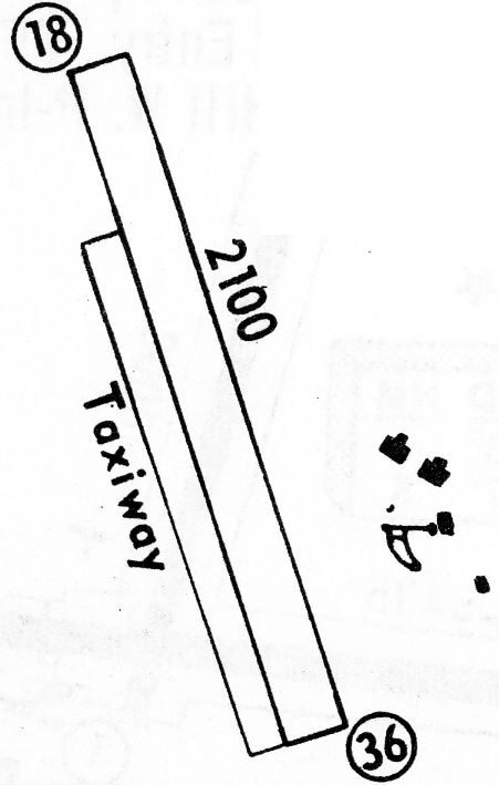
The 1968 Flight Guide (courtesy of Robert Levittan) depicted Maheux Airport
as having a 2,100' unpaved Runway 18/36, with 2 T-hangars & 2 other small buildings on the east side.
The last aeronautical chart depiction which has been located of Maheux Airport as an active airfield
was on the April 1978 Montreal Sectional Chart (courtesy of Chris Kennedy).
It depicted Maheu as a public-use airport having a 2,100' unpaved runway.
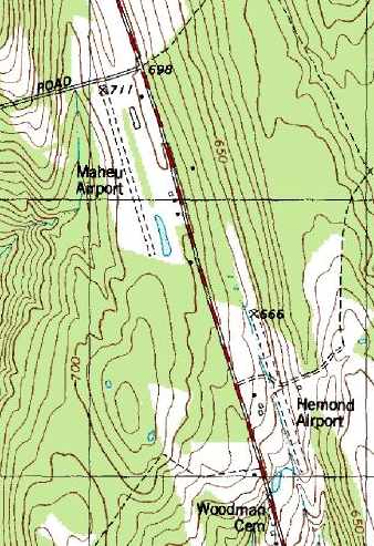
The 1989 USGS topo map depicted Maheu Airport as having a single 2,100' northwest/southeast unpaved runway,
with a few small buildings along the east side of the field.
Note that it also depicted “Hemond Airport” almost directly across the road as well.
Maheu Airport was evidently closed (for reasons unknown) at some point between 1978-2005,
as it was no longer depicted on the 2005 Sectional Chart as an active airfield.
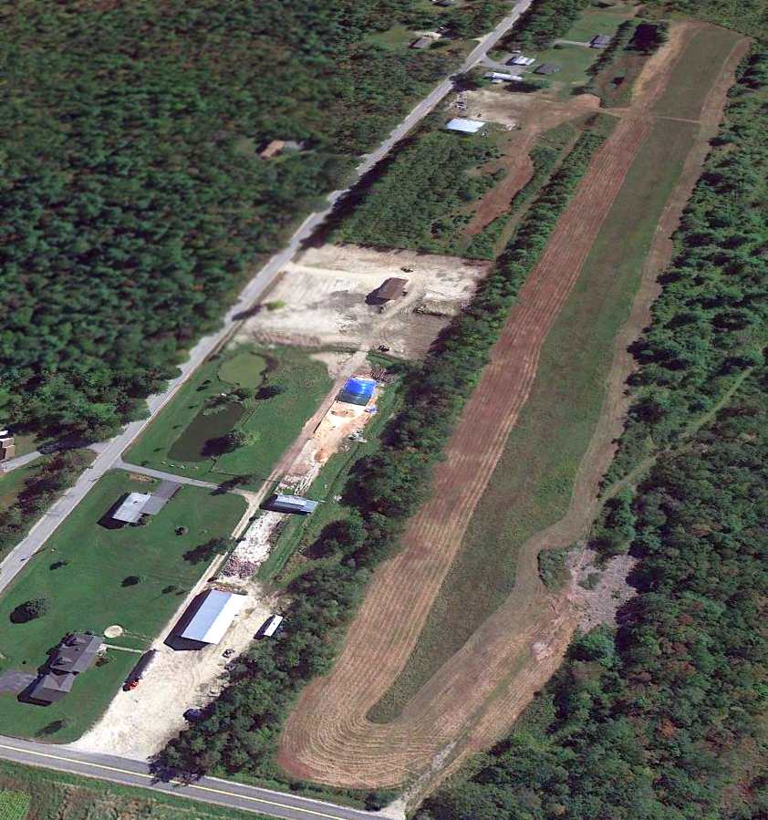
A 9/18/13 aerial view looking southeast showed Maheu Airport to appear completely intact, but there was no obvious sign of current aviation usage,
so it is not apparent if the airfield was still in use at this point.
Clarence Dargie explained the airport layout: “The cluster of buildings on the northeast end of the field
are the home (the dark building) that Roland Maheu built there after taking out the apple orchard & extending the runway another 900'.
The runway used to end even with that curved line just below the light colored ramp in front of his house
The cluster on the southeast end, starting with the square light colored northern most building are the old main hangar.
There used to be 3 or 4 T-hangars just north of the main hangar but I see they are now gone.
South of that, on the other side of the entrance to the airport by the maintenance hangar is the club house/office building.
It is shaped sort of like an inverted T.”
Maheu Airport is located southwest of the intersection of Route 119 & Jackass Annie Road.
__________________________________________________________________________
45.13, -67.31 (Northeast of Bangor, ME)
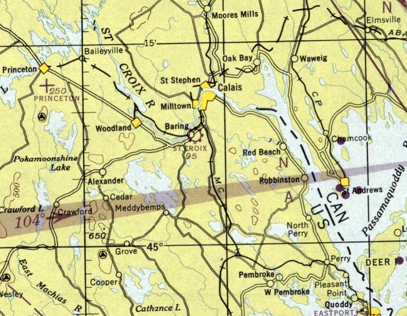
The St. Croix Airport, as depicted on the January 1947 Lewiston Sectional Chart.
This small general aviation airport was located less than a half-mile from the Canadian border.
According to Andrew Laverdiere, St. Croix Airport “was built under the Federal Emergency Relief Administration / Maine Emergency Relief Administration
around 1934 when they were constructing airports all over the state.”
However, St. Croix Airport was not yet depicted on the July 1946 Lewiston Sectional Chart.
The earliest depiction of the St. Croix Airport which has been located was on the January 1947 Lewiston Sectional Chart.
It depicted St. Croix as a commercial/municipal airport.
The 1948 Lewiston Sectional Chart (courtesy of Chris Kennedy) depicted St. Croix as having a 1,900' unpaved runway.

The 1949 USGS topo map depicted St. Croix as having a single unpaved northwest/southeast runway, labeled simply as “Airfield”.
The runway at St. Croix was evidently paved at some point between 1948-68,
as the 1968 Flight Guide (courtesy of Robert Levittan) depicted described St. Croix
as having a single 3,000' paved Runway 17/35, with 2 small buildings at the northwest end.
The 1972 Flight Guide (courtesy of Chris Kennedy) depicted described St. Croix as having a single 3,000' paved Runway 17/35.
Gary Ross recalled, “For many years St. Croix Airport was the base for Thomas DiCenzo,
a contractor who built roads & infrastructure including several Nike sites throughout Maine.
In the 1970s I landed there practicing touch & go’s in a 172.
The airport was challenging as it had major power lines at the right at the hangar end of the runway.
DiCenzo had kept a PA-23 in the lone hangar located at the northeast corner of the strip. He was the primary user of the field.
In June of 1973 he & his pilot were killed when the PA-23 struck trees in a dense fog while attempting to locate the Princeton Airport.
After his death I saw a few aircraft at the field.”
St. Croix became a private field by 1976,
as that is how it was described in the 1976 AOPA Airport Directory (courtesy of Chris Kennedy).
The airfield was described as consisting of a single 2,800' asphalt Runway 17/35.
In the 1996 USGS aerial view looking south, a single light aircraft was visible parked at the northwest end of the runway.
St. Croix Airport apparently was closed at some point between 1996-2004,
as it was no longer depicted on the Sectional Chart, or listed in the Airport/Facility Directory as of 2004.
A 2014 aerial view looking southwest along the former St. Croix runway showed it to remain intact, along with several buildings at the northwestern end of the field.
Gary Ross reported in 2017, “Today machinery lines the old strip.”
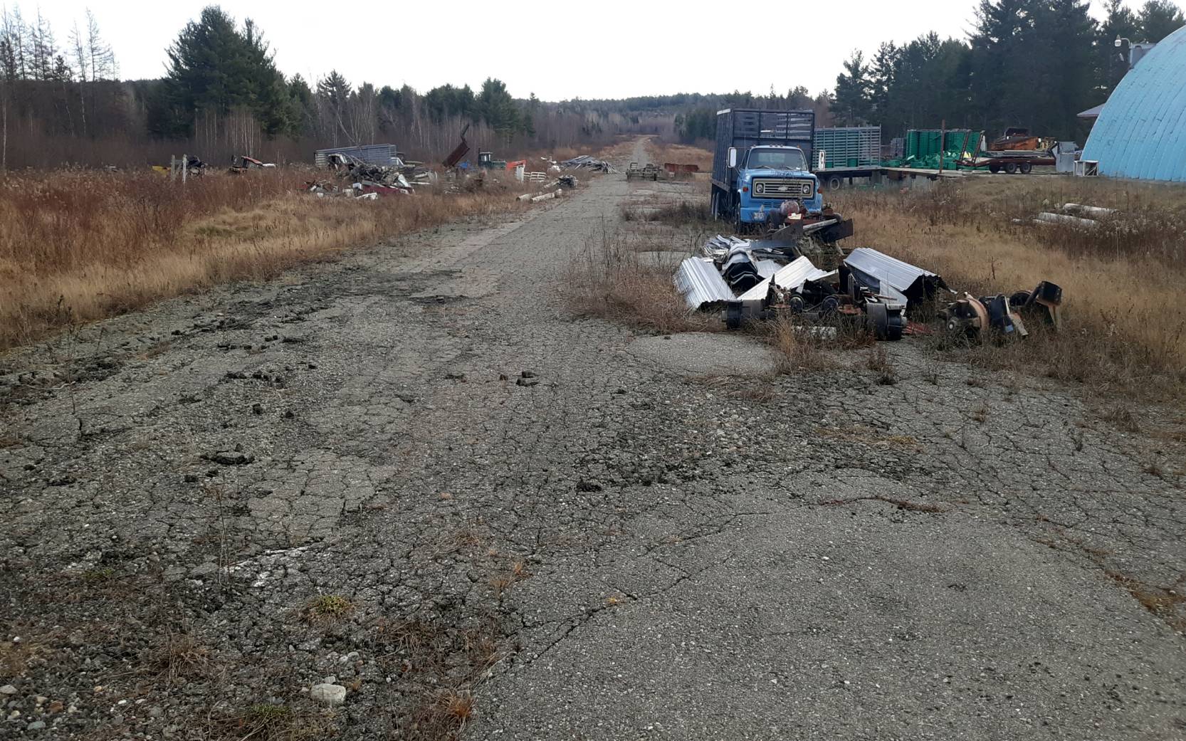
A 12/29/20 photo by Andrew Laverdiere looking northwest along the remains of the St. Croix Airport runway.
Andrew reported, “The company has turned the airfield into a junk yard. The asphalt was in very poor condition.”
The site of St. Croix Airport is located southeast of the intersection of Route 1 & Center Street.
__________________________________________________________________________
(Original) Portland Airport / Scarboro Airport / Scarborough Airport, Scarborough, ME
43.57, -70.36 (Southwest of Portland, ME)
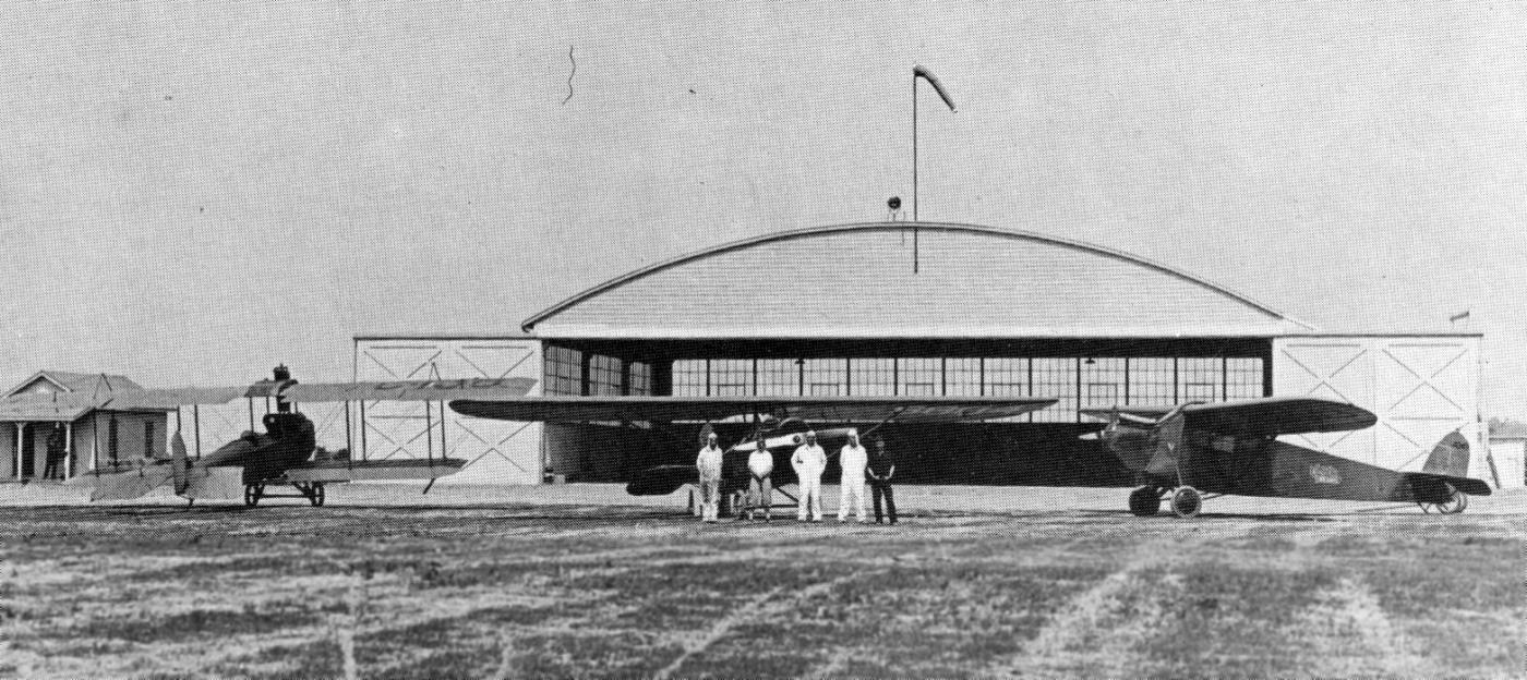
A summer 1928 photo by Ira Milliken of a biplane & 2 monoplanes in front of the newly built hangar at Scarborough Airport (courtesy of Bill Deane).
According to the Scarborough Historical Society, the Scarborough Airport was the brainchild of Chester Jordan,
an avid aviator & president of the Portland Chamber of Commerce.
He began to dream establishing an airport for Portland in the early twenties when flight was still a novelty
and much of the local action was taking place on the sands of Pine Point & Old Orchard Beaches.
Jordan found an enthusiastic audience in the person of Phillips Payson,
who had succeeded his father as president of the H. M. Payson Investment Banking firm in Portland.
Payson had learned to fly while in the Army Air Corps during WW1
and had continued his interest in aviation after returning to civilian life.
Jordan's dream became a reality when Payson took over the practical aspects of the concept through incorporation & the sale of stock.
The 2 men purchased the site off Manson Libby Road in 1926 from George Eastman & Lida Libby
and hired a contractor, the W. E. Arthur Company, to prepare the site & erect several structures.
The famous visit of Charles Lindbergh took place over the weekend of July 23, 1927
while the Scarborough airfield was still very much under construction.
In spite of that, several thousand patient flying enthusiasts turned up to await the arrival of their hero in what turned out to be a pea-soup fog.
Lindbergh arrived at the site & circled the field for more than an hour,
hoping for a break in the fog; although he caught occasional glimpses of the tracks of the PS&P railroad,
which skirted the eastern end of the runway,
he ultimately decided to spend the night at Concord, NH which was in the clear, and try again the following day, Sunday.
Sunday proved no better, weatherwise, for the fog persisted.
Yet fans by the thousands returned & continued their patient vigil.
Again, The Lone Eagle circled the field for nearly an hour, then flew southeast over Old Orchard Beach.
A hole developed in the overcast just long enough for the aviator to land the Spirit of St. Louis on the sand shingle.
Mindful of the waiting throngs, Lindbergh was whisked by motorcade to the Scarborough Airport
where he addressed the throng, shook as many hands as he could, and continued the motorcade to Portland.
The earliest photo which has been located of Scarborough Airport was a summer 1928 photo by Ira Milliken (courtesy of Bill Deane)
of a biplane & 2 monoplanes in front of Scarborough's newly built hangar.
The Scarborough Airport was opened in 1928, with a huge air show & open house over the weekend of September 27-28, 1928.
The air show was a wild success.
The weather beamed, the flyers outdid themselves, the daring parachute jumpers all landed safely,
and the only casualty was someone in the parking lot who suffered a bruised knee
when a motorist backed out of his parking place & bumped gently into her.
The cooperation of the Town of Scarborough was sought to improve the access road,
and the town meeting in 1928 voted to spend $5,000 to do so.
Nevertheless, the final result was a subject of ridicule in the press during the big weekend in September 1928,
when several front page photos sarcastically showed "the class A roadway"
as a rutted, uneven, gravel track extending a mile & a quarter from Route One to the Airport complex.
Shortly after the above 1928 photograph of the hangar,
the blank white 65' wide space over the hangar doors was lettered "PORTLAND AIRPORT".
A similar legend adorned the roof so as to be clearly visible to approaching aircraft.
The hangar suffered extensive damage during a freak windstorm in December, 1934;
apparently someone opened at least one of the great rolling doors which all moved toward Dunstan
long enough for the building to fill during a gust & the entire rear wall exploded outward, damaging several aircraft.
This wooden/glass wall was subsequently replaced with a more substantial masonry/glass/steel curtain.
The Curtiss Wright Company was prominent in the active years of the airport,
operating a flying school & contributing expertise to administration.
As an adjunct to their presence, the company decided to build a bunkhouse nearby
for what they anticipated would be a flood of young men desiring to learn how to fly.
Taking on this franchise was Halsey Gulick, whose family achieved fame via the Luther Gulick Camps at Sebago Lake.
They built a log building nearby which today is the home of Post 76, American Legion.
Upon completion, the school only managed to enroll 2 students who completed their courses in 1929.
The crash of the stock market that year doomed the project & the building was sold & subsequently became the Plantation Restaurant.
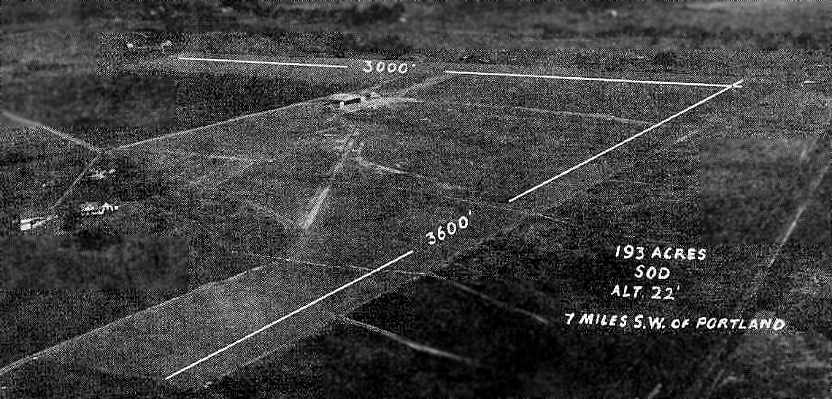
The original Portland Airport, as depicted on the Boston Chamber of Commerce's
1931 "Airports & Landing Fields of New England" (courtesy of Chris Kennedy).
It described the field as a commercial airport, located in the town of Scarboro.
The field was said to consist of a 193-acre triangular sod & clay field,
with 3 grass runways (with the longest being a 3,600' northeast/southwest strip).
The field was also said to have an 80' x 60' hangar, and the commercial operator was listed as Curtiss-Wright Flying Service.
An aerial view looking north at Scarborough Airport,
from The Airport Directory Company's 1933 Airports Directory (courtesy of Chris Kennedy).
The directory described the Scarborough Airport as having 2 sod runways: 3,600' northeast/southwest & 3,000' northwest/southeast.
A single hangar was depicted west of the runway intersection.
The manager was listed as Sanford Chandler, and the operator was listed as the Portland Flying Service.
The earliest aeronautical chart depiction which has been located of the original Portland Airport was on the March 1933 Boston Sectional Chart.
The field was depicted as the "Portland" Airport on the 1934 U.S. Navy Aviation Chart (courtesy of Chris Kennedy).
Within 10 years of its grand opening, the Scarborough Airport became too limited
to accommodate the larger, increasingly powerful aircraft being developed.
Hemmed in by the railroad tracks to the east, by Moses Brook to the North,
U.S. Route One to the West, and the great marsh to the south, relocation became a priority.
Operations moved to Stroudwater in the late 1930s & the Scarborough complex became a flying school.
The Airport Directory Company's 1937 Airports Directory (courtesy of Bob Rambo)
described Scarborough Airport as having a triangular sod & clay landing area.
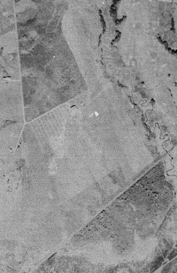
The last photo which has been located of Scarborough Airport was a 10/5/40 USGS aerial view,
which depicted a single hangar on the northwest edge of an irregularly-shaped grass airfield.
The November 1944 Boston Sectional Chart (courtesy of Chris Kennedy) labeled the airport as "Scarboro".
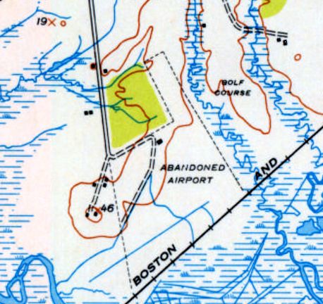
Scarborough Airport may have gone through a period of temporary closure,
as it was labeled “Abandoned Airport” on the 1944 USGS topo map.
The last aeronautical chart depiction which has been located of Scarboro Airport was on the July 1946 Boston Sectional Chart.
Scarborough Airport was reportedly the site of numerous air shows in the late 1940s.
Scarborough Airport was evidently closed at some point between 1946-50,
as it was no longer depicted on the January 1950 Boston Sectional Chart.
A 1956 aerial photo showed the irregular outline of the Scarborough Airport property, and the airport circle marking.
There was a single hangar on the northwest side of the field.
The field appeared abandoned, as there were no aircraft visible on the field, but it was intact.
The Scarborough Airport was no longer depicted at all on the 1956 USGS topo map
or the 1960 Boston Sectional Chart (courtesy of Mike Keefe).
The hangar became a storage warehouse for several enterprises, Humpty Dumpty notably which stored empty cans & packaging materials there.
Then, in the early 1960s, the hangar was destroyed in a spectacular nighttime fire,
which left little but a pile of twisted steel & broken bricks among the ashes.
The remaining buildings were demolished or moved elsewhere.
The site of Scarborough Airport was labeled "Airport (Abandoned)" on the 1978 USGS topo map.
A 1998 USGS aerial photo of the site of Scarborough Airport bore no recognizable sign of having been an airport.
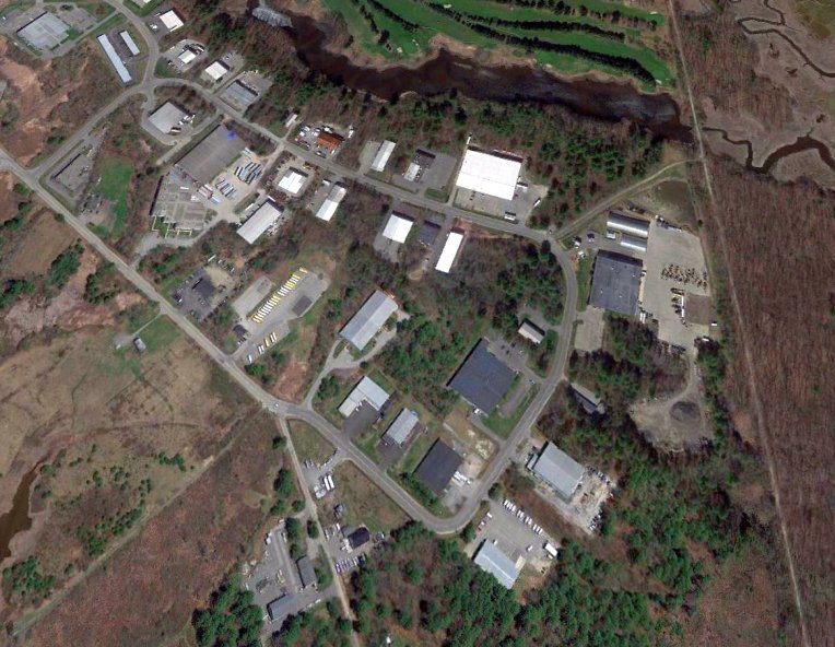
A 2018 aerial view looking northeast showed no trace of Scarborough Airport. The property is the home of the Scarborough Industrial Park.
The Public Works complex occupies the grassy spot upon which Ira Milliken stood to snap his historic photo above,
and a Butler-type building now rises where the Lone Eagle waved to thousands of spectators.
The site of Scarborough Airport is located southeast of the intersection of Manson Libby Road & Washington Avenue.
Thanks to Chris Kennedy for pointing out this location.
__________________________________________________________________________
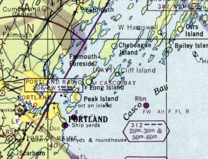
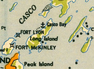
Casco Bay Naval Auxiliary Air Facility, Long Island, ME
43.7, -70.15 (East of Portland, ME)
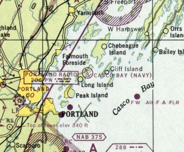
"Casco Bay (Navy)", as depicted on the November 1943 Boston Sectional Chart.
The Casco Bay seaplane base was not yet depicted on the November 1942 Boston Sectional Chart.
This small seaplane facility was built by the Navy in 1942 on Long Island
to support the aviation activities of the surface fleet in Casco Bay.
Warren Brayley reported that the land for the seaplane facility was purchased by the Navy from his Grandfather, Elwin Doughty, in 1942.
The Casco Bay seaplane facility consisted of 300' square paved parking apron, a single hangar, and a seaplane ramp.
Most of the facility's personnel were housed in summer residences which were leased from their civilian owners,
with a total capacity of 87 personnel.
After the loss of a PBY Catalina flying boat in 1942, Casco Bay was deemed unsuitable for PBY operations.
In spite of that, Casco Bay was commissioned in the following year as an auxiliary of NAS Brunswick.
For the next 2 years, the base was primarily charged
with the support of catapult seaplanes assigned to surface naval vessels.
The earliest depiction of the Casco Bay seaplane base which has been located was on the November 1943 Boston Sectional Chart.
The 1944 USGS topo map depicted the seaplane hangar at Casco Bay,
but did not specifically identify the seaplane base.
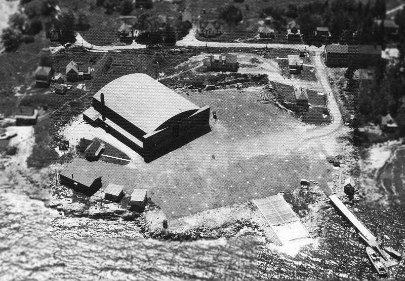
A WW2-era National Archives aerial view looking southeast at Casco Bay NAAF
depicted a single arch-roof hangar & several smaller buildings on a paved apron, with a seaplane ramp leading into the water.
A fire destroyed Casco Bay's hangar & Officer in Charge's quarters in early 1946.
The base was closed later that year, and the property was sold back into private ownership.
However, according to Warren Brayley (grandson of original property owner Elwin Doughty),
many of the original pre-war property owners thought that they would regain ownership of their land,
but that did not turn out to be the case.
The last aeronautical chart depiction of the Casco Bay seaplane base which has been located was on the January 1947 Boston Sectional Chart.
The Casco Bay seaplane base was not longer depicted on the July 1947 Boston Sectional Chart.
The last depiction which has been located of the Casco Bay Seaplane Base was on the 1949 USGS topo map.
A 1956 aerial photo depicted the foundation of the hangar,
with several smaller buildings still standing along the periphery of the seaplane apron.
The 1957 USGS topo map still labeled the property as “U.S. Naval Reservation”.
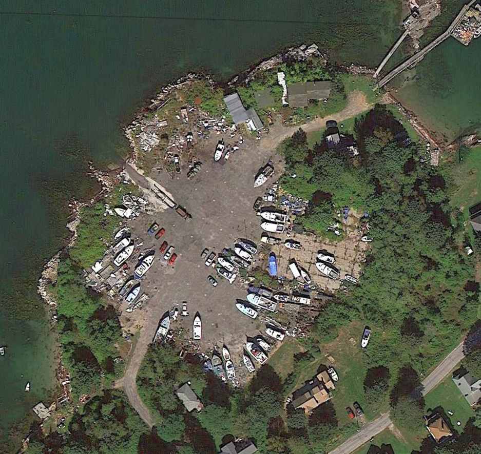
A 9/18/13 aerial view showed the Casco Bay seaplane apron still existed, reused for boat storage.
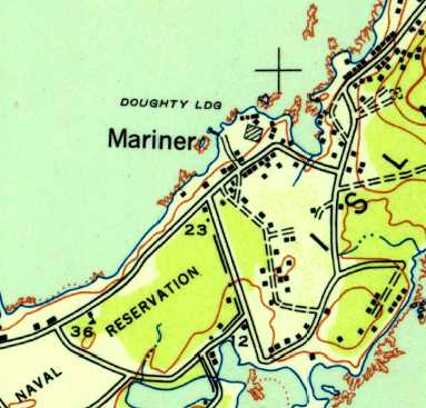
The site of the seaplane base is at Doughty Landing, at the end of Doughty Lane,
just north of the little town of Mariner.
Thanks to Lloyd Momborquette for pointing out this location.
__________________________________________________________________________
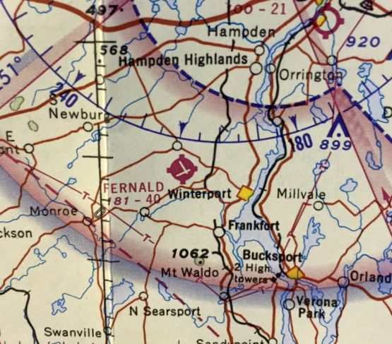
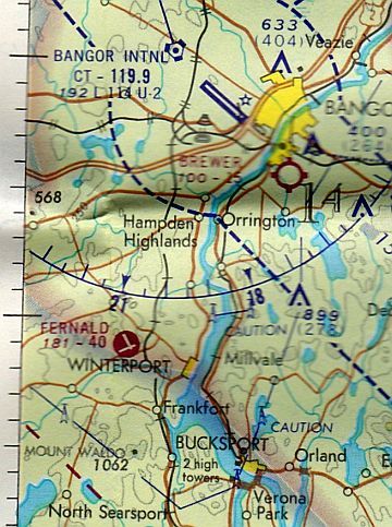
44.65, -68.91 (Southwest of Bangor, ME)
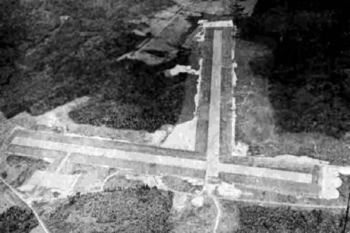
A circa 1943-45 aerial view looking north at Fernald Field from the 1945 AAF Airfield Directory (courtesy of Scott Murdock).
Fernald Field was apparently built at some point between 1943-44,
as it was not yet depicted on the December 1943 Lewiston Sectional Chart.
The earliest depiction which has been located of Fernald Field was a circa 1943-45 aerial view looking north from the 1945 AAF Airfield Directory (courtesy of Scott Murdock).
It depicted Roy L. Fernald Field as having 2 paved runways.
The April 1944 US Army/Navy Directory of Airfields (courtesy of Ken Mercer) described Roy L. Fernald Field as having a 4,000' hard-surface runway.
According to Norman Houle, Fernald Field may have been constructed as a takeoff alternate
for military aircraft departing from Runway 22 at Dow Field in Bangor.
However, none of the many chart depictions which have been located of this field ever depicted it as a military field.
The earliest aeronautical chart depiction which has been located of Fernald Field was on the June 1944 Lewiston Sectional Chart.
Fernald Field was depicted as an auxiliary airfield.
The 1945 AAF Airfield Directory (courtesy of Scott Murdock) described Roy L. Fernald Field
as a 517 acre L-shaped property having 2 bituminous concrete 4,000' runways, oriented ENE/WSW & NNW/SSE.
The field was said to not have any hangars, and to be owned by the City of Winterport.
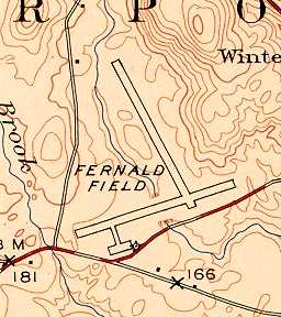
The 1948 USGS topo map depicted Fernald Field as having two 4,000' paved runways, with a small paved ramp at the southwest corner of the field.
Fernald Field was depicted on the 1948 Lewiston Sectional Chart (according to Chris Kennedy) as having a 4,000' hard-surface runway.
Fernald Field was still depicted as a civilian airport on the May 1954 Lewiston Sectional Chart (courtesy of Chris Kennedy),
but the airspace over the field was surrounded by an unusual circular Caution Area (C-133) centered on the field.
The chart's description of Caution Area C-133 indicated that it was used by the Maine National Guard for "Drone aircraft operation".
Was this in reference to target drone operations?
Fernald Field was no longer depicted on the 1957 USGS topo map.
Fernald Field was described in 1962 AOPA Airport Directory as having 2 paved runways, and the operator was listed as the Town of Winterport.
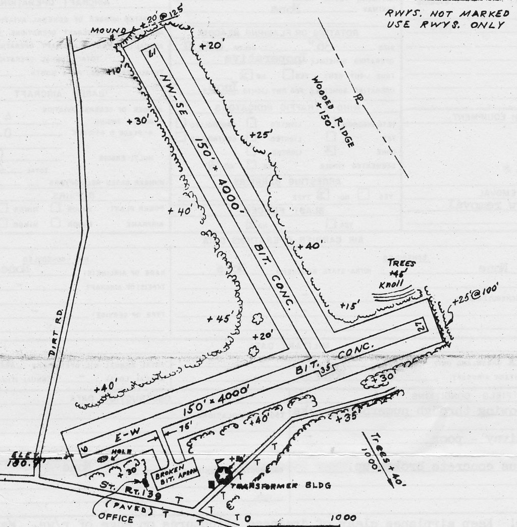
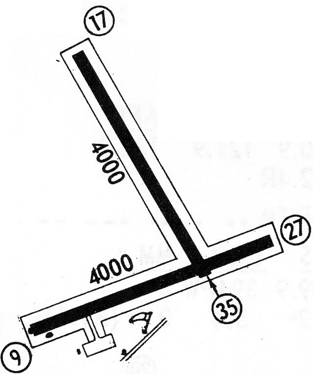
A 10/8/65 FAA Airport Facilities Record (courtesy of Norm Houle) depicted Fernard Field as having 2 bituminous concrete 4,000' runways: 9/27 & 17/35.
A broken bituminous ramp & an office were depicted on the southwest end.
It was listed as being owned by the Town of Winterport, and the Manager was Morris Curtis.
The November 1965 Lewiston Sectional Chart (courtesy of Ron Kunse) depicted Fernald Field as having 2 paved runways, with the longest being 4,000'.
The last map depiction which has been located Fernald Field as an active airport was on the 1968 Flight Guide (courtesy of Robert Levittan).
It depicted Fernard as having 2 paved 4,000' runways, with a ramp & 3 small buildings at the southwest end.
Fernald was listed in the "low use airports" section of the 1971 Flight Guide (according to Chris Kennedy).
It was described as having a single 4,000' paved Runway 17/35, along with the remarks "Drag racing May-Nov."
The last aeronautical chart depiction which has been located of Fernald Field was on the 1971 Halifax Sectional Chart.
It depicted Fernald as having 2 paved runways, with the longest being 4,000'.
Fernald Field was apparently closed at some point between 1971-76,
as it was not listed among active airfields in the 1976 AOPA Airports USA directory (according to Chris Kennedy).
The 1984 Halifax Sectional Chart & 1988 USGS topo map depicted Fernald Field as an abandoned airfield.
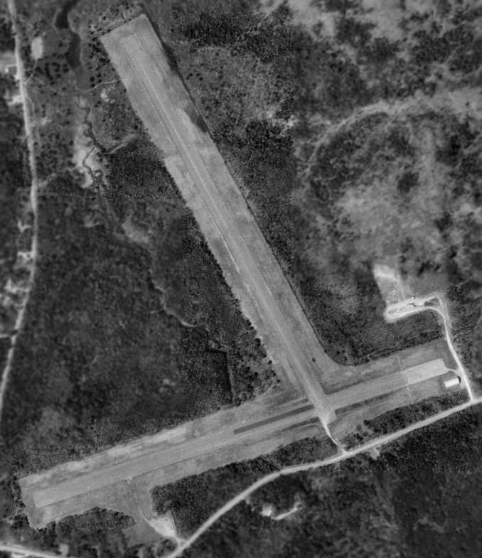
In the 1995 USGS aerial photo, both paved runways of the abandoned Fernald Field still remained in excellent condition.
There appeared to be one small building at the southeast end of the east/west runway,
but its location immediately adjacent to the side of the runway makes it presumed to have been built after the site's airfield days.
The former Fernald Field runways are now apparently used for drag racing as the "Winterport Dragway".
A 2015 aerial view looking north showed both paved runways of the abandoned Fernald Field still remained in excellent condition.

An April 2021 aerial view by Alex Melia looking north at Fernald Field.
Alex reported, “This former airstrip is very prominent leaving & coming into Bangor International Airport.
It looks like a dragstrip has been constructed on one of the runways.
It's a shame the town didn't keep it & develop it into general aviation use. It's still in quite a nice condition & no doubt the 185s & bush planes prevalent in Maine could still easily utilize it.”
Fernald Field is located northeast of the intersection of Route 139 & Boston Road.
____________________________________________________
Or if you prefer to contact me directly concerning a contribution (for a mailing address to send a check),
please contact me at: paulandterryfreeman@gmail.com
If you enjoy this web site, please support it with a financial contribution.
____________________________________________________
This site covers airfields in all 50 states.
For the site's main menu: Home