Abandoned & Little-Known Airfields:
Michigan, Northwest Detroit area
© 2002, © 2025 by Paul Freeman. Revised 12/22/25.
This site covers airfields in all 50 states: Click here for the site's main menu.
____________________________________________________
Please consider a financial contribution to support the continued growth & operation of this site.
Burns Landing Field / Burns Airport (revised 11/4/22) - Detroit Army Artillery Armory Airfield (added 9/4/21) - Farmington Hills Airfield (added 12/16/14) - Ford Airport (revised 12/22/25)
John R. Airport / Big Beaver Airport (revised 9/8/21) - Krist Port (revised 11/4/22) - Robbins Airfield (revised 6/2/20) - Salem Airport (revised 2/21/24)
Spencer Landing Field / Spencer Airport / Vernon M Spencer Memorial Airfield / Wixom International Airport (revised 8/29/22)
Triangle Glider Port / Triangle Airport (revised 2/9/22) - Warren Airport (revised 11/2/18)
____________________________________________________
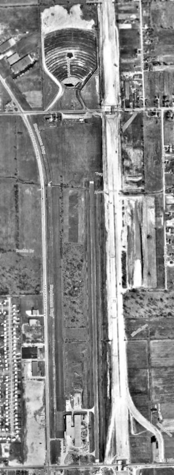
Spencer Landing Field / Spencer Airport / Vernon M Spencer Memorial Airfield /
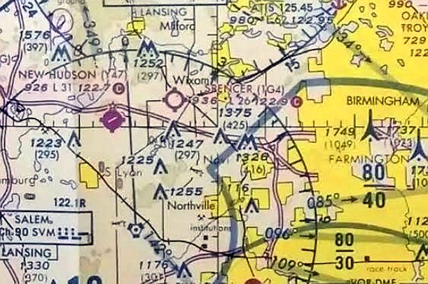
Wixom International Airport (1G4), Wixom, MI
42.522, -83.55 (Northwest of Detroit, MI)
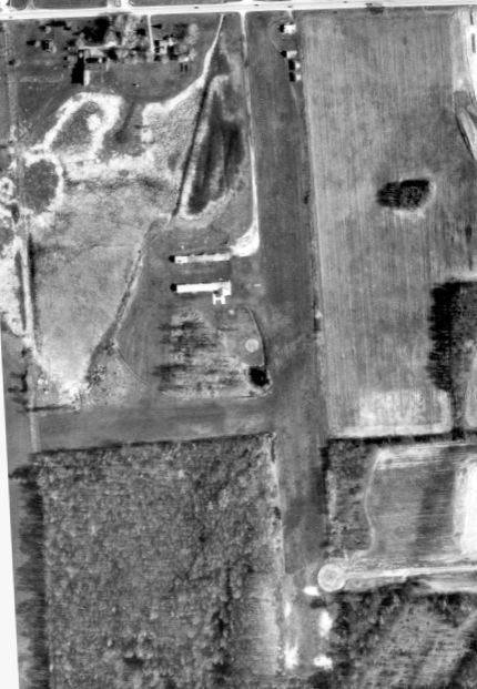
A 1949 aerial view of Spencer Airport (courtesy of Mike Denja) showed 1 single-engine plane on the north end of a north/south grass runway, next to one small building.
Spencer Airport was evidently established at some point between 1947-49,
as it was not yet depicted on the 1945 USGS topo map, listed in the 1947 MI Airport Directory (according to Mike Denja),
or depicted on the December 1949 Detroit Sectional Chart.
The earliest depiction which has been located of Spencer Airport was a 1949 aerial view (courtesy of Mike Denja)
which showed 1 single-engine plane on the north end of a north/south grass runway, next to one small building.
Spencer Airport was founded by Vern Spencer on his home property (according to his obituary, courtesy of Mike Denja).
Spencer was a founder of the MI Flying Farmers.
The earliest aeronautical chart depiction which has been located of Spencer Airport was on the June 1950 Detroit Sectional Chart.
It depicted Spencer Airport as having a mere 1,700' unpaved runway.
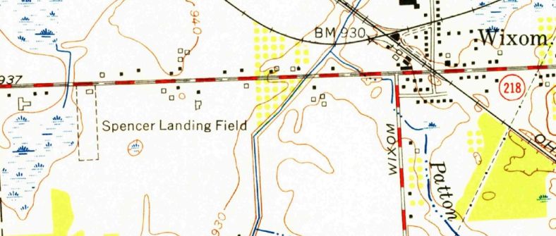
The 1954 USGS topo map (courtesy of Mike Denja) depicted “Spencer Landing Field”
as having a single unpaved north/south runway with 1 small building on the northeast side.
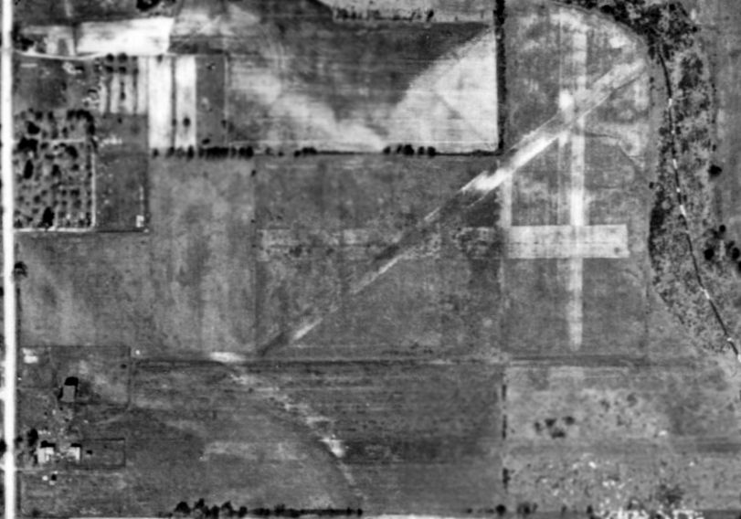
A 1956 aerial view (courtesy of Mike Denja) showed Spencer Airport
had gained a 2nd small hangar on the northeast side at some point between 1-54-56.
Mark Murdock recalled, “I kept a Luscombe 8A at Spencer Airfield in 1964/65.”
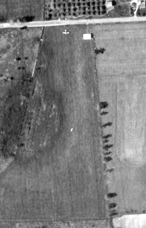
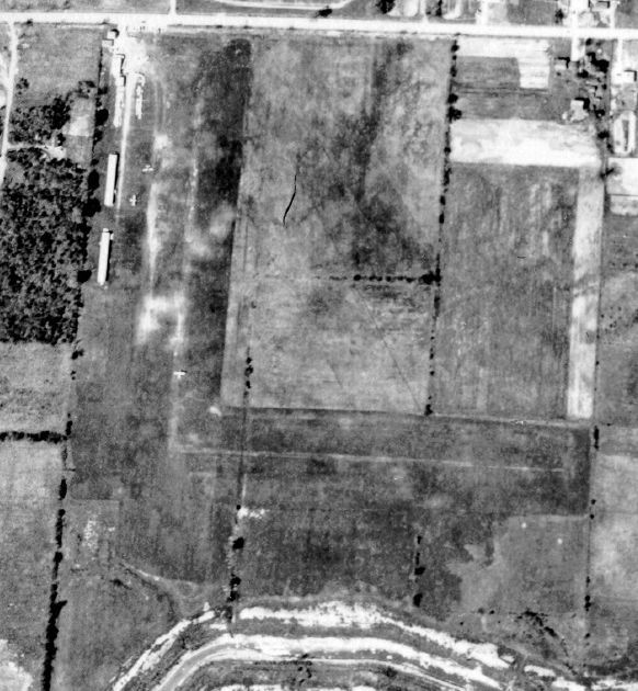
Spencer Airport evidently gained a crosswind runway at some point between 1956-67,
as shown on a 1967 aerial view (courtesy of Mike Denja).
A total of 13 light aircraft were visible on the field.
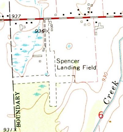
The 1969 USGS topo map (courtesy of Mike Denja) depicted “Spencer Landing Field”
as having 2 unpaved runways & 6 small building on the northwest & northeast sides.
Spencer Airport was operated by its founder Vern Spencer until his death in 1971 (according to his obituary, courtesy of Mike Denja).
According to Mike Denja, “Some newspaper articles [indicated that] Oakland County officials wanted to save it & make it a public airport
but in the end they ended up buying/saving 3 other airports in the area.”
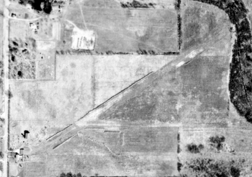
The May 1977 Detroit Sectional Chart (courtesy of Mitchell Hymowitz) depicted Spencer Airport as having a 2,600' unpaved runway.
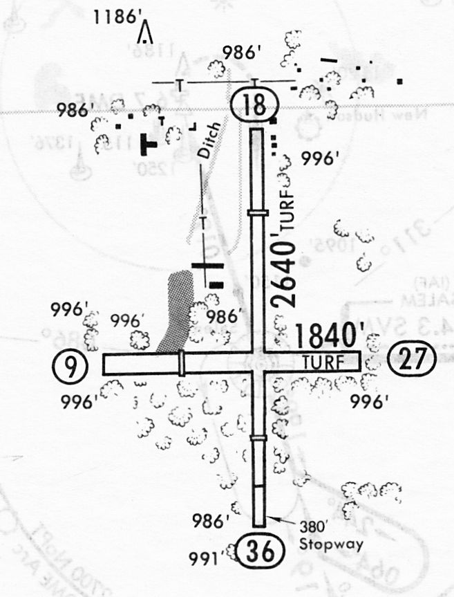
The last airport directory listing which has been located of Spencer Airport was in a 12/2/83 airport directory (courtesy of John Kielhofer).
It depicted Spencer Airport as having 2 unpaved turf runways: 2,640' Runway 18/36 & 1,840' Runway 9/27.
Two small buildings were depicted northwest of the runway intersection.
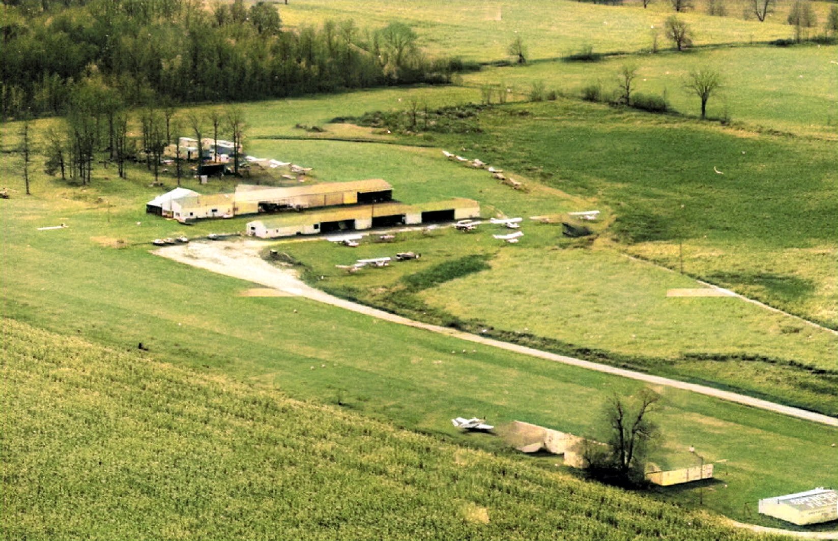
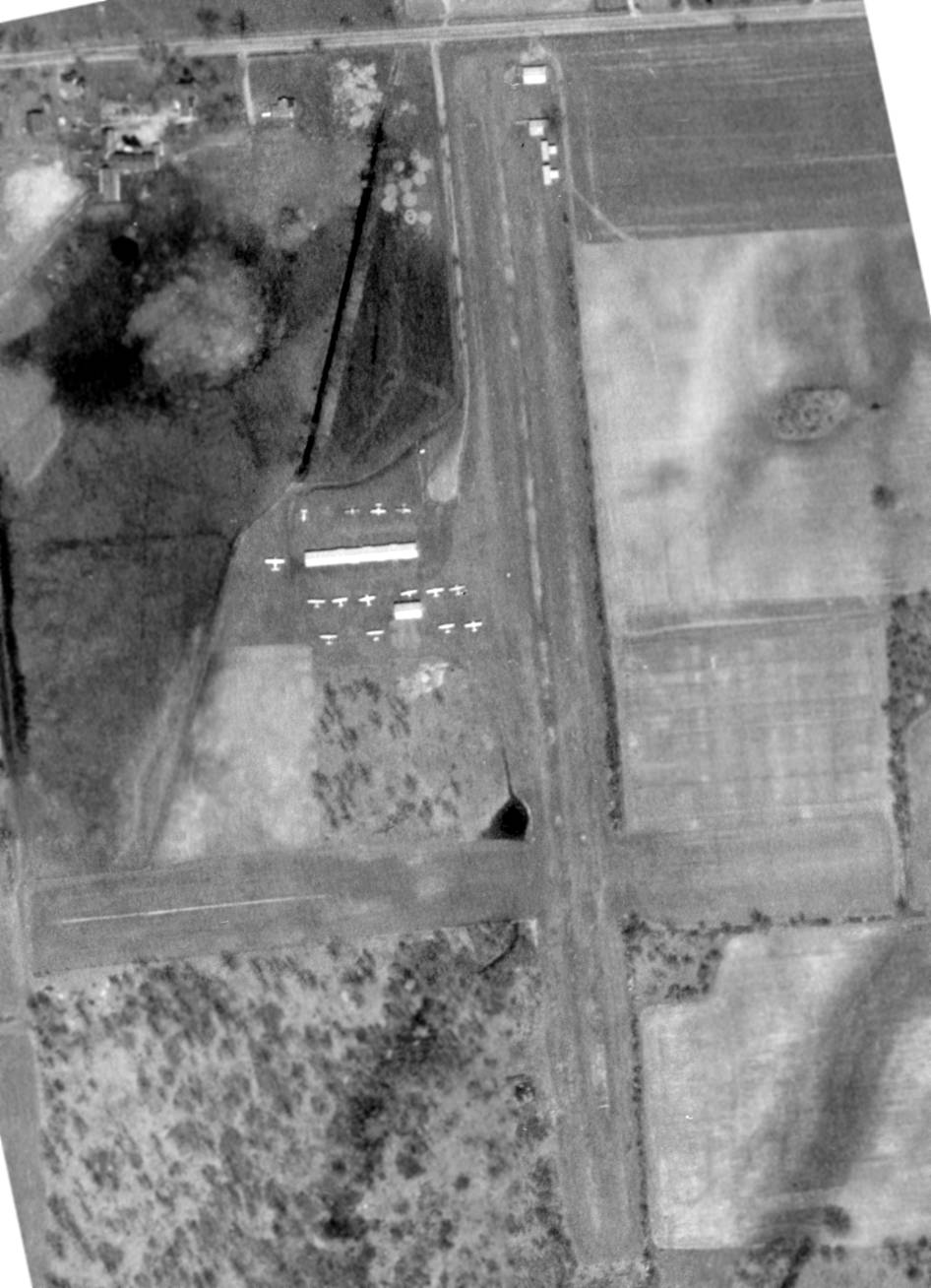
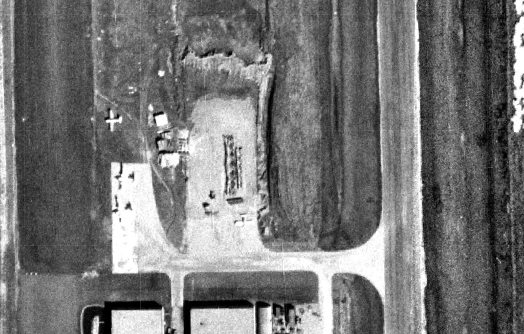
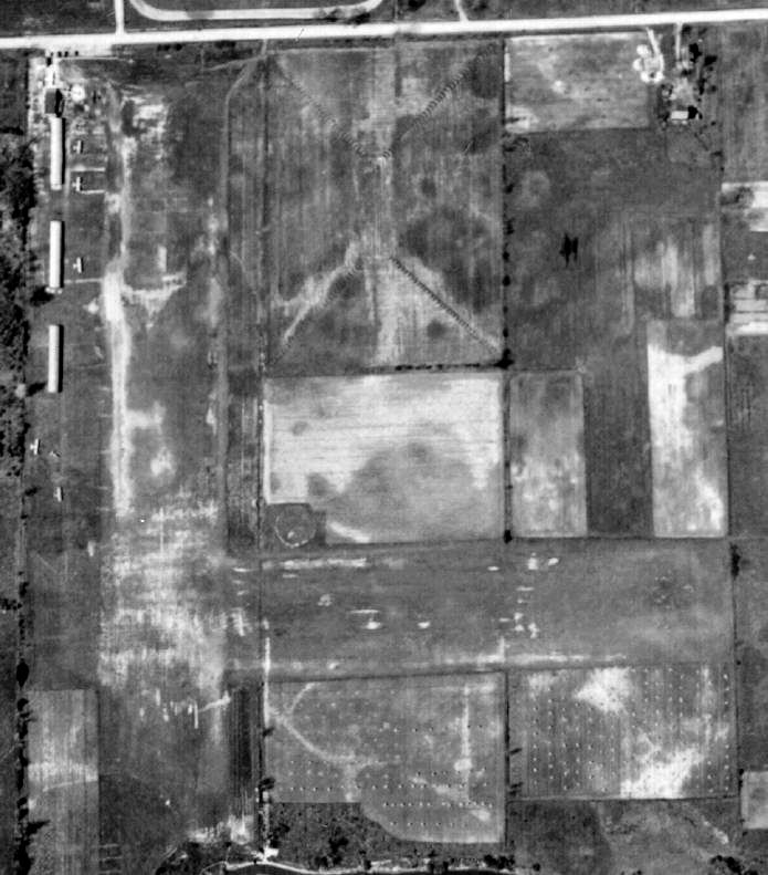
A 1985 aerial view looking southwest (colorized by Mike Denja) depicted Spencer Field at perhaps its zenith of popularity, with 22 light aircraft visible on the field.
The hangar at bottom-right had “Spencer Field” painted on its roof.
The last aeronautical chart depiction which has been located of Spencer Airport was on the October 1994 Detroit Sectional Chart (courtesy of Joe Fortman).
It depicted Spencer Airport as having a 2,600' unpaved runway.
The last reference which has been located of Spencer Airport still in operation came from Joe Fortman,
who recalled, “I logged a landing in November of 1995, 7 days after getting my Private Pilot License.
I am pretty sure it closed in 1996.”
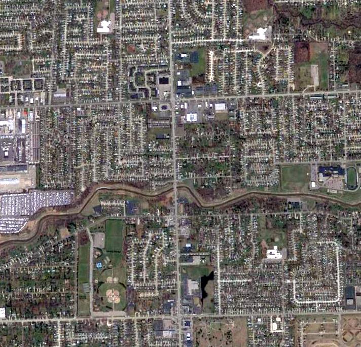
A 1997 aerial view (courtesy of Mike Denja) showed Spencer Airport devoid of aircraft,
and a cul-de-sac for a new street had been built over the southern end of the north/south runway.
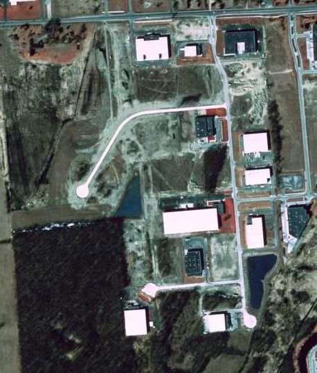
A 1997 aerial view (courtesy of Mike Denja) shows a dramatic transformation of the Spencer Airport site in only 1 year,
with all traces of the former airport having been erased by new construction.
The site of Spencer Airport is located south of the intersection of Century Drive & West Pontiac Trail.
Thanks to Mike Denja for pointing out this airfield.
____________________________________________________
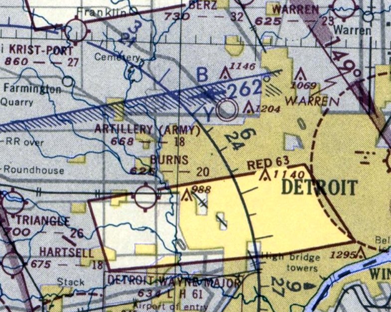
Detroit Army Artillery Armory Airfield, Oak Park, MI
42.449, -83.193 (Northwest of Detroit, MI)
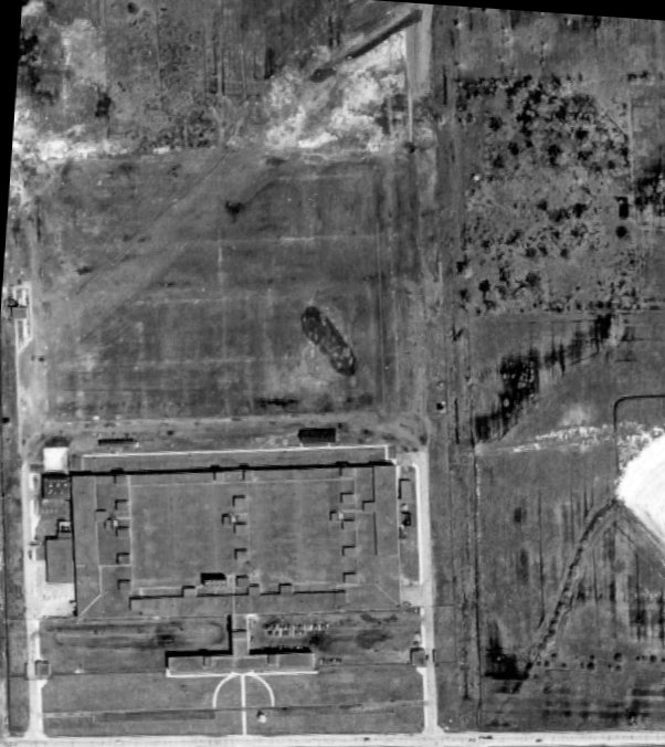
The Detroit Army Artillery Armory Airfield, as depicted on a 1949 aerial photo (courtesy of Mike Denja).
The Detroit Army Artillery Armory was built in 1944.
At some point between 1944-49, a small grass airfield was constructed on the north side of the Armory,
possibly for use of small fixed-wing liaison aircraft which were used at the time as artillery spotters.
The earliest depiction which has been located of the Detroit Army Artillery Armory Airfield was a 1949 aerial photo (courtesy of Mike Denja).
It depicted a single short grass northeast/southwest runway, on the north side of the Armory.
No aircraft or other improvements were visible.
The earliest aeronautical chart depiction which has been located of the Detroit Army Artillery Armory Airfield was on the June 1951 Detroit Sectional Chart (courtesy of Mike Denja).
It depicted the “Army Artillery” airfield as having a mere 1,800' unpaved runway.
A 1956 aerial photo (according to Mike Denja) showed a small “X” on the center of the Detroit Army Artillery Armory Airfield, so it may have been closed at some point between 1951-56.
A 1963 aerial photo (courtesy of Mike Denja) showed a small “X” on the center of the Detroit Army Artillery Armory Airfield, possibly indicating the airfield's closure.
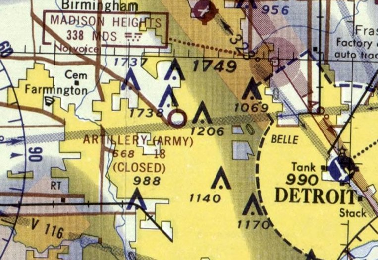
The January 1965 Detroit Sectional Chart (courtesy of Mike Denja) depicted the Detroit Army Artillery Armory Airfield as having an 1,800' unpaved runway, but being closed.
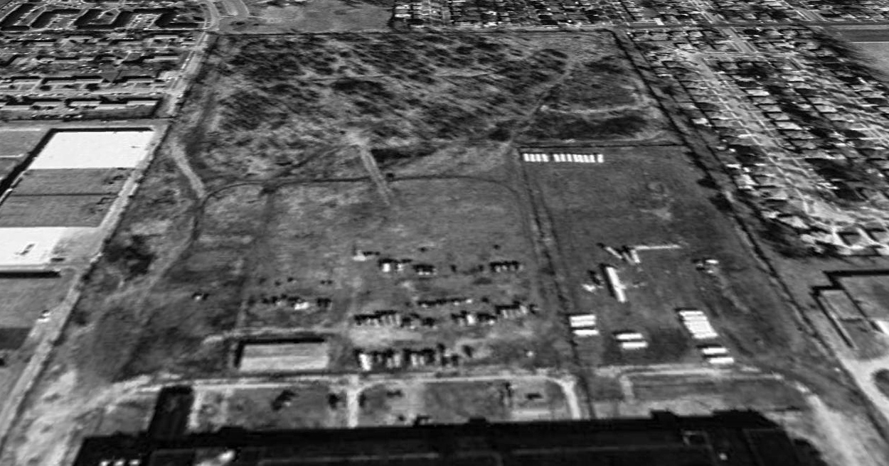
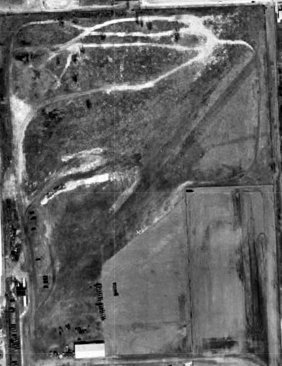
A 1999 aerial view looking north showed no trace remaining at the site of the Detroit Army Artillery Armory Airfield, with the property overgrown.
Aerial photos show the Detroit Army Artillery Armory building was razed at some point between 2002-2005,
and a FedEx Ground distribution center was built over the site of the Detroit Army Artillery Armory Airfield at some point between 2014-16.
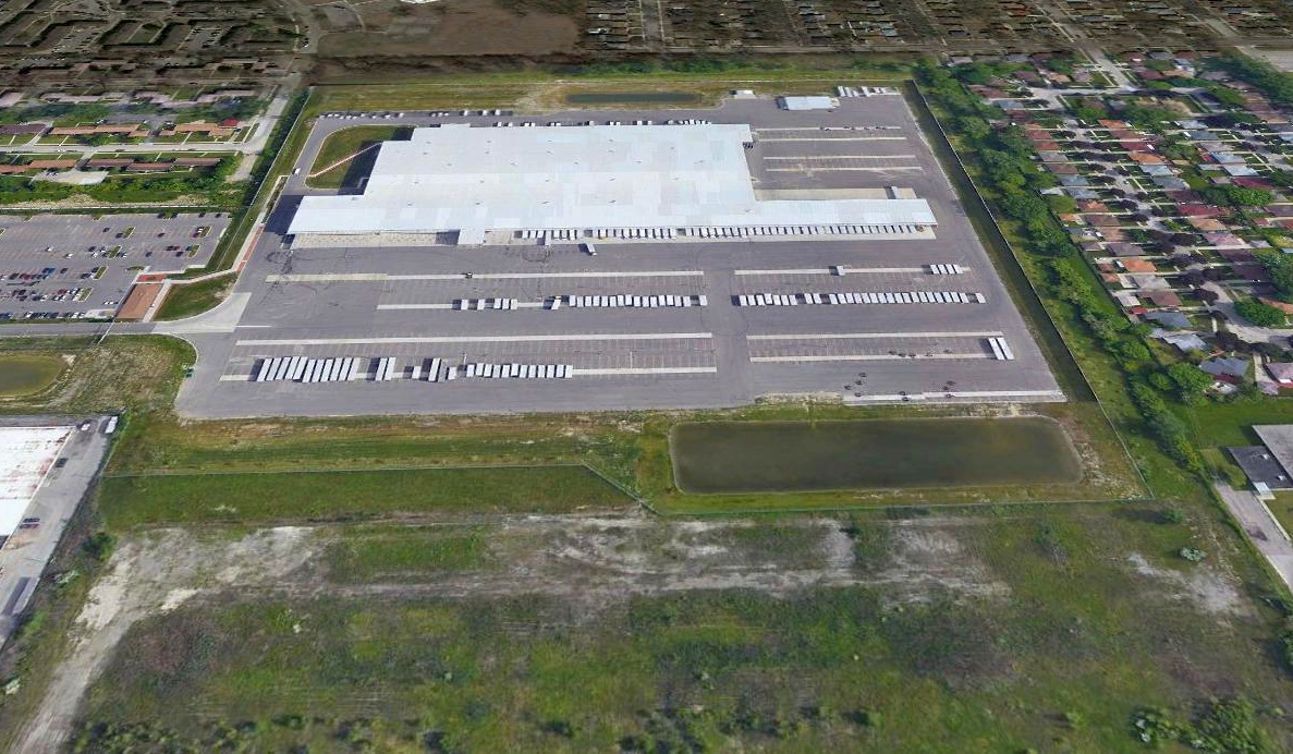
A 2019 aerial view looking north showed the FedEx Ground distribution center covering the site of the Detroit Army Artillery Armory Airfield.
Thanks to Mike Denja for pointing out this airfield.
____________________________________________________
Robbins Airfield, Madison Heights, MI
42.54, -83.118 (North of Detroit, MI)
Robbins Airfield, as depicted on a 1963 aerial photo (courtesy of Mike Denja).
This short-lived private airfield was owned by Jim Robbins, who also owned the Robbins Executive Airport Corporation.
Robbins Airfield was evidently established at some point between 1959-63,
as it was not yet depicted on a 1959 aerial photo.
The earliest depiction which has been located of Robbins Airfield was on a 1963 aerial photo,
which depicted a single paved north/south runway, with some industrial buildings on the southwest side.
A close-up of the 1963 aerial view showing 3 planes parked on the ramp on the southwest side of Robbins Airfield (courtesy of Mike Denja).
Robbins Airfield was not yet depicted on the July 1965 Detroit Local Aeronautical Chart or the July 1966 Detroit Sectional Chart.
Robbins Airport owners Jim Robbins was tragically killed in 1966 when the jet he was piloting exploded mid-air,
according to a 9/27/66 Detroit Free Press article (courtesy of Mike Denja).
The earliest aeronautical chart depiction which has been located of Robbins Airfield was on the January 1967 Detroit Sectional Chart.
It depicted Robbins Airport as having a single paved 4,200' north/south runway.
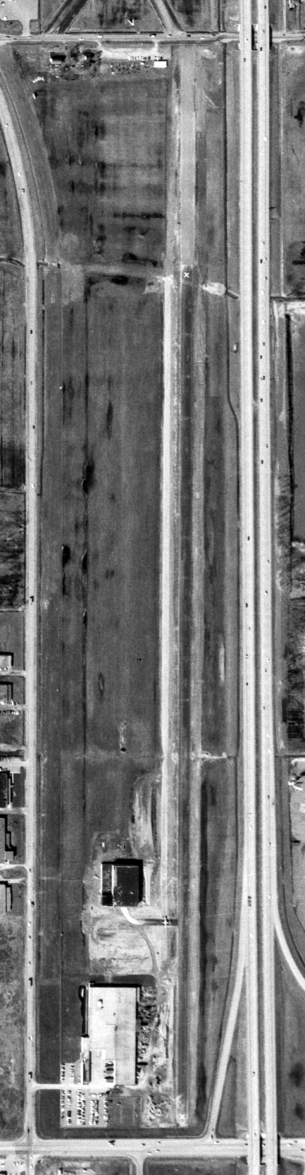
A 3/29/67 aerial view (courtesy of Mike Denja) courtesy of Mike Denja shows that a hangar was built added to the southwest side of Robbins Airfield at some point between 1963-67.
A single plane was visible on the taxiway between the runway & the hangar,
but inexplicably the runway was marked with 2 closed-runway “X” symbols.
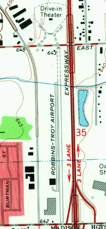
The 1968 USGS topo map depicted “Robbins-Troy Airport” as having a single paved north/south runway, an unpaved northern extension,
a paved parallel taxiway, and 2 buildings on the southwest side.
The last aeronautical chart depiction which has been located of Robbins Airfield was on the July 1969 Detroit Sectional Chart (courtesy of Mike Denja).
It depicted Robbins Airport as a private airfield having a single paved 5,300' north/south runway.
Robbins Airfield was evidently abandoned at some point between 1969-70,
as it was labeled as “Abandoned airfield” on the January 1970 Detroit Sectional Chart.
A 1974 aerial photo (courtesy of Mike Denja) showed the Robbins Airfield runway remained intact but the adjacent buildings had been removed.
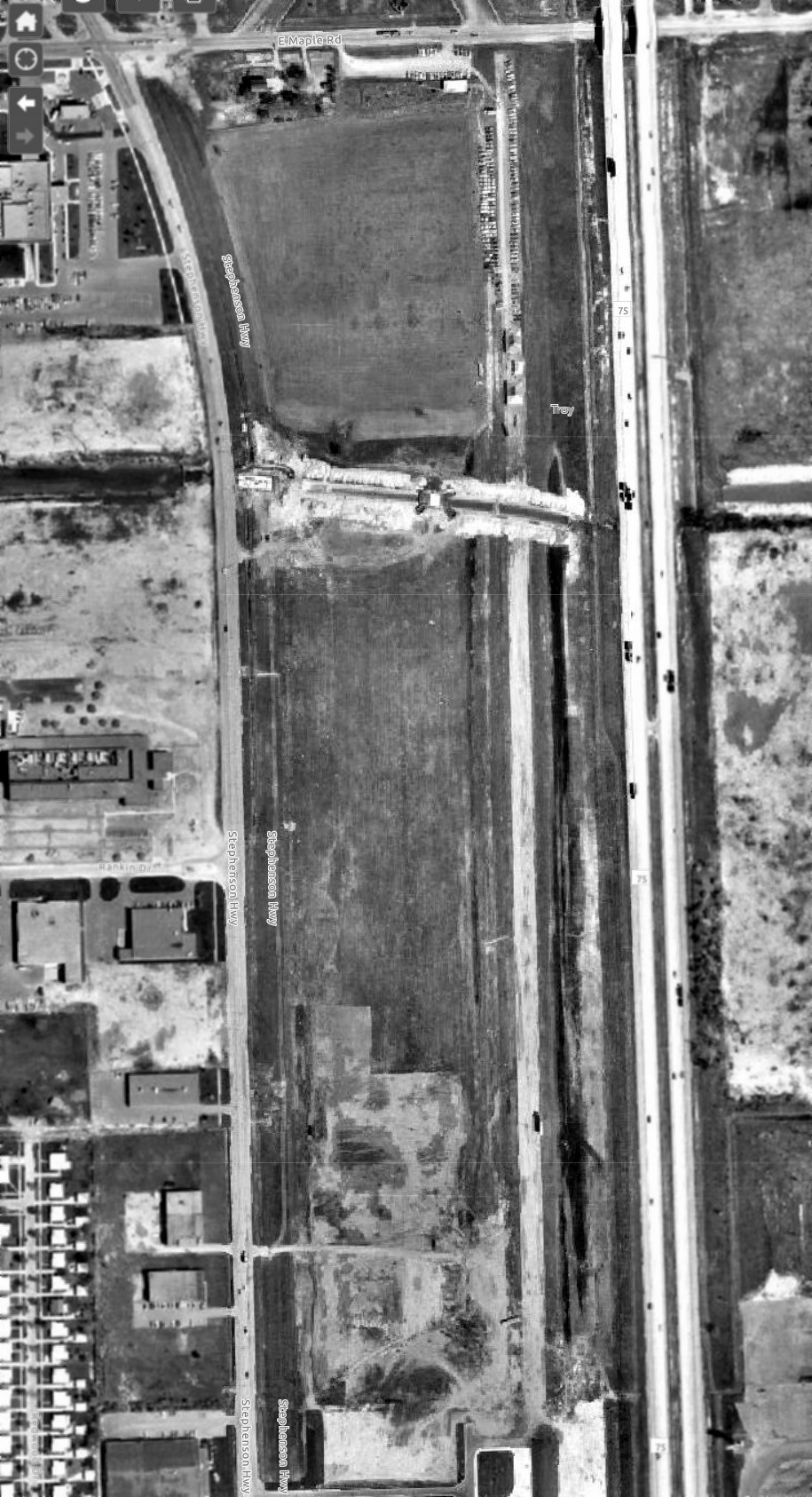
A 2019 aerial view looking northwest showed no trace remaining at the site of Robbins Airfield.
Thanks to Mike Denja for pointing out this airfield.
____________________________________________________
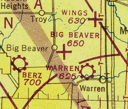
42.54, -83.07 (North of Detroit, MI)
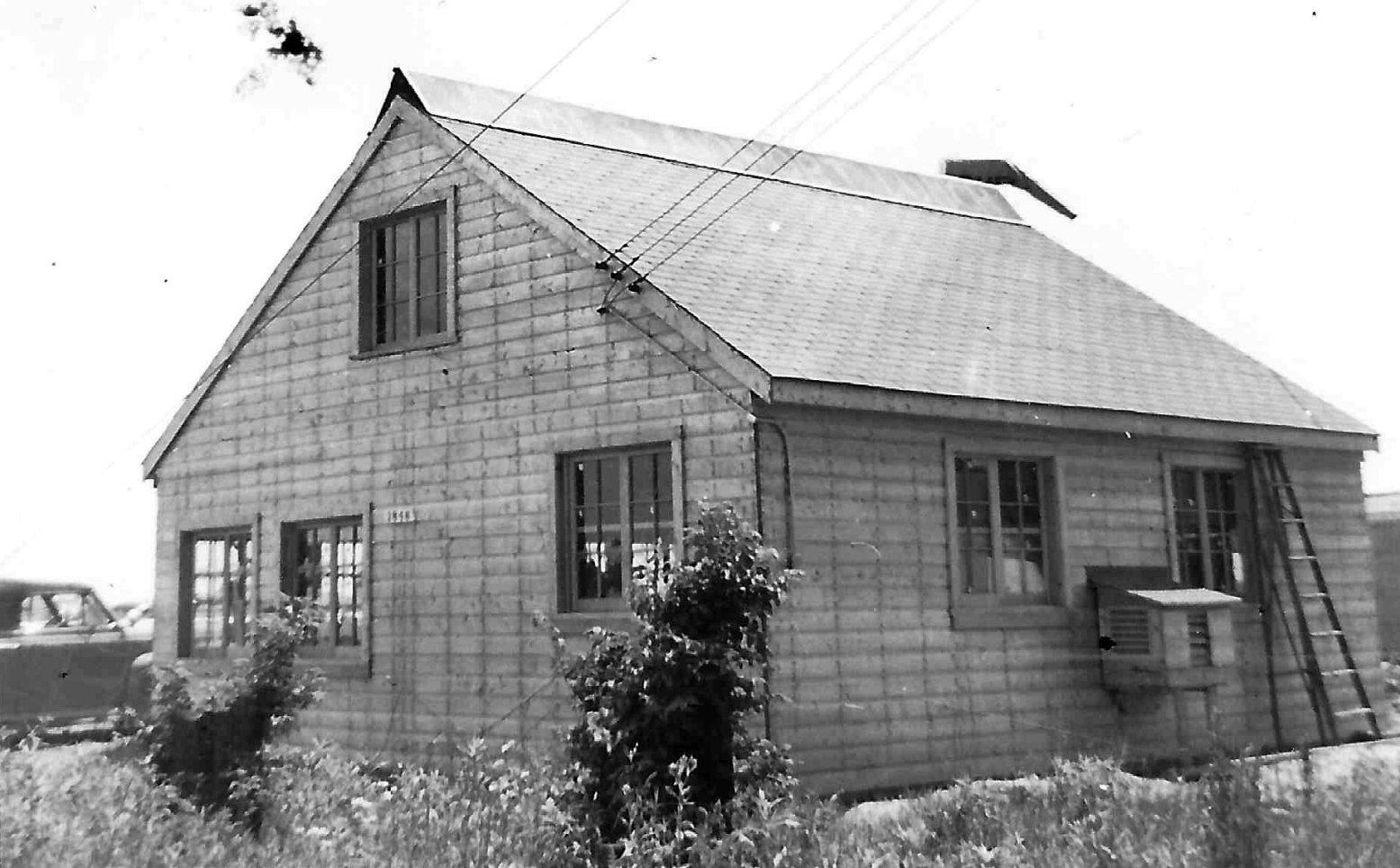
A June 1946 photo by Winfield Sluyter of a building at Warren Airport, presumably the airport office (courtesy of Rachel Fields).
Warren Airport was not yet depicted on the May 1945 Detroit Sectional Chart.
According to the Village of Van Dyke page (courtesy of Michael Bond),
“The Warren Airport, or Detroit-Warren Airport sometimes referred to as the Kinnally Airport, was probably established in or before 1945.
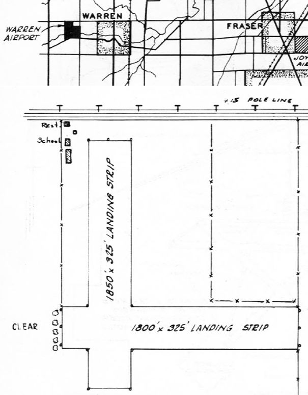
It started out as a private airport & had 3 hangars & 2 landing strips.
One runway was 1,850', the other 1,800'. In 1946 the manager was John Kinnally.
The Warren Flying Service offered services of a office, major repairs, gas (80 octane Avgas), training, charter, day service, taxi & also had a restaurant.”
The earliest depiction which has been located of Warren Airport was a June 1946 photo by Winfield Sluyter of a building, presumably the airport office (courtesy of Rachel Fields).
The earliest aeronautical chart depiction which has been located of Warren Airport was on the July 1946 Detroit Sectional Chart (courtesy of Chris Kennedy),
which depicted Warren as a commercial/municipal airport.
The 1946 MI Airport Directory (courtesy of Doug Ranz)
depicted Warren Airport as having 2 unpaved runways, measuring 1,850' north/south & 1,800' east/west.
Four buildings were depicted on the northwest corner, including a school & a restaurant.
The earliest aerial photo which has been located of Warren Airport was a 1949 aerial view.
It depicted Warren as having 2 perpendicular grass runways, with 3 long hangars & 5 single-engine aircraft on the northwest corner.
The 1949 Detroit Sectional Chart (courtesy of Donald Felton) depicted Warren as having a 2,800' unpaved runway.
A 1952 aerial view of Warren Airport showed little change compared to the 1949 photo (according to Mike Denja).
According to the Village of Van Dyke page (courtesy of Michael Bond),
“The airport was sold in 1954 to Arthur Evans, owner of Modern Die & Tool Company,
with the Intention of building a factory on the site & having the advantage of housing his own planes at the airport so that he could better utilize his airplanes in his business.
However the Detroit Aviation Commission with the approval of Mayor Cobo, contacted Mr. Evans to ascertain whether he would be willing to sell Warren Airport to the City.
Mr. Evans stated that he was not at all anxious to sell because he had obtained the property for a definite business use,
but that he realized the urgent need for expanding the facilities of Detroit City Airport.
Mr. Evans stated that he was planning Improvements to the Airport & had already applied to have the area re-zoned for his own commercial purpose,
but Detroit prevailed & purchased the property.”
Ted Larkins recalled, “Warren Airport was on the south side of 14 Mile [Road] & backed up to Red Run Drain, a bit west of Ryan.
My dad took us flying there many times on Sundays. We lived on Ryan about 1/2 mile north of 14 Mile Road (1955-62).”
The Experimental Aircraft Association Chapter #13 originally met at the Warren Airport before they were even incorporated as a Chapter (1955) with 13 members.
The founding president was Roger Perreault. They also apparently moved when the developers took over.
Also located at the Warren Airport circa 1955 was the Warren Aviation Company who made wheel pants for Piper planes that were approved by the CAA.
The Warren Flying Club was founded in 1957 at the Warren Airport.
The 5 original members pooled their money & purchased a used 2-place Luscombe.
The last photo which has been located of Warren Airport was a 1957 aerial view (courtesy of Mike Denja).
It depicted Warren as having 2 perpendicular grass runways, with 3 long hangars & 5 single-engine aircraft (including 1 on the north/south runway).

The last aeronautical chart depiction which has been located of Warren Airport was on the May 1958 Detroit Sectional Chart.
It depicted Warren as having a 2,100' unpaved runway.
In 1958 The Michiganian reported: "The Detroit Aviation Commission has recommended that the Detroit-Warren Airport be closed to all traffic effective 9/1/58.
As a result of this request, the Detroit Distributor Flying School, based at the airport, will also cease.”
Warren Airport was lastly used by the Radio Control Club of Detroit in 1959 to fly radio controlled model planes.
Warren Airport was no longer depicted on the January 1959 Detroit Sectional Chart.
A 1961 aerial photo (according to Mike Denja) showed streets & homes being built on the site of Warren Airport.
A 1999 aerial photo showed no recognizable trace remaining of Warren Airport.
A 2015 aerial photo showed no recognizable trace remaining of Warren Airport.
The site of Warren Airport is located at the intersection of Ryan Road & East 14 Mile Road.
Thanks to Michael Bond for pointing out this airfield.
____________________________________________________
Burns Landing Field / Burns Airport, Redford, MI
42.37, -83.28 (Northwest of Detroit, MI)
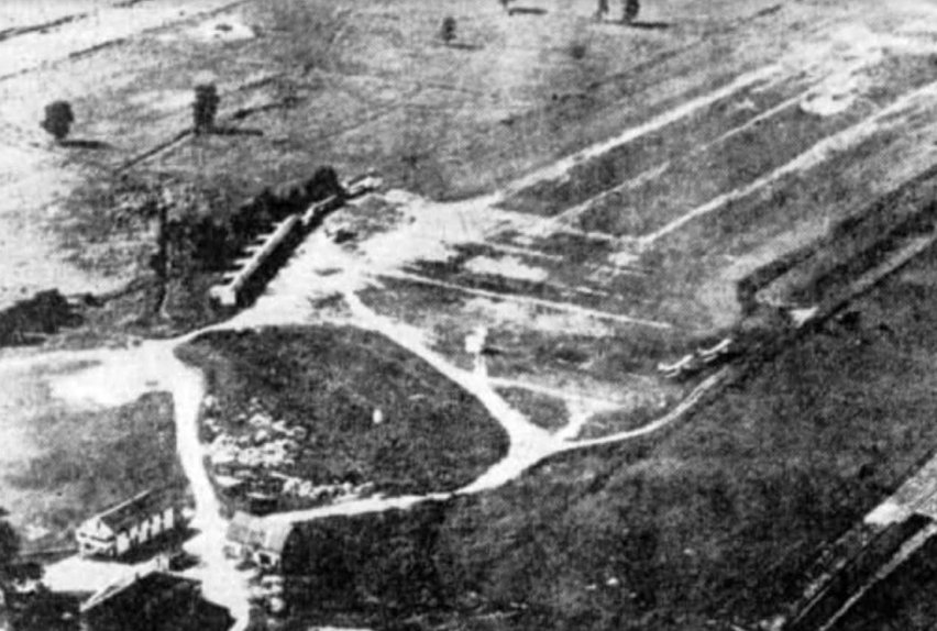
An undated aerial view of Burns Airport from the 9/30/28 Detroit Free Press (courtesy of Mike Denja).
The date of establishment of this small general aviation airport has not been determined.
The earliest reference which has been located to Burns Airport was a 6/16/27 Dearborn Press article (courtesy of Karen Wisniewski),
which described an injury of an aircraft passenger at the airport.
The earliest depiction which has been located of Burns Airport was an undated aerial view from the 9/30/28 Detroit Free Press (courtesy of Mike Denja).
It was captioned, “Busy season at the Burns Airport, of Plymouth Road, keeps all the planes at work with students of the flying school & passengers for the taxi service.”

The earliest aeronautical chart depiction which has been located of Burns Airport was on the June 1931 Detroit Sectional Chart.
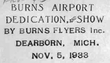
A postmark commemorating the 11/5/33 dedication of Burns Airport, an occasion also accompanied by a show by the Burns Flyers Inc.
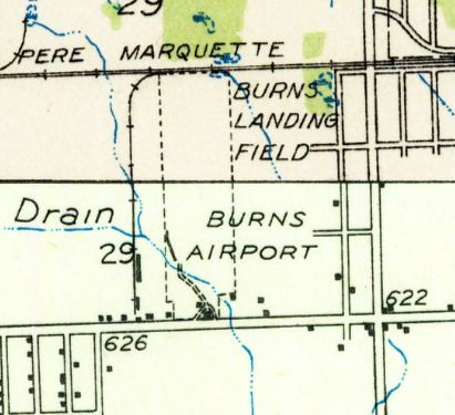
The 1936 USGS topo map depicted “Burns Landing Field” / “Burns Airport” as a north/south oriented property with a few small buildings on the south end.
Barbara Felder recalled, “Burns Airport... My father, Ronald Chappell, operated that airport.
I was about 11 years old when we moved from Detroit to Wisconsin, so I remember it well.
My father didn’t own the land, but he did own the buildings, and many planes at different times.
I remember my parents talking about how worried they were when war was declared on 12/8/41, as it was thought that the airfield would be closed down.
I am sure they were worried as my parents had twin daughters born in December 1941; I am one of the twins.
My grandfather was hired as a guard at night to make sure the Japanese didn’t take over Burns!”
A 9/10/43 aerial view looking north from the 1945 AAF Airfield Directory (courtesy of Scott Murdock)
depicted Burns Airport as having a single unpaved north/south runway.
The 1945 AAF Airfield Directory (courtesy of Scott Murdock) described Burns Airport
as a 40 acre rectangular property having a single 1,850' north/south clay, loam, and sod runway.
The field was said to have a single 40' x 28' wooden T-hangar,
and to be owned & operated by private interests.
The location of Burns Airport, as depicted in the 1946 Michigan Airport Directory (courtesy of Doug Ranz).
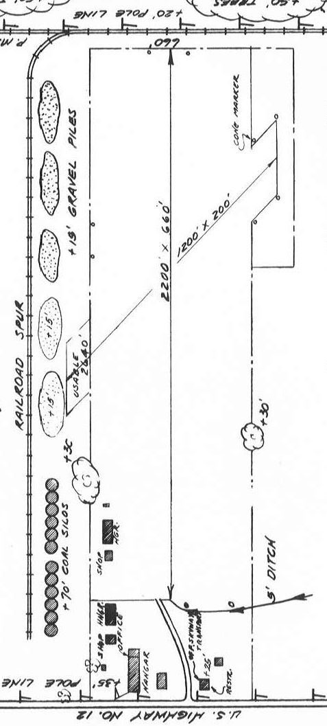
The 1946 Michigan Airport Directory (courtesy of Doug Ranz) depicted Burns Airport
as having a 2,200' north/south runway & a very short 1,200' crosswind runway.
An office, several shops & hangars were located on the south side.
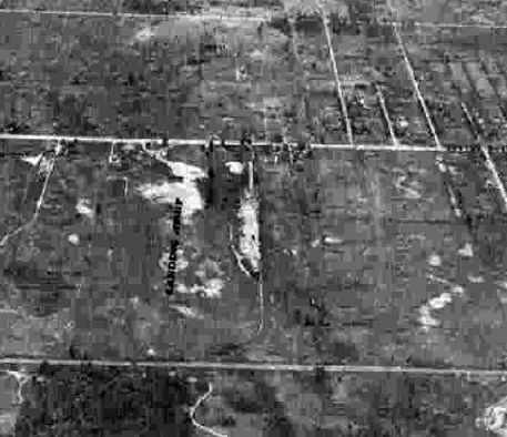
A 1949 aerial view (courtesy of Mike Denja) depicted Burns Airport as having 2 unpaved runways,
with over a dozen single-engine planes parked around some small buildings on the south side.
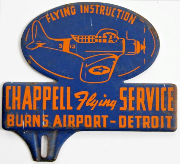
A circa late 1940s license plate frame advertising Burns Airport's Chappel Flying Service.
Barabara Felder reported, “The blue/orange topper... We have a number of them.
We also have a topper shaped like a plane in blue/silver that advertised the airport.”
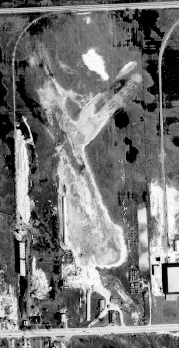
The last photo which has been located of Burns Airport was a 5/20/51 USGS aerial view.
It depicted Burns Airport as having 2 unpaved runways, with over a dozen single-engine planes parked around some small buildings on the south side.
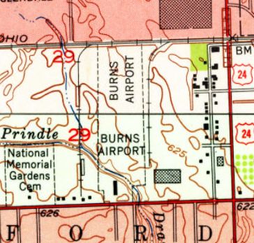
The 1952 USGS topo map depicted Burns Airport as a north/south oriented property with 1 small building on the south end.
Burns Airport, as depicted on the 1954 USGS topo map.
The last depiction which has been located of Burns Airport was on the May 1954 Detroit Sectional Chart.
It depicted Burns Airport as having a 2,000' unpaved runway.
Barbara Felder recalled, “Burns Airport... My father, Ronald Chappell, operated that airport until 1954 when the land was sold to a developer.”
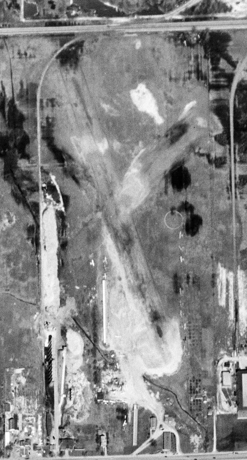
A 1957 aerial photo showed that Dixie Drive had been built along the Burns Airport runway orientation, and commercial buildings had covered the site.
Like thousands of other small general aviation airports, Burns Airport evidently fell victim to being located in a area that became densely developed.
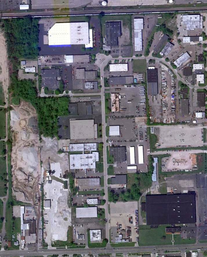
A 2010 aerial view showed no trace remaining of Burns Airport.
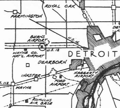
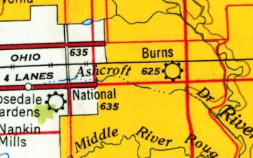
The site of Burns Airport is located north of the intersection of Dixie Road & Plymouth Road.
____________________________________________________
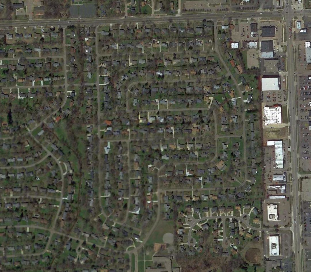
Farmington Hills Airfield, Farmington Hills, MI
42.52, -83.38 (Northwest of Detroit, MI)
A 1949 aerial view of the Farmington Hills Airfield (courtesy of Mike Denja).
Not much is known about this small airfield, including its name or date of construction.
No airfield was depicted at this location in the 1946 Michigan Airport Directory (courtesy of Doug Ranz),
on 1945/46/48/50/52/54/56 Detroit Sectional Charts, or on the 1947 Farmington Plat Map (courtesy of Mike Denja).
The earliest depiction which has been located of this airfield was a 1949 aerial view (courtesy of Mike Denja),
which depicted an airfield with 3 grass runways.
This airfield was not depicted on the 1954 USGS topo map.
The last photo which has been located of the Farmington Hills Airfield was a 1956 aerial view (courtesy of Mike Denja).
According to Wikipedia, North Farmington High School was built on the Farmington Hills Airfield site in 1961.
A 1964 aerial view showed the North Farmington High School covering the Farmington Hills Airfield site.
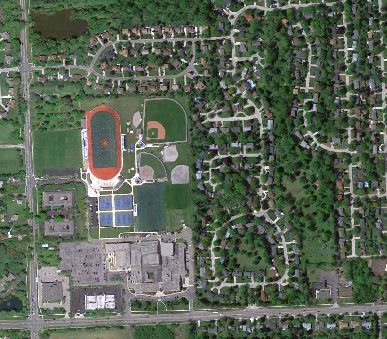
A 2010 aerial view showed North Farmington High School covering the Farmington Hills Airfield site.
The site of Farmington Hills Airfield is located on the northeast corner of Farmington Road & 13 Mile Road.
Thanks to Mike Denja for pointing out this airfield.
____________________________________________________
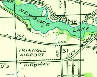
Triangle Glider Port / Triangle Airport, Plymouth, MI
42.36, -83.43 (West of Detroit, MI)
Triangle Airport, as depicted on the 1928 Commerce Department Airway Bulletin (courtesy of Mike Denja).
The date of establishment of Triangle Airport has not been determined.
The earliest depiction which has been located of Triangle Airport was on the 1928 Commerce Department Airway Bulletin (courtesy of Mike Denja).
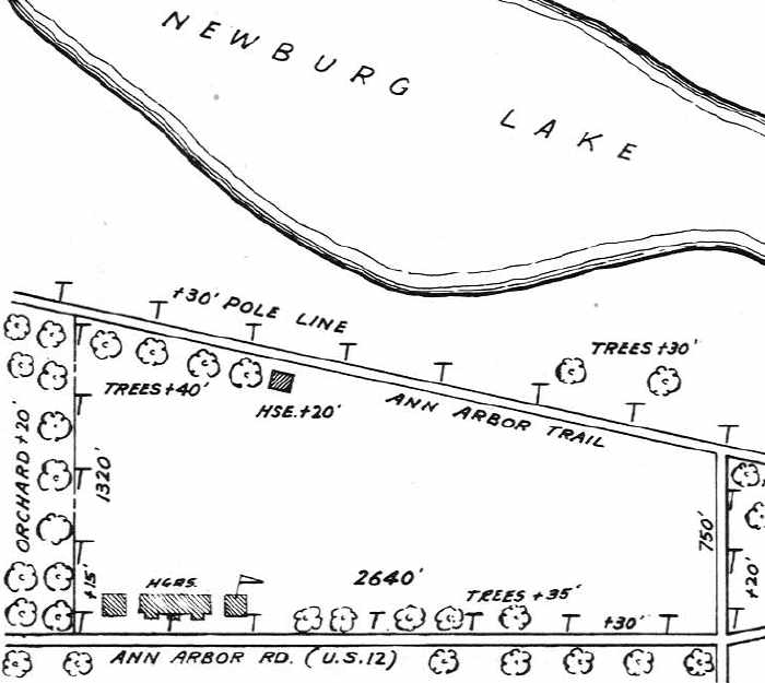
It depicted Triangle Airport as having 3 unpaved runways, with the longest being the 2,700' east/west strip, and 2 buildings (hangars?) on the southwest side.
The earliest aeronautical chart depiction which has been located of Triangle Airport was on the June 1931 Detroit Sectional Chart.
Triangle Airport, as depicted on the 1936 USGS topo map (courtesy of Mike Denja).
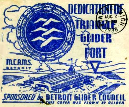
Even though Triangle Airport had evidently already been in existence for 2 years,
an 8/7/38 postmark (courtesy of Mike Denja) commemorated the “Dedication “of Triangle Glider Port”, “Sponsored by Detroit Glider Council”.
It depicted a large hangar, perhaps more elaborate than the reality at this relatively modest airport.
The earliest photo which has been located of Triangle Airport was an undated aerial view looking northeast from an April 1939 article (courtesy of Greg Steinmayer).
A 1939 Soaring Magazine article described “Triangle Gliderport”:
“We practically exhausted the possibilities of obtaining permission to fly gliders on the more desirable
fields when the manager of National Airways pointed out to us the fact that there was a small airport down the highway
on which no commercial operator had been able to make a living in recent years.
This field was known as Triangle Airport.
L.D. Montgomery & Steve Sund, two of the XYZ members, made an exploratory trip over the field with a car and, as a result, were almost totally unimpressed.
The field was too small; it had obstructions on all 4 boundaries; it just didn't have the makings of a permanent place to fly.
However, with the consent of the owner, it was tried out on 4/24/38, by the members of the XYZ Club.
They were able to train students, and several of the members had the best flying day they had experienced since our ignominious dismissal from Pontiac Airport.
Ideas began to crop up. Why not persuade the Detroit Glider Council to rent the field for the use of all the local groups?”
The 1946 Michigan Airport Directory (courtesy of Doug Ranz) depicted Triangle Airport
as an unpaved field with several hangars along the southwest side.
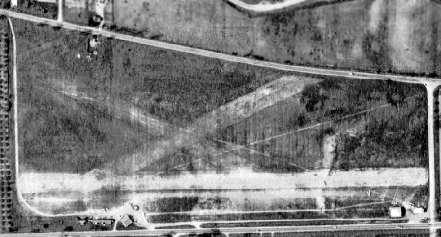
A 1949 aerial view (courtesy of Greg Steinmayer) depicted Triangle as an unpaved field having 3 runways,
with several hangars along the southwest & southeast sides, with at least 3 light aircraft visible at the southeast corner.
The last aeronautical chart depiction which has been located of Triangle Airport was on the May 1951 Detroit Sectional Chart.
It depicted Triangle as having a 2,600' unpaved runway.
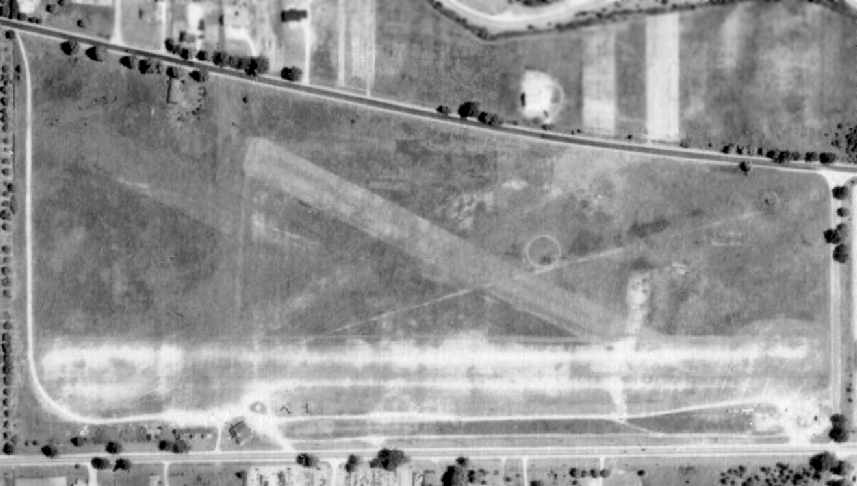
The last photo which has been located of Triangle Airport was a 1952 aerial view (courtesy of Greg Steinmayer).
It depicted Triangle as an unpaved field having 3 runways, with several hangars along the southwest & southeast sides, with at least 2 light aircraft visible at the southeast corner.
The last depiction which has been located of Triangle Airport was on the 1952 topo map (courtesy of Mike Keefe).
The site of Triangle Airport remained clear in a 8/10/56 USGS aerial view,
but it was not evident whether the airport was still in operation by that point.
Triangle Airport was no longer depicted on the May 1958 Detroit Sectional Chart.
According to an article by Ruth Moehlman in the 1/29/06 issue of the Farmington Observer & Eccentric (courtesy of Mike Denja),
the former airport terminal building is now an auto repair shop, Auto Solutions,
and some of the former dirt-floored hangars have been recycled as retail shops.
A 5/9/10 aerial view showed no sign remaining of Triangle Airport.
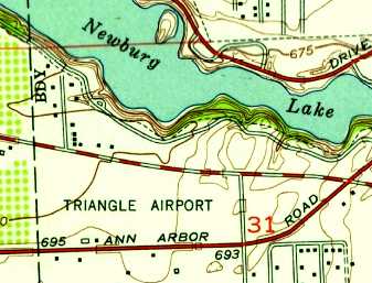
The site of Triangle Airport is located southwest of the intersection of Ann Arbor Trail & Hix Road.
____________________________________________________
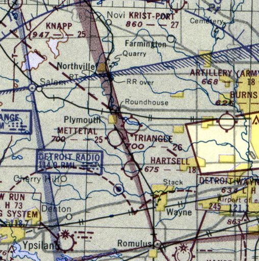
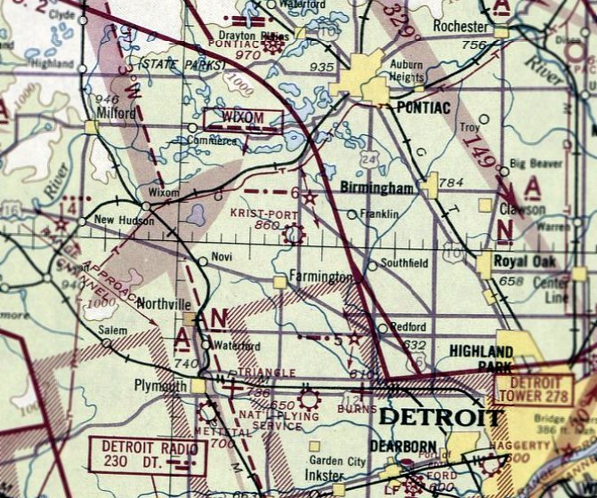
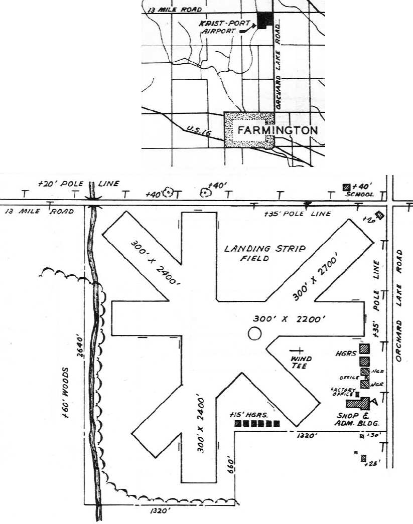
42.511 ,-83.363 (Northwest of Detroit, MI)
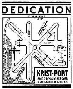
A 1941 postmark commemorating the dedication of Krist-Port (courtesy of Mike Denja).
The 140 acre Krist-Port was established in 1936 by Chris Kristiansen (according to the book “Farmington & Farmington Hills”, courtesy of Mike Denja).
An entrepreneur, Kristiansen hoped to boost the local economy with an air freight service, and also sold aircraft on the premises.
The field initially had 2 runways, each 2,000' long.
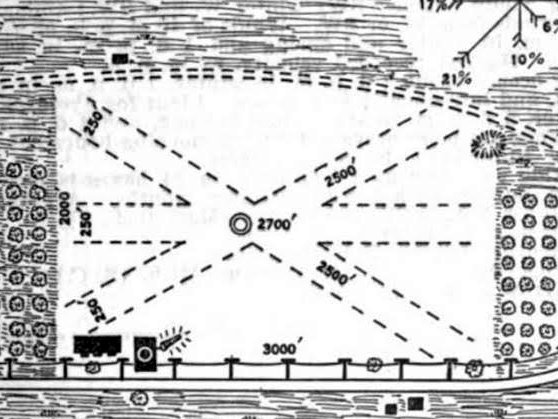
A 1941 postmark (courtesy of Mike Denja) commemorated the dedication of Krist-Port.
It depicted the airfield as having 4 runways, with the longest being 2,400',
and depicted 3 buildings along the east side of the field.
It was a busy airport & the Governor at the time would land there when doing business in that area.
However Krist-Port was not yet depicted on the September 1941 Detroit Sectional Chart.
During & after WW2, Krist Port was used for Civil Defense,
and an observation tower was built on the top of the Shop & Administration Building,
which was used as a lookout tower for enemy aircraft.
The earliest aeronautical chart depiction which has been located of Krist-Port was on the August 1942 Detroit Sectional Chart.
The earliest photo which has been located of Krist-Port
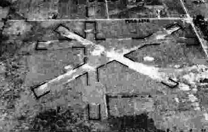
was a 10/10/43 aerial view looking north from the 1945 AAF Airfield Directory (courtesy of Scott Murdock).
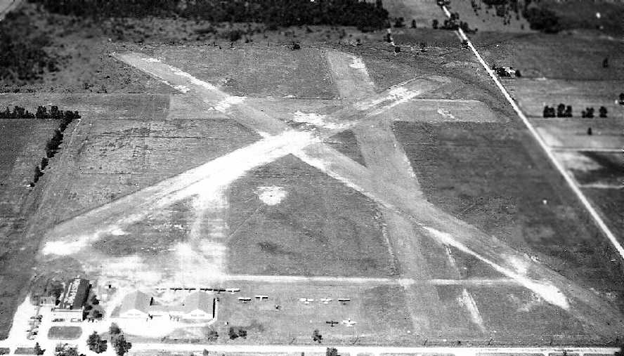
It depicted Krist-Port Airport as having 3 unpaved runways.
The 1944 US Army/Navy Directory of Airfields (courtesy of Ken Mercer) described Krist Port as having a 2,700' unpaved runway.
The 1945 AAF Airfield Directory (courtesy of Scott Murdock) described Krist-Port Airport
as a 130 acre L-shaped property having 3 earth runways, the longest being the 2,700' northeast/southwest strip.
The field was said to have 2 wood & metal hangars, the largest measuring 81' x 80'.
Krist-Port was described as being owned & operated by private interests.
The 1946 Michigan Airport Directory (courtesy of Doug Ranz)
depicted Krist Port as having a total of 4 unpaved runways,
with the longest being the 2,700' northeast/southwest runway.
A total of 10 hangars & buildings were located along the eastern & southern sides of the airfield.
A circa 1946-47 aerial view by Ray Baker (courtesy of Brian Baker) looking west at Krist-Port,
showing the 4 unpaved runways, hangars, administration building, and 13 single-engine aircraft.
According to Brian, “Everything seems to indicate 1946-1947, as the observation tower is there,
and there is a PT-19 on the field, along with a bunch of Taylorcrafts.”
A circa 1946-47 aerial view by Ray Baker (courtesy of Brian Baker) looking north at the east side of Krist-Port,
showing the hangars & administration building, with 13 single-engine aircraft.
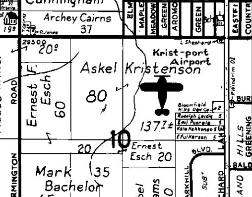
A 1947 Farmington Township Plat Map (courtesy of Mike Denja) depicted the owner of Krist-port Airport as Askel Kristenson.
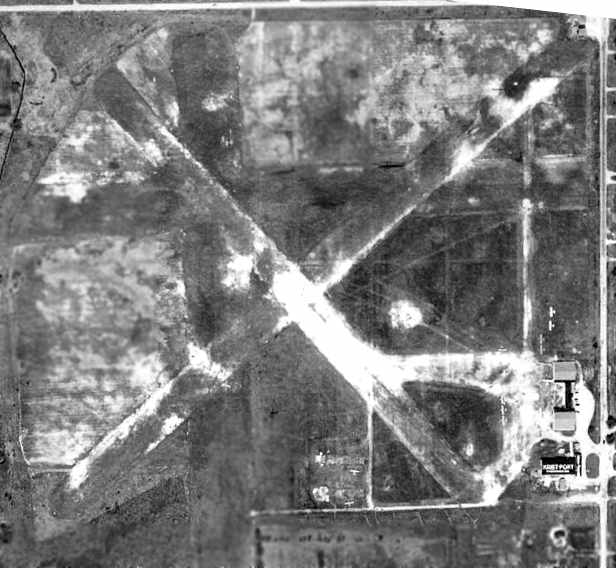
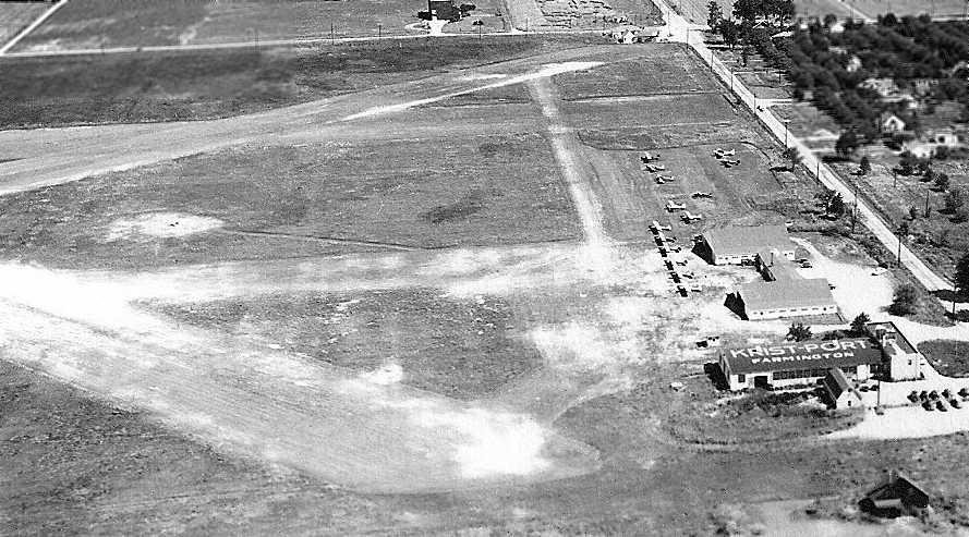
A 1949 Detroit Edison aerial view of Krist Port (courtesy of Mike Denja).
Note the shop & administration building at the southeast corner, with "Krist Port" painted on the roof.
About a dozen light aircraft were visible on the southeast corner of the field.
An article in the 7/7/49 issue of the Farmington Enterprise (courtesy of Mike Denja)
was entitled “Canadian Planes forced down at Krist Port”.
It said, “Two Canadian jet planes made a forced landing late Tuesday afternoon at the Krist Port airfield,
Harold Shobe, manager of the airport, announced Tuesday.
Both planes made a safe landing & neither the crews nor the planes were damaged.
Shobe stated the planes landed at about 4:30 Tuesday afternoon.
He stated that weather conditions caused the planes to make the forced landing.”
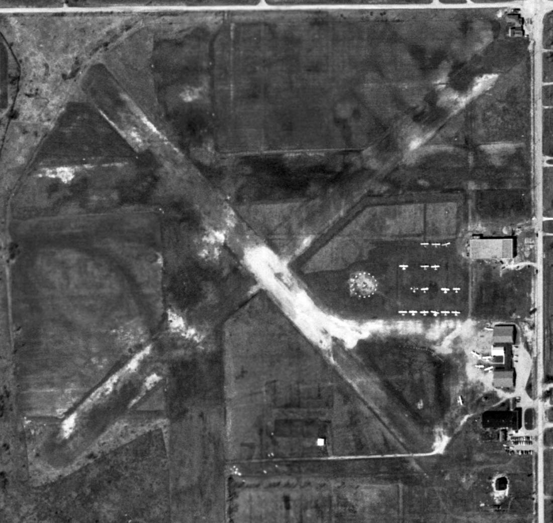
The last photo which has been located of Krist Port was a 4/27/51 USGS aerial view, which depicted a total of 23 light aircraft on the southeast corner of the field.
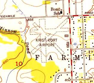
The 1952 USGS topo map depicted Krist-Port Airport as having 3 unpaved runways, with several buildings along the east side.
Kristport's former control tower was used as a Ground Observation post (a program to use civilian observers to augment air defense)
from January 1952 through at least 1955 (according to articles courtesy of Mike Denja).
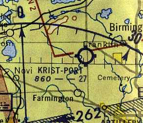
The May 1954 Detroit Sectional Chart (courtesy of Mike Keefe) depicted Kris Port as a commercial airport having a 2,700' unpaved runway.
According to Brian Baker, “I think the airport was operated by Harold Shobe for a while
before he moved to Wayne County & established Wayne County Flying Service, where I learned to fly in 1954-1955.
I think it [Krist Port] was closed by 1955 or so, as I remember Harold talking about it in the past tense.”
Cliff Waeschle recalled, “I remember Kristport well.
I worked there in the summer of 1955 when it was still operational as an airport.
I got hired as line boy to clean up the offices, pump gas, mow the grass runways & help the A&P mechanic Ray do general maintenance.
How I loved repacking wheel bearings, sand blasting plugs etc.
The owners were two WWII vets that ran the flight school - Chuck Spicer & his buddy Johnny.
I also got my Student pilot license that summer & I soloed a 7AC Champ.”
Krist Port was evidently closed (for reasons unknown) in late 1955,
as an article (courtesy of Mike Denja) mentioned that the airfield was "abandoned" by 1955.
Krist Port was no longer depicted on the May 1960 Detroit Sectional Chart (courtesy of Mike Keefe).
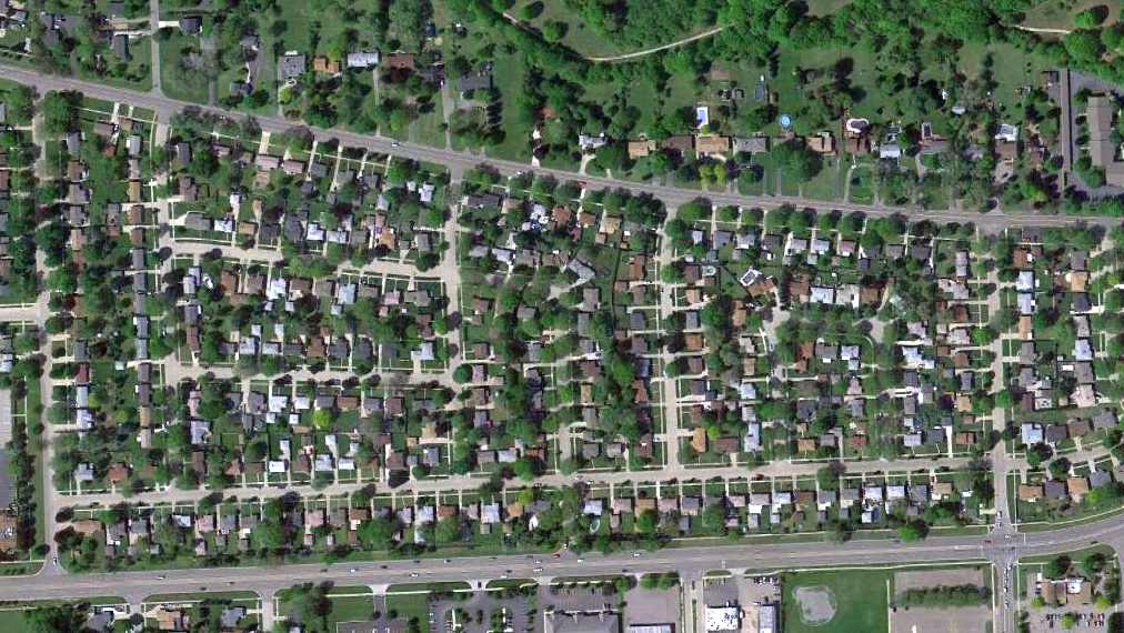
A 1964 aerial view showed that the airfield property had been filled in with houses,
but the administration building & hangar still remained standing on the east side.
A 2003 photo by Michael Denja of the front of the former shop & administration building of Krist Port.
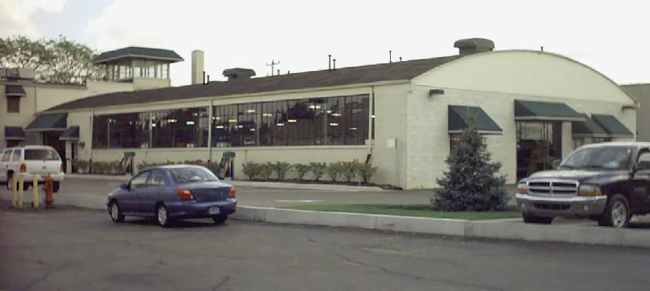
A 2003 photo by Michael Denja of the hangar portion of the former shop & administration building of Krist Port.
A 2003 closeup by Michael Denja of the WW2-era observation tower which remains atop the former shop & administration building of Krist Port.
This former airfield was "rediscovered" by Michael Denja,
who reported in 2003, "There is a building off a main road (Orchard Lake Road) in Farmington Hills
that I was told was the former control tower of the airport.
The building is now an auto repair shop & has since been renovated & added to but the top does look like a control tower.
It has 360 panoramic windows."
According to an article by Ruth Moehlman in the January 29, 2006 issue
of the Farmington Observer & Eccentric (courtesy of Mike Denja),
the former airport terminal building is now an auto repair shop, Auto Solutions,
and some of the former dirt-floored hangars have been recycled as retail shops.
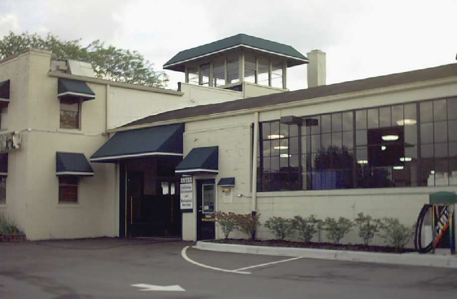
A circa 2005-2010 aerial view looking east at the former shop & administration building of Krist Port.
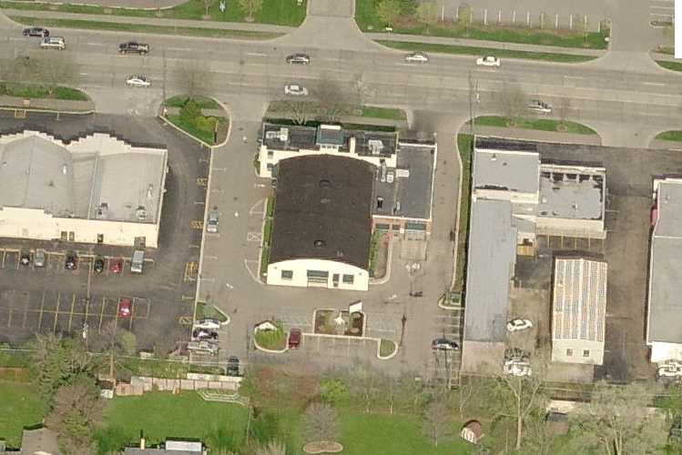
A 2017 aerial view shows the area of Krist Port's former runways has been completely redeveloped with houses,
but the former shop & administration building remained standing along the east side of the property.
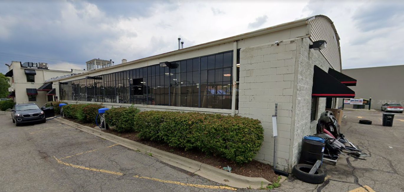
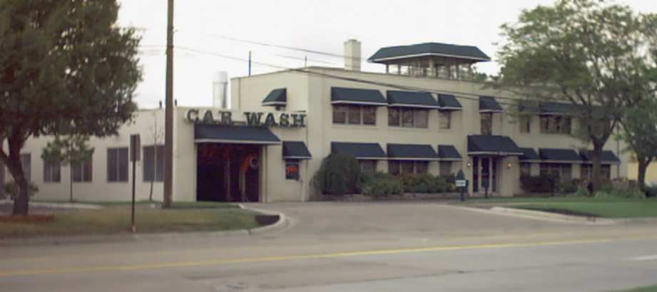
A July 2018 photo looking southeast at the former shop & administration building of Krist Port, with observation tower on top, reused as a car wash.
The site of Krist Port is located on the southwest corner of Orchard Lake Road & 13 Mile Road.
____________________________________________________
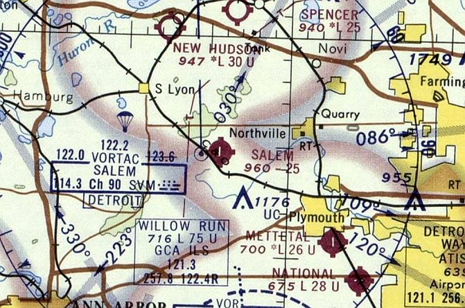
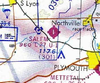
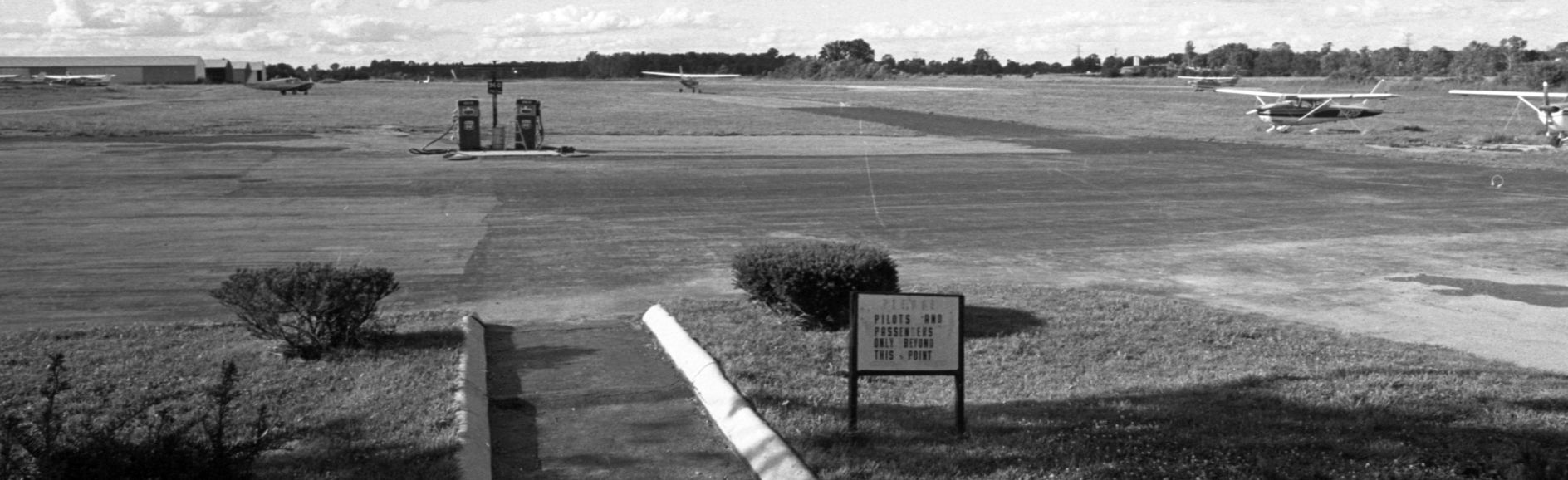
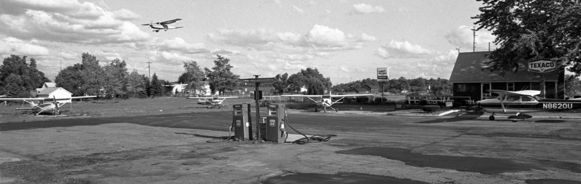
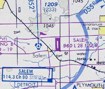
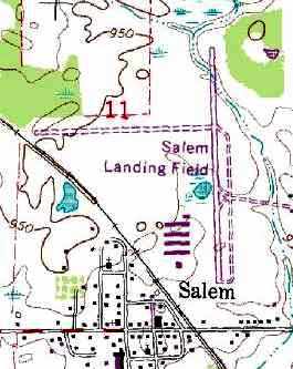
Salem Airport (0G9), Salem, MI
42.41, -83.58 (West of Detroit, MI)
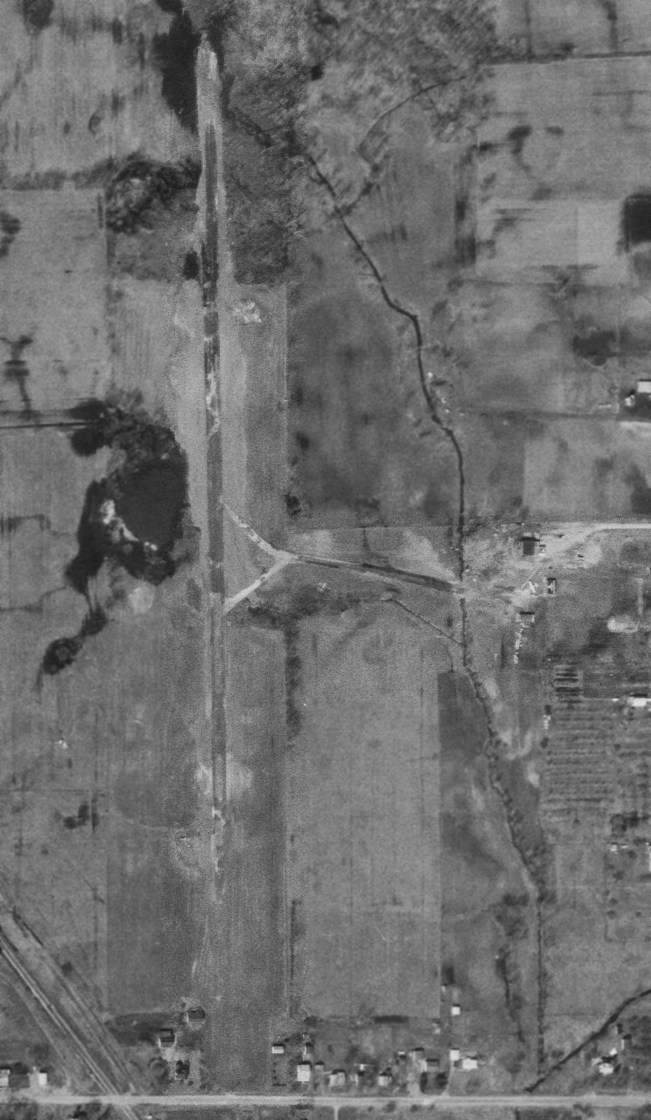
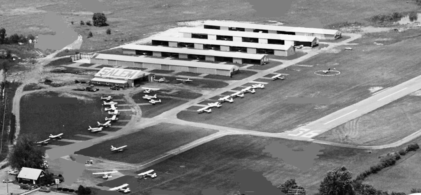
Salem Airport, as depicted on a 1967 aerial photo (courtesy of Mike Denja).
This general aviation airport was apparently built at some point between 1965-67, as it was not yet depicted on a 1963 aerial photo
nor on the July 1965 Detroit Sectional Chart (according to Chris Kennedy).
The earliest depiction of Salem Airport which has been located was on a 1967 aerial photo (courtesy of Mike Denja).
It depicted Salem Airport as having a single paved north/south runway.
A taxiway led to a few small buildings & 1 light single-engine aircraft on the east side of the field,
The earliest aeronautical chart depiction which has been located of Salem Airport was on the January 1969 Detroit Sectional Chart (courtesy of Mike Denja).
It depicted Salem Airport as having a single paved north/south 2,500' runway.
Salem Airport was depicted on the May 1971 Detroit Sectional Chart (courtesy of Chris Kennedy)
as having a single 2,700' paved runway.
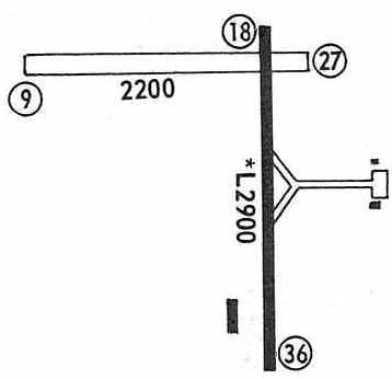
The 1971 Flight Guide (courtesy of Chris Kennedy) depicted Salem Airport as having a single 2,900' paved Runway 18/36 & a 2,200' unpaved Runway 9/27.
The crosswind runway had evidently been added at some point between 1967-71.
A taxiway led to a ramp with 2 small buildings on the east side of the field, and another building was depicted on the southwest side of the field.
The 1973 USGS topo map depicted "Salem Landing Field" as having a paved north/south runway
and 3 rows of T-hangars & a smaller building at the southwest end of the field.
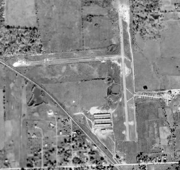
A 1973 aerial view depicted Salem Airport as having a single paved north/south runway & and unpaved crosswind runway.
Four hangars were located on the southwest side of the field,
and a total of 16 light aircraft were parked on the southwest & southeast sides of the field.
Larry Ekstrom observed, “If you look at the 1973 aerial shot you will notice a round white dot on the north side of the hangars
and to the west 2/3 of the way to the railroad tracks.
That was a pea gravel landing target for parachuters.
It [ the Para-Hawks jump operation] was run by Pete & Nora Myks of Detroit until 1976 when Ron Shuebridge owned it.
I personally made 1,004 jumps there.
We had the last hangar on the left in the 2nd row south with a training mockup air plane & suspended harness.
We operated Wednesday through Sunday & I am surprised there aren't cars in the east-west lighter area south of the target.”
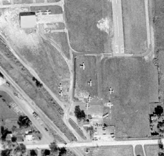
A closeup from the 1973 aerial view, showing some of the planes parked on the southwest side of Salem Airport.
Tom Korzeniowski recalled, “I remember doing my primary flight training in 1973 at Salem Airport, where Don Little was my instructor.
I believe he was named 'Flight Instructor of the Year' in 1972.
I don't recall there having been a unpaved east/west runway in 1973.
I kept my first plane, a 1965 Mooney, in one of the 4 T-hangars on the property,
which was owned by a Ron Shoebridge, a man in the asphalt paving business.
The airport office was in a tiny building just off [6 Mile] Road & to the left of Runway 36.
A parachute club was in frequent attendance at the airport,
and it always behooved us to keep our heads on swivels to look for canopies as we flew the pattern.”
Tim Rawlings recalled, “Ron Shoebridge owned the airport/property back into the 1960s.
Ron cleared the trees to put in the runway & lived just east of the airport on the 'old taxiway' / tiedown area.
My dad took his instructor checkride from Don little there then taught there I think as early as 1971 or 1972.
I washed & degreased the school planes & others for money as a kid.
I was in about 2nd to maybe 8th grade when I hung around while my dad taught in the summers & weekends.
So many memories of the characters who drank the coffee & the regulars who flew in for chit chat.
I recall the 'Wixom Airforce': a pair of older guys who would fly in formation in their C-170s.
N8188A was one with crosswind landing gear.”
A photo from the 7/25/76 Ann Arbor News (from the Ann Arbor Library, courtesy of Mike Denja), captioned “Salem Airport owner Ronald Shoebridge is trying to bail out of the private airport business.
His landing field is up for sale to the highest bidder. Shoebridge says property taxes & the new state Single Business Tax have caused the move.
He's trying to interest area communities in buying the field, enabling them to pick up on federal & state subsidies.”
Salem Airport was depicted on the May 1976 Detroit Terminal Aeronautical Chart (courtesy of Chris Kennedy)
as having a single 2,800' paved runway.
The 1980 USGS topo map depicted "Salem Landing Field" as having a paved north/south runway, and unpaved east/west runway,
and 4 rows of T-hangars & 2 other buildings at the southwest end of the field.
The 1982 AOPA Airport Directory (courtesy of Ed Drury) described Salem Airport as having a 2,850' asphalt Runway 18/36 & a 2,200' turf Runway 9/27.
The field was said to provide fuel, repairs, hangars, tiedowns, flight instruction, and plane rental.
The operator was listed as Salem Airport Inc. (a Cessna dealer).
A 1982 aerial view looking northwest (courtesy of Mike Denja) depicted Salem Airport perhaps at the zenith of its popularity, with at least 34 light aircraft visible on the field.
Tim Rawlings recalled, “Ron Shoebridge sold the airport/property to Holloway Construction in the 1980s.”
According to Greg, “Salem Airport... The airport closed in 1983 give or take a year.”
Salem Airport was no longer depicted on the October 1985 Detroit Sectional Chart.
Cal Locklin recalled, “I was also told that it was because the landfill wanted to expand.
The landfill had been there for a number of years but it couldn't expand due to the proximity of the airport
and the potential problems the birds would create.
The fact that Holloway Construction purchased the airport so they could close it is true.”
=
According to Randy Coller (of MDOT-Aeronautics), “There was a proposal to construct a landfill near the airport.
Since state & federal law discourages such activity in close proximity to public use airports, the state opposed the proposed landfill.
The proponent (Halloway Construction) then bought the Salem Airport & closed it so they could develop the landfill.
Unfortunately, landfills are much more profitable than airports!”
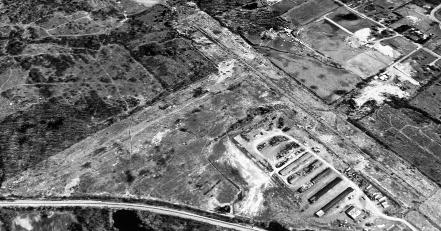
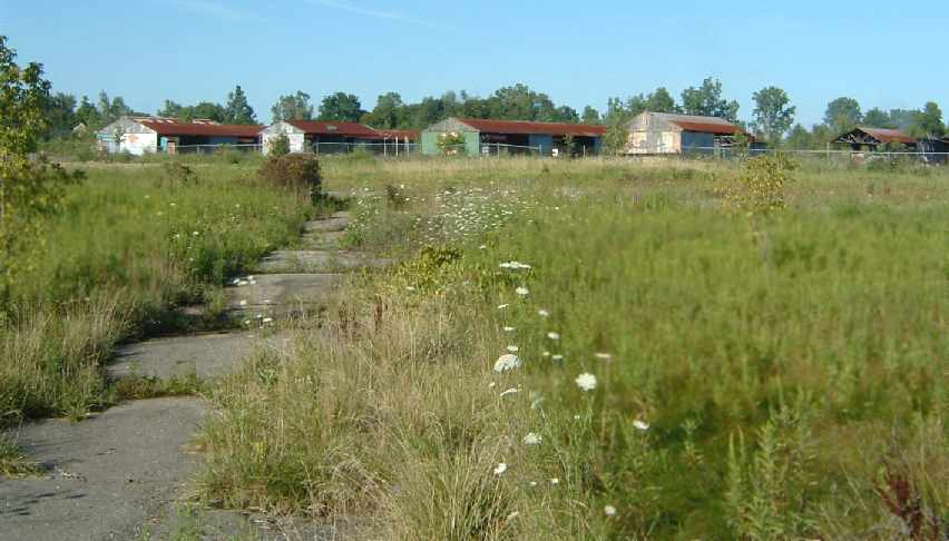
In a 2000 USGS aerial view looking northeast, the Salem Airport appeared to be abandoned.
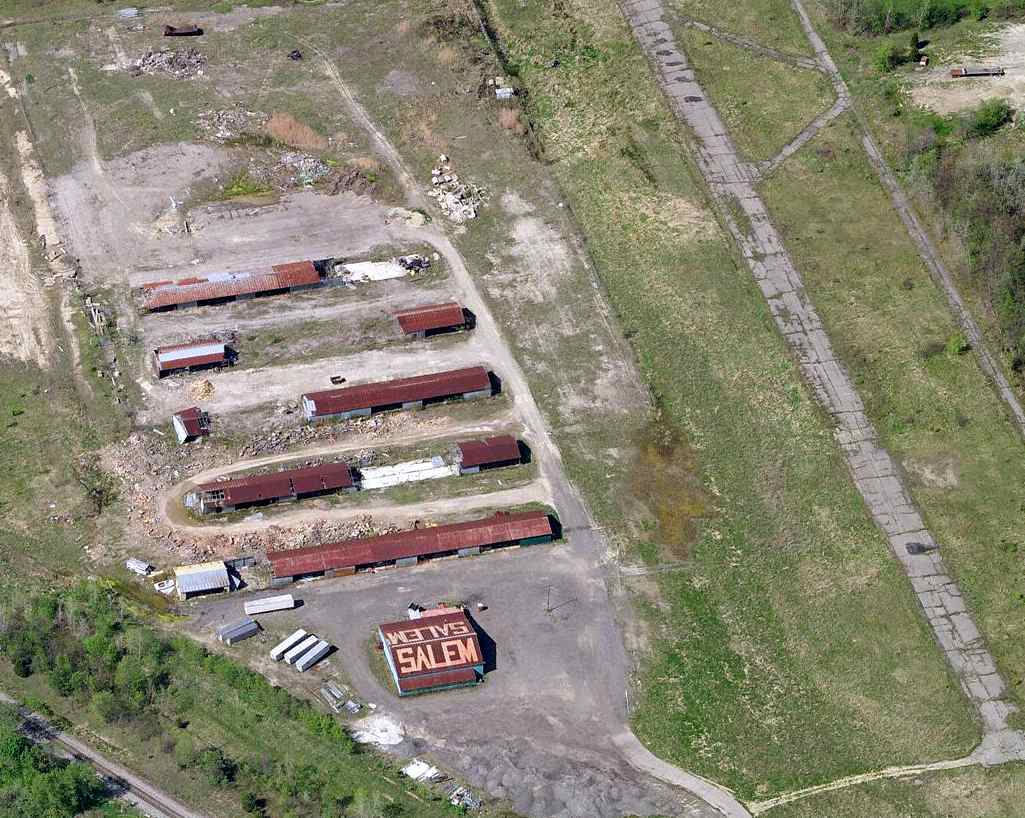
Five rows of T-hangars were visible on the southwest side of the field, but large portions of 2 of the buildings had fallen down (or been demolished).
Another building (a hangar?) sat to the south of the T-hangars. All sorts of trailers & junk appeared to be stored on the field, east of the hangars.
In the 2002 USGS aerial photo, 3 of Salem Airport's T-hangars had been partially demolished.
Note the painted "Salem" visible on the roof of the individual hangar at the south end of the T-hangars.
The pavement of the north/south runway remained intact, but it appeared to be quite deteriorated.
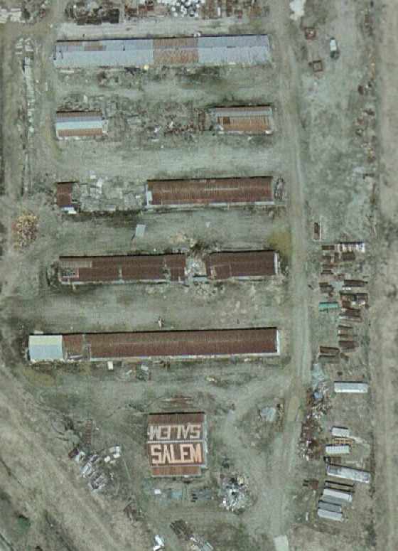
A closeup of Salem Airport's partially demolished hangars, from the 2002 USGS aerial photo.
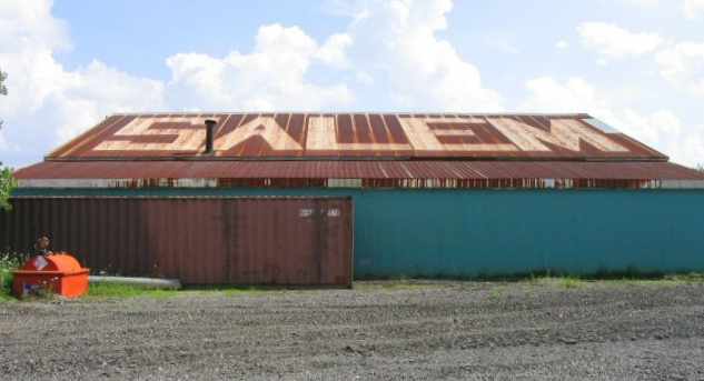
A 2004 picture of the hangar with "Salem" still painted on the roof.
An 8/2004 photo by Greg Steinmayer of the hangars & runway pavement at Salem Airport.
Greg Steinmayer visited the site of Salem Airport on 8/2004.
"The area has been cleaned up - the abandoned trailers are no longer extant,
and there are a lot of muddy ruts in the area -
they may be preparing to redevelop the property (it is only a few miles from Ann Arbor).
The runway is VERY badly deteriorated, with the painted orange X's at each end almost completely vanished.
At several points along the runway, trees as big as 8" in diameter had grown through the cracks,
and been cut down (in fact there is an orange highway barrel covering the stump of one).
I saw no evidence of the branch of the taxiway going east that is shown on the map from the 1971 Flight Guide."
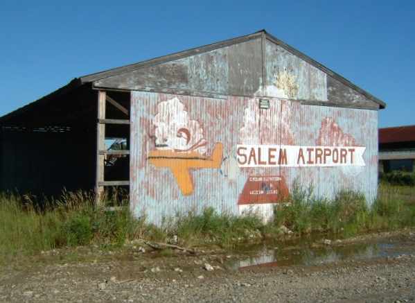
An 8/2004 photo by Greg Steinmayer of the faded sign on the end of a former T-hangar at Salem Airport.
An 8/2004 photo by Greg Steinmayer of the former main hangar at Salem Airport.
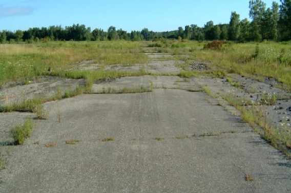
An 8/2004 photo by Greg Steinmayer looking along the remains of the pavement of Salem's runway.
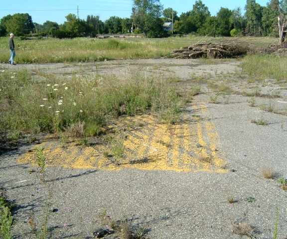
An 8/2004 photo by Greg Steinmayer of the remnants of Salem Airport painted runway markings.
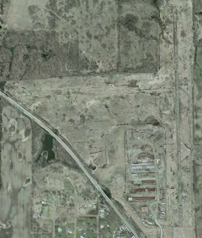
A 2005 aerial view showed that the Salem Airport property remained in the same condition, with the runway still intact & the hangars still standing.
A circa 2010 aerial view looking north at the sad remains of Salem Airport's hangars & runway.
Russ reported in 2011, “I am a project manager for Holloway Company.
We will be working on the property soon; most of the hangars are ready to fall on their own.
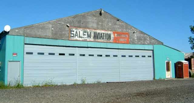
I was considering keeping the building with 'Salem' intact & thought it would be a neat part of Salem's history to hold on to.”
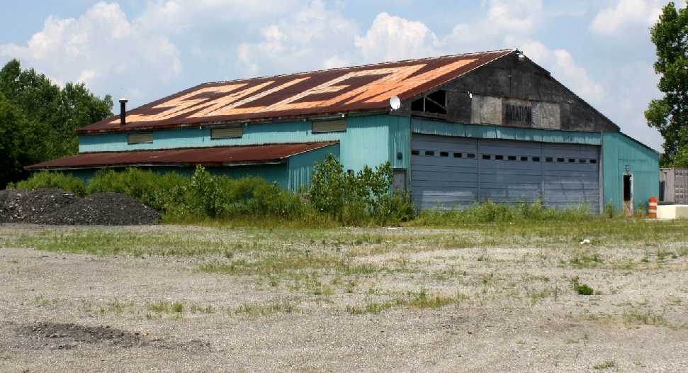
A July 2011 photo of the former main Salem Airport hangar by John Penrice.
John reported, “I’ve lived within 10 miles of it for almost 50 years & never knew it was there.
There has been significant deterioration even since the most recent photos [2004].”
A July 2011 photo of the interior of the former Salem Airport hangar by John Penrice.
A July 2011 photo of the last remaining T-hangar at Salem Airport hangar by John Penrice.
John reported, “Three of the 4 T-hangars on the site are now gone. The one that remains is barely standing.”
A July 2011 photo by John Penrice of the remains of Salem Airport pavement.
A 2016 aerial view looking northeast showed that Salem Airport's paved runway remained intact though deteriorated, and the hangar marked “Salem” still remained standing.
A sad 6/17/19 aerial view by John Hawkins looking north showed that Salem Airport's paved runway remained intact though deteriorated, and the hangar marked “Salem” still remained standing.
The site of Salem Airport is located northeast of the intersection of Salem Road & 6 Mile Road.
Thanks to Gsteinma for pointing out this airfield.
____________________________________________________
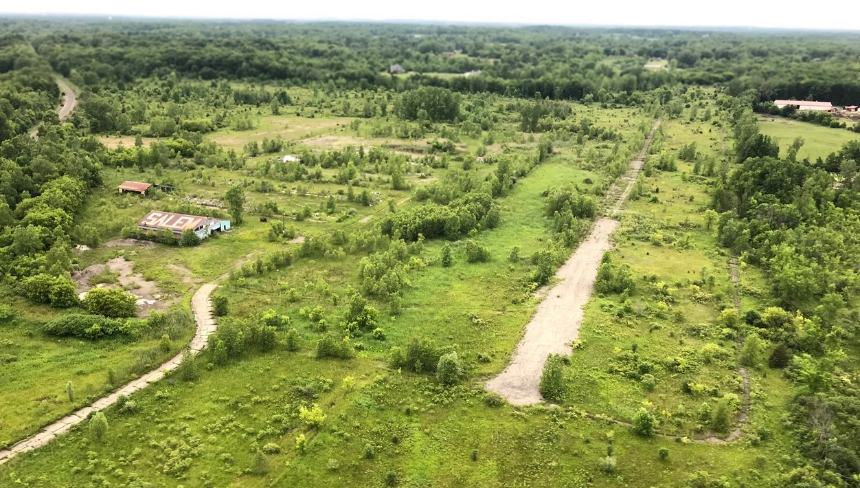
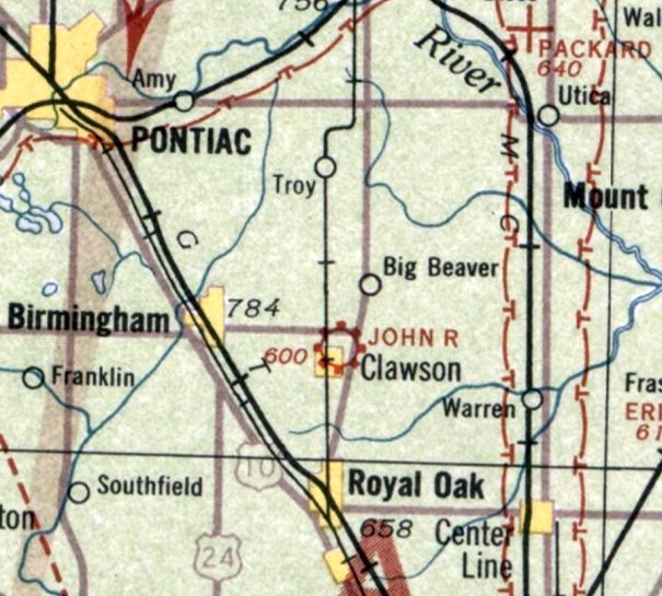
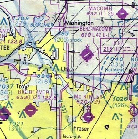
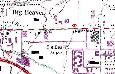
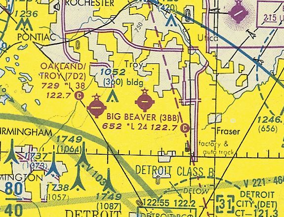
John R. Airport / Big Beaver Airport (3BB), Big Beaver, MI
42.56, -83.11 (North of Detroit, MI)
John R. Airport, as depicted on the 8/8/29 Commerce Department Airway Bulletin (courtesy of Derek Spinei).
This property has been the location of 2 different airports throughout the decades, and was originally known as John R. Airport.
The date of establishment of John R. Airport has not been determined.
The earliest depiction which has been located of John R. Airport on the 8/8/29 Commerce Department Airway Bulletin (courtesy of Derek Spinei).
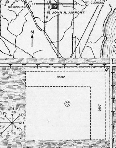
It described John R. Airport a commercial field consisting of a 200 acre square-shaped property having 2 sod runways, measuring 3,000' east/west & 2,600' north/south.
The owner & operated was listed as the Robert Anderson Company.
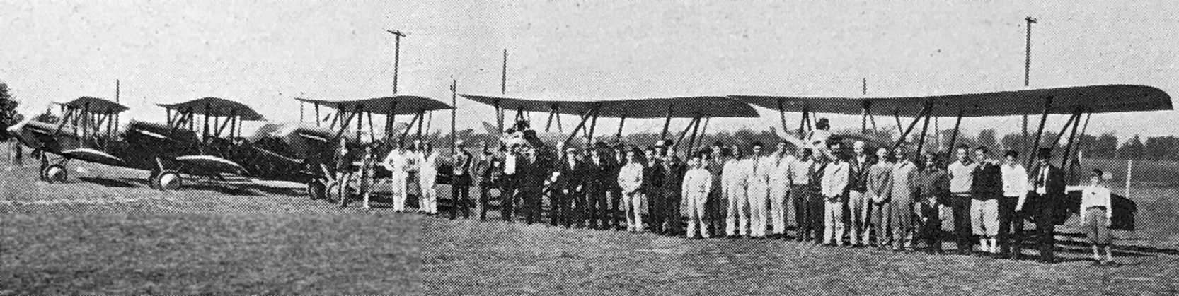
An undated photo from a November 1929 article (courtesy of Scott Schuyler) showing members, flying students, and instructors in front of their Eaglerock biplanes at John R. Airport,
all associated with the Detroit Eaglerock Sales Corporation & the Avian Flying Club of Detroit, which was noted to jointly operate the airport.
The John R. Airport was evidently closed (for reasons unknown) at some point between 1929-31,
because no airport at this location was depicted on the June 1931 Detroit Sectional Chart.
The John R. Airport was once again depicted on the August 1933 Detroit Sectional Chart (courtesy of Mike Denja).
Note that it was depicted somewhat further southwest than other depictions (adjacent to the town of Clawson).
Was this an error by the mapmakers, or did the airport operate in a different location?
John R. Airport was still depicted on the January 1935 Detroit Sectional Chart (according to Mike Denja).
John R. Airport was not depicted on the May 1945 Detroit Sectional Chart (according to Chris Kennedy).
Another phase of this airfield started in 1946, as the Big Beaver Airport was established in 1946 on the same location, with a 2,400' gravel runway.
It had originally been the John Main family farm, and Big Beaver Airport
was owned & operated by his surviving daughter, Anna Main, until her death.
The earliest depiction which has been located of Big Beaver Airport was on the July 1946 Detroit Sectional Chart (courtesy of Chris Kennedy).
It depicted Big Beaver Airport as an auxiliary airfield.
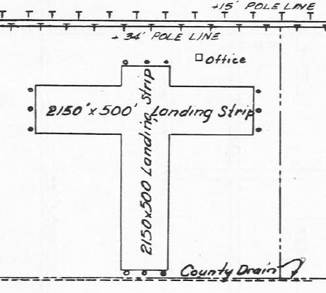
The 8/1/47 MI Airport Directory (courtesy of Mike Denja) depicted Big Beaver Airport as having 2 perpendicular 2,150' runways, with an office on the northeast side.
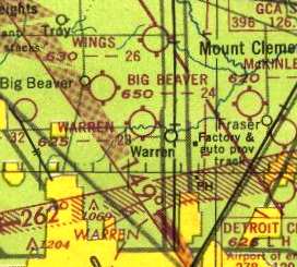
Big Beaver Airport, as depicted on the 1949 Detroit Sectional Chart (courtesy of Donald Felton).
The earliest photo which has been located of Big Beaver Airport was a 1949 aerial view (courtesy of Mike Denja),
which showed the field to have a single east/west runway.
A single hangar on the northeast side of the field was surrounded by about 15 light aircraft, and another aircraft was at the west end of the runway.

The earliest topo map depiction which has been located of Big Beaver Airport was on the 1952 USGS topo map (courtesy of Mike Denja).
It depicted Big Beaver Airport as having 2 unpaved runways with one building along the northeast side.
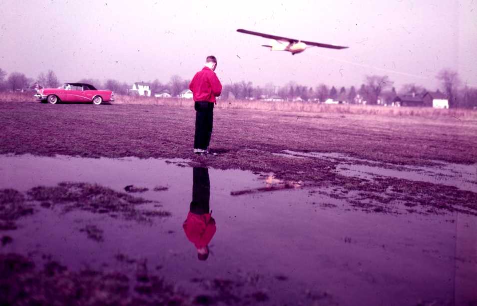
A circa 1950s photo of a unidentified glider being towed aloft at Big Beaver Airport.
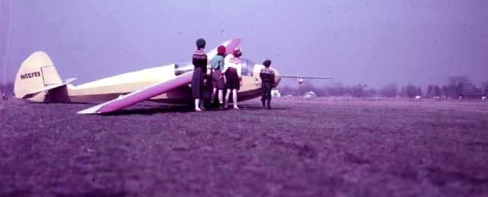
A circa 1950s photo of a a family in front of a unidentified glider, with another coming in to land, at Big Beaver Airport.
The 1962 AOPA Airport Directory described Big Beaver as having a 2,400' gravel Runway 9/27 & a 2,100' sod Runway 18/36,
and listed the operator as John Main.
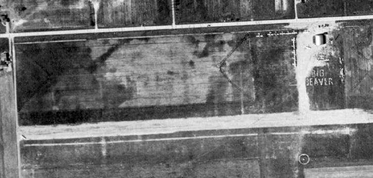
A 1964 aerial view depicted Big Beaver as having a gravel east/west runway & a grass north/south runway.
A single building was on the north side of the field.
A total of no less than 53 light aircraft were visible parked on the field.
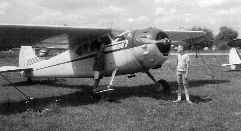
An August 1964 photo of Rich Connell admiring a Cessna 190 at Big Beaver Airport.
The July 1965 Detroit Local Aeronautical Chart depicted Big Beaver Airport as having a 2,400' unpaved runway.
Big Beaver was still depicted as having a 2,400' unpaved runway on the July 1969 Detroit Sectional Chart (courtesy of John Voss).
Jim Kerns recalled, “Big Beaver Airport... My brother learned to fly there in Anna's Champs (lowest cost rental in the Detroit area) back around 1970 -
at that time the airport still had the large Quonset-style hangar, a small brick 'office' building -
the size of one small room (small square shadow east of the hangar in the 1973 picture), and an outhouse (can't pick it out in the picture).
[Runway] 9/27 was paved, but we used to land on the grass along the south side of the runway parallel to the pavement.
It was still semi-rural out that way back in the late 1950s / early 1960s, but by 1970 development was happening all around that area.”
A 1973 aerial view showed Big Beaver to be a very well-used airport, with a total of 44 light aircraft parked on the north & south sides of the field.
Runway 9/27 had also been paved at some point between 1969-73. The grass crosswind runway appeared to still be maintained as well.
Jim Kerns recalled, “In the mid-1970s, my dad (Bob Kerns) had a Cessna 120 there that we all flew -
somehow he ended up designing a new hangar / office building with indoor plumbing that you can see in the 1977 photo. Quite an upgrade.
There was pretty tall building built a couple miles east about that time as well.
In the little [Cessna] 120 you couldn't climb fast enough in the summer to get over it so you had to make a bit of a jog around it.
The Beech 18 parked by Big Beaver Road... I only recall one being there - but the owner would come out each summer & polish a few square feet of it & quit.
The progress was so slow that where he had started would be back to dull before he ever finished.”
Big Beaver Airport had gained a paved runway (a single 2,400' east/west strip)
by the time of the 1976 Detroit Sectional Chart (courtesy of Mike Keefe).
The May 1977 Detroit Sectional Chart (courtesy of Mitchell Hymowitz) depicted Big Beaver Airport as having a single 2,400' paved east/west runway.
The 1980 USGS topo map depicted Big Beaver Airport as having a paved east/west runway.
The 1982 AOPA Airport Directory (courtesy of Ed Drury) described Big Beaver Airport
as having a 2,400' asphalt Runway 9/27 & a 2,100' sod Runway 18/36.
The operator was listed as Big Beaver Airport Inc.
Greg Srteinmayer recalled, "I used to work down the road from the former Big Beaver Airport from 1984-88,
and during that time there were 2 derelict Twin Beech's close to the road."
John Fordon recalled, “In 1986 I learned to fly at the Big Beaver Airport. This was a very special place.
I fondly remember Anna Main as a tough old cookie with a heart of gold.”
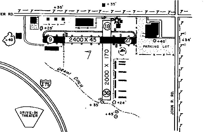
The 1987 MI Airport Directory (courtesy of William Willyard) depicted Big Beaver Airport
as having a 2,400' paved Runway 9/27 & a 2,000' unpaved Runway 18/36.
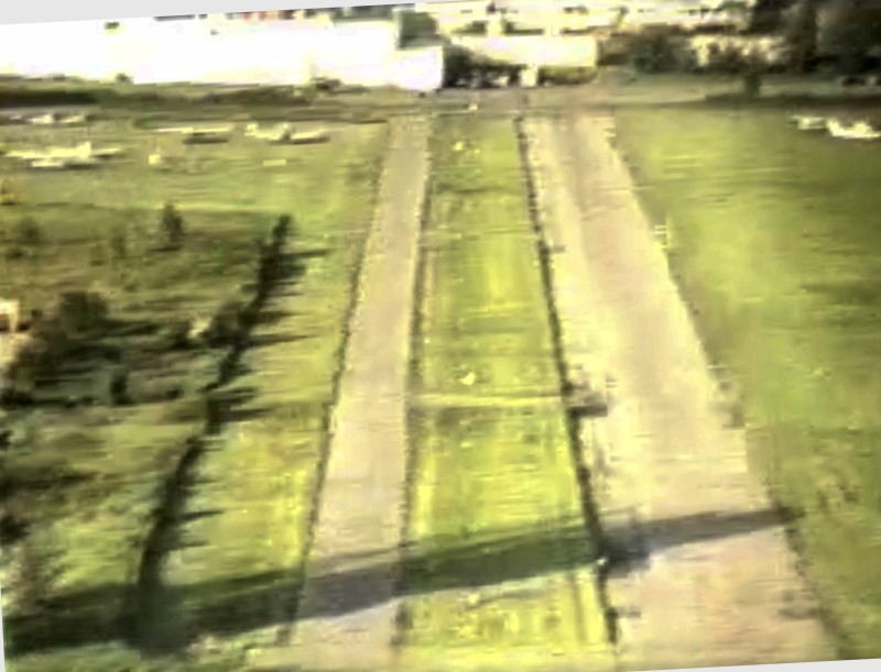
A still image from a 6/11/89 video by John Ellis looking east from final approach to Big Beaver Airport's Runway 9.
The last aeronautical chart depiction which has been located of Big Beaver Airport was on the October 1993 Detroit Sectional Chart (courtesy of Ron Plante).
It depicted Big Beaver Airport as having a single 2,400' paved east/west runway.
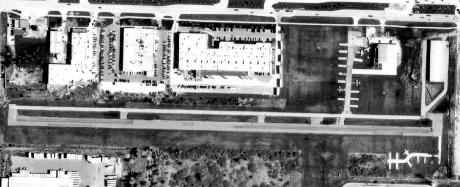
The last photo which has been located showing the Big Beaver Airport still in operation was a 1997 aerial view (courtesy of Mike Denja),
which depicted 5 single-engine aircraft still on the field, which was clearly on its last legs by that point.
John Ellis recalled, "I kept my Piper Tomahawk there until it closed.
After her brother died, Anna Main owned & operated the airport until her death & the airport closed.
She was never married & had no family but was somewhat of a legend to the fliers in the area.
The city constantly tried to close her airfield until an agreement was reached to let her maintain it until she died
and the field would have to close which is exactly what happened."
Big Beaver Airport reportedly closed in 1997.
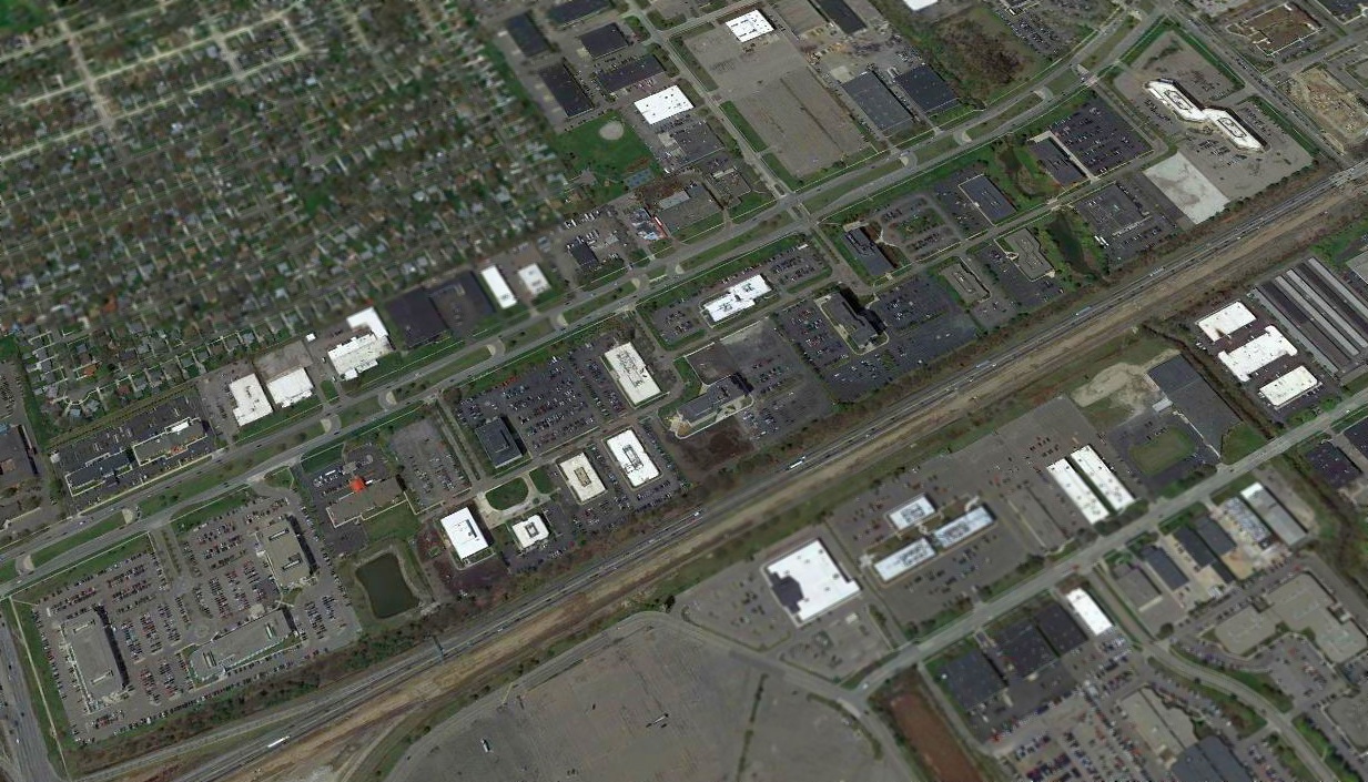
A 1999 USGS aerial photo showed that the runway had already been largely obliterated, with new buildings having been constructed on the site.
Greg Srteinmayer reported, “The Big Beaver Airport has been consumed by light industrial & office buildings."
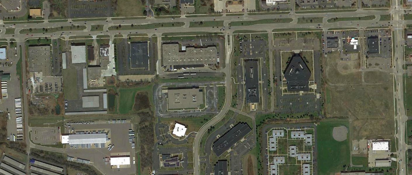
In 2017 aerial view, no trace of Big Beaver Airport was still recognizable.
The Big Beaver Airport was located southwest of the intersection of East Big Beaver Road & John R Road.
Thanks to Neil McNeight for pointing out Big Beaver Airport.
____________________________________________________
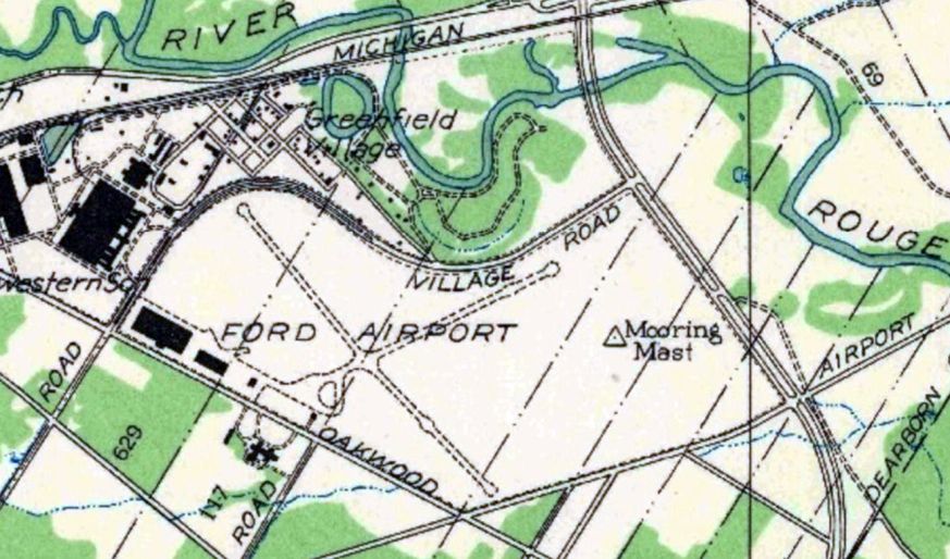
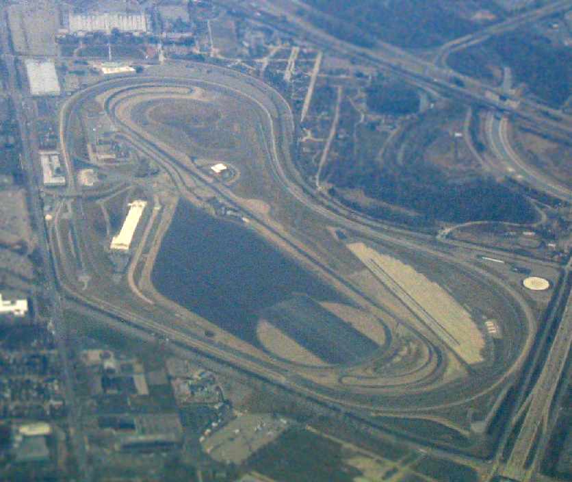
42.3, -83.22 (West of Detroit, MI)
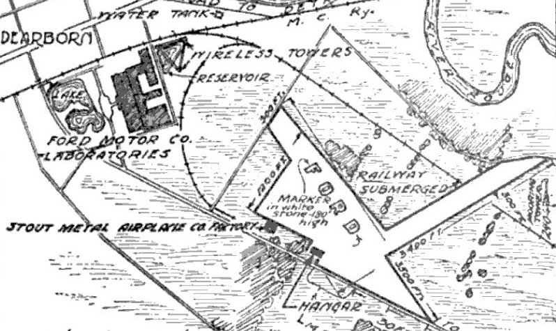
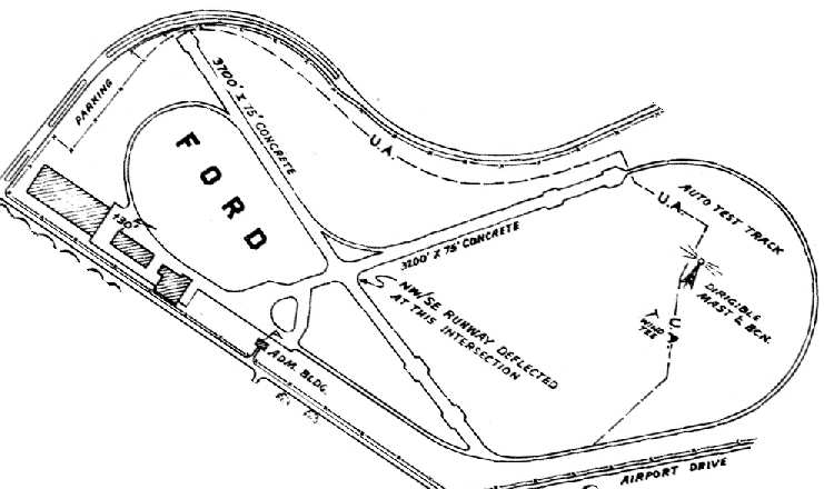
Ford Airport, as depicted on the 10/5/25 Commerce Department Airway Bulletin (courtesy of Mike Denja).
According to Michael Kuentz, Henry Ford became an investor in William Stout's airplane manufacturing firm, which built single-engine aircraft.
However, Ford was not happy with his investment, so in an attempt to control the company he bought into,
he had a 2nd Stout airplane factory built on the corner of Oakwood & Village Road.
The 20,000 square foot Stout Metal Airplane Company factory opened in 1924.
In 1925, the Ford Airport was dedicated, with 2 grass runways & flood lights for night landings.
It was widely touted as being the first "modern" airport in the world.
The airport was the first in the US to operate a regularly scheduled passenger airline in continuous domestic service,
with the Ford Air Transportation Service providing a route between between "Detroit" (Dearborn) & Chicago.
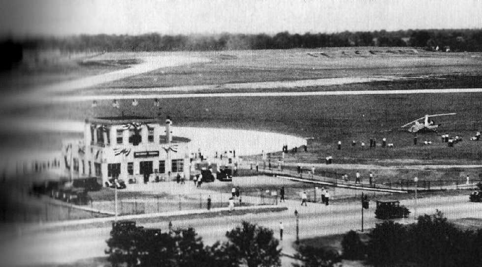
Ford Airport was also the first in the US to have an airline terminal for passenger use,
the first in the world to have a hotel (the Dearborn Inn) designed & built for the air traveler.
The Ford Motor Company Airplane Division manufactured aircraft at this location starting in 1925.
The earliest depiction which has been located of Ford Airport was in the 10/5/25 Commerce Department Airway Bulletin (courtesy of Mike Denja).
It depicted Ford Airport as having 2 runways, measuring 3,500' northwest/southeast & 3,400' northeast/southwest,
with a hangar & the Stout Metal Airplane Company Factory on the southwest side.
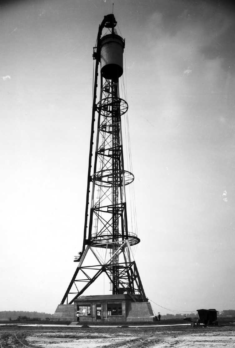
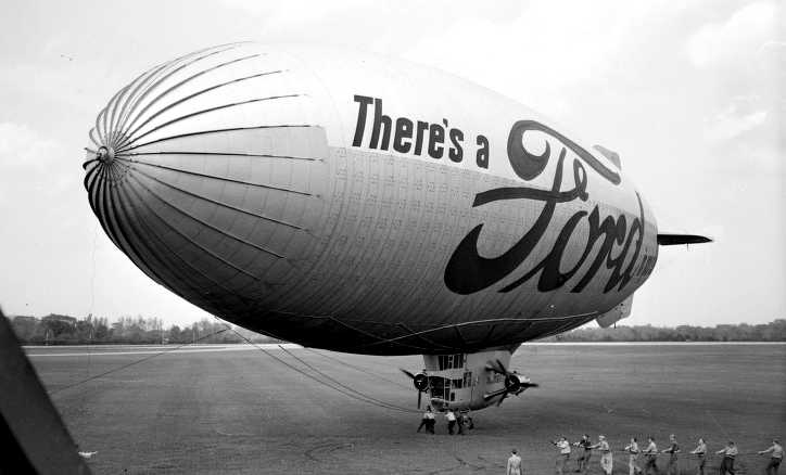
Henry Ford erected the largest, most modern & only privately-owned permanent dirigible mooring mast in 1925 at Ford Airport.
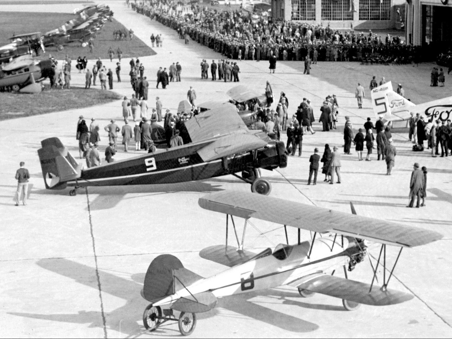
From 1925-31 the Annual National Air Tour (to demonstrate safety & reliability of commercial aviation) started & ended at Ford Airport.
The earliest photo which has been located of Ford Airport was a circa 1925-26 photo of the ungainly Stout 3-AT C/n 3-AT-1.
In 1926 Ford Airport operated the world's 1st flight of a commercial airliner guided by radio, using system developed by Ford Motor Company.
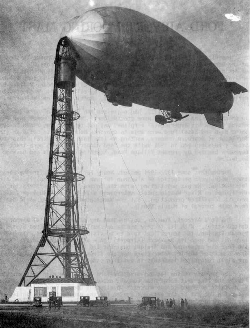
A 9/18/26 photo of the first airship to moor at Ford Airport, the Army's RS-1 (courtesy of Mike Denja)..
A circa 1920s view of Ford Airport's dirigible mooring mast (from Wayne State University's Virtual Detroit website, via Mike Denja).
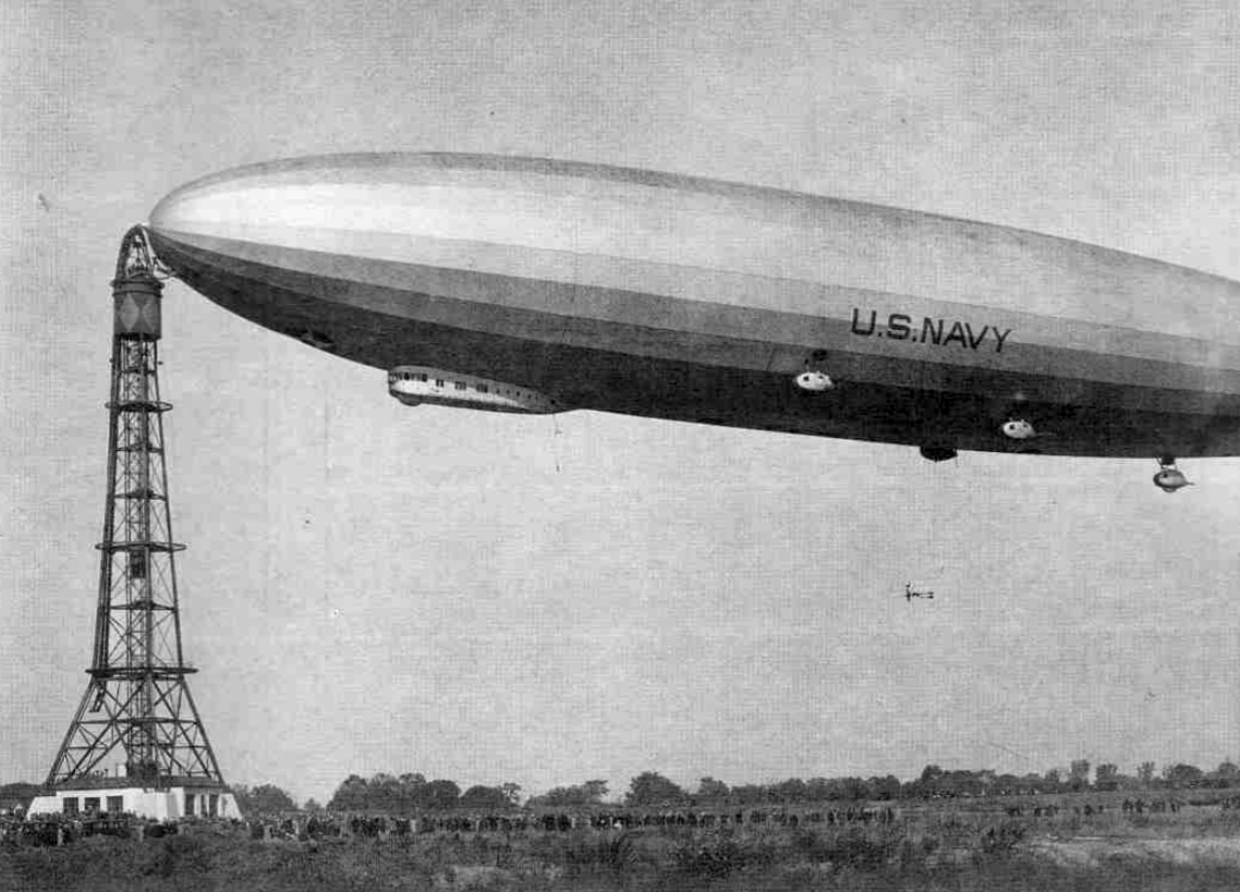
A 10/15/26 photo of the airship Los Angeles moored at the Ford Airport mooring mast (courtesy of Mike Denja).
The was only the 2nd & last time that Ford Airport's dirigible mast was ever used.
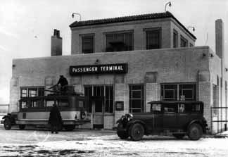
A 1926 photo of the passenger terminal at Ford Airport.
According to Michael Kuentz, Stout aircraft had a poor flight record, suffering many crashes.
Ford was losing money rapidly,
and on the night of 1/27/26 a fire mysteriously started in the all-brick & steel plant, destroying the building.
Shortly after the fire Henry sent Bill Stout on a nation-wide public relations tour
and then contracted with Albert Kahn to design & build 2 new buildings -
one a new 62,000 square-foot Ford Tri-Motor airplane factory,
and the other, the world's first airport hotel (The Dearborn Inn).
Shortly after Bill Stout left for his PR tour, Henry was overheard telling one of his executives,
"For the first time in my life I have bought a lemon, and I don’t want the world to know about it", in regards to the puzzling fire.
Never again would the Stout name appear on an airplane factory.
Eventually Henry Ford bought out William Stout & turned his transportation company into Ford Air Transport.
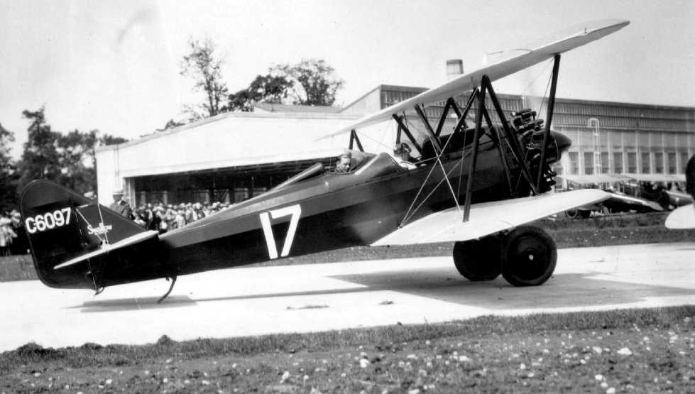
A circa 1927 photo by Nick Kankula (courtesy of Paul Kankula) of a Swallow with a J-5 engine at an airshow at Ford Airport.
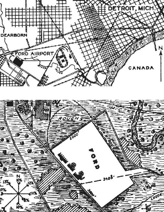
The location & layout of Ford Airport, as depicted on a 1927 Department of Commerce Airway Bulletin (courtesy of David Brooks).
The Bulletin described Ford Airport as a 600 acre irregularly-shaped property with the longest dimension being 3,500' northwest/southeast.
A row of buildings were depicted along the southwest side.
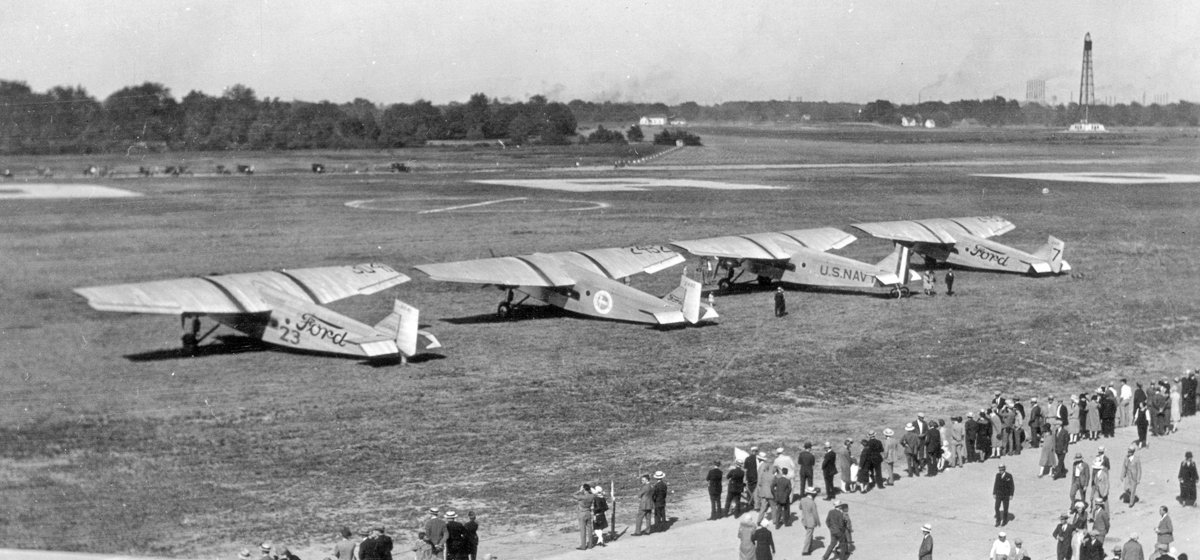
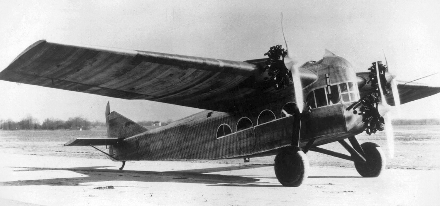
A photo of 4 Ford Trimotors at Ford Airport on or near the 6/27/27 start of the 1927 Ford National Reliability Air Tour.
From left to right, the 4 Trimotors were: NC3041, the 3rd 4-AT-A built, which went to the Ford Air Transport Service,
NC2492, the 6th 4-AT-A, which was used by Standard Oil of IN as a company transport,
A-7526, the 4th 4-AT-A Trimotor, built as a demonstrator for the U.S. Navy & assigned Navy model number XJR-1 & Bureau # A-7526,
and NC2435, the 1st Ford Trimotor, serial # 4-AT-1.

The Royal Typewriter Company bought this early Tri-Motor to deliver its typewriters to distributors, with the alleged intention to drop them by parachute, but the aircraft was sold to Stout Air Services within a few months.
From 1928-29 Ford Airport's grass runways were paved – giving the field the 1st concrete runways in the world.
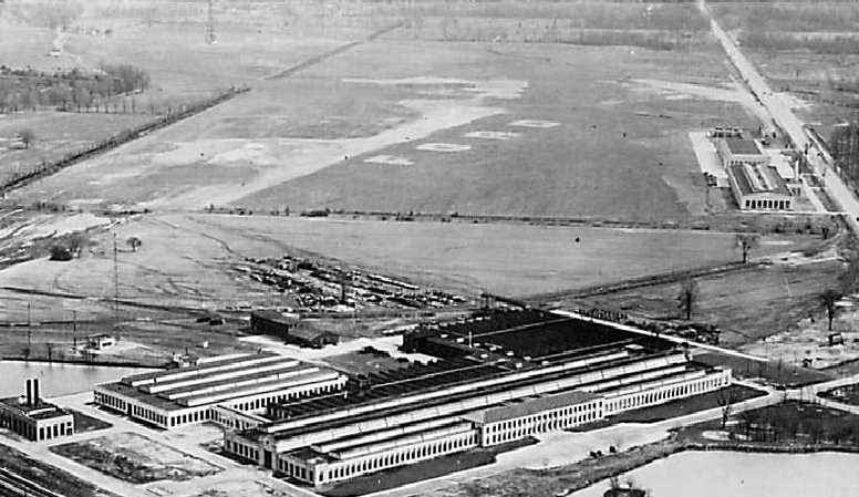
A circa 1920s aerial view looking east at the Ford engineering labs in the foreground, with the Ford Airport & hangars behind.
A circa 1920s/30s aerial view looking north at the Ford Airport terminal, showing an autogiro on the right (courtesy of Jonathan Westerling).
A 9/27/30 photo of an airshow at Ford Airport (courtesy of Mike Denja).
The aircraft at bottom is Rearwin 2000-CO Ken Royce NC400V C/n 104, a 3-seat touring biplane.
The aircraft at center is Curtiss 55 Kingbird D-2 NC589N, a twin-engine monoplane flown by Walter Beech, Curtiss VP.
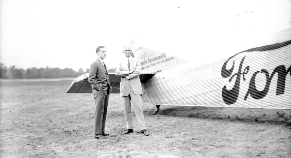
A circa 1930 photo of Edsel & Henry Ford with the "Maiden Dearborn II" Ford Tri-Motor at the Ford Airport.
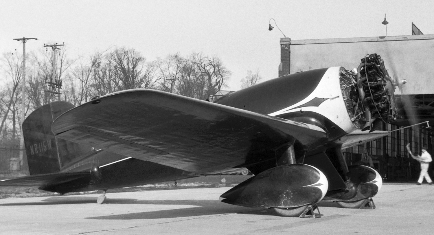
An April-June 1931 photo of Lockheed 8A Sirius NR115W C/n 166 at Ford Airport.
A 1931 aerial view looking northwest at Ford Airport.
According to the MI Historical Marker website, Henry Ford built the Dearborn Inn (opening in 1931) to accommodate overnight travelers arriving at the Ford Airport.
Located opposite of the airport along Oakwood Boulevard, the 179-room inn was the world's first airport hotel.
The guest quarters along Pilots Row originally were used by the airlines' crews.
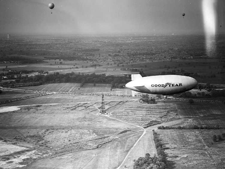
A 7/25/31 view of a Goodyear Blimp over Ford Airport's dirigible mast (from Wayne State University's Virtual Detroit website, via Mike Denja).
Note also the 3 balloons visible at the top of the photo.
The earliest aeronautical chart depiction which has been located of Ford Airport was on the June 1931 Detroit Sectional Chart.
Note the blimp mooring mast symbol.
According to the Dearborn Historian (courtesy of Karen Wisniewski), “Henry Ford's interest in aviation waned in the early 1930s.
The last flight of the Ford Air Transportation Service was in 1932. The field was used sporadically for local flights after this for the next decade & a half.”
Unfortunately, Henry Ford lost more than $10 million on his airplane division, which closed in 1933.
A total of 199 Ford Tri-Motors were eventually built at the Dearborn facility.
The Tri-Motor was the 1st American all-metal, multi-engine, commercial airliner.
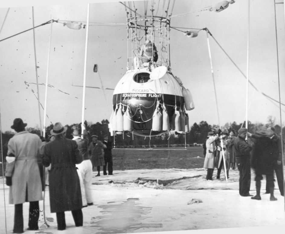
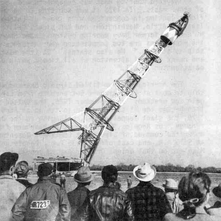
A 10/23/34 photo (courtesy of Mike Denja) of husband & wife balloon pioneer aviators Jean & Jeannette Piccard
during their takeoff from Ford Airport on a record-setting flight to an altitude of 57,579', almost 11 miles up.
The Piccards’ intention was to reach the stratosphere, both to set an altitude record & to collect scientific data.
Jeanette set the women’s altitude record which held for almost 30 years.
As the Piccards’ pet turtle was also along for the ride, it is likely that it also set the unofficial altitude record for turtles or reptiles of any kind.
They had been training at the airport where Jeannette, the pilot of the craft, worked to become the first licensed female balloon pilot in the U.S.
Henry Ford even allowed them to use his hangar.
The earliest topo map depiction which has been located of Ford Airport was on the 1936 USGS topo map (courtesy of Mike Denja).
It depicted Ford Airport as having 2 unpaved runways, several buildings along the southwest side, and the Mooring Mast on the east side.
In 1938 the 1st automobile test track was laid down on the Ford Airport property.
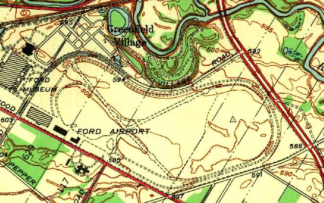
The 1942 USGS topo map (courtesy of Mike Denja) depicted the test track having been built around Ford Airport's 2 runways.
In contrast to the 1936 topo map, the Mooring Mast symbol was still shown, but no longer labeled.
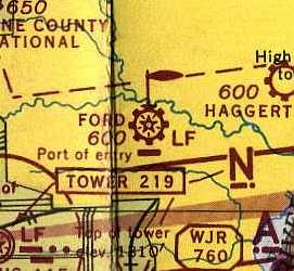
The October 1943 Detroit Sectional Chart (courtesy of Mike Keefe) depicted Ford Airport & its blimp mooring mast.
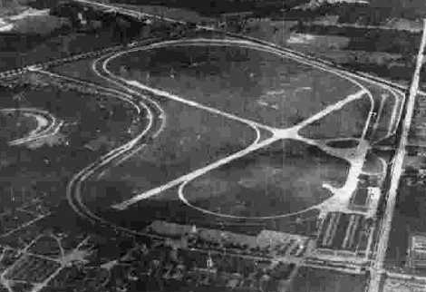
The last photo which has been located showing Ford Airport overall while in operation
was a 10/10/43 aerial view looking east from the 1945 AAF Airfield Directory (courtesy of Scott Murdock).
It depicted the field as having 2 concrete runways within the test track.
The 1945 AAF Airfield Directory (courtesy of Scott Murdock) described Ford Airport
as a 300 acre irregularly-shaped property having 2 concrete runways, measuring 3,700' northwest/southeast & 3,200' northeast/southwest.
The field was said to have a single 354' x 116' steel, brick & concrete hangar,
and to be owned & operated by private interests.
Ford Airport was still depicted as an active private airfield in the 1946 MI Airport Directory (courtesy of Doug Ranz).
It was depicted as having 2 concrete runways (3,700' & 3,200').
By this point, the airport had been converted to simultaneously serve as an automobile testing ground,
with an automobile test track extending beyond the runways.
A 10/26/46 photo of spectators watching the demolition of Ford Airport's dirigible mooring mast (courtesy of Mike Denja).
Henry Ford witnessed the demolition while sitting in a car.
The last photo which has been located showing an aircraft at Ford Airport
was a circa 1940s photo of a blimp being moored at Ford Airport (from Wayne State University's Virtual Detroit website, via Mike Denja).
Note that this blimp appears to be a military surplus K-type airship reused for civilian purposes after WW2.
A 10/21/47 press release issued by Ford Motor Company President Ernest Breech announced the closing of Ford Airport.
The reasons given were the need for expanding engineering operations
and secondarily the need for basing company aircraft at a field better equipped with traffic control facilities,
longer runways & lighting needed for modern, high-performance aircraft.
Thus Ford Airport became history & the Dearborn Automotive Proving Grounds took its place
By the time of the 1948 Detroit Sectional Chart (according to Chris Kennedy), Ford Airport was no longer depicted.
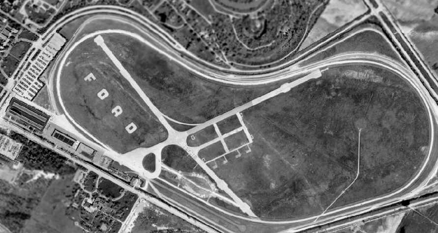
Ford Airport was shown only 2 years after it was closed, in a 1949 aerial photo (courtesy of Mike Denja).
Both paved runways remained intact, and note the lettering “Closed X Airport” which was barely discernible on the middle of the former northwest/southeast runway.
A number of paved aircraft parking spots were located just east of the runway intersection, and the circular clearing for the former dirigible mooring mast was still visible on the east end of the field.
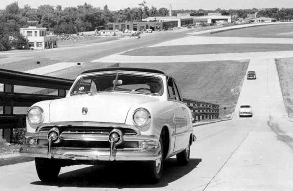
A circa 1951 photo of a new 1951 Ford convertible climbing the carburetor grade at the Dearborn Proving Grounds, as it was then called.
Above & behind the car in the photo are the old Ford Airport passenger terminal & hangars.

A 6/1/51 USGS aerial view still showed the “Closed X Airport” lettering on the former Ford Airport northwest/southeast runway.
A number of paved aircraft parking spots were located just east of the runway intersection, and the circular clearing for the former dirigible mooring mast was still visible on the east end of the field.
According to the Dearborn Historian (courtesy of Karen Wisniewski), “The old passenger terminal was finally demolished 4/11/61.”
Tom Korzeniowsk recalled, “The old Ford Airport... the DC-3 that currently resides in the museum there
actually flew into that airport in 1975 or 1976 after North Central Airlines donated the aircraft.
I recall it made a low pass, then fired the JATO bottles attached to it.
I was a TV reporter for WJBK-TV at the time and covered that story.
After languishing outdoors at the museum for years, the plane was repainted in Northwest Airlines livery & brought indoors, where it currently resides.”
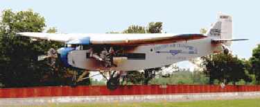
A 6/9/03 photo of a 1929 Ford Tri-Motor which landed at Ford Airport for the Ford 100 Year Anniversary Celebration (courtesy of Greg Steinmayer).
Five vintage airplanes (including 2 Ford Tri-Motors) landed at the former Ford Airport.
It was the first time in 56 years the test track had been used as an airport.
The planes were part of the "Taking Flight: Ford's History in Aviation" exhibit,
which was one facet of Ford Motor Company's 100th anniversary celebration.
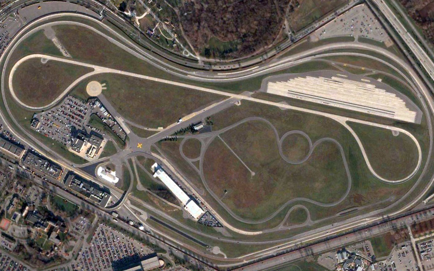
A 2004 aerial photo showed the remains of 2 paved runways of the former Ford Airport were still discernible in the middle of the auto proving grounds.
Along the south end of the former airfield, the building farthest to the left is a Ford Engineering facility that was built in part of the old Ford Airplane Factory.
Looking at it today you could never tell what it was in a former life.
Moving to the right, the next small building is all that remains of the powerhouse for the former Ford Airplane Factory.
Today this building houses garages for prepping cars for the test track.
The next building to the right is a 123' x 300' sandstone & steel hangar,
where the first Ford Tri-motors were first assembled while the big factory was still being built.
The hangar was later used to house the Ford Tri-Motor airplanes. It still exists today but houses a small wind tunnel for experimental vehicles.
To the south of this hangar is the Dearborn Inn. The 4th building moving to the right was built back in the 1970s & is another testing facility.
Located north of the 3rd & 4th buildings is a small structure that has been heavily added onto - the former Ford Airport passenger terminal.
Just beyond that is a concrete circle where the dirigible mast used to be.
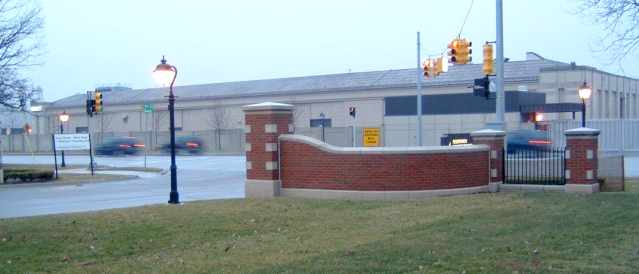
A 2004 photo by Greg Steinmayer "of the original Ford Airport hangars which still exist,
complete right down to their huge glass sliding doors (now painted over).
The building is now used for 'Experimental Engines' by the Ford Motor Company."
Greg Steinmayer continued, "The original Ford hangars, complete right down to the original hangar doors,
still exist on the Southwest side of the former airfield (along Oakwood Boulevard).
They are currently used as testing labs.
Directly across from the hangars is the Dearborn Inn, constructed as the worlds first specific airport hotel.
It is still in operation as the premier hotel in Dearborn."
Greg Steinmayer reported in 2005, “Ford Airport, which became the Ford Proving Grounds, is no more.
Ford has completely restructured the proving grounds & eliminated all traces of the former runways,
which were still extant as part of the proving ground's roadway system.
My brother, who works at Ford nearby, confirms that the former runways are at least covered, if not gone altogether.”
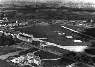
A March 2006 aerial view by Paul Freeman looking northwest at the Ford Airport site.
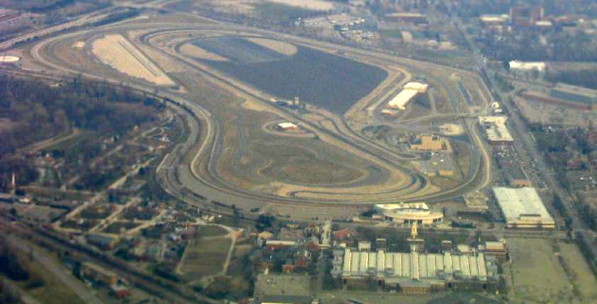
A March 2006 aerial view by Paul Freeman looking southeast at the Ford Airport site.
According to Greg Steinmayer, a 2016 article reported that “the Ford Motor Company is beginning a big renovation of its 'campus' in Dearborn,
and it began by demolishing what was Wind Tunnel Lab # 1 which had originally been the Ford Airport Terminal, the first airport passenger terminal in the country.
According to the article, it bore no reminders of its original purpose except for 2 ticket windows & a sign, which were turned over to the Henry Ford Museum.”
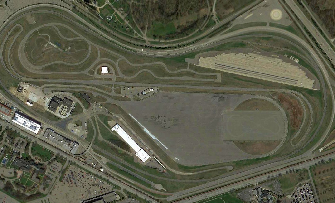
A 2017 aerial photo of the Ford Proving Grounds showed almost no recognizable trace of the former Ford Airport.
According to a Ford document, “On 3/5/18 demolition will commence at the Experimental Engine Building”, which is evidently the last remaining hangar.
Thus eliminating the last vestige of Ford Airport.
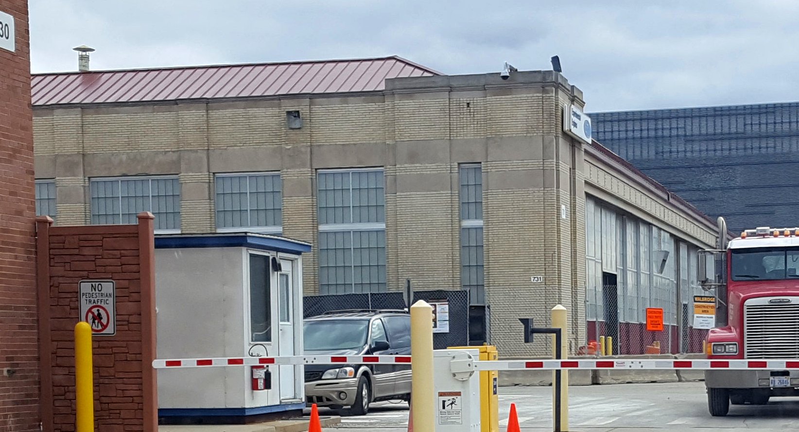
A 3/10/18 photo by Greg Steinmayer of the Ford Experimental Engine Building, the last remaining Ford Airport hangar.
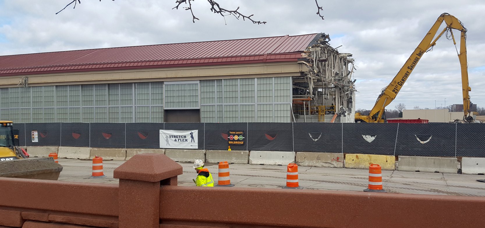
A 3/10/18 photo by Greg Steinmayer of the demolition of the Ford Experimental Engine Building, the last remaining Ford Airport hangar.
Greg reported on 3/15/18, “As of yesterday, only a small portion of the main hangar of the Ford Airport remains, and by tomorrow it will all be gone.
Of everything, only the world's first airport hotel, The Dearborn Inn across the street, remains.”
Greg Steinmayer reported in 2018, “The Ford Airport lives on - in a small way.
The new building at the Ford proving grounds (former Ford Airport) that replaced the original Ford Airport passenger terminal...
they saved & reused some of the original doors & windows from the terminal in the new building, as accent pieces.”
The Ford Airport site is located north of the intersection of Oakwood Boulevard & Rotunda Drive.
The Henry Ford Museum is adjacent to the airport site.
Another airfield which is currently operated as a Ford proving ground is Yucca AAF, AZ.
____________________________________________________
Or if you prefer to contact me directly concerning a contribution (for a mailing address to send a check),
please contact me at: paulandterryfreeman@gmail.com
If you enjoy this web site, please support it with a financial contribution.
____________________________________________________
This site covers airfields in all 50 states.