
Abandoned & Little-Known Airfields:
Minnesota: Minneapolis / St. Paul area
© 2002, © 2026 by Paul Freeman. Revised 1/16/26.
This site covers airfields in all 50 states: Click here for the site's main menu.
Sponsored by: “Find Trusted Home Builders in MN”
____________________________________________________
Please consider a financial contribution to support the continued growth & operation of this site.
Anoka Flying Service Airport (revised 1/7/23) - Anoka Industrial Airport / Gateway North Industrial Airport (revised 11/1/19) - Belle Plaine Airport / A.R.S. Sport Strip (revised 11/13/24)
Curtiss Northwest Airport / Curtiss Field / Curtiss Twin City Airport (added 12/5/14) - Holcomb Airport / Robbinsdale Airport (revised 1/16/26)
Northern Pump Airfield (revised 12/12/15) - Northport Airport / White Bear Airport (revised 9/2/22) - Parker Airfield / St. Paul Park Airport (revised 1/16/26)
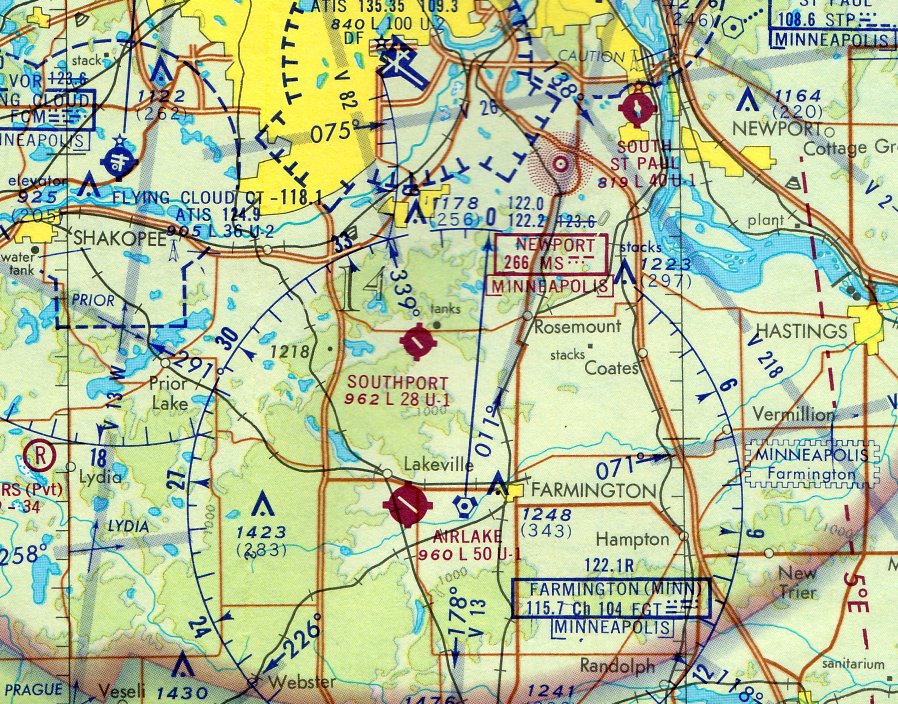
St. Cloud Airport / Whitney Memorial Airport (revised 1/7/23) - Southport Airport (revised 10/31/21) - University of Minnesota Airport (revised 8/9/20) - Victory Airport (revised 9/13/19)
____________________________________________________
Belle Plaine Airport / A.R.S. Sport Strip (7Y7), Belle Plaine, MN
44.659, -93.779 (Southwest of Minneapolis, MN)
Belle Plaine Airport, as depicted on the 1969 Twin Cities Sectional Chart.
Photo of airport while in use has not been located.
This small general aviation airport southwest of Minneapolis was evidently established at some point between 1965-69,
as it was not yet depicted on a 1957 aerial photo or the 1965 Twin Cities Sectional Chart.
The earliest depiction which has been located of Belle Plaine Airport was on the 1969 Twin Cities Sectional Chart.
It depicted Belle Plaine Airport as having a 2,500' unpaved runway.
The earliest photo which has been located of Belle Plaine Airport was a 1975 aerial view.
It depicted Belle Plaine Airport as having a single north/south unpaved runway, with a taxiway leading to 2 hangars to the northwest.

The earliest topo map depiction which has been located of Belle Plaine Airport was on the 1979 USGS topo map.
A 1984 aerial photo showed Belle Plaine Airport's 2 hangars were removed at some point between 1975-84.

The 1985 USGS topo map depicted Belle Plaine Airport as having a single north/south runway.
A flight instructor recalled, “It was a very nice grass runway, relatively smooth, even in the winter, when conditions were dry enough to allow operations.
I took my Private Pilot checkride from an examiner at nearby Flying Cloud Airport in the (very dry) winter of 1981.
We 'diverted' into Belle Plaine & I demonstrated my short- & soft-field proficiency there.
Mid-1985 through early 1987 I was employed as a full-time flight instructor at Flying Cloud Airport & took all my private pilot students into Belle Plaine on a regular basis;
they all loved flying into & out of a grass airport & it also afforded uncontrolled airport procedures practice.”
Belle Plaine Airport was evidently renamed “A.R.S. Sport Strip” at some point between 1985-94,
as that is how it was labeled on the 1994 Twin Cities Sectional Chart, with a 2,500' unpaved runway.
A flight instructor recalled, “I remember seeing about [2009-2014] pictures of a Cessna 152 which attempted a landing there when the runway was too soft (wet) for operations.
The nosewheel dug in on landing & the plane endured a prop-strike, with some pretty serious damage forward of the firewall.
Neither the instructor or her student were hurt, but the plane might have been a write-off. I've often wondered if that accident played a part in the airport closing.
It's a shame that it closed; Flying Cloud is still a very busy training airport & Belle Plaine / A.R.S. would still be a useful training field.”

The earliest photo which is available of Belle Plaine Airport was a 1991 aerial view looking southeast.
It depicted Belle Plaine Airport's runway as remaining intact, but there were no hangars or aircraft on the field.
Mark McClure recalled, “Belle Plaine Airport was a public-use/privately-owned airport owned by James Drometer & his partner Dianna Minar.
Jim was a Airframe & Powerplant Mechanic & Authorization Inspector. I brought my J3 there for 10 years [2006-2016] for maintenance & annuals.”

A 2016 photo by Mark McClure of a Cessna 152 that had lost its nosewheel in a soft-field accident at Belle Plaine Airport.

A 2016 photo by Mark McClure of a Ford Model A & Mark's Piper J3 Cub inside a hangar at Belle Plaine Airport.

A 2016 photo by Mark McClure of a formidable-looking airport dog standing watch over Belle Plaine Airport.
Mark McClure recalled, “Belle Plaine Airport owner James Drometer passed away in 2016.”

The last aeronautical chart depiction which has been located of A.R.S. Sport Strip was on the 2018 Twin Cities Sectional Chart.
It depicted “A R S” as having a 2,500' unpaved runway.
Mark McClure recalled, “Dianna did not want to continue maintaining the runway so it was officially closed in 2019.”
A.R.S. Sport Strip was no longer depicted on the 2019 Twin Cities Sectional Chart.

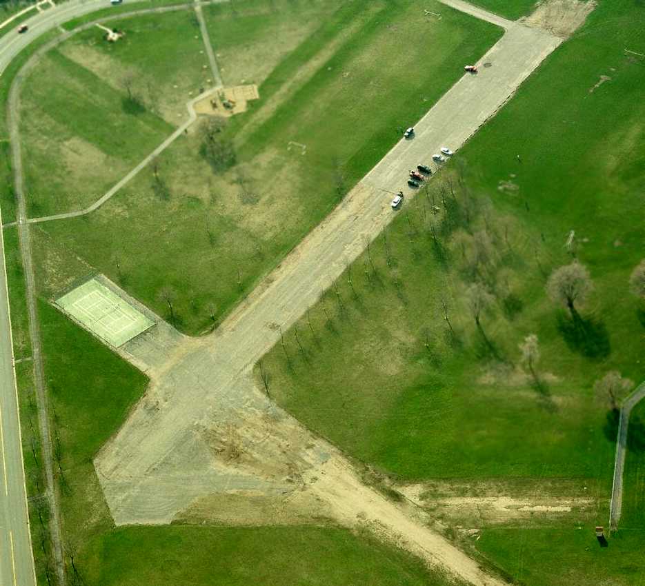
A 2023 aerial view looking southeast showed A.R.S. Sport Strip's runway to remain clear, but with no sign of any aviation usage.
Mark McClure reported in 2024, “The house in the picture still operates an airplane out of that hangar.”
____________________________________________________
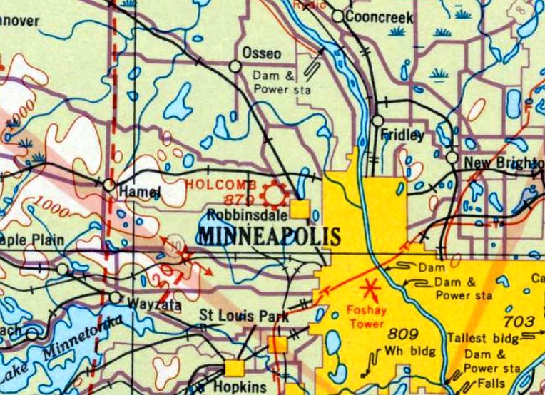
Holcomb Airport / Robbinsdale Airport, Robbinsdale, MN
45.043, -93.353 (Northwest of Minneapolis, MN)
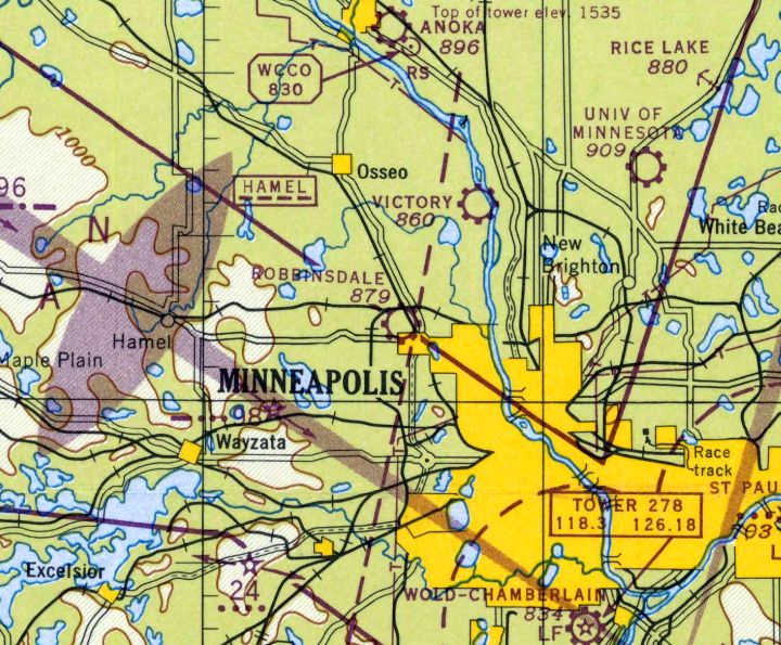
Holcomb Airport, as depicted on the November 1934 Twin Cities Sectional Chart.
According to the Robbinsdale Historical Society, “The Robbinsdale Airport opened in 1920.
On 1/8/27 a hangar caught fire & burned 6 planes at the Robbinsdale Airport.
Volunteer firemen were called out from Robbinsdale & Crystal Village. Damages were estimated at $25,000.
Lack of a water supply forced the fireman to form a bucket brigade. They only managed to save one plane.
Four of the planes that burned up belonged to the head of the airport, Marvin Northrup. Repairs were completed in March.
In May, the airport hosted a high flying circus. The featured dare-devil Al Blackstone was renown for over 600 parachute jumps
with no more damage than a few broken ribs, a shattered ankle & some broken teeth.
The event was held to raise funds for the MN Municipal Auditorium organ.
In October, Robbinsdale Flyer Gene Shank won the Minnesota State Air Derby in Grove City. Shank flew the 65 mile course in just under 47 minutes.”
The earliest aeronautical chart depiction which has been located of the airport in Robbinsdale was on the November 1934 Twin Cities Sectional Chart.
It depicted it as Holcomb Airport.
The last aeronautical chart depiction which has been located of Holcomb Airport was on the October 1936 Twin Cities Sectional Chart.
Holcomb Airport evidently closed (presumably due to the effects of the Depression) at some point between 1936-37,
as it was no longer depicted on the November 1937 Twin Cities Sectional Chart.
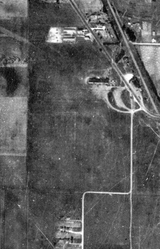
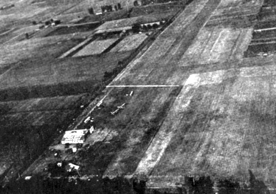
The earliest photo which has been located of Robbinsdale Airport was a 9/12/37 aerial view (courtesy of Chris Sorenson),
which depicted a few small hangars on the east side of an irregularly-shaped grass airfield.
Holcomb Airport still was not depicted on the July 1941 Twin Cities Sectional Chart.
According to the Robbinsdale Historical Society, civilian flying at Robbinsdale Airport was halted during World War II.”
Holcomb Airport was evidently reopened as Robbinsdale Airport at some point between 1941-42,
as that is how it was labeled on the July 1942 Twin Cities Sectional Chart.
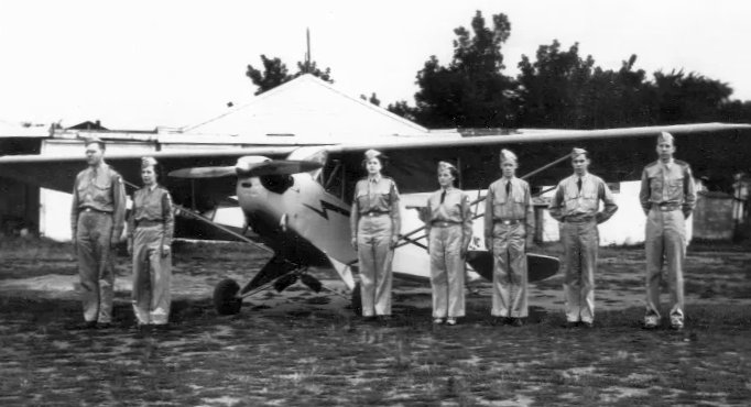
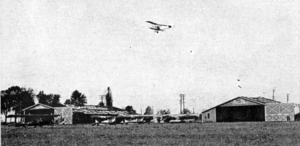
A circa 1942-44 photo of Civil Air Patrol members in front of a Piper Cub & a hangar at Robbinsdale Airport.
According to the Robbinsdale Historical Society, “In 1942, the 40 fliers & 25 ground crewmen & women of Robbinsdale’s Civil Air Patrol, part the MN State Guard,
completed a 230 hour ground school in basic & specialized training at the Robbinsdale Airport.
The Robbinsdale squadron had 23 planes, all 50-75 horsepower 2-seat Cubs.
They could fly as fast as 100 MPH & as slow as 60; the slower speed was of high value for scouting.
Their ceilings averaged around 13,000', but private pilots were restricted to altitudes below 3,500' unless they carried 2-way radios.
The fliers were all volunteer without compensation of any kind; they furnished their own planes, services, gas & oil.”
The last photo which is available showing Robbinsdale Airport while in operation was a 1945 aerial view (courtesy of Chris Sorenson).
It depicted no less than 20 light single-engine aircraft (possibly of the Civilian Pilot Training program?) parked on the east side near several small hangars.
The last aeronautical chart depiction which has been located of Robbinsdale Airport was on the December 1947 Twin Cities Sectional Chart.
It depicted Robinsdale as a commercial/municipal airport.
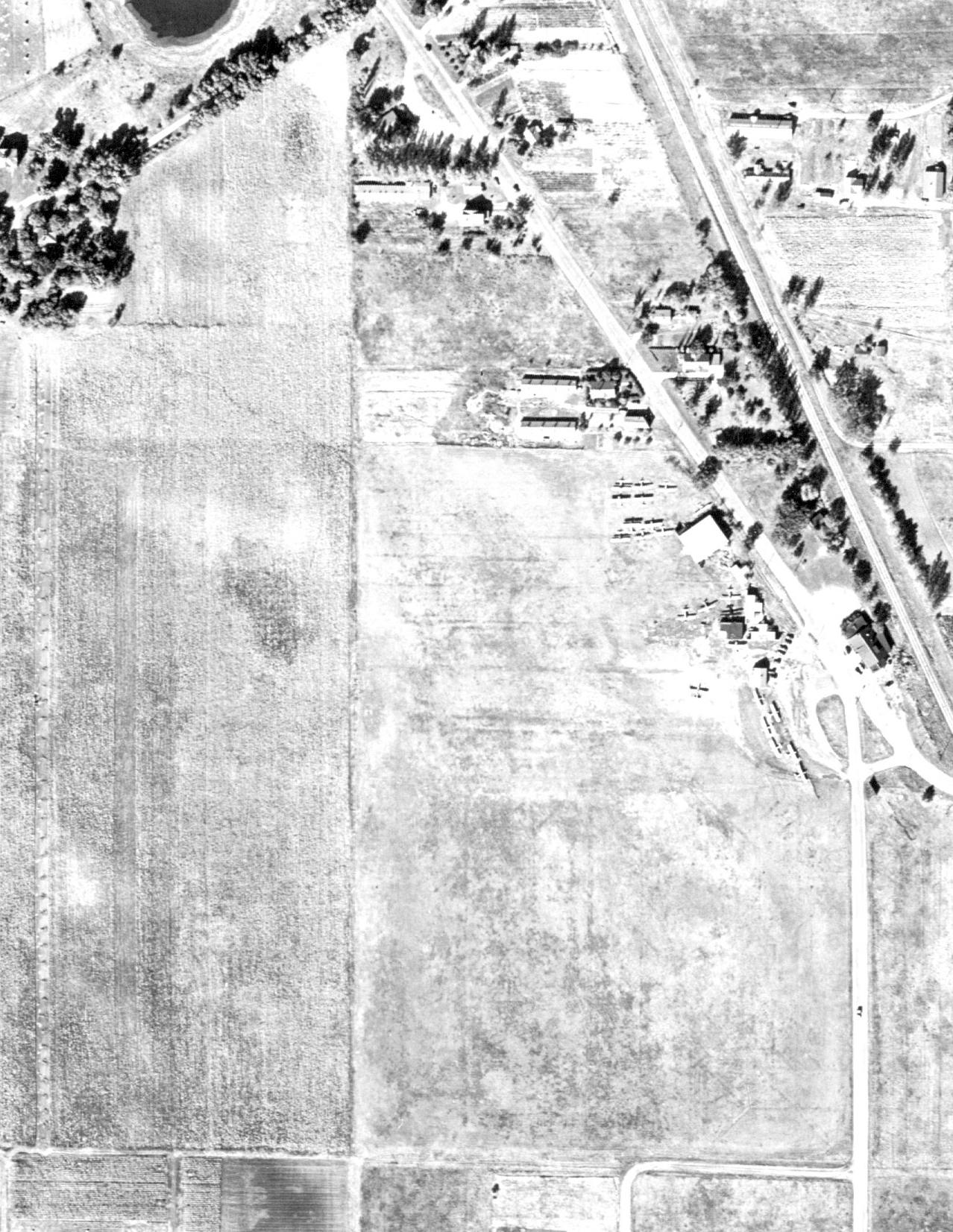
A 1947 aerial view depicted 15 light single-engine aircraft parked on the east side of Robbinsdale Airport.
According to David West, “Robbinsdale Airport was in operation until the middle-1940s.
The boundary was West Broadway on the east. The other boundaries were what would later be 45th Avenue North on the south & Brunswick Avenue North on the west.
Planes were stored on the east side near where West Broadway doglegs over the railroad tracks.
Robbinsdale Airport was closed before Crystal Airport opened.
Apparently some planes were stored at the Robbinsdale field until they could be moved when Crystal finally opened.”
Robbinsdale Airport was evidently closed at some point between 1947-48, no longer depicted on the June 1948 Twin Cities Sectional Chart.
A 1956 aerial view (courtesy of Chrus Sorenson) showed houses covering most of the Robbinsdale Airport site.
A 1966 aerial view showed that one former hangar remained standing on the east side of the Robbinsdale Airport site.
A 1972 aerial view showed the former hangar had been removed at some point between 1966-72, erasing the last trace of Robbinsdale Airport.
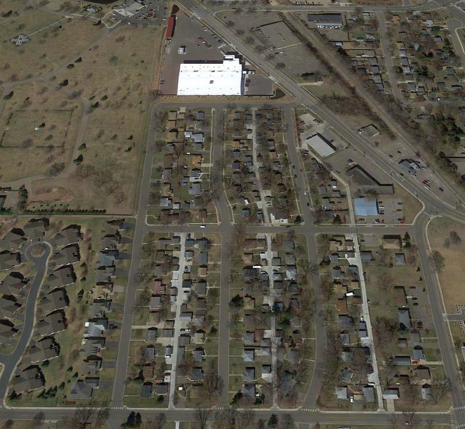
A 2017 aerial view looking north showed no trace remaining of Robbinsdale Airport.
Thanks to David West for pointing out this airfield.
____________________________________________________
Curtiss Northwest Airport / Curtiss Field / Curtiss Twin City Airport, Falcon Heights, MN
44.99 ,-93.161 (Northwest of St. Paul, MN)
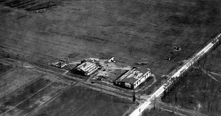
An undated aerial view of Curtiss Northwest Airport from the 1922 Curtiss Northwest Airplane Company brochure “Our Airport” (courtesy of Tom Heitzman).
According to an article in the 2/7/09 Pioneer Press, Curtiss Northwest Airport “was the state's first full-service airport.
Minneapolis native [Bill Kidder] secured the first commercial license for an airport in the state in April 1919.
With 75 surplus training planes from World War I — Curtiss JN-4s, or 'Jennies' - Kidder was able to sell planes, service them & train pilots in one location.
After World War I there wasn't much entertainment in the area, and residents were enthralled with aviation.
Snelling & Larpenteur avenues - 2-lane dirt roads at the time - would be lined with cars on weekends as Kidder's planes took off & landed.
Kidder offered short plane rides for $15.”
According to the 1922 Curtiss Northwest Airplane Company brochure “Our Airport” (courtesy of Tom Heitzman),
“Curtiss Northwest Airport is situated just east of the Minnesota State fair grounds.
It was established in 1919 by the Curtiss Northwest Airplane Company for the purpose of selling Curtiss airplanes,
furnishing service to purchasers of Curtiss airplanes & to educate the public regarding the new method of transportation,
the possibilities of which had been suddenly developed by the war.”
An photo of a plane in flight over several other planes & hangars
from the 1922 Curtiss Northwest Airplane Company brochure “Our Airport” (courtesy of Tom Heitzman).
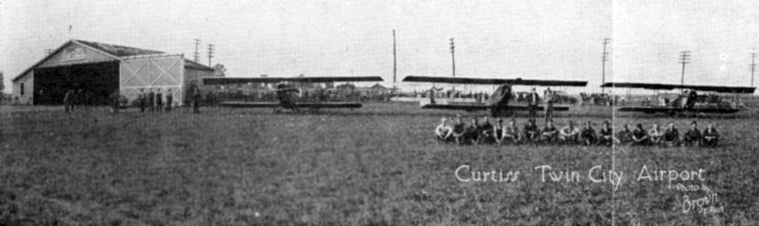
An undated photo of several planes, staff members, and a hangar at “Curtiss Twin City Airport”
from the 1922 Curtiss Northwest Airplane Company brochure “Our Airport” (courtesy of Tom Heitzman).
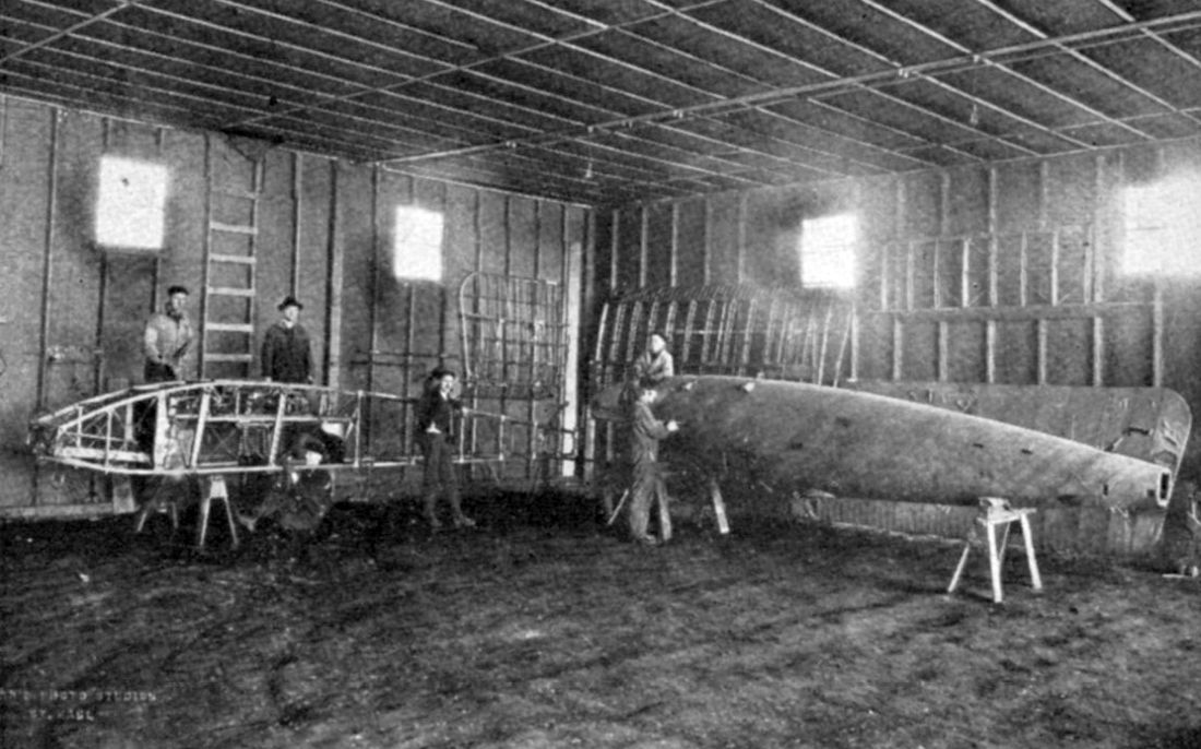
An undated photo of the fuselage repair shop from the 1922 Curtiss Northwest Airplane Company brochure “Our Airport” (courtesy of Tom Heitzman).
The 2/7/09 Pioneer Press article continued, “According to an old interview with Kidder, an Iowa wrestling promoter & his passenger landed at the airport one day.
Kidder offered to take them out to lunch. The promoter went along but said his lanky assistant would stay back & keep an eye on the plane.”
"I will bring him a sandwich. He is a good kid. He does the jumping & takes care of the ship & I am teaching him to fly," Kidder recalled.
"He comes from someplace up here, I think his father was a congressman named Lindbergh."
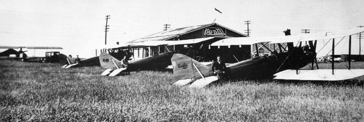
A circa 1920s aerial view looking south at several planes & hangars at Curtiss Northwest Airport.
A July 1923 photo of several planes & a hangar at Curtiss Northwest Airport.
The 2/7/09 Pioneer Press article continued, “Despite brushes with fame, or at least soon-to-be famous aviators,
the Curtiss field's small size & competition from the downtown St. Paul airport & Speedway Field (the forerunner to today's Minneapolis-St. Paul International Airport)
helped speed the end of Kidder's operation.
He left the business over some unknown dispute in the mid-1920s.”
No airfield was depicted at this location on the 1926 or 1928 USGS topo maps, or the November 1934 Twin Cities Sectional Chart.
The 2/7/09 Pioneer Press article continued, “In the 1930s, a couple of golf driving ranges opened near the airport, and the surrounding land was platted for development.
The Falcon Heights Shopping Center opened adjacent to the airport site in 1946.
Curtiss Northwest Airport's land eventually was dredged - for drainage purposes - and became a de facto park known as 'the Hole'.
The south end of the parcel took on the name 'Curtiss Field' in 1991 during improvements funded by the state.
The other section - closest to the Snelling-Larpenteur intersection - now is the Falcon Heights Town Square residential/commercial development.”
A 2014 aerial view showed no trace remaining of Curtiss Northwest Airport.
The site of Curtiss Northwest Airport is located southeast of the intersection of Larpenteur Avenue & Snelling Avenue.
Thanks to Tom Heitzman for pointing out this airfield.
____________________________________________________
Parker Airfield / St. Paul Park Airport, Cottage Grove, MN
44.822, -92.912 (Southeast of St. Paul, MN)
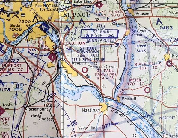
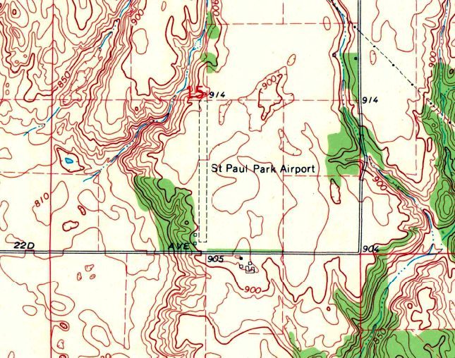
Parker Airfield, as depicted on the April 1965 Twin Cities Sectional Chart.
USGS topo maps as far back as 1951 depicted an airway beacon directly across 90th Street from the eventual site of this airport.
Parker Airfield may have been established at some point between 1962-66,
as it was not yet depicted on the November 1960 Twin Cities Sectional Chart or the 1962 USGS topo map.
The earliest depiction which has been located of Parker Airfield was on the April 1965 Twin Cities Sectional Chart.
It depicted Parker as a private airfield having 2,600 unpaved runway.
Parker Airfield was evidently renamed St. Paul Park Airport at some point between 1965-66,
as that is how it was labeled on the April 1966 Twin Cities Sectional Chart.
The earliest photo which has been located of St. Paul Park Airport was on an 11/28/66 USGS aerial view.
It depicted St. Paul Park Airport as having a single grass north/south runway.
On the southwest side was located a row of 5 T-hangars, along with one single-engine aircraft parked outside.
The May 1969 Twin Cities Sectional Chart (courtesy of Alex Hauzer) depicted St. Paul Park as a private airfield having a 2,500' unpaved runway.
Dan Karg recalled of St. Paul Park Airport, "My wife's grandfather flew out if it in the 1960s. I remember seeing it in the 1960s & early 1970s.”
The 1967 USGS topo map depicted St. Paul Park Airport
as having a single unpaved north/south runway, with a few small buildings on the southwest side.
The last aeronautical chart depiction which has been located of St. Paul Park Airport was on the November 1970 Twin Cities Sectional Chart.
St. Paul Park Airport was evidently closed at some point between 1970-72,
as it was no longer depicted on the August 1972 Twin Cities Sectional Chart.
A 1974 USGS aerial photo showed houses covering the St. Paul Park Airport site.
Showing that you can't always trust maps, St. Paul Park Airport continued to be depicted on the 1991 USGS topo map,
even though it had ceased to exist for at least 17 years by that point.
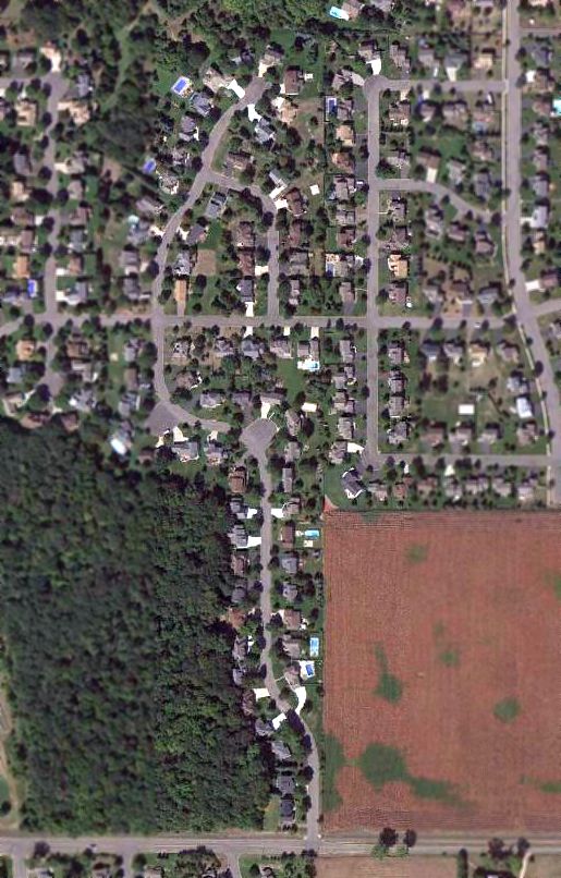
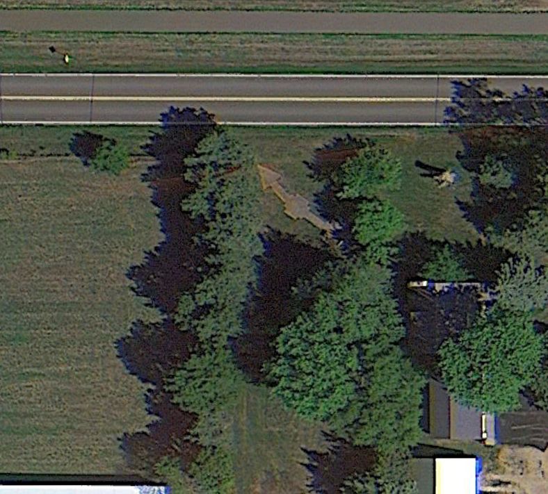
A 9/15/13 aerial view showed no trace remaining of St. Paul Park Airport.
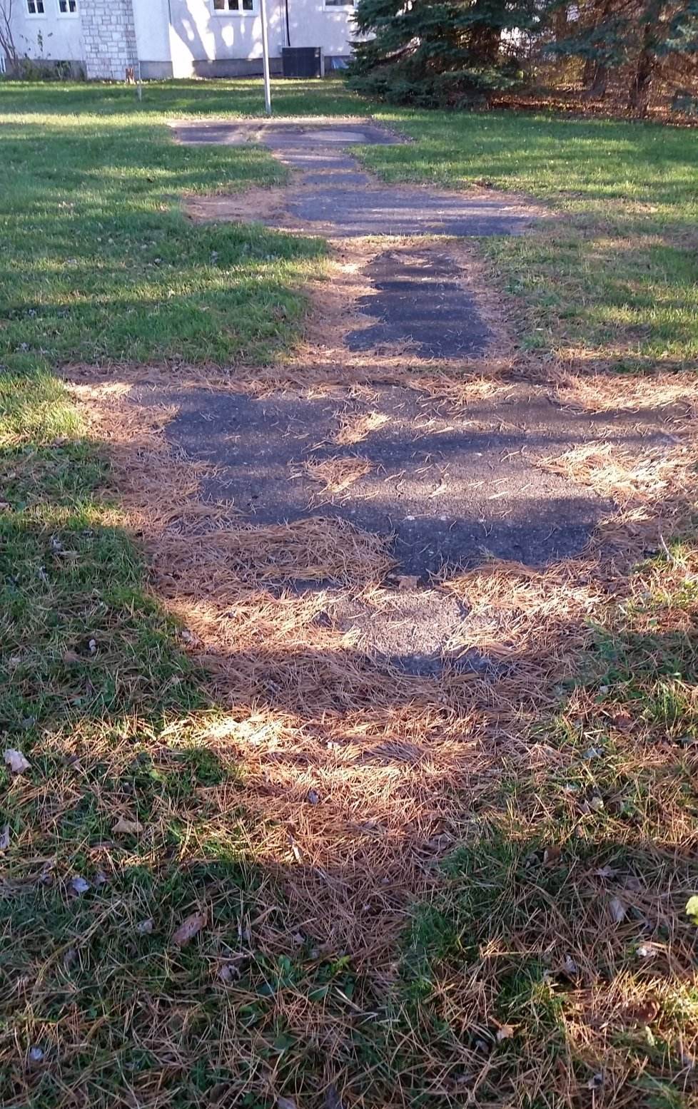
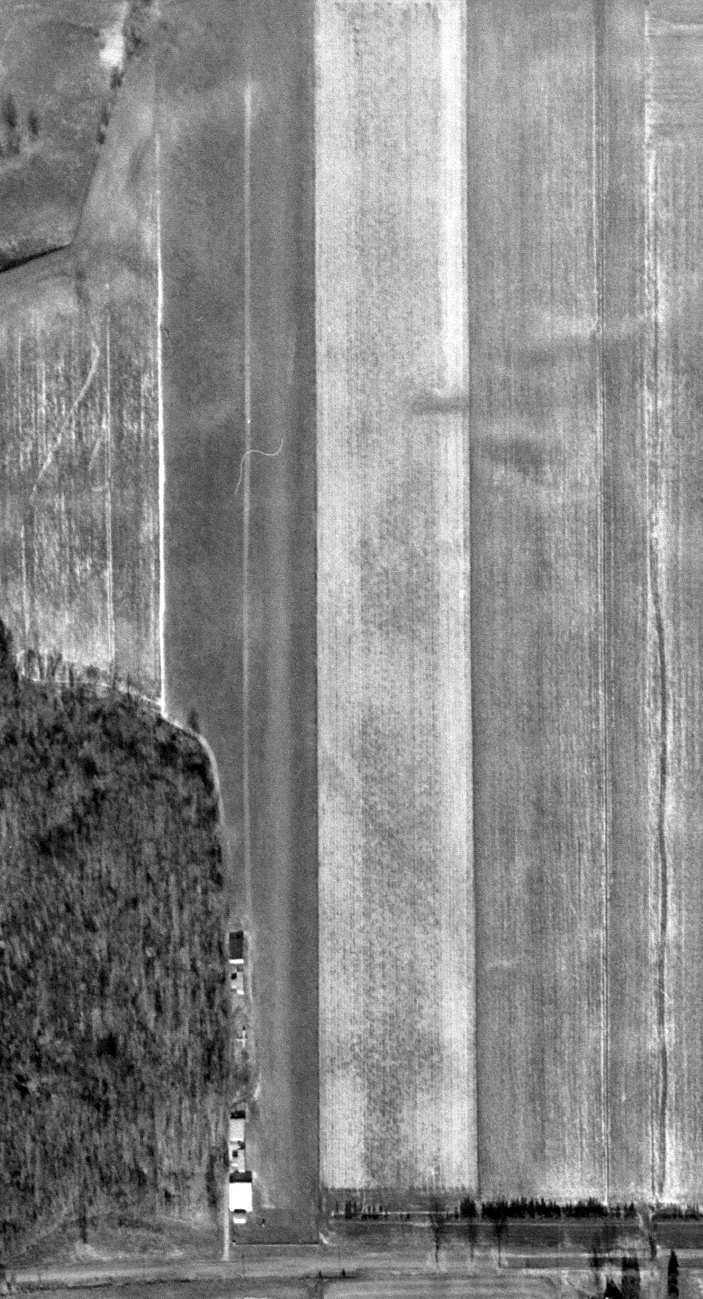
An 11/15/15 photo by Dick Merrill of the remains of the concrete airway arrow across the street from the site of St. Paul Park Airport.
Dick reported, “That was Beacon #33. It was one of the Beacons that had a concrete arrow at the base.
It is located in the front yard of a diary farm, which is amazingly, is on the very edge of the Twin Cities development.”
A 2021 aerial view of the remains of the Airway Beacon #33 concrete arrow which remains across the street south from the site of St. Paul Park Airport.
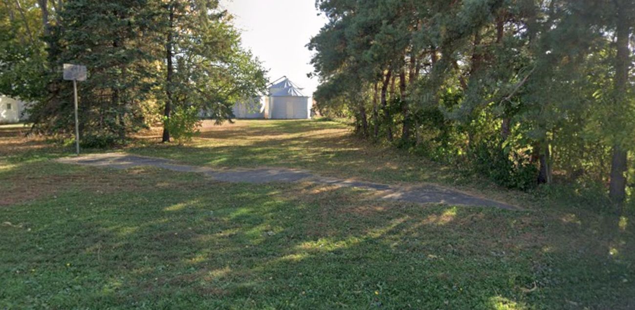
A 2024 photo looking south at of the remains of the Airway Beacon #33 concrete arrow which remains across the street south from the site of St. Paul Park Airport.
Apparently a basketball backboard was installed along the back of this historic artifact.
The site of St. Paul Park Airport is located north of the intersection of 90th Street South & Jewel Avenue.
Thanks to Dan Karg for pointing out this airfield.
____________________________________________________
Anoka Flying Service Airport, Anoka, MN
45.19, -93.37 (Northwest of Minneapolis, MN)
A 1945 aerial view (from MHAPO) of the Anoka Flying Service Airport.
According to “Coon Rapids Oral History Project” (courtesy of Bill Peterson),
Anoka Flying Service Airport was established in 1927 by Theodore Hansen, an Anoka County Sheriff.
Hansen purchased an Waco 10 GXE biplane in 1928 along with his pilot's license. He barnstormed & gave rides for $3.
Unfortunately, the the 11/16/31 Anoka Union reported “Thunderstorm & a tornado damaged H.T. Hansen hangars & airplane.”
As a result of the storm damage, in 1931 Hansen sold the airport to George Pierce, who owned an auto salvage yard.
With the backing of his other business, the airport began to grow.
Within a few years the field had 4 hangars, 5 airplanes, and a 3,000' runway.
Anoka Flying Service Airport was not yet depicted on the November 1934 Twin Cities Sectional Chart.
However an 8/4/37 aerial view (from MHAPO) showed an open field, without any recognizable sign of an airfield.
Anoka Flying Service Airport was not yet depicted on the June 1944 Twin Cities Sectional Chart.
The earliest aeronautical chart depiction which has been located of Anoka Airport was on the December 1944 Twin Cities Sectional Chart.
It depicted Anoka as a commercial/municipal airport.
The earliest directory listing which has been located of the Anoka Flying Service Airport was its listing in the 1945 AA Airfield Directory (courtesy of Scott Murdock).
It described the Anoka Flying Service Airport as a 64 acre L-shaped property having 4 turf runways, the longest being the 1,870' north/south strip.
Anoka was said to have 2 wood & metal 40' x 28' hangars, and to be owned & operated by private interests.
Scott Ewald recalled, "I grew up next to [this airfield] & used to fly from it.
It was a dirt strip run by a Mr. Pierce, with 2 runways, 1 or 2 hangars, windsock & a gas pump.
The main strip ran north/south with a shorter cross runway running east/west.
It was located just on the eastern boundary of Anoka with Coon Rapids, south of Main Street & west of Reisling Boulevard (now called Round Lake Boulevard).
A small neighborhood of 40 homes to the east contained quite a few residents who were pilots during the 1950s - early 1960s.
Folks had airplanes parked in the back yard or modified garage & would fly from their homes.
It was common to watch folks fly in from our kitchen window when I was a boy.”
The earliest photo of which has been located of the Anoka Flying Service Airport was a 1945 aerial view (from MHAPO).
It depicted Anoka Flying Service Airport as having 4 unpaved runways, with at least 2 single-engine aircraft parked amidst a cluster of small buildings on the southwest side.
A 5/8/47 USGS aerial view depicted Anoka Flying Service Airport as having 4 unpaved runways,
with at least 6 single-engine aircraft parked amidst a cluster of small buildings on the southwest side.
One single-engine aircraft appeared larger than the rest – perhaps a WW2 surplus military aircraft.
The November 1950 Twin Cities Sectional Chart depicted Anoka Airport as having a 3,800' unpaved runway.
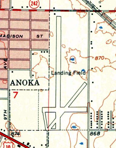
The 1955 USGS topo map depicted Anoka Airport as 3 runways, labeled simply as “Landing Field”.
The primary north/south runway had been significantly lengthened toward the north compared to earlier descriptions & depictions.
A 1957 aerial view showed Anoka's north/south runway had been lengthened considerably toward the north, running all the way to Main Street.
A dozen light aircraft were parked at the southwest corner of the airfield.
The 1959 USGS topo map continued to depict the field in the same fashion.
The last photo which has been located of Anoka Airport was a 5/8/60 aerial view (from MHAPO),
which depicted 18 light aircraft parked at the southwest corner of the airfield.
The last aeronautical chart depiction which has been located of Anoka Airport was on the November 1960 Twin Cities Sectional Chart.
It depicted Anoka as having a 3,800' unpaved runway.
According to “Coon Rapids Oral History Project” (courtesy of Bill Peterson),
George Pierce died in 1964, and the airport land was sold for $50,000 to Federal Cartridge.
Anoka Airport was no longer depicted on the November 1965 Twin Cities Sectional Chart.
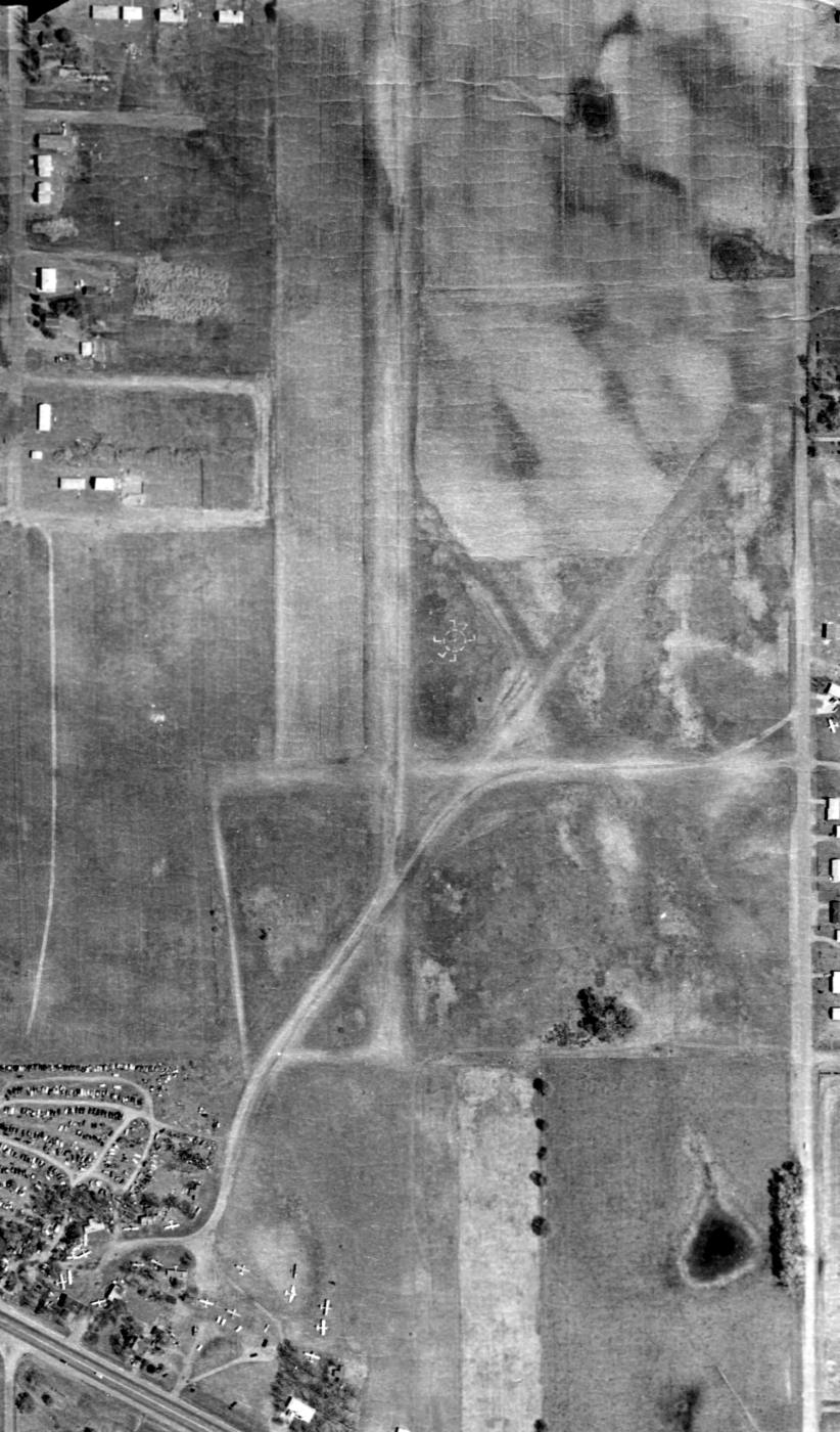
A 1966 aerial view showed the Anoka Airport land remained clear, but the runways were no longer evident,
and all of the aircraft were gone.
Scott Ewald recalled of Anoka Airport, "It later became a bean field with a junkyard on the south side by the old hangars."
The 1969 USGS topo map no longer depicted any of the Anoka Airport runways, just an empty clearing.
A 1979 aerial view showed the Anoka Airport area remained clear.
A 2003 aerial view showed that houses had covered all but the southern-most portion of the Anoka Airport site.
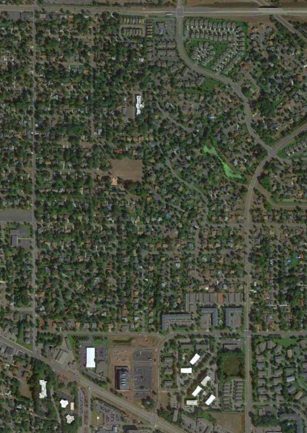
A 9/15/13 aerial view showed no trace remaining of Anoka Airport.
The site of Anoka Airport is located southwest of the intersection of Round Lake Boulevard & Main Street.
Thanks to Scott Ewald for pointing out this airfield.
____________________________________________________
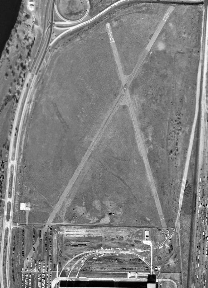
Northern Pump Airfield, Fridley, MN
45.065, -93.277 (North of Minneapolis, MN)
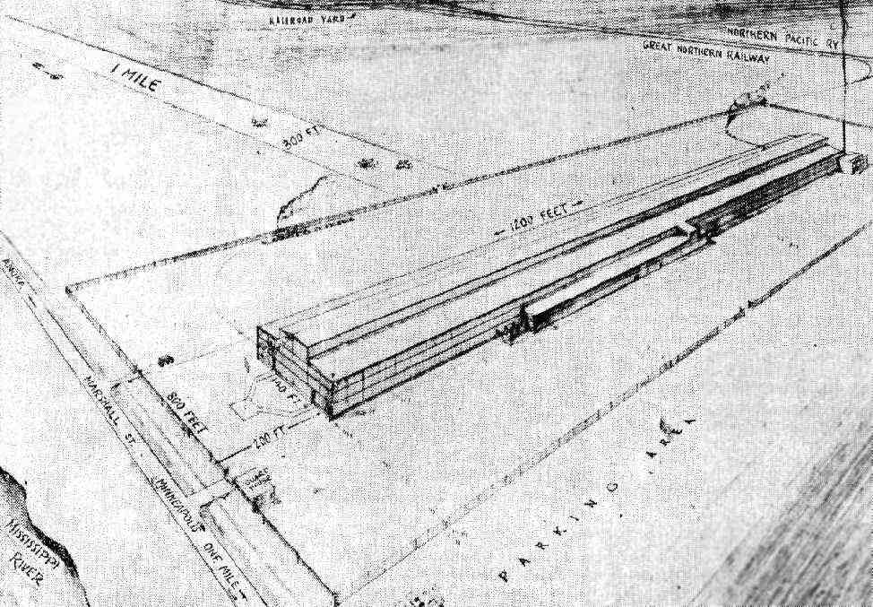
A Summer 1940 original design concept of the Northern Pump Airfield (courtesy of Chris Sorenson).
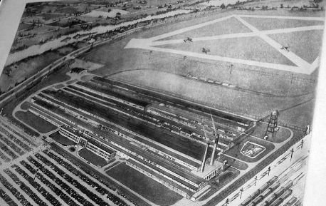
In September of 1940, with war looming, hurried construction began in southern Fridley on a giant factory known as Northern Ordnance
(a wholly owned subsidiary of Northern Pump).
A Summer 1940 “original design concept” (courtesy of Chris Sorenson) showed a 1-mile long runway
extending perpendicularly toward the north away from the midpoint of a massive industrial building.
This was hardly a safe layout, and it differed significantly from the airfield layout that was eventually built.
For reasons unknown, the planned airfield was evidently not built until a decade later.
Chris Sorenson observed, “Another thing that’s interesting is that the original planned 1 mile runway length proved to be way over-ambitious;
the eventual runways were much shorter.”
Weapon production of 5” guns began at Northern Ordnance in January 1941.
A 6/30/42 print by B. McVeigh (courtesy of Jean Ann Weymiller) depicted the “Northern Pump Company Naval Ordnance Plant”
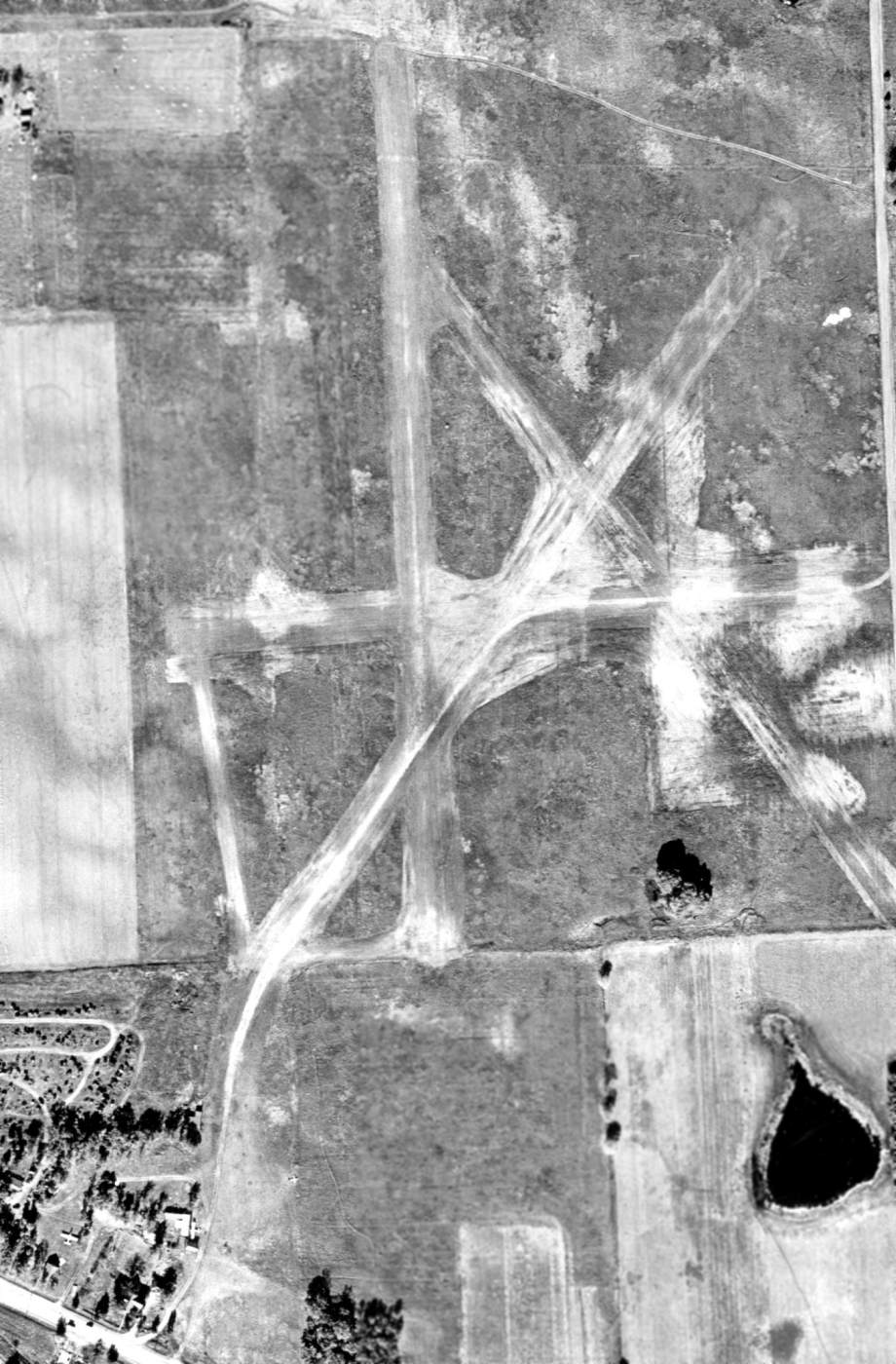
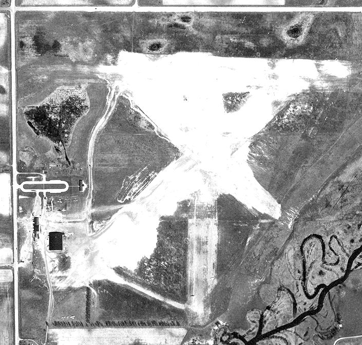
having a very different airfield configuration from the previous depiction, with 2 paved runways in an X shape surrounded by perimeter taxiways.
Three aircraft were depicted on the field.
Northern Pump Airfield was not yet depicted on the November 1943 Twin Cities Sectional Chart (nor on later Sectionals from 1950/52/54/56/69)
Northern Ordnance employment peaked in 1943 with 11,400 workers putting in 12 hour shifts & production going 7 days / week.
No airfield was depicted at this location on a 5/8/47 USGS aerial photo
nor on the January 1949 Minneapolis-St Paul USAF Target Complex Chart (courtesy of Timothy Aanerud).
According to Chris Sorenson, the Northern Pump Airfield was built in 1950.
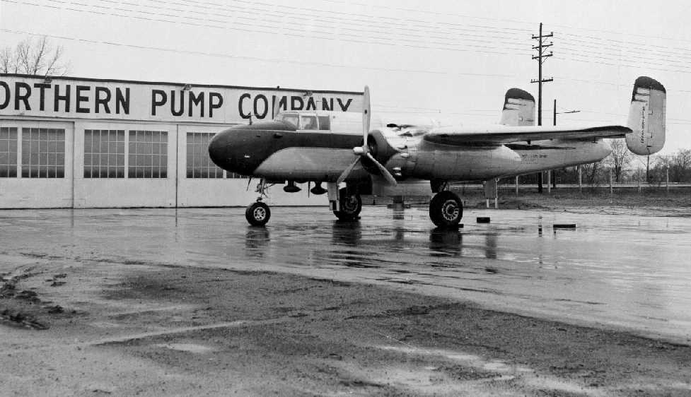
The earliest photo which has been located of the Northern Pump Airfield
was a 1950 photo of a surplus B-25J Mitchell bomber (NL75755, Serial # 45-8883) operated as a business aircraft by Northern Pump Company (courtesy of Chris Sorenson)
in front of the Northern Pump Company hangar at their airfield.
According to Chris Sorenson, “The B-25 was at the time named 'The Bloody Nose' because it was painted red.
In the book 'Follow Me: The Life of John B. Hawley', there is a description of how difficult the pilot,
a WWII Army Air Corps bomber pilot, found it to take off & land the B-25 on the short runways.”
The 1952 USGS topo map depicted the entire Northern Ordnance Plant as having a “Landing Field”
with 2 paved runways & a taxiway leading to a hangar on the southwest side.
The earliest photo which has been located showing the entire Northern Pump Airfield was a 10/1/53 USGS aerial view.
It depicted the field as having 2 paved runways on the north side of the factory.
The Northern Pump Airfield was not depicted at all on the 1955 USGS topo map.
An 8/21/56 aerial view looking southeast at the Northern Pump Airfield, with the hangar at the lower-left (courtesy of Chris Sorenson).
Chris Sorenson observed, “The roof of the hangar is painted 'Northern Pump – Private'.”
A 1957 aerial view depicted the Northern Pump Airfield as having 2 asphalt runways in an X-shape adjacent to the north side of the factory,
with an asphalt taxiway leading to a single hangar on the southwest side.
Northern Pump Company operated their B-25J until 1958.
According to Chris Sorenson, “I don’t think the airfield was used much after the B-25 was sold.”

A 5/10/60 aerial view of the Northern Pump Airfield (from MHAPO) showed the hangar at the lower-left to be painted “Northern Pump - Private”.
A 4/13/61 aerial view looking northwest at the Northern Pump Airfield showed a pair of paved runways in an X-shape adjacent to the north side of the factory.
Chris Sorenson observed, “You can see the hangar is still there [on the west side of the field] and the north half of the back parking lot is still blocked off.”
According to Chris Sorenson, “I think [the airfield] was officially decommissioned
when FMC Corporation bought the plant from John Hawley, who was its sole proprietor [owner of Northern Pump], in 1964.”
A 5/6/65 tornado caused over $2 million of structural damage at the plant & put it out of operation for over a month.
A 1965 aerial view looking northeast at the Northern Pump plant showed a pair of paved runways in an X-shape adjacent to the north side of the factory.
A 11/28/66 USGS aerial view showed the hangar was removed at some point between 1957-66.
The runways otherwise remained intact.
Chris Sorenson observed that an aerial photo taken “between January 1968 - March 1969” showed that “the hangar has been torn down,
and the back half of the parking lot has been returned to use for parking (it was closed to parking while the runway on that side was active).”
A 1979 aerial view showed the majority of the site were covered by several new buildings at some point between 1966-79,
but traces of the northwest/southeast runway remained recognizable.
By the time of the 1991 USGS aerial photo, no trace of the former airfield remained.
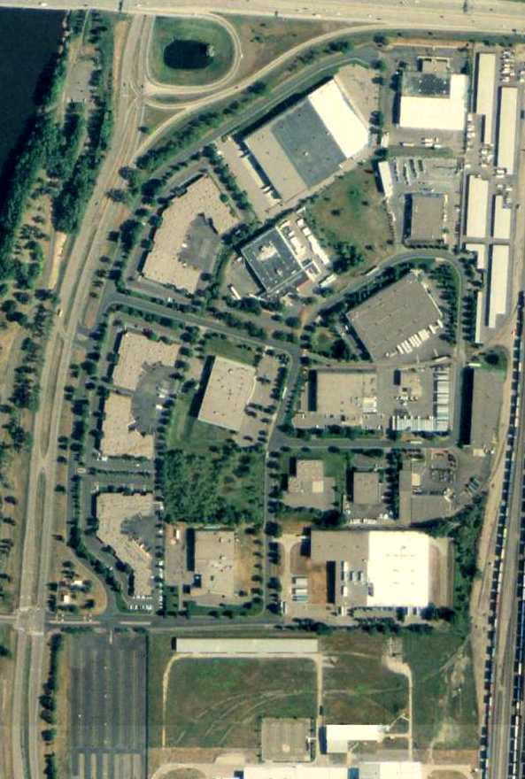
A 6/3/09 aerial photo showed no trace remaining of the former Northern Pump Airfield.
The site of the Northern Pump Airfield is located southeast of the intersection of East River Road & Interstate 694.
Thanks to Mike Kenton for pointing out this airfield.
____________________________________________________
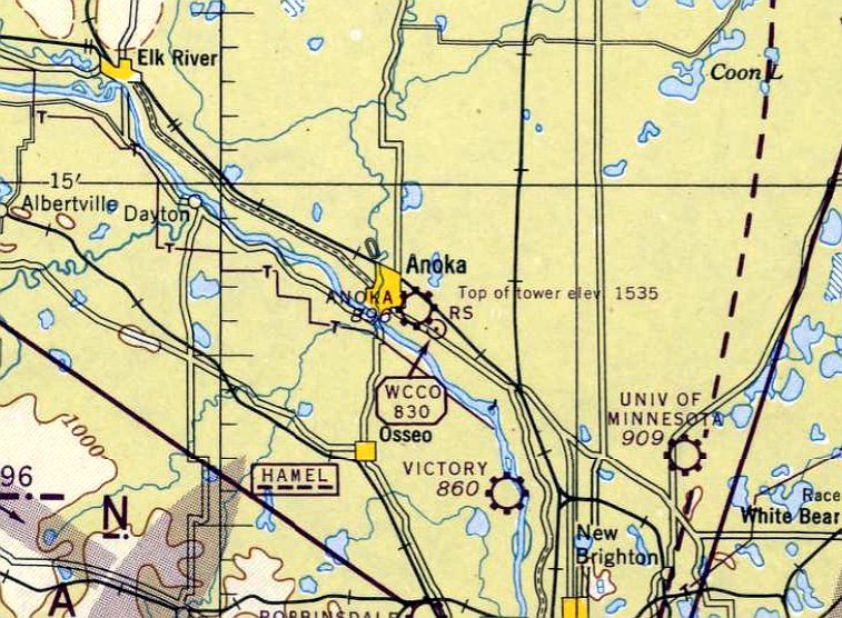
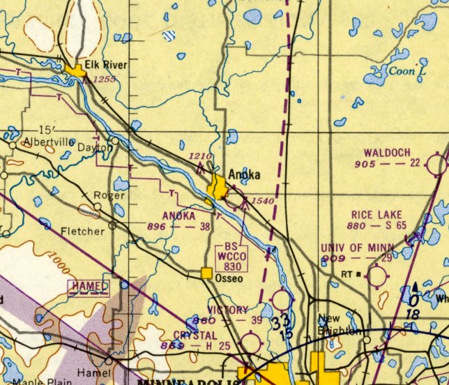
Victory Airport, Brooklyn Center, MN
45.097, -93.307 (Northwest of Minneapolis, MN)
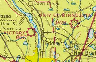
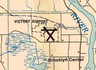
Victory Airport, as depicted on the November 1943 Twin Cities Sectional Chart (courtesy of Chris Kennedy).
According to Timothy Aanerud, Victory Airport was named by Adrain McInnis,
who moved from the South Saint Paul Airport & was an early operator of this airport under a War Training Service contract.
Victory Airport was evidently established at some point between 1942-43,
as it was not yet depicted on the November 1942 Twin Cities Sectional Chart (according to Chris Kennedy).
According to Timothy Aanerud, Victory Airport "was certainly open by April 1943, maybe earlier."
The earliest depiction of Victory Airport which has been located was on the November 1943 Twin Cities Sectional Chart (courtesy of Chris Kennedy).
It depicted Victory as a commercial/municipal airport.
The April 1944 US Army/Navy Directory of Airfields (courtesy of Ken Mercer) described Victory Airport as having a 3,500' unpaved runway.
The June 1944 Twin Cities Sectional Chart (courtesy of Chris Kennedy) depicted Victory as a commercial or municipal airport.
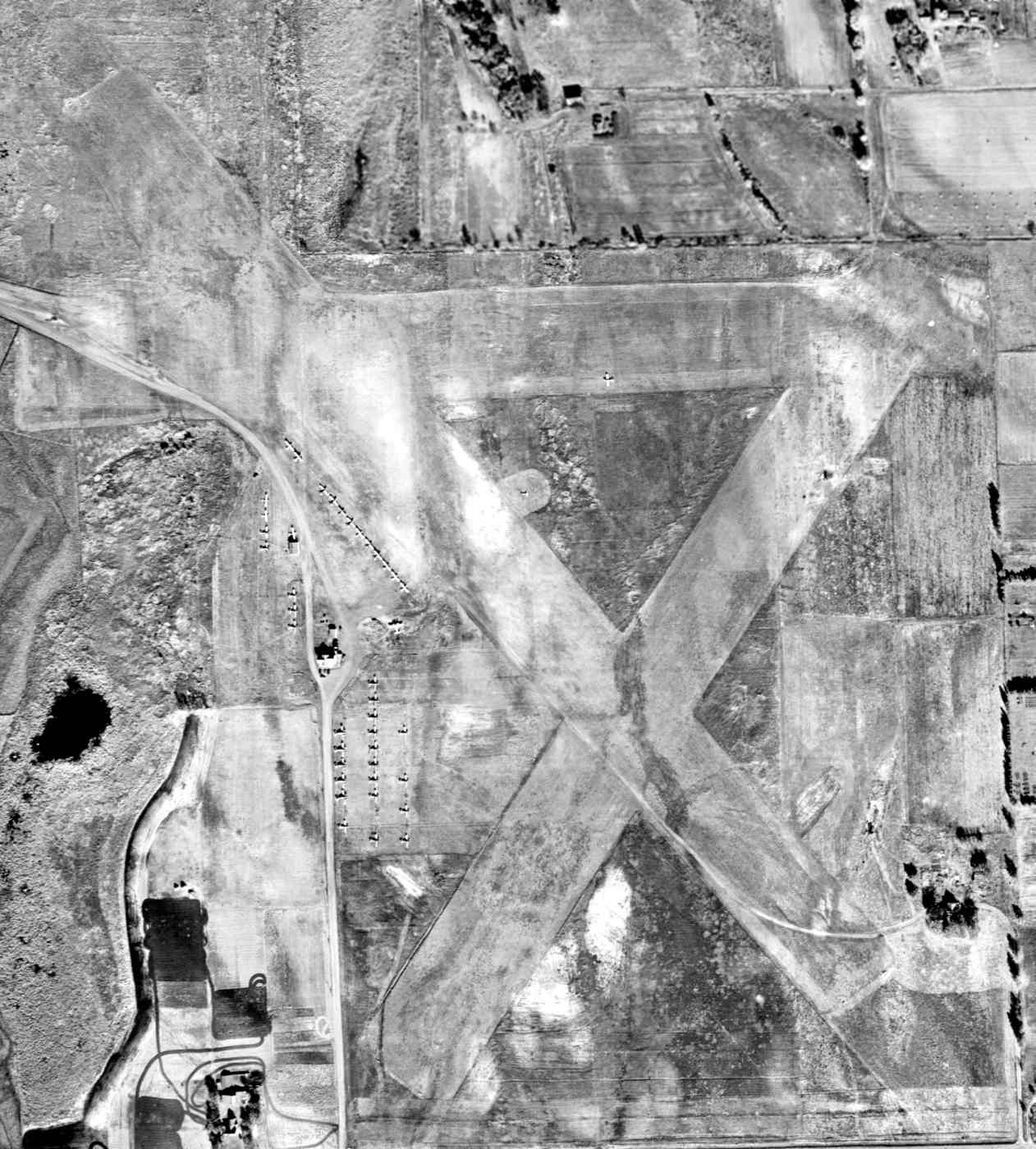
The earliest photo which has been located of Victory Airport was a 1945 aerial view (from MHAPO). It depicted Victory Airport as having 3 unpaved runways.
At least 39 single-engine aircraft (Civilian Pilot Training aircraft?) were parked amidst some small buildings on the west side of the field - so many aircraft that some were parked on the opposite side of the road.
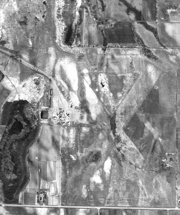
The last photo which has been located showing Victory Airport while it was operational was a 1947 aerial photo (from the MN DNR, courtesy of Chris Kennedy).
It depicted Victory Airport as having 3 unpaved runways.
A hangar & several smaller buildings were located on the west side of the field, and over a dozen light aircraft were visible parked on the field.
The January 1949 Minneapolis-St Paul USAF Target Complex Chart (courtesy of Timothy Aanerud) depicted Victory Airport as having a total of 3 runways,
with 2 buildings (hangars?) on the west side of the field.
The last aeronautical chart depiction which has been located of Victory Airport was on the November 1950 Twin Cities Sectional Chart.
It depicted Victory as having a 3,900' unpaved runway.
Victory Airport evidently lasted no more than 16 years, and was apparently closed at some point between 1950-54,
as it was no longer depicted on the May 1954 Twin Cities Sectional Chart (courtesy of Jim Stanton) or subsequent aeronautical charts.
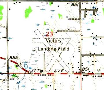
The 1955 USGS topo map still depicted the “Victory Landing Field”, even though the airport had evidently already been closed for a few years.
It depicted the field as having 3 unpaved runways, with a few small buildings around the periphery.
A 1956 aerial view showed that several of the airfield buildings had been removed, and there was no sign of any recent aviation usage of the property.
A 1960 aerial view showed the Victory Airport property remained unchanged.
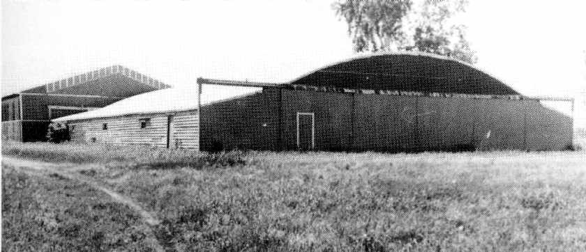
A 1978 photo of the main hangar at Victory Airport, from the book "Minnesota Aviation History 1857-1945" by Noel Allard (courtesy of Timothy Aanerud).
"At that time, the big hangar & other buildings were being used by the Folaside Door Manufacturing Company."
A 1991 USGS aerial photo showed the site of Victory Airport had been heavily developed between 1978-91, and not a trace appeared to remain of the former airport.
A 2014 aerial view showed no trace remaining of Victory Airport.
The site of Victory Airport is located north of the intersection of Brookdale Drive & Queen Avenue.
____________________________________________________
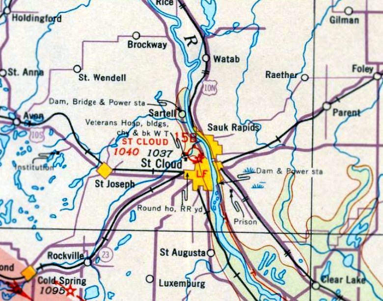
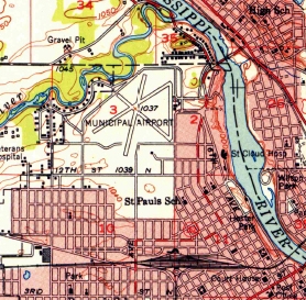
St Cloud Airport / Whitney Memorial Airport, St. Cloud, MN
45.58, -94.183 (Northwest of Minneapolis, MN)
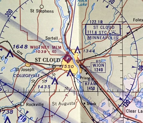
St Cloud Airport, as depicted on the June 1935 Twin Cities Sectional Chart.
No airfield in St. Cloud was yet depicted on the November 1934 Twin Cities Sectional Chart.
The earliest depiction which has been located of St. Cloud Airport was on the June 1935 Twin Cities Sectional Chart.
It depicted St. Cloud Airport as a commercial/municipal airport.
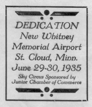
The “New Whitney Memorial Airport” was dedicated on 6/29/35, as commemorated on a postmark (courtesy of Dallam Oliver-Lee).
The Airport Directory Company's 1938 Airport Directory (courtesy of Chris Kennedy)
described Whitney Memorial Airport as having a 3,320' x 2,574' rectangular sod field.
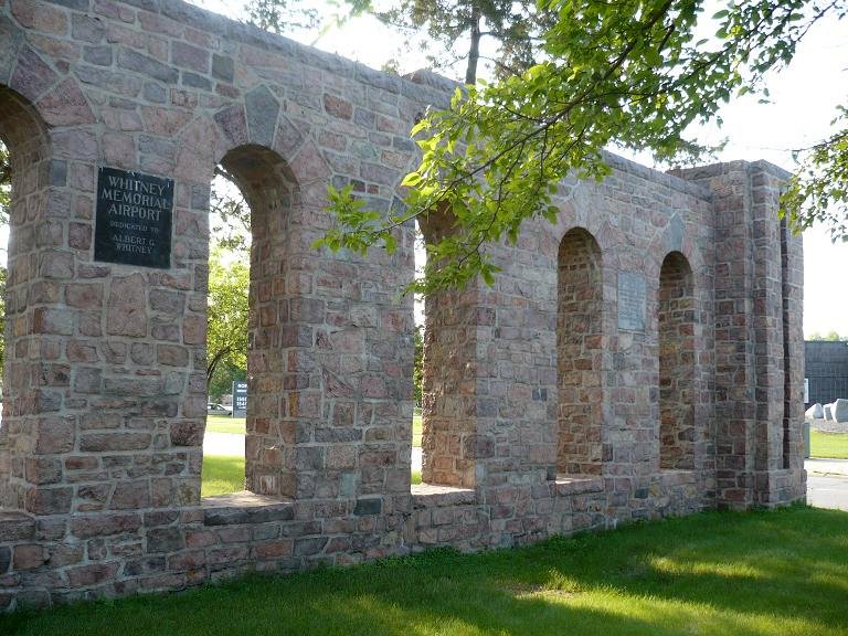
Ken Chirhart recalled, “Whitney Memorial... My father worked with the WPA in the 1930s to construct the granite walls near the airfield entrance.”
According to John Evans, “The Whitneys were a very wealthy family
that owned a lot of Northern States Power Company & gave the land for use as an airport.”
According to the St. Cloud Hospital, the airport had a revolving beacon light marking the airport,
but this disturbed the sleep of patients in the nearby hospital,
so the city & the hospital agreed to move the beacon to the roof of the hospital.
This allowed the patients to sleep in peace
and gave the beacon light a wider range since the hospital was the highest structure near the airport.
John Evans recalled, “The beacon for the Whitney Field was on top of the nearby St. Cloud Hospital.
We lived directly across the Mississippi River from the hospital.
The beacon was a constant in my life each night.
I would fall asleep with the reassuring soft green & white light coming through my bedroom window.”
The earliest photo which has been located of Whitney Memorial Airport
was a 1938 aerial photo (from the MN DNR, courtesy of Chris Kennedy).
The most elaborate part of the airfield's infrastructure seemed to be its entrance road.
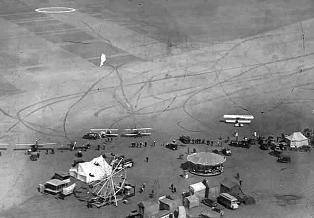
A 1940 aerial view by Leo Moore of Whitney Memorial Airport (from the Minnesota History Center, courtesy of Barry Kazmer), showing a Ferris wheel & merry-go-round next to several aircraft.
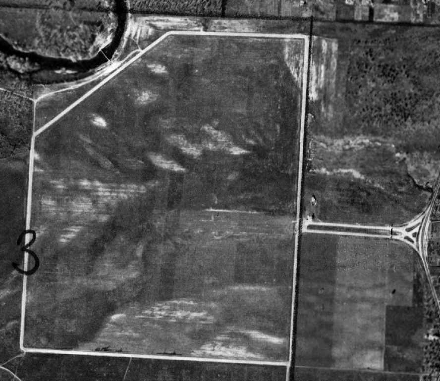
A 10/16/49 aerial photo (courtesy of Dallam Oliver-Lee) appeared to show 3 paved runways under construction at Whitney Memorial Airport.
Three single-engine aircraft were visible parked south of the cluster of hangars on the east side.
The 1950 USGS topo map (courtesy of Dallam Oliver-Lee) depicted the “Municipal Airport” as having 3 paved runways.
Ken Chirhart recalled, “While still in high school in 1957 I soloed in a J-3 Cub at Whitney.
Later, when I was a member of the St. Cloud State College Flying Club,
I earned my private license in an Aeronca 7AC at the field.”
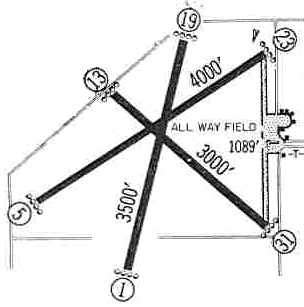
The 1960 Jeppesen Airway Manual (courtesy of Chris Kennedy) depicted Whitney Memorial Airport as having 3 paved runways,
with the 4,000' Runway 5/23 being the longest.
Taxiways led to a ramp on the east side of the field with several buildings arranged in a semicircle.
The 1962 AOPA Airport Directory described Whitney Memorial Airport as having 3 bituminous runways: 4,300 Runway 5/23,
3,500' Runway 1/19, and 3,000' Runway 13/31.
The airport had hangars & offered charter services. The operator was listed as St. Cloud Flying Service, Inc.
A 4/4/64 aerial photo (courtesy of Dallam Oliver-Lee) showed 9 light aircraft parked south of the cluster of hangars on the east side.
The last aeronautical chart depiction which has been located of Whitney Memorial Airport
was on the May 1969 Twin Cities Sectional Chart (courtesy of Alex Hauzer).
It depicted Whitney Memorial as having 3 paved runways, with the longest being 4,000'.
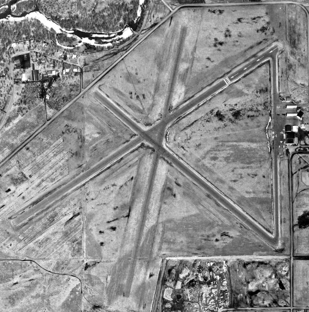
The last photo which has been located showing Whitney Memorial Airport still in operation
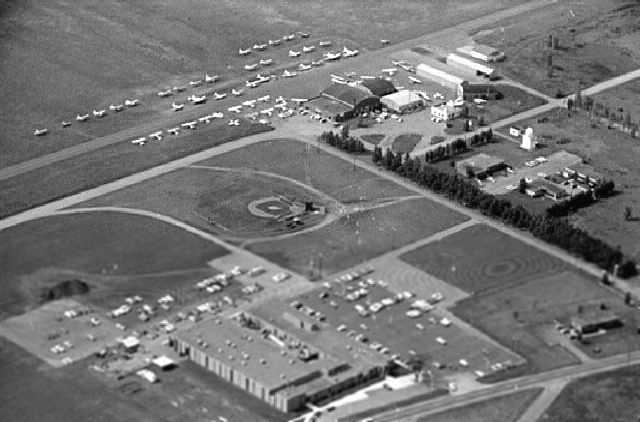
was a 1969 aerial view looking northwest by Vincent Mar (from the Minnesota History Center, courtesy of Barry Kazmer).
It depicted dozens of light aircraft parked adjacent to several hangars.
The new St. Cloud Municipal Airport opened in 1970 at a site 3 miles east of the city,
at which point Whitney Memorial Airport apparently closed.
A 1973 aerial photo (courtesy of Dallam Oliver-Lee) showed the majority of the length of the runways still remained,
but baseball fields were being built over the airport site.
The former airport beacon atop the hospital wasn't actually removed until 1979,
when it was relocated to Aitkin (94 miles northeast of St. Cloud).
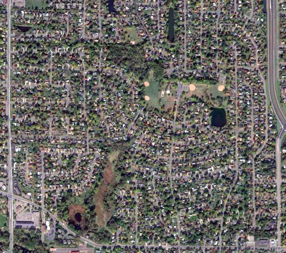
The site of Whitney Memorial Airport was labeled Whitney Park on the 1984 & 1993 USGS topo maps.
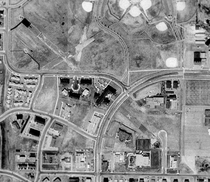
In the 1991 USGS aerial photo, a 2,500' portion of the former Runway 13/31 was still visible,
on either side of Northway Drive, which was built over it.
The remaining runway portion southeast of Northway Drive was still marked with a closed runway "X".
A shorter portion of the former Runway 5/34 also still existed.
Matt Haas reported on the status of the site in 2003: "Parts of the runway are still there, plus a brick wall that was the gate to the airport.
Now it's mostly soccer & baseball fields, all of the hangars & buildings are now home to Whitney Senior Center."
A circa 2007 aerial view looking west at the remains of 3 runways at the site of Whitney Airport.
A circa 2007 aerial view looking east at 2 former hangars at the site of Whitney Airport.
A July 2008 photo looking northeast at a former hangar on the east side of the Whitney Airport site.
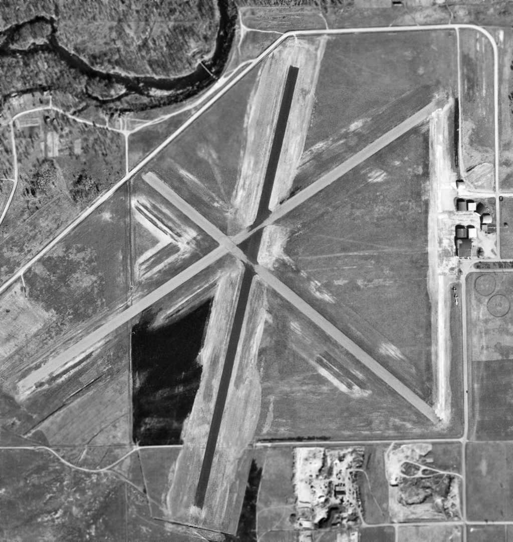
A 5/16/11 aerial photo (courtesy of Dallam Oliver-Lee) showed that portions of 3 runways still remained as the site of Whitney Memorial Airport.
An August 2012 photo looking west at a former hangar on the east side of the Whitney Airport site.
A 2013 photo of the former entrance gate to Whitney Memorial Airport, which remains in the middle of Northway Drive.
The site of Whitney Airport is located at the intersection of Northway Drive & Stockinger Drive.
Thanks to Matt Haas for pointing out Whitney Airport.
____________________________________________________
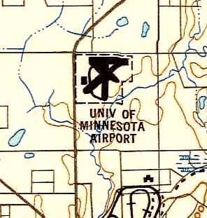
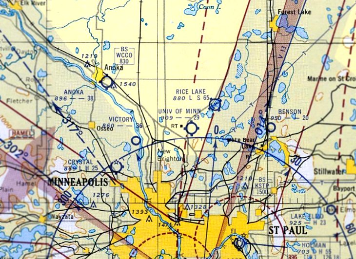
University of Minnesota Airport, Blaine, MN
45.12, -93.185 (Northeast of Minneapolis, MN)
The University of MN Airport, as depicted on the November 1942 Twin Cities Sectional Chart.
According to an article in the 10/19/98 issue of the Minnesota Daily (via Timothy Aanerud),
the University of MN has owned a 209 acre property at this site since 1941.
The University of Minnesota Airport was evidently established at some point in 1942,
as it was not yet depicted on the July 1942 Twin Cities Sectional Chart.
The earliest depiction which has been located of the University of Minnesota Airport was on the November 1942 Twin Cities Sectional Chart.
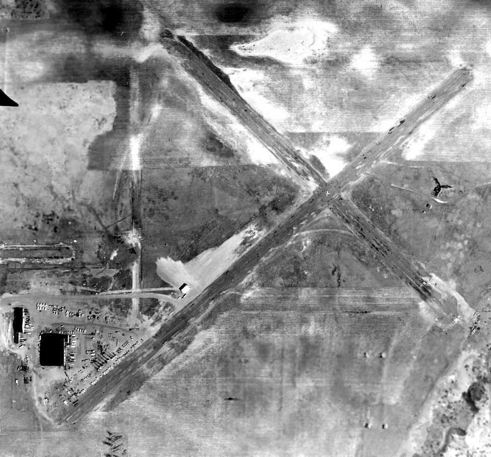
The only photo which has been located showing the University of MN Airport while it was operational was a 5/8/47 aerial view (from MHAPO).
It depicted the University of MN Airport as having 4 unpaved runways.
A single hangar & several smaller buildings were located on the southwest corner of the field,
and at least 6 aircraft were visible parked nearby, one of which appeared to be a 4-engine aircraft.
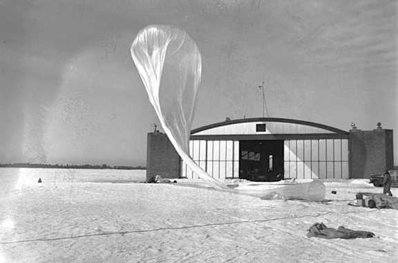
A 2/25/48 photo of a balloon launch in front of a hangar at the University of MN Airport.
The 1949 USAF Target Complex Chart (courtesy of Chris Kennedy) depicted the University of Minnesota Airport
as having 4 runways (with the longest being a 2,600' northeast/southwest strip),
and a single hangar on the west side of the airfield.
The last aeronautical chart depiction which has been located of the University of Minnesota Airport was on the June 1952 Twin Cities Sectional Chart.
It depicted the University of Minnesota Airport as having a 2,900' unpaved runway.
The University of Minnesota Airport was evidently closed at some point between 1952-53,
as it was no longer depicted on the April 1953 Twin Cities Sectional Chart,
which instead showed the larger Anoka County Blaine Airport which had been built only a mile to the northwest.
However, in spite of being dropped from aeronautical charts,
the University of Minnesota Airport may have continued to see some use for a few more years, perhaps in an unofficial capacity.
John Johnson recalled, “The University of Minnesota Airport... I flew out of that airport with the U of M flying club back in 1955-56.
The University owned a couple of Beech C-45s & a batch of tricycle gear Piper Cubs!
They had 6 of them & they rented for $3/hour wet.
You could get dual instruction in them for an additional $3/hour for the instructor.
The airport manager was Ron Staloch. We called him 'Keeplatched' from Staloch.
In 1956 the mechanic was welding in the big hangar where all of the University's airplanes were stored.
His torch flashed back & exploded, killing the mechanic & burning out the hangar.
All of the University's airplanes were totally destroyed in the fire.
I remember that quite clearly because I was about to get some right seat time in one of the C-45s & it was melted down in the fire.”
According to an article in the 10/19/98 issue of the Minnesota Daily (via Timothy Aanerud),
the University of MN Airport was closed in 1956.
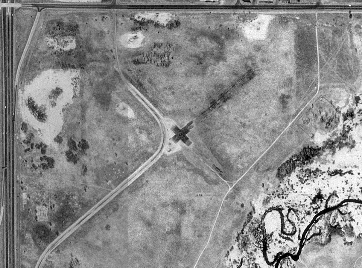
A 1957 aerial view showed that 2 University of Minnesota Airport hangars still remained standing.
The airfield appeared to have had 2 paved runways, oriented northwest/southeast & northeast/southwest.
The last photo which has been located showing the University of MN Airport still largely intact was a 1960 aerial view.
It depicted the field as having 2 paved runways, with 2 hangars on the southwest side of the site.
Nearby resident Curtis Olson reported, "I was told that in the 1960s a tornado came through & leveled most of the buildings."
The much larger Anoka County Blaine Airport was eventually built only one mile to the northwest of the site of the University of MN Airport.
According to Curtis Olson, "There must have been some motivation to close that airport & rebuild nearby (proximity to the freeway? lack of expansion space?).
The University of Minnesota ended up owning the site & for years it was just a big open field...
from driving past it you'd never know there used to be an airport there.
A local R/C club got permission to operate on the site & so they had a little chunk of asphalt that they flew off.
I went out there many times and as far as I could tell, that was the only asphalt remaining."
Curtis continued, "One day I had a chance to fly over in a small plane with a friend who is a pilot.
I was really surprised that from the air, the original runway was completely visible.
Much of the old asphalt was still there, just from the ground everything was so overgrown, you couldn't really tell.
"In the last couple years the University sold the land & it is being completely redeveloped as town houses, ball fields, some retail stores, etc.
It seems sad to see an airport go, but what are you going to do."
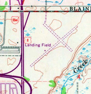
The 1972 USGS topo map still depicted the University of Minnesota Airport as 2 unpaved runways, labeled simply as “Landing Field”.
A 1980 aerial view showed that the foundations remained visible of the 2 hangars,
along with a somewhat smaller “X” of former runway pavement of the center portion of 2 runways.
A 1991 USGS aerial photo of the site of the University of Minnesota Airport showed the remains of 2 asphalt runways were still visible,
along with a hangar foundation on the southwest side.
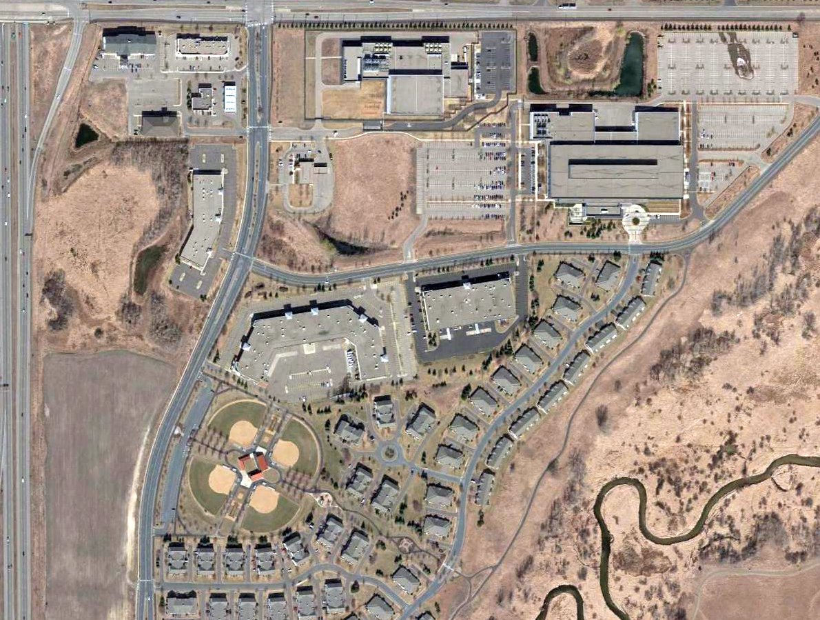
A 2016 aerial view showed that new construction had obliterated all traces of the University of Minnesota Airport.
The U of MN Airport site is located southeast of the intersection of Interstate 35 & 85th Avenue Northeast.
____________________________________________________
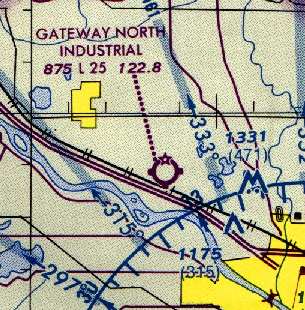
Anoka Industrial Airport / Gateway North Industrial Airport (Y25), Ramsey, MN
45.23, -93.445 (Northwest of Minneapolis, MN)
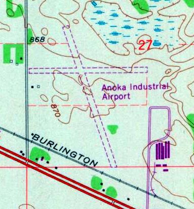
The 1972 USGS topo map depicted Anoka Industrial Airport as having 2 unpaved runways.
This small general aviation airport was evidently established at some point between 1970-72,
as it was not yet depicted on a 1970 aerial view (according to Eric Mibs).
The earliest depiction which has been located of Anoka Industrial Airport was on the 1972 USGS topo map,
which depicted it as having 2 unpaved runways & 2 small buildings on the southwest side.
Anoka Industrial Airport was not yet depicted on the August 1972 Twin Cities Sectional Chart.
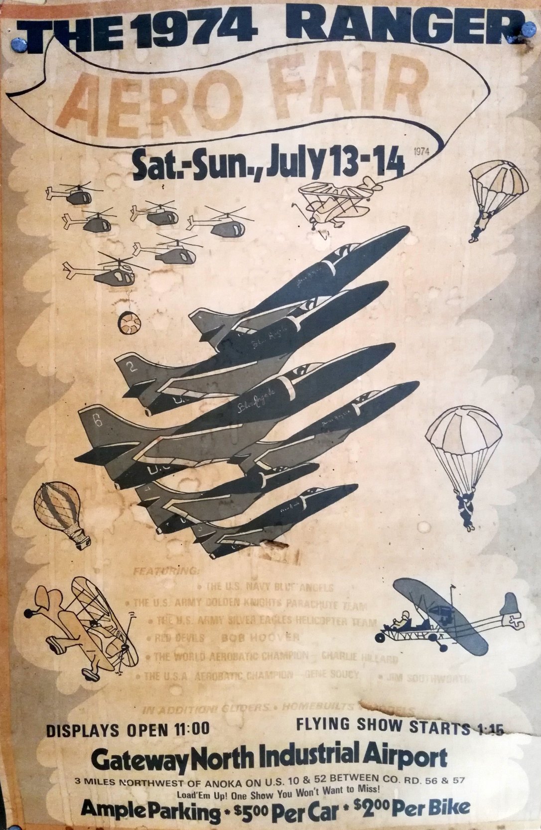
Anoka Industrial Airport was renamed Gateway North Industrial Airpark at some point between 1972-74,
as that is how it was named on a 1974 Ranger Aero Fair poster (courtesy of John Quinlan), of a show featuring the US Navy Blue Angels.
John Quinlan recalled, “Gateway North Industrial Airport... I saw a couple airshows there.
Large crowds for the shows there, but it wasn't much more than a dirt strip.
They had the Blue Angels (and Thunderbirds in another year), Silver Eagles, Golden Knights, Bob Hoover, Soucey, Hilliard etc. Quite the deal.
The Blue Angels operated out of MSP (off the 934th AW, the TAG, ramp). The Thunderbirds flew the F-4 then; you could feel their show in your chest. Just stunning.”
Ramsey police officer Brad Paplham reported, "The other day I came across the raincoat of the original Ramsey police chief, Mike Auspos.
In the pocket there was a concession token good for '1 hot dog & 1 soft drink' at the Ranger Aero Fair and the ticket was dated 7/3/77 or 7/31/77.
The air show was held several times at the airport."

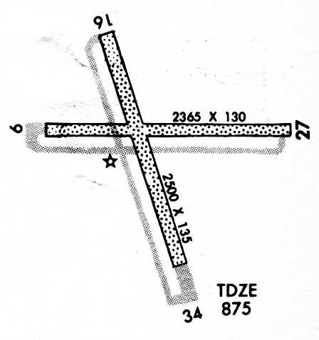
The February 1978 Twin Cities Sectional Chart (courtesy of Stu Sibitzky) depicted Gateway North Industrial Airpark as having a 2,700' unpaved runway.
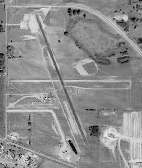
The earliest photo which has been located of Gateway North Industrial Airpark was a 1979 aerial view.
It depicted Gateway North Industrial as having 2 runways, with a cluster of small hangars southwest of the runway intersection.
A total of 20 single-engine aircraft were visible parked on the field.
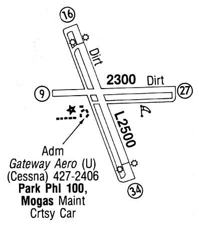
The April 1987 Flight Guide (courtesy of Chris Kennedy) depicted Gateway North Industrial Airpark
as having 2 dirt runways (2,500 Runway 16/34 & 2,300' Runway 9/27) each with parallel taxiways.
A cluster of buildings was located southwest of the runway intersection, at which was located the facilities of Gateway Aero.
The July 1988 Minneapolis Terminal Control Area Chart (courtesy of Timothy Aanerud)
depicted Gateway North Industrial Airport as having a 2,500' unpaved runway.
Gateway North Industrial Airport, as depicted on the July 1990 Approach Procedures (courtesy of Timothy Aanerud).
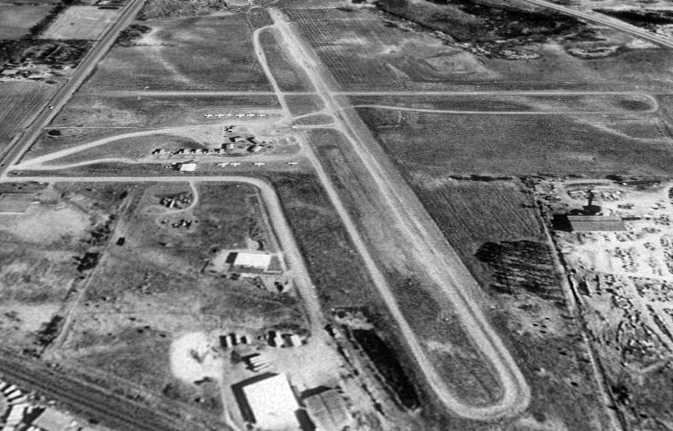
In a 1991 USGS aerial view looking north, Gateway North Industrial Airport was still open.
A total of 9 light aircraft were visible parked on the field.
Gateway North Industrial Airport consisted of 2 gravel/dirt runways & a small group of hangars.
The primary runway, 16/34, was 2,500' long and had a VOR 34 instrument approach,
According to Timothy Aanerud, the Gateway Flying Club used to be located at this airport..
John Evans recalled, “I remembered flying there & staying a few days. My brother lives nearby & this was the closest field.
My logbook showed the date to be June 6-9, 1991. I recall the strip to be very poor, not much grass, mostly soft dirt.”
Gateway North Industrial Airport was still depicted as an active airport on the July 1991 Twin Cities Sectional Chart (according to Timothy Aanerud).
Gateway North Industrial Airport was evidently closed at some point between 1991-92,
as it was no longer depicted on the February 1992 Minneapolis Terminal Chart (according to Timothy Aanerud).
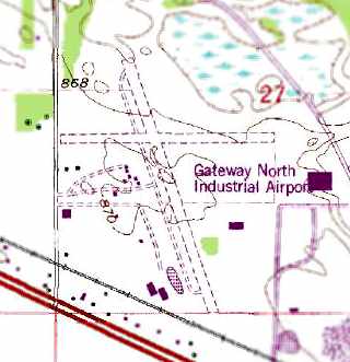
The 1993 USGS topo map still depicted the Gateway North Industrial Airport,
even though it had apparently already been closed for at least a year by that point.
It depicted the field as having 2 unpaved runways, with several small buildings southwest of the runway intersection.
Ramsey police officer Brad Paplha recalled of Gateway North Industrial Airport,
"I started here in 1994 & all that was left of the airport then was the foundations of the hangars."
Eric Mibs reported that on a 1997 aerial photo of the Gateway North Industrial Airport site, “there is almost no proof of the airport existing.”
A 2003 aerial photo showed that the Gateway North Industrial Airport property had been completely redeveloped, with not a trace remaining of the airfield.
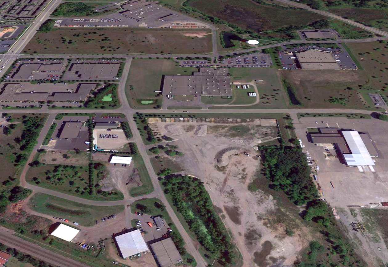
A 2015 aerial view looking north showed no trace remaining of Gateway North Industrial Airport.
Thanks to Timothy Aanerud for pointing out this airfield.
____________________________________________________
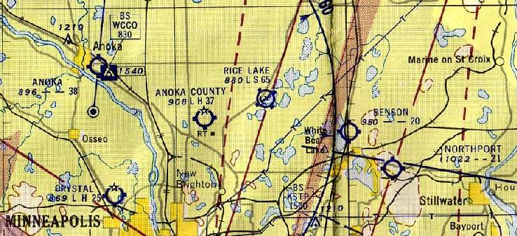
Northport Airport / White Bear Airport, White Bear Lake, MN
45.083, -92.93 (Northeast of St. Paul, MN)
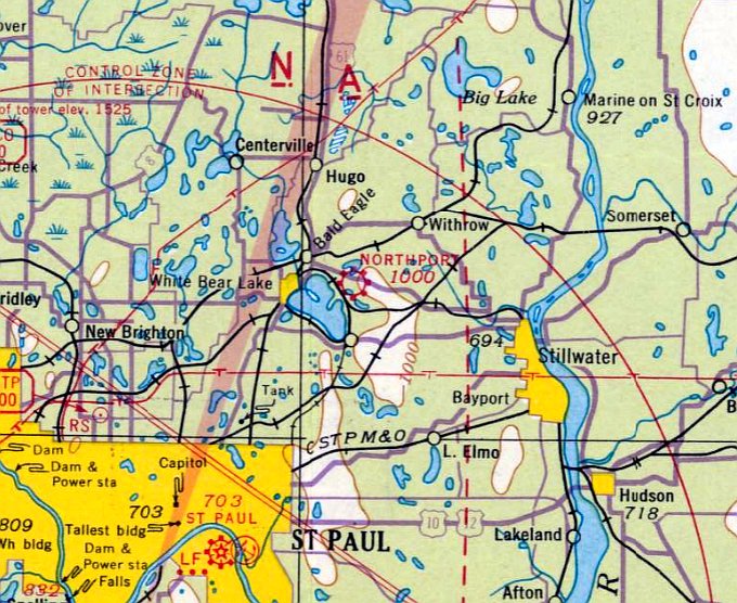
Northport Airport, as depicted on the July 1941 Twin Cities Sectional Chart.
Northport Airport was evidently opened at some point between 1940-41,
as it was not yet depicted on the May 1940 Twin Cities Sectional Chart.
The earliest depiction of Northport which has been located was on the July 1941 Twin Cities Sectional Chart.
It depicted Northport as a commercial/municipal airport.
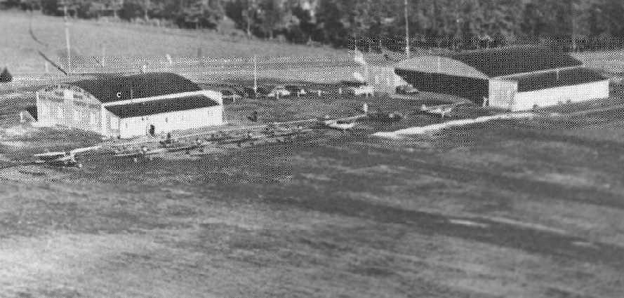
A 1942 photo by Milan Gersting from the book "Minnesota Aviation History 1857-1945"
by Noel Allard & Gerald Sandvick (courtesy of Timothy Aanerud).
The caption read, "Tom North's fleet consisting of one Stinson Gullwing & one Cabin Waco,
plus a group of Waco UPF-7's for the CPT Secondary program.
Note the absence of the airmail hangar which had not yet been moved in at the time this photo was taken."
The April 1944 US Army/Navy Directory of Airfields (courtesy of Ken Mercer) described Northport as having a 2,300' unpaved runway.
Thomas North was the owner of the "North Aviation Company", according to Timothy Aanerud.
Taylorcraft L-2As were used at Northport during WW2 for glider instruction as part of the Civilian Pilot Training program.
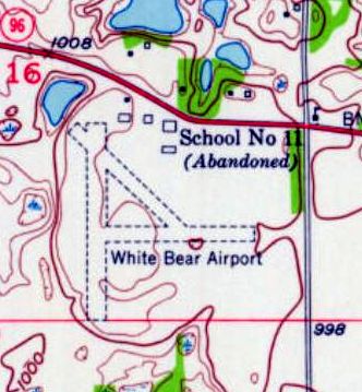
The 1951 USGS topo map depicted “White Bear Airport” as having 3 unpaved runways,
and several buildings along the north side.
The May 1954 Twin Cities Sectional Chart Chart (courtesy of Jim Stanton) depicted Northport as having a 2,100' unpaved runway.

A 6/1/57 aerial view depicted Northport as having 2 grass runways, with 3 hangars at the north end.

The 1971 Flight Guide (courtesy of Chris Kennedy)
depicted Northport as having a 2,100' unpaved Runway 17/35 & a 1,950' unpaved Runway 13/31.
Taxiways led to a ramp on the northeast side of the field with a few small hangars.
Nicholas Brogren recalled, “My father kept his C150A at Northport. I recall one hangar; I believe it held 2-3 general aviation aircraft.”
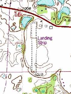
The 1980 USGS topo map only depicted a single runway, labeled "Landing Strip",
along with 3 hangars on the north end of the field.
Kristin Winter recalled of Northport, “The east/west runway... I did takeoffs & landings on that runway as late as 1985,
while working as an instructor at the nearby Lake Elmo Airport.”
Northport was still charted as a public-use airport
on the February 1987 Minneapolis/St. Paul Terminal Control Area Chart (according to Timothy Aanerud).
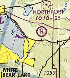
The 1988 July 1988 Minneapolis/St. Paul Terminal Control Area Chart (courtesy of Timothy Aanerud)
depicted Northport as a private field with a 2,500' unpaved runway.
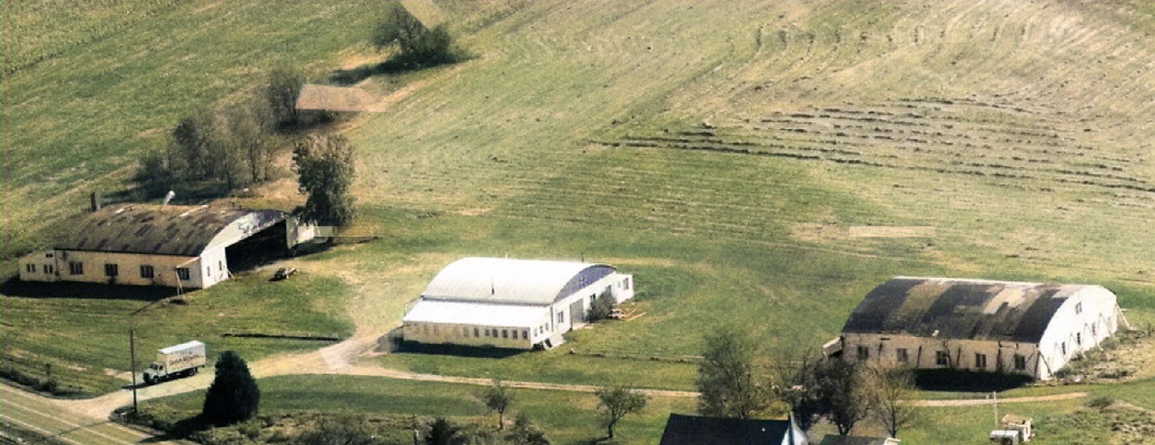
A 1988 aerial view looking southeast (colorized by Mike Denja) showed the 3 Northport Airport hangars as remaining intact, but no aircraft were visible on the field.
Northport Airport evidently closed (at least officially) at some point between 1988-89,
as it was no longer charted on the February 1989 Twin Cities Sectional Chart (according to Timothy Aanerud).
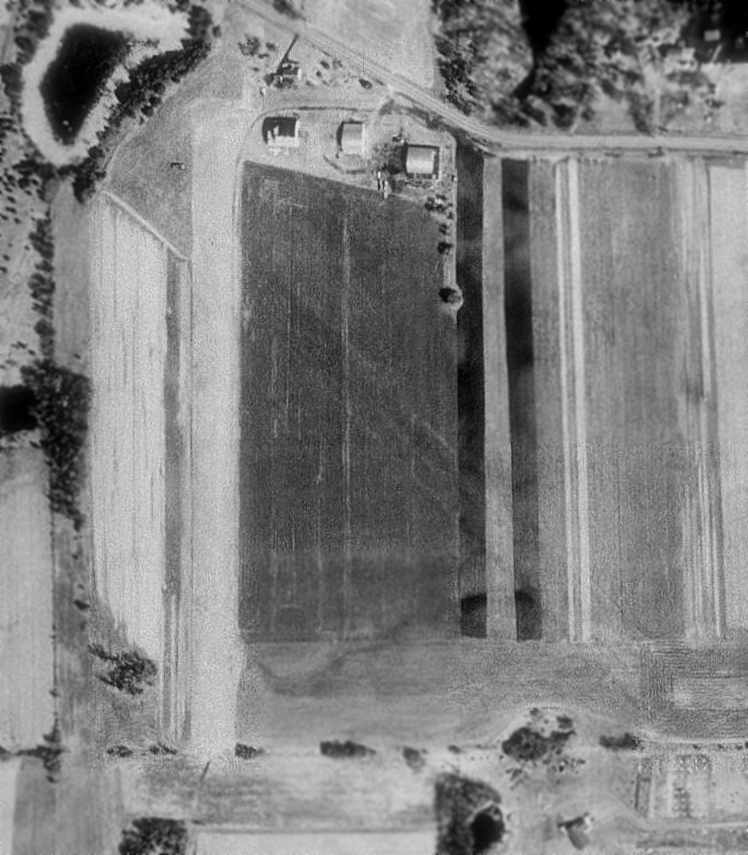
In the 1991 USGS aerial photo, Northport Airport was still intact -
both the north/south runway & the outline of the former northwest/southeast runway were still visible.
All 3 hangars also still remained standing.
In fact, the airport may still have been in use (at least unofficially), as there appeared to be one white light plane parked just south of the western hangar.
A 2003 aerial view showed that at some point between 1991-2003 the site of Northport Airport was redeveloped,
with a new street (Ivy Avenue) & several houses covering the airport site.
Not a trace appeared to remain of the little airport.
A 2015 aerial view shows no trace remains of Northport Airport.
The site of Northport Airport is located south of the intersection of Dellwood Road & Ivy Avenue.
____________________________________________________
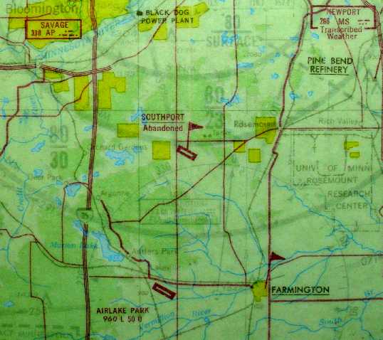
Navy Outlying Field A-3 / Outlying Field 17412 / Hogan Field / Paris Field /
Southport Airport, Apple Valley, MN
44.728, -93.212 (South of Minneapolis, MN)
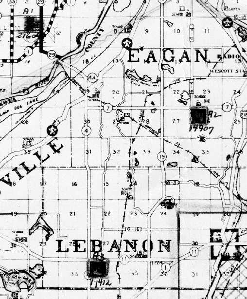
A circa 1942-45 Navy location map for NAS Minneapolis & its outlying fields, showing the location of field “A3”, also labeled “17412” (courtesy of Brian Rehwinkel).
According to Brian Rehwinkel, “The location for Southport Airport (at least the northwest portion) was used by the Navy during World War Two
as a site for one of the outlying practice fields for NAS Minneapolis.
The US Government paid the owner of the land $1,500 a year to lease 149.5 acres of land for the field – which the Navy referred to as 'Field A-3' or 'Hogan Field'.
In a June 1944 real estate report from the Commanding Officer of NAS Minneapolis to the Chief of Naval Aviation Primary Training,
this field was described as consisting of 149.5 acres & was being rented at an annual cost of $1,500 from a Robert Ferguson.
The document went on to say the lease agreement was entered into on 7/1/42.
I don’t know if there was an existing airfield that was leased by the Navy, but it appears the Navy first used the field sometime after July 1942.”
According to an article by Noel Allard in the June 2006 in the Minneapolis EAA “On Final” newsletter (courtesy of Brian Rehwinkel),
Field A3 was one of 3 outlying fields used to support flight training conducted at NAS Minneapolis.
“Practice would take student pilots straight south from Wold to shoot landings at field A3 (known at the time as Paris Field),
west past Cleary Lake to a maneuver area over Prior Lake, then back to Wold-Chamberlain.
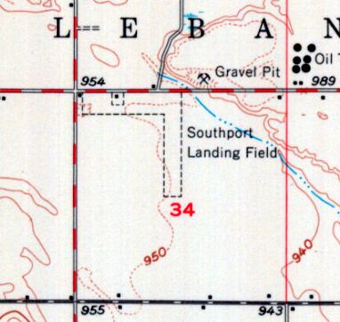
Paris Field had been farmland & was on property owned by Jack Kipp, located 4 miles west of Rosemount in Lebanon Township.”
The earliest depiction which has been located of Field A-3 was a circa 1942-45 Navy location map for NAS Minneapolis & its outlying fields (courtesy of Brian Rehwinkel).
Brian Rehwinkel observed, “As you will notice on the map, the Navy assigned a Bureau of Aeronautics number of 17412
(In later documents, the number was changed to 18212…I don’t know why).”
In 1944, the property owner was granted a license to operate Southport as a public airport.
No airport at this location was yet depicted on the December 1944 Twin Cities Sectional Chart
nor listed in the Haire Publishing Company's 1945 Airport Directory (according to Chris Kennedy).
According to an article by Noel Allard in the June 2006 in the Minneapolis EAA “On Final” newsletter (courtesy of Brian Rehwinkel),
“On 2/16/46, following the war, the Minnesota Aeronautics Commission licensed Lt. Col. Jack Kipp, to operate as Southport Aero Service.
He had become a decorated Marine Corps pilot, who was flying his reserve hours from Wold-Chamberlain Field.
Kipp told Sherm Booen in a conversation many years later that he purchased war-surplus military aircraft from the government
and kept them in the old farm barn, still located on the field, along with geese that he raised!
From this venue, Kipp sold 12 Stearmans at $150 apiece & a glider with trailer for $175.
Kipp also taught students to fly on the GI Bill.”
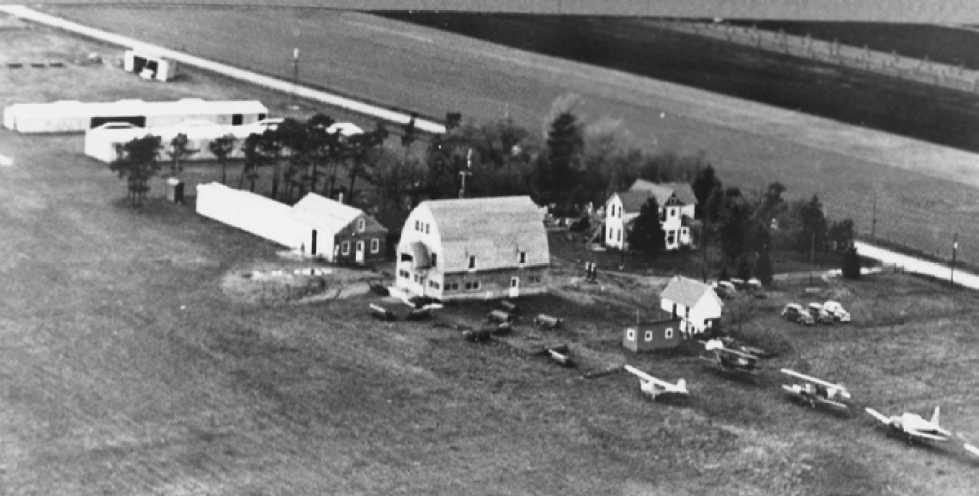
The earliest photo of Southport which has been located was a 1946 aerial view by Jack Kipp looking northwest,
showing the “barn” warehouse, several other rows of hangars, and 5 single-engine aircraft.
According to an article by Noel Allard in the June 2006 in the Minneapolis EAA “On Final” newsletter (courtesy of Brian Rehwinkel),
“Records show that in 1947, the National Academy of Model Aeronautics model airplane meet took place at Southport Airport.
Hobby shop owner, Paul Ring, was the event coordinator.”
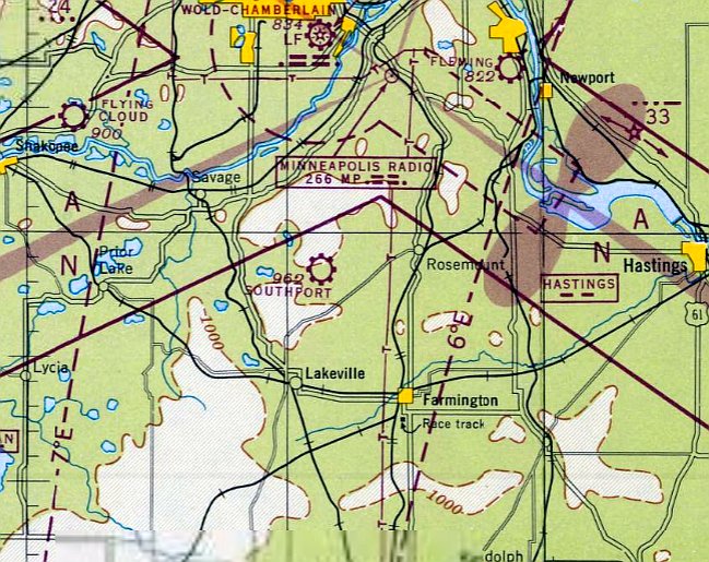
The earliest aeronautical chart depiction of Southport which has been located was on the June 1947 Twin Cities Sectional Chart,
which depicted Southport as a commercial airport.
According to an article by Noel Allard in the June 2006 in the Minneapolis EAA “On Final” newsletter (courtesy of Brian Rehwinkel),
“Kipp had trained GIs to fly on the GI Bill, but in 1951 with the Bill’s funding dried up, Kipp decided to sell out & move to Florida.
Before he departed, Kipp sold the airport property to George Ellis of a restaurant-owning family.
Ellis, in turn, sold the property to P.A. Rasmussen who owned the Viking Company which manufactured commercial audio equipment.
Chuck Doyle was a stockholder in the Viking Company.
Orville Brede leased facilities at the field to run a flight school & maintenance shop.
Rasmussen shortly afterward hired Willard Steichen from Fargo, ND to take over & run the operation.
Larry Lucken worked as a maintenance technician for Brede & then Steichen.
When Rasmussen died, his family maintained the lease with Steichen.”
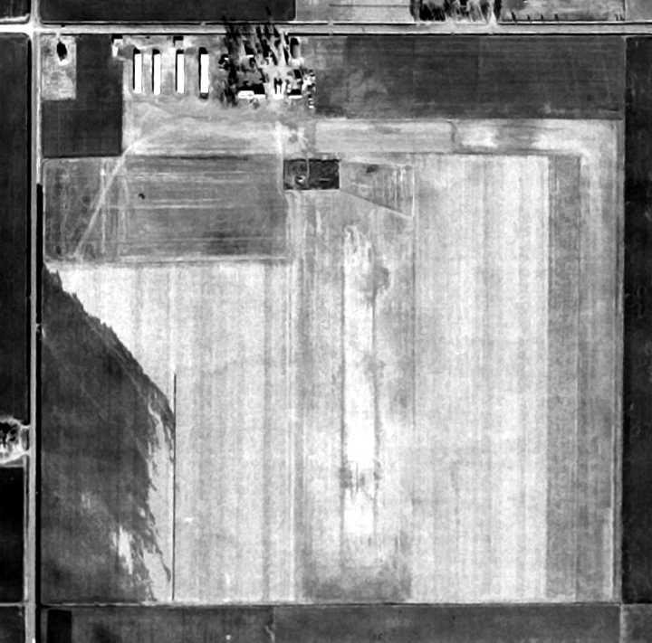
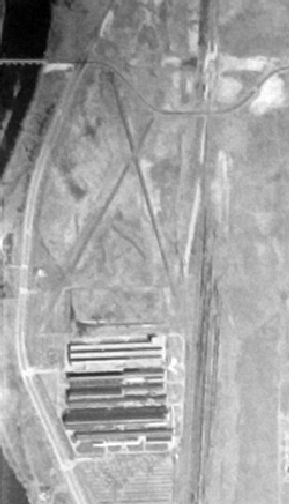
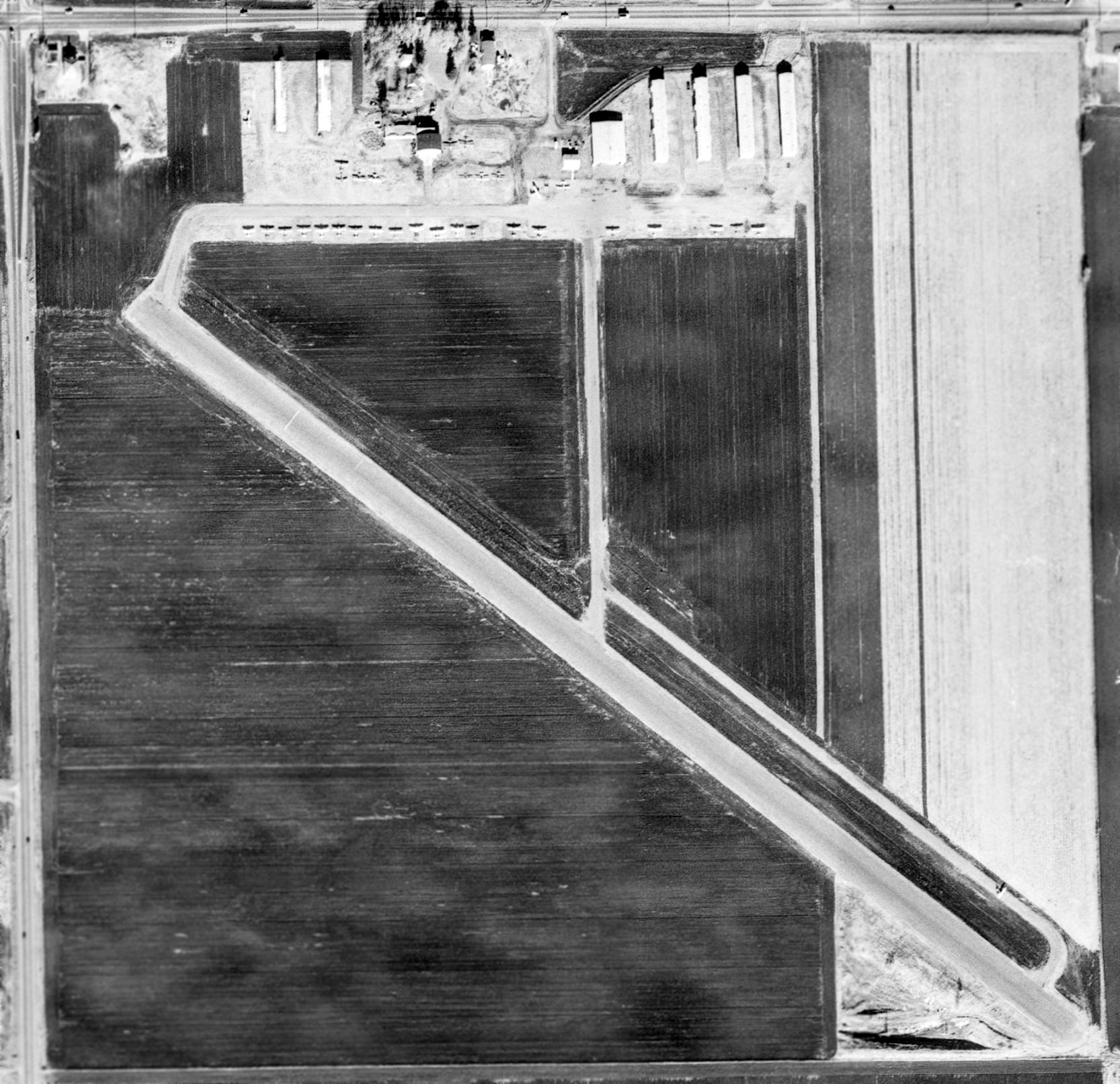
A 1953 USDA aerial photo (courtesy of Brian Rehwinkel) depicted Southport as having 4 rows of hangars on the northwest side of a square grass field.
There were no aircraft visible in the photo; it was not evident if it was actively in use as an airport.
According to an article by Noel Allard in the June 2006 in the Minneapolis EAA “On Final” newsletter (courtesy of Brian Rehwinkel),
“In 1955, the 2,800’ Runway 12/30 was paved.”
However, the April 1956 Twin Cities Sectional Chart (courtesy of Chris Kennedy)
still depicted Southport as having a 2,300' unpaved runway.
The 1957 USGS topo map also continued to depicted “Southport Landing Field” as having 2 unpaved runways.
A 1957 aerial view depicted Southport as having a paved northwest/southeast runway,
along with an unpaved north/south runway.
Five rows of T-hangars & other smaller buildings were located at the northwest corner of the field.
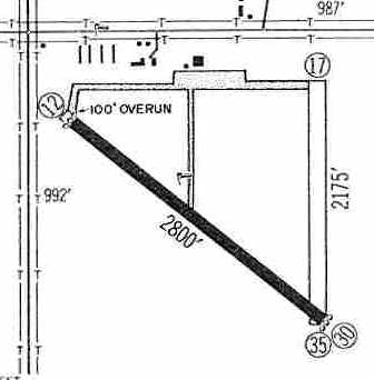
The 1959 Jeppesen Airway Manual (courtesy of Chris Kennedy)
depicted Southport as having a 2,800' paved Runway 12/30 & a 2,175' unpaved Runway 17/35.
Taxiways led to a ramp on the north side of the field with a few small hangars.
An undated photo of a Southport Airport “Fly In Drive In” event from an article (courtesy of Lance Huston).
At its high point in the 1960s Southport was home to over 100 aircraft & hosted airshows.
According to an article by Noel Allard in the June 2006 in the Minneapolis EAA “On Final” newsletter (courtesy of Brian Rehwinkel),
“In the 1960s, the Blue Angels & Thunderbirds performed at the annual Aquatennial Airshows over Southport.
They staged from Wold-Chamberlain’s Navy Base.
The Sports Car Club of America, Land-O-Lakes Chapter, staged annual sports car races at the field from 1963-68 using the runway & taxiways.
I attended the Southport races & one year watched them while orbiting overhead in a Cessna 150.
Forrest Lovley flew overhead one year & when he wanted to land, chose a break in the races & landed, catching hell from the organizers.
Scotty Beckett, the winner of the 1963 race, told me that the racing arrangements were handled between the club & Chuck Doyle.”
Eric Brown recalled, “Southport Airport... a single 2,800' paved runway. I learned to fly there in 1965.
I received my private pilot check ride in 1967 from airport operator Willard Stiechen, who lived on the airport.
I worked part-time in the FBO shop while attending Airframe & Powerplant [mechanic] school in 1967/68.
I kept my airplane there in 1968/69.”
According to Randy Sohn, Southport Airport was operated by Chuck Doyle & Williard Stiechen.
According to an article by Noel Allard in the June 2006 in the Minneapolis EAA “On Final” newsletter (courtesy of Brian Rehwinkel),
“Willard Steichen’s son, Jon & daughter Julie, both learned to fly at Southport Airport.
The field became a popular base for local pilots who wished to fly outside the controlled airspace of Minneapolis-St. Paul International.
In September 1970, with less than 100 hours in my logbook,
I bought a Southport-based Aeronca Chief from 2 Northwest mechanics who were on strike & needed the money.
Roger Poore & Cliff Bakko were very patient with me;
over the course of the next few weeks they allowed me to fly with them & shoot a few hours of landings in the Chief…from the right-hand seat.
Neither would let me fly from the left seat while they were in the plane.
When he thought I knew how to handle a taildragger, Roger got out, shook my hand & told me, 'Now you can fly it from the left.'
I spent many a calm evening that Fall & Winter gingerly checking myself out on the airplane.
I can remember the locale very well to this day.
The approach from the northwest was over the red roof of a Dairy Queen store at the intersection of Cedar Avenue & County Road 42.
To the North of the airport was a huge gravel pit & to the South, virtually nothing but open cultivated farm fields.”
Noel continued, “On a fairly warm morning in the Spring of 1971, I attempted to fulfill a promise to give my wife, Mary’s best friend, Sylvia Anderson, a plane ride.
By the time we got to the airport, a fairly strong crosswind was blowing from the north.
I had made a hundred landings with no problems, but had never practiced crosswind landings.
I was a little nervous & suggested that I taxi out and shoot a couple landings before I took Sylvia for a ride.
That was approved by the girls & so I took off and circled the airport.
On my first approach, I marveled at the amount of crab I had to carry to hold alignment with the runway.
I was too inexperienced to know what this meant.
I got one wheel on the ground & then the wind lifted my upwind wing & carried me off the runway.
I didn’t know what I did wrong, nor what I did right,
but I ended up plunk among the freshly plowed rows of black dirt in the field alongside the runway, fortunately right side up.
Willard Steichen & a couple others, watching my plight from the flight office, came running out with grins on their faces.
They helped me push the plane back onto the runway & walked around looking it over.
'Well nothing looks to be broken', Willard said. I was somewhat confused. 'What do I do now?'
I wanted to know, 'Is this something I have to report, or fill out a form for…what happens?'
Willard just stared at me with his imposing grimace & stated, 'Well, if I were you, I’d crank up & go flying.'
'Really?' I almost groaned. 'Well, if you put that airplane away now, you won’t ever pull it out of the hangar again.'
I reluctantly climbed back in the plane & Willard flipped the prop.
Thinking to myself that I was damn lucky the first time, I took off again & circled once more.
This time, I tried really hard to recall what my flight instructor had taught me about crosswind landings & managed to bounce the plane onto the runway…
but that was enough…I taxied back to the hangar & sheepishly admitted to Mary & Sylvia that this just wasn’t the day for a ride.”
Noel continued, “Willard was airwise in many ways.
Along with maps and student flight equipment in the office, he sold a booklet titled 'Everything I Know About Flying' by Willard Steichen.
I bought a copy & when I opened it I found only blank pages!”
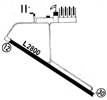
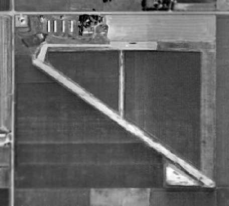
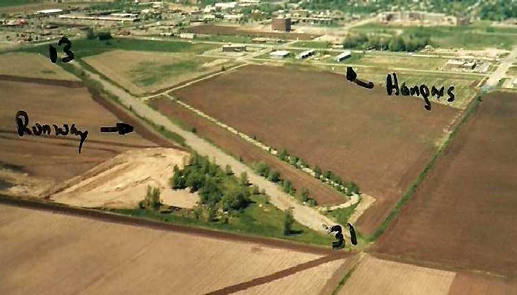
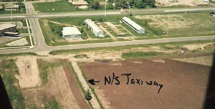
The August 1971 Flight Guide (courtesy of Chris Kennedy) depicted Southport as having a single 2,800' paved Runway 12/30,
with 2 taxiways leading to a ramp on the north side.
The number of T-hangars on the northwest side had decreased from 4 to 2 compared to the 1959 diagram,
but 4 rows of T-hangars had been added on the northeast side.
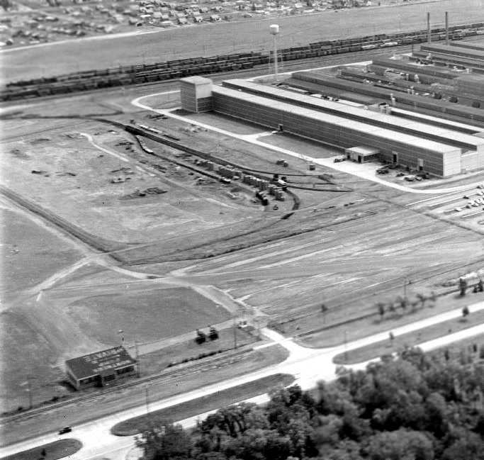
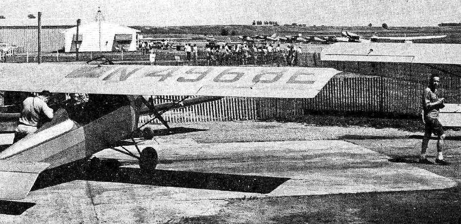
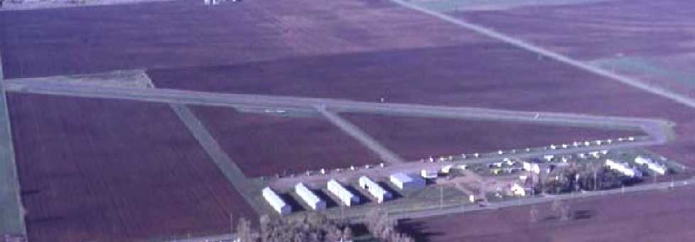
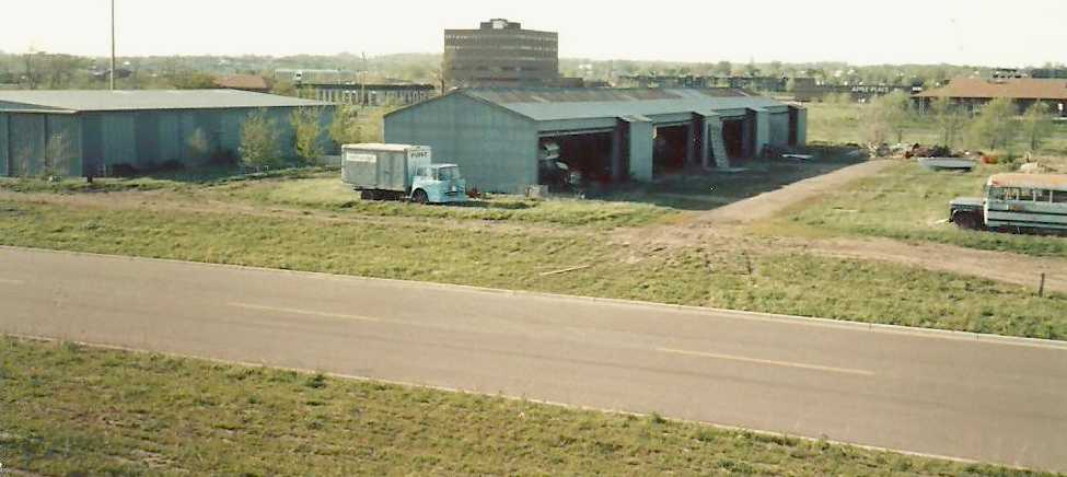
A 1971 aerial view of Southport Airport, looking northwest (copyright George Bordner of Bordner Aerials; used by permission).
A total of at least 7 hangars were visible along the north side of the field, along with a total of at least 35 aircraft visible parked outside.
A circa 1970s aerial view by Noel Allard looking southwest at Southport Airport.
Eric Brown recalled, “The large hangar… was the FBO storage hangar. I reassembled my airplane in that hangar in May 1972.
I kept my airplane there... in 1972 to the closing in 1974.”
The last aeronautical chart depiction which has been located showing Southport Airport still in operation was on the August 1972 Twin Cities Sectional Chart.
It depicted Southport as having a northwest/southeast 2,800' paved runway.
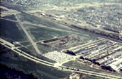
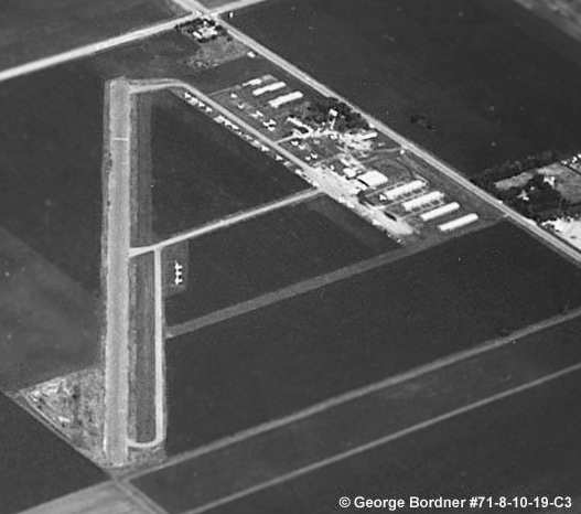
An 11/30/73 USGS aerial view depicted Southport Airport as very well-used,
with at least 33 light aircraft parked on the north side of the field.
Eric Brown recalled, “Stories of the airport's impending closing had circulated for 3 years before it actually closed.
The basic story was that a land developer had purchased the land & was going to build a shopping center.
Well, that certainly was true. In June 1974, I had to move my airplane, install a radio & move to a control-towered airport.”
According to an article by Noel Allard in the June 2006 in the Minneapolis EAA “On Final” newsletter (courtesy of Brian Rehwinkel),
“Southport Airport property became vastly valuable & the land was sold by the Rasmussen family to developers.
The airport was officially closed on 6/1/74.
The last commercial flight was flown by Viking Flying Service in May.”
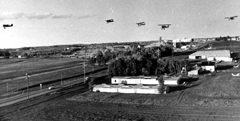
A 1974 aerial view by Gary Hanson of the last flyby of Southport Airport by small planes evicted when the airport was ordered closed:
Forrest Lovley's Vega Pietenpol, Harlan Darr's Piper J-5, Gary Hanson's Star Cavalier, D. Duea's Corvair Pietenpol, and Bert Sisler's Whistler.
According to Noel Allard, “The last flight by the sport pilots based there was... a series of fly-bys in salute to the nostalgic country airport.
With that salute, the field ceased operation, a chapter of Minnesota’s aviation history concluded.
A place of great fun, where the essentials of flying were learned,
banners were towed aloft, hangar doors froze shut in the winter, and one could slow-fly backward in a summer breeze.
It was a place where the vistas were always broad & the sky always beckoning.”
Southport was depicted as an abandoned airfield on the 1975 MN Aviation Chart (courtesy of Eric Brown).
Eric Brown recalled, “Southport Airport... I last landed on it in 1976.”
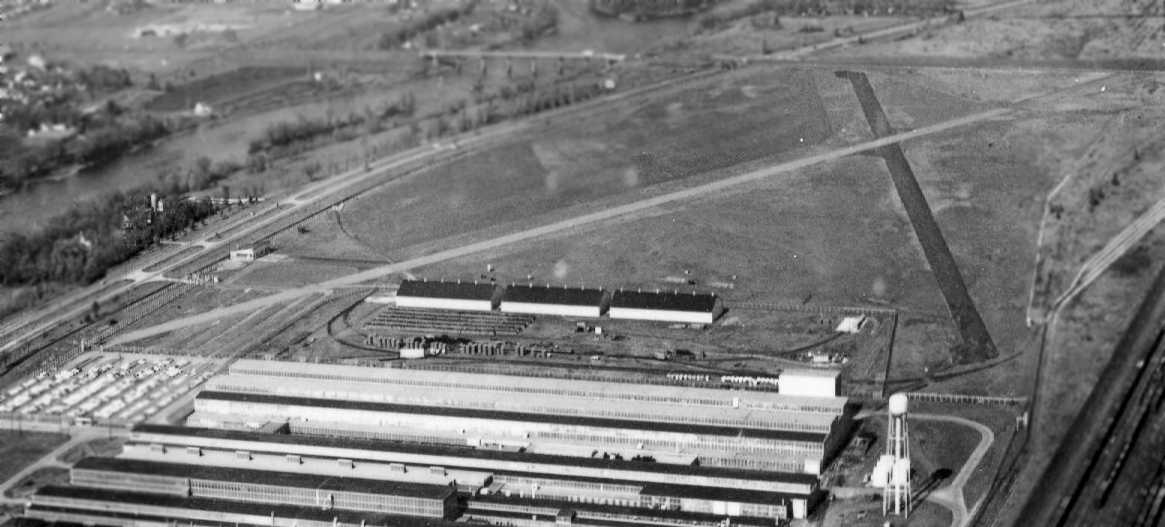
A 1979 aerial view showed that Southport Airport remained intact, including the runway & 5 hangars on the northeast side.
No aircraft were visible on the field.
A May 1986 aerial view by Eric Brown looking northwest at the intact remains of Southport Airport.
A May 1986 aerial view by Eric Brown looking northeast at the hangars which remained at the site of Southport Airport.
A May 1986 photo by Eric Brown looking northwest at the hangars which remained at the site of Southport Airport.
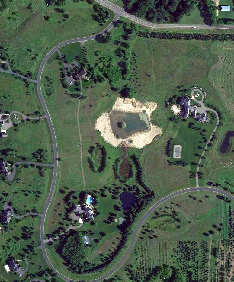
A 1991 aerial photo showed the majority of the site of Southport Airport was occupied by several retail shopping buildings,
and 2 new roads (Garrett Avenue & West 153rd Street) had been built through the middle of the former airport.
However, a 700' section of the runway still remained visible at the southeast corner of the property.
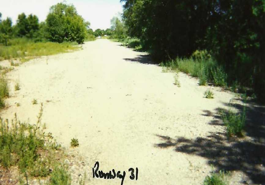
A June 2004 photo by Eric Brown looking northwest along the remains of Southport's Runway 31.
However, Todd Schmit reported in March 2005, “Just this past fall, I went walking along the old runway remains.
Last week, I drove past the old site on the way to some nearby businesses.
A brand-new street now covers all traces of the runway, following the exact compass orientation of the old airport.
The surrounding land has also been leveled in preparation of new construction.”
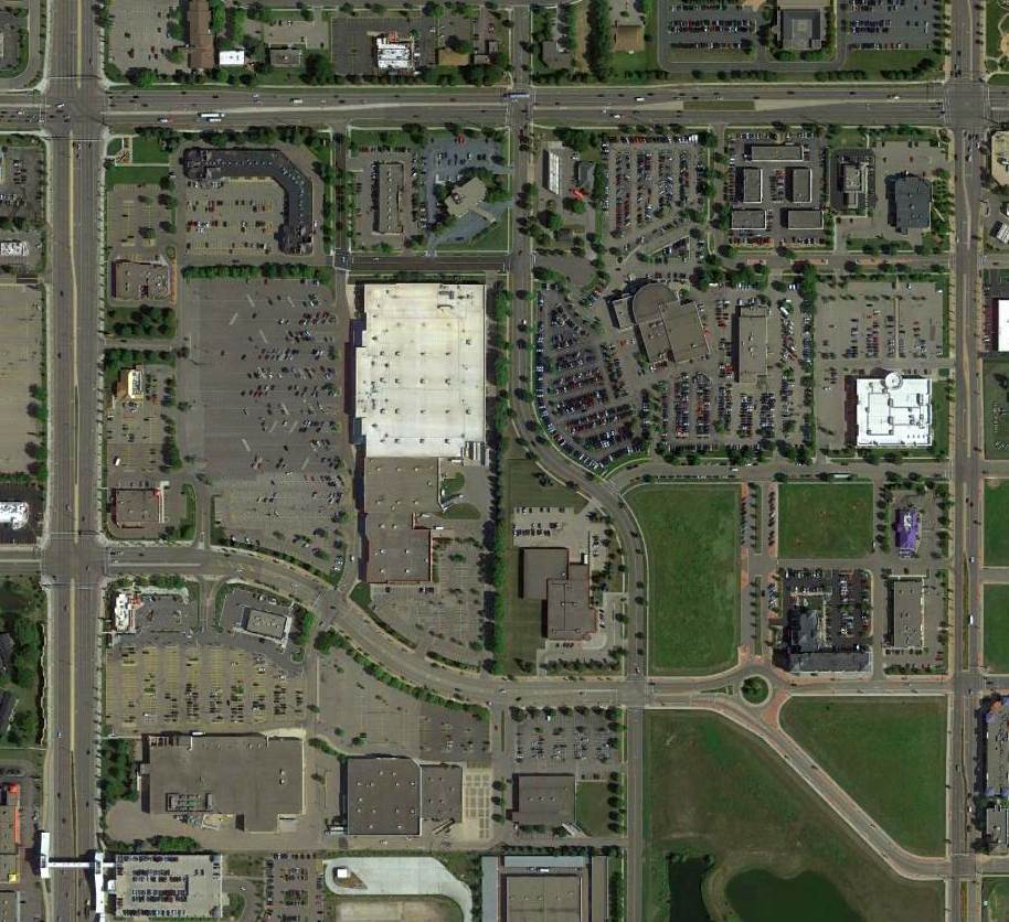
A 2015 aerial view shows no trace remaining of Southport Airport.
See also: http://www.co.dakota.mn.us/planning/pdf/compplan/2DCToday.pdf
____________________________________________________
Or if you prefer to contact me directly concerning a contribution (for a mailing address to send a check),
please contact me at: paulandterryfreeman@gmail.com
If you enjoy this web site, please support it with a financial contribution.
____________________________________________________
This site covers airfields in all 50 states.