
Abandoned & Little-Known Airfields:
Northwestern Missouri
© 2002, © 2025 by Paul Freeman. Revised 3/11/25.
This site covers airfields in all 50 states: Click here for the site's main menu.
The MO pages of this website are sponsored by the Missouri Aviation Historical Society:
____________________________________________________
Please consider a financial contribution to support the continued growth & operation of this site.
Ace High Airport (added 7/4/18) - Boonville Airport (revised 5/20/22) - Brookfield Memorial / Pershing Memorial Airport (revised 11/21/20)
Heart of America Airport / Thirty-First Street Airport / Heart Airport (revised 12/30/17) - Independence Memorial Airport (revised 11/26/23)
Kansas City Aero Club Field / Richards Field / Old Richards Airport / Ong Airport (revised 3/11/23)
Kansas City Grandview Airport / Richards Gebaur AFB (revised 3/11/25) - Rock Port Municipal Airport (added 6/30/19)
____________________________________________________
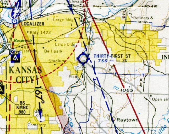
Independence Memorial Airport (3IP, 5MO2), Independence, MO
39.065, -94.342 (East of Kansas City, MO)
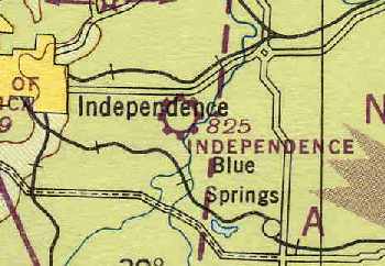
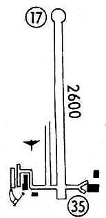
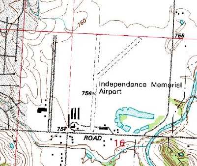
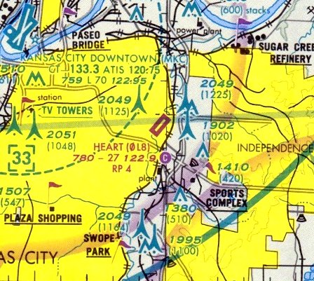
Independence Memorial Airport, as depicted on the September 1946 Kansas City Sectional Chart (courtesy of Chris Kennedy).
This small general aviation airport was apparently built at some point between 1944-46,
as it was not listed among active airfields in the 1944 US Army/Navy Directory of Airfields (courtesy of Ken Mercer).
Diane Sadler reported, “My grandmother owned that airport. She was Vesta Ailshire, known as 'Mrs. A.'.
Mrs. A inherited the land from her aunt Minnie in 1945. She created the airport with a few other developers.
She owned the airport, adjacent restaurant, Horseshoe Lake Grocery, pilot school, etc. [starting in] 1945.
She was quite a businesswoman, running the airport, establishing a ground school,
airplane repair shop, ran the Horseshoe Lake Grocery & restaurant, later named 'Mrs. A's Place'.
She became quite a local icon, many newspaper articles were written about the 'grandmother who owned an airport'.
She hosted air shows & was known for her homemade cooking & delicious pies.”
The earliest reference to Independence Memorial Airport which has been located
was on the September 1946 Kansas City Sectional Chart (courtesy of Chris Kennedy).
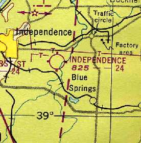
The September 1948 Kansas City Sectional Chart (courtesy of Chris Kennedy)
depicted Independence Memorial Airport as having a 2,400' unpaved runway.
Diane Sadler reported, “Mrs. A bought them [the other airport partners] out in 1950.”
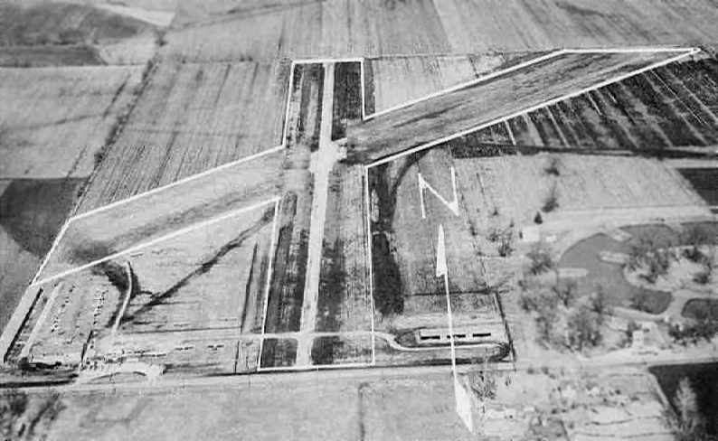
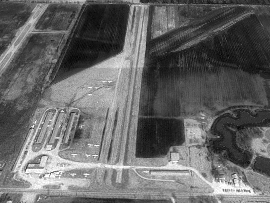
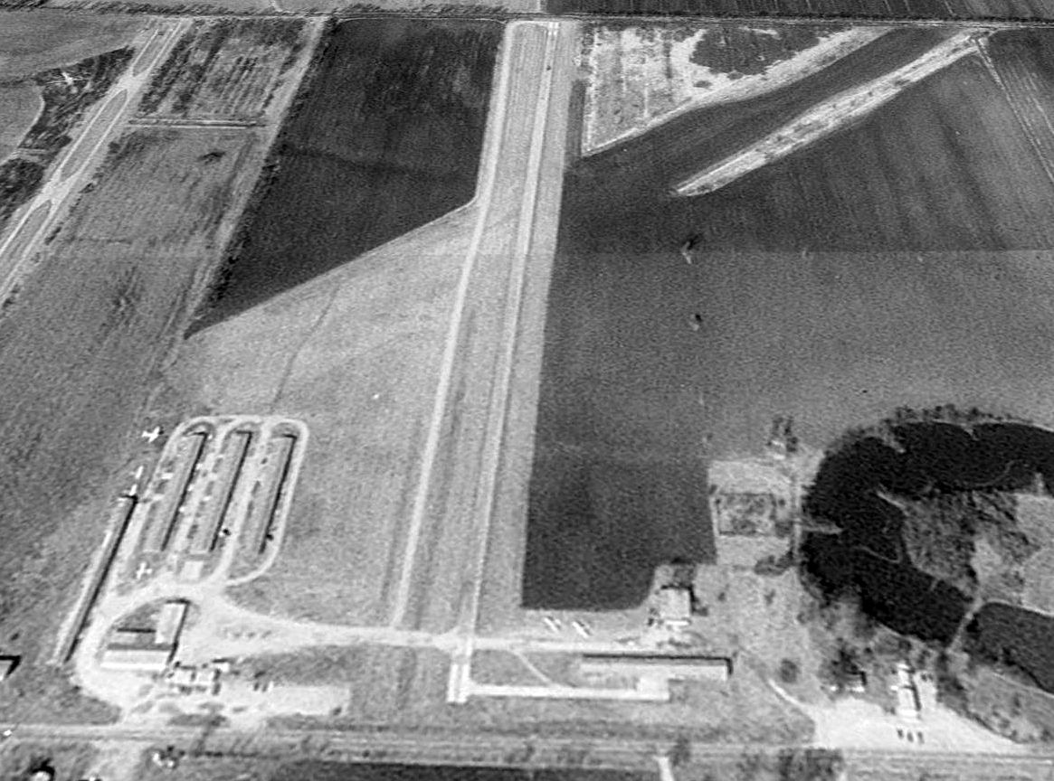
An aerial view looking north at Independence Memorial Airport, from a circa 1957-61 MO Airport Directory (courtesy of Chris Kennedy).
The field was described as having a 3,000' hard-surface Runway 18/36 & a 2,800' turf Runway 4/22.
A tiedown area was depicted on the southwest side of the field, at which were a few small buildings & around a dozen light aircraft.
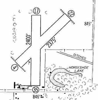
The 1960 Jeppesen Airway Manual (courtesy of Chris Kennedy)
depicted Independence Memorial Airport as having 2 unpaved runways: 2,400' Runway 17/35 & 2,375' Runway 4/22.
A few small buildings were clustered around a small ramp on the southwest corner of the field.
The 1962 AOPA Airport Directory described Independence Memorial Airport
as having 2 turf runways: 2,400' Runway 18/36 & 2,375' Runway 4/22.
The operator was listed as Independence Memorial Airport.
The May 1971 Flight Guide (courtesy of Chris Kennedy) depicted Independence Memorial as having a single 2,600' Runway 17/35,
with taxiways at the south end leading to buildings on either side of the runway.
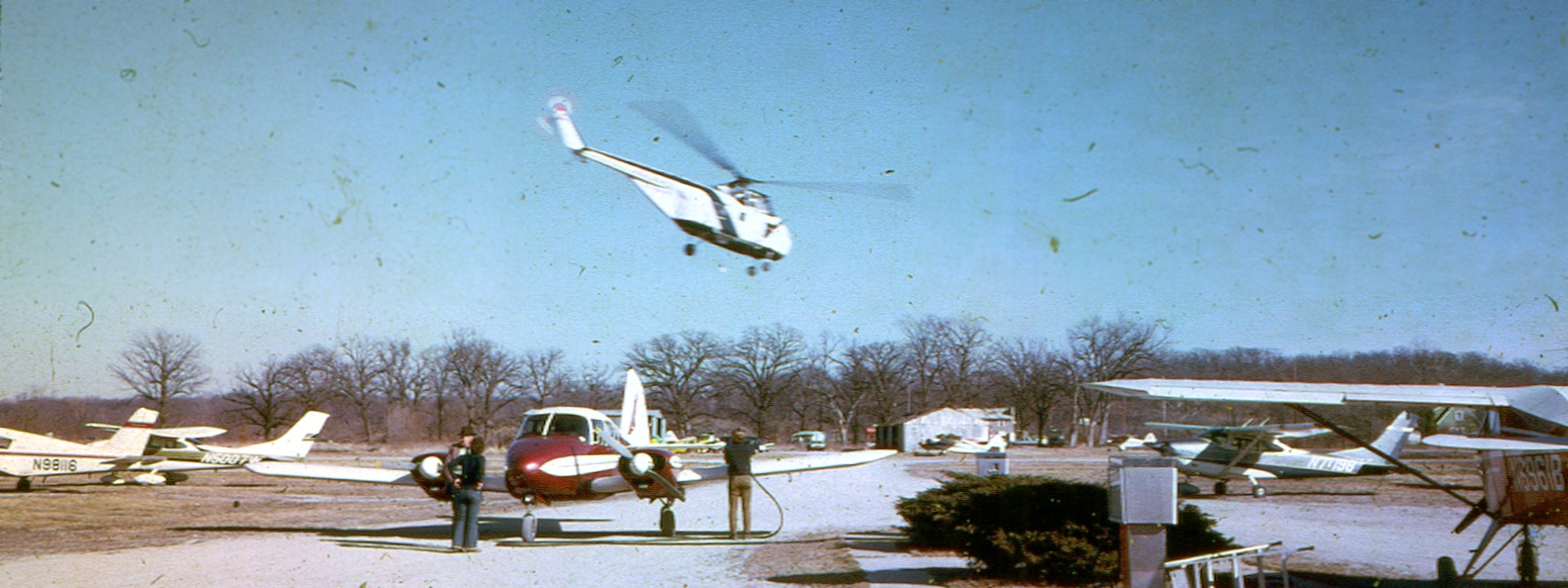
A circa 1973 photo by Doug Jones of Jack Stillwell standing next to his Piper Aztec (Safe Wing Flying Service?) being fueled by the lineboy at Independence Memorial Airport.
Doug observed, “His pilot Mary is standing beside him. My plane the Piper Tri-Pacer is waiting by the pumps to be fueled.
I think Bob Schlotzhauer is flying the [Sikorsky S-55] helicopter.
The helo wasn't based there. But the owner Bob Schlotzhauer hung out there a lot.
He was a good friend of Gary Wilson who owned an aircraft re-building business at the airport (I bought 2 planes from Gary).
Bob had a helicopter repair business & a charter business. His offices were about 3 miles away from the airport.”
Lynn Travers reported, "I lived about 2 miles north of the runway from 1978-95.
It had a single runway running mostly north/south. It was gravel & was paved sometime in the 1980s.
My dachshund would wait at our yard fence & chase planes as they passed over our yard.
From time to time a TBM Avenger or a Spanish-marked T-6 would shoot touch & go's.
Lots of ultralight traffic."
The 1982 AOPA Airport Directory (courtesy of Ed Drury) described Independence Memorial as having a single 2,600' gravel Runway 17/35.
The last aeronautical chart depiction which has been located of Independence Memorial Airport was on the 1982 Kansas City Sectional Chart.
It depicted Independence Memorial Airport as having a 2,600' unpaved runway.
A 1990 USGS aerial view looking north depicted Independence Memorial Airport
as having a paved north/south runway along with its former grass crosswind runway.
Twenty light single-engine planes were visible on the parking spots at the southwest corner of the field.
The 1995 USGS topo map depicted Independence Memorial Airport as having 2 unpaved runways,
along with several buildings (hangars?) on the southwest corner of the field.
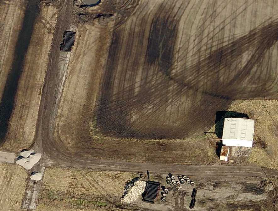
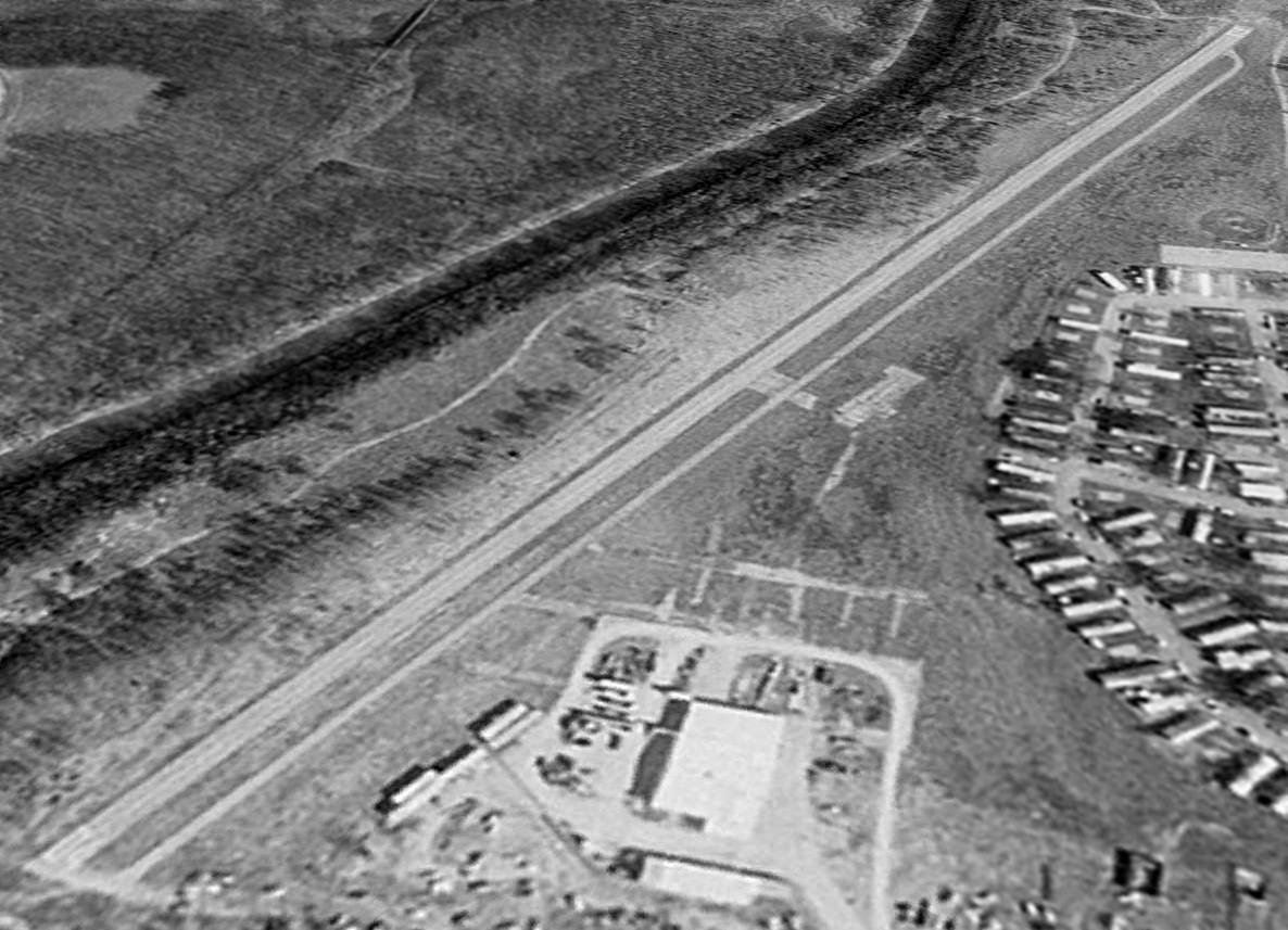
The last photo which has been located showing aircraft at Independence Memorial Airport was a 1996 aerial view looking north.
But compared to the 1990 aerial photo, the number of aircraft visible on the field had dwindled to only six.
Diane Sadler reported, “Mrs. A owned the airport until 1998 when she sold it to Bob Schlotzhauer.
He said he was going to develop it, but within a year had demolished all the hangars & sold the land to a developer.”
The 2000 AOPA Airport Directory described the field as having a single 2,600' asphalt Runway 17/35.
Independence Memorial Airport was evidently closed at some point between 2000-2002.
According to the summary of the 2/20/02 meeting of the Aviation Committee of the Mid-America Regional Council,
"This privately owned public airport is closed.
No maintenance is being performed at the airport & some of the buildings have been taken down.
Few aircraft remain there.
It appears that most of the displaced aircraft have moved to East Kansas City Airport.
MARC's current Airports System Plan has a proposed new airport in Northeastern Jackson County.
The City of Independence completed an airport master plan for a location in the Atherton river bottoms
adjacent to Little Blue River sewage treatment plant.
Currently, the City of Independence is not interested in building a new airport."
A 2002 aerial photo showed no aircraft on the field, and half of the hangars had been removed,
but the runway was still marked as an active runway.
Independence Memorial Airport was still listed as an active airport as of 2003 in the FAA Airport/Facility Directory.
However, the remarks included, "Airport unsafe, not maintained."
The owner was listed as Robert Slotzhaurer.
A total of 54 aircraft were listed as being based at the field, and it was listed as conducting a total of 55 aircraft operations per day.
However, Lynn Travers reported, "I went by to visit the field in September of 2003 & found it closed & pretty well overgrown."
A 2003 aerial photo showed the runway had been painted with closed-runway “X” symbols.
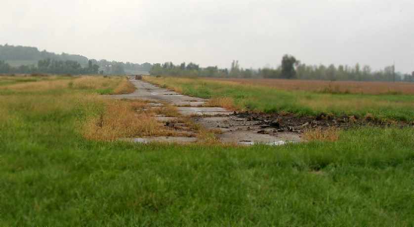
A 2005 photo by Paul Eriksmoen, looking along the remains of the paved runway at the former Independence Memorial Airport.
“The runway is still intact, though overgrown, and there are earthmovers that are in the process of tearing up the taxiways & tarmac.”
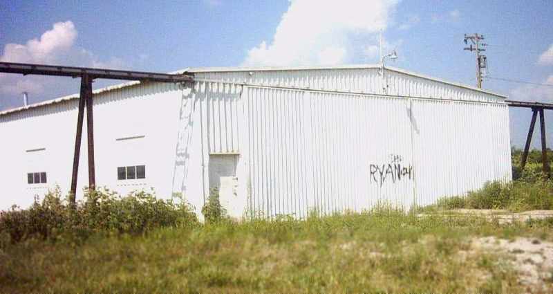
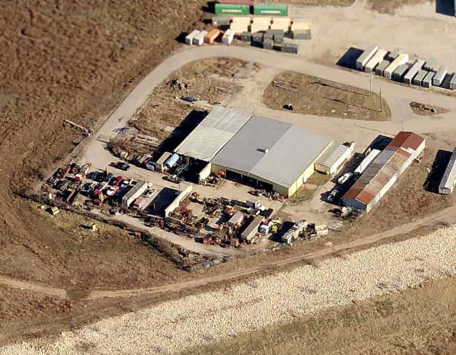
A July 2005 photo of the sole remaining hangar at the site of Independence Airport (at the southeast corner of the site).
A 2006 aerial photo showed all of the hangars on the southwest side had been removed,
with the hangar on the southeast side the only one remaining.
A circa 2006 aerial view looking north at the sole remaining hangar at the site of Independence Airport (at the southeast corner of the site),
along with the former runway (which was in the process of having its pavement removed).
All of the hangars on the southwest side of the field had been removed.
A 2007 aerial photo of the site of Independence Memorial Airport showed the last hangar (on the southeast side) had been removed at some point between 2006-2007.
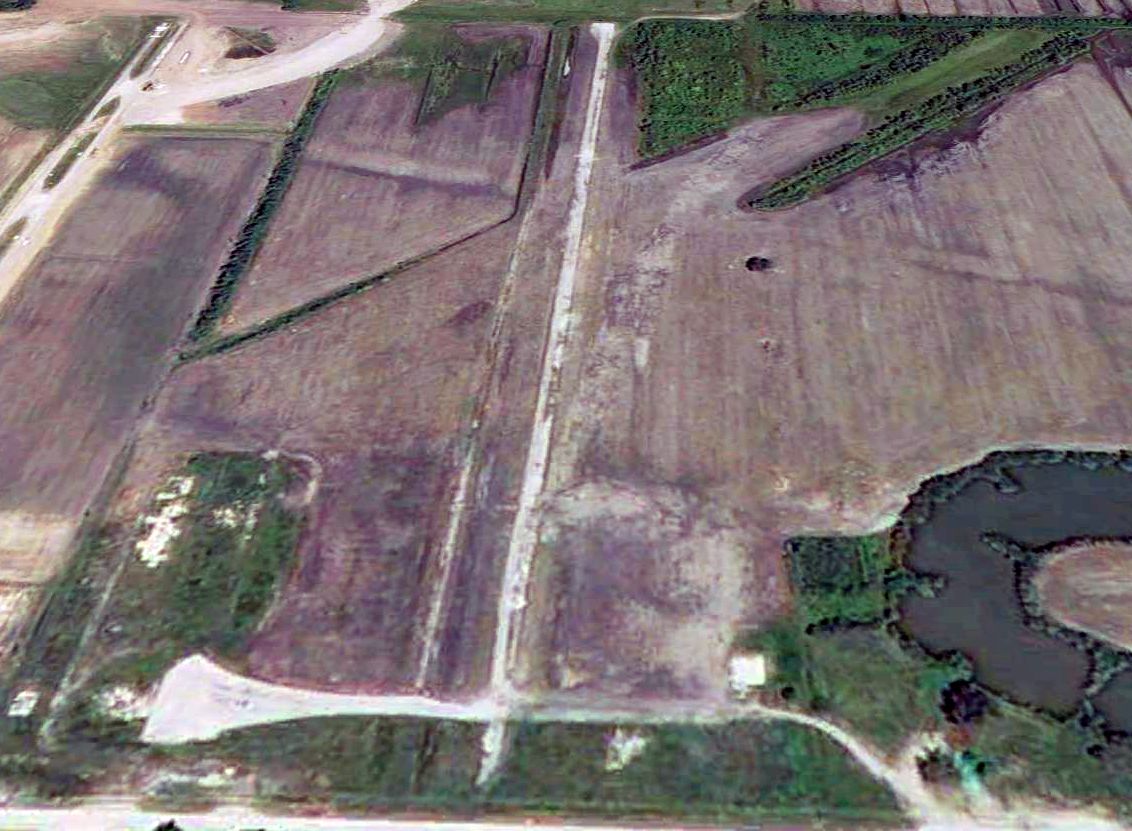
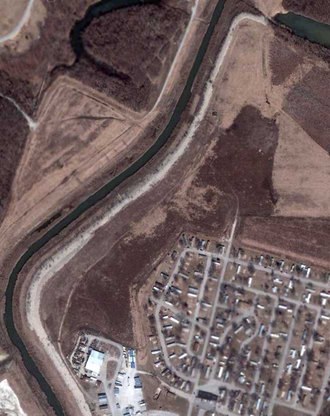
A 2009 aerial view looking north at the remains of Independence Memorial Airport showed the paved north/south runway, taxiways, and the unpaved crosswind runway.
A 2010 aerial photo showed Little Blue Parkway was being constructed through the center of the Independence Memorial Airport site.
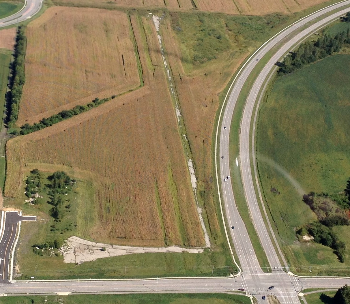
A 9/13/14 aerial view by Donald Harper looking north showed Little Blue Parkway had been built through the site of Independence Memorial Airport,
but the remains of the paved north/south runway, taxiways, and the unpaved crosswind runway were still quite evident.
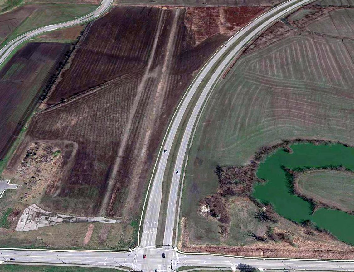
A 2016 aerial view looking north at the site of Independence Memorial Airport showed the remains of the paved north/south runway, taxiways, and the unpaved crosswind runway were still evident.
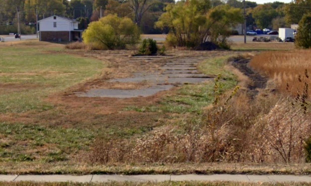
A 2022 photo looking west at the remains of the Independence Memorial Airport taxiway pavement.
The site of Independence Memorial Airport is located northeast of the intersection of E Rd Mitze Road & South Selaa Road.
____________________________________________________
Rock Port Municipal Airport, Rock Port, MO
40.416, -95.6 (Northwest of Kansas City, MO)
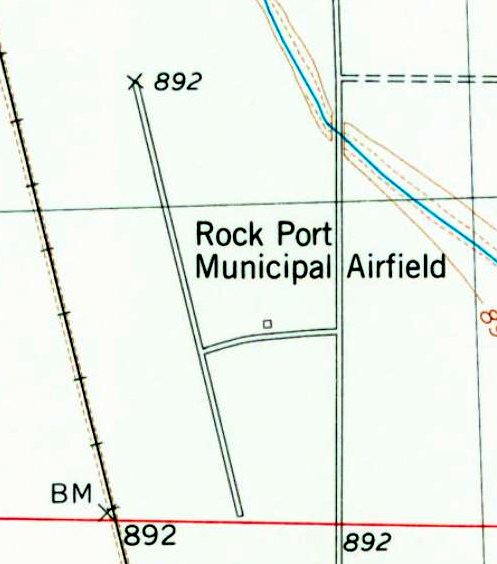
“Rock Port Municipal Airfield”, as depicted on the 1981 USGS topo map.
Another of America's disappearing small general aviation airports.
Rock Port Municipal Airport was evidently established at some point between 1965-81,
as it was not yet depicted on a 1965 aerial photo.
The earliest depiction which has been located of Rock Port Municpal Airport was on the 1981 USGS topo map.
It depicted “Rock Port Municipal Airfield” as having a northwest/southeast paved runway, with 1 small building on the east side.
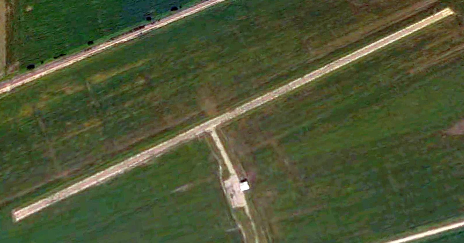
The earliest photo which has been located of Rock Port Municipal Airport was a 2003 aerial view looking northwest (courtesy of Lee Corbin).
It depicted Rock Port as having a northwest/southeast paved runway, with 1 small building on the east side, but there were no aircraft visible on the field.
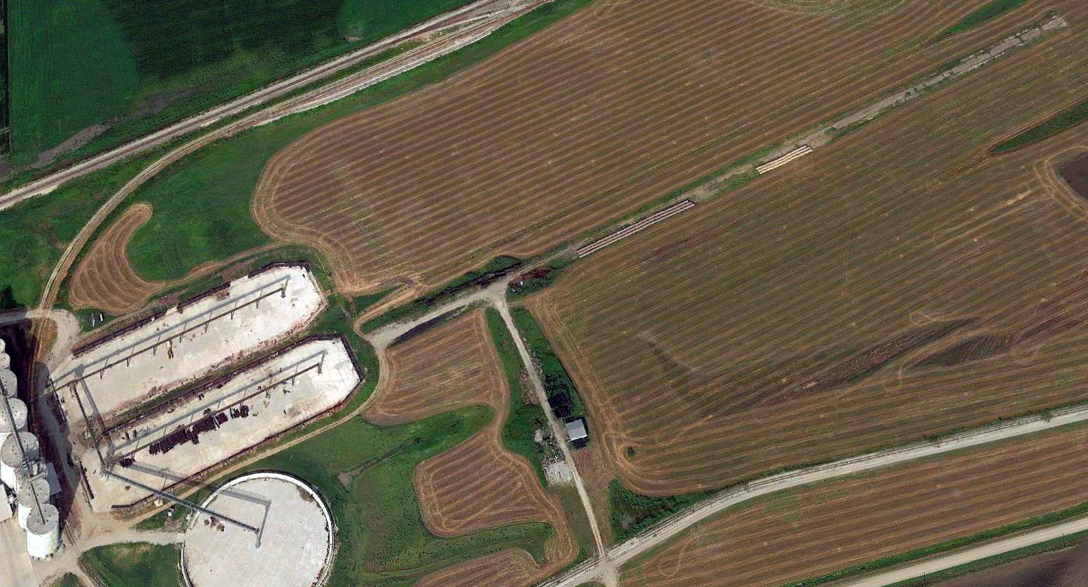
Rock Port Municipal Airport was evidently closed at some point between 2003—2015,
as a 2015 aerial view looking northwest showed the southern portion of the runway had been covered by a large industrial facility.
A 2015 aerial view showed the former hangar remained standing on the east side of the site of Rock Port Municipal Airport,
and the deteriorated remains of the runway were being used for storage.
Thanks to Lee Corbin for pointing out this airifeld.
____________________________________________________
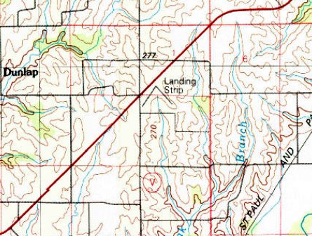
40.108, -93.438 (Northeast of Kansas City, MO)
Ace High Airport, as depicted on the May 1949 Des Moines Sectional Chart.
This small general aviation airport was evidently established at some point between 1946-49,
as it was not yet depicted on the June 1946 Des Moines Sectional Chart.
The earliest depiction which has been located of Ace High Airport was on the May 1949 Des Moines Sectional Chart.
It depicted Ace High Airport as having a 2,700' unpaved runway.
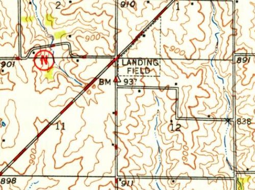
The 1949 USGS topo map (courtesy of Lee Corbin) depicted Ace High Airport as a triangular shaped property outline, labeled simply as “Landing Field”,
with a small building on the northwest side.

The last aeronautical chart depiction which has been located of Ace High Airport was on the June 1960 Des Moines Sectional Chart.
It depicted Ace High Airport as having a 2,300' unpaved runway, a slight reduction compared to 1949.
Ace High Airport was evidently closed (for reasons unknown) at some point between 1960-65,
as it was no longer depicted on the April 1965 Des Moines Sectional Chart.
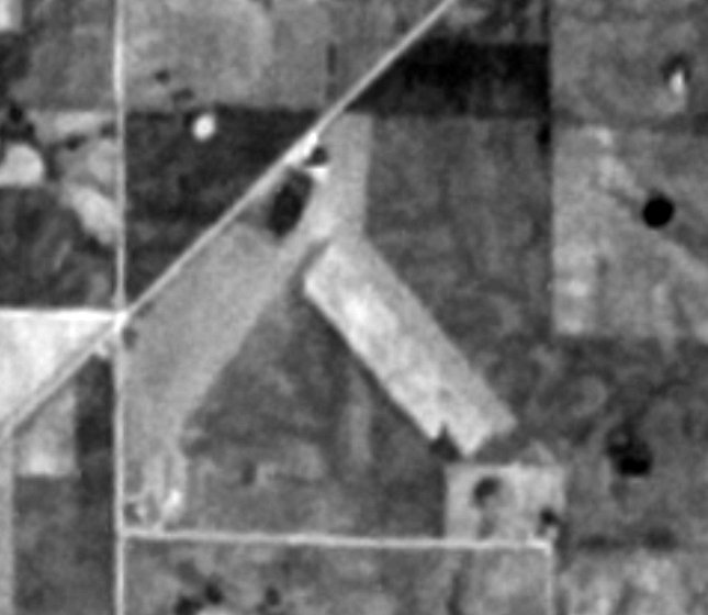
The earliest photo which has been located of Ace High Airport was a 4/4/74 USGS aerial view (courtesy of Lee Corbin).
It depicted Ace High Airport as having 2 unpaved runways & a small building on the northwest side.
The 1981 USGS topo map (courtesy of Lee Corbin) depicted Ace High Airport as 2 runways, labeled simply as “Landing Strip”.
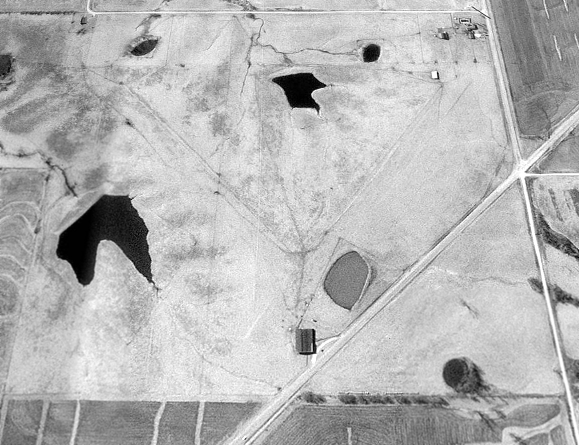
A 1996 USGS aerial view looking south depicted Ace High Airport as having 2 unpaved runways & a small building on the northwest side.
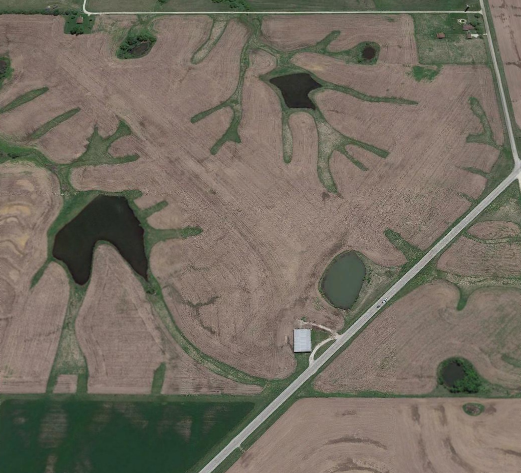
A 2015 aerial view looking south showed the 2 former runways of Ace High Airport were still recognizable, and the building remained on the northwest side.
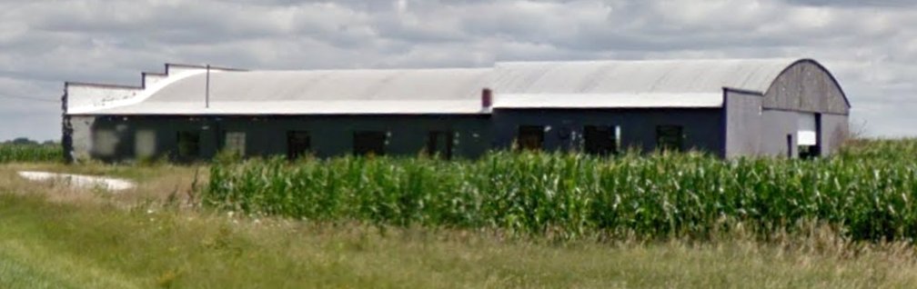
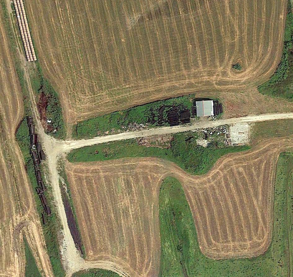
A pre-2018 photo (courtesy of Lee Corbin) showed the hangar which remains on the north side of the site of Ace High Airport
is unusually substantial for such an otherwise small rural airport.
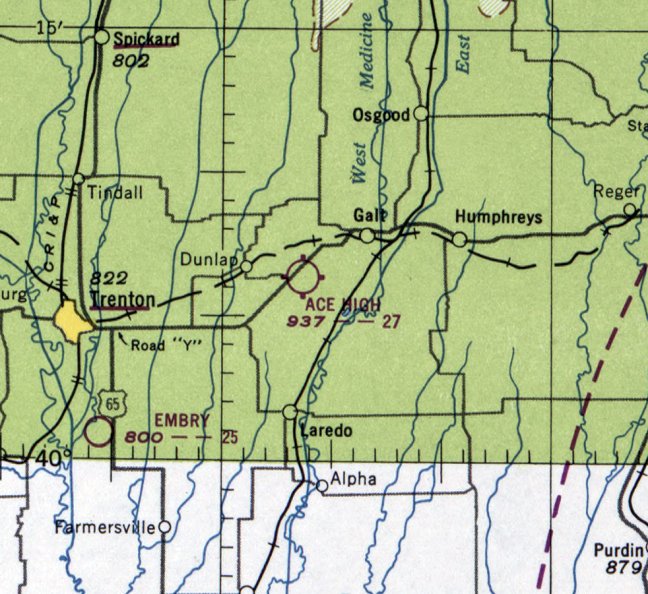
The site of Ace High Airport is located on the southeast side of Route 6, 3 miles southwest of Galt.
Thanks to Lee Corbin for pointing out this airifeld.
____________________________________________________
Boonville Airport, Boonville, MO
38.991, -92.75 (East of Kansas City, MO)
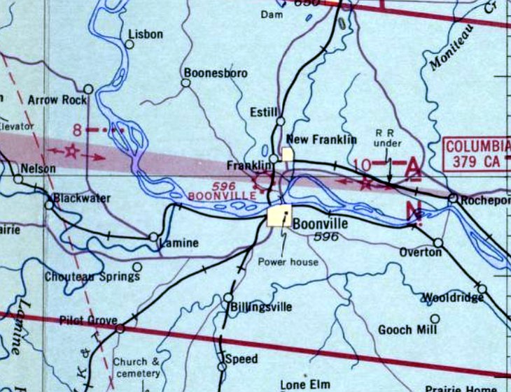
Boonville Airport, as depicted on the January 1942 Kansas City Sectional Chart.
Boonville Airport was evidently established at some point between 1939-42,
as it was not yet depicted on the May 1939 Kansas City Sectional Chart.
The earliest depiction which has been located of Boonville Airport was on the January 1942 Kansas City Sectional Chart.
It depicted Boonville Airport as a commercial/municipal airport.
The earliest photo which has been located of Boonville Airport was a 1947 aerial photo.
It depicted Boonville Airport as having 2 unpaved runways & several small buildings on the northeast side.
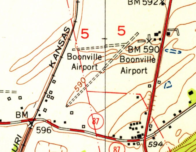
The earliest topo map depiction which has been located of Boonville Airport was on the 1952 USGS topo map (courtesy of Lee Corbin).
It depicted Boonville Airport as having 2 unpaved runways & 6 small buildings on the northeast side.
The only photo which has been located showing a plane at Boonville Airport was a 1970 aerial photo, which depicted a single-engine light plane parked south of the buildings.
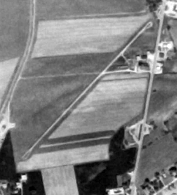
The last photo which has been located showing Boonville Airport intact was a 5/9/77 USGS aerial view (courtesy of Lee Corbin).
It depicted Boonville Airport as having 2 paved runways & several mall buildings on the northeast side.
Boonville Airport was evidently closed (for reasons unknown) at some point between 1970-95,
as a 1995 aerial photo showed no trace remaining of the runways, with the land having been returned to cultivation.
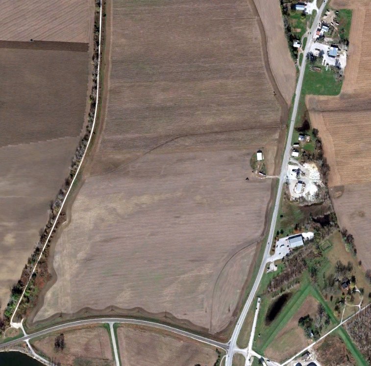
A 2014 aerial view (courtesy of Lee Corbin) showed the area of Boonville Airport's runways remained farmland.
Several of the hangars on the east side had been removed, with only 1 building remaining, a possible hangar.
Thanks to Lee Corbin for pointing out this airifeld.
____________________________________________________
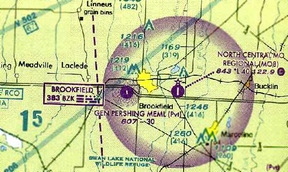
Brookfield Memorial Airport / General Pershing Memorial Airport,
Brookfield, MO
39.762, -93.108 (Northeast of Kansas City, MO)
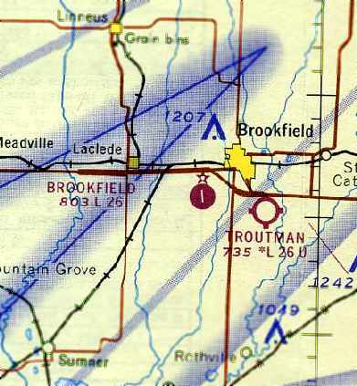
Brookfield Memorial Airport, as depicted on the August 1967 Kansas City Sectional Chart (courtesy of Chris Kennedy).
The original airport for the town of Brookfield was located on the southwest side of the town.
Brookfield Memorial Airport was evidently established at some point between 1966-67,
as it was not yet depicted at all on the February 1966 Kansas City Sectional Chart (according to Chris Kennedy).
The earliest depiction of Brookfield Memorial Airport which has been located
was on the August 1967 Kansas City Sectional Chart (courtesy of Chris Kennedy).
It depicted Brookfield as having a 2,600' paved runway.
Brookfield Airport was not yet depicted on the 1979 USGS topo map.
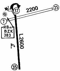
The 1980 Flight Guide (courtesy of Chris Kennedy) depicted Brookfield Memorial
as having a single 2,600' paved Runway 17/35 & a 2,200' unpaved Runway 7/25.
A Non-Directional Beacon navaid was depicted just northwest of the runway intersection.
The airport was still listed as Brookfield Memorial in the 1982 AOPA Airports USA Directory (according to Chris Kennedy).
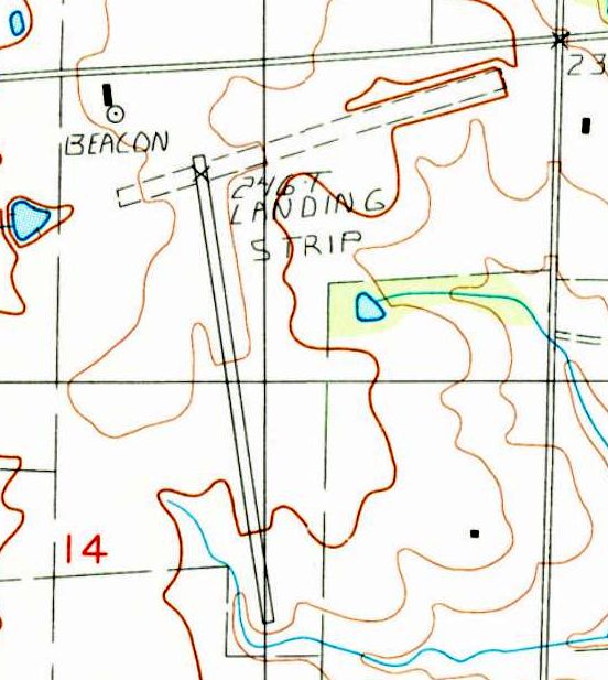
The 1984 USGS topo map depicted a single paved northwest/southeast runway, and an unpaved northeast/southwest runway,
labeled simply as “Landing Strip”.
A beacon was depicted on the northwest side.
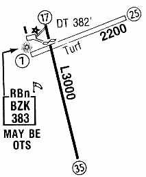
At some point between 1982-86, the field was evidently renamed as “Pershing Memorial”,
as that is how it was depicted in the 1986 Flight Guide (courtesy of Chris Kennedy).
The paved Runway 17/35 had been slightly lengthened to 3,000',
and the field continued to have a 2,200' crosswind unpaved Runway 7/25.
A Non-Directional Beacon navaid was depicted just northwest of the runway intersection.
The only photo which has been located showing an aircraft at Pershing Memorial Airport
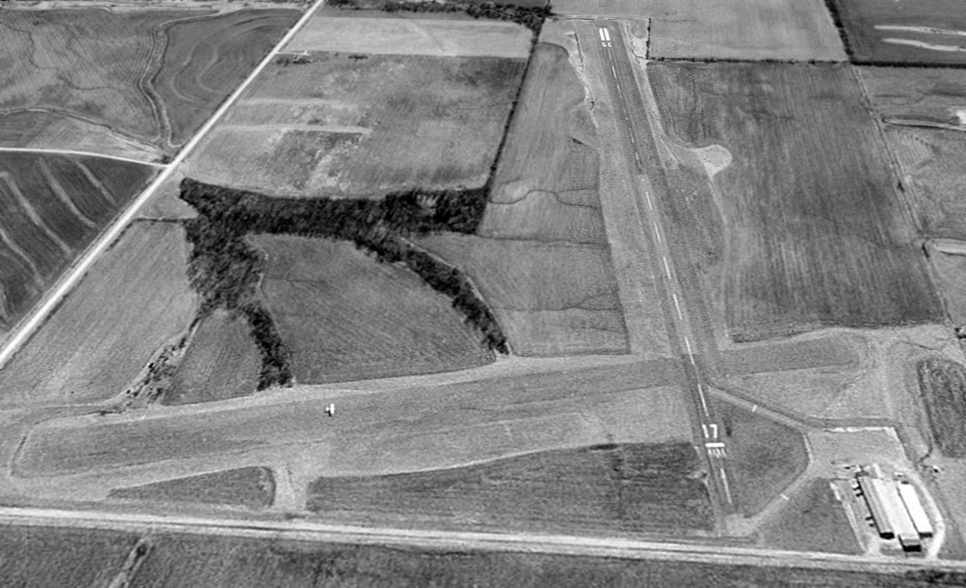
was a 1997 USGS aerial view looking south, which showed a single-engine aircraft headed west on the grass crosswind runway.
It depicted Pershing to have a single paved Runway 17/35, as well as a grass crosswind runway.
A ramp & a cluster of hangars was located on the northwest corner of the field.
The last aeronautical chart depiction which has been located of General Pershing Memorial Airport
was on the June 2004 Kansas City Sectional Chart (courtesy of Chris Kennedy).
It depicted the field as having a 3,000' north/south paved runway, and an NDB beacon.
A 12/30/03 aerial view still depicted General Pershing Memorial Airport as having runway markings of an active airport.
General Pershing Memorial Airport was evidently closed at some point between 2003-2004,
as a 7/28/04 aerial view showed the paved runway marked with closed “X” symbols.
The airport was otherwise completely intact.
According to Ken Jay, the “reason for closure of this airport (and the nearby Marceline Municipal Airport)
was a cooperative agreement between Brookfield & Marceline that provided for the construction & operation
of a regional airport with a much longer runway & greater utility.
The closure of the 2 airports was a requirement of that agreement & also the sale of the Brookfield airfield property was part of this agreement as well.”
A 2007 aerial view showed that the hangars had been removed.
Chris Lampe pointed out in 2012 that the former Brookfield Municipal Airport property is for sale.
Although the listing does mention the 2 runways, none of the ground-level pictures in the listing depict the runways, which seems an odd omission.
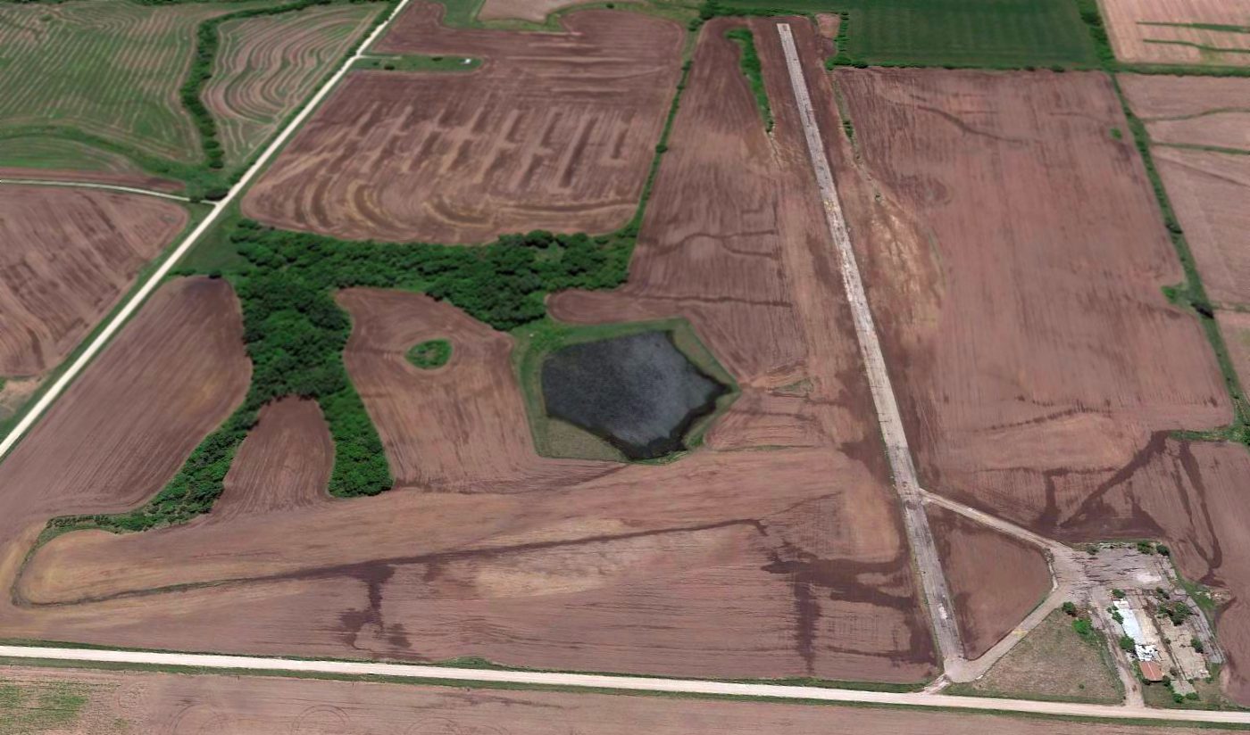
A 2015 aerial view looking south showed the Pershing Memorial Airport property remained unredeveloped,
with the paved runway remaining intact though deteriorated, along with the unpaved crosswind runway.
The ramp also remained intact, though most of the airport buildings had been removed.
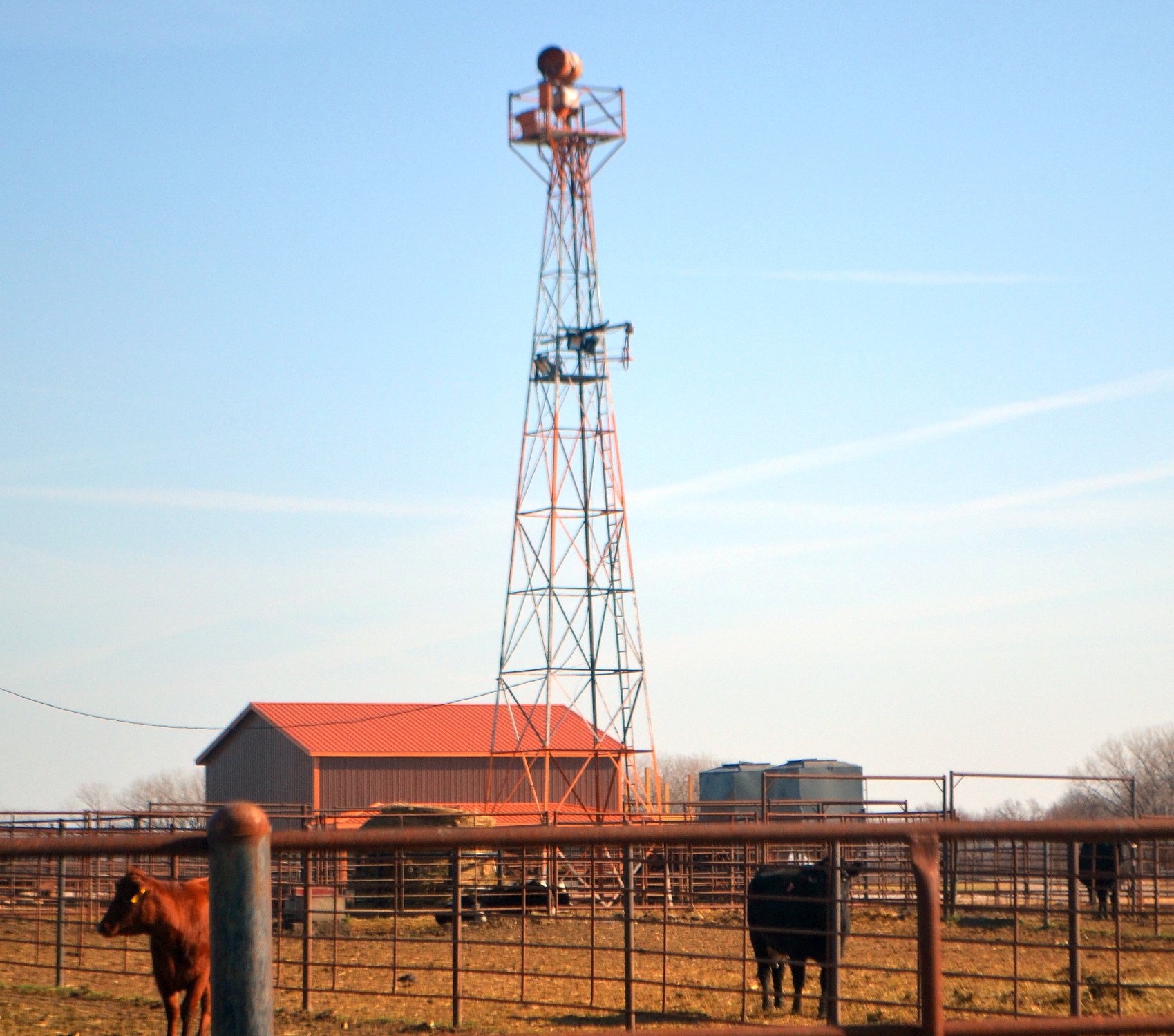
An 11/19/20 photo by Mark Morgan of the former Brookfield / Pershing Memorial Airport beacon tower, along with a couple of the current local residents.
Mark reported, “The beacon's still standing; the north end of the old airport is now a feedlot with no original buildings.”
General Pershing Memorial Airport is located southwest of the intersection of Husk Road & Huron Drive.
____________________________________________________
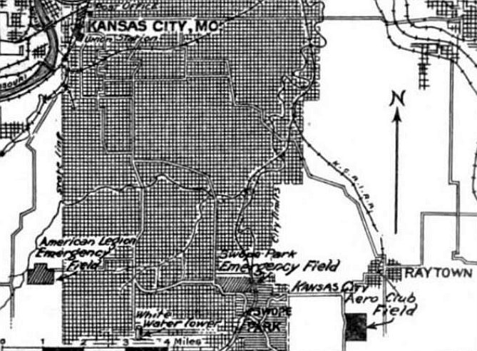
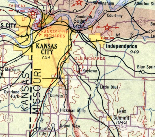
Kansas City Aero Club Field / Richards Field / Old Richards Airport / Ong Airport, Raytown, MO
38.994, -94.476 (Southeast of Kansas City, MO)
Richards Field was also labeled as “Kansas City Aero Club Field” on the 4/15/24 Commerce Department Airway Bulletin (courtesy of Mike Denja).
Robert Lester wrote in his autobiography (courtesy of Peter Buckner), “As 1921 drew to a close,
five of us banded together to provide an airport for Kansas City; the first Kansas City ever had.
We were Rogers Critendon, Ford Harvey, Howard Wehrle, Simpson Yoemans, and the writer [Robert Lester].”
Robert continued, “Richards Field, as we named our new field, was the first airport in this part of the country
(perhaps I should say 'civilian' airport in this part of the country).
We had raised our money & set up our corporations in the spring of 1921, and hoped to have the field in operation by summer.
Just at that time we learned that the U.S. Army was looking for a field for summer Reserver flying activities.
The rent was not great, but would help us over the hump.
Our attorney, Leland Hazard, went to Washington & leased the field to the Army.
The field was named after John Richards, of a well-known Kansas City family; the first American pilot shot down in the war.
The field would need grading, a hangar, a small office building, and utilities.
It was very well drained, and we did not have any gravel runway; merely an apron in front of the hangar.
The business which the field was able to develop was very slim & unprofitable.
About the only aviation in those days was barnstorming & passenger carrying.
There was no regular flying between communities.
The lease to the Army was the saving factor, but it produced very little revenue.”
Robert continued, “The field was for all of us an interesting & stimulating connection with the aviation of those days, but it turned out to be a small financial disaster.
Richards Field in those days, of course, had no lighted runways; not even a light on a tower.
There were no radio beacons; pilots flew under what would be called visual flight regulations, except that there were no regulations.”
The earliest depiction which has been located of Richards Field was on the 4/15/24 Commerce Department Airway Bulletin (courtesy of Mike Denja),
which labeled it as “Kansas City Aero Club Field”.
The 4/15/24 Commerce Department Airway Bulletin (courtesy of Mike Denja) depicted Richards Field
as measuring 2,641' north/south, with 1 northeast/southwest runway, and 3 hangars along the road on the north side.
The earliest aeronautical chart depiction which has been located of Old Richards Airport was on the June 1932 Kansas City Sectional Chart.
The earliest directory listing of Old Richards Airport which has been located
was in the Department of Commerce's 1933 Airport Directory (courtesy of Chris Kennedy).
It described Old Richards as a commercial airport, having a 2,640' x 1,700' rectangular sod field.
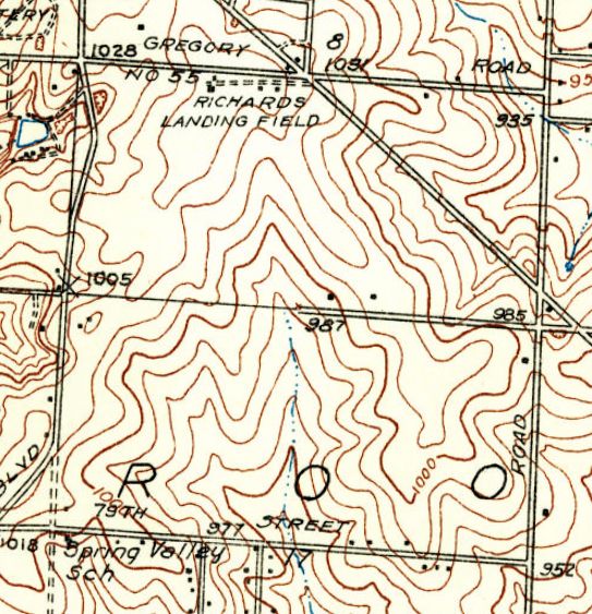
The 1934 USGS topo map depicted “Richards Landing Field” as an open area with a few small buildings along the north side.
The Airport Directory Company's 1937 Airports Directory (courtesy of Bob Rambo)
described Old Richards as having a single 2,600' north/south sod runway.
A hangar was said to have "Old Richards" painted on the roof.
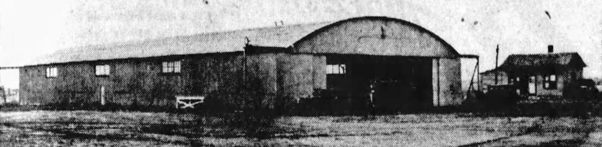
An undated photo of an Old Richards Airport hangar from a 5/11/37 article (courtesy of Alexa Lausen).
It was captioned, “This hangar is the only remaining principal building remaining on Old Richards Field, Blue Ridge Extension & Gregory Road, at one time Kansas City's principal airport.
This field was bought yesterday by E. Milton, Stanley LaSha, and E. Porterfield, from the Airminal Investment Company.”
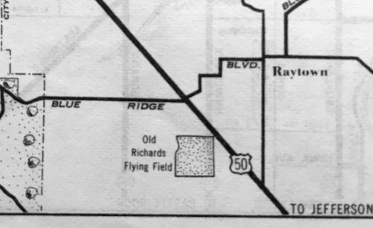
A 1938 street map (courtesy of Kevin Walsh) depicted “Old Richards Flying Field” as a square property outline.
The 1939 USGS topo map depicted “Landing Field” as an open area with a few small buildings along the north side.
Bob Wehner recalled, “I learned to fly the Piper Cub at Ong Airport in the summer of 1940 under the CPTP initial flight program offered to college students free of charge.
I was 19 years old, completing 50 hours of flight training, awarded a single engine private pilots license,
along with 5 college credit hours at the KC Junior College Downtown Kansas City.
This included aerodynamics, cross country flying & navigation as well as flight meteorology -
classes for this was at Jr. College night school between my ending freshmen semester, during summer vacation,
3 months time before my first sophomore semester started September 1939.
It was a fun-learning experience to support my aim to become an airline pilot.
My flight instructor was Mr.Gustafason & the operating airport owner was Mr. Ong.”
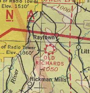
Old Richards Airport, as depicted on the January 1941 Kansas City Sectional Chart (courtesy of Chris Kennedy).
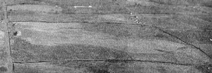
An aerial view looking east at the Old Richards Airport
from the Airport Directory Company's 1941 Airports Directory (courtesy of Chris Kennedy).
The field was described as having a total of 4 sod landing strips, with the longest being the 2,600' northeast/southwest strip.
A hangar was said to have "Old Richards" painted on the roof.
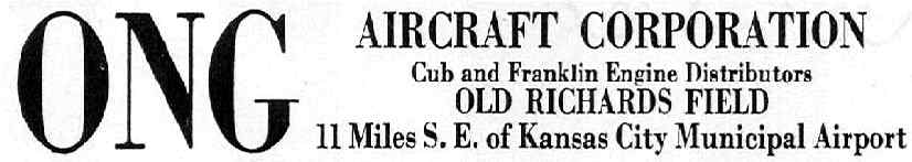
An advertisement for the Ong Aircraft Corporation
from The Airport Directory Company's 1941 Airports Directory (courtesy of Chris Kennedy).
Robert Lester wrote in his autobiography (courtesy of Peter Buckner), “To close out the story of Kansas City's first flying field,
when Kansas City Municipal Airport was finally built & took over the growing needs of an aviation industry,
there was very little for the old field to do except to cater to flying schools & barnstormers.
It was leased to one or two inadequately-financed operators for just enough to pay the taxes;
then Bill Ong took over the property & during World War II operated a primary flying school for Air Force Cadets.
Unfortunately, a certain unpleasantness developed when K.C. Municipal Airport was inaugurated.
The Army part of it was to be known as Richards Field, and some of its protagonists who were antagonistic to our old airport,
during the night went to our field & detached the bronze plaque [of John Richards] on the gate & took it to Municipal Airport.”
The field was reportedly renamed Ong Airport in 1943.
Ong Airport was described in the April 1944 US Army/Navy Directory of Airfields (courtesy of Ken Mercer)
as having a 2,600' unpaved runway.
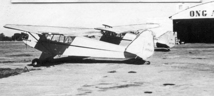
An undated photo of 2 Piper Cubs in front of a hangar marked “Ong Airport” (courtesy of Bob Wehner).
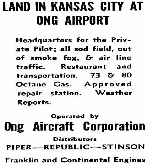
An advertisement for the Ong Airport from the Haire Publishing Company's 1945 Airport Directory (courtesy of Chris Kennedy).
The directory described Ong Airport as being owned & operated by the Ong Aircraft Corporation.
The field was said to have a total of 4 sod runways,
with the longest being a 2,800' northeast/southwest strip.
An aerial view of Ong Airport from the 1947 MO Airport Directory (courtesy of Stephen Mahaley).
The field was described as being owned by William Ong.
It was said to have 3 turf strips, with the longest being the 2,600' northwest/southeast strip.
The field was said to offer hangars, repairs, fuel, and tie-downs.
The last aeronautical chart depiction which has been located of Ong Airport
was on the September 1948 Kansas City Sectional Chart (courtesy of Chris Kennedy).
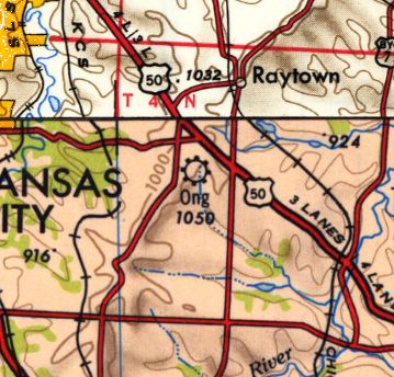
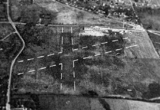
Ong Airport, as depicted on the 1950 USGS topo map.
Ong Airport was evidently closed at some point between 1948-50,
as it was no longer depicted on the May 1950 Kansas City Sectional Chart.
Steve Vaughn recalled, "My dad [Larry Vaughn] was the operations manager for the airport
until his death in a plane crash at the airport in October 1950.
Mr. Ong also had a crop dusting business out of the airport.
Ong Air Corporation announced in June that the land would be transformed into housing.
The airport closed in late 1950.”
Mike Hartman recalled, "I grew up in the subdivision that was just being built on the property.
The old hanger, a few military style buildings & the Ong Aircraft buildings were still there in 1953.
My Dad purchased our house in 1953 on 72nd Terrace from Bill Ong & Grace McAdams Harris.
As a child I & other kids played around the old hangar that contained old biplanes.
Wow! What a blast for a bunch of kids.”
The 1954 USGS topo map continued to depict the “Landing Field” as an open area with a few small buildings along the north side,
even though it had evidently ceased to exist several years earlier.
Mike Hartman recalled, "The old buildings were soon torn down in around 1956 for more new houses."
The 1958 USGS topo map showed new streets & houses covering the site of the airport.
A 1969 aerial view depicted not a trace remaining of Ong Airport.
In 1979, the Raytown Historical Society commemorated the site of "Richards Flying Field".
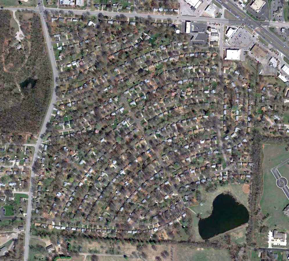
A 2015 aerial view showed the site of Ong Airport has been covered by a residential development,
and not a trace appears to remain of the airport.
The site of Ong Airport is located southeast of the intersection of East Gregory Boulevard & Blue Ridge Boulevard.
The names of the airport live on,
as one of the streets in the residential neighborhood at the site is "Richards Drive",
and "Ong Lake" is located on the southeast corner of the property.
____________________________________________________
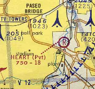
Heart of America Airport / Thirty-First Street Airport / Heart Airport (MO06, 0L8), Kansas City, MO
39.074, -94.507 (Southeast of Kansas City Downtown Airport, MO)
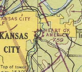
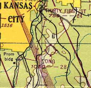
"Hearts of America" Airport, as depicted on the September 1946 Kansas City Sectional Chart (courtesy of Chris Kennedy).
This small general aviation airport was evidently established at some point between 1945-46,
as it was not yet depicted on the 1940 USGS topo map
nor listed among active airfields in the 1945 AAF Airfield Directory (courtesy of Scott Murdock).
The earliest reference to Heart of America Airport which has been located
was on the September 1946 Kansas City Sectional Chart (courtesy of Chris Kennedy).
It depicted "Heart of America" as a commercial airport.
According to Brett Lovett, “I believe the Heart of America Airport was originally developed by Ed Licata in the 1940s.”
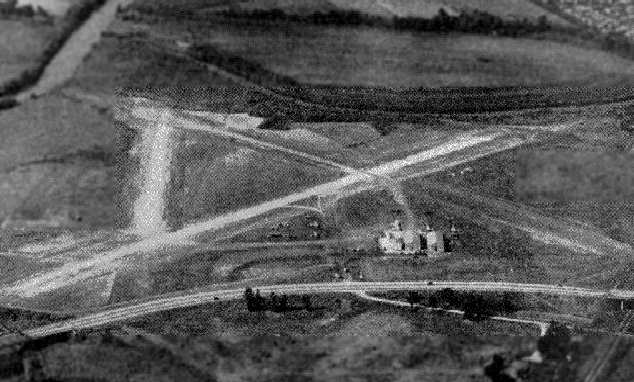
A view looking north at "Heart of America" Airport from the 1947 MO Airport Directory, courtesy of Stephen Mahaley.
The field was described as having 3 "turf & chat strips", with the longest being a 2,250' northeast/southwest runway.
The manager was listed as C.H. McMillan.
According to Brett Lovett, “I own a Piper Vagabond that was sold new
by 'Aircraft Distributors, Inc. Heart of America Airport, Hangar #3, Kansas City' in August 1948.
In January 1952 it was again sold by 'Aircraft Distributors, Inc. 31st Street Airport, Kansas City'.
Evidently the same airport was then known as the 31st Street Airport,
as it was located on 40 Highway, which ran on 31st Street from just west of the airport into Kansas City.”
The only depiction which has been located of Thirty-First Street Airport was on the June 1954 Kansas City Local Aeronautical Chart (courtesy of Mac Hayes).
It depicted Thirty-First Street Airport as having a 2,400' unpaved runway.
The 1955 Missouri Airport Directory (according to Brett Lovett) described the field as having 2 gravel runways: 2,370' & 2,300'.
There was no airport lighting.
Heart of America Airport was depicted on the 1956 USGS topo map.
According to Brett Lovett, “This field was closed in 1956, and a trailer park was built in it's place.”
According to Brett Lovett, “In 1962 or 63 Ed's son Leonard, who still runs the trailer park today,
started a new runway to the east of the trailer park along the bank of the Blue River.
This was known as the 'Heart Airport'.”
The 1964 USGS topo map depicted the trailer park, but did not depict any airport on the property.
A 1969 aerial photo showed 6 single-engine aircraft parked on the southeast side of the airfield,
which consisted of an open area between the river & the trailer park, without any distinguishable runways.
No airfield was depicted at this location on the 1970 USGS topo map.
Heart Airport was listed in the 1971 Flight Guide (according to Chris Kennedy) as having a single 1,800' paved Runway 4/22,
but the other 2 runways had apparently been abandoned.
Heart Airport was depicted as a private field on the St. Louis local insert
of the July 1973 Kansas City Sectional Chart (courtesy of Chris Kennedy).
Interestingly, Heart was not depicted on the main portion of the chart - was the chart too crowded?
Heart was described as having an 1,800' runway.
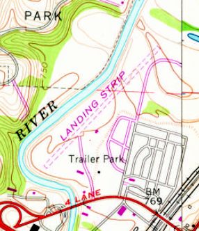
The 1975 USGS topo map depicted a single unpaved northeast/southwest runway, labeled simply as “Landing Strip”,
between the river & the trailer park.
The 1982 AOPA Airport Directory (courtesy of Ed Drury) described Heart Airport as having a 2,760' asphalt Runway 3/21.
The operator was listed as Heart Flying Service.
According to Brett Lovett, “I believe this airport was often used for picking up aerial banners to be flown over the nearby sports complex during the 1980s & 90s.”
According to Brett Lovett, “Looking at the 1990 photo,
I see that some of the area around the airport was being used as a junk yard at the time,
and that lead me to recall White Industries using the airport for their aircraft salvage operations until they moved to their current location in Bates City, MO.
I believe they were at Heart from sometime in the 1960s or 70s until sometime in the mid to late 1980s.”
According to Piedmont pilot Justin Lawlor, Heart Airport was destroyed by the 1993 flooding.
The owners keep trying to resurrect it,
but being located with the Class B airspace of Kansas City International, within the city limits of a major city,
and within a mile of a sports stadium probably preclude this prospect.
According to Brett Lovett, “I'm not sure whether the Heart Airport actually flooded in 1993,
but I don't recall flooding in that area, and I believe that I landed there in 1996.
The taxiway was in very poor shape at that time, but the runway was usable.”
In the 1997 USGS aerial photo, the airport was still completely intact, without any redevelopment,
although it appeared the former ramp area was being used for storage.
In addition to the single runway, the airfield had a parallel taxiway, a ramp area & one hangar.
The last aeronautical chart depiction which has been located of Heart Airport was on the June 1999 Kansas City Terminal Aeronautical Chart (courtesy of Ron Plante).
Heart was depicted as having a 2,400' paved northeast/southwest runway.
According to Brett Lovett, “Sometime around 1999, the U.S. Army Corps of Engineers rerouted the channel of the Blue River
where it ran around the southwest end of the runway.
The moving of the river dictated the removal of 400' from the southwest end of the runway,
but they evidently completely removed the taxiway & runway during the process.
I spoke with Leonard Licata not too long before this project was started,
and at that time he had hopes of again resurrecting the airport when river project was completed.”
According to Brett Lovett, “The building that appears to be a 'former hangar'
actually has been a welding shop as long as I can remember (at least back to the first time I visited the airport in the late 1980s),
and I believe it continues in that function [as of 2010].
Based on it's location it probably was a hangar at one time.
Just behind the welding shop, on one of the old tie downs, was a Stinson 108, minus wings,
that looked like it had been sitting there for at least 20 years.
It was the only airplane I ever saw parked at the airport when I visited.
I haven't been there in a long time, but looking at recent photos, it looks like it could still be there, in the same spot.”
The 2002 USGS topo map depicted a single paved northeast/southwest runway, labeled simply as “Landing Strip”.
Unfortunately, a 7/17/02 aerial photo showed that the runway of the former Heart Airport had been completely removed at some point between 1997-2002,
with not even a trace remaining of the runway.
However, the former hangar remained intact at the southwest corner.
A circa 2006 aerial view looking east at the former Heart Airport hangar, now reused for some industrial purpose.
Looking very closely will reveal a Stinson 108 fuselage which sits just beyond the far corner of the hangar -
apparently the last plane to remain at this former airport.
A 2007 aerial photo showed that not even a trace remained of the Heart Airport runway, but the former hangar remained intact at the southwest corner.
What a sad sight! A February 2010 photo by Marlin Parrott (courtesy of Brett Lovett) of “a Stinson 108 minus wings” which remains as the only airplane still parked at the site of Heart Airport.
Brett recalled, “It's been there as long as I can remember.”
According to Brett Lovett, “The Heart of America Airport site was sold to Jackson County in July 2021.”
Brett Lovett reported in 2024, “I drove by the former site of the Heart of America Airport, and was surprised to find that the Heart Mobile Village is now gone, replaced by a major construction site.
They are building a new county jail there.”
The Heart Airport site is located on the east bank of the Blue River, northwest of the intersection of I-70 & I-435.
____________________________________________________
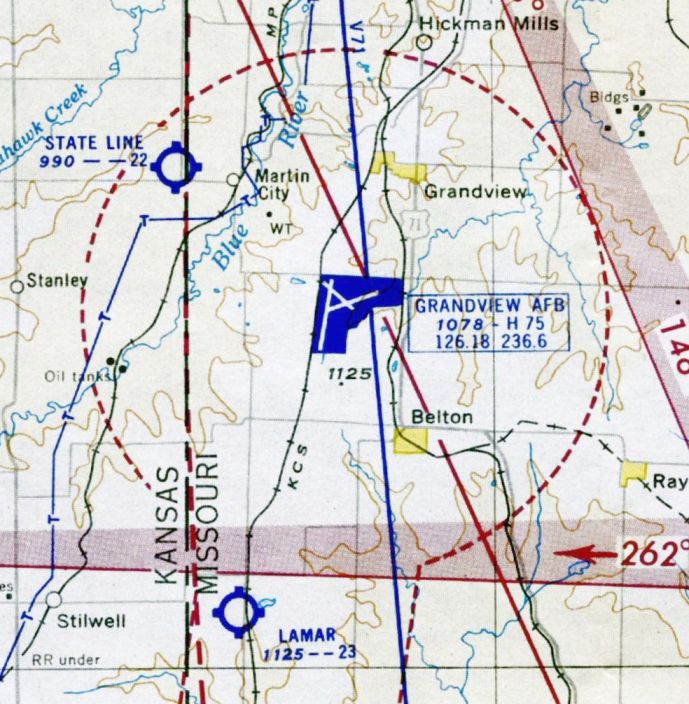
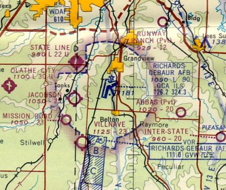
Kansas City Grandview Airport / Grandview AFB / Richards Gebaur AFB /
Richards Gebaur Airport (GVW), Grandview, MO
38.844, -94.56 West (South of Kansas City, MO)
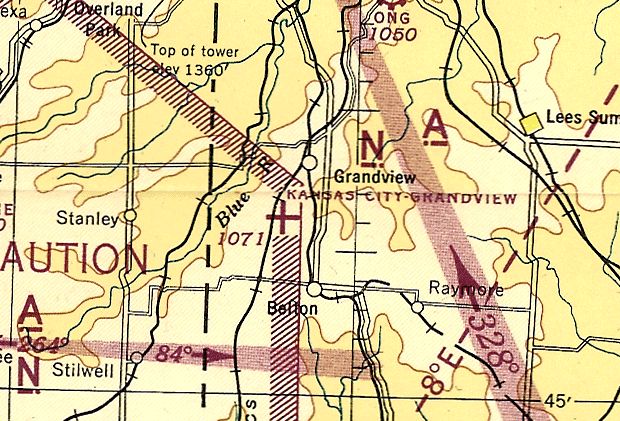
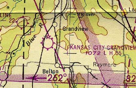
Kansas City Grandview Airport, as depicted on the March 1944 Kansas City Sectional Chart (courtesy of Ron Plante).
No airport was yet depicted at this location on the 1934 USGS topo map.
Grandview Airport was built in 1941 on land owned by the City of Kansas City, MO.
Grandview Airport was reportedly used as an auxiliary airport for NAS Olathe during World War II.
During World War II, the United States Army Air Forces I Troop Carrier Command built a facility on part of the airfield in 1944
which was used as a sub-base for Sedalia AAF for overflow traffic & training uses.
The main USAAF unit at Grandview was the 813th AAF Base Unit.
The earliest depiction which has been located of Kansas City Grandview Airport
was on the March 1944 Kansas City Sectional Chart (courtesy of Ron Plante).
It depicted Kansas City Grandview as an auxiliary airfield.
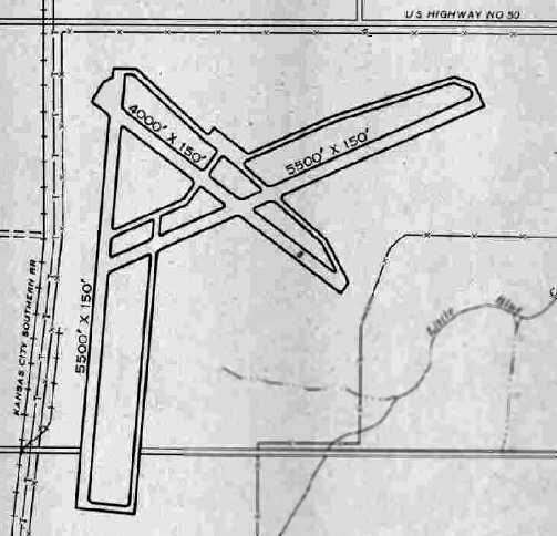
Kansas City Grandview Airport, as depicted in the 1945 AAF Airfield Directory (courtesy of Scott Murdock).
It described Grandview as a 962 acre irregularly-shaped property within which were 3 concrete runways,
the longest being the 5,500' north/south & ENE/WSW strips.
The field was not said to have any hangars (nor were any depicted in the diagram).
Grandview Airport was said to be owned & operated by the City of Kansas City.
After WW2, the Grandview AAF facility was turned over to Continental Air Forces, with C-46s occasionally using the field until it was closed in November 1945.
The airfield was declared surplus on 12/13/45 & transferred to Army Division Engineers on 3/1/46 for disposal.
The September 1946 Kansas City Sectional Chart (courtesy of Chris Kennedy)
depicted “Kansas City Grandview” as a commercial/municipal field.
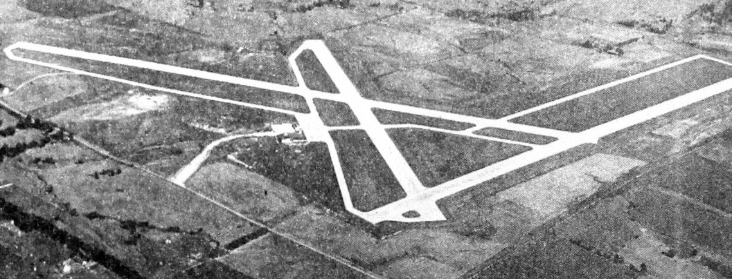
The earliest photo which has been located of Grandview Airport was an undated aerial view looking southwest from the 1947 MO Airport Directory (courtesy of Joe Gurney).
The directory described Grandview as being managed by Charles Daily,
and it was said to have 3 concrete runways, with the longest being the 5,500' north/south & northeast/southwest strips.
"Kansas City Grandview" Airport was depicted on the 1949 Kansas City Sectional Chart (courtesy of Chris Kennedy)
as having a 5,500' paved runway.
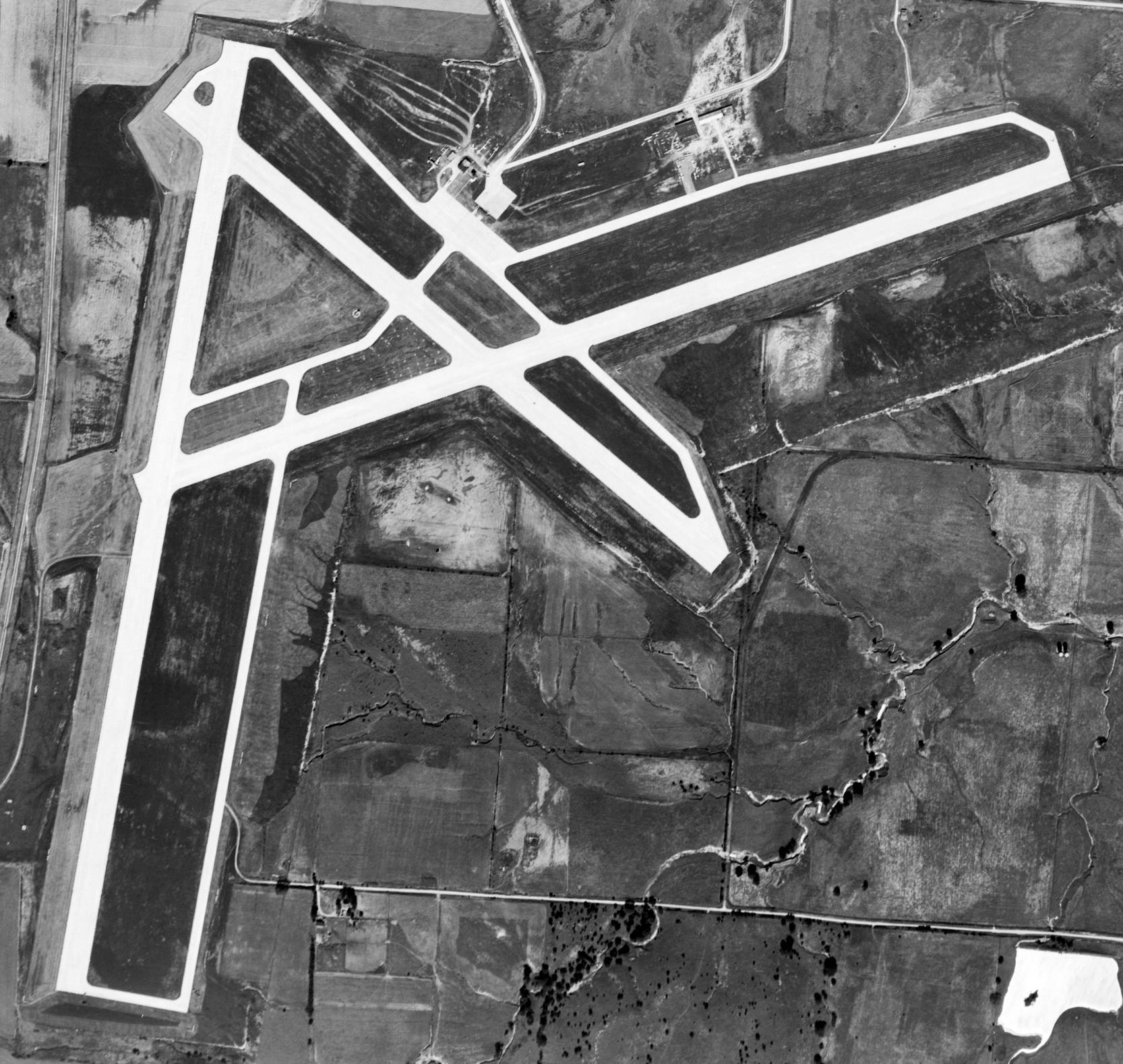
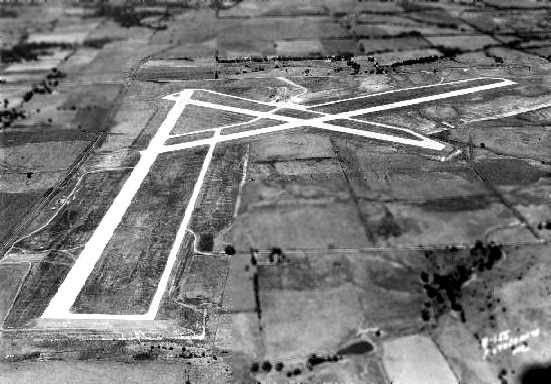
A 9/11/48 USGS aerial photo depicted Grandview Airport as having 3 concrete runways.
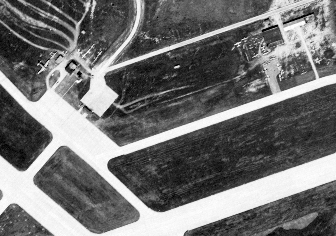
A closeup of the 9/11/48 USGS aerial photo of 26-some planes at Grandview Airport, including what appears to be a P-38 Lightning at top-left.
As a result of the Cold War military buildup, Grandview Airport was leased by the USAF on 1/1/52.
After some construction & upgrading of facilities, Grandview Air Force Base was opened on 10/1/52,
with the 4610th Air Base Squadron being the base operating unit.
No military personnel were assigned prior to 1954 while major construction took place of runways, taxiways, aprons and support facilities.
The 1953 USGS topo map depicted Grandview Air Force Base as having 3 paved runways,
with the southern third of the primary runway depicted as still being “under construction”.
The majority of the airfield buildings were on the north side.
The June 1954 Kansas City Local Aeronautical Chart (courtesy of Mac Hayes)
depicted Grandview AFB as having 3 paved runways, with the longest being 7,500'.
The first major use for the base was Air Defense Command, which used the base as a command & control headquarters.
HQ, Central Air Defense Force was established on 2/24/54, along with HQ 20th Air Division (Defense) on 10/8/55.
The first flying unit was the 328th Fighter Group, with its 326th Fighter Squadron being equipped with F-86 Sabres.
Along with the Air Defense & Communications mission, the Military Air Transport Service (MATS), later Military Airlift Command (MAC),
begin using the base in 1955 as a reserve troop carrier unit facility under the auspices of the 2472nd Air Force Reserve Training Wing.
C-119 Flying Boxcars were flown by the 442nd Troop Carrier Squadron.
On 4/27/57 the installation was renamed Richards-Gebaur Air Force Base
in honor of Kansas City natives 1st Lt John Francisco Richards & Lt. Col. Arthur William Gebaur.
Lt. Richards's Nieuport was shot down on 9/26/18 during an artillery surveillance mission on the 1st day of the Meuse-Argonne Offensive of World War I.
Col. Gebaur's F-84 was shot down over North Korea on 8/29/52 during a low-level bombing run during the Korean War.
In 1957, the 4620th Air Defense Group was activated at Richards-Gebaur.
The 4620th was a SAGE unit, which operated the Semi Automatic Ground Environment radar system for ADC.
SAGE was an automated control system used by ADC & later NORAD for collecting, tracking & intercepting enemy bomber aircraft.
It could also automatically direct aircraft to an interception by sending commands directly to the aircraft's autopilot.
The mission of the 4620th was later turned over to the 4660th Support Squadron (SAGE) (ADC).
Richards-Gebaur's 442nd Airlift Wing received the Air Force Reserve's first C-124 Globemaster cargo planes in April 1961.
After an FAA memo in the early 1960s declared that the city's Kansas City Downtown Airport was the most unsafe major airport in the country,
the city considered relocating its main airport to Richards-Gebaur.
However, the city government ended up relocating the facility north of the city at Kansas City International Airport.
The 326th Fighter-Interceptor Squadron eventually upgraded to the Convair F-102 Delta Dagger.
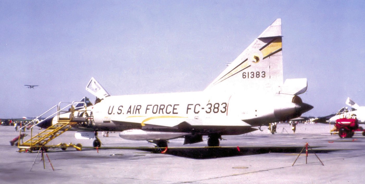
The earliest photo which has been located of an aircraft at Richards-Gebaur AFB was a May 1964 photo
of a 326th Fighter-Interceptor Squadron Convair F-102A-75-CO Delta Dagger 56-1383 of the 328th Fighter Wing,
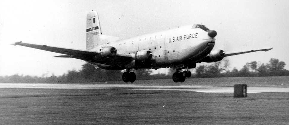
A circa 1960s photo of a massive C-124 transport landing at Richards-Gebaur Air Force Base.
The August 1965 Kansas City Sectional Chart (courtesy of Ron Kunse)
depicted Richards-Gebaur AFB as having 3 paved runways, with the longest being 9,000'.
The 326th Fighter-Interceptor Squadron operated the Convair F-102 Delta Dagger until 12/66.
Doug Casterline recalled, “Richards-Gebaur Air Force Base, from 1967-73, I was stationed with the 442nd Wing of the Military Airlift Command loading C-124s.”
The 71st Fighter-Interceptor Squadron arrived 1/67 from Selfridge AFB, Michigan with the F-106 Delta Dart.
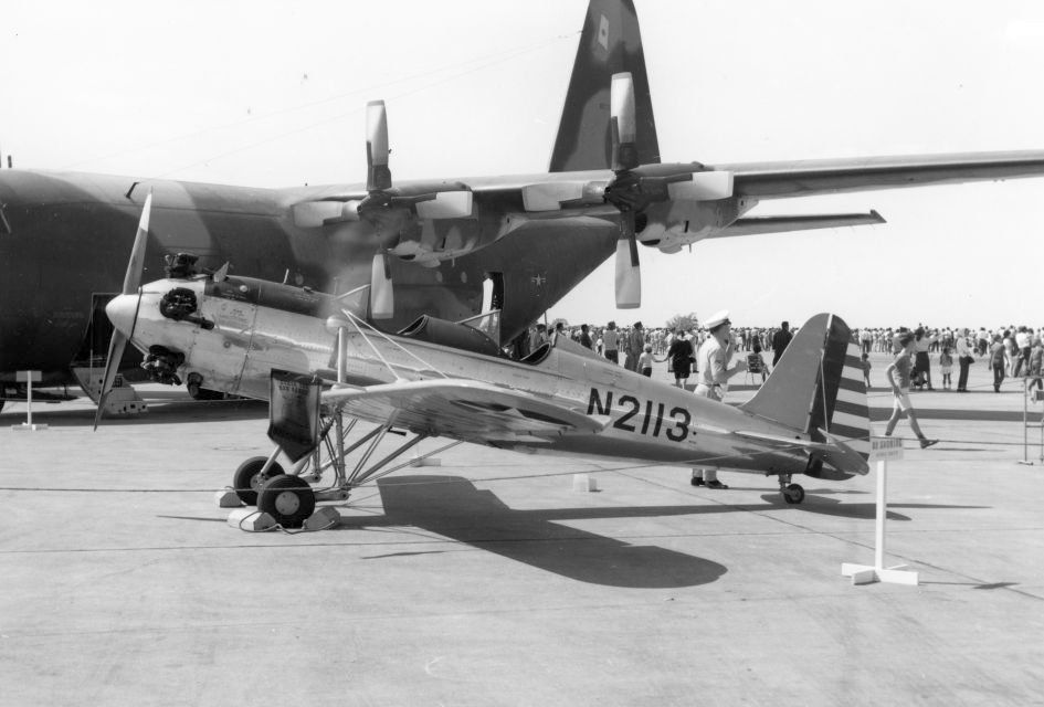
A September 1967 photo of Ryan PT-22 N2113 at a Richards-Gebaur AFB airshow.
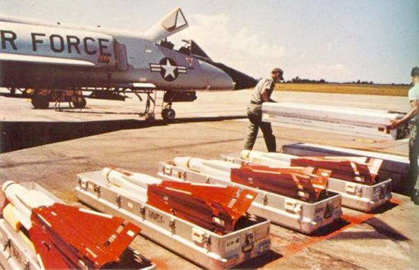
A circa 1967-68 photo of AIM-4 Falcon missiles being loaded on an F-106 Delta Dart at Richards-Gebaur AFB.
Headquarters ADC also stationed the 4650th Air Transport Squadron (later designated as the 4,650th Combat Support Squadron)
provided ADC with Air Transportation for parts & equipment & to transport personnel from the Fighter Interceptor Squadrons
to training bases where the crews could conduct live missile firings.
The 4,650th operated the C-118 Liftmasters from Richards-Gebaur.
As the threat of Soviet air attack diminished during the 1960s, the Air Defense presence at Richards-Gebaur was reduced.
The F-106-equipped 71st Fighter-Interceptor Squadron departed in 1968, ending the ADC interceptor presence on the base.
A 1969 aerial photo depicted 14 C-118 transports on Richards-Gebaur's north ramp,
and 2 F-106 Delta Darts & a dozen other aircraft on the south ramp.
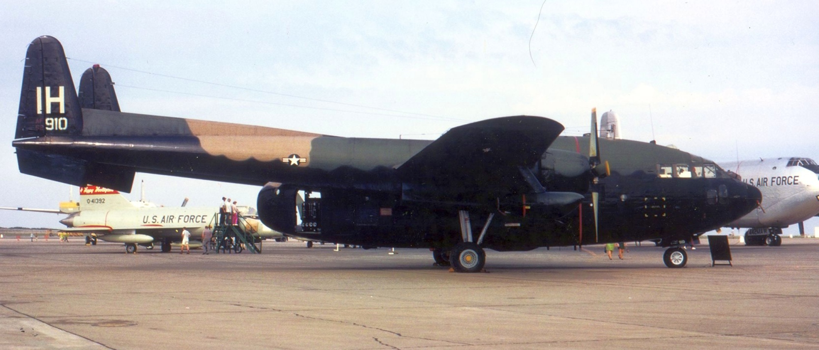
An April 1969 photo of a Fairchild AC-119K gunship, 52-5910, of the 1st Special Operations Wing's 4413th Combat Crew Training Squadron at Richards-Gebaur AFB.
On 7/1/70, Richards-Gebaur AFB was turned over to the Air Force Communications Service, with HQ AFCS establishing its headquarters on the base.
Richards-Gebaur's 442nd Airlift Wing transitioned to the C-130 Hercules in 1971.
Doug Casterline recalled, “Later [after 1973] still in the 442nd Wing but by then part of the Tactical Airlift Command [I was] packing parachutes & loading practice cargo loads on C-130s.
[There was a] drop zone proximal to GVW where we hid in a bunker while those C-130s practiced dropping our practice loads.”
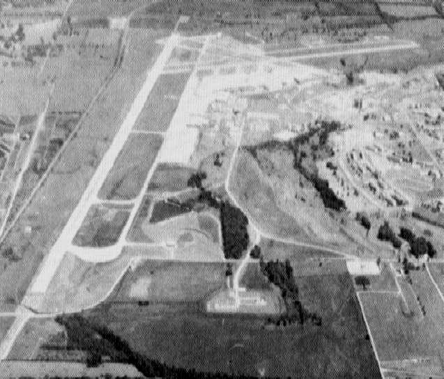
A 1973 aerial view looking north at Richards-Gebaur AFB.
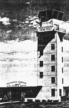
An undated photo of the Richards Gebaur AFB tower.
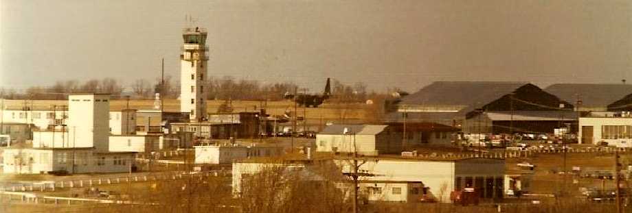
A 1975 photo by Michael Mays, which he took “from the 2nd floor of the Security Police barracks at Richard Gebaur AFB.
The C-130 Hercules was one of about 27 that were assigned to the 442nd Tactical Airlift Wing AFRES.
The building to in the mid-foreground on the left, with a tower appendage, was the parachute shop.
RGAFB was the HQ for AFCS (Air Force Communications Service) and hosted the 442nd Tactical Airlift Wing, AFRES.
The 442nd TAW maintained a drop zone several miles south of the base in Cass County
where they practiced dropping pallets of cargo by parachute & pushed out the back of the C-130s during touch-and-go landings.”
With reductions in Air Force activity at the base, 1,362 acres were declared as surplus property in 1976.
Military Airlift Command assumed control of Richards-Gebaur in 1977.

A 7/3/77 photo by Clyde Gerdes of a brightly-painted Air Force Communications Service Lockheed C-140A JetStar at Richards-Gebaur AFB.
tHQ AFCS moved to Scott AFB in 1980. On 10/1/80, MAC turned over Richards-Gebaur to the Air Force Reserve.
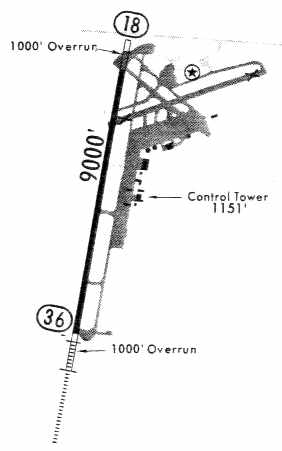
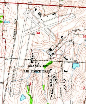
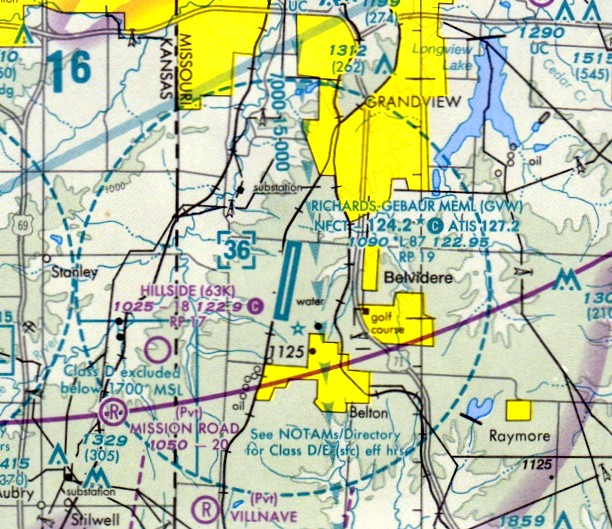
A 1981 airport diagram (courtesy of Eric James) depicted Richards-Gebaur Airport
as having a single 9,000' paved Runway 18/36, along with 2 other former runways.
The notes included “Tactical C-130 aircraft training flights & parachute activity.”
In 1982 Richards-Gebaur's 442nd Tactical Airlift Wing became the 442nd Tactical Fighter Wing,
transitioning to the A-10 Thunderbolt II attack aircraft.
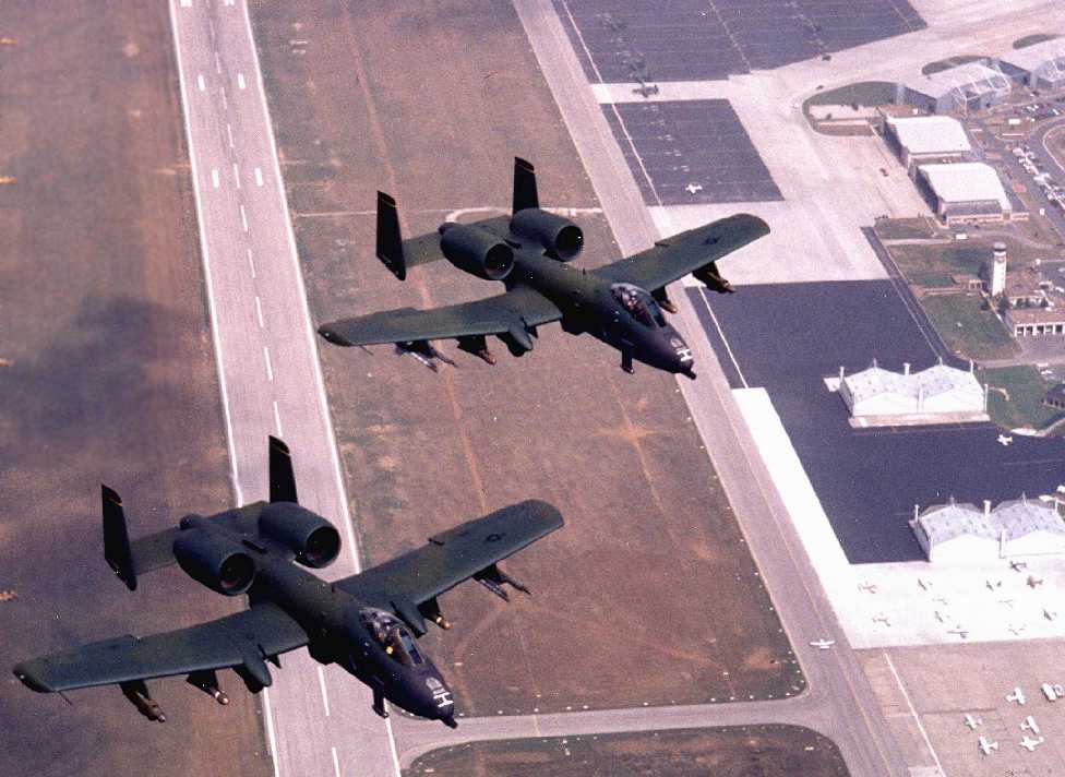
A mid-1980s aerial view looking north at 2 Fairchild A-10A Thunderbolts of the 442nd Tactical Fighter Wing overflying Richards-Gebaur AFB.
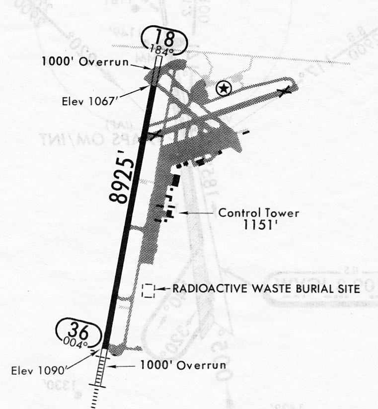
A 5/4/84 airport diagram (courtesy of John Kielhofer) depicted Richards-Gebaur Airport
as having a single 8,925' paved Runway 18/36, along with 2 other former runways.
Also interesting to see a “RADIOACTIVE WASTE BURIAL SITE” directly adjacent to a taxiway – never seen that before on an airport diagram.
In 1985, the United States conveyed the Richards-Gebaur land back to Kansas City.
This conveyance required the city to use the property as a public use airport, and it established the Richards-Gebaur Airport.
Between 1986-94, the city had accepted $12 million in federal Airport Improvement Program funds for airport development,
and each grant required the city to give written assurances that the airport would be available to the public for aeronautical use.
A 1990 USGS aerial view looking southeast at Richards-Gebaur Airport showed 4 Air Force Reserve A-10 Thunderbolts on the north ramp
along with a variety of general aviation aircraft on the south ramp.

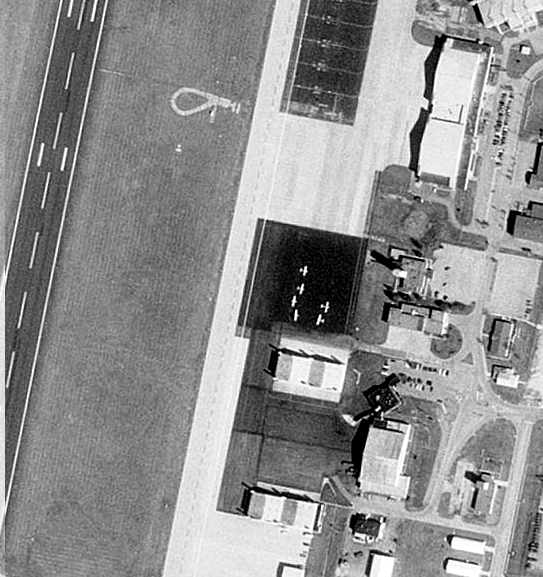
A 1992 aerial view by Ed Noulin looking northwest at the 'Rally of The Giants' radio-controlled airplane event on Richards-Gebaur's northeast/southwest runway.
Ed Noulin recalled, “During its final days as an airport, I was fortunately able to shoot as series of takeoffs & landings on Richards-Gebaur's semi-poor-condition northeast/southwest runway.
Not with a full-scale airplane, but instead with a large-scale radio-controlled airplane.
Several radio-controlled clubs, including the one where I was a member, joined forces in 1992 to host what was then an annual gathering called the 'Rally of The Giants'.
It was attended by 447 pilots who brought over 700 aircraft to fly & display. Adding to the event were the hundreds of spectators who stopped by to see what large-scale model airplanes were all about. Good times!”

A 1992 aerial view by Ed Noulin looking southwest at the 'Rally of The Giants' radio-controlled airplane event on Richards-Gebaur's northeast/southwest runway.
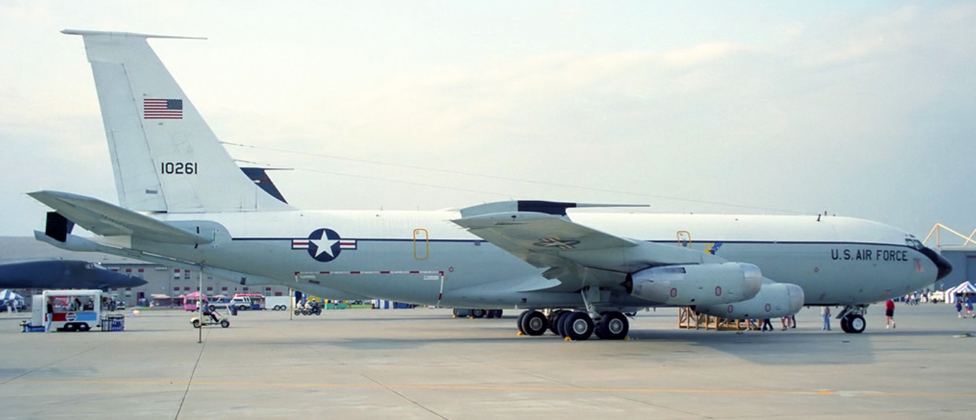
The last photo which has been located showing a military aircraft at Richards-Gebaur Airport
was a 5/10/92 photo of Boeing EC-135L Stratotanker, 61-0261, c/n 18168/T0483 at an airshow.
As part of a Base Realignment and Closure (BRAC) decision to close Richards-Gebaur ARS,
the 442nd FW began transferring to Whiteman AFB in 1993
and the last military aircraft departed Richards-Gebaur ARS on 6/12/94.
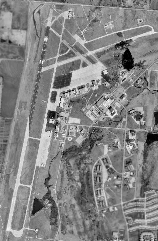
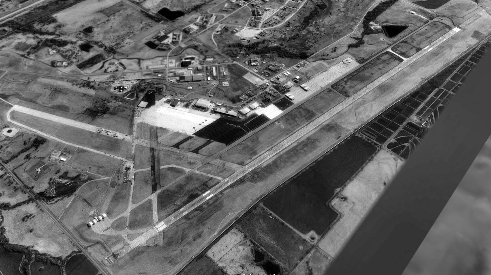
A 1997 USGS aerial photo of the Richards-Gebaur Airport, while the field was still open.
A close-up from the 1997 USGS aerial photo, showing a grand total of only 6 light single-engine aircraft on the entire field.
For several years, the Richards-Gebaur Airport had consistently lost money.
In 1997, in an effort to pursue an opportunity to redevelop the land into an intermodal rail-truck freight distribution center,
Kansas City submitted an application to the FAA requesting permission to close the airport
and seeking to be released from its federal obligations & assurances to maintain the property
for public aeronautical use under the Surplus Property Act & the Airport Improvement Program.
The last aeronautical chart depiction which has been located of Richards-Gebaur Memorial Airport
was on the June 1999 Kansas City Terminal Aeronautical Chart (courtesy of Ron Plante).
It depicted Richards-Gebaur as having an 8,700' paved runway.
The local government closed Richards-Gebaur Airport in 1999 in violation of federal laws concerning use of federal airport grant funds.
The decision to close the airport was bitterly contested by the Friends of Richards-Gebaur Airport & the city of Grandview, MO.
At the time of its closure, the airfield consisted of 2 large runways (the longest, 1/19, is 8,700' long),
numerous taxiways, ramps & hangars.
According to Rick Morgan, "The field portion of the former Richards-Gebaur AFB
was sold to Kansas City Southern Industries,
who converted it into the Kansas City International Freight Gateway,
an intermodal & automobile trans-shipment facility.
The remainder of the base is still used by governmental & light industry applications."
A 7/17/02 aerial view showed the main runway marked with closed “X” symbols.
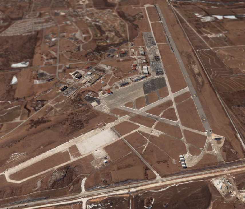
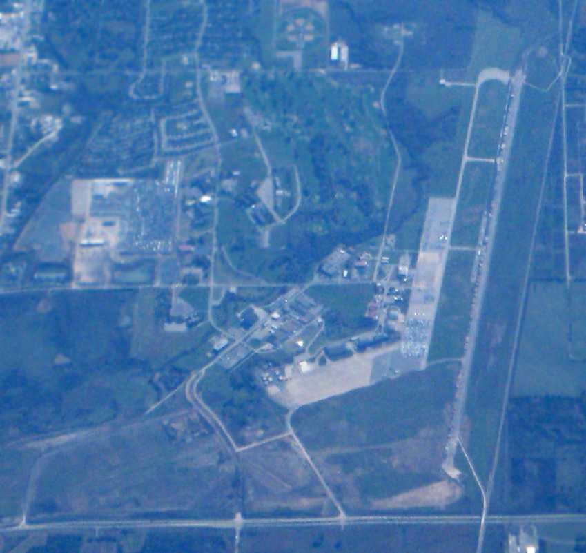
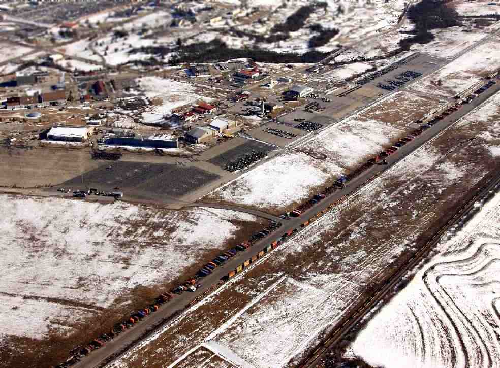
A circa 2000-2005 USGS aerial photo looking south at the former Richards-Gebaur AFB,
showing the massive airfield going to waste, but still largely intact at that point.
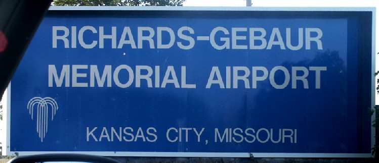
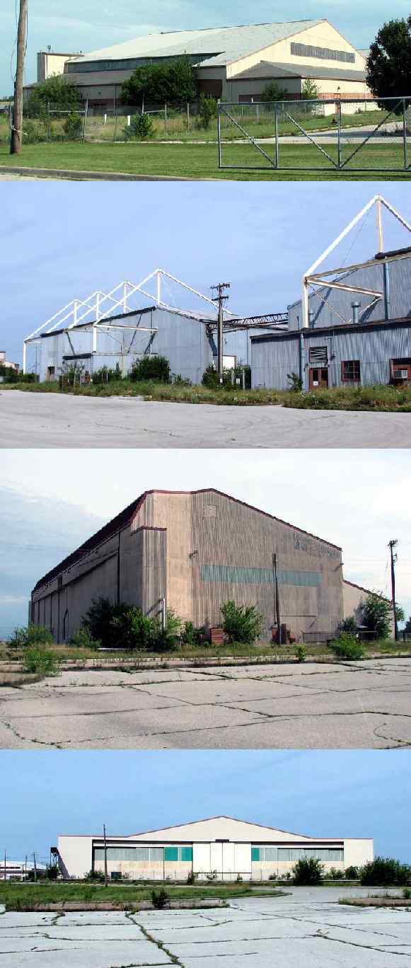
A 2002 photo by Tim Tyler of the entrance sign of the former Richards-Gebaur Memorial Airport.
A 2002 photo by Tim Tyler of the abandoned control tower at Richards-Gebaur.

A 2002 photo by Tim Tyler of Richards-Gebaur AFB's massive former SAGE blockhouse (a former air defense control center).
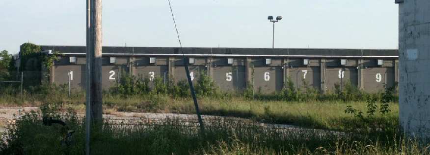
A 2002 photo by Tim Tyler of abandoned former Weapons Storage Area bunkers at Richards-Gebaur.
A 2005 photo by Scott Murdock of Richard Gebaur's “type 4 Air Defense Direction Center (which preceded the SAGE DC).
This somewhat-hardened, gas proof building seems to be abandoned, and the dense brush really obfuscated my photographic intentions.”
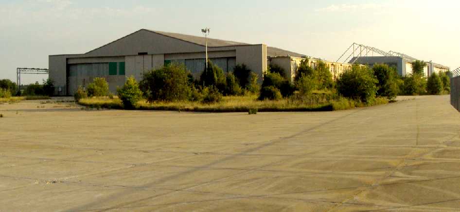
Two 2005 photos by Scott Murdock of the front & back
of Richard Gebaur's former fighter-interceptor alert hangars at the north end of the field.
“This was one of the first-generation ADC hangars, built by Butler, and has the modified (bulged) rear doors.
The hangar seems to be in very good condition, except for a cinder block infill under the control booth.”
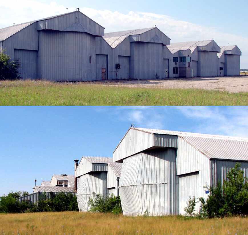
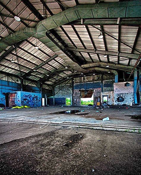
A series of 2005 photos by Scott Murdock of the wide variety of former Air Force hangars which remain intact at Richard Gebaur.
What a shame to see all of this substantial infrastructure not reused for any other form of aviation.
Mike Mays reported in 2005, “This past July I returned to Richards-Gebaur AFB after 30 years.
I must say that it was disheartening to see the place - with all its potential, to be so under-utilized.
What community couldn’t use a good hospital?
Yet, the Richards-Gebaur AFB Hospital, like so many other nice buildings, was leveled.
The JAG’s & Base Commander’s building was gone, the big HQ building was gone,
the Security Police building (including small jail) was a grass lot.
Just doesn’t seem to make sense. And the flight-line has basically gone to pot.”
Ian Beyer reported in 2005, “I do a fair amount of work at Richards-Gebaur these days -
The US Marine Corps is a pretty heavy user of the place (has been since the late 1990s),
but BRAC recently recommended moving MOBCOM (formerly known as MCRSC) to New Orleans.
Due to Hurricane Katrina, there is a fairly substantial number of transient personnel
at the Marine facilities for an indefinite period of time.
The Marines have invested a fair amount of money rehabbing several of the buildings,
as well as building some new ones.
Even if BRAC goes ahead & moves MOBCOM out of the place,
it's still home to the 9th Marine Corps District & the 24th Marine Regiment (in Building 710, the old Air Force HQ Building).
I've also heard the several other Marine administrative functions
currently housed in leased space at the Bannister Federal Complex
would be relocating to space at Richards-Gebaur vacated by MOBCOM.
The bulk of the Kansas City piece of MOBCOM operates in a building (#100)
across from the SAGE blockhouse that appears to have been constructed in the late 1990s.
In 2004, the Marines also completed a new 4-story barracks building to replace Building 252.
There's a heavy equipment auctioneer that uses space on the east-west closed runway,
and I believe they store some additional equipment in the hangars.
I've seen the hangar doors open as recently as a few weeks ago.
Still a shame they decommissioned Runway 18/36 & used it as a big parking lot.
Even if they were to decide it made a good runway again,
aircraft ops would be severely hindered by a new high-voltage transmission line
at the south end that was completed last spring.”
An article entitled “Old airport land sale is expected” by Rick Alm appeared on the 11/17/05 issue of the Kansas City Star:
“City officials today are expected to announce the sale of most of the Richards-Gebaur Airport land
to a Chicago area industrial developer, CenterPoint Properties Trust.
The agreement with CenterPoint would be a big step forward
for the long-anticipated redevelopment of the former Air Force base as a regional cargo transit hub.
City officials said the details of the sale would be released today.
City Council member Chuck Eddy said Wednesday that the sale would be for market value.
In a presentation to city officials & others set for today,
CenterPoint officials are expected to outline their plan for a public-private partnership
that would redevelop more than 900 acres of the nearly 1,400-acre airport site,
creating an estimated 3,000 jobs when completed.”
The article continued, “When the project was announced in late 2003,
Mayor Kay Barnes said early planning called for development of 13 million square feet
of industrial & commercial buildings for use by a variety of industries.
At the time city officials estimated the project could create 4,000 jobs with capital investment totaling $520 million.
The Kansas City Port Authority in 2003 designated CenterPoint & Kansas City-based Hunt Midwest Enterprises
as co-master developers of the airport tract, which it manages for the city.
Hunt later backed out as a master developer, but Lee Derrough, president & chief executive officer,
said Wednesday that the company was actively negotiating with the Port Authority for development rights beneath the airport.
Derrough said he hoped to announce a deal before the end of the year
to mine & develop several million underground square feet as warehouse & industrial space.”

A 2006 photo by Duncan McPhail of the runway light control panel inside the abandoned Richards-Gebaur control tower.
Note the legend on the crosswind runway for the “Future Runway 6/24”.
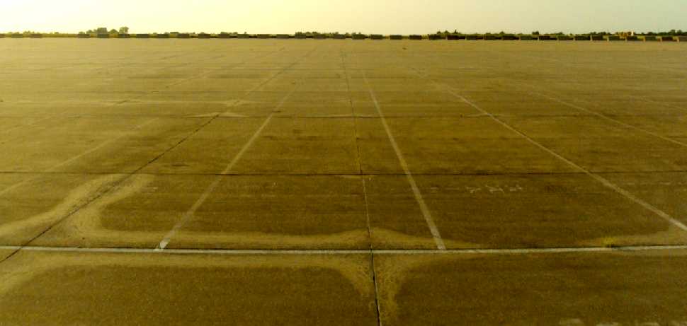
A 3/7/07 aerial view still showed both runways remaining intact.
A 2008 aerial view by Bryan Lipson looking south at the remains of Richards-Gebaur AFB,
showing a road which had been built over the former crosswind runway at some point between 2007-2008.
Bryan observed, “The former crossing runways are no longer recognizable thought the ramp remains largely intact.
It appears the airport is on its last legs of existence.”
The former alert barns on the north end of the base were evidently removed at some point between 2005-2008.
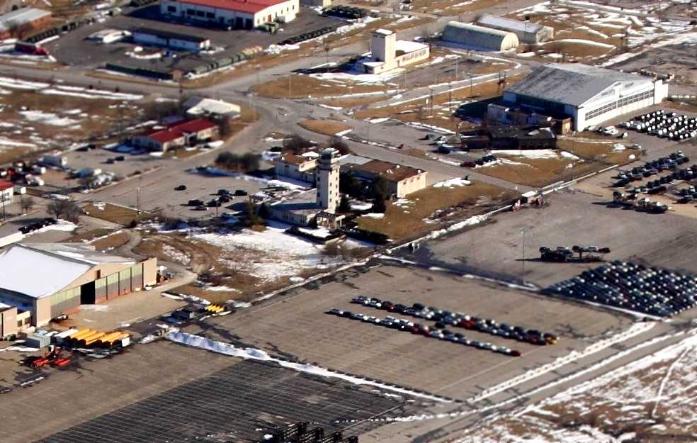
A 2009 photo by Rex Ricks of 2 former Richards-Gebaur hangars.
A 2009 photo by Rex Ricks of the seemingly endless Richards-Gebaur ramp.
A 2/17/10 aerial view by John English looking southeast at the site of Richards-Gebaur AFB.
John noted, “It is now partly an inter-modal hub for a railroad.”
A closeup from John English's 2/17/10 aerial view looking southeast at the former Richards-Gebaur AFB control tower & hangars.
Ron Plante visited the site of Richards-Gebaur AFB in 2011, and reported:
“There’s lots of USMCR activity & some very new buildings.
The SAGE blockhouse remains, though on a Saturday there was no evidence of activity.
The adjacent building is used by a company called BTM or maybe BTI.
The Weapons Storage Area apparently belongs to the city of Belton, and the outer gate was locked.
I did not look for the old WSA / Belton Training Annex.
On the north end where I expected to find the Fighter Interceptor Squadron barns was a lot of construction, mostly for a new Highway 150 interchange.
The crosswind runway appears to be totally gone, and I could not find the alert area.”
A circa 2013 photo of the interior of a small hangar which remains on the southeast end of Richards-Gebaur AFB's former Runway 36.
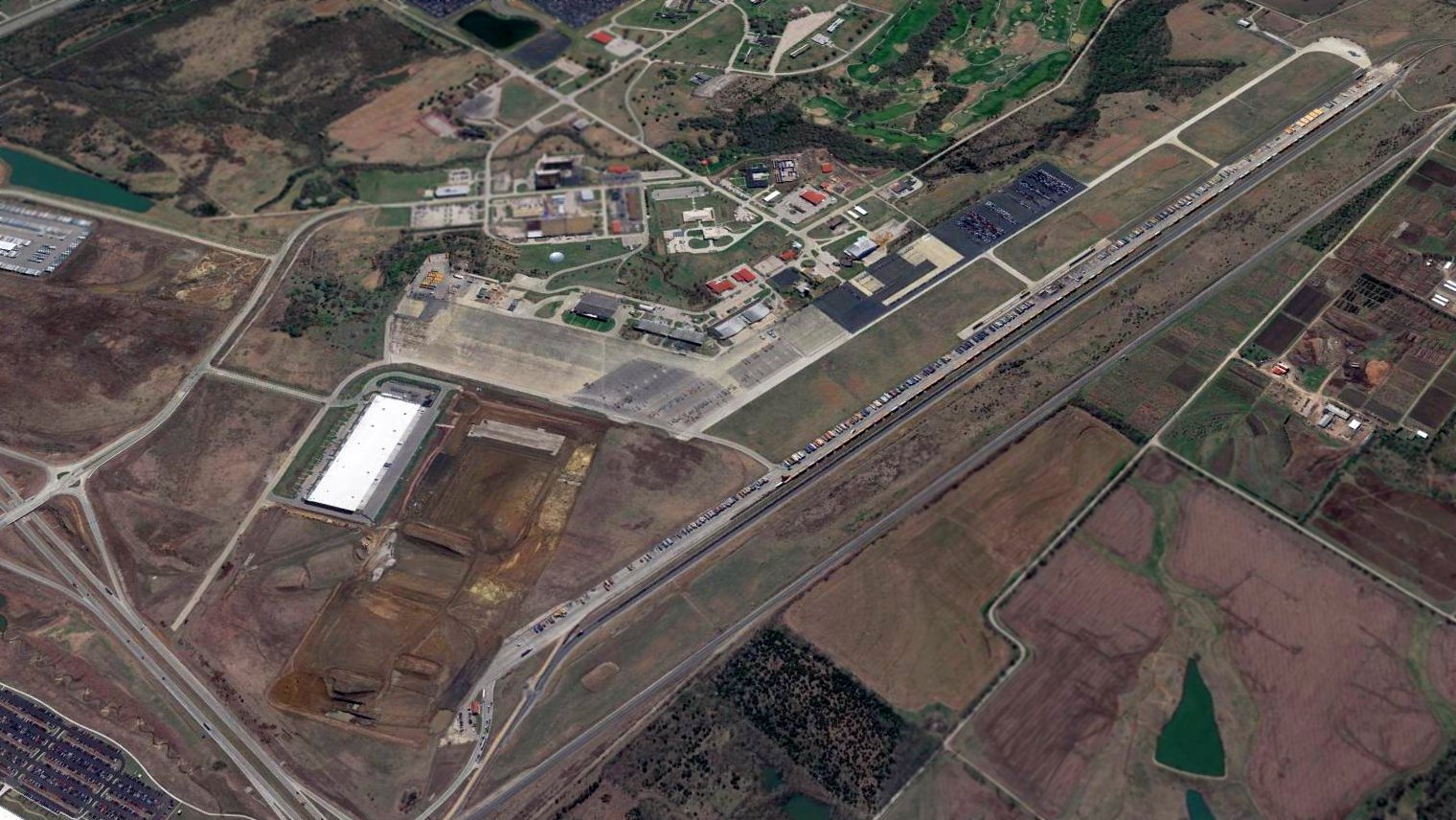
A sad 2016 aerial view looking southeast at the remains of Richards-Gebaur AFB, with the crosswind runway having been completely removed,
and the northern portion of the primary runway also having been removed.
What an incredible waste of aviation infrastructure paid for by the taxpayers.
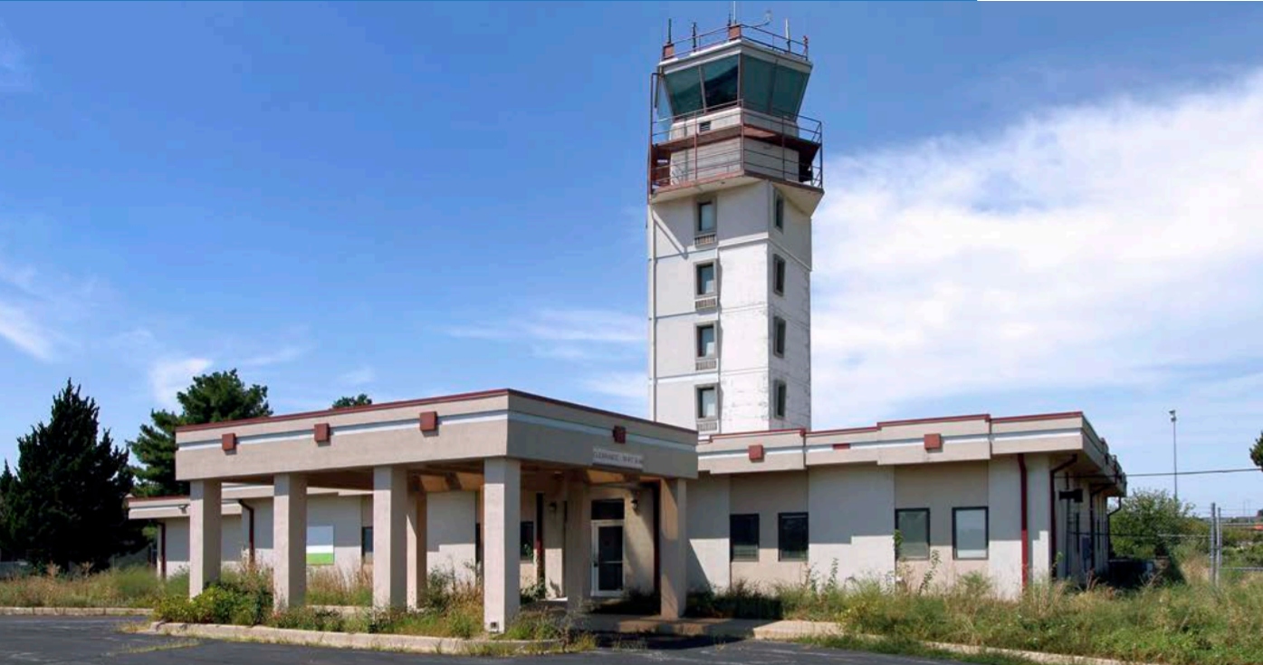
A 2021-or-before photo of the former Richards-Gebaur AFB control tower, from a Richards-Gebaur Commerce Park advertisement.

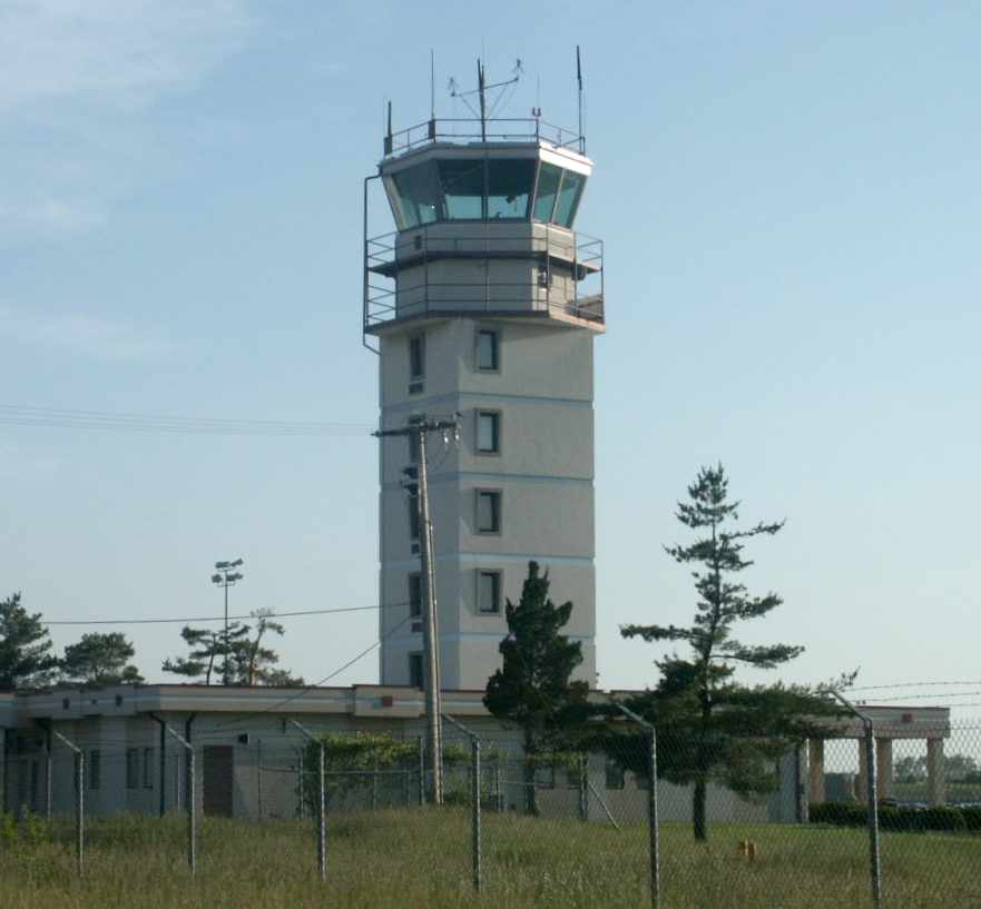
A 3/10/25 photo by David Jaffray of the former Richards-Gebaur AFB control tower.

A 3/10/25 photo by David Jaffray of a former Richards-Gebaur AFB fire station, adorned with friendly graffiti.

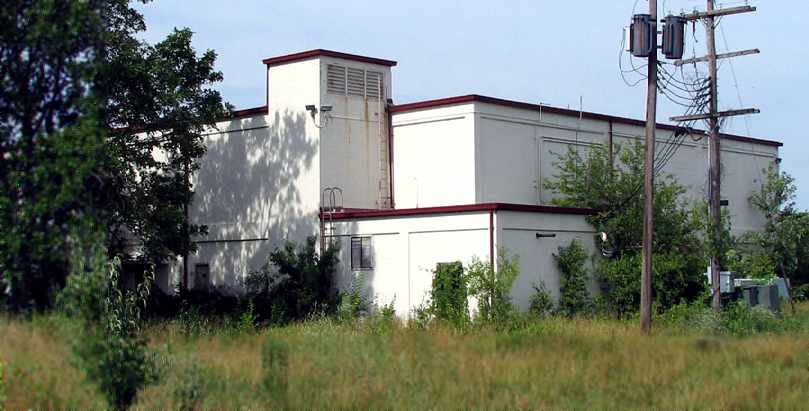
A 3/10/25 photo by David Jaffray of a former Richards-Gebaur AFB hangar.

A 3/10/25 photo by David Jaffray of a former Richards-Gebaur AFB hangar.
See also: http://www.globalsecurity.org/military/facility/richards-gebaur.htm
____________________________________________________
Or if you prefer to contact me directly concerning a contribution (for a mailing address to send a check),
please contact me at: paulandterryfreeman@gmail.com
If you enjoy this web site, please support it with a financial contribution.
Or if you prefer to contact me directly concerning a contribution (for a mailing address to send a check),
please contact me at: paulandterryfreeman@gmail.com
If you enjoy this web site, please support it with a financial contribution.
____________________________________________________
This site covers airfields in all 50 states.