Abandoned & Little-Known Airfields:
Northeastern Mississippi
© 2002, © 2025 by Paul Freeman. Revised 11/22/25.
This site covers airfields in all 50 states: Click here for the site's main menu.
____________________________________________________
Please consider a financial contribution to support the continued growth & operation of this site.
Carthage Airport / (Original) Leake County Airport (added 2/12/20) - Fulton-Itawamba County Airport (revised 1/2/21) - River Aux AAF #2 / River AF Aux / River Airport (revised 9/7/16)
Payne Field (revised 6/8/22) – Eddie A. Stinson Field / Columbus AAF Auxiliary #7 / Stinson Field Municipal Airport (revised 11/22/25)
Vaughn Aux AAF #6 / Vaughn AF Aux / Vaughn Airport (revised 11/22/25)
____________________________________________________
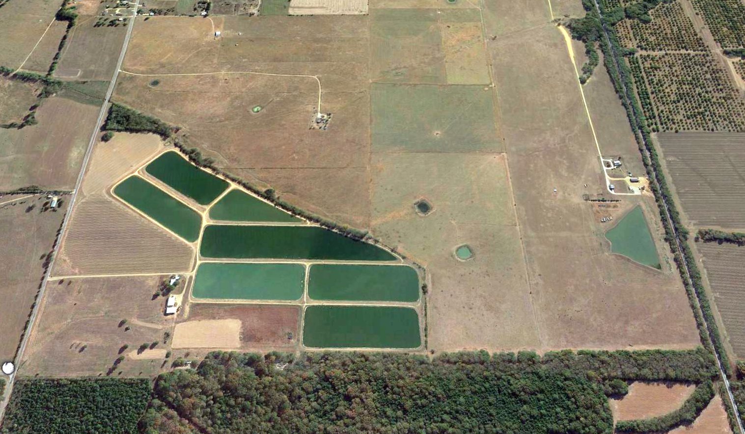
Carthage Airport / (Original) Leake County Airport, Carthage, MS
32.703, -89.517 (Northeast of Jackson, MS)
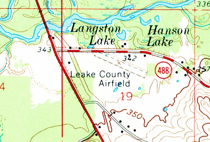
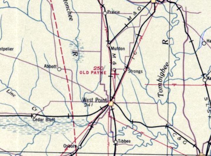
Leake County Airfield, as depicted on the 1961 USGS topo map.
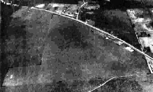
Carthage Airport was evidently established at some point between 1955-61,
as it was not yet depicted on a 1955 aerial photo.
The earliest depiction which has been located of Carthage Airport was on the 1961 USGS topo map (courtesy of Jimmy McPhail).
It depicted “Leake County Airfield” as having an unpaved northwest/southeast runway, with 2 small buildings on the northeast side.
According to Jimmy McPhail, “I consider it historical because it was the first aviation site in Leake County.”
Carthage Airport was not yet depicted on the February 1961 Birmingham Sectional Chart (according to Jimmy McPhail).
Jimmy McPhail recalled, “The first airport I ever visited as a kid was a former cow pasture in Leake County, Mississippi, south of Carthage.
In 1962, I was 7 years old & my mom & dad took my brother & I on a Sunday afternoon to the sandy banks of the Pearl River
to scoop a 5-gallon bucket of white river sand to replenish our backyard sandbox at home in Carthage.
While we were scooping sand near the west side of the State Highway 35 bridge,
a green & white Aeronca Champ glided right over us & disappeared behind the tree line on the east side of Highway 35.
I thought it was in trouble because it was so low, but my dad said there was a little airport across the road behind the trees.
I was immediately done with scooping sand. I wanted to go see that airplane! Dad took us there & we saw 3 taildraggers tied down.
The green & white Champ was the first airplane I ever had got to touch & see up close.
I could smell the sweet aroma of the warm engine oil & thought the plane was huge!
After that day, we made many visits to the pasture on Sunday afternoons & watched the activity.
I have never forgotten it. I became a Private Pilot in 1979, a Commercial Pilot in 1990, and Flight Instructor in 1991.
It all started with watching Sky King on Saturday mornings & visiting the little airport on Sunday afternoons, thanks to mom & dad.”
The earliest aeronautical chart depiction which has been located of Carthage Airport was on the April 1965 Birmingham Sectional Chart.
It depicted Carthage Airport as having a mere 1,900' unpaved runway.
Jimmy McPhail recalled, “The old airport was replaced by a new airport - Carthage-Leake County Airport - on the north side of town.”

The last aeronautical chart depiction which has been located of the original Carthage Airport was on the September 1968 Birmingham Sectional Chart.
It depicted Carthage Airport as having a mere 1,900' unpaved runway.
The earliest photo which has been located of the original Carthage Airport was a 1970 aerial view.
It depicted Carthage Airport as having an unpaved northwest/southeast runway, with 2 light single-engine planes parked on the north side.
There did not appear to be any hangars or other airport buildings.
Jimmy McPhail recalled, “I lost track of the old airport until 1974-75 when I saw 2 high-wing taildraggers through the tree line tied down out there (perhaps crop dusters?).
By the late 1970s it was a cow pasture again & a few mobile homes had been moved in along Highway 488.”
A 1980 aerial view showed the Carthage Airport runway was still intact, but overgrown, and there was no indication of recent aviation use.
The 1984 USGS topo map no longer depicted Carthage Airport.
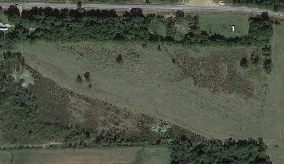
A 2014 aerial view showed the Carthage Airport runway was still intact, several decades after being abandoned.
Thanks to Jimmy McPhail for pointing out this airfield.
____________________________________________________
Payne Field / Old Payne Field, West Point, MS
33.668, -88.633 (Northeast of Jackson, MS)
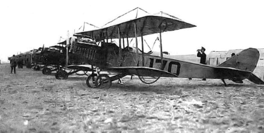
A 1918 US Army photo of JN-4 training aircraft at Payne Field.
According to Wikipedia, “Payne Field operated as a training field for the Air Service, United States Army between 1918-20.
The airfield was one of 32 Air Service training camps established in 1917 after the United States entry into World War I.
It was the first airport constructed in Mississippi.
Payne Field was named in memory of Captain Dewitt Payne.
Payne was transferred to Taliaferro Field, near Fort Worth, TX.
There on 2/1/18, Payne was flying to the aid of a pilot who had crashed into the top of a tree & crashed his own plane in the process.
He died from the injuries sustained in the crash.”
Wikipedia continued, “During World War I, Payne Field was used as a training facility for military pilots.
In November 1917, the Department of War sent a cadre of officers to the Columbus, MS area to survey sites for an aviation school.
The group decided on a location about 5 miles northeast of West Point, MS. An agreement to lease the land for the Army was concluded.
The field consisted of 533 acres & was constructed at a cost of $891,340 & could accommodate up to 1,000 personnel.
Dozens of wooden buildings served as headquarters, maintenance, and officers’ quarters. Enlisted men had to bivouac in tents.”
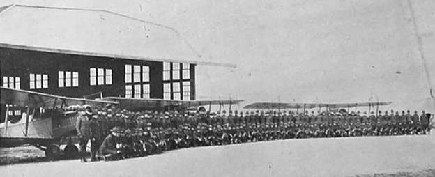
A 1918-20 US Army photo of the men & JN-4 training aircraft of Squadron C in front of a Payne Field hangar.
Wikipedia continued, “The commander of Payne Field was Lt. Col. Jack Heard.
Heard was a career army officer, a West Point graduate (class of 1910), and the son of Medal of Honor John Heard.
The first units stationed at Payne arrived in April, 1918, being transferred from Kelly & Ellington Fields, TX.
However, only a few U.S. Army Air Service aircraft arrived with the squadrons. Most of the Curtiss JN-4 Jennys to be used for flight training were shipped in wooden crates by railcar.
Payne Field served as a base for flight training for the United States Army Air Service.
In 1918, flight training occurred in 2 phases: primary & advanced.
Primary training took 8 weeks & consisted of pilots learning basic flight skills under dual & solo instruction with a student capacity of 300.
After completion of their primary training, flight cadets were then transferred to another base for advanced training.
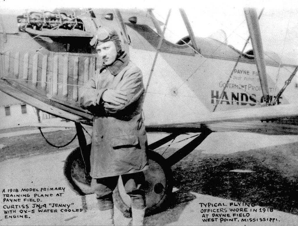
A 1918 US Army photo of a flying instructor in front of a JN-4 training aircraft at Payne Field.
Wikipedia continued, “Training units assigned to Payne Field were: Post Headquarters, Payne Field,
175th Aero Squadron, April, 1918 (Transferred from: Ellington Field, TX), Re-designated as Squadron "A", July–November 1918,
238th Aero Squadron (II), April 1918 (Transferred from: Kelly Field, TX), Re-designated as Squadron "B", July–November 1918,
239th Aero Squadron (II), April 1918 (Transferred from: Kelly Field, TX), Re-designated as Squadron "C", July–November 1918,
252nd Aero Squadron, April 1918 (Transferred from: Ellington Field, TX), Re-designated as Squadron "D", July–November 1918,
Flying School Detachment (Consolidation of Squadrons A-D), November 1918- November 1919.”
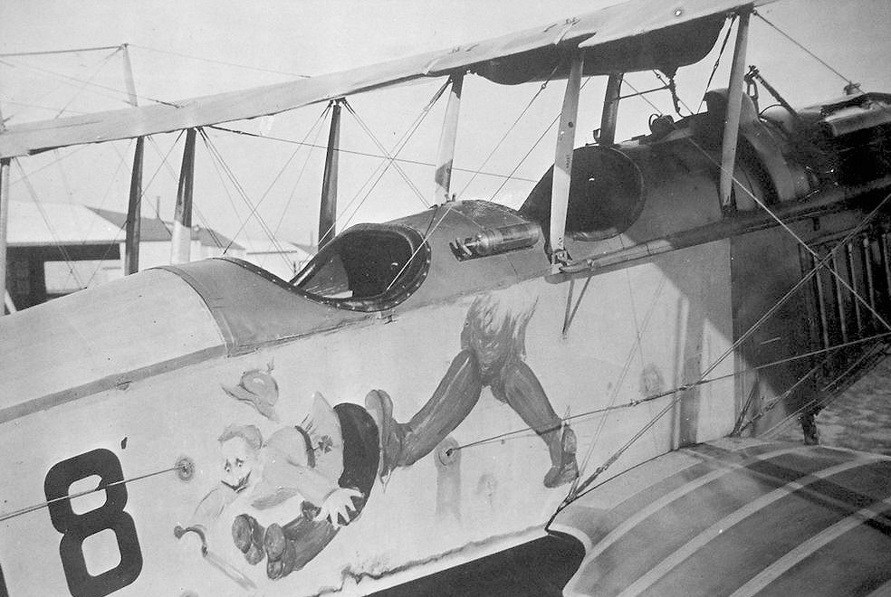
A 1918 US Army photo of fanciful art on the fuselage of a JN-4 training aircraft at Payne Field.
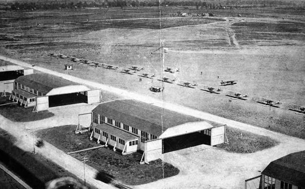
A 1918-20 US Army photo looking southeast at JN-4 training aircraft & hangars at Payne Field.
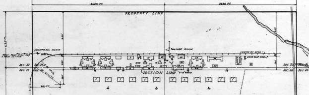
A 2/11/18 plan of the buildings & hangars at Payne Field.
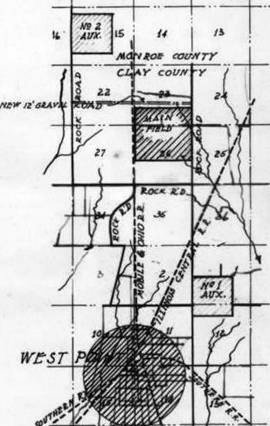
A 2/11/18 map of Payne Field (“Main Field”) & its 2 nearby auxiliary airfields.
Wikipedia continued, “In all some 1,500 pilots trained at the field during its operation.
Accidents were frequent & in the first 4 months of operation there were 4 fatal plane crashes.”

A 1918 US Army photo of the interior of the JN-4 aircraft repair shop at Payne Field.
Wikipedia continued, “With the sudden end of World War I in November 1918, the future operational status of Payne Field was unknown.
Many local officials speculated that the U.S. government would keep the field open because of the outstanding combat record established by Payne-trained pilots in Europe.
Cadets in flight training on 11/11/1918 were allowed to complete their training, however no new cadets were assigned to the base.
Also the separate training squadrons were consolidated into a single Flying School detachment, as many of the personnel assigned were being demobilized.”
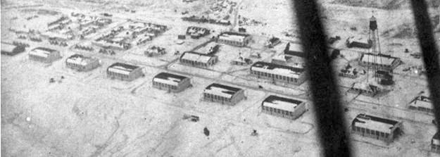
A winter 1918 US Signal Corps aerial view looking northwest at the row of Payne Field hangars covered in snow.
Wikipedia continued, “Payne Field played a role in one of the milestones of aviation.
The first North American transcontinental round trip flight occurred in 1919.
The flight by Major Theodore Macauley & his mechanic, Pvt. Staley, began in January 1919.
Macauley was flying west from Montgomery, AL, in a De Havilland DH-4 when its propeller was damaged during a rain storm.
He was able to land at Payne Field for repairs & then continued on to complete his historic trip.
There was, though, a delay of over a week at Payne Field as all of the rain had made the runway too muddy for the De Havilland to take off.”
Wikipedia continued, “With the end of World War I, in December 1919 Payne Field was deactivated as an active duty airfield,
however, and a small caretaker unit was assigned to the facility for administrative reasons.
It was used by the aerial forestry patrol.
It also was used intermittently to support small military units.
However, the decision had been made to phase down all activities at the base in accordance with sharply reduced military budgets, and it was closed.
The base closed in March 1920.”
Wikipedia continued, “Shortly after it closed the Inter-State Airplane Company of Dallas purchased much of the field.
Their plan was to develop a 'municipal flying field' with passenger service from the east to Shreveport, Dallas, Ft. Worth & Wichita Falls.
Apparently it was a plan that never materialized.”
Payne Field may have continued to be reused for civilian aviation in some capacity, as it was still depicted on the April 1933 Birmingham Sectional Chart.
After the end of military activities at Payne Field, a hangar was disassembled & sold to a company in nearby Tupelo.
In 1934, the Gravlee Lumber Company moved to Tupelo from Nettleton & took over the building & used the former hangar for storage.
It was still depicted as “Payne” Field on the October 1935 Birmingham Sectional Chart.
The last aeronautical chart depiction which has been located of Payne Field was on the October 1937 Birmingham Sectional Chart, labeled as “Old Payne”, an auxiliary airfield.
Aviation use of Payne Field evidently ended at some point between 1937-38,
as it was no longer depicted on the April 1938 Birmingham Sectional Chart.
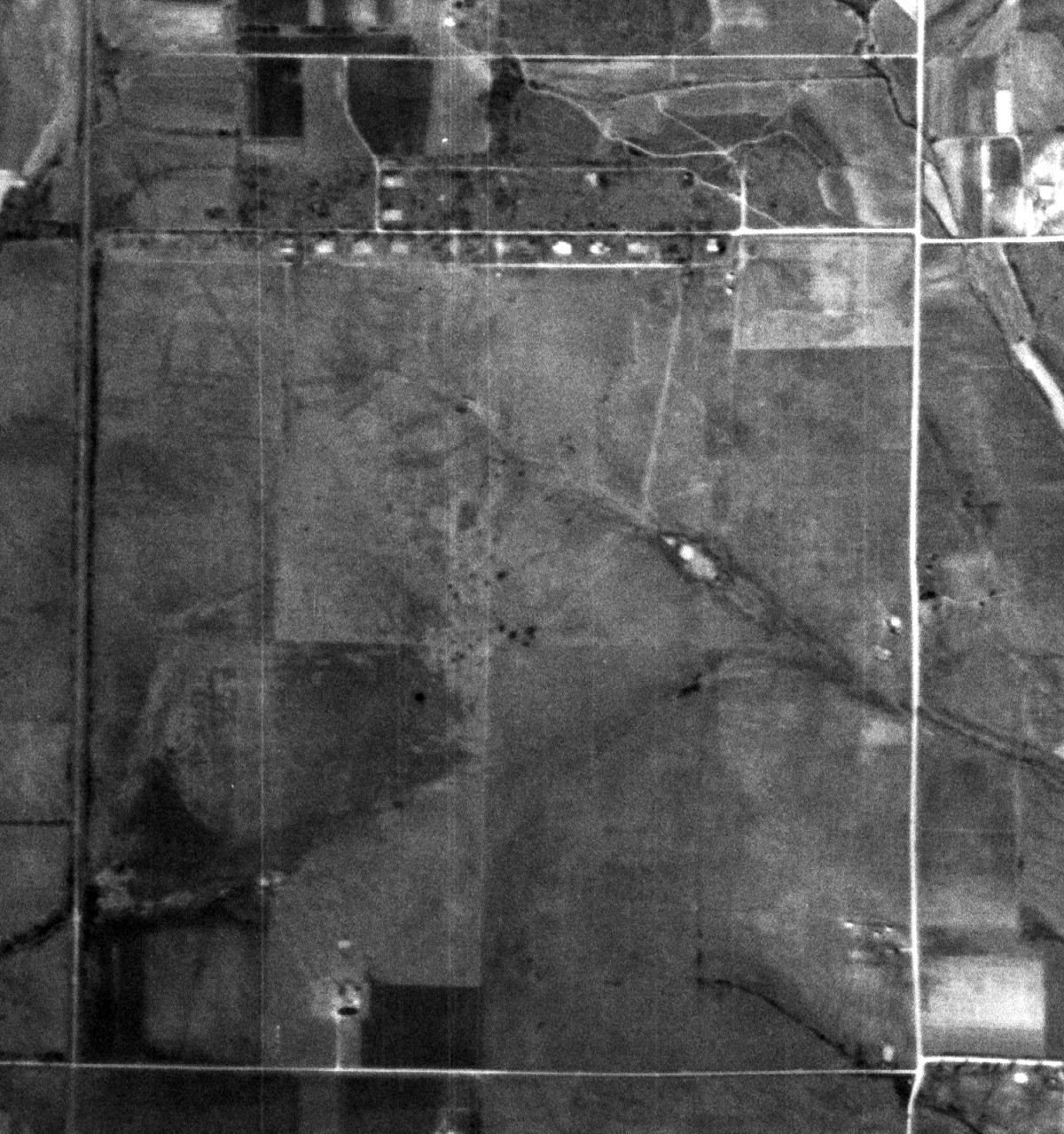
A 3/8/52 USGS aerial view of the Payne Field site showed the row of hangar foundations remained recognizable along the north side.
Nothing was depicted at the site of Payne Field on the 1960 USGS topo map.
A historical marker was erected commemorating Payne Field on 8/23/68, on the occasion of a 50th Anniversary & Reunion.
A 1996 aerial view of the Payne Field site showed the flying field had been reused for agriculture.
The row of hangar foundations along the north side had been overgrown, but was still recognizable.
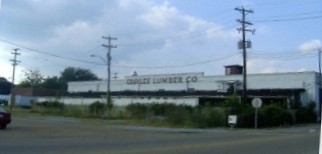
A pre-2012 photo of a former Payne Field hangar, moved to Tupelo & reused by the Gravlee Lumber Company.
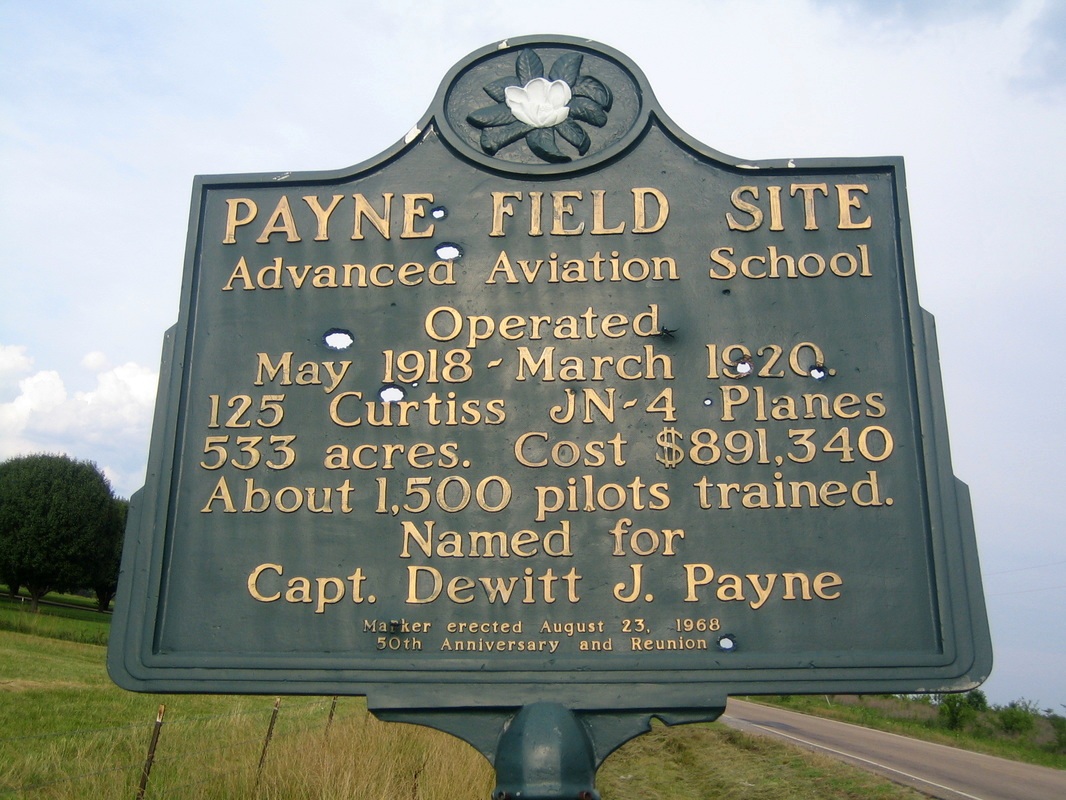
An undated historical marker commemorating Payne Field.
A 2016 aerial view looking south at the site of Payne Field showed the location of the row of hangar foundations in the foreground (a wooded stretch along the northern property edge).
According to Wikipedia, “The former air field is now agricultural land & thickets with no indication that it had once been a busy military base.”

A 5/10/20 drone aerial view by Matthew Payne of a former Payne Field hangar, moved to Tupelo & reused by the Gravlee Lumber Company.

A 5/10/20 photo by Matthew Payne of a former Payne Field hangar, moved to Tupelo & reused by the Gravlee Lumber Company.
Matthew Payne reported in 2022, “The former Payne Field hangar in downtown Tupelo was purchased by the City of Tupelo & will likely be demolished soon.”
The site of Payne Field is located at the intersection of Old Vinton Road & Payne Field Road, appropriately enough.
Thanks to Jason Ward for pointing out this airfield.
____________________________________________________
Fulton-Itawamba County Airport (11M), Fulton, MS
34.35, -88.38 (Northeast of Tupelo, MS)
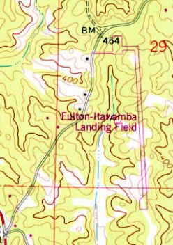
“Fulton-Itawamba Landing Field”, as depicted on the 1979 USGS topo map.
Photo of the airport while in use is not available.
This small general aviation airport was evidently established at some point between 1968-79,
as it was not yet depicted on a 1963 aerial photo, the 1965 USGS topo map, or the August 1968 Chattanooga Sectional Chart.
The earliest depiction which has been located of Fulton-Itawamba County Airport was on the 1979 USGS topo map.
It depicted “Fulton-Itawamba Landing Field” as having a single paved runway with a paved ramp on the northwest side.
The earliest photo which has been located of Fulton-Itawamba County Airport was a 1980 aerial view.
It depicted Fulton-Itawamba as having a single asphalt Runway 17/35, with a paved ramp on the northwest side, on which was 1 single-engine light aircraft.
According to its FAA Airport/Facility Directory data, Fulton-Itawamba County Airport was owned by Fulton-Itawamba County Airport Board.
It comprised an area of 76 acres, and had a single 3,000' asphalt Runway 17/35.
The earliest photo which is available of Fulton-Itawamba County Airport was a 4/4/90 USGS aerial view.
It depicted Fulton-Itawamba County Airport as having a single paved runway with a paved ramp on the northwest side.
But there were no aircraft visible or any other sign of recent aviation use.
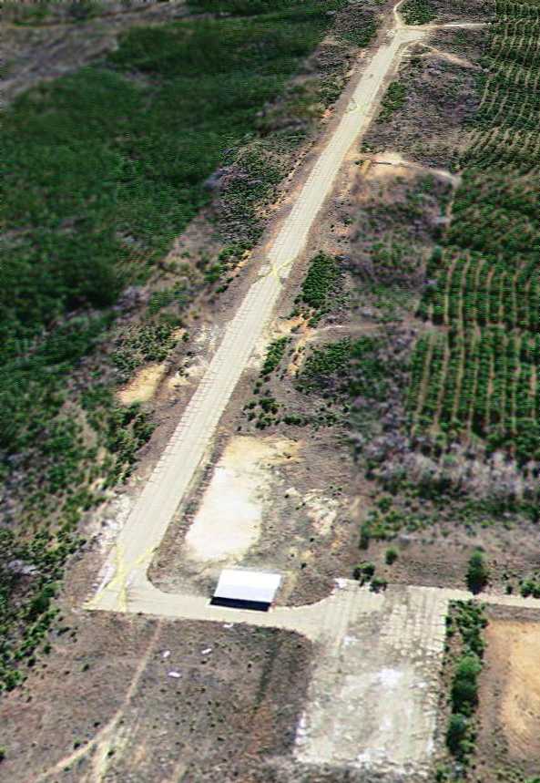
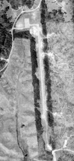
Fulton-Itawamba County Airport was evidently closed by 2007, as a 1/3/07 aerial view looking southeast showed the runway marked with multiple closed-runway “X” symbols, and the pavement appeared quite deteriorated.
The reason for the airport's closure has not been determined. A small building had been added at some point between 1990-2007 along the northwest taxiway.
A 2016 aerial view looking southeast at Fulton-Itawamba County Airport showed the paved runway & ramp remained intact, though deteriorated.
Fulton-Itawamba County Airport is located on the east side of Airport Road, appropriately enough.
Thanks to Aubrey Patterson for pointing out this airfield.
____________________________________________________
Eddie A. Stinson Field / Columbus AAF Auxiliary #7 / Stinson Field Municipal Airport, Aberdeen, MS
33.85, -88.59 (Southeast of Memphis, TN)

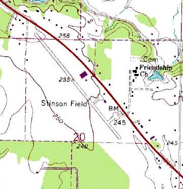
Stinson Field, as depicted on the March 1937 Birmingham Sectional Chart.
Stinson Field was evidently established at some point between 1936-37,
as it was not yet depicted on the September 1936 Birmingham Sectional Chart.
The earliest depiction which has been located of Stinson Field was on the March 1937 Birmingham Sectional Chart.
It depicted Eddie A. Stinson as an auxiliary airfield.
The earliest photo which has been located of Stinson Field
was a 6/3/43 aerial view looking north from the 1945 AAF Airfield Directory (courtesy of Scott Murdock).
It depicted “Columbus AAF Auxiliary #7 (Stinson Field)” as an irregularly-shaped grass field, with several buildings along the road on the northeast side.
The 1945 AAF Airfield Directory (courtesy of Scott Murdock) described “Columbus AAF Auxiliary #7 (Stinson Field)”
as a 109 acre irregularly-shaped property having a single 3,500' northwest/southeast sod runway.
The field was not said to have any hangars,
to be owned by private interests, but operated by the Army Air Forces.
At some point after 1945, Stinson Field was relinquished by the military & reverted to its role as a general aviation airport.
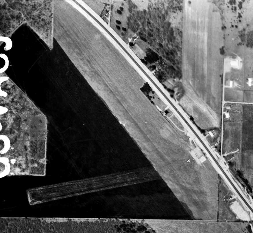
The only photo which has been located showing aircraft at Stinson Field was a 3/26/60 USGS aerial view.
It depicted Stinson Field as having a single unpaved northwest/southeast runway, with 2 small buildings & one single-engine aircraft on the east side.
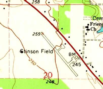
The 1966 USGS topo map depicted Stinson Field as having a single 2,000' paved northwest/southeast runway (evidently an improvement at some point between 1960-66),
with 2 paved ramps & small hangars on the east side.
The 1982 USGS topo map showed that the length of Stinson's runway had been nearly doubled to 3,400', having been lengthened toward the northwest.
The 1995 USGS topo map depicted Stinson Field as having a single paved northwest/southeast runway,
with two ramps & several small buildings on the east side.
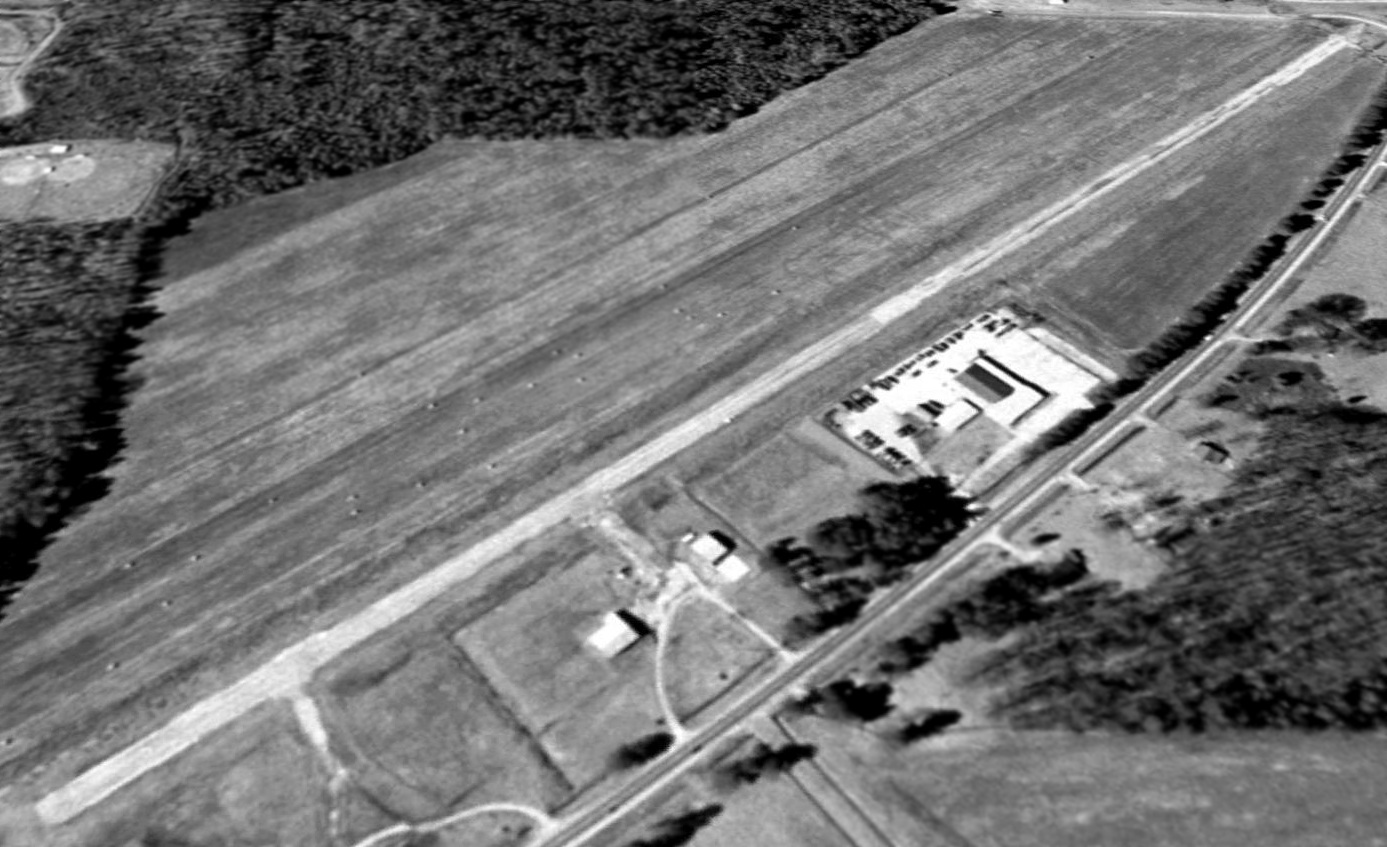
A 1997 USGS aerial view looking west showed Stinson Municipal Airport to remain completely intact,
but there were no aircraft visible on the field, so it is indeterminate whether the field was still operational at that point.
A circa 2007 aerial view looking north at the remains of Stinson Municipal Airport
showed the remains of the runway pavement, along with the ramp, and foundations of several buildings.
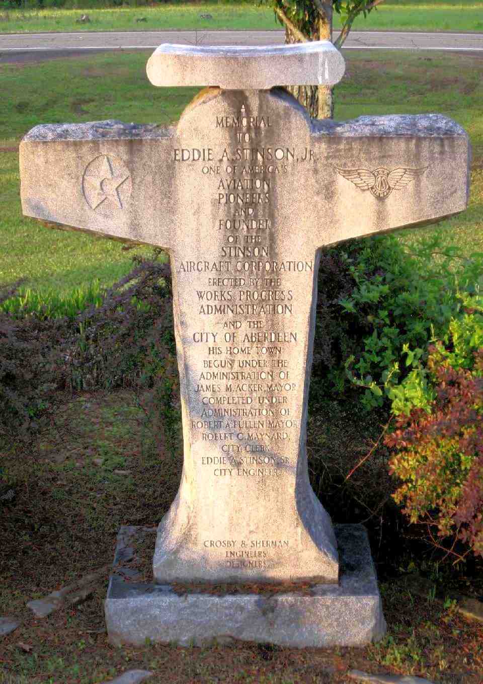
A 4/15/11 photo by Matthew Nichols of a memorial to Eddie Stinson located in a small park next to the hangar foundations at the site of Stinson Field Municipal Airport.
The monument reads: “A memorial to Eddie A Stinson Jr. One of America's aviation pioneers & founder of the Stinson Aircraft Corporation.
Erected by the Works Progress Administration & the City of Aberdeen, his home town.”
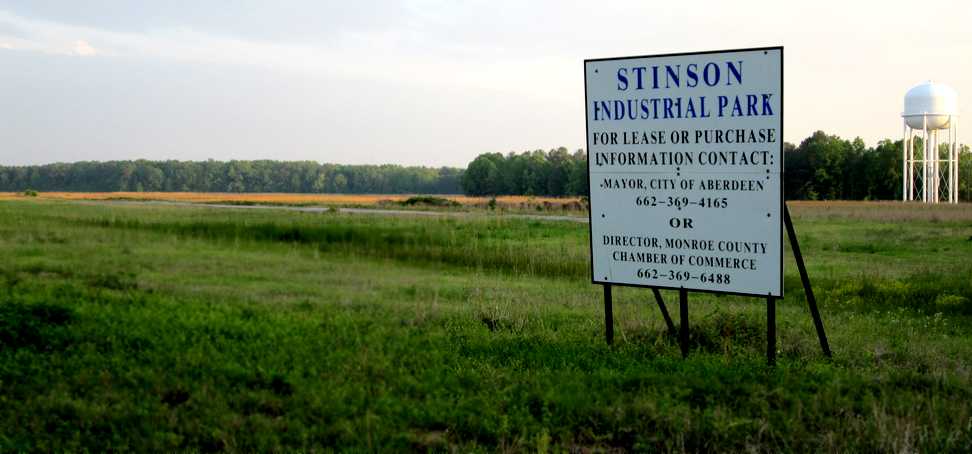
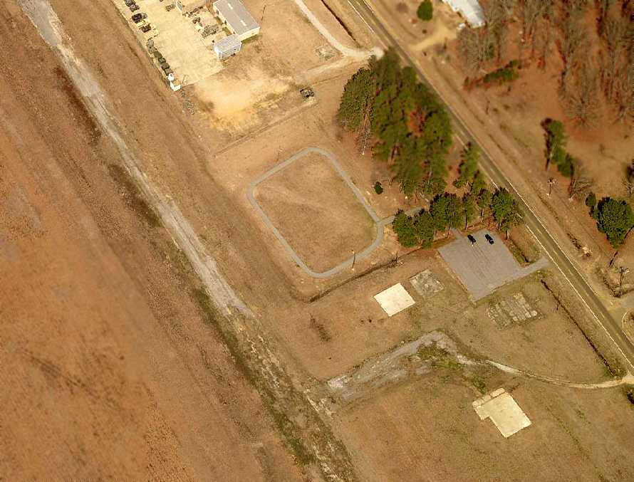
A 4/15/11 photo by Matthew Nichols looking south at a “sign on the north end of the former Stinson Field Municipal Airport indicating its current use as an industrial park.
The remaining strip of runway can be seen behind the sign. Looks like they should have left it as an airport.”
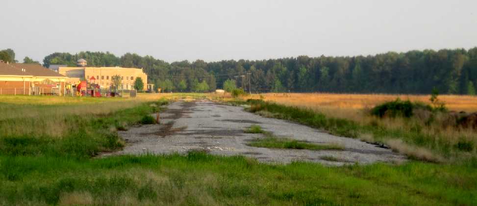
A 4/15/11 photo by Matthew Nichols looking southeast “down the remaining strip of runway at the site of the former Stinson Field Municipal Airport.
A school facility, National Guard Armory and Tax Court encroach on the field.”
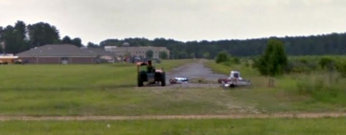
A 2013 photo looking southeast along the remains of the Stinson Field runway.
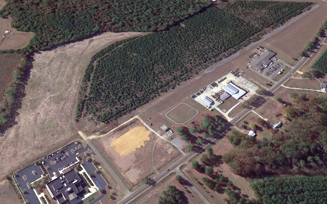
A 2016 aerial view looking west showed the western half of Stinson Field's runway remained intact,
but a school had been built adjacent to the northwest side of the runway, and the Northern Mississippi Bankruptcy Court covered the southeast end of the runway.
The site of Stinson Municipal Airport is located south of the intersection of Route 45 & Stinson Road, appropriately enough.
Thanks to Bud Green for pointing out this airfield.
____________________________________________________
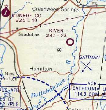
River Auxiliary Army Airfield #2 / River Air Force Auxiliary / River Airport, Aberdeen, MS
33.8, -88.32 (West of Birmingham, AL)

A 6/3/43 aerial view looking north at “Columbus AAF Auxiliary #2 (River Field)” from the 1945 AAF Airfield Directory (courtesy of Scott Murdock).
River Field was not yet depicted on the October 1942 Birmingham Sectional Chart.
River Field was reportedly established during WW2 as one of 8 satellite airfields for Columbus AAF (12 miles southwest),
which conducted training in twin-engine bombers.
The earliest depiction which has been located of River Field
was a 6/3/43 aerial view looking north from the 1945 AAF Airfield Directory (courtesy of Scott Murdock).
It depicted “Columbus AAF Auxiliary #2 (River Field)” as a single north/south runway, with a parallel taxiway.
The airfield appeared to still be under construction, with only the southern half of the runway & taxiway having been built.
River Field was not yet depicted on the March 1944 Birmingham Sectional Chart.
The 1945 AAF Airfield Directory (courtesy of Scott Murdock) described “Columbus AAF Auxiliary #2 (River Field)”
as a 143 acre rectangular property having a single 4,000' north/south sod runway.
The field was not said to have any hangars, to be owned by private interests, but operated by the Army Air Forces.
River Field was presumably abandoned by the military shortly after WW2,
as it was not depicted at all on the April 1945 Birmingham Sectional Chart or the April 1946 Birmingham Sectional Chart.
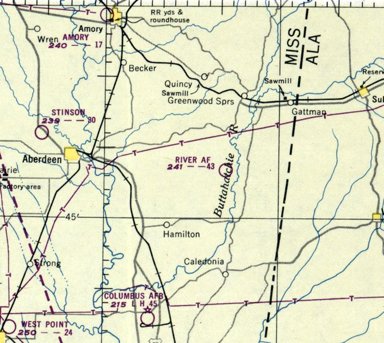
River Field was evidently reactivated by the Air Force under the jurisdiction of Craig AFB at some point between 1946-50,
as it was depicted as “River AF” on the February 1950 Birmingham Sectional Chart.
It was depicted as having a 4,300' unpaved runway.
The use of the River airfield by the Air Force in the 1950s reportedly lasted only a few months.
It was still labeled as “River AF” on the August 1954 Birmingham Sectional Chart (courtesy of Chris Kennedy), and depicted as having a 2,300' unpaved runway.
A 1955 aerial view did not show any sign of recent aviation use at the site of River Field.
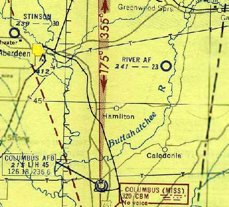
By the time of the February 1960 Birmingham Sectional Chart (courtesy of Chris Kennedy), “River” was depicted as a civilian airfield, with a 2,300' unpaved runway.
River Airport was still depicted in the same fashion on the June 1961 Boston Mountains World Aeronautical Chart (courtesy of Chris Kennedy).
The last aeronautical chart depiction which has been located of River Airport was on the August 1963 Birmingham Sectional Chart (courtesy of Chris Kennedy).
It depicted River as having a 2,300' unpaved runway.
River Airport was evidently abandoned (for reasons unknown) at some point between 1963-65,
as it was no longer depicted at all on the April 1965 Birmingham Sectional Chart, or the 1970 or 1980 USGS topo maps.
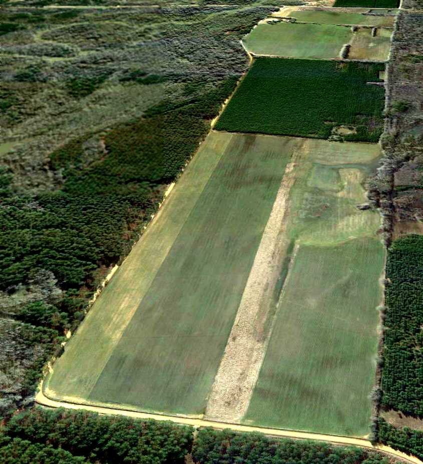
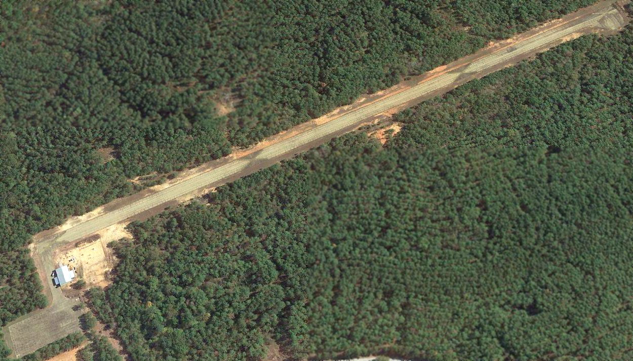
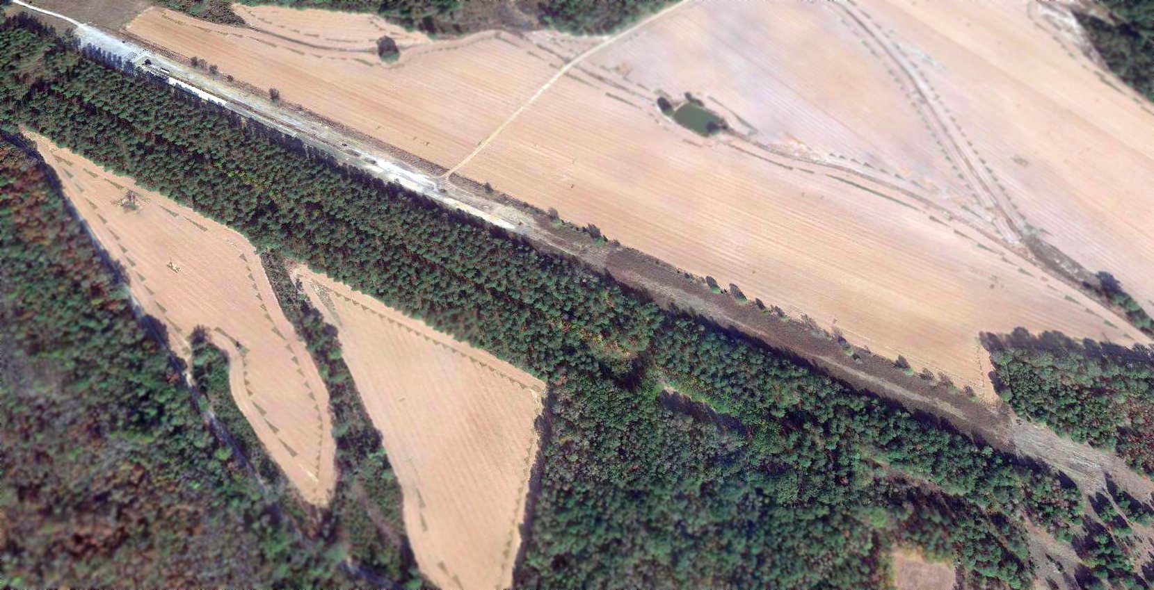
The outline of River Airport's runway was very distinct in a 1/18/13 aerial view looking southeast.
As of 2022, road maps label the road adjacent to the east side of the River Airport site as Air Base Road.
Thanks to Steven McNicoll for information about River Airport.
____________________________________________________
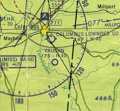
Columbus Auxiliary Army Airfield #6 / Vaugh Field / Vaughn AF Aux / Vaughn Airport, Columbus, MS
33.38, -88.37 (West of Birmingham, AL)
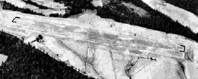
A 6/3/43 aerial view looking north at “Columbus AAF Auxiliary #6 (Vaughn Field)” from the 1945 AAF Airfield Directory (courtesy of Scott Murdock).
The date of construction of this airfield has not been determined.
It evidently was established during WW2 as one of 8 satellite airfields for Columbus AAF (13 miles north), which conducted training in twin-engine bombers.
The earliest depiction which has been located of Vaughn Field was a 6/3/43 aerial view looking north from the 1945 AAF Airfield Directory (courtesy of Scott Murdock).
It depicted “Columbus AAF Auxiliary #6 (Vaughn Field)” as a single northwest/southeast paved runway.
The 1945 AAF Airfield Directory (courtesy of Scott Murdock) described “Columbus AAF Auxiliary #6 (Vaughn Field)”
as a 68 acre irregularly-shaped property having a single 4,000' northwest/southeast bituminous runway.
Vaughn Field was not said to have any hangars, to be owned by private interests, but operated by the Army Air Forces.
The earliest aeronautical chart depiction of Vaughn Field which has been located
was on the October 1945 Boston Mountains World Aeronautical Chart (courtesy of Chris Kennedy).
It depicted “Vaughn” as an auxiliary airfield.
A 3/8/52 USGS aerial view depicted Vaughn Field as having a single paved 4,300' runway & a parallel taxiway.
Vaughn Field was evidently reactivated by the Air Force under the jurisdiction of Craig AFB at some point between 1945-54,
as it was depicted as “Vaughn AF” on the August 1954 Birmingham Sectional Chart (courtesy of Chris Kennedy).
It was depicted as having a 4,000' paved runway.
The use of Vaughn Field by the Air Force in the 1950s reportedly lasted only a few months.
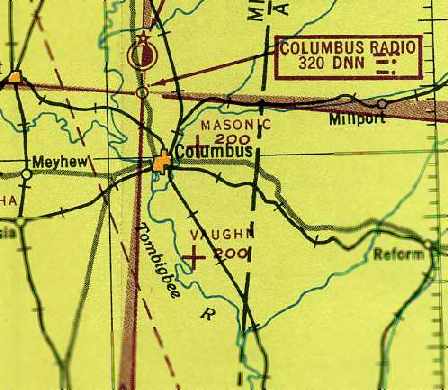
The 1960 USGS topo map depicted "Vaughn Landing Field" as having a single northwest/southeast runway, with a parallel taxiway.
By the time of the February 1960 Birmingham Sectional Chart (courtesy of Chris Kennedy),
“Vaughn” was depicted as a civilian airfield, with a single 4,000' paved northwest/southeast runway.
The last aeronautical chart depiction which has been located of Vaughn Field as an active airport
was on the June 1961 Boston Mountains World Aeronautical Chart (courtesy of Chris Kennedy).
It depicted the field as having a 4,000' paved runway.
Vaughn Field was evidently abandoned (for reasons unknown) at some point between 1961-63,
as it was depicted as “Aband airport” on the the August 1963 Birmingham Sectional Chart (courtesy of Chris Kennedy).
Vaughn Field was apparently reused for some period of time as a drag strip.
Michael Anthony recalled that he visited a drag strip at the site "in the 1960s to the late 1970s",
and he believes that it was privately owned during that period.
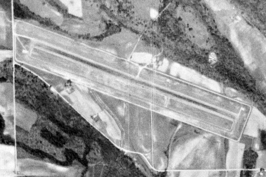
A 5/4/72 USGS aerial view depicted Vaughn Field as having a single paved 4,300' runway & a parallel taxiway, and possibly a small building on the north side.
The 1980 USGS topo map depicted the "Vaughn Landing Field" as having a single northwest/southeast runway.
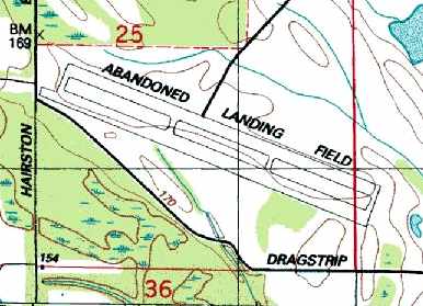
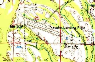
The 1987 USGS topo map depicted Vaughn Field labeled as "Abandoned Landing Field", with a single northwest/southeast runway & a parallel taxiway.
It also labeled the road to the south as "Dragstrip Road".
Vaughn Field was labeled "Drag Strip" on late 1990s aeronautical charts.
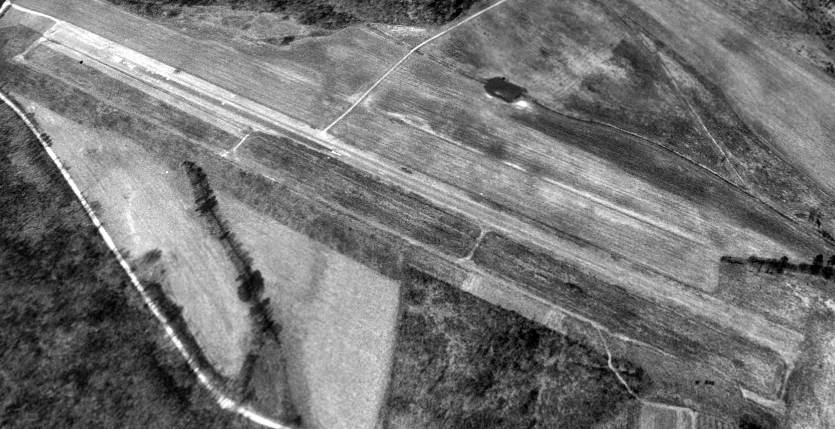
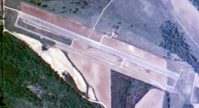
A 2/19/92 USGS aerial view looking northwest depicted Vaughn Field as having a single paved 4,300' runway & a parallel taxiway. There was no indication of any buildings at the site.
A 2016 aerial view looking northwest showed Vaughn Field's runway still remained recognizable though deteriorated, but trees had grown up to surround its parallel taxiway.

A 2013 photo looking southeast along the remains of the Vaughn Field runway, reused as “Columbus Dragstrip”.
Thanks to Steven McNicoll for information about this field.
____________________________________________________
Or if you prefer to contact me directly concerning a contribution (for a mailing address to send a check),
please contact me at: paulandterryfreeman@gmail.com
If you enjoy this web site, please support it with a financial contribution.
____________________________________________________
This site covers airfields in all 50 states.