Abandoned & Little-Known Airfields:
North Carolina: Greensboro area
© 2002, © 2025 by Paul Freeman. Revised 5/3/25.
This site covers airfields in all 50 states: Click here for the site's main menu.
____________________________________________________
Please consider a financial contribution to support the continued growth & operation of this site.
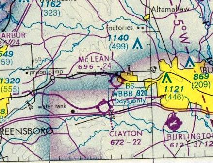
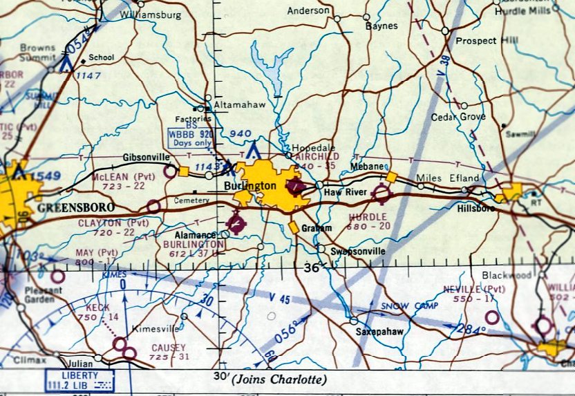
Caswell Airpark (revised 2/29/20) - Clayton Airport / Meadowlark Gliderport (revised 2/24/24) - Colonial Airport (revised 2/24/24)
Huffman Field / Fairchild Field (revised 2/29/20) - Lexington Airport / Grubb Airfield (revised 2/24/24) - May Airport (added 2/5/22) - Mayo Airport (revised 5/3/25)
Midway Airport (revised 6/3/17) - (Original) Mt. Airy Airport (revised 2/24/24)
____________________________________________________
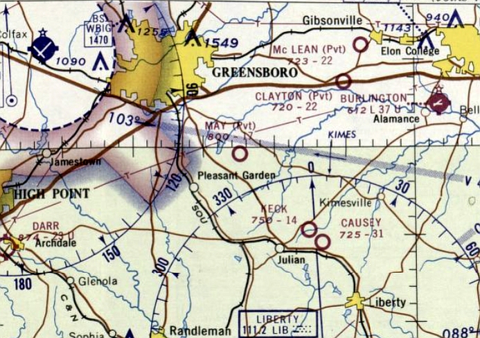
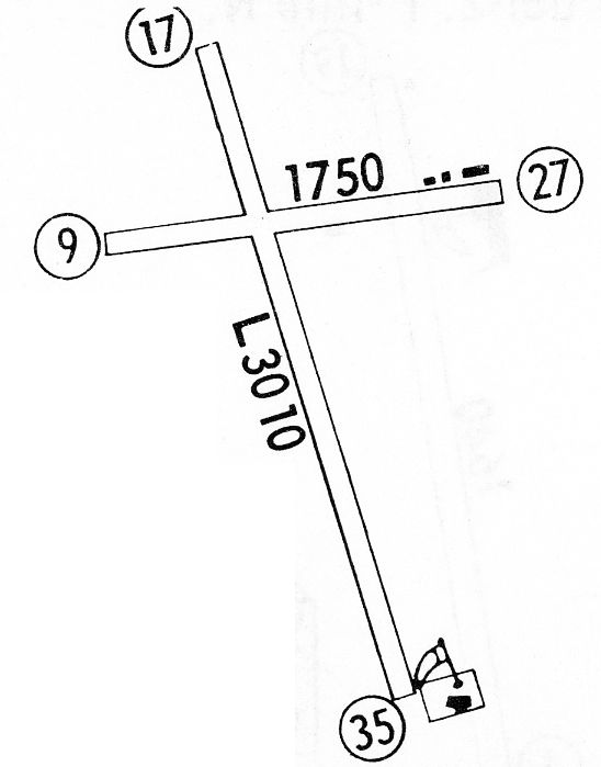
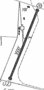
May Airport (80NC), Forest Oaks, NC
35.999, -79.689 (Southeast of Greensboro, NC)
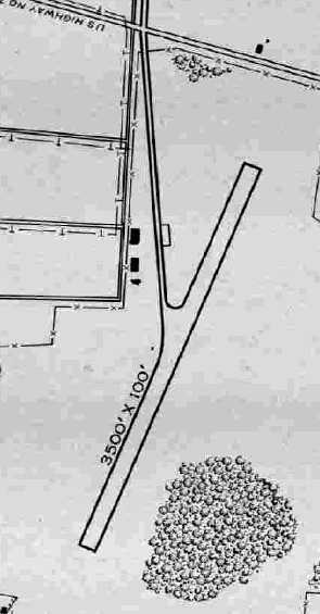
May Airport, as depicted on the April 1967 Charlotte Sectional Chart.
Photo of the airport while in use is not available.
This small general aviation airport southeast of Greensboro was evidently established at some point between 1966-67,
as it was not yet depicted on a 1955 aerial photo or on the October 1966 Charlotte Sectional Chart.
The earliest depiction which has been located of May Airport was on the April 1967 Charlotte Sectional Chart.
It depicted May Airport as a private airfield having a mere 1,700' unpaved runway.
The earliest photo which has been located of May Airport was a 1968 aerial view.
It depicted May Airport as having a single unpaved east/west runway, with a few small buildings on either side.
No aircraft were visible on the field.
The September 1970 Charlotte Sectional Chart showed that May Airport's depicted runway length had increased slightly, to 2,200'.

The earliest topo map depiction which has been located of May Airport was on the 1970 USGS topo map.
It depicted a single unpaved east/west runway, labeled generically as “Landing Strip”.
Lee Dingman reported, “I know some folks that flew in & out of May Airport back in the 1970s & 80s.”
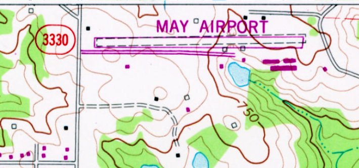
The 1982 USGS topo map depicted May Airport as having gained a paved east/west runway, and a few larger buildings (hangars?) to the southeast.
A 1983 aerial photo depicted May Airport pehaps at the zenith of its popularity,
with 5 light single-engine aircraft visible on the northeast & southeast side of the runway.
The earliest photo which is available of May Airport was a 1993 USGS aerial view looking northwest.
It depicted May Airport as having a single paved Runway 9/27, with several hangars on the southeast side.
No aircraft were visible on the field.
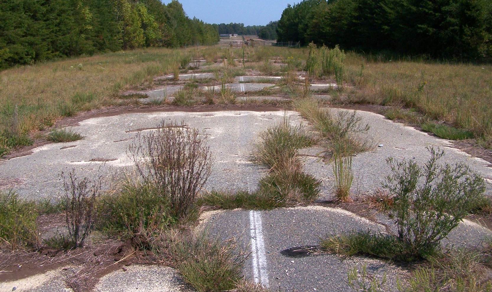
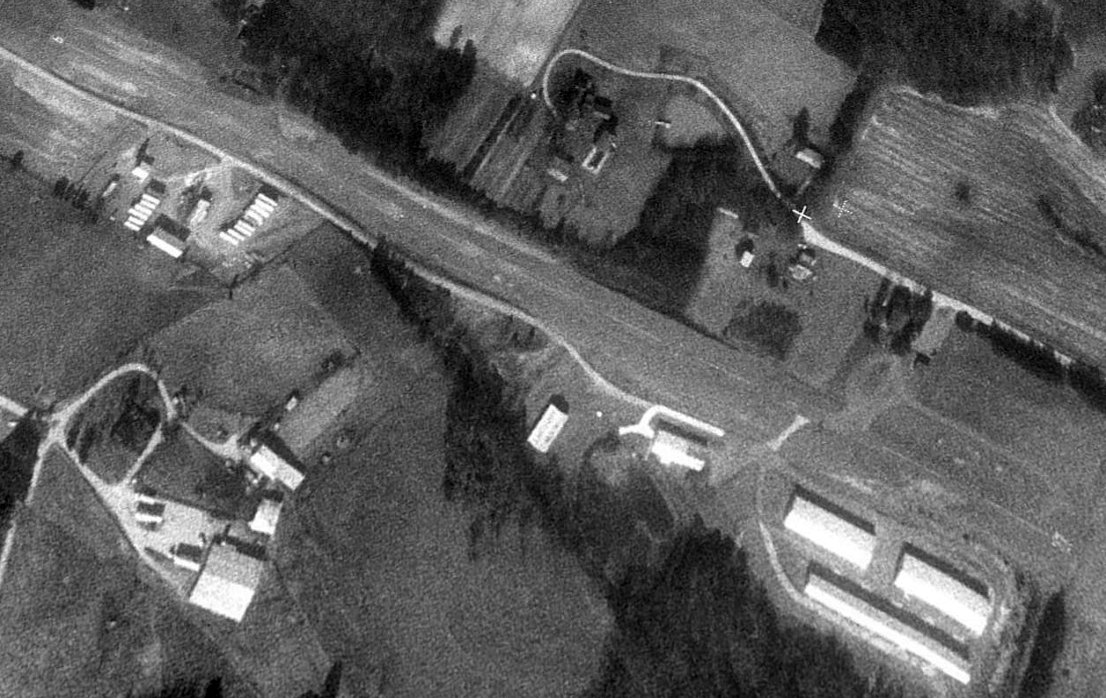
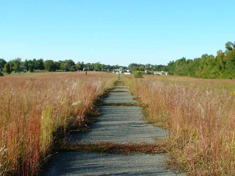
May Airport was evidently closed at some point prior to 2007, as a 9/26/07 photo looking along the runway shows weeds growing through multiple cracks, and a fence across the midpoint.
Lee Dingman reported, “May Airport... has been closed since at least 2009 when I began flying in Greensboro.”
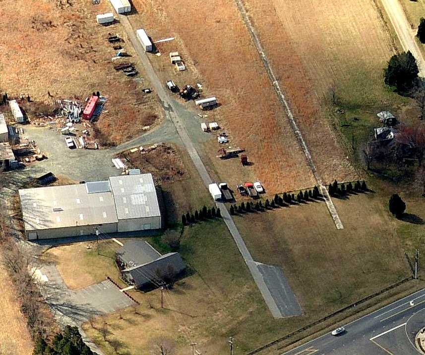
According to its 12/12/13 FAA Airport/Facility Directory data, May Airport as owned by Becky May, and managed by Charles May.
It was said to comprise 10 acres, having a single 2,400' asphalt Runway 9/27, in fair condition.
It was noted to have ultralight aircraft activity.
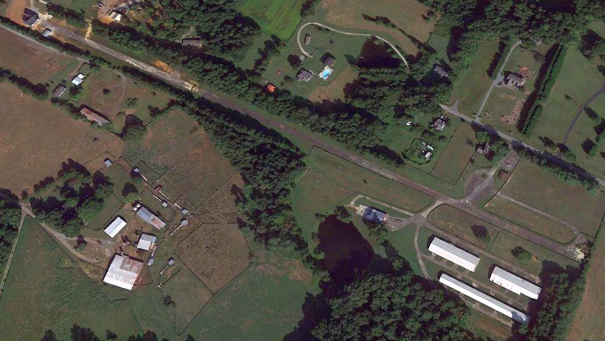
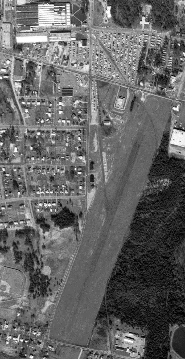
A 2020 aerial view looking northwest showed the May Airport runway remained mostly intact, though a building had been built directly on the western end.
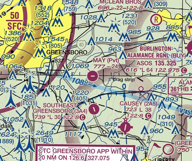
May Airport continued to be depicted on the 2020 Charlotte Sectional Chart, at least 17 years after it was closed.
As other photos show, the runway would not be safe for any landing, and it is doing a disservice to aviation safety to continue to depict it as an active airfield.
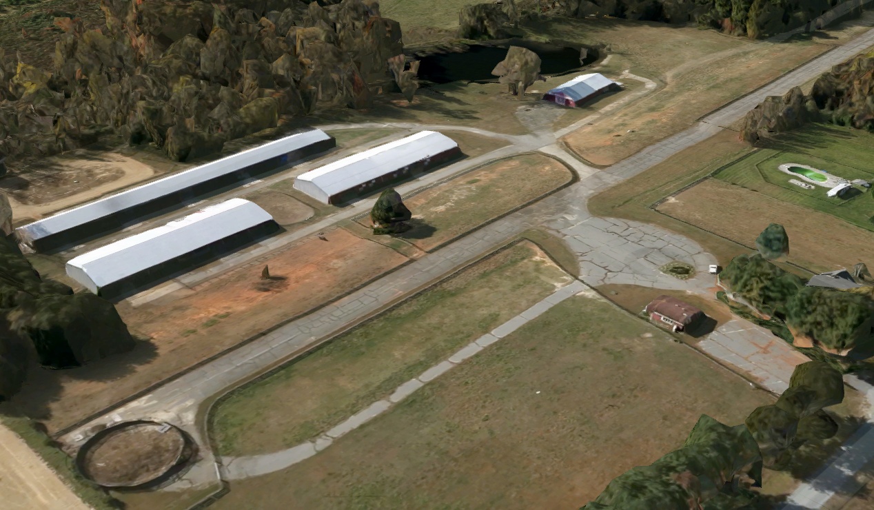
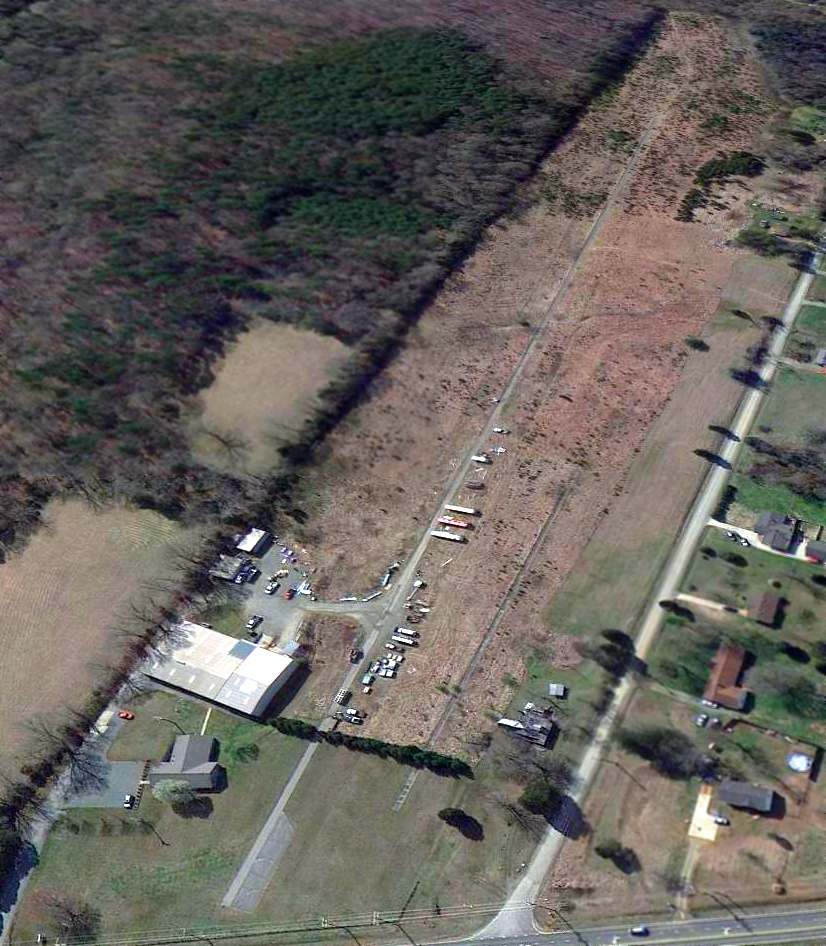
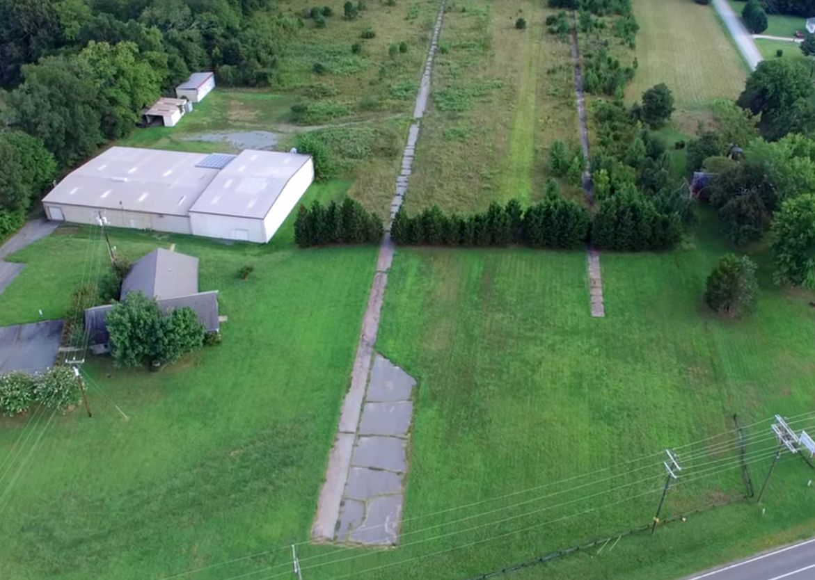
A circa 2022 3-D aerial view looking southwest showed the May Airport runway & hangars remained mostly intact, though a horse riding ring had been built blocking the east runway end.
Lee Dingman reported in 2022, “May Airport... I was going to try to land at it in my bush plane, but someone put a fence across the middle of it.”
Thanks to Lee Dingman for pointing out this airfield.
____________________________________________________
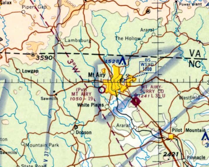
(Original) Mt. Airy Airport, Mt. Airy, NC
36.478, -80.64 (Northwest of Greensboro, NC)
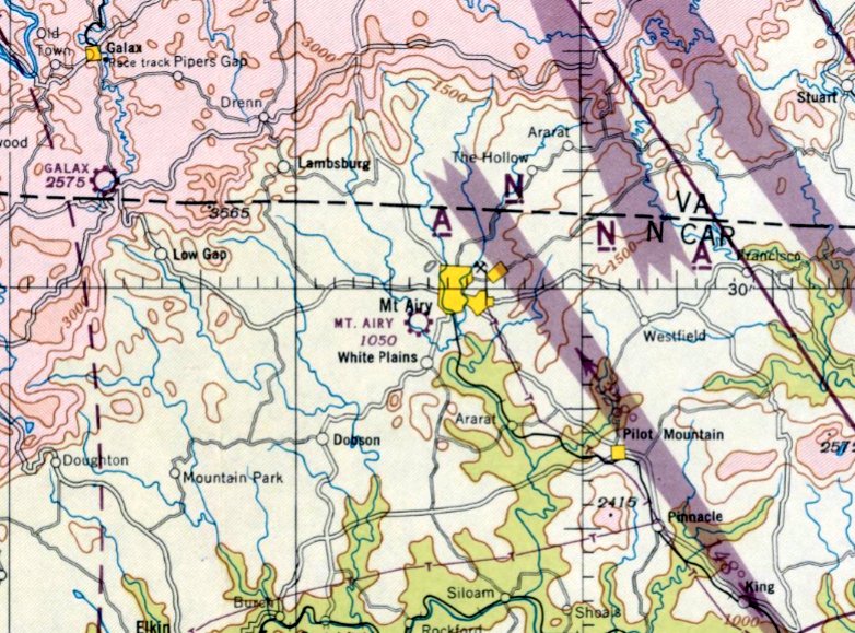
Mt. Airy Airport, as depicted on the October 1945 Winston-Salem Sectional Chart.
The original airport for the town of Mt. Airy was located to the southwest of the town.
Mt. Airy Airport was evidently established at some point in 1945,
as it was not yet depicted on the March 1945 Winston-Salem Sectional Chart.
The earliest depiction which has been located of Mt. Airy Airport was on the October 1945 Winston-Salem Sectional Chart.
It depicted Mt. Airy Airport as a commercial/municipal airport, and described the field as having 2 unpaved runways, the longest being 2,000'.
The 1946 Airman's Guide (courtesy of Jonathan Westerling) described the Mt. Airy Airport as having a 2,000' unpaved runway.
The 1947 Decker's Guide (courtesy of Jonathan Westerling) described the Mt. Airy Airport as having 2 sod runways, measuring 2,100' north/south & 1,800' northwest/southeast.
The field was said to offer tiedowns, gas, and repairs.
The 1948 Haire Airport Directory (courtesy of Jonathan Westerling) described the Mt. Airy Airport as having 2 unpaved runways, measuring 2,000' north/south & 1,700' east/west.
The field was said to offer hangars, gas, training, charter, and sales, and the manager was L.P. Wrenn.
The earliest photo which has been located of Mt. Airy Airport was a 10/21/49 USGS aerial view.
It depicted Mt. Airy Airport as having 2 unpaved runways, with a small building on the northeast side.
There were no aircraft visible on the field.
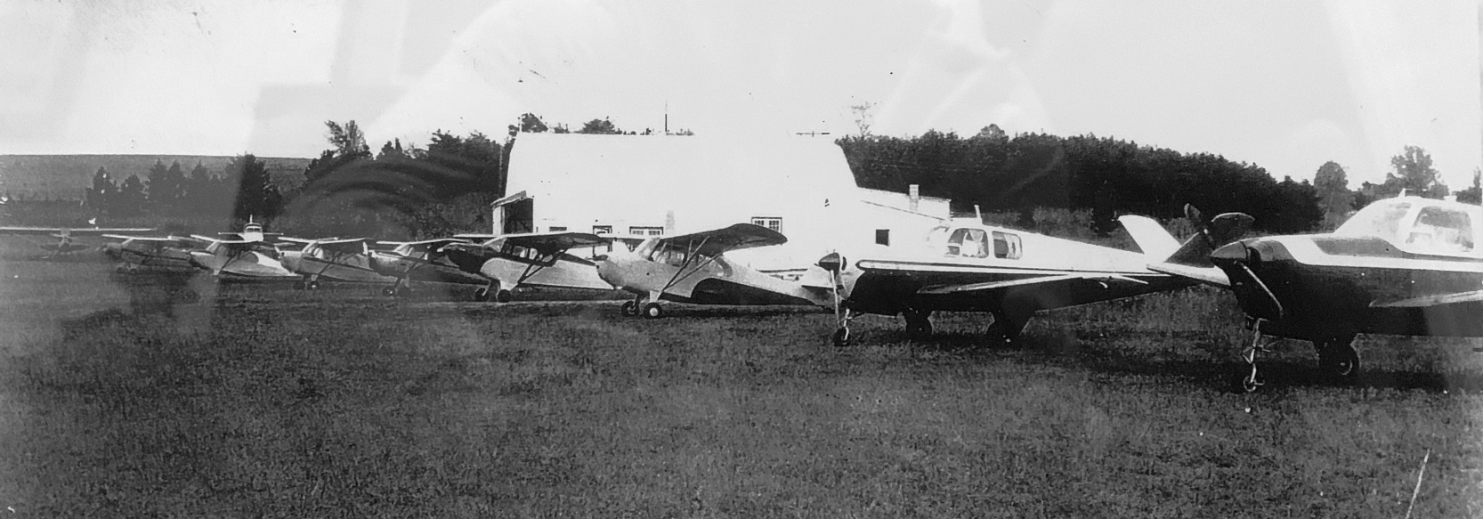
The only photo which is available showing the original Mt. Airy Airport while in use was a circa 1940s-50s photo, originally captioned “The old Mt. Airy Airport Belvue Drive”, found by Thomas Gravitt in an antique store.
The earliest topo map depiction which has been located of the original Mt. Airy Airport was on the 1953 USGS topo map.
The 1954 Airport & Business Flying Directory (courtesy of Jonathan Westerling) described the Mt. Airy Airport as having a 2,200' rough unpaved runway.
The field was said to offer storage, repairs, gas, training, charter, and sales, and the manager was L.P. Wrenn.
A 1955 aerial view depicted Mt. Airy Airport as having 2 unpaved runways, with a small building on the northeast side.
There were no aircraft visible on the field.
A 1966 aerial photo showed 2 small hangars had been added to the east side of Mt. Airy Airport at some point between 1955-66.
The 1967 AOPA Airport Directory (courtesy of Jonathan Westerling) described the Mt. Airy Airport as having a 1,900' turf Runway 17/35.
The field was said to offer hangars, tiedowns, and charter, and the operator was J.C. Bowman.
The Mt. Airy Surry County Airport was opened in January 1968 to the southeast of the town.
Having a paved runway, it would eventually replace the original Mt. Airy Airport.
The last aeronautical chart depiction which has been located of the original Mt. Airy Airport was on the October 1969 Winston-Salem Sectional Chart.
It depicted Mt. Airy Airport as a private airfield having a 1,900' turf runway, and the airfields table described the field as being “unusable at times Jan-Mar due to heavy rains.”
Note that it also depicted the larger Mt. Airy Surry County Airport to the southeast, which would eventually replace the original Mt. Airy Airport.
The 1971 Airman's Information Manual (courtesy of Jonathan Westerling) described the Mt. Airy Airport as having a 1,900' unpaved Runway 17/35.
The original Mt. Airy Airport was presumably closed at some point between 1971-73,
as it was no longer depicted on the 1973 USGS topo map.
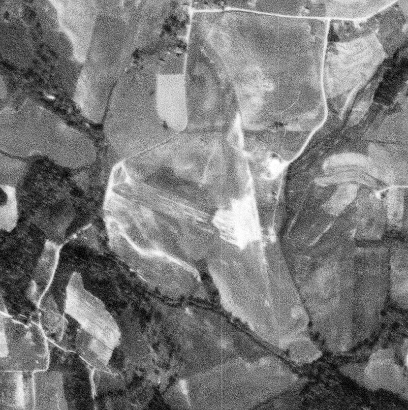
A 1982 aerial photo showed the original Mt. Airy Airport's 2 runways remained clear, but 1 of the small buildings had been removed at some point between 1966-82.
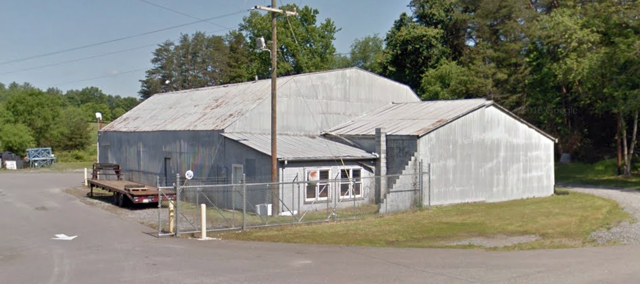
A 2016 photo looking west at the former hangar which remains at the northeast portion of the original Mt. Airy Airport site.
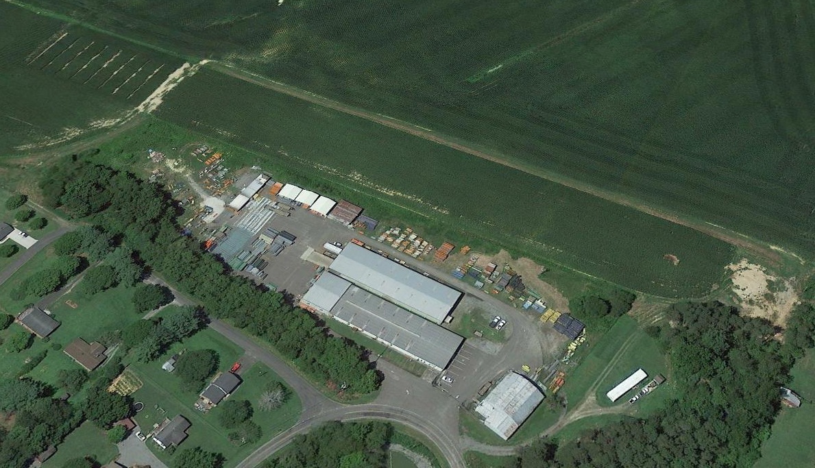
A 2017 aerial view looking west showed the grass runway of the original Mt. Airy Airport remained intact, remarkably, more than 44 years after the airport's closure.
The former hangar also remained intact, at bottom-right.
A 4/3/21 photo by Jordan Goings looking northwest at the former hangar which remains at the northeast portion of the original Mt. Airy Airport site.
Thanks to Thomas Gravitt for pointing out this airfield.
____________________________________________________
Colonial Airport, Mt. Airy, NC
36.516, -80.596 (Northwest of Greensboro, NC)
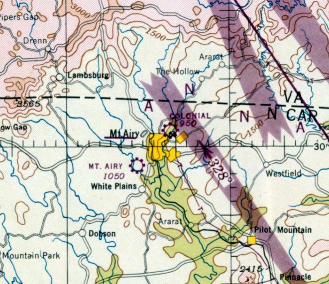
Colonial Airport, as depicted on the October 1946 Winston-Salem Sectional Chart.
This small general aviation airport existed for a mere 2 years on the northeast side of the town of Mt. Airy.
Colonial Airport was evidently established at some point in 1946,
as it was not yet depicted on the April 1946 Winston-Salem Sectional Chart.
The earliest depiction which has been located of Colonial Airport was on the October 1946 Winston-Salem Sectional Chart.
It depicted Colonial as a commercial/municipal airport.
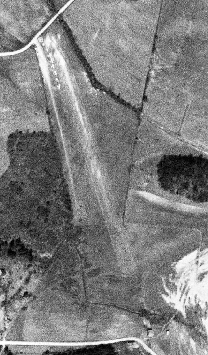
The only photo which has been located of Colonial Airport was a 3/2/48 USGS aerial view.
It depicted Colonial Airport as having a northwest/southeast unpaved runway,
with a row of no less than 7 light single-engine planes parked near some small buildings on the northwest side.
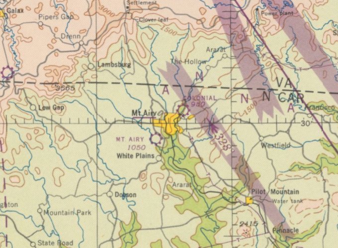
The last aeronautical chart depiction which has been located of Colonial Airport was on the April 1948 Winston-Salem Sectional Chart.
It depicted Colonial as a commercial/municipal airport.
Colonial Airport was presumably closed at some point in 1948, lasting only a mere 2 years,
as it was no longer depicted on the October 1948 Winston-Salem Sectional Chart or the 1953 USGS topo map.
A 1955 aerial photo & the 1959 USGS topo map showed Riverside Drive had been built through the center of the former Colonial Airport runway,
and the former airport buildings had also been removed.
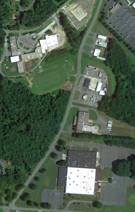
A 2017 aerial view showed no trace remaining of Colonial Airport, with the Millennium Charter Academy occupying the northwest portion of the airport site,
and the Renfro Corporation occupying the southeast portion.
Thanks to Jonathan Westerling for pointing out this airfield.
____________________________________________________
Lexington Airport / Grubb Airfield, Lexington, NC
35.798, -80.289 (Southwest of Greensboro, NC)
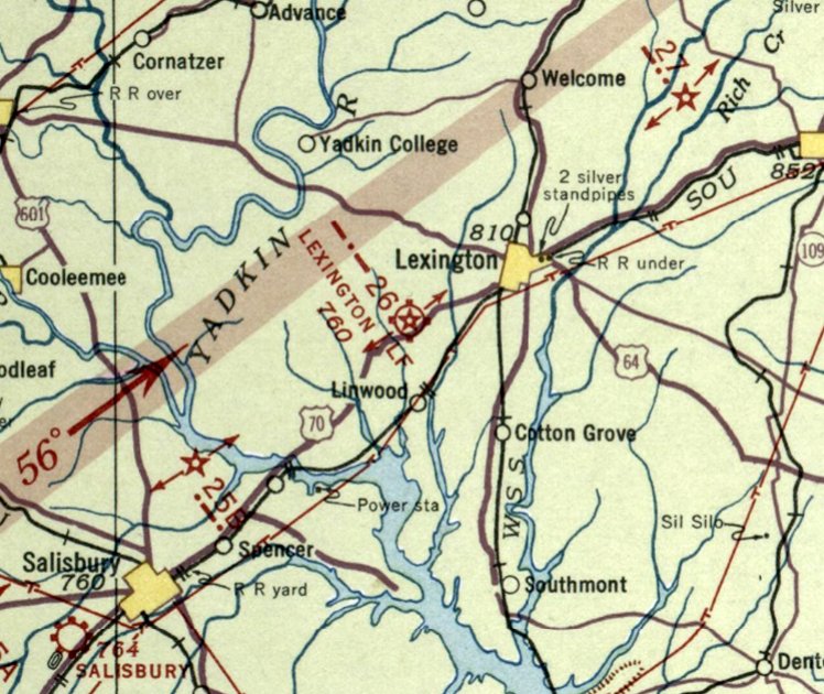
Lexington Airport, as depicted on the May 1935 Charlotte Sectional Chart.
Photo of the airfield is not available.
The date of establishment of Lexington's original airport has not been determined.
The earliest depiction which has been located of Lexington Airport was on the May 1935 Charlotte Sectional Chart.
It depicted Lexington Airport as a commercial/municipal airport, and showed it having Commerce Department Airway Beacon #26.
Will continued, “The racetrack in Lexington was owned by Zeb Grubb. He had his own plane & had flown for a number of years.
On Labor Day weekend of 1948, he flew back from Daytona Beach.
As he arrived back in Lexington, a bad thunderstorm was coming up. Winds were bad. He waved-off attempting to land at his airfield.
There was an attendant on the ground awaiting his arrival. After the wave-off, the attendant said he turned back towards Salisbury.
He never arrived. He was found on the banks of the Yadkin River, still strapped into his seat & a majority of the airplane under water.
I would think that after his death, the family divested certain properties. I don't know of any other family members of the family that would need the airstrip.
Land was likely more valuable to the industry that bought next to rail lines.”
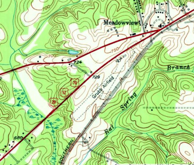
The Lexington Airport was also apparently known as Grubb Airfield, as that is how it was labeled on the 1950 USGS topo map.
It depicted Grubb Airfield as being located along a narrow slice of property between Route 29/52/70 & the Southern Railroad tracks.
The airfield was shown to have 2 unpaved runways, with 3 small buildings on the north end.
The earliest aerial photo which has been located of Lexington Airport was a 1955 aerial view.
It depicted Lexington Airport as having an unpaved northeast/southwest runway, with a row of hangars & 1 light single-engine aircraft on the north side.
Will Tate recalled of the Lexington Airport, “It was a grass strip, right off South Main Street.
It ran near some of my family’s land, parallel to the main NC railroad.
I have a distant cousin who remembers the strip as grass & dirt, not widely used by the public.
On the north end of the field, there were 3 hangars that were accessible to the road.”
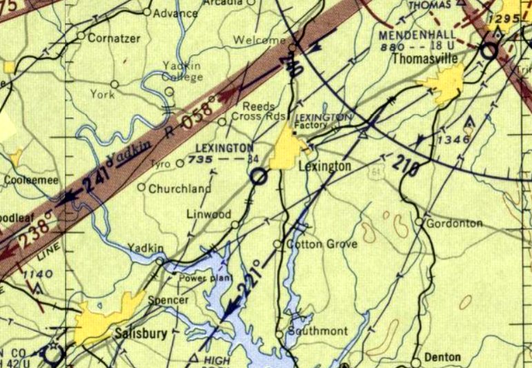
The last aeronautical chart depiction which has been located of Lexington Airport was on the July 1959 Charlotte Sectional Chart.
It depicted Lexington Airport as having a 3,400' unpaved runway.
Lexington Airport was evidently closed at some point between 1959-60,
as it was no longer depicted on the 1960 Charlotte Sectional Chart.
It was replaced in 1961 by the Davidson County Airport a few miles to the southwest, which boasted a paved runway.
A 1961 aerial photo showed the hangars remained standing, but a building had been built over the southwest end of the runway.
A 1984 aerial photo showed 3 of the Lexington Airport hangars remained on the north end.
The northern half of the runway area remained clear, but several more buildings had covered the southern portion of the airport site.
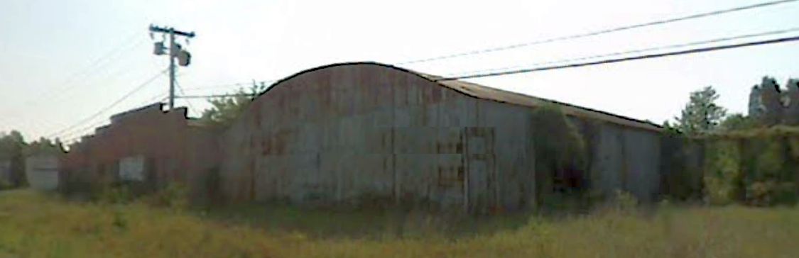
A 2007 photo looking east at the northern-most 2 former Lexington Airport hangars.
A 2008 aerial view showed the northern-most Lexington Airport hangar (with the arched roof) had been removed at some point between 2007-2008.
A 2010 aerial view showed 2 Lexington Airport hangars still remained standing.
A 2012 aerial view showed another former Lexington Airport hangars had been removed, leaving only one.
A 2019 aerial view looking west showed buildings covering the majority of the Lexington Airport site, but one hangar remained standing on the north side (bottom-right),
next to which is visible the foundation of the other 2 hangars.
Will Tate recalled in 2021 of the former Lexington Airport buildings, “I recall that 2 of the 3 buildings were torn down within the last 10 years. They were just storage buildings.
One of those buildings still exists today. The runway is no longer there at all.
Today, there is a nursing home and a few large warehouse/plants on the runway.
There has also been a lot of land digging, as it is no longer flat, and one can tell where the earth used to be flat, and now has been more dug out.”
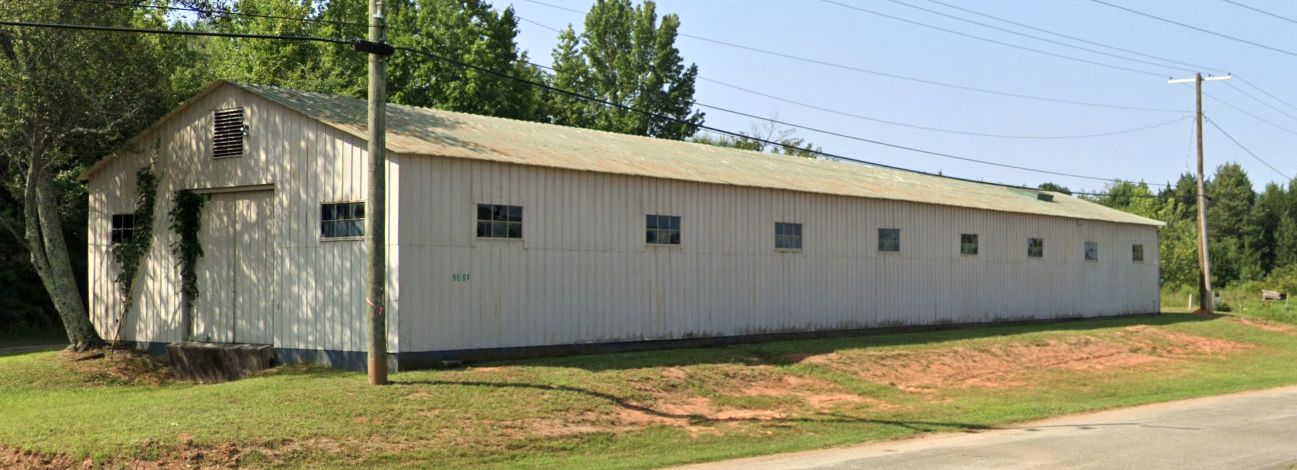
A 2023 photo looking southwest at a former Lexington Airport hangar.
Thanks to Will Tate for pointing out this airfield.
____________________________________________________
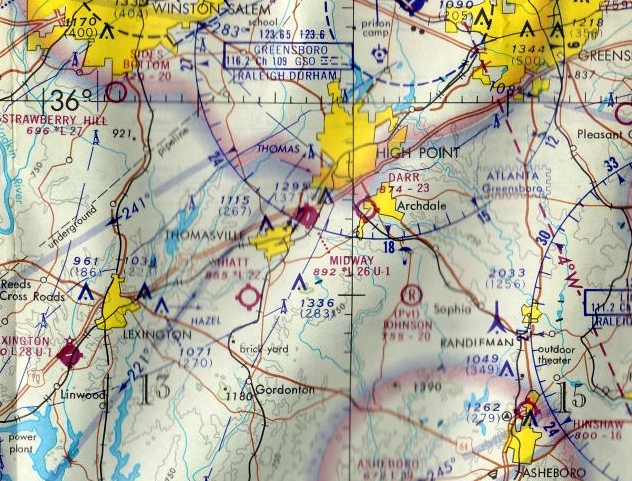
Midway Airport, Thomasville, NC
35.908, -80.049 (Southwest of Greensboro, NC)
Midway Airport, as depicted on the July 1960 Charlotte Sectional Chart.
This general aviation airport was evidently established at some point between 1958-60,
as it was not yet depicted on the August 1958 Charlotte Sectional Chart.
The earliest depiction which has been located of Midway Airport was on the July 1960 Charlotte Sectional Chart.
It depicted Midway Airport as having a 2,600' unpaved runway.
The earliest photo which has been located of Midway Airport was a 2/18/65 USGS aerial view.
Midway Airport had evidently gained a paved runway at some point between 1960-65, as it depicted an asphalt Runway 2/20, with a parallel taxiway on the west side,
and 6 rows of hangars & 6 light aircraft visible parked outside.
A 1968 aerial photo depicted Midway Airport in the same configuration, with an asphalt Runway 2/20, with a parallel taxiway on the west side,
and 6 rows of hangars & 6 light aircraft visible parked outside.
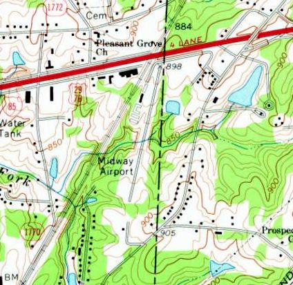
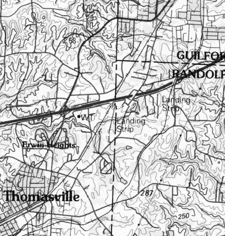
The 1969 USGS topo map depicted depicted Midway Airport as having a northeast/southwest runway, with several buildings on the west side.
The last aeronautical chart depiction which has been located of Midway Airport was on the September 1972 Charlotte Sectional Chart.
It depicted Midway Airport as having a 2,600' paved northeast/southwest runway.
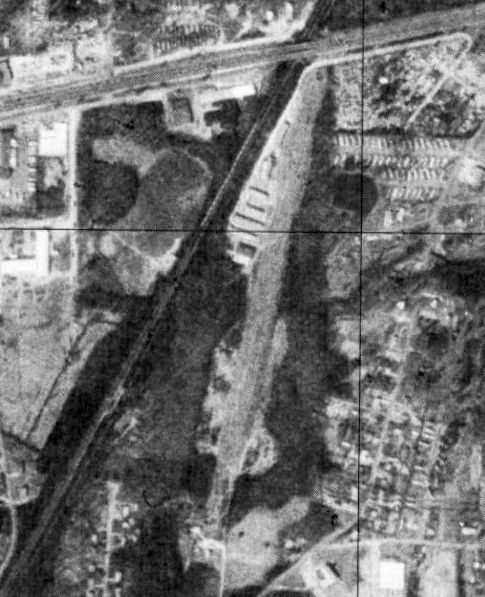
The last photo which has been located of Midway Airport was a 3/15/77 USGS aerial view.
It depicted Midway Airport in the same configuration as the 1968 photo.
The last depiction which has been located of Midway Airport was on the 1985 USGS topo map.
It depicted a single northeast/southwest runway, but labeled simply as “Landing Strip”,
which may indicate that the airport was closed by that point.
Midway Airport was evidently closed by 1990,
as it was no longer depicted on the August 1990 Charlotte Sectional Chart (courtesy of Ron Plante).
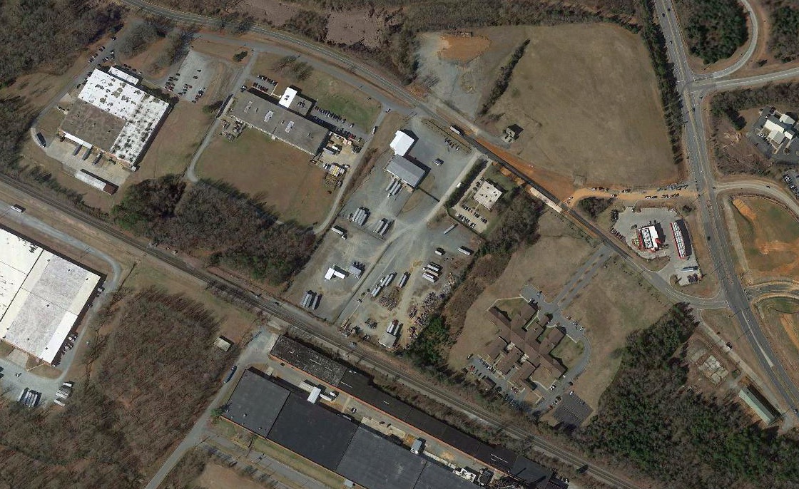
A 1993 aerial photo showed no trace of Midway Airport, with the southern portion occupied by a large warehouses building,
and the northern portion (site of the hangars) having been scraped clean.
A 2013 aerial view showed no trace of Midway Airport.
The site of Midway Airport is located southwest of the intersection of Interstate 85 & Old Thomasville Road.
____________________________________________________
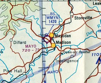
36.41, -79.98 (North of Greensboro, NC)
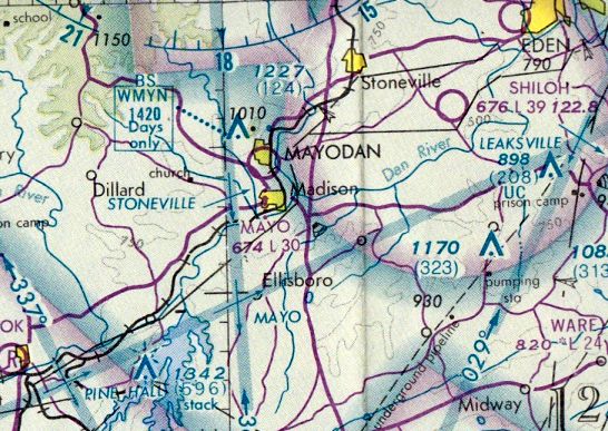
Mayo Airport, as depicted on the November 1944 Winston Salem Sectional Chart.
Mayo Airport was evidently established at some point in 1944,
as it was not yet depicted on the May 1944 Winston-Salem Sectional Chart.
The earliest aeronautical chart depiction which has been located of Mayo Airport was on the November 1944 Winston-Salem Sectional Chart.
It depicted Mayo Airport as an auxiliary airfield.
Doug Garrou reported, “My Mom told me once – apparently a C-47 in some sort of distress had to land there during the war [WW2].
This was a Big Deal & all the locals turned out to watch it take off.”
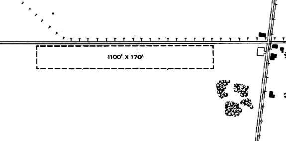
The 1945 AAF Airfield Directory (courtesy of Scott Murdock) described Mayo Airport as a 5 acre rectangular property having a single 1,100' easy/west turf runway.
The field was said to have a single 40' x 30' wooden hangar, and to be owned & operated by private interests.
John Buontempo recalled, “Mayo Airport... I vividly remember the old airport & occasionally watching airshows there.
The airport was located at the intersection of NC Highway 704 West & Ayersville Road.
The airport was owned & operated by Espie Joyce for his personal use but really open to the public.
Mr. Joyce also owned a Studebaker dealership (as I best recall) located adjacent to the airport.
I remember I used to take my children over to the airport on Saturday mornings to watch the planes fly in.
We would walk around looking at the beautiful aircraft while the pilots & passengers ate at the restaurant.
Then we would watch as each plane would take off.”
Doug Garrou reported, “Mayo Airport... Espie Joyce was my grandfather on my Mom’s side,
and did indeed operate the airport & a nearby Studebaker dealership, which was opened in the late 1940s.
Espie & my grandmother, Lena Joyce, lived next to the airport.
After Espie’s death, his son (my uncle) Espie Joyce Jr., known to everyone as 'Butch,' took over operation of the airport.”
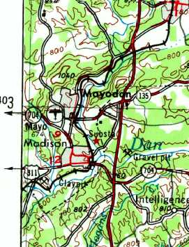
Mayo Airport, as depicted on the 1953 USGS topo map.
The October 1965 Winston Salem Sectional Chart (courtesy of Ron Kunse) depicted Mayo Airport as having a 2,300' unpaved runway.
The 1968 USGS topo map depicted Mayo Airport as having 2 unpaved runways,
quite different than the runway orientation depicted in the 1945 directory.
Doug Garrou reported, “I grew up visiting my grandmother in the summers (late 1960s, 1970s, and early 1980s) and watching Butch [Joyce] build & fly various aircraft at the Mayo Airport.
The airport had an absolutely classic collection of airport characters – really an entertaining crowd & lots of amazing aircraft.
I remember watching skydiving there & hearing one of the skydivers hit a tin roof in the adjacent neighborhood (no injuries luckily).
I also have fond memories of cutting the grass runway using the tractor – which for some reason I was allowed to operate at a young age.
I became a pilot years later & I’m sure it’s because it got into my blood at Mayo Airport.
I had no idea that the airport once had a crossing runway! I certainly don’t doubt it, I just don’t remember any evidence of that by the time I got there.”
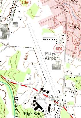
The 1971 USGS topo map depicted Mayo Airport as having a single northwest/southeast runway,
with the crosswind runway having been evidently closed at some point between 1968-71.
The earliest photo which has been located showing Mayo Airport while operational was a 3/14/71 USGS aerial view.
It depicted Mayo Airport as having a single northwest/southeast runway,
with a few small buildings & one single-engine aircraft at the southeast corner.
The last aeronautical chart depiction which has been located of Mayo Airport
was on the August 1976 Cincinnati Sectional Chart (courtesy of Mitchell Hymowitz).
It depicted Mayo Airport as having a 3,000' unpaved runway.
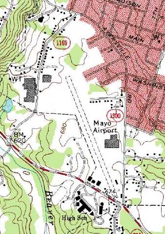
The 1991 USGS topo map depicted Mayo Airport as having a single unpaved northwest/southeast runway, with several small buildings along the east side.

A 1991 aerial view by Sparky Barnes on final approach landing south at Mayo Airport from her father Homer Barnes' 1946 Aeronca 11AC Chief.

The last photo which has been located showing Mayo Airport while operational was a 1991 photo by Sparky Barnes of a row of single-engine general aviation aircraft at a fly-in at "Madison Mayodan".
Sparky recalled, “We were parked midway on the field & the photo was taken looking across the airstrip to the west.
We all walked down to the south end & had lunch at the restaurant there. Madison Mayodan was a popular place.”
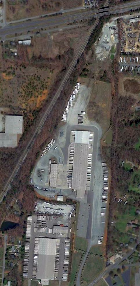
John Buontempo recalled, “His son Butch (Espie Jr.) took over the land & buildings upon the passing of his father & finally sold the property to a local textile firm.
The textile firm developed the property by building a large office & warehouse facility on the existing runway.
Later, the textile firm sold the property to Bridgestone Tires (ironically, they make and/or distribute aircraft tires in the warehouse now).
There is a drive-in restaurant located at the end of the runway (appropriately named the 'Airport Drive-in') still in operation today [2011].”
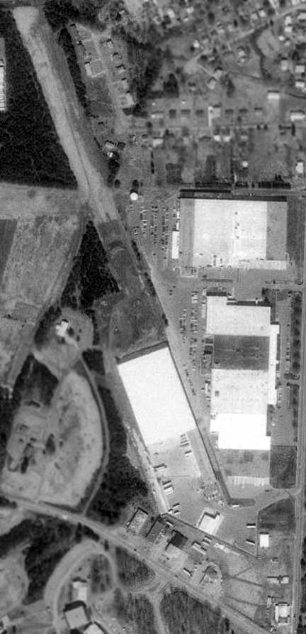
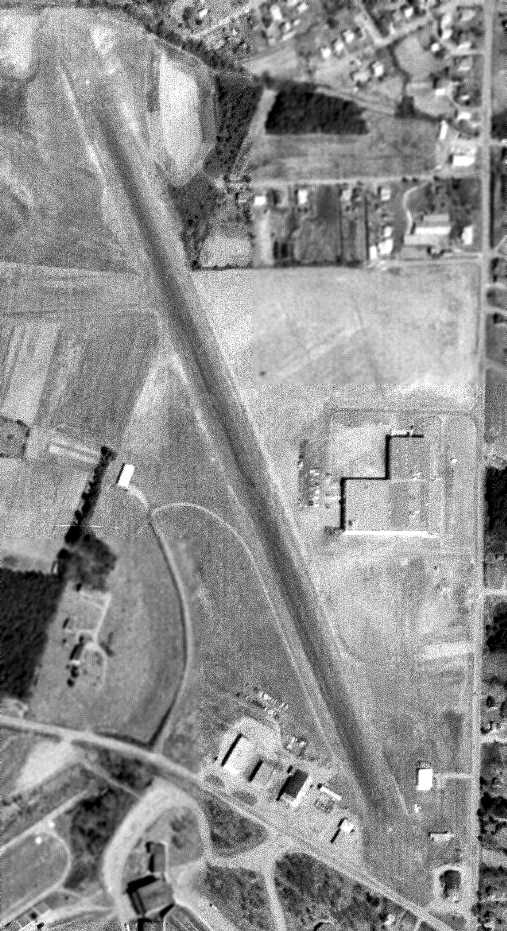
Mayo Airport had evidently closed at some point between 1991-93,
as the 3/1/93 USGS aerial photo depicted several large industrial buildings covering the southern half of the site, but the northern half of the runway remained intact.
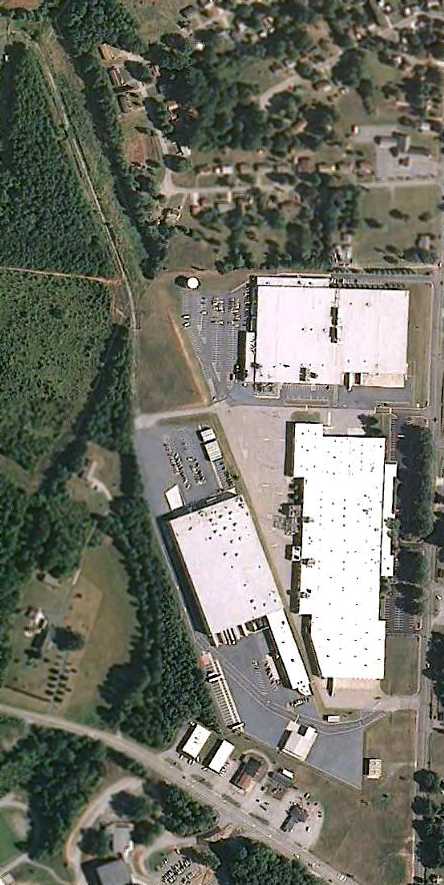
A 5/31/09 aerial view of the site of Mayo Airport shows little change from the 1993 photo,
with the northern half of the runway remaining recognizable.
Doug Garrou reported in 2016, “My uncle Butch was very active in the EAA. His wife Norma still lives next to the site of the old airport.”
Thanks to John Buontempo for pointing out this airfield.
____________________________________________________
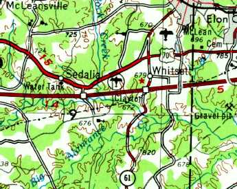
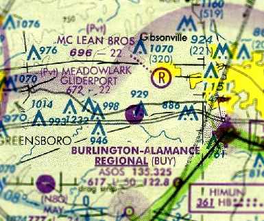
Clayton Airport / Meadowlark Gliderport (NC19), Whitsett, NC
36.07, -79.58 (East of Greensboro, NC)
Clayton Airport, as depicted on the 1953 USGS topo map.
The date of construction of this little airfield has not been determined.
The earliest depiction which has been located of Clayton Airport was on the 1953 USGS topo map.
The earliest photo which has been located of Clayton Airport was a 1955 aerial view.
It depicted a single north/south unpaved runway, with some small buildings & possibly 1 light single-engine plane on the northeast side.
Clayton Airport was not yet depicted on the 1962 Charlotte Sectional Chart.
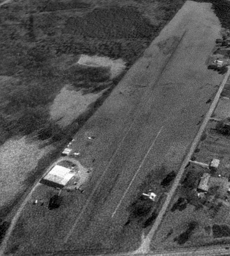
The earliest photo which is available of Clayton Airport was an 11/29/68 aerial view (courtesy of Dallam Oliver-Lee).
It depicted over a dozen single-engine aircraft parked on the north side of a single north/south runway.
A 2/19/69 aerial view (courtesy of Dallam Oliver-Lee) also showed over a dozen light aircraft parked on the field.
According to John Ritchie, “Clayton Airport was named for Miles 'Chic' Clayton, the owner-operator, A&P-IA,
and pilot that operated this field in the 1960s & 1970s.
Chic (pronounced 'Chick') did the annual inspections & maintenance on our family Tri-Pacer during that time,
and he had quite a maintenance operation serving general aviation aircraft.
He was a friendly, well-liked fellow that lived on the property with his family. We loved to fly in & visit.”
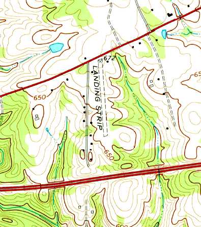
The 1970 USGS topo map depicted a single north/south runway, labeled simply as “Landing Strip”.
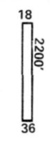
The 1974 Flight Handbook (courtesy of Jonathan Westerling) depicted Clayton Airpark as having a 2,200' Runway 18/36,
and listed the operator as Skylark Aviation.
The earliest aeronautical chart depiction which has been located of Clayton Airport
was on the August 1976 Cincinnati Sectional Chart (courtesy of Mitchell Hymowitz).
It depicted Clayton Airport as having a 2,200' unpaved runway.
According to John Ritchie, “In 1979, Chic left his location in Whitsett & took over the operation of Tuck Airport in South Boston, VA.
Clayton Airport then later became Meadowlark Gliderport under new management.
I didn't notice any gliders at Clayton Airport until it became Meadowlark.
One of the interesting things about this field was that the runway centerline crossed I-85 at a perpendicular angle just south of the field.
For many years, alarmed motorists would call in that a 'plane had crashed just north of I-85'
until signs were posted on the interstate to warn drivers of low-flying aircraft.”
Jonathon Payne recalled, “Meadowlark had one 2,000' paved Runway 18/36,
a few tiedowns west of the runway, no facilities, and was privately owned.
One of the more interesting features of this airfield was the incredibly narrow paved runway.
At only 5' wide it barely seemed wide enough to be a sidewalk, let alone a runway.
The reason for this was that the paved part of the runway was for the tow-plane
and the gliders took off & landed from the grass immediately adjacent to the runway.”
Jonathan continued, “But the real attraction at Meadowlark was not the sailplaneing,
but the $100 hamburgers at the Brightwood Inn across the street.
Brightwood’s claim to fame is that in 1955 Elvis Presley stopped by for a meal
before a concert at Williams High School in Burlington.
Even though Elvis wasn’t famous yet, it was still probably the biggest thing to happen to the tiny town of Whitsett before or since.”

The 1983 Flight Guide (courtesy of Jonathan Westerling) depicted Clayton Airpark as having a 2,200' turf Runway 18/36, with a few small buildings on the northwest & northeast sides.
It was said to operate gliders.
The 1983 AOPA Airport Directory (courtesy of Jonathan Westerling) described Meadowlark as having a 2,200' turf Runway 18/36.
The operators were Meadowlark Soaring Company & Skylark Aviation Company.
Janet Williams recalled “flying & finally soloing in the old Tin Lizzy, the Schweizer 2-33A, at Meadowlark Gliderport in 1983.
The fellow who owned the place in the 1980s was a retired dentist.
He put quite a bit of money into building a shed for us to congregate & then a lounge. Wow - we were hot stuff.
When the paved runway went in, we thought we'd had it made, man. So cool!”
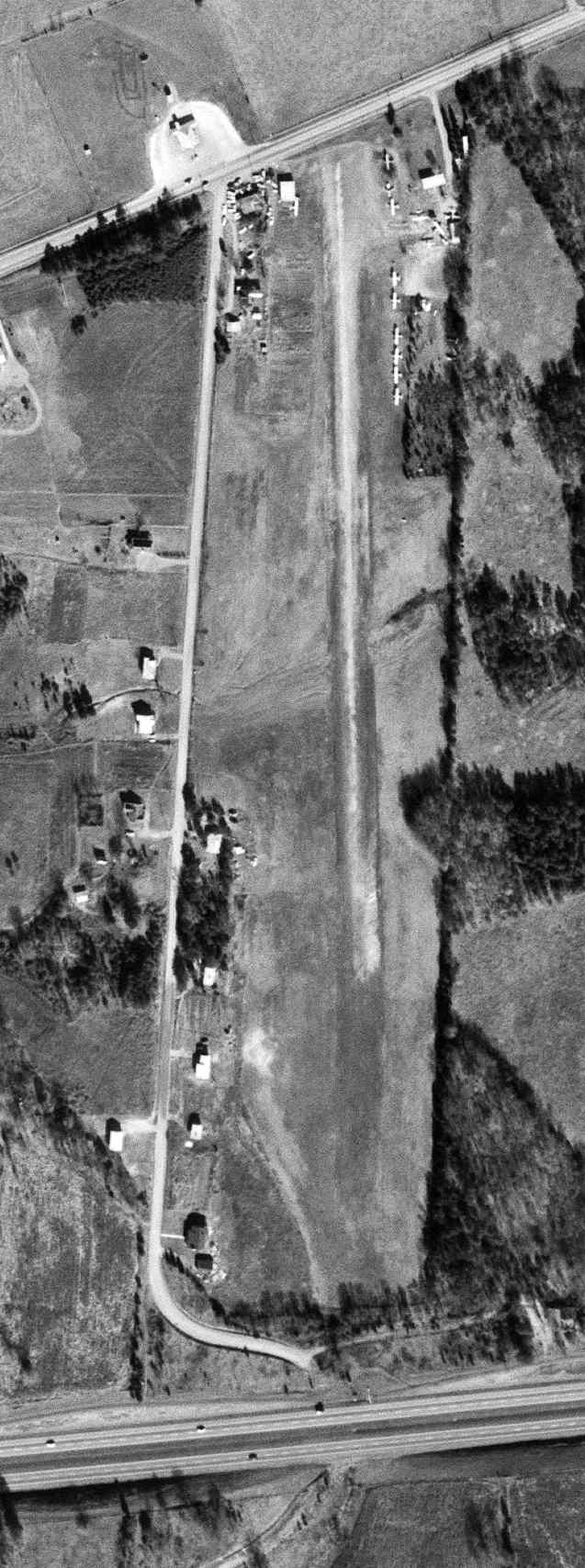
A 1/29/93 USGS aerial view looking southeast depicted the Meadowlark Gliderport as remaining intact,
but without any aircraft visible on the field, in stark contrast to earlier photos.
The 1999 Charlotte Sectional Chart depicted Meadowlark Gliderport as a private field having a single 2,200' paved runway.
The last aeronautical chart depiction which has been located of Meadowlark Gliderport
was on the 2000 NC Aeronautical Chart (courtesy of Jonathan Payne).
It depicted Meadowlark Gliderport as a private field having a single 2,200' paved runway.
Meadowlark Gliderport was evidently closed at some point between 2000-2002,
as it was no longer depicted at all on the 2002 Sectional Chart (according to Jonathan Payne).
According to Jonathon Payne, “Concerning the closure of the gliderport,
the owner died and, not finding a person with the funds who wanted to keep the airport open,
the property was sold to Systems Contractors Inc., a construction subcontractor, who used the property to house their warehouses & shops.”
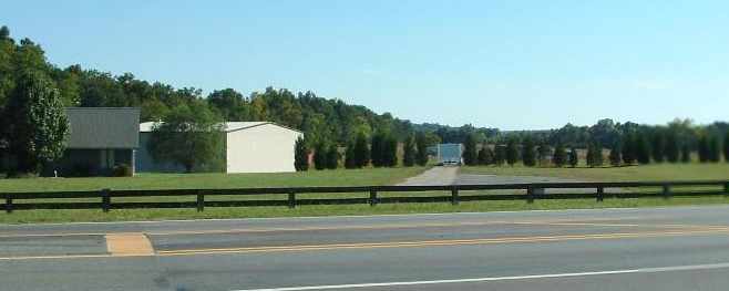
A 2006 photo by Jonathan Payne looking south along Meadowlark's former Runway 18.
Jonathon Payne reported in 2006, “Even if someone was found that could have kept it operational,
I doubt that it would have lasted too long as up-scale housing developments have started cropping up all around the old airport.
The runway still exists, but the grass is slowly starting to overtake it.
Part of the runway is used to store the business’ trailers & CONEX containers.”
A 2006 photo by Jonathan Payne looking north along the remains of Meadowlark's incredibly narrow paved Runway 36: a mere 5' wide.
A circa 2008 aerial view looking south at what appears to be the remains of 2 parallel paved runways at Meadowlark.
A 4/5/13 aerial view looking southeast depicted the what appears to be the remains of 2 parallel paved runways at Meadowlark.
A 2023 photo looking south at the northern end of the former Meadowlark eastern runway (with paved turnaround pad) & the slightest northern bit of the much-smaller parallel paved western runway (protruding from the treeline at right).
Meadowlark Gliderport is located southeast of the intersection of Boone Valley Road & Burlington Road.
____________________________________________________
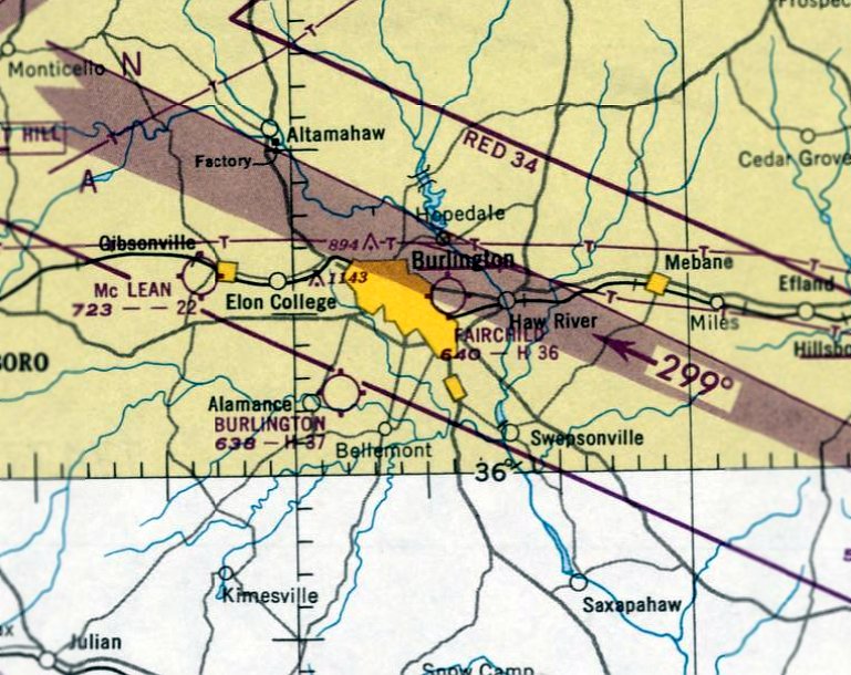
Huffman Field / Fairchild Field, Burlington, NC
36.09, -79.41 (West of Raleigh, NC)
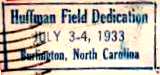
A postmark commemorating the 7/3/33 dedication of Huffman Field.
According to an article from the 9/4/93 issue of the Burlington Times (according to John Jarratt), the first plane landed at this location in 1919,
and Glenn Huffman & Dover Fogleman built an airfield here in 1931.
Huffman Field was formally dedicated 7/3/33, as commemorated by a postmark.
The earliest directory listing of Huffman Field which has been located
was in the 1934 Department of Commerce Airfield Directory (courtesy of Chris Kennedy).
It described Huffman Field as a commercial airport with two 1,800' sod runways,
Two hangars were said to be located on the northwest corner of the field.
The earliest aeronautical chart depiction of Huffman Field which has been located was on the March 1935 Winston-Salem Sectional Chart.
It depicted Huffman as a commercial/municipal airport.
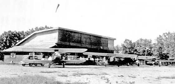
A circa 1930s photo (courtesy of Almance County Area Chamber of Commerce) of a biplane & 2 monoplanes in front of a Huffman Field hangar.
The Airport Directory Company's 1938 Airports Directory (courtesy of Chris Kennedy)
described Huffman as a commercial airport.
It was said to have two 1,800' sod runways (north/south & northeast/southwest),
and offer "hangars, fuel, and limited repairs".
Robert Craddock recalled, “My Grandfather (a Burlington native) used to fly out of Fairchild field.
My Grandfather told me he once flew a 3-cylinder radial Cub out of the field - must've been a Taylor Cub?”
Huffman Field was depicted as a commercial airfield on the August 1942 Winston-Salem Sectional Chart.
After the outbreak of WW2, the federal government took over the old Burlington Rayon Plant on North Church Street,
and moved Fairchild Aircraft Company into it to begin production of a twin-engine training plane, the Fairchild AT-21 Gunner.
The factory was greatly enlarged to support its new role of aircraft production,
and had a USAAF code of “FB” during WW2.
The factory was located directly across the street from Huffman Airport,
which taken over in 1942 & renamed to Fairchild Field,
displacing civilian aircraft operations to a location near Alamance.
Fairchild Field was improved with new hangars & a concrete runway,
and was used to perform flight tests of the factory's new AT-21s.
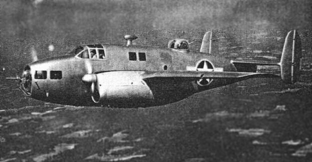
An undated (WW2-era) view of a Fairchild AT-21 Gunner flying over Alamance County.
The AT-21 had fairly unusual construction, being built from plastified wood.
It looked rather like a small bomber,
with a single machine gun in the glazed nose & a top turret with twin machine guns.
The AT-21 was a specialized bomber crew trainer,
intended to train crews in the use of power gun turrets or a gun on a flexible mount,
as well as learn to function as a member of a crew.
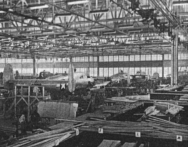
An undated (WW2-era) view of AT-21s on the assembly line inside the Fairchild Factory in Burlington.
The AT-21 had a brief production run & an extremely brief service life.
The first AT-21 was completed at Burlington in 1943.
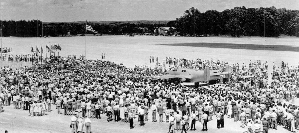
A 5/21/43 photo of a crowd around a Fairchild AT-21,
on the occasion of a speech by Governor Melville Broughton at the flight of the first plane built at the plant.
Production of the AT-21 ran for only one year, by which point the plant had turned out a total of 105 aircraft.
Use of the AT-21 ended in 1944,
when they were replaced by training examples of the actual aircraft in which the gunners would eventually serve.
Fairchild Field was depicted as a commercial airfield on the April 1944 Winston-Salem Sectional Chart.
After production of the AT-21 was completed, Fairchild vacated the facility,
and the Firestone company moved in to produce guns as a part of the war effort.
The war years brought tremendous growth to the area.
Many new people moved in to work at the facility & a completely new community went up on the side of the property
where Eastlawn Elementary School & the City Schools Administration building are located today.
A community of barracks-like buildings were constructed to house the workers at Fairchild & the area became Fairchild Heights.
Fairchild Field was depicted as an auxiliary airfield on the March 1945 Winston Salem Sectional Chart (courtesy of Chris Kennedy).
The 1945 AAF Airfield Directory (courtesy of Scott Murdock) described Fairchild Field
as a 227 acre irregularly-shaped property having a single 3,500' NNE/SSW asphalt runway.
The field was said to have 2 hangars, depicted on the west side of the field, the largest being a 90' x 40' wood structure.
Fairchild Field was described as being owned by the Defense Plant Corporation,
and operated by private interests.
After WW2 ended, the Western Electric Company took over the plant, which was still a government-owned facility.
Fairchild Field continued in operation after WW2 as a civil airport,
as Fairchild Field was depicted on the 1948 Winton-Salem Sectional Chart (according to Chris Kennedy).
The January 1950 Winston-Salem Sectional Chart depicted Fairchild Field as having a 3,600' paved runway.
The earliest photo which has been located showing all of Fairchild Field was an 11/18/50 USGS aerial view.
It depicted Fairchild Field as having a single paved northeast/southwest runway,
with a ramp & some small buildings on the northeast side, and the former Fairchild aircraft factory across the street.
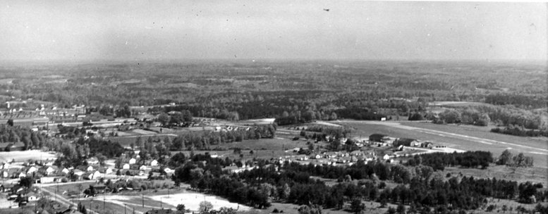
A circa 1950s aerial view looking northeast at Fairchild Field, with the former Fairchild aircraft factory at left, and the runway & 2 hangars at right (courtesy of Chris Laforet).
A single-engine light plane can be seen above the runway (top-center of photo).
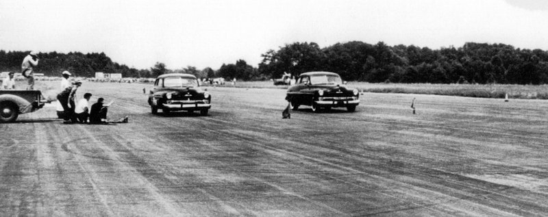
A circa 1953 / early 1954 photo of a drag race held on the Fairchild Field runway, before they started using lights & racing into the evening hours (courtesy of Chris Laforet).
According to Chris Laforet, “The races would run ¼ mile starting from the north end of the runway. The remaining runway would be used as the slowdown area.
Notice how people lined up close to the racing cars. There were no accidents during the 3 years the races ran there every alternate weekend.”
Robert Craddock recalled, “When my Father worked for Burlington Industries in the late 1950s / early 1960s,
he said there was a low-wing Fairchild monoplane for sale at Fairchild Field for $350.
A group of inexperienced locals purchased the plane & had it trailered to an airfield a few miles away in Mebane, NC.”
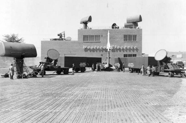
A circa 1950s photo of a display of Nike surface-to-air missile guidance radars manufactured at the Burlington plant.
In the 1950s & 60s, Western Electric manufactured large portions
of the Nike Ajax & Hercules surface-to-air missile system at the Burlington plant.
The 759,000-square-foot plant, also known at the Tarheel Army Missile Plant, was once the largest employer in Burlington.
The 1960 Jeppesen Airway Manual (courtesy of Chris Kennedy)
depicted Fairchild Field as having a single 3,500 paved Runway 2/20,
with a taxiway leading to a ramp on the west side of the field with a few small buildings (hangars?).
The 1962 AOPA Airport Directory described Fairchild Field as having a single 3,500' asphalt Runway 4/22,
and listed the operator as Alamance Aviation Service, Inc.
The last photo which has been located showing Fairchild Field in operation was an 2/1/67 USGS aerial view.
It depicted one single-engine aircraft on the ramp on the northwest side of the runway.
The last aeronautical chart depiction which has been located of Fairchild Field was on the March 1967 Winston-Salem Sectional Chart.
It depicted Fairchild Field as having a single 3,500' paved northeast/southwest runway.
Fairchild Field was evidently closed at some point in 1967,
as it was no longer depicted on the October 1967 Winson-Salem Sectional Chart,
nor listed in the 1968 Flight Guide (courtesy of Bob Levittan).
George Wallace held a rally at Huffman Field during his campaign for president in 1968, according to Eddie Huffman.
Eddie recalled, “I grew up in the neighborhood,
and my father worked for four decades at the Western Electric (later AT&T) plant, located in the former Fairchild Aircraft plant.
I have vague recollections of planes still taking off & landing there in the late 1960s or early 1970s.
When I was growing up in the 1970s, the runway was still clearly visible along Graham-Hopedale Road.”
In the 1970s the Burlington plant was geared for new growth with plans for production of the Safeguard system,
an anti-ballistic missile defense system,
but treaties with the Soviet Union ended this program before it had a chance to begin.
That resulted in severe cutbacks in production & employment at the Burlington plant.
Fairchild Field was apparently closed by 1972,
as it was no longer depicted at all (even as an abandoned airfield)
on the August 1972 Charlotte Sectional Chart (courtesy of Robert Brown).
After the breakup of the Bell system in the 1980s, the Burlington plant became an AT&T facility.
Jonathon Payne recalled, “My father grew up in the area & worked at the AT&T building in the late 1980s.
At the time part of the building was used as a monitoring station for the Navy’s SOSUS sonar net in the North Atlantic.
My father was a UNIX programmer for the station’s mainframe.
When Western Electric won the contract, it had to put the receiving station somewhere
and the old Fairchild plant was still government-owned & available
(the SOSUS signals were sent by satellite, so the receiver station wasn't dependent on a specific geographical location).”
Eddie Huffman recalled, “Hobbyists routinely flew radio-controlled airplanes at the old Huffman Field
into the 1980s and possibly early 1990s until a pair of mobile home dealerships covered most of the remaining runway.”
The Burlington plant continued to operate as an AT&T facility
until AT&T moved to the Rock Creek Industrial Park in 1992.
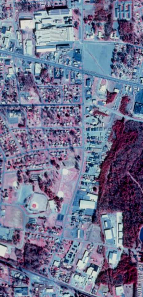
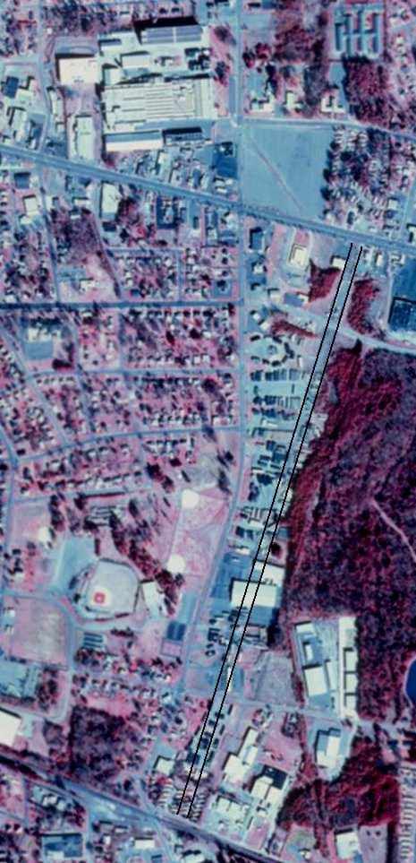
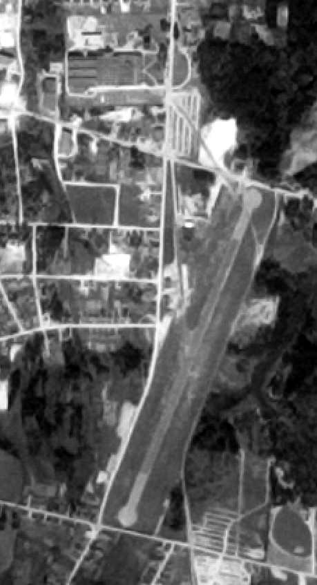
A circa 2000 USGS aerial view of the site of the former Fairchild Field
(both the original photo, and a version with the runway alignment superimposed by John Hunter).
The former Fairchild aircraft factory at the northwest corner of the photo.
According to John Hunter, "The remains of the runway are still visible if one knows what to look for.
A Lowe's lumber store was built on the site as well as other commercial construction."
"The Lowe's has moved on & there is other stuff there now -
the lumber yard used to be at the south end of the strip 20 years ago.
The large white-roofed building top center (just north of US 70) is the old Fairchild plant.
If you look at the vacant lot to the east of the plant you will see a small diagonal trail going southeast to US70.
This is where the taxiway used to be.
The taxiway terminated on the south side of US70 on the west side of the runway.
The runway alignment was at a right angle to US 70
and ran south along the large forest of trees grown up on the east side.
I believe that personal inspection would yield some original runway pavement still remaining."
Eddie Huffman reported in 2005, “Most of the asphalt runway remained visible until 2004.
Wal-Mart has recently begun construction of a new store at the site,
obliterating almost all that remained of the old runway.
The only section of the runway still relatively intact & visible
lies between Mebane Street & North Church Street, a block-sized strip just east of the state alcohol store on Mebane.”
The Minor League baseball park just west of the former south end of the runway is still known as "Fairchild Field".
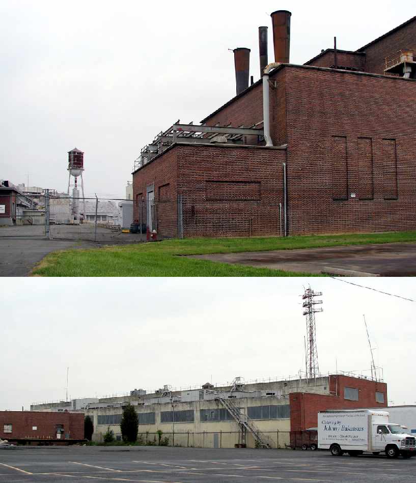
Two 2006 photos by Scott Murdock of the former Fairchild factory.
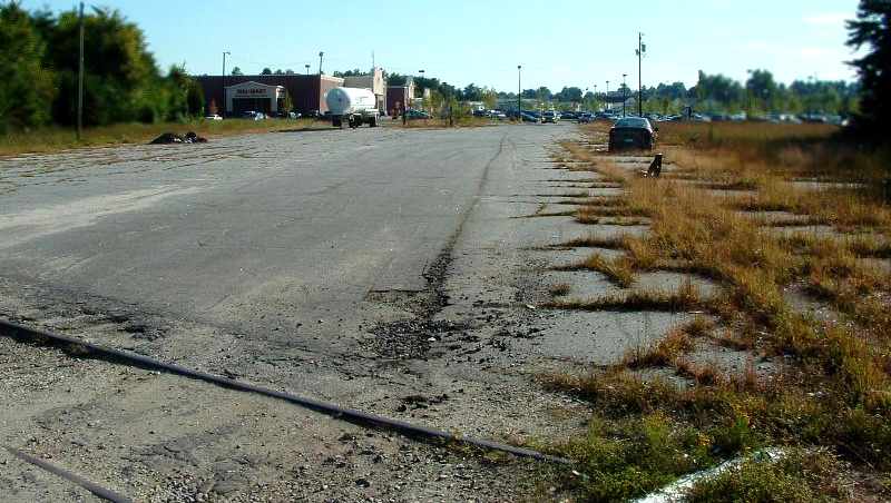
A 2006 photo by Jonathon Payne “of the last remaining segment of runway from the old Fairchild Field.”
A Wal-Mart was built over a portion of the runway site, opening on 4/19/06.
Jonathon Payne reported in 2006, “The new Wal-Mart was recently competed, obliterating most traces of the old runway.
There is still a piece of the old runway on the north side of Mebane Street.
There are a few parts still visible at the mobile home retailers,
just south of the Wal-Mart, if one knows what to look for.”
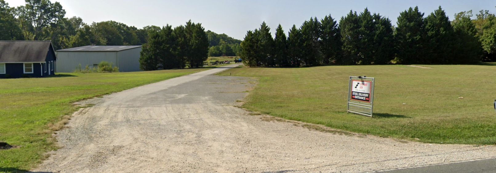
The site of Fairchild Field is located at intersection of Route 70 & North Graham Hopedale Road.
See also:
http://homepages.rootsweb.com/~mwellis/book/chapter16.html
http://newsarch.rootsweb.com/th/read/NCROOTS/1999-03/0921436382
____________________________________________________
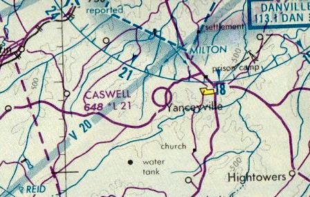
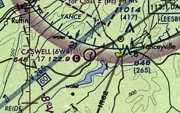
Caswell Airpark (6W4), Yanceyville, NC
36.4, -79.39 (Northwest of Raleigh, NC)
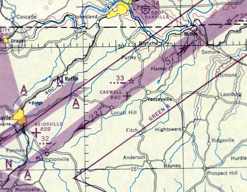
Caswell Airpark, as depicted on the October 1945 Winston-Salem Sectional Chart.
This little public-use airport was apparently established at some point in 1945
(like hundreds of other small American airports, in the post-WW2 general aviation boom),
as it was not yet depicted on the March 1945 Winston-Salem Sectional Chart.
The earliest depiction which has been located of Caswell Airpark as on the October 1945 Winston-Salem Sectional Chart.
It depicted Caswell as an auxiliary airfield.
The October 1948 Winston-Salem Sectional Chart (courtesy of Chris Kennedy) described Caswell Airpark as having a 2,000' unpaved runway.
Graham Page recalled, “That airstrip was built by my grandfather, Dr. Ludolphus Graham Page
and was designed to spec by the Army Corps of Engineers.
My grandfather owned several light military planes that were purchased after WWII,
and both of his sons - my father & uncle - were pilots as well.”
The field was equipped with a former Civil Defense tower.
According to Graham Page, “The civil air tower was purchased in the 1960s - I believe it was surplus military.”
The 1962 AOPA Airport Directory described Caswell as having a single 2,100' sod Runway 4/22,
and said that the airport provided fuel, hangars, and tie-downs.
The earliest photo which has been located of Caswell Airport was a 1971 aerial view.
It depicted Caswell as having a single northeast\southwest unpaved runway.
Caswell Airport was depicted on the August 1976 Cincinnati Sectional Chart (courtesy of Mitchell Hymowitz)
as having a 2,100' unpaved runway.
Graham Page recalled, “The airport was still active up until the late 1980s
and had 4-6 'resident' planes – Cessna 152s, a Cessna 180, and a couple of Piper Tri-Pacers.
Then the local pilots starting getting older & quit flying -
I think the declining local economy also meant that there were not many people with the resources to continue using the airport.”
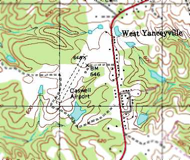
The 1991 USGS topo map depicted the Caswell Airport as having a single northeast\southwest unpaved runway.

The earliest photo which is available of Caswell Airpark was a 1993 USGS aerial view looking southeast.
It showed Caswell to have a single grass northeast/southwest runway, with a small building on the east side. There were no planes visible on the field.
Caswell Airpark was depicted as an active public-use airport on the 1996 NC Aeronautical Chart.
The 1998 USGS aerial photo showed Caswell to have a single grass northeast/southwest runway.
Caswell Airpark was listed in the 2000 AOPA Airport Directory,
and as having a single 2,050' sod Runway 4/22.
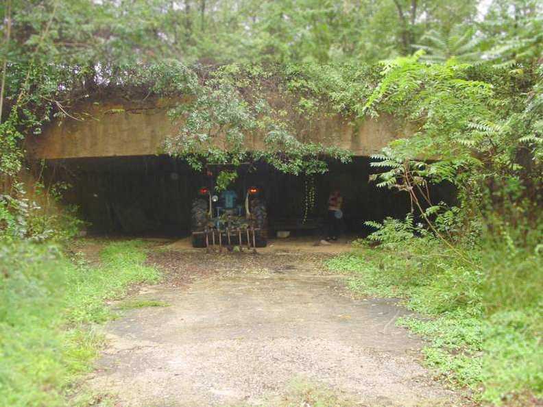
A 2003 photo by Les Parker of the former underground hangar at Caswell Airpark,
evidently constructed under the runway during the Cold War to house a private "escape plane".
Les Parker visited the hangar in 2003. His report: "The hangar is reinforced concrete & about 50' wide by 30' deep.
Just enough of the floor is concrete to accommodate a small tricycle landing gear. The rest is just clay.
The ramp up to the runway is paved about 2/3rds of the way up.
There is about 15' of earth over the hangar up to the runway surface.
There is a tractor stored out of the weather in the now unused hangar.
It is open faced & I couldn't find any door mounts, but it did have electric power at one time.
You can still see the conduit on the ceiling & walls.
I thought the lack of 'blast doors' was odd, considering the supposed reason for construction.
I believe a natural gully or depression was used & enlarged when the hangar was built.
Yanceyville could have been 'Mayberry'. There are no first strike targets, that I am aware of, anywhere near by.
Danville VA is about 15 miles away, to the north. The doors do face south.
I was told by a 'local' who stopped by that the field was built by a wealthy doctor.
I might venture to guess that some military branch may run training operations there.
The runway looked pretty well mowed & has a tree-line at the west end.
There is what appears to be an old Civil Defense tower still there."
According to Graham Page, “Not far from the pictured underground hangar is an underground house / apartment that had blast doors, etc.
Dr. Page could probably have been labeled as eccentric, but more than anything he just liked to experiment & try anything new.
He was also an inventor & had invented part of the design for the gyrocopter & a tailsection that was capable of rotating around 3 axes.”
Caswell Airpark, as depicted on the 2004 Sectional Chart.
Caswell Airpark is described in the 2004 Airport Facility Directory as having a single 1,735' turf Runway 4/22,
and the owner was listed as Dr. G. Allison Page.
It is still listed in the 2004 Airport Facility Directory as a public-use civilian airport,
but several strange items in the Airport Operational Statistics & Remarks sections
seem to indicate that this field is used predominantly for military purposes.
The Airport Operational Statistics section gives a total of 50 aircraft operations per year,
which are (inexplicably) described as "100% military".
Furthermore, the Remarks section includes "Occasional nighttime military operations."
Graham Page reported in 2006, “In reference to the 'military' use of the airport:
My uncle, Dr. Graham 'Allison' Page (who still lives on the property)
has maintained an agreement with the regional military for use of the airport.
They come in - do touch & go's, and occasionally there is a visit from Blackhawk helicopters running night training exercises.
Nowadays there are no planes housed at the airport.”
A 2013 photo by Alan Goodwin “looking approximately northeast towards the access road (off Highway 158) from about mid-field.
You can just see the Civil Defense tower with the red siren on top just to the right of center in front of the oak trees.”
Alan Goodwin reported, “We arrived at the end of the access road which pretty much dead-ends at the edge of the runway under the oak trees.
There are no signs directing you in any particular direction or to stay away.
We thought no one was there but as we were taking our helmets off we saw a car coming up the side of the runway.
We greeted the driver & he informed us that there were more folks up the path & we should head there.
We hopped back on our bikes & headed in that direction.
That's where we found the 'carport at the airport' & a few gentlemen preparing their radio-controlled planes for flight.
We were welcomed by the group & had a great time talking aircraft & local history.
There wasn't too much knowledge about the history of Caswell itself or it's creator. They didn't even know of the underground hangar.
They did know it was privately owned by a gentleman that lived in nearby Yanceyville.
The stories of military helicopter activity at night was echoed so it seems that part of the history still persists.”
Alan continued, “The area around the airpark looked to have been logged at some point in the last year or so and the brush was growing back.
I tried locating the underground hangar but the brush was very thick & prevented me from doing so.
The underground hangar is best seen if you go back to the access road & hang a left right at the Civil Defense tower
(as if you were coming from Highway 158, if from the carport you'd be making a u-turn to the right).
The hangar access is before & parallel the path that leads down the runway to the carport.
As you head towards the hangar you'll be headed slightly downhill & there are buildings on your left, the runway to the right.”
Alan continued, “The runway itself looks to be very smooth. The grass, at least the portions that are kept mowed, are in good shape.
It has a distinct downhill slope with the northeast end being higher.
The southwest end has a drop-off at the extreme end of the runway.
Running a plane off that end is probably not advisable as you're likely to not get it back. The terrain to the sides of the runway varies.
The northwest side is mostly flat or slight uphill with the southeast side having several drop-offs.
These are the same drop-offs that seem to facilitate the existence of the underground hangar.
If I had to guess large amounts of dirt were brought in the fill in the undulations in the terrain when the airpark was made filling in over the hangar.”
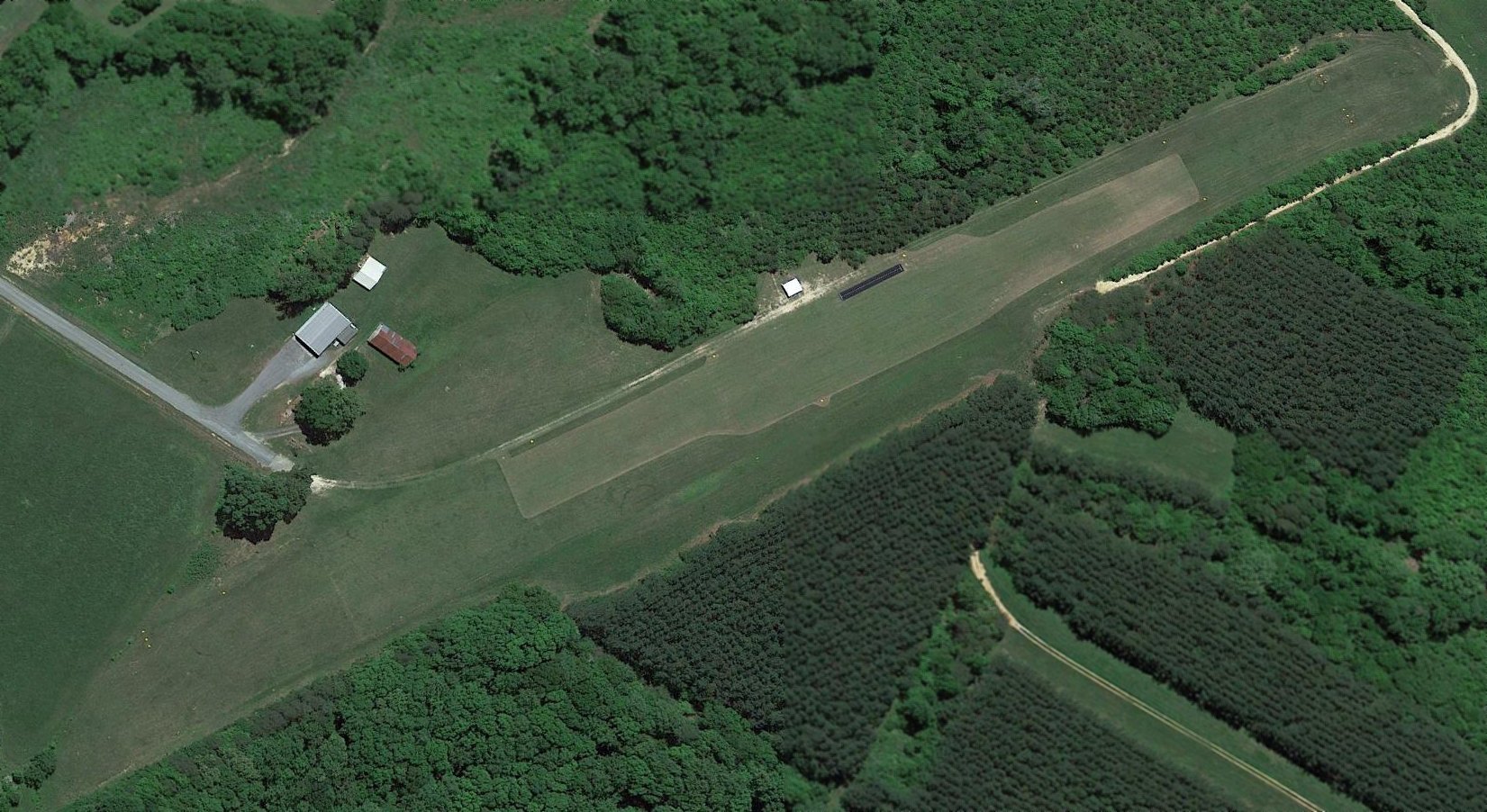
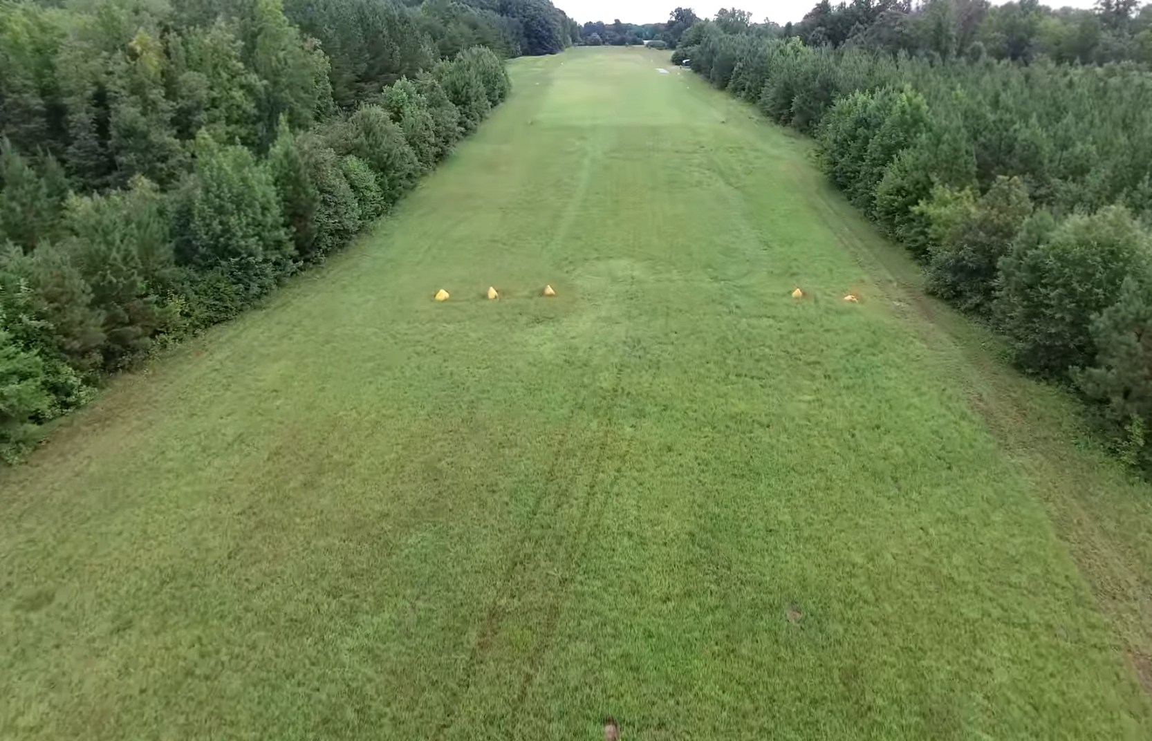
A 2017 aerial view looking southeast depicted Caswell Airpark to have a single grass northeast/southwest runway.
A short black model aircraft runway had evidently been constructed on the east side of the grass runway at some point between 2016-17.
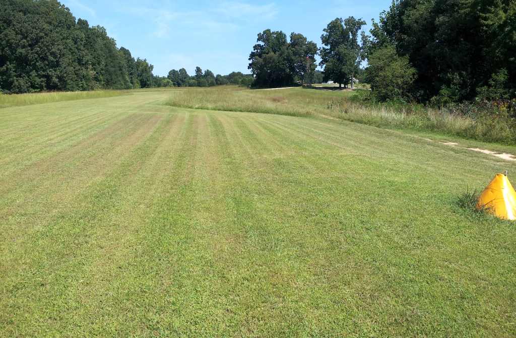
A still from a 2018 drone aerial video by Jack Fessler looking southwest along Caswell Airpark's grass runway.
Jack reported, “The model airplane runway is not paved at all, but a cleverly designed piece of black plastic tarp stretched taut with white lines painted on it!
It would support a model aircraft that weighed a few pounds, but nothing more.
A small electric at best. It was very short for an radio-controlled model aircraft runway too, not even 100'.”
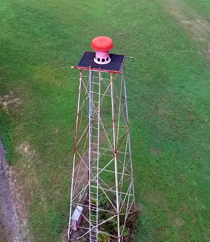
A still from a 2018 drone aerial video by Jack Fessler of Caswell Airpark's civil defense tower.
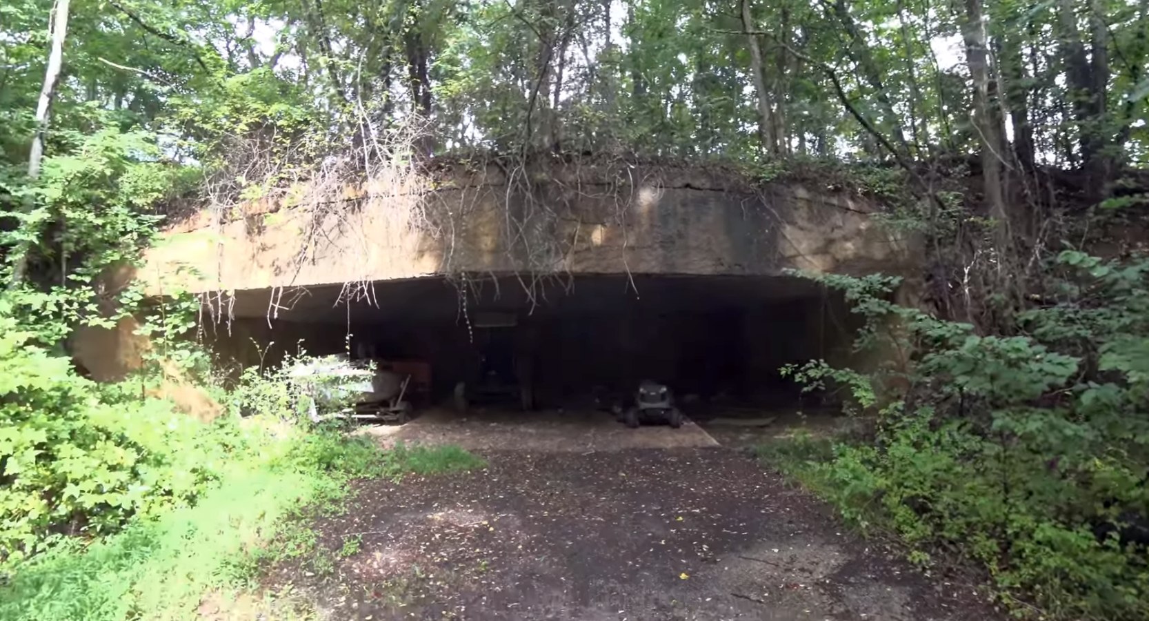
A still from a 2018 drone aerial video by Jack Fessler of Caswell Airpark's blast-resistant underground hangar.
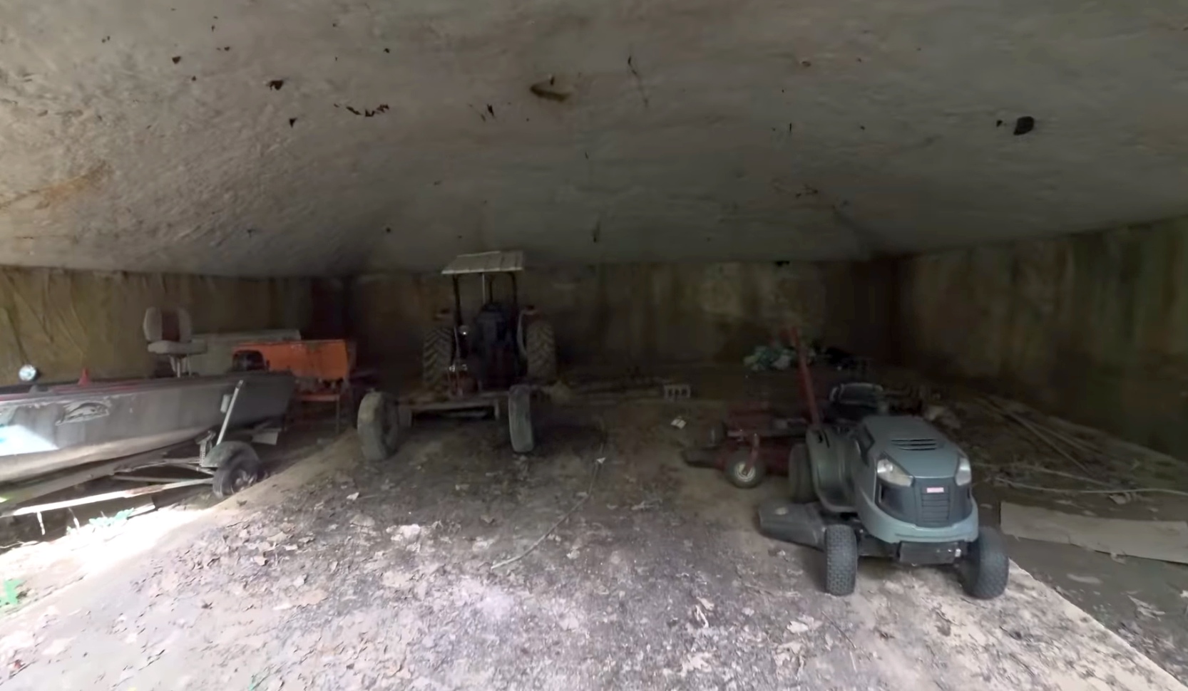
A still from a 2018 drone aerial video by Jack Fessler of the interior of Caswell Airpark's underground hangar.
Caswell Airpark is located west of the intersection of Route 158 & Hodges Dairy Road.
____________________________________________________
Or if you prefer to contact me directly concerning a contribution (for a mailing address to send a check),
please contact me at: paulandterryfreeman@gmail.com
If you enjoy this web site, please support it with a financial contribution.
____________________________________________________
This site covers airfields in all 50 states.