
Abandoned & Little-Known Airfields:
North Carolina: Raleigh area
© 2002, © 2026 by Paul Freeman. Revised 5/31/26.
This site covers airfields in all 50 states: Click here for the site's main menu.
____________________________________________________
Please consider a financial contribution to support the continued growth & operation of this site.
Eagle Airport / Rocky Mount Municipal Airport (revised 1/3/25) - Franklin Field (revised 3/31/17) - Hurdle Field (revised 5/31/26) - Lee County Airport (original location) (revised 1/10/16)
Louisburg Municipal Airport (revised 1/22/16) - Martindale Field / Chapel Hill Airport / Horace Williams Airport (revised 2/2/25) - Raleigh Municipal Airport (revised 5/6/22)
Sanford Lee County Airport (revised 1/3/25) - Shelba Airport / Wake South Airport / Raleigh Executive Airport (added 9/16/25)
____________________________________________________
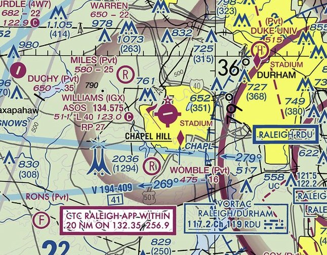
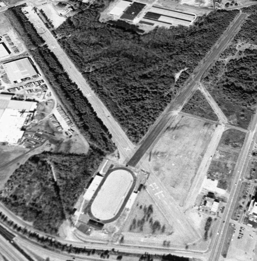
Hurdle Field (4W7), Mebane, NC
36.073, -79.281 (West of Raleigh, NC)
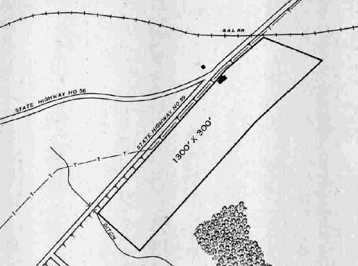
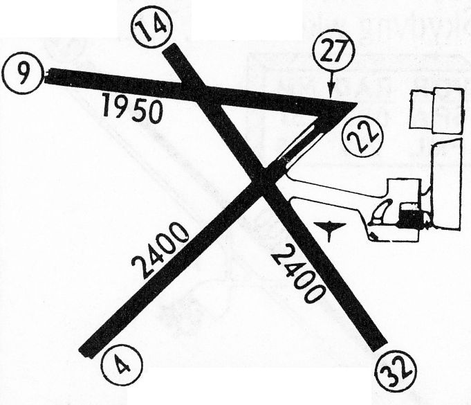
Hurdle Field, as depicted on the October 1966 Winston-Salem Sectional Chart.
The date of establishment of this small rural general aviation airport has not been determined.
The earliest depiction which has been located of Hurdle Field was on a 1955 aerial photo.
It depicted a single northeast/southwest unpaved runway, with one small hangar on the northeast side.
However, Hurdle Field still was not on depicted on the April 1966 Charlotte Sectional Chart.
It depicted Hurdle as having a mere 2,000' unpaved runway.
The earliest aeronautical chart depiction which has been located of Hurdle Field was on the October 1966 Winston-Salem Sectional Chart.
It depicted Hurdle as having a mere 2,000' unpaved runway.

The earliest photo which is available of Hurdle Field was a 2/1/67 USGS aerial view.
It depicted Hurdle to have 1 unpaved northeast/southwest runway & 1 hangar on the northeast side.

The earliest topo map depiction which has been located of Hurdle Field was on the 1981 USGS topo map.
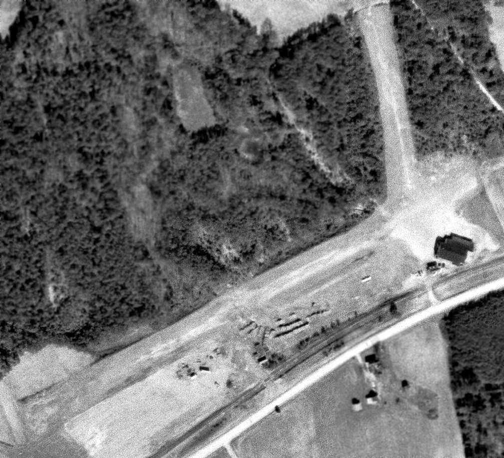
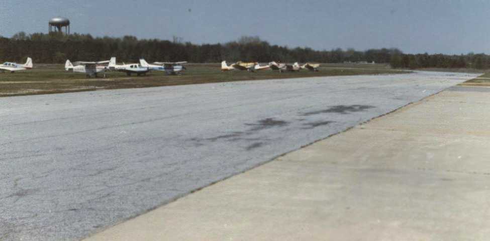
The earliest photo which has been located showing aircraft at Hurdle Field was a 1982 aerial view.
It depicted 6 light single-engine aircraft parked near the hangars on the northeast side.

The 1984 USGS topo map depicted Hurdle Field Airport as having a single northeast/southwest runway.

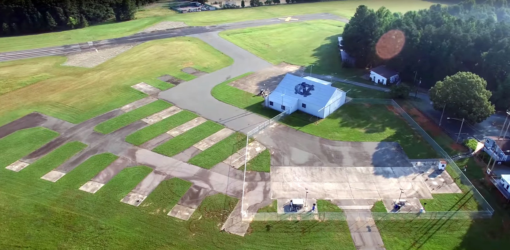
The last photo which has been located showing an aircraft at Hurdle Field was a 2016 aerial view looking west.
It depicted 1 light single-engine plane parked near the hangars on the east side.

The last aeronautical chart depiction which has been located of Hurdle Field was on the 2018 Charlotte Sectional Chart.
It depicted Hurdle as having a 2,200' unpaved runway.
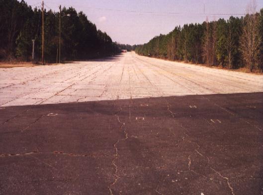
A 2018 aerial view showed Hurdle Field remained intact, but sadly devoid of aircraft.
Hurdle Field was evidently closed at some point between 2018-19, as it was no longer depicted on the 2019 Charlotte Sectional Chart.
Presumably yet another grassroots airfield lost to rising property values & resultant tax increases.
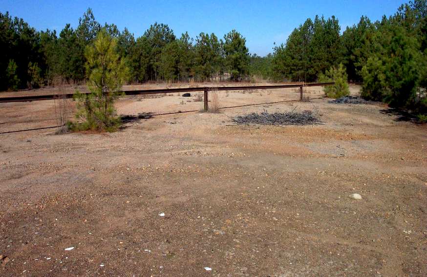
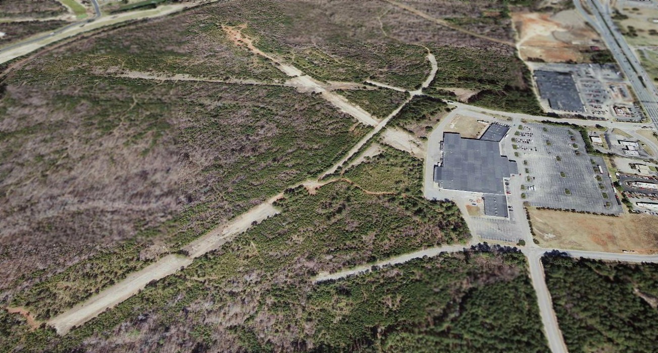
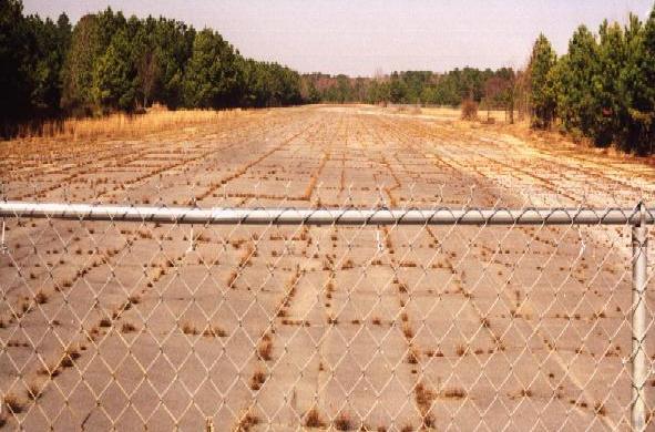
A sad 2021 aerial view showed all traces of Hurdle Field had been erased by residential development.

A 2025 aerial view looking west showed no trace remaining of Hurdle Field.
Ironically, “Hurdle Field (4W7)” was still depicted on Google Maps in 2026, even though the underlying imagery is of dense houses, not an airport.
Several of the residential street names pay homage to the site's past, with names of Airport Road, Beechcraft Drive, and Socata Lane.
____________________________________________________
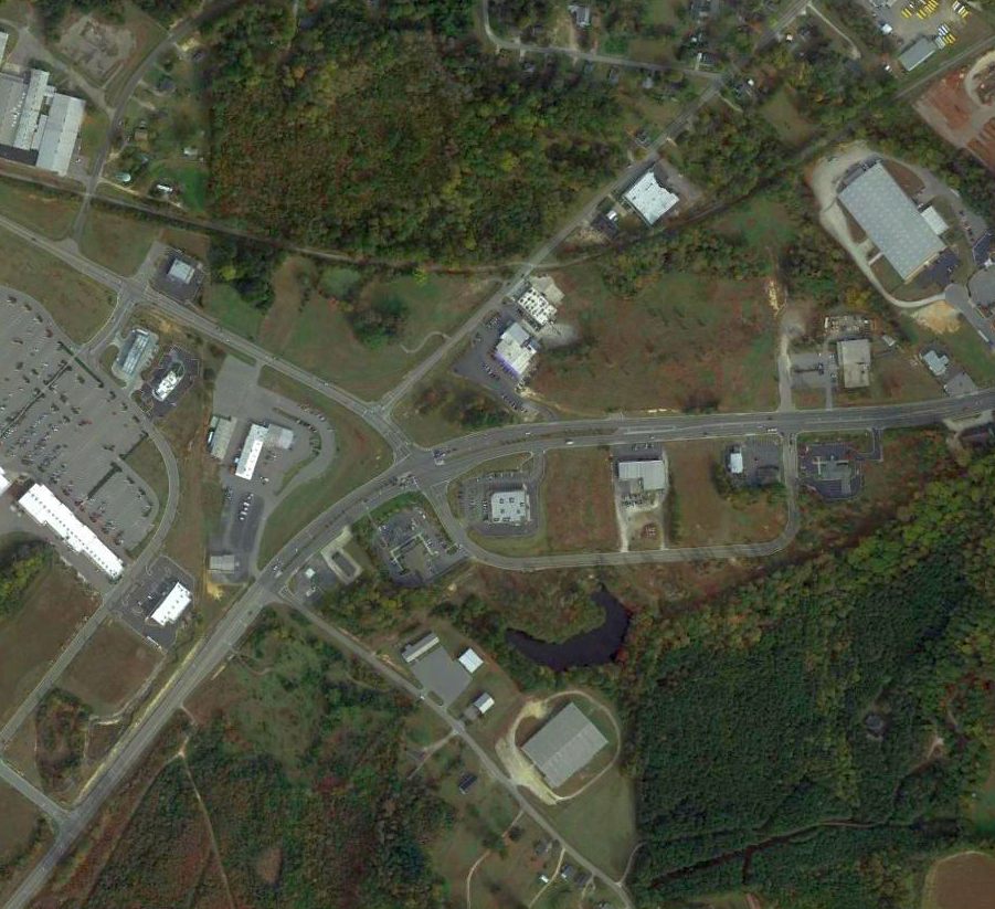
Shelba Airport / Wake South Airport / Raleigh Executive Airport, Holly Springs, NC
35.635, -78.856 (Southwest of Raleigh, NC)

Shelba Airport, as depicted on the September 1970 Charlotte Sectional Chart.
The airfield was evidently constructed at some point between 1964-70, as it was not yet depicted on a 1964 aerial photo.
The earliest depiction which has been located of Shelba Airport was on the September 1970 Charlotte Sectional Chart.
It depicted Shelba Airport as having a 3,000' unpaved runway.
This small general aviation airport was the home of Aerosport Inc, owned by Harris Woods, which designed homebuilt aircraft kits.
According to NC Secretary of State data (courtesy of Mike Legeros), Aerosport, Inc. had a 11/17/70 Creation Filing.
According to Wikipedia, Aerosport's products included the Quail, Rail, Scamp, Woody Pusher, and Aerosport-Rockwell LB600.
A 4/29/71 News & Observer advertisement (courtesy of Mike Legeros) touted the aircraft maintenance capabilities of Aerosport Inc.
The earliest photo which has been located of Shelba Airport was a 1973 aerial view.
It depicted Shelba Airport as having a single unpaved northwest/southeast runway, with a small building & 2 light single-engine aircraft on the east side.

An undated cover photo of an Aero-Sport catalog, presumably taken at Shelba Airport (courtesy of Mike Legeros).
Aerosport Inc. owner Harris Woods passed away 9/6/75, according to a Statesville Record article (courtesy of Mike Legeros).
According to NC Secretary of State data (courtesy of Mike Legeros), Aerosport, Inc. had a 3/6/86 Destruction Filing.

The earliest topo map depiction which has been located of Shelba Airport was on the 1987 USGS topo map.
It depicted Shelba Airport as having a single unpaved northwest/southeast runway, with a few small buildings on either side.
It was still depicted as Shelba Airport on the 1988 Charlotte Sectional Chart.

The last topo map depiction which has been located of Shelba Airport was on the 1990 USGS topo map.
It depicted Shelba Airport as having a single northwest/southeast runway.
A 4/22/92 Herald Sun article (courtesy of Mike Legeros) entitled “South Wake airport expansion on hold”
said “a proposed expansion of the Holly Springs airfield in on hold while Raleigh & Wake County officials review air traffic & environmental concerns.”
A 5/10/92 Herald Sun article (courtesy of Mike Legeros) entitled “City Oks Wake South Wake Airport expansion”
said “The council endorsed the use of money from the state Aviation Trust Fun to expand & equip the Wake South Airport for instrument landings.”
At some point between 1988-92, Shelba Airport was evidently reestablished as a private airfield named Raleigh Executive,
as that is how it was depicted on the 1992 Charlotte Sectional Chart.

The earliest photo which is available of Raleigh Executive Airport was a 1993 aerial view looking northeast.
It depicted a single unpaved northwest/southeast runway, with 1 small hangar & 1 T-hangar on the east side.

The last aeronautical chart depiction which has been located of Raleigh Executive Airport was on the 1994 Charlotte Sectional Chart.
It depicted Raleigh Executive as a private airfield having a 3,200' unpaved runway.
A 1998 aerial photo showed construction had started adjacent to the west side of the Raleigh Executive Airport site,
which remained intact though not showing any sign of aviation use.
Raleigh Executive Airport was evidently closed (for reasons unknown) at some point between 1994-99,
as it was no longer depicted on the 1999 Charlotte Sectional Chart or the 1999 USGS topo map.

A 2002 aerial view looking northeast showed construction of new streets covering the northwest end of the former Raleigh Executive Airport runway, but its hangar remained standing.
A 2010 aerial photo showed the Raleigh Executive Airport hangar remained standing.
A 2012 aerial photo showed the Raleigh Executive Airport hangar had been removed at some point between 2010-2012, with only its foundation remaining.

A 2023 photo showed a clue to the past use of the Shelba / Raleigh Executive Airport site, with a streetsign for Old Airport Road.

A 2023 photo showed another clue to the past use of the Shelba / Raleigh Executive Airport site, with a streetsign for Aerosport Road.

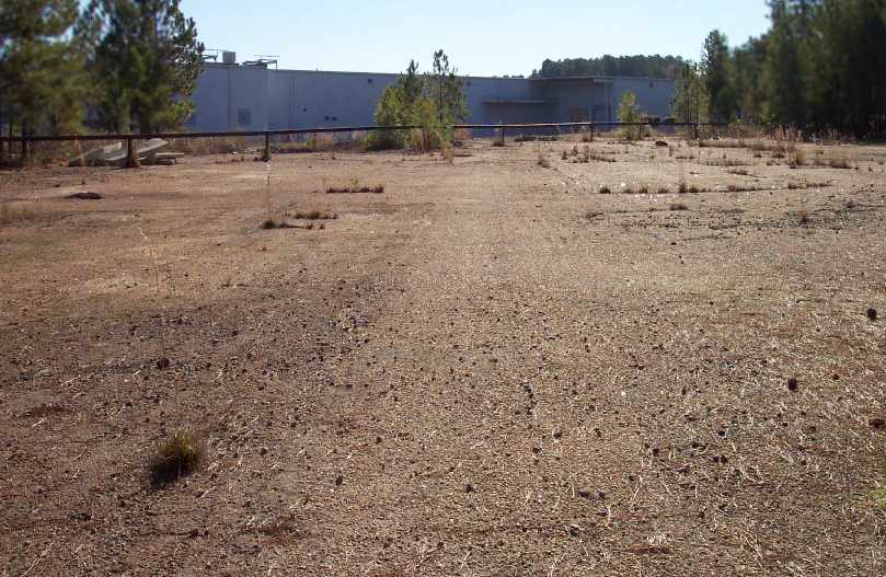
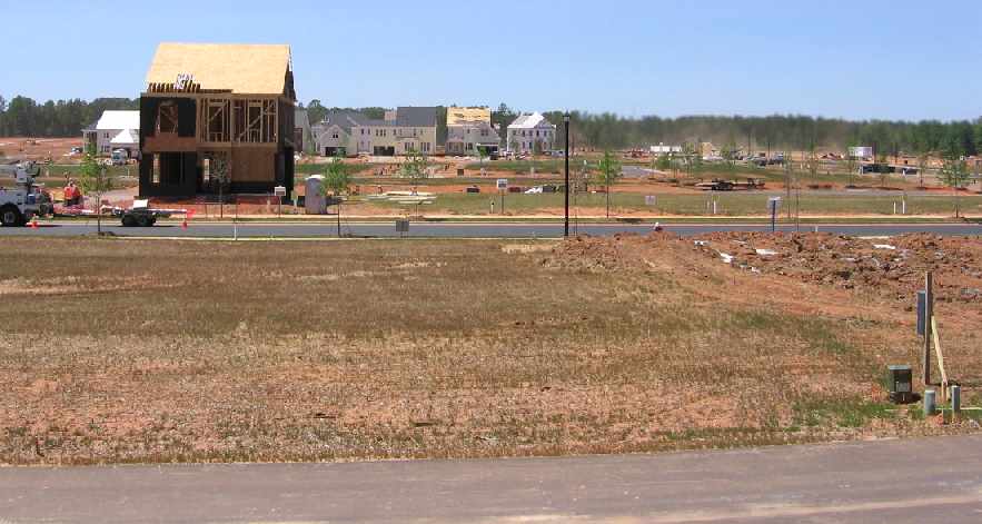
A 2025 aerial view looking northeast showed that suburban houses have covered nearly all the Raleigh Executive Airport site,
with the only remaining trace being the hangar foundation in the clearing in the center of the picture.
Thanks to Mike Legeros for pointing out this airfield.
____________________________________________________
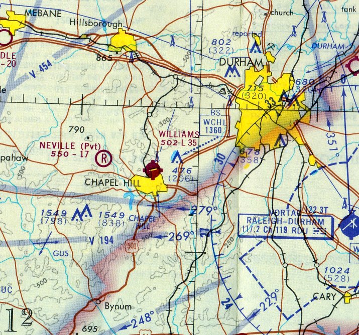
Martindale Field / Chapel Hill Airport / Horace Williams Airport (KIGX), Chapel Hill, NC
35.935, -79.066 (Northwest of Raleigh, NC)
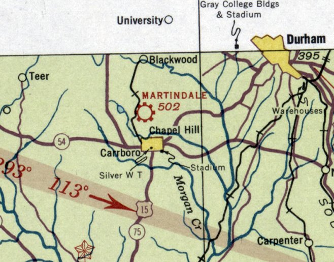
Martindale Field, as depicted on the May 1935 Charlotte Sectional Chart.
According to Wikipedia, “The airport was part of a large gift of land to the university by Professor Horace Williams in the 1930s,
and while the professor did not restrict the use of the property to airport use, it has been an airport since 1933.”
The airport was “originally known as Martindale Field for Chapel Hill contractor Lee Martindale, and [was] one of the first airfields in NC.”
The earliest depiction which has been located of Martindale Field was on the May 1935 Charlotte Sectional Chart,
which depicted Martindale as a commercial/municipal airport.
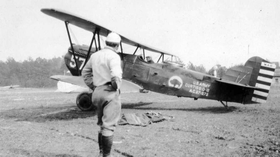
The earliest photo which has been located of Martindale Field was a circa 1930s photo of an Army Air Corps Curtiss biplane (model unidentified) at the field.
It was still depicted as Martindale on the October 1940 Charlotte Sectional Chart.
According to Wikipedia, “It was renamed 'Chapel Hill Airport' & offered pilot training & air shows.
The airport was purchased by the University in 1940 & renamed for Professor Horace Williams, Chair of Mental & Moral Science at the University,
who also donated much of the land needed to expand the airport.”
It was depicted as Horace Williams Airport on the February 1942 Charlotte Sectional Chart.
According to Wikipedia, “Presidents Ford & George H. Bush received Navy primary flight training at the airport”, in 1942.
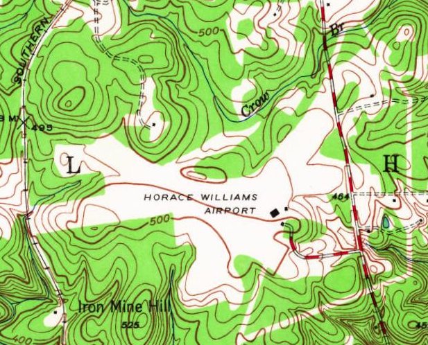
The 1946 USGS topo map depicted Horace Williams Airport as having 3 unpaved runways, with 3 small buildings on the southeast side.
The earliest aerial photo which has been located of Horace Williams Airport was a 1940s aerial view looking southwest.
It depicted Horace Williams Airport as having 3 unpaved runways, with a small hangar on the southeast side.
A 3/31/51 USGS aerial view depicted Horace Williams Airport as having 3 unpaved runways, with a small hangar on the southeast side.
According to Wikipedia, “President Kennedy visited UNC in October 1961 & arrived & departed via Horace Williams Airport.”
The March 1972 Charlotte Sectional Chart depicted Horace Williams Airport as having a 3,500' paved northeast/southwest runway.
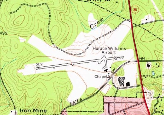
The 1978 USGS topo map depicted Horace Williams Airport as having a paved northeast/southwest runway, along with the clearings of 2 former unpaved runways.
Three small buildings were depicted on the southeast side.
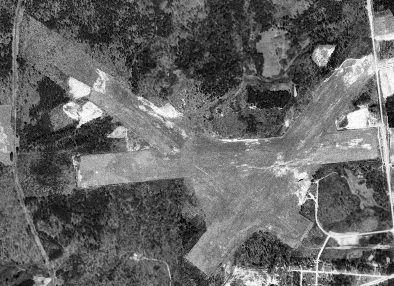
A 1993 USGS aerial view looking north depicted Horace Williams Airport as having an asphalt Runway 9/27, along with still-recognizable traces of 2 former unpaved runways.
A total of 18 light aircraft were parked near some small hangars on the southeast side.
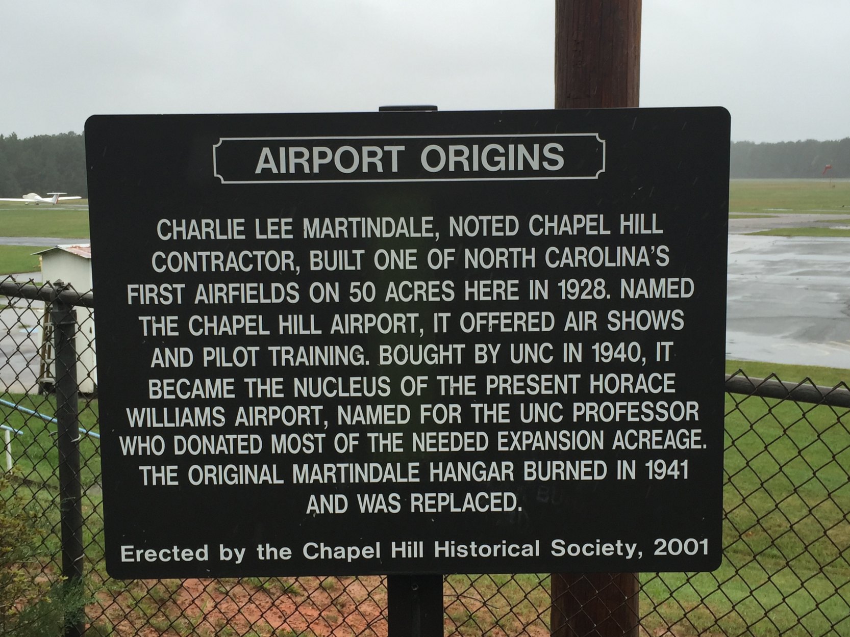
A 2001-2015 photo of a historical sign erected in 2001 by the Chapel Hill Historical Society commemorating the history of Horace Williams Airport.
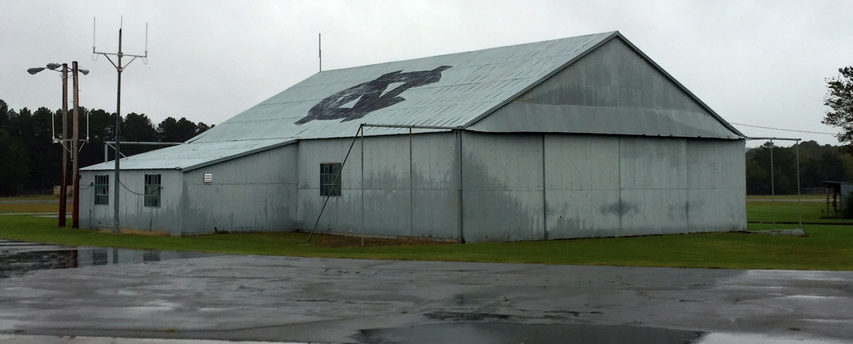
A 2001-2015 photo of the Horace Williams Airport hangar.
According to its FAA Airport/Facility Directory data, as of 2007 Horace Williams Airport conducted 29 takeoffs or landings per day, and had 47 based aircraft.
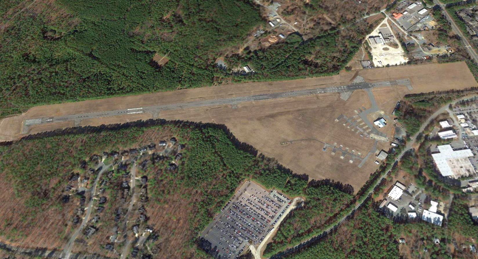
The airport consisted of 420 acres, and had a 4,005' asphalt Runway 9/27.
According to Wikipedia, “The University plans to close the airport to make room for construction of Carolina North, a planned major long-term expansion of its campus.
Opposition to closure plans began immediately after the announcement of the planned closure,
in 2000 when pilots claimed that closing this air field would be a loss of infrastructure that would never be replaced.
They note that upgrades to the airport approved by the FAA have kept pace with current technology & it is staffed with meticulous attention to detail & careful people,
although there have been some complaints about runway maintenance.
The position of general aviation advocates & lobbyists is that there is something very special about airplanes,
and to lose them in Chapel Hill for the sake of more buildings, traffic & population density must be carefully considered.”
Wikipedia continued, “Conflict between the town & airport advocates has had a history dating back to the 1980s,
revolving around issues such as the location of the airport in a residential area that includes 4 schools, a church, and a YMCA.
Critics of the airport noticed that the University's first plans for the Carolina North project included keeping the airport in close proximity to occupied buildings
and reminded the University that liability in the event of a crash could be substantial, given the existence of known guidelines recommending against building so close to a working runway.
In addition, interested private-industry interests indicated concern about the costs & liabilities of building on the site if the airport remained.
The plans for Carolina North were revised, and the UNC Board of Trustees commissioned a study on the basis of which they ordered the airport closed.”
Wikipedia continued, “The University's plans for airport closure have been blocked in the state legislature on at least three occasions since the 2000 announcement.
Although some planes using the airport do so on University business,
opposition to closure has historically been offered primarily by private plane owners & general aviation lobbyists desiring to preserve their access to the airport.
Most recently, opposition efforts have focused on the University's planned move of 6 Area Health Education Centers (AHEC) planes to new facilities at Raleigh-Durham International Airport,
to make way for construction of the first phase of the new Carolina North campus project, planned to include teaching, research, and cooperative public-private projects affiliated with the University.
However, economic realities stalled all progress on development of Carolina North, and the airport remained open.”

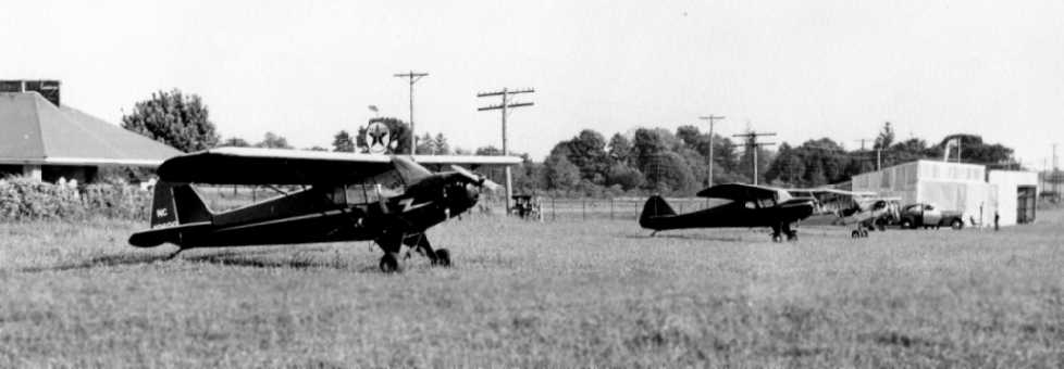
A 6/6/05 photo of 2 light general aviation aircraft on the Horace Williams Airport ramp.

A 6/18/08 photo of a variety of light general aviation aircraft on the Horace Williams Airport ramp.

A circa 2011 photo of the Horace Williams Airport Administration Building.
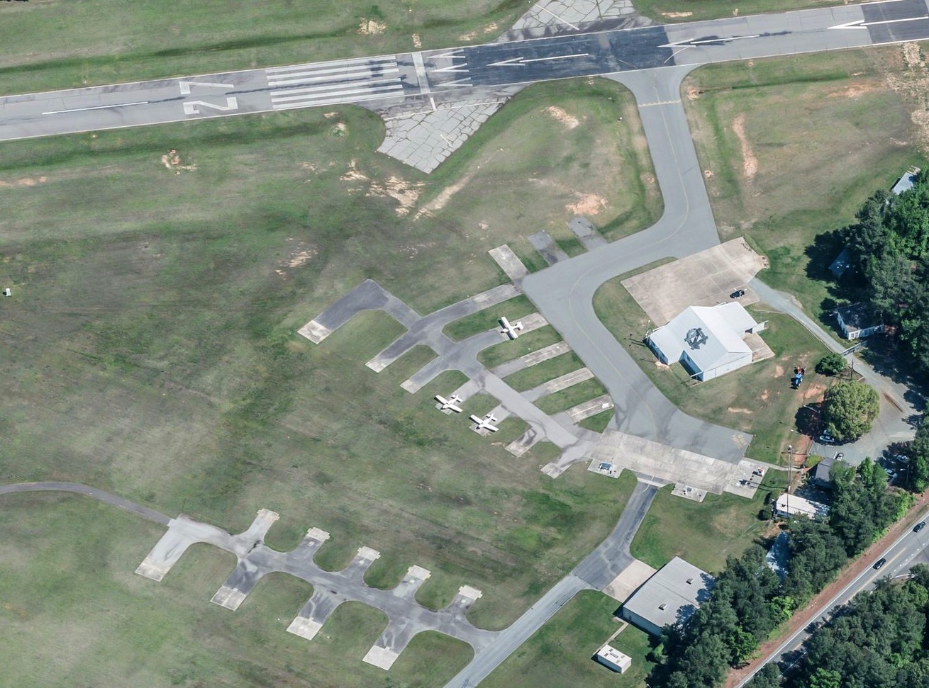
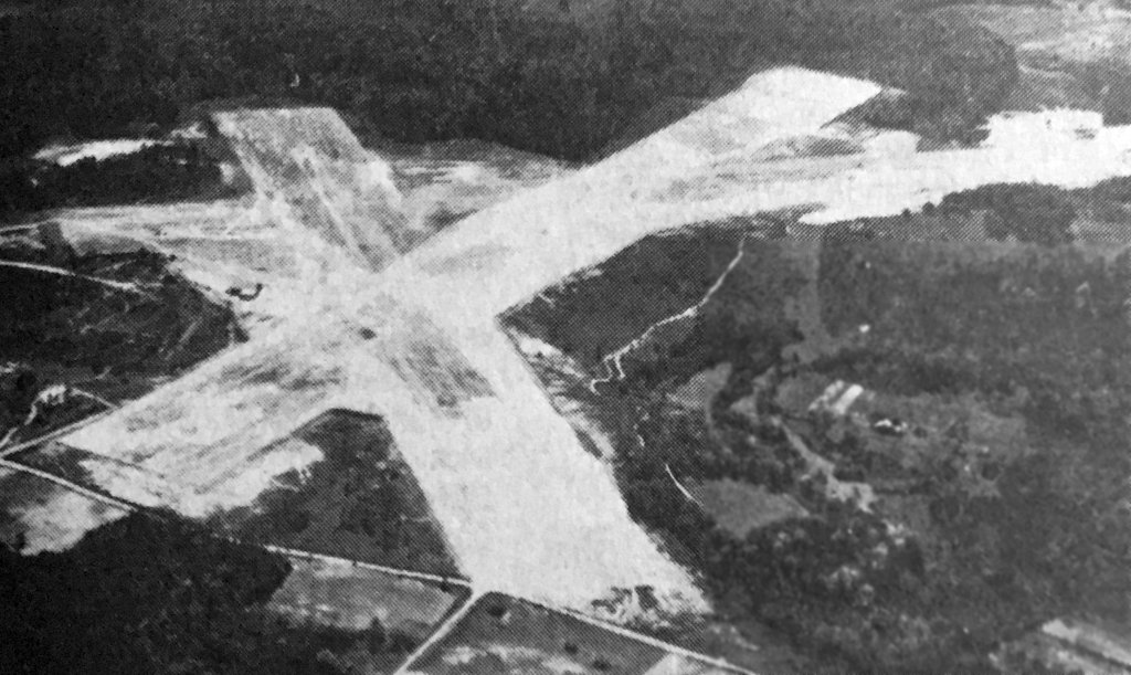
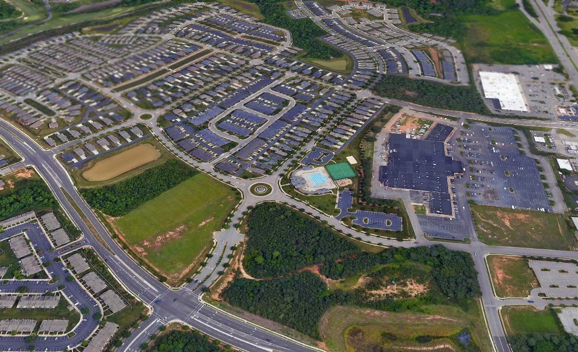
A circa 2014-2018 aerial view looking north at Horace Williams Airport showed a drastically different scene from previous years,
with the University having succeeded in its goal of driving aviation business away from their airport, clearing it for lucrative redevelopement.
Thus the dozens of aircraft parking pads were occupied by a mere 3 light single-engine aircraft.
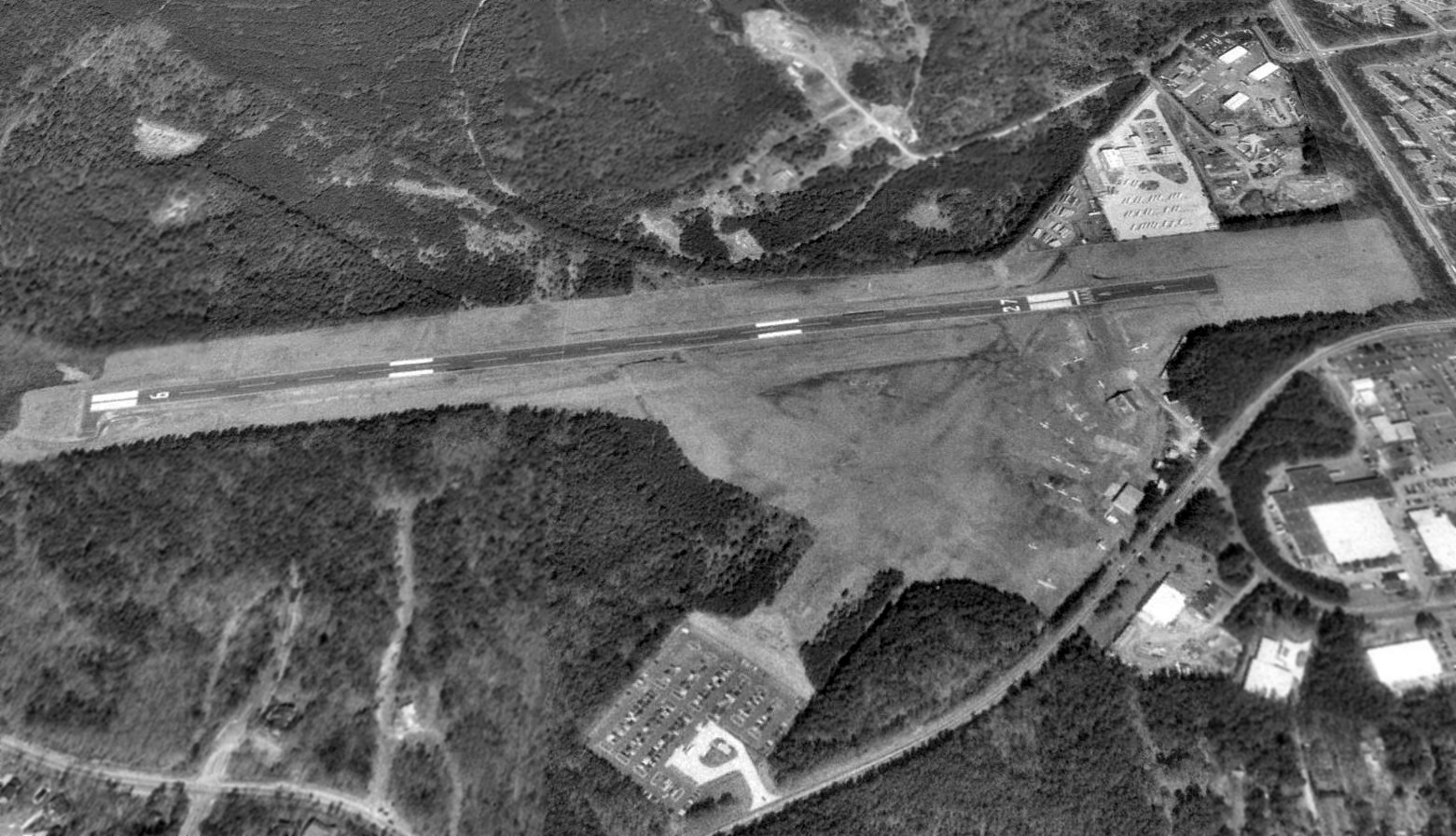
According to its FAA Airport/Facility Directory data, as of 2016 Horace Williams Airport conducted 61 takeoffs or landings per week, and had 15 based aircraft,
It had a 4,000' asphalt Runway 9/27, was owned by the University of NC, and the manager was Kimball Wallace.
A 2/8/18 aerial view looking north at Horace Williams Airport showed the University had succeeded in its goal of driving aviation business away from their airport, clearing it for lucrative redevelopement,
as only 1 aircraft was still visible on the airport.
The 2018 Charlotte Sectional Chart depicted Horace Williams Airport as having a 4,000' paved northeast/southwest runway.
According to Wikipedia, “A NOTAM announced the permanent closure of the airport effective 5/1/18.
According to local news sources, the closure will make way for a solar energy project.
Airplanes based at Horace Williams were removed from the airport prior to May 1.”
According to a local pilot, “A developer with a large chunk of property across the road from Horace Williams was frustrated by height restrictions imposed by the airport,
and he just may have made a large donation to the school.”
What a shame for the University to have all this nice aviation infrastructure going to waste.
____________________________________________________
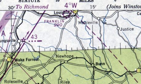
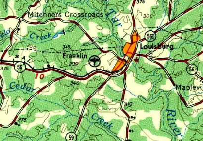
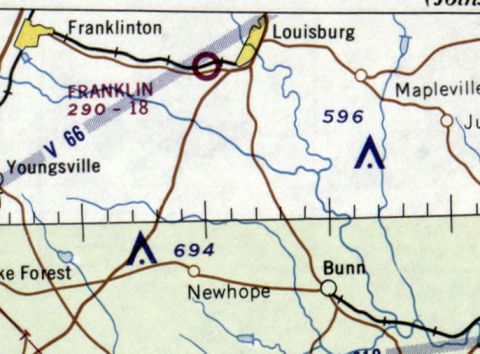
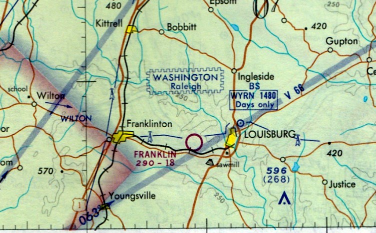
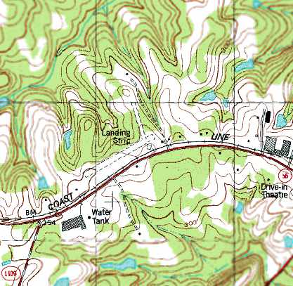
Louisburg Municipal Airport, Louisburg, NC
36.083, -78.314 (Northeast of Raleigh, NC)
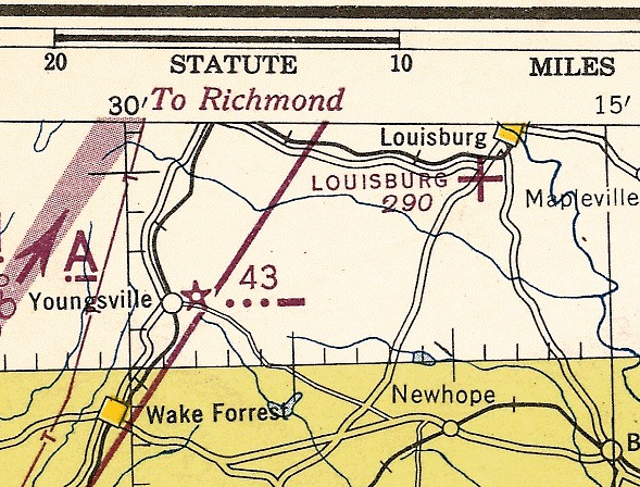
Louisburg Municipal Airport, as depicted on the November 1944 Charlotte Sectional Chart.
This small general aviation airport was located adjacent to the southwest side of the town of Louisburg.
According to Billy Lumpkin, “I have lived in Louisburg since the 1940s.
Lousiburg Municipal Airport was built in 1943,
based on a request by several local pilots to the town of Louisburg to borrow the town’s motor grader for the grading of this site,
from Town of Louisburg minutes dated January 1943.”
The airport was “located at the intersection of U.S. 401 & NC 56”, and its runway was “oriented northeast/southwest.”
Louisburg Municipal Airport was not yet depicted on the April 1944 Winston-Salem Sectional Chart.
The earliest depiction which has been located of Louisburg Municipal Airport was on the November 1944 Charlotte Sectional Chart,
which depicted Louisburg as an auxiliary airfield.
The last aeronautical chart depiction which has been located of Louisburg Municipal Airport was on the March 1945 Charlotte Sectional Chart,
which depicted Louisburg as a commercial/municipal airport.
Louisburg Municipal Airport, as depicted in the 1945 AAF Airfield Directory (courtesy of Scott Murdock).
The directory described Louisburg Municipal Airport as a 24 acre L-shaped property having a single 1,300' partly turfed northeast/southwest runway.
The field was said to have a single 42' x 12' wood hangar.
Curiously the field was described as being owned & operated by “Private interests”, in contradiction to its name of a “Municipal” airport.
The earliest depiction which has been located of Louisburg Municipal Airport was a 1946 photo (courtesy of Mark Flatman)
of 2 Piper Cubs in front of some small hangars & an adjacent Texaco station.
A June 1946 photo (courtesy of Mark Flatman) of an unidentified person in front of a Taylorcraft at Louisburg Municipal Airport.
According to Billy Lumpkin, Louisburg Municipal Airport “was consumed by highway construction - Bickett Boulevard.”
The October 1946 Charlotte Sectional Chart no longer depicted Louisburg Municipal Airport,
but instead depicted the replacement Franklin Field which was constructed a mile to the west.
An 11/18/50 USGS aerial view showed the site of Louisburg Municipal Airport partly covered with construction for the new road.
A 2014 aerial photo showed no recognizable trace remaining of Louisburg Municipal Airport.
The site of Louisburg Municipal Airport is located at the intersection of Route 56 & South Bickett Boulevard.
____________________________________________________
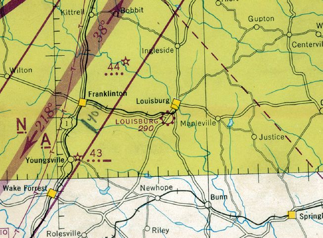
36.087, -78.33 (Northeast of Raleigh, NC)
Franklin Field, as depicted on the October 1946 Charlotte Sectional Chart.
Franklin Field was not yet depicted on the April 1946 Winston-Salem Sectional Chart,
At some point in 1946, after the site of Louisburg Municipal Airport had been covered by the construction of Bickett Boulevard,
Franklin Field was established only a mile to the west, on the north side of Route 56.
The earliest depiction which has been located of Franklin Field was on the October 1946 Charlotte Sectional Chart,
which depicted Franklin as a commercial/municipal airport.
The October 1948 Winston-Salem Sectional Chart (courtesy of Chris Kennedy)
depicted Franklin Field as having a 2,100' unpaved runway.
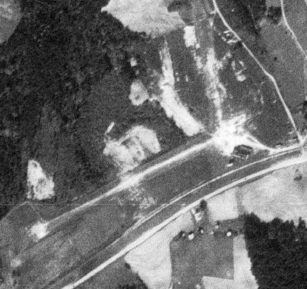
The earliest photo which has been located of Franklin Field was a 11/18/50 USGS aerial view.
It depicted Franklin Field as having 2 unpaved runways, with 1 building (a hangar?) to the southeast.
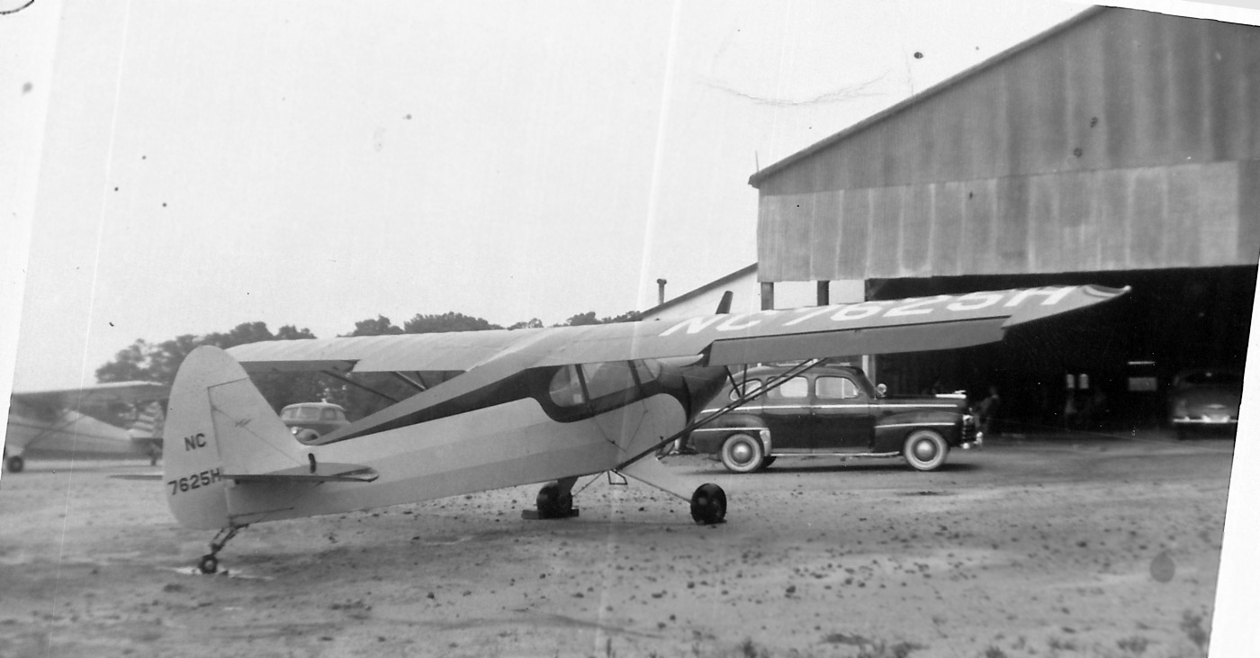
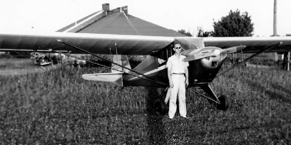
The earliest photo which has been located showing aircraft at Franklin Field was a 1951 photo of a Piper PA-12 in front of a hangar (courtesy of Billy Lumpkin).
According to Billy Lumpkin, “I have lived in Louisburg since the 1940s.
Franklin Field had an old lumber mill in the 'hangar' building.
This hangar would hold 16 aircraft, only if you had Joe Shearon 'directing'.”
The earliest topo map depiction of Franklin Field which has been located was on the 1954 USGS topo map.
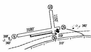
The 1960 Jeppesen Pilot Guide (courtesy of Chris Kennedy)
depicted Franklin Field as having 2 unpaved runways: 2,080' Runway 8/26 & 1,150' Runway 18/36.
A single building (a hangar?) was depicted to the southeast of the runway intersection.
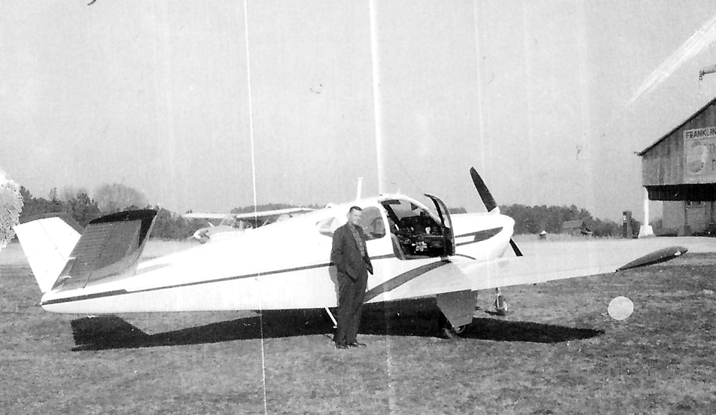
A circa 1960 photo by Billy Lumpkin of Joe Ball in front of his Bonanza at Franklin Field.
Billy lumpkin observed, “Note in the upper right portion that one can read 'Franklin' on the building.”
Billy Lumpkin recalled, “Joe Shearon managed the airport & instructed flying in the 1960s.”
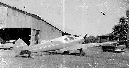
The last photo which has been located showing an aircraft at Franklin Field
was a circa 1960 photo by Billy Lumpkin of a Ryan SCW in front of a hangar at Franklin Field.
Billy recalled, “This Ryan was very rare (one of a dozen or so).
It appeared in movies, and belonged to a U-2 pilot.
In the upper right corner was a metal, elevated water tank left over from the lumber mill days.”
The Airfields table on the July 1961 Charlotte Sectional (according to Chris Kennedy)
described “Franklin Field” as having 2 turf runways, with the longest being 2,080'.
The Airfields table on the April 1964 Charlotte Sectional (according to Chris Kennedy)
described “Franklin Field” as having only a single 1,850' turf runway.
The 1965 Jeppesen Pilot Guide (according to of Chris Kennedy)
described Franklin as having a single 1,850' Runway 7/25.
The October 1968 Charlotte Sectional Chart depicted Franklin Field as having an 1,800' unpaved runway.
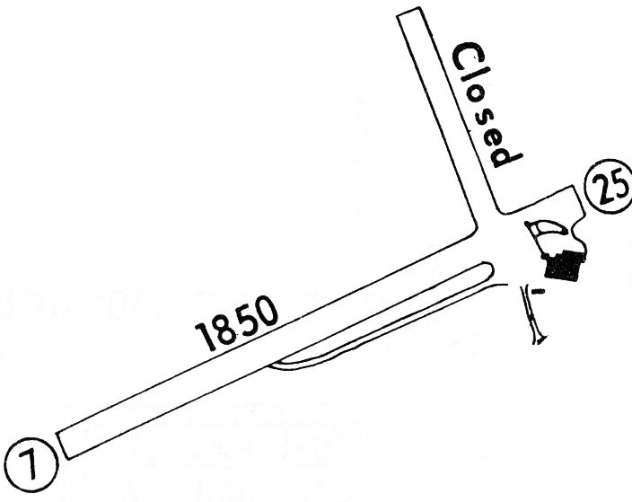
The 1968 Flight Guide (courtesy of Bob Levittan)
depicted Franklin Field as having an 1,850' unpaved Runway 7/25, in addition to a closed crosswind runway.
A single building (a hangar?) was depicted to the southeast of the runway intersection.
The last aeronautical chart depiction which has been located of Franklin Field was on the February 1971 Cincinnati Sectional Chart (courtesy of Ron Plante).
It depicted Franklin Field as having an 1,800' unpaved runway.
The last photo which has been located of Franklin Field was a 2/14/71 USGS aerial photo.
It depicted Franklin Field as having 2 unpaved runways, with a building to the southeast,
and one single-engine aircraft parked on the south side.
Billy Lumpkin noted, “There is an odd shadow southwest of the west corner of the 'hangar'.
This is a metal, elevated water tank left over from the lumber mill days.”
According to Billy Lumpkin, “This site closed about 1971, when the lease expired, and became a tree bark mulch packing plant.”
Franklin Field was was no longer depicted at all on the September 1971 Charlotte Sectional Chart (according to Chris Kennedy).
The 1978 USGS topo map still depicted the 2 unpaved runways, but labeled simply as “Landing Strip”.
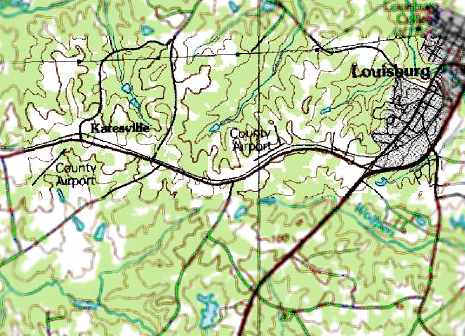
The 1991 USGS topo map continued to depict the original location of Franklin County as “County Airport” (in the center),
but note that it also depicted the replacement “County Airport” to the west.
As seen in the 1999 USGS aerial photo, the site of Franklin Field was built over by an industrial facility,
and there did not appear to be any remaining recognizable trace of a former airfield.
John Sessoms reported in 2007 that at the site of the former Franklin Field,
“the industrial facility manufactures wooden shipping pallets.”
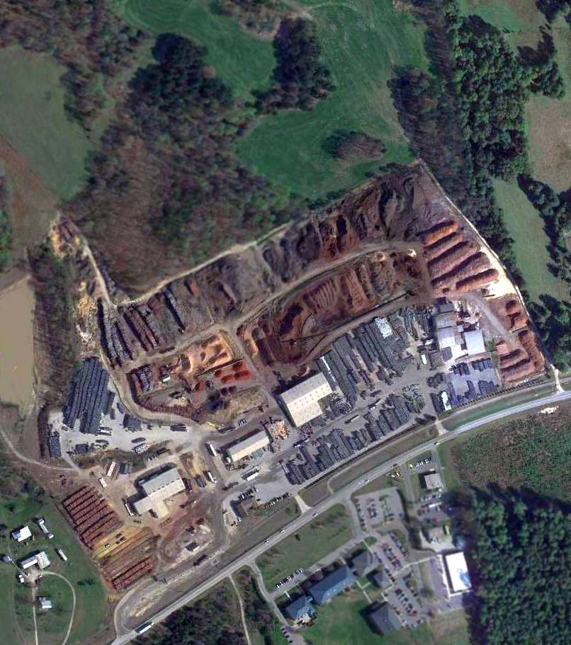
As seen in a 4/9/13 aerial view, there did not appear to be any remaining recognizable trace at the site of Franklin Field.
Billy Lumpkin reported in 2016 that the site of Franklin Field is still “a tree bark mulch packing plant.”
The site of Franklin Field is located northwest of the intersection of Route 56 & T Kemp Road.
____________________________________________________
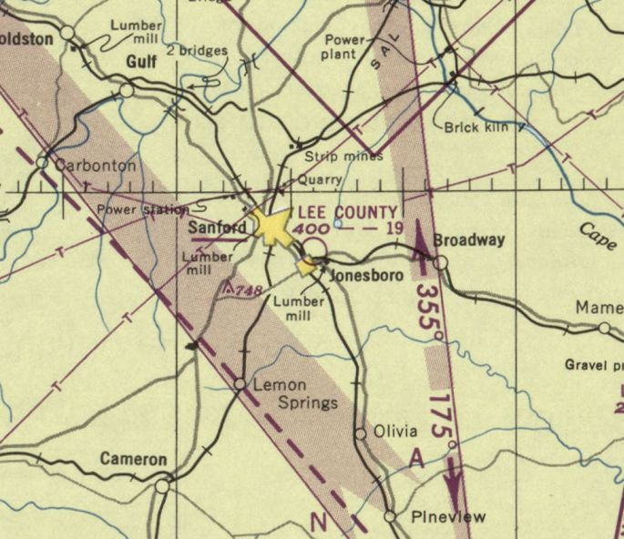
Lee County Airport (original location), Sanford, NC
35.46, -79.16 (Southwest of Raleigh, NC)
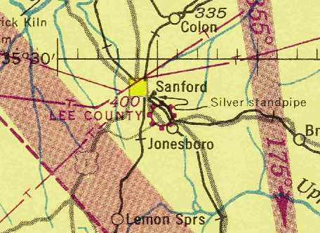
Lee County Airport, as depicted on the April 1944 Charlotte Sectional Chart (courtesy of Chris Kennedy).
Sanford's original airport was located immediately adjacent to the southeast side of the town.
The Lee County Airport was apparently built at some point between 1942-44,
as it was not yet depicted on the February 1942 Charlotte Sectional Chart.
The earliest depiction of the Lee County Airport which has been located was on the April 1944 Charlotte Sectional Chart (courtesy of Chris Kennedy).
It depicted Lee County as a commercial or municipal field.
The April 1944 US Army/Navy Directory of Airfields (courtesy of Ken Mercer) described Lee County Airport as having a 1,900' unpaved runway.
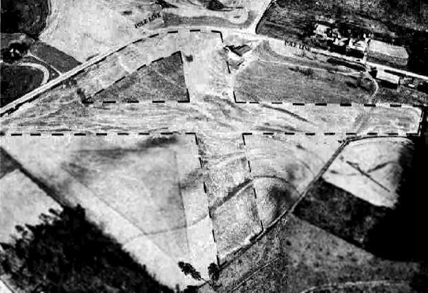
A circa 1943-45 aerial view of Lee County Airport from the 1945 AAF Airfield Directory (courtesy of Scott Murdock).
The directory described Lee County Airport as a 30 acre rectangular property within which were 3 sod runways, with the longest being a 1,900' northwest/southeast strip.
The field was said to have a single 60' x 50' wood hangars,
to be owned by Lee County, and to be privately operated.
The last aeronautical chart depiction which has been located of the original Lee County Airport was on the February 1950 Charlotte Sectional Chart.
It depicted Lee County Airport as having a 1,900' unpaved runway.
The original Lee County Airport was evidently closed at some point between 1950-52,
as it was no longer depicted on the April 1952 Charlotte Sectional Chart or the 1953 USGS topo map.
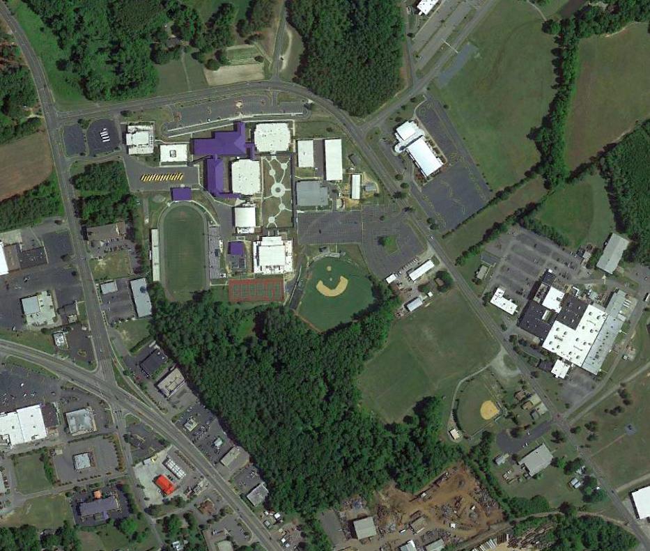
According to Rodney Brewer, “I have lived in Sanford all my life.
The original airport... I am 99% sure that Lee Senior High School sits there today.
Lee County Senior High School wasn't built there until about the late 1940s or early 1950s.”
The original Lee County Airport was eventually replaced by a new Sanford Airport to the southwest of the town.
Neither the 1974 USGS topo map nor the 1997 USGS aerial photo depicted any remaining recognizable trace of a former airfield.
A 2013 aerial photo showed no trace trace remaining of the original Lee County Airport.
The site of the original Lee County Airport is located southeast of the intersection of Nash Street & Bragg Street.
____________________________________________________
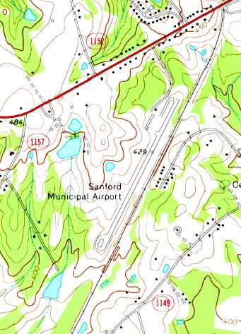
Sanford Lee County Brick Field (W77), Sanford, NC
35.43, -79.18 (Southwest of Raleigh, NC)
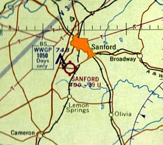
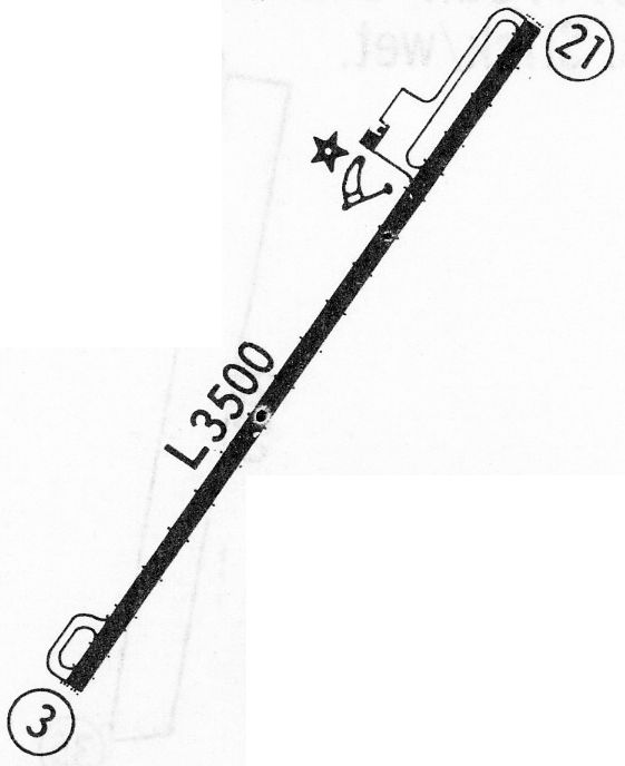
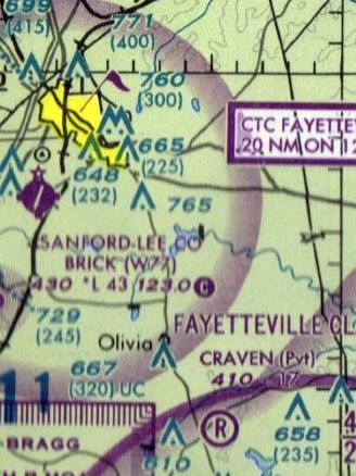
Sanford Airport, as depicted on the 1962 Charlotte Sectional Chart.
At some point between 1961-63, the original Lee County Airport was replaced by a new Sanford Airport, southwest of the town of Sanford.
The new airport was not yet depicted on the January 1961 Charlotte Sectional Chart (according to Chris Kennedy).
The earliest depiction of the Sanford Airport at its new location which has been located
was on the 1962 Charlotte Sectional Chart, which depicted Sanford as having a 3,500' unpaved runway.
Tommy Walton recalled, “I landed my 1930 Fleet biplane on the Sanford Airport on 8/10/63. At that time it was not paved.”
The runway at Sanford had apparently been paved at some point between 1963-68,
as the 1967 Flight Guide (courtesy of Bob Levittan) depicted the field as having a single 3,500' paved Runway 3/21.
The August 1972 Charlotte Sectional Chart (courtesy of Robert Brown) depicted Sanford as having a single 3,500' paved runway.
The 1974 USGS topo map depicted Sanford Municipal Airport
as having a single paved runway with a ramp & 2 small buildings on the northwest side.
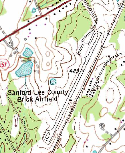
The 1980 USGS topo map depicted Sanford-Lee County Brick Airfield
as having a single paved runway with a ramp on the northwest side.
The last aeronautical chart depiction which has been located of the Sanford-Lee County Brick Airport was on the 1999 Charlotte Sectional Chart.
It depicted Sanford-Lee County Brick Airport as having a 4,300' paved runway.
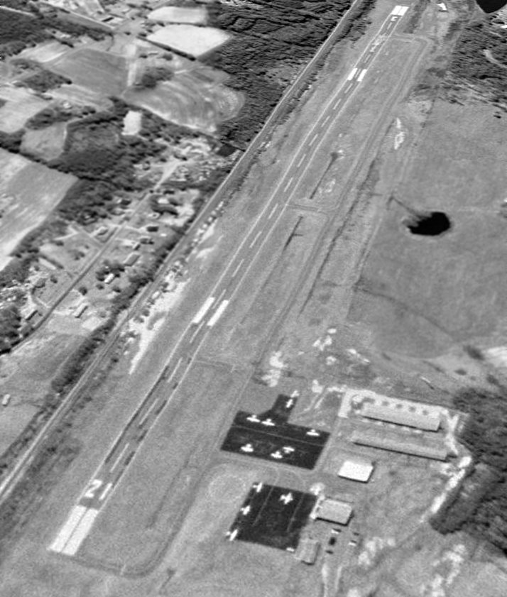
The last photo which has been located showing the Sanford-Lee County Brick Airport in operation was a 2/14/99 USGS aerial view looking south.
It depicted 12 single-engine aircraft parked on the northeast ramps near several small hangars.
Sanford-Lee County Brick Airport closed in 2000 when the larger Sanford Lee County Regional airport was opened on the northeast side of Sanford.
The primary reason for the replacement of this airfield was the inability to obtain a precision instrument approach, due to the proximity of railroad tracks to the runway.
A total of 38 single & multi-engine aircraft were based at the field during its final year of operation.
The Sanford-Lee County Brick Airport property has been purchased by the Central Carolina Community College, which plans to use the runway for police driver training.
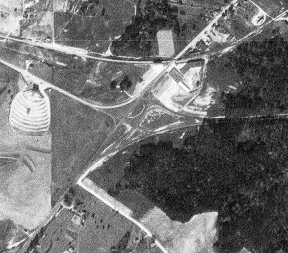
A 2003 aerial photo showed the former Sanford-Lee County Brick Airport remained completely intact, including the runway, taxiway, and several hangars.
But there were no aircraft on the field, and closed-runway “X” markings were painted on the runway.
Melissa Davis reported in 2005, “The Sanford-Lee County Airport is being used by both police & fire departments for training.
Land on the far end of the runway (from the buildings) is now on the property of the new Southern Lee High School, which opened August 2005.
Emergency crews training on the property tell of a small plane that landed on the closed runway a couple of years ago.
The pilot was shocked when the paramedic in charge told him the airport was closed. A lesson in chart updating, perhaps.”
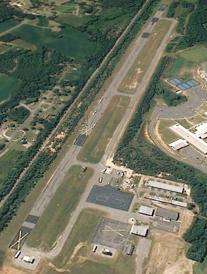
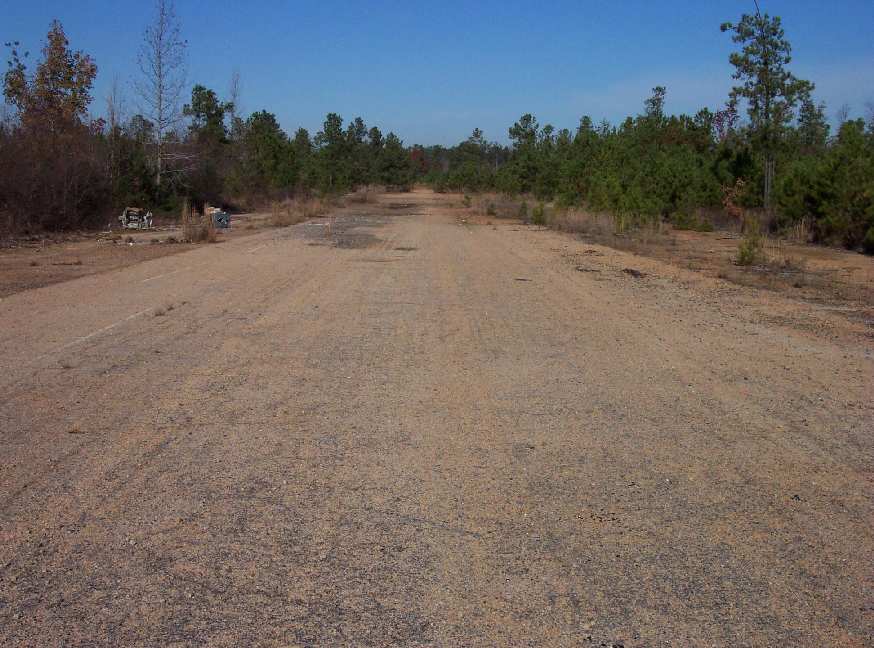
A 5/30/09 aerial view looking south showed the airport remained completely intact, including the runway, taxiway, and several hangars.
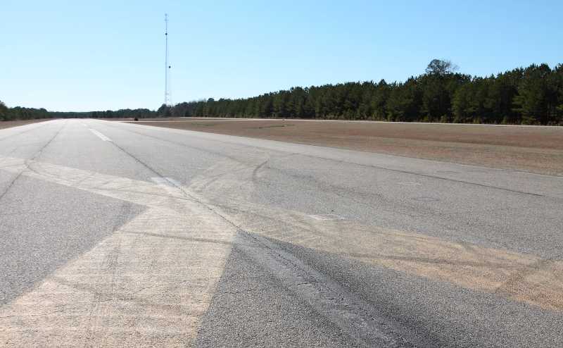
A 1/29/12 photo by Mike Legeros looking south along the Sanford-Lee runway.
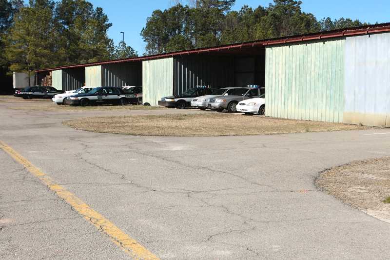
A 1/29/12 photo by Mike Legeros of former hangars at Sanford-Lee now used to store police cars.

A 2015 photo looking southeast at buildings on the Sanford-Lee Airport site.
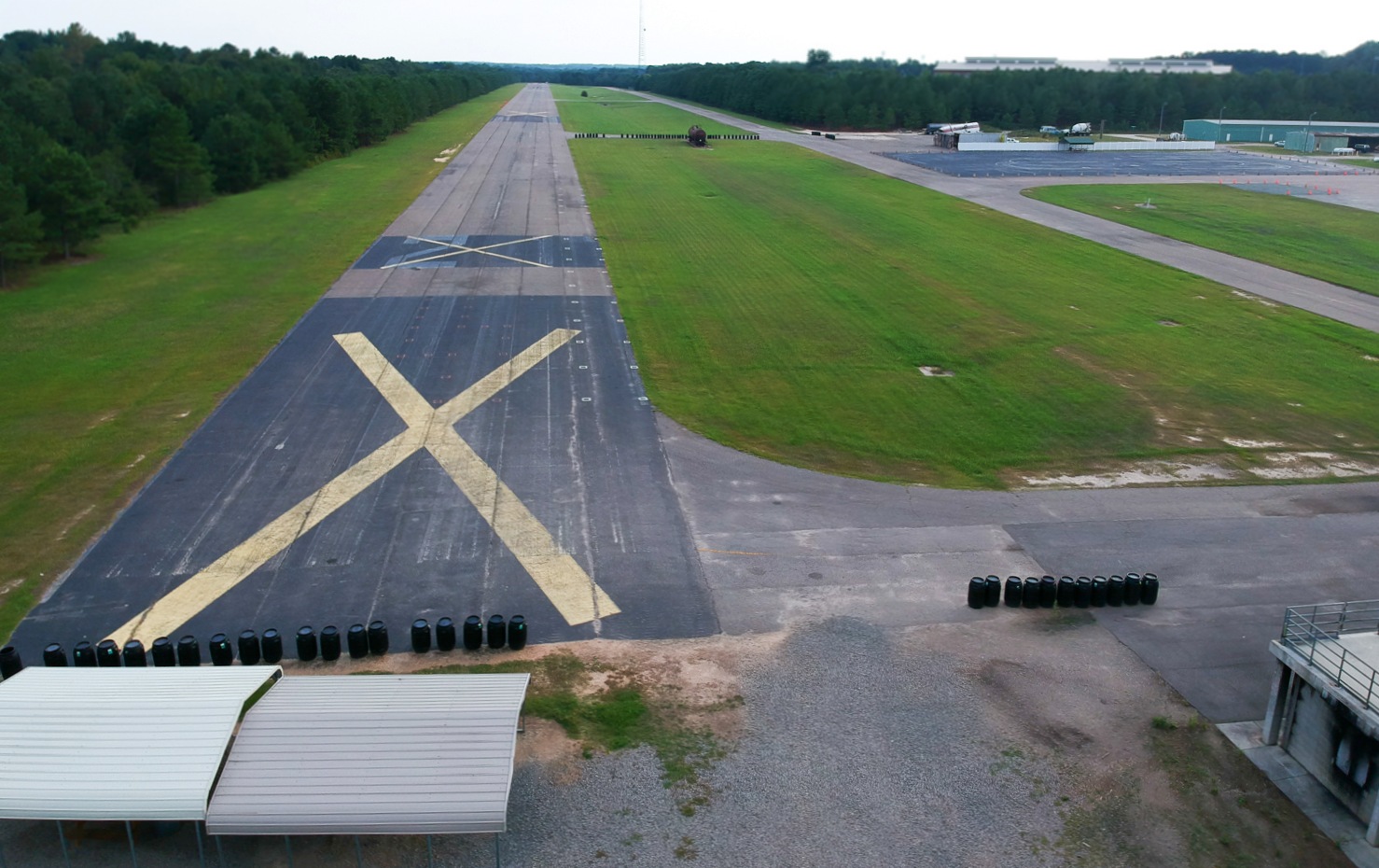
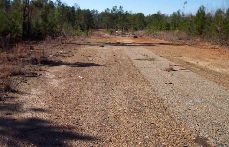
An 8/26/17 drone aerial view by Chris Laforet looking southwest along the Sanford-Lee runway.
Chris reported, “It is still in excellent condition. The Central Carolina Community College owns the property.”
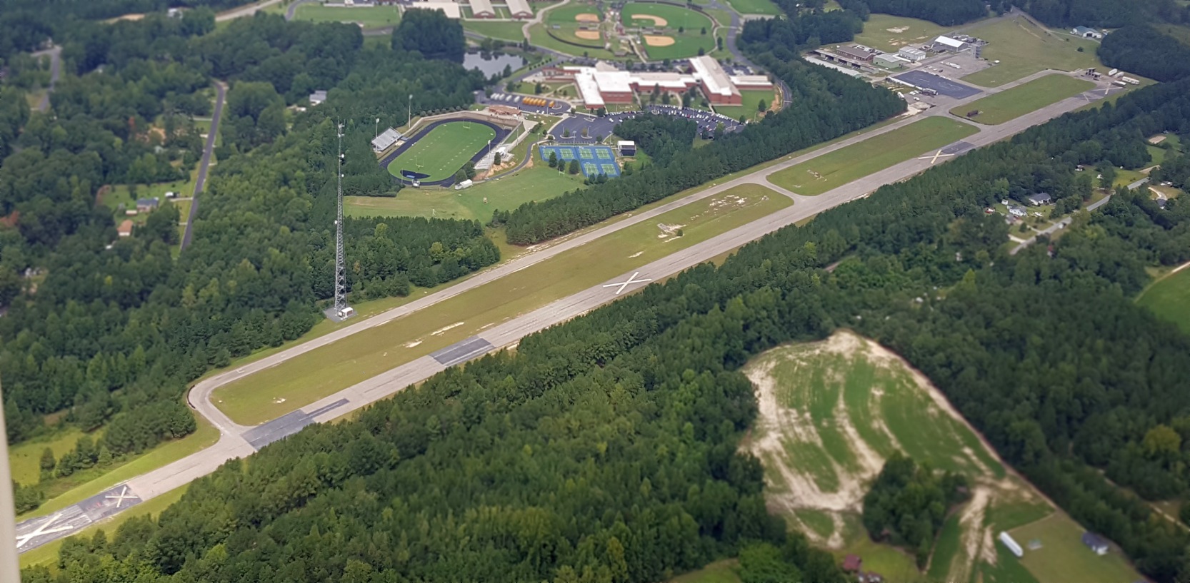
An 8/27/19 aerial view by Greyson Noles looking northwest along at the former Sanford-Lee County Airport.
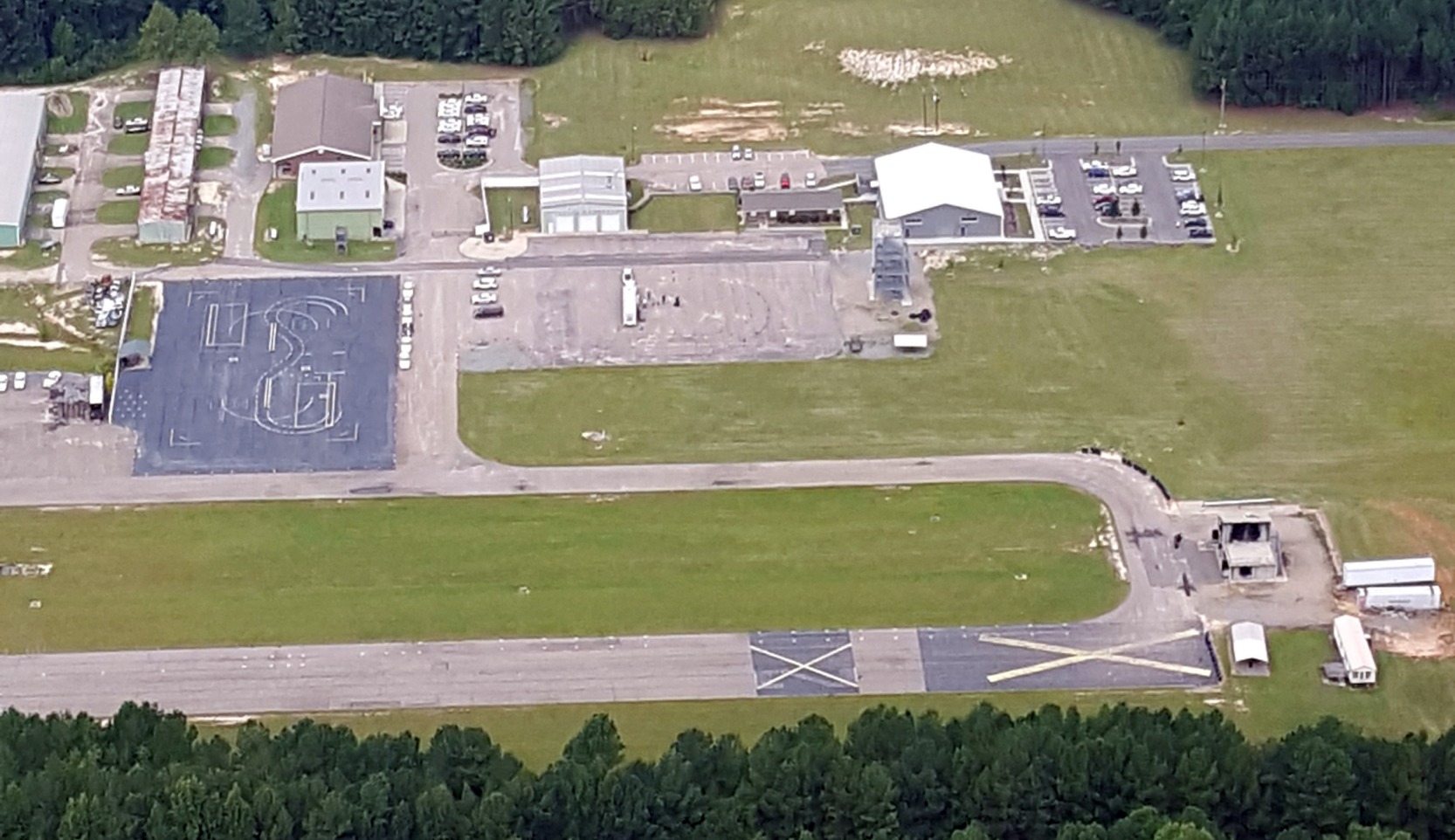
An 8/27/19 aerial view by Greyson Noles looking at the former Sanford-Lee County Airport hangars.

A 2023 photo looking southeast at buildings on the Sanford-Lee Airport site.
____________________________________________________
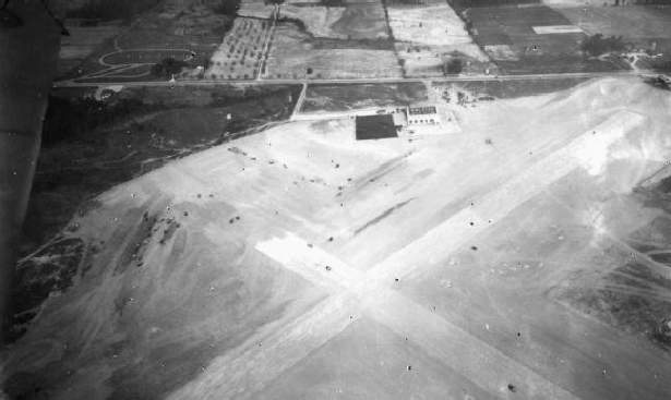
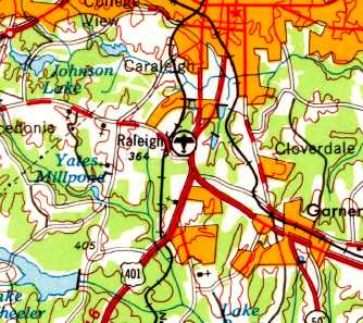
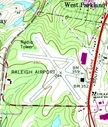
Raleigh Municipal Airport, Raleigh, NC
35.736, -78.655 (Southeast of Raleigh-Durham International Airport, NC)
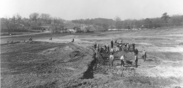
A circa late 1920s photo of the Works Progress Administration construction of Raleigh Municipal Airport.
Raleigh's first air transportation hub was established in 1929 by the Curtiss Wright Flying Service
at the present-day location of the intersection of Tryon Road & U.S. 70-401, south of Raleigh.
The company leased the property, and built 3 runways & a hangar.
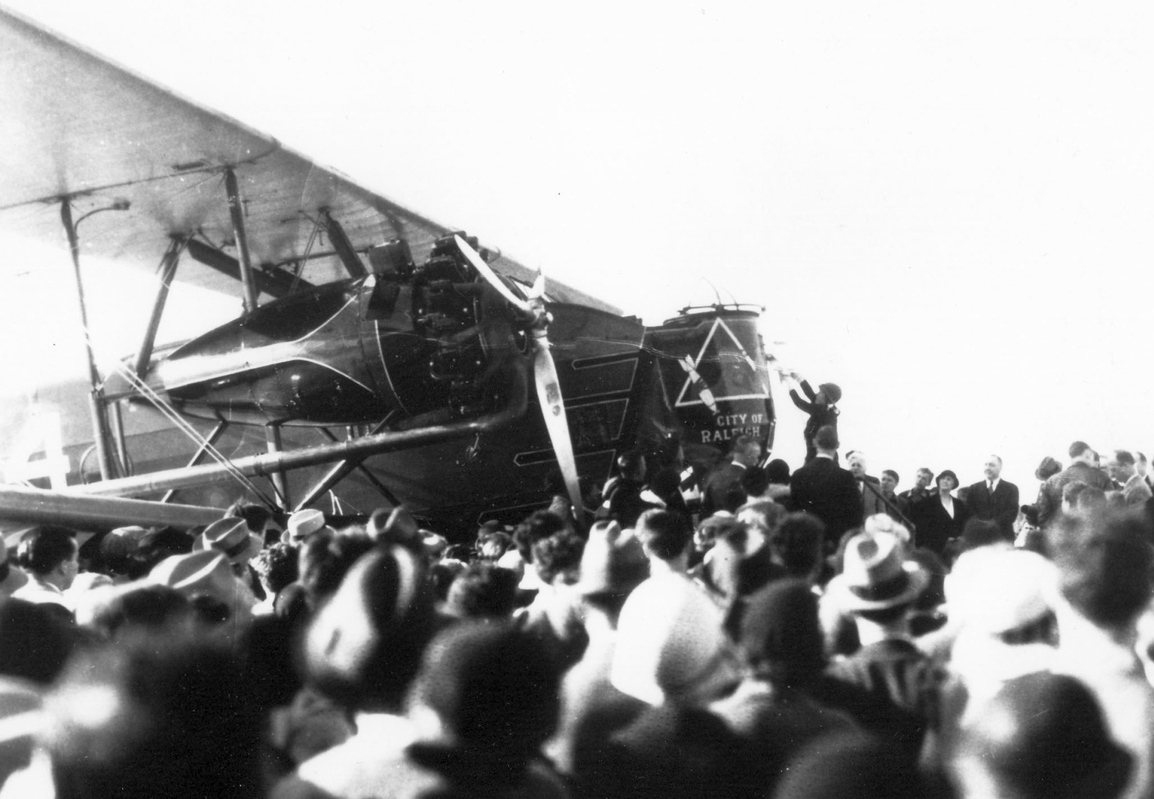
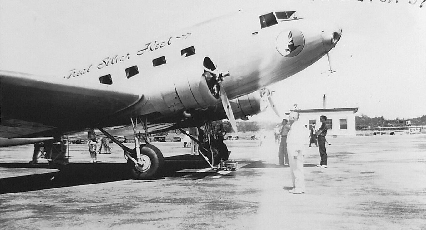
A 1929 photo of Keystone B-5A "The City of Raleigh" being christened by Annie Underwood at Raleigh Municipal Airport's Dedication (courtesy of David Amos).
According to David Amos, “It was an Army bomber, converted to an airliner.
Miss Underwood was Raleigh's first female pilot, as her husband was the manager of the airport.
On the front of the plane, in front of the pilot, you can see the big gun turret, with the gun removed.
The name of the plane is painted on the front, as well as a picture of a bomb pointed down.”
According to David Amos, the dedication of Raleigh Municipal Airport was attended by such notables as Josephus Daniels & Thad Eure.
Eddie Rickenbacker (former WW1 ace, then owner/pilot for Eastern) flew a Curtiss Condor (a 15-passenger twin-engine biplane, huge for its time).
David reported, “An air route was established from NY to FL, with Raleigh as the half-way stop.
Three planes arrived from New York, and 2 letters were delivered, officially establishing the air route & air-mail service on the route.
They made a big deal of the fact that 'You can now eat breakfast in NY, lunch in Raleigh, and supper in FL, all in the SAME DAY!'”
The article "N.Y-Florida Air Service Through Raleigh Started" in the 9/19/29 Raleigh Times (courtesy of David Amos)
described the airport under 2 different names: “Curtiss Field” & “Curtiss Airport”.
A circa early 1930s aerial view of Raleigh Municipal Airport, possibly showing the field at an early stage with just one runway.
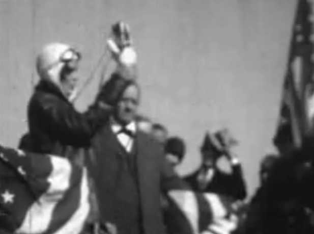
A still from a 1931 movie of Amelia Earhart christening her plane at Raleigh Municipal Airport
(by James Denmark, copyright Jay Denmark of Denmark Studios, used with permission).
Jay reported, “I actually talked to some folks that were there that day.”
Two monoplanes & a biplane in front of the Raleigh Municipal Airport hangar, from a 1931 movie of Amelia Earhart at Raleigh Municipal Airport
(by James Denmark, copyright Jay Denmark of Denmark Studios, used with permission).
A circa early 1930s aerial view looking east at Raleigh Municipal Airport (courtesy of the NC Division of Archives & History, via Mark Turner)
depicted the field as having 2 runways, with a hangar & ramp.
A circa early 1930s aerial view looking northwest at Raleigh Municipal Airport (courtesy of the NC Division of Archives & History, via Mark Turner)
showed that a 3rd (east/west) runway had been added.
Eastern Air Transport, the predecessor of Eastern Airlines,
began passenger & airmail service to Raleigh Municipal in 1932 using Curtiss Kingbird biplanes.
They operated 2 daily trips between New York & Miami.
The Airport Directory Company's 1933 Airports Directory (courtesy of Chris Kennedy)
described Raleigh's “Curtiss-Wright” Airport as a commercial airport, consisting of a 300 acre clay & sand field.
It was said to have a total of 5 runways, with the longest being 3,200'.
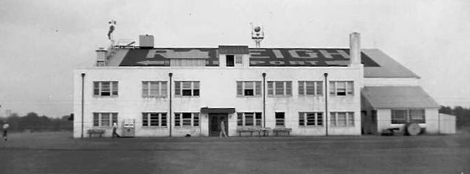
A hangar was said to have “Raleigh” painted on the roof.
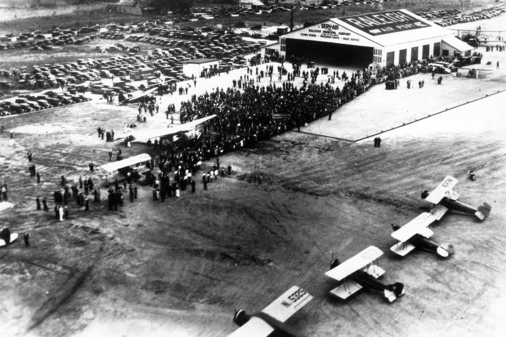
Curtiss Wright Flying Service went bankrupt, and the city leased the property in 1933.
The Serv-Air company provided airport services, including a flying school & passenger flights.
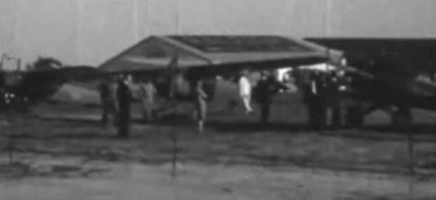
A 1934 photo of the grand re-opening of Raleigh Municipal Airport's Dedication (courtesy of David Amos).
David Amos reported, “In 1934, they had a grand re-opening of the newly renovated Quarter-Million Dollar Airport.
Imagine that, a quarter of a million tax dollars from what was a small town at the time, in the middle of the Great Depression.
The 3 runways had been paved & were lighted. The airport was advertised as an 'All-weather airport'.
Some pilots said 'It was the finest airport east of the Mississippi.'
A huge crowd was there for the event, and many famous people attended.
Some Army biplanes put on an air show, complete with stunts, there was a parachute jump, auto vs. airplane races, and other festivities.
There was a police motorcycle guarding the Army biplanes, the pilots in their white suits can be seen in the crowd surrounded by fans, there is a Ford Tri-Motor plane.
At the far end of the hangar, you can see the huge 'City of Raleigh' biplane.
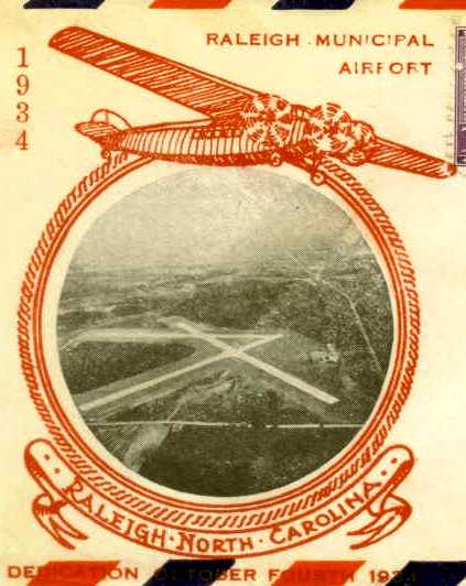
An elaborate postmark commemorated the 10/4/34 “Dedication” of Raleigh Municipal Airport (courtesy of Mark Hess).
This second dedication was evidently to mark the reopening of the airport under the lease of the City of Raleigh.
The postmark featured an undated aerial view showing 3 paved runways & a building on the east side.
The 1934 Department of Commerce Airfield Directory (courtesy of Chris Kennedy) described Raleigh Municipal as having 3 clay, sand, and grass runways,
with the longest being the 3,475' northwest/southeast strip. The hangar was said to have "Raleigh" painted on the roof.
During its heyday, the Raleigh Municipal Airport was a wondrous place. Folks flocked to air shows that included wing-walkers.
Hundreds visited on Sundays just to watch planes land & take off.
Gene Autry, Dinah Shore, Will Rogers & Amelia Earhart all caused excitement when they landed.
The earliest chart depiction which has been located of Raleigh Municipal Airport was on the May 1935 Charlotte Sectional Chart.
An aerial view looking northwest at Raleigh Municipal from the 1936 book "Emergency Relief in North Carolina" (courtesy of Nick Demilio).
The Airport Directory Company's 1937 Airports Directory (courtesy of Bob Rambo) described Raleigh Municipal as having 3 clay & sand landing strips.
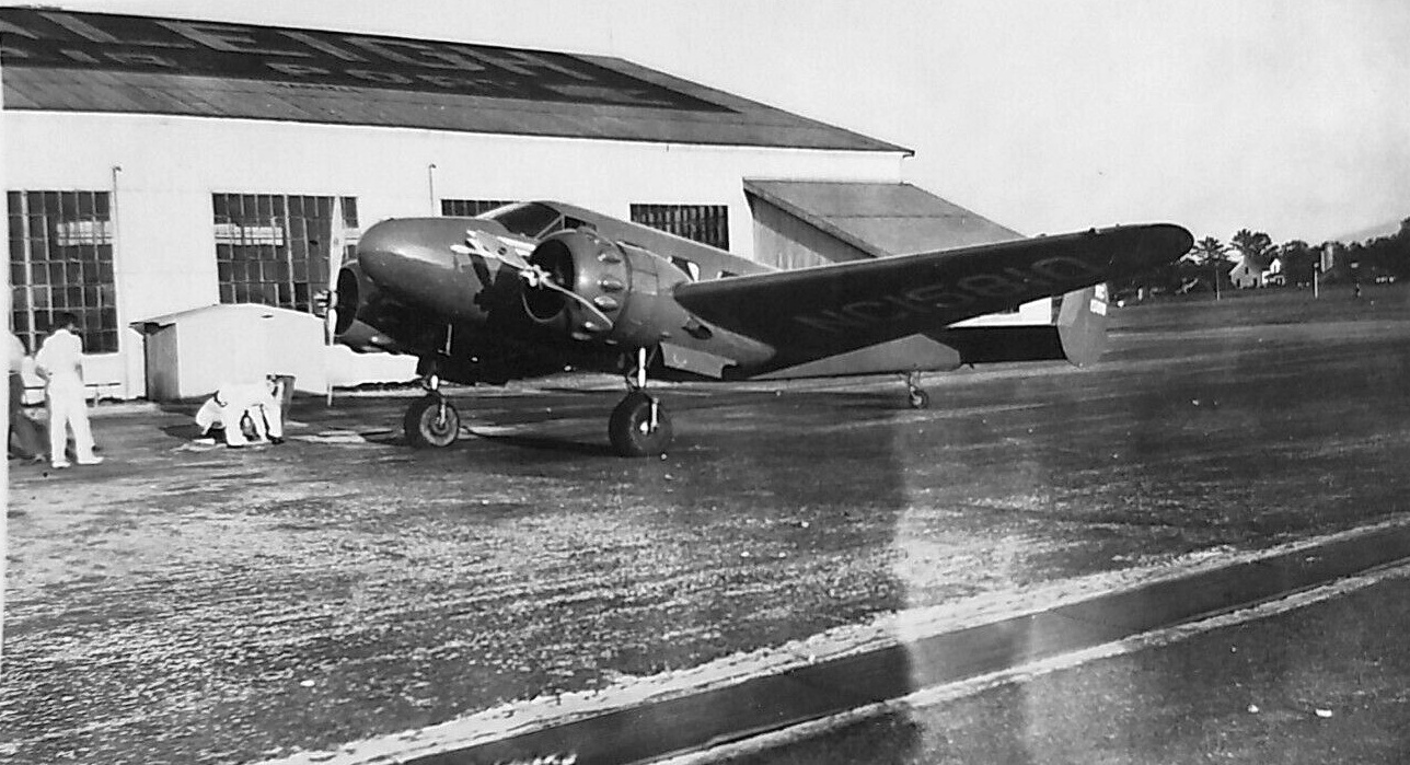
A 1937 photo of a Beech 18 in front of the Raleigh Municipal Airport hangar.
A 1937 photo of a Douglas DC-2 at Raleigh Municipal Airport.
The Airport Directory Company's 1938 Airports Directory (courtesy of Chris Kennedy) described Raleigh Municipal as having 3 hard-surfaced runways.
Serv-Air Inc. was listed as providing flight instruction, sales, and service.
A lifelong Raleigh area resident, Gracie Beck (the grandmother of the wife of the author of this web site)
recalled taking a sightseeing flight from Raleigh Municipal Airport in the late 1930s or early 1940s.
A 4/23/38 aerial view showed Raleigh Municipal Airport to have 3 asphalt runways.
By the late 1930s, business was outgrowing Raleigh Municipal Airport.
The runways of Raleigh Municipal were only 2,100' long, and could not be expanded due to the geographic constraints of the site.
DC-3s could not take off fully loaded with passengers or cargo because the runway was too short.
of the Raleigh office of the National Weather Service, from 1940-1944.
Raleigh held the lease until 1940, when it joined in the land purchase for a replacement airline airport,
Raleigh-Durham Airport, 12 miles to the northwest.
Raleigh Municipal lost traffic. Private owners purchased the facility & later leased it to others.
A 1941 photo of a taildragger in front of the hangar at Raleigh Municipal (courtesy of Billy Lumpkin, whose Uncle George Lumpkin was in the Civilian Pilot Training program there).
A 1941 photo of the hangar at Raleigh Municipal (courtesy of Billy Lumpkin, whose Uncle George Lumpkin was in the Civilian Pilot Training program there).
Raleigh Municipal was used by military aircraft during WW2.
Michael Yonkovig recalled, “My uncle, Daniel Yonkovig, was training to be a WW2 pilot at Raleigh Municipal Airport & and was killed by lightning on 8/26/43.”
The 1945 AAF Airfield Directory (courtesy of Scott Murdock) described Raleigh Municipal Airport
as a 293 acre rectangular property within which were 3 asphalt runways, with the longest being a 2,800' northwest/southeast strip.
The field was said to have a single 120' square steel hangar, to be privately owned, and operated by the City of Raleigh.
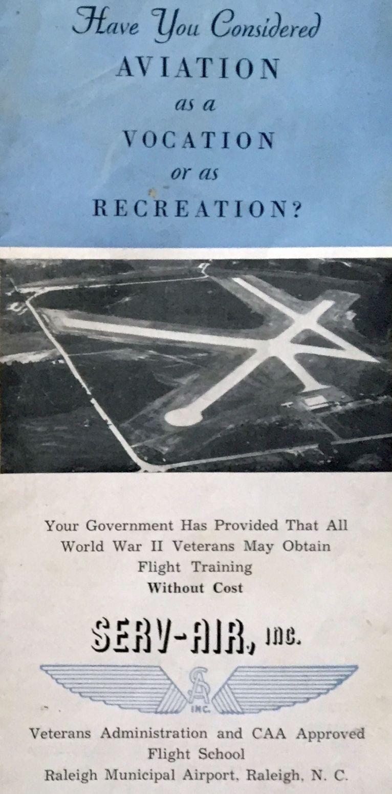
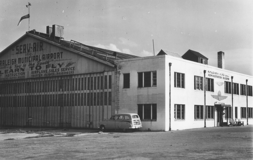
The cover of a post-WW2 brochure for Raleigh Municipal Airport's Serv-Air Inc. (courtesy of David Stevenson),
featuring an undated aerial view looking west at the airport.
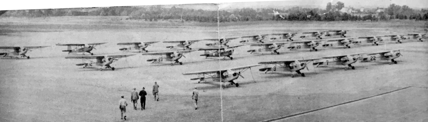
An undated photo of 19 Piper Cubs & 3 Aeronca L-3s from a post-WW2 brochure for Raleigh Municipal Airport's Serv-Air Inc. (courtesy of David Stevenson).
A circa 1950s view of the hangar at Raleigh Municipal (courtesy of the NC Division of Archives & History, via Mark Turner).
The earliest topo map depiction which has been located of Raleigh Municipal Airport was on the 1953 USGS topo map.
Dennis Crenshaw recalled, “Raleigh Municipal Airport... Dad kept an airplane out there since 1953.
I was around the airport as a kid in the 1950s when my Dad owned a Stinson 10A & a J-3 Cub.”
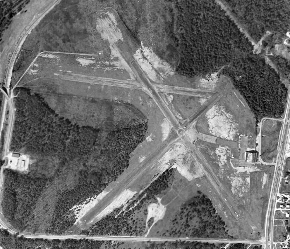
A 3/24/59 USDA aerial view (from the UNC Libraries) depicted Raleigh Municipal Airport as having 3 paved runways.
A closeup from the 3/24/59 USDA aerial view (from the UNC Libraries) depicted a total of 21 light aircraft on Raleigh Municipal Airport, including 2 twin-engine aircraft.
Note the “M” (for Municipal?) in the circle at the runway intersection.
Also note the “U.S. Army” lettering visible on the east side of the hangar roof – what was the purpose of that?
Raleigh Municipal was still listed among active airports in the 1962 AOPA Airport Directory,
with 3 asphalt runways (14/32: 2,800' long, 4/22: 2,600' long, and 9/27: 1,800' long), and the operator listed as Justice Aero Company.
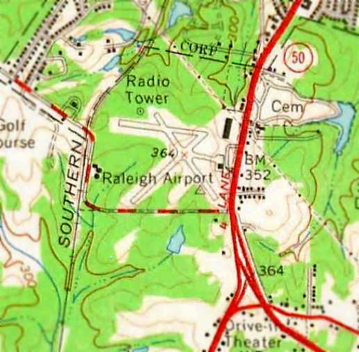
The 1964 USGS topo map depicted “Raleigh Airport” as having 3 paved runways, with a taxiway leading to a single hangar on the east side of the field.
Note the shopping center which had been built at some point between 1959-64 in close proximity to the northeast corner of the field.
The 1968 Flight Guide (courtesy of Bob Levittan) depicted Raleigh Municipal Airport
as having 3 paved runways, with a taxiway leading to a single hangar on the east side of the field.
Dennis Crenshaw recalled, “Raleigh Municipal Airport... In the mid 1960s there was an airport dog named Pork Chop who was a regular fixture at the airport.
He was a sandy colored dog, probably a lab.
One day I came out to the airport to fly my father's Stinson 10A that we kept in the hangar, and learned that old Pork Chop had died.
Even though I was 20 or 21 years old, I shed a tear for him. He was part of the airport culture.
They buried him at the southeast corner of the hangar right where the cars pulled up to park, and his grave was marked with a wooden cross there.
As a 20 year old in 1968 I took flying lessons from Bill Wilser.
He ran the Fixed-Base Operator (Raleigh Flying Service) from 1968 until the airport closed.
Bill was an IBM electrical engineer who ran the airport on the side.
Alonzo Coots, an N.C. State chemistry professor, was a part-time flight instructor
and gave me dual instruction in preparation for my Private Pilot checkride in July 1969.”
An October 1969 photo of Dennis Crenshaw at Raleigh Municipal Airport.
Dennis observed the picture is “of me, 21years old, standing next to our Stinson, with the south facing door of the hangar in the background.
I had just gotten my Private Pilot signed off. I was in college (N.C. State) and had just gotten my license in July. Lots of good memories.”
A 1969 photo of Dennis Crenshaw taking off to the northeast from Raleigh Municipal Airport's Runway 4 in his Stinson.
Eddie Lord recalled of Raleigh Municipal Airport, “Where I started flying, with my first flight in a Cessna 150 (N22270) 8/6/70
and my last flight there on 8/28/71 (Cessna 150 N61014) when I passed my Private Pilot License check flight.
My instructor was a Johnny Skaar.”
A 1971 photo by Ron Benson of Radger Harris in front of a Beech Staggerwing at Raleigh Municipal.
According to Radger, the plane was “parked near the intersection of Runways 9 & 14, the camera was pointed south.”
Dennis Crenshaw recalled, “I well remember the Staggerwing Beech - it was a beautiful airplane
and was tied down on the south side of the taxiway coming off the ramp towards the intersection of Runways 14/32 & 4/22.”
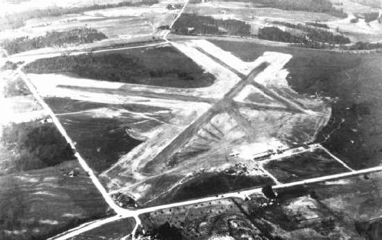
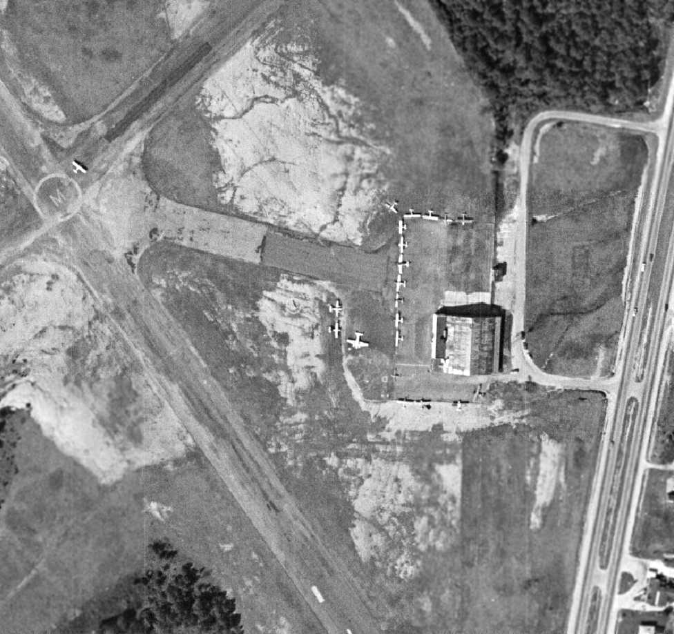
A 2/24/71 USDA aerial view of Raleigh Municipal Airport (from the UNC Libraries).
Although the airport configuration was unchanged from earlier depictions,
a shopping center had been built in close proximity to the northeast corner of the field,
and trailers or other non-aviation items were being stored in close proximity to the southeast corner of the field.
A closeup from the 2/24/71 USDA aerial view of Raleigh Municipal Airport (from the UNC Libraries)
depicted the field at perhaps its height of popularity – with no less than 37 light aircraft visible on the field, including 2 twin-engine aircraft.
Note the “Raleigh” lettering visible on the west side of the hangar roof.
A 1971 airfield directory (courtesy of Chris Kennedy) depicted Raleigh Municipal Airport
as having 3 paved runways, with the longest being the 2,600' Runway 4/22.
The ramp & a single hangar were depicted on the east side of the field.
Dennis Crenshaw recalled, “I left Raleigh for the Navy in August 1971
and remember having to move our Stinson off the airport because the airport was closing down.
Sad day for me, because Dad had kept an airplane out there since 1953.”
Radger Harris recalled, “In 1972 I worked for Norman Bellamy of Garner, NC.
Mr. Bellamy owned a Cessna which he kept tethered at RMA.
Several times he & I took our lunch breaks at the airport flying high over Raleigh,
and once he allowed me to pilot his airplane on takeoff over highway 401 & around the airfield a few times.”
The last aeronautical chart depiction which has been located of Raleigh Municipal Airport
was on the 1972 Charlotte Sectional Chart (courtesy of Robert Brown).
It depicted Raleigh as having 3 paved runways, with the longest being 2,600'.
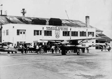
Dennis Crenshaw recalled, “The airplane in the foreground (N148V) a 1959 Cessna 182, belonged to Alonzo Coots, an N.C. State chemistry professor.”
Checking my father's log book, he had his first dual instructional flight out of Raleigh Municipal Airport 8/22/51. Our first airplane, the Stinson, shows up in his log 4/19/53.”
Raleigh Municipal Airport closed in 1972.
The property was sold to a developer, whose dreams of a big shopping center & industrial park never materialized.
A road (Chapanoke Road) was built from Route 401 extending west into the former airport property,
and a half-mile long road segment running north/south was built over the area of the former runway intersection,
partially overlaying some of the runways.
In 1973, the Norfolk Southern Corporation (a railroad company) bought the Raleigh Municipal Airport property,
and the hangar & administration building were razed in 1974.
David Amos recalled, “Sometime after Raleigh Municipal Airport closed, people started using one remaining runway for drag racing on the weekends.
It was almost like a public event, with regular spectators cheering for their favorite car.
The cops didn't seem to mind, because it kept the drag racers off the streets.
Sadly, one night a car lost control & went into the crowd, and so they had to shut it down.
They came in with a bulldozer & cut deep trenches across the runway at intervals to shut it down.”
The last depiction which has been located of the Raleigh Municipal Airport was on the 1980 USGS topo map.
It continued to depicted the 3 paved runways & the hangar, even though the hangar had reportedly been razed 6 years previously.
A 1983 aerial view showed the majority of the former Raleigh Municipal Airport runways were still intact,
but the hangar had been replaced by several retail buildings.
Raleigh Municipal Airport was no longer depicted on the August 1988 Charlotte Sectional Chart (courtesy of Ron Plante).
By 1987 the Raleigh Municipal Airport runways were no longer depicted on the 1987 USGS topo map, just their outlines.
A 1993 aerial view looking north showed the 3 Raleigh Municipal runways remaining largely intact, but a shopping center had been built over the eastern portion at some point between 1983-93.
Radger Harris recalled, “In 1994 I went to work for Parker-Lincoln Developers (now BPG Ltd.),
and they eventually bought & managed the property & the building at that location.
I was Parker-Lincoln's locksmith at the time & I was responsible for physical security at that property.
I used to walk the runways when I worked there, and I was familiar with the vagrants & homeless people who lived in the wooded area behind the building.”
Jan Chamblee recalled, “I am a Raleigh firefighter that was assigned to Station 2 on Pecan Road near Sam's Club from 1996-98.
While there, our company routinely trained behind the old Pack & Save grocery store built on the former Raleigh Airport grounds.”
The 250 acre site was still owned by Norfolk Southern as of 2002, but not used, apparently just waiting for the right offer.
They had a few trailers on the Northeast side of the property where they stored railroad equipment.
A 2002 photo by Paul Freeman looking northwest at the front of the shopping center (mostly vacant)
which was built over the location of the former hangar at Raleigh Municipal.
Amazingly, the remains of the southeast end of Runway 32 were still perceptible in the grass in the foreground,
running straight toward the shopping plaza.
The remains of this end of the runway were also visible in the recent aerial photo.
A 2002 photo by Paul Freeman looking northwest from the back of the shopping plaza along the remains of Runway 32.
The majority of the former airport property consisted of a wooded area directly adjacent to the back of the shopping plaza.
The remains of Runway 14/32 extended away from the shopping plaza parking lot toward the northwest.
A steel railing had been constructed by the property owner, presumably to prevent vehicular access onto the former runways.
A 2002 photo by Paul Freeman looking southeast toward the back of the shopping plaza along the remains of Runway 14.
A 2002 photo by Paul Freeman looking northwest from the runway midpoint along the remains of Runway 32.
Runway 14/32 was the most intact of the 3 former runways, although even it had several patches of trees which had sprouted up through the former pavement.
The remaining length of Runway 14/32 was 3,400'.
A 2002 photo by Paul Freeman looking southwest along the remains of Runway 4.
The majority of Runway 4/22 had been obliterated by the shopping plaza parking lot & the road built for the abortive industrial park.
Only the southwest third of Runway 4/22 still existed,
and a large dirt mound had been placed along it (possibly intended early on after the field's closure to discourage unauthorized landings).
Runway 9/27 was the most deteriorated of the 3 former runways.
The eastern portion had been mostly obliterated by the industrial park roadway.
The western portion of Runway 9/27 still existed (west of its intersection with Runway 14/32),
but the pavement remains were considerably more deteriorated & less obvious than those of Runway 14/32.
No remains still existed of any airport buildings.
As of 2002 the shopping center which bordered the former airport property was mostly vacant,
and the wooded former airport property was the site of several violent crimes.
Patricia Brezny reported in 2003, "I live within a few miles of there & pass it often.
There is (at least was for a long time now & probably still is) a 'for sale' sign located on the Tryon Road side of the property.
I have also noticed that vagrants live behind the shopping mall to the Tryon Road side.
I know that the City of Raleigh would like to straighten out Tryon Road so that it goes directly
(in a straight line across the airfield) from the bridge across the railroad tracks to the intersection with 70/401.
This is actually a part of the Capital Improvements Plan which includes the widening (to 5 lanes) of Tryon Road,
but the City is waiting for the State to replace the bridge across the railroad."
David Amos recalled, “After the shopping center was built, when there was still a stretch of the original runway in the woods behind the shopping center,
I heard that the pavement wasn't going to be there much longer, because it was going to be developed over with houses.
I went out there, parked behind the shopping center at the guard rail shown in the pictures, and walked along the old runway back into the woods.
The trenches that had been dug across the pavement by then had some pretty good size pine trees growing in them.”
The last photo which has been located showing the remains of the Raleigh Municipal runways being largely intact was a 6/14/05 aerial view looking north.
Les Parker reported in 2006, “It is sad for me to pass this along,
but the site of the Raleigh Municipal Airport has been cleared behind the shopping center.
When I passed behind the site a few days ago, heavy equipment was scraping the site.
I saw no evidence of the runways other than piles of concrete.
I don't know what is planned, but the Raleigh Police Department had a major problem
with a homeless camp in the area north & west of the triangle formed by the runways.
I also did not see the 'For Sale' sign as I passed.”
A 3/29/06 aerial photo showed the site had been largely cleared for new construction.
Greg Kissel reported in November of 2006, “The site of the old Raleigh Municipal Airport
has been completely scraped clean within the last few months in preparation for condos.”
George Smart reported in 2007, “The old Raleigh Municipal property was sold by the railroad.
The runways are now completely obliterated & building has commenced.”
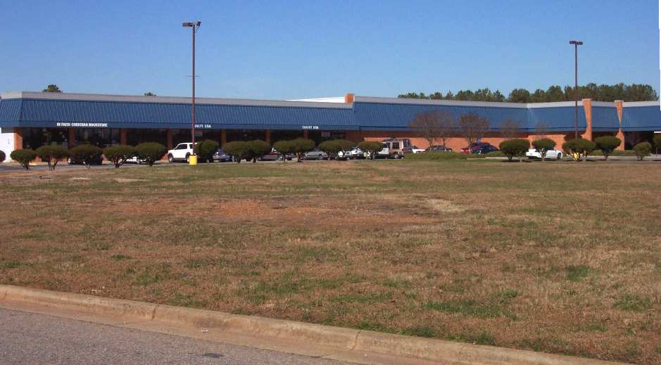
A 2007 photo by Phil Brooks, looking west from the back of the shopping center at the site of the former Raleigh Municipal Airport.
Phil noted, “I was surprised to arrive at the site of the former Raleigh Municipal Airport to find it in the throes of development!
I did a quick drive-around, and was disappointed that none of the streets had aviation-themed names. The former airport is now lost to history.”
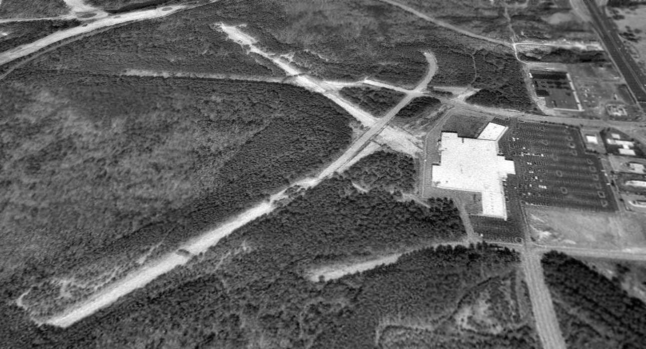
A 2018 aerial view looking north showed the site of Raleigh Municipal Airport to have been taken over by development.
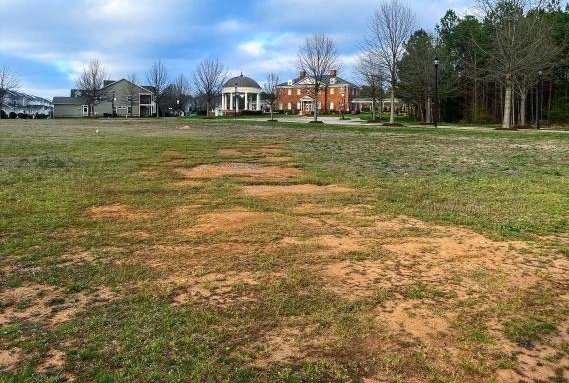
However, eagle-eyed Maria Taylor-Perry pointed out one small patch of runway remains which remained:
a small trace of Runway 4 (a light colored patch running northeast/southwest, in the brown dirt),
southwest of the traffic circle at the intersection of Ileagnes Road & Olympia Drive (the traffic circle to the west of the pool).
A 2020 photo looking northeast from Tryon Road showing the last remaining trace of Raleigh Municipal Airport: a light colored trace of dirt along the former alignment of Runway 4,
looking toward the traffic circle at the intersection of Ileagnes Road & Olympia Drive.
A 2020 photo of the remains of Raleigh Municipal Airport's asphalt Runway 4 surface, northeast of Tryon Road.
The site of Raleigh Municipal Airport is located at the western terminus of Chapnoke Road, northwest of the intersection of Route 401 & Tryon Road.
See also:
"When City History Took Wing", The Raleigh News & Observer, 3/6/98.
http://ftp.rootsweb.com/pub/usgenweb/nc/wake/bicen/airport.txt
____________________________________________________
Eagle Airport / Rocky Mount Municipal Airport (RMT), Rocky Mount, NC
35.96, -77.79 (East of Raleigh, NC)
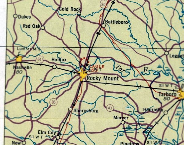
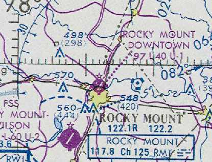
Rocky Mount "Eagle" Airport, as depicted on the March 1935 Norfolk Sectional Chart.
According to 11/22/30 Charlotte Observer article (courtesy of Mark Hess), Eagle Airport was established on 7/2/30 by the Eagle Aircraft Company.
The earliest airfield directory entry which has been located for Eagle Airport
was in The Airport Directory Company's 1933 Airports Directory (courtesy of Chris Kennedy).
It described Eagle Airport as a commercial field located ½ mile north of Rocky Mount.
The airfield was said to consist of a 4-acre rectangular sand & sod field, measuring 1,400' by 1,200'.
The 1934 Department of Commerce Airfield Directory (courtesy of Chris Kennedy)
listed Eagle Airport as a municipal airport, located "One mile north of Rocky Mount, just north of Tar River on west side of Highway #40."
The airfield was described as consisting of a rectangular sand & clay field, measuring 3,600' north/south by 1,400' east west.
Hangars & buildings were said to be located along the southeast side.
The earliest depiction which has been located of Rocky Mount "Eagle" Airport was on the March 1935 Norfolk Sectional Chart.
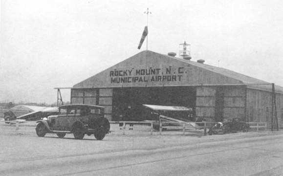
The airport was evidently renamed Rocky Mount Municipal Airport at some point between 1934-36,
as that is how it was labeled on a hangar pictured in the 1936 book "Emergency Relief in North Carolina" (courtesy of Nick Demilio).
An undated aerial view looking south at Rocky Mount Municipal Airport
from the Airport Directory Company's 1937 Airports Directory (courtesy of Bob Rambo).
The field was described as having a 3,600' x 1,500' sand & sod landing area.
An undated aerial view looking northeast at Rocky Mount Municipal Airport
from the Airport Directory Company's 1941 Airports Directory (courtesy of Chris Kennedy).
The field was described as having a 3,600' x 1,800' sand & sod landing area.
A single hangar was depicted on the east side of the field.
The directory contained an advertisement for the Rocky Mount Flying Service.
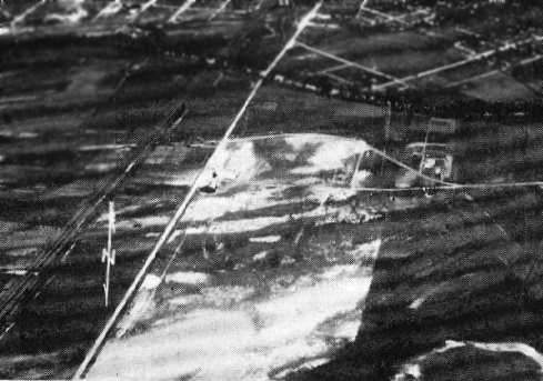
A 12/15/42 aerial view looking north at Rocky Mount Municipal Airport from the 1945 AAF Airfield Directory (courtesy of Scott Murdock)
depicted a dramatic transformation of the airport compared to the 1941 directory photo,
with the previous grass landing area replaced by 2 asphalt runways.
The 1945 AAF Airfield Directory (courtesy of Scott Murdock) described Rocky Mount Municipal Airport
as a 286 acre irregularly-shaped property within which were 2 bituminous runways, measuring 4,000' NNW/SSE & 3,800' NNE/SSW.
The field was said to have a single 100' x 80' steel hangar,
to be owned by the City of Rocky Mount, and to be operated by the City of Rocky Mount & private interests.

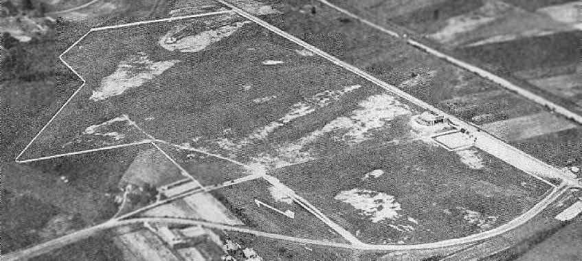
A 12/26/56 USGS aerial view depicted Rocky Mount Municipal Airport as having 2 asphalt runways, with over 15 light aircraft parked near some small hangars on the southeast side.
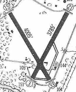
The 1960 Jeppesen Airway Manual (courtesy of Chris Kennedy) depicted Rocky Mount Municipal as having 2 paved runways (4,005' Runway 15/33 & 3,785' Runway 3/21),
as well as a taxiway leading to a ramp on the southeast side of the field with a single building (a hangar?).
Rocky Mount Municipal Airport was described in the 1962 AOPA Airport Directory as having 2 paved runways,
and the operator was listed as Rocky Mount Air Service.
The Aerodromes table on the 1965 Norfolk Sectional Chart (courtesy of John Voss)
described Rocky Mount Municipal as having 2 asphalt runways, with the longest being 4,005'.
Joe Benson recalled, "I flew a Cessna 210 from Opa Locka up to RMT in 1967 & I landed on Runway 21.
The next night, [I departed] off of Runway 3. The only buildings even then were the FBO right on US 301."
Jan Chamblee recalled, “Living in Nash County most of my life, my family made frequent trips to Rocky Mount in the 1960s through 1980s.
I remember cropdusters & private aircraft flying out of there.
I recall being on the airfield & seeing the cropdusters parked at hangars that backed up
to a convenience store / gas station property adjoining Centura Highway which was Hardees Boulevard at that time.”
The 1968 Flight Guide (courtesy of Bob Levittan) depicted Rocky Mount Municipal as having 2 paved runways: 4,000' Runway 15/33 & 3,785' Runway 3/21,
as well as a taxiway leading to a ramp on the southeast side of the field with a single building (a hangar?).
Bill Duff recalled, “On 5/11/68 I flew into Rocky Mount Municipal Airport aboard a Piedmont Airlines Martin 404.
I was surprised that the airline was flying into a small field like this, which looked like a place I would fly the old Supercruiser I used back then.
I noticed as the plane made it's turning taxi to the take-off runway (33 I think) I could see the Hardees headquarters building across the road.
Also the stewardess, Kathy, asked if she could sit beside me, which she did the rest of the way to Raleigh-Durham.
There was only 1 or 2 other passengers on the plane.”
Rocky Mount Municipal Airport was renamed Rocky Mount Downtown Airport at some point between 1968-72,
after the larger Rocky Mount Wilson Airport had been built to the south.
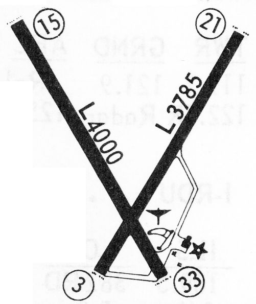
"Rocky Mount Downtown" Airport was depicted on the August 1972 Charlotte Sectional Chart (courtesy of Robert Brown)
as having 2 paved runways, with the longest being 4,000'.
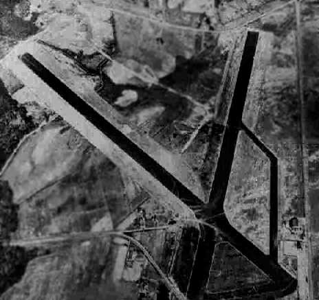
A 1975 USGS aerial view depicted Rocky Mount Municipal Airport as having 2 paved runways,
with a ramp, several buildings & what appeared to be several light planes on the southeast side.
The last aeronautical chart depiction which has been located of Rocky Mount Municipal Airport
was on the November 1976 CG-21 World Aeronautical Chart (courtesy of Chris Kennedy).
It depicted "Rocky Mount Downtown" Airport as having 2 paved runways, with the longest being 4,000'.

The 1977 USGS topo map depicted the “Municipal Airport”
as having 2 paved runways, with a few small buildings on the southeast side of the field.
A 3/1/77 USGS aerial view depicted Rocky Mount Municipal Airport as having 2 paved runways,
with a ramp, several buildings & a row of light planes on the southeast side.
Ken Stallings recalled, “The old KRMT airport in Rocky Mount... That was the airport for my hometown as I was growing up.
The FBO at the airport from at least the early 1970s until the airport was closed was known as Air Care, Inc.
There was also a crop duster operation there named Air-Ag, Inc. which was affiliated with the Air Care operation.
These 2 operations moved to the new KRWI airport when it opened, but remained at the old municipal airport until it closed.
The hangar from a 1930s photo remained in use until the airport was closed & remained the largest single building at the airport.
However, a few smaller facilities were constructed.”
Ken continued, “All of the additional buildings were aligned along the eastern side of Runway 03/21 so that it would have access to Business 321 highway.
Interestingly, during this time, the headquarters of Hardees was located across 321 from the airport. My dad worked there as a restaurant manager.
The additional airport buildings were 2 single-story facilities that served as the FBO management building
and pilot briefing room & lounge for the Air Care & Air-Ag operations.
The Air Care FBO office was next to the large hangar in [the] 1930s photo, and was across a small parking lot off 321 about 75 yards southwest of that hangar.
Another single-story structure was located about 200 yards northeast of the large hangar
and served as the headquarters building for the Air-Ag operation.
The Piper Pawnee & Cessna aircraft were parked on the grass next to this one office.
General aviation parking was in an open apron located on the west side of the large hangar & extending SW to the FBO building.
From RMT is where I took my very first airplane ride on my 16th birthday back on 6/7/79.
It was in a Piper 4-seat model, likely Archer or Cherokee.”
The 1980 USGS topo map depicted the “Rocky Mount Downtown” Airport as having 2 paved runways.
The last photos which have been located showing Rocky Mount Municipal Airport still in operation was a series of 1980 photos by Mike Massimini.
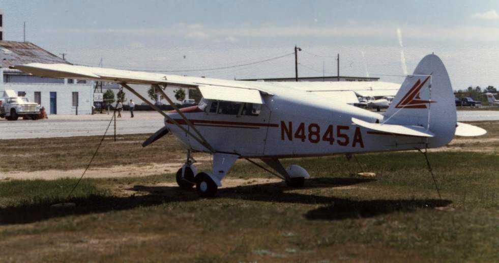
This picture shows a Piper Tri-Pacer; Mike observed, “Past the Tri-Pacer you can see the cinderblock structure added on to the original hangar.
There were offices as well. At the very left you can see the edge of the building Hardee's used as its headquarters.”
Mike Massimini recalled, “I worked for Air Care, Inc. at the time this airport was closed.
This FBO had operations at both RMT & RWI, but all aircraft maintenance & administrative offices were at RMT.
I flew Aztecs, a Seminole, a Bonanza, and a couple of Arrows while I was there, as well as the usual CFI stuff.
I last flew out of RMT on 9/16/80. The transition had been in progress for about a month & was completed a few days later.
All operations at RMT ended, and the airport was officially closed.
The crosswind Runway 15/33 had already been closed long before I started working there in March of 1980;
departing [Runway] 15 would set you up for a buzz job of Hardee's corporate headquarters which was across the street (Church Street / US 301) back then.
Nevertheless, we'd occasionally land on [Runway] 15 during periods of strong (favorable) winds.
The fence northwest of the airport had a car-sized gap & unimproved access to this runway.
Those of us living in this direction could take this short cut & drive down the closed runway to the FBO (looking both ways as we crossed [Runway] 3/21, of course).
Not advisable in this day & age.”
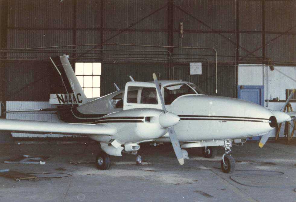
A 1980 photo by Mike Massimini of A Piper Aztec inside a Rocky Mount Municipal Airport hangar.
Mike observed, “N44AC was the main charter airplane, and is shown in a maintenance hangar.
The big hangar shown in the earlier pictures still existed, but had this smaller structure added on, as well as a Quonset hut type structure on the other side.
This Aztec had an enlarged cargo door - you can just make out it's outline.
It disappeared one Friday night; [it was] eventually found gear-up in a Jamaican field with traces of marijuana in the cargo area.”
A 1980 photo by Mike Massimini at Rocky Mount Municipal Airport, from “in front of the FBO looking northwest towards the end of Runway 21.”
The 1983 USGS topo map depicted the “Muni Airport” as having 2 paved runways.
According to Jan Chamblee the Rocky Mount Downtown Airport was evidently closed “around 1983 or 1984
since I participated in sports car autocross on the closed runways during that time frame.
These events were sponsored by the Tar Heel Sports Car Club.”
A 1993 USGS aerial photo showed both runways still remained largely intact, but marked with closed-runway "X" symbols.
A stadium had been built over the southern end of Runway 3.
Joe Benson continues, "The parking ramp was still there when I visited in 1994 but no buildings of any kind.
The stadium was there but you could drive the full length of both runways.
I was sitting on the centerline in my Bronco & a cop came by & just stared at me but didn't stop.
A penny for his thoughts. I guess he couldn't tell when someone is reminiscing."
Adelia Ramey (of the City of Rocky Mount's Department of Planning & Development) recalled in 2005,
“When we first moved here in 1997 the site was used for recreational soccer.
There were 1,000 kids & their families swarming all over the fields & using the runways as a parking lot.
That stopped about 6 years ago [1998] when they discovered the contamination.
It was from the crop dusters dumping out their tanks on the ground. It took a long, long time to clean up.”
A 1/25/98 USGS aerial view looking north showed both runways still remained largely intact,
and the Runway 33 markings were still visible.
A 2000 photo by Paul Freeman looking northwest along the abandoned Runway 33.
Both runways were still very much in existence, but trees had grown right up to the edge of the pavement.
A small football stadium had been built on the portion of Runway 3/21 below the runway intersection,
and Runway 15/33 was apparently used for parking for stadium events (and was open & accessible by car).
Most of the northern end Runway 3/21 was fenced off,
with a sign indicating that it will not be open for public access until cleanup of hazardous materials is complete (buried fuel storage tanks?).
No evidence of hangars or other former airport buildings were noticeable.
A 2000 photo by Paul Freeman looking northeast along the abandoned Runway 3.
Rocky Mount Municipal was still depicted on 2002 sectional charts as an abandoned airfield.
Rocky Mount resident Nick Demilio reported in 2003, "The old runways are still there.
They have been used as storage pads for various materials by the city (recycling collection points),
for people to take their teenagers out to practice driving away from the traffic, and not much else.
The city built the 'Rocky Mount Athletic Complex' there over 20 years ago.
Rocky Mount Senior High plays its home football games there.
The city has been talking for years about turning the rest of the 'old airport' property
into a more ambitious municipal athletic complex with many baseball, softball, and soccer fields.
That plan is supposedly ready to start building after being held up by the hazardous waste found there...
not old aviation-related stuff but PCB's contaminating the soil - how they got there I don't really know.
It is an official 'Superfund' site and has been cleaned up.
The pavement is cracking but still drivable,
and some of the old markings painted on the runways are still there."
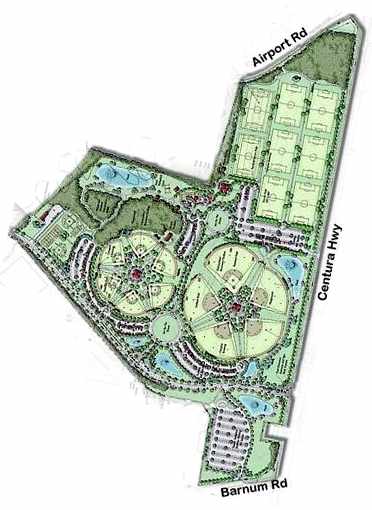
The City of Rocky Mount's website described the “Rocky Mount Sports Complex” as “opening Fall 2006”.
It said “Work on the Rocky Mount Sports Complex is moving forward at a rapid pace,
and the old airport grounds are moving aside for 'fly balls' instead of flying planes.”
A 2005 aerial photo showed that construction for the new municipal athletic complex had covered most of the site.
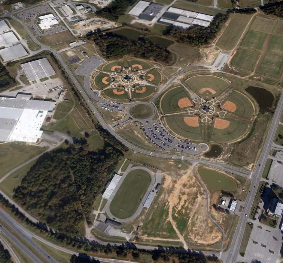
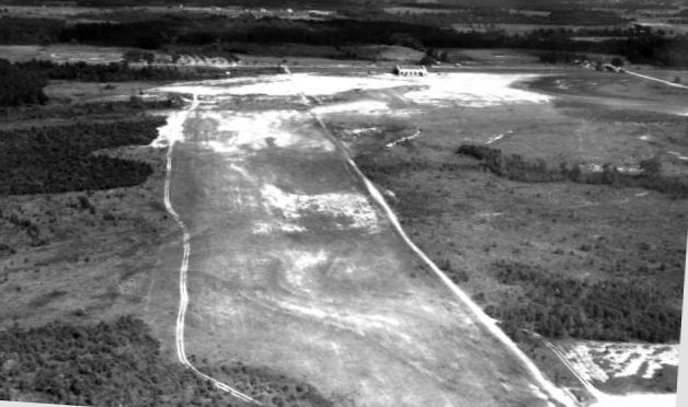
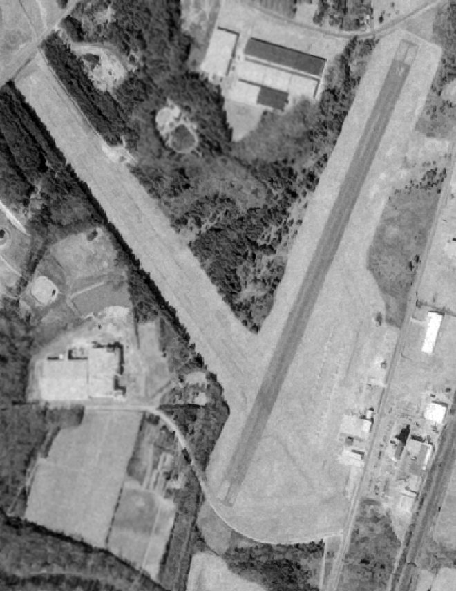
A 3/11/12 aerial view looking north showed that all runway pavement from both former runways had been removed, with ball fields covering the center portion of the former Rocky Mount Airport.
____________________________________________________
Or if you prefer to contact me directly concerning a contribution (for a mailing address to send a check),
please contact me at: paulandterryfreeman@gmail.com
If you enjoy this web site, please support it with a financial contribution.
____________________________________________________
This site covers airfields in all 50 states.