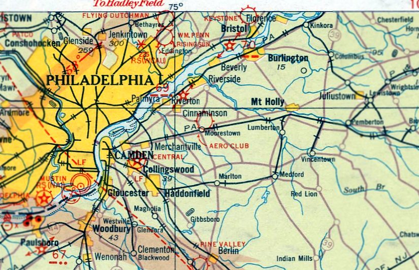
Abandoned & Little-Known Airfields:
New Jersey: Camden area
© 2003, © 2026 by Paul Freeman. Revised 2/25/26.
This site covers airfields in all 50 states: Click here for the site's main menu.
____________________________________________________
Please consider a financial contribution to support the continued growth & operation of this site.
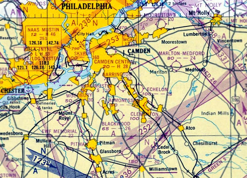
Collins Field (revised 2/25/26) - Crescent Airport / Camden Central Airport (revised 1/3/25) - Echelon Airport (revised 1/2/20)
Merrill Airport / Barrington Airport (revised 3/24/23) - Moorestown Airport (revised 5/30/23) - Palmyra Airport (revised 6/13/21) - Triangle Airport (revised 2/29/20)
____________________________________________________
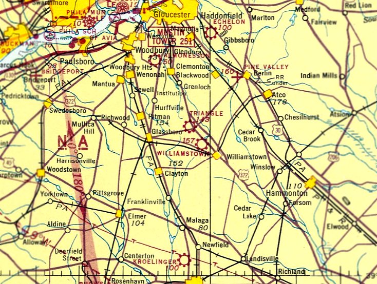
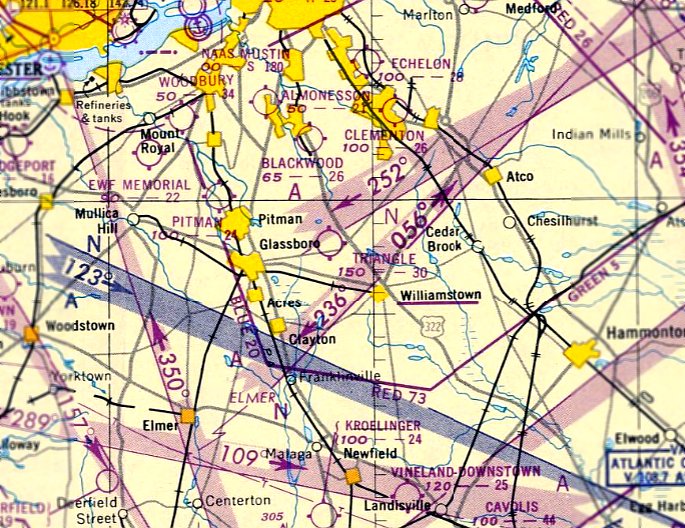
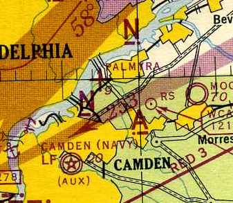
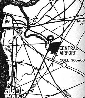
Triangle Airport, Cross Keys, NJ
39.72, -75.03 (Southeast of Philadelphia, PA)
Triangle Airport, as depicted on the November 1942 Washington Sectional Chart.
This little general aviation airport was evidently established at some point in 1942,
as it was not yet depicted on a 1940 aerial photo or on the May 1942 Washington Sectional Chart.
The earliest depiction which has been located of the Triangle Airport was on the November 1942 Washington Sectional Chart.
It depicted Triangle as an commercial/municipal airfield.
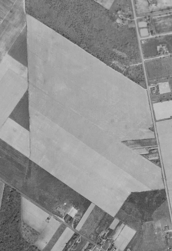
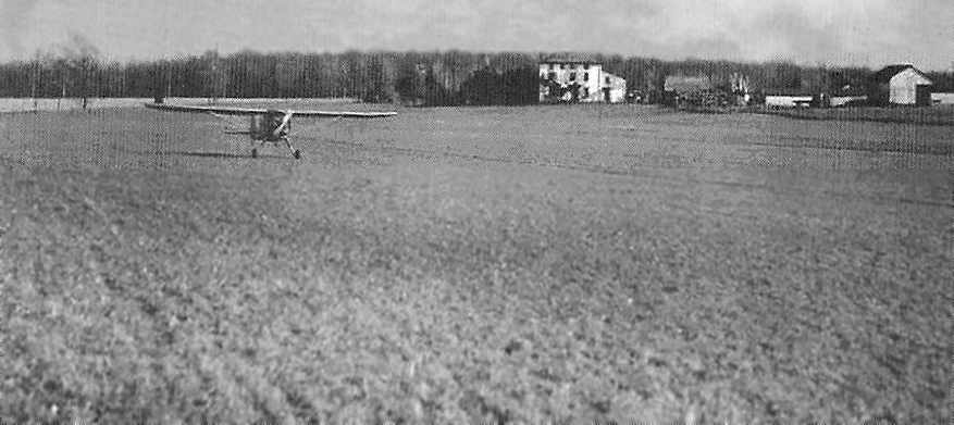
A circa 1942-45 aerial view looking north at Triangle Airport from the 1945 AAF Airfield Directory (courtesy of Scott Murdock).
The 1945 AAF Airfield Directory (courtesy of Scott Murdock) described Triangle Airport
as a 27 acre irregularly-shaped property having a 1,300' sod north/south runway.
The field was said to have a single 60' x 40' wood & metal hangar,
to be owned by private interests, but not currently in operation
(presumably it may have been closed during WW2, like many other small general aviation airports near the coasts).
Joe Cella recalled, “Triangle Airport... I grew up directly across the street from this airport.
I recall my grandfather talking about an airport being there.
My family moved to the area in the mid-1940s & my grandfather used to say he loved watching the planes.”
Ernest Geisert recalled, “My first airplane ride was at Triangle Airport just as World War 2 was over.
My brother was a Navy pilot home on leave & took me for a ride.
Two guys ran it after the war.. Johnny Lentine & Woodrow Emmey.
It had an east/west runway besides the north/south which was longer.
I remember flying in there to get gas as a couple of us kids had planes in a farm field about 6 miles east of there.”
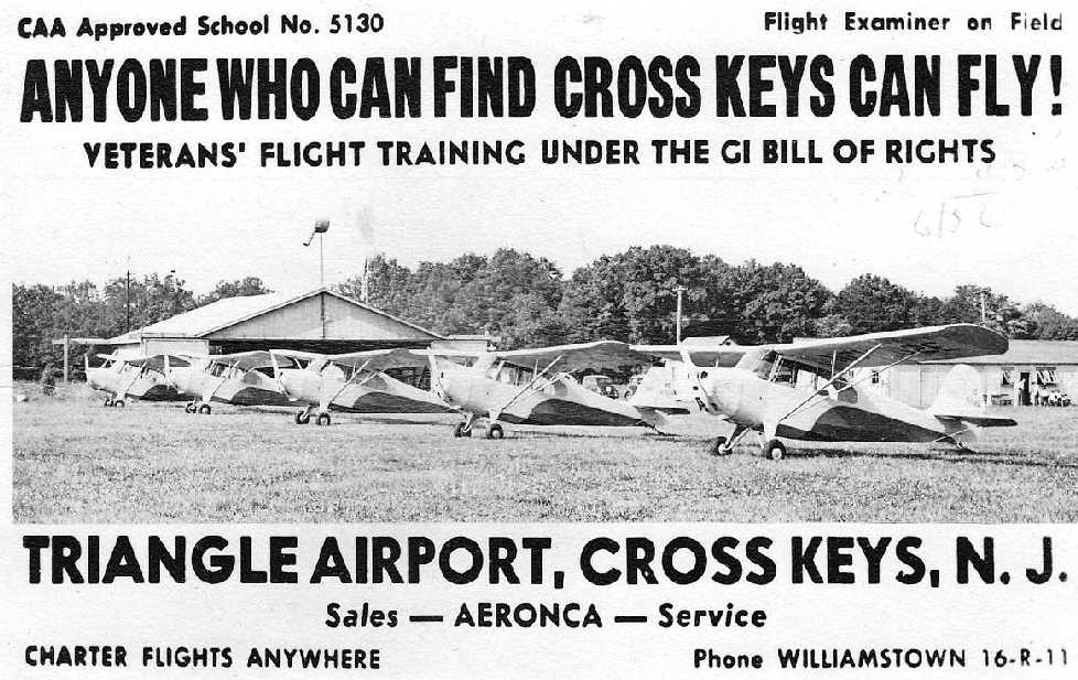
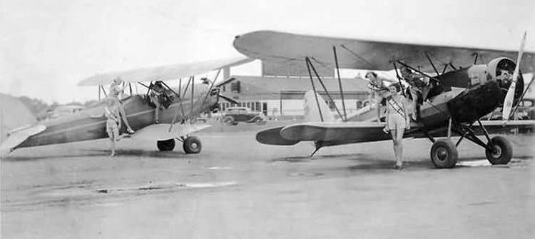
A circa 1940s advertisement for Triangle Airport (courtesy of Richard Schiavo) depicted a row of 5 Aeroncas in front of a hangar.
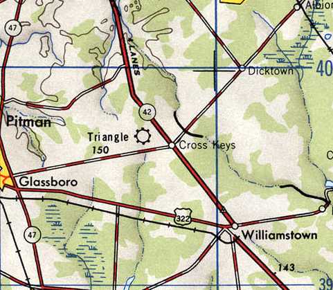
Triangle Airport, as depicted on the 1946 USGS topo map.
The last aeronautical chart depiction which has been located of Triangle Airport was on the January 1951 Washington Sectional Chart.
It depicted Triangle as having a 3,000' unpaved runway.
Ernest Geisert recalled, “The last I remember flying in there was about 1951;
the runways were not marked very well, it was more like one big grass field.”
Triangle Airport evidently closed (for reasons unknown) at some point in 1951,
as it was no longer depicted on the July 1951 Washington Sectional Chart.
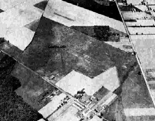
A 5/2/51 aerial photo depicted a single hangar on the south side of Triangle Airport,
which appeared to consist of an irregularly-shaped grass field without distinct runways.
Triangle Airport was no longer depicted on the 1953 USGS topo map.
According to Joe Cella, “I am fairly sure it closed due to the development of Cross Keys airport (opened 1954) just down the road.
Triangle is actually directly under the old [Cross Keys] pattern for Runway 9 landings.
My father said [Triangle] was abandoned when he was a child [in the] 1950s-1960s.”
A 1970 aerial photo still depicted a single hangar on the south side of Triangle Airport,
but there was not any sign of recent aviation usage.
Joe Cella reported, “My father said that when he became a pilot in the 1970s the area had been bought by a farmer.
For a long time the land was owned by a local farmer, it was being used for growing from the 1970s into the late 1990s.”
A 1995 aerial photo showed that the hangar had been removed at some point between 1970-95.
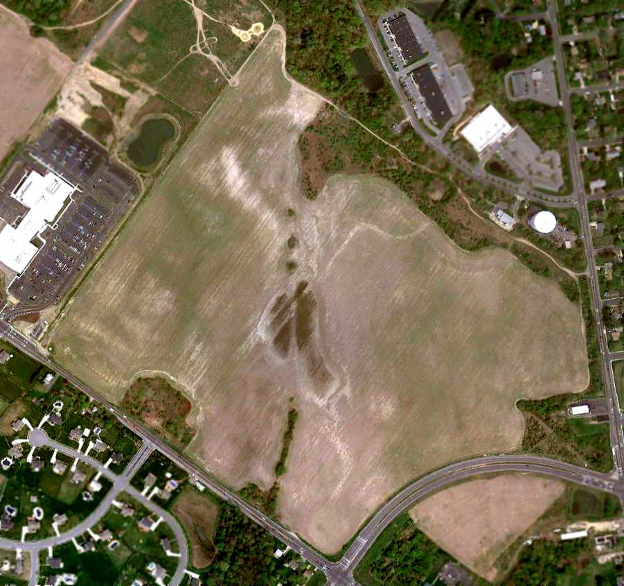
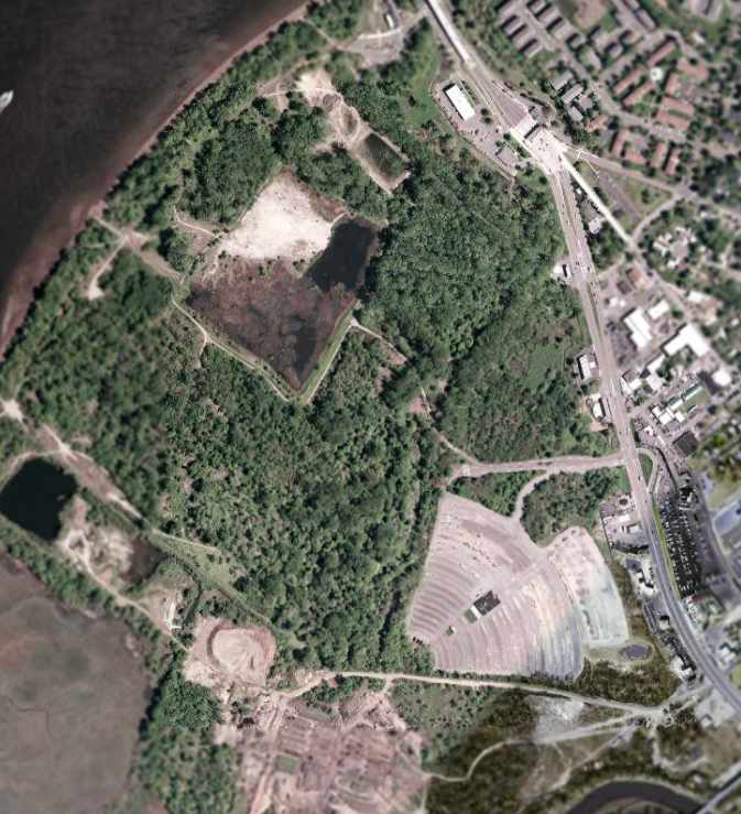
Remarkably a 4/12/10 aerial photo showed that the airfield area of Triangle Airport remained clear & unredeveloped, more than 50 years after the airport closed.
Joe Cella reported in 2011, “The foundation of the hangar actually still exists, hidden by trees now”,
[bottom-center of the above photo, just south of the curved road].
The area is undeveloped 50 years later for a few reasons.
Mainly the river head, that area is always muddy & after a good rain its underwater for a week or two.
Flowing water starts right near the road.
Now days it is corporate owned & has an occasional crop in it for tax write-offs.
I am not sure as to the exact location of the runway, but from the terrain it was most likely away from the river head to the east.
It could be said that Triangle Airport is still in use, only on a smaller scale,
as my father & myself were using the area near the hangar foundation for radio-controlled model aircraft
until that bypass was put in a few years ago & we had to move to the other side of the field.”
The site of Triangle Airport is located north of the intersection of Hurffville Cross Keys Road & Cross Keys Bypass.
____________________________________________________
40, -75.04 (East of Philadelphia, PA)
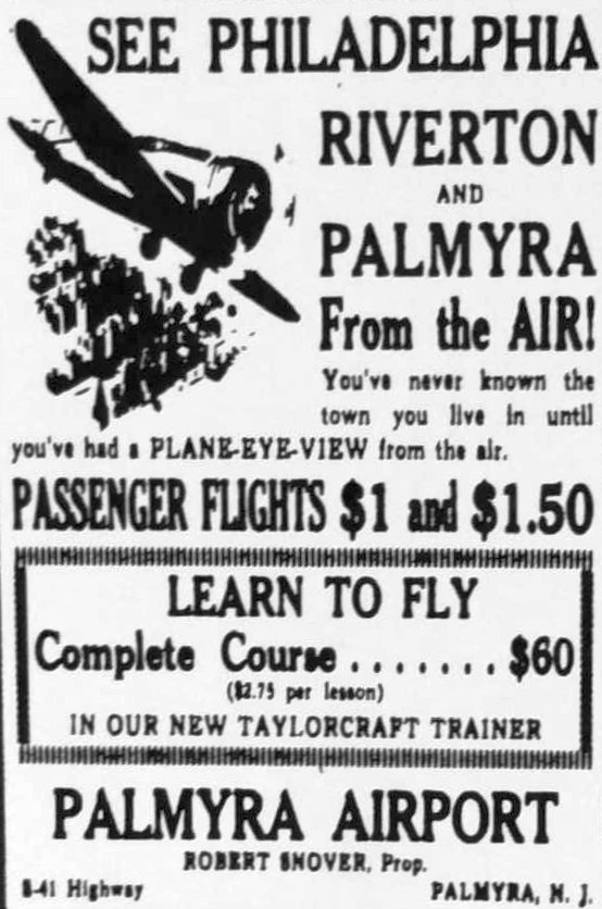
A circa 1937 advertisement for Palmyra Airport (courtesy of Jim Higgins).
This small & enigmatic airport evidently had a total lifespan of less than a decade.
Palmyra Airport was evidently established at some point between 1930-1937,
as no airport in Palmyra was depicted on the Philly Chamber of Commerce's
1930 "Aviation Map of the Philadelphia Metro District" (courtesy of Tom Beamer),
nor listed in The Airport Directory Company's 1937 Airport Directory (courtesy of Bob Rambo).
The earliest reference which has been located to Palmyra Airport was a circa 1937 advertisement (courtesy of Jim Higgins).
It advertised flights for $1, a complete flight training course for $60 in their new Taylorcraft trainer.
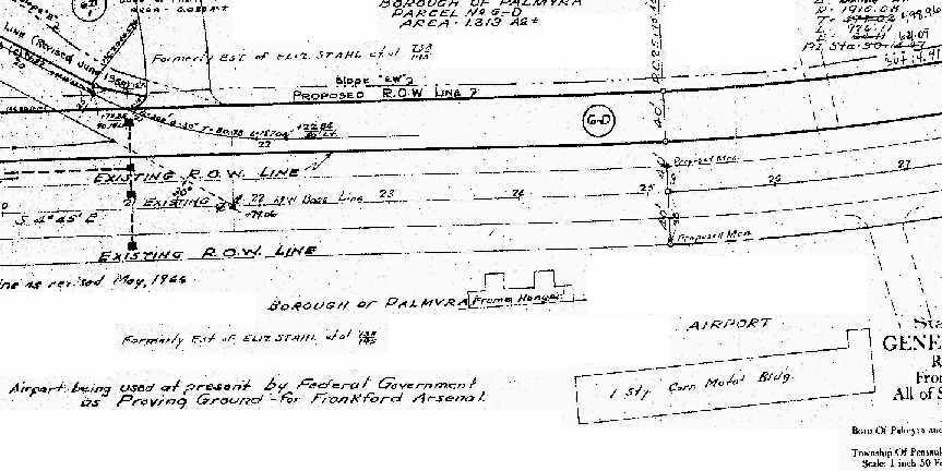
The earliest depiction which has been located of the Palmyra Airport
was on a February 1939 NJ State Highway Department map (courtesy of Steve Clouser).
It depicted the “Airport” in Palmyra as having 2 buildings along the west side of a street:
a “frame hangar” & a “1-story corrugated metal building”.
Other notes on the map indicated that the property was “formerly [the] estate of Elizabeth Stahl”,
and that the “Airport being used at present by Federal Government as Proving Ground – for Frankford Arsenal.”
[The Frankford Arsenal was located directly across the Delaware River to the west, in Philadelphia,
and within a few years would be involved in development & large-scale production of weapons during WW2.]
Other than the buildings mentioned above, no other details of the airfield configuration of Palmyra Airport have been determined.
The Palmyra Airport was not depicted on the January 1940 Washington Sectional Chart.
The earliest aeronautical chart depiction which has been located of Palmyra Airport was on the April 1940 Washington Sectional Chart.
It depicted Palmyra as an auxiliary airfield.
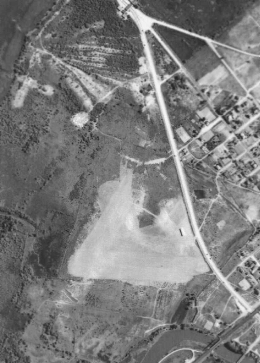
A 7/6/40 aerial view of Palmyra Airport (courtesy of the National Archives & Records Administration).
The airfield appeared to consist basically of a triangularly-shaped grass/dirt clearing,
within which were 2 runways, oriented east/west & northeast/southwest.
A single hangar was located on the east side of the field, alongside Route 73.
There were no aircraft visible on the field, or any other indications of active use.
The first account which has been located of someone flying from Palmyra Airport came from William Davis,
who recalled, “I recall getting my first ever airplane ride at the Palmyra Airport in a Luscombe 8A.
I think it was 1940 or 1941. It was a birthday present from my Mom.”
The November 1941 Washington Sectional Chart (courtesy of Chris Kennedy)
depicted Palmyra as a commercial/municipal airport.
According to Steve Clouser, “The Army built a proving ground on the site of Palmyra Airport
that was in operation during both wars [WW2 & the Korean War] to develop & test tank chassis-mounted versions
of their recoilless rifles for armor-piercing capabilities.
Large target berms were constructed & holes were dug adjacent to the berms to accommodate the highly-modified tracked tank chassis.
The various caliber test shells were fired into the target butts in the direction of the Borough of Palmyra.”
The 1943 NY Sectional Chart (courtesy of Chris Kennedy) went back to depicting Palmyra Airport as an auxiliary airfield.
The last aeronautical chart depiction which has been located of Palmyra Airport
was on the May 1944 Washington Sectional Chart (courtesy of Chris Kennedy).
It depicted Palmyra once again as an auxiliary airfield.
The Palmyra Airport was evidently closed (for reasons unknown) at some point in 1944,
as it was no longer depicted at all on the November 1944 Washington Sectional Chart (according to Chris Kennedy)
or on subsequent aeronautical charts,
nor listed among active airfields in the 1945 AAF Airfield Directory (courtesy of Scott Murdock).
A 3/4/46 aerial photo (courtesy of Steve Clouser) still showed a single hangar from the former Palmyra Airport,
along with adjacent target butts that had been constructed for Army firing tests of recoilles rifles on the property.
The 1949 USGS topo map did not depict any airfield at the site.
According to Steve Clouser, “At some point circa 1953, the Army gave up on their tracked recoilless armor-piercing rifle project
and was ready to build & test-fire their new Davey Crockett recoilless rifles.
Needing a much larger & more isolated area to test-fire the Davey Crockett,
the Palmyra proving ground was cleared & leveled back to its original condition.
The large stockpile of untested shells that had been manufactured on the other side of the Delaware River
at the Frankford Arsenal were buried on the north side of the site,
and the fired & un-fired shells that were temporarily stored at the target butts were buried right there at the individual target butts.
Immediately prior to the last piece of equipment leaving the site for relocation to Molokaii Island, Hawaii,
all of the munitions buried on the north side of the site were so hastily removed that the large holes are still there today.
The property was sold & a drive-in movie theater was built on the site, a rather convenient way to seal-off buried munitions.”
A 1956 aerial view depicted the airfield after it had been abandoned,
with construction apparent over much of the property.
The single hangar remained standing, for the time being.
A 1957 aerial view showed that all traces of the former Palmyra Airport had been removed,
with a drive-in movie theater having been constructed over the site.
The 1988 USGS topo map depicted the “Drive-in Theater” on the site of Palmyra Airport.
In the 1999 USGS aerial photo, no recognizable trace still remained of the airport,
but the drive-in theater still remained on the site.
As seen in the 2000 USGS aerial photo, not a trace appears to remain of the former Palmyra Airport,
although the remains of the drive-in theater are still quite recognizable (at the bottom of the photo).
A 12/31/03 aerial photo by Dennis Bratnik (courtesy of Steve Clouser), looking north at the side of the Palmyra Airport,
showing the remains of the drive-in theater.
Steve Clouser reported in 2005, “The drive-in theater was sold to a company that owns & operates a chain of flea markets.
They removed the movie screen, tore down the ticket booths, and renovated the projection/snack bar building
and are operating the site as the Tac-Palm Flea Market.”
Steve described that the property adjacent to the site of Palmyra Airport is planned to be redeveloped into the Palmyra Cove Park,
with a new access road going over the former airport site.
According to Steve, “I have surveyed every square foot of ALL of the area
and have found no remaining evidence of the old airport.”
According to Steve Clouser, “The Borough of Palmyra became interested in purchasing the property in 2007.”
The site of Palmyra Airport is located west of the intersection of Palmyra Bridge Road (Route 73) & West 5th Street.
____________________________________________________
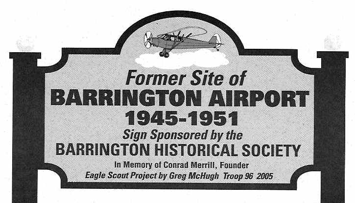
Merrill Airport / Barrington Airport, Barrington, NJ
39.866, -75.05 (Southeast of Philadelphia, PA)
Merrill Airport, as depicted on the Decenber 1945 Washington Sectional Chart.
A 1940 aerial view did not yet show any sign of Barrington Airport.
According to “The History of Barrington Airport” by the Barrington Historical Society (courtesy of Scott Roberts),
Conrad Merrill operated the Merrill Engineering Company on this property during WW2,
working on a variety of military products in the area of radar & other electrical systems.
The Merrill Airport was opened in June 1945 on 116 acres along East Gloucester Pike.
Merrill Airport was not yet depicted on the June 1945 Washington Sectional Chart,
nor listed in the 1945 AAF Airfield Directory (courtesy of Scott Murdock).
The earliest depiction of Merrill Airport which has been located was on the December 1945 Washington Sectional Chart.
It depicted Merrill as a commercial/municipal airport.
A 1945 photo of Conrad Merrill landing at Merrill Airport in his Luscombe (courtesy of the Barrington Historical Society, via Scott Roberts).
According to “The History of Barrington Airport” by the Barrington Historical Society (courtesy of Scott Roberts),
Al Snyder ran the flight school at Barrington Airport starting in 1946.
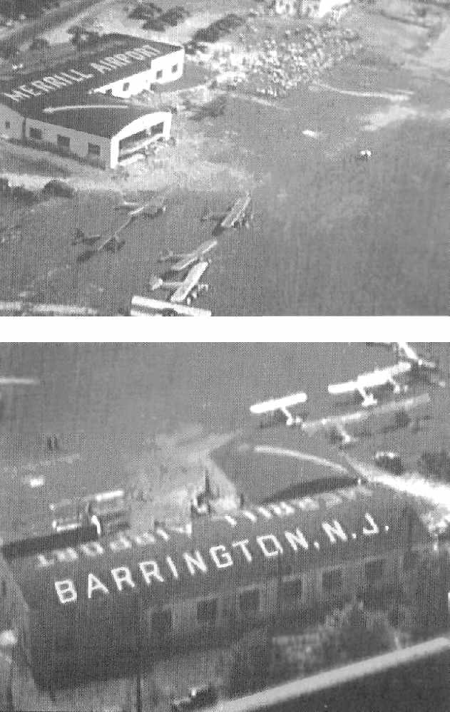
Two aerial views of planes & hangars at Merrill Airport during the 9/22/46 airshow
(courtesy of the Barrington Historical Society, via Scott Roberts).
It was still depicted as Merrill Airport on the October 1946 Washington Sectional Chart.
Barrington Airport, as depicted on a 1946 USGS map.
It was depicted as Barrington Airport on the April 1947 Washington Sectional Chart.
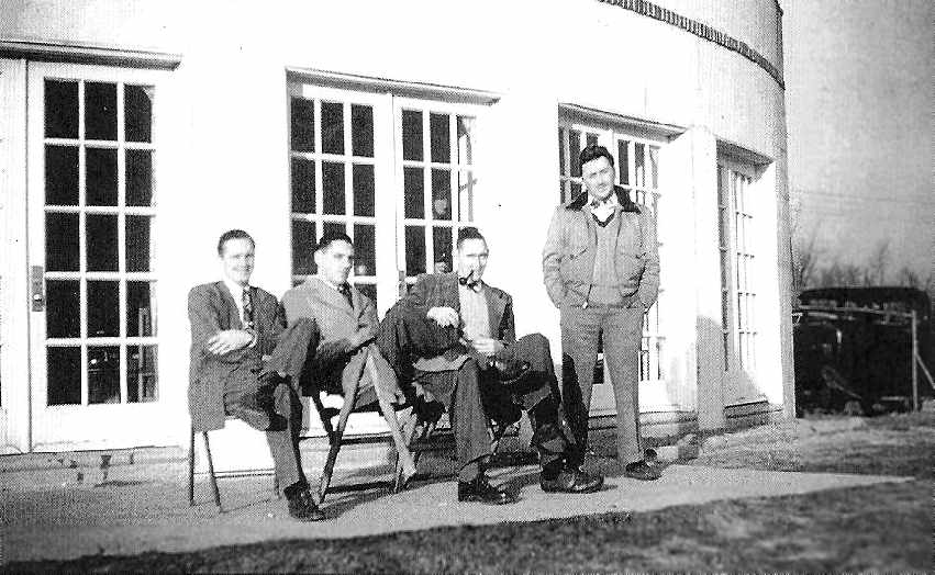
A 1947 view of Max Reihmann, Bob Hunter, Bill Hunter, and Al Snyder
in front of the Barrington Airport Administration Building (courtesy of the Barrington Historical Society, via Scott Roberts).
A 1947 view of a Cessna being fueled at Barrington Airport,
with the Administration Building in the background (courtesy of the Barrington Historical Society, via Scott Roberts).
An undated photo of a Cessna at Barrington Airport,
with the Administration Building in the background (courtesy of the Barrington Historical Society, via Scott Roberts).
A 1947 aerial view looking west at Barrington Airport,
with the hangars visible at the top, with Gloucester Pike running along the right side
and the PA Railroad tracks at bottom-right (courtesy of the Barrington Historical Society, via Scott Roberts).
A 1948 view of the T-hangars at Barrington Airport (courtesy of the Barrington Historical Society, via Scott Roberts).
The last aeronautical chart depiction which has been located of Barrington Airport was on the July 1950 Washington Sectional Chart.
It depicted Barrington as having a 3,200' unpaved runway.
According to “The History of Barrington Airport” by the Barrington Historical Society (courtesy of Scott Roberts),
Al Snyder ran the flight school at Barrington Airport until 1950 (when he moved it to Moorestown Airport).
Barrington Airport was no longer depicted on the January 1951 Washington Sectional Chart.
According to “The History of Barrington Airport” by the Barrington Historical Society (courtesy of Scott Roberts),
“In 1951 construction of the NJ Turnpike divided the Barrington Airport property into 2 smaller parcels.
Owens Corning Fiberglass Company purchased the east portion as a site for a manufacturing plant.
The west parcel along Gloucester Pike eventually was subdivided & became Barrington Industrial Park.”
A 1951 aerial photo showed the middle of the airport site bisected by construction for the NJ Turnpike.
But the former hangar along the northwest side of the site was still painted with “Merrill Airport Barrington NJ” on its roof.
A 1957 aerial view depicted the 3 former hangars & airfields buildings on the northeast side of the Barrington Airport site.
The NJ Turnpike had gone right through the middle of the former airfield property,
and 2 large buildings covered the northeastern & southeastern portions.
According to “The History of Barrington Airport” by the Barrington Historical Society (courtesy of Scott Roberts),
“Mrs. Merrill sold the last piece of the airport property in 1984.”
An undated (2005 or earlier) photo of a sign located on Weyerhauser property (which occupies a large portion of the former airport) on East Gloucester Pike
(courtesy of the Barrington Historical Society, via Scott Roberts).
As of 2005, the former Barrington Airport Administration Building was reported to be in use by the Red Lion Insulation Company,
according to “The History of Barrington Airport” by the Barrington Historical Society (courtesy of Scott Roberts),
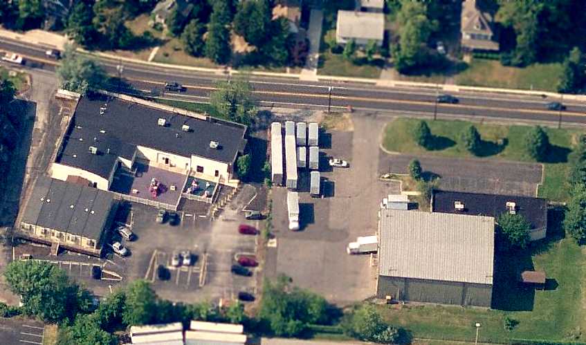
A circa 2006 aerial view looking north at the 1940s-era Barrington Airport hangar (at left) & airport administration building (at right).
Both buildings have had more modern structures built onto them in the foreground.
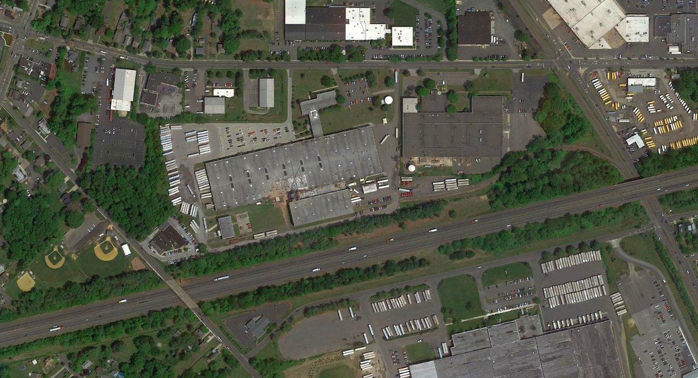
A 2016 aerial view showed the site of Barrington Airport has been covered by industrial buildings,
but the former hangar & airport administration building remain on the northwest corner of the site.
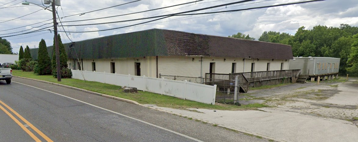
An August 2022 photo looking southeast the the former Barrington Airport hangar showed it to be unrecognizable as a 1945 hangar.
The site of Barrington Airport is located southwest of the intersection of East Glouchester Pike & East Atlantic Avenue.
____________________________________________________
Echelon Airport / Delaware Valley Airport, Ashland, NJ
39.85, -75 (Southeast of Philadelphia, PA)
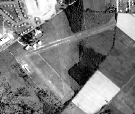
A 1940 aerial view depicted Echelon Airport as having 2 unpaved runways.
Jeannette Glennon-Morrissey reported, “I am the granddaughter of Rod & Jean Smith, who owned & operated Echelon airfield [starting in] 1938.”
According to a history of Vorhees, Rogers & Jeanette Smith bought land on Somerdale Road in 1939
and built an airport, which they named Echelon, after their flying club.
The earliest depiction which has been located of Echelon Airport was a 1940 aerial view.
It depicted the field as having 2 grass runways.
A few small farm buildings were located on the northwest side of the field,
but there did not yet appear to be any hangars, nor any aircraft visible on the field.
No airfield at this location was yet depicted on the November 1941 Washington Sectional Chart (courtesy of Chris Kennedy).
According to Harry Silvers, the Smiths' “house was known as the Ebert Mansion - the largest in the area.
During WW2 they had to dismantle the airplanes & store the parts in the rafters.
Those that could afford to flew their airplanes to Lancaster PA, which was 100 miles from the ocean, and still fly.”
The earliest aeronautical chart depiction of Echelon Airport which has been located
was on the May 1944 Washington Sectional Chart (courtesy of Chris Kennedy).
It depicted Echelon as an auxiliary airfield.
According to Harry Silvers, “Roger [reestablished] the airport after the war
and used surplus Vultee Valiant BT-13 for trainers.”
The 1945 Washington Sectional Chart (courtesy of John Voss) depicted Echelon as a commercial/municipal airfield.
Echelon Airport, as depicted on a 1946 USGS map.
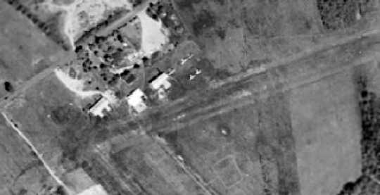
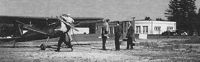
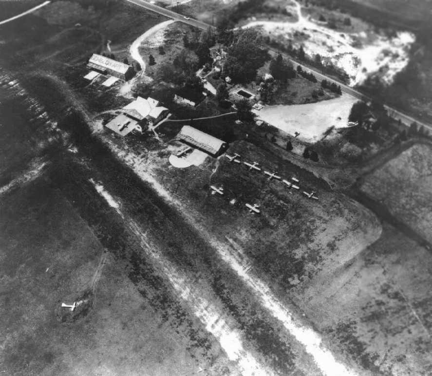
A 1947 aerial view of Echelon Airport depicted 3 hangars which had been added at some point between 1940-47,
and it also showed 5 light aircraft parked on the field.
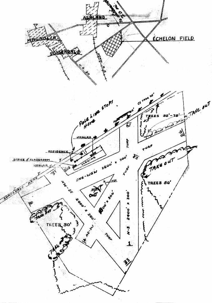
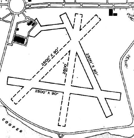
The location & layout of Echelon Field, as depicted on a June 1947 Department of Commerce Airport Facilities Record (courtesy of Harry Silvers).
It depicted the field as having a total of 4 grass runways, with the longest being the 2,800' east-northeast/west-southwest strip.
An office/classroom & 2 hangars (which had been added at some point between 1940-47) were depicted along the road on the northwest side of the field.
The operator was listed as Echelon Aeronautical Service Inc., and the manager was listed as R.M. Smith.
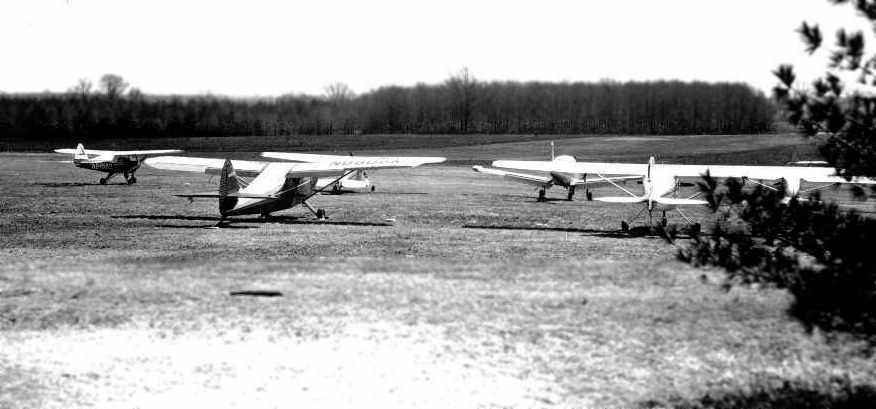
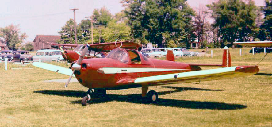
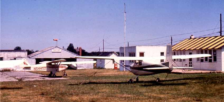
A May 1950 photo by Charles Findeisen (courtesy of Harry Silvers) looking east at Echelon Airport,
showing several single-engine planes & a grass runway.
According to Harry Silvers, airport founder Roger Smith “died in 1950 when he was ferrying 2 men to Ohio.
Jean Smith told me he was murdered by an insane man in the back seat of the plane.
Smith's body was found near the crash site.”
The Aerodromes Table on the 1951 Washington Sectional Chart (courtesy of Mike Keefe) described Echelon as a commercial airport,
having a total of 4 runways, with the longest being 2,800'.
According to Harry Silvers, “Hugh Hamill & his wife Kathryn leased the airport from Jean Smith the widow in July 1952.”
The 1953 USGS topo map depicted Echelon Airport as having 2 unpaved runways.

Echelon's northeast/southwest runway was evidently abandoned at some point between 1947-55,
as the March 1955 Department of Commerce Airport Facilities Record (courtesy of Harry Silvers)
depicted the field as having 3 grass runways, with the longest being the 2,800' east-northeast/west-southwest strip.
An office/classroom & 2 hangars were depicted along the road on the northwest side of the field.
The operator was listed as H & K Hamills Inc., and the manager was listed as Hugh Hamill.
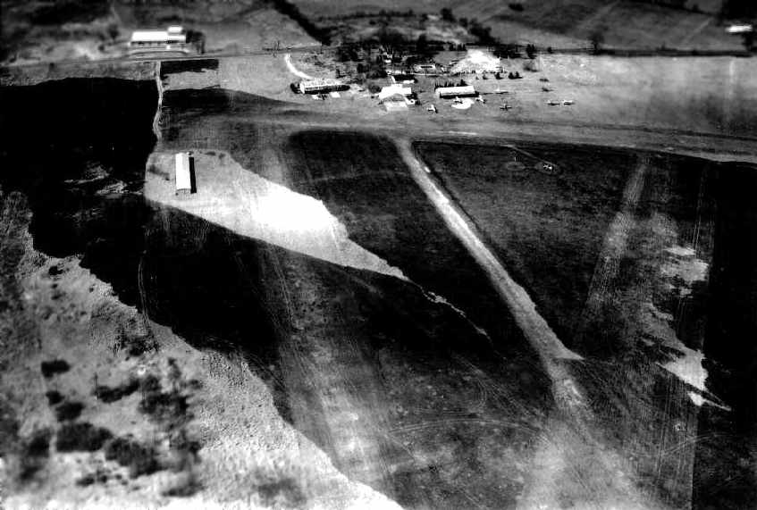
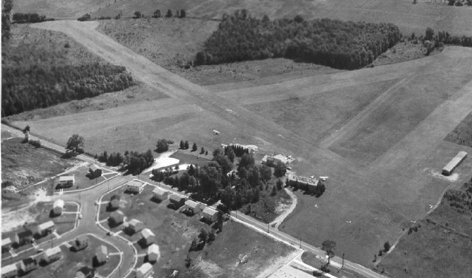
A 1957 aerial view of Echelon Airport depicted 3 hangars on the northwest side of the field,
around which were parked 5 single-engine aircraft.
In a May 1959 aerial photo by Charles Findeisen (courtesy of Harry Silvers) looking north at Echelon Airport,
much of the runways were still blackened from a recent grass fire.
A May 1959 aerial photo by Charles Findeisen (courtesy of Harry Silvers) looking northwest at Echelon Airport.
Note “Echelon” painted on the hangar roof.
The Aerodromes Table on the 1960 Washington Sectional Chart (courtesy of Mike Keefe)
described Echelon as having a total of 3 runways, with the longest being a 2,800' turf strip.
A circa 1960 aerial view looking southeast at Echelon Airport (courtesy of Carol Smith, via Harry Silvers).
The 3 grass runways were visible, along with several hangars & buildings, and several light planes.
Dan Ceglia recalled, “Echelon Airport... I took my first plane ride there in a Piper Cub with Hugh Hamill.
I believe he owned the property & was the instructor.
I remember he had a twin on the field that I later found out was a 'Bamboo Bomber' (Cessna [T-50]).
The field was grass with 2 runways & was used to bring in jockeys that raced at the Garden State Race Track.
One beautiful spring day in May of 1960 I was sitting at the fence dreaming of learning to fly,
when an Apache landed & Willie Shoemaker got out to go to the track & ride in the Jersey Derby.”
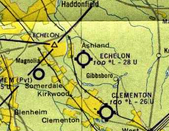
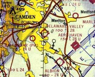
The 1961 Philadelphia Local Aeronautical Chart (courtesy of Mike Keefe) depicted Echelon as having a 2,800' unpaved runway.
It also depicted the nearby Echelon aeronautical intersection.
Matt Wilson recalled, “I moved there in 1961. Our best friends Manny & Vicki Lynn owned Echelon Airport.
It was NEVER called Echelon Airport, except by the FAA...
it was always referred to as Osage Airport, hence Osage School being built directly across from it.
I can remember many flights with Manny Lynn in his Piper Navajo as a child.
I can remember many times riding our bikes to Echelon Airport.”
The 1962 AOPA Airport Directory described Echelon Airfield
as having 3 turf runways, with the longest being the 2,800' Runway 8/26.
The field was said to offer fuel, major repairs, hangars, tiedowns, and charter.
The operator was listed as H & K Hamill Inc. (a Piper dealer).
According to Jeannette Glennon-Morrissey, “I am the granddaughter of Rod & Jean Smith, who owned & operated Echelon airfield [until] 1962.
It was sold in 1962 to the developer.”
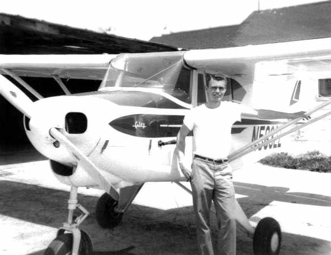
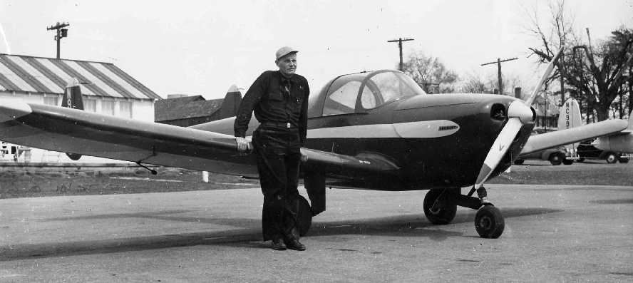
A June 1963 photo of Harry Silvers in front of the Piper Colt at Echelon Airport, after his 1st solo flight.
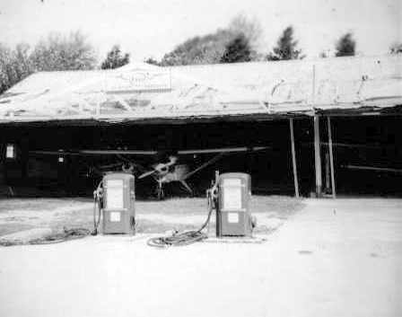
A July 1963 photo by Harry Silvers of the Esso gas pumps in front of a hangar at Echelon.
According to Harry Silvers, “Hugh Hamill gave up operating the airport in July 1963.
Manny Lynn from nearby Clementon Airport took over & I was eventually let go.
He probably renamed it Delaware Valley Airpark.”
Lee Oldershaw recalled, “In 1963 I got my multi-engine ratings at Echelon Field in a 150 hp Piper Apache.
John Horton was the excellent instructor.”
A 1963 aerial view of Echelon / Delaware Valley showed a decrease in the number of planes visible parked outside – to only 1.
The 1964 Washington Sectional Chart depicted “Delaware Valley” Airport as having a 2,800' unpaved runway.
Harry Silvers recalled, “I flew into the airport in a J-3 in 1964. It closed for good in 1965.”
The 1965 USGS topo map still depicted Echelon Airport as having 2 unpaved runways.
A sad 1965 aerial photo showed Echelon Airport seemingly abandoned.
It remained intact, but no aircraft were visible on the field.
Echelon Airport was no longer depicted on the October 1966 Philadelphia Local Aeronautical Chart (courtesy of John Ferrara).
The 1968 USGS topo map no longer depicted Echelon Airport, just a clearing.
A 1970 aerial photo showed the Echelon Mall covering the southwestern portion of the Echelon Airport site, with no trace left of the former airport.
According to Harry Silvers, “The Echelon Mall opened in 1970” on the site of Echelon Airport.
Scott Roberts reported in 2005, “The [Echelon] Mall has fallen into harder times recently, despite a great location, with its anchor stores leaving after many years there.
Maybe they could put the airport back?”
Scott Roberts provided an update in 2007: “The mall which had replaced it in the early 1970s has been half demolished,
and now housing is going up in its place.
The remainder of the mall is being refurbished as a smaller version of its old self.
Funny - the airport left for the mall, and the mall gave a wing for housing... Sad.”
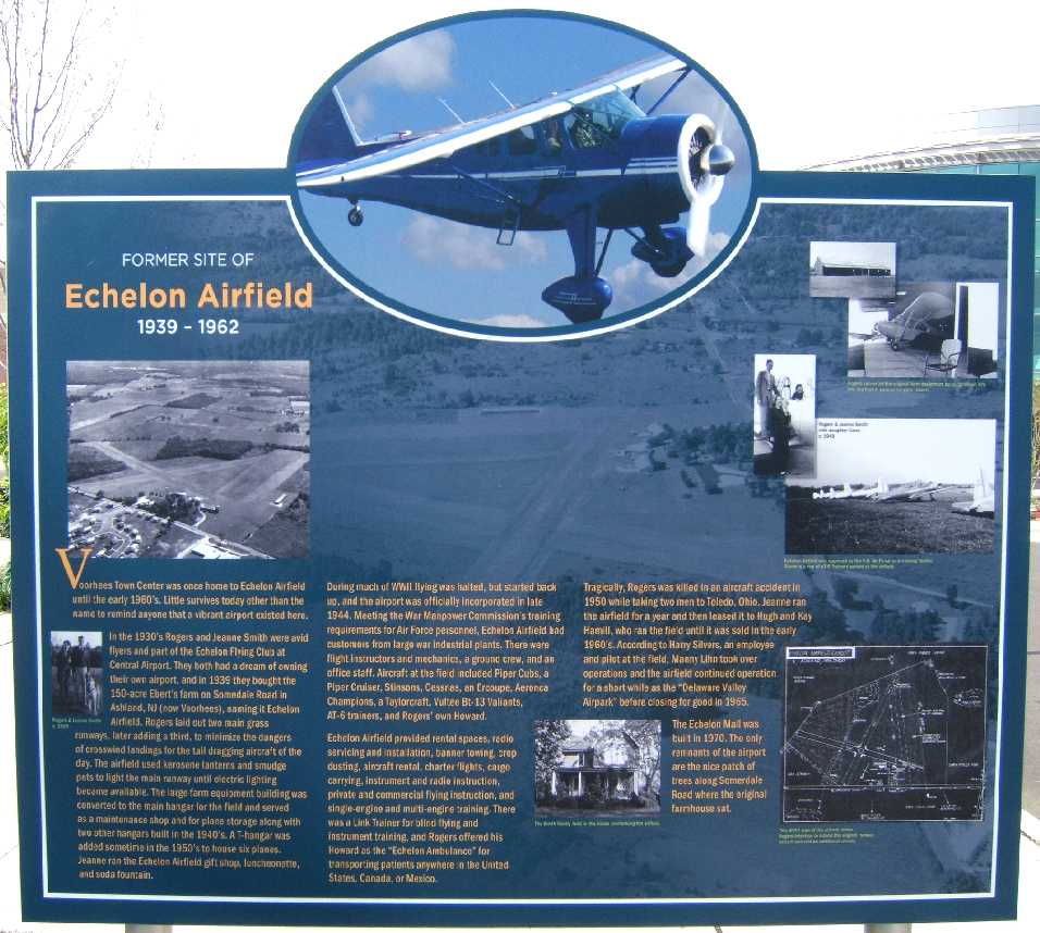
A 2009 photo by Harry Silvers of the historical sign which stands at the site of Echelon Airport.
Harry reported, “There was a dedication on 9/19/09 of a new sign about Echelon Airfield
which stood on what is now the Voorhees Town Center. No more Echelon Mall.
Carol Smith (daughter of Roger & Jeanne Smith, the original owners of Echelon Airfield) was there along with the Mayor & townsfolk.
A township resident who learned to fly at Echelon on the GI Bill after WW2 was there showing his signed logbook.”
A 2019 aerial view showed no trace remaining of Echelon Airport.
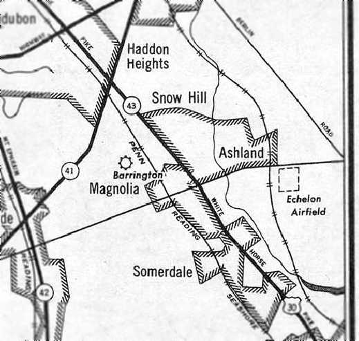
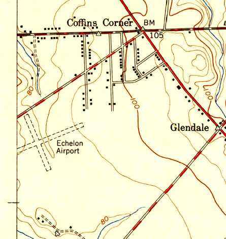
The site of Echelon Airport is located south of the intersection of Sommerdale Road & Echelon Road.
____________________________________________________
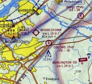
39.97, -74.91 (East of Philadelphia, PA)
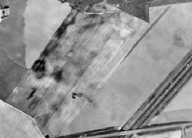
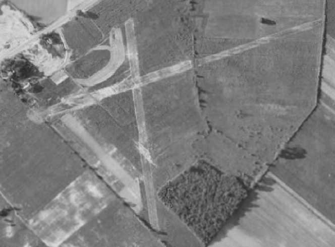
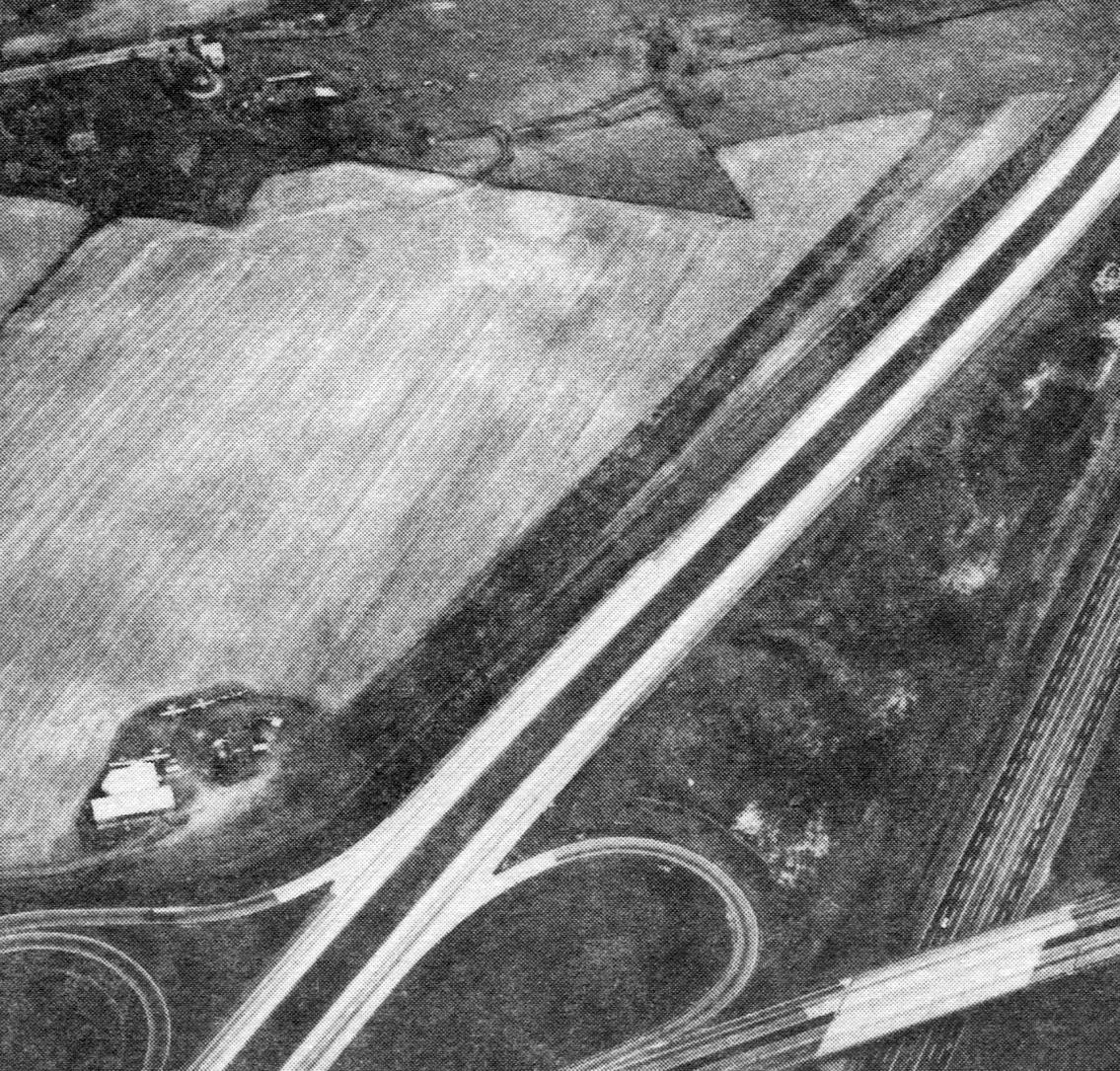
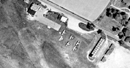
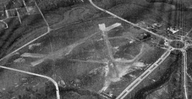
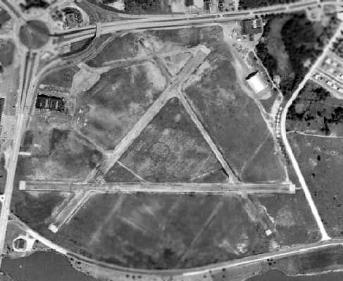
A 1956 aerial view depicted Collins Field as having a single northeast/southwest grass runway.
This little private airfield was located adjacent to the north side of Interstate 295.
Collins Field was evidently established at some point between 1944-59,
as it was not yet depicted on the May 1944 Washington Sectional Chart (courtesy of Chris Kennedy).
The earliest reference to Collins Field which has been located
was in a circa 1949-53 article in the Maple Shade NJ Progress (courtesy of Dennis Weaver),
entitled “Airplanes Burned in Hangar Fire”.
It reported that 2 planes (a Funk & a Piper Cub belonging to Roy Collins)
were destroyed in a fire along with a hangar, at the Collins farm on Route 38.
A 1951 aerial photo depicted a small farmhouse & what may have been a hangar just to the southeast.
According to Dennis Weaver, “It was Harold Collins farm & son Roy Collins.
They grew potatoes & Roy repaired airplanes on the side. He was an airplane mechanic.”
Collins Field was not yet depicted on the 1953 USGS topo map.
The earliest depiction of Collins Field which has been located was a 1956 aerial view.
It depicted Collins Field as having a single northeast/southwest grass runway,
with a small building at the southern end of the property.
The other building (the hangar that had reportedly burned down?) was gone.
The earliest aeronautical chart depiction of Collins Field which has been located
was on the August 1959 Philadelphia Local Aeronautical Chart (courtesy of Chris Kennedy).
It depicted Collins Field as a private field with a 2,600' unpaved runway.
Carolyn Boxmeyer recalled "Collins Field… We discovered it near Route 38 & 295.
It had a wood frame house & a little hangar with a Funk aircraft in it.
I think that's where Mr. Collins lived
and I remember him coming to Lincoln Flying Service (Abe Stein's place) and doing some A&P work for him."
The 1962 AOPA Airport Directory described Collins Field
as a private field having a single 2,650' turf Runway 4/22.
The field was said to offer fuel, minor repairs, hangars, and tiedowns, and to be operated by H.R. Collins.
A 1963 aerial photo just depicted a single farmhouse.
A 1965 aerial photo showed that another building (a hangar?)
had been added southwest of the farmhouse at some point between 1963-65.
Collins Field was not yet depicted on the 1966 USGS topo map.
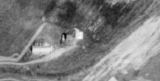
The earliest photo that has been located showing an aircraft at Collins Field was a 1970 aerial view.
A closeup from that photo showed a single light aircraft parked near a hangar which had been added at some point between 1963-70.
Collins Field had apparently lost some of its runway length at some point between 1962-70 due to the construction of I-295 on the southern part of the property,
as the 1970 Washington Sectional Chart (courtesy of John Clifford) depicted it as having only an 1,800' unpaved runway.

An undated aerial view looking northwest at Collins Field from the 1973 NJ Airport Directory.
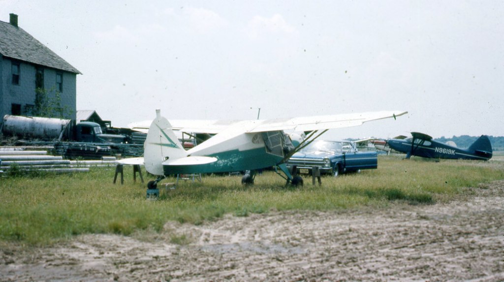
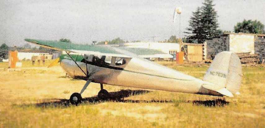
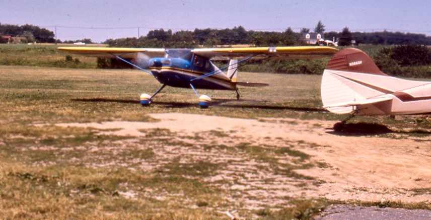
A 1975 photo by Jim Megee at Collins Field showed “a 1950 Piper Pacer PA20 N7363K (getting ready for paint) and it was my Dad's plane.
The Black Stinson N9619K in the background belonged to Dan Calderale who was a friend of my Dad's.
Dan was one of the Original Six of Diamond T-6 pilots.
He had bought an old raggedy T-6 & restored it to Marine markings & later used that aircraft in the Six of Diamonds flight team.
When he bought his T-6 it was painted in a Vietnam camouflage paint job.”
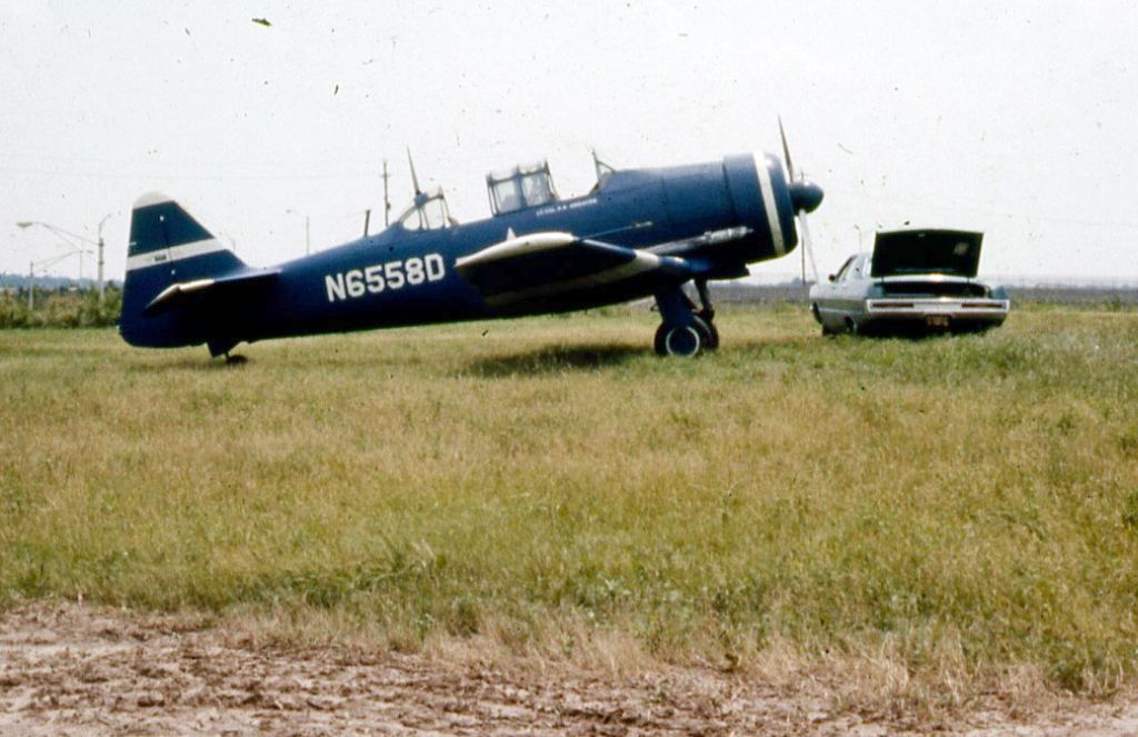
A 1975 photo by Jim Megee of a T-6 Texan at Collins Field.
Jim observed, “I am NOT sure if the T-6 is one of the same ones that flew with the Six of Diamonds.”
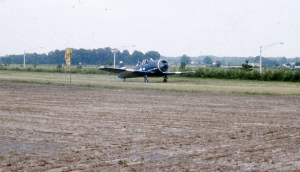
A 1975 photo by Jim Megee of a T-6 Texan at Collins Field.
Collins Field was still listed as an active airfield in the 1976 AOPA Airport Directory (according to Chris Kennedy).
The last photo which has been located showing aircraft at Collins Field was an undated aerial view looking north from the 1979 NJ Airport Directory.
It described Collins Field as having a single 1,860' turf Runway 4/22, and listed the manager as Harold Collins.
Five light single-engine aircraft were visible parked near the building on the southwest end.
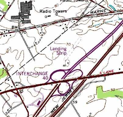
Collins Field was still depicted on the 1981 USGS topo map, although labeled simply as a "Landing Strip".
It was depicted as a single northeast/southwest runway,
along with what appeared to be 2 small buildings on the southwest side of the runway.
Collins Field was still listed as an active airfield in the 1982 AOPA Airports USA Directory (courtesy of Ed Drury).
It described Collins Field as having a single 1,800' turf Runway 5/23.
Richard Headley recalled, “As to the Collins field, I understand that they kept 2 AT-6s at the field in the late 1980s.
They would practice their follow-the-leader flying next to my house.”
The last aeronautical chart depiction which has been located of Collins Field was on the March 1987 Philadelphia Terminal Aeronautical Chart (courtesy of Kevin O'Reilly).
It depicted Collins as having only an 1,800' unpaved runway.
The 1988 USGS topo map continued to depict a single northeast/southwest “Landing Strip”.
Collins Field was evidently abandoned at some point between 1987-95,
as the 1995 USGS aerial photo no longer depicted any recognizable trace of a runway at the site.
The property remained an open grass field, and had not (yet) been redeveloped.
Collins Field was no longer depicted on the 1998 USGS topo map nor the August 1998 Philly Terminal Chart (courtesy of John Ferrara).
Scott Roberts reported in 2005, “The site of Collins Field is fully redeveloped now - it is no longer the nice open space it had been.
Covering what had been the airport are now several box stores & accompanying mini-malls.
The whole section is now commercial. Target, Home Depot, are a couple of the anchor stores for the area.
This has happened in the past 3 years. The site shown on the topo map is all under parking lots now.”
Jim Megee reported in 2013, “The stores that now exist in that area do not include a Home Depot.
It has a Costco there at one end of the strip mall; that would be the northern end of the runway.”
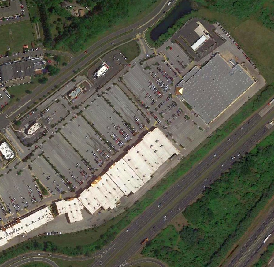
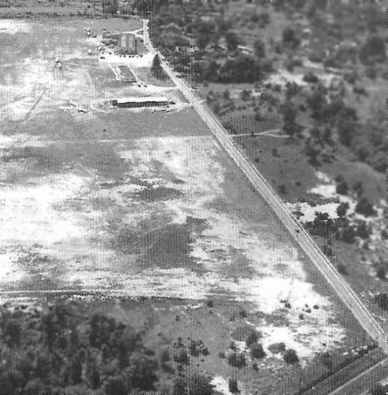
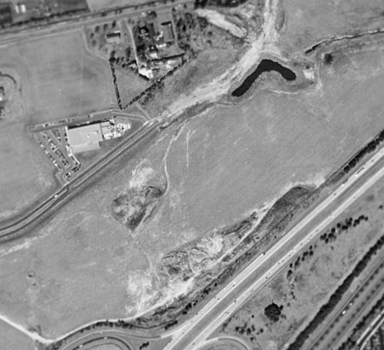
A 2016 aerial view shows no trace remaining of Collins Field, with the property covered by the Centerton Square shopping center.
The site of Collins Field is located north of the intersection of Interstate 295 & Route 38 (Exit 40).
____________________________________________________
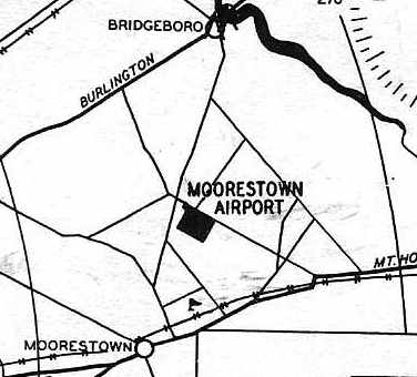
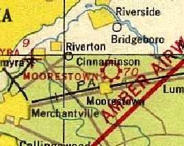
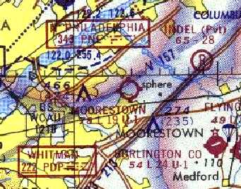
Moorestown Airport (2NE), Moorestown, NJ
39.99, -74.94 (East of Philadelphia, PA)
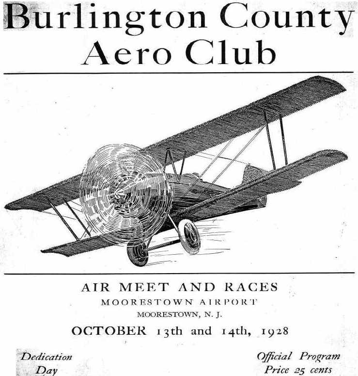
The cover of the 10/13/28 Dedication Day program for the Moorestown Airport (courtesy of Dennis Weaver).
According to "A Concise History of the Burlington County Aero Club" (courtesy of Dennis Weaver),
starting in 2/1/28, the club secured a 50-acre field, "one of the safest in the east",
purchased 2 new Waco 10 biplanes, purchased & erected a large metal hangar,
employed as full time chief pilot & instructor Lt. E. G. Pennock, of the 103rd Observation Squadron, PA National Guard,
and made 1,450 passenger hops.
The Burlington County Aero Club held an "Air Meet & Races"
to commemorate the Dedication Day of the Moorestown Airport on 10/13/28,
according to the program of the event (courtesy of Dennis Weaver).
According to an article entitled “Air show opened club's new airfield” by Nancy Bowker
in a post-1970s issue of the Burlington County Times (courtesy of Doris Stow),
the Aero Club offered lessons in flying in 3 membership categories
and on weekends short hops over Moorestown were given for a small fee.
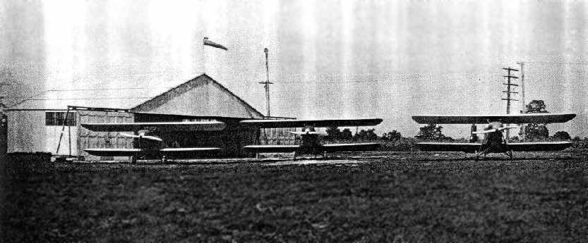
The earliest photo which has been located of Moorestown Airport was a 1928 photo of 3 Waco 10 biplanes in front of the Burlington County Aero Club hangar (courtesy of Dennis Weaver).
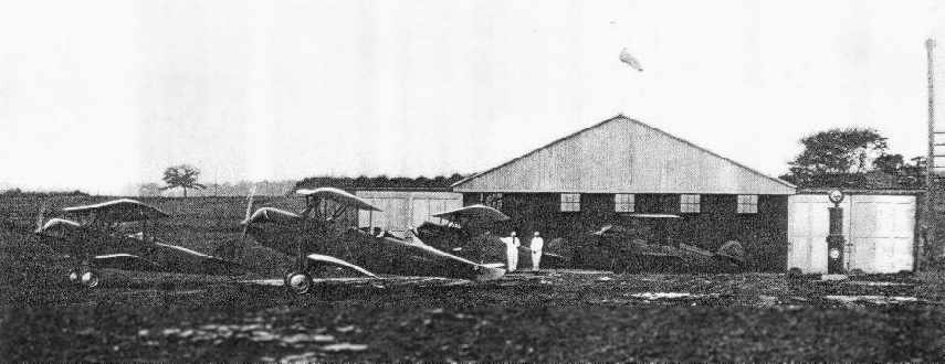
A circa 1928 photo of the 2 Burlington County Aero Club airplanes & 2 member airplanes in front of the Moorestown Airport hangar (courtesy of Dennis Weaver).

A circa 1920s photo of a woman & 2 girls in front of a biplane (model undetermined) at Moorestown Airport (courtesy of Cathy).
Cathy recalled, “Moorestown Airport... my mother talked about remembering wing-walkers & stuntmen.
She inferred they really were a 'seedy' lot of daredevils.
She took flying lessons when she was 12 but never got her official license as her dad (Les Marshall) did not think it was appropriate for a girl to do so.
She talked about Charles Lindbergh using the Moorestown Airport as an out-of-the-way meeting place for friends of his who were also pilots.”
A 1930 aerial photo depicted Moorestown Airport as a square grass field with an airport circle marking in the center,
and several buildings along the north side.
The earliest map depiction of the Moorestown Airport which has been located
was on the Philly Chamber of Commerce's 1930 "Aviation Map of the Philadelphia Metro District" (courtesy of Tom Beamer).
The airfield layout of the "Burlington County Aero Club Field, Moorestown"
from the 1930 book "Philadelphia Aeronautical Center of the East"
(courtesy of the George H. Stuebing Collection of the Delaware Valley Historical Aircraft Association).
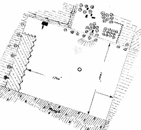
The directory described the field as consisting of a 50 acre rectangular gravel field,
measuring 1,700' northwest/southeast by 1,400' northeast/southwest.
The field was said to be owned & operated by the Burlington County Aero Club.
A single 40' x 40' metal hangar was depicted on the north side of the field.
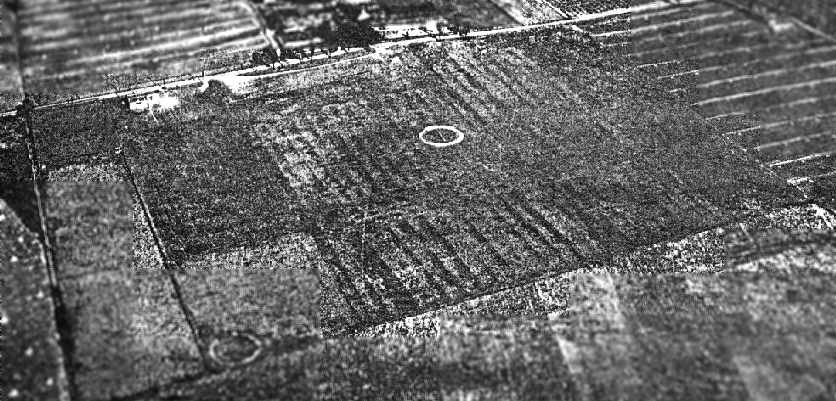
An aerial photo looking northeast at the "Burlington County Aero Club Field, Moorestown"
from the 1930 book "Philadelphia Aeronautical Center of the East"
(courtesy of the George H. Stuebing Collection of the Delaware Valley Historical Aircraft Association).
The earliest aeronautical chart depiction which has been located of Moorestown Airport was on the May 1932 Washington Sectional Chart.
It depicted the “Aero Club” airfield.
The Moorestown Airport may have gone through a period of abandonment at some point starting between 1932-35,
as it was not depicted at all on the 1935 Washington Sectional Chart,
nor listed among active airfields in the Airport Directory Company's 1937 Airports Directory (courtesy of Bob Rambo).
The first Air Mail flight in the history of Moorestown was 5/19/38 (according to the Burlington County Times article, courtesy of Doris Stow).
That air mail flight flew out of Moorestown Airport.
The Depression ended the Aero Club & the airfield eventually became a pumpkin field,
until Les Marshall reopened the airport & established the Marshall Flying Service".
Marshall's wife ran the cafeteria.
According to a relative of Moorestown Airport owner Lester Marshall,
“Family history says that Lindbergh had a private meeting at the airport with a Colonel Ricken.”
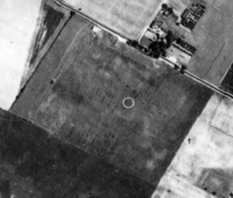
A 1940 aerial photo depicted Moorestown Airport as a square grass field with an airport circle marking in the center, and 3 runways.
Several buildings were located along the north side.
Moorestown was depicted as a commercial/municipal airport on the 1940 Washington Sectional Chart (courtesy of Mike Keefe).
Les Marshall operated Moorestown Airport until World War 2 (according to the Burlington County Times article, courtesy of Doris Stow).
The 1942 USGS topo map depicted Moorestown Airport as having 3 unpaved runways.
Moorestown Airport was described in the April 1944 US Army/Navy Directory of Airfields (courtesy of Ken Mercer).
as having a 1,500' unpaved runway.
Lee Oldershaw recalled, “One day during WW2 there was an Army C-75 (Boeing 307) & a dozen L-19s parked there.
How the C-75 ever landed there I'll never know. I distinctly remember it was a tailwheel aircraft in olive drab with 4 engines so it wasn't a C-47 (DC-3).”
Moorestown Airport was not listed among active airfields in the 1945 AAF Airfield Directory (courtesy of Scott Murdock).
After the Second World War, Les Marshall was short on funds
so his boss Richard Hineline of the Camden Lime Company became his partner
(according to the Burlington County Times article, courtesy of Doris Stow).
Together they ran the "GI Bill of Rights Flying School".
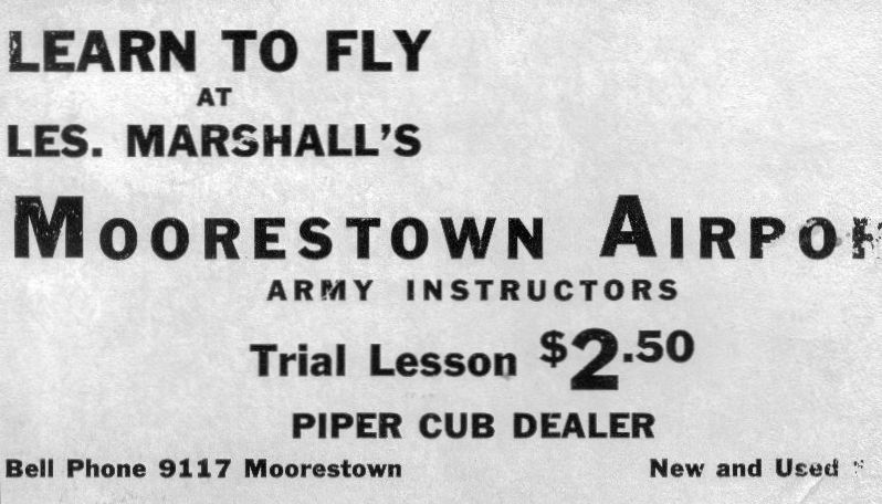
A circa 1940s advertisement for Moorestown Airport (courtesy of Cathy).
Cathy recalled that her grandfather, Les Marshall, owned Moorestown Airport.
A circa 1940s photo of planes in front of a Moorestown Airport hangar (courtesy of Cathy).
A circa 1940s photo of the Moorestown Airport office (courtesy of Cathy).
Debbie Steinberg reported, “Joseph Denison flew out of Moorestown airport. After the war [WW2] a friend told him about the school in Moorestown
and that he could learn to fly for free through the GI Bill.
He loved flying & he went down & signed up for training as a crop duster.
He did get his pilot's license but had to stop flying when Uncle Sam stopped paying because it was too expensive.”
According to Richard Hineline Jr., “I think our family / Camden Lime Company became financially invested in the airport shortly after WWII ended.
My Father was Richard Hineline who started the the 'GI Bill of Rights Flying School' with Les Marshall.
I think Les Marshall may have also been employed by Camden Lime Company.
My Grandfather was Frank Hineline who at the time was President of Camden Lime Company.
I remember going up to the airport with my Father when I was a little boy & my Father putting me in the seat of a small yellow plane.
I remember a metal building with C.A.P. (Civil Air Patrol) printed on the side.
I remember the story my Father told me that after WWII was over, my Father’s Brother, Budd Hineline
flew a US Navy plane from Willow Grove & landed at the Moorestown Airport & picked up my Father & took him for a ride.
My Uncle got in a little trouble for that stunt but because the war was over, he just got slapped on the wrist.”
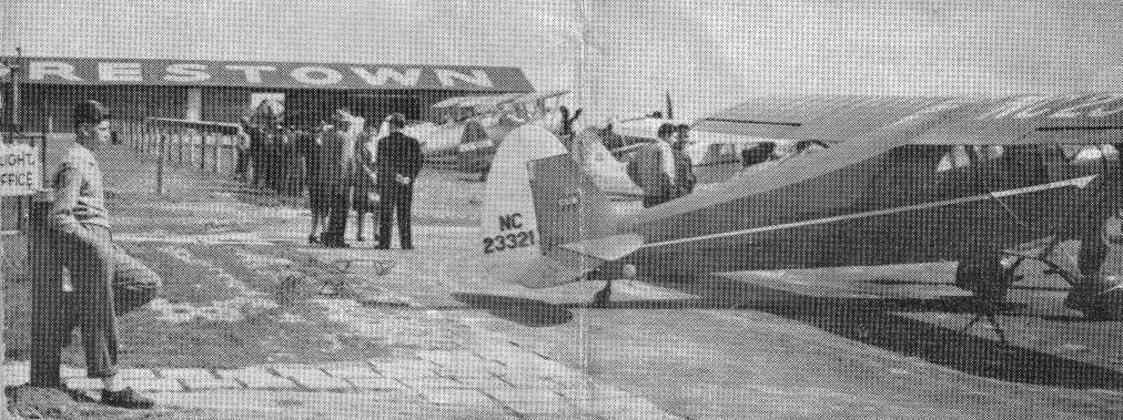
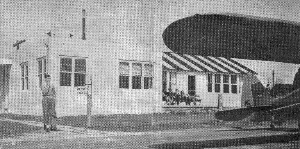
A circa 1940s aerial view of the hangar of Marshall Flying Service at Moorestown Airport (courtesy of Doris Stow).
An Ercoupe is visible in front of the hangar, as well as a Republic SeaBee above the hangar.

A circa 1940s photo (courtesy of Richard Headley) of his father “Robert Headley’s airplane in front of his hangar at Moorestown Airport.
It is a PT-19 Trainer. The plane had a 440 cubic inch, 6-cylinder air-cooled Ranger engine. It developed about 175 HP. I flew many times in the rear open cockpit.
The building behind the plane is part of the main hangar & Marshall’s Air Service Hangar.
We would fly out of there on Sundays during the summer. The Civil Air Patrol would have meetings & parties at the airport.”
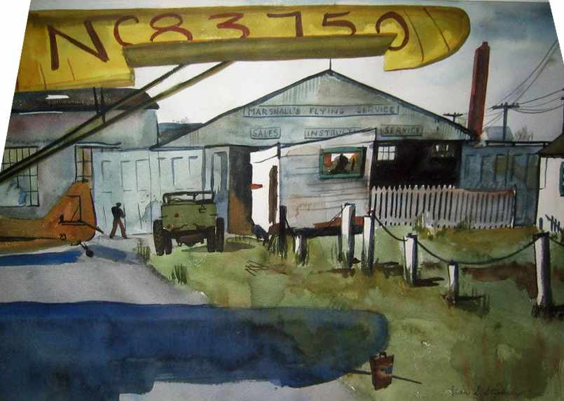
A 1949 watercolor by Jean Stickney of Moorestown Airport's Marshall's Flying Service hangar (courtesy of Veronica Balassone).
Lee Oldershaw recalled, “I took my first ride in a [Piper] J-3 at Moorestown Airport in 1949 at age 12.
I went on to be a pilot for Eastern Air Lines, the same airline that Joe Stow & his son Calvin flew for who lived across the street from the airport.”
The 1950 Washington Sectional Chart (courtesy of Mike Keefe)
described Moorestown Airport as having a 2,000' unpaved runway.
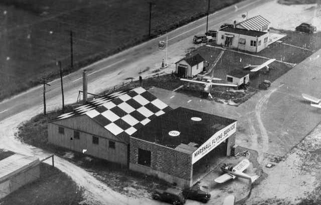
A 1951 aerial photo showed a hangar painted with “Moorestown” had been added along the northeast side at some point between 1940-51.
Three single-engine planes were visible near a checkerboard-painted hangar on the north side.
Dennis Weaver recalled, “On the grounds of Moorestown Airport was the 'Airport Lunchroom'
a sandwich counter where locals riding their horses might stop in for a lunch.”
The 1953 USGS topo map depicted Moorestown Airport as having 3 unpaved runways, with 3 buildings along the northeast side.
Joseph & Ginny Stow bought a house & farmland in 1953 across from the Moorestown Airport.
They bought the house because Joseph was an airline pilot.
Corky Scott recalled, "There was a small grass field near where I grew up called Moorestown Airport.
It doesn't exist anymore, it's all built up,
but when I was a kid I used to ride my bike the 5 or 6 miles to it
and crawl as close as I could to the edge of the runway in the brush
to watch the Cubs & Cessnas touch down just 30 or 40 feet away.”
Corky continued, "I remember distinctly watching one J-3 come in.
He was obviously too high & I expected him to go around
but instead he cocked his wing way up & kicked in opposite rudder & came down like a freight elevator.
I was amazed, never having seen a slip before
(there were 2 in the airplane & in retrospect it appears the instructor was demonstrating slips).
He brought the wing up at around 10 feet & settled into his landing.
I remember watching him let the airplane glide down to just above the grass & flared.
I could see the elevator making minute movements as he milked it back bit by bit, loosing more & more speed.
The airplane held on for a second, then seemed to sigh & settled onto the grass on all 3 wheels bouncing very slightly as it rolled out.
Even at the age of 10, it was easy to recognize a good landing when I saw it."
A circa 1953-54 photo by Bob Welsh of his beautiful red Ercoupe at Moorestown Airport (courtesy of Kathleen Welsh Baxter).
A 1954 photo of Bob Welsh in front of his Ercoupe at Moorestown Airport (courtesy of Kathleen Welsh Baxter),
with Moorestown's distinctive striped-roof hangar in the background.
Kathleen Welsh Baxter recalled, “Moorestown Airport [was] where my father kept his plane.
My father, Bob Welsh was an engineer with RCA.
I took many flights with him as a child; small enough that I would say at takeoff: 'Is we up yet, Daddy?'
We often flew to Rising Sun, MD to land at a field near where my grandmother lived & would follow the NJ Turnpike home.
Rod Smith (who owned Echelon Field) was also an engineer.
My father would remember how Rod would come home from work in the summer
and cut the grass at night on a mowing tractor with headlights.”
Dennis Weaver reported, “I had a nice talk with John Ravikio [son of Blase Ravikio].
Tom Edwards, Herbert Dubois, and Blase Ravikio purchased Moorestown Airport from the Camden Lime Company in August 1955 for roughly $45,000.
The airport, when they bought it contained about 50 acres, of which 15-16 acres were wetland.
Paul Schirmer ran the airport for them. A lady named Josey ran the Airport Restaurant.”
A 1956 aerial view depicted Moorestown as having 3 unpaved runways.
A closeup from the 1956 aerial view showed a total of 8 aircraft at Moorestown Airport,
in addition to the checkerboard-roofed hangar, and another hangar with “Moorestown” painted on the roof.
According to Lee Seetoo, “In 'The Fire Within: The Story of Inductotherm Industries Inc.' by Henry Rowan,
Rowan describes buying his first plane at Moorestown Airport in 1957.
According to the book Rowan & his wife installed the airstrip's first lights in 1958 because he was tired of landing in the dark at night.
The airfield was critical to the early success of Inductotherm because of the edge it gave Rowan in reaching customers
either to pitch deals or service installations (of induction furnaces).
Eventually Inductotherm moved to a larger facility with its own airfield.”
In the 1950s the airport was sold to Blase Ravikio (according to the Burlington County Times article, courtesy of Doris Stow).
It was thriving at the time. Paul Schirmer was the operator.
Blase Ravikio wanted to improve the airport with a paved runway,
but with nearby residential development he realized it couldn't be a 1st-class airport.
A 1963 aerial view depicted Moorestown as having 3 unpaved runways.
A 1965 photo by Bernie Rieck of a Piper & Cessna in front of a hangar & office building at Moorestown Airport.
A 1965 photo by Bernie Rieck of 2 Cessnas at Moorestown Airport.
According to Eric Ravikio (the son of John Ravikio & the grandson of Blase Ravikio),
one of Moorestown's 2 runways was closed “when the High School was completed in 1965.”
Dennis Weaver reported, “After the Moorestown High School was built, one runway was closed.
Houses were built & another one was closed.”
Richard Edwards recalled, “Between 1966-68 I ran a an Explorer Squadron flying club at the Moorestown Senior High School.
The club did their flying out of Moorestown Airport.
When the Moorestown Mall was finished I suggested to Bob & Paul that they have a fly-in at the Mall, and they did.
After having an article run in the Courier Post, Trudy Haynes came out & did a news story on my flying club.
I also organized a 30+ student trip to Lock Haven, PA. In just as many airplanes.
The problem with Moorestown Airport was it had so many issues... The main runway was a grass\dirt runway & not paved, only 1,900'.
The airport was leased to the owners by Blase Ravikio. The Moorestown Senior High School was so close to one of the runways that they had to close it.
By 1970, Richard Nixon started pulling contracts from RCA.
Moorestown Airport couldn't complete with Flying W Ranch for fly in breakfast meals & rubbing shoulders with the likes of Bob Cummings. So, it died.”
The 1968 USGS topo map still depicted Moorestown Airport as having 3 unpaved runways.
The 1968 Flight Guide (courtesy of Robert Levittan) depicted Moorestown as having 3 unpaved runways,
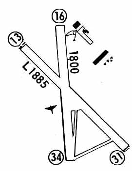
with the longest being the 1,885' Runway 13/31, and with several buildings on the north side.
The 1970 Washington Sectional Chart (courtesy of John Clifford)
described Moorestown as having a 1,900' unpaved runway.
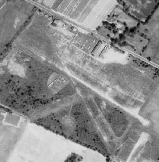
The last photo which has been located of the Moorestown Airport was a 1970 aerial view.
Note that the new high school had been built directly on the end of the northeast/southwest runway (a very compatible location for a school, right?),
which resulted in the closure of that runway.
It depicted a total of 25 light aircraft on the field.
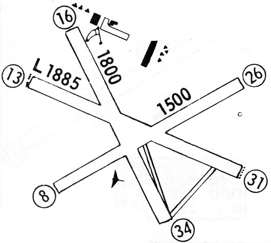
The 1972 Flight Guide (courtesy of Chris Kennedy) depicted Moorestown Airport
as having 2 unpaved runways (1,885' Runway 13/31 & 1,800' Runway 16/34),
along with several buildings (hangars?) on the Northeast corner of the field.
Blase Ravikio closed the Moorestown Airport at some point between 1972-73
after the township had built its high school right in the path of the airstrip
(according to the Burlington County Times article, courtesy of Doris Stow).
At the time of its closure, Moorestown was the 2nd-oldest airport in New Jersey.
According to Richard Hineline Jr., “I think our family / Camden Lime Company continued some type ownership until the airport closed about 1972-73
or maybe sometime before it closed.”
According to Eric Ravikio, “I was born in 1973 & grew up on that parcel of land, but unfortunately, [the airport] was closed by then.
One of my favorite things to do as a child was to go into the wooded area (very close to the school's parking lot)
and search through junk from the airport days.
I remember old airplane tires, medicine & Coke bottles & even an old wooden fuselage. It truly was a child's treasure.”
Dennis Weaver reported, “Tom Edwards died in 1974 & his family wanted Blase Ravikio to settle & buy his share.
John Ravikio became 2/3 owner & Blase 1/3 of all the Moorestown Airport land.”
A slightly later closing date was reported by Richard Woodland,
who recalled, “Moorestown Airport... I always knew it as Flying Feather.
I lived in Moorestown until 1975 when I graduated from high school.
My memory tells me that airport was open through my high school years ending in June 1975.
While attending Moorestown High School I would often walk across the field & runway when I had a free period or two in the spring.
Several times I hitched rides around the pattern in a Cessna 150 with one of the old instructors.
I remember it open at least until 1975.
I was in the Civil Air Patrol as a youth member & they had a hangar & a single-engine airplane.
They held meetings in the hangar; it might have been the Camden Composite Squadron.”
Moorestown Airport was no longer depicted on the February 1975 Washington Terminal Chart.
Dennis Weaver reported, “By 1977 they closed the Airport. It was the 2nd oldest airport in NJ.
There was a rancher there for Paul Schirmer to live in.
Paul Schirmer, after the Moorestown Airport closed, moved to run the Hammonton Airport.
Josey's Restaurant building was given to a neighbor & was moved across the street (Westfield Road) to become an addition to a house.”
Moorestown Airport was no longer depicted on the 1981 USGS topo map.
According to Richard Hineline Jr., “I drove by sometime in the 1970s or 1880s well after the airport closed
and I think there was a landscaping business using some of the buildings.”
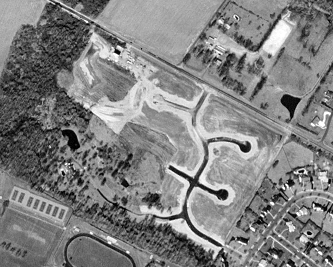
As seen in the 1995 USGS aerial photo, the majority of the property of Moorestown Airport had been covered by several recently constructed streets.
However, the circa-1928 hangar actually remained standing in the northwest corner of the property.
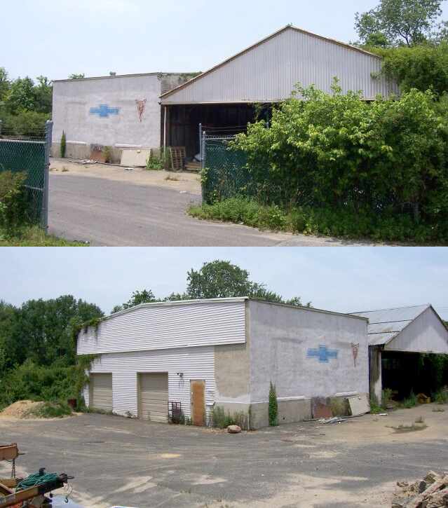
Two 2006 photos of the the circa-1928 hangar which remains standing at the site of Moorestown Airport.
Eric Ravikio reported in 2006, “My father still owns the property.
I restored antique cars in one of the 2 buildings still standing when I was in High School, hence the Chevy & Pontiac signs on the side.
Currently, we use it for construction storage.
Development was always put off since we lived there & enjoyed the privacy, but there will be 16 more homes built in the near future.
The one hangar closest to Westfield Road must be removed as it is located in the county road right-of-way.
The other building could remain as it will be located on a 3.5 acre residential building lot.
I have often considered building my own home there & restoring the building - the 'Barn' as we call it.
It is filled with fond memories for me.”
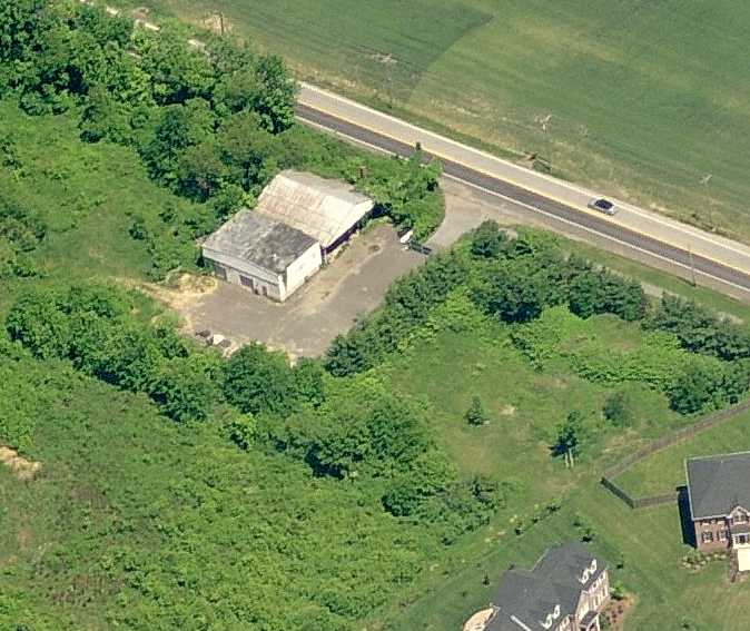
A circa 2007 aerial view looking north at the 80-year-old hangar which remains standing at the site of Moorestown Airport.

A 2016 aerial photo showed that houses had been built over the eastern portion of the former Moorestown Airport, but the western portion remained unredeveloped,
and the circa-1928 hangar actually remained standing in the northwest corner of the property.
Tom Weaver reported in 2020, “The hangar buildings are still there on Westfield Road.
Soon he must tear down the metal 1928 hangar due to it being so many feet to the county-owned road & it has to go.
It isn't built with screws but riveted together & has beams measuring 16x4 inches.
The cinderblock hangar could be used for a garage for the home to be built in the near future on that 3 acre lot, but it probably will just be torn down.”
A 2015 photo showed the former Moorestown Airport hangar remained standing on Westfield Road.
A 2017 photo showed the former hangar had been removed at some point between 2015-2017, erasing the last trace of Moorestown Airport.
The site of Moorestown Airport is located south of the intersection of Westfield Road & Garwood Road.
____________________________________________________
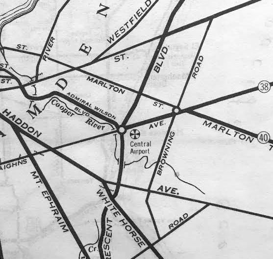
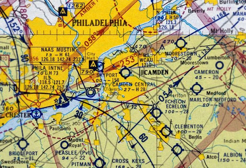
Crescent Airport / Camden Central Airport, Pennsauken, NJ
39.93, -75.08 (Southeast of Philadelphia, PA)
A 9/21/29 aerial view looking southeast at Camden Central Airport's dedication (from the Dallin Aerial Survey Collection, courtesy of the Hagley Museum & Library).
Nancy Gager reported, “I have a Public Ledger rotogravure section paper from 4/22/28 that talks about a 67 acre tract being dedicated as Crescent Airport.”
Several sites were considered in the late 1920s in an attempt to develop a commercial airport for the Philadelphia metropolitan area.
A piece of undeveloped ground along the north bank of the Cooper River,
east of Crescent Boulevard & South of Marlton Pike, attracted the interest of those desiring an airport's construction.
The site offered level ground & easy access to nearby roads.
According to an article by Walter Rebeiro in the Fall 2006 Aero Club of PA Pennsylvania Pilot,
“Central Airport was developed in 1929 from a small airport already built on farmland adjacent to the circle.”
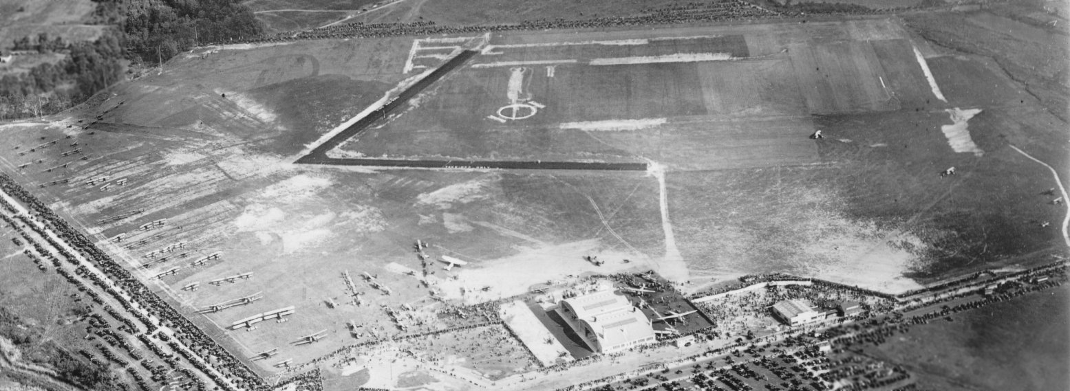
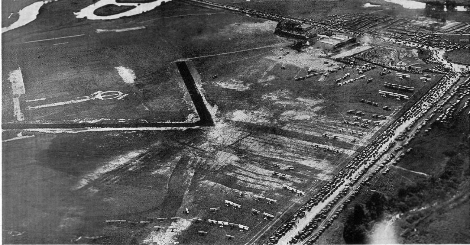
The earliest depiction of Camden Central which has been located was a 9/21/29 aerial view looking southeast,
showing its dedication, with hundreds of spectators & dozens of aircraft on the field.
It depicted the field as having 2 paved runways in the middle of a grass field, with several hangars along the west side.
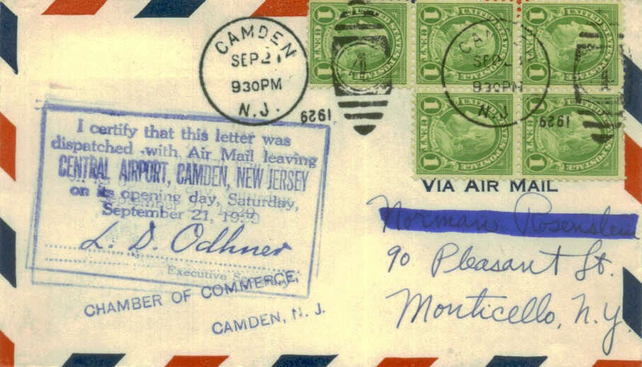
Camden Central's 9/21/29 Opening Day was commemorated with a postmark.
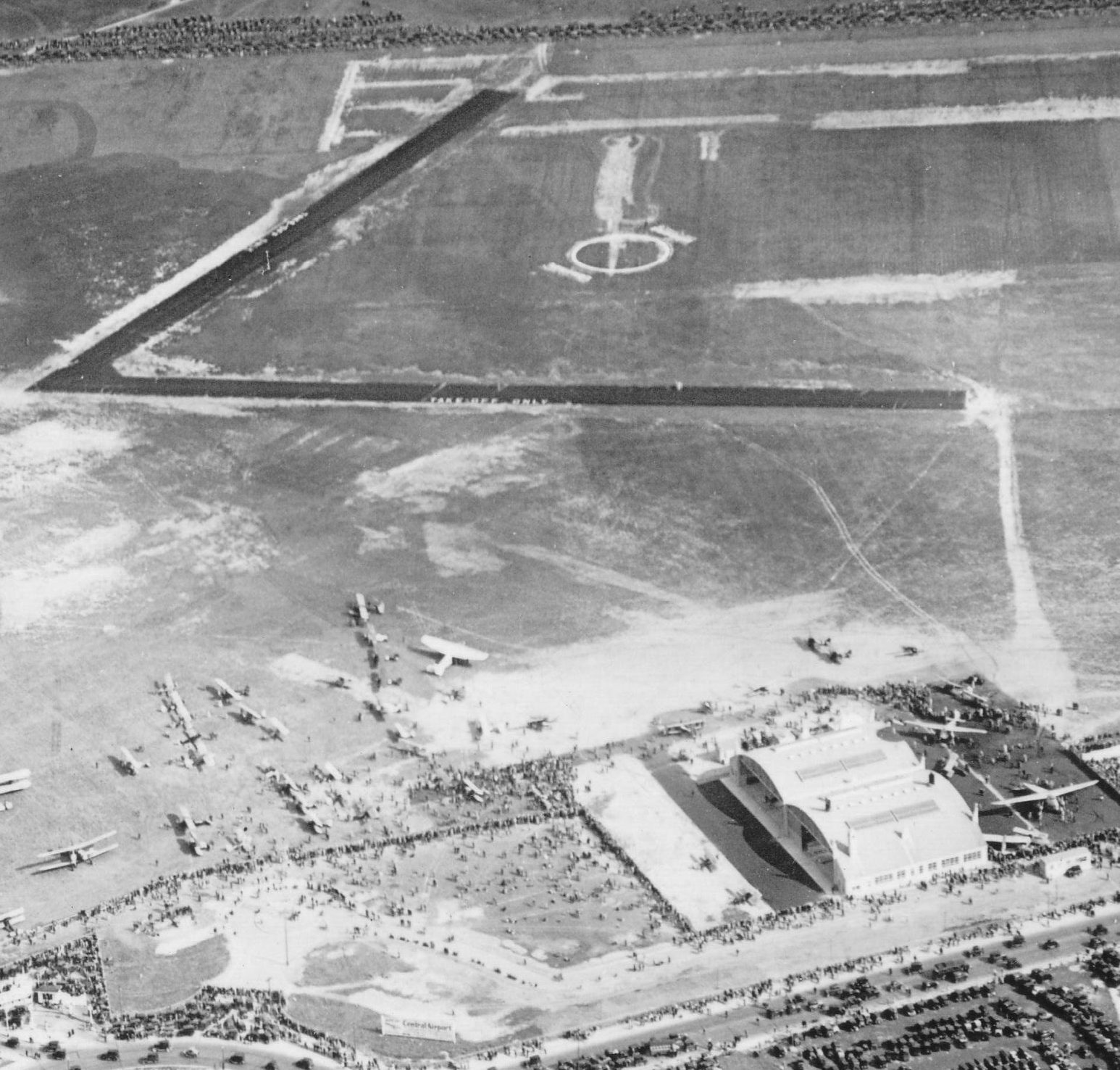
A closeup from the 9/21/29 aerial view looking southeast at Camden Central Airport's dedication (from the Dallin Aerial Survey Collection, courtesy of the Hagley Museum & Library).
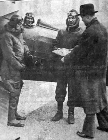
A 1929 photo of William Engle (pilot) & others delivering photographic plates to an Evening Ledger representative at Camden Central Airport (courtesy of William Engel Jr.).

A 1929 photo of several planes inside a Camden Central Airport hangar.
Camden Central Airport would become the prime air connection between the Philadelphia metropolitan area & the world for the next 12 years.
The 1930 "Rand McNally Standard Map of New Jersey With Air Trails" (courtesy of Chris Kennedy)
depicted Camden Central as Airfield #68 along the Atlanta-NY Airway,
and described the field as having two 2,400' runways (oriented north/south & east/west).
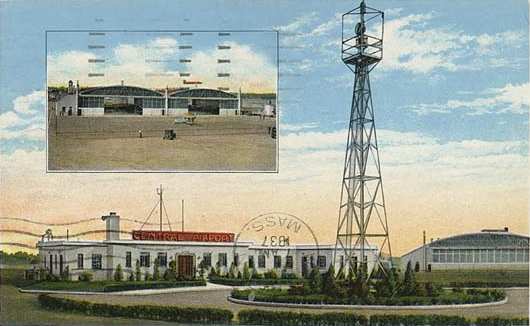
Camden Central Airport, as depicted on the Philly Chamber of Commerce's
1930 "Aviation Map of the Philadelphia Metro District" (courtesy of Tom Beamer).
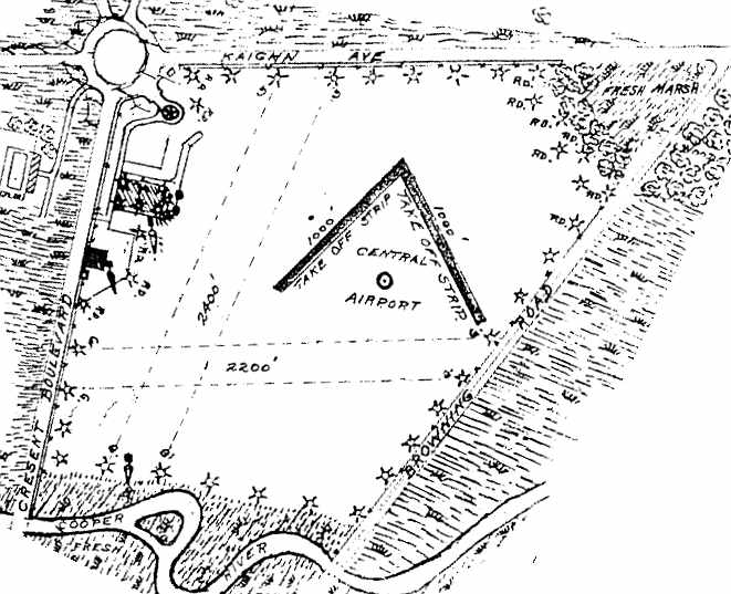
The airfield layout of Camden Central Airport,
from the 1930 book "Philadelphia Aeronautical Center of the East"
(courtesy of the George H. Stuebing Collection of the Delaware Valley Historical Aircraft Association).
The directory described the field as consisting of a 180 acre sandy loam field,
within which were 2 unpaved runways (measuring 2,400' northeast/southwest & 2,200' east/west)
as well as two 1,000' hard surface "take off strips".
The field was said to be owned & operated by Central Airport Inc.
Two 127' x 100' steel & concrete hangars were depicted on the northwest side of the field, along Crescent Boulevard.
The operators were listed as the Curtiss Flying Service, Luddington-Philadelphia Flying Service,
Jacobs Engine Manufacturing Company, and Wings Inc.
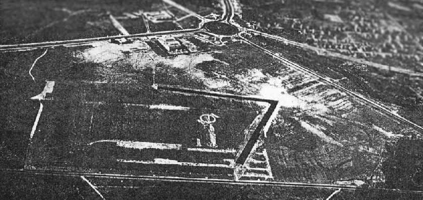
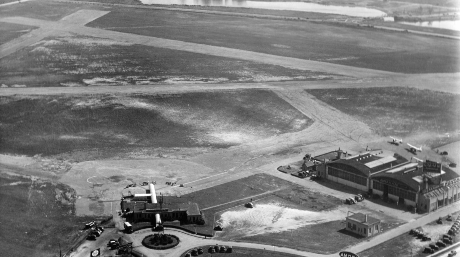
An aerial photo looking northwest at Camden Central Airport
from the 1930 book "Philadelphia Aeronautical Center of the East"
(courtesy of the George H. Stuebing Collection of the Delaware Valley Historical Aircraft Association).
A circa 1930 aerial view looking southwest at Camden Central Airport, showing 2 paved runways, a large gathering of biplanes, and hundreds of cars.
According to "Camden County, 1681-1931" (published by the Camden County Chamber of Commerce in 1931),
a plant for the Jacobs Aircraft Engine Company was established on the northern edge of the field.
A 1931 aerial photo showed a large hangar on the west side of Camden Central Airport,
a terminal building on the northwest side, and a small hangar on the northeast side.
Camden Central Airport, as depicted on the May 1932 Washington Sectional Chart.
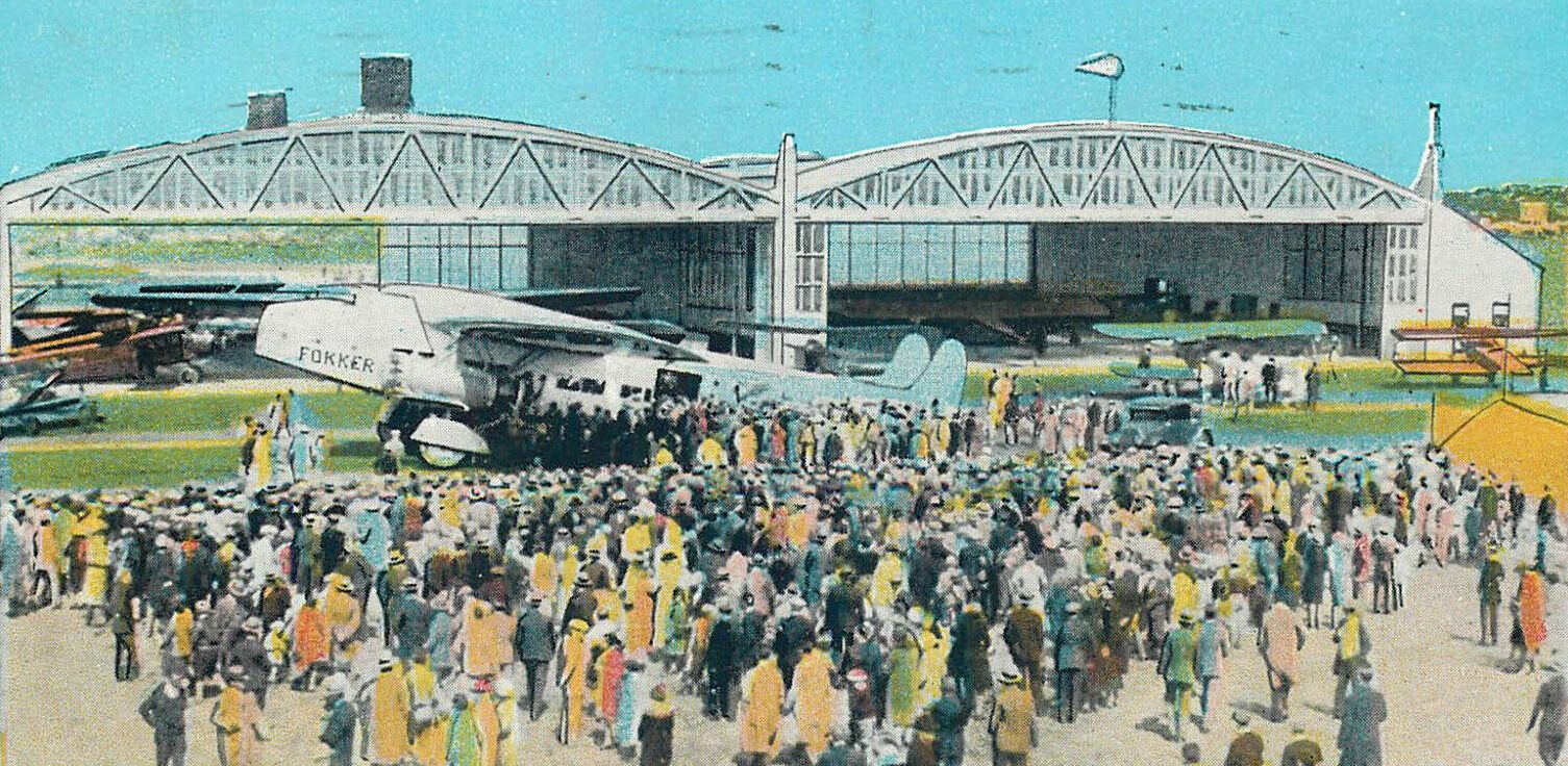
An undated colorized postcard of crowds in front of a Fokker F-32 airliner in front of Camden Central's hangars (courtesy of Dennis Weaver).
An aerial view looking east at Camden Central Airport,
from The Airport Directory Company's 1933 Airports Directory (courtesy of Chris Kennedy).
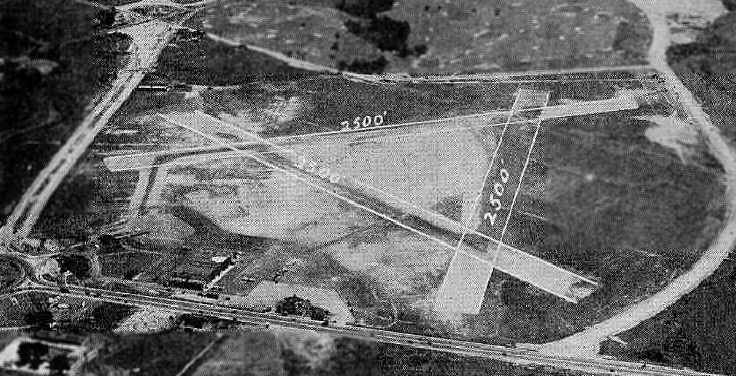
The directory described Camden Central Airport as having three 2,500' runways, described as "asphaltic oil treated gravel & macadam".
The aerial photo in the directory depicted a cluster of hangars along the northwest side of the field.
The manager was listed as J. W. Markheim,
and the operators were listed as Eastern Air Transport, Jacobs Engine Company,
Kellett Aircraft Company, Luddington Airplanes, Camden Flying Service,
and Transcontinental & Western Air.
According to an article by Walter Rebeiro in the Fall 2006 Aero Club of PA Pennsylvania Pilot,
“During its peak in 1933, transcontinental planes made 150 stops daily, making Central one of the busiest airports in the nation.”
A circa 1934 photo of a Brunner-Winkle Bird BK & a Brunner-Winkle Bird CK at Camden Central Airport.
Howard Walker reported, "This photo was the single photo taken at the airport as part of a promotion for the opening of the movie 'Dames'.
One of the models is my mother - she is the one getting out of the cockpit of the Bird BK, the plane on the left.”
Howard Walker recalled, “My first real job in the summer after I graduated high school was at the Central Airport working for Kellet Aircraft.
They had a government contract to build experimental air mail pickup devices.
Two steel poles about 50' high, about 50' apart with a cable strung between the poles.
The air mail sack was attached to the cable, and a plane would fly low & snag the sack with a hook.
I saw a test flight/pickup done there once & it did work. My job was to de-grease the steel poles before they were machined. Ugh! It was messy.”
The 1934 Department of Commerce Airport Directory (according to Chris Kennedy) described Camden Central as having three 2,500' gravel runways,
within which were located two 1,000' macadam takeoff strips.
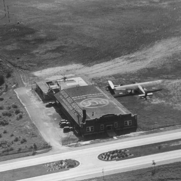
![]()
A circa 1930s view of what appears to be a floodlight in front of one of Camden Central's hangars.
Development & testing of what eventually became the VOR (Very High Frequency Omni-Directional Range) navigation radio system was conducted at Camden Central Airport in the 1930s.
According to the January 1942 RCA Review (courtesy of Jack Bartolick), “Experiments on an omnidirectional range system were begun at Camden early in 1936,
a frequency of approximately 61/2 megacycles per second being chosen for reasons of convenience.
The first flight test, in November 1936, gave the expected automatic bearing indication in all directions, but the accuracy attained was not of a practically useful order.
Continuing work on details of apparatus & operation resulted, by the Spring of 1937, in usefully accurate & stable omnidirectional bearing indication.
Field tests were continued through the summer of that year to complete the work.”
An aerial view looking southwest at Camden Central Airport from The Airport Directory Company's 1937 Airports Directory (courtesy of Bob Rambo).
The directory described Camden Central Airport as having three 2,500' sod runways.
The aerial photo in the directory depicted a cluster of hangars along the northwest side of the field.

An 8/27/37 aerial view of Camden Central Airport (from the Dallin Aerial Survey Collection, courtesy of the Hagley Museum & Library),
showing 3 unpaved runways, a terminal building, 2 hangars, and 5 planes.

A closeup from the 8/27/37 aerial view of Camden Central Airport (from the Dallin Aerial Survey Collection, courtesy of the Hagley Museum & Library),
showing several planes parked near the hangars & terminal on the north side.
A 9/30/37 aerial view looking east at Camden Central Airport (from the Dallin Aerial Survey Collection, courtesy of the Hagley Museum & Library),
showing 3 unpaved runways, a terminal building, 2 hangars, and 2 single-engine planes.
A closeup from the 9/30/37 aerial view looking east at Camden Central Airport (from the Dallin Aerial Survey Collection, courtesy of the Hagley Museum & Library), showing 2 hangars & 2 single-engine planes.
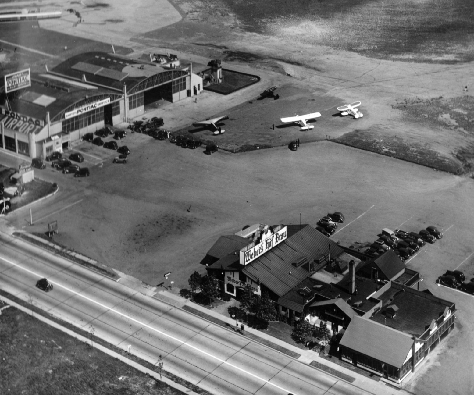
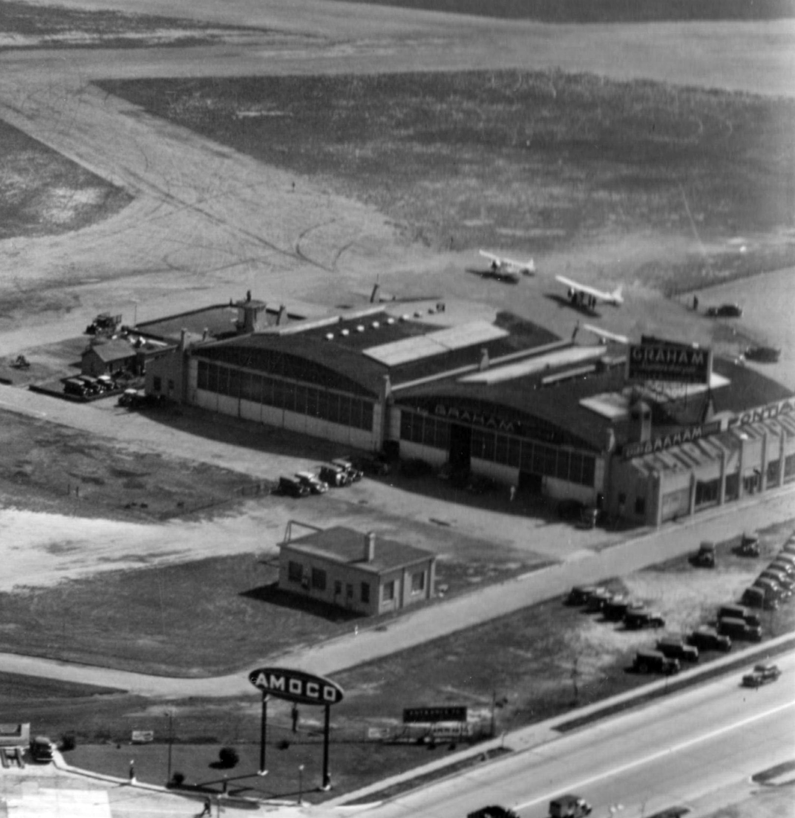
A 9/30/37 aerial view looking northeast at Webers Hof Brau on the west side of Camden Central Airport (from the Dallin Aerial Survey Collection, courtesy of the Hagley Museum & Library).
A 9/30/37 aerial view looking west at the RCA hangar at Camden Central Airport, marked with “Aviation Radio Headquarters” on its roof.
Two small planes & a 3rd larger plane were parked around it.
Central Airport was used early on for airmail flights.
Airmail would arrive at Central Airport, and be transported by autogiro (a precursor of the modern helicopter)
to the roof of the Post Office at 9th & Market Streets in Philadelphia.
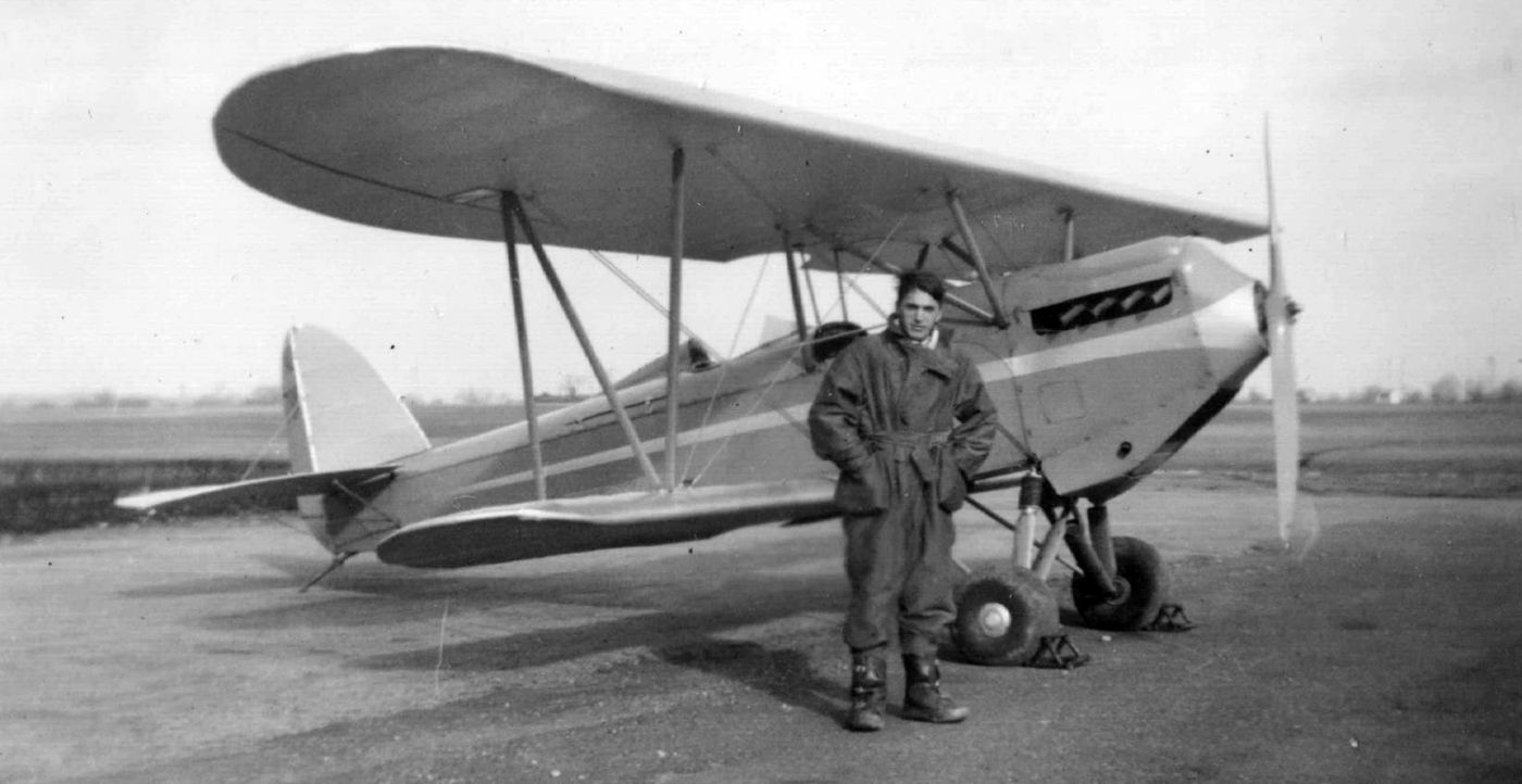
A 1937 photo of Clayton Werley with Brunner-Winkle Bird N85K at the Camden Central Airport.
Camden Central Airport, as depicted on a 1938 street map (courtesy of Kevin Walsh).
A 6/22/39 aerial view looking northwest at Camden Central Airport.

A 6/22/39 aerial view looking southeast at Camden Central Airport.
According to the January 1942 RCA Review (courtesy of Jack Bartolick), “In view of the strong general trend of aviation radio toward ultrahigh frequencies & of the success of the early work,
it was decided to undertake the development of an omnidirectional range to operate at 125 megacycles per second and to have instrumental errors not exceeding 3 degrees.
Work was begun early in 1938 & equipment was built & installed by the latter part of that year.
As there was at that time considerable interest in the project, an attempt was made to get the new system into operation early in 1939.
As a result of the accuracy required and the problems of ultra- high- frequency technique encountered, however, quantitatively acceptable flight results were not attained until the late summer of that year.
Flight testing continued until early in 1940 and the apparatus was kept in operative condition until dismantled upon the closing of Central Airport at Camden at the end of July 1940.
Testing being then practically completed, the system has not been set up again.”
A circa 1938-40 aerial view looking northeast at the experimental RCA 6425 kc omnidirectional range radio antenna just northeast of Camden Central Airport (courtesy of Jack Bartolick).
By the late 1930s the end was in sight for airline operations at Camden Central Airport.
The widespread use of larger airliners such as the Douglas DC-3
required the use of longer runways than those available at Central Airport.
In 1940, when the much larger Philadelphia Airport opened across the river, the 4 airlines which had been serving Central Airport
(American, Eastern, TWA, and United) terminated their operations at Camden & moved across the river to Philly.
A 1996 State Government report on the shrinking number of airports in NJ reported,
"At Camden Central Airport business went into a steep decline after the opening of Philadelphia Airport,
which attracted the airline business which had been operated at Camden."
A 1940 aerial photo showed Camden Central Airport in basically the same configuration as seen in 1931.
During the WW2 period, Camden Central was used by the Navy,
becoming a Naval Outlying Landing Field for the Philadelphia Navy Yard's Mustin Field.
It served as a training facility for naval & marine aviators, using yellow Stearman N2S-3 biplanes.
It was labeled "Camden (Navy)" on the November 1941 Washington Sectional Chart (courtesy of Chris Kennedy)
and subsequent WW2-period sectionals.
The 1943 USGS topo map depicted Camden Central Airport as having 3 unpaved runways, with 3 buildings along the west side.
The 1945 AAF Airfield Directory (courtesy of Scott Murdock) described Central Airport
as a 230 acre irregularly-shaped property having 2 asphalt 2,500' runways & 2 gravel 2,600' runways.
The field was said to have 2 steel & concrete 120' x 100' hangars,
to be owned by private interests, but operated by the Navy.
It was still labeled "Camden (Navy)" on the 1946 Washington Sectional Chart (courtesy of Mike Keefe).
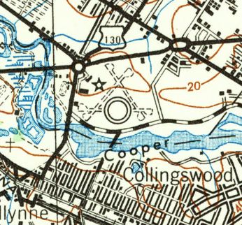
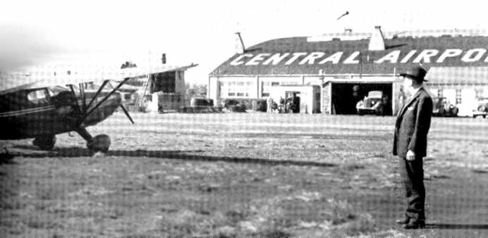
Camden Airport, as depicted on the 1946 USGS topo map.
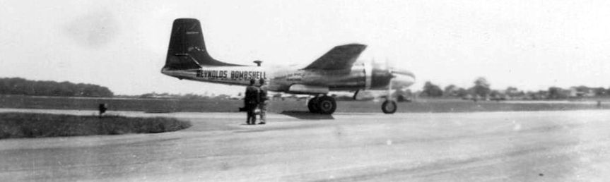
A 1947 photo of the “Reynolds Bombshell” at Camden Central Airport.
The Bombshell was a Douglas A-26 Invader which was reused for promotion by Milton Reynolds,
who made millions with the commercial success of the ballpoint pen.
Reynolds had the armor stripped off & retrofitted the plane with new commercial engines.
He hired war hero Bill Odom as pilot, Tex Sallee as copilot, and in 1947 the 3 of them flew around the world in 78 hours & 55 minutes,
making 4 stops for refueling, to set the world record for twin-engine propeller aircraft.
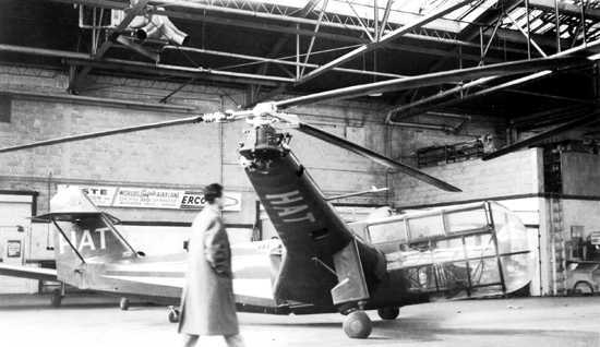
A 1947 photo of the Platt-LePage XR-1A, in the markings of Helicopter Air Transport.
According to Jay Hendrickson of the Platt-LePage Aircraft Archives, “The photo was at the Camden NJ Airport where HAT (Helicopter Air Transport) was located;
HAT had bought the XR-1A as part of a deal for a number of civil Platt-LePage heicopters.
Both Platt-LePage & HAT would go out of business before the deal was concluded.
Ex PL-LP test pilot Lou Leavitt got the XR-1A flying, and the helicopter was sold to Frank Piasecki at HAT's bankruptcy sale (Frank worked on the XR-1 at Platt-LePage early in his career).
The person walking in front of the XR-1A is an engineer from PL-LP, Alan Price, who did a great deal of design work at PL-LP.
From what I understand about HAT, they flew a handfull of the early Bell-47Bs & Sikorsky S-51s,
plus they had the XR-1A, which would have been turned in to a PL-11/PL-12 civil machine.
They were more of a utility helicopter operator, trying to make the early helicopters into commercial machines.”
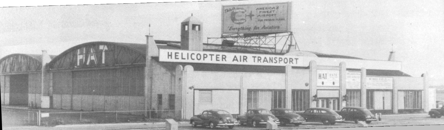
A 1948 photo of the Helicopter Air Transport hangar at Camden Central Airport.
After the war, Camden Central reverted to its original role as a commercial airport,
but business never picked back up again.
According to CFI Don Kinney, "Camden like Newark had to struggle
against political & CAA forces (La Guardia & others) in the late 1940s & early 1950s.
A circa 1940s photo of a Stinson Voyager in front of a hangar at Camden Central.
The 1949 Washington Sectional Chart (courtesy of Mike Keefe)
described Camden Central Airport as having a 2,600' hard-surface runway.
The 1949 USGS topo map depicted Camden Central Airport as having 3 paved runways, with numerous buildings along the west, north, and northeast sides.
A large hangar had been added to the northeast side of the field at some point between 1945-49.
A 4/20/51 USGS aerial photo showed Camden Central Airport with 3 paved runways.
A long curved row of T-hangars had been added at some point between 1940-51 on the east side.
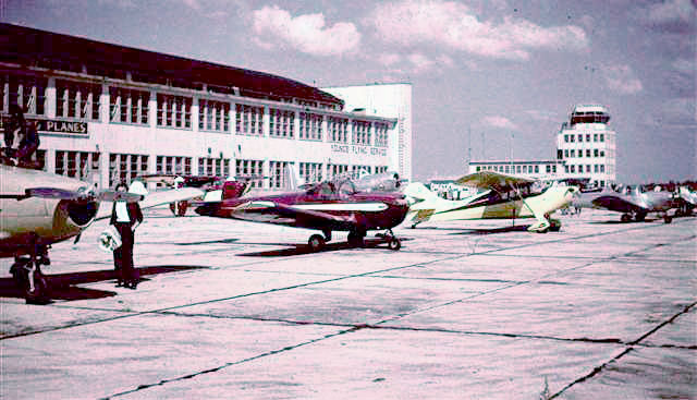
A circa 1953-54 photo by Bob Welsh of his beautiful red Ercoupe among other private planes at Camden Airport (courtesy of Kathleen Welsh Baxter).
Camden Central Airport was still depicted as an active airfield on the 1955 Washington Sectional Chart (courtesy of Mike Keefe),
which described it as having 3 runways, with the longest being a 2,800' asphalt strip.
However, the field was apparently on its last legs, as it was described as "unattended".
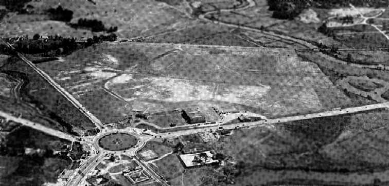
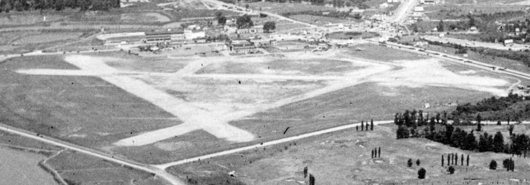
The last depiction which has been located showing Camden Central Airport in operation was a 1956 aerial view.
An expansion of traffic lanes had replaced the terminal building on the northwest corner of the field at some point between 1951-56.
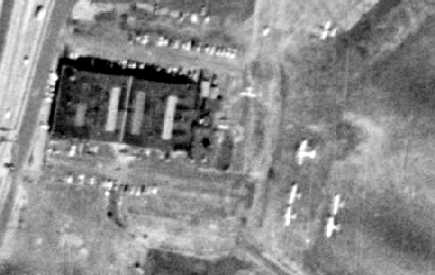
A closeup from the 1956 aerial view, showing only 7 aircraft visible parked outside at Camden Central Airport.
According to Harry Silvers, a notation on a July 1955 NJ Airport Directory indicated for Central Airport,
“Advised that operations will cease as of 2/1/57.”
The last aeronautical chart depiction which has been located of Camden Central Airport was on the February 1957 Washington Sectional Chart.
It depicted Camden Central Airport as having a 2,800' paved runway.
According to Dennis Weaver, “Central Airport closed in 1957. It didn't have enough room to extend (expand) its runways.”
Camden Central Airport was no longer depicted on the August 1957 NY Sectional Chart.
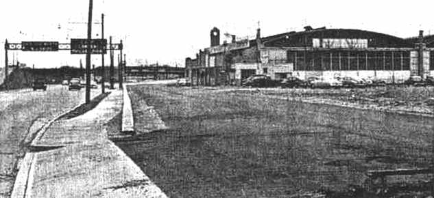
A 1957 view looking north along Route 130 towards the Airport Circle, with one of Camden Central's hangars still standing.
According to Dennis Weaver, “From 1957-60 the hangars were used for small businesses such as a mattress & furniture store.”
Harry McGrath recalled, “Camden Central Airport... the airport right after closing, 1957-58,
for about a week, hundreds of kids showed-up & were drag racing on the runways, thus a lot of cameras were flashing!
Finally Pennsauken Police Department had the runways plowed-up, thank god, somebody would have been hurt, probably me!”
According to Dennis Weaver, “Someone bought it & was planning to put up a GEX store (sort of like a Sams Club store for Government employees).
This was about 1960 & the hangars had to come down to make way for the GEX store (now a Kmart is there).”
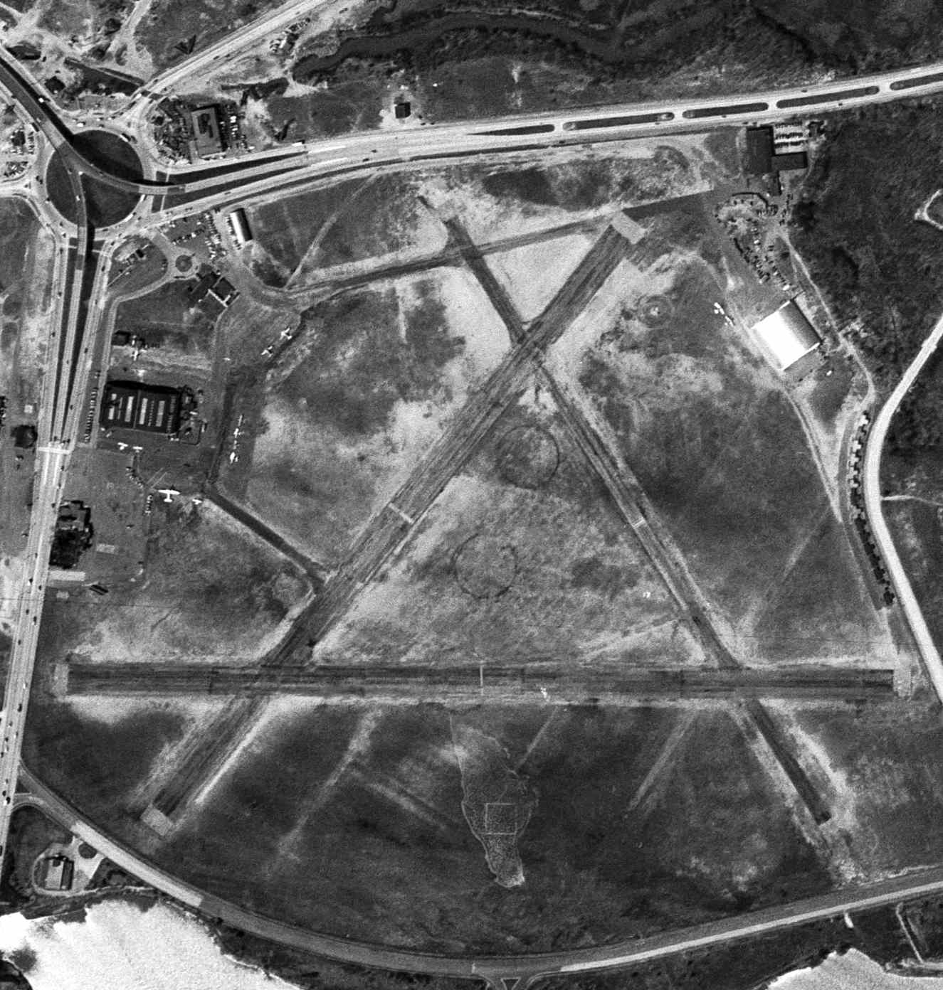
The site of Camden Central was labeled "Abandoned Airport" on the 1961 Philadelphia Local Aeronautical Chart (courtesy of Mike Keefe).
A 1963 aerial view showed that all of the former Camden Central hangars (on both the northwest & northeast sides of the field)
had been removed at some point between 1957-63.
Significant portions of all 3 former runways still remained, along with the curved row of T-hangars on the east side.
but industrial buildings had been built over many portions of the former airport.
A 1970 aerial view showed that the western portion of one runway still had recognizable remains.
New buildings & streets covered the majority of the former airport.
A 1995 aerial view showed that the last runway segment had been covered by new construction.
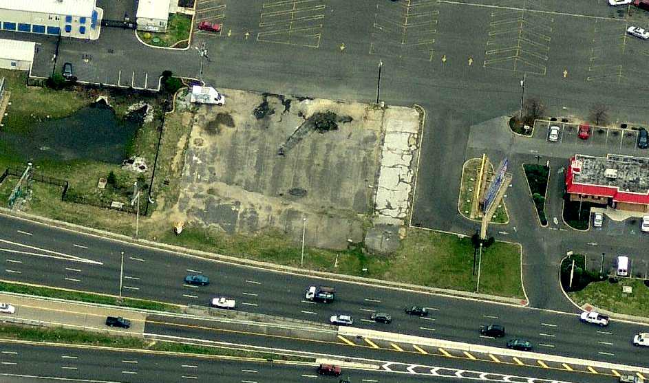
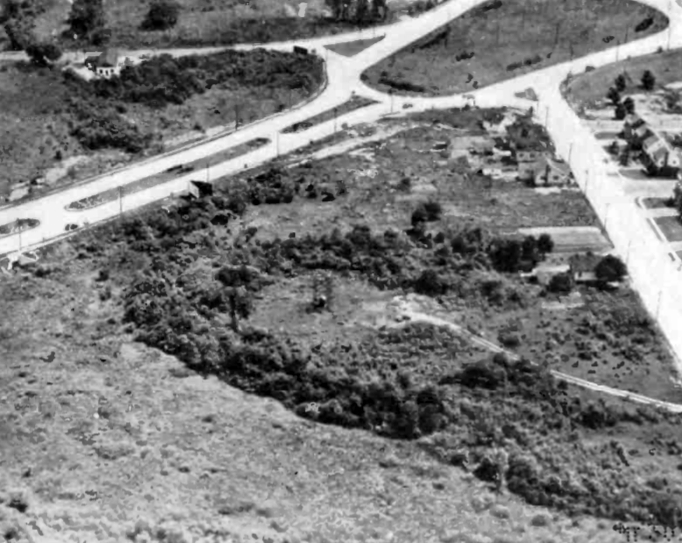
A circa 2008 aerial view looking east at what appears to be the last remnant of Camden Central Airport:
remains of the ramp adjacent to the south side of the hangar on the west side of the property.
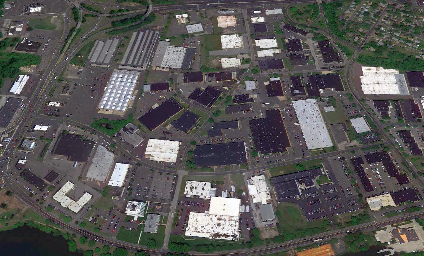
A 2016 aerial view looking north showed the site of Camden Central Airport has been heavily redeveloped as an industrial park, with no recognizable trace remaining of former airport.
The site of Camden Central Airport is located at the intersection of Airport Highway & Central Highway, appropriately enough.
Thanks to Jay Cooke for pointing out this airfield.
____________________________________________________
Or if you prefer to contact me directly concerning a contribution (for a mailing address to send a check),
please contact me at: paulandterryfreeman@gmail.com
If you enjoy this web site, please support it with a financial contribution.
____________________________________________________
This site covers airfields in all 50 states.