Abandoned & Little-Known Airfields:
Northwestern New Jersey
© 2002, © 2026 by Paul Freeman. Revised 1/25/26.
This site covers airfields in all 50 states: Click here for the site's main menu.
____________________________________________________
Please consider a financial contribution to support the continued growth & operation of this site.
Aircraft Radio Corporation Airfield (revised 12/7/24) - Budd Lake Airfield (revised 1/19/25) - Flanders Valley Airport (revised 1/18/22)
Lake Hopatcong Airport / Brady Field / Hurdtown Airport (added 2/12/25) - Newton Airport (revised 8/8/23)
Northwest Jersey Airport (revised 9/15/19) - Pine Brook Airport (added 10/16/20) - Somerset Hills Airport (revised 1/25/26) - Trinca Airport (revised 4/21/23)
____________________________________________________
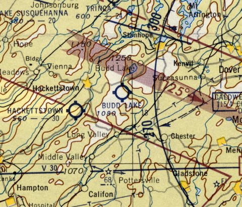
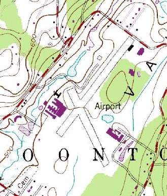
Somerset Hills Airport (N64), Basking Ridge, NJ
40.693, -74.535 (West of New York, NY)
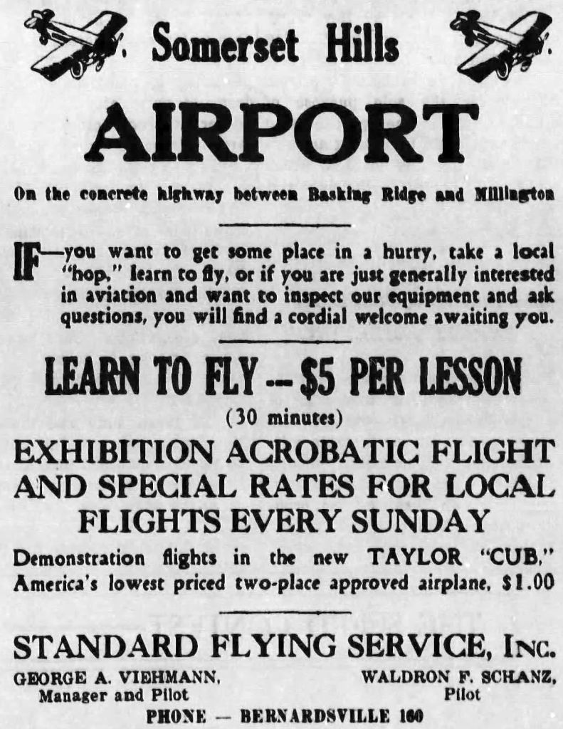
An advertisement for the Somerset Hills Airport from the 8/4/32 Bernardsville News (courtesy of Lee Corbin).
Somerset Hills Airport was not yet depicted on a 1931 aerial photo.
According to an article entitled “Basking Ridge plans for airport approved” in the 7/14/32 Bernardsville News (courtesy of Lee Corbin),
“Plans for an airport for Basking Ridge have been approved by the commissioner of aviation,
and George Viehman has begun leveling the field & building a hangar & office structures.
The work is being done on the Walter Fenner property in Building Lane.”
Somerset Hills Airport was not yet depicted on the August 1932 NY Sectional Chart.
The earliest reference which has been located to the Somerset Hills Airport was an advertisement in 8/4/32 Bernardsville News (courtesy of Lee Corbin).
Somerset Hills Airport managers in 1932 were George Viehmann & Waldron Schanz.
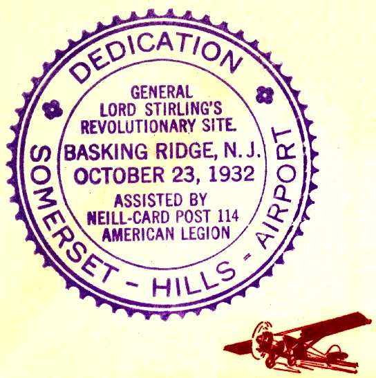
A postmark commemorating the 10/23/32 Somerset Hills Airport dedication (courtesy of Ed Drury).
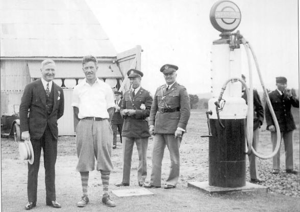
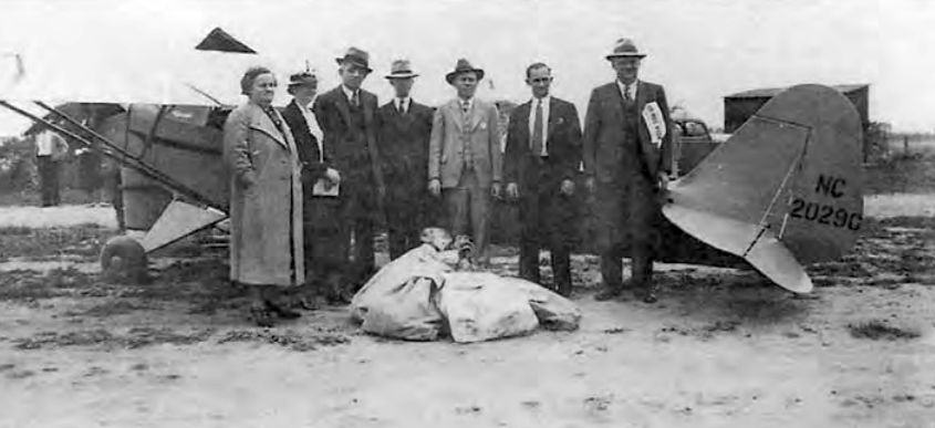
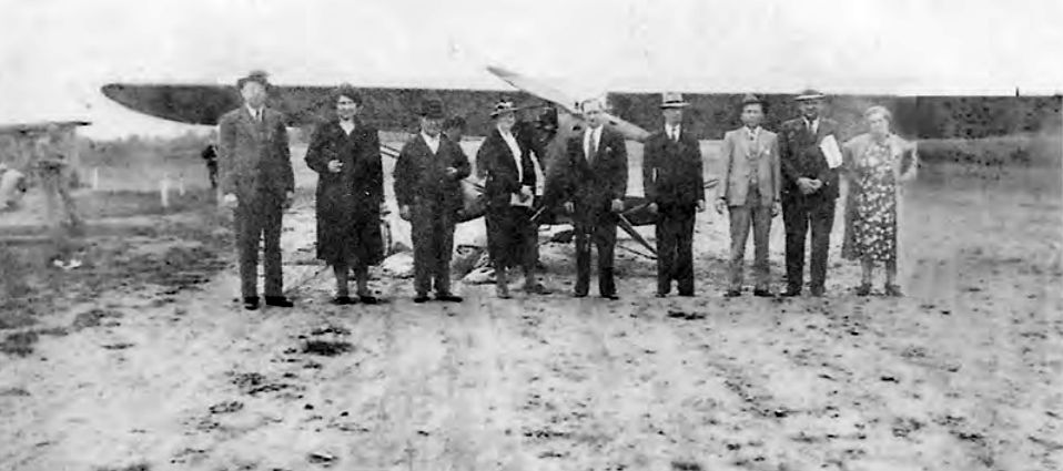
The earliest photo which has been located of Somerset Hills Airport was a 1932 photo (courtesy of Lee Corbin)
of Governor Harry Moore (at left) upon his arrival at the airport on a visit to the Lyons U.S. Veterans' Hospital.
Greeting the governor was Somerset Hills Airport manager & head instructor Wally Shantz, and to the right were several Army personnel.
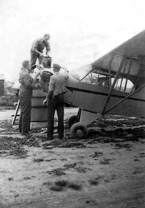
Lee Corbin observed, “I love seeing all the Army guys with cigars & cigarettes milling around the fuel pump.”
The earliest aeronautical chart depiction which has been located of Somerset Hills Airport was on the April 1933 NY Sectional Chart.
The 1934 Department of Commerce Airport Directory (according to Chris Kennedy)
described Somerset Hills Airport as having 3 sod runways, with the longest being a 1,900' east/west strip.
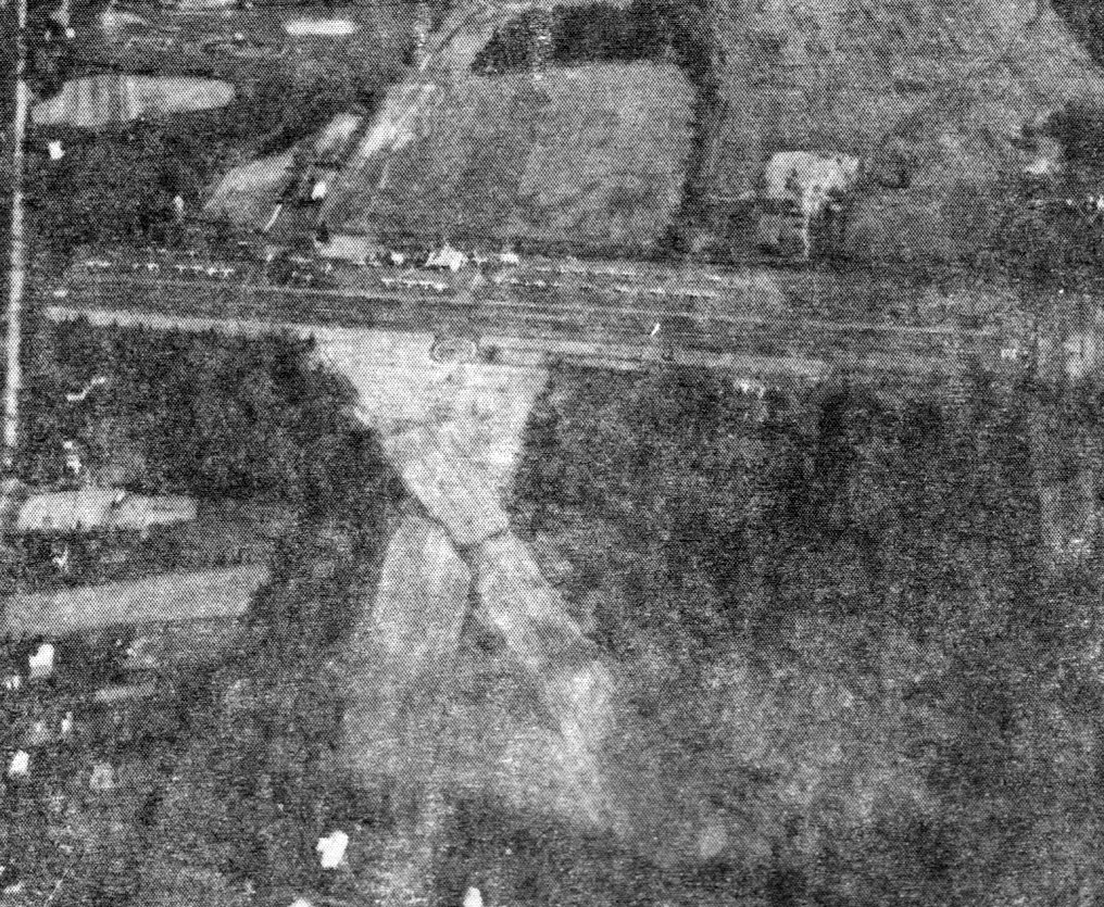
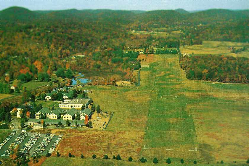
The earliest aerial photo which has been located of Somerset Hills Airport was an undated aerial view looking north
from The Airport Directory Company's 1937 Airports Directory (courtesy of Bob Rambo).
It described Somerset Hills as having a total of 3 sod runways, with the longest being a 2,600' east/west strip.
The aerial photo depicted several hangars along the north side of the field.
According to a historical sign commemorating Somerset Hills Airport,
it served as an Army Air Corps flight training facility starting in 1941.
The 1944 US Army/Navy Directory of Airfields (courtesy of Ken Mercer).
described Somerset Hills as having a 2,200' runway.
According to a historical sign commemorating Somerset Hills Airport, the Army Air Corps' use of the field ended in 1945.
The August 1946 NY Terminal Aeronautical Chart (courtesy of Tim Zukas) depicted Somerset Hills as a commercial/municipal airport.
Somerset Hills Airport manager in 1946-48 was Paul Housel (United Aviation Corporation owner).
The 1947 USGS topo map depicted Somerset Hills Airport as an open area with several small buildings along the north side.
A 1956 aerial photo depicted Somerset Hills as having 3 unpaved runways,
and a hangar on the north side of the field, near which were parked over 25 light aircraft.
A 1957 aerial photo depicted the field in the same manner.
Paul Downing recalled, “Regarding Basking Ridge, as Somerset Hills Airport was more commonly known back in 'the day',
I soloed there on my 16th birthday & got my Private license one year later on my 17th.
This would have been July, 1957 & 1958.
At that time the airport was owned by Harry Calvin, a 707 flight engineer with Pan Am based in New York.
Rick Decker operated the airport, having moved up there when Westfield Airport closed.
Rick's brother in law, Richard 'Brick' Karl came with him as mechanic.
There was always a carnival atmosphere around the airport, always something going on.
The towns people would come out in droves,
filling up the parking lot waiting for the impromptu airshow that would always take place, Ed Mahler usually starting it.”
Paul continued, “Rick had an old fashioned bicycle - 5' front wheel, 1' rear wheel - that he kept at the airport.
We found several rolls of theater tickets in the attic of the tiny office as well as an old PA system that still worked.
We set up the PA, someone played a guitar & sang, I rode the bike up & down the line
and we sold airplane rides for a penny a pound, made a lot of money,
kids were coming back 3 & 4 times, couldn't believe it.”
Two 1959 aerial photos of Basking Ridge Airport by Paul Downing.
Paul Downing recalled, “There was a farm house & barn just to the south of the approach end of the west runway
with power lines running from the street, across the end of the runway to the house.
The farmer refused to bury the lines which subsequently snagged aircraft over the years, though none fatally.
I think the lines were finally buried after I left.”
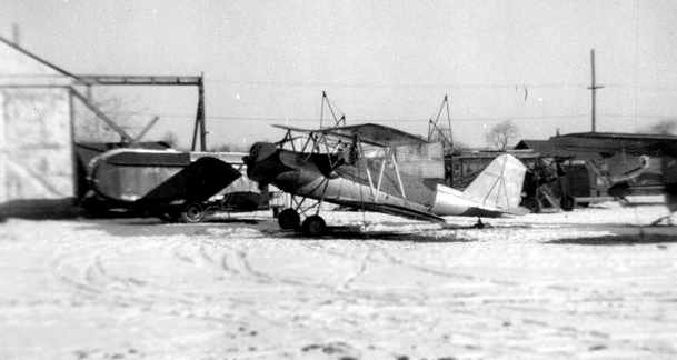
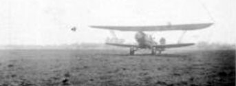
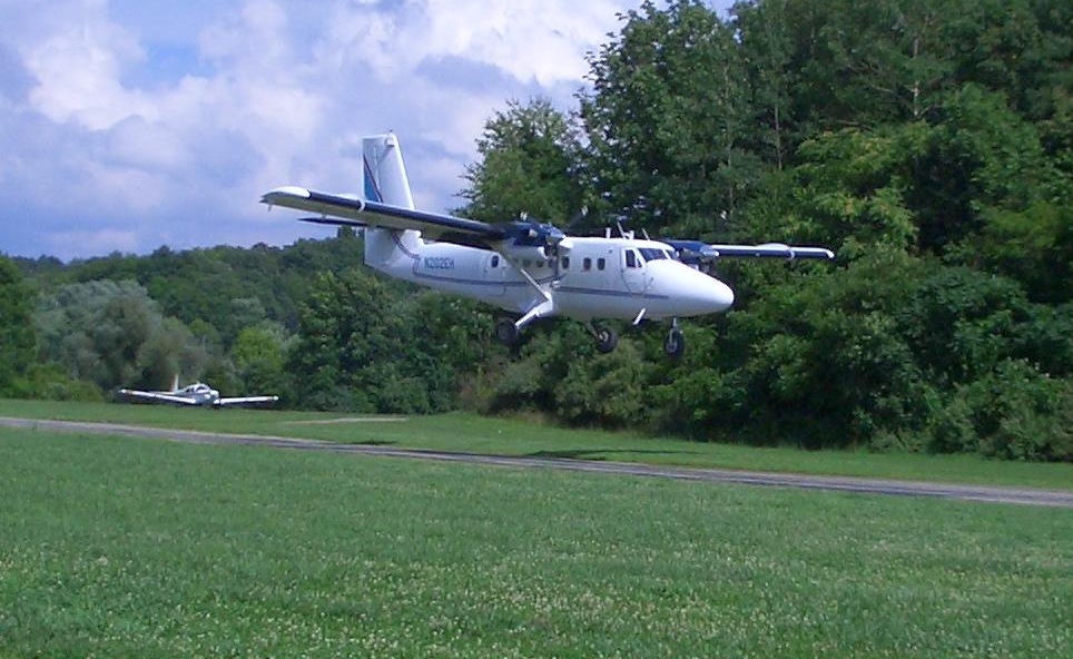
A 1959 photo by Paul Downing of a Meyers OTW at Basking Ridge.
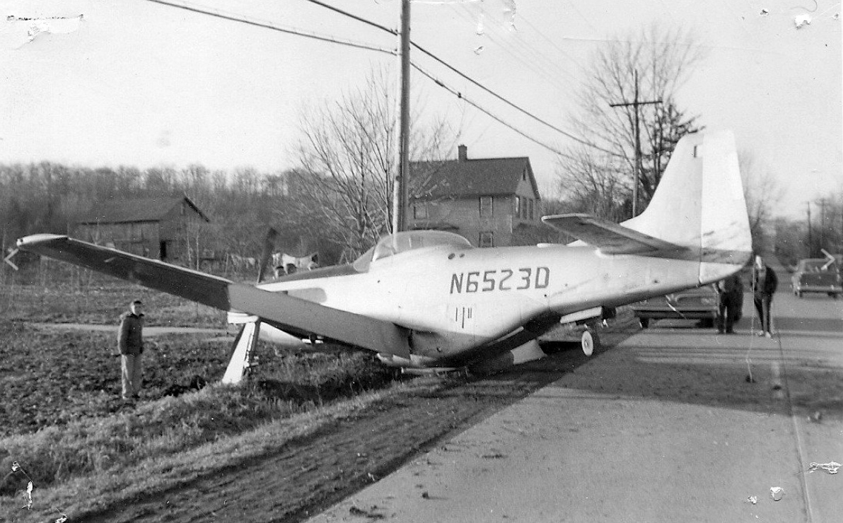
A photo from the Bernards Township Police Department of North American P-51D-30NA Mustang, N6523D, serial 44-74483,
which overrun the Somerset Hills Airport on what was coined “Crash Corner”, on 2/4/60, the same day they took delivery of the plane.
The 1961 NY Local Aeronautical Chart depicted Somerset Hills Airport as having a 2,400' unpaved runway.
Somerset Hills Airport in 1961–63 was owned by Basking Ridge Aviation Company.
Andy Wells recalled, “In the spring of 1961 (my senior year in high school),
I discovered that if I showed up at Basking Ridge with $6 (or more), I could get a short flying experience from Pop Decker in one of his 2 J-3 Cubs.
He would do the take off & quickly give me the controls. I was then free to fly around until my dollars were used up.
He never actually taught me anything at all, just let me experiment with the controls.
I was an experienced aeromodeler by then, so had an inkling of what to do.
I always managed to fly over to my home town of Cranford, make a few turns around the high school,
then get back to someplace near the airport, where Pop would take over with a big shake of the stick & make the landing.”
Paul Downing recalled, “Harry Calvin was transferred to Pan Am's SFO base,
Rick & Brick went down to run Kupper Field
and Jimmy, Harry's son, took over operations at Basking Ridge for awhile.
Harry was killed in an F4F accident on the west coast, I believe his wife sold the airport.”
The 1961 NY Local Aeronautical Chart (courtesy of Mike Keefe)
described Somerset Hills as having 3 turf runways, with the longest being 2,400'.
Somerset Hills Airport was described in the 1962 AOPA Airport Directory
as having with 3 turf runways (the largest being an 1,800' east/west strip).
and the operators were listed as Lawrence Tokash & James Stanley.
A 1963 aerial photo depicted Somerset Hills as having 3 unpaved runways,
and a hangar on the north side of the field, near which were parked over 20 light aircraft.
Somerset Hills Airport's manager in 1964 was Webster Todd.
Kern Buck reported, “The best description of Somerset Hills Airport in the 1960s
appears in a book written by my brother, Rinker Buck, 'Flight of Passage'.
The flight described in the book began at Somerset Hills Airport.
Both Rinker & I made our 1st solo flights there, mine in 1964, Rinker's in 1966.”
Kern continued, “At that time, the field still had grass runways.
The main runway, 9/27 was about 2,500' long, with a very small hill at the east end,
the grade of which was no greater than the normal descent path of a light airplane.
Approaching from the west, one also descended over a declining grade,
with trees underneath & 25' wires over the threshold at Maple Avenue.
Runway 15 had a flat approach over open field,
but 10' wires over the dusty road leading from Maple Avenue to the airport parking lot.
The approach to Runway 33 was also relatively flat, but there was a small housing development near the threshold,
and one of the houses had a TV antenna atop the roof.
The antenna was a factor for such a short runway.”
Kern continued, “The original operations building was still being used in the 1960s.
It was about the size of a child's playhouse, and had about 125 square feet of space inside.
The hangar was larger. It could hold 4 light airplanes, if they were positioned correctly.”
Kern continued, “At any one time during that era, the field was home for from 15-30 airplanes,
including civilianized World War II AT-6s, PT-19s, a PT-23, and a rare Meyers OTW.
There was also an assortment of Cubs, Aeroncas, Taylorcrafts, etc.”
Kern continued, “It was a great airport, somewhat unruly.
I recall Ed Mahler, who was a well known aerobatic pilot at the time,
flying his AT-6 on the deck toward the hangar at a speed approaching 300 mph before pulling straight up.
I was the only one looking at the time. I guess he was practicing.
He built his famous biplane, the PJ-260, in the hangar at Basking Ridge.”
The 1968 Flight Guide (courtesy of Robert Levittan) depicted Somerset Hills
as having 2 unpaved runways: 2,360' Runway 10/28 & 2,200' Runway 15/33.
Two small buildings were depicted on the north side of the field.
Somerset Hills Airport's owner & operator in 1968 was Jim Calvin. Forty planes were based at the 70 acre airport.
According to an 8/1/72 Bernardsville News article, Jim Calvin was the first pilot to land on Somerset Hills Airport's newly-paved runway on 7/19/69 in a Cessna 150.
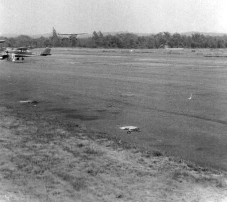
A 1970 photo of Somerset Hills Airport by Pete Galligan.
Pete recalled that "at that time there was just 1 paved runway & 1 grass."
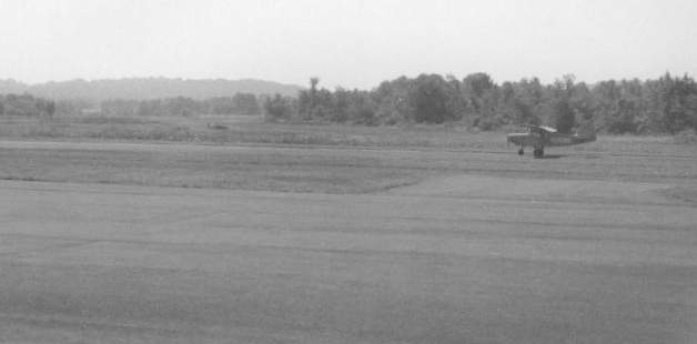
A 1970 photo by Pete Galligan of a plane on the Somerset Hills Airport runway.
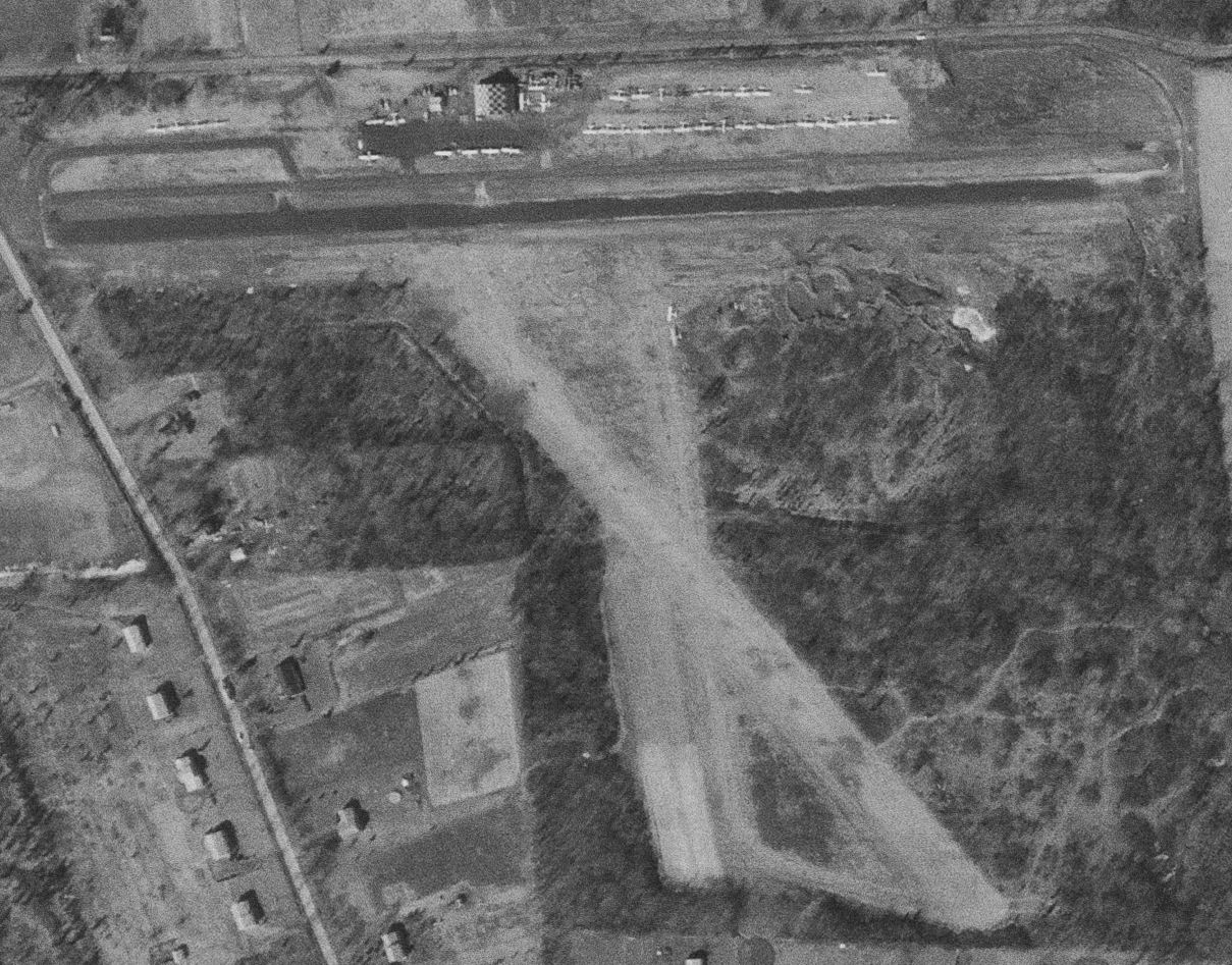
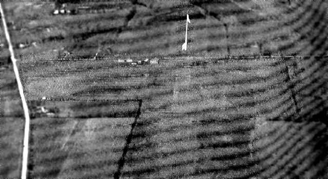
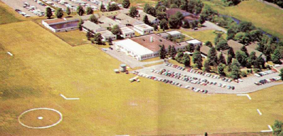
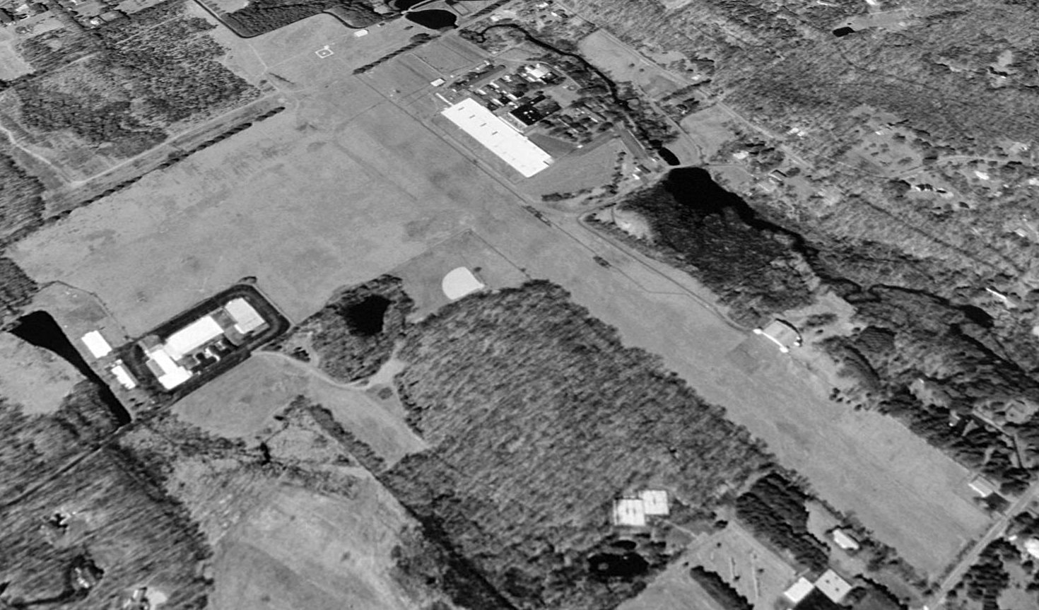
A 2/24/70 USGS aerial view depicted Somerset Hills' newly-paved east/west runway, along with the 2 previous unpaved runways.
It also showed the field perhaps at its zenith of popularity, with a total of over 37 light aircraft were visible parked on the north side of the field.
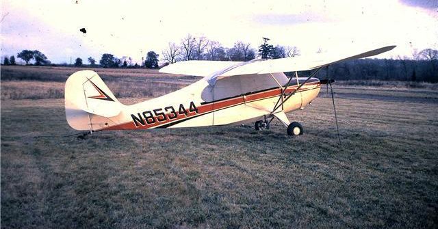
The last photo which has been located showing Somerset Hills Airport while open
was a circa 1972 photo of N85344, a 1946 Aeronca 7AC Champion, serial #7AC-4084.
The 1972 Flight Guide (courtesy of Chris Kennedy) depicted Somerset Hills as having a 2,300' paved Runway 10/28 & a 2,200' unpaved Runway 15/33.
A ramp on the northern side of the field had a single building along its northern edge.
Jeff Walden recalled, “My college roommate (Brian Cooker) & I flew out of Somerset Hills / Basking Ridge between 1972-74, when it was owned & run by Jim Calvin & his mom.
Cooker bought a 1939 Aeronca Chief that was for sale on the field, and he & I rebuilt it – in the college fraternity house –
and I flew it out of the field until Cooker was finally stationed somewhere by the Marines where he could come & get it.
I recall a steep hill to the west of the field. You had to slip in to land on the numbers (no flaps on a 1939 Aeronca).
There was a silo (you can see it in one of the photos) on the east almost in-line with the runway. A tight field.”
About Somerset Hills Airport, Dennis Sandow recalled "I've lived under its traffic pattern since 1976.
The proximity caused me to become aware of GA & want to take up flying.
Between 1976 & about 1980, I don't ever recall seeing more than 6-10 based aircraft there."
Jan Wolitzky recalled, “I once visited the airport with my Grumman Cheetah N9734U during the late 1970s,
but with the surrounding trees I felt the field was too short for comfort.”
Niel Young recalled, “About 1978 there was a new maintenance & repair FBO who took over from Jim Calvin.
It was a successful operation that helped keep the airport going with 4 mechanics.
In the winter of 1979-80 the hangar burned down due to highly suspicious circumstances, with absolutely no connection to Calvin or the FBO.
I left the area shortly thereafter so I don't know the impact of the fire on the ultimate demise of the airport
but I'm sure the loss of the the FBO & the accompanying traffic contributed to it.
Up to that time it was a fairly active little airport.”
An undated aerial view looking north at Somerset Hills Airport from the 1979 NJ Airport Directory.
It described Somerset Hills Airport as having a 2,297' asphalt Runway 10/28.
The manager was listed as James Calvin, and the Fixed Base Operator as Somerset Hills Aviation.
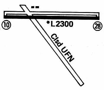
The 1979 Flight Guide (courtesy of Chris Kennedy) showed that Somerset Hills Airport's crosswind grass runway was "Closed until further notice",
leaving the field's sole runway as the 2,300' paved Runway 10/28.
Two buildings were depicted on the north side of the field.
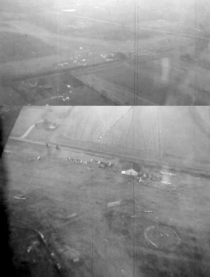
The last photo which has been located showing the Somerset Hills Airport in operation was a 1979 aerial view.
It depicted a very well-used little airport, with over 2-dozen light aircraft visible parked on the field.
The 1979 NY TCA chart (courtesy of Bill Suffa) described Somerset Hills Airport as having a single 2,300' paved east/west runway.
Dennis Sandow recalled, "The legal issues started when a pilot landed short & hard (stalled turning final?)
on the athletic field of the high school about half mile west of the runway - about 1980.
The town quickly turned negative, and everything was downhill from then on."
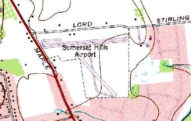
As depicted on the 1981 USGS topo map, Somerset Hills Airport consisted of 2 paved runways (the largest was 2,400' long) & several taxiways.
Dennis Sandow recalled, ""The AT&T operating Headquarters was located less than 2 miles away, but the official corporate Headquarters was still in NYC.
In April 1982, I last flew out of the field in a charter helicopter, which regularly used the field to pick up & deliver AT&T execs flying into NYC.
At that time, the FBO was closed & there were no based aircraft left on the field."
The last aeronautical chart depiction which has been located of Somerset Hills Airport
was on the June 1982 NY Terminal Aeronautical Chart (courtesy of Mitchell Hymowitz).
It depicted Somerset Hills Airport as having a single 2,300' paved east/west runway.
In a 1996 report by the New Jersey General Aviation Study Commission's Subcommittee on Airport Closings,
reasons were given for the closing of 13 New Jersey general aviation airports.
According to the report, in its final 16 years of operation,
Somerset Hills Airport saw its taxes rise 500%, from $2,000/year to $10,000/year.
The report also pointed out that litigation costs for development of small airports had become enormous, discouraging airport growth.
At one point late in its existence, the owners of Somerset were trying to build 20 T-hangars,
but found their litigation expense equaled the expense of the improvements they were intending to make.
According to an article entitled “Airport to close October 15 for housing complex” in the 9/15/82 Bernardsville News (courtesy of Lee Corbin),
“Townhouses & single-family homes will soon replaced planes at the Somerset Hills Airport.
The airport, established 50 years ago, will close October 15.”
Somerset Hills Airport was was no longer listed among active airfields in the 1983 Flight Guide (according to Chris Kennedy).
By the time of the 1986 USGS topo map, it was labeled "Airfield (Abandoned)".
A 1987 aerial photo showed that housing had covered the site, with not a trace recognizable of Somerset Hills Airport.
A December 2006 photo by Daniel Berek of the site of Somerset Hills Airport, now covered with housing.
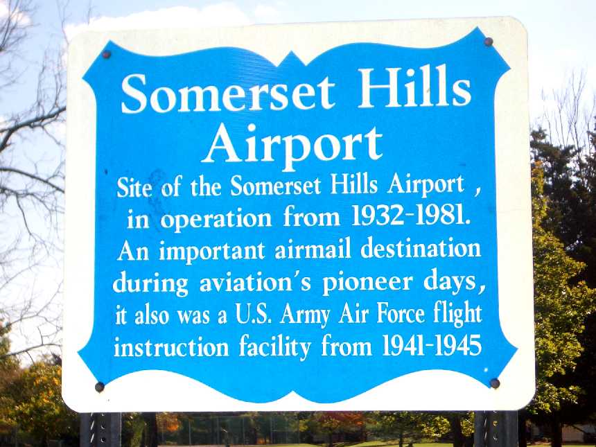
A 2008 photo by Jan Wolitzky of a historical sign which commemorates the site of Somerset Hills Airport.
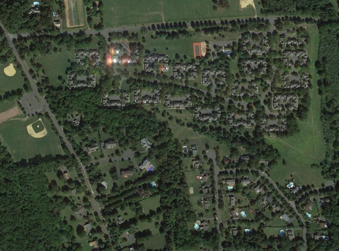
A 2013 aerial photo showed no trace remaining of Somerset Hills Airport.
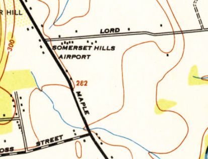
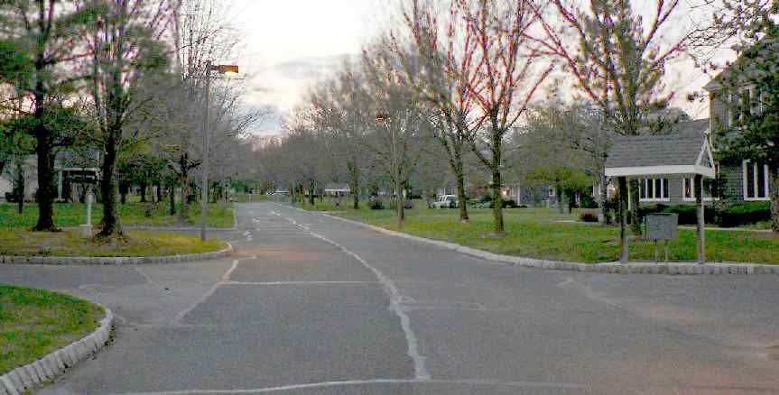
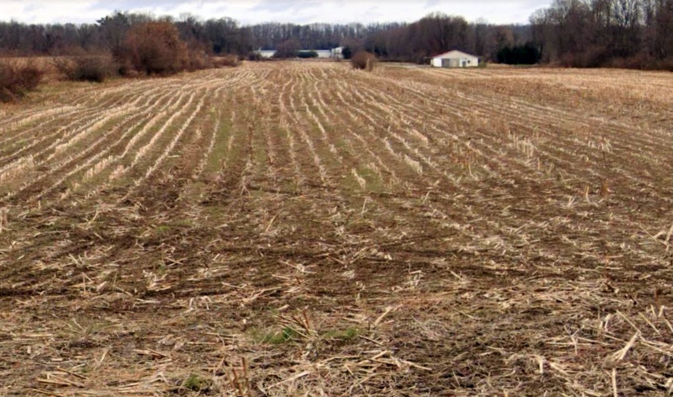
The site of Somerset Hills Airport is located southeast of the intersection of Maple Avenue & Lord Stirling Road.
Thanks to James G. for pointing out this airfield.
____________________________________________________
Lake Hopatcong Airport / Brady Field / Hurdtown Airport, Lake Hopatcong, NJ
40.9623, -74.601 (Northwest of New York, NY)

A circa 1920s/30s photo of spectators around an unidentified biplane at Brady Field.
According to a 6/14/18 article by the Lake Hopatcong Historical Museum (courtesy of Philip Kineyko),
“Lake Hopatcong’s airport started like many others around the country with the clearing of a large area of flat land which could be made suitable for the takeoff & landing of airplanes of the day.”
The 6/30/28 Lake Hopatcong Breeze reported, “Lake Hopatcong, not to be outdone by other far-sighted communities, will soon have a full-fledged airport.
A large field situated near Tierney’s Corners, belonging to the Consumers’ Coal & Ice Company, is being leveled-off & graded to form a modern landing place for aircraft.”
According to a 6/14/18 article by the Lake Hopatcong Historical Museum (courtesy of Philip Kineyko), “The airport was the idea of Jerome Brady, principal of Consumers’ Coal & Ice,
which owned much land around the northern part of the Lake Hopatcong.
Brady owned a plane & was the first to land at his new airport.”
The Breeze reported that he planned to commute regularly between the lake & the company’s offices in Bayonne “as soon as he can get an official pilot’s license.”
At the time, the construction of hangars was also planned.”

A circa 1920s/30s advertisement for Brady Field.
According to a 6/14/18 article by the Lake Hopatcong Historical Museum (courtesy of Philip Kineyko), “The opening of the new airport, officially called Lake Hopatcong Airport but more commonly known as Brady Field,
was celebrated with a host of the daredevil attractions which became wildly popular in America during these early days of aviation.
On 8/19/28 local residents & visitors flocked to the new field to witness a day of thrills including a dead-stick landing wherein the pilot ascended to a height of 3,000', shut the motor off, and then brought the plane to a safe landing.
Other spectacles included a parachute jump from 5,000' & a wing-walker, a daredevil who walked on the wings of an aircraft flying 2,000' above the ground without the aid of a parachute.
Many lake residents & visitors had their first introduction to airplanes at Brady Field. The new field advertised sightseeing trips, student instruction & aerial advertising.
During the late 1920s & early 1930s thrill seekers could arrange to be taken aboard for a ride.”
The 8/23/30 Lake Hopatcong Breeze provided a good example of the public’s reaction to this newfangled excitement:
“Mr. Peterson, the aviator at Brady Field, took Shirley Wills, 6 years old, for her first airplane ride.
At the request of her cousin, Velma Lake, who was also a passenger, the ride was replete with stunts & thrills.”
Brady Field was not depicted on the 1932 NY Sectional Chart, or subsequent Sectionals.
According to a 6/14/18 article by the Lake Hopatcong Historical Museum (courtesy of Philip Kineyko), “Although the airfield at Lake Hopatcong began with great fanfare, like most other early ones it was not destined to become a real airport.
One might say that the concept of flying to Lake Hopatcong never quite took off.
Instead of widespread individual ownership of small airplanes with people using aircraft instead of cars, the airline industry evolved differently.
As the 1930s wore on, Brady Field was utilized more for baseball than for flying.
Though there was some talk of revitalizing the local airstrip after the end of World War II, this never occurred.
Another business located in front of the airport would become quite popular.
Built in the early years of the 19th century on what was then known as Union Turnpike,
the Seward Inn had been one of the earliest hotels in the area but had not seen active use for almost 20 years when returning Army veteran Joseph Zidek acquired the business & in 1945 reopened it as the Airport Inn.
Operating as a restaurant & tavern on what was then known as Route 6A, the Airport Inn would remain popular for the next decade.
It featured an airplane motif & offered homemade specialties, dancing, and catering.
The Airport Inn was very active in sponsoring baseball & softball teams, which played behind the restaurant on what had once been Brady Field.”
Brady Field was not depicted on the 1949 or 1954 USGS topo maps.

At some point prior to 1956, the former Brady Field was reopened as Hurdtown Airport, as that is how it was depicted on the 1956 USGS topo map.
It was depicted as an open area with no other details.
Aerial photos from 1956 & 1957 showed the majority of Hurdtown Airport remained clear, but there was no indication of aviation use.
According to a 6/14/18 article by the Lake Hopatcong Historical Museum (courtesy of Philip Kineyko), “In the late 1950s, the establishment became Doc’s & in more recent years hosted the Fish & Booze restaurant & bar.”
The 1961 USGS topo map depicted Hurdtown Airport in an unchanged fashion.
Hurdtown Airport was evidently closed (for reasons unknown) by 1963,
as a 1963 aerial photo showed several roads having been built over the site.
Hurdtown Airport was no longer depicted on the 1972 USGS topo map, which instead showed several roads covering the site.
According to a 6/14/18 article by the Lake Hopatcong Historical Museum (courtesy of Philip Kineyko), “Today, what was once Lake Hopatcong’s airport is actively used by Jefferson Township teams, providing thrills of a different sort.
We know the area today along Route 15 South & across from the Lakeside Shopping Center as Fireman’s Field & Lakeside Recreation Complex, parts of Jefferson Township’s Recreation Department.”

A 2024 aerial view showed no trace remaining of Brady Field.
Thanks to Philip Kineyko for pointing out this airfield.
____________________________________________________
Pine Brook Airport, Pine Brook, NJ
40.85, -74.34 (Northwest of New York, NY)
Pine Brook Airport, as depicted on the April 1933 NY Sectional Chart.
This short-lived general aviation airport was evidently established at some point between 1932-33,
as it was not yet depicted on the August 1932 NY Sectional Chart.
The earliest depiction which has been located of Pine Brook Airport was on the April 1933 NY Sectional Chart.
The earliest photo which has been located of Pine Brook Airport was a 1934 photo of several planes & buildings.
A 1934 photo of an unidentified biplane at Pine Brook Airport.
The last depiction which has been located of Pine Brook Airport was on the January 1937 NY Sectional Chart.
Pine Brook Airport was evidently closed (for reasons unknown) at some point in 1937,
as it was no longer depicted on the June 1937 NY Sectional Chart,
or the 1947 USGS topo map.
A 1957 aerial view showed no recognizable trace of Pine Brook Airport.
A 2019 aerial view showed no trace remaining of Pine Brook Airport.
Thanks to Steve Boggess for pointing out this airfield.
____________________________________________________
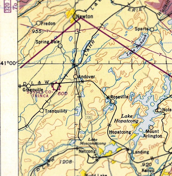
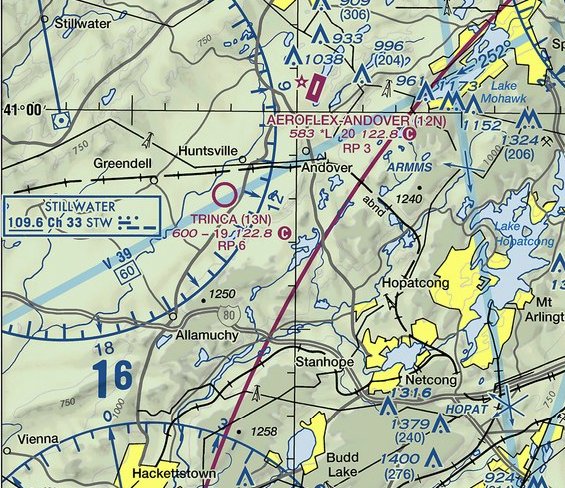
Trinca Airport (13N), Andover, NJ
40.966, -74.782 (Northwest of New York, NY)
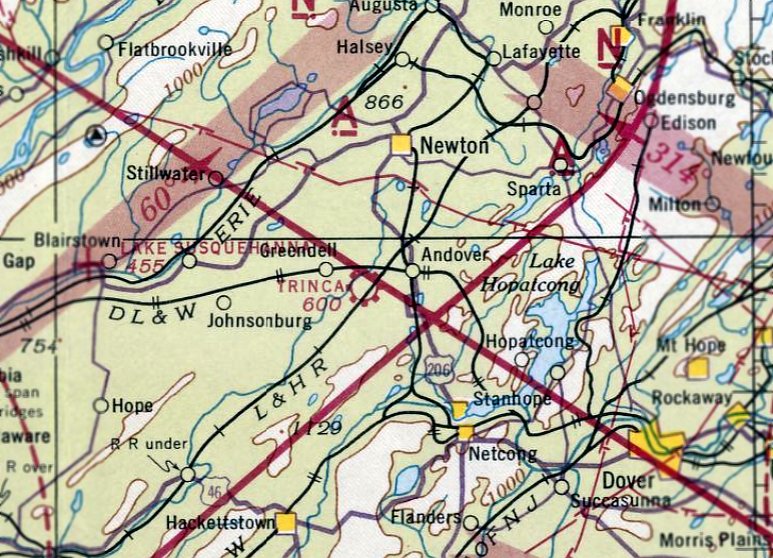
Trinca Airport, as depicted on the March 1942 NY Sectional Chart.
Trinca Airport was not yet depicted on the October 1941 NY Sectional Chart.
According to its FAA Airport/Facility Directory data, Trinca Airport was activated in October 1941.
The earliest depiction which has been located of Trinca Airport was on the March 1942 NY Sectional Chart.
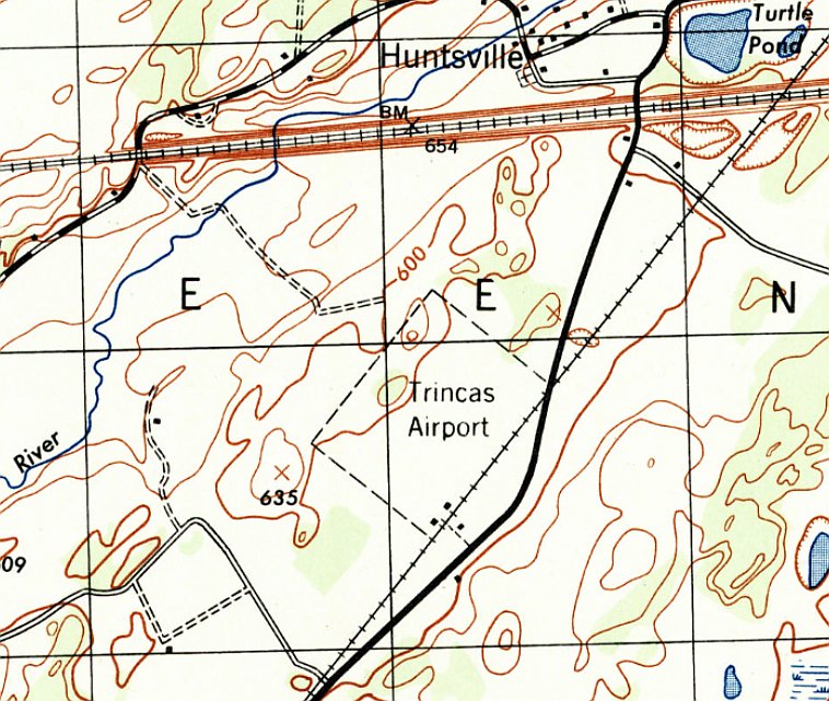
The earliest topo map depiction which has been located of Trinca Airport was on the 1943 USGS topo map.
It depicted “Trincas Airport” as a rectangular property outline, within the southern corner were 2 small buildings.
The August 1946 NY Terminal Aeronautical Chart depicted “Sussex County Trinca” Airport as a commercial/municipal airport.
The 1954 USGS topo map depicted “Trinca Landing Field” as having a single unpaved northeast/southwest runway, with 2 small buildings on the southeast side.
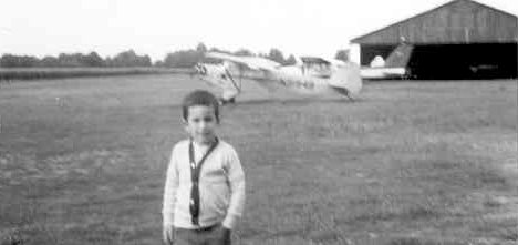
The earliest photo which has been located of Trinca Airport was a 1965 photo of a boy, a Piper, and a Cessna in front of a small hangar.
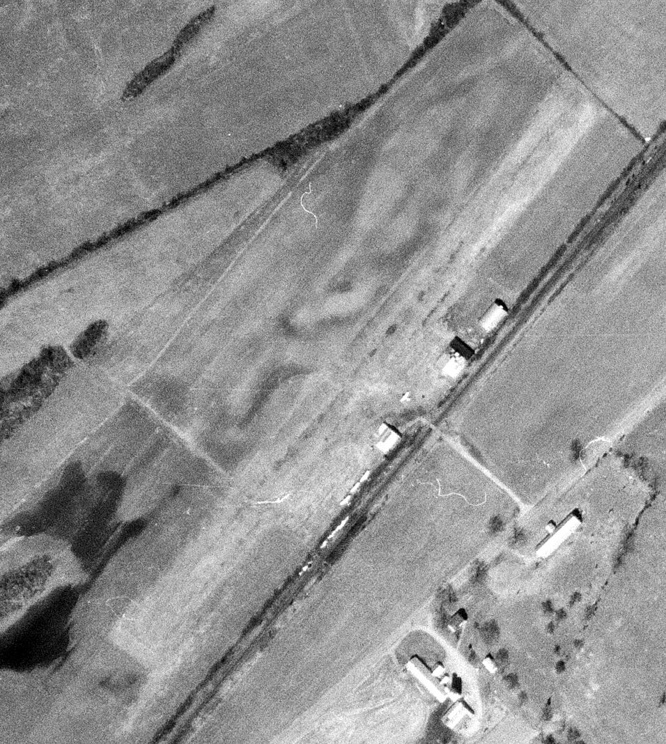
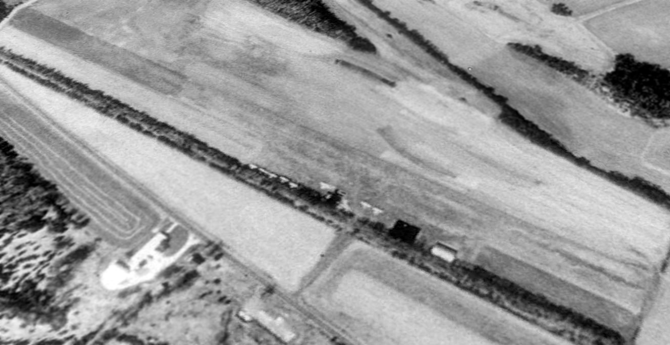
The earliest aerial photo which has been located of Trinca Airport was a 9/25/71 USGS aerial view.
It depicted Trinca Airport as having a single unpaved northwest/southeast runway, with 4 light aircraft & 3 small hangars on the southeast side.
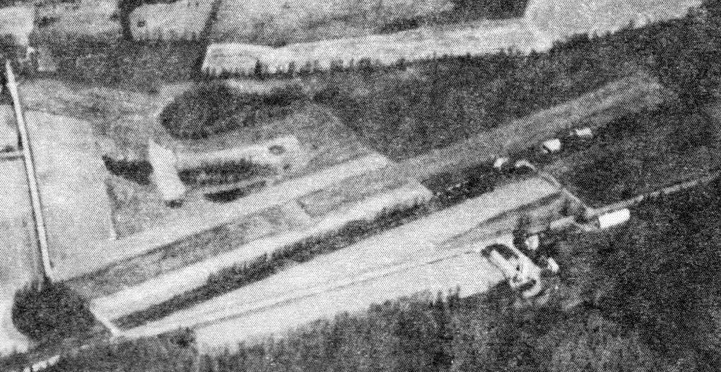
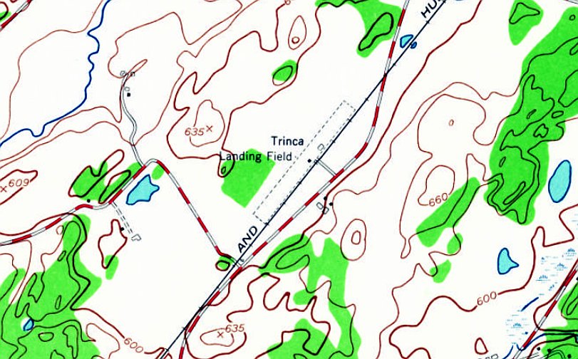
An undated aerial view looking northwest at Trinca Airport from the 1979 NJ Airport Directory.
It described Trinca Airport as having a single 1,920' turf Runway 5/23, and listed the manager as Ernest Billow.
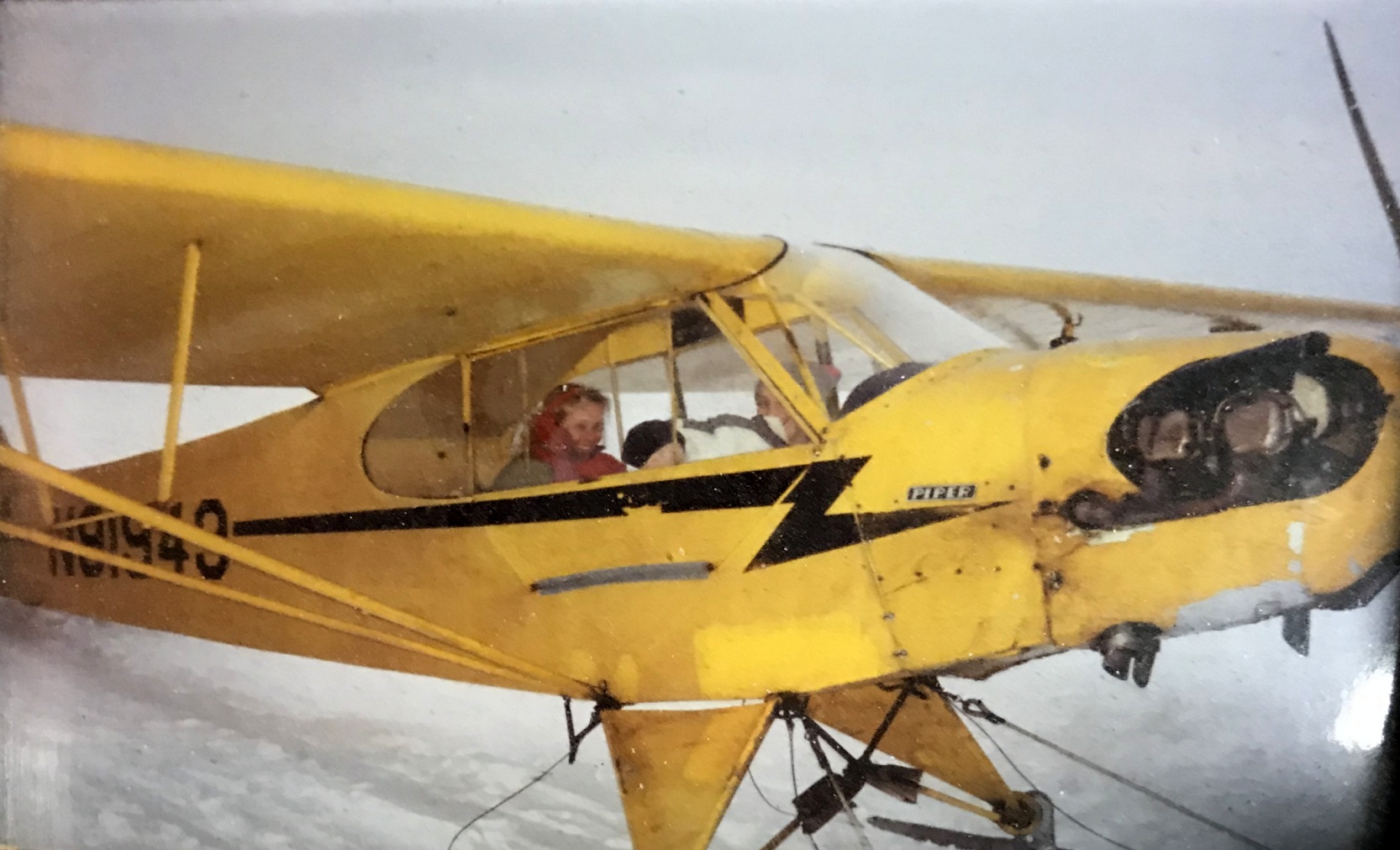
A circa 1989-94 photo by Mike Engelman of Nancy Engelman flying Piper Cub N91949 on skis on snow at Trinca Airport.
Mike Engelman recalled, “Trinca was our primary training grounds.
Pete Billow ran the place & was the chief instructor, mechanic , and Mr. personality.
Pete was a contract pilot trainer in WW2; even had a Link trainer in his office.
[Piper Cub] J-3 N91949 was my great love from 1989-94. Nancy & I soloed on grass, mud, snow, everything except concrete.
All Pete's students loved him, even when he would tap them on the head with a rolled up sectional... he taught flying.”
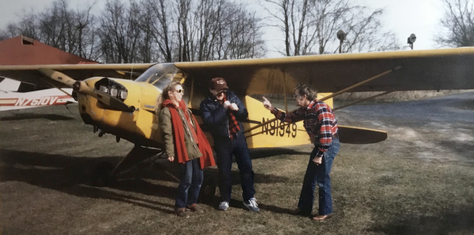
A circa 1989-94 photo (courtesy of Mike Engelman) of Nancy & Mike Engelman & Pete Billow in front of Piper Cub N91949 at Trinca Airport.
A 1994 USGS aerial view looking west depicted Trinca Airport as having a single unpaved northeast/southwest runway, with 8 light aircraft & some small buildings on the east side.
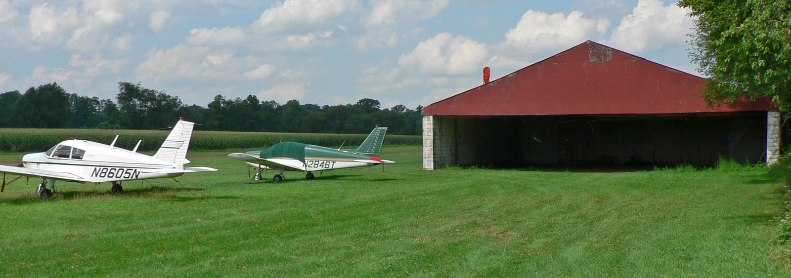
An 8/6/06 photo of 2 single-engine Pipers & a hangar at Trinca Airport.

An 8/6/06 photo of a Piper Apache & a hangar at Trinca Airport.
A 10/2/07 photo of a Piper L-4 Grasshopper at a snowy Trinca Airport.
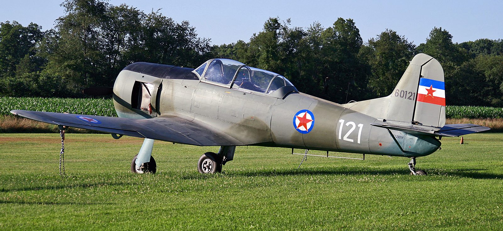
An 8/4/07 photo of a rare Soko 522 (Yugoslavian military trainer) at Trinca Airport.

A 2015 aerial view looking west depicted 6 light single-engine aircraft parked on the east side of Trinca Airport.
A sad 2018 aerial view looking west at Trinca Airport showed its ramp devoid of aircraft, but 1 aircraft on the southwest runway end.
According to its FAA Airport/Facility Directory data, for the year ending 10/2/19, Trinca Airport conducted an average of 5 takeoffs or landings per day.
The 2020 NY Terminal Aeronautical Chart depicted Trinca Airport as having a 1,900' unpaved runway.
According to its FAA Airport/Facility Directory data, as of 2020 Trinca Airport had a 1,924' turf Runway 6/24,
was owned by Green Township, and managed by Mark Zschack.
Unfortunately the end eventually came for this nice little grassroots airport,
as it was announced that Trinca Airport will close in September 2020.
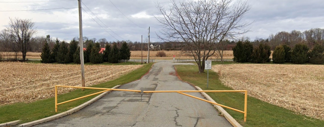
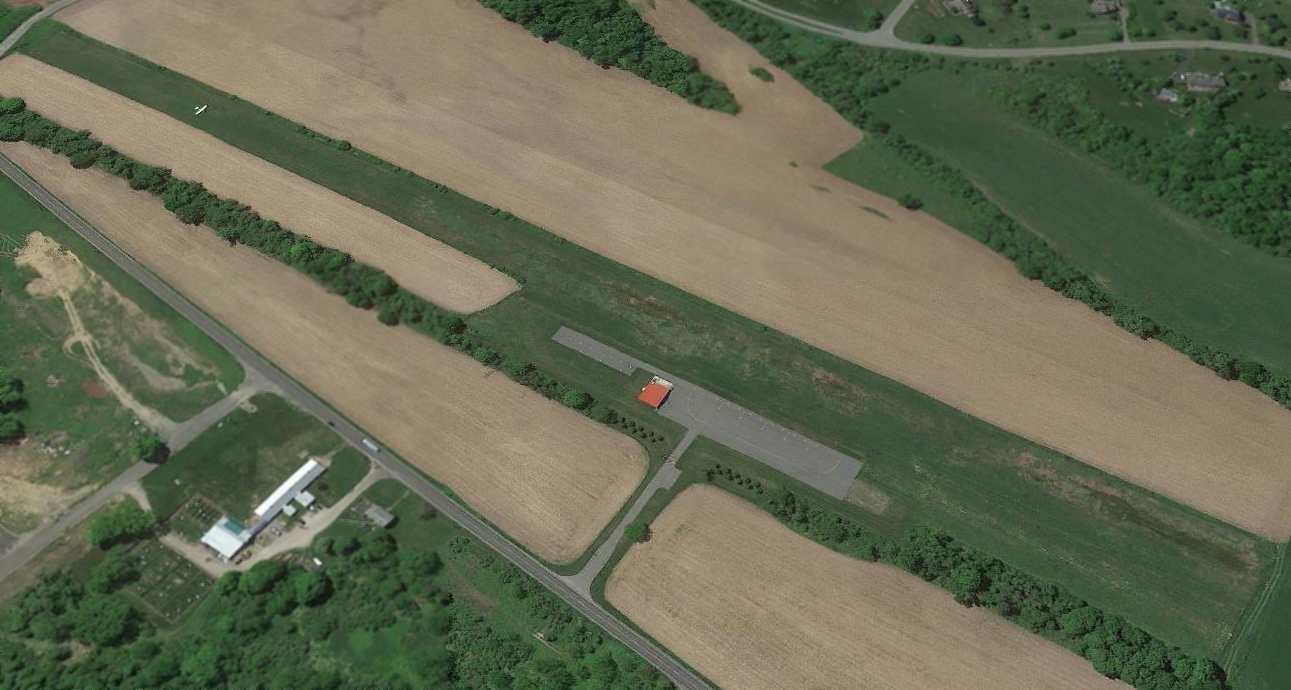
A December 2021 photo looking northwest at the Trinca Airport gate.
A December 2021 photo looking northeast along the former Trinca Airport runway, with the hangar also visible.
Thanks to Larry Cutler for pointing out this airfield.
____________________________________________________
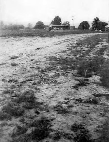
Northwest Jersey Airport, Perryville, NJ
40.634, -74.977 (West of New York, NY)
A 5/19/38 photo of the Air Mail flight originating from Northwest Jersey Airport, as part of National Air Mail Week.
This small early airport was evidently established at some point between 1931-38, as it was not yet depicted on a 1931 aerial photo.
According to Barry Haver, “Northwest Jersey Airport... My father owned a small airport at Perryville.
I have the original sales agreement from 1938. My father was a OX-5 member."
A 5/19/38 photo of a group of Postmasters in front of the Piper Cub to be used on an Air Mail flight from Northwest Jersey Airport, as part of National Air Mail Week.
A 5/19/38 photo of a Piper Cub being serviced before its flight from Northwest Jersey Airport, as part of National Air Mail Week.
A 5/19/38 photo of a Piper Cub taking off from Northwest Jersey Airport, as part of National Air Mail Week.
Northwest Jersey Airport was not yet depicted on the June 1939 NY Sectional Chart.
The earliest aeronautical chart depiction which has been located of Northwest Jersey Airport
was on the March 1940 NY Sectional Chart (courtesy of Tim Zukas).
The last photo which has been located showing aircraft at Northwest Jersey Airport was a 1940 aerial view.
It depicted Northwest Jersey Airport as having 2 unpaved perpendicular runways,
with 2 light single-engine aircraft parked near a few small T-hangars on the northeast side.
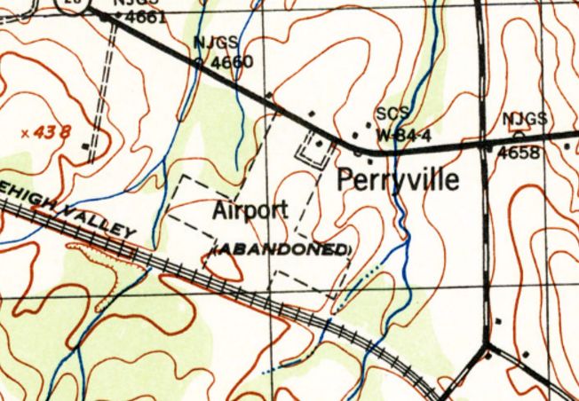
The earliest topo map depiction which has been located of Northwest Jersey Airport was on the 1943 USGS topo map.
It depicted a property outline for 2 unpaved perpendicular runways, labeled simply as “Airport (Abandoned)”,
with a small building on the northeast side.
The last aeronautical chart depiction which has been located of Northwest Jersey Airport was on the May 1943 NY Sectional Chart.
Barry Haver remarked of Northwest Jersey Airport, “WW2 closed it down; it was closed by the government for wartime security."
Northwest Jersey Airport was no longer depicted on the May 1944 NY Sectional Chart.

Northwest Jersey Airport was still depicted on the 1949 USGS topo map,
even though it had evidently been abandoned for at least 6 years already by that point.
A 1953 aerial view of the site of Northwest Jersey Airport showed the land of the 2 runways had been returned to cultivation,
and the T-hangars had been removed at some point between 1940-53.
Amazingly, the property of Northwest Jersey Airport remained an open field as of a 2015 aerial view.
The site of Northwest Jersey Airport is located southwest of the intersection of Interstate 78 & Perryville Road.
Thanks to Barry Haver for pointing out this airfield.
____________________________________________________
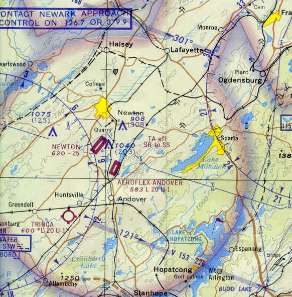
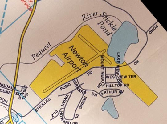
Newton Airport (3N5), Newton, NJ
41.025, -74.76 (Northwest of New York, NY)
Newton Airport, as depicted on the 1965 NY Sectional Chart.
Yet another one of the amazingly disproportionate number of general aviation airports which have been lost to “redevelopment” in NJ.
Why has NJ lost so many small airports?
Does the NJ state government & aviation organizations not care about NJ's disappearing general aviation infrastructure?
Newton Airport was not yet depicted on the 1961 NY Local Aeronautical Chart (courtesy of Tim Zukas).
The earliest reference which has been located of Newton Airport came from Richard Halstead,
who reported, “Newton Airport... The logbook of my grandfather [Lyle Halstead] shows he landed there in June 1961 in the company Aero Commander 680.
Since I see no other flights in his records in the general timeframe from unimproved runways, my hunch it that Newton was probably paved by that date.”
According to its FAA Airport/Facility Directory data, Newton Airport was established in April 1962.
The earliest depiction which has been located of Newton Airport was on the 1965 NY Sectional Chart.
It depicted Newton as having a 2,000' unpaved runway.
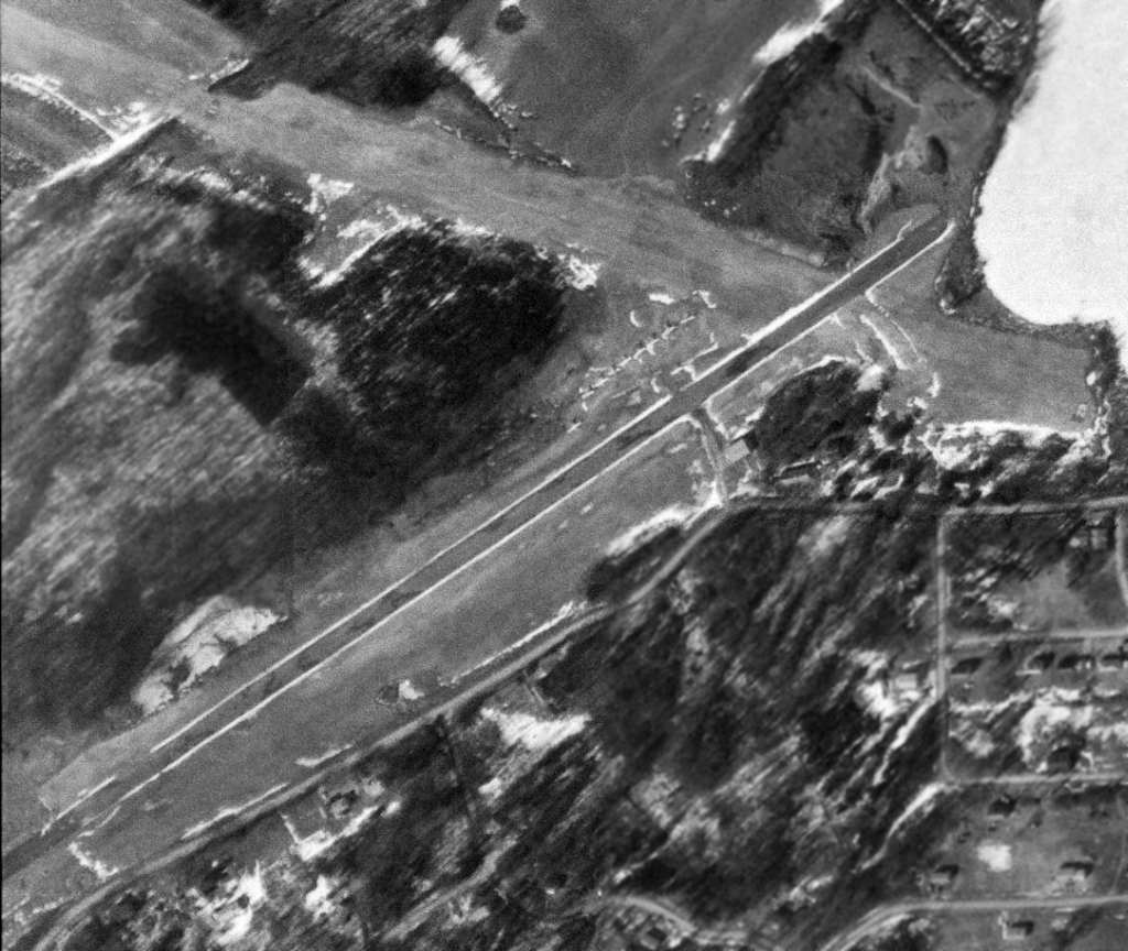
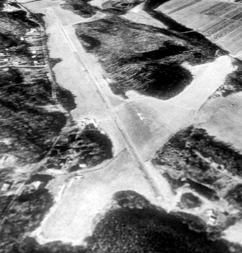
The earliest photo which has been located of Newton Airport was a 2/24/70 USGS aerial view.
It depicted Newton as having a paved northeast/southwest runway,
and an unpaved crosswind Runway 11/29 (labeled with runway numbers, somewhat unusual for a grass runway).
A total of at least 9 light aircraft were visible on the north side of the paved runway.
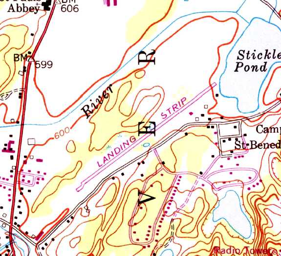
Newton evidently gained a paved runway at some point between 1965-71,
as the 1971 USGS topo map depicted a single paved northeast/southwest runway, labeled simply as “Landing Strip”,
along with several small buildings on the east side.
The 1972 NY Terminal Area Chart depicted Newton as having a single paved 2,500' runway.
A 1986 map (courtesy of Steven Boggess) depicted Newton Airport as having 2 runways.
A 4/4/94 USGS aerial view looking southwest depicted Newton as having a paved northeast/southwest runway, and an unpaved crosswind runway.
A total of at least 6 light aircraft were visible on the northeast & southeast sides of the paved runway.

A 2000-2003 photo by Chris Uminowicz of skydivers loading onboard a CASA 212 at Newton Airport.
A 2000-2003 photo by Chris Uminowicz of a skydiving Cessna Caravan taking off from Newton Airport.
A 2000-2003 photo by Chris Uminowicz of a skydiving de Havilland Twin Otter landing at Newton Airport.
A 2000-2003 photo by Chris Uminowicz of Newton Airport's paved runway.
Chris Uminowicz recalled, “Newton Airport... the locals shut the dropzone down.
I was surprised at that since the airport owners took money from the FAA to repave the runway.
There was a town meeting, and the zoning commission said no jet aircraft, and they considered a 'turboprop' to be a jet.”
An 8/6/06 photo looking northeast at Newton's runway, & hangar, showing one aircraft inside the hangar, and a windsock.
An 8/6/06 photo showing one aircraft inside Newton's hangar.
An 8/6/06 photo of an ultralight which has seen better days in front of a shed at Newton Airport.
According to its FAA Airport/Facility Directory data, in 2009 Newton Airport was described as having conducted an average of 29 takeoffs or landings per day.
A 2010 aerial view looking southwest along Newton's Runway 24 showed 4 light aircraft visible on the field.

The 2012 NY Terminal Area Chart depicted Newton as having a single paved 2,500' runway.
As of 2013, Newton Airport's FAA Airport/Facility Directory data described the field as having a single 2,546' asphalt Runway 6/24.
The owner was listed as RRL group, and the manager listed as Tony Valente.
Newton was said to have 18 aircraft based on the field, including 1 helicopter & 10 ultralights.
The last photo which has been located showing aircraft at Newton Airport was a January 2013 photo of a Cessna 150 or 152 on a snow-covered field.
In January 2013, it was announced that Newton Airport would be closing,
as it had been purchased by a utility company which planned to use the property to stage electrical power equipment used in constructing new transmission lines.
How many small airports does NJ have to lose? When does it stop?
An article entitled “Up, up, and away” by By Jessica Reyes in the 1/12/13 NJ Herald (courtesy of Mark Krefting) noted,
“Local aviation enthusiasts say that the recent sale of Newton Airport to Public Service Electric & Gas highlights the national trend of small airports shutting down.
The number of public use and general aviation airports in NJ has dropped from 82 in 1950 to 44 today, according to the state Department of Transportation.
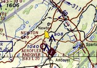
The sale of Newton Airport makes it the latest airport to close, leaving Sussex County with 3 airports:
Trinca in Green, Aeroflex-Andover in Andover & Sussex Airport in Wantage - according to the state.”
Barry Landy, a Chief Flight Instructor at the Essex County Airport in Caldwell, has seen this trend firsthand.
"I've been in this business for 42 years, and I've seen about 42 airports, just in New Jersey, close," Landy said.
The article continued, “PSE&G, a power company that supplies nearly three-quarters of NJ residents, bought the Newton Airport in December
for $3.5 million to use for the storage & construction of pieces of the new 500,000-volt transmission line
that is planned to run from Susquehanna in PA to Roseland in Essex County.
Cynthia DeCristofaro, a broker associate with Weichert Realtors Sparta, was the selling agent for this sale,
which is one of the largest recorded sales in Sussex County in several years.
Since the Susquehanna-Roseland transmission line will run through 6 Sussex County municipalities,
George Sous, Manager of Transmission Outreach, said the 96-acre Newton Airport is an ideal location for storing steel & other hardware
that will be used to construct 200-foot-tall towers that will replace existing 90-foot towers built in the 1920s.
Helicopters will move the partially assembled towers from the airport to environmentally sensitive areas & locations that are challenging to access.
Local pilots hope that when this project is complete in 2015, PSE&G would consider returning the property to a public-use airport.
Sous said PSE&G has not decided that yet.”
"There is no plan for what we are going to do once we are done with the construction," Sous said, adding that PSE&G is "focusing on the task at hand."
He said pilots or others with questions about the project could contact a hotline at 888-771-7734.
The article continued, “Users of the airport & neighbors said it received little traffic in recent years.
Joshua Weinstein, a Green resident & instructor at Essex County Airport,
said over the years he & Landy have used the Newton Airport for emergency training & simple landings for students.”
"It's a nice long runway for our purposes, and it's generally pretty well maintained," Landy said.
The article continued, “They will now have to find an alternate airport for training,
which may be difficult considering Aeroflex-Andover has a shorter runway & is often busy on weekends,
while Trinca has a grass strip that is not ideal for that purpose.”
"Newton is an important place, but its not heavily utilized," Weinstein said. "(The issue is) when these close, they do not come back."
Weinstein said he used Newton Airport often, but recently only saw smaller ultralight aircraft stored there.
The airport had an asphalt runway, but did not provide fuel services or lights for night operation.
"It will be sorely missed, and I'm really hopeful that PSE&G returns it to an airport status when they are finished with it," Weinstein said.
The article continued, “Pecoraro said that it is not uncommon to hear of privately owned, public-use airports closing,
mainly due to the financial gains or business decisions that can come from selling the land for other purposes.
He said NJ has significantly more privately owned, public-use airports than other states, and therefore may be seeing a higher number of closures.”
"We, of course, as an organization that represents individual pilots and owners, are interested to see them stay open," Pecoraro said.
The article continued, “Weinstein said sometimes private airports are sold for the land.”
"They can sell off 100 acres of airport land and turn it into 200 condos, and that makes a lot of financial sense in the near-term to pull in all that money,
but there have been instances where residents have wanted to get rid of the airport (for another use),
but then they realize it increases traffic & the strain (on the area)," Weinstein said.
Weinstein said the public sometimes does not realize "all the hidden benefits" to having an airport in the community.
These airports not only serve pilots, but also help with aerial firefighting, law enforcement, search-and-rescue operations, and airlifts to hospitals.
"People tend to forget about all that," Weinstein said.
The article continued, “Landy said airports also hire local residents for jobs, draw people to the area and aid local businesses.
Also, the pilots who use small airports often go on to be pilots working for airlines and for the military.”
"They all don't have to be LaGuardia or Newark or Kennedy; the smaller airports are aiding the local businesses," Landy said.
"There is tremendous long-term economic benefit to having a local airport."
The article continued, “There is sometimes a perception that living near an airport is noisy and disturbing,
but Weinstein said these small airports are not like being near major airports like Newark Liberty International Airport.”
"A lot of people think of (airports) as nuisances, but it is a lot more than that," Kiss said. " It has a lot of value that people don't see right away."
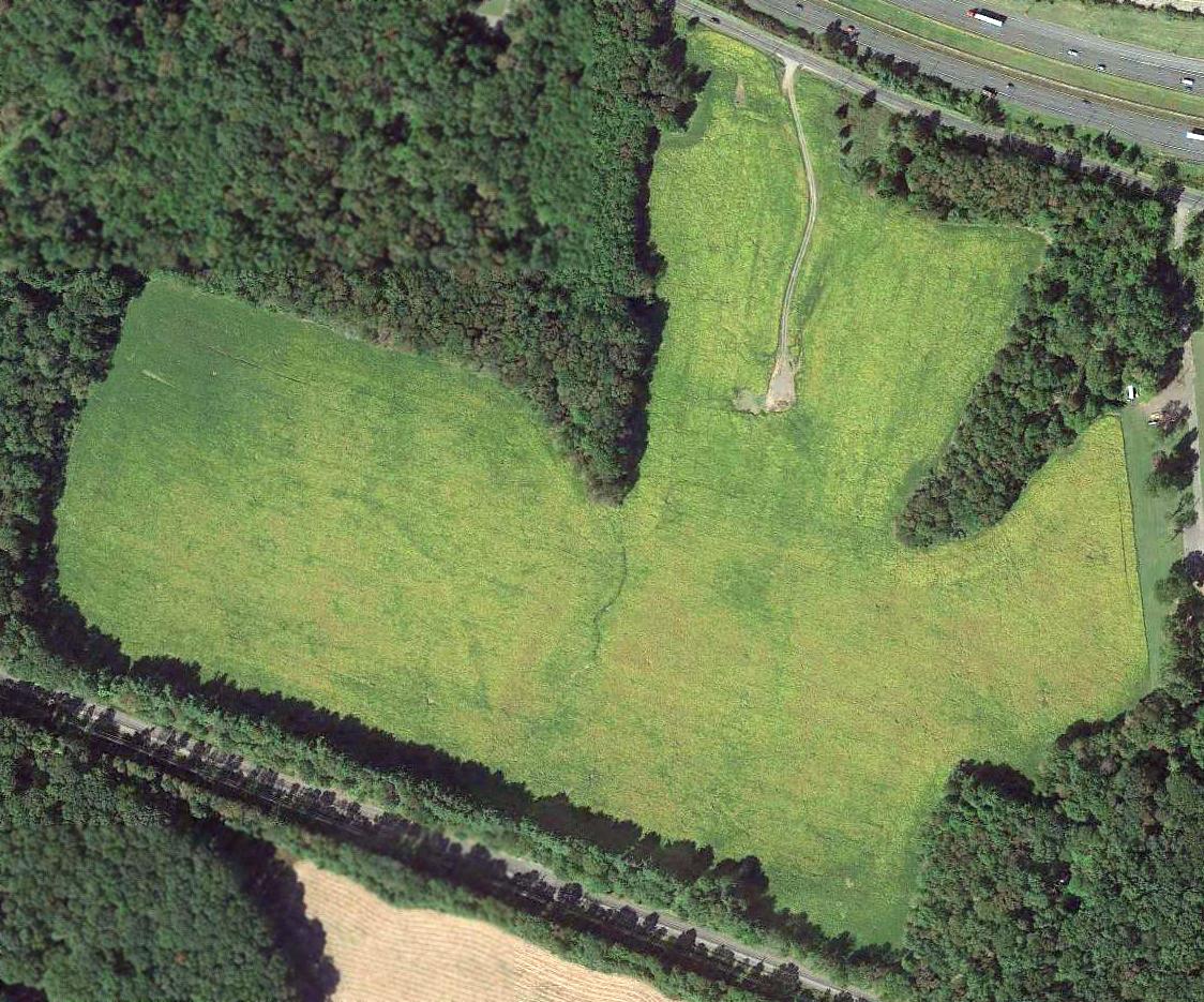
A 9/18/13 aerial view showed Newton Airport's runway marked with a large yellow closed-runway “X” symbol at each end,
but 2 light aircraft remained parked on the southeast corner of the field, evidently stranded after the airport's closure.
A 2016 aerial view still showed 2 light aircraft parked on the southeast corner of Newton Airport, field, 3 years after the airport's closure.
The April 2017 NY Terminal Area Chart no longer depicted Newton Airport.
A 2018 aerial view showed only 1 light aircraft remained on the southeast corner of Newton Airport.
A 2020 aerial view looking northwest showed a twin-engine aircraft remained parked on the southeast corner of the former Newton Airport, 7 years after the airport's closure.
The airport, including its nice paved runway, remained intact – why did this airport need to be closed if it remains completely unused?
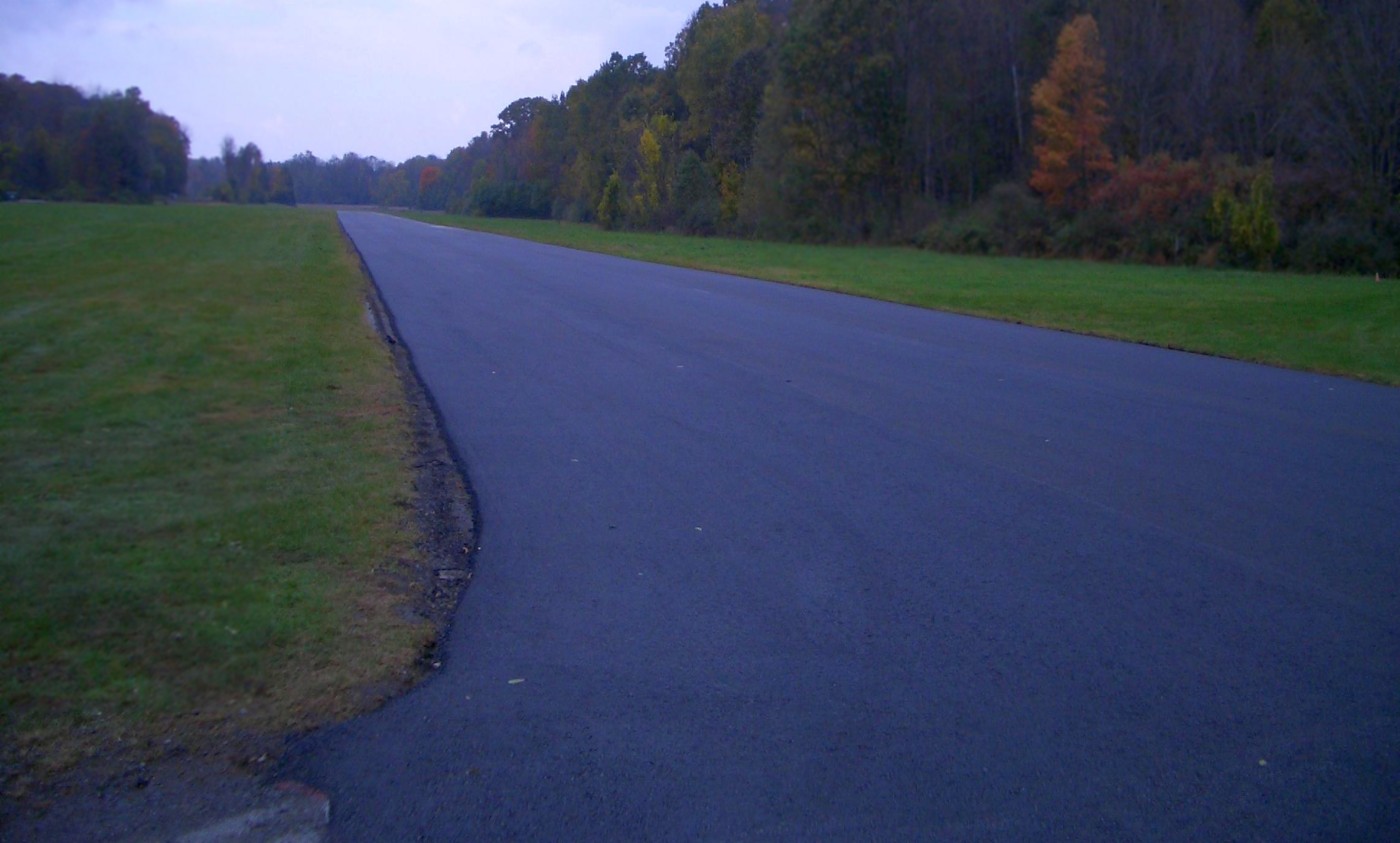
A sad 8/7/23 photo by Steve Boggess looking north at the Newton Airport runway & hangar.
A 8/7/23 photo by Steve Boggess showing weeds growing up through the Newton Airport runway pavement.
Newton Airport is located north of the intersection of Stickles Pond Road & Bernard Drive.
____________________________________________________
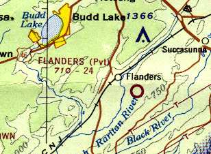
Budd Lake Airfield, Budd Lake, NJ
40.84, -74.775 (West of New York, NY)
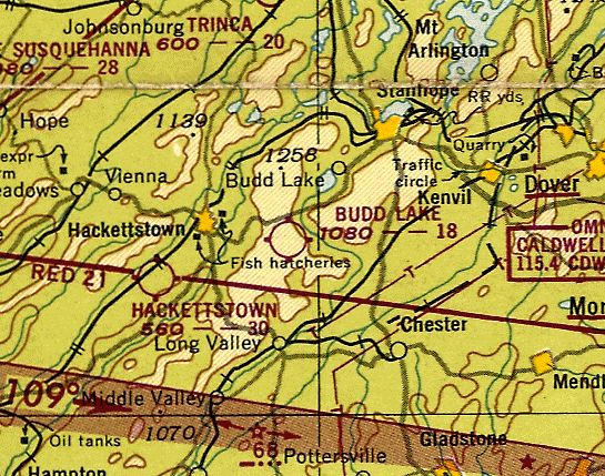
Budd Lake Airport, as depicted on the July 1949 NY Sectional Chart (courtesy of Ron Plante).
Budd Lake Airfield was apparently opened at some point between 1946-49,
as it was not depicted at all on the 1943 USGS topo map nor on the August 1946 NY Terminal Aeronautical Chart (courtesy of Tim Zukas) nor on the 1947 USGS topo map.
The earliest depiction which has been located of Budd Lake Airfield
was on the July 1949 NY Sectional Chart (courtesy of Ron Plante).
It depicted Budd Lake as having a mere 1,800' unpaved runway.
According to Bob Zimmerman (who grew up across the road from Budd Lake Airport), "The airport began business shortly after WW2.
The property owner's son wanted a place close to home where he could learn to fly & keep his airplane.
They dedicated about 90 acres of their farm & leased the property to Howard Bartholomew - the FBO.
He offered lessons, tie downs hangars, fuel, repairs & a snack bar.
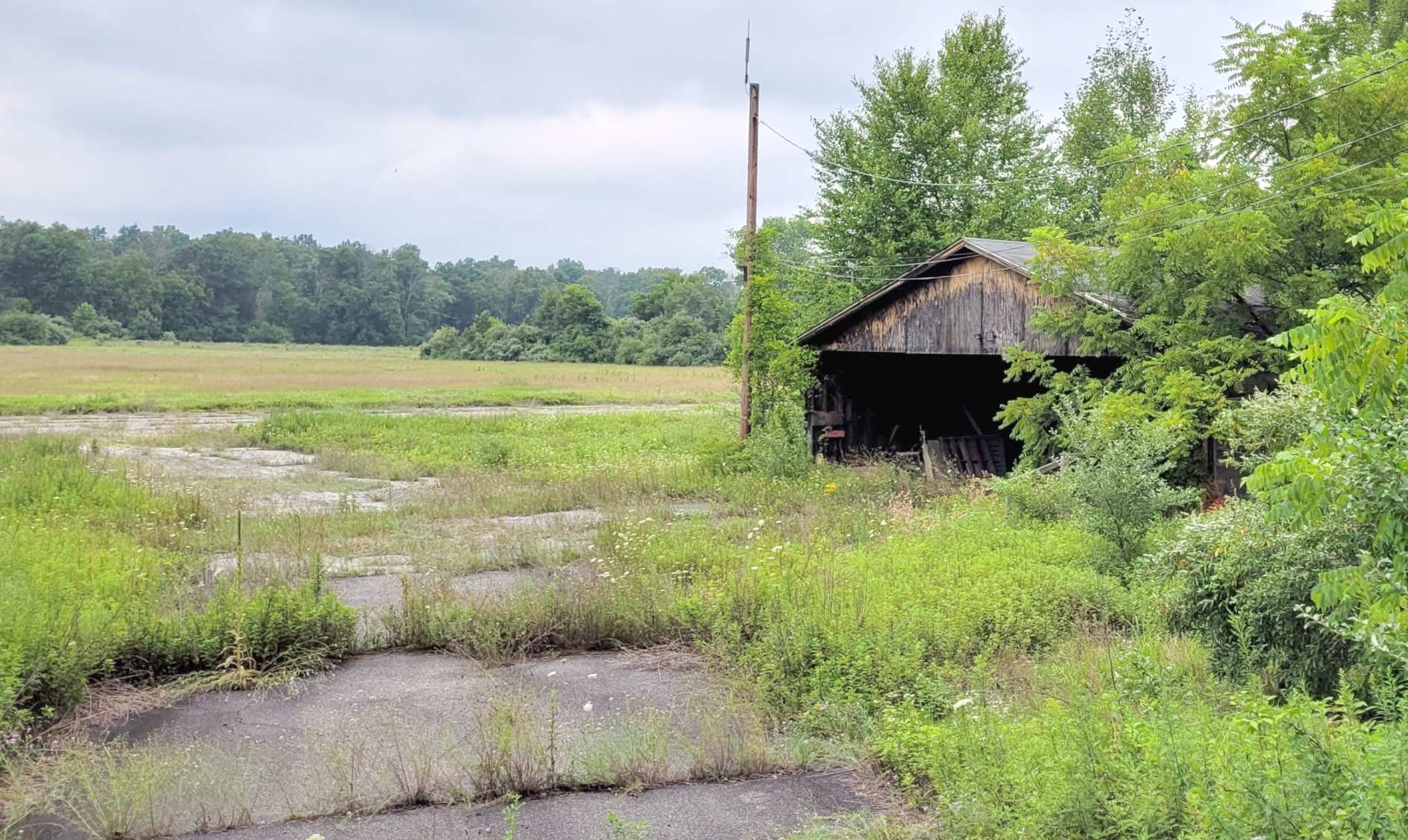
The 'admin' building was a 2 story cinderblock building which still stands, but is obscured by overgrowth.
There was a row of tin-roofed open-front hangars that could accommodate approximately 20 planes.
A concrete fuel island is still in place in front of the building."
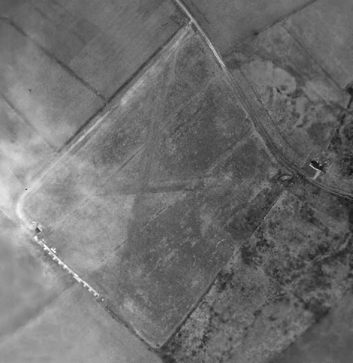
The earliest photo which has been located of Budd Lake Airfield was a circa 1950-54 aerial view (courtesy of Tom Beamer).
It depicted the field as having 2 grass runways,
and a row of 10 T-hangars along the southwest side, in front of which was seen one light aircraft.
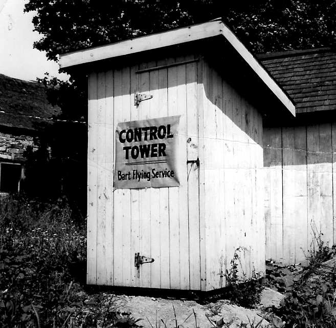
A circa 1950-54 photo of the "Control Tower" at Budd Lake (courtesy of Tom Beamer).
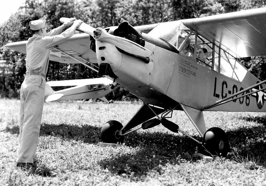
A circa 1950-54 photo of hand-propping a Civil Air Patrol Cub at Budd Lake (courtesy of Tom Beamer).
According to J. Passannante, "I believe the man propping the cub is my father (though hard to tell)."
A circa 1950-54 photo of planes parked at Budd Lake (courtesy of Tom Beamer).
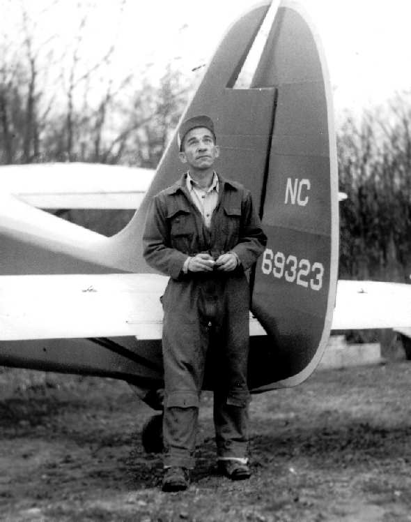
A circa 1950-54 photo of "Bart" Howard Bartholomew at Budd Lake (courtesy of Tom Beamer).
According to Tom Beamer, Budd Lake was operated by "Bart", Howard Bartholomew.
The runway at Budd Lake Airport was "1,800' long with wires at one end & trees at the other.
They operated T-6s, BT-13s, the typical assorted light planes of the era & the Stinson Reliant.
It was a different era - accidents were expected."
Tom continued, "There was a very active CAP [Civil Air Patrol] Squadron there.
In the [aerial photo above] you can see the buildings in the lower left.
Bart built a small square office & some T-hangars, rather basic.
He was a GREAT guy, learned to fly at Mitchel Field in a Hisso Jenny in 1920,
knew the business well, filled with charisma,
unfortunately he made the mistake of building his businesses on rented airports."
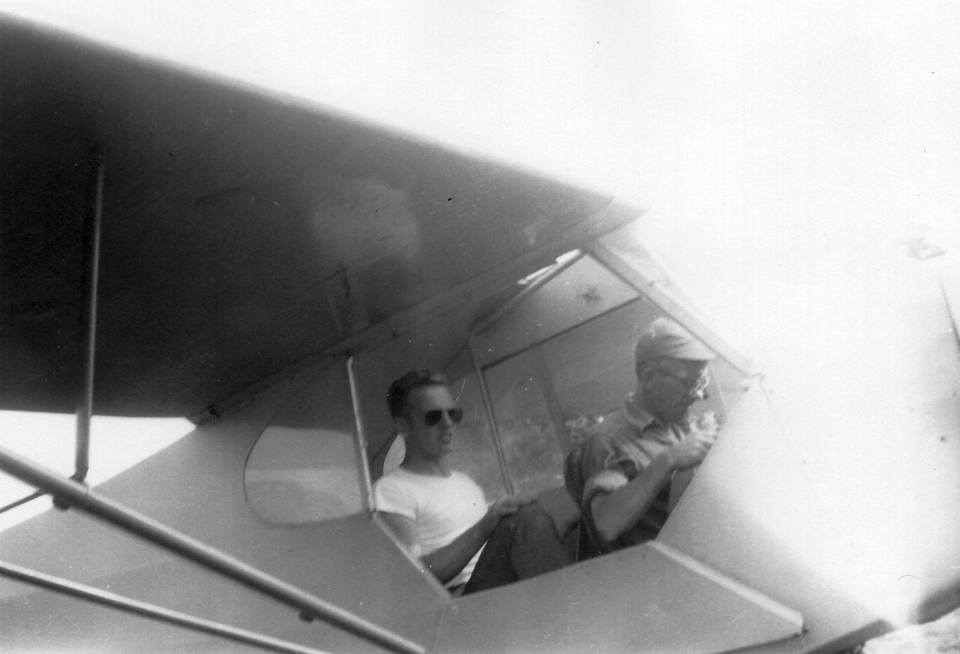
An undated photo of John Lewis in the back seat of Piper J-3 Cub N98138 at Budd Lake, with "Bart" Howard Bartholomew in the front seat (courtesy of John Lewis).
John Lewis recalled, “I took my training through to a private license with Bart & Bill Rhode who was also did parachute testing for Switlik & wrote 4 books on early aviation.”
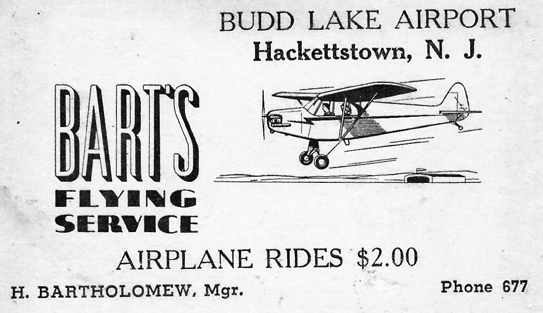
An undated business card of Budd Lake Airport's Bart's Flying Service (courtesy of John Lewis).
The 1953 USGS topo map depicted Budd Lake Airfield as an open field with 2 small buildings.
According to J. Passannante, "My father was based at Budd Lake.
The BT-13 mentioned at Budd Lake was my father's.
Two more planes he kept there were a 1946 85 hp Swift, an AT-6, a Ryan PT-22, military & civilian versions."
The 1953 NY Terminal Aeronautical Chart (courtesy of Tim Zukas) depicted Budd Lake Airport as having an 1,800' unpaved runway.
The last aeronautical chart depiction which has been located of Budd Lake Airport was on the January 1955 NY Sectional Chart.
It depicted Budd Lake Airport as having a mere 1,800' unpaved runway.
According to Bob Zimmerman, "The airport ceased operations in 1956 or 57.
The FBO moved to Princeton & leased Princeton Airport until the mid-1960s."
[Operator Bart Bartholomew also later operated Skyport Airport in PA.]
In a 1996 report by the New Jersey General Aviation Study Commission's Subcommittee on Airport Closings,
reasons were given for the closing of 13 New Jersey general aviation airports.
According to the report, Budd Lake Airport closed because the owner (who lived about 500 feet from the runway)
did not like the noise & refused to renew the lease.
Budd Lake was definitely closed prior to 1957, as it was not depicted at all on the 1957 NY Sectional Chart (courtesy of Mike Keefe).
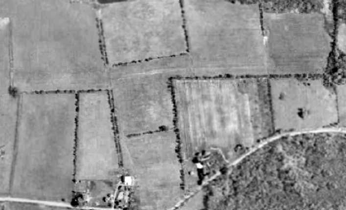
A 1957 aerial view depicted the airfield as basically intact (including all of the T-hangars), but there were no aircraft visible on the field.
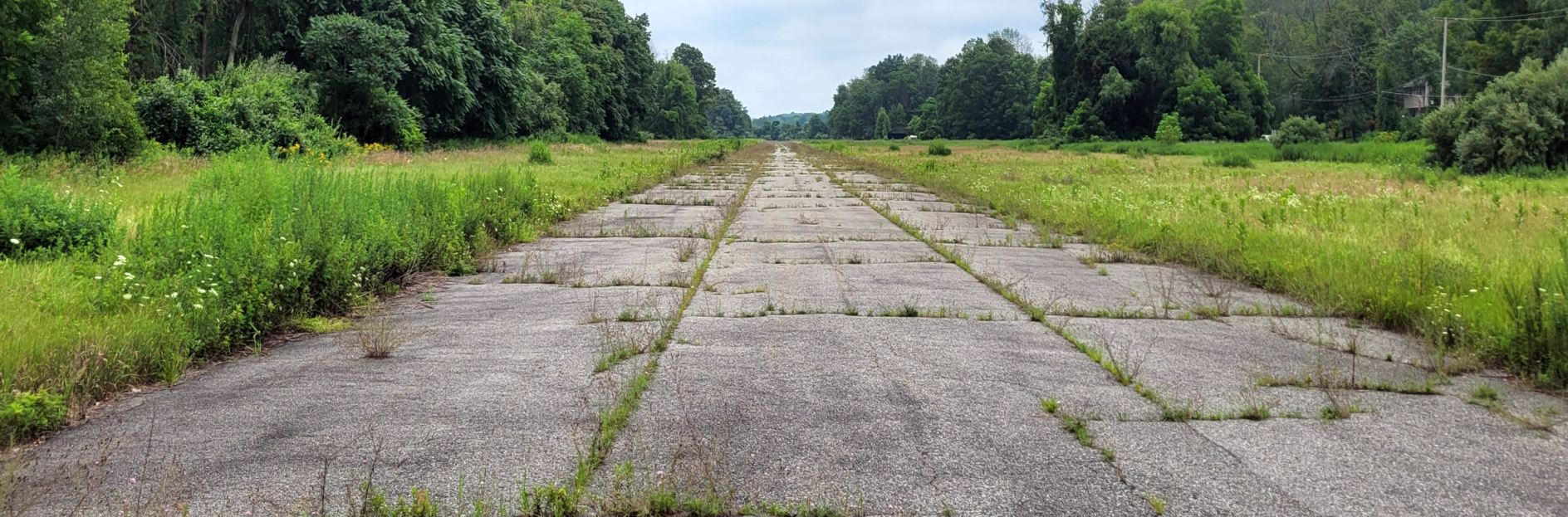
All but 2 of the T-hangars had been removed at some point between 1957-63, as seen in a 1963 aerial view.
The runways area remained clear, though.
Only a sole T-hangar remained standing at the site of Budd Lake Airfield in a 1970 aerial photo.

Only a sole T-hangar remained standing at the site of Budd Lake Airfield in a 1971 USGS aerial photo.

Budd Lake Airfield was still depicted on the 1971 USGS topo map, even though the field had been closed for at least 14 years by that point.
The 1986 USGS topo map still depicted Budd Lake Airfield, with a single 2,100' runway, oriented northwest/southeast.
Eileen Stokes (of the Washington Township Historic Society) reported in 2003
that the former Budd Lake Airport "will soon be built upon for a new elementary school.
Several folks are looking to document the site & story for an eventual display in the school."
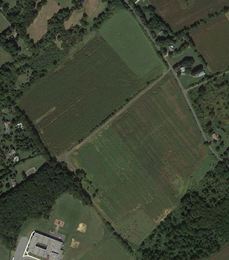
However a 2006 aerial view shows that the elementary school was built at some point between 2002-2006,
but adjacent to the southwest side of the Budd Lake Airport property,
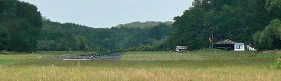
and a 2007 aerial view shows that a single small building appeared to remain standing on the southwest side of the airport property.
A circa 2007-2010 aerial view looking south of all that remains from Budd Lake Airport -
a single small building on the southwest side of the airport property.
A 9/18/13 aerial photo shows the site of Budd Lake Airfield to remain an open field,
but without a trace that would be recognizable to an observer that is was once a vibrant little airport.

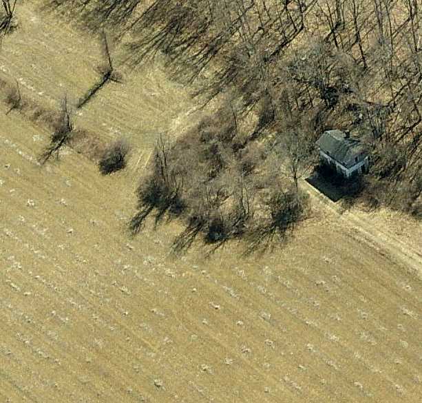
A 9/7/14 photo by Daniel Berek showed no trace of Budd Lake Airfield.

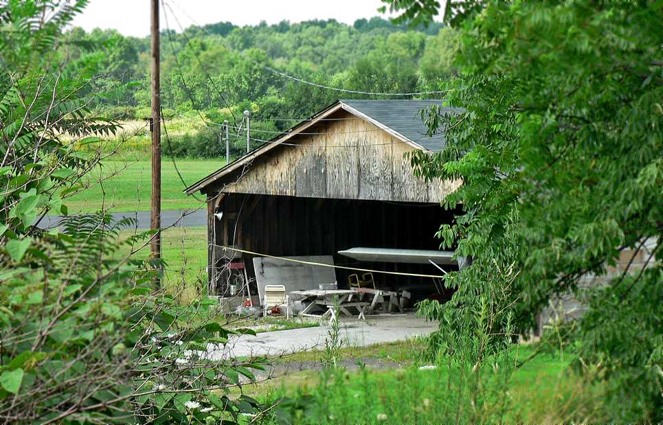
A 9/7/14 photo by Daniel Berek of the former Budd Lake Airfield office building.

A 9/7/14 photo by Daniel Berek of the interior of the Budd Lake Airfield office building.
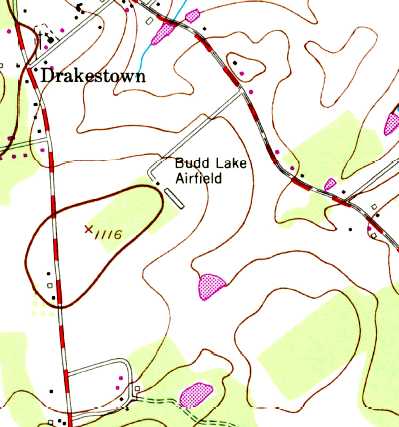
The site of Budd Lake Airport is located south of the intersection of Drakestown Road & Church Road.
Thanks to James G. for pointing out this airfield.
____________________________________________________
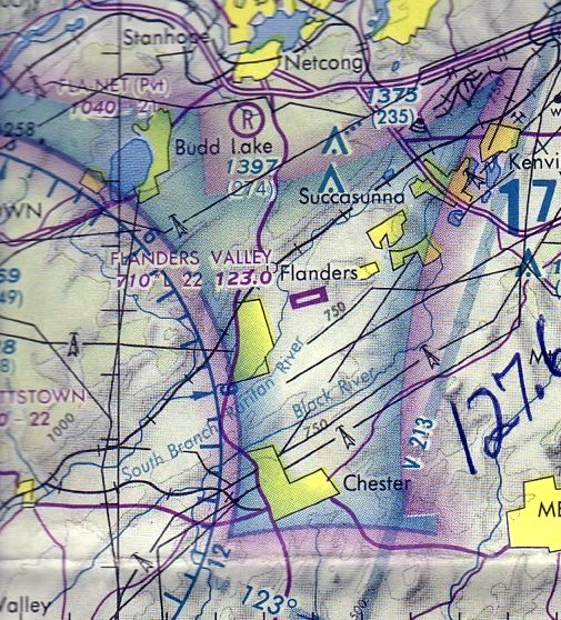
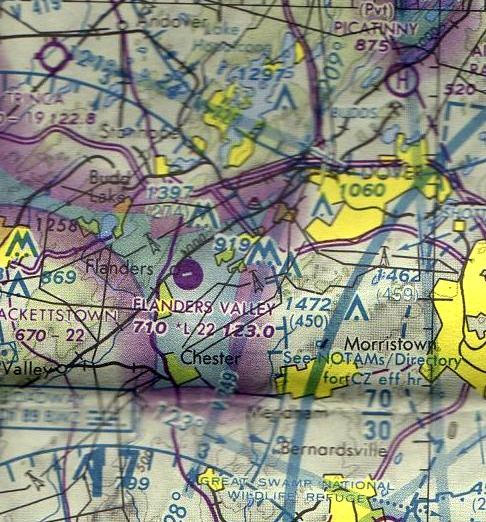
Flanders Valley Airport (81N), Flanders, NJ
40.838, -74.685 (West of New York, NY)
A 1963 aerial view depicted Flanders Valley Airport as having a single east/west grass runway visible.
Flanders Valley Airport was was not yet depicted on the 1947 USGS topo map.
A 1957 aerial view appeared to depict the beginnings of Flanders Valley Airport,
with cuts having been made in 2 treelines, making a clear path for what would eventually be the runway.
A 1963 aerial view depicted Flanders Valley Airport as having a single east/west grass runway.
There were no aircraft visible on the field.
Flanders Valley was not yet depicted on the March 1966 NY Sectional Chart (courtesy of Mike Keefe).
The earliest aeronautical chart depiction of Flanders Valley which has been located
was on the 1967 NY Local Aeronautical Chart (courtesy of Mike Keefe).
It described Flanders Valley as a private field having a single 2,500' turf runway.
Richard Krentz recalled, "I received my flight training from Frank Ragucci at that airport [in 1968]
and subsequently got my instrument rating there also.
In my minds eye I can relive my experiences & all the people there since 1968 when I first started to fly.
Those were 'good ole days'. Flanders Valley was one of those airports where you always felt at home.
The hangar flying was the best in the country, and as I said, the pies were to die for.
I have many picture of the pilots & planes that were there
and the little restaurant there that served the best apple & berry pies in the world, a pilots dream."
The runway at Flanders Valley was evidently paved at some point between 1967-69,
as the 1969 NY Sectional Chart (according to Chris Kennedy)
described Flanders Valley as having a single 2,200' asphalt runway.
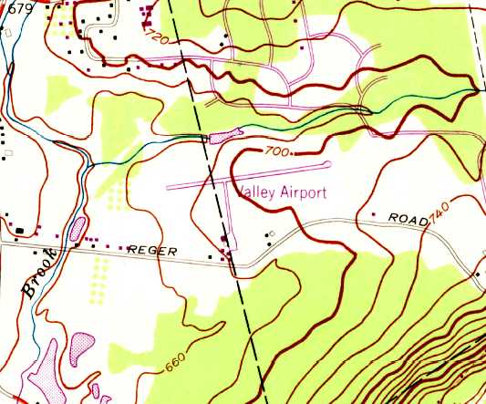
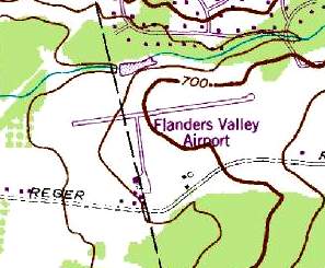
The 1970 USGS topo map depicted “Valley Airport” as having a single east/west paved runway,
a perpendicular taxiway, a small ramp, and several small buildings on the southwest side.
The 1971 NY Sectional Chart (according to Chris Kennedy) depicted "Flanders" as having a 2,200' runway.
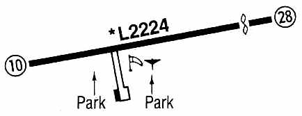
The 1971 Flight Guide (according to Chris Kennedy) depicted "Valley (Flanders)" as having a single 2,224' paved Runway 10/28.
Erika Eick recalled, "I was living in Flanders, NJ, in the 1970s. I rode in my 1st airplane in 1973 at Flanders Valley Airport.
It was in a Piper Cherokee 140 & a pilot named Roy flew my sister & I around Flanders.
My sister & I rode bicycles to the airport & found the rides were priced at $3 / person for twenty minutes.
We rode home to bug our father to take us there & let us fly. I later took my grandmother & aunt from Holland there to take a flight in a 172.
We barely got off the ground on Runway 28 as the plane was heavy & it was summertime.
I used to love going there on weekends & watching cows & airplanes do their thing.
My experiences there led me to join the Army & go into avionics. I will never forget those days!"
J. Passannante recalled, "I was based out of Hackettstown Airport in the 1970s, and visited Flanders every Sunday afternoon, for many years.
The man who owned Flanders at the time was Walt Hoffman."
The 1975 NY Local Aeronautical Chart (courtesy of Mike Keefe) depicted Flanders Valley Airport as having a 2,200' paved runway.
Flanders Valley Airport was still depicted as an active airfield on the 1979 NY TCA chart (courtesy of Bill Suffa).
It was depicted as having a single 2,200' paved east/west runway.

An undated aerial view looking northwest from the 1979 NJ Airport Directory depicted Flanders Valley Airport as having a single 2,224' asphalt Runway 10/28, with a large number of light aircraft parked on the south side.
The manager was listed as Walter Hoffman, and the Fixed Base Operator as Flandaire Inc.
As was depicted on the 1981 USGS topo map, the airfield consisted of a single 2,300' paved runway,
a perpendicular taxiway, a small ramp & at least one hangar.
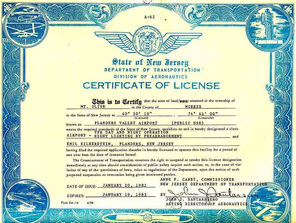
The NJ Department of Transportation 1982 License for Flanders Valley Airport.
The June 1982 NY Terminal Aeronautical Chart (courtesy of Mitchell Hymowitz)
depicted Flanders Valley Airport as having a single 2,200' paved east/west runway.
The 1983 Flight Guide (courtesy of Chris Kennedy)
depicted Flanders Valley as having a single 2,224' paved Runway 10/28,
with a taxiway leading to a ramp with a single building (a hangar?) on the south side of the field.
The remarks said: "Runway 10 - closed for takeoff with less than 10 kt headwind."
Richard Krentz recalled, "My last flight from that airport… was 1984 & the airport was shut down shortly afterward."
The last aeronautical chart depiction which has been located of Flanders Valley Airport
was on the June 1985 NY Sectional Chart (courtesy of Mitchell Hymowitz).
It depicted Flanders Valley Airport as having a single 2,200' paved east/west runway.
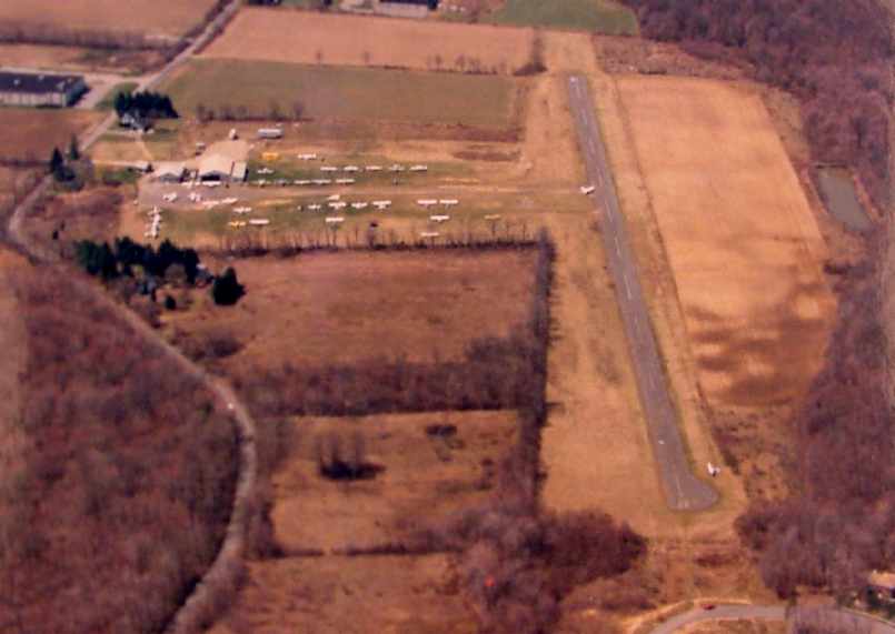
A 1986 photo by Dick Krentz looking west at Flanders Valley Airport, with over 40 light aircraft visible on the field.
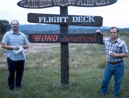
A 1986 photo of Robert Bond (the last manager of the airport) & Al Montecalvo at the Flanders Valley Airport sign.
According to Michael Bond,, “Bond aviation was the FBO there, [which] provided flight training, aircraft maintenance/inspections, etc.
Flight Deck was a graphics artist, [which] did lots of signs.”
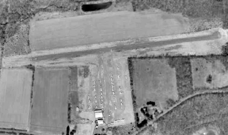
The last photo which has been located showing the Flanders Valley Airport while it was open was a 1987 aerial view.
The airport was obviously very well-used right up to the end, as a total of over 40 aircraft were visible on the field.
According to Roger Hendrixson, “The AT&T Flying Club operated out of the Flanders Airport up to the mid-1990s. The club had a Cessna 152 & 172.”
Richard Krentz recalled, "It was a sad day when I got the call that Flanders was closing forever.
We were sad to see the place go but the developer got his way as usual & that was that."
In a 1996 report by the New Jersey General Aviation Study Commission's Subcommittee on Airport Closings,
reasons were given for the closing of 13 New Jersey general aviation airports.
According to the report, Flanders Valley Airport closed when the developers encroached on the runway,
building homes very close to the approach end of one runway.
Flanders Airport was no longer depicted on the December 1993 NY Sectional Chart (courtesy of Ron Plante).
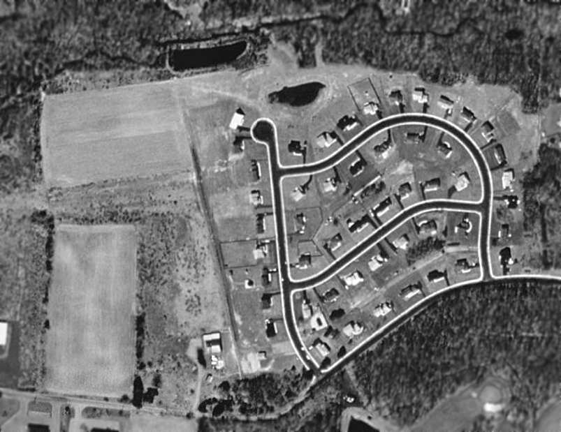
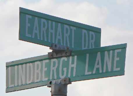
By the time of a 1995 USGS aerial photo, the eastern half of the airfield property had been redeveloped as a housing subdivision
(which ironically has streets named Wright Court, Lindbergh Drive & Earhart Drive).
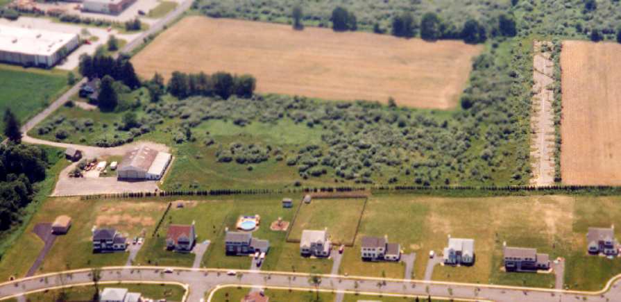
A sad 1996 aerial view looking west at the remains of Flanders Valley by Philip Kineyko.
The hangar is at the left, while the remaining runway portion is at the right.
Unfortunately a 2002 aerial photo showed that additional houses had been built over the remaining runway portion & site of the hangar,
erasing the last traces of Flanders Valley Airport.
Steve Lanieri reported in 2005 of Flanders Valley Airport that “the western part of the airport has now unfortunately been developed
and there in no longer any existence of the airport.
The runway, taxiway, and buildings have all been demolished & a development put in their place.”
street signs in the neighborhood bearing the names of famous pilots.
Michael Bond reported in 2012 of Flanders Valley Airport, “I have the last wind sock that was flown there.”
A 9/28/13 aerial view showed no trace remaining of Flanders Valey Airport.
The site of Flanders Valley Airport is located on the north side of Reger Road, across the road from the Flanders Valley Golf Course.
Thanks to James G. for pointing out this airfield.
____________________________________________________
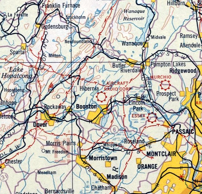
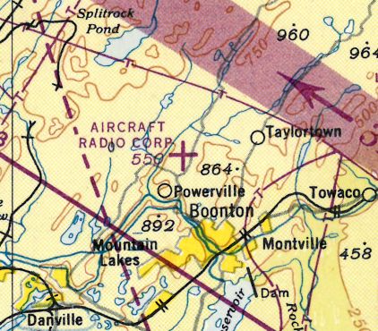
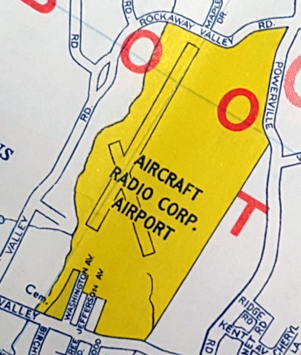
Aircraft Radio Corporation Airfield, Boonton, NJ
40.935, -74.428 (West of New York, NY)
The Aircraft Radio Corporation Field, as depicted on a 1929 ARC booklet entitled “Development of Aircraft Radio Receivers” (courtesy of Albert Helfrick).
According to Albert Helfrick (who “worked for ARC from 1977-84”),
a 1929 ARC booklet entitled “Development of Aircraft Radio Receivers”
stated “In the fall of 1927 the Aircraft Division of the Laboratories [Radio Frequency Laboratories Inc.]
was formed to handle the aircraft radio developments then in progress.”
Shortly after their incorporation, a "Flying Field" was established at their facility.
According to Albert Helfrick, the 1929 booklet “shows pictures of a totally complete facility:
buildings completely furnished, hangar, cleared runways etc.
It had to take more than a year to do this, especially with the North Jersey winters.
Also, the land is reasonably flat but there was a brook that ran through the property
and some of the land had to be filled in & graded. This had to take months.
Therefore, I would say the construction took place the entire year of 1928.”
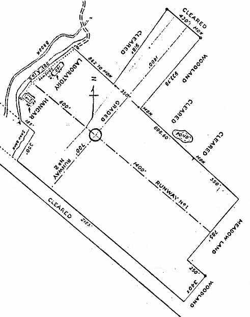
Albert continued, “The booklet also shows a detailed plat of the property.
It shows the northwest/southeast runway at 2,200’ & northeast/southwest runway at 2,100’.”
In early 1929 a great engineering conference was held at the Flying Field,
and the electronic instruments industry came in full force to celebrate the opening & dedication
of the company's new facilities, which included a hangar at the Flying Field & a laboratory in the town of Boonton.
While his Consolidated trainer plane was hangared at ARC,
young Jimmy Doolittle became a familiar personality on the local scene.
It was in this plane in late 1929 that he made his famous "under-the-hood" landing at Mitchel Field, NY,
ARC personnel having installed his special ARC receiver & radio gear.
The 1930 "Rand McNally Standard Map of New Jersey With Air Trails" (courtesy of Chris Kennedy)
described the Aircraft Radio Corporation Airport as consisting of an irregularly shaped field,
measuring 2,200' northwest/southeast x 2,100' northeast/southwest.
A circa early 1930s aerial view depicted the Aircraft Radio Corporation Field
as an irregularly-shaped grass field, with a few small hangars on the west side of the property.
Note the airport circle marking in the center of the field.
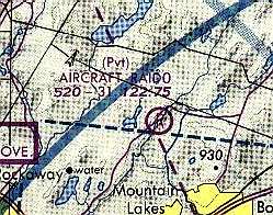
The earliest aeronautical chart depiction which has been located of the Aircraft Radio Corporation Airfield
was on the August 1932 NY Sectional Chart.
By 1933, ARC-designed equipment was installed in the first fighter squadrons of the Army Air Corps & Navy.
The 1934 Department of Commerce Airport Directory (according to Chris Kennedy)
described the Aircraft Radio Corporation Airport as having two 2,200' sod runways oriented at right angles.
The Airport Directory Company's 1937 Airports Directory (courtesy of Bob Rambo)
described the Aircraft Radio Corporation Field as having three 2,200' sod runways.

The earliest photo which has been located showing an aircraft at the Aircraft Radio Corporation Airfield was a 1940 photo (courtesy of Bill Engle Jr.) of Fleetwings A-1.
Bill observed, “The Fleetwings Model 27 was a private-venture radio-controlled aerial gunnery target built in 1940 & known as the A-1.
It had fabric-covered 20' span wings with split flaps & fabric-covered empennage & flight controls. A Continental A65 engine gave a top speed of 180 mph.
The radio set was located in a compartment positioned on the center of gravity, so with the equipment removed it could carry a pilot.
On 4/1/40 test pilot William H. Engle took it for a flight from the Aircraft Radio Corporation airfield at Boonton.
Military designation [was] believed to be OQ-1. No further examples were built.”

A 4/11/43 aerial view looking north from the 1945 AAF Airfield Directory (courtesy of Scott Murdock)
depicted the Aircraft Radio Corporation Airport as having several grass runways.
The directory described Aircraft Radio Corporation Airpoort as an 80 acre irregularly-shaped property
having 3 sod runways, the longest being a 2,200' northeast/southwest & northwest/southeast strips.
The field was said to have a single 60' x 50' concrete hangar,
to be owned by private interests, but not to be in operation (most likely due to wartime restrictions on general aviation near the coasts).
The August 1946 NY Terminal Aeronautical Chart (courtesy of Tim Zukas)
depicted Aircraft Radio Corporation as am auxiliary airfield.
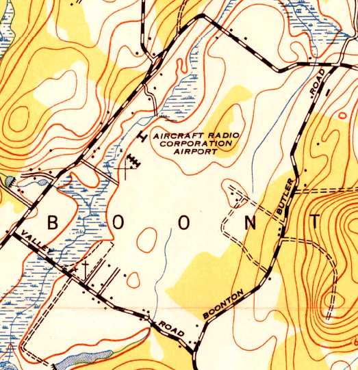
The 1947 USGS topo map depicted the “Aircraft Radio Corporation Airport” as an open field with several buildings along the west side.
According to former ARC employee Albert Helfrick, “As for the purchase date of ARC by Cessna,
I was told many years ago it became a 'wholly owned subsidiary' in 1954.
Later it became a 'division' of Cessna.
I have an article from 'The Citizen of Morris County', a magazine,
which outlines 'Boonton New Jersey, and its role in the Electronic Precision Instruments Industry', by Edgar Weed.
In the article it names the officers of ARC & they are the original RFL group,
so Cessna was not the owner or major player in 1950 giving credence to the 1954 date.”
The ARC company eventually went on to become the standard-equipment supplier of avionics
in the many thousands of Cessna civil aircraft produced between the 1950s & the 1980s.
They continued to use their airfield for test flights of aircraft equipped with their avionics.
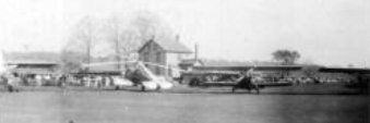
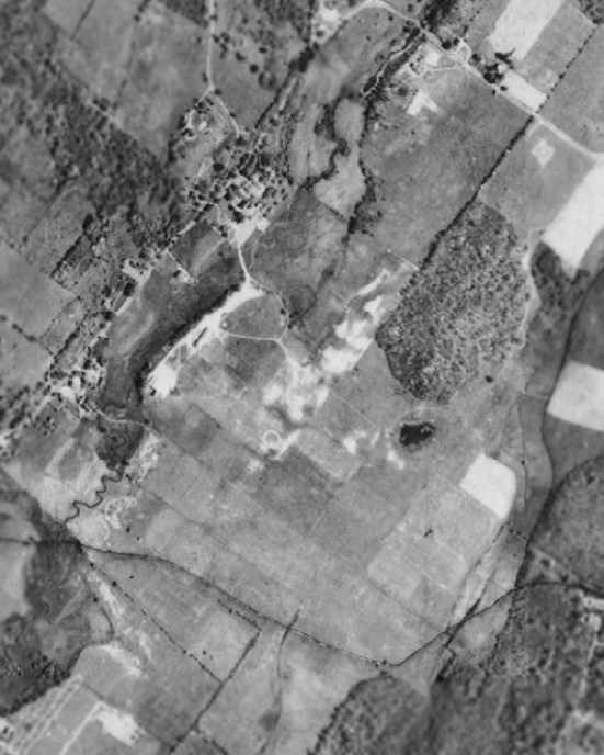
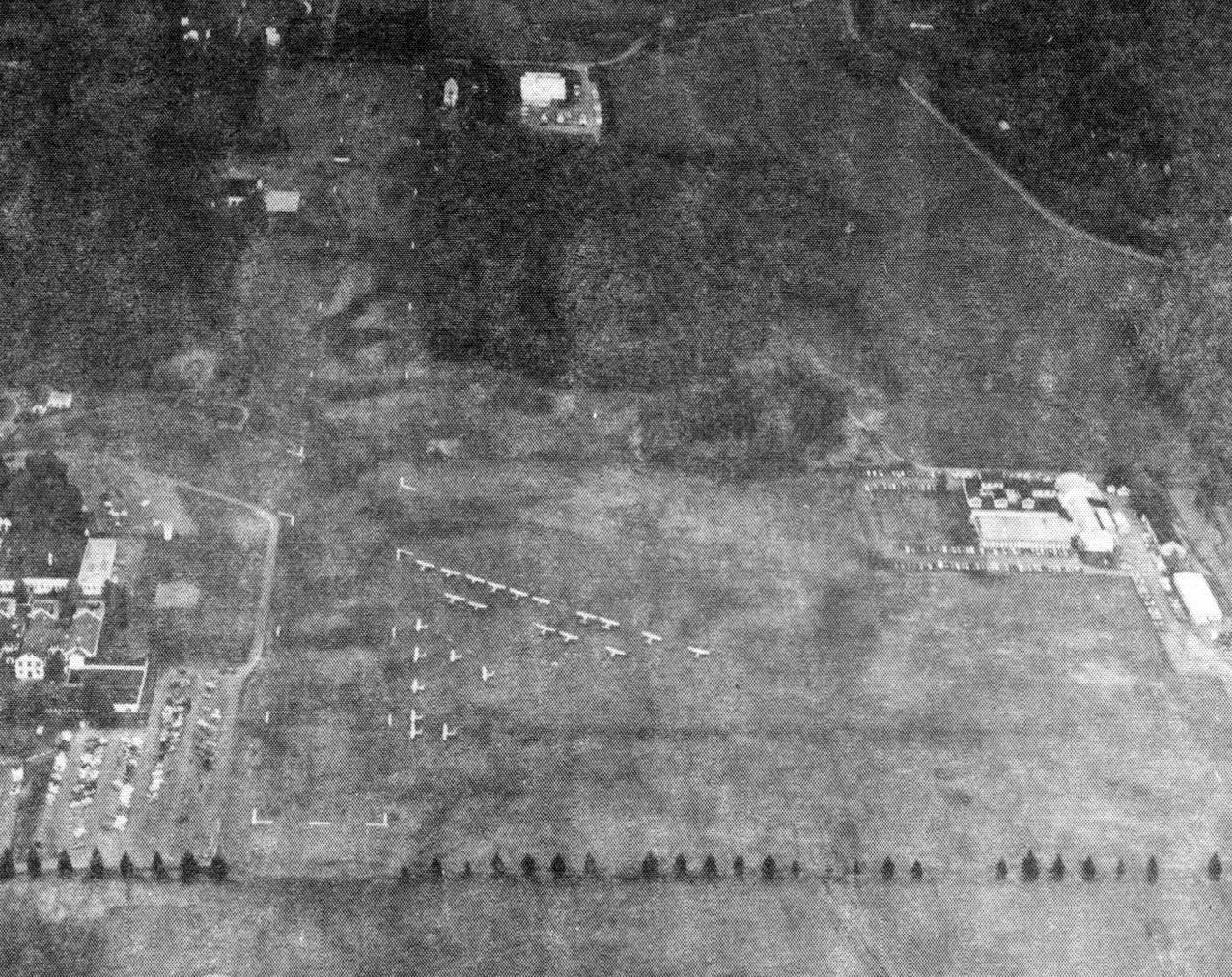
A 1956 aerial photo looking northeast from a card commissioned by ARC (courtesy of Geroge Torpey).
George noted, “The buildings at the bottom housed the production facilities.
The engineering building is above it & the administrative functions were housed in the buildings above engineering.
The hangar is on the left of the runway about half way up the picture.”
George Torpey recalled, “I worked for Aircraft Radio from 1957 through 1970
holding a number of different positions in commercial field engineering & sales, systems engineering, and military sales & marketing,
all of which included piloting company owned and/or operated aircraft into & out of the Booton, NJ airfield.
It was a great place to work with a great history in the development of products for both military & commercial aviation.
It is sad that the company is probably remembered most for the lower-quality panel-mounted radios
that Cessna forced the company to build for their general aviation aircraft after they acquired ARC.”
According to Wikipedia, “In 1959, ARC was acquired by one of its principal customers, Cessna Aircraft Company, the world's highest-volume airplane manufacturer.”
The Aircraft Radio Corporation airfield was described in the 1962 AOPA Airport Directory
as having 3 grass runways with the longest being 3,100'.
However, former ARC employee Albert Helfrick disagreed: “The 1962 AOPA Airport Directory
suggestion that there were 3 runways can’t be right.
I have no idea where the 3rd runway would have been. It is true that the northwest/southeast runway was extended to 3,100’.”
Mark Rusin recalled, “I grew up in Booton Township & from 1963-73, I lived almost directly across the street on Rockaway Valley Road.
From our kitchen window you could see the Cessna planes making their final approach for landing. I was always amazed.
On weekends you could watch the gliders take off & land there.
My sister had a horse & we would ride along the runway or run our lawn tractors along the edge of the runway.
When we walked home from School (Rockaway Valley School) we walked through the cemetery on Rockaway Road,
through Marotta's property, down the runway, and back home. We had some great times.
They had a dump on the property & they dumped electronic parts & wires (most likely illegal now)
and we would rummage through the dump looking for things we could play with, until someone chased us off.
I knew some kids back then that somehow got hold of a key to the hangar door
and on weekends when the pilots would leave their cars in the hangar & fly off to Florida or other spots,
the kids would go in the hangar & take the cars out for joy rides.
I can assure you I did not partake, but it happened a lot.”
Forrest Smith recalled, “My mother & Uncle used to work there.
They said it employed 3,500 people at one time before its demise.
The hangar was the only one on the field; it was used to install & test radios.”
A closeup from a 1963 aerial photo depicted one single-engine aircraft in front of the hangar at Aircraft Radio.
An undated aerial view looking west at the ARC Airfield from a 1966 issue of the Cessna Pennant (courtesy of William Goebel),
showing a single light aircraft on the grass field, with grass runways outlined with white markings.
Ron Estler recalled, “My father, LeRoy Estler worked at Aircraft Radio Corporation (ARC) for most his adult life, up to 1972. We lived fairly close by.
I remember when ARC would open its doors once a year to family – I have vivid recollections I walking through the facility with my father –
he worked for many years in the final test area.
In the fall of 1968, somehow my father got me on a test flight back to the Pennsylvania college I was attending – probably broke every rule there was – but it saved me a lot of time.
The Cessna was pretty well stripped-out & had lots of test equipment installed – it was a great flight!”
David Schober recalled, “I worked at ARC from 1972-73 & 1974-76.
The large building that was added on the northwest, closing the short cross runway was sometime in the 1973-74 time frame.
I know this because when I went back to work there in 1974, part of my department was moved 'upstairs'.
I worked in the Printed Circuit department & the plating shop was in the downstairs of the old building.
I was also a member of the flying club & in 1974, the 172 was only $10 / hour.”
Rich Amon recalled, “I used to commute by air from Blairstown to Cessna’s ARC field in where I worked from 1974-78.”
John Biggers recalled, “I worked at ARC... from September of 1976 as an Avionics Flight Test Pilot / Engineer.”
Former ARC employee Albert Helfrick recalled, “The northeast/southwest runway apparently had not been used
for quite some time when I arrived in 1977 but it would appear on some maps. It was a parking lot when I arrived.”
A December 1978 photo by Doug Crook of one of the Cessna Flying Club's 172s at the Aircraft Radio Company Airfield.
Doug recalled, “Here is one of the club's planes, N1571E preflighted & ready to go.
The airplane is parked to the left of the hangar;
it was always great going up on a weekend; just drive up, unlock the gate & let yourself in.
On a cold, clear day like this one, you always had great engine performance.
I learned to fly there in the 1970s. It was a special place.
I worked maintenance & cut the lawns for 3 summers while in college,
but all employees could join the Cessna flying club, where we had new model year airplanes each year.
A 172 was $15/hour wet, a 152 was $7/hour wet!”
The Aircraft Radio Corporation airfield was still depicted as an active (private) airfield on the 1979 NY TCA chart (courtesy of Bill Suffa).
It was shown as having a 3,100' unpaved runway.
An undated aerial view looking northeast at Aircraft Radio Corporation Airfield from the 1979 NJ Airport Directory.
It described Aircraft Radio Corporation Airfield as having a single 3,150' turf Runway 5/23, although a crosswind runway was also seen.
A large number of light aircraft were seen parked on the field, possibly for some kind of fly-in?
The manager was listed as Dennis Newton.
A 1983 street map (courtesy of Steven Boggess) depicted the Aircraft Radio Corporation Airport as having 2 runways.
An October 1980 photo by Doug Crook, looking northwest along the crosswind runway, with the hangar along the right side.
A twin-engine & single-engine Cessna are visible in front of the hangar.
According to Wikipedia, “In 1981, the ARC had an employee flying club at the company's private airfield adjacent to the factory.”
According to former ARC employee Albert Helfrick,
it was about 1982 when a large new building was constructed adjacent to the west side of the northeast/southwest runway.”
According to Wikipedia, “In late 1983, Cessna finally unloaded its now-unpopular avionics subsidiary onto rival avionics maker Sperry.
Sperry decided to relocate ARC to Sperry's Phoenix AZ facility, ending 57 years of ARC's avionics development & production in Boonton.”

The last aeronautical chart depiction which has been located of the Aircraft Radio Corporation Airfield
was on the June 1985 NY Secttional Chart (courtesy of Mitchell Hymowitz).
It depicted the ARC Airfield as a private field having a 3,100' unpaved runway.
Mathew Grubel recalled, “Aircraft Radio Corp. Field... I worked there from 1987-89 when Breed Corp / Breed Automotive used most of the facility.
The land was held under a different corporate name, something like Rockaway Valley Holding Corp.
It was no secret the runway was maintained.
One of our Vice Presidents kept his plane (a Cherokee) in the main hangar starting around 1988.
Also the tenant of Building #1 occasionally had his twin-engine Beechcraft on site.
He lives on top of one of the nearby hills (or did) & seemed to have some interest in aviation history.
On one of the anniversary dates of the first blind flight, there was a bunch of historic aircraft that flew in for a show.
It was open to the public. Oh yes, the airstrips lights worked.
A couple times we got flights to take our products to test facilities, and at least one time we got back after sunset.”
The last photo which has been located showing an aircraft on the Aircraft Radio Airfield was a 1987 aerial view,
in which one single-engine aircraft was visible next to the hangar.
The 1990 USGS topo map depicted the ARC “Airport” as having 2 runways (the largest was 3,100' long) & a large hangar.
The Aircraft Radio Corporation airfield apparently closed at some point between 1987-93,
as it was no longer depicted at all (even as an abandoned airfield) on the December 1993 Sectional Chart (courtesy of Ron Plante).
Steve Pavlisko recalled, "When I started flying in 1995, it was still pretty much an airstrip.
I remember seeing VASI lights out there on the end of the field as well."
A 1995 USGS aerial view looking southwest at the Aircraft Radio airfield.
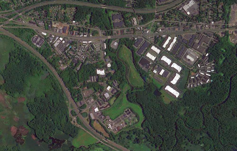
The town government made arrangements to take over the property from the previous owner to preserve as open space.
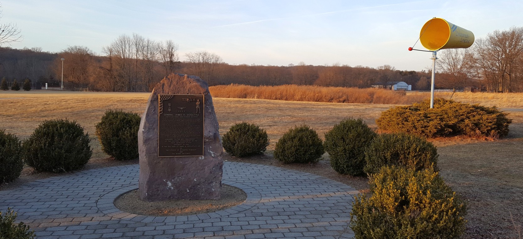
There is a historical marker along Rockaway Valley Road, adjacent to a firehouse near the northern end of the main runway,
commemorating the use of the airfield by Billy Mitchell.
Aaron Gould reported in 2003 that "the airfield now has several obstacles in the form of soccer & lacrosse nets.
I recently flew over the field & found there to be significant radio controlled aircraft activity.
The obstacles on the field would probably preclude any emergency landing."
Aaron Gould reported in 2004 that "The Township of Boonton is stonewalling me as to who currently owns the main runway.
They say there is some sort of dispute as to whether they own it or the former owner owns it.
I asked them why then could they put lacrosse & soccer nets up on it if they didn't know if it was their property.
I received no reply.
If it does turn out that this property is owned by the former owner my father & I will be attempting to purchase the runway (3,100')
from them and we'll see where we can go from there. Keep your fingers crossed."
A 2005 photo by Forrest Smith of the front of the hangar at the Aircraft Radio Corporation Field.
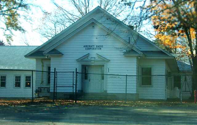
Forrest observed, “The hangar is still in very good condition! There are no planes inside, only small boats.”
A 2005 photo by Forrest Smith of the top of the hangar,
along which can still be discerned the lettering, “Aircraft Radio Corporation, Boonton, New Jersey”.
A 2005 photo by Forrest Smith looking north across the former runway at the hangar.
Forrest noted “The crosswind runway still has the metal wind direction indicator on it.”
A 2005 photo by Forrest Smith of one of the former Aircraft Radio Corporation production buildings.
According to Forrest, “Only a small portion of the old production buildings are now being used.”
A 2005 photo by Forrest Smith, looking across the former runway
toward the former Aircraft Radio Corporation production buildings.
Forrest observed, “The field itself is still very neatly cut, but, has soccer nets on it.”
Terry Davis recalled, “Over the past several years, I've visited Aircraft Radio Corporation Airport twice.
The first time was between 2003-2007. I was driving by, and saw hangars, so I stopped to see.
I saw the large plaque commemorating Gen. Doolittle's first instrument flight. Wow. To be standing in the very place where that flight happened.”
A circa 2006 aerial view looking west at the hangar which remains at the Aircraft Radio airfield.
Terry Davis recalled, “I A few years later [post-2007], I went there again, and the plaque [commemorating Doolittle's historic flight at ARC] had been removed.
A search of the grounds produce nothing. What a shame.”
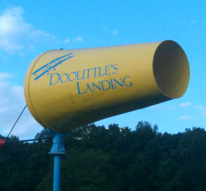
A September 2011 photo of a windsock-shaped metal sign for the Doolittle's Landing playground near the site of the ARC airfield.
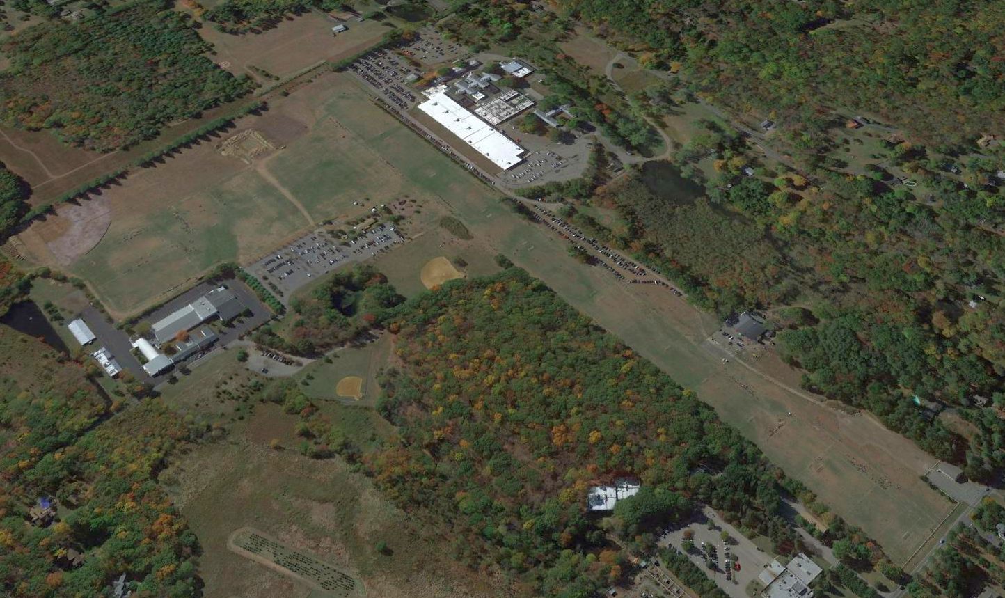
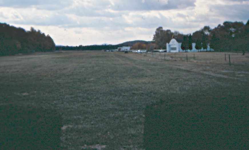
A 2014 aerial view looking southwest showed that the Aircraft Radio Corporation airfield main runway still survives in excellent shape.
It is still cut to active-runway standards, and seems ready for use.
There appear to be some kind of lighting fixtures along the runway,
although lighting was not mentioned in its entry in the 1962 AOPA Airport Directory.
A model-airplane club uses the field on occasion for their activities.
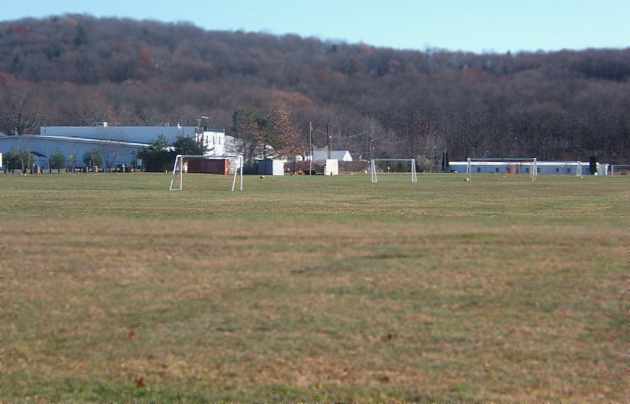
The shorter crosswind runway (southeast corner) is being used for youth athletic fields.
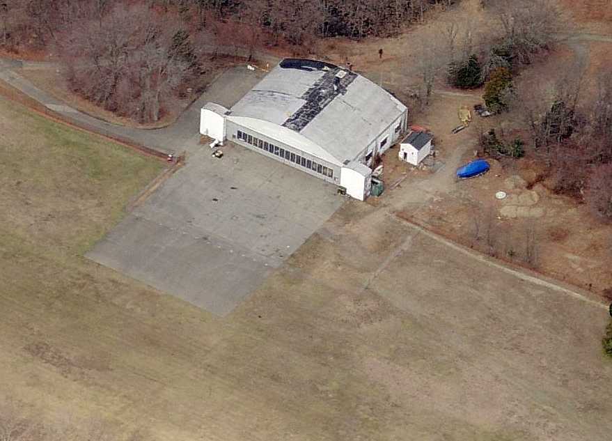
The hangar has been well-maintained over the years, and still stands just east of the runway intersection.
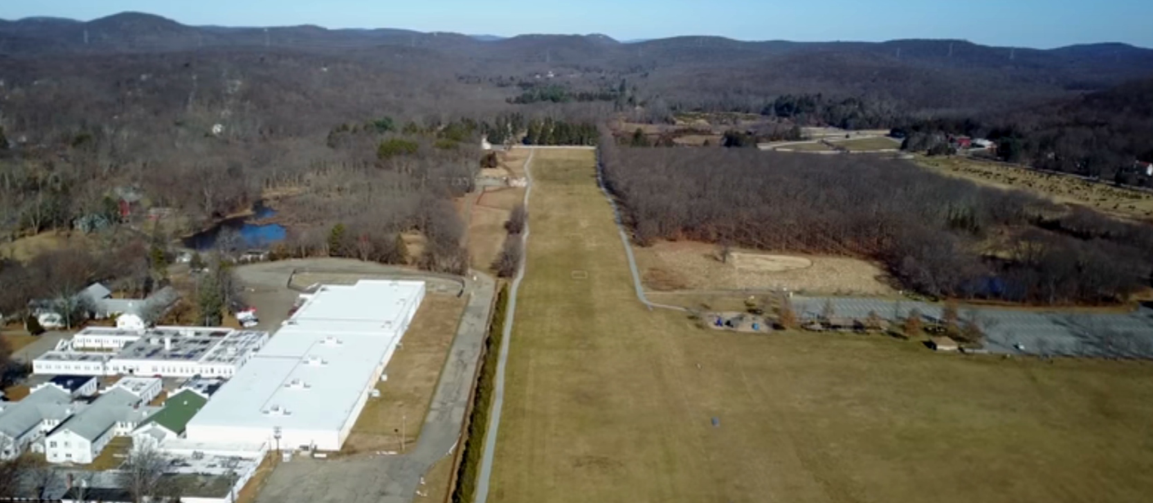
A 2017 aerial view looking northeast along Aircraft Radio Corporation's crosswind runway, with the former ARC facilities along the left side.
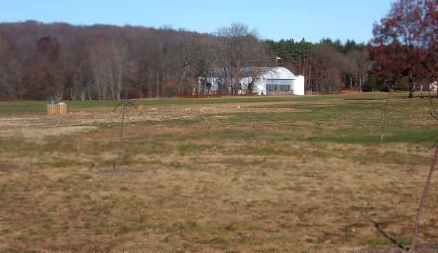
A 2/27/17 photo by Steven Boggess looking northwest along Aircraft Radio Corporation's crosswind runway, with the hangar along the right side.
Steven observed, “The soccer goals are mostly out of the way this time of the year.”
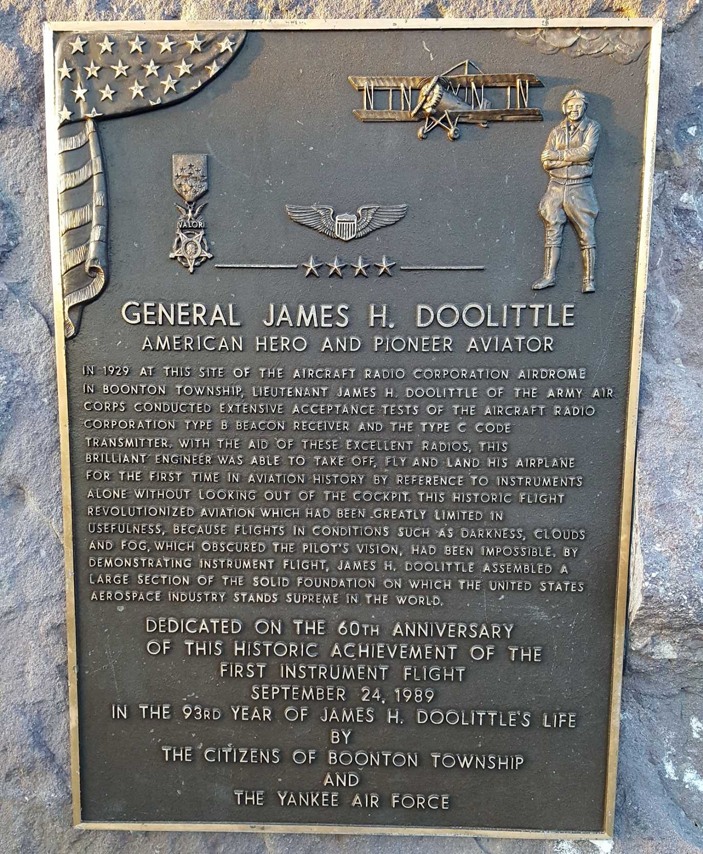
A 2/3/18 photo by Steven Boggess of the historical plaque which commemorates the first instrument flight,
performed by Jimmy Doolittle in 1929 using radio equipment developed by the Aircraft Radio Corporation.
A 2/3/18 photo by Steven Boggess of the historical plaque & windsock-shaped metal sign for the Doolittle's Landing playground near the site of the ARC airfield.
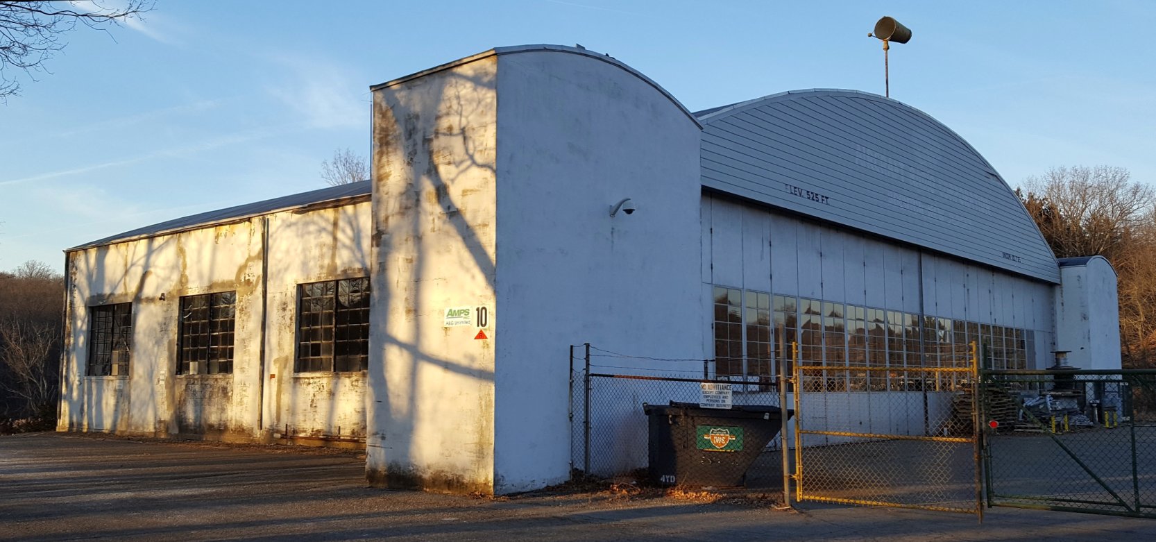
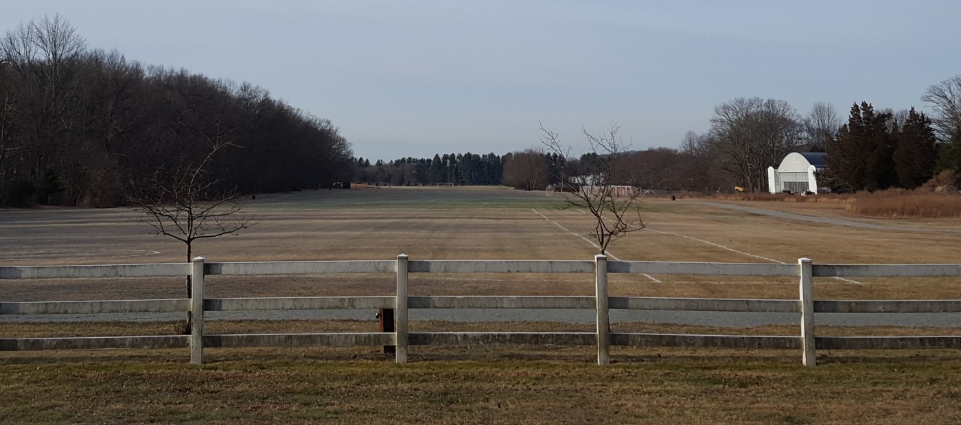
A 2/3/18 photo by Steven Boggess of the Aircraft Radio Corporation hangar.
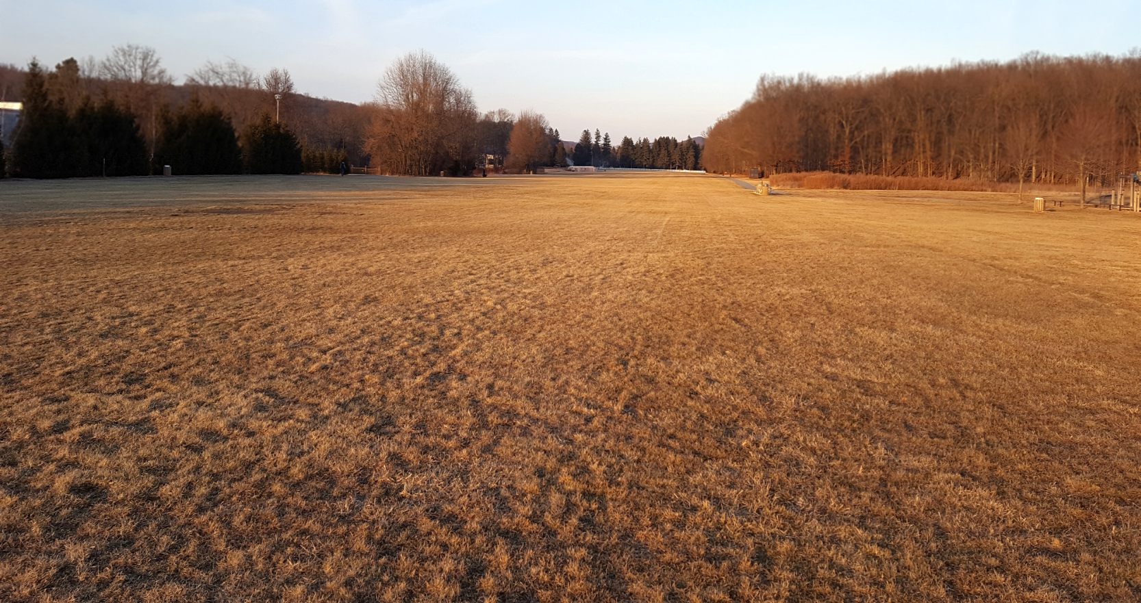
A 2/3/18 photo by looking north across the former Aircraft Radio Corporation grass runway.
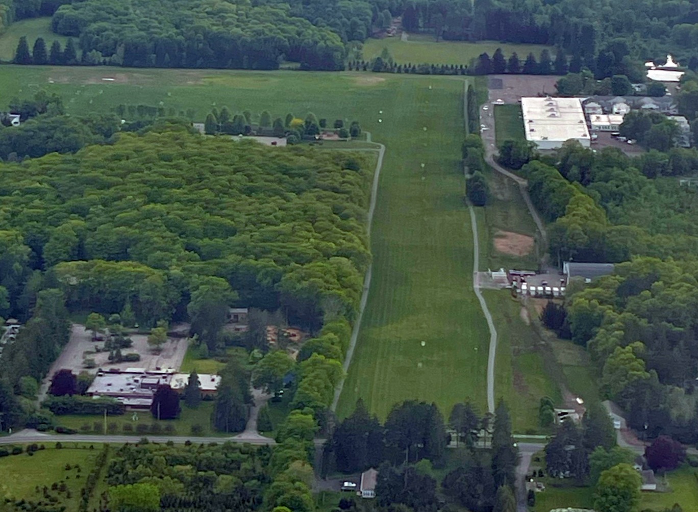
A 5/19/22 aerial view by pilot Rebekah Boggess (courtesy of Steven Boggess) looking southwest at the 2 grass runways at Aircraft Radio Corporation Airfield, showing the hangar to the right.
Aircraft Radio Corporation Field is located east of the intersection of Valley Road & Rockaway Valley Road.
Thanks to Aaron Gould for pointing out this airfield, and to James G. for providing further historical background.
See also: http://www.boontontownship.com/about.htm
____________________________________________________
Or if you prefer to contact me directly concerning a contribution (for a mailing address to send a check),
please contact me at: paulandterryfreeman@gmail.com
If you enjoy this web site, please support it with a financial contribution.
____________________________________________________
This site covers airfields in all 50 states.