Abandoned & Little-Known Airfields:
Southern Nevada
© 2002, © 2023 by Paul Freeman. Revised 10/16/23.
This site covers airfields in all 50 states: Click here for the site's main menu.
____________________________________________________
Please consider a financial contribution to support the continued growth & operation of this site.
Ash Meadows Airport (added 4/9/21) - Chicken Ranch Airfield (revised 12/30/19) - Desert Rock Army Airfield (original location) (revised 6/20/20) - Hidden Hills Ranch Airport (added 8/27/23)
Scotty's Intermediate Field / Bonnie Claire Airport (revised 10/16/23) - Scotty Airport / Bonnie Claire Lake Landing Strip (revised 8/23/23) - Lathrop Well Airport / Jackass Aeropark (revised 9/15/23)
____________________________________________________
Hidden Hills Ranch Airport (L57), Pahrump, NV
36.007, -115.862 (West of Las Vegas, NV)
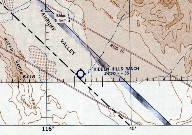
Hidden Hills Ranch Airport, as depicted on the September 1955 Mt. Whitney Sectional Chart.
Photo of the airfield while open has not been located.
Lenny Davis reported, “The Hidden Hills Ranch Airstrip was part of the old Hidden Hills Ranch movie location. Several films from the 1940s & 50s were shot at the location.”
Hidden Hills Airport was evidently established at some point between 1954-55,
as it was not yet depicted on the September 1954 Mt. Whitney Sectional Chart.
The earliest depiction which has been located of Hidden Hills Ranch Airport was on the September 1955 Mt. Whitney Sectional Chart.
It depicted Hidden Hills Ranch Airport as having a 3,500' unpaved runway.
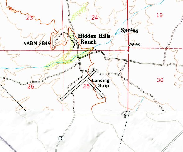
The earliest topo map depiction which has been located of Hidden Hills Ranch Airport was on the 1958 USGS topo map.
It depicted 2 perpendicular runways, generically labeled “Landing Strip”, just south of the Hidden Hills Ranch.
The earliest photo which has been located of Hidden Hills Ranch Airport was a 1978 aerial view.
It depicted 2 perpendicular unpaved deteriorated runways, with an unpaved street grid on the southeast side.
There was no sign of recent aviation use.
Lenny Davis recalled, “In late 1983 I made my first trip to the Hidden Hills Ranch. There were two older gentlemen that lived on the ranch & were employed as caretakers.
They were there full time, so they were great sources of information about activity on the ranch. During that first meeting they drove us around the ranch & gave us the history.
At that time there was still one building that has served as a small sound stage for filming. They had told us it was first a movie location.
Then as that business faltered, the owners tried opening as a dude ranch, with hopes of wealthy guests flying in to visit the ranch.”
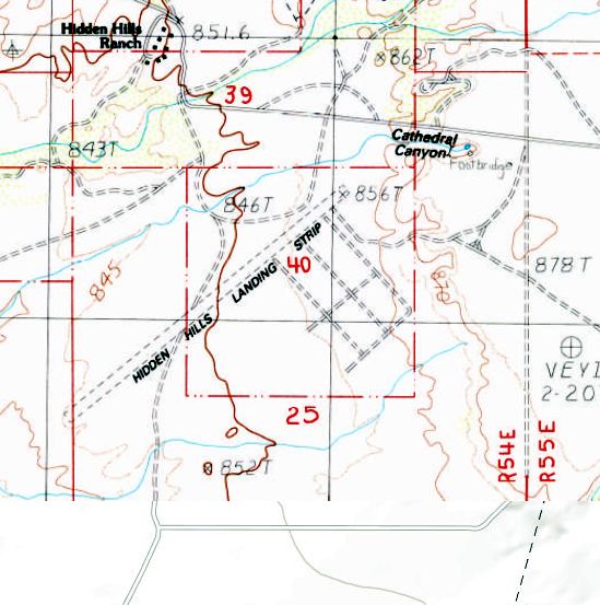
The 1984 USGS topo map depicted “Hidden Hills Landing Strip” as having 1 northeast/southwest unpaved runway, with the former crosswind runway having been replaced by an unpaved street grid on the southeast side.
Lenny Davis recalled, “In 1988 one of my first trips was to the Hidden Hills Ranch.
I was told both of the caretakers had died, and the ranch was slowly being torn apart by vandals & antique hunters.
Sometime in the mid 1990s a fire destroyed several of the remaining buildings.”
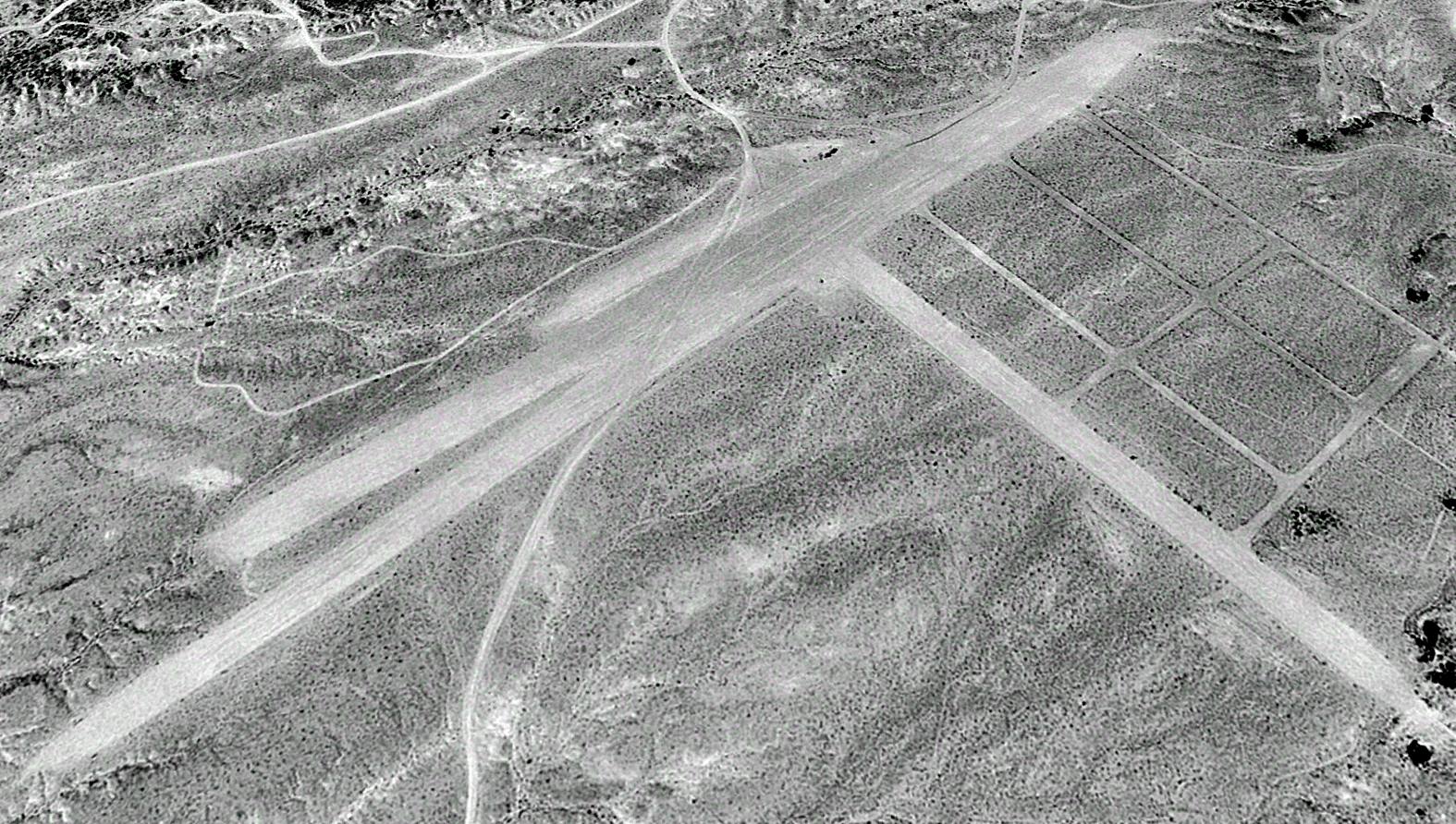
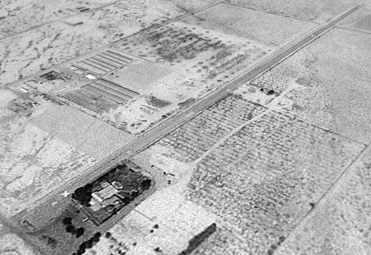
The earliest photo which is available of Hidden Hills Ranch Airport was a 1994 aerial view looking north.
It depicted 2 perpendicular unpaved deteriorated runways, with an unpaved street grid on the southeast side.
There was no sign of recent aviation use.
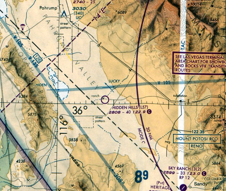
The September 2000 Las Vegas Sectional Chart depicted Hidden Hills as a public-use airport, having a 4,000' unpaved runway.
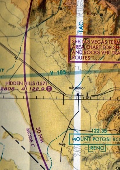
The last aeronautical chart depiction which has been located of Hidden Hills Airport was on the March 2001 Las Vegas Sectional Chart.
It depicted Hidden Hills as a public-use airport, having a 4,000' unpaved runway.
Lenny Davis reported, “In the early 2000s the ranch was abandoned, and the building were torn down.”
Hidden Hills Airport was evidently abandoned at some point between 2001-2009,
as it was no longer depicted on the March 2009 Las Vegas Sectional Chart.
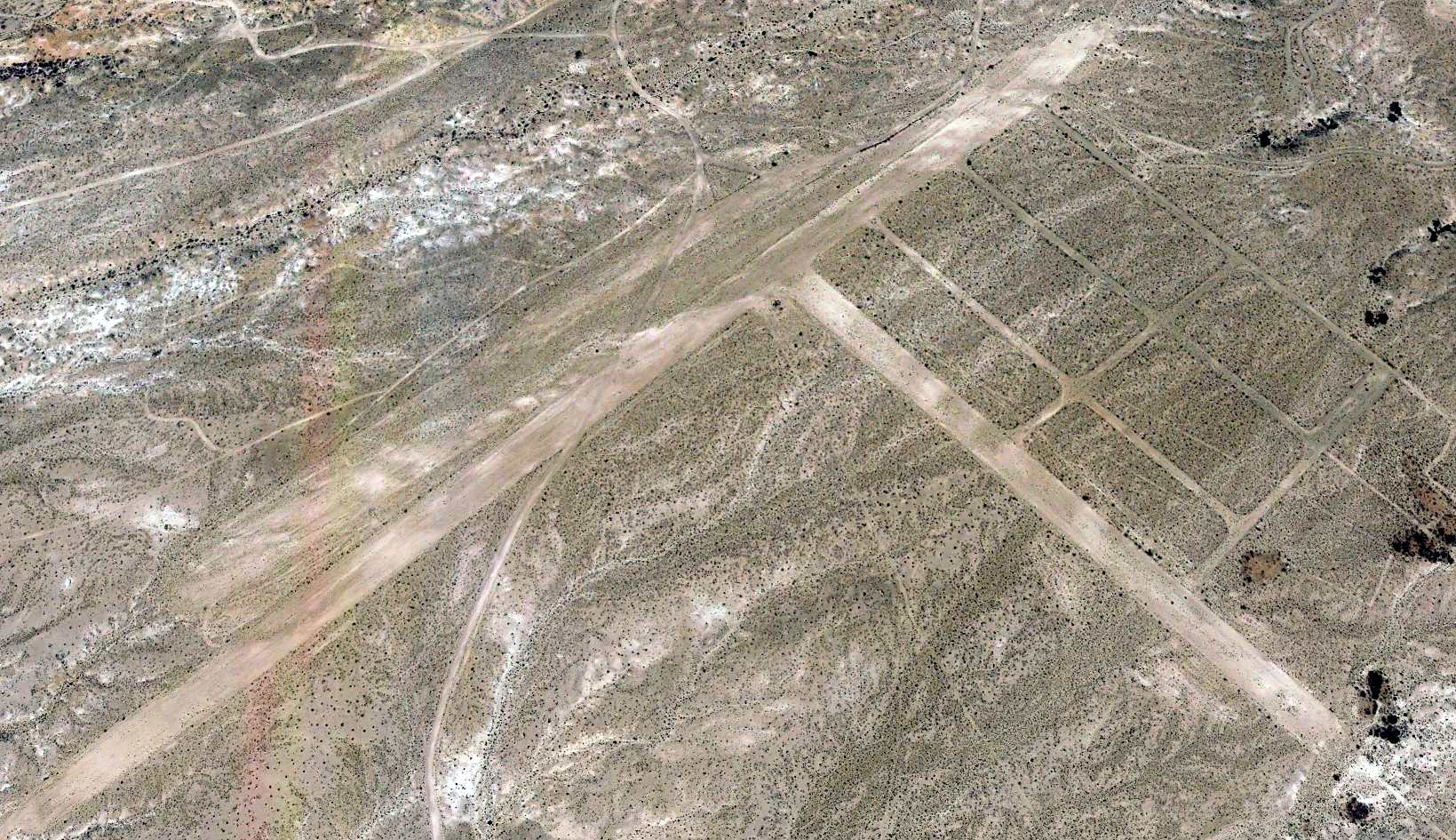
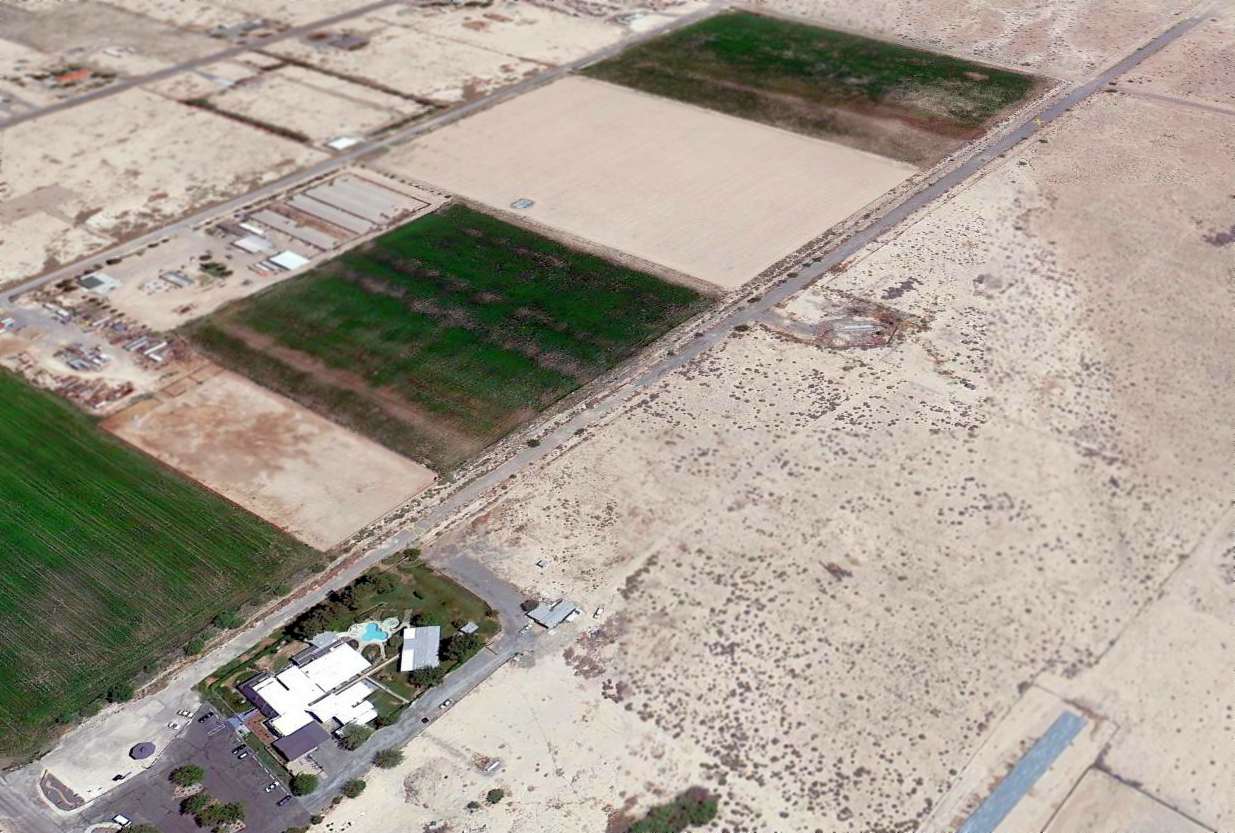
A 2019 aerial view looking north depicted Hidden Hills Airport in an unchanged configuration.
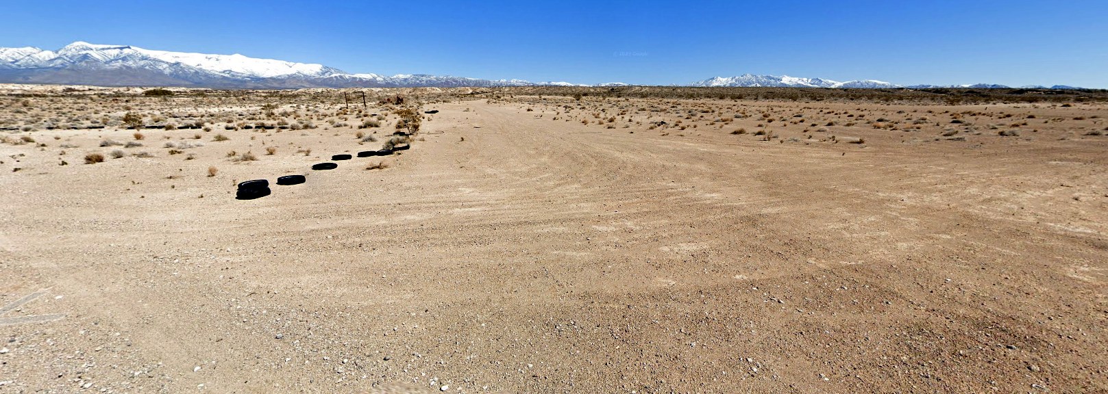
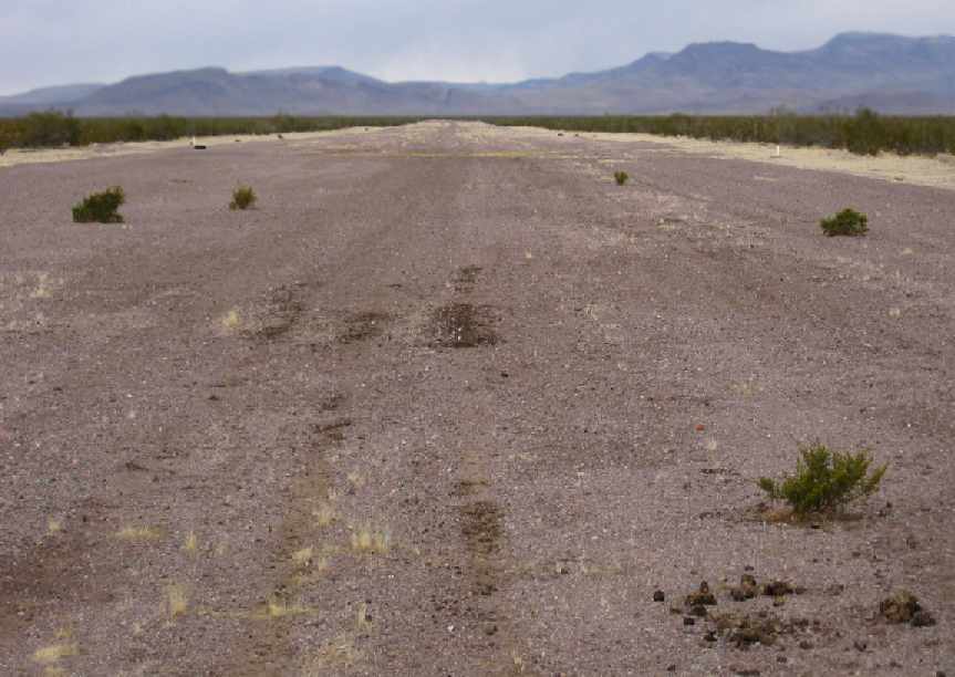
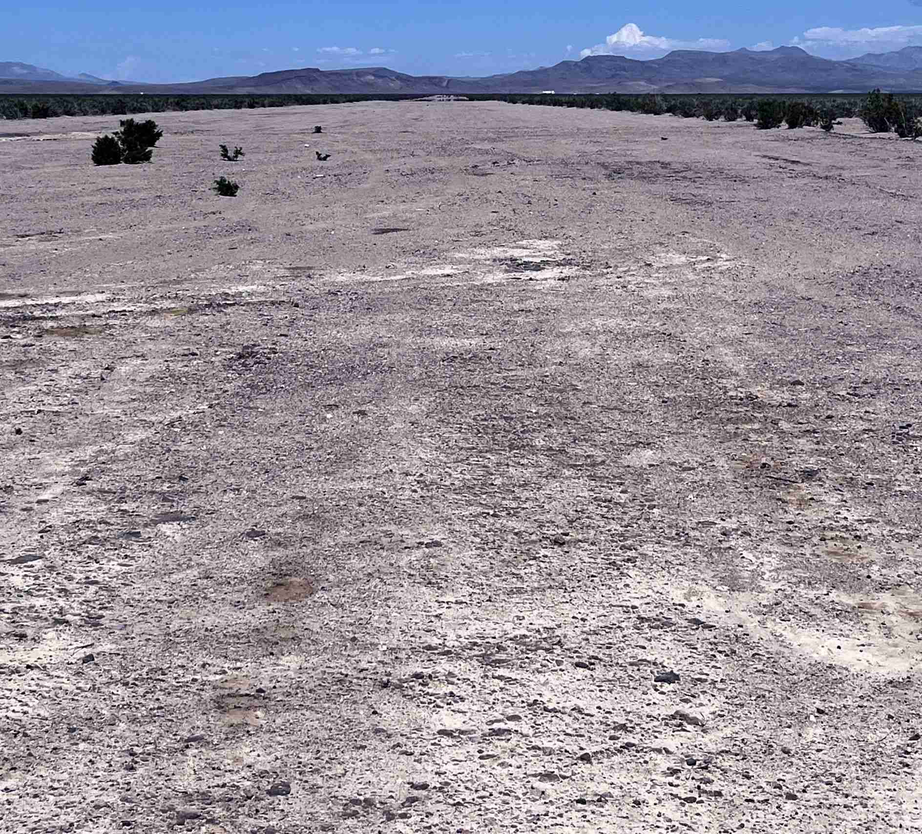
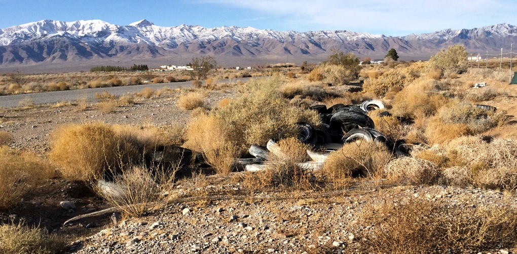
A 2023 photo looking southeast along the former Hidden Hills Airport crosswind runway, with tires lining one side.
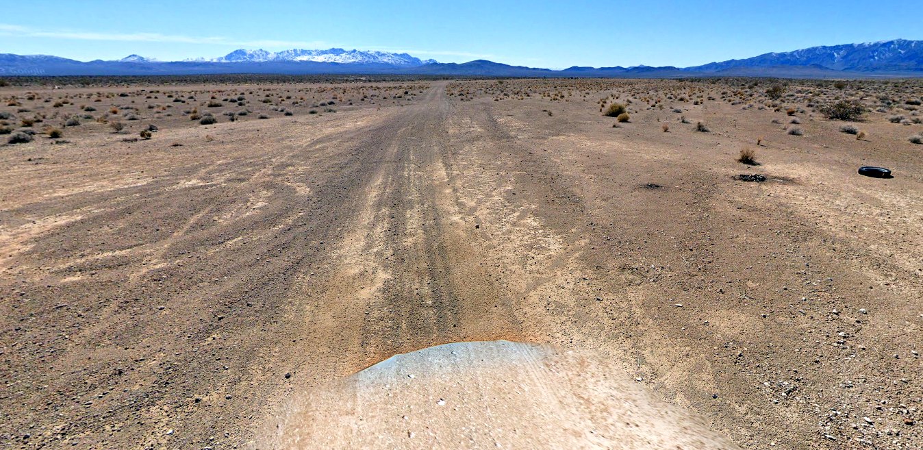
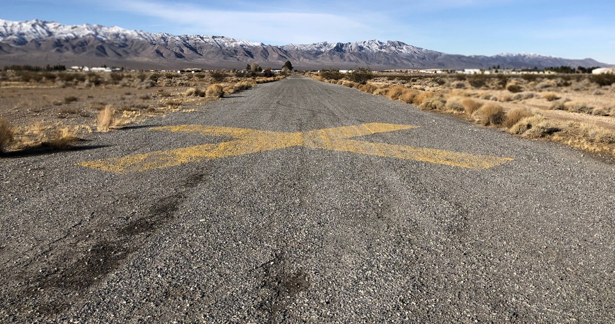
A 2023 photo looking southwest along the former Hidden Hills Airport primary runway.
Lenny Davis reported in 2023, ”All of the building are now gone.”
Thanks to Lenny Davis for pointing out this airfield.
____________________________________________________
Ash Meadows Airport, Lathrop Wells, NV
36.361, -116.297 (Northwest of Las Vegas, NV)
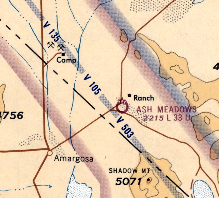
Ash Meadows Airport, as depicted on the 1965 Las Vegas Sectional Chart (courtesy of Jonathan Westerling).
Photo of the airfield while open has not been located.
Jonathan Westerling reported, “The desert oasis area of Ash Meadows is so named for the ash trees that grow in abundance near the mineral springs.
It sits just 2 miles from the California border but a long way from anywhere else.
In the 1940s there were several small ranches nearby which didn't amount to much.”
According to a 1988 Oral History of Harry Ford by Robert McCracken for the Nye County Town History Project,
the property that hosted the Ash Meadows Airport "was originally built by a man by the name of Berry, and I don't know who put up the money.
He came up here from the southern CA area & had a dream of building this dude ranch.
This would've been 1946-48... he built this real nice, Spanish-style place with a red mission tile roof.
There was a bar & a little dance area & the dining room, a large room with a fireplace & french doors [which] opened out onto a veranda with grass & a pond.
Out back was a line of rooms like a motel on the right & left, a dozen or 14 rooms.
He had an airstrip, and a telephone, which was something different - he put it in himself."
Jonathan Westerling reported, “Eventually the dude ranch became a brothel.
Ash Meadows was one of only 3 to be granted a license on the first day Nye County legalized prostitution in 1958.”
Jonathan Westerling reported, “Ash Meadows Sky Ranch airstrip was officially designated an airfield in 1962.”
The 1962 FAA Airman's Guide (courtesy of Jonathan Westerling) described Ash Meadows Airport as a new airport,
having a 2,250' north/south gravel runway.
The 1963 FAA Airman's Guide (courtesy of Jonathan Westerling) said that Ash Meadows Airport's gravel runway had been lengthened to 3,300',
and runway lights had been added.
The earliest depiction which has been located of Ash Meadows Airport was on the 1965 Las Vegas Sectional Chart (courtesy of Jonathan Westerling).
It depicted Ash Meadows Airport as having a 3,300' unpaved runway.
The 1967 AOPA Airports USA directory (courtesy of Jonathan Westerling) described Ash Meadows Airport as having a 3,300' gravel Runway 15/33,
and (not surprisingly!) being attended 24 hours.
According to the book "Howard Hughes: Power, Paranoia, and Palace Intrigue" By Geoff Schumacher, Hughes was a customer of Ash Meadows on at least 2 occasions:
“On their next night-time flight, in the summer of 1967, Hughes instructed [his pilot Guido Robert] Deiro to fly to Ash Meadows.
As they climbed out of the plane, Deiro said he noticed that Hughes was carrying a black satchel 'not unlike an old-fashioned doctor's bag.'
Upon entering the brothel, they were presented with a lineup of 7 women in evening gowns. Hughes selected a woman named 'Sunny'.
Deiro says he recognized the woman, and that he thought she 'had worked in Hollywood.' Deiro sat down in a chair & waited.
'Within 30 minutes Hughes re-entered the front room & without saying anything crossed quickly to the door clutching the black bag to his chest.
He kept his head down while waiting for the barkeep to round the bar & open the door. He looked about furtively & walked quickly to the plane.'
Another trip to the Ash Meadows brothel occurred a couple of weeks later, according to Deiro.
This time, he said, Hughes was with Sunny for more than an hour & left happier than the time before."
The 1968 Flight Guide (courtesy of Jonathan Westerling) described Ash Meadows Airport as having a 3,300' unpaved Runway 15/33.
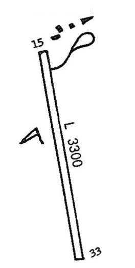
The 1968 Western States directory (courtesy of Jonathan Westerling) depicted Ash Meadows Airport as having a 3,300' unpaved Runway 15/33,
with several small buildings to the northeast.
An adjacent advertisement said, “Ash Meadows: Bar open 24 hours, fine food at all hours, generous slot machines, dancing, swimming.”
Harry Weisberger recalled, “April 10, 1969: Runway 15 at Ash Meadows sloped severely upward (5 degrees).
The Black Hole Approach happens on a moonless night to an upsloping runway with no surrounding light, only the runway's.
This gives the impression of being higher than actual. In my case, it was just after midnight & I was set up nicely on final.
I saw the runway lights starting to blink & had just thought, 'They must be having a generator problem' when my windscreen was filled with cottonwood tree branches.
It was early Spring & the trees hadn't yet leafed out. The bare branches wiped out the leading edges of both wings, killing my lift & producing a very hard 3-point landing 500' short of the Runway 15 threshold.
I was amazed to discover that not only was I still alive but neither I nor my 2 passengers were injured.
I called the FAA in Vegas to advise them of the accident, but when they heard it was non-injury they said a report wasn't necessary.
Ah, the Good Ol' Days. There was no NOTAM about the runway slope or the 50' high trees so close to the threshold.
I had my plane, a Luscombe 11A Sedan, trucked back to Southern CA.”
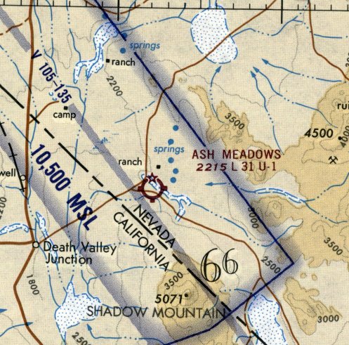
The last aeronautical chart depiction which has been located of Ash Meadows Airport was on the 1970 Las Vegas Sectional Chart (courtesy of Jonathan Westerling).
It depicted Ash Meadows Airport as having a 3,100' unpaved runway.
The 1971 Airman's Information Guide (courtesy of Jonathan Westerling) described Ash Meadows Airport as having a 3,300' unpaved Runway 15/33.
According to http://raisethestakeseditions.com/ash-meadows-sky-ranch/, "In 1971, the brothel was sold to 'Death Valley Madam' Vickie Starr.
During Vickie’s ownership, the county eventually refused to issue a brothel license due to the cost of traveling out to the rural location to provide the girls’ weekly medical inspections.
This would lead to the closure of the Sky Ranch, which would never reopen as a brothel."
Jonathan Westerling reported, “When Sky Ranch closed, the airport was closed as well.”
Harry Weisberger recalled, “I believe the Ash Meadows Airport was closed sometime around 1971.
I flew over it in mid-1971 & saw the runway X'd-out & a ditch dug across it. I guess the FAA decided it was too dangerous.
That morning I had seen a Mooney off the side of the runway with its gear collapsed, and the remains of a Cessna at the far end of Runway 15.”
The last airport directory directory listing which has been located of Ash Meadows Airport was in the 1974 Flight Handbook (courtesy of Jonathan Westerling).
It described Ash Meadows Airport as having a 3,100' dirt Runway 15/33.
Lenny Davis reported, “In approximately 1977, Dick & Jody Peterson were living at the Ash Meadows Ranch. Jody was the 'House Mom' of the Ash Meadows Ranch Brothel.
One night a D-18 Beechcraft was reported to have dropped a load of marijuana on an airstrip in the desert near Rice, CA.
The aircraft departed before law enforcement agents arrested the ground crew & seized the marijuana.
A request was sent to the Las Vegas DEA office to check local airfields in the area for a suspicious D-18.
One of the DEA agents Jeffrey Green knew Dick Peterson had a fondness for the D-18 to fly loads of marijuana in.
Agent Green knew Dick was living at the Ash Meadows Ranch. Following his instincts, Agent Green & some fellow DEA agents went to the Ash Meadows Ranch.
Not surprisingly, there was a D-18 parked on the airstrip. All the passenger seats had been removed, which was a sure sign of smuggling aircraft.”
Lenny continued, “Agent Green went to the Ash Meadows Ranch & spoke to Dick, and asked if he knew anything about the aircraft parked on the airstrip.
Dick said it must have come in during the night, but he was sleeping & was unaware of the aircraft. Agent green thanked Dick for his cooperation, and returned to the aircraft.
Agent Green then had crime scene personnel from the Las Vegas Metro Police Department to come & process the aircraft for evidence.
During the search marijuana debris was found on the floor of the D-18. The entire aircraft was dusted for fingerprints. but none were found.
The crime scene techs were about to leave, when Agent Green saw a small flashlight in a pocket of the pilots seat. He requested they process the flashlight & batteries for fingerprints.
The was one fingerprint located on the last battery they processed. The fingerprint was identified as belonging to none other than Dick Peterson.
Based on the fingerprint, Agent Green took Dick into custody. Dick admitted to flying the load of marijuana in from Mexico, and was sentenced to another 10 years in prison.
That would Dick Peterson's second of 4 arrests & convictions for smuggling.”
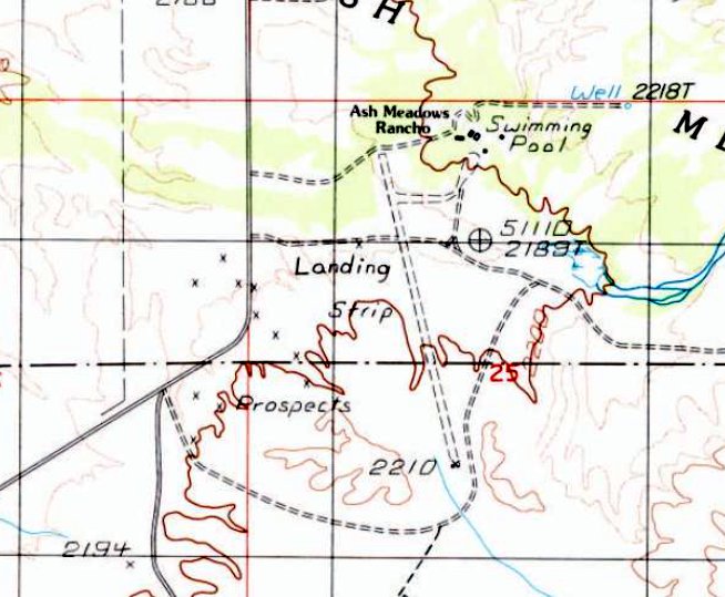
The 1987 USGS topo map depicted Ash Meadows Airport as a single unpaved northwest/southeast runway, generically labeled “Landing Strip”,
with several small buildings & a swimming pool labeled “Ash Meadows Rancho”.
Jonathan Westerling reported, “Shortly after it closed, the airfield was used in the filming of several scenes for the [1987] movie Cherry 2000.
These include a fat-tired Aeronca Champ landing on the airstrip.”
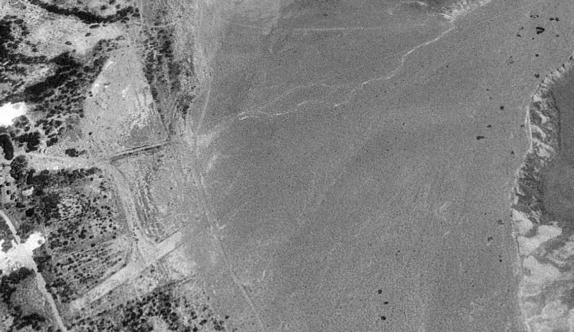
A 1995 aerial view looking southeast depicted Ash Meadows Airport as having a single unpaved northwest/southeast runway, with the former “Rancho” small buildings to the northeast.
Jonathan Westerling reported, “The land was purchased by a zeolite mining operation.”
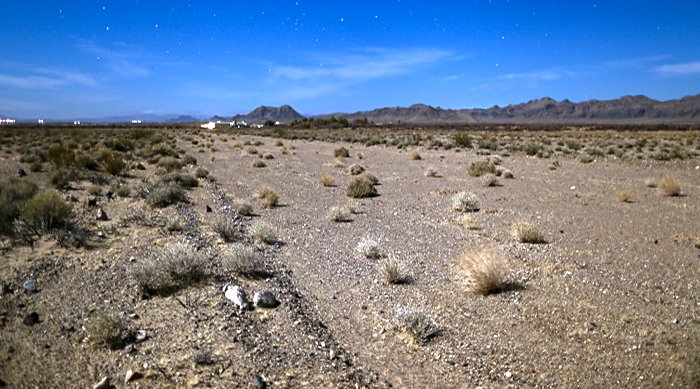
A 2017 photo by Shaun Astor (used with permission) looking along the remains of the Ash Meadows Airport runway with the brothel buildings in the background.
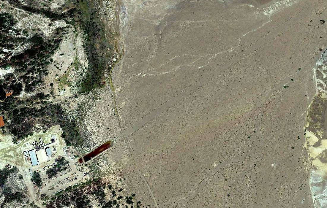
A 2019 aerial view looking southeast showed the former Ash Meadows Airport runway as remaining recognizable, although it appeared the northern end had been flooded.
Several buildings of the zeolite mining operation had been added at some point between 1995-2019, adjacent to the northeast end of the runway.
Jonathan Westerling reported in 2021, “The zeolite mining operation continues there to this day, but does not make use of the airstrip.”
As of 2021, road maps label the property as “KMI Zeolite Inc.”
Thanks to Jonathan Westerling for pointing out this airfield.
____________________________________________________
Desert Rock Army Airfield (original location), Mercury, NV
36.64, -116.01 (Northwest of Las Vegas, NV)
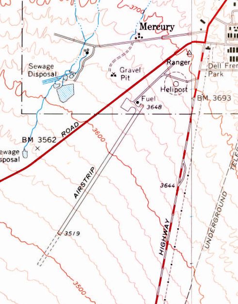
The original Desert Rock Army Airfield in Mercury was labeled simply as “Airstrip” on the 1961 USGS topo map.
Photo of the airfield while open has not been located.
According to Wikipedia, the town of Mercury was established in 1950 at the beginning of operations of the Nevada Test Site as Base Camp Mercury,
a military-style encampment built to provide basic facilities for personnel involved.
As the scope of the testing program expanded, so did the number of personnel required to fulfill the site's mission,
and beginning in 1951 a $6.7 million construction project was undertaken to provide adequate individual housing, office, and service structures with a civilian town-like design.
No airfield in Mercury was yet depicted on a 1952 USGS aerial photo or the September 1954 Mt. Whitney Sectional Chart.
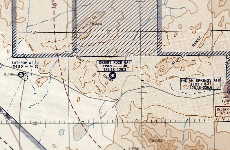
The earliest depiction which has been located of Desert Rock Army Airfield was on the March 1955 Mt. Whitney Sectional Chart.
It depicted Desert Rock AAF as having a 4,000' unpaved runway & a control tower.
The Naval Radiological Defense Laboratory conducted its first test flight in 1956 of atmospheric sounding rockets
to measure nuclear radiation and other atmospheric data, using Mercury as a staging area.
This test rocket lifted 30 lbs to an altitude of 25 miles. In 1957, the US Navy launched 9 sounding rockets.
The last aeronautical chart depiction which has been located of the original Desert Rock Army Airfield in Mercury was on the September 1958 Mt. Whitney Sectional Chart.
It depicted Desert Rock AAF as having a 5,300' unpaved runway.
Note that the airfield location was depicted about a mile west of its actual location (out in the desert, not adjacent to the Mercury installation).
Was this an error by the mapmakers, or an intentional depiction due to the facility's mission?
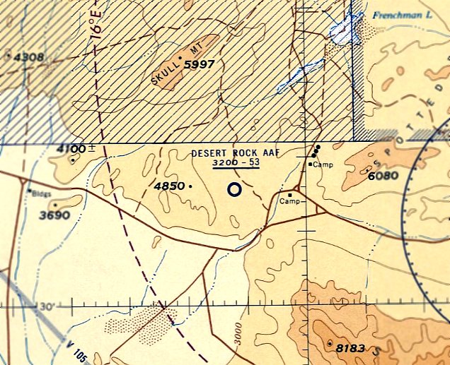
A larger Desert Rock Airstrip was constructed less than a mile to the southwest at Camp Desert Rock, evidently replacing the original Desert Rock Army Airfield in Mercury.
Only the new Desert Rock AAF in Camp Desert Rock was depicted on the March 1959 Mt. Whitney Sectional Chart.
The earliest topo map depiction which has been located of the original Desert Rock Army Airfield in Mercury was on the 1961 USGS topo map.
It depicted a single northeast/southwest runway, labeled simply as “Airstrip”, with an unpaved overrun extending to the southwest.
A ramp with fuel was depicted on the north end, along with a heliport.
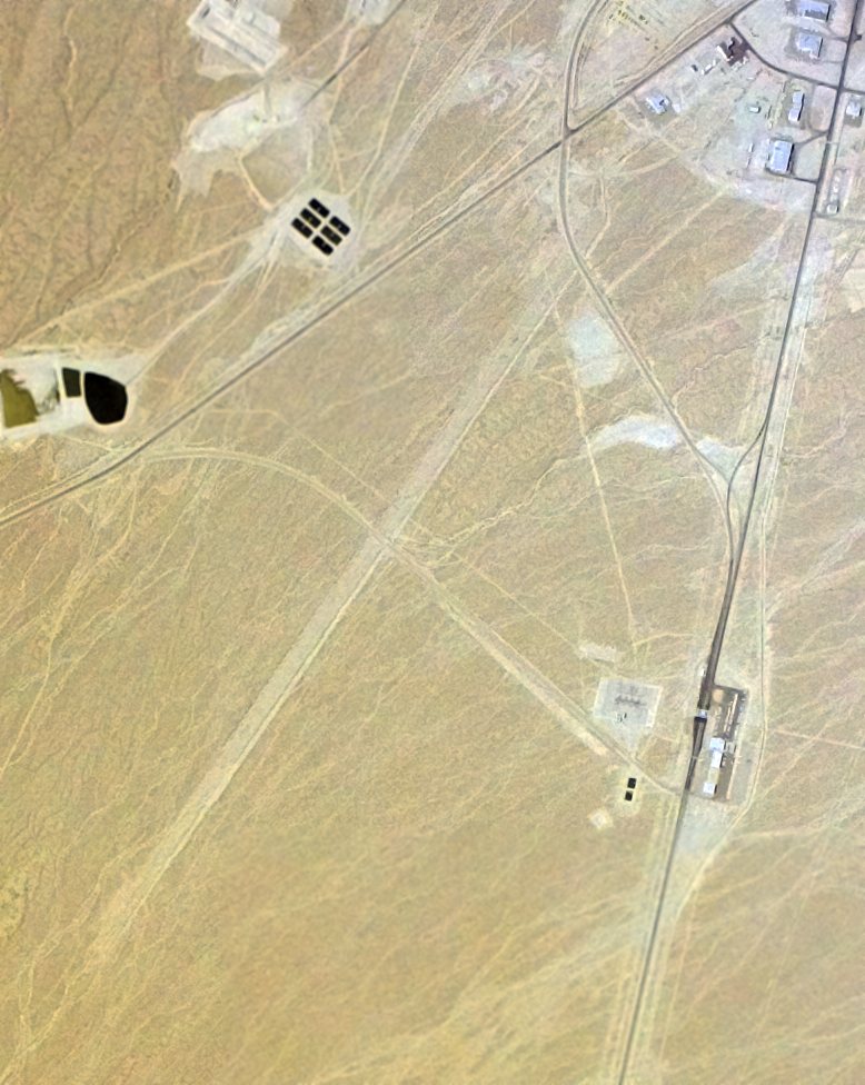
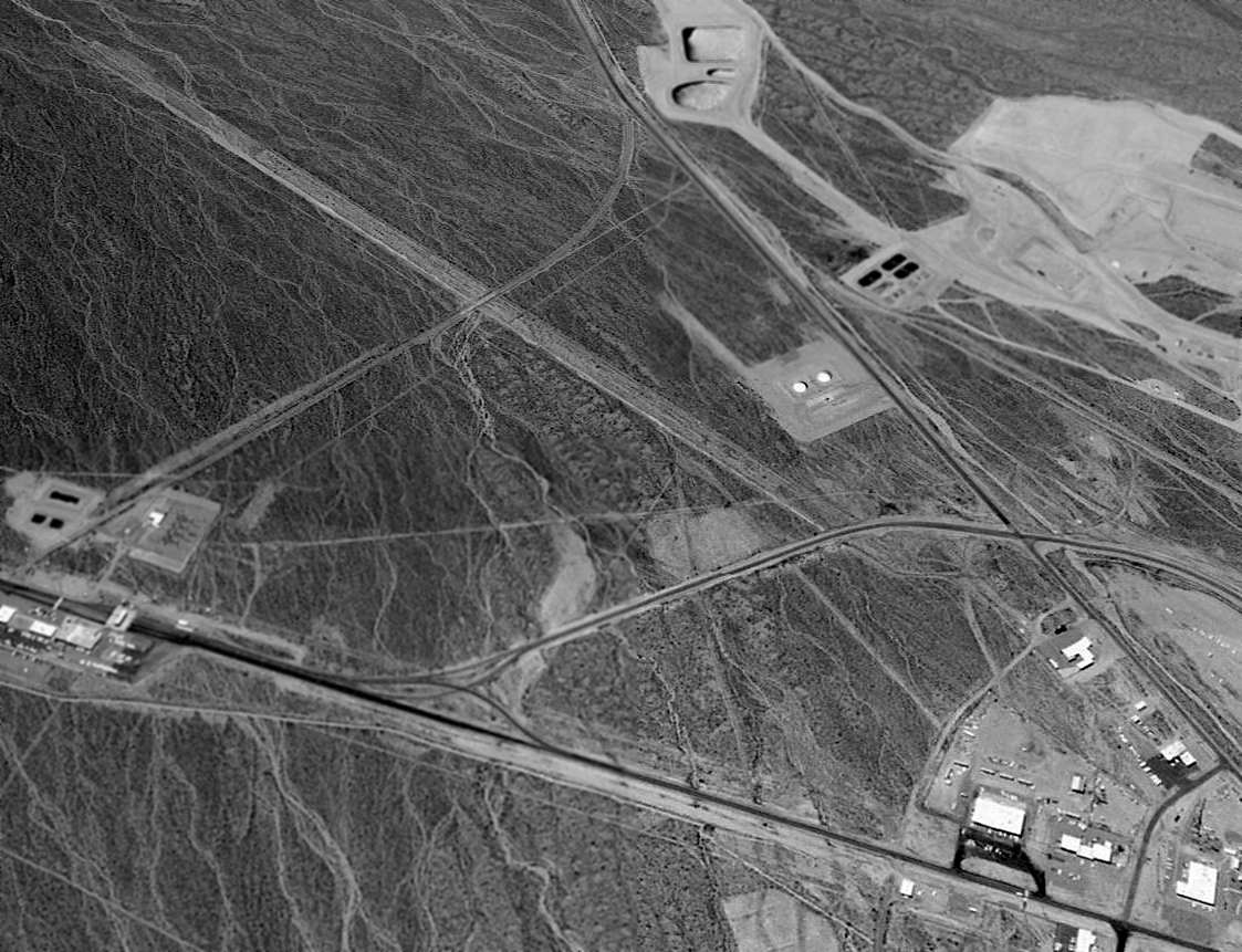
A 3/3/80 USGS aerial view depicted the original Desert Rock Army Airfield in Mercury as deteriorated but recognizable.
Several roads cut across the former runway, and the former heliport to the northeast was not recognizable.
A 1998 aerial view looking west showed the runway of the original Desert Rock Army Airfield in Mercury remained recognizable.
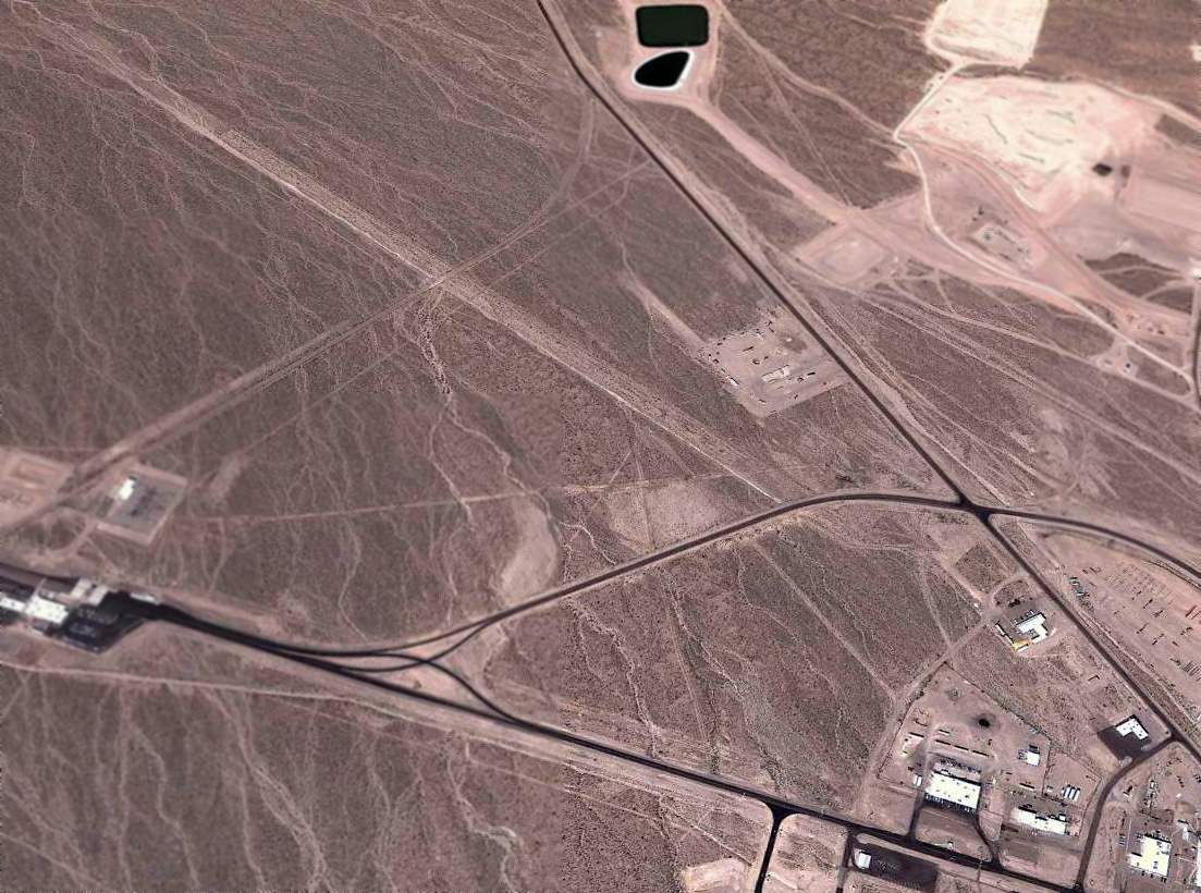
A 2011 aerial view looking west showed the runway of the original Desert Rock Army Airfield in Mercury remained recognizable.
The site of the original Desert Rock Army Airfield in Mercury is located southwest of the intersection of Jackass Flats Road & Mercury Highway.
Thanks to Colleen Beck for pointing out this airfield.
____________________________________________________
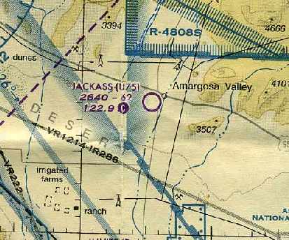
Lathrop Wells Airport / Jackass Aeropark (U75), Amargosa Valley, NV
36.64, -116.41 (Northwest of Las Vegas, NV)
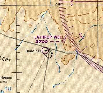
Lathrop Wells Airport, as depicted on the February 1949 Mt. Whitney Sectional Chart (courtesy of Chris Kennedy).
Photo of the airfield while open has not been located.
The Lathrop Wells Airport was evidently established at some point between 1946-49,
as it was not yet depicted at all on the February 1946 Mt. Whitney Sectional Chart (according to Chris Kennedy).
The earliest depiction of the field which has been located
was on the February 1949 Mt. Whitney Sectional Chart (courtesy of Chris Kennedy).
It depicted Lathrop Wells as having a 4,700' unpaved runway.
Lathrop Wells Airport was still depicted on the May 1957 Mt. Whitney Sectional Chart (according to Chris Kennedy),
with the listed runway length having grown slightly to 5,000'.
The Lathrop Wells Airport was evidently closed (for reasons unknown) at some point between 1957-59,
as it was no longer depicted at all on the March 1959 Mt. Whitney Sectional Chart (according to Chris Kennedy).
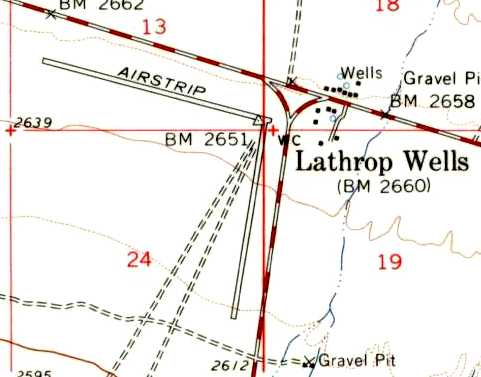
The Lathrop Wells Airport was depicted on the 1961 USGS topo map as having 2 runways.
It was merely labeled “Airstrip”, so it may not have been in operation at that time.
No airfield was depicted at this location on the June, 1963 Mt. Whitney Sectional Chart (according to Chris Kennedy).
At some point between 1963-64, a new longer runway was constructed adjacent to the west side of the original airfield,
reopening under the name of Jackass Aeropark.
The June 1964 Mt. Whitney Sectional Chart (courtesy of Chris Kennedy) depicted Jackass as having a 6,200' unpaved runway.
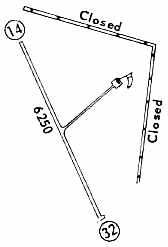
The 1968 Flight Guide (courtesy of Chris Kennedy) depicted Jackass as having a single 6,250' unpaved Runway 14/32,
with a taxiway leading to a single hangar to the northeast.
The 2 closed runways of the original Lathrop Wells Airport were also depicted to the northeast.
The 1971 Las Vegas Sectional Chart (courtesy of Vince Granato) depicted Jackass as having a 6,200' unpaved runway.
The 1994 USGS topo map depicted the Jackass Aeropark as having a single paved runway, oriented northwest/southeast.
A taxiway led northeast toward a single hangar.
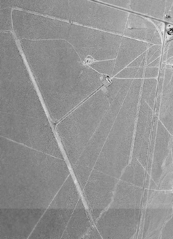
The 1998 USGS aerial photo depicted the single northwest/southeast paved runway,
along with the 2 earlier unpaved runways of the original Lathrop Wells Airport,
oriented roughly east/west & north/south, paralleling the adjacent roads.
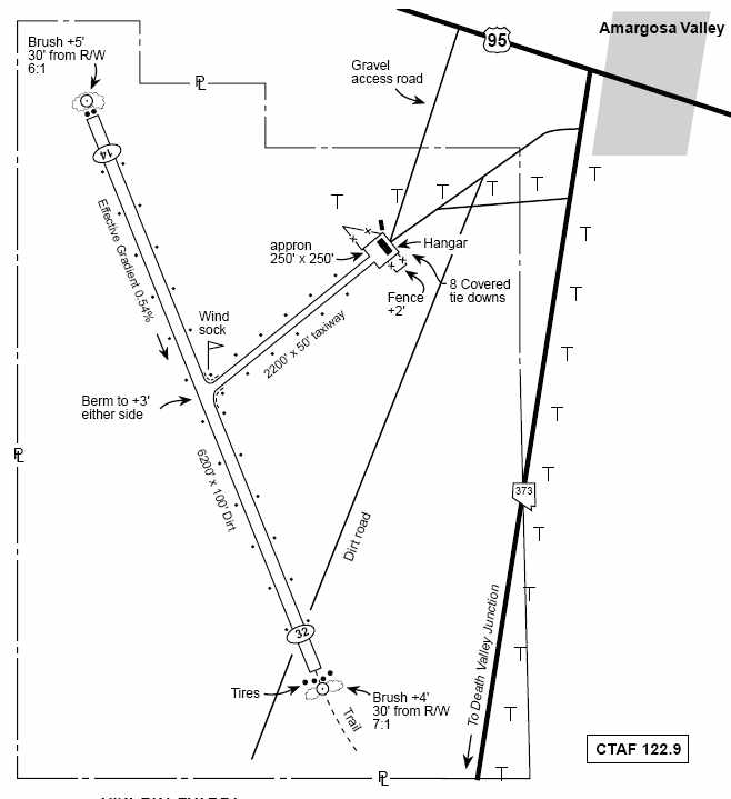
The December 2003 NV Department of Transportation airport diagram
depicted Jackass Aeropark as having a single 6,200' dirt Runway 14/32.
A taxiway led to a single hangar, containing 8 covered tie-downs.
Jan Cameron (chairwoman of the Amargosa Valley Advisory Board) reported in 2004
that the Jackass Aeropark was the only airport in Nye County capable of taking jets.
A Boeing 737 has on at least on occasion landed there, she said.
Upgrade plans for the airport were discussed in 2004, but were not implemented.
The last aeronautical chart depiction which has been located of the Jackass Aeropark
was on the March 2004 Las Vegas Sectional Chart (courtesy of Chris Kennedy).
It depicted Jackass as having a 6,200' unpaved runway.
The Jackass Aeropark was evidently abandoned at some point between 2004-2006,
as it was no longer depicted at all on the 2006 Las Vegas Sectional Chart.
A 2006 photo by Pen Parks, looking along the former paved runway at Jackass Aeropark.
Pen reported, “It was paved at one time, 1.2 miles long & 130 feet wide,
with a taxiway to a hangar & tiedowns from the center.”
A 2006 photo by Pen Parks, looking northeast along the former taxiway toward the abandoned hangar at Jackass Aeropark.
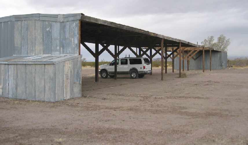
A 2006 photo by Pen Parks of the abandoned former hangar at Jackass Aeropark.
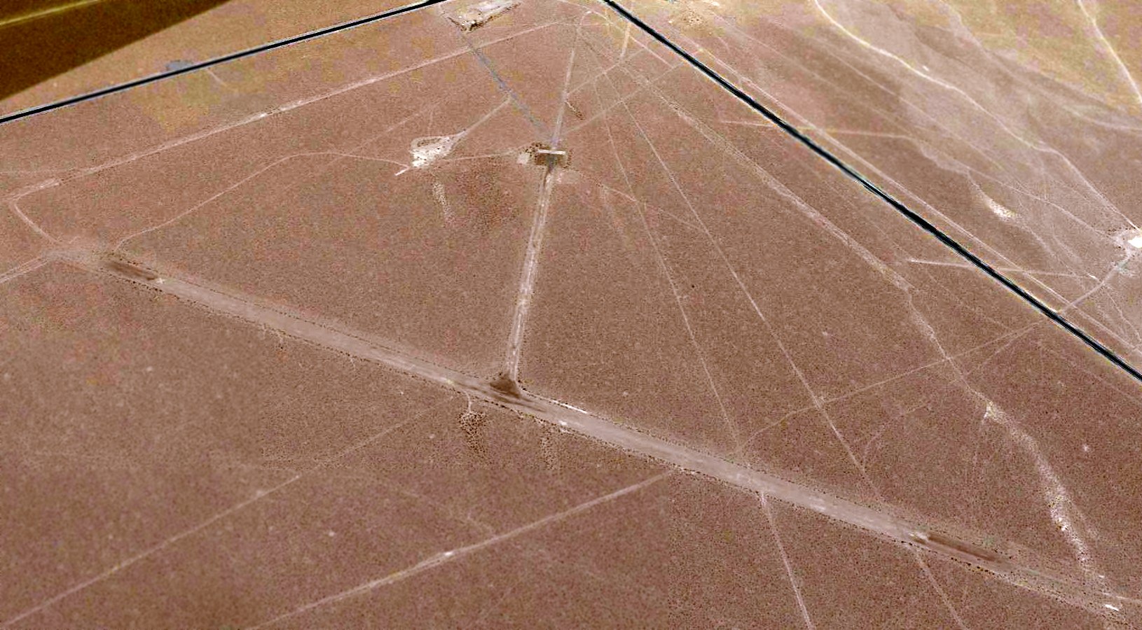
A 2015 aerial view looking northeast at Jackass Aeropark, showing the 3 runways remain recognizable.
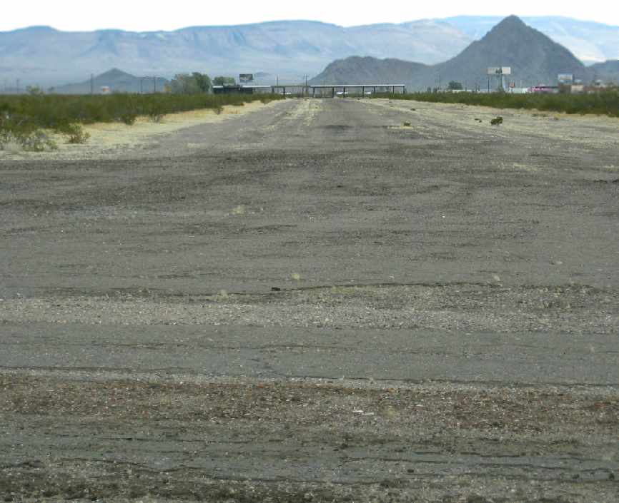
A 9/13/23 photo by Lenny Davis looking north along the former Jackass north/south runway, which Lenny reported “is still in pretty good condition.”
A 9/13/23 photo by Lenny Davis looking west along the former Jackass east/west runway, which Lenny reported “was pretty rutted from the recent monsoons.”
Jackass Aeropark is located west of the intersection of Route 95 & Route 373.
____________________________________________________
Chicken Ranch Airfield, Pahrump, NV
36.07, -115.95 (West of Las Vegas, NV)
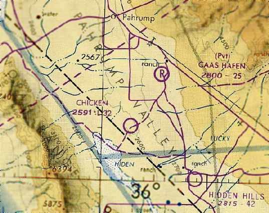
The Chicken Ranch Airfield, as depicted on the October 1980 Las Vegas Sectional Chart (courtesy of Chris Kennedy).
This private airfield was established by the Chicken Ranch brothel - one of the more unusual operators of a private airfield.
No airfield at this location was depicted on the 1971 Las Vegas Sectional Chart (courtesy of Vince Granato).
According to a 2008 article in the Pahrump Valley Times (courtesy of Jonathan Westerling),
the Chicken Ranch brothel moved to its current location in 1978.
According to Dan Eikleberry, “They have had a runway for 'commuters' from Las Vegas on & off for about 40 years.
Sometimes it shows up on sectional charts, sometimes it doesn't.
There was an air-taxi from [Las Vegas] McCarran Airport in the 1970s & 1980s
who advertised & flew Cessna 182s to & from the Chicken Ranch.”
No airfield at this location was depicted on the April 1980 Las Vegas Sectional Chart (according to Chris Kennedy).
The earliest depiction of the Chicken Ranch Airfield which has been located
was on the October 1980 Las Vegas Sectional Chart (courtesy of Chris Kennedy).
It depicted “Chicken” as a public-use airfield having a 3,200' unpaved runway.
However, it was not listed among active airfields in the 1980 or 1982 AOPA Airport Directories (according to Chris Kennedy).
The 1983 USGS topo map labeled the field simply as “Landing Field”.
The 1983 AOPA Airports USA
Directory (courtesy of Jonathan Westerling)
described the Chicken Ranch private airport
as having 2 oil-treated runways: 3,100' Runway 9/27 & 1,800' Runway 18/36.
Runway 18/36 was along the alignment of today's Squaw Valley Road & extended south of Runway 9/27; it can be seen in the 1994 photo.
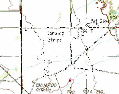
The Chicken Ranch Airfield was depicted simply as “Landing Strips” on the 1984 USGS topo map.
The 1989 AOPA Airports USA
Directory (courtesy of
Jonathan Westerling) described the
Chicken Ranch private airport largely in the same fashion as the 1983
directory,
except that the westernmost 800' of Runway 9/27 had been paved, and that lighting was available on request.
The single paved runway at the Chicken Ranch had closed runway “X” symbols visible along it in a 1994 USGS aerial view looking northeast, so it was evidently already closed by that point.
There was no sign of any hangars or other buildings directly related to the airfield.
The Chicken Ranch Airfield was no longer listed in airfield directories after 1995,
or depicted on the March 1999 Las Vegas Sectional Chart (according to Chris Kennedy).
According to Dan Eikleberry, “One of the county real estate moguls who makes a business out of selling lots & hangars
at the Calvada Meadows Airport at the north end of Pahrump didn't appreciate the competition for airports in his town
and somehow got them to shut down the Chicken Ranch airport about 2004.”
A 2013 aerial view looking northeast showed the closed-runway “X” symbols visible along the length of the Chicken Ranch Airfield runway.
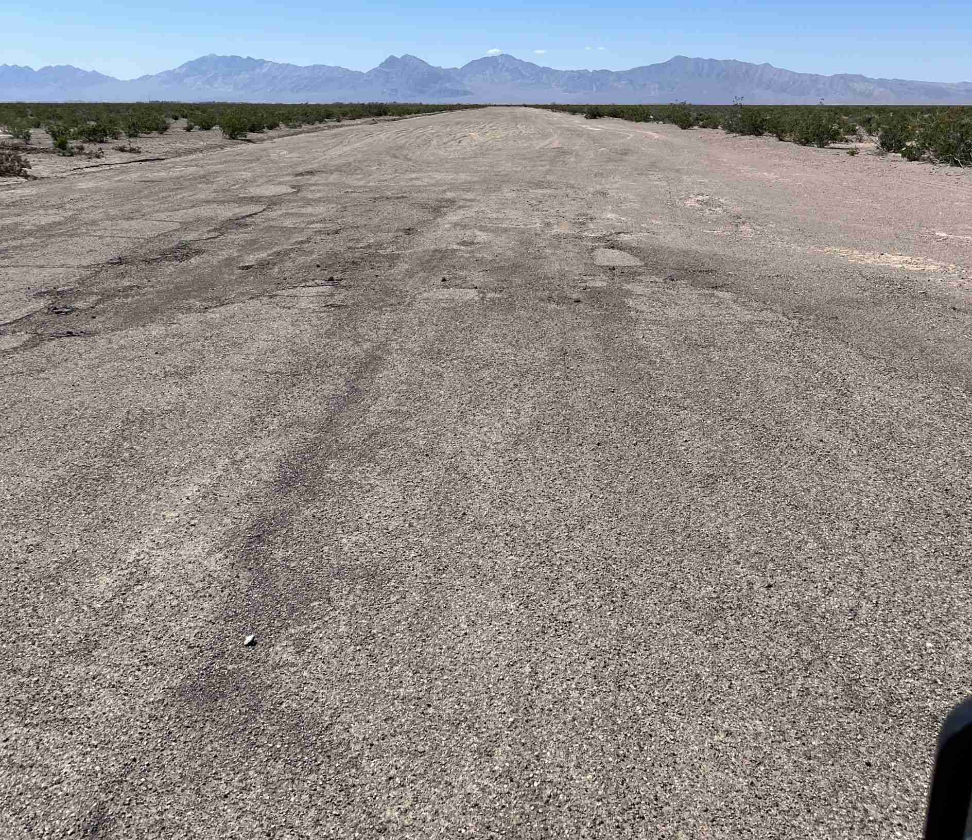
An 11/30/19 photo by Emmanuelle Delchambre (courtesy of Jonathan Westerling) looking west along the former Chicken Ranch paved runway towards the snow-covered Nopah range,
with a yellow closed-runway “X” symbol prominently visible.
Jonathan observed, “The Chicken Ranch airstrips remain in good condition & have been co-opted as city streets.”
An 11/30/19 photo by Jonathan Westerling of the “white painted tires which used to mark the edges of the runways at Chicken Ranch, which now lie in a drainage rut adjacent to the airstrip.”
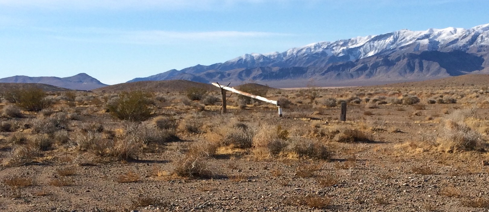
An 11/30/19 photo by Jonathan Westerling of the remains of the Chicken Ranch Airfield wind direction indicator at the runway intersection.
The Chicken Ranch Airfield is located southeast of the intersection of Homestead Road & Silver Street.
____________________________________________________
Scotty Airport / Bonnie Claire Lake Landing Strip, Bonnie Claire, NV
37.16, -117.16 (Northwest of Las Vegas, NV)
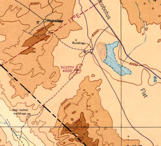
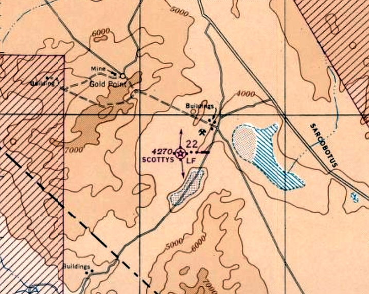
Scotty Airport, as depicted on the February 1936 Mt. Whitney Sectional Chart.
The date of construction of this lakebed airfield has not been determined.
The earliest depiction which has been located of Scotty Airport was on the February 1936 Mt. Whitney Sectional Chart.
It depicted “Scotty” as an auxiliary airfield located on the middle of Bonnie Claire Dry Lake.
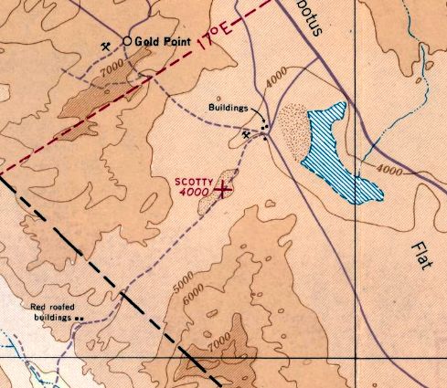
The last aeronautical chart depiction which has been located of Scotty Airport was on the August 1941 Mt. Whitney Sectional Chart.
It depicted “Scotty” as an auxiliary airfield located on the middle of Bonnie Claire Dry Lake.
Scotty Airport was evidently abandoned at some point between 1941-42,
as it was no longer depicted on the July 1942 Mt Whitney Sectional Chart.
Bonnie Claire Lake may have been intended for use as one of several emergency landing sites for the X-15 rocket plane (from 1959-68).
Another lakebed landing strip which is of very similar configuration is the Delamar Lake Landing Strip,
which was one of the designated emergency landing sites for the X-15.
Therefore, although not listed among references of X-15 landing sites,
Bonnie Claire Lake could have presumably been among possible X-15 landing sites.
According to Jim Unruh, “I found a few documents (including NASA's 'X-15, Extending the Frontiers of Flight'), which make references to 'Grapevine Lake' as one of the emergency landing areas for the X-15.
I believe 'Grapevine Lake' is the same as what we now call 'Bonnie Claire (Dry) Lake'.
The strip was named, perhaps, after Grapevine Canyon, just a few miles to the southwest.”
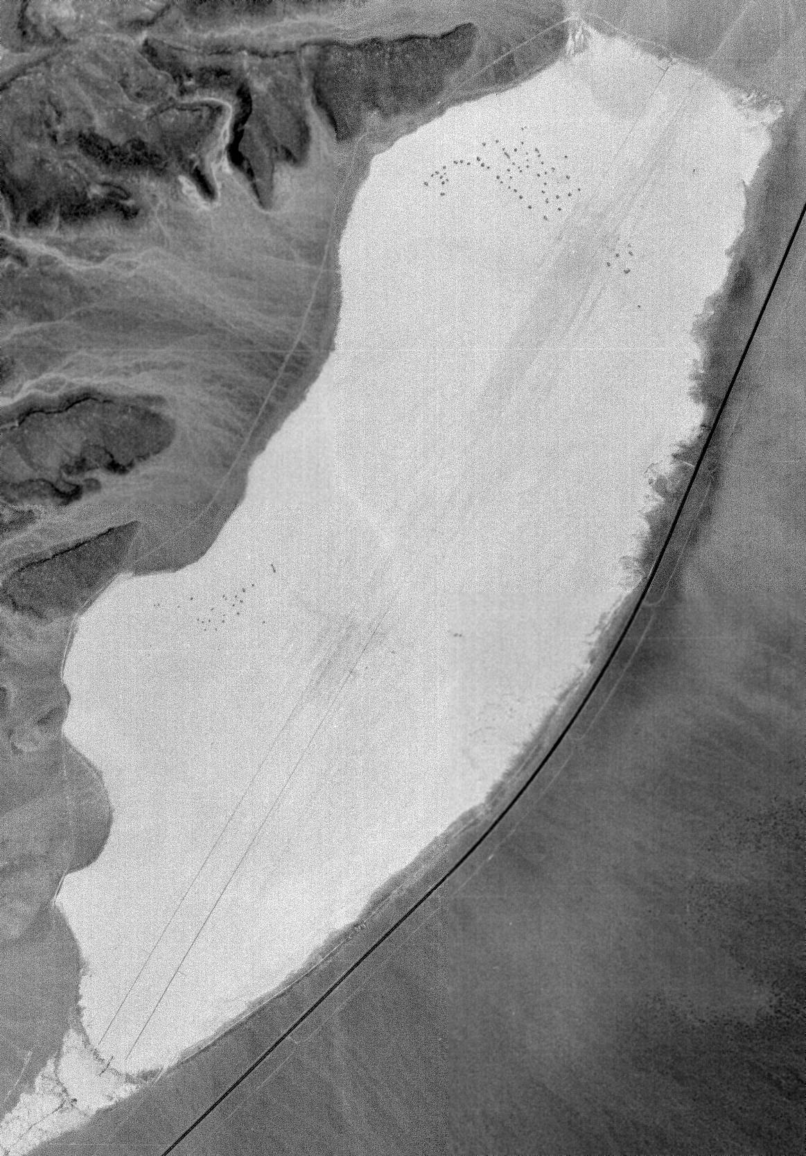
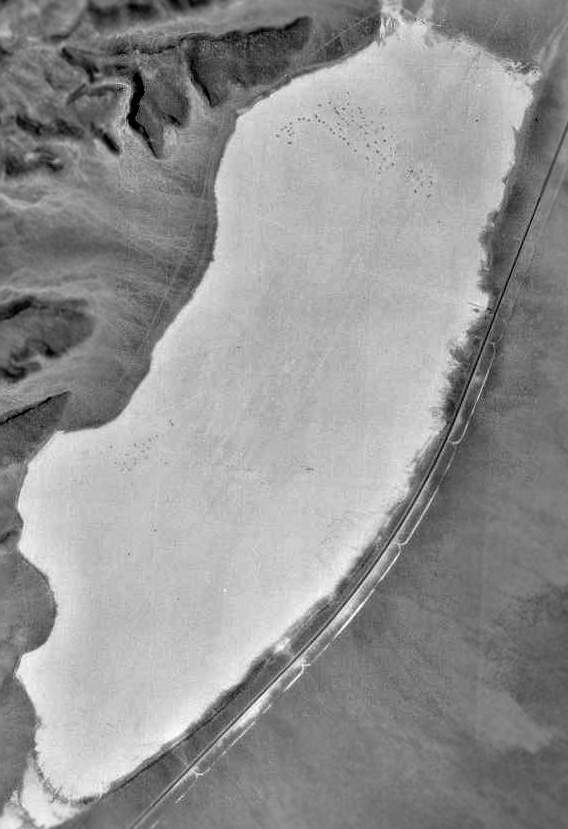
The earliest photo which has been located of the Bonnie Claire Lake landing strip was a 6/11/65 USGS aerial photo.
The lateral edges of the runways were very clearly marked for nearly its entire length.
There was no sign of any buildings or other improvements.
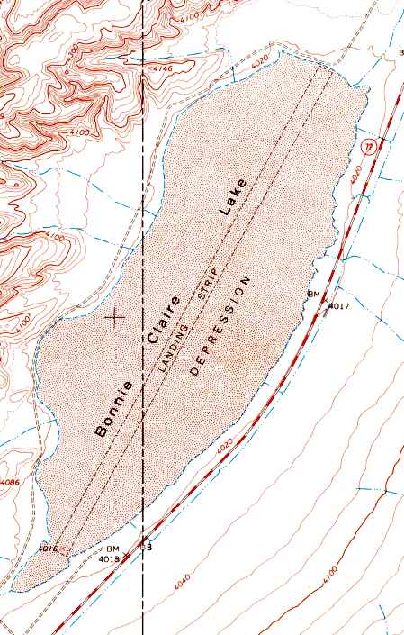
The 1968 USGS topo map depicted a single northeast/southwest runway outline running the entire length of Bonnie Claire Lake,
labeled simply as "Landing Strip".
No airfield at this location was depicted on the 1970 USGS topo map or the 1971 Las Vegas Sectional Chart (courtesy of Vince Granato).
Jim Unruh recalled, “When I worked at Scotty's Castle in the early 1973,
the lateral edges along the length of the strip were marked with what appeared to be loosely scattered dark asphalt-like material.”
Lenny Davis recalled, “Bonnie Claire Dry Lake Bed was used for many years as a clandestine airstrip for drug smugglers.
I first visited the airstrip in 1981. I had been informed by Nye County Sheriff's investigators that there was recent evidence of the lake bed being used to land drugs.
When I arrived a few days later there were approximately 20 burned road flares laid out as landing lights to mark the airstrip.
There were tricycle gear aircraft tracks, and several vehicle tracks that met the aircraft at the end of the airstrip at the western end of the lake bed. Obviously a smuggling crew had made a successful run.
Many times in the following years, we observed evidence of clandestine landings on the lake bed.”
The field was depicted as a "Landing Strip" on the 1985 USGS topo map.
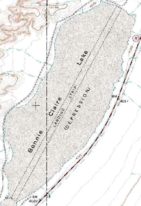
The 1991 USGS topo map depicted a single northeast/southwest runway outline running the entire length of Bonnie Claire Lake,
labeled simply as "Landing Strip".
The outline of the Bonnie Claire Lake landing strip was barely discernible in the 1994 USGS aerial photo.
Lenny Davis recalled, “In 1995, I received information that a smuggling group was using the Bonnie Claire Lake Bed to land their drugs.
The group was using a twin-engine Piper Navajo that they were basing at the Reno/Tahoe International Airport.
Further information from an informant stated that the group was going to fly a load into the Bonnie Claire Lake Bed the next day.
Based on this information, several Agents & I began a surveillance of the lake bed area.
About 18 hours into the surveillance, we received information that the pilot had left the Reno/Tahoe airport, but had crashed in Mexico.
That was the last time law enforcement received any information that the Bonnie Claire Lake Bed had been used for smuggling.
But obviously over the years it had been used many times to smuggle narcotics into the country.”

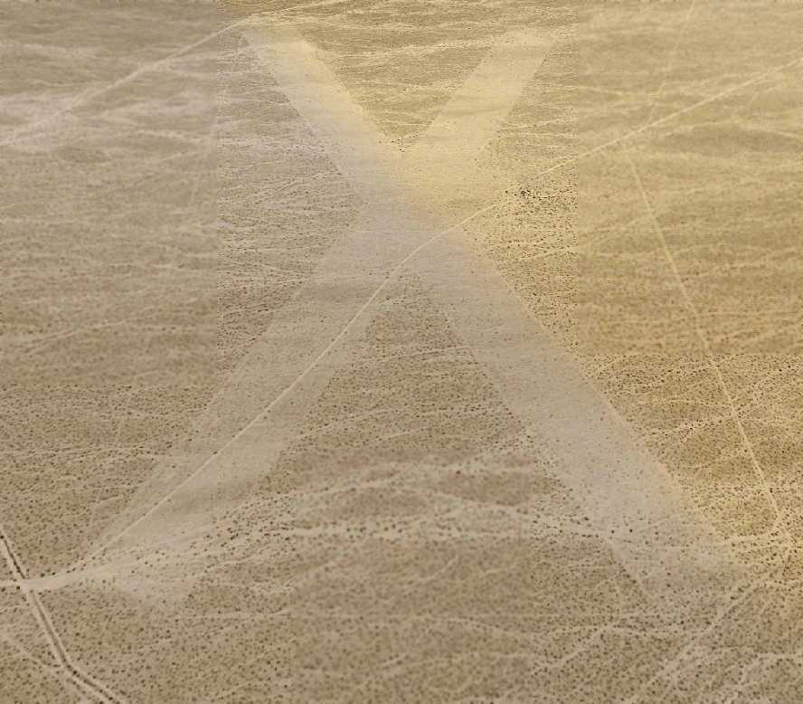
A 2001 aerial view by JD Lawson looking north at Bonnie Claire Lake,
with Bonnie Claire Airport visible as an "X" in the upper left corner.
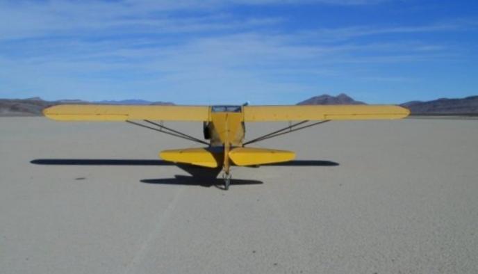
A 2001 photo by JD Lawson of a Taylorcraft on the dry lakebed at Bonnie Claire.
The Bonnie Clark Lake airfield was not depicted at all on the 2002 Sectional Chart.

A 2015 aerial view looking northwest at Bonnie Claire Lake did not show any trace of the landing strip.
According to Jim Unruh, the lateral edge markings along the length of the strip “are gone,
but 2 short black markers perpendicular to the alignment of the strip on the southwest end still exist. Perhaps these were threshold markers?
They are visible in the lower-left of the image.”
Bonnie Claire Dry Lake is located 4 miles southwest of the town of Bonnie Claire, adjacent to the west side of Route 267 (which is labeled Route 72 on USGS topo maps).
Yet another airfield, Bonnie Claire Airport, is located only 2 miles northwest.
Thanks to JD Lawson for pointing out this airfield.
____________________________________________________
Scotty's Intermediate Field / Bonnie Claire Airport, Bonnie Claire, NV
37.2, -117.18 (Northwest of Las Vegas, NV)
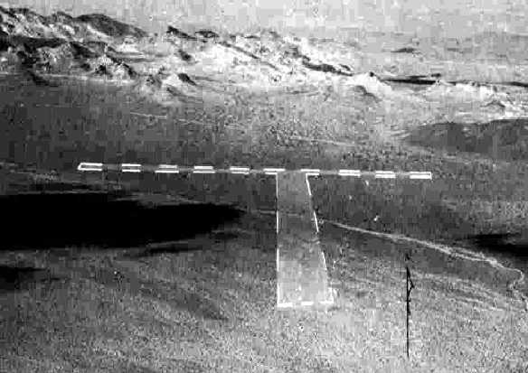
A 10/21/43 aerial view looking north at “Scotty's Intermediate Field”
from the 1945 AAF Airfield Directory (courtesy of Scott Murdock).
Only 2 miles northwest of Bonnie Claire Lake Landing Strip sits another airfield in the middle of nowhere: Scotty's Intermediate Field / Bonnie Claire Airport.
Scotty's Intermediate Field was apparently built as one of the Civil Aeronautics Administration's network of intermediate fields.
It may have been built at some point in 1943,
as it was not depicted at all on the 1940 Airports & Airways Map from the NV Division of Aeronautics (courtesy of Jim Mallery)
nor on the August 1943 Mt. Whitney Sectional Chart (according to Chris Kennedy).
The earliest photo which has been located of Scotty's Intermediate Field
was a 10/21/43 aerial view looking north from the 1945 AAF Airfield Directory (courtesy of Scott Murdock).
It depicted the “Scotty's Intermediate Field” as having 2 unpaved runways.
Keith Wood noted that Scottys was most likely established as an intermediate field along the Las Vegas - Reno & Salt Lake City – Bakersfield airways,
as the field is located almost directly along these 2 routes.
Scotty's Intermediate Field was not yet depicted on the February 1944 Mt. Whitney Sectional Chart.
The earliest aeronautical chart depiction which has been located of Scotty's Intermediate Field was on the August 1944 Mt. Whitney Sectional Chart.
It depicted Scotty's as Civil Aeronautics Administration's Site 22.
The 1945 AAF Airfield Directory (courtesy of Scott Murdock) described “Scotty's Intermediate Field”
as a 640 acre irregularly-shaped property having 2 graded 6,000' runways, oriented north/south & northeast/southwest.
The field was said to not have any hangars,
to be owned by the U.S. Government, and operated by the Civil Aeronautics Administration.
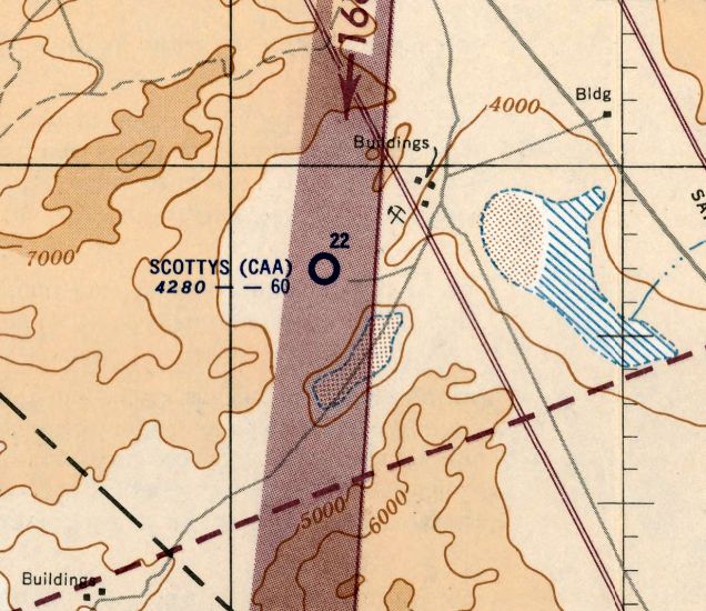
The last aeronautical chart depiction which has been located of Scotty's Intermediate Field was on the March 1952 Mt. Whitney Sectional Chart.
It depicted “Scottys (CAA)” as having a 6,000' unpaved runway.
Scotty's Intermediate Field was evidently abandoned at some point in 1952,
as it was no longer depicted on the September 1952 Mt. Whitney Sectional Chart.
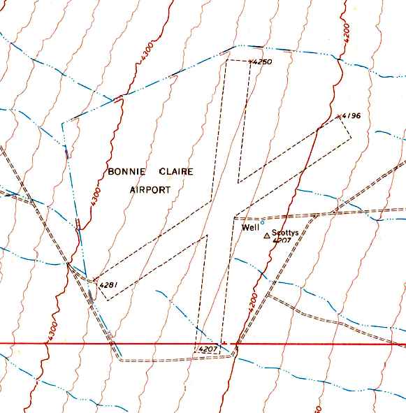
The 1968 USGS topo map depicted the 2 unpaved runways of Bonnie Claire Airport.
A reminder of the airport's previous name was also still depicted - a survey marker named "Scottys" just east of the runway intersection.
Scottys Airport was evidently abandoned by 1970, as it was no longer depicted at all on the 1970 USGS topo map
or the 1971 Las Vegas Sectional Chart (courtesy of Vince Granato).
At some point between 1971-85, the airfield was evidently reopened as "Bonnie Claire Airport",
as that is how it was labeled on the 1985 USGS topo map.
Bonnie Claire Airport was depicted as a private airfield on the 1990 NV Airports & Landing Strips Map (courtesy of Jim Mallery).
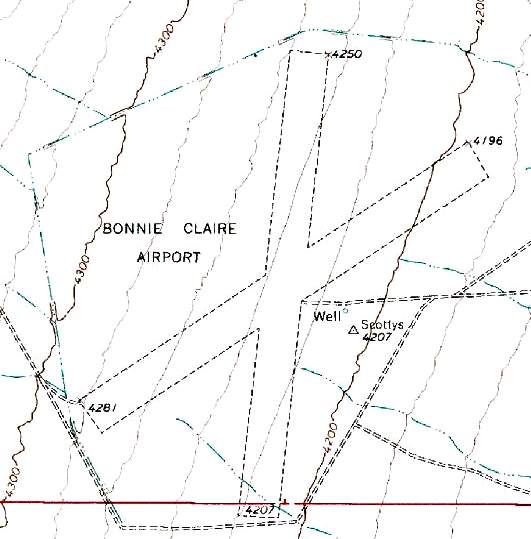
The 1991 USGS topo map depicted the 2 unpaved runways of Bonnie Claire Airport.
A reminder of the airport's previous name was also still depicted - a survey marker named "Scottys" just east of the runway intersection.
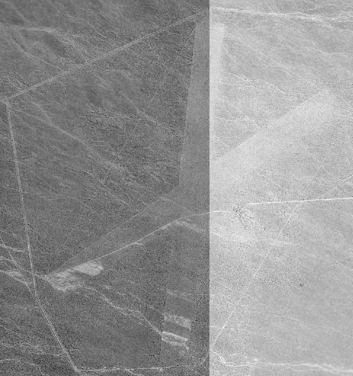
The 1994 USGS aerial photo of Bonnie Claire Airport was very low-contrast,
but it depicted the airfield as consisting of two 5,800' unpaved runways, with an unpaved road ringing the airfield.
Keith Wood noted that this airfield's “perimeter road suggests military use, either during or after WW2,
possibly in conjunction with the nuclear testing program at Yucca Flat.
In fact, it appears that there were 2 perimeters, the obvious one near the edge of the overhead,
and an inner perimeter from the corners of the runways (probably a fenceline).
The outer line would have been patrolled by jeep, the inner possibly by dog teams.
Whatever they were doing there, they didn't want to have visitors, though the field is clearly visible from surrounding hills.”
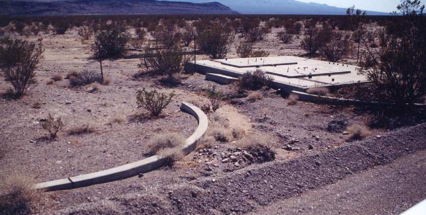
A 2002 photo by Gerry of Talk Radio of Pahrump of unidentified remains at Bonnie Claire Airport.
Note the fence which has been placed (at a later date) over the concrete foundation.
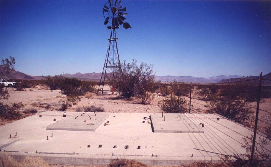
A 2002 photo by Gerry of Talk Radio of Pahrump of unidentified remains at Bonnie Claire Airport.
The water holding tank (behind the bush in front of the windmill) had "4300" spray-painted on it, presumably the elevation.
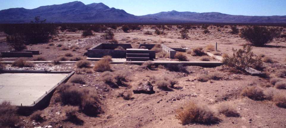
A 2002 photo by Gerry of Talk Radio of Pahrump of unidentified remains at Bonnie Claire Airport.
Gerry visited Bonnie Claire Airport in 2002, and observed that the airstrip is
"drivable but it's washed out to the point that it would take extensive repairs to make it usable."
She found a variety of concrete foundations (see photos above), a windmill,
and several drainage channels along the airfield perimeter.
But still no clues as to who constructed this airfield, or what purpose it served.

A 2003 aerial photo by Keri Daminelli (via Bill Sloan), looking southwest at Bonnie Claire Airport.
A circa 2006 aerial view looking northeast at the Bonnie Claire Airport runways.
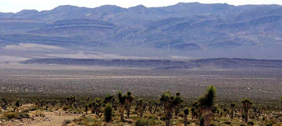
A 4/11/11 photo looking at the Bonnie Claire Airport runways from a distance.
Noe Flightrisk reported in December 2011, “I landed at Scotty's earlier this week.
Of the three 2002 photos, the first shows the foundation for an antenna mast (or masts).
The second shows the same foundation with windmill & water tank.
The third shows the remains of a garage in the left foreground & a building in the center with what appears to have been the base of a flagpole on the right.
The building apparently contained communication equipment, since there are cables running in conduit through the building's foundation,
presumably connecting to the conduit emerging from the antenna foundation.
The airfield hasn't yet been fully overgrown by creosote bushes,
but is currently usable only by high ground clearance aircraft with large tires, due to erosion, hummocks, and brush.
I have a Maule M7-235C with 31" Alaskan Bushwheels.
I camped out at Scotty's, in part because I'm an amateur astronomer and it is VERY dark there, and in part because I just like camping.
The low was 20 F, but there was no snow as it has been a very dry winter so far.”
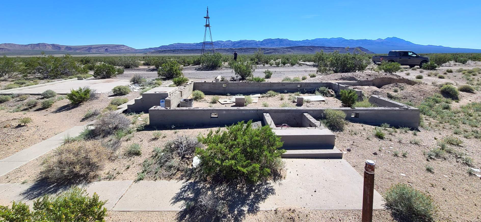
A 10/12/23 photo by Bob Frenchu of building foundations at the Bonnie Claire Airport site.
Bob reported the site is “deteriorated somewhat, but mostly unchanged.”
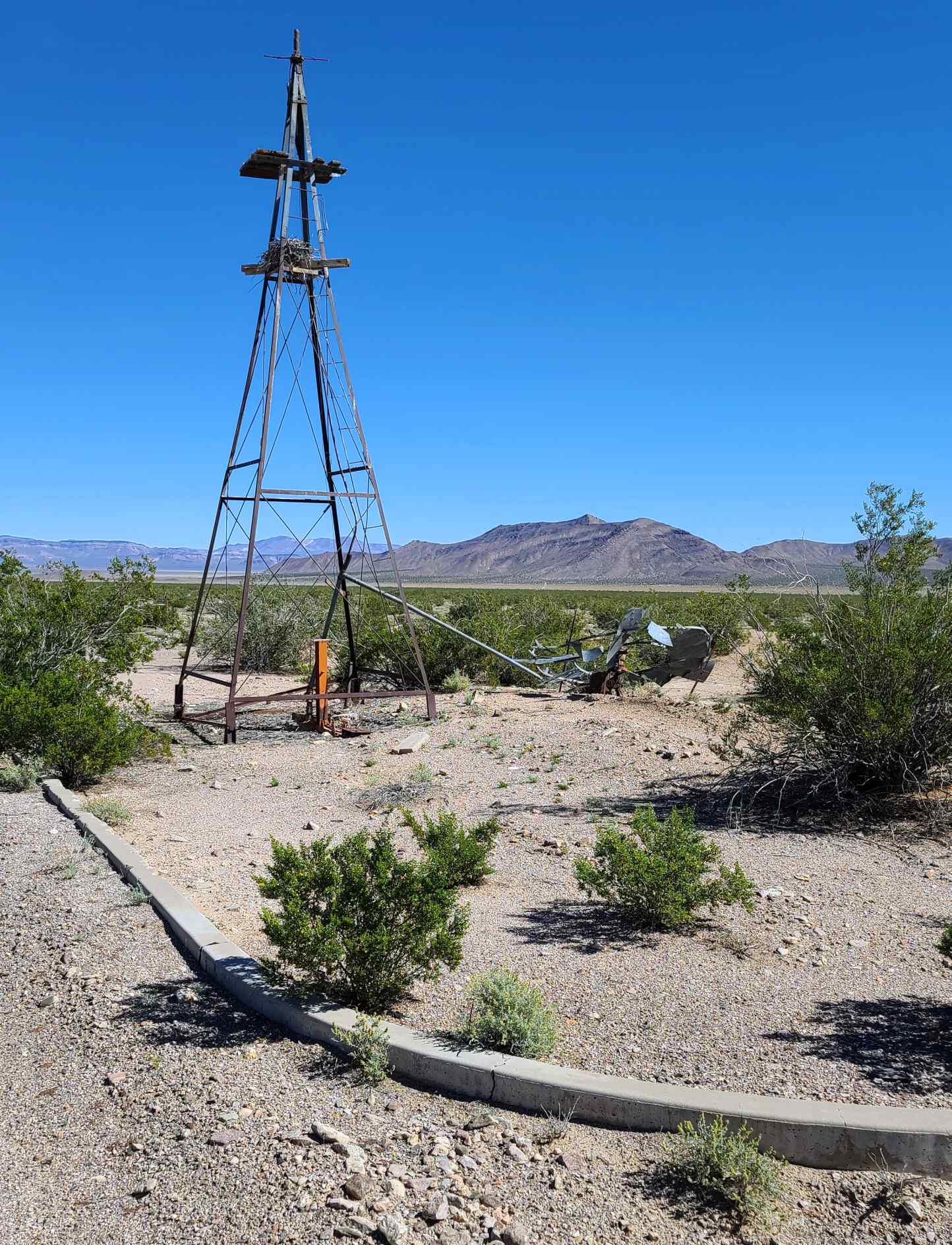
A 10/12/23 photo by Bob Frenchu at the Bonnie Claire Airport site, of the fallen windmill on the ground next to its tower.
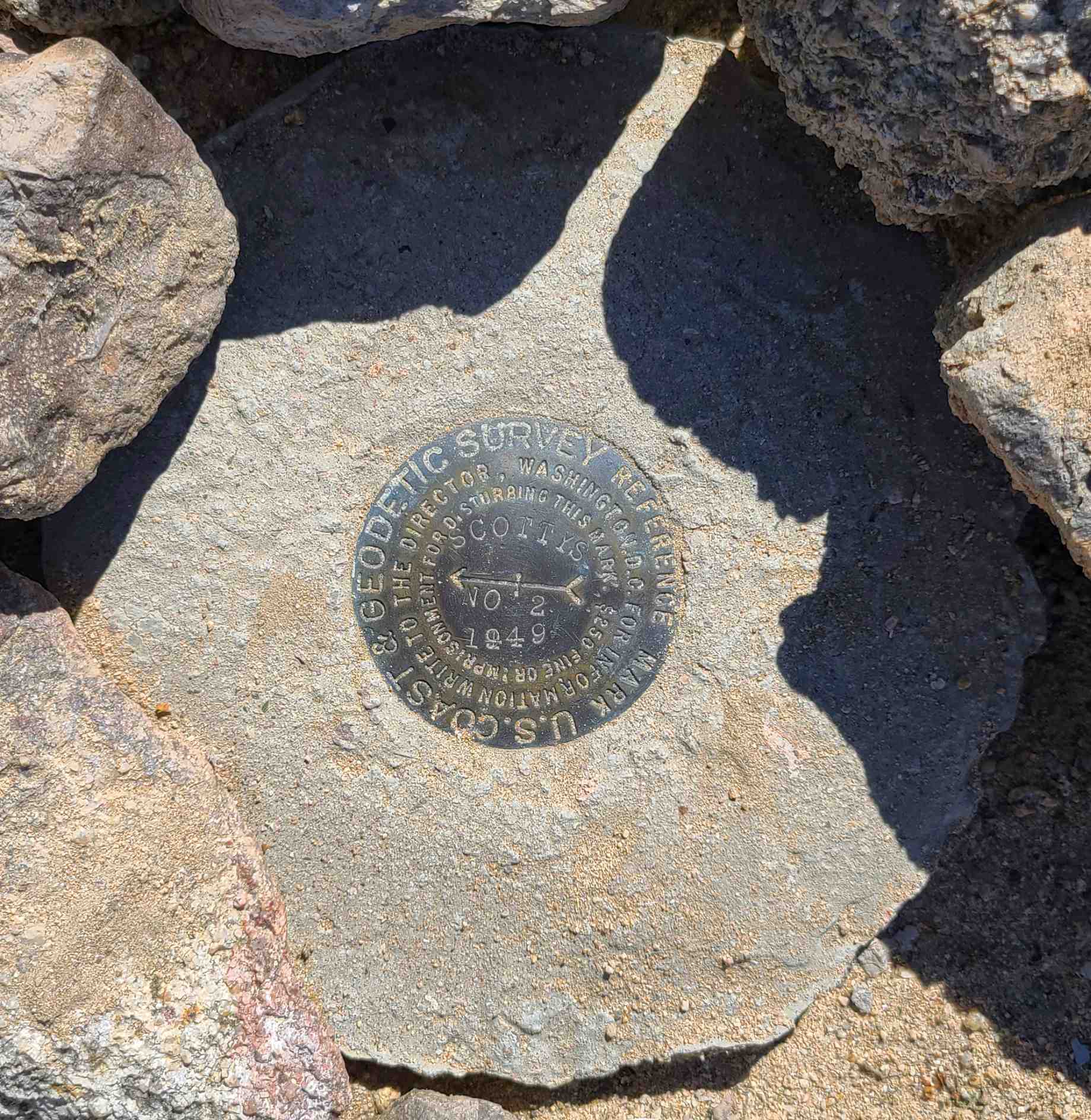
A 10/12/23 photo by Bob Frenchu of the Scottys 1949 USCGS Reference Mark at the Bonnie Claire Airport site.
The Bonnie Claire Airport is located on an unnamed dirt road, 3 miles west of Route 267, 3 miles southwest of the town of Bonnie Claire.
Thanks to JD Lawson for pointing out this airfield.
____________________________________________________
Or if you prefer to contact me directly concerning a contribution (for a mailing address to send a check),
please contact me at: paulandterryfreeman@gmail.com
If you enjoy this web site, please support it with a financial contribution.
____________________________________________________
This site covers airfields in all 50 states.