Abandoned & Little-Known Airfields:
Northeastern New York State
© 2002, © 2024 by Paul Freeman. Revised 4/5/24.
This site covers airfields in all 50 states: Click here for the site's main menu.
____________________________________________________
Please consider a financial contribution to support the continued growth & operation of this site.
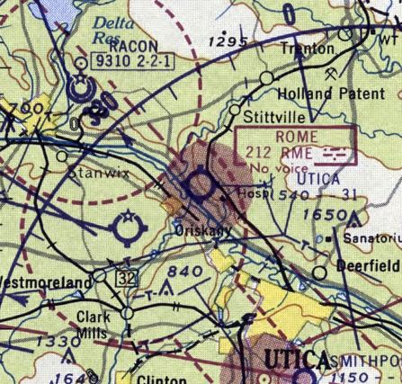
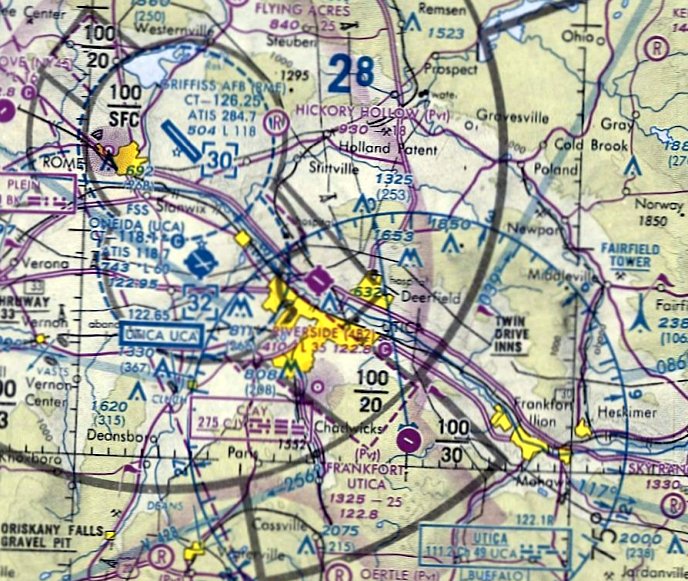
Atlas Missile Site 556-10 / Site 556-5 Airfield (added 4/5/24) - Frontier Town Airpark (revised 5/29/23) - Oneida County Airport (revised 5/29/23) - Oval Wood Dish Company Airfield (added 6/21/22)
Plattsburgh Municipal Airport / Clinton County Airport (revised 11/8/21) - Riverside Airport (revised 5/29/23)
Ticonderoga Intermediate Field / Ticonderoga Airport (revised 10/14/18) - Utica Municipal (revised 8/23/22)
____________________________________________________
Atlas Missile Site 556-10 / Site 556-5 Airfield, Lewis, NY
44.334, -73.561 (North of New York, NY)
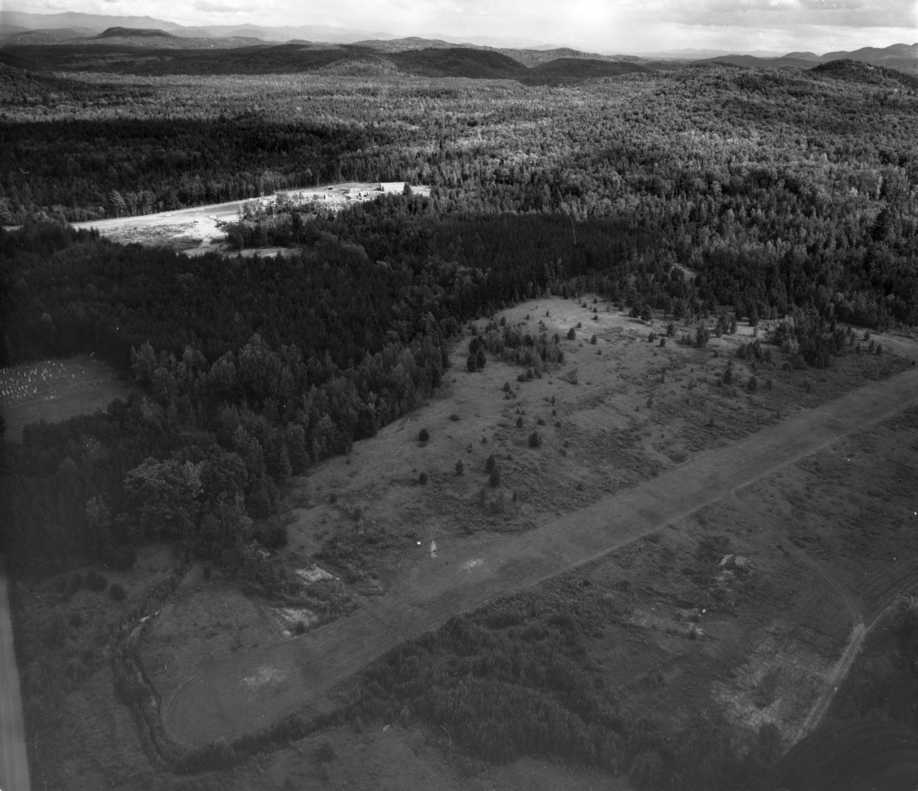
A 9/19/62 aerial view looking southeast at Atlas Missile Site 556-10 Airfield, with the missile silo in the background (courtesy of Gary Baker, via Ron Plante).
According to TheMilitaryStandard, Atlas F Site 556-10 was Site 556-10 was activated 10/1/61,
as one of 12 Atlas F intercontinental ballistic missile silos operated by Plattsburgh AFB's 556th Strategic Missile Squadron, designated 556-1 through 556-12.
As was the case with several other ICBM silos, Site 556-10 had a nearby small airstrip, to facilitate construction &/or operation.
The earliest depiction which has been located of Atlas Missile Site 556-10 Airfield was a series of 9/19/62 aerial views (courtesy of Gary Baker, via Ron Plante).
It depicted an 1,800' unpaved northeast/southwest runway, with no buildings, located a half-mile west of the missile silo.
According to Ron Plante, “Assuming the site is on alert, presumably one of the enlisted guys drove to the strip to await the U-6A Beaver. The BMAT is probably not leaving.
Weather would limit use of the strip. Between snow in the winter, mud in the spring, and no IFR approach, it does not seem they could use it much.”
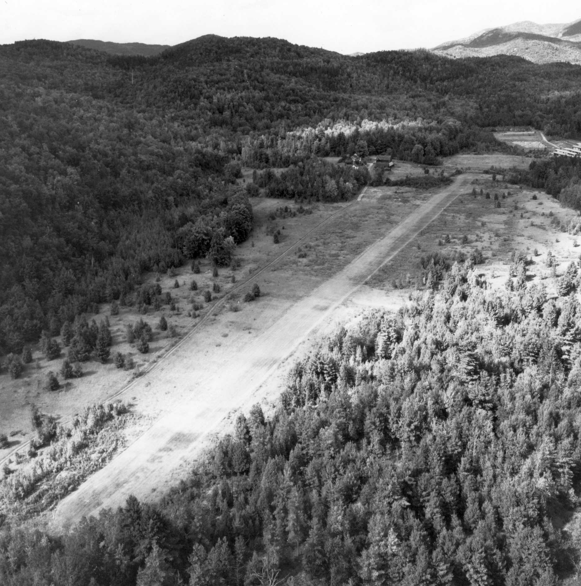
A 9/19/62 aerial view looking northwest at Atlas Missile Site 556-10 Airfield (courtesy of Gary Baker, via Ron Plante).
A 9/19/62 aerial view looking southwest at Atlas Missile Site 556-10 Airfield (courtesy of Gary Baker, via Ron Plante), showing the hilly terrain in close proximity to the airfield.
The Site 556-10 airfield was not depicted on the 1962 USGS topo map.
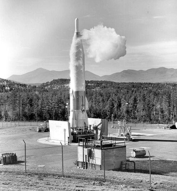
A 1962 USAF photo of a Convair SM-65F Atlas ICBM elevated from its silo at nearby Site 556-6 Au Sable Forks NY.
Site 556-10 was later redesignated Site 556-5.
Ron Plante reported, “All Atlas F squadrons were originally planned for 9 missiles, then they added 3 more.
When SAC accepted the missiles, they converted each squadron with Site 1 at 001 degrees from the base, at 359 degrees would be Site 12. Some site numbers were changed.
A site might have one number under construction & another while operational.”
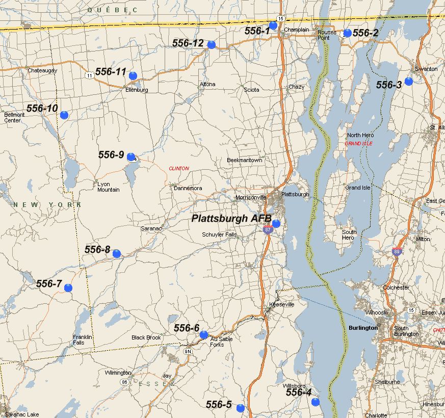
A map of the 12 Atlas F intercontinental ballistic missile silos operated by Plattsburgh AFB's 556th Strategic Missile Squadron, designated 556-1 through 556-12.
According to TheMilitaryStandard, Atlas F Site 556-5 was deactivated 6/25/65, after serving for less than only 4 years.
The Site 556-5 airfield was not depicted on the June 1965 Burlington Sectional Chart.
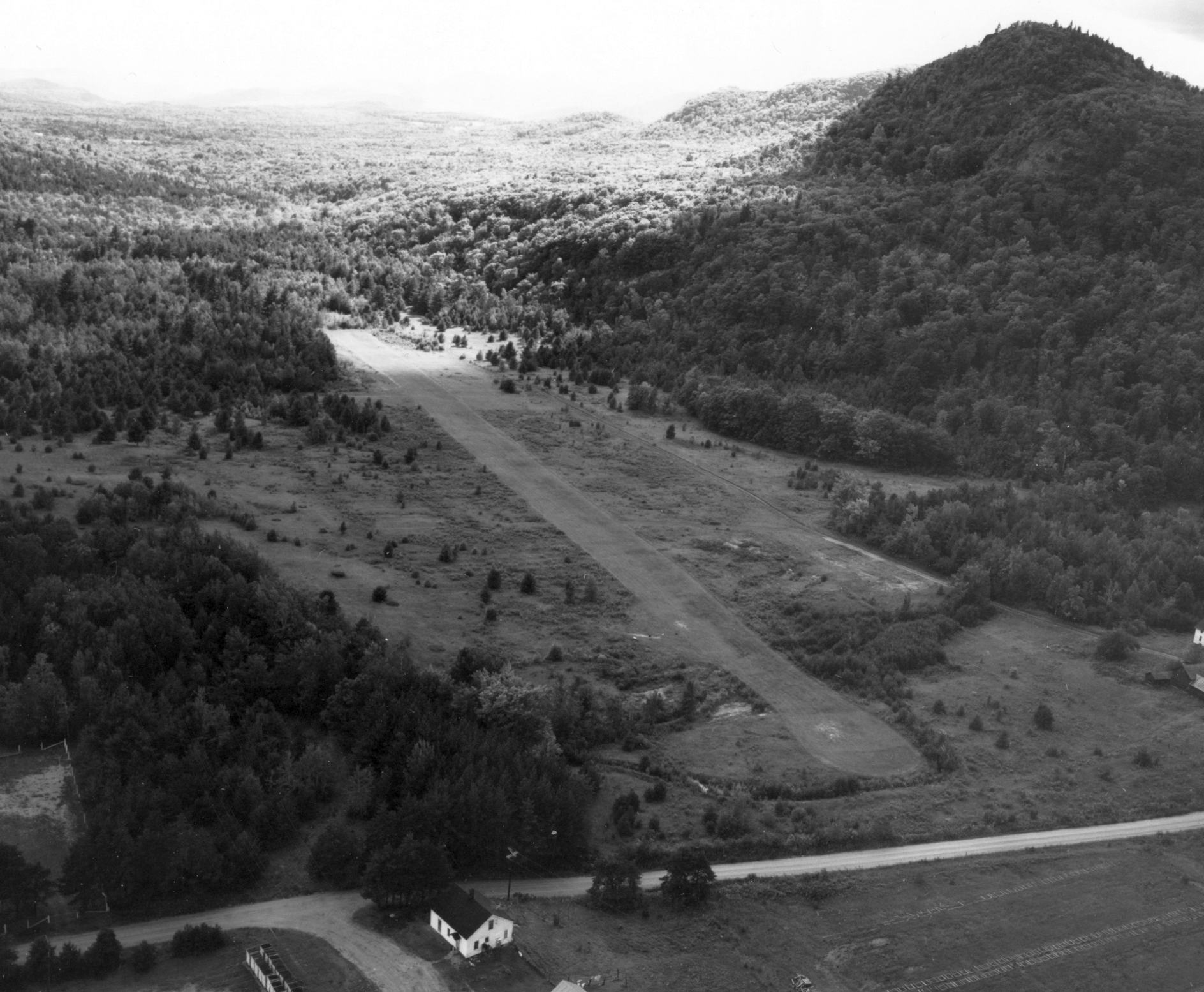
A 1976 aerial view showed the Site 556-5 airfield remained clear, but did not show any sign of recent use.
The Site 556-5 airfield was not depicted on the 1978 USGS topo map, but the adjacent missile silo was depicted as “Site 10”.
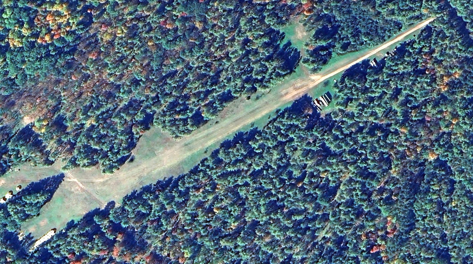
A 2023 aerial view looking northwest showed the Site 556-5 airfield remained clear, but did not show any sign of recent use.
Thanks to Ron Plante for pointing out this airfield.
____________________________________________________
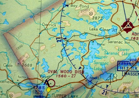
Oval Wood Dish Company Airfield, Tupper Lake, NY
44.237, -74.458 (Northwest of New York, NY)
The Oval Wood Dish Company Airfield, as depicted on the December 1950 Burlington Sectional Chart.
The Oval Wood Dish Company factory in Tupper Lake was established in 1917, according to Malcolm Dickinson.
An adjacent airfield to support the factory was evidently established at some point in 1950,
as it was not yet depicted on the 1949 USGS topo map or the June 1950 Burlington Sectional Chart.
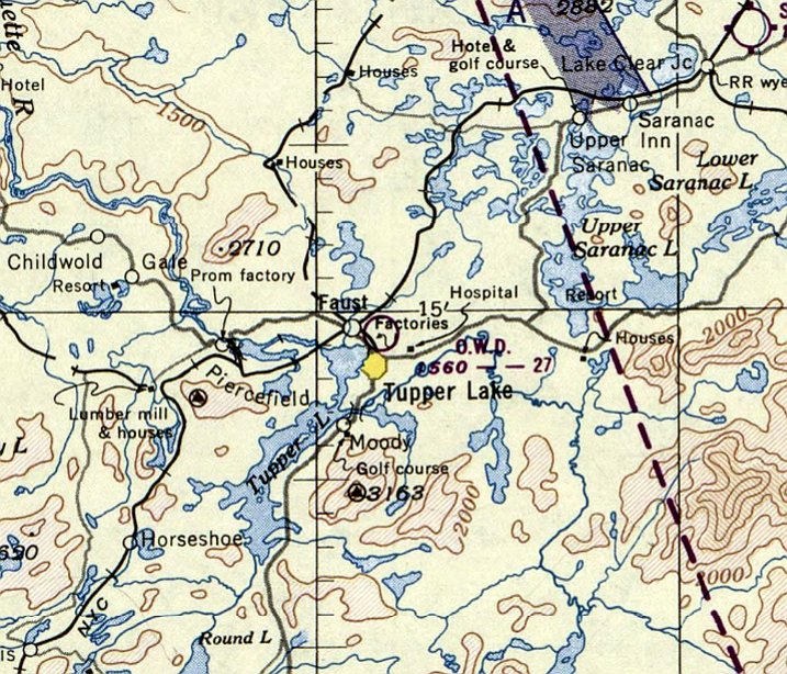
The earliest depiction which has been located of the Oval Wood Dish Company Airfield was on the December 1950 Burlington Sectional Chart.
It depicted the “O.W.D.” airfield as having a 2,700' unpaved runway.
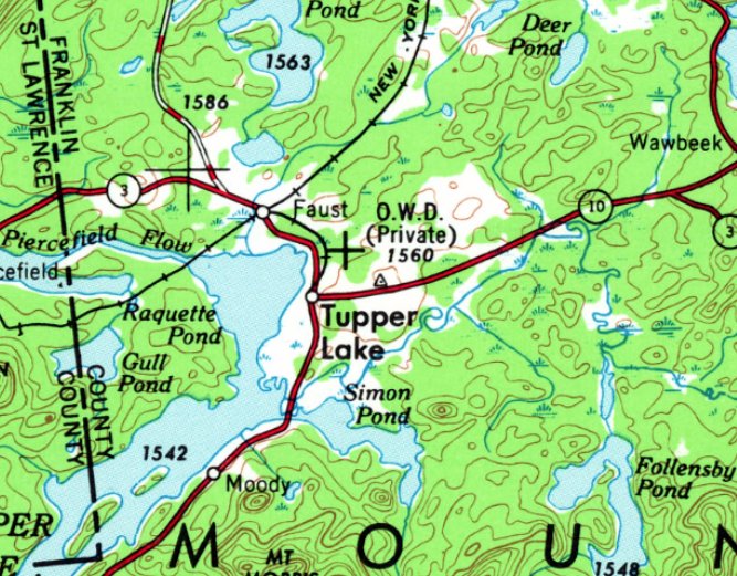
The earliest topo map depiction which has been located of the Oval Wood Dish Company Airfield was on the 1951 USGS topo map.
It depicted “O.W.D.” as a private airfield.
The earliest photo which has been located of the Oval Wood Dish Company Airfield was a 1953 aerial photo.
It depicted a single unpaved northeast/southwest runway, with 1 small building (a hangar?) on the northwest side.
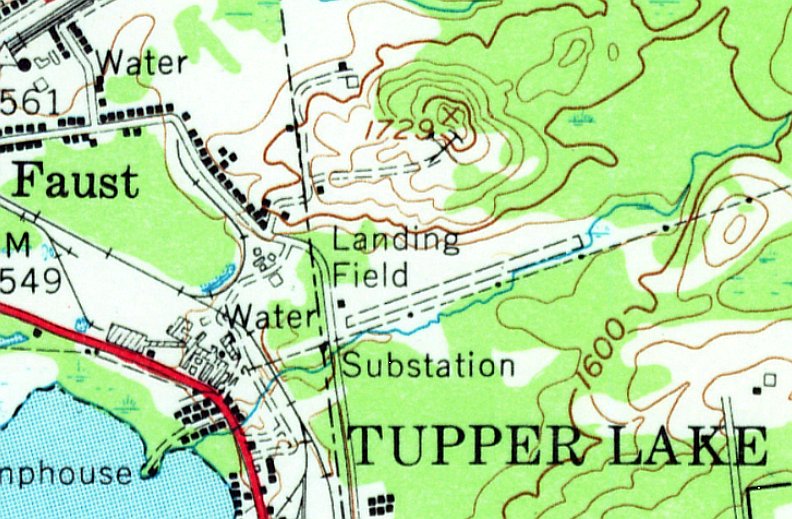
The 1955 USGS topo map depicted the Oval Wood Dish Company Airfield as a single unpaved northeast/southwest runway, generically labeled “Landing Field”, with 1 small building on the northwest side.
The Oval Wood Dish Company factory operated until 1964, according to Malcolm Dickinson.
The last aeronautical chart depiction which has been located of the Oval Wood Dish Company Airfield was on the April 1972 Montreal Sectional Chart.
It depicted the Oval Wood Dish Company Airfield as having a 2,700' unpaved runway.
The Oval Wood Dish Company Airfield was evidently closed at some point between 1972-84,
as it was no longer depicted on the September 1984 Montreal Sectional Chart.
A 1985 aerial photo depicted the Oval Wood Dish Company Airfield in a configuration largely unchanged from the 1953 photo,
but the northeastern portion of the runway appeared to have been paved.
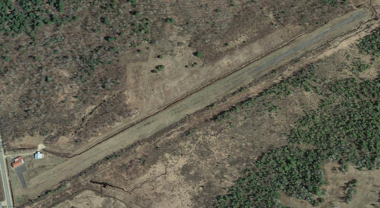
A May 2015 aerial view looking northeast showed the Oval Wood Dish Company Airfield to appear to remain perfectly manicured, including both the grass runway, 2 hangars, and a paved ramp & taixway,
even though it had not been charted as an airfield for at least 31 years.
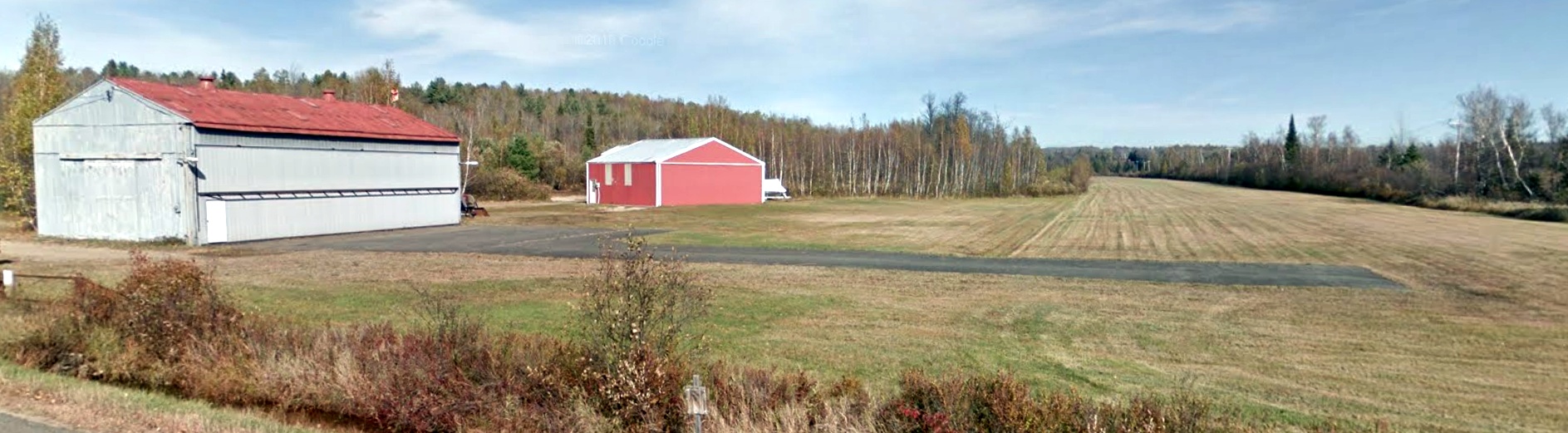
An October 2015 photo looking northeast showed the Oval Wood Dish Company Airfield to appear to remain perfectly manicured, including both the grass runway, 2 hangars, and a paved ramp & taixway,
even though it had not been charted as an airfield for at least 31 years.
Thanks to Malcolm Dickinson for pointing out this airfield.
____________________________________________________
Oneida County Airport (KUCA), Whitestown, NY
43.145, -75.38 (Northwest of New York, NY)
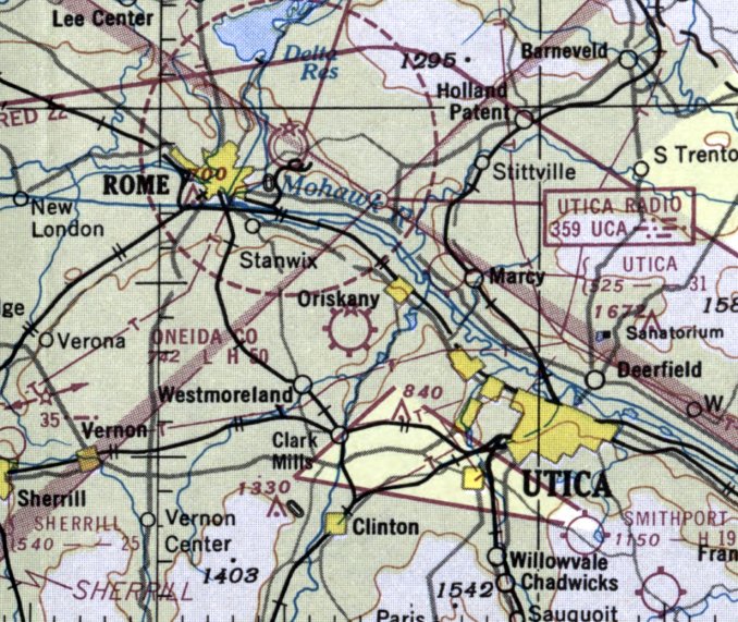
Oneida County Airport, as depicted on the January 1952 Albany Sectional Chart.
The Oneida County Airport was evidently established at some point between 1950-52,
as it was not yet depicted on the January 1950 Albany Sectional Chart (courtesy of Mike Keefe) nor the 1952 USGS topo map.
According to the Oneida County Airport website, in 1952 Robinson Airlines made Oneida County Airport its hub.
It provided DC-3 air service to virtually every major city in the Northeast.
The earliest depiction of the Oneida County Airport which has been located was on the January 1952 Albany Sectional Chart.
It depicted Oneida County as having a 5,000' paved runway.
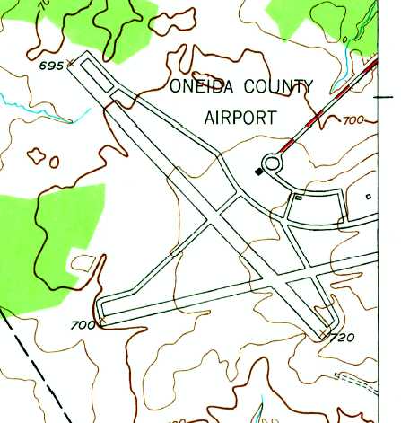
The 1955 USGS topo map depicted the Oneida County Airport as having 2 paved runways, multiple taxiways, and 3 small buildings.
According to the Oneida County Airport website, Robinson Airlines was taken over in a buyout in 1956.
The name was then changed to Mohawk Airlines.
The earliest photo of the Oneida County Airport which has been located was a 10/13/58 USGS aerial view.
It depicted Oneida County as having 2 paved runways, taxiways, and ramps & buildings on the northeast side.
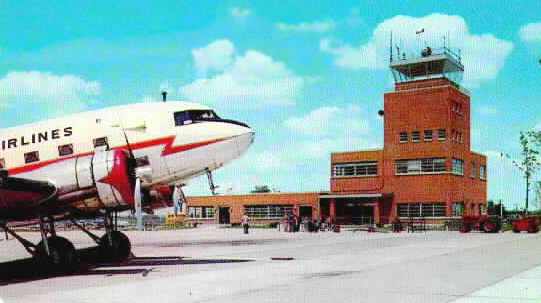
An undated postcard of a Mohawk Airlines DC-3 in front of the Oneida County Airport control tower.
Mohawk Airlines continued service from the Oneida County Airport to points in the Northeast,
adding flights to Montreal, Quebec City, and Toronto with the purchase of Convair turboprops.
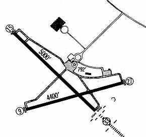
The 1960 Jeppesen Airway Manual (courtesy of Chris Kennedy)
depicted the Oneida County Airport as having 2 paved runways: 5,000' Runway 15/33 & 4,400' Runway 9/27.
In 1960 Mohawk had enplanements in excess of 40,000 per year
and the purchase of BAC-111 jets boosted enplanements to over 55,000 by 1970.
Mohawk Airlines employed over 400 people in 1970.
The variety of flight options offered by Mohawk Airlines
made Oneida County Airport the transportation hub of the Mohawk Valley.
In addition to its executive offices, reservation center, and maintenance facility
Mohawk Airlines also established a jet training facility at the airport.
The combination of these facilities & services made Oneida County Airport the premier regional airline hub at the time.
In 1970, Allegheny Airlines, based in Washington, DC, purchased Mohawk Airlines
and continued to utilize the Oneida County Airport as its hub.
However in 1975 Allegheny Airlines relocated its Oneida County operations,
which included reservation centers & maintenance facilities, to Pittsburgh.
Brien Miller recalled, “Oneida County (UCA) was marvelous, albeit small field. Well kept, and fun to shoot.
As I recall, there was an NDB to it that had you turning over a race track.
If you actually shot it in low visibility at night when there was a race on,
the glow from the race track was a solid visual on where you'd be turning into [Runway] 33.”
In 1978 Paul Quackenbush founded Empire Airlines, and began service with twin-engine Navajos.
Empire began to fill the void left by Allegheny's departure.
In 1980 Empire purchased 10 Fokker 28 jets
and in 1981 began to utilize the reservation & maintenance center left vacant with Allegheny's departure.
Empire's growth in the mid-1980s, coming from added flights to New England & the Middle Atlantic states,
made it one of the busiest regional jet carriers in the Northeast.
There were over 24 departures per day in 1987.
In 1987 Empire was acquired by Piedmont Airlines.
Several years later Piedmont merged with USAir, formally Allegheny Air.
Both Piedmont & USAir utilized the reservation & maintenance facilities
until USAir relocated the operations to various locations in 1995.
USAirways began to downsize its operations at Oneida County Airport in 1995.
At this time it discontinued its DC-9 & 737 service.
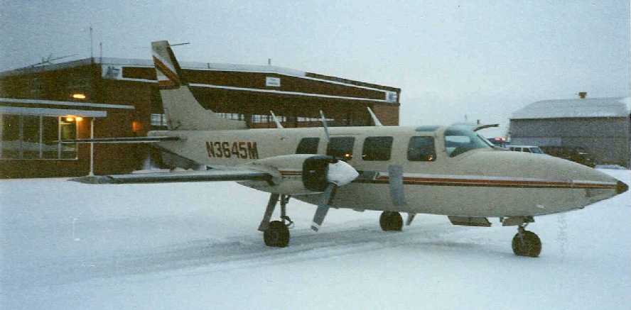
A 1995 photo by Jim Hann of a 1980 Piper Aerostar 600 at Oneida County Airport.
Jim recalled, “The primary airplane that I flew, all operated by USCheck, now AirNet Express.
We hauled canceled checks between bank processing centers, only 2 seats up front.
Utica has a Federal Reserve Bank & also had a processing center for one of the big banks in the northeast.
The outside shot of 45M pictures the plane sitting directly in front of the FBO where the county fuelers worked out of.
There was no Signature or Basler or AMR Combs FBO, just the County. The county did all the fueling, and it wasn't cheap (for the time).
The hangar you can see in the picture housed equipment such as tugs, and deicers, not airplanes, it was fairly old but in decent shape.”
Jim Hann recalled, “I only flew out of there a couple of months & actually lived closer to the base than UCA.
The airport was (and probably still is) in good shape, all the ramps, taxiways, and runways were smooth,
there was an ILS approach to both ends of Runway 15/33 and they did a pretty good job of keeping the snow off the runways & taxiways.
There was also the Horizon hotel right on the main drag into the airport. It wasn't bad for a small town airport hotel.”
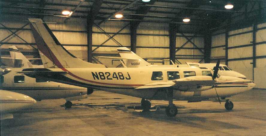
A 1995 photo by Jim Hann of a Piper Aerostar 601 inside the main community hangar at Oneida County Airport.
Jim observed, “There were several resident aircraft & then the transients.
Commutair kept 2 Beechcraft 1900Ds in there every night. USCheck always had 2 slots for Barons & Aerostars.
The MU-2 was also a check-hauler, Epps Air headquartered in Atlanta.
There was a Seneca I in there that might have also hauled some checks, but I believe it was based there.
There was a pair of Falcon 20s owned by a union (clothing workers?) that flew rarely.
Also a Twin Commander, a Cessna 421, and a Cessna Citation.
There were a bunch of T-hangars and other group storage hangars in addition to a maintenance hangar that always had airplanes in it.”
According to the Oneida County Airport website,
Commute Air, a subsidiary of Continental Connection flew Beech 1900s from Oneida County Airport
until it discontinued service on June 30, 2002.
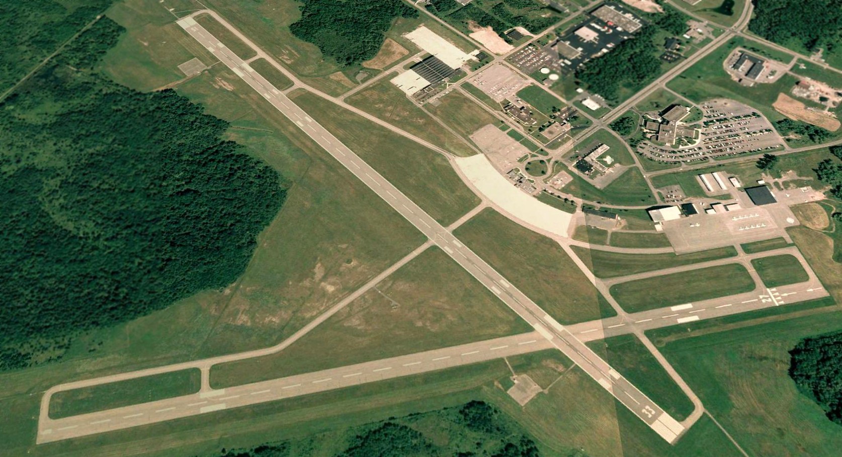
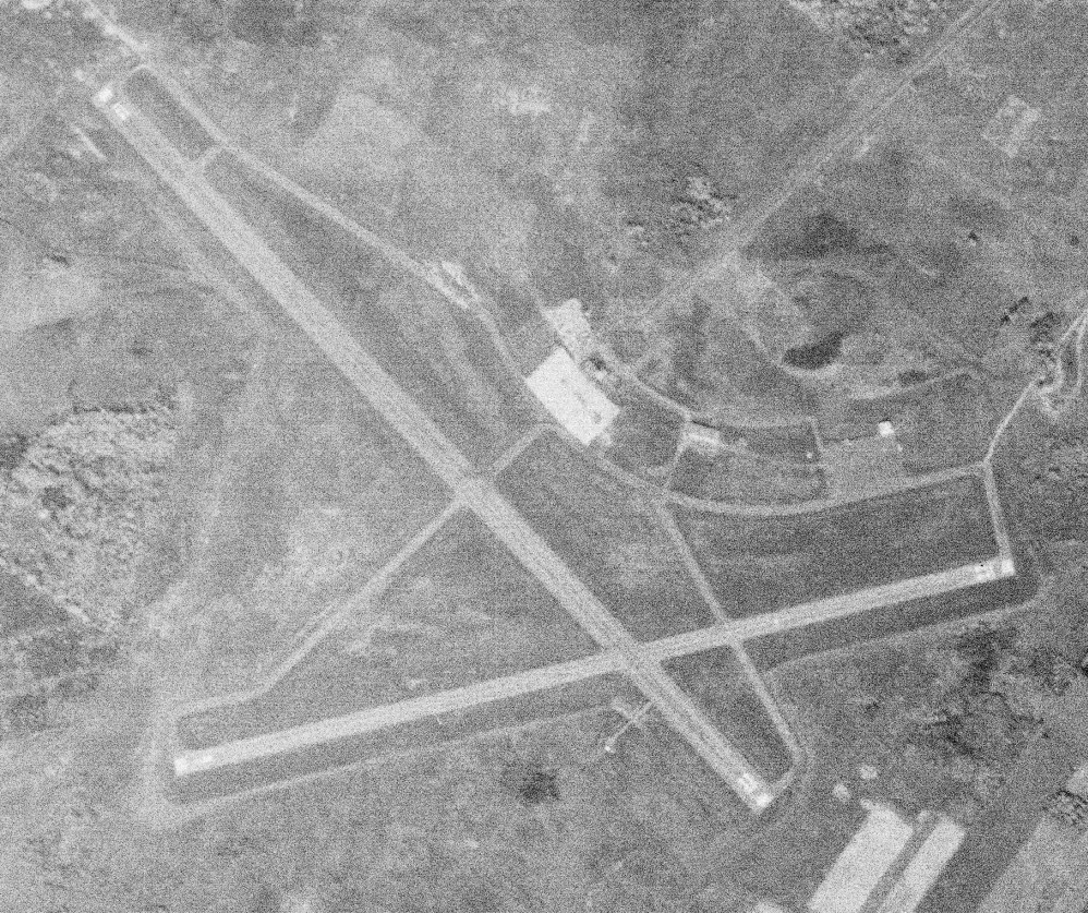
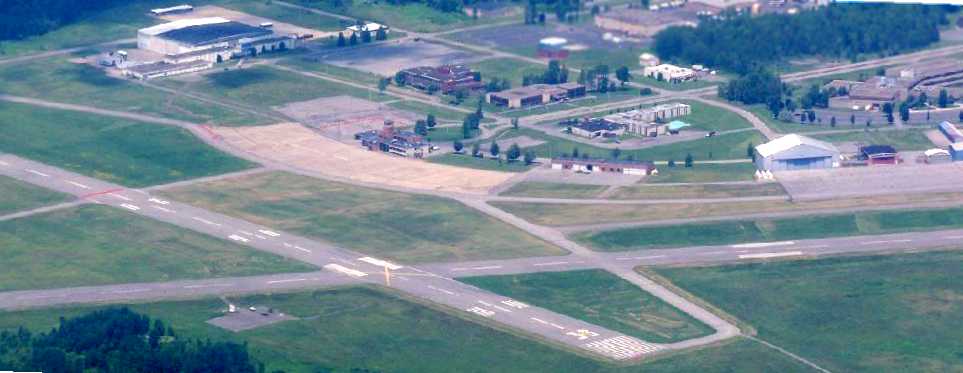
A 2006 aerial view looking north at Oneida County Airport.
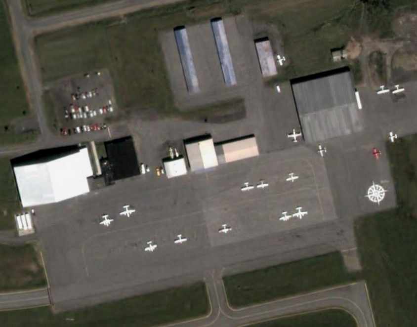
A 2006 aerial photo depicted a total of 17 light single & twin-engine aircraft on the east ramp of the Oneida County Airport.
An undated aerial view looking east at the Oneida County Airport while the field was in operation.
The November 2006 Albany Sectional Chart depicted Oneida County Airport as having 2 paved runways, with the longest being 6,000'.
In its last year of operation, Oneida County Airport encompassed 1,800 acres.
Joyce Palmer recalled, “Oneida County Airport had a very active school, Galaxy Aviation.
They hosted 6 full-size air shows until the county decided to move the airport to the closed Griffith Air Forced Base.”
Joe Peters recalled, “This is where I learned to fly.
UCA was a great airport. The runways were about 6,000', and occasionally you'd see 737-sized aircraft on the ramp.
It was most common to take off from either Runway 15 or 27.
Never in my experience had I heard a controller issue Runway 9 for takeoff or landing.
Oneida County Airport closed in late 2006, and all operations were relocated to former Griffis AFB, about 5 nm North.
The county felt as though its operations had stagnated at UCA,
and decided to utilize the former air base as the local economy had been adversely impacted from the AFB closure in 1995.”
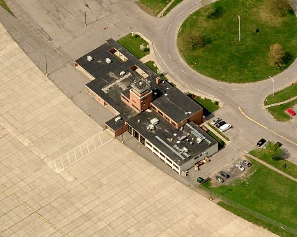
A circa 2007-2010 aerial view looking north at the Oneida County Airport control tower, after the field's closure.
A circa 2007-2010 aerial view looking north at the Oneida County Airport's east ramp, after the field's closure.
A 6/28/09 aerial view looking north at Oneida County Airport by Joe Peters, showing the field to remain intact.
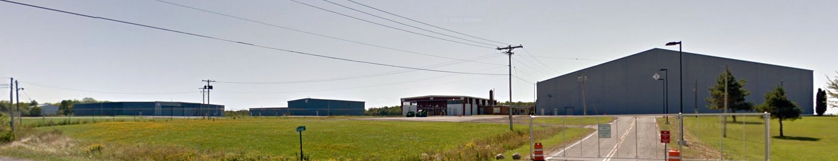
A 2011 photo looking southeast at Oneida County Airport hangars.
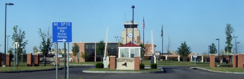
An 8/25/15 photo by Ron Plante looking southwest at the former Oneida County Airport control tower.
Ron reported, “The former terminal building looks great, the airport is now a State Preparedness Training Center (SPTC).
The staff was very polite but would not allow me to take any photos of the site, only from the public access road.
They did give me a hand-out with their website: http://www.dhses.ny.gov/sptc/
which has a 3 minute video that has some scenes of training on the runways: http://www.dhses.ny.gov/sptc/video.cfm.”
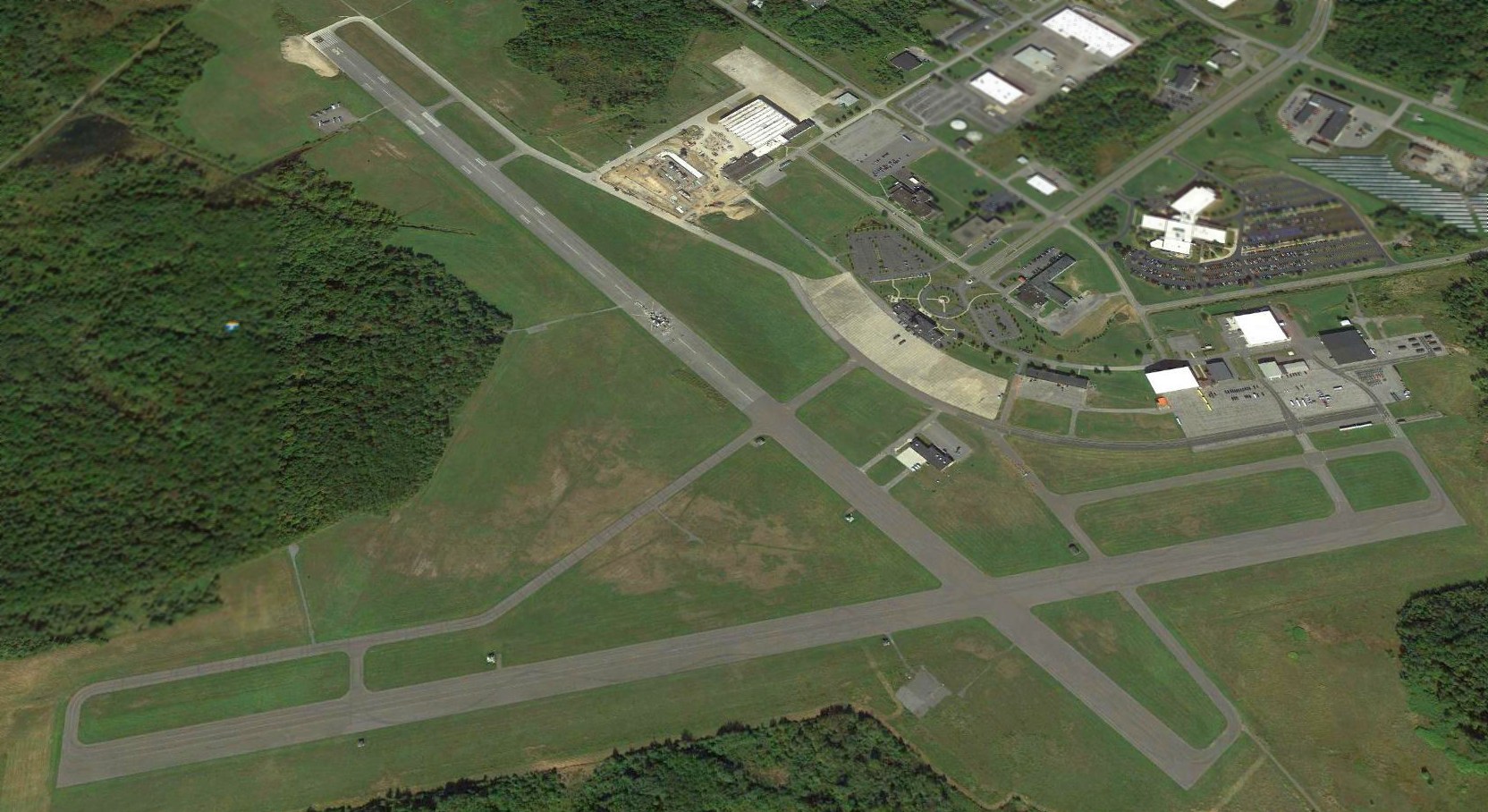
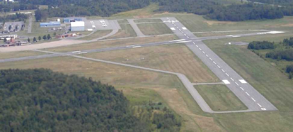
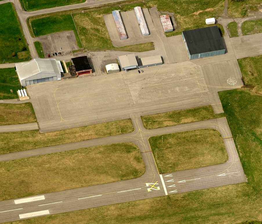
A 2017 aerial view looking north at the site of Oneida County Airport, showing the extensive runways, taxiways, ramps, and hangars which remain intact.
____________________________________________________
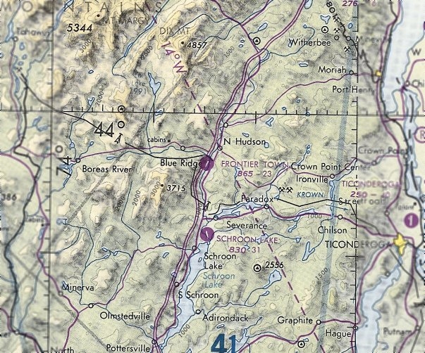
Frontier Town Airpark, North Hudson, NY
43.949, -73.736 (North of Albany, NY)
Frontier Town Airpark, as depicted on the July 1970 Albany Sectional Chart.
Frontier Town, a Wild West theme park, operated here in 1952.
Frontier Town Airpark was not yet depicted on a 1952 aerial photo.
At some point between 1969-70, the theme park gained its own airfield,
as Frontier Town Airpark was not yet depicted on the 1969 Albany Sectional Chart.
The earliest depiction which has been located of Frontier Town Airpark was on the July 1970 Albany Sectional Chart.
It depicted Frontier Town Airpark as having a 2,300' paved northeast/southwest runway.
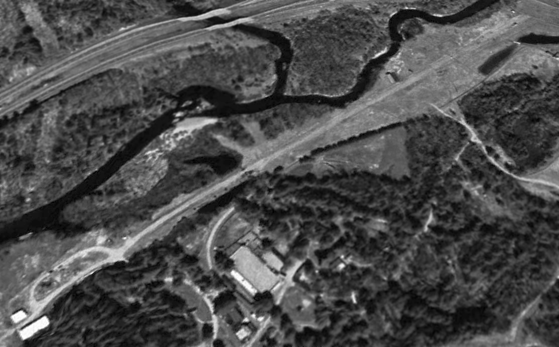
The earliest photo which has been located of Frontier Town Airpark was a 1970 aerial view.
It depicted Frontier Town Airpark as having a paved northeast/southwest runway, with 2 light single-engine planes parked on the north end.
There did not appear to be any hangars or other buildings on the airport.
Robert Cook recalled, “I remember going past it as a child & seeing some aircraft there”, circa 1970s.
The earliest photo which is available of Frontier Town Airpark was a 5/15/71 USGS aerial view.
It depicted Frontier Town Airpark as having a paved Runway 5/23.
There did not appear to be any hangars or other buildings on the airport.
The 1973 USGS topo map depicted Frontier Town Airpark as having a paved northeast/southwest runway.
There did not appear to be any hangars or other buildings on the airport.
The last aeronautical chart depiction which has been located of Frontier Town Airpark was on the June 1981 Albany Sectional Chart (courtesy of Ron Plante).
It depicted Frontier Town Airpark as having a 2,300' paved northeast/southwest runway.
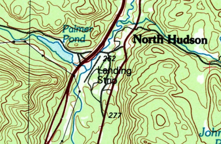
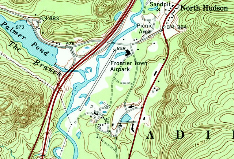
The 1989 USGS topo map depicted Frontier Town Airpark as a paved northeast/southwest runway generically labeled as “Landing Strip”,
which may indicate that it was closed by that point.
Frontier Town Airpark was evidently closed (for reasons unknown) at some point between 1981-93,
as it was no longer depicted on the December 1993 Albany Sectional Chart (courtesy of Ron Plante).
The Frontier Town theme park closed in 1998, causing a severe impact to North Hudson's economy.
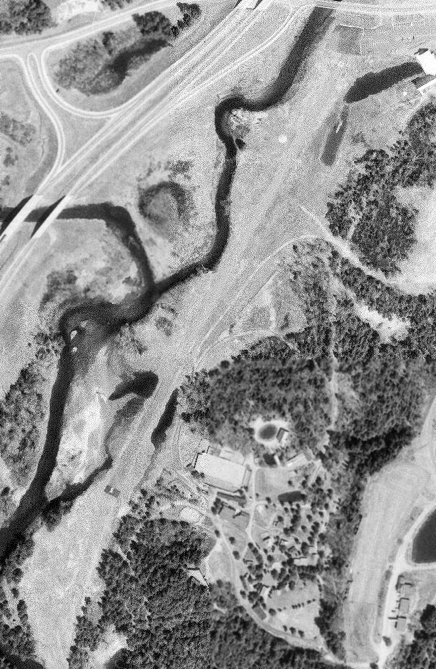
A 1995 USGS aerial view looking northwest depicted Frontier Town Airpark as having a paved northeast/southwest runway, which remained intact though deteriorated.
In 2017, plans were announced for redevelopment of some portion of the abandoned Frontier Town theme park property,
but it is unknown if this included the former airfield.
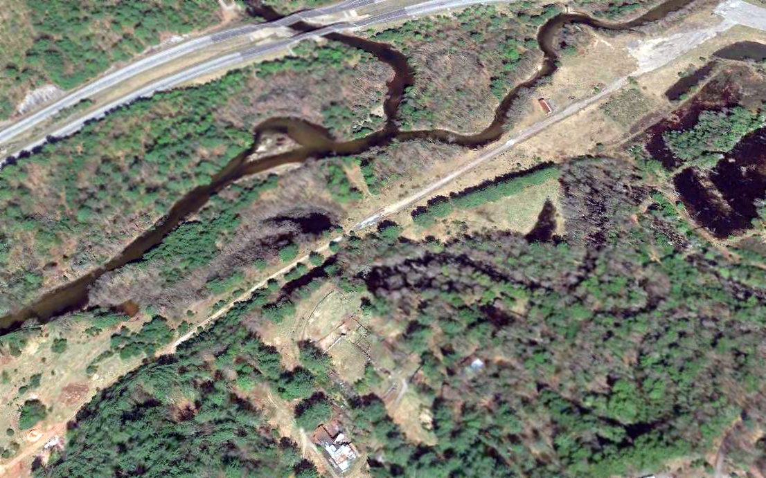
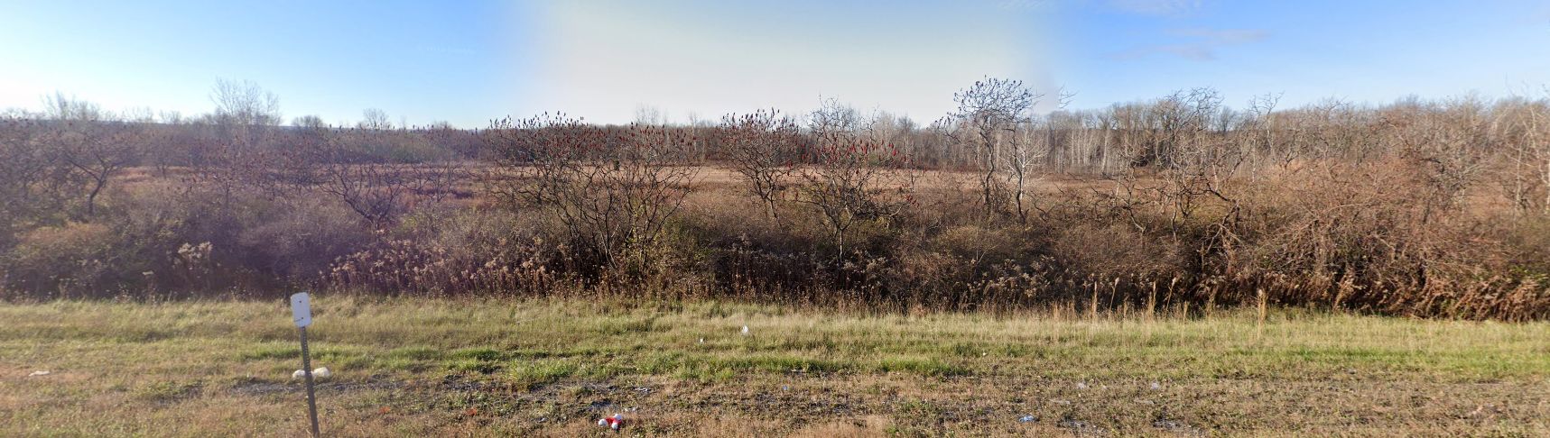
A 2018 aerial view looking northwest at Frontier Town Airpark showed the runway remained but significantly deteriorated.
A 2022 photo looking southwest along the remains of the Frontier Town Airpark runway.
Thanks to Robert Cook for pointing out this airfield.
____________________________________________________
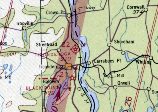
Ticonderoga Intermediate Field / (Original) Ticonderoga Airport, Ticonderoga, NY
43.89, -73.4 (Northeast of Albany, NY)
Ticonderoga Intermediate Field, as depicted on the September 1940 Albany Sectional Chart.
The Ticonderoga Intermediate Field was not yet listed among active airfields
in The Airport Directory Company's 1937 Airports Directory (courtesy of Bob Rambo),
nor depicted on the January 1940 Albany Sectional Chart.
The earliest depiction which has been located of Ticonderoga Intermediate Field was on the September 1940 Albany Sectional Chart.
It depicted Ticonderoga as Site 22 along the Commerce Department Airway.
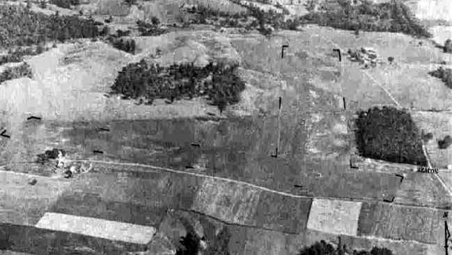
The earliest photo which has been located of Ticonderoga Intermediate Field
was an 8/26/42 aerial view looking north from the 1945 AAF Airfield Directory (courtesy of Ernie Tobin).
A 10/13/42 USGS aerial view showed Ticonderoga Intermediate Field to have 2 grass runways with an airport circle marking at the intersection,
and some small buildings northeast of the runway intersection.
There were no aircraft visible on the field.
Ticonderoga Intermediate Field was listed in the 1944 Army/Navy Airfield Directory (according to Ernie Tobin)
and depicted on the 1944 & 1945 Albany Sectional Charts (according to Ernie Tobin).
The 1945 AAF Airfield Directory (courtesy of Ernie Tobin) described Ticonderoga Intermediate Field
as a 23 acre L-shaped property having 2 sod runways oriented in an L-shape,
measuring 3,200' west-northwest/east-southeast & 2,900' north-northwest/south-southeast.
The field was said to have 2 wood & metal hangars, the largest being 40' x 25'.
Ticonderoga was described as being operated by the Civil Aeronautics Administration & owned by private interests.
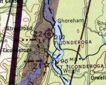
The May 1945 Albany Sectional Chart depicted Ticonderoga Airport as also having CAA Airway Beacon #22.
Ticonderoga Intermediate Field was listed in the 1947 Haire Airport Directory (according to Ernie Tobin).
A 1947 aerial photo depicted Ticonderoga in the same manner as the 1942 photo.
Ticonderoga Intermediate Field was listed in the 1948 Haire Airport Directory (according to Ernie Tobin),
and was depicted on the 1949 Albany Sectional Chart (according to Ernie Tobin).
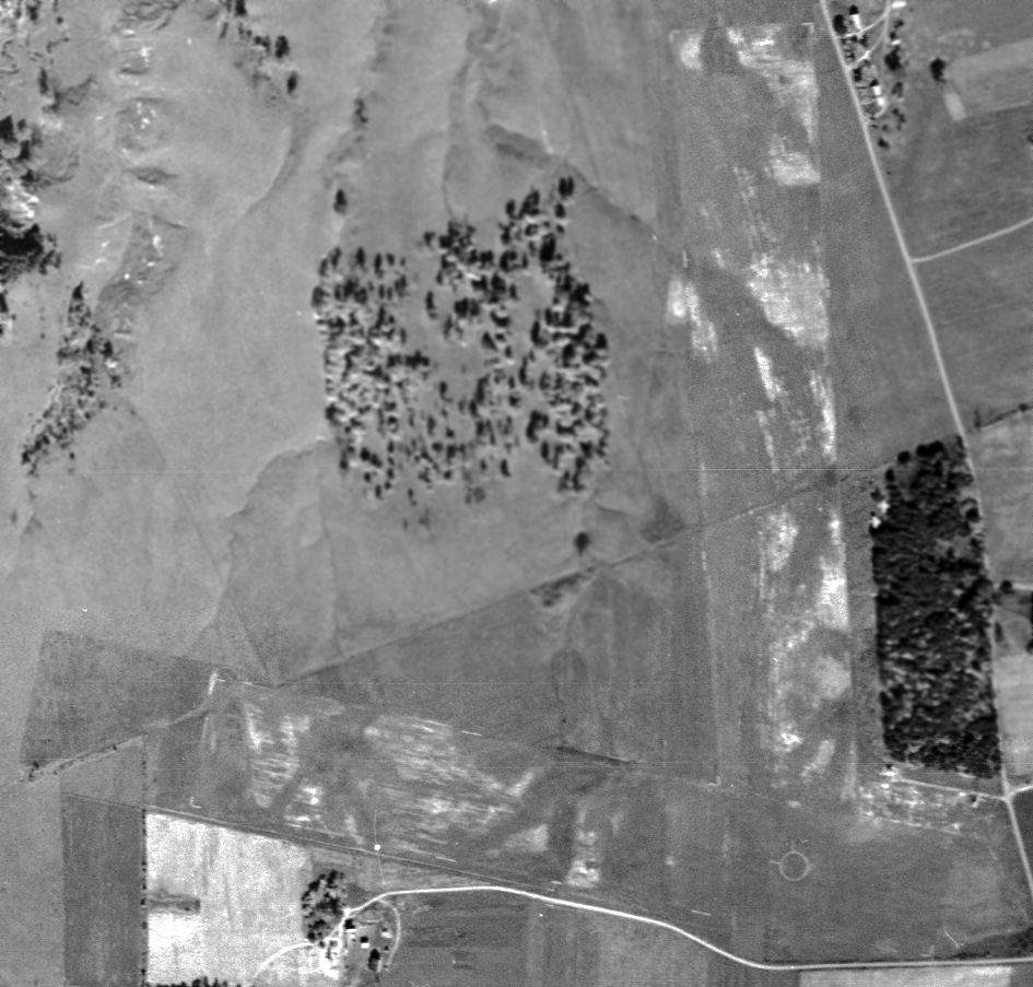
The 1950 USGS topo map depicted Ticonderoga Airport as having 2 unpaved runways & 2 small buildings northeast of the runway intersection.
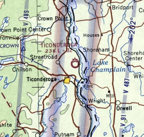
The last aeronautical chart depiction which has been located of the original Ticonderoga Airport was on the July 1965 Albany Sectional Chart.
It depicted Ticonderoga Airport as having a 3,200' unpaved runway.
According to Ernie Tobin, the original Ticonderoga Airport operated “until the mid-1960s when the airport was sold to a paper company for a new mill.”
No airport in Ticonderoga was depicted on the February 1970 Albany Sectional Chart.
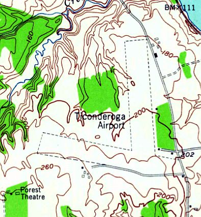
The new Ticonderoga Municipal Airport opened just a mile to the southeast in October 1978, with a paved runway.
A 1994 USGS aerial photo showed that Shore Airport Road had been built
through the center of the original Ticonderoga Airport property at some point between the 1960s-1994.
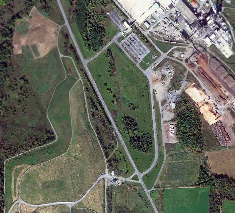
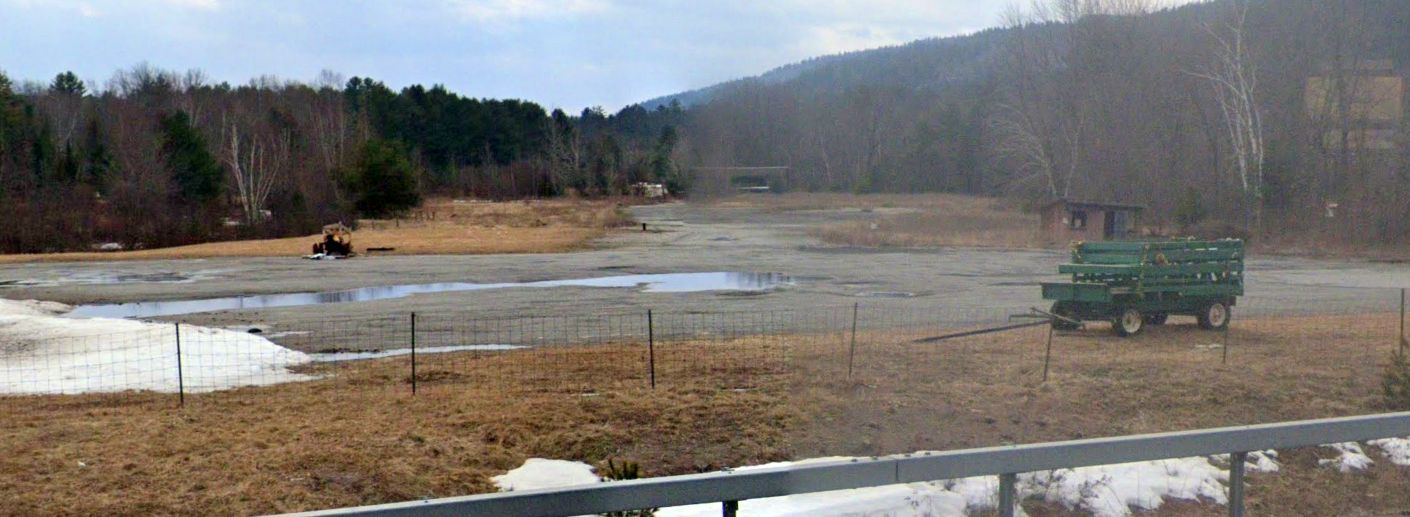
A 10/8/11 aerial view showed the faintest traces of the outline of the 2 Ticonderoga grass runways.
![]()
A circa 2010 aerial view looking north at the historic circa 1942 airport beacon on the east side of the site of Ticonderoga Intermediate Field.
Ernie Tobin observed in 2013, “The only thing remaining on site is the old beacon light, but pieces of the old grass runways can still be seen from the air.
The beacon is one of my aviation causes.
It would be great to do something with it at the current airfield,
however the cost of dismantling, transporting, and restoration would be much more than one man could do.”
The site of Ticonderoga Intermediate Field is located east of the intersection of Adirondack Park Preserve & Shore Airport Road, appropriately enough.
____________________________________________________
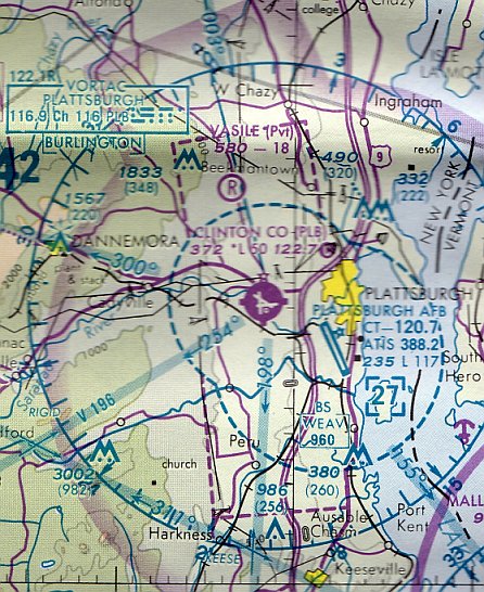
Plattsburgh Municipal Airport / Clinton County Airport, Plattsburgh, NY
44.69, -73.52 (Northeast of Albany, NY)
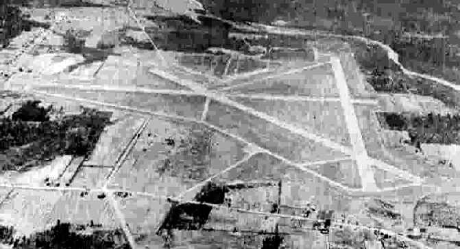
A circa 1943-45 aerial view looking north at Plattsburgh Municipal Airport, from the 1945 AAF Airfield Directory (courtesy of Scott Murdock).
No airfield was yet depicted at this location on the 1943 USGS topo map.
According to its FAA Airport/Facility Directory data, Plattsburgh Municipal Airport / Clinton County Airport was established in 1943.
The earliest depiction which has been located of Plattsburgh Municipal Airport
was a circa 1943-45 aerial view looking north from the 1945 AAF Airfield Directory (courtesy of Scott Murdock).
It depicted the field as having 3 paved runways, taxiways, and a ramp on the north side.
Plattsburgh Municipal Airport was not yet depicted on the January 1944 Burlington Sectional Chart.
The earliest aeronautical chart depiction which has been located of Plattsburgh Municipal Airport was on the June 1944 Burlington Sectional Chart.
It depicted Plattsburgh as an auxiliary airfield.
The 1945 AAF Airfield Directory (courtesy of Scott Murdock) described Plattsburgh Municipal Airport
as a 1,120 acre irregularly-shaped property having 3 asphalt 5,000 runways.
The field was said to have a single 60' x 52' wooden hangar under construction, and to be owned by the City of Plattsburgh.
A 5/14/46 aerial view looking northwest at Clinton County Airport
showed the field to have 3 paved runways, taxiways, and 2 small buildings on the north side.
The 1957 USGS topo map depicted the Plattsburgh Municipal Airport as having 3 runways, taxiways,
and a small ramp with several small buildings & a beacon on the north side.
The April 1964 Burlington Sectional Chart depicted Plattsburgh Municipal Airport as having a 5,000' runway.
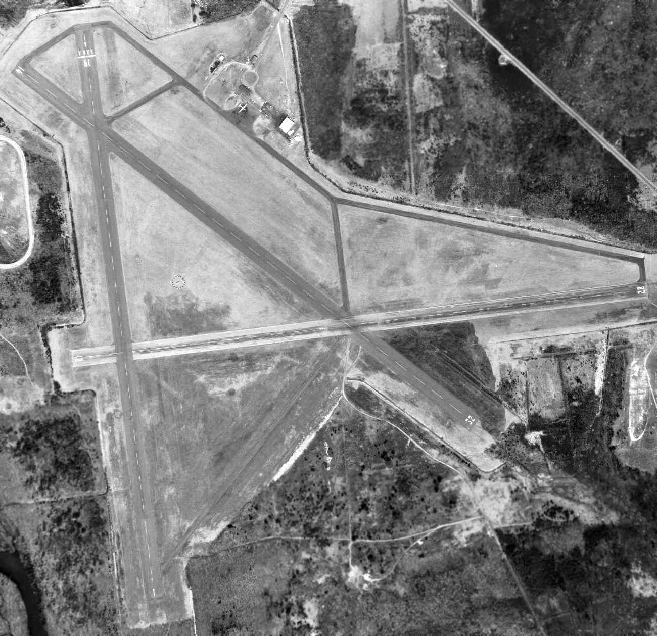
A 4/19/64 USGS aerial view of Plattsburgh Municipal Airport.
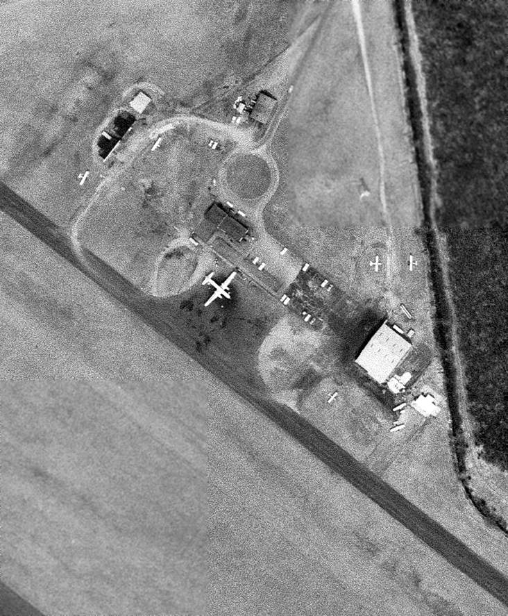
A closeup from the 4/19/64 USGS aerial photo depicted 7 aircraft on Plattsburgh's north ramp, including 6 single-engine aircraft & 1 larger twin-engine airliner (a Convair?).
The November 1966 Burlington Sectional Chart (courtesy of John Price)
depicted Plattsburgh Municipal Airport as having 3 paved runways, with the longest being 5,000'.
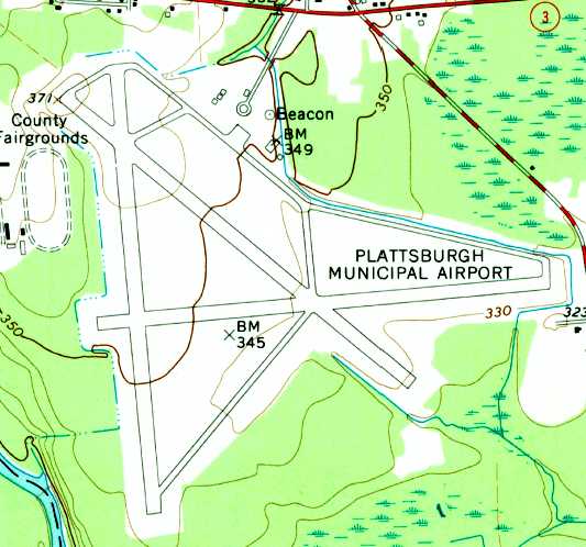
The 1966 USGS topo map depicted the Plattsburgh Municipal Airport as having 3 paved runways, taxiways,
and a small ramp with several small buildings & a beacon on the north side.
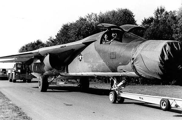
Perhaps the most infamous episode in the history of Clinton County Airport:
A 1972 photo of the partially-disassembled Strategic Air Command FB-111 supersonic nuclear bomber being towed away from Clinton County Airport,
after mistakenly landing at the relatively small civilian airport after mistaking it for the nearby Plattsburgh AFB.
H. Van Acker recalled, “[I] took most of my lessons at Flying Nunn's Aviation located at the former county airport, less than a mile west of the base [Plattsburgh AFB].
We used to get permission to overfly the centerline of the base runway when heading east.”
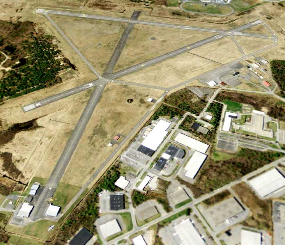
The last aeronautical chart depiction which has been located of Clinton County Airport was on the 1994 Montreal Sectional Chart.
It depicted Clinton County Airport as having 3 paved runways, with the longest being 5,000'.
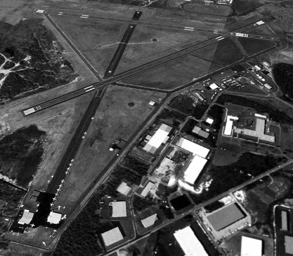
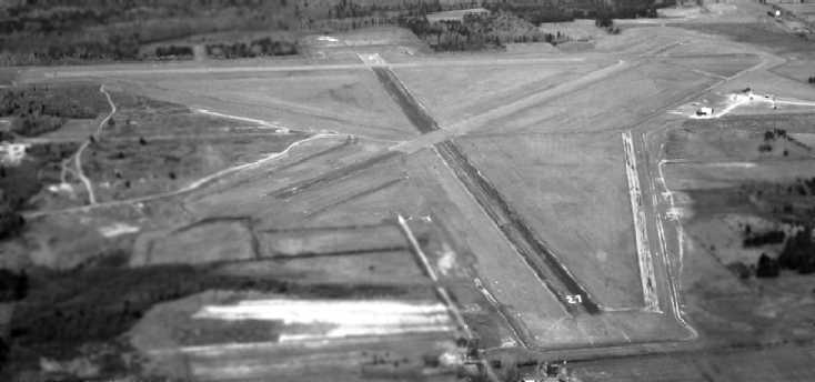
A 5/7/95 aerial view looking southwest at Clinton County Airport showed a well-used facility with numerous based aircraft,
including at least 2 vintage DC-3s among the many aircraft parked at the lower-left at the end of the former Runway 27.
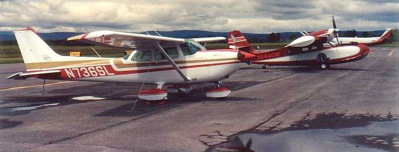
A 6/20/96 photo of N736SL (a 1977 Cessna R172K Hawk XP, C/N: R1722752) & a Grumman Goose amphibian at Clinton County Airport.
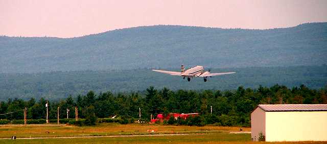
A 7/7/06 photo of a 1940s DC-3 departing from Clinton County Airport.

An undated (circa 2000s?) NY DOT directory entry depicted Clinton County Airport
as having 2 paved runways, with the former Runway 9/27 being closed.
During its last year of operation, the FAA Airport/Facility Directory described Clinton County Airport as having a total of 30 based aircraft,
and conducting an average of 39 takeoffs or landings per day.
The manager was listed as Rodney Brown.
Clinton County transitioned to using the nearby Plattsburgh International Airport (the former Plattsburgh AFB) as the primary airport for the region on 6/18/07,
and Clinton County Airport was closed to itinerant aircraft, though it continued to be used for paradrops, and a few aircraft were still based there.
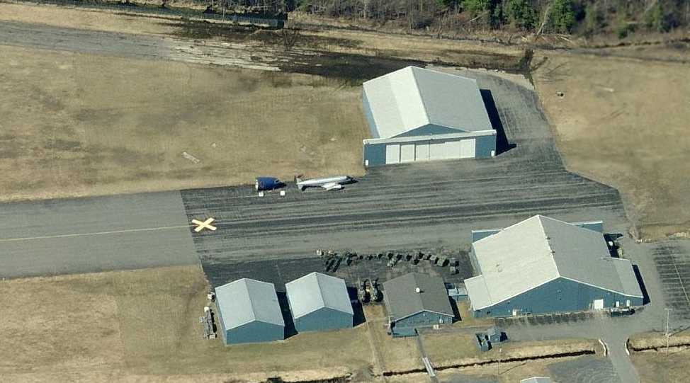
A circa 2007-2011 aerial view looking north at the east end of the former Runway 27,
showing a wingless DC-3 fuselage & the cockpit of a larger aircraft, which appear to be the last aircraft remaining at the former Clinton County Airport.
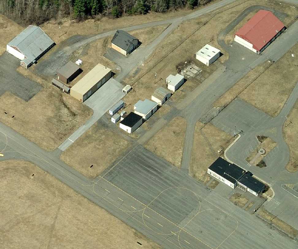
A circa 2007-2011 aerial view looking north at the hangars on the north side of the former Clinton County Airport.
A 5/27/11 aerial view looking southwest at Clinton County Airport showed only a single aircraft remaining on the entire field:
a vintage DC-3 at the bottom-left.
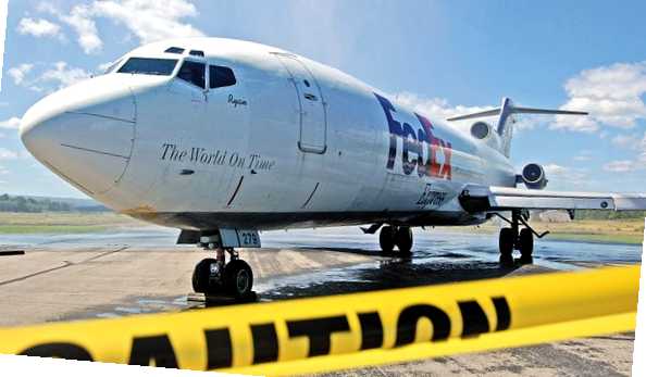
An 8/18/11 photo of what is evidently the last aircraft to land at the former Clinton County Airport:
a retired Federal Express 727 which was brought into the field to be donated to the Plattsburgh Aeronautical Institute.
An article entitled “Donated FedEx jet lands in Plattsburgh” by Dan Heath in the Press-Republican described the donation:
“A FedEx Boeing 727 made what might be the last landing at the former Clinton County Airport.
A gift to Plattsburgh Aeronautical Institute, the aircraft first made one approach & fly-over, then circled to the right before making a smooth landing.
It taxied to the Aeronautical Institute, where it rolled under a water arch created by 2 water cannons on Morrisonville Fire Department trucks.
Jim McCartney III, principal of the CV-TEC satellite campus that houses the institute there & other programs, said that is the traditional way aircraft are retired from service.
The Boeing 727 is the latest of more than 50 FedEx has given away since it started its Aircraft Donation Program in 1995,
said FedEx Managing Director of Aircraft Acquisitions & Sales David Sutton.
U.S. Representative Bill Owens & Senators Charles Schumer & Kirsten Gillibrand helped support getting the donation this summer,
as it was unknown how long the closed airport might be available for such landings.”
As of 2012, the status of Clinton County Airport was listed as “Closed permanently”.
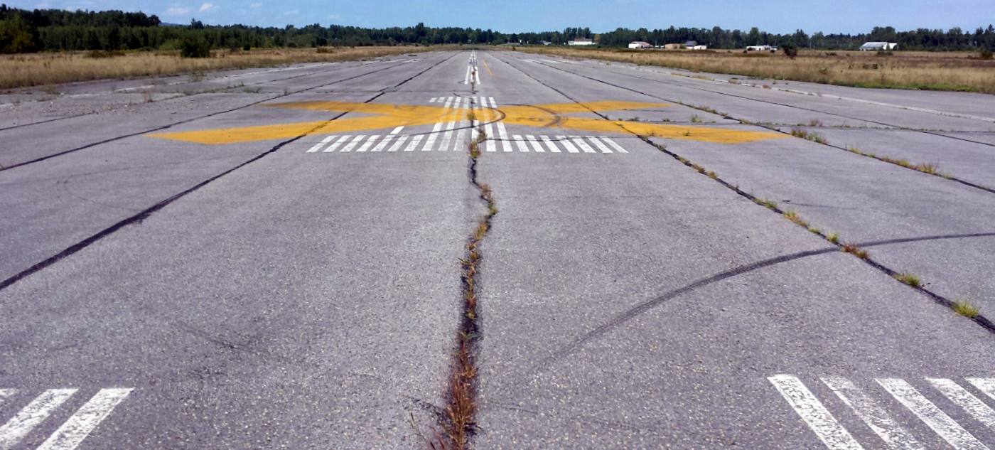
An 8/25/15 photo by Ron Plante looking North along the former Clinton County Airport Runway 1.
Ron reported, “Except for Plattsburgh Aeronautical Institute (PAI) at the eastern corner, there is zero activity, the runways are unused.
The land is owned by the county, which plans to convert it into an industrial park.”
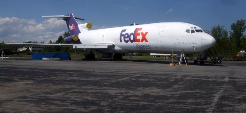
An 8/25/15 photo by Ron Plante of the last aircraft to land at the former Clinton County Airport:
a retired Federal Express 727 which was brought into the field to be donated to the Plattsburgh Aeronautical Institute.
Ron reported, “Plattsburgh Aeronautical Institute has numerous aircraft outside and inside, largest is the FedEx 727 N279FE.
I also spotted several Hueys, a Fouga CM-170, and a T-39 in Navy markings. ”
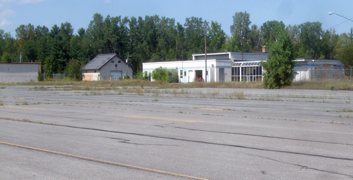
An 8/25/15 photo by Ron Plante of abandoned hangars & the terminal of the former Clinton County Airport.
Ron reported, “The terminal building & hangars are empty.”
An 8/25/15 photo by Ron Plante of the entrance to the abandoned Clinton County Airport terminal.
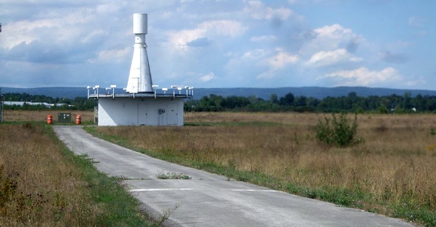
An 8/25/15 photo by Ron Plante of the PLB VORTAC at the former Clinton County Airport.
Ron reported, “AirNav shows the VORTAC operational as PLB, but there’s no sign or fence.”
The site of Clinton County Airport is located at the southwest terminus of Airport Entrance Road.
____________________________________________________
Utica Municipal Airport, Marcy, NY
43.17, -75.32 (East of Syracuse, NY)
Utica Municipal Airport, as depicted on a 1929 "Rand-McNally Standard Map of NY with Air Trails" (courtesy of Chris Kennedy).
The Utica Municpal Airport was dedicated 6/1/28, according to a historical plaque on the site of the airport.
The earliest depiction which has been located of Utica Memorial Airport
was on a 1929 "Rand-McNally Standard Map of NY with Air Trails" (courtesy of Chris Kennedy).
It described Utica Municipal as having a 3,000' x 3,920' field.
Scott Primiano reported, “My grandfather owned & operated 'Utica Skyways' with 2 Model 2T-1A Great Lakes Sports Trainers in 1929-30.”
Presumably, this firm operated from the Utica Airport.
The earliest aeronautical chart depiction which has been located of Utica Airport was on the June 1933 Albany Sectional Chart.
The earliest photo which has been located of Utica Municipal Airport
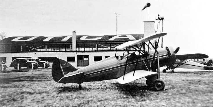
was a 1935 view of a Waco QCF-2 biplane in front of the main hangar with UTICA painted on the roof.
Gloria Santucci, one of the area's first woman pilots & the first licensed to carry passengers, was a longtime instructor at Utica Airport.
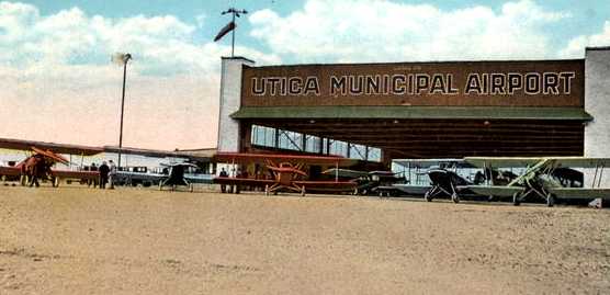
An undated colorized postcard photo depicted a group of biplanes in front of a hangar marked “Utica Municipal Airport”.
An undated aerial view looking west from The Airport Directory Company's 1937 Airports Directory (courtesy of Bob Rambo)
depicted Utica Municipal Airport as having a single hangar, which had "Utica" painted on the roof.
The directory described Utica Municipal Airport as having a total of 4 sod runways, the longest being a 3,300' northwest/southeast strip.
A 5/4/41 USGS aerial view depicted Utica Municipal Airport as having a single hangar, which had "Utica" painted on the roof, on the west side of a grass airfield, with an airport circle marking in the center.
A total of 8 light aircraft were seen parked around the hangar.
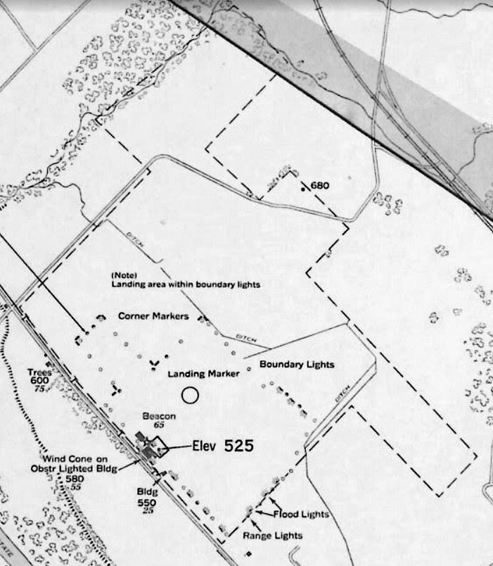
A May 1944 approach plate (courtesy of Michael McConnell) depicted Utica Municipal Airport as having an irregularly-shaped property outline, with several buildings along the southwest edge of the property.
The last photo which has been located of Utica Municipal Airport was a circa 1942-45 aerial view looking north
from the 1945 AAF Airfield Directory (courtesy of Scott Murdock).
It depicted Utica as an open grass area with a hangar on the south side.
The 1945 AAF Airfield Directory (courtesy of Scott Murdock) described Utica Municipal Airport
as a 355 acre irregularly-shaped property having a sod all-way landing area, with the longest dimension being 3,100' northwest/southeast.
The field was said to have 2 hangars, the largest being a 120' square brick structure.
Utica Municipal Airport was described as being owned by the City of Utica & operated by private interests.
The 1947 USGS topo map depicted Utica Municipal Airport with an outline of the property,
with several buildings (hangars?) & a beacon depicted along the southwest edge of the property.
The June 1953 Hudson River World Aeronautical Chart (courtesy of Chris Kennedy) depicted Utica as having a 3,100' unpaved runway.
The November 1956 Albany Sectional Chart (courtesy of Chris Kennedy) described Utica as having a 3,100' "all-way" turf landing area.
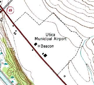
Utica Municipal Airport was still depicted on the 1955 USGS topo map,
with an outline of the property, several buildings (hangars?), and a beacon depicted.
A 1957 aerial view depicted 8 light single-engine aircraft parked near 2 hangars on the southwest side of Utica Municipal Airport.
Jim Stanton recalled, “Regarding the original Utica Municipal Airport, I took my private pilot flight test there in spring of 1958.
I think it was open for a while after that.”
The last aeronautical chart depiction of Utica Airport which has been located was on the May 1960 Albany Sectional Chart.
It described Utica as having a 3,100' unpaved runway.
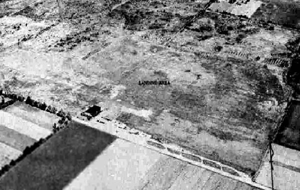
The last photo which has been located showing Utica Municipal Airport still intact was a 5/4/60 USGS aerial view.
But the airport may have already been closed by this point, as there were no aircraft visible on the field, which otherwise remained unchanged.
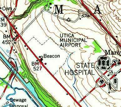
Utica Municipal Airport was apparently closed at some point between 1958-62,
as it was no longer depicted on the 1962 Albany Sectional Chart (courtesy of Mike Keefe),
nor listed among active airfields in the 1962 AOPA Airport Directory.
Keith Hunt recalled that the Utica Municipal Airport property was used to fly radio-controlled model aircraft in the 1960s.
A historical plaque was erected on the site of Utica Municipal Airport in 1993, on the occasion of the 69th anniversary of the airport's dedication.
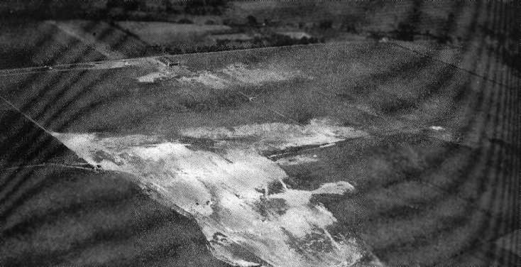
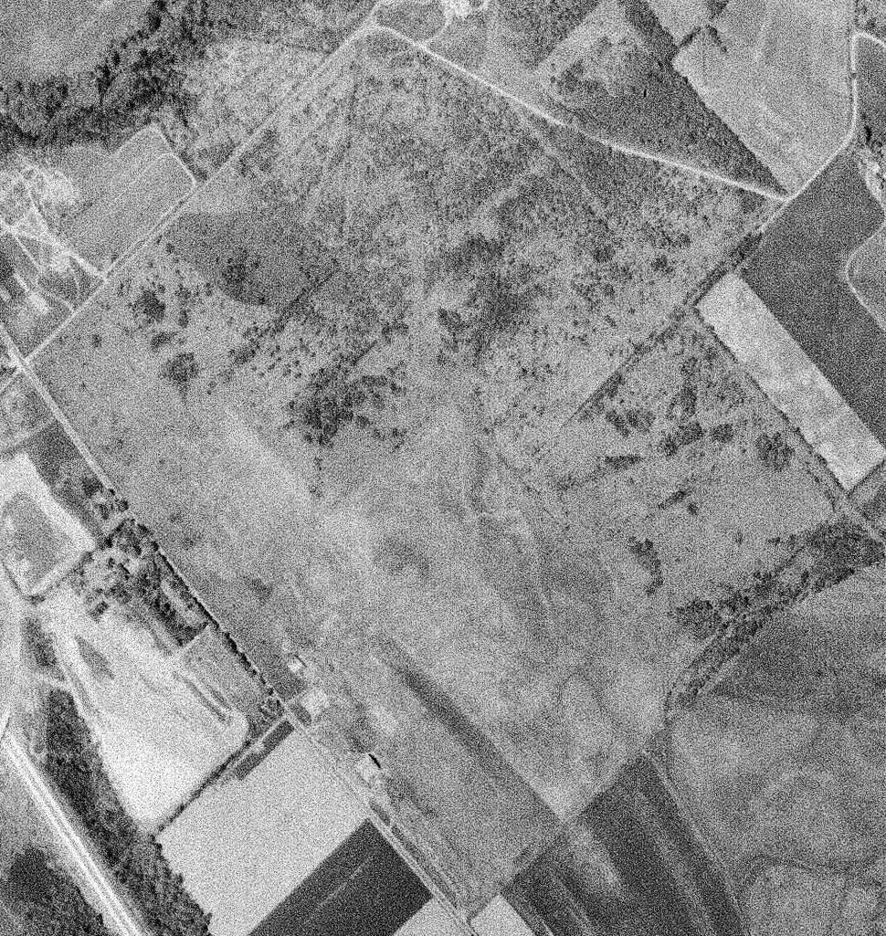
A 1997 USGS aerial photo showed that the entire site of Utica Municipal Airport had been obliterated with the construction of a Wal-Mart distribution center,
with not a trace of the former airfield remaining.
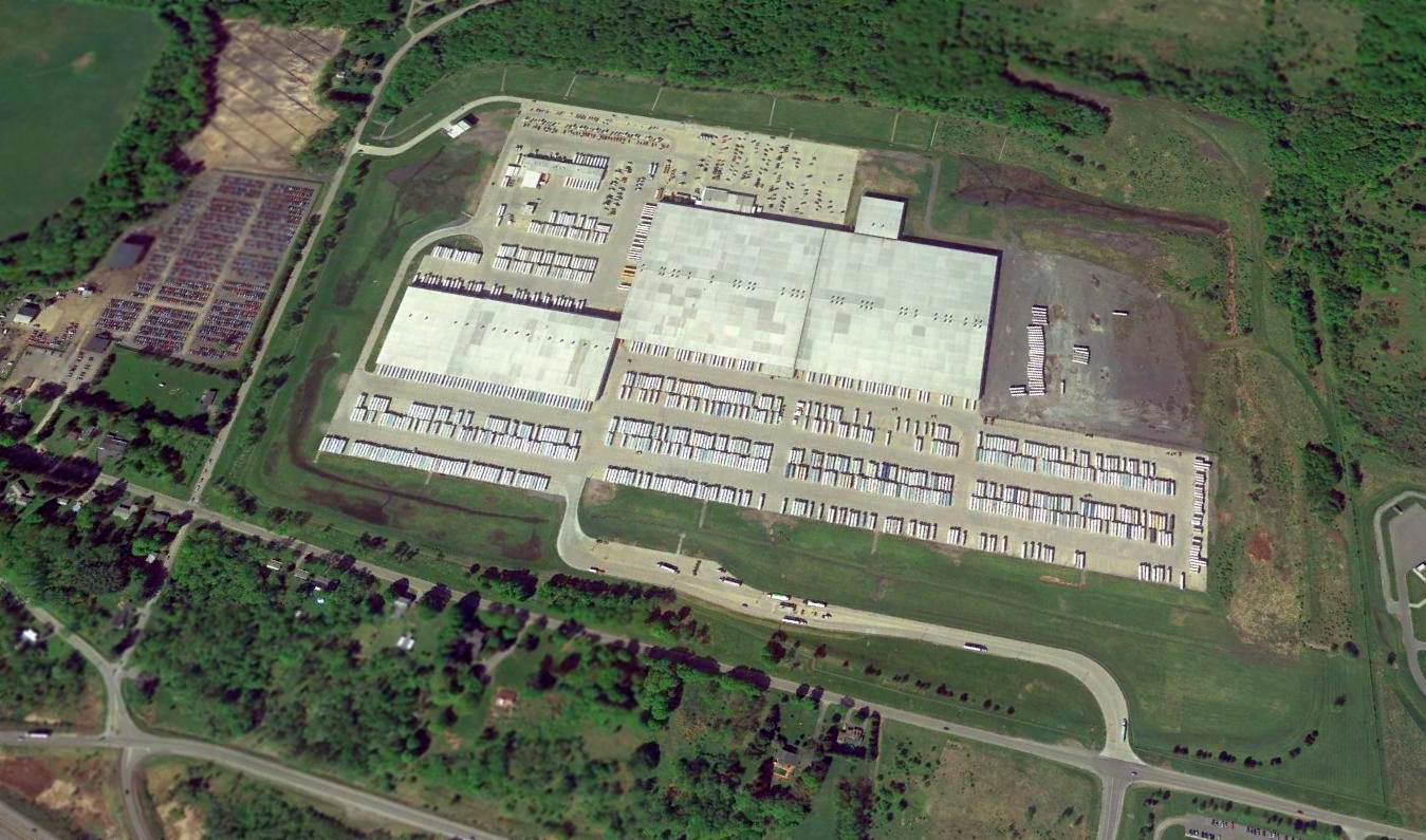
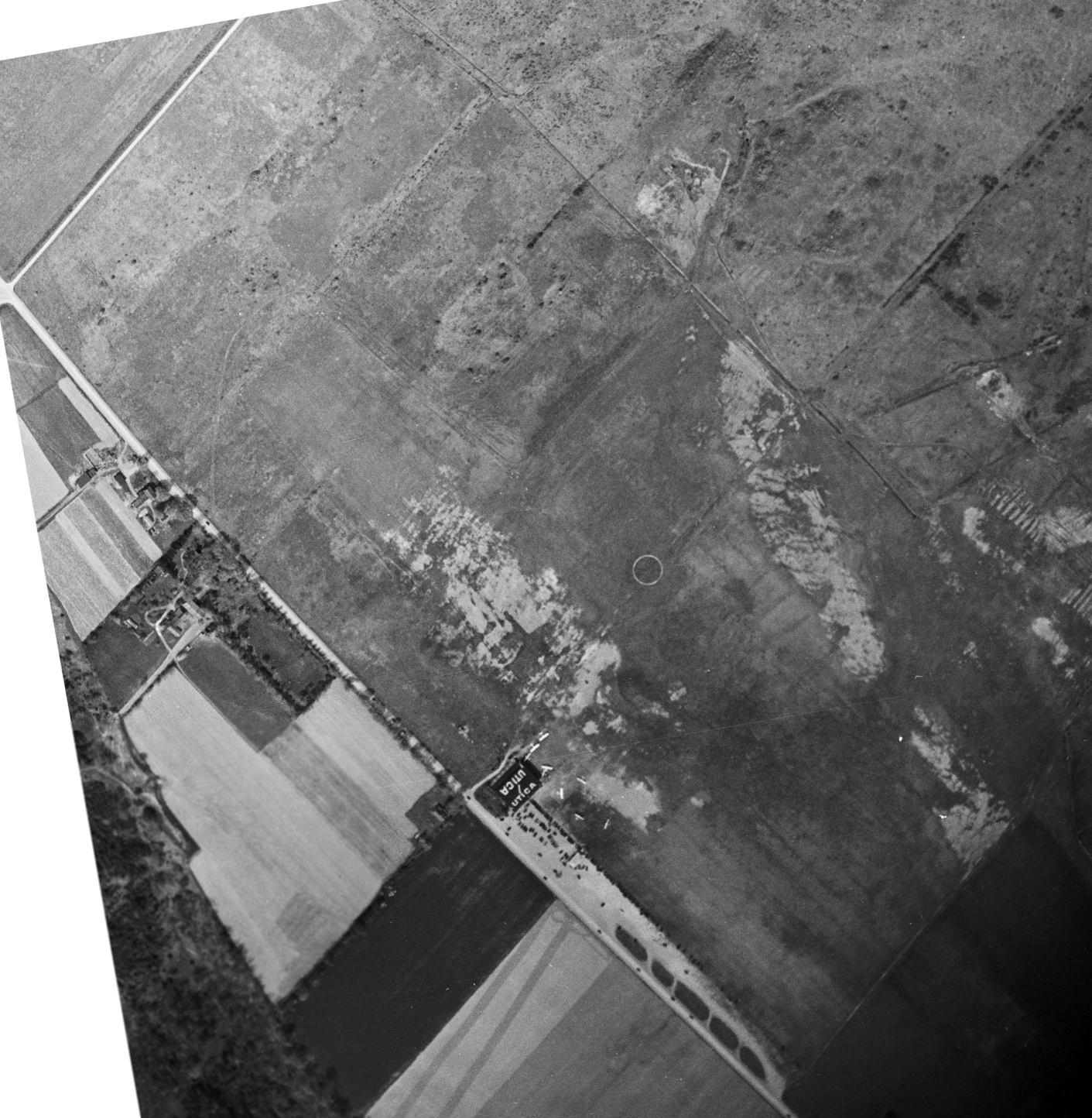
A 2015 aerial view looking northeast shows no trace remaining of the Utica Municipal Airport.
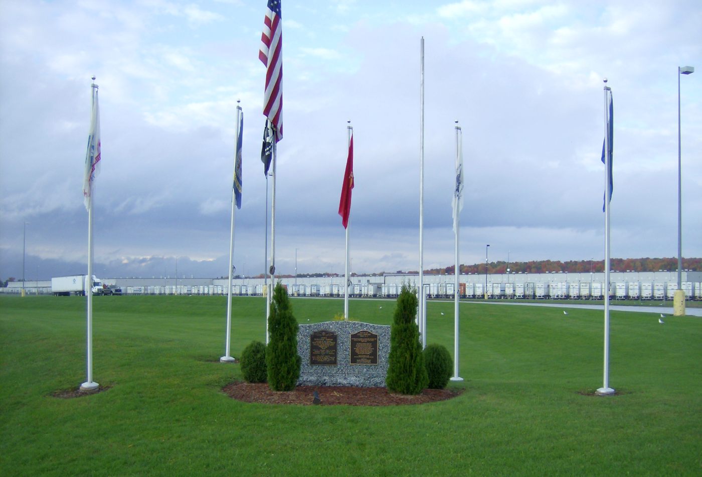
A 2015 photo by Andy Frank of a historical plaque on the site of Utica Municipal Airport.
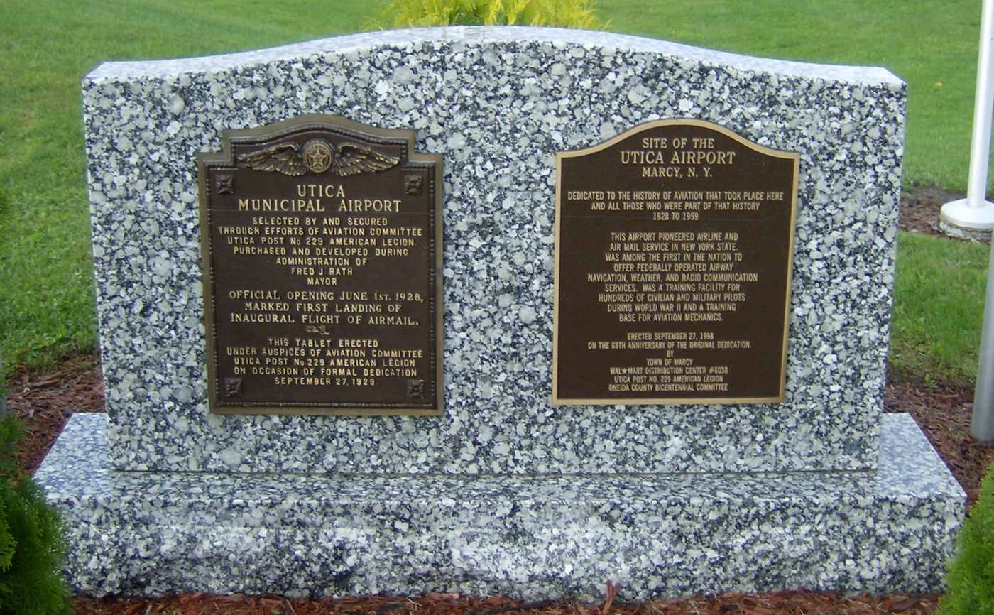
A 2015 closeup by Andy Frank of a historical plaque on the site of Utica Municipal Airport.
The site of Utica Memorial Airport is located east of the intersection of Old River Road & Chaminade Road, across the Erie Canal from Utica.
____________________________________________________
Riverside Airport (4B2), Utica, NY
43.13, -75.27 (East of Syracuse, NY)
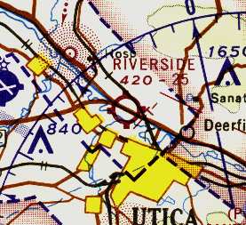
Riverside Airport, as depicted on the 1967 Albany Sectional Chart (courtesy of Mike Keefe).
This small general aviation airport was located only 3 miles southeast of the site of the former Utica Municipal Airport.
Riverside Airport was apparently built between 1965-66, as it was yet depicted on the July 1965 Albany Sectional Chart.
The earliest reference to Riverside Airport which has been located came from Judy Lust,
who recalled, “Riverside... I took lessons there when I was 18 [1966]. My father flew out of there also.
He had his license for years, but studied with me. His name is Leon Lust. He knew the Ground School teacher, Gloria Santucci.
My Flight Instructor was Al Waskiewicz. Al or somebody else owned a WWII Navy trainer, an SNJ.
It was a nice little airport. The school was accredited, I think, but I'm not sure.
They were aiming for that if it was not yet accredited. I think it was a one year course in aircraft mechanics.
The guys used to get on the radio telephone & say things like, 'Better move out of the way. A 747 is coming in.'
Gloria would get a little riled up & say, 'We'll lose our license if you keep that up!' It was all really fun to listen to!
Riverside was a great airport & I'm sure it's missed. One of the men who hung out there used to be a flight instructor.
Before that, he was a wing walker. His name was Sharkey.”
The earliest aeronautical chart depiction of Riverside Airport which has been located
was on the 1967 Albany Sectional Chart (courtesy of Mike Keefe).
It described Riverside Airport as having a single 2,500' gravel runway.
Riverside Airport's runway was apparently paved at some point between 1967-70,
as the February 1970 Albany Sectional depicted it as having a 2,600' paved northwest/southeast runway.
Gary Lampman recalled, “I attended the Riverside School of Aeronautics from July 1972 to July 1973, earning my A&P certificate.
The school was owned by Gordon Newell, managed by Gloria Santucci, with Pat Malara, Chief Instructor.
In those days there were a number of G.I. Bill students returning from the military & classes of 24 each quarter were the norm.
Being located at an active airstrip, there was plenty of opportunity to get hands-on experience on light aircraft.
Students could get involved in transferring floatplanes back to wheels & vice-versa each season, prepping planes for Powderpuff derby contestants & being able to view a variety of visiting planes.
Gordon Newell owned a Grumman Widgeon which several classes were installing a number of upgrades.
There was an instructor for each quarter semester who was retired from either airline, corporate or general aviation.
The school had 2 hangars, 3 classroom buildings & a wide assortment of engines, mockups & airframes, T-6, BE-18, Stearman, etc. It was an excellent education.
Riverside Airport inherited a number of aircraft from the old Utica Municipal & seemed to attract a variety of visitors.
Besides a flight office there was a very active avionics shop which drew traffic.”
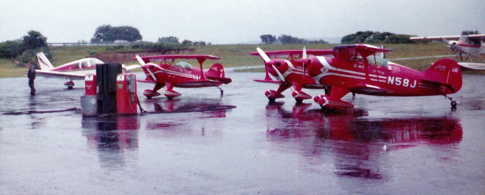
A July 1973 photo by Gary Lampman of the Pitts Specials of the Red Devils aerobatic team parked at the Riverside Airport gas pumps.
Gary recalled, “One rainy Friday afternoon there was a visit by the Red Devils aerobatic team ducking out of the weather.
Charlie Hilliard, Tom Poberezny & Gene Soucy with their S-1 Pitts Specials had to wait out the weather on way to a Boston airshow.
The embankment in the background is the NYS Thruway.”
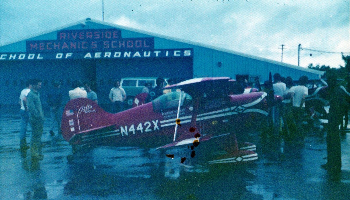
A July 1973 photo by Gary Lampman of Charlie Hilliard's Pitts parked in front of the Riverside Mechanics School of Aeronautics hangar.
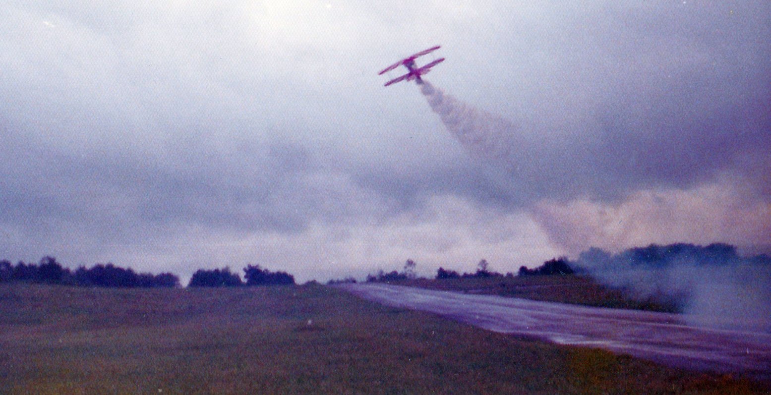
A July 1973 photo by Gary Lampman of the Pitts Specials of the Red Devils aerobatic team departing from Riverside Airport.
Gary observed, “After several hours they were able to leave, but remarked they hope they didn’t have to return to Riverside as the narrow runway disappeared under the nose of the Pitts.
Another unique aspect of the runway was the rather steep grade - the eastern third rose 10-15’. Note the rising runway in the foreground.”
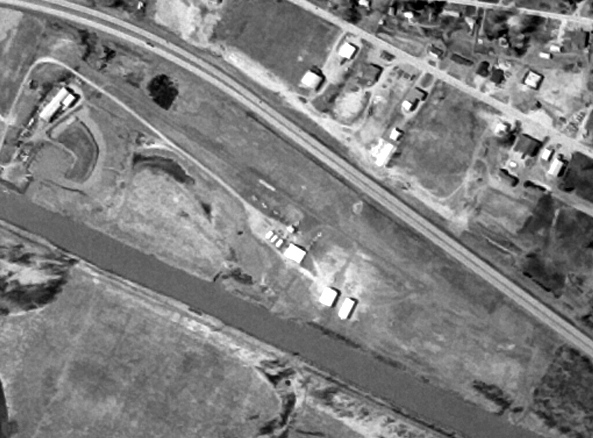
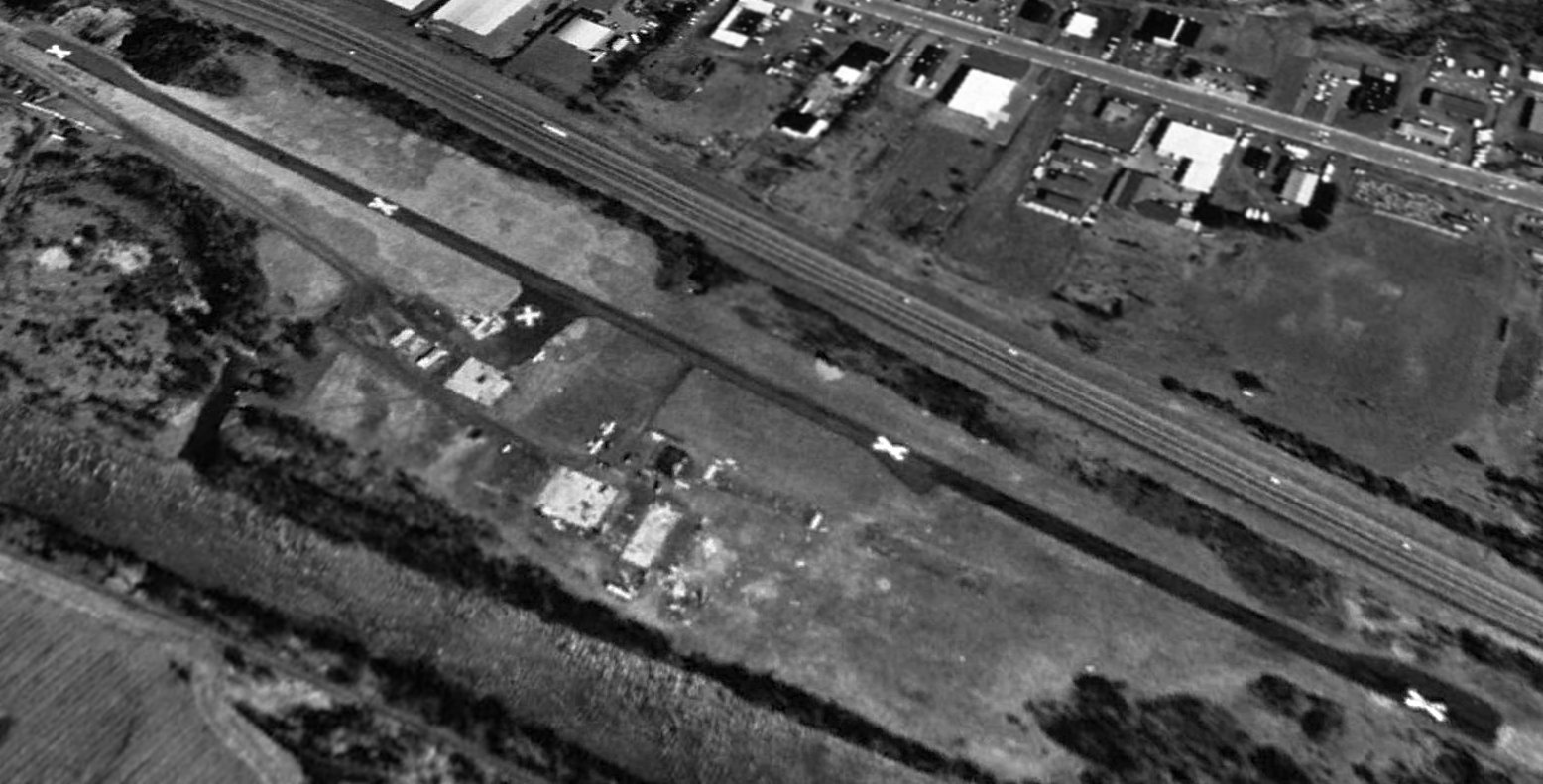
The last photo which has been located showing Riverside Airport while in operation was a 4/1/74 USGS aerial view.
It depicted a few small aircraft parked near the hangars on the south side of the runway.
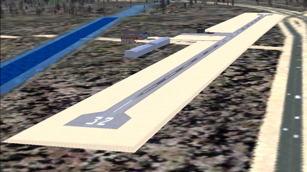
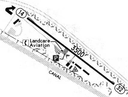
A flight simulator scenery depiction looking west at Riverside Airport.
The 1982 AOPA Airport Directory (courtesy of Ed Drury)
described Riverside Airport as having a single 3,500' asphalt Runway 14/32.
Strangely, Riverside Airport was not depicted at all on the 1985 USGS topo map.
Mark Hrutkay observed of Riverside Airport, “It was a nice place; it had a aviation mechanics school & lots of stories.
It was wedged between the Thruway & the Erie Barge Canal, so the seaplanes could take off.
Gordon Newell (who owned the airport) had a super nice Widgeon he kept there.”
Jeffrey Miller recalled, “I am an aircraft mechanic who started my training at Riverside School of Aviation in Marcy.
I started my training as an aircraft maintenance technician (A&P) there in January 1990;
in around June 1990 we were suddenly informed that the airport was sold & closing suddenly & the entire school was moving to the partially refurbished Charlestown Mall in Utica.
Sadly I remember being quite disheartened, as it seemed to many others including school staff, that the new location was not an airport!
To us the thrill of being at an airport & seeing its operation was an experience never to forget even if it was just a small airport.
Personally the best experience we students had outside on a nice day, lunch break I believe,
was when the beating of rotor blades got louder a military Bell AH-1 Cobra came in slowly out of the west on final approach.
The gunship was a thrill to see as it very slowly at approximately 15' off the runway completed its hover down the runway, did a 180 degree turn heading slowly back up the runway,
then heading back west, but at the point closest to our gathering to watch (approximately 75 yards distance) it slowed its transition
and while staying in hover stopped & rotated about 90 degrees facing the small crowd for maybe 2 minutes.
Staying in the hover facing us dead-on I remember us thinking, as we were looking down the barrels of its menacing guns, we are certainly glad we were not its targets.
I suppose the pilot was affording us a unique thrill, if i am correct in that assumption, that pilot was indeed successful.
Some names also such as Gloria Santucci, Gordy Newell, also Pat Malara.
This time in my life was the beginning of the best times of my life & career in aviation.”
The last aeronautical chart depiction which has been located of Riverside Airport was on the December 1993 NY Sectional Chart (courtesy of Ron Plante).
It depicted it as having a 3,500' paved northwest/southeast runway.
In the 1995 Jeppesen Airport Directory, the operators at Riverside Airport were listed as
Landcare Aviation, Inc. & Mark's Flight Training.
According to Mark Hrutkay, Riverside “got sold to NY Thruway commission since it was right next to the Thruway.”
Jonathan Westerling reported, "While closed, the Riverside airport is very much intact.
I visited it back in 1997. It is right next to the canal, visible from the Throughway & easily accessible.
The land is private, and there were no trespassing signs."
Riverside Airport was evidently closed (for reasons unknown) at some point between 1995-97,
as a 1997 USGS aerial view looking north showed the runway marked with closed-runway "X" symbols,
although there were still at least 2 light aircraft visible parked on the ramp.
Riverside was still depicted as an abandoned airfield on 2002 aeronautical charts.
However, Ed Hamlin reported that a 2003 aerial photo showed that “As far as Riverside is concerned,
the airport no longer exists - the runways were removed in order to construct major highway interchanges in the area.
There is nothing there next to the marina anymore. There is no sign that there ever was an airport there.”
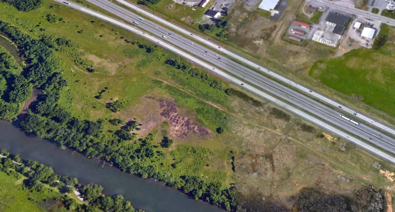
A 2016 aerial view looking north at the site of Riverside Airport showed a dramatic difference compared to the 1997 aerial photo.
All of the airport buildings & runway pavement had been removed, with only the slightest traces of the ramp pavement remaining.
Another grassroots American airport completely removed from existence.
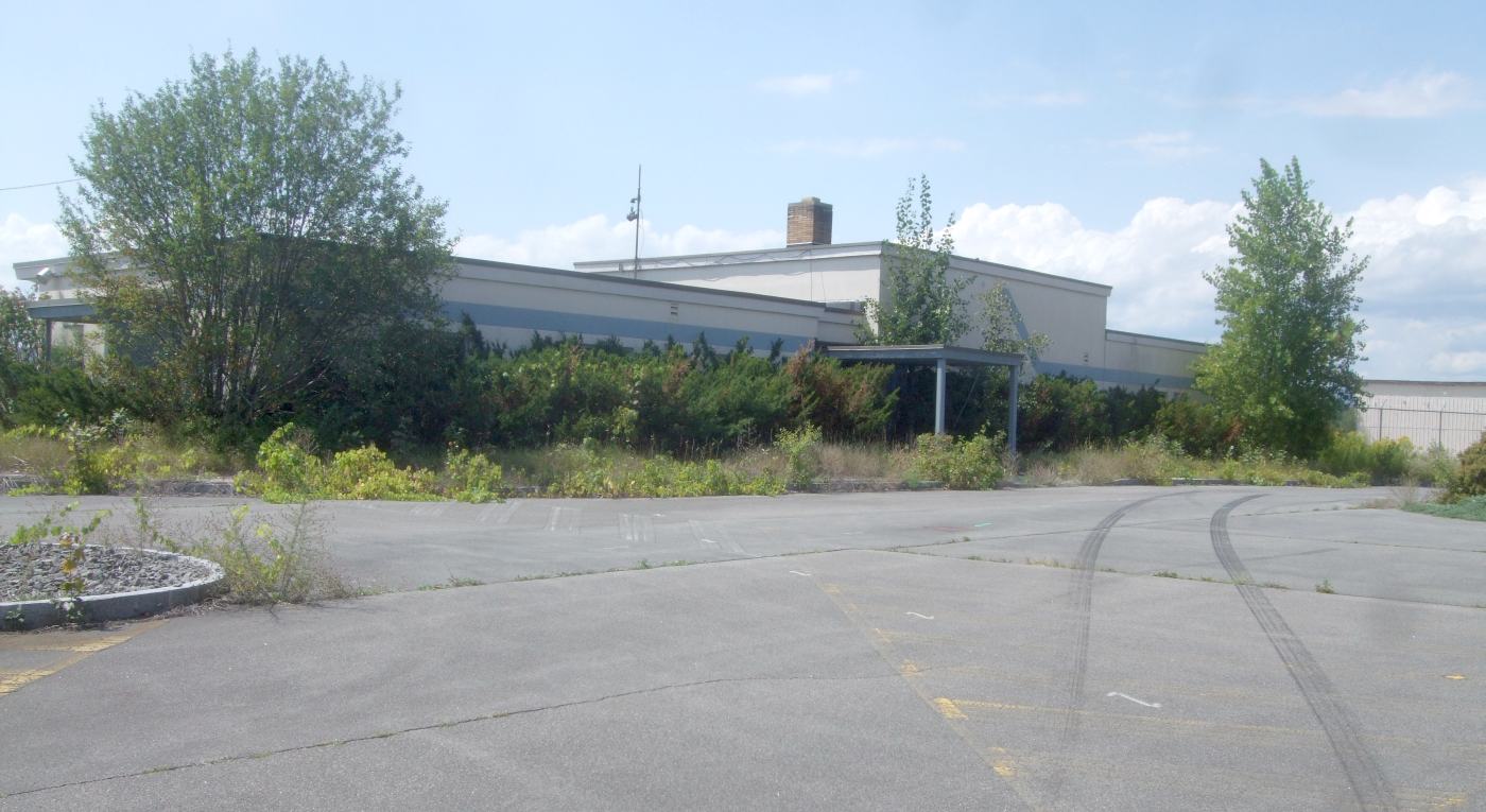
A 2022 photo looking southwest showed no trace of Riverside Airport.
The site of Riverside Airport is located south of Interstate 90 & north of the Erie Canal, northwest of Route 8.
____________________________________________________
Since this site was first put on the web in 1999, its popularity has grown tremendously.
If the total quantity of material on this site is to continue to grow,
it will require ever-increasing funding to pay its expenses.
Therefore, I request financial contributions from site visitors,
to help defray the increasing costs of the site
and ensure that it continues to be available & to grow.
What would you pay for a good aviation magazine, or a good aviation book?
Please consider a donation of an equivalent amount, at the least.
This site is not supported by commercial advertising –
it is purely supported by donations.
If you enjoy the site, and would like to make a financial contribution,
you
may use a credit card via
![]() :
:
Please consider checking the box to make a monthly donatation.
For a mailing address to send a check, please contact me at: paulandterryfreeman@gmail.com
If you enjoy this web site, please support it with a financial contribution.
please contact me at: paulandterryfreeman@gmail.com
If you enjoy this web site, please support it with a financial contribution.
____________________________________________________
This site covers airfields in all 50 states.