Abandoned & Little-Known Airfields:
New York City, Staten Island
© 2002, © 2026 by Paul Freeman. Revised 2/21/26.
This site covers airfields in all 50 states: Click here for the site's main menu.
____________________________________________________
Please consider a financial contribution to support the continued growth & operation of this site.
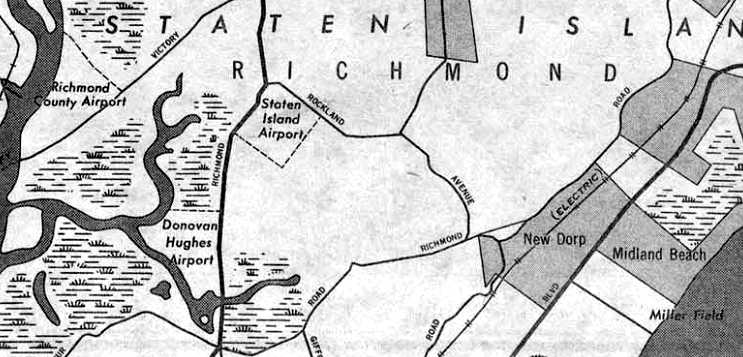
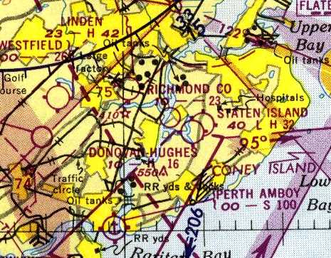
Bellanca Richmond Hill Airfield / Staten Island Airport (revised 2/21/26) - Donovan Hughes Airport (revised 7/13/20)
Miller Field / Miller AAF (revised 11/2/25) - Richmond County Airport (revised 12/29/24)
____________________________________________________
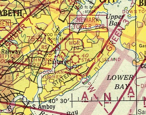
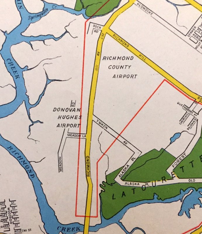
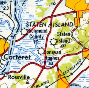
Donovan Hughes Airport, New Springville, NY
40.573, -74.17 (South of Newark Airport, NJ)
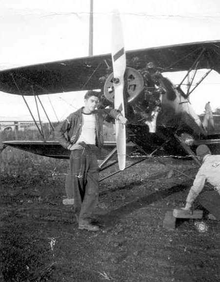
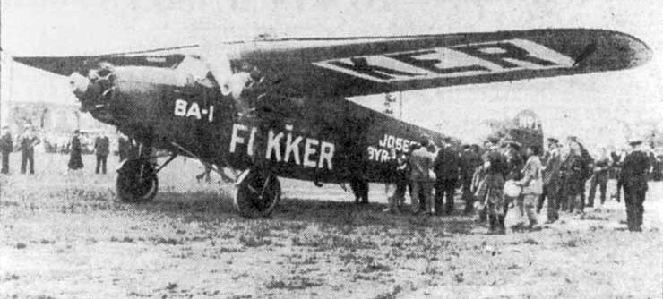
A 1928 photo of Joe Thomas' Curtis-Allison monoplane at Donovan Hughes Airport (or possibly Richmond County Airport) (courtesy of Winnie Thomas).
According to Staten Island Historian Tom Matteo,
“The first commercial airport in Greater New York, Donovan-Hughes Airport in New Springville-Greenridge, was opened by George Schaff in 1926.”
According to Ed Drury's “Staten Island: The Other Cradle of Aviation”, “George Schaaf founded Richmond Airways in 1926.
It later became Donovan-Hughes Airport. The airport was on the western side of Richmond Avenue.
It had a single north/south gravel/turf runway & several hangars.
There was a seaplane base in the Fresh Kills adjacent to the airport.
The seaplane base was considered part of the airport & was operated by Schaaf.
Schaaf operated Richmond Airways Inc. as a sightseeing & charter company.
The name Donovan-Hughes must have referred to an operator of the field at some time.
Other than the airport name, I've found no reference to either Donovan or Hughes.
Even the old-timers who flew there have no recollection.
In the late 1920s Schaaf also had a factory on the field where they built &/or converted the Richmond Airplane.”
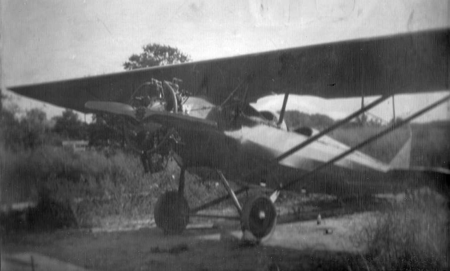
The earliest depiction which has been located of Donovan Hughes Airport was a 1928 photo of Joe Thomas' Curtis-Allison monoplane (converted from a biplane)
at Donovan Hughes Airport (or possibly Richmond County Airport) (courtesy of Winnie Thomas).
Winnie Thomas recalled, “My father, Joe Thomas was a contemporary & friend of George Schaff.
He told me about building Heath Parasols using Henderson 4 cylinder motorcycle engines.”
Donavan Hughes Airport was not yet depicted on the November 1931 NYC-Albany Air Navigation Map.
The earliest aeronautical chart depiction which has been located of Donovan Hughes Airport was on the August 1932 NY Sectional Chart.
It depicted Donovan Hughes as a commercial/municipal airport.
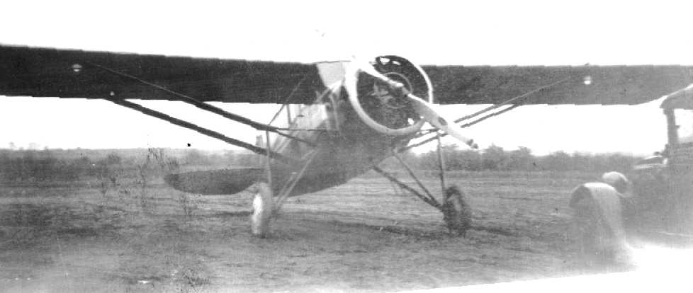
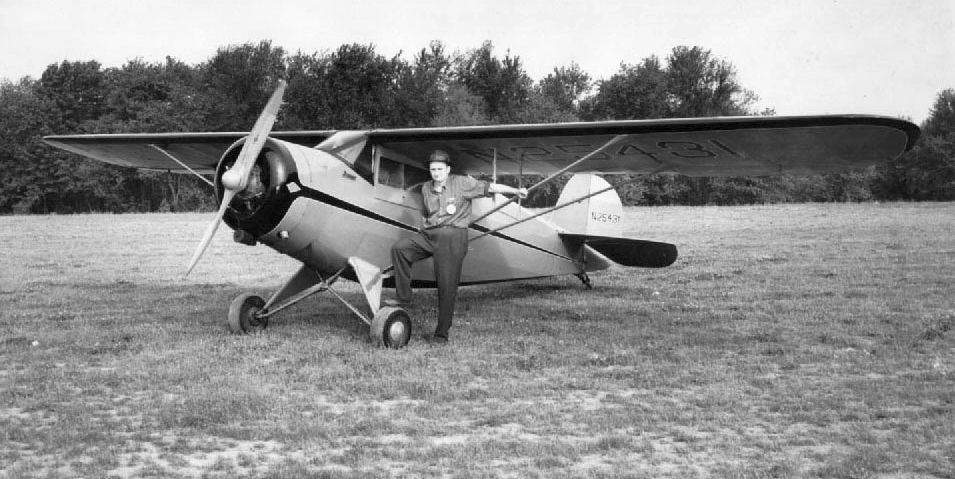
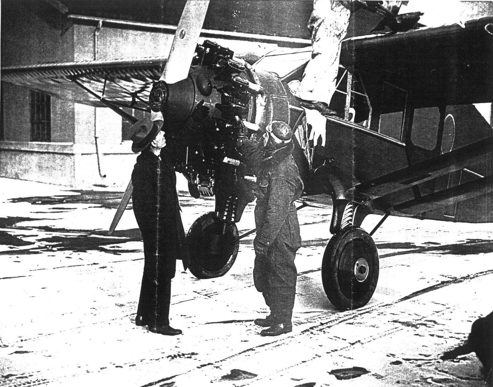
A circa 1930s photo of a rare radial-engined Fairchild at Donovan-Hughes Airport (courtesy of Ed Drury from ”Staten Island: The Other Cradle of Aviation”).
An article entitled “Many Landing Fields in NY Making Air Travel Simpler” in the 7/30/34 Niagara Falls Gazette (courtesy of Mark Hess)
listed Donovan Hughes among the 96 airports dotting the Empire State.
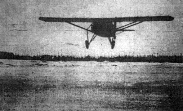
A 2/25/36 photo of a rare radial-engined Fairchild flown by Dr. & Mrs. Conrad Meibauer landing on the ice-covered Fish Kills Creek adjacent to Donovan-Hughes Airport (courtesy of Ed Drury).
George Schaaf of Richmond Airways had used the frozen creek for flight operations for a month.
A hangar can be seen under the plane's wingtip, on the left.
The 1938 Aviation Facilities in NY State (courtesy of Bob Parmerter) described Donovan-Hughes Airport as having 1 sod 2,600' north/south runway, but no hangars.
Donovan Hughes Airport, as depicted on the November 1942 NY Sectional Chart (courtesy of Ron Plante).
According to Staten Island Historian Tom Matteo, “The airport was closed in 1942
when the Army forbid civilian flying along the Atlantic Coast during World War II.”
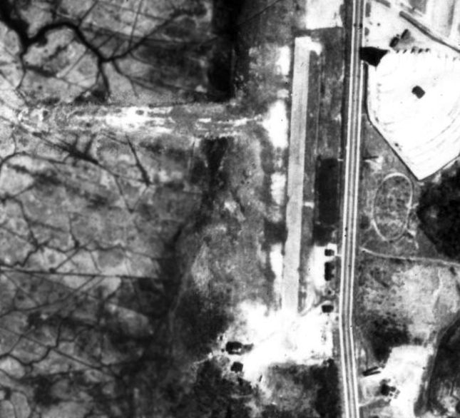
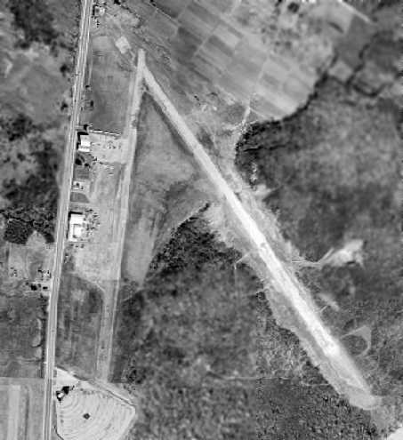
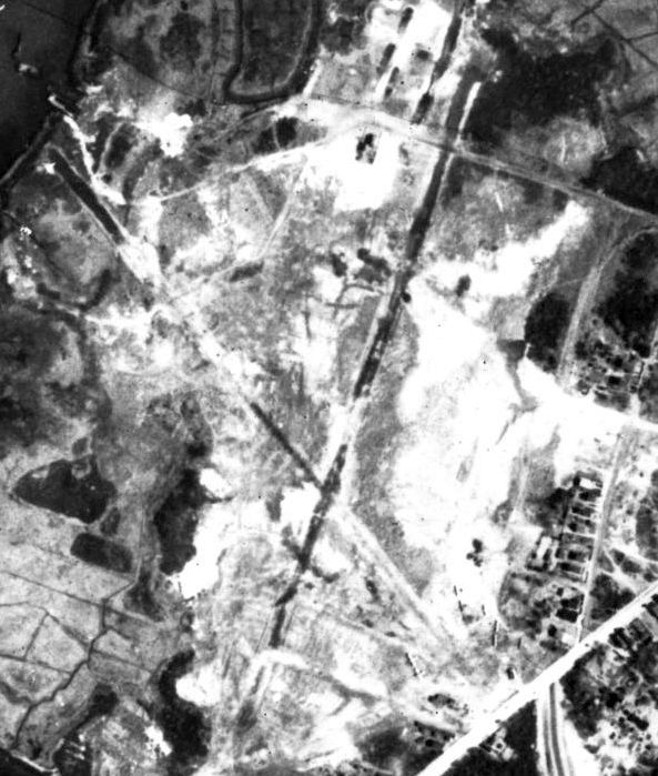
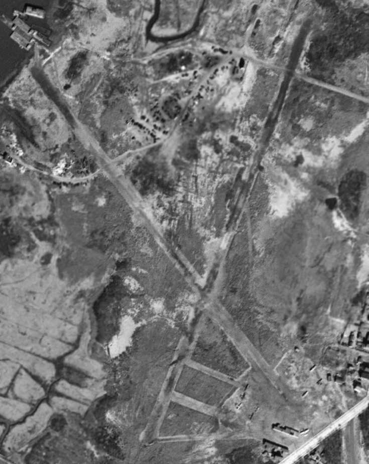
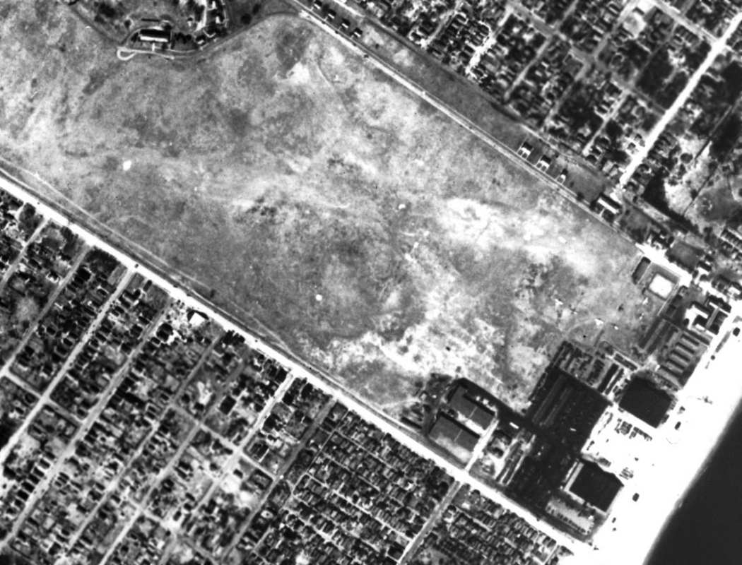
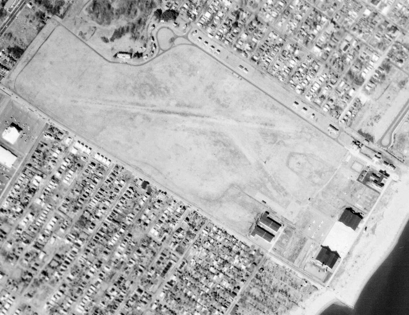
A 10/1/42 U.S. Military aerial view looking east at Donovan Hughes Airport (from the National Archives, courtesy of Brian Rehwinkel).
It depicted an irregularly-shaped unpaved airfield, primarily oriented north/south, with a small checkerboard-roof hangar & 2 T-hangars on the southwest side.
There were no aircraft visible on the field, evidently the result its wartime closure due to restrictions on general aviation near the coasts.
According to Mark Hess, “On 2/2/43, 2nd Lt. George La Rose, Civil Air Patrol pilot made a forced landing at Donovan-Hughes Airport in his Taylorcraft.
He was towing targets for CAP Tow Target Unit #2 at Mitchel Field. He survived, but his plane was badly damaged.”
According to Staten Island Historian Tom Matteo, “The airport reopened in 1945.
An interesting side note, the airport was adjacent to the city’s first drive-in movie theater
and was forced to close at 7:30PM so air traffic would not interfere with showing movies.”

Donovan Hughes Airport was depicted as a commercial/municipal airport
on the August 1946 NY Terminal Aeronautical Chart (courtesy of Tim Zukas).
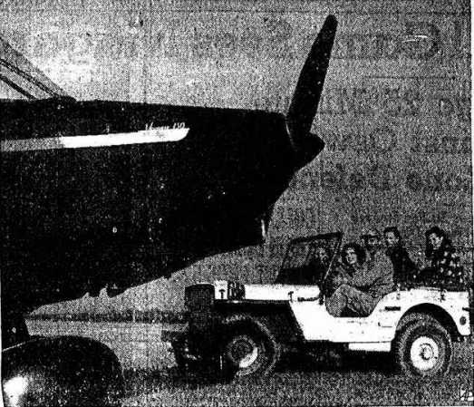
An undated photo from the 11/30/46 Niagara Falls Gazette (courtesy of Mark Hess) of a group driving up to a plane at Donovan-Hughes Airport.
The photo was captioned, “Flying Models – Richard Gans, flying service manager,
drives 4 NY models in a Jeep to a small plane at Donovan-Hughes Airport, Staten Island, for their 1st flying lesson.
The girls (left to right) are: Ann Purdy, Heddie Day, Nancy Fay, and Jeanne Hutchinson.”
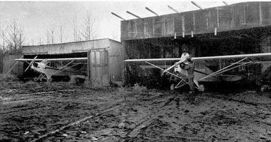
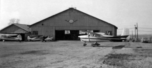
A 1946 photo of 2 Piper Cubs in the mud in front of the Richmond Flying Service hangars at Donovan-Hughes Airport (courtesy of Ed Drury).
Ed Drury recalled of Donovan-Hughes, “It wasn't a very big airport.
My brother worked at both airports & said that taxiing a Cub sometimes took lift to get out of the mud.”
A circa 1946 photo of a Rearwin Cloudster at Donovan-Hughes Airport (courtesy of Ed Drury).
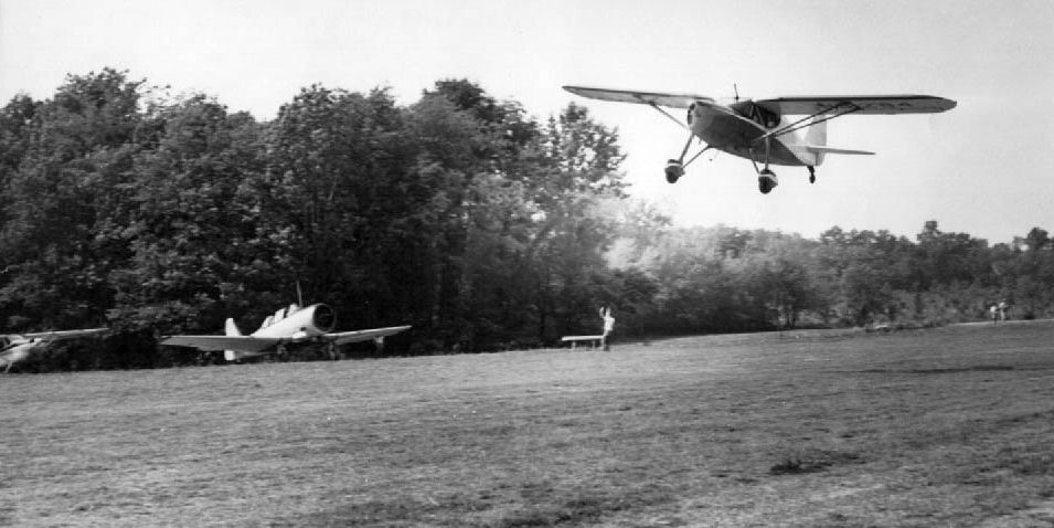
A circa 1946 photo of an unidentified aircraft taking off from Donovan-Hughes Airport (courtesy of Ed Drury),
overflying a surplus North American T-6 Texan.
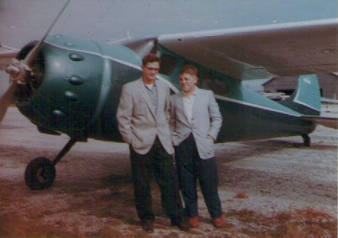
Bob Kaplan recalled, “Back on 8/31/47 I flew a solo cross country from Donovan Hughes Airport to Washington National Airport.
Got up in the morning & flew back to Donovan Hughes.
It was Cessna 140 NC72211, checkout by Woody Wittman, Instructor #97729.”
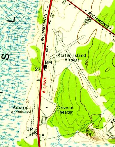
Donovan Hughes Airport, along with 3 other airports on Staten Island (Richmond County Airport, Staten Island Airport, and Miller Field),
as depicted on a 1947 USGS map.
A 1947 street atlas (courtesy of Kevin Walsh) depicted labeled Donovan Hughes Airport but without any details of the airfield configuration.
According to Ed Drury's “Staten Island: The Other Cradle of Aviation”, “Schaaf sold the airport in 1948 to Richard Gans.”
Ed recalled, “There were always airplane watchers at Donovan Hughes Airport.
A split rail fence. Every Saturday there would be 50 or so people watching. There was an open house every Saturday at Donovan-Hughes Airport.
Flour bombing, spot landings and T paper cutting in the air.”
Donovan Hughes Airport, along with 2 other airports on Staten Island (Richmond County Airport & Staten Island Airport),
as depicted on the 1949 USGS map.
A 1949 photo of Sy Commanday in front of a Waco UPF-7 Donovan Hughes Airport.
Sy remarked, “The owner of the aircraft is kneeling with his back to me. He had recently purchased the plane for $800.
Donovan Hughes Airport had a paved runway but most aircraft operated from the grass at the side of the runway since the taildraggers were easier to control in the grass.”
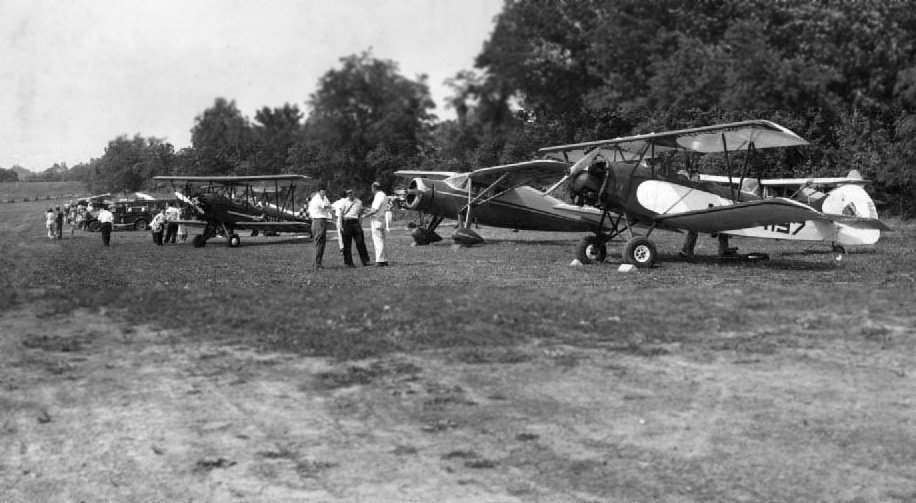
A circa 1949 photo of a row of monoplanes & biplanes at Donovan-Hughes Airport (courtesy of Ed Drury, author of ”Staten Island: The Other Cradle of Aviation”).
The last photo which has been located showing Donovan Hughes Airport in operation was a 1951 aerial view.
It depicted a north/south runway, along with what appeared to be the remains of a crosswind east/west runway.
A few small buildings were on the southeast & southwest side of the north/south runway.
The drive-in movie theater was located directly across the street to the northeast,
adjacent to the southwest side of Staten Island Airport.
According to Ed Drury's “Staten Island: The Other Cradle of Aviation”,
“Richard Gans operated [the airport] until its demise in 1952.
After the closing of the airport in 1952, Gans sold the site to August “Gus” Dinger,
a local farmer, who opened an auto racetrack & a golf driving range on the property.
Even though the airport was legally closed, Cabby's shop stayed open.
Many an aircraft took off & landed on the auto racetrack after dark
and many were rolled across the street from the other airport early on a Sunday morning.
One day a man known as 'Goldie' landed his Beechcraft Bonanza wheels-up on the field.
I don't know how they explained that, but Cabby got the repair job & it was illegally flown out a month later.”
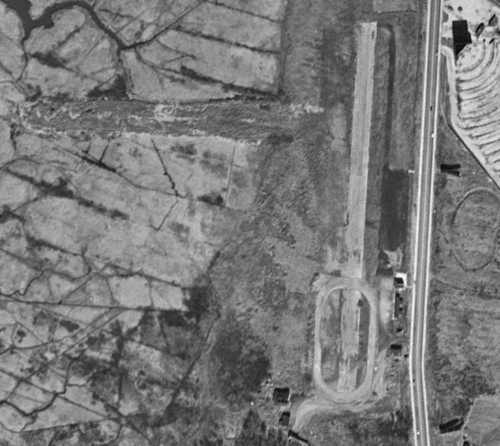
A 2/18/54 aerial view depicted Donovan-Hughes Airport shortly after its closure,
with an oval racetrack covering the southern half of the north/south runway.
A few small buildings remained on the southeast & southwest side of the former north/south runway.
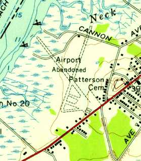
The last map depiction which has been located of Donovan-Hughes Airport was on the 1955 USGS topo map,
which depicted a single unpaved north/south runway, labeled “Airstrip Abandoned”.
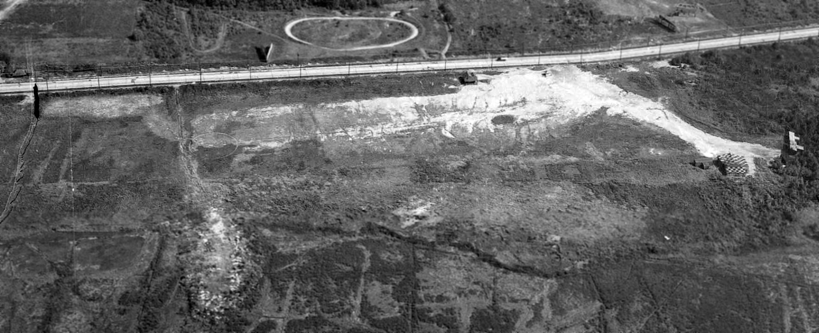
A 1957 aerial view showed the landfill had erased any traces of Donovan-Hghes Airport.
Winnie Thomas recalled, “The airports on Staten Island... I remember them all as a kid growing up on Staten Island.
My shop teacher at Tottenville High School in 1958 had a shop at the old Donovan Hughes where he still worked on planes.”
Donovan-Hghes Airport was no longer depicted on the 1961 NY Local Aeronautical Chart (courtesy of Tim Zukas).
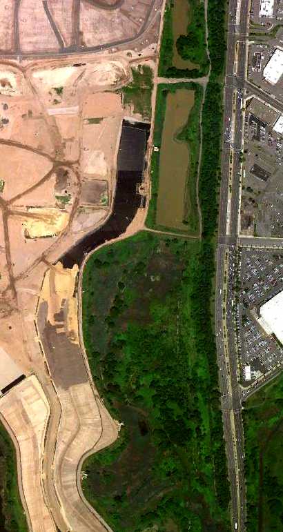
A 6/18/10 aerial photo shows the landfill covering the site of Donovan Hughes Airport, with not a trace remaining of the airport.
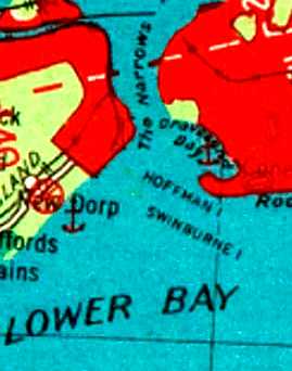
The site of Donovan Hughes Airport is located northwest of the intersection of Richmond Avenue & Forest Hill Road.
See also: http://statenislandaviation.com/
____________________________________________________
Bellanca Richmond Hill Airfield / Staten Island Airport, New Springville, NY
40.58, -74.166 (South of Newark Airport, NJ)
A 1928 photo (presumably taken at the Richmond Hill airfield which would eventually become Staten Island Airport) of a Bellanca CH-200 Pacemaker with her original owner & Mario Bellanca (courtesy of Ed Drury).
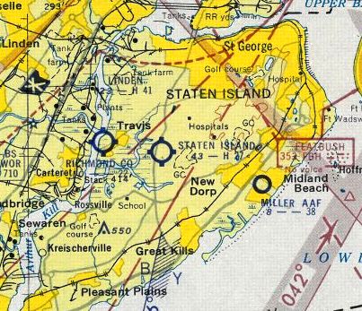
At various times in the past century, Staten Island had a total of 4 airports.
One of them was Staten Island Airport, located on the east side of Richmond Avenue, south of Richmond Hill Road.
Staten Island Airport was the largest privately owned airfield in the city, with more than 250 acres.
It was located just across the road from another former airport, Donovan-Hughes Airport.
No airfield was yet depicted at this location on a 1924 aerial photo.
According to Wikipedia, “Bellanca Aircraft Corporation of America in 1927, sited first in Richmond Hill, NY.”
According to Ed Drury, “The Bellanca factory was on Staten Island for about a year.
Most of the CH models were built here: CH 200, not the CH300 & up.
Richmond Hill, where Staten Island Airport was, Bellanca used that strip before it was named.”
According to Wikipedia, “Bellanca Aircraft Corporation of America [moved] in 1928 to New Castle (Wilmington), DE.”
According to a promotional brochure (circa 1950s?),
the development of Staten Island Airport was begun by Ed McCormick in 1935.
McCormick was a successful local businessman who flew his own Fairchild 24 & Republic Seabee,
nd he would later become the operator of Staten Island Airport.
Staten Island Airport was not yet depicted on the October 1941 NY Sectional Chart.
The Staten Island Airport opened in 1941.
Benjamin Smith reported, “My grandfather, Allan Heinsohn, was one of the principles at Cousin's Air, Inc. along with Charles H. Retz at Staten Island Airport.
I have my grandfather's flight log.
My grandfather's flight training with Mr. Retz started on 3/11/41 at Staten Island Airport.”

The earliest aeronautical chart depiction which has been located of Staten Island Airport was on the March 1942 NY Sectional Chart.
With the United States' entry into the Second World War,
the newly-opened Staten Island Airport was ordered closed by the government "for the duration",
as was also the case at many other small civil airports along the East Coast during WW2.
However, the date of closure of the field may have been after 1942,
as "Staten Island" was still depicted as a commercial airport
on the November 1942 Regional Aeronautical Chart (courtesy of Chris Kennedy).
It was not depicted at all on the 1943 NY Sectional Chart (courtesy of Chris Kennedy) or
the 1945 NY Sectional Chart (courtesy of Norman Freed).
Staten Island Airport was evidently reopened at some point in 1945.
Benjamin Smith reported, “The first post-war flight that mentions Staten Island [in his grandfather Allan Heinsohn's logbook]
is a flight from West Nyack to Staten Island in a Piper J-3 Cub on 9/30/45.
He flew another aircraft there on 12/27/45.
Starting in January 1946 I see lots of entries for 'Staten Island Local'.”
Staten Island Airport was depicted as a commercial/municipal airport
on the August 1946 NY Terminal Aeronautical Chart (courtesy of Tim Zukas).
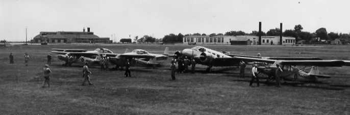
A circa 1940s aerial view looking southeast at Staten Island Airport (courtesy of Ed Das), showing the 2 grass runways (before they were paved).
A circa 1940s photo (courtesy of Ed Das) of an Aeronca tanden trainer being refueled in front of Staten Island Airport's checkerboard roofed hangar.
Staten Island Airport, along with 3 other airports on Staten Island (Richmond County Airport, Donovan Hughes Airport, and Miller Field), as depicted on a 1947 USGS map.
An circa 1948 aerial view looking southeast at Staten Island Airport
from a promotional brochure touting the field (courtesy of Ed Drury).
As described on the promotional brochure, the airfield at Staten Island Airport consisted of
"two hard-surface runways with a gross load-limit of 45,000 lbs...
one running North/South for 3,000', the other Northwest/Southeast for 3,700'.
Five modern steel hangars accommodate both transient & permanent planes in safe, clean, uncrowded conditions."
The brochure touted the ability of the airport to provide convenient access to New York City,
being only "40 minutes to Times Square", and being the NY airport which was "singularly free of crossing airline traffic".
Staten Island Airport was depicted on the 1949 NY Sectional Chart (according to Chris Kennedy)
as having a 2,900' hard-surface runway.
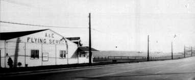
A circa 1940s photo of Staten Island Airport's A & E Flying Service hangar along Richmond Avenue
(courtesy of Ed Drury from ”Staten Island: The Other Cradle of Aviation”).
According to Ed Drury, “A & E stood for Anken & Engel.
The small lean-to structure of the building was the home of the Staten Island Aero Club.”
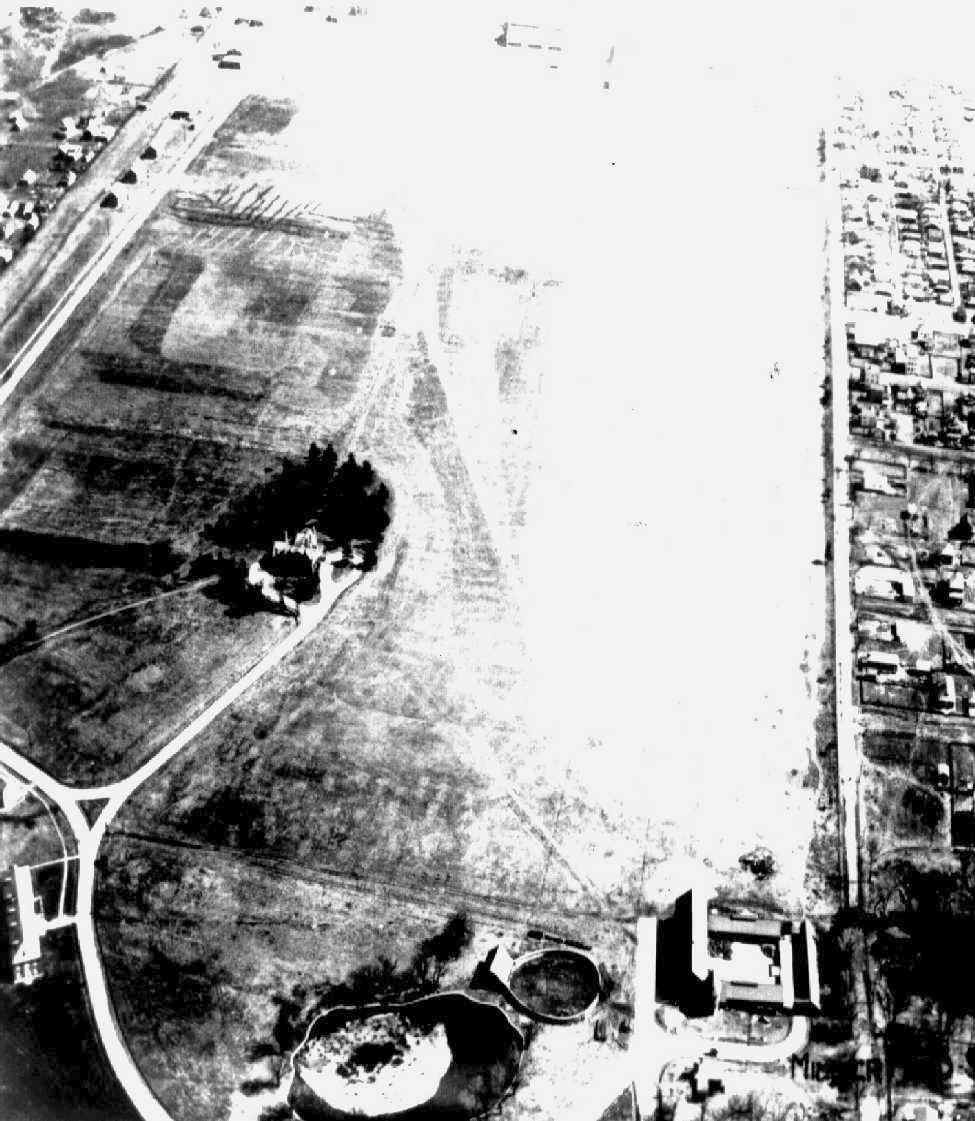
A circa 1940s aerial view looking west at the southwest corner of Staten Island Airport, showing the southern end of the north/south runway, 2 hangars & 2 light planes,
and the drive-in movie theater immediately off the south end of the runway (courtesy of Ed Drury from ”Staten Island: The Other Cradle of Aviation”).
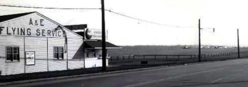
A circa 1940s/1950 photo of Staten Island Airport's A&E Flying Service.
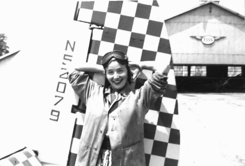
A young woman posing in front of a plane belonging to Fred Zurhmelan at Staten island Airport in 1950 (courtesy of Ed Drury).
A circa 1950 photo of Joe West in front of a Cessna T-50 “Bamboo Bomber”, at the north end of Staten Island Airport by the A&E hangar (courtesy of Ed Drury).
According to Ed Drury, Joe was “the owner of Cousin's Air Service at Staten Island Airport.”
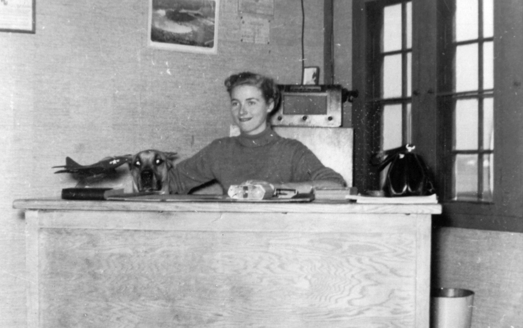
A 1953 photo of Staten Island Airport office manager Kari Martin, with her Great Dane peeking over her desk (courtesy of Ed Drury).
Ed Drury recalled, “Bill Cullen, a famous TV host, owned a charter service there called 'Appointment Airlines'. Kari would often fly with nervous passengers to calm them.”

A circa1954 photo of Staten Island Airport office manager Kari Martin & a Tecmo Swift in front of the airport office (courtesy of Ed Drury).
A circa 1954 photo (courtesy of Ed Drury) of “spectators watching the airplanes at the back of the office at Staten Island Airport. The other side faced Richmond Avenue.
There were always airplane watchers hanging on the fence.”
According to Ed Drury, Staten Island Airport served as home for several businesses,
including R.A. Martin Flying Service, Cousins Flying Service, and Appointment Airlines (run by TV star Bill Cullen).
Apparently the western runway (the one parallel to Richmond Avenue) was not used for very long,
as Ed Drury said it "was never in use in my time. It was shortened & ended at the end of the hangars.
The hangars became a farmers market & the aircraft were relegated to the northern end of the field."
Ed also adds that the runway was shortened to make room
for the drive-in theater that was erected next to the airport.
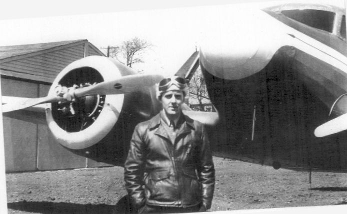
Ed recalled, “I did a not-so-legal solo there at 12 years old, in a Howard DGA 15.
I flew with my father all the time. I took off & landed that airplane all the time.
One day, for some reason, my father had left his car at Travis Airport, a few miles away.
I don't know if it was intended or not, but he said, 'Fly me over to get the car.'
I was too young to drive so I had to fly the airplane back. At the time I didn't think anything of it. When I think back, OMG.
I flew solo around the patch many times after that. Two years later, at 14, I took my first lesson.”
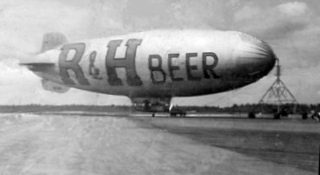
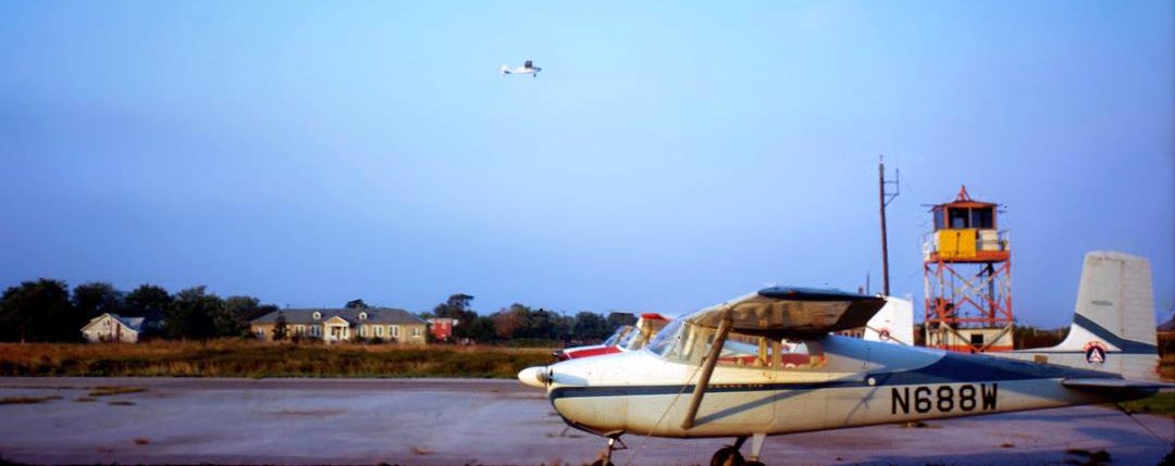
A circa 1950 photo of a Goodyear blimp advertising R&H Beer, for which the original caption said Staten Island Airport (courtesy of Ed Drury).
According to Ed Drury, “She was moored at Flushing Airport, but she was temporarily moored at Staten Island Airport for at least one open house weekend.
It may still [have been taken at] Flushing Airport.”
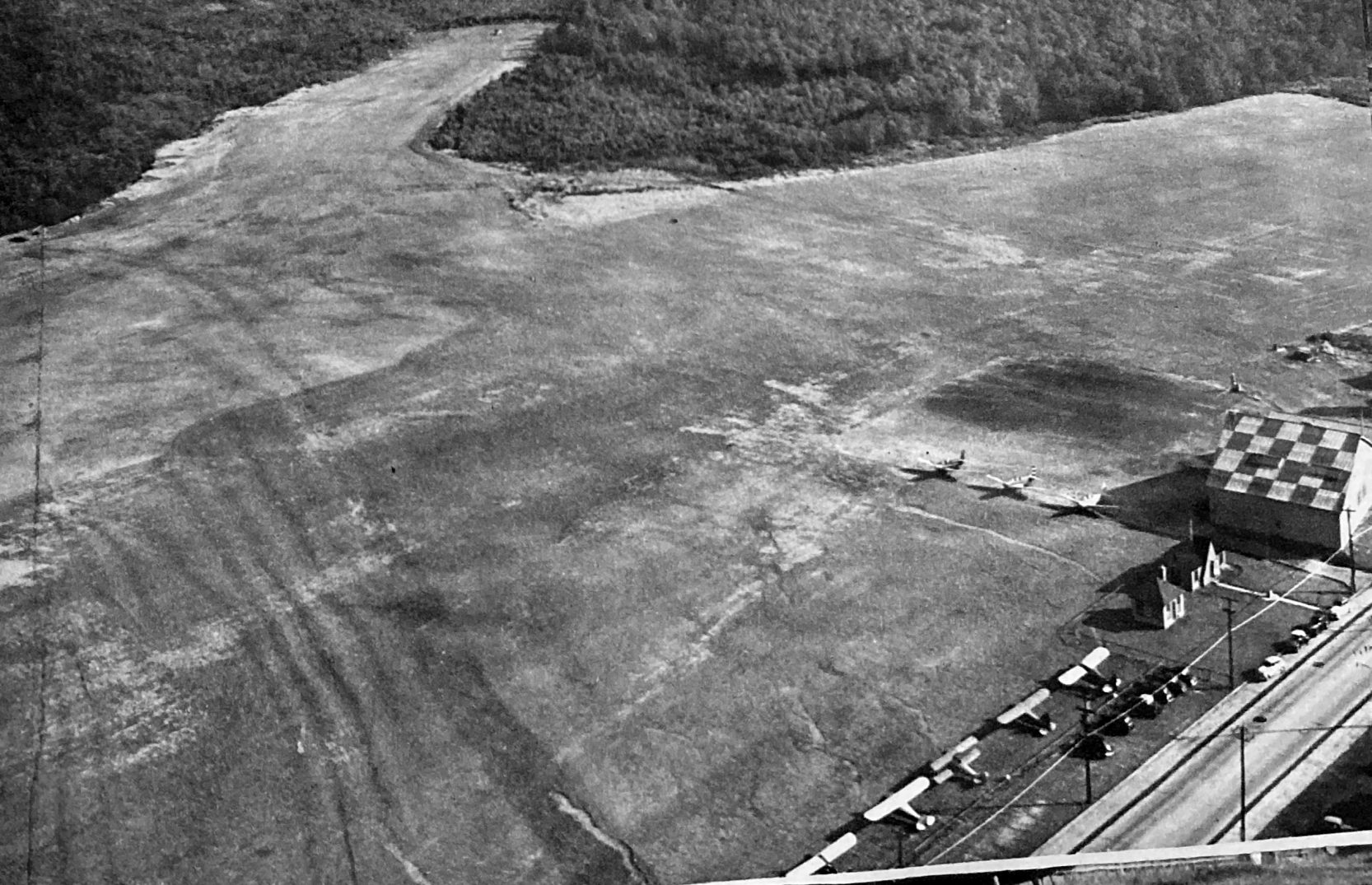
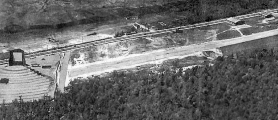
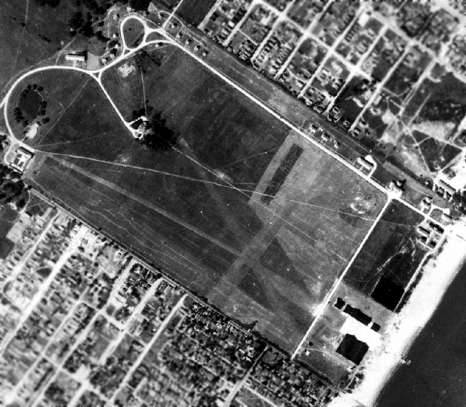
The last aerial photo which has been located showing the Staten Island Airport still open was a 1954 aerial view.
It depicted the airport as having a single paved northwest/southeast runway.
The majority of the former north/south runway was still intact,
but the southern end had been truncated by the construction of a drive-in movie theater.
A closeup from the 1954 aerial view of Staten Island Airport.
Two hangars were located on the west side of the field,
but only the northern hangar appeared to be used for aviation purposes.
Around the northern hangar were visible a total of 15 single-engine aircraft.
The Staten Island Airport property was sold in 1955 for a planned shopping & amusement center (known as the Staten Island Center),
but the airport remained open for another 9 years.
The 1955 USGS topo map depicted Staten Island Airport as having 3 unpaved runways & several buildings along the west side.
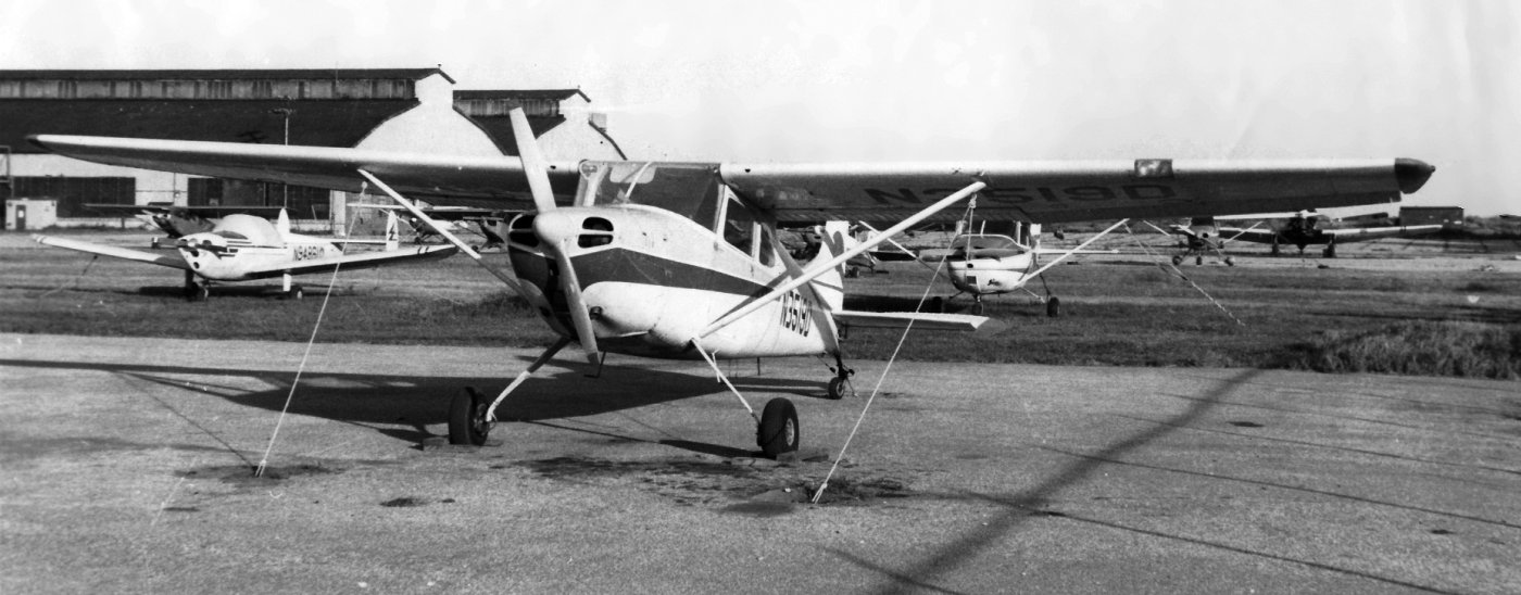
A circa 1957 photo of Jack & Ed Drury in front of their father's Cessna 190 N1055D at Staten Island Airport (courtesy of Ed Drury).
Ed recalled, “I flew that plane for over 800 hours.
I remember pulling up to fuel & telling the line boy '2 gallons of oil please'. His reply: 'You mean quarts?' 'Nope, gallons.'
It also had crosswind landing gear. So if you pulled up to fuel & spun it on a brake, one wheel would appear broken.
Many line boys said 'You can't take off, your wheel is broken.' Notice no struts, it would lay its ears back & go.”
The Aerodromes table on the 1958 NY Sectional Chart (courtesy of Norman Freed)
described Staten Island Airport as having 2 runways,
with the primary being a 2,700' paved runway, but it also included the remark, "North/south runway closed."
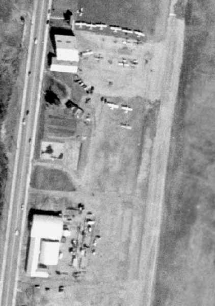
The last photo which has been located showing the Staten Island Airport still open was a May 1960 photo by Wilred Robles of 2 Pipers & a Cessna in front of a hangar.
Wilfred observed, “Its not the sharpest print, but then it was taken with an old Kodak camera back in May of 1960. That is to say the camera was old back in 1960.”
Wilfred Robles recalled, “As a teenager I took flying lessons at Staten Island Airport through Staten Island Flying Service.
The flying service was owned by Joe Cartiglia & Frank Flavale.
My instructor (1960/61) was William Douglas. I received instruction in J3 Piper Cubs, of which there were several
(a yellow Cub, a yellow Cub with a black nose, and an aqua green & gray Cub licensed as 1107D).
They also owned a Cessna 172, in which I received instrument training, and possibly an additional Cessna 175.
Parked to the right of the active runway (heading southeast) were the fuselage remains of a Stinson high-wing monoplane,
which I was told by Bill Douglas, had landed & burned in-situ.
The pilot & passengers apparently jumping out of it unharmed, only to watch it burn.
Another aircraft of note was a red BT-13 that was still being flown during my time flying from there.”
The last aeronautical chart depiction which has been located of Staten Island Airport
was on the 1964 NY Local Aeronautical Chart (courtesy of John De Nicola).
It depicted the field as having a 2,700' paved runway.
Staten Island Airport closed in 1964.
According to pilot Ed Drury, after Ed McCormick died, his widow sold the field for $40,000.
Other sources indicate that the field closed after the operator lost his lease & the owner sold the land.
By the time of the 1965 NY Sectional Chart (courtesy of John Voss),
Staten Island Airport was no longer depicted at all (not even as an abandoned airfield).
A 1966 aerial view of the site of Staten Island Airport showed that the 2 hangars remained intact.
A large building & parking lot had been built
over the southern end of the former north/south runway (just north of the drive-in movie theater).
A road cut through the middle of the former northwest/southeast runway, which was otherwise intact.
A 1970 aerial view showed that the 2 hangars had been removed at some point between 1966-70.,
along with the drive-in movie theater.
The site was otherwise basically unchanged from how it was depicted in 1966,
with the majority of the length of the 2 former runways still intact.
The Staten Island Mall opened in 1973 on the site of the former airport.
A 1980 aerial photo showed that the shopping center covered the site,
erasing any remaining trace of the former Staten Island Airport.
A circa 2000s photo of a relocated former hangar from Staten Island Airport (courtesy of Ed Drury from ”Staten Island: The Other Cradle of Aviation”).
As seen in a July 5, 2007 aerial photo, not a trace appears to remain of the former Staten Island Airport.
Ed Drury observed, "The site now contains a mall & 2 separate shopping centers.
Just behind the plot are unending condos & townhouses. A far cry from the sleepy little airport."
See also: Staten Island Advance 12/26/99
http://statenislandaviation.com/
____________________________________________________
Richmond County Airport, Travis, NY
40.592, -74.196 (South of Newark Airport, NJ)
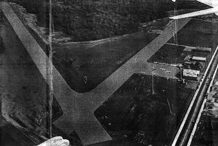
A 10/1/42 U.S. Military aerial view looking north at Richmond County Airport (from the National Archives, courtesy of Brian Rehwinkel).
A 1940 aerial photo did not depict any sign of an airport at this location.
According to Staten Island Historian Tom Matteo,
“In 1941, the Richmond County Airport was opened by John Cosgrove in Travis as a commercial airport.
It was bordered by Cannon Avenue, Glen Street, Victory Boulevard & the Arthur Kill, and was designed for use by students & commercial fliers.”
The earliest depiction which has been located of Richmond County Airport Airport was a 10/1/42 U.S. Military aerial view looking north (from the National Archives, courtesy of Brian Rehwinkel).
It depicted an irregularly-shaped unpaved airfield, with a few small hangars & T-hangars on the east side.
There were no aircraft visible on the field, though, which may have been the result of wartime restrictions on general aviation near the coasts.
The earliest aeronautical chart depiction which has been located of Richmond County Airport Airport
was on the November 1942 NY Sectional Chart (courtesy of Ron Plante).
It depicted Richmond County as a commercial/municipal airport.
Richmond County Airport was depicted as an auxiliary airfield on the August 1946 NY Terminal Aeronautical Chart (courtesy of Tim Zukas).
A 1947 aerial view depicted Richmond County Airport as having 8 single-engine aircraft parked around a few small buildings on the northwest side of Victory Boulevard.
The airfield consisted of an open grass area.
Richmond County Airport, along with 3 other airports on Staten Island (Donovan Hughes Airport, Staten Island Airport, and Miller Field), as depicted on a 1947 USGS map.
A 1947 street atlas (courtesy of Kevin Walsh) depicted labeled Richmond County Airport but without any details of the airfield configuration.
Richmond County Airport, along with 2 other airports on Staten Island (Donovan Hughes Airport & Staten Island Airport), as depicted on the 1949 USGS map.
The 1950 NY Sectional Chart depicted Richmond County Airport as having a 2,300' unpaved runway.
A 1951 aerial view depicted Richmond County Airport as having 8 single-engine aircraft parked around a few small buildings.
At some point between 1947-51 the airfield had gained 2 distinct unpaved runways, oriented northwest/southeast & northeast/southwest.
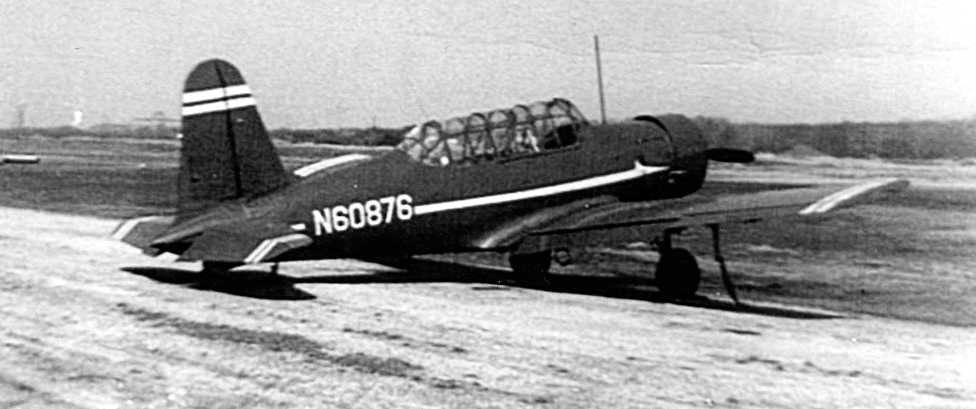
A circa 1950s photo of a military surplus Vultee BT-13 at Richmond County Airport (courtesy of Ed Drury from ”Staten Island: The Other Cradle of Aviation”).
The 1953 NY Terminal Aeronautical Chart (courtesy of Tim Zukas) depicted Richmond County Airport as having a 2,200' unpaved runway.
The last photo which has been located showing Richmond County Airport still in operation was a 2/18/54 aerial view.
It depicted a total of 7 single-engine aircraft parked around a few small buildings.
Several taxiways led to a ramp area on the northwest side of Victory Boulevard.

The last aeronautical chart depiction which has been located of Richmond County Airport was on the July 1954 NY Sectional Chart,
which strangely did not depict any runway length for the field.
According to Staten Island Historian Tom Matteo, “Richmond County Airport... was unable to keep up with the growing tax burden & was closed in 1955.
The land was sold to Con Edison who built a power plant on the site.”
Richmond County Airport was no longer depicted on the January 1955 NY Sectional Chart.
The last map depiction which has been located of Richmond County Airport was on the 1955 USGS topo map,
which depicted 2 unpaved runways, a ramp, and several buildings, labeled “Airport Abandoned”.
A 1957 aerial photo showed that the runways & airfield buildings had been removed at some point between 1954-57,
with the site having been wiped clean, erasing any traces of Richmond County Airport.
Construction had begun on a Con Edison power plant on the west side of the airport site.
Aerial photos show that between 1966-70, the West Shore Expressway was built through the eastern portion of the Richmond County Airport site.
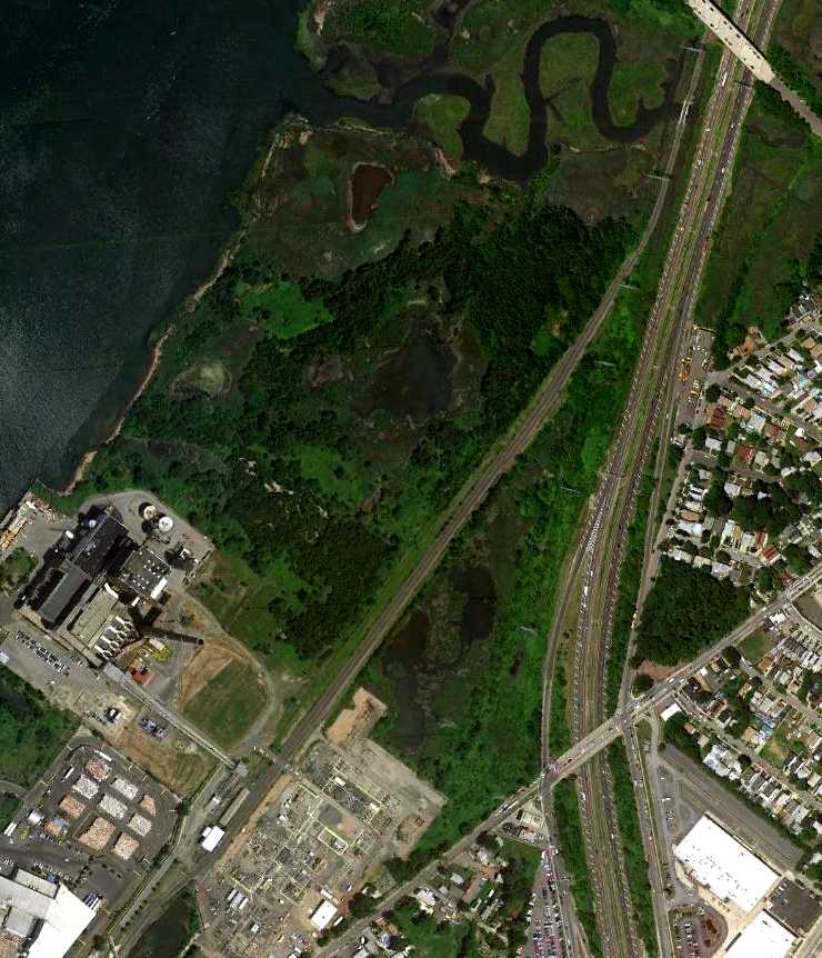
A 6/18/10 aerial photo shows not a trace remaining of Richmond County Airport.
A 7/21/12 aerial view by Paul Freeman looking east at the site of Richmond County Airport.
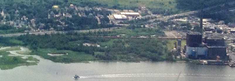
The majority of the site remains clear, with the southern portion being covered by the NRG Energy plant.
The site of Richmond County Airport is located northwest of the intersection of Victory Boulevard & the West Shore Expressway.
See also: http://statenislandaviation.com/
____________________________________________________
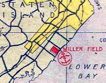
Miller Field / Miller Army Airfield, New Dorp Beach, NY
40.567, -74.097 (South of Newark Airport, NJ)
Miller Field, as depicted on the 1923 New York – Bellefonte Air Navigation Map #3 (courtesy of David Brooks).
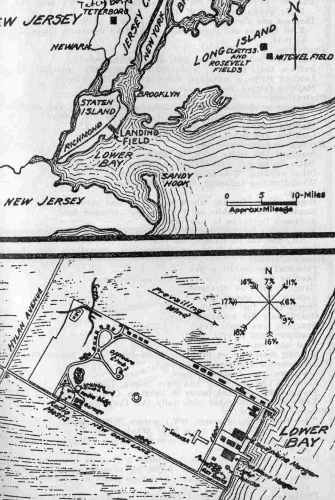
This airfield is located on the shore of Staten Island, along Lower New York Bay.
According to an article in the 2/2009 issue of the Coast Defense Journal (courtesy of Ron Plante & Mark Berhow),
in 1919 a farm belonging to William Vanderbilt was selected as the location for an Army Air Service airfield,
its primary mission being to assist the Coast Artillery in the defense of New York Harbor.
Construction began in November 1919 of the field's 2 sod runways, seaplane ramps, and 4 hangars.
Miller Field was named after Capt. James Miller, commander of the 95th Aero Squadron,
who was shot down & killed by a German aircraft on 3/10/18 over German-held territory in the Rheims sector.
Miller Field was completed in July 1921, after 20 months of construction costing $1,350,000, yet was initially little used.
By October 1922, no Army Air Service personnel remained at the field.
In 1923, the NY National Guard's 102nd Observation Squadron moved from Long Island's Mitchel Field to Miller Field.
This unit, part of the 27th Division's Aviation section, remained at Miller Field through the 1930s.
The earliest depiction of Miller Field which has been located
was on the 1923 New York – Bellefonte Air Navigation Map #3 (courtesy of David Brooks).
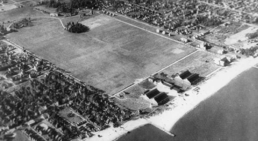
The earliest photo of Miller Field which has been located was a 1924 aerial view (from the NYCityMap, courtesy of Chris Kennedy).
It depicted the field as a rectangular grass area within which were 4 grass runways.
A hangar & several other buildings were located at the southeastern corner of the field.
Miller Field was the site of military air shows in the 1920s.
The 9/12/24 National Defense Day Celebration included a mock air attack on nearby Fort Wadsworth using sacks of flour as simulated bombs.
On 7/25/25 the Tank Company of the 1st Division arrived at Miller Field, after 2 & a half months of intensive training at Camp Dix, NJ.
A circa 1920s aerial view looking east at Miller Field (courtesy of Ed Drury from ”Staten Island: The Other Cradle of Aviation”).
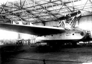
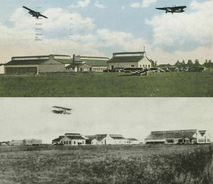
A May 1927 photo of the Savoia-Marchetti S.55 Santa Maria II flying boat undergoing final assembly inside the Miller Field hangar.
The Santa Maria II had arrived on Staten Island in a steamer on 5/1/27 & was taken to Miller Field for final assembly,
before completing its historic North American tour.
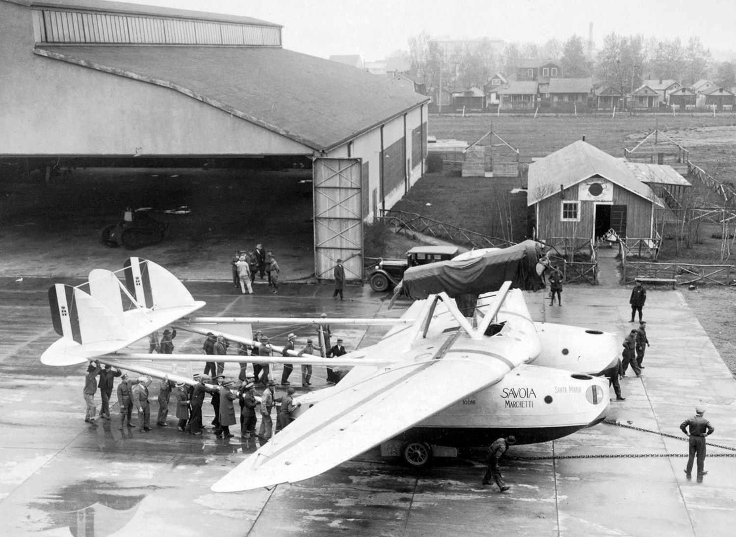
A 5/8/27 photo of the Savoia-Marchetti S.55 Santa Maria II flying boat in front of the Miller Field hangar.

A 5/8/27 photo of the Savoia-Marchetti S.55 Santa Maria II flying boat MM40208 C/n 10016 in front of the Miller Field hangar.
It had been assembled at Miller Field as a replacement for the original Santa Maria. An M1917 tank seemed to used as a tractor.
During the summer of 1928, Adm. Richard Byrd, the polar explorer, tested his Ford Trimotor named "Floyd Bennett" at Miller Field.
A 1929 NY Legislative Report (courtesy of Tom Heitzman) described Miller Field as a 186 acre rectangular sod field with hangars on the east side.
By 1931, the little-used Miller Field was being considered for sale as surplus.
In May 1931, Miller Field was included in the 53 military posts slated for abandonment & sale.
However, the field was retained as Headquarters of the Aviation Section of the 27th Division.
The earliest aeronautical chart depiction which has been located of Miller Field was on the November 1931 NYC-Albany Air Navigation Map.
Miller Field, as depicted on the August 1932 NY Sectional Chart.
The 1934 Navy Aeronautical Chart (courtesy of Chris Kennedy)
depicted Miller Field as a rectangular field with an adjacent seaplane base.
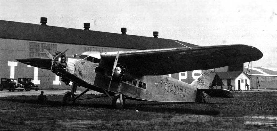
A circa 1930s photo of a the Byrd Antarctic Expedition's Ford Tri-Motor in front of the Miller Field hangar
(courtesy of Ed Drury from ”Staten Island: The Other Cradle of Aviation”).
A 1935 aerial view looking north at Miller Field (from the 2/2009 issue of the Coast Defense Journal, courtesy of Ron Plante & Mark Berhow).
The Airport Directory Company's 1937 Airports Directory (courtesy of Bob Rambo)
described Miller Field as consisting of a rectangular 2,800' x 1,600' sod landing area.
It was also described as having a seaplane harbor,
with "ramp & facilities for hauling seaplanes & amphibians ashore."
The 1938 Aviation Facilities in NY State (courtesy of Bob Parmerter) described Miller Field as a 2,800' x 1,600' rectangular sod field with Army hangars.
On 10/15/40, the 102nd Observation Squadron was activated for federal service & moved to Fort McClellan, AL.
Miller Field's broad open area served as storage for trucks & other material awaiting shipment overseas during World War II.
The airfield was also the site for one of the anti-motor torpedo boat batteries covering the Narrows during the war,
as well as one of the many facilities holding Axis Prisoners Of War.
Miller Field evidently was not used as an airfield during WW2,
as no airfield at the site was depicted on the 1942 or 1944 Regional Aeronautical Charts (courtesy of Chris Kennedy),
the 1945 NY Sectional Chart (courtesy of Norman Freed),
or the August 1946 NY Terminal Aeronautical Chart (courtesy of Tim Zukas).
Miller Field, along with 3 other airports on Staten Island (Richmond County Airport, Donovan Hughes Airport, and Staten Island Airport),
as depicted on a 1947 USGS map.
According to a history of the 42nd Combat Aviation Brigade, a fixed- wing aviation detachment was formed in 1947 at Miller Field.
Matt Elkan recalled, “I flew out of Miller with the Civil Air Patrol starting in 1948. The Army Guard flew L-16 Aeroncas.
Our CAP unit, 8th Group NY, was parked alongside the Army Guard. They had over a dozen L-16s as well as L-17 Navions.
The Army 42nd Aviation Brigade left Miller Field for Long Island around 1949.”
Miller Field was apparently still officially closed as an airfield in 1950,
as no airfield at the site was depicted on the 1950 NY Sectional Chart (courtesy of Mike Keefe).
Miller AAF was apparently reopened at some point between 1950-51,
as a 1951 aerial view depicted at least 5 single-engine light aircraft parked on the east end of the grass airfield.
"Miller (Army)" was depicted on the 1952 NY Sectional Chart (courtesy of Mike Keefe).
Miller AAF was depicted on the 1953 NY Terminal Aeronautical Chart (courtesy of Tim Zukas) as having a 3,800' unpaved runway.
A 1954 aerial view depicted a total of 15 light aircraft parked along the northern edge of Miller Field.
Where these Civil Air Patrol aircraft?
The 1955 USGS topo map depicted “U S Military Res Miller Field” as having 2 unpaved runways, with the hangars along the southeast side.

Miller AAF was described by the as the Aerodromes table on the 1958 NY Sectional Chart (courtesy of Norman Freed)
as having 2 runways, with the primary being a 3,800' turf strip.
According to pilot Ed Drury, during the latter years of Miller Field's active use it was opened to planes of the Civil Air Patrol.
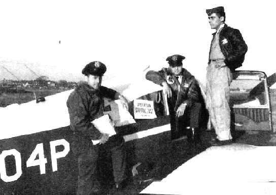
An undated photo of Monroe Klein, Rodney Jaeger, and Don Speroni on a Piper PA-24 Comanche at Miller Field during “Operation Survival East”,
a Civil Air Patrol radiation testing mission.
Chris Christensen recalled, “In March of 1959 I was assigned to Fort Wadsworth.
I was sent to the Brigade Aviation Section on Miller Field to be their aircraft supply clerk.
That was a start of a 20-year Army aviation career built around helicopter maintenance.
Not much is written about the Active Army units & facilities that were located there.
There was the 1st Army Aircraft Field Maintenance Unit
which was primarily Department of the Army civilians who did higher-level of maintenance of both fixed-wing & rotary-wing aircraft.
There was the 52nd Artillery Brigade (Air Defense) Aviation Section who supported the mission of NYC metropolitan Nike sites.
It also supported & carried many dignitaries flying in & about NYC
including Nikita Krushchev at the time that he slammed his shoe down on the podium at the United Nations.
At that time there was nothing left at Miller AAF to show that it had supported any seaplane activity & while I was there from 1959-62 I never heard of that.
It was not very well known in those days by those that worked there.
Our unit had 3 H-13s which had the large bubble over the cockpit & could carry 2 people including the pilot.
We also had 2 H-21C cargo helicopters.
Since most of our flights involved flying over water someone decided that helicopters that did that should have floats on them... just in case.”
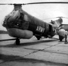
A circa 1960 photo by Chris Christensen of an Army Piasecki H-21C with deployed floats at Miller AAF.
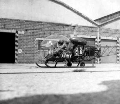
An August 1960 photo by Chris Christensen of an Army Bell H-13 in front of the Miller hangars.
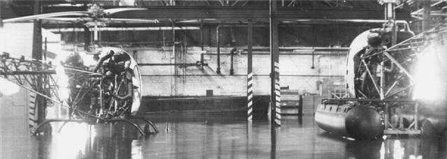
A circa 1960 photo by Chris Christensen of 2 Army Bell H-13s inside a flooded Miller hangar.
Note that the helicopter on the left has its skids submerged, whereas the helicopter on the right, being equipped with floats, is floating.
Chris recalled of the Miller flood: “What I remember is 2 hurricanes.
In both cases the area between the 2 hangars did flood & that area did have high & low points in the concrete slabs
and there were drains out in the middle which I don't know where they drained to.
There was a lot of flooding all over the Island.”
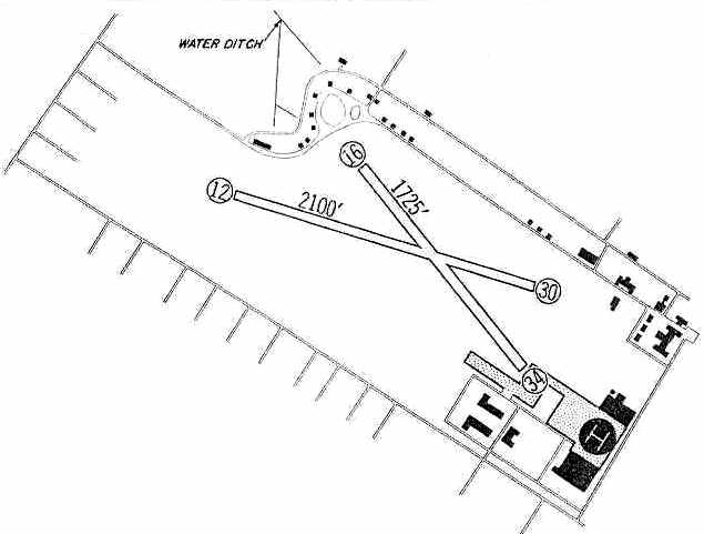
Miller AAF was depicted on the 1960 Jeppesen Airway Manual (courtesy of Chris Kennedy)
as having 2 unpaved runways: a 2,100' Runway 12/30 & a 1,725' Runway 16/34,
as well as a helipad in between the 2 large hangars along the shoreline on the southeast corner of the field.
On 12/16/60 a Lockheed Constellation (TWA Flight 266) headed to La Guardia
and a Douglas DC-8 (United Flight 826) bound for Idlewild (JFK) collided just west of Miller Field.
The Connie came down in Miller Field, the DC-8 in Park Slope, Brooklyn.
There were no survivors.
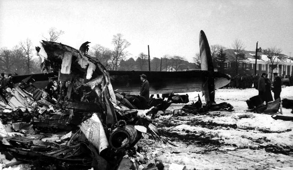
An undated photo of the tail section of a Lockheed Constellation, TWA Flight 266, which fell on Miller Field after a collision with a DC-8 on 12/16/60.
Chris Christensen recalled, “I don't remember any other aircraft there
except that Fort Wadsworth did have a flying club there with a couple of Piper observation-type aircraft from WW2, and one Navion L-17 & a Cessna 126.
I know the 2 H-21s were turned in & were supposed to be replaced with 2 UH-1 Hueys.
I don't know that the replacements did ever come in.
I know the flying club Navion did have an engine failure after I left in 1962 & it fell in the drink off the end of the runway.
They supposedly tried to drag it out of the water & onto the beach but apparently put a chain around the tail & pulled the tail off.
I was in Germany when the picture of it in the water was posted I think on the front page of the Stars & Stripes.”
A 1962 photo (courtesy of Mark Hess) of Civil Air Patrol aircraft at Miller Field for Operation Lifeline.
Mark reported, “Operation Lifeline was a 1962 NY Civil Defense/CAP Joint Exercise.
Basically, it was an atom bomb training exercise that included aerial radiological monitoring, communications, courier service,
first aid, evacuation & other joint training with local & NY state agencies at Miller Field.
I think CAP used Miller Field primarily for training purposes only. I haven't found a squadron based there yet.”
According to CAP Lt. Col. Henry Deutch, when the Governor's Island Airfield was closed (circa 1962-65),
“1st Army fixed-wing operations were transferred to Miller Army Airfield.”
With the dissolution of 1st Army Miller Army Airfield was primarily used for Reserve & National Guard training,
and as a base of operations for Civil Air Patrol units.
The 3 Civil Air Patrol Groups that conducted operations from Miller Army Air Field were:
Brooklyn Group, Manhattan Group, and Staten Island Group.”
Randy Turner recalled, “Having lived on Miller Army Airfield as a young man from 1962-66...
During that period, my father, Captain Albert Turner was the Officer in Charge of the 52nd Air Defense Artillery Brigade Aviation Section.
The unit had Bell H-13 & Hiller H-23 helicopters, some of which were on floats & some of which were not.
Whether the aviation unit possessed its own L-19 Bird Dog & DHC L-20 Beaver aircraft or not I don’t know,
but my father also flew these aircraft regularly from Miller Field in support of nearby Nike Hercules missile sites.
I believe there was a second Army Aviation unit at Miller Field, which used the 2nd large hangar.
My father also occasionally flew the Piasecki H-21 Shawnee while at Miller Field,
but I am reasonably sure that by 1962 they were no longer assigned there.
I remember my father telling me one afternoon that he had just flown an H-21 mission solo,
which was not authorized by Army Regulations, but there had been some urgent support mission and he was the only H-21 pilot available.
It was a very impressive aircraft.”
Randy continued, “I very clearly remember that my father, upon returning from a night flight,
would signal his arrival by gunning the engine several times – especially impressive if the aircraft was the L-20 Beaver – as he approached the field.
I would race to the porch of our house on the airfield & flash the porch lights on and off in return.
Sometimes, if he was returning late from a night flight,
my father would land his H-23 on that portion of the airfield immediately across the street from our house.
I would run out & help him secure the aircraft for the night.
I very clearly remember being shown how to disconnect the battery of the aircraft.
The blades would be tied down & the aircraft would remain in our front yard, as it were, overnight.”
Randy continued, “Occasionally, Army DHC Caribou aircraft would fly into Miller Field,
and in 1966, shortly before my father left for UH-1 training at Fort Benning - the first Huey to visit Miller Field arrived.
I remember my father taking me to look at the new aircraft.
After the H-13s & H-23s, it was a remarkable leap forward.”
Randy continued, “The flying club at Miller Field was housed in one of 2 WWII-era buildings.
It had several Piper Cubs, a Piper Tri-pacer, a Ryan Navion and a Cessna 195, which was its pride & joy.
My father taught me the rudiments of flying in these aircraft, before the Navion & 195 were both lost in accidents.
The Navion landed short in the ocean & I was there on the beach as an Army Reserve M-88 ARV was used to try & tow it out of the shallow water.
The Cessna 195, which had been an Army instrument trainer in a previous life,
was written off by a former naval aviator who made a bad approach but was said by flying club members to be 'too proud to go around'.
I saw this accident as it happened, sitting on our front porch with my mother.”
Randy continued, “The CAP occupied the building adjacent to the flying club
and pride of place went to a single SNJ or T-6 Texan – which flew very rarely.”
Randy continued, “There were about 20 single homes on Miller Field, half for officers & half for enlisted.
There was also a 'mansion' which had been turned into apartments for 4 senior officers.
The houses were marvelous large old homes.
My mother liked her house at Miller Field best out of all the places she lived with my father during his 30 year military career.
In the most recent photos that I have seen, many of the houses are still standing.”
Randy continued, “During the time I lived there, an Army reserve unit had its headquarters at Miller Field
and several M-48s & at least one M-88 ARV were parked a short way from the Army Aviation Hangars.”
Randy continued, “One interesting aspect of Miller Field was the fact that the grass landing area
was bordered by numerous large concrete rectangles, upon which were mounted twin spotlights.
I don’t know for sure, but was told at the time that these lights, unused for many years,
had been used to illuminate the landing area for bomber aircraft based there in the 1920s.
As I recall, during the 1962-66 timeframe, there was one grass runway with runway lighting.
There was no control tower in use.”
Randy continued, “New York City used to send barges full of refuse out beyond Sandy Hook, where they would be burned.
Every day, the garbage being burned cast a long gray pall over the horizon beyond Miller Field.
The children at Miller Field were taken to local schools by a small Army bus.
All post support services for Miller Army Air Field were located at Fort Wadsworth, overlooking New York harbor.”
The 1964 NY Local Aeronautical Chart (courtesy of John De Nicola) depicted Miller AAF as having a 2,100' unpaved runway & a control tower.
A 1964-65 photo of a Piper Tri-Pacer at Miller Field (courtesy of Mary Dalton).
Mary recalled, “I lived here in 1964-65. Our [house] was the first one on the road.”
Miller AAF was still depicted as an active airfield on the 1965 NY Sectional Chart (courtesy of John Voss).
It was described as having 2 turf runways, with the longest being 2,100', but the remarks included, "Runway 16/34 emergency only."
The airfield also had its own control tower.
The last aircraft to use Miller Field were those of the National Guard & Reserve.
In its final years, Miller was the last grass airstrip within New York City.
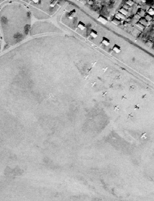
A 2/22/66 USGS aerial view depicted a total of 9 light single-engine aircraft parked on the southeast side of Miller Field.
Douglas Cox recalled, “It must have been in the late summer or early autumn of 1966
when I attended annual training at Miller AAF, as part of the 11th Special Forces Group (Army Reserve).
We stayed in tents pitched inside the long northern boundary line of the field.
The airfield was used as a drop zone for airborne (parachute) operations.
In the final week of the training period, we flew from Miller AAF to Otis AFB, MA,
for loading onto Albatross seaplanes, from which we parachuted into the White Mountains of NH.
The final week in the mountains made the sweltering in the tents at Miller AAF totally worthwhile.”
Miller AAF was not depicted at all on the March 1966 NY Sectional Chart (courtesy of Mike Keefe).
Miller AAF was not depicted on the 1968 NY Terminal Aeronautical Chart (courtesy of Tim Zukas),
but ironically it did depict a parachute drop zone at the former airfield location.
A 1968 photo by Don Ryan (courtesy of Ed Drury) of several Cessnas in front of a control tower (temporary or portable?) at Miller Field, and one single-engine aircraft overflying the field.
The last photos which have been located showing aircraft at Miller Field was a series of circa 1968-70 photos (courtesy of John Breznik),
with this one snowing a Civil Air Patrol Cessna 170 & several other planes in front of Miller Field's distinctive North Hangar.
The last photos which have been located showing aircraft regularly operating from Miller Field was a series of circa 1968-70 photos (courtesy of John Breznik),
with this one snowing a Civil Air Patrol Piper J-3 Cub at Miller Field.
According to CAP Lt. Col. Henry Deutch, “Miller Army Air Field was an active airfield until it was closed on 6/30/70.
Closure was caused by the Defense Department transferring the property
to the National Park Service to be part of Gateway National Park.
The 3 Civil Air Patrol Groups that conducted operations from Miller Army Air Field were relocated as follows:
Brooklyn Group to Flushing Airport in Queens, Manhattan Group to Flushing Airport in Queens,
and Staten Island Group to Linden Airport in Linden, NJ.
The Defense Department tried to trade the site to developers, but covenants on its use prevented this.”
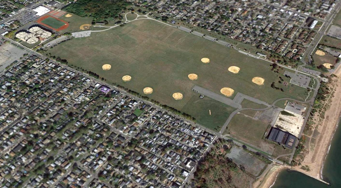
In 1974, Miller Field became part of the newly established Gateway National Recreation Area.
“Miller Field” was still labeled on the 1989 USGS topo map,
but “towers” were the only details depicted on the field.
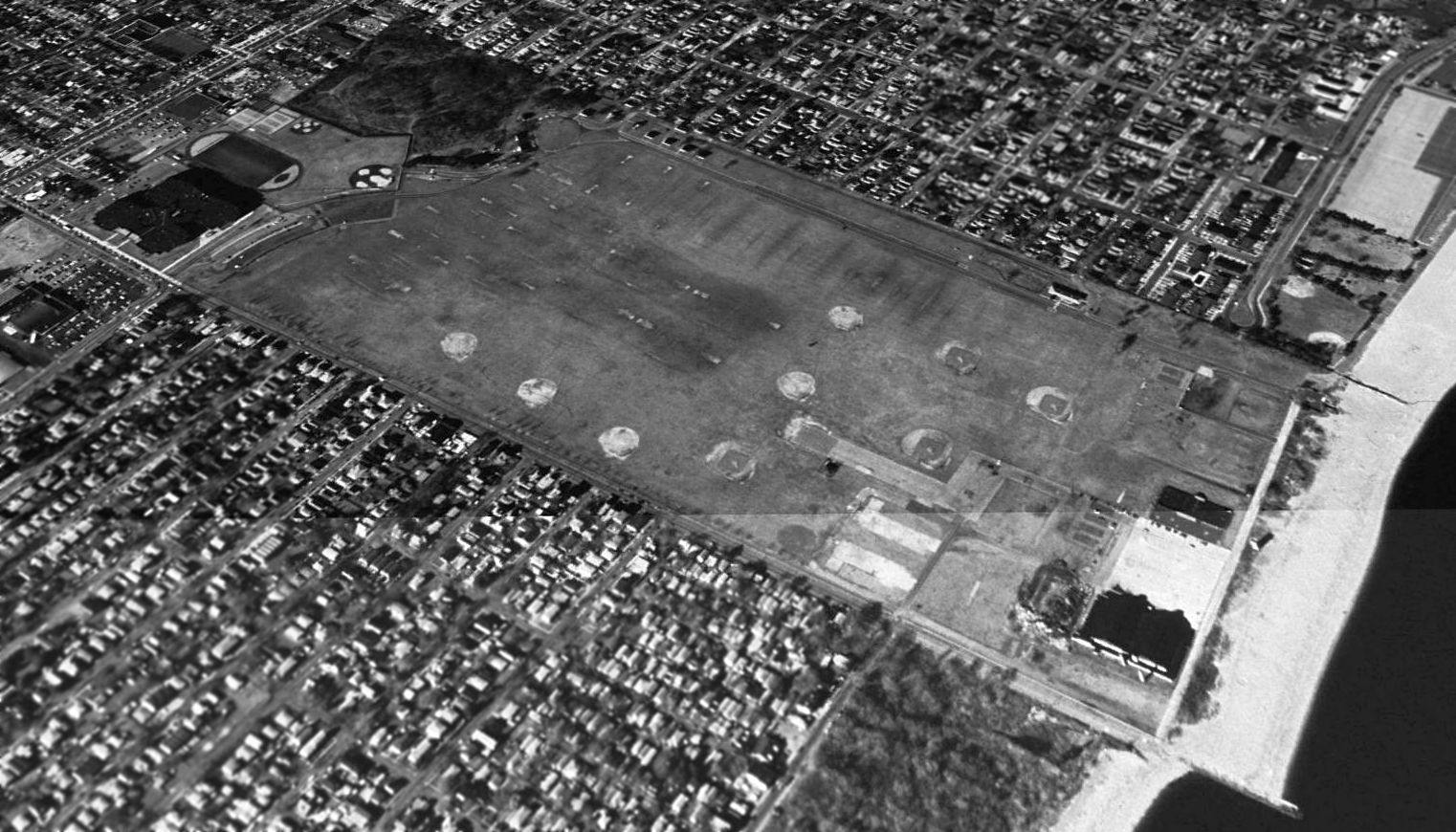
A 1991 USGS aerial view looking north at Miller AAF, showing the asphalt taxiway portion & hangar at the southeast side.
A 2003 aerial photo of Miller Field by Ed Drury.
"The lookout tower is visible near the beach.
The pilings to the right were a dock for seaplanes & army boats,
although the seaplane ramp was near the big hangars."
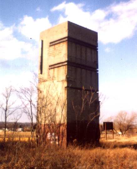
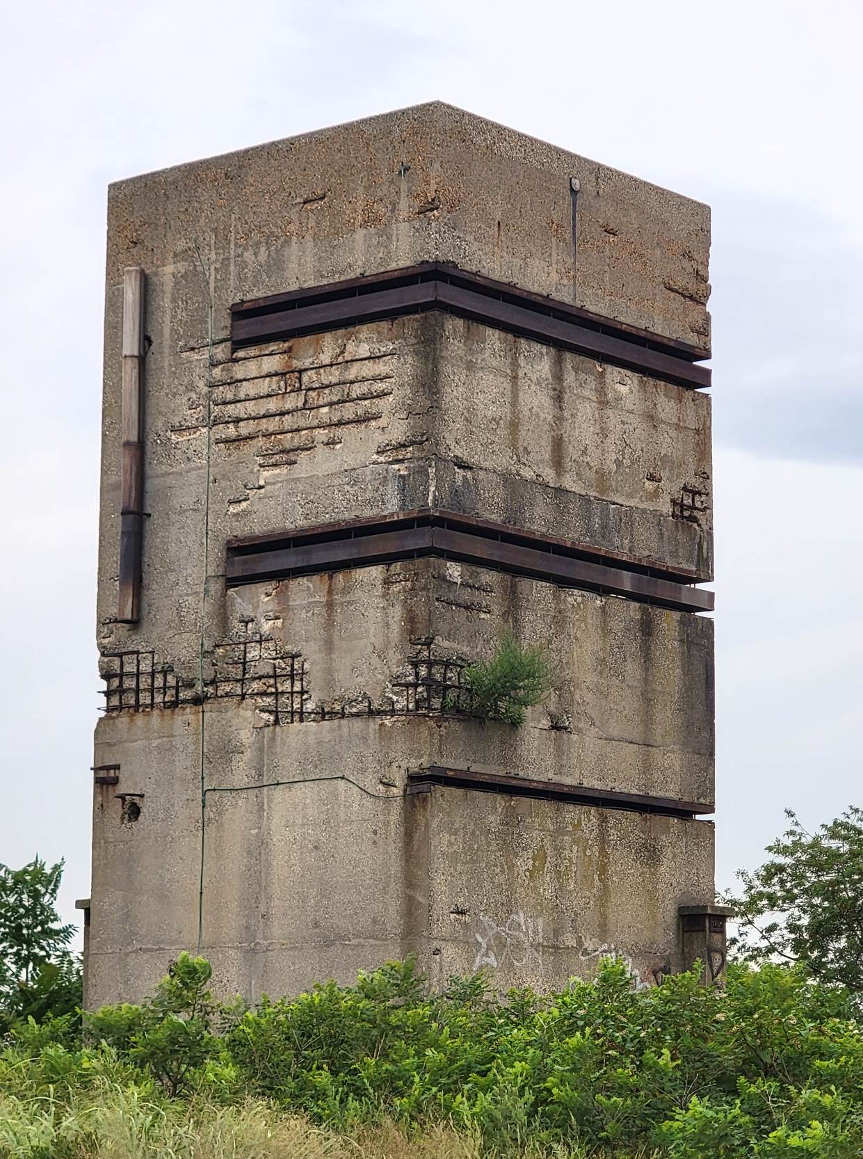
A 2003 photo by Ed Drury of a lookout tower which still stands along the shore at Miller AAF,
built as a Base End Station, part of the coastal defense network during WW2.
According to CAP Lt. Col. Henry Deutch, “The observation tower was built as an observation & fire control station for the Coast Artillery at Fort Wadsworth.”
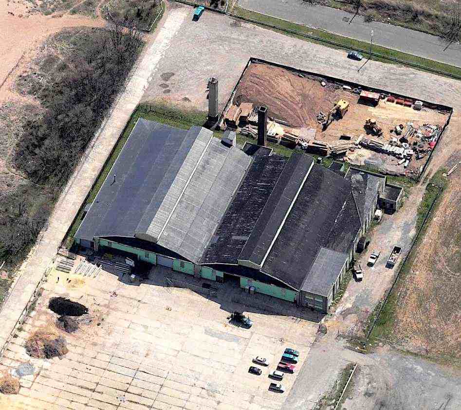
A hangar & a concrete ramp area remain intact, on the southern corner of the property along the Bay.
A high school has been built on the northwest corner of the former airfield.
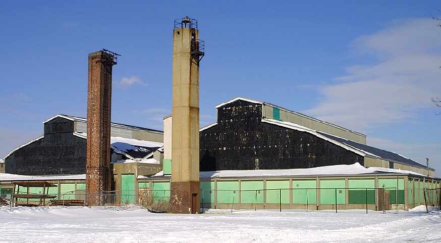
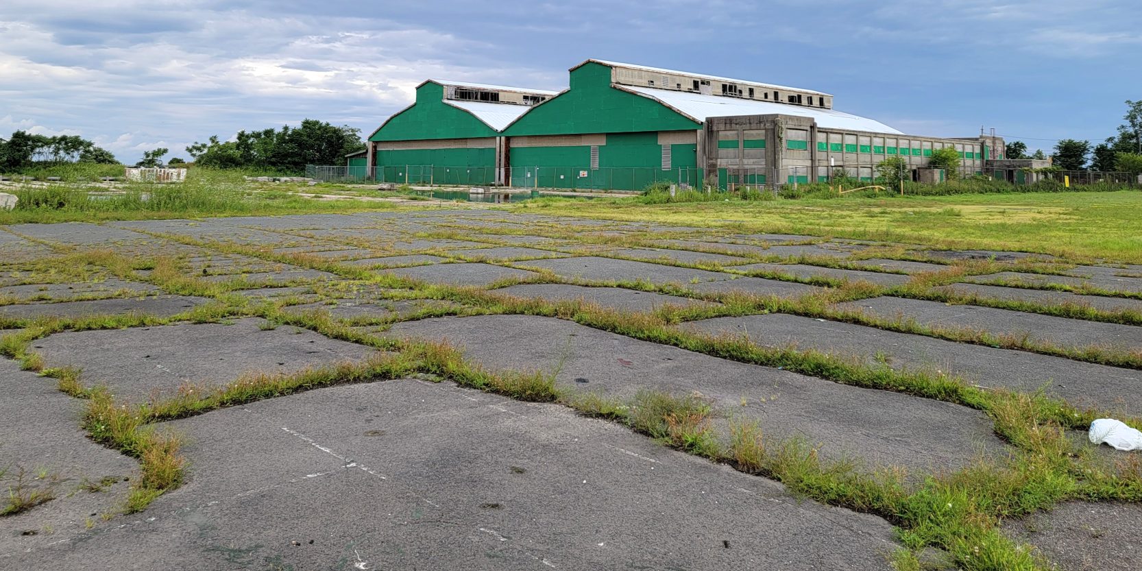
A 2004 photo by Tom Turner of the remaining hangars at Miller Field, along with the beacon tower (in the center).
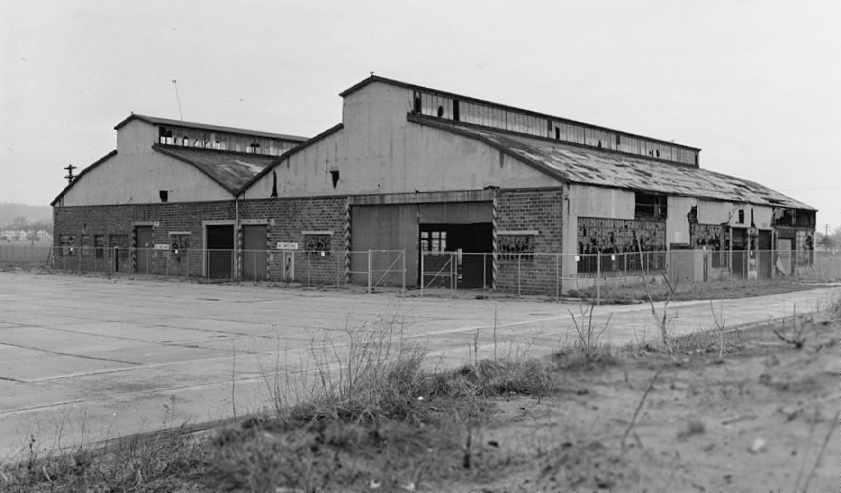
A circa 2007 aerial view looking south at the Miller AAF hangars.

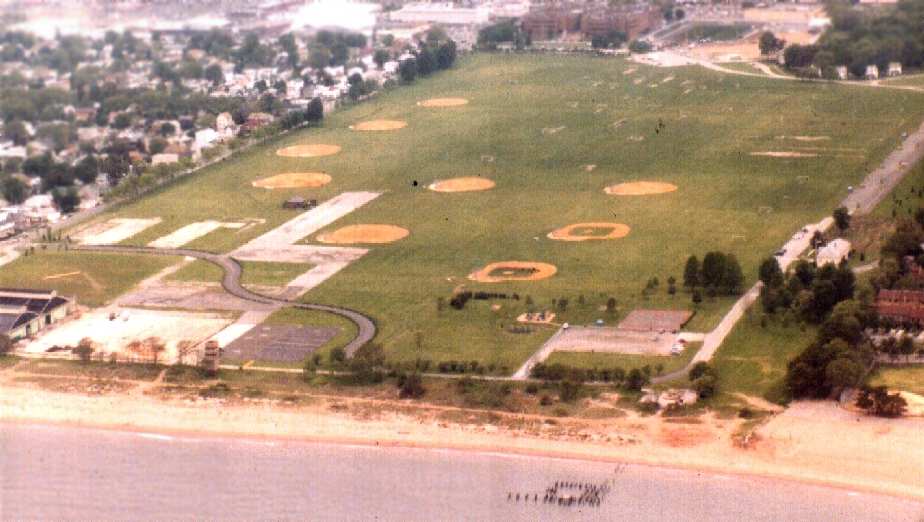
A 1/11/13 aerial view by Butch Moran looking south at Miller Field.
A 2014 aerial view looking north at Miller AAF, showing the asphalt taxiway portion & hangar at the southeast side.
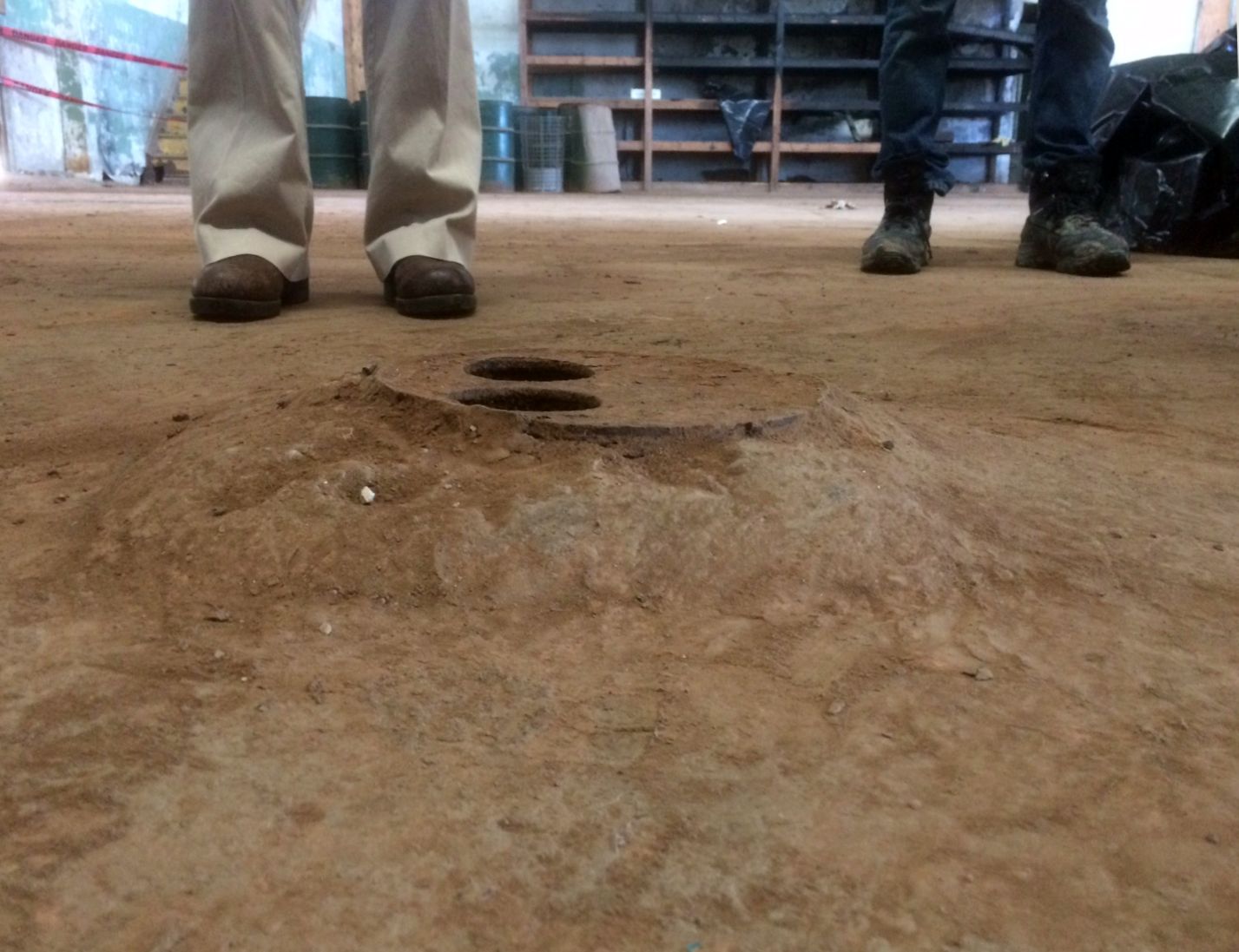
A 12/1/16 photo by Jonathan Blonk of an unidentified feature on the floor of Miller Field's Hangar 38, the furthest southeastern hanger on the site, originally a seaplane hangar.
Jonathan reported, “I am assisting in cleaning up from Hurricane Sandy at Miller Field.
Running from north to south down the center of the east hangar appears to be about a 2 inch metal pipe about 8 inches under the concrete pad.
The pipe comes up out of the floor at 4 locations to metal plates with 2 holes in it.
The metal plate sits about 3 inches above the grade of the pad on a little concrete lump, so we do not believe they are floor drains of any kind,
plus we believe we have located the floor drain in the middle of the hanger at grade level.
There is debris & sediment currently being cleaned up which is preventing us from seeing the complete hangar floor.
We have heard various guesses to what it could be including ground fueling, fuel disposal, oil disposal, etc.”
A 5/1/19 photo of a banner-towing Piper J3 Cub which made a precautionary landing at Miller Field due to worsening weather (courtesy of Steven Boggess).
An 8/4/21 photo by Sebastian looking south at the Miller AAF hangars.
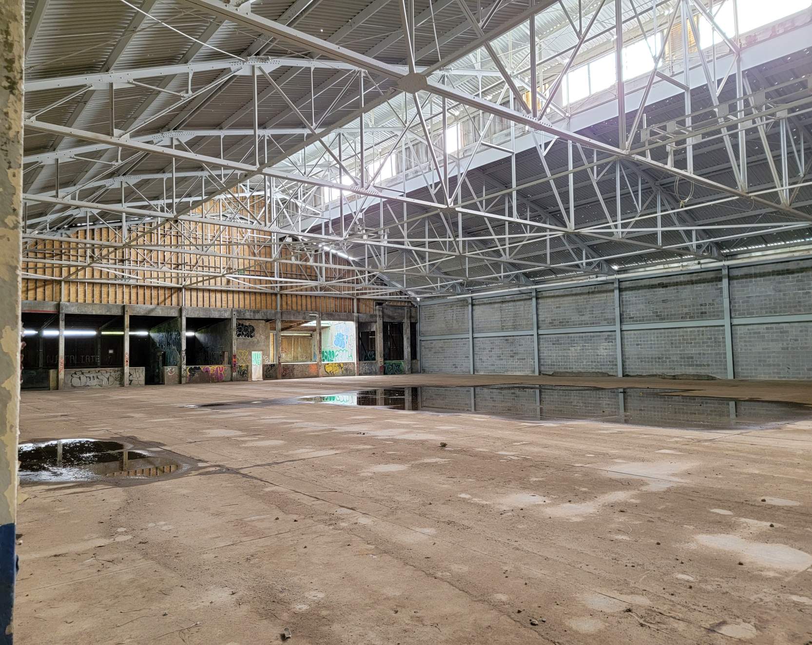
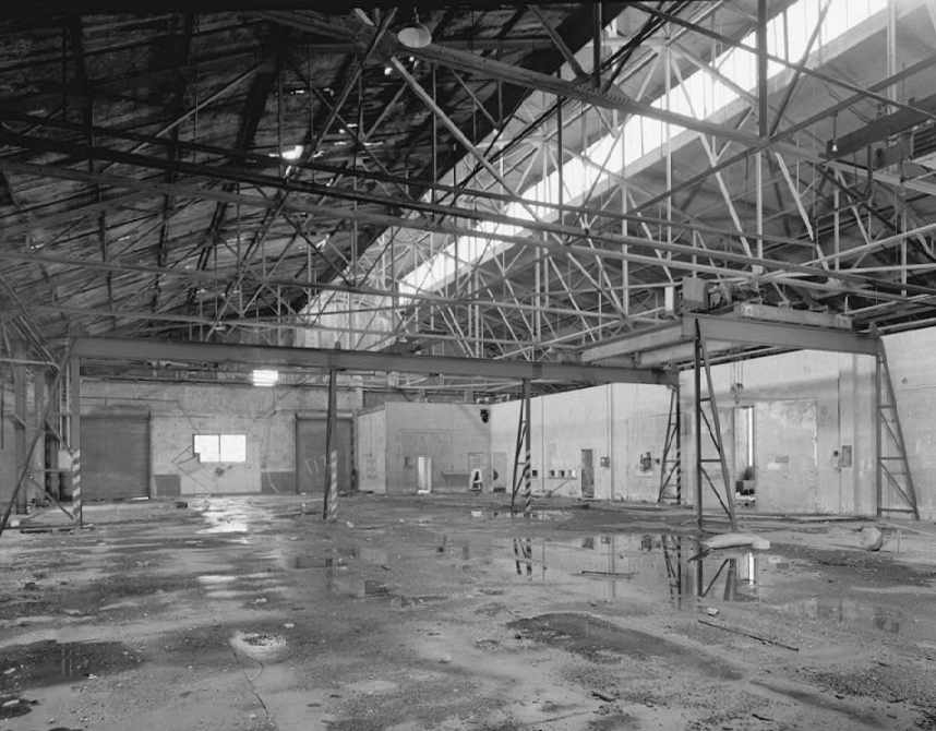
An 8/4/21 photo by Sebastian of the interior of a Miller AAF hangar.
An 8/4/21 photo by Sebastian of the WW2 Base End Station lookout tower on the grounds of Miller AAF.
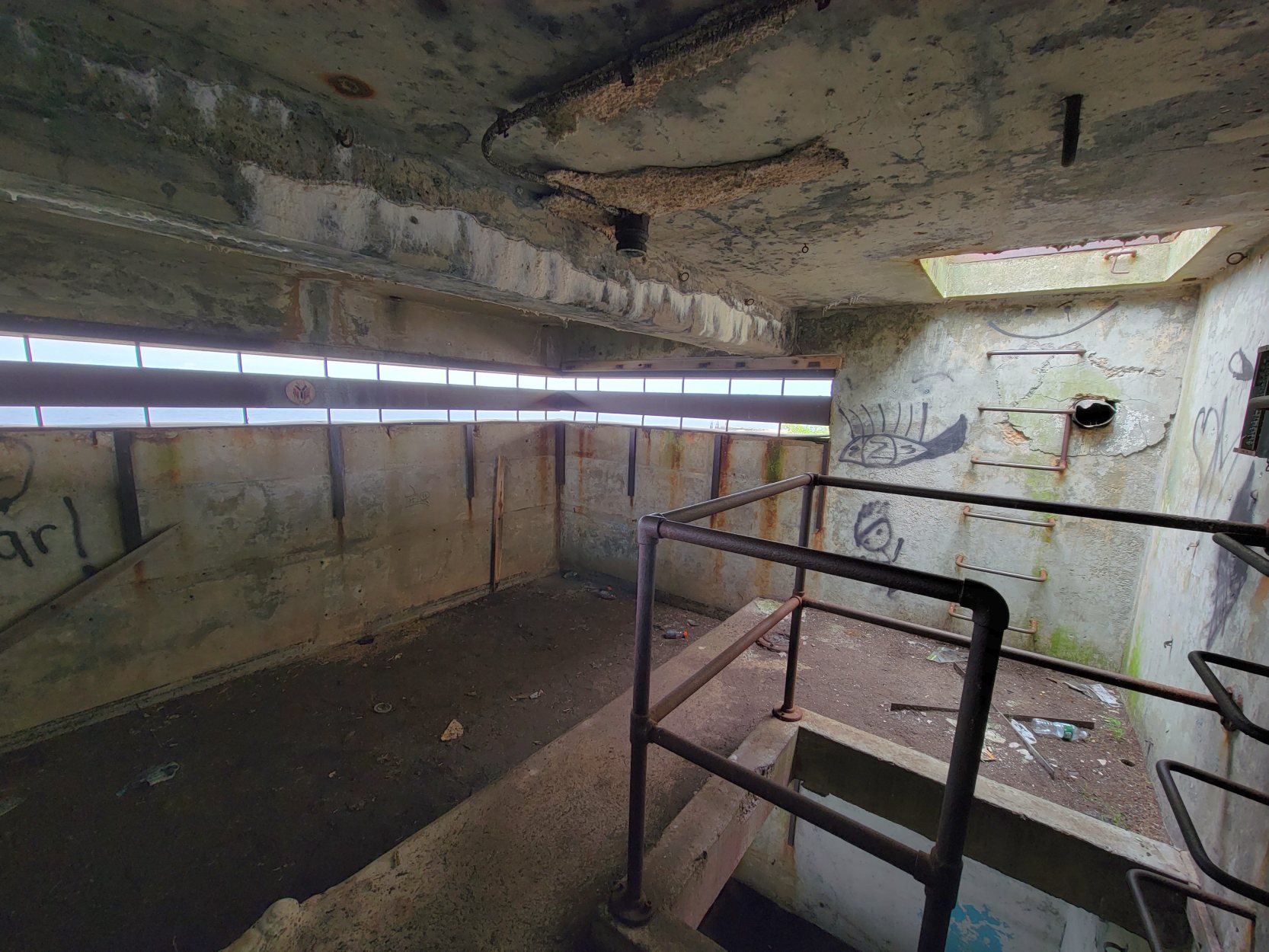
An 8/4/21 photo by Sebastian of the interior of the WW2 Base End Station lookout tower on the grounds of Miller AAF.
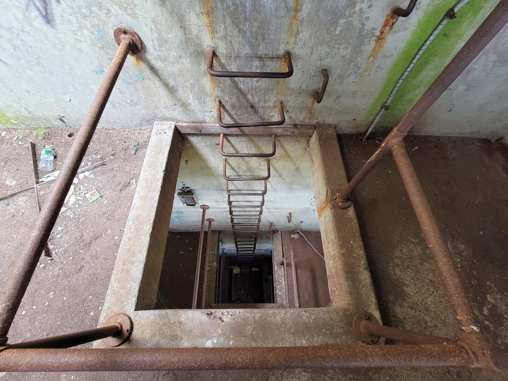
An 8/4/21 photo by Sebastian of the steps inside the WW2 Base End Station lookout tower on the grounds of Miller AAF.
See also: Staten Island Advance 12/26/99
http://statenislandaviation.com/
____________________________________________________
Or if you prefer to contact me directly concerning a contribution (for a mailing address to send a check),
please contact me at: paulandterryfreeman@gmail.com
If you enjoy this web site, please support it with a financial contribution.
____________________________________________________
This site covers airfields in all 50 states.