Abandoned & Little-Known Airfields:
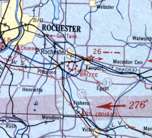
New York State: Rochester area
© 2002, © 2026 by Paul Freeman. Revised 4/23/26.
This site covers airfields in all 50 states: Click here for the site's main menu.
____________________________________________________
Please consider a financial contribution to support the continued growth & operation of this site.
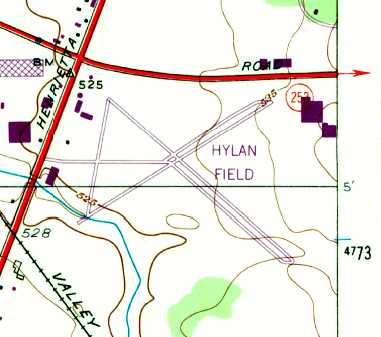
Brizee - Harmon Airport (revised 11/14/25) - Genesee Airport (revised 5/17/22) - Honeoye Falls Airport (revised 8/31/21) - Hylan Field (revised 2/21/18)
Para-Tech Airfield (revised 9/10/25) - Ridgeway Airpark (revised 5/4/19) - Sampson AFB / Seneca AAF (revised 2/14/23) - Sampson Naval Training Center Airfield (revised 10/12/19)
Scenic Aire Park (revised 1/8/20) - Taylor-Van Gelder Airport (revised 4/23/26) - Woodward Field / Le Roy Airport (revised 11/14/25)
____________________________________________________
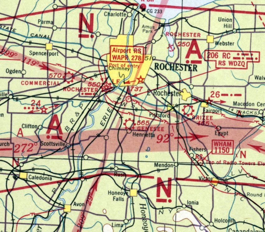
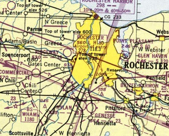
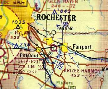
Genesee Airport, Rochester, NY
43.085, -77.611 (Northwest of New York, NY)
Genesee Airport, as depicted on the January 1940 Albany Sectional Chart.
This general aviation was evidently established at some point between 1938-40,
as it was not yet depicted on the July 1938 Albany Sectional Chart.
The earliest depiction which has been located of Genesee Airport was on the January 1940 Albany Sectional Chart.
It depicted Genesee as a commercial/municipal airport.
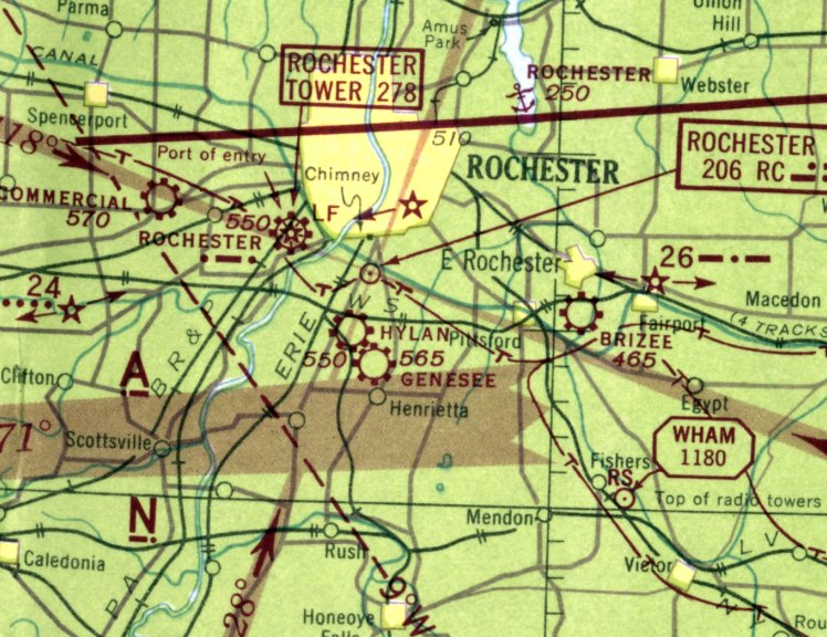
Genesee Airport, as depicted on the July 1942 Albany Sectional Chart.
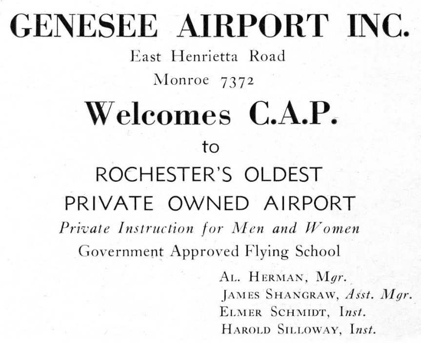
An advertisement for Genesee Airport from the 2/26/44 Civil Air Patrol meeting program booklet (courtesy of Alan Reddig).
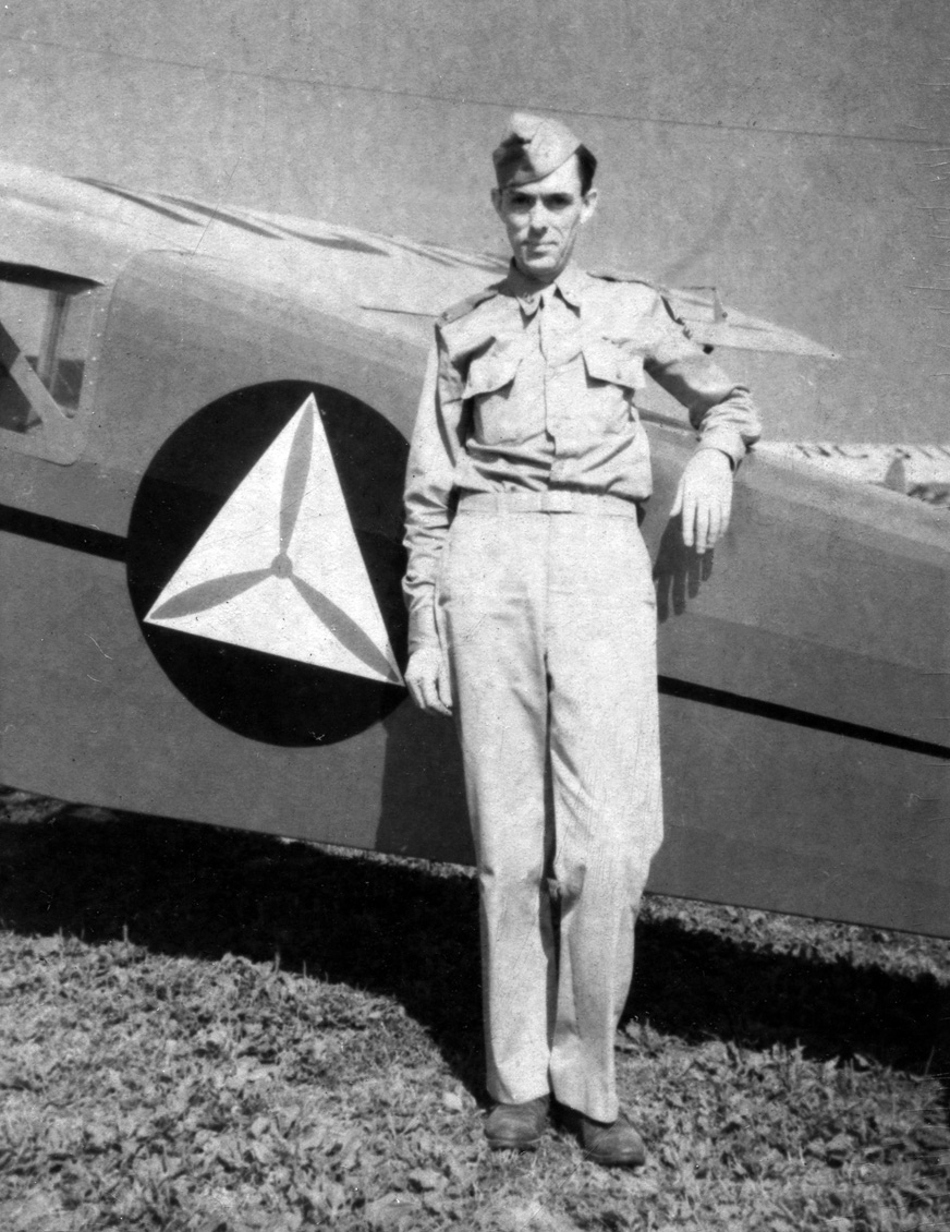
The earliest photo which has been located taken at Genesee Airport was a 1945 photo of James Reddig (courtesy of his son Alan Reddig)
in his Civil Air Patrol Uniform, leaning on a CAP Rearwin Sportster with a 90 hp LeBlond engine at Genesee Airport.
Susan Tietze recalled, “My father, Marvin (Bud) Fritchman, ran a flight school at the grass strip Genesse Airport in the late 1940s / early 1950s.
My family & I lived on the airport. I loved living there.”
The January 1950 Albany Sectional Chart (courtesy of Bob Bailey) depicted Genesee as having a 2,300' unpaved runway.
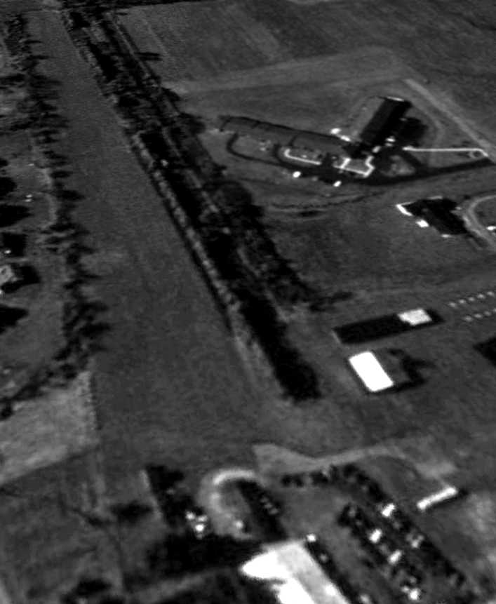
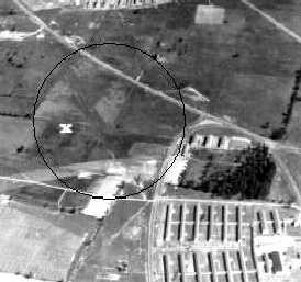
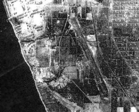
The only aerial photo which has been located of Genesee Airport was a 9/8/51 USGS aerial view.
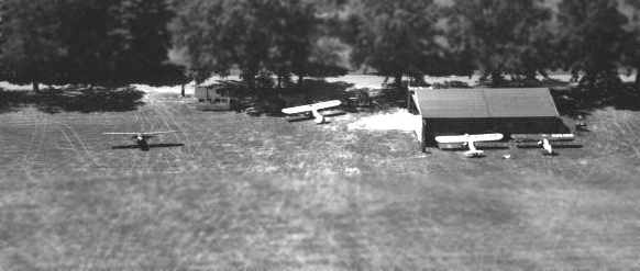
It depicted Genesee as having 3 grass runways, with several small hangars & over 20 light planes on the northeast side.
The last aeronautical chart depiction which has been located of Genesee Airport was on the January 1952 Albany Sectional Chart.
It depicted Genesee as having a 2,200' unpaved runway.
Susan Tietze recalled, “We stayed at the airport until it failed financially & the property was bought for construction of a factory.”
Genesee Airport was evidently closed at some point between 1952-55,
as it was no longer depicted on the May 1955 Albany Sectional Chart.
Genesee Airport was presumably not able to maintain viable business, given that Hylan Field was located less than a mile to the west.
Alan Reddig noted, “I suspect the reason that two airports that close together were not viable is because Ray Hylan,
who had a flying school, made his field to the west bigger & better, and simply overwhelmed Genesee.”
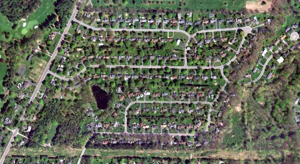
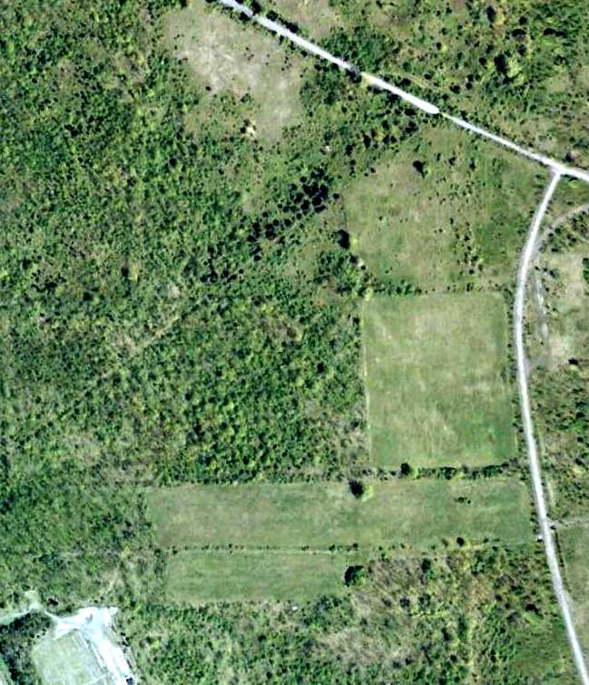
A 1994 aerial photo showed no trace remaining of Genesee Airport.
A 2016 aerial view showed no trace remaining of Genesee Airport.
Thanks to Alan Reddig for pointing out this airfield.
____________________________________________________
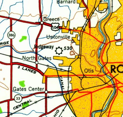
43.19, -77.68 (West of Rochester, NY)
Ridgeway Airpark, as depicted on the May 1945 Albany Sectional Chart (courtesy of Chris Kennedy).
Ridgeway Airpark, a small general aviation airport on the west side of Rochester, was evidently established at some point in 1945,
as it was not yet depicted on the January 1945 Albany Sectional Chart.
The earliest depiction which has been located of Ridgeway Airpark was on the May 1945 Albany Sectional Chart.
It depicted Ridgeway as a commerial/municipal airport.
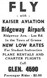
A 1947 advertisement for Kaiser Aviation at Ridgeway Airpark (courtesy of William Sauers) described the firm as offering flight instruction, plane rentals, and charter flights.
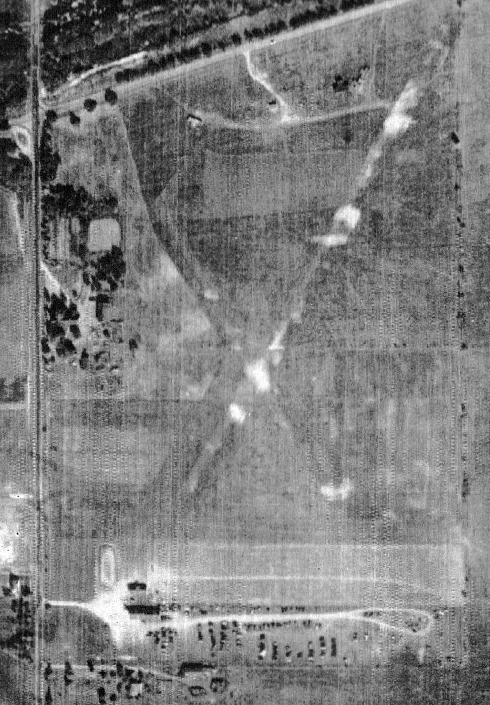
The earliest photo which has been located of Ridgeway Airpark was a 1950 aerial view (courtesy of William Sauers).
It depicted Ridgeway as having 1 (or possibly 2) unpaved runways, with 3 T-hangars & a few small buildings on the north side.
The last aeronautical chart depiction which has been located of Ridgeway Airpark was on the November 1957 Albany Sectional Chart.
It depicted Ridgeway as having a mere 1,800' unpaved runway.
The last depiction which has been located of Ridgeway Airpark was on the 1960 USGS topo map.
Ridgeway Airpark was evidently closed at some point between 1957-58,
as it was no longer depicted on the May 1958 Albany Sectional Chart.
A 1969 aerial view showed several large buildings were being built on the southern & eastern sides of the Ridgeway Airpark site.
A 1994 aerial view showed several large buildings had covered the site of Ridgeway Airpark.
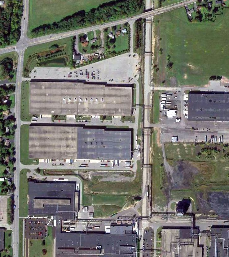
A 2013 aerial view showed no trace remaining of Ridgeway Airpark.
The site of Ridgeway Airport is located southeast of the intersection of Ridgeway Avenue & Lee Road.
Thanks to William Sauers for pointing out this airfield.
____________________________________________________
42.83, -76.98 (East of Rochester, NY)
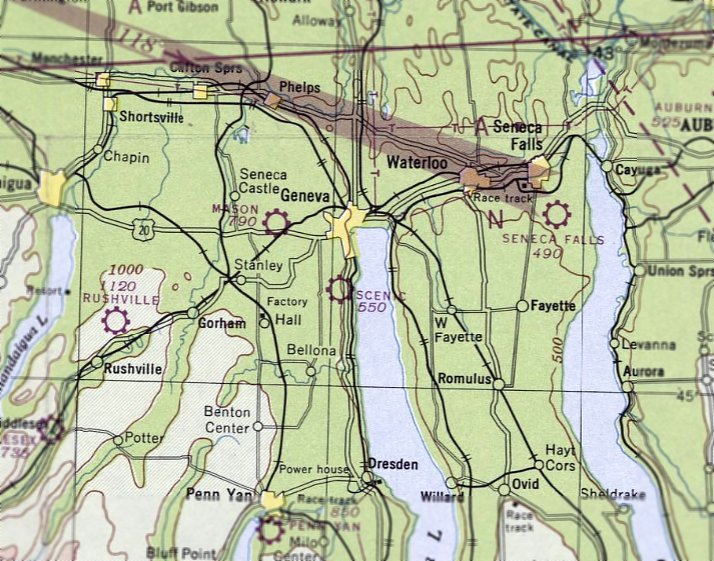
Scenic Aire Park, as depicted on the July 1947 Albany Sectional Chart.
Scenic Aire Park was not yet depicted on the January 1947 Albany Sectional Chart.
This small general aviation airport on the west shore of Seneca Lake was established in 1947,
as described in an article entitled “Dream Come True, ScenicAire, Geneva Airport, Promises Vast Benefits, Brings World Closer”
in the 4/19/47 Geneva Daily Times (courtesy of Michael McMurtrey).
The earliest depiction which has been located of Scenic Aire Park was on the July 1947 Albany Sectional Chart.
It depicted Scenic Aire Park as a commercial/municipal airport.
The January 1950 Albany Sectional Chart depicted Scenic Aire Park as having a 2,800' unpaved runway.
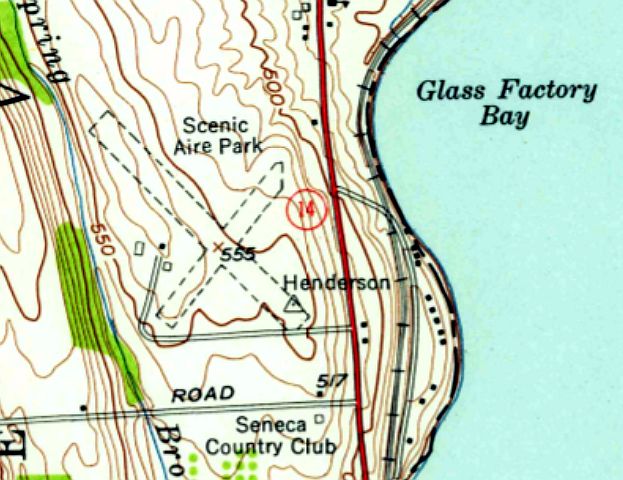
The 1953 USGS topo map depicted Scenic Aire Park as having 2 unpaved runways, with 3 small buildings on the west side.
The only photo which has been located showing Scenic Aire Park while it was in operation was a 10/21/59 USGS aerial view.
It depicted the field as having 2 unpaved runways, with a few small buildings on the west side.
Scenic Aire Park was not depicted on the May 1960 Albany Sectional Chart.
The last depiction which has been located of Scenic Aire Park was on the 1973 USGS topo map,
which depicted it in the same fashion as on the 1953 topo.
Scenic Aire Park was evidently closed (for reasons unknown) at some point between 1973-79,
as it was no longer depicted on the 1979 USGS topo map.
A 1995 USGS aerial photo showed no trace remaining of Scenic Aire Park, with houses having been built on the property.
A 9/24/13 aerial view showed no trace remaining of Scenic Aire Park.
The site of Scenic Aire Park is located west of the intersection of Bay Heights Circle & Route 14.
Thanks to Michael McMurtrey pointing out this airfield.
____________________________________________________
Para-Tech Airfield, Brockport, NY
43.26, -77.999 (Northwest of Rochester, NY)

Para-Tech Airfield, as depicted on the October 1985 Detroit Sectional Chart.
This private airfield was not yet depicted on a 1971 aerial photo or the 1972 Detroit Sectional Chart (according to Richard Finley).
According to Debbie Young, “Para-Tech Skydivers purchased the 120 acre site in 1977
and built a 1,700' dirt runway for its skydiving operation which was completed in the spring of 1979.
I was one of the people who founded the airport & worked on building the runways.
The strip was improved & paved by the club members in 1980. It was then used as a skydiving operation, glider school, and banner tow operation.
A parallel 1,700' grass runway was added for glider & banner operations in 1981.
I ran the parachute operation, glider school, and banner tow operation until 1986.
In 1986, Rochester Skydivers took over the operation.”
Para-Tech Airfield was still not depicted on the 1984 USGS topo map.
The earliest depiction which has been located of Para-Tech Airfield was on the October 1985 Detroit Sectional Chart.
It depicted Para-Tech as a private airfield with a single paved east/west 1,600' runway, conducting parachuting operations.
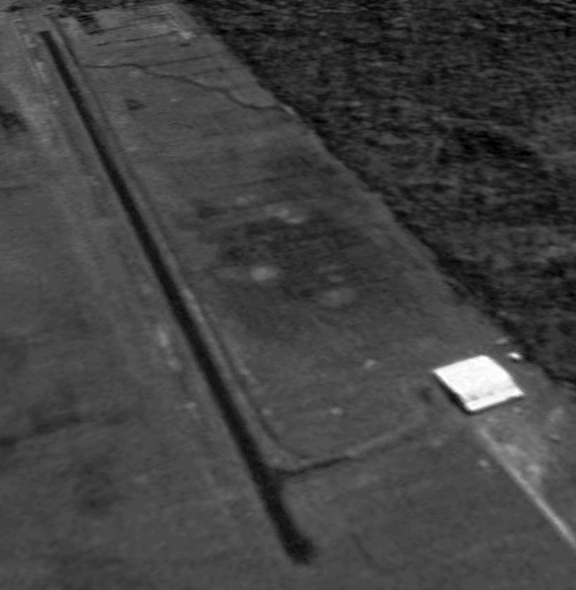
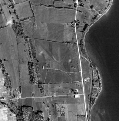
The only photo which has been located showing Para-Tech while it was in operation was a 5/2/94 USGS aerial view looking southeast.
The field has a single east/west asphalt runway, with one hangar on the southwest side.
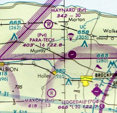
The last depiction which has been located showing Para-Tech Airfield as operational was on the March 1999 Detroit Sectional Chart (courtesy of Richard Finley).
It depicted Para-Tech as a private airfield with a single paved east/west 1,600' runway, conducting parachuting operations.
According to Debbie Young, “Rochester Skydivers were there until 1999. The skydivers left & the airport was unused.”
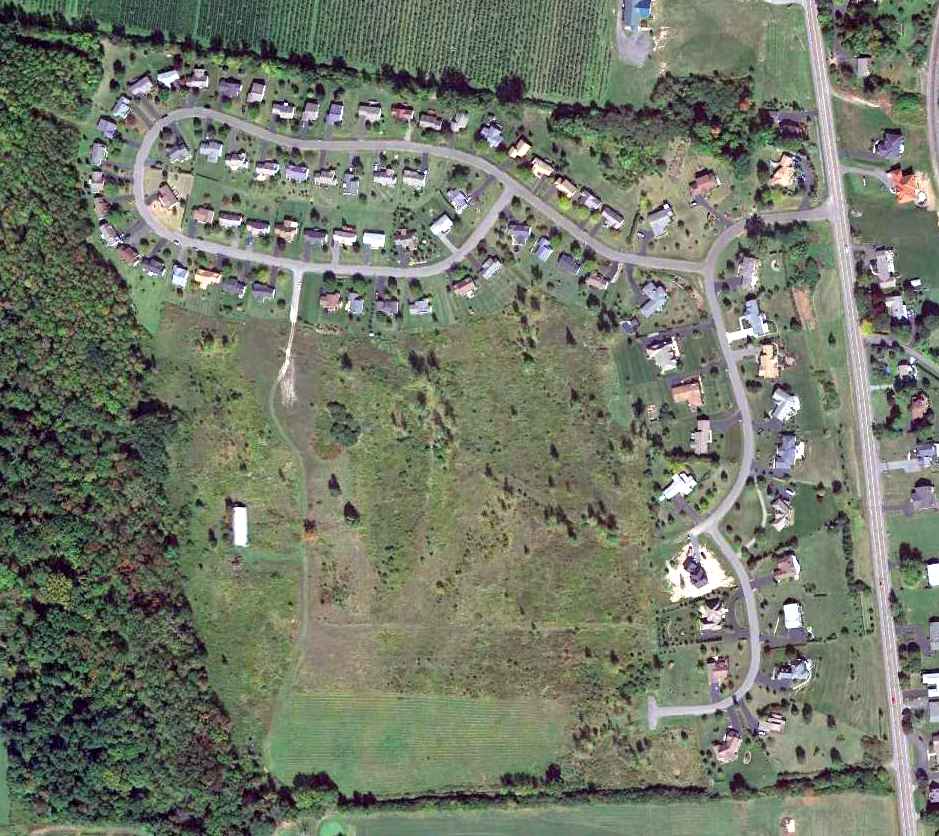
Para-Tech Airfield was evidently closed by 2006, as a 2006 aerial view depicted closed-runway “X” symbols painted on the runway.
According to Debbie Young, “The airport was unused until it was sold around 2007.”
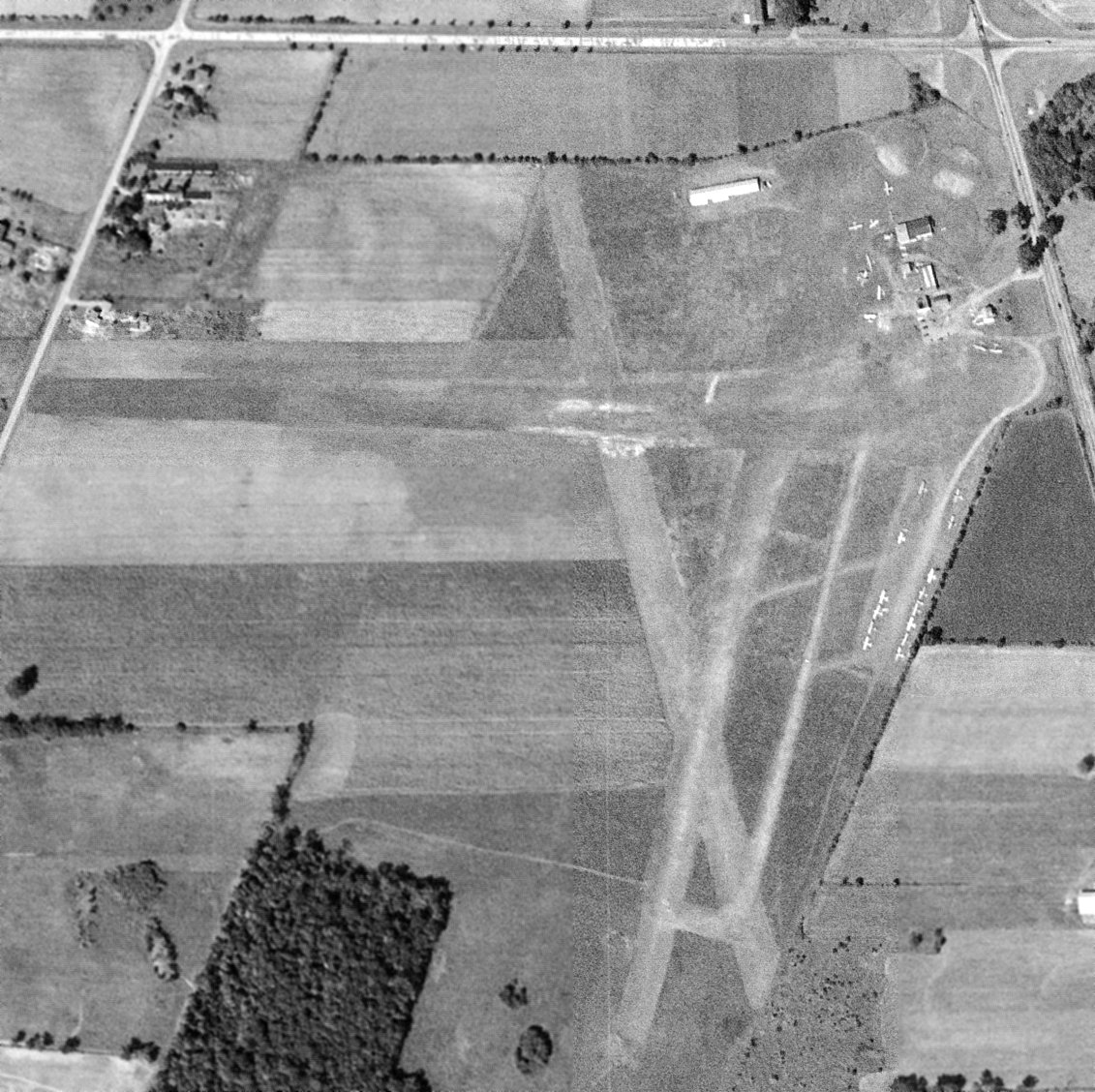
A 5/9/11 aerial view looking southeast showed the Para-Tech runway & hangar to remain intact, though deteriorated.
Richard Finley observed, a “Classic airport/drop zone... [with a] pea gravel pit in field south of runway.”
A 2021 aerial view looking northeast showed the Para-Tech runway & hangar remained intact, although the pea gravel pit south of the runway had been removed at some point between 2011-2021.
The site of Para-Tech Airfield is located northeast of the intersection of Route 104 & County Line Road.
Thanks to Richard Finley for pointing out this airfield.
____________________________________________________
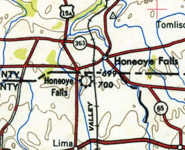
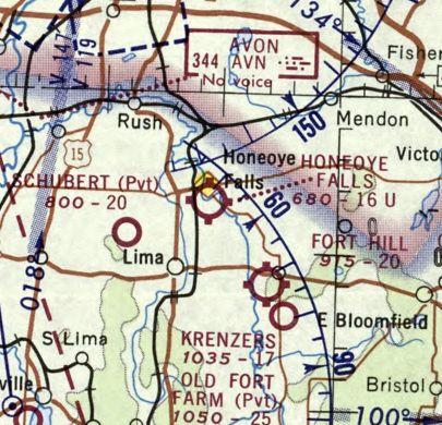
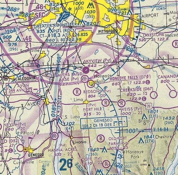
Honeoye Falls Airport (D70), Honeoye Falls, NY
42.95, -77.6 (South of Rochester, NY)
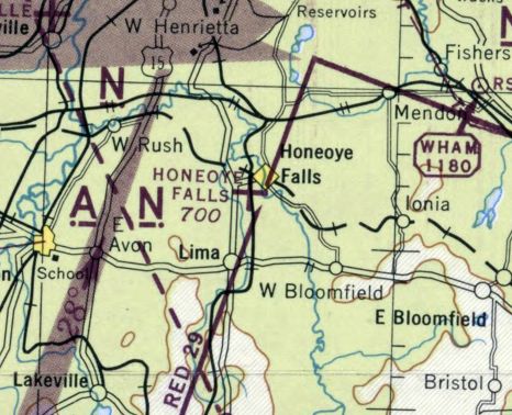
Honeoye Falls Airport, as depicted on the May 1945 Albany Sectional Chart.
According to Bob McNamara, “This airfield was constructed in the late 1930s or 1940s by a group of local pilots, including my father & uncle.
At one time there were 2 runways, with a large hangar including an apartment & many T-hangars.”
Honeoye Falls Airport was not yet depicted on the January 1940 Albany Sectional Chart nor on the 1942 USGS topo map.
The earliest depiction which has been located of Honeoye Falls Airport was on the May 1945 Albany Sectional Chart.
It depicted Honeoye Falls Airport as an auxiliary airfield.
The 1950 USGS topo map depicted Honeoye Falls Airport as a commercial/municipal airport.
The earliest photo which has been located of Honeoye Falls Airport was a 1951 aerial photo,
which appeared to depict a single grass north/south runway, with a single hangar on the northwest side.
According to its FAA Airport/Facility Directory data, Honeoye Falls Airport was activated (probably when it was first officially registered) in November 1959.
Jim Hertsch recalled, “I took my first flying lessons at Honeoye Falls Airport with Jack McNamara (Bob’s uncle or Dad?)
and Linc Shaw (Linc owned or ran the tractor dealer, Ford tractors I think) during spring & summer 1959.
I was the 'airport kid' & after several months’ hanging around the pilots offered me 75 cents / hour credit toward flying lessons to be kind of a line person there.
The planes I remember were Jack’s Champ N83597, Linc’s Champ, N82780,
an Ercoupe (I wonder if it’s the one in the 1970s picture) and Ev Lewis’ brand new pink Tri Pacer (ah the fantasies).
At the time the airport also was the Honeoye Falls Little League Field.
Not only did the plate umpire have to call balls & strikes but he had to watch the downwind for landing traffic & call time-out to allow airplanes to land.”
The January 1970 Albany Sectional Chart depicted Honeoye Falls Airport as having a mere 1,600' unpaved runway.
A 1971 aerial photo of Honeyoke Falls Airport showed 3 single-engine aircraft parked on the northwest side of the field.
A 2nd hangar had been added at the northwest side at some point between 1951-71,
and 2 T-hangars had been added in the same timeframe on the northeast side.
The earliest topo map depiction which has been located of Honeoye Falls Airport was on the 1973 USGS topo map,
which depicted a single unpaved north/south runway, labeled simply “Landing Strip”.
Interestingly, the 2 hangars at the northwest corner of the field were separated from the runway by a railroad which ran parallel to the west side of the runway.
Will Dalton recalled, “Honeoye Falls Airport... a field near where I grew up, and one that I saw planes fly from as a kid in the 1970s.
Honeoye Falls Airport (D70), was a small grass strip that was directly behind a Ford dealer, Ev Lewis Ford.”
Paul Norder recalled, “Honeoye Falls Airport was owned by Everett Lewis;
I believe that he constructed the airport & owned it up to the time of his death.
He also owned the Honeoye Falls Ford dealership, which was located at the northeast corner of the airport property.
The airport was used for light civilian aircraft & sailplanes.
Ev was a very interesting fellow; a down-to-earth country man; loved to sit & chat; never charged a landing fee.”
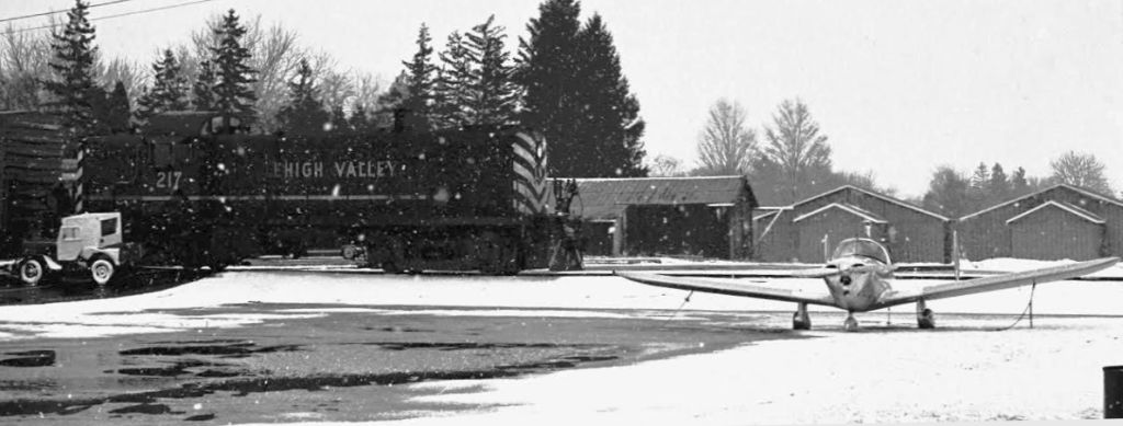
A 2/26/75 photo by Paul Templeton of a Lehigh Valley Railroad local train MR-1 passing between the Honeoye Falls Airport hangars & an Ercoupe.
According to Paul Templeton, the railroad tracks which bisected Honeoye Falls Airport
“were the Rochester branch of the Lehigh Valley Railroad which went out of business on 4/1/76.
ConRail took over operation of the Rochester branch [and] made a final trip through the airport on 11/13/81.
ConRail abandoned it [the railroad track] in 1982.
The rails that went through the Honeoye Falls Airport were pulled up in the spring of 1984.”
Miek Worden recalled, “Honeoye Falls... When I grew up there in the 1980s they used to hold an annual event called 'The Fly-In Breakfast'
where they would serve pancakes, waffles, eggs, etc. in one of the hangars & then offer quick airplane rides to the attendees.
I clearly remember the thrill of getting to fly over our house. It was awesome!”
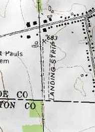
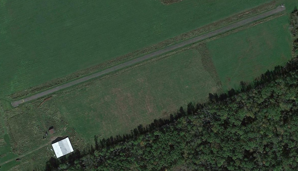
The 1990 USGS topo map depicted Honeoye Falls Airport as a single unpaved north/south runway, labeled simply “Landing Strip”.
The last aeronautical chart depiction which has been located of Honeoye Falls Airport was on the October 1993 Detroit Sectional Chart.
It depicted Honeoye Falls Airport as having a mere 1,700' unpaved runway.
A 4/22/94 USGS aerial view did not show any signs of recent aviation usage at Honeoye Falls Airport.
Bob McNamara recalled, “As recently as the mid-1990s I owned & based a Tri-pacer there.”
Bob McNamara reported in 2006, “Honeoye Falls Airport (D70) was permanently closed at the end of last autumn [2005].
This field has not been plowed in recent winters, and was closed by the family of recently-deceased owner Everett Lewis.
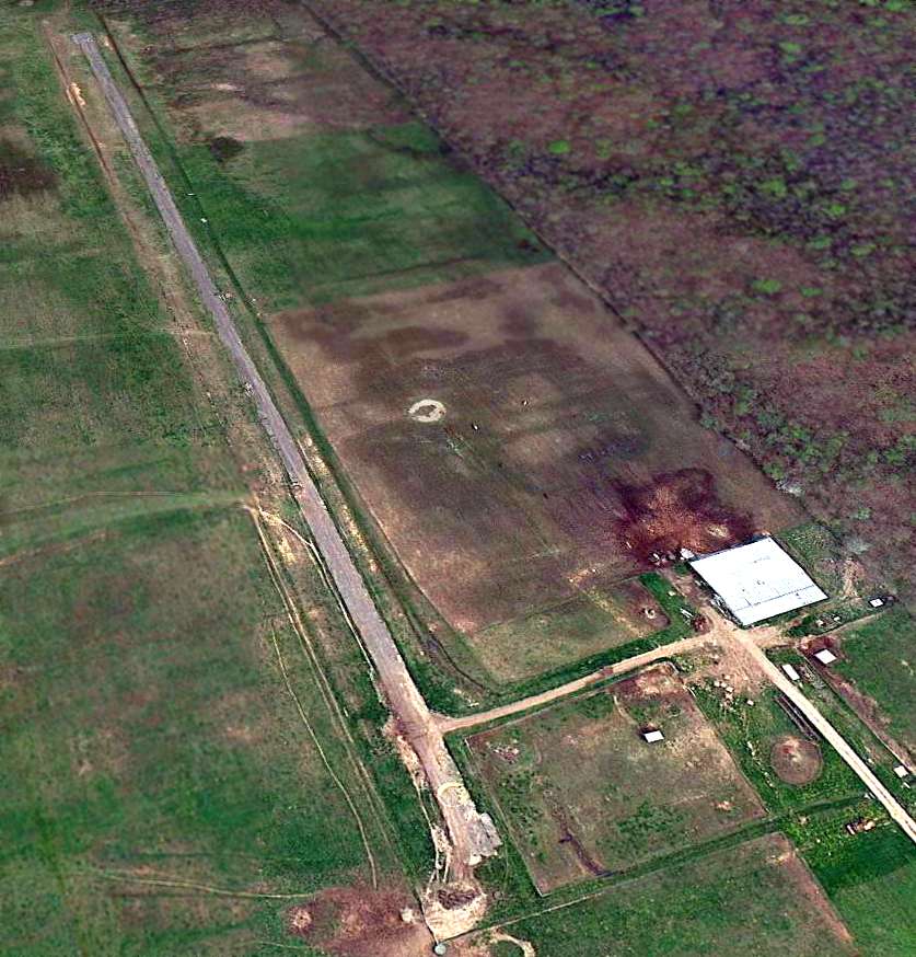
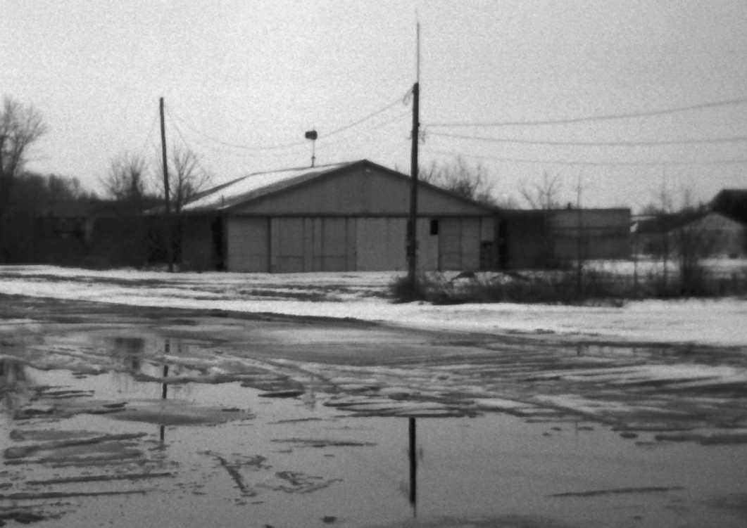
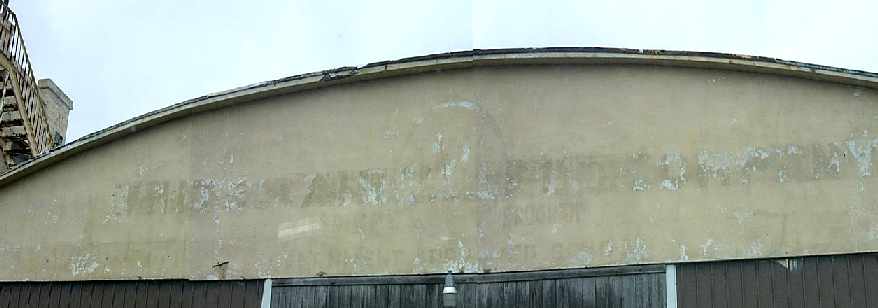
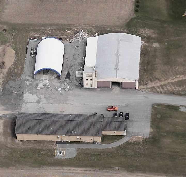
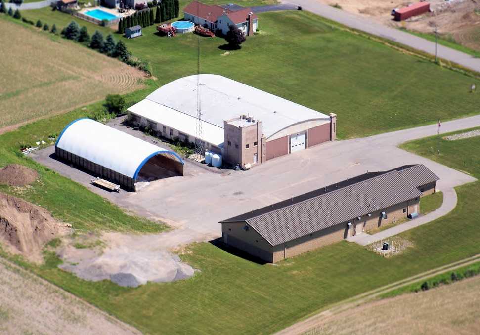
A circa 2005-2011 aerial view looking south showed the hangars at Honeoye Falls Airport, and the paved taxiway.
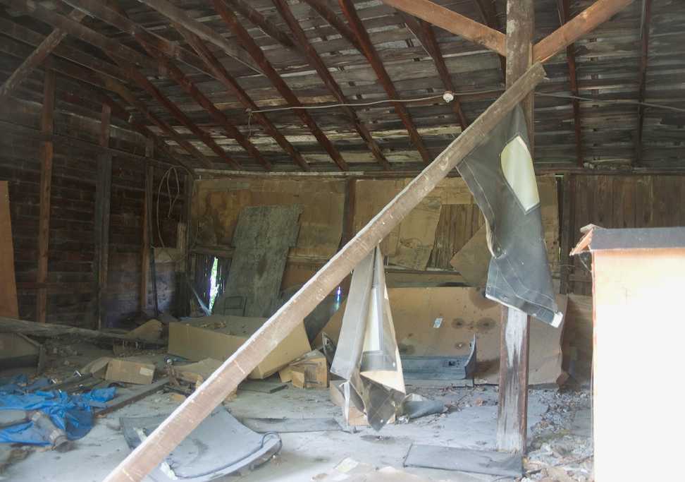
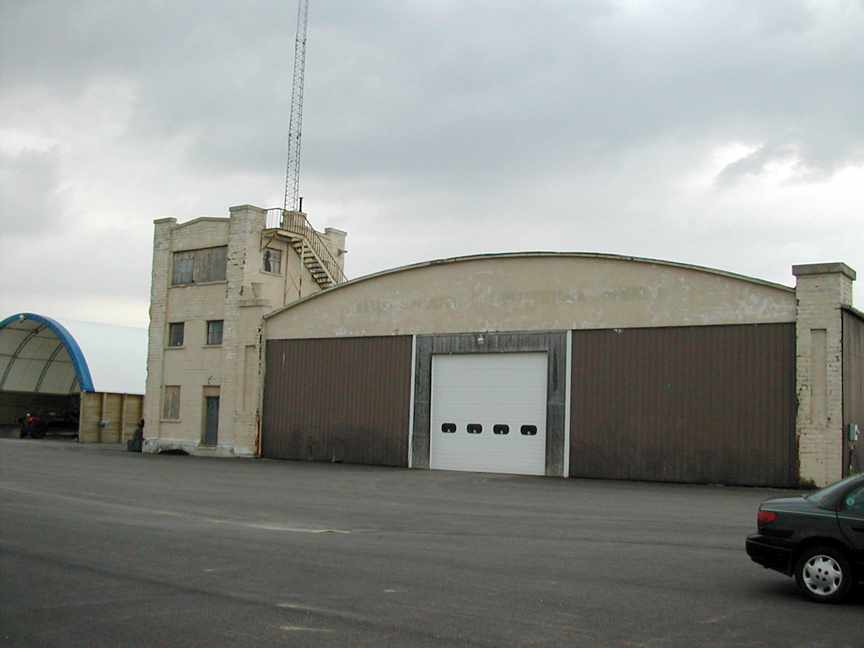
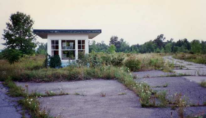
An 8/31/08 photo by Tommasz of the interior of the Honeoye Falls hangar.
An 9/12/08 photo by Htcoogan of the Honeoye Falls hangar.
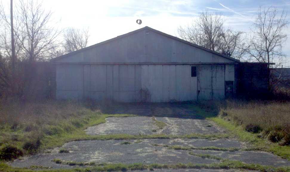
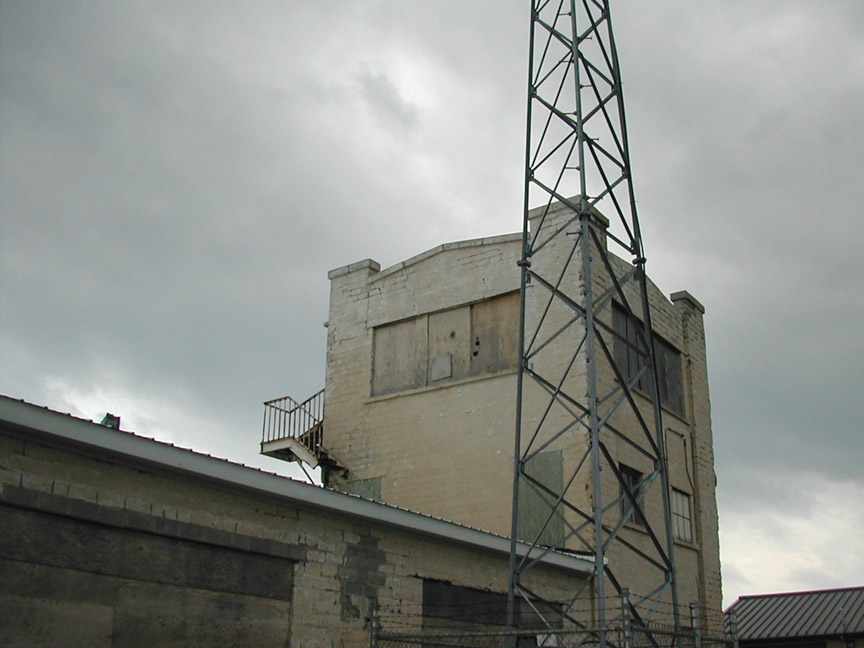
A 2011 photo looking south at the main Honeoye Falls hangar by Will Dalton.
Note the windsock frame which remains on top of the hangar.
Will reported, “The field is closed, the buildings are falling into disrepair.”
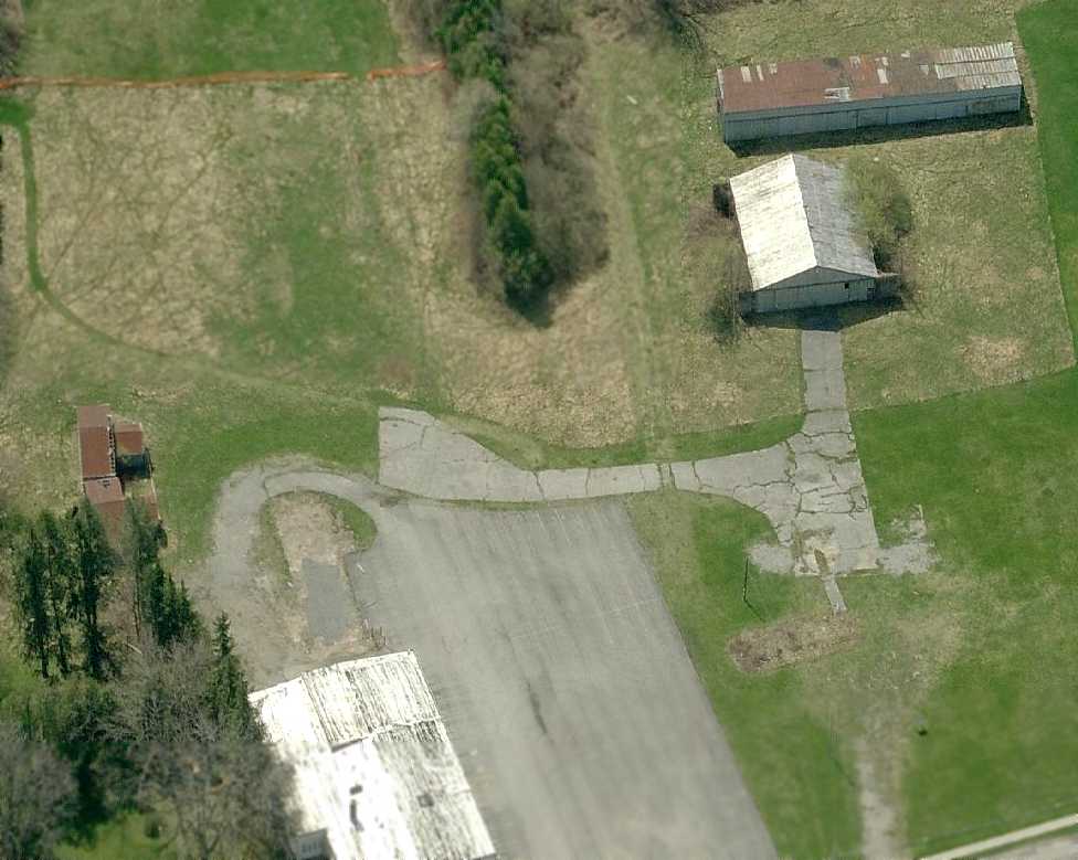
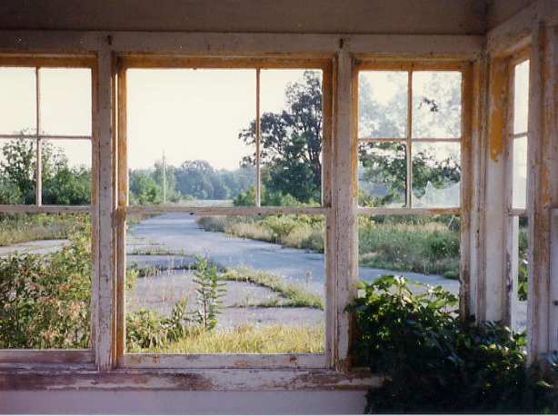
A 2011 photo looking south along Honeoye Falls former runway hangar by Will Dalton.
Will reported, “The runway looks well-groomed, and a landscape company that operates from the site is now using the north end of the runway to store mulch, topsoil, etc.”
A 2011 photo looking east at 2 T-hangars which remain on the northeast side of the site of Honeoye Falls Airport by Will Dalton.
Will reported, “The main doors face away from the runway.”
A 2011 photo by Will Dalton of “former taxiway leading to the front of the main hangar.”
A 5/10/11 aerial view looking southwest at Honeoye Falls Airport showed all of the hangars remained standing, and the taxiway & runway remained intact.
Paul Templeton observed, “One can still make out where the 2 rails passed through the hard taxiway.”
A 2012 listing in the FAA Airport/Facility Directory data listed the status of Honeoye Falls Airport as “Closed permanently”.
It described the field as having a single 1,685' turf Runway 1/19, “in good condition”.
It listed the owner as “Estate of Everett Lewis”, and listed the manager as William Delmore.
As of February 2014, Paul Templeton reported, “I believe the T-hangars remain extant.
I was recently informed that a portion of this field has recently been sold but no info on what the new owner will do with the property.”
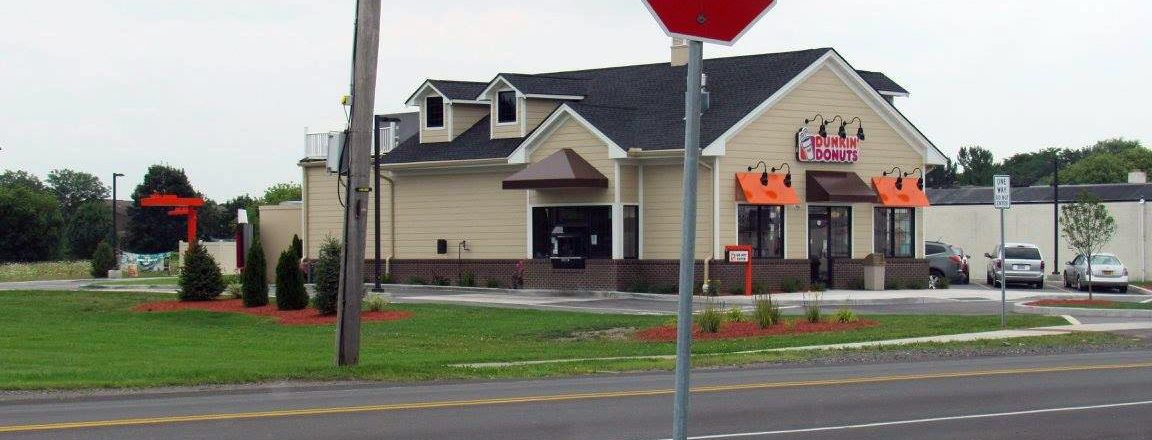
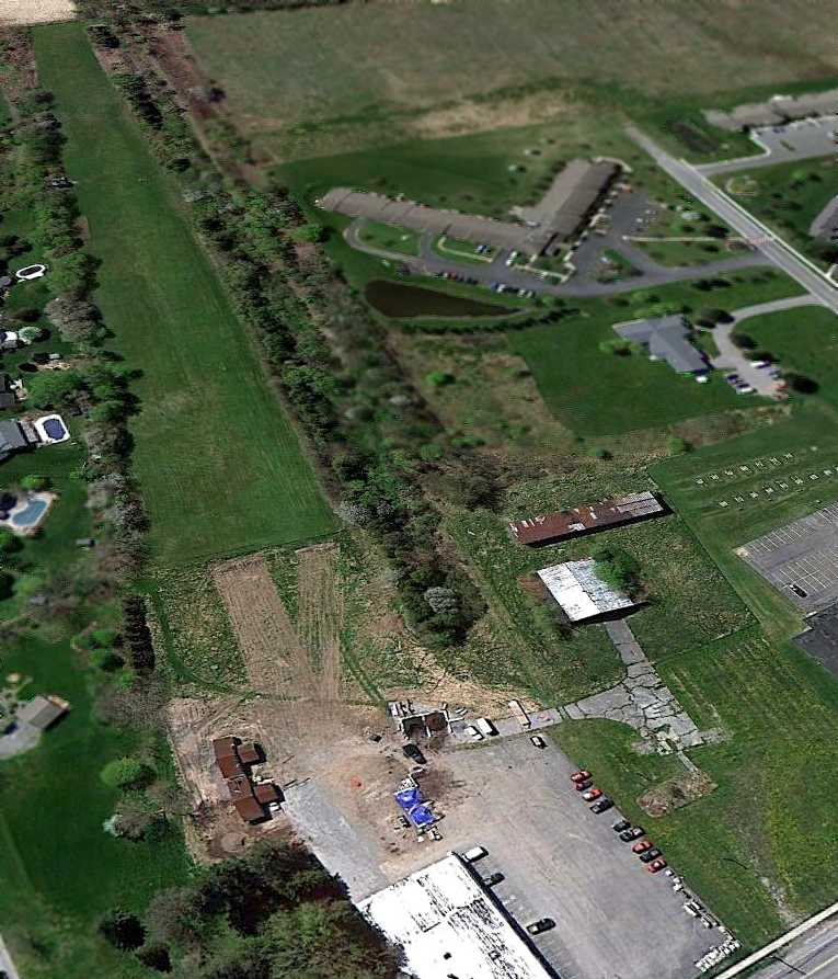
A 2017 photo by Mark Skipworth of the new Dunkin Donuts facility which has been built over the entrance of the former Honeoye Falls Airport.
Paul Templeton reported, “Mark related that nothing remains of the airport structures or concrete taxiways which were located to the rear of the donut shop.
The Lehigh Valley Railroad Rochester Branch tracks which passed through the airport were located to the left of the donut shop.”
The site of Honeoye Falls Airport located southeast of the intersection of West Main Street & Pine Trail.
____________________________________________________
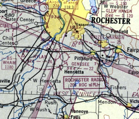
Brizee - Harmon Airport, Pittsford, NY
43.09, -77.48 (Southeast of Rochester, NY)
Brizee Field, as depicted on the 1929 Rand-McNally Standard Map of NY with Air Trails (courtesy of Chris Kennedy).
Brizee-Harmon Airport was a small general aviation airport.
The precise date of establishment of the Brizee-Harmon Airport has not been determined.
According to Bob Bailey, “This airport... was in operation from the 1920s.
The airport was opened by Warren Brizee. Warren Brizee had learned to fly during the World War I period.
The airport was owned & managed a majority of the time by Roy Harmon.
Roy Harmon was the son-in-law of Warren Brizee. Roy had also learned to fly about the same time.”
The earliest depiction which has been located of the Brizee Field was on the 1929 Rand-McNally Standard Map of NY with Air Trails (courtesy of Chris Kennedy).
It described Brizee Field as a commercial field, operated by W.M. Brizee. The field was said to measure 3,300' x 1,500'.
A late 1920s photo of the Taylor Chummy prototype next to the main hangar at Brizee (courtesy of Bob Bailey).
According to Bob Bailey, “The Taylor Chummy was built in Rochester. The Taylor Brothers were friends of Warren Brizee.”
The earliest aeronautical chart depiction which has been located of Brizee Field was on the June 1933 Albany Sectional Chart.
The Airport Directory Company's 1933 Airport Directory (courtesy of Chris Kennedy)
described Brizee as a commercial field, consisting of an 86-acre L-shaped sand field.
It was said to have 3 runways, measuring 3,000' northeast/southwest & northwest/southeast & 1,500' north/south.
The hangar was said to be marked with “Brizee Field” on the roof.
A 1936 photo of 2 Taylor J-2 Cubs, a Waco RNF, and a Waco 10,
all of which had returned to Brizee after a barnstorming trip (courtesy of Bob Bailey).
According to Bob Bailey, “Roy Harmon was a school teacher & aeronautics in a Rochester, New York high school.
He would teach school during the day & operate the airport in the late afternoon, evenings & weekends.
While he was teaching school other employees would manage the airport for him.
My father, John Bailey, filled this position in the mid to late 1930s.
During the 1930’s there was a flying club based at the airport. Roy provided the instructors for the club.”
Bob continued, “There were originally 3 runways. The shortest runway was the north-south runway, which was about 1,000' long.
In later years this runway was closed.
There was also a northwest-southeast runway, and the longest runway was the northeast-southwest runway which was 2,500' long.
There were trees along Marsh Road which bordered the west side of the airport.”
Bob continued, “In the mid 1930s Roy Harmon was giving a ride to a passenger in an Arrow Sport.
This was a low wing, side by side, open cockpit airplane.
It was powered by a Model A Ford engine. After taxiing a short distance the engine quit.
Although some people offered to help restart the airplane Roy replied that he could do it himself.
Roy hand propped the airplane without any chocks & there were no brakes on the airplane.
The throttle was well open & the airplane began to roll forward after the engine started.
Roy made it around the wing & was about to climb in the cockpit
when the passenger dove out of the cockpit & knocked Roy down.
The airplane ended flipping over on its back.
Although there was minimal damage to the airplane, Roy began to get very safety conscious.
If Roy thought someone was not being careful enough he would insist that they not use the airport.
As a result, there were very few accidents at the airport.”
Bob continued, “Originally the office was in a lean-to that was built on the west side of the hangar.
In later years this was used for parts storage & parachute rigging loft.”
A former hot-dog stand became the airport office in 1937.
The Airport Directory Company's 1937 Airport Directory (courtesy of Bob Rambo)
described Brizee as a commercial field, consisting of a rectangular sand field,
having 2 runways, measuring 3,300' east/west & 1,500' north/south.
The hangar was said to be marked with “Brizee Field” on the roof.

The 1938 Aviation Facilities in NY State (courtesy of Bob Parmerter) described Brizee Aviation Field as having 2 sand runways, measuring 2,500' east/west & 1,400' north/south, and 1 hangar on the west side.
A winter 1938 aerial view of Brizee Airport (courtesy of Bob Bailey).
A winter 1938 view of 2 Taylors & a biplane in front of the Harmon Aviation hangar (courtesy of Bob Bailey).
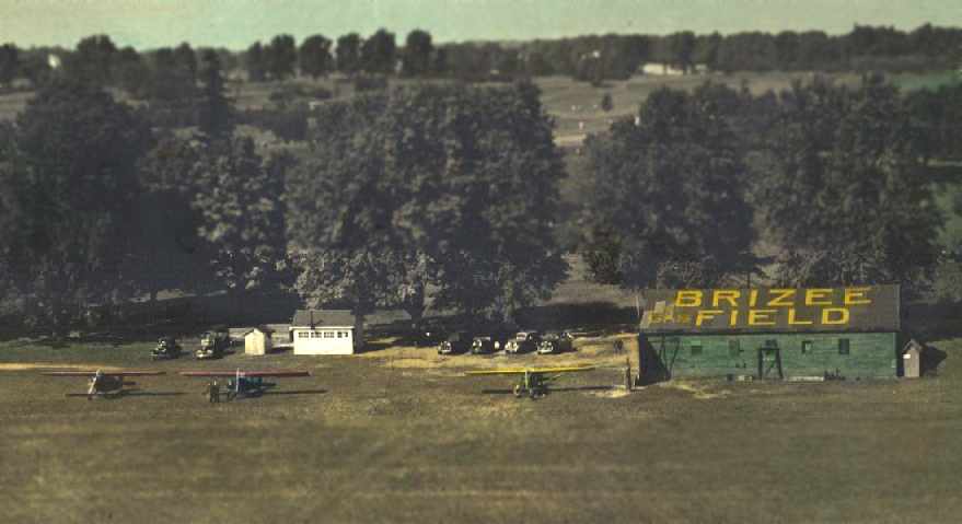
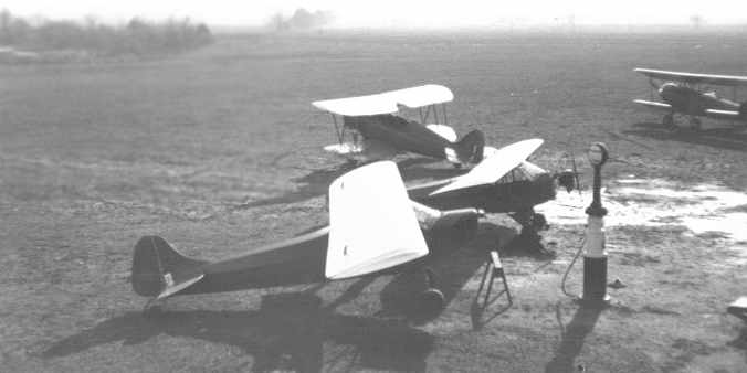
A 1938 view of a Rearwin Sportster, Taylor E-2 Cub, a Taylorcraft, the office, and hangar at Brizee Field.
The photo (courtesy of Bob Bailey) was colorized by a studio.
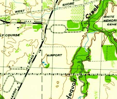
The 1943 USGS topo map depicted Brizee Field as an open area with two small buildings along the west side, labeled simply as “Airport”.
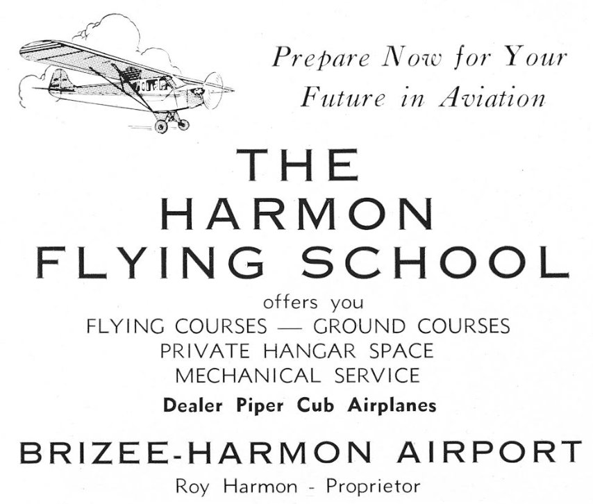
An advertisement for Brizee-Harmon Airport's Harmon Flying School from the 2/26/44 Civil Air Patrol meeting program booklet (courtesy of Alan Reddig).
The April 1944 US Army/Navy Directory of Airfields (courtesy of Ken Mercer) described “Brizee Aviation” Airport as having a 2,500' unpaved runway.
The 1945 AAF Airfield Directory (courtesy of Scott Murdock) described Brizee Airport
as a 78 acre rectangular property having 4 sod runways, with the longest being the 2,500' northeast/southwest strip.
The field was said to have a single 70' x 50' wood hangar, and to be owned & operated by private interests.
The May 1945 Albany Sectional Chart (courtesy of Chris Kennedy) depicted Brizee as a commercial/municipal airport.
The 1950 Albany Sectional Chart (courtesy of Bob Bailey) depicted Brizee-Harmon Airport as having a 2,500' unpaved runway.
Bob Bailey recalled, “Roy grew fruit & vegetables to sell between the runways.
I can recall corn, asparagus & peaches that were purchased at the airport.
In the spring Roy would tap the maple trees & would produce & sell maple syrup.
He had attended Cornell University & had studied agriculture. He put his knowledge to good use.”
Bob continued, “In the early 1950s the airport flourished. The hangar was full & there were many airplanes tied down.
The airplanes ranged from Cubs, Aeroncas, Taylorcrafts, Luscombes & Cessnas to a few military surplus airplanes up to an AT-6.”
A 9/8/51 USGS aerial view depicted Brizee Airport as having 2 grass runways,
with a single hangar on the west side, next to which was visible a single light plane.
Brizee Field was no longer depicted on the 1952 USGS topo map.
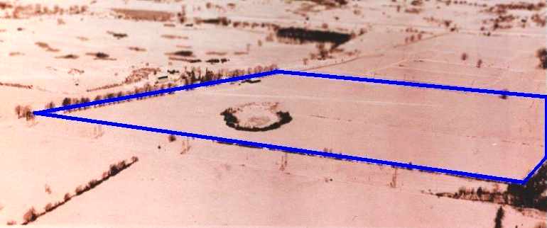
A July 1952 aerial view, taken over the primary (northeast/southwest) runway (courtesy of Bob Bailey).
The airplanes are a Stinson 108, a Piper PA11 Cub Special, and 2 J-3 Cubs tied down next to the hangar.
Bob Bailey recalled, “In the late 1950s some individual hangars were built in midfield.
They were large T-hangars that accommodated 6 airplanes.
The main hangar normally held 6 airplanes. There were still quite a few airplanes tied down until the airport closed.”
Bob continued, “The airport was quite busy in the 1950s & early 1960s.
By this time Roy Harmon had retired from teaching school & was at the airport full time.
He did flight instruction & for a while was a designated pilot examiner.
He was one of the few parachute riggers at the time & packed quite a few parachutes.”
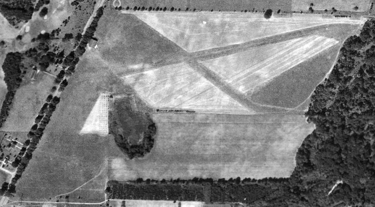
Brizee-Harmon Airport, as depicted on the 1961 USGS topo map.
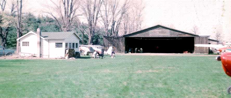
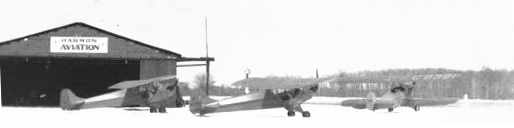
An early 1960s view of the office & hangar (courtesy of Bob Bailey).
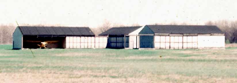
A 1963 view of the midfield T-hangars (courtesy of Bob Bailey).
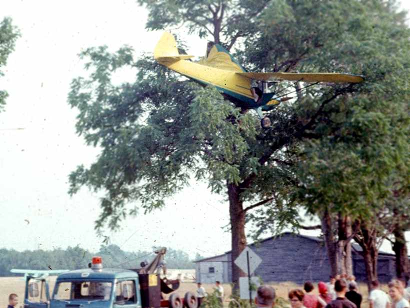
An early 1960s view of a Taylorcraft which ended up in a tree at the end of one of the runways at Brizee (courtesy of Bob Bailey).
“It occurred as a result of a late go around after a bounced landing. There were no injuries.”
A 1963 aerial view looking northwest at Brizee Airport (courtesy of Bob Bailey).
The eventual cause of the airport's demise (housing developments) were already visible all around the field.
Rich Lanze recalled, “My dad used to have a 1946 Aeronca Champ back around 1964-66.
We first kept the Aeronca at Roy Harmon's on Marsh Road;
I still remember taking off over the gully at the East end of the field.“
Kathleen Rosenberg (Zinsmeister) recalled, “Harmon / Brizee Field, my dad had his plane there, and we spent a lot of time out there!”
The last aeronautical chart depiction which has been located of Brizee
was on the July 1964 Albany Sectional Chart (courtesy of Chris Kennedy).
It depicted Brizee-Harmon Airport as having a 2,500' unpaved runway.
Bob Bailey recalled, “Like an increasing number of airports, Brizee was an airport that was a fun, enjoyable place to fly.
There was a lot of activity at various times in its history & it is an airport not easily replaced.”
Bob Bailey recalled, “By the 1960s Pittsford was experiencing rapid growth. There were a lot of new homes being built.
Across Marsh Road, which bordered the west side of the airport, was the Monroe Golf Course.
Immediately to the north of the airport was the White Haven Cemetery.
The land to the south & east was prime real estate.
There were more & more homes built close to the airport.
Roy was made an offer for the land. It was sold & the airport was closed by 1965.”
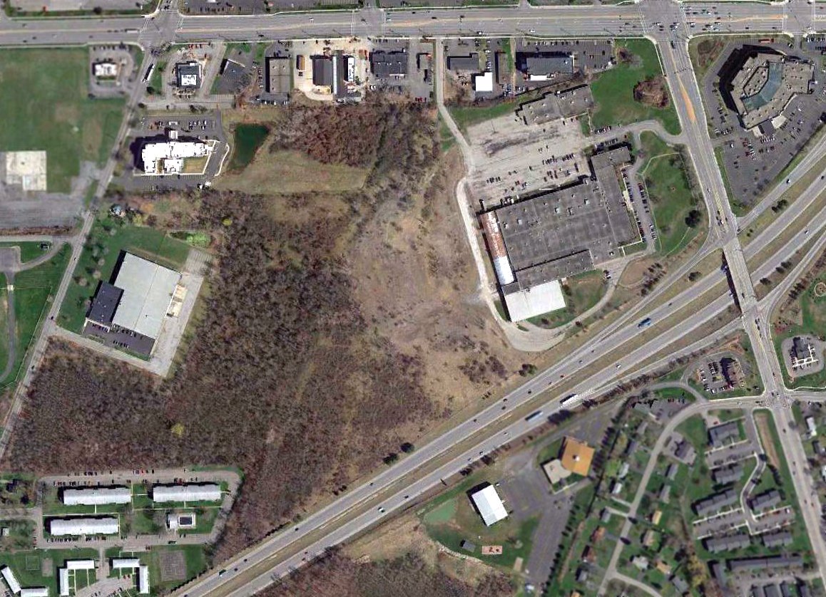
A housing development called Landmark Estates was built on the site of Brizee Airport, covering the entire property with homes.
By the time of the February 1966 Albany Sectional Chart (according to Chris Kennedy), Brizee Airport was no longer depicted.
A 1971 aerial photo showed no trace of the former airport – it had been covered with houses.
A 5/9/11 aerial photo showed no recognizable trace of the former airport at the site of Brizee Field.
The site of Brizee Field is located west of the intersection of Marsh Road & Kitty Hawk Drive.
____________________________________________________
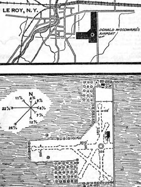
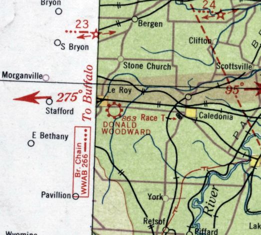
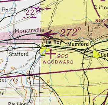
Woodward Field / Le Roy Airport, Le Roy, NY
42.98, -77.97 (Southwest of Rochester, NY)
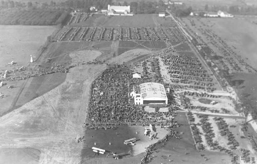
A 1928 aerial view looking north at Woodward Field (courtesy of Ryan Keogh),
taken during festivities celebrating the airport's grand opening.
The field was depicted as having a single hangar with a control tower on the southwest corner, as well as at least 2 paved runways.
At least a dozen biplanes were visible on the field, along with thousands of people & cars.
Before the town of Le Roy got its first airport, the little western New York village was known mostly for being the home
of the Jell-O manufacturing plant (established by the Woodward family).
According to the Woodward Memorial Library, “Donald Woodward was the youngest of the sons. Donald's passion was aviation.
He was the first person to step from an airplane on LeRoy soil.
In 1928, Donald converted 150 acres of farmland into an airport.”
Donald Woodward had purchased Amelia Earhart's airplane, the “Friendship”,
in 1928, and shipped it to Le Roy in time for the opening of his airport.
According to the Woodward Memorial Library, “The Donald Woodward Airport opened in October 1928
attracting what police officials said at the time was the largest crowd ever assembled in Genesee County: 60,000 for the 3-day event.”
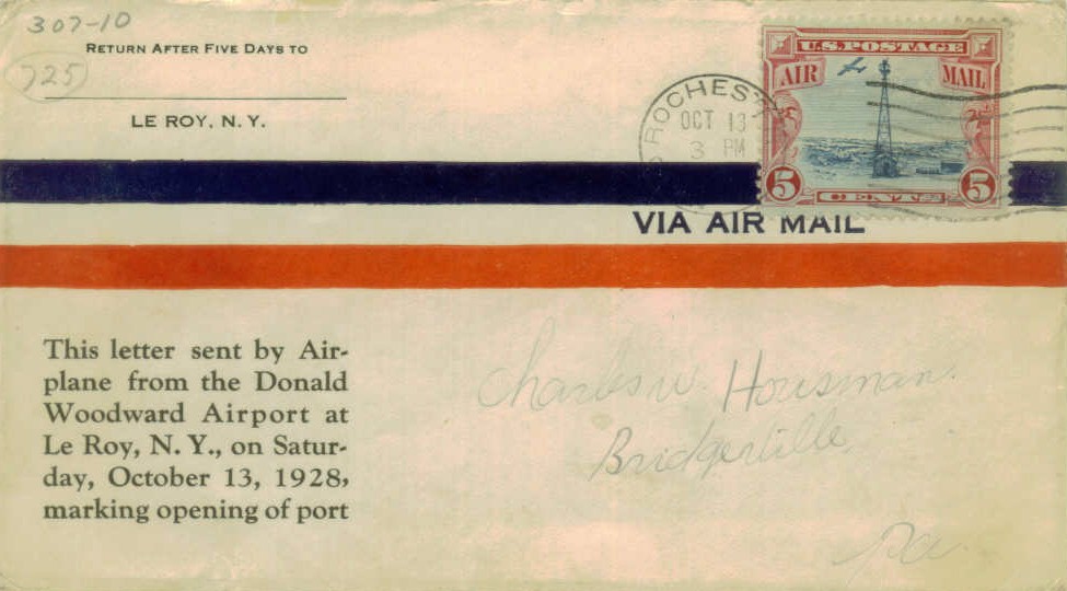
A postmark commemorated the 10/13/28 opening of Donald Woodward Airport.
A 1928-33 photo by Russell Holderman (courtesy of Alan Reddig) of Donald Woodward's Loening C-2-C cabin amphibian in front of the Woodward Aviation Field hangar.
According to Alan Reddig, “Holderman said the Loening aircraft, which he had picked up at the Loening factory in NYC & flown to Le Roy upon its purchase in November, 1928,
was sold by Woodward in 1933.”
According to Franklyn Dailey, Woodward Field was said to have 4 paved runways, a hangar with a control tower on its corner, passenger ramp, and space for parked aircraft.
A 1928 aerial view looking northwest at Woodward Field (courtesy of Ryan Keogh), taken during the field's grand opening.
Three paved runways were visible, along with the hangar.
In January 1929, Amelia Earhart arrived in Le Roy by automobile to visit her former airplane, the “Friendship”.
The town of Le Roy was also the site of one of the early aeronautical light beacons
in the visual flight navigation path which spanned the United States.
Franklyn Dailey had his first airplane ride in the summer of 1929 at Woodward Airport.
The Stinson Detroiter was piloted by former World War I aviator Lieutenant Commander Russell Holderman, USNR
(Russell Holderman was also the Donald Woodward Airport's manager, and had a hand in the airport's design).
Most of the aircraft at Woodward at that point were the single-engine biplanes of early aviation.
A few of the aircraft parked at Leroy that summer were single-engine, high-wing monoplanes. All were painted orange.
Donald Woodward's airport at Leroy held fly-in events,
attracting many well-known national & international figures, all pioneers in early aviation.
Woodward Airport, as depicted on the 1929 Rand McNally Standard Indexed Map With Air Trails, NY edition (courtesy of Chris Kennedy).
The 1930 Commerce Department Airway Bulletin depicted Donald Woodward's Airport as having 4 unpaved runways.
The earliest chart depiction of Donald Woodward Airport which has been located was on the June 1933 Albany Sectional Chart.
It depicted Donald Woodward Airport as a commercial/municipal field.
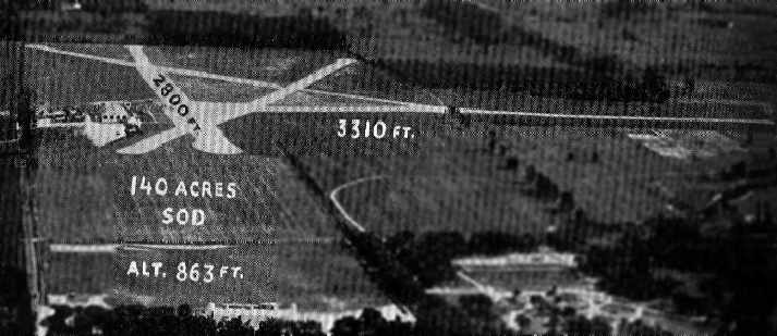
An undated aerial view looking south at Le Roy Airport from The Airport Directory Company's 1937 Airport Directory (courtesy of Bob Rambo).
The directory described Le Roy as a commercial field, consisting of a 140-acre irregularly-shaped sod field,
having 4 hard surfaced runways, with the longest being the 3,310' east/west strip.
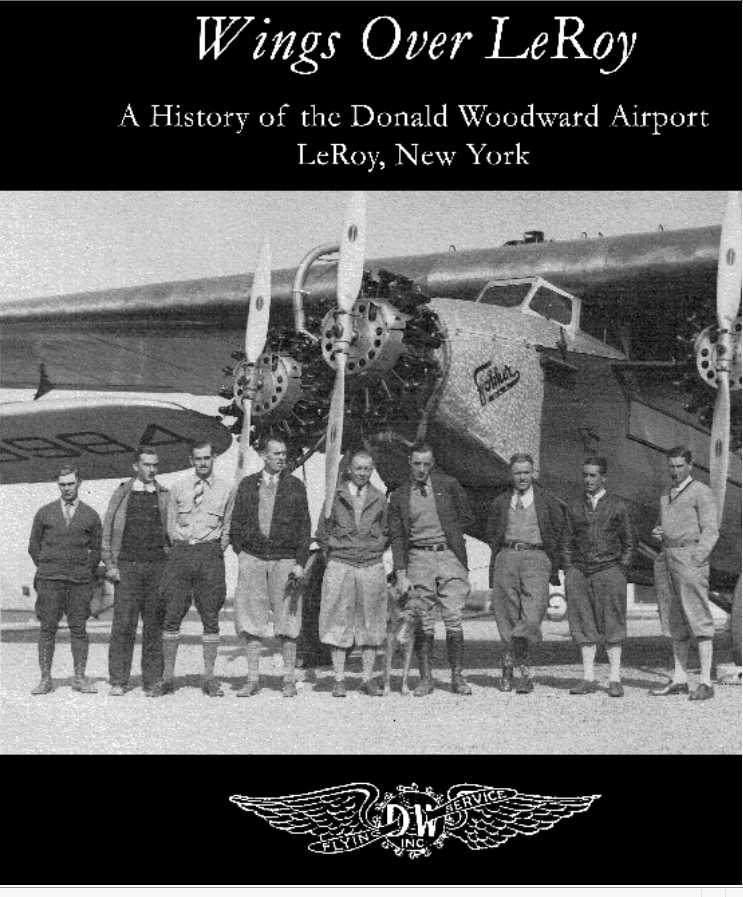
A circa 1930s photo of a Fokker Trimotor from the cover of “Wings Over LeRoy, A History of Donald Woodward Airport” by Brian Duddy.
The White Aircraft Company was established at Woodward Airport in Le Roy in 1937 by Donald White.
In 1938 the firm acquired the Jones Aircraft Company inventory, as well as Argonaut Inc.

The 1938 Aviation Facilities in NY State (courtesy of Bob Parmerter) described Donald Woodward Airport as having 4 hard-surfaced runways, with the longest measuring 3,310' east/west, and a concrete & steel hangar on the northeast side.
In 1939 Donald White purchased the rights to the Verville AT.
The products of the White Aircraft Company included the models A-R, D-25B, Gull, and PT-7, all of which were produced in very small quantities.
In 1940, the White Aircraft Corporation relocated to Palmer, MA.
The 1944 USGS topo map depicted Le Roy Airport as having 4 paved runways, with a single building on the northeast side.
The April 1944 US Army/Navy Directory of Airfields (courtesy of Ken Mercer) described Donald Woodward Airport as having a 2,800' runway.
However, the field was noted as being for “Gliders only”, which may have been related to wartime flight training,
or perhaps due to wartime fuel rationing for civilian aviation.
The 1945 AAF Airfield Directory (courtesy of Scott Murdock)
described Donald Woodward Airport as a 90 acre irregularly-shaped property having 4 sod & stone runways,
with the longest being the 2,640' east/west strip.
The field was said to have a single 140' x 80' steel & concrete hangar, and to be owned by private interests.
Woodward was said to be “Designated for gliders only.”
The last aeronautical chart depiction of Woodward Airport which has been located
was on the November 1945 Albany Sectional Chart (courtesy of Chris Kennedy).
It depicted Woodward as an auxiliary airfield.
Woodward Field was apparently abandoned at some point between 1945-46,
as it was no longer depicted on the July 1946 Detroit Sectional Chart.
Gerry McBurney recalled, “Woodward Field, so the stories went, was closed at the death of Donald Woodward, the airport's founder.
The estate supposedly passed to his sister, who was not an airplane buff, and she specified that the site would never again be used as an airport.
The village was without an airport for a number of years (around 10 or so).”
Woodward Field was not labeled at all (even though the hangar was still depicted) on the 1951 USGS topo map.
Woodward Field was eventually replaced by the new Le Roy Airport, only 1 mile to the east.
A 6/3/58 USGS aerial photo showed Woodward Field's 4 paved runways & hangar remained intact.
Gerry McBurney recalled, “During the 1970s, about once a year or so, some itinerant pilot would mistakenly land at the old Woodward Field, on the east-west runway, instead of at Bickford's.
Although it was a bit bumpy, the Woodward Field runway was still usable & everyone would fly out again when they realized their mistake.”
The 1977 USGS topo map didn't depict any airfield at the location of Woodward Field.
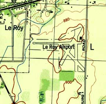
The 1983 USGS topo map depicted “LeRoy Airport” as having a single east/west runway.
The 1987 USGS topo map still depicted the former hangar, but the airfield itself was not labeled at all.
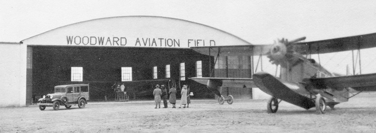
A 2005 photo by Ryan Keough looking northwest at the former hangar which remains standing at the site of Woodward Field.
A more recent equipment shelter sits to the left of the hangar.
A 2005 photo by Ryan Keough looking southeast at the former control tower attached to the hangar.
A 2005 photo by Ryan Keough of the traces of the lettering along the top of the south side of the former hangar.
According to Ryan, the traces of lettering were from the White Aircraft Company, and from the Civilian Pilot Training Program.
A 2005 photo by Ryan Keough looking south along the former paved runway area of Woodward Field.
Ryan Keough reported in 2005, “I believe the current owner is the Le Roy Department of Public Works.
They store their equipment (trucks, snowplows, etc) in it & the shed next to it
and built a larger building across the ramp from the hangar.
The land is leased farmland that is broken up among a few owners,
and it is fascinating that even though the runways are long gone,
the outlines are still there & there is a distinct difference
between the soil of the runways & the soil of the surrounding area.”
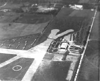
A circa 2005 aerial photo looking north at Woodward Field's former hangar, along with the more recent buildings.
An October 2006 aerial view by Darrell Klein looking northwest at the site of Woodward Field,
showing the remains of the runways as well as the former hangars.
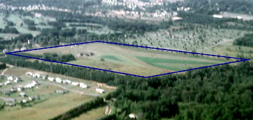
A 7/1/11 aerial view looking east at the site of Woodward Field by Chris Houston.
Chris observed, “The outline of the field has always provided some hint of where the runways once existed...
but, today, ghostly vestiges of the runways from former Woodward Field visibly haunted the site.
This was the first time I had observed them so clearly.”
A 7/1/11 aerial view looking northeast at the former Woodward Field hangar & control tower by Chris Houston.
Chris observed, “The old main hangar is still present, used by the city to store heavy equipment.
It sits below where one would turn from crosswind to downwind while in the pattern for Runway 28 at the current Le Roy Airport.
We can see the old tower / hangar structure from the pattern.”
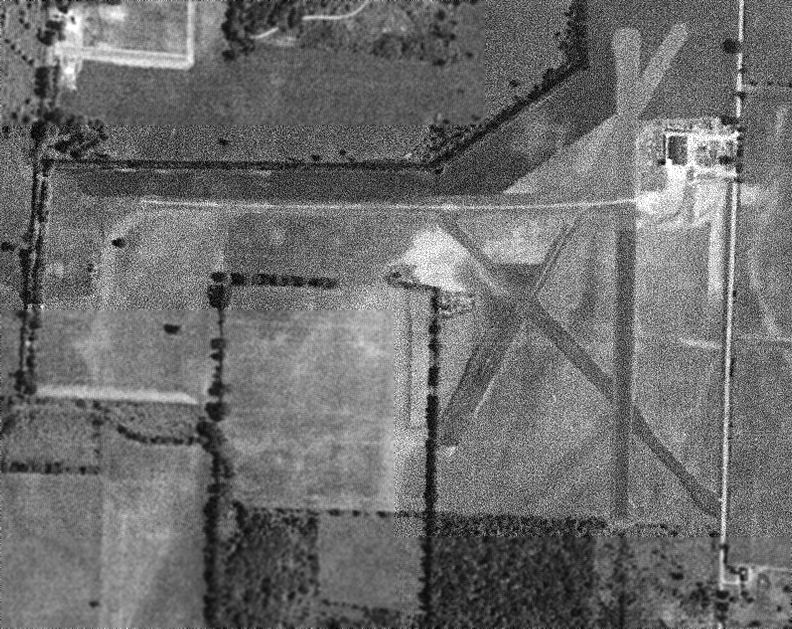
A 2013 aerial photo showed traces of all 4 former Le Roy runways to remain recognizable.
A 2020 photo of a historical plaque commemorating “D.W. Airport”.


A 2021 photo looking northwest at the former Woodward Field hangar. A sign along the road said “Town of LeRoy Highway Department”.
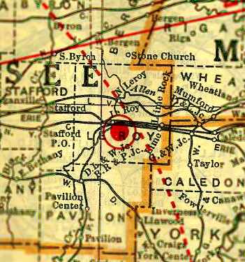
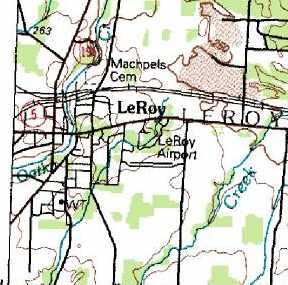
The site of Woodward Field is located on the west side of Asbury Road, south of Route 5.
____________________________________________________
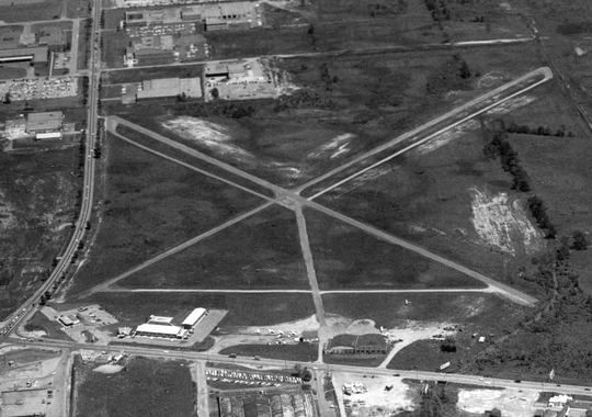
43.08, -77.64 (Northwest of New York, NY)
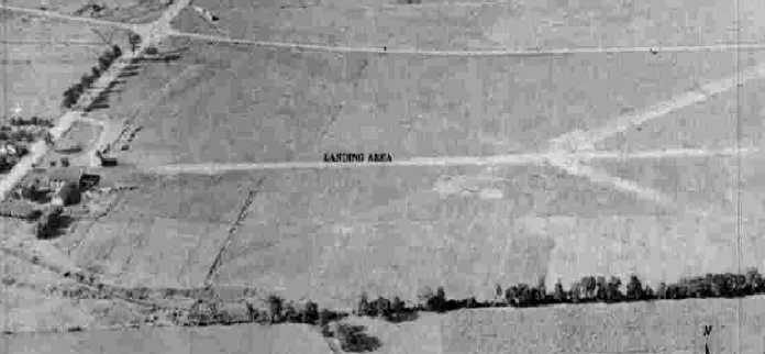
An 8/24/42 aerial view looking north at Hylan Field from the 1945 AAF Airfield Directory (courtesy of Scott Murdock).
This general aviation was evidently established at some point between 1941-42,
as it was not yet depicted on the October 1941 Albany Sectional Chart or listed in The Airport Directory Company's 1941 Airports Directory (according to Chris Kennedy).
The earliest depiction of Hylan Field which has been located was an 8/24/42 aerial view from the 1945 AAF Airfield Directory (courtesy of Scott Murdock).
It depicted Hylan as having 3 grass runways with several small buildings on the west side.
According to an article in the 1/16/15 Democrat & Chronicle (courtesy of Phil Brooks),
Ray Hylan “bought half a dozen farms in Henrietta & built his airport on some of the land.
He taught students to fly in old Wacos & Fairchilds & J-3 Cubs that were designed by brothers from Wayne County.”
The earliest aeronautical chart depiction which has been located of Hylan Field was on the July 1942 Albany Sectional Chart.
The April 1944 US Army/Navy Directory of Airfields (courtesy of Ken Mercer) described Hylan as having a 5,000' unpaved runway.
The 1945 AAF Airfield Directory (courtesy of Scott Murdock) described Hylan Field as a 215 acre rectangular property having 2 cinder runways,
2,400' ENE/WSW & 1,850' NNW/SSE, along with a north/south runway under construction.
The field was said to have a single 100' x 80' wood & concrete hangar, and to be owned & operated by private interests.
The November 1945 Albany Sectional Chart (courtesy of Chris Kennedy) depicted Hylan as a commercial airport.
The January 1950 Albany Sectional Chart (courtesy of Bob Bailey) depicted Hylan as having a 2,800' unpaved runway.
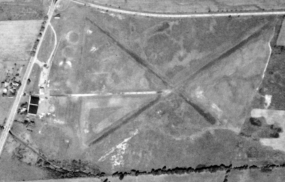
A 9/8/51 USGS aerial view depicted Hylan as having 3 grass runways, with 2 hangars & 6 light planes on the west side.
John Lebbon recalled, “I was hired as a lineboy by Ray in 1955, I was 15 years old.
During the 7 years working there I earned my Private, Commercial, and Flight Instructor Ratings.
During my years there Gloria Santucci was the lady that kept the operation going.
She lived with the Hylan's for many years. Gloria taught all the groundschool courses, and ran the office, she really was a great instructor.”
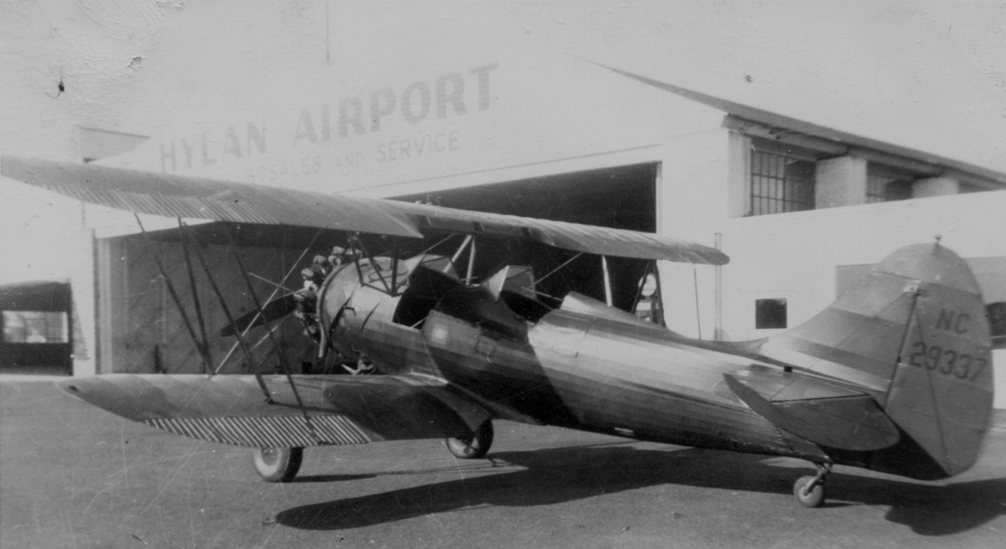
A circa 1950s photo by James Reddig of a Waco UPF-7 in front of a Hylan Airport hangar (courtesy of Alan Reddig).
The first meeting of EAA Chapter 44 was held at Hylan Airport on 2/25/58.
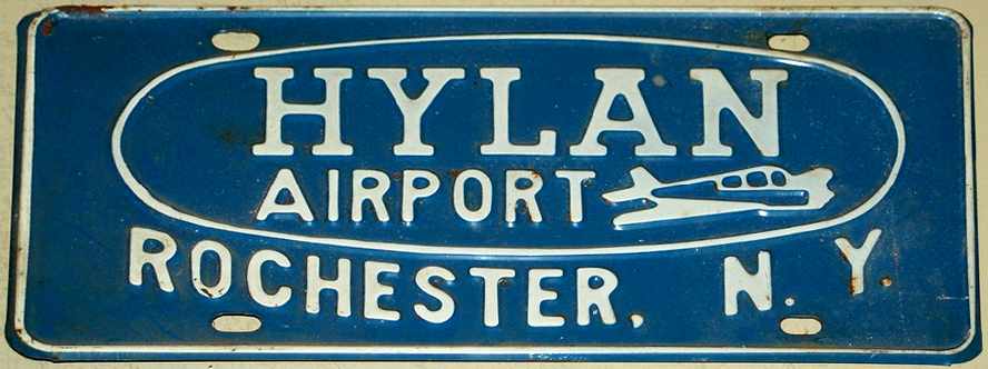
A vintage metal sign for Hylan Airport.
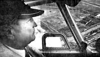
An undated aerial view of Hylan Field as seen from a plane piloted by Ray Hylan.
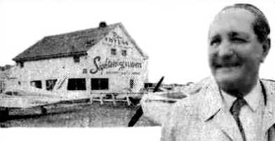
An undated photo of Ray Hylan in front of a Hylan Field building.
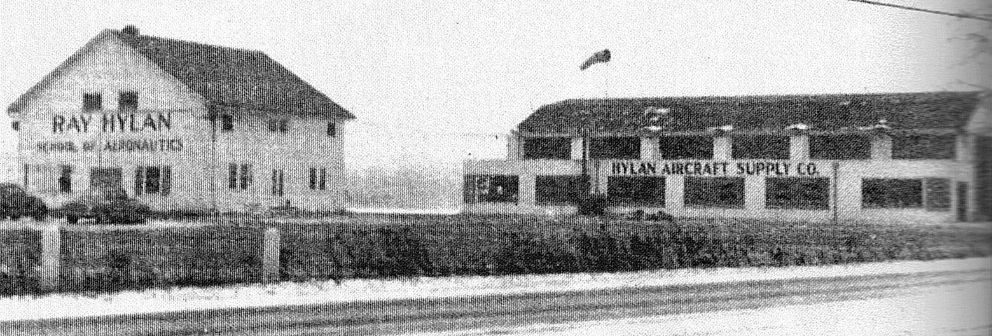
An undated photo of buildings marked “Ray Hylan School of Aeronautics” & “Hylan Aircraft Supply Co.” (courtesy of Mike Lashombe).
A circa 1960s aerial view looking east (courtesy of Phil Brooks) depicted Hylan Field as having 2 paved runways, with several hangars on the west side.
Tom Van der Veer recalled, “John Lebbon was my first instructor.
I was an ROTC cadet at Hobart College in 1961 & USAF had a flight instruction program that gave us 36 hours in the J-3 Cub.
I had a great career flying airplanes, large & small, and remember fondly that it all began at Ray Hylan's little airport.”
Bob Heavener recalled, “From 1962-66 we would fly to Hylan from Amherst
park on the lawn of Howard Johnson & enjoy a '$5 hamburger.' Those were the days!”
The 1962 AOPA Airport Directory described Hylan Field as having 2 cinder runways: 3,000' Runway 14/32 & 2,650' Runway 7/25.
The operator was listed as the Ray Hylan School of Aeronautics, Inc. (a Piper dealer).
The last photo which has been located showing Hylan Airport in operation was a June 1964 photo by John Staber of a Colonial C-1 Skimmer amphibian.
According to Ray Detor Jr, AKA "Little Ray", “I started working for Ray Hylan at 14 in 1966.
I lived at Hylan Airport from [age] 16-18 where I bartered my work for flight time.
Ray was my Flight Instructor & mentor - he trained me for my Private, Commercial, Flight Instructor, Multi-engine Land & Multi-Engine Sea pilot ratings.
Rich Lanze recalled, “We ended up moving the plane [an Aeronca] to Ray Hylan's & parking next to what used to be Howard Johnson's.”
According to Will Dalton, “I clearly recall driving by Hylan as a little boy in ~1970 & seeing the Goodyear Blimp tethered there.
The yellow anchor-like structure they tethered it to was there for years until the land was torn up to make a mall.”
Bruce Jenkins recalled that he was “one who finished learning to fly there, flew my 1st solo out of that field
and was instructed by Ray Detor as well as Ray Hylan.
The runways were paved with asphalt when I flew there in 1970-71
and I learned a great deal about flying into & out of airports with snow-covered runways.
I was lucky enough to have gotten to know Ray Hylan fairly well & my greatest regret is that I didn't record some of our conversations.
He was a master storyteller & had limitless experiences to talk about. Movies could have been made about his exploits.”
The 1969 USGS topo map depicted Hylan as having 2 paved runways, each with a parallel taxiway, and a few buildings on the west side.
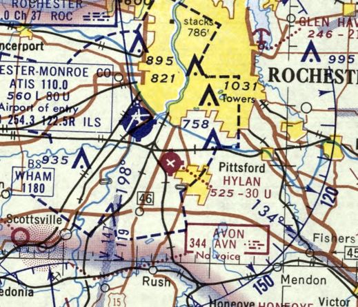
The last depiction which has been located of Hylan Airport was on the January 1970 Albany Sectional Chart.
It depicted Hylan as having 2 paved runways, with the longest being 3,000'.
According to Ray Detor Jr, “On closing of Hylan Airport in 1971 I flew one of the last planes out.”
According to Bruce Jenkins, “Ray Hylan closed the airport in 1971 & moved the Ray Hylan School of Aeronautics to the Rochester/Monroe County Airport.
Ray Hylan moved from Hylan Airport so he could complete his dream of developing Market Place Mall, which now occupies the area.
When the real estate taxes became so high in the late 1960s & early 1970s,
Ray decided to close the airport because the flight operations there could no longer support the operating costs & the increasing tax bill.
His fight to build the shopping center actually took several years from inception to victory & he died shortly after the shopping center opened.
He had been diagnosed with cancer during the construction of Market Place & while he was very ill, I personally believe he survived to see his dream dedicated.”
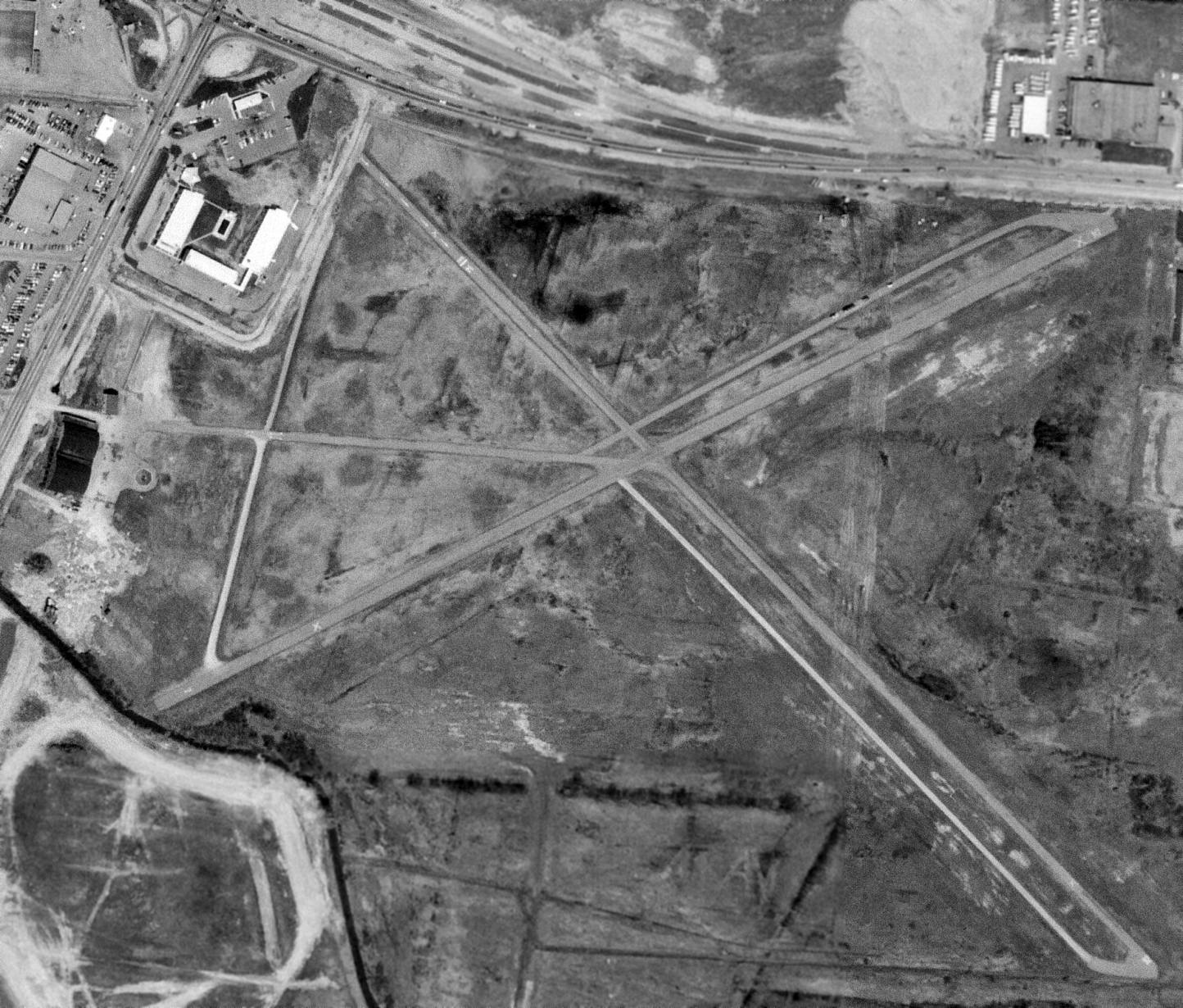
A 5/7/71 USGS aerial photo appeared to depict Hylan Field shortly after it had closed.
The airport appeared to remain intact, with 2 paved runways, numerous taxiways, and 2 hangars on the west side.
But no aircraft were visible on the field, and the southwest/northeast runway was marked with closed-runway “X” symbols.
The 1972 Albany Sectional Chart (courtesy of Ron Plante) no longer depicted Hylan Field.
Ron Plante recalled, "I remember seeing the runways while visiting friends in Rochester in the mid-1970s."
According to an article in the 1/16/15 Democrat & Chronicle (courtesy of Phil Brooks),
“The Marketplace mall opened in 1982. A road fronting the mall was named after Hylan.”
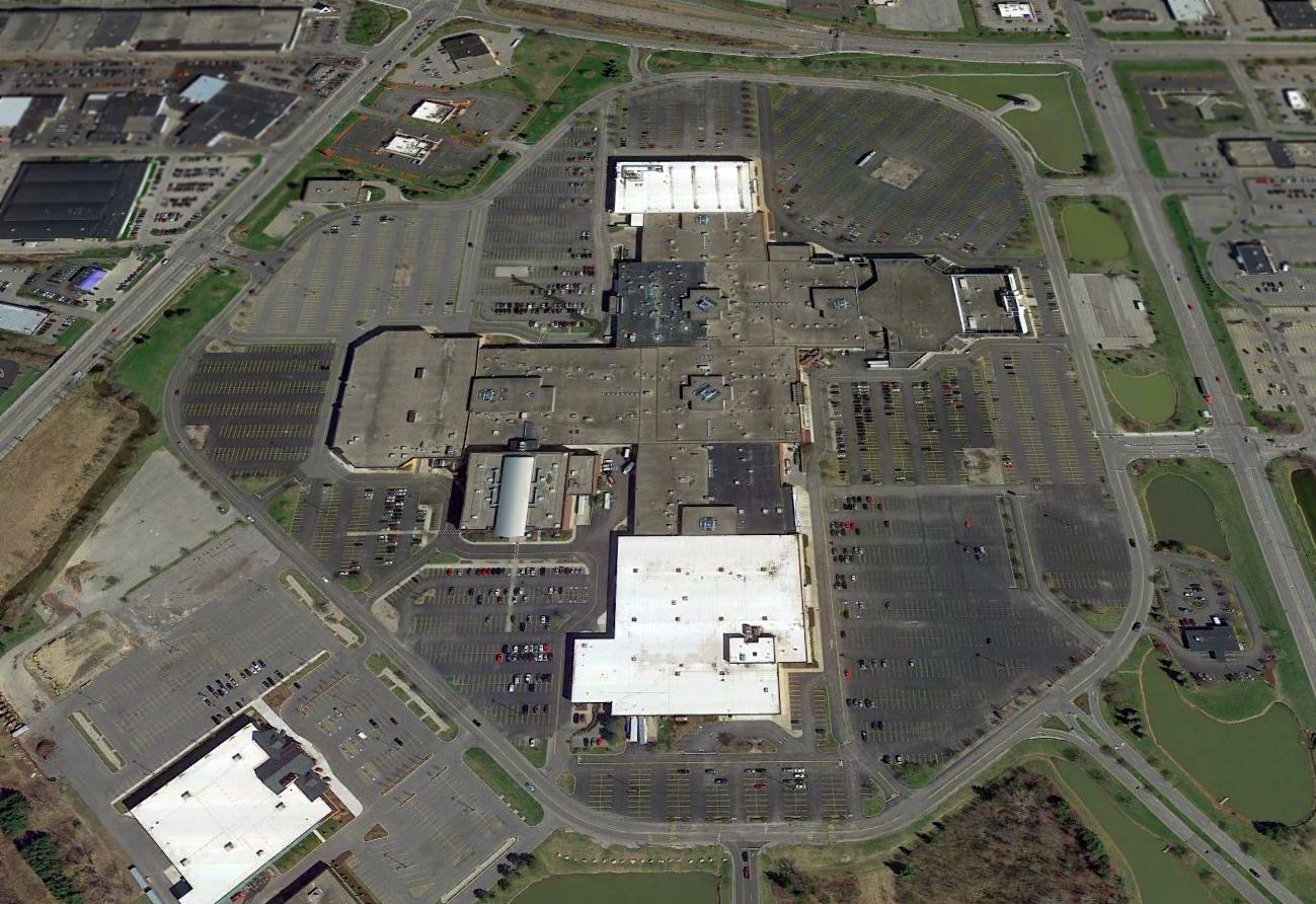
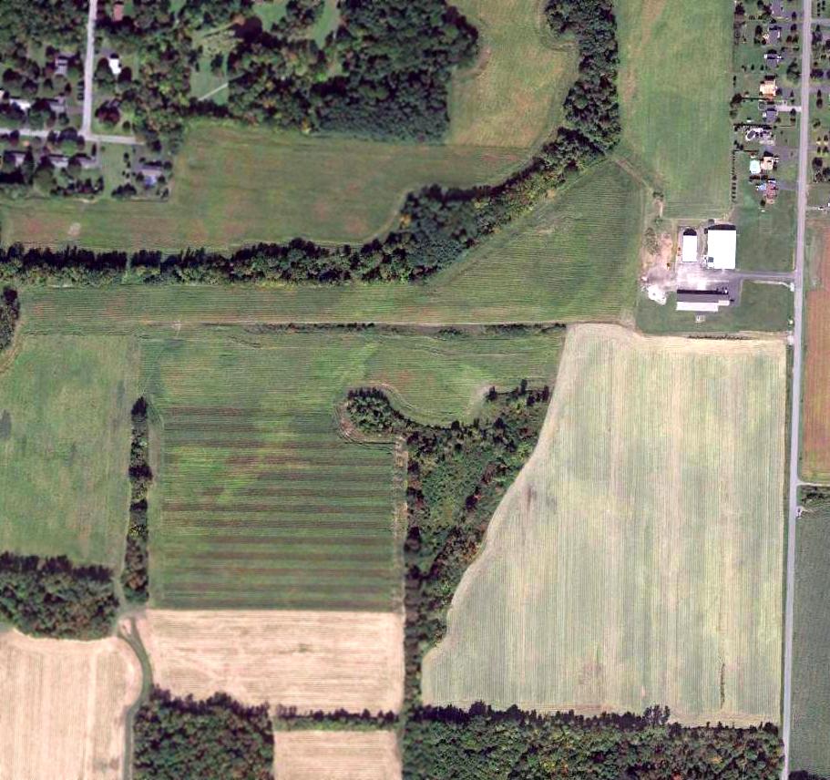
A 2016 aerial view looking north showed the site of Hylan Field had been covered by the Marketplace Mall, with no trace remaining of the former airport.
The site of Hylan Field is located southwest of the intersection of Jefferson Road & Hylan Road, appropriately enough.
Thanks to Ron Plante for pointing out this airfield.
____________________________________________________
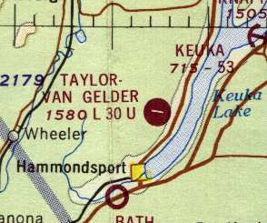
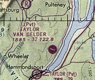
Taylor-Van Gelder Airport (00G), Hammondsport, NY
42.44, -77.21 (Southeast of Rochester, NY)
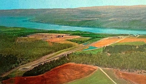
An undated aerial view looking northeast at Taylor-Van Gelder Airport from a postmarked 1965 postcard (courtesy of Scott Schuyler).
Taylor-Van Gelder Airport was apparently built at some point between 1963-66,
as it was not yet depicted on a 1952 aerial photo nor on the 1963 Albany Sectional Chart (courtesy of Mike Keefe).
According to Gardner Soule, "Taylor Van Gelder was built by Walter Taylor,
formerly of Taylor wines & later founding Bully Hill Winery which is on the airport grounds."
An article entitled “New Airport at Hammondsport - Glenn Curtiss Day Observed” in the 6/27/64 Geneva Times Saturday (courtesy of Carl Kohl) described the Taylor-Van Gelder Airport dedication:
“Activities will begin at 5pm today when William Piper, president of the Piper Aircraft Corporation will formally dedicate the Taylor-Van Gelder Airport on Bully Hill Farms in Hammondsport.
The airport was built by the Taylor Wine Company of Hammondsport, and is the first airport built under the Piper National Airpark Program.
The public is cordially invited to attend the dedication ceremonies & the landing of an American Airlines Ford Tri-Motor.
The one-time American Airlines transport, NC9683 the airline purchased again for presentation to the Smithsonian Institution upon completion of its Air Museum.
Later this evening aviation greats will be introduced to the public & Dr. Paul Garber, curator of the Smithsonian Institution National Air Museum
will give an illustrated lecture on early Glenn Curtiss aviation activities & the development of it in Hammondsport.
On Sunday various vintage airplanes as well as the American Airlines Ford Tri-Motor will be on display at the newly-dedicated Taylor-VanGelder Airport.
The airport is located 2 ½ miles north of Hammondsport on the Bully Hill Road, west side of Keuka Lake.
The American Airlines Ford Tri-Motor is being flown to the dedication through the courtesy of Great Western Champagnes.
Among notables attending the 2-day event will be USAF Major-General Floulois, Senator William Smith, and author Jules Bergman.”
Carl Kohl recalled of the Taylor-Van Gelder Airport dedication: “I recall attending this event as a child & lived near the airport.”
The earliest depiction of Taylor-Van Gelder Airport which has been located was an undated aerial view from a postmarked 1965 postcard (courtesy of Scott Schuyler).
It was captioned: “Taylor-Van Gelder Airport: This spectacularly view airport located 1,000' above Lake Keuka.
Paved 3,000', lights on request, Unicom, tiedowns, gas. Owner Walter Taylor, Taylor Aviation Inc., fixed-base operator.”

An undated aerial view looking southeast from a postmarked 1966 postcard (courtesy of Robert Adams)
depicted Taylor-Van Gelder Airport as having an asphalt east/west runway, with a taxiway & hangar on the east end.
Gardner Soule recalled of Taylor-Van Gelder Airport, "I landed there in 1966 & was given a tour of the home he was building next to the airport.
Landing to the west was kind of like an aircraft carrier landing with the ground coming up to meet you."
According to Gretchen Van Gelder Casey, “My father, Clifford Van Gelder, was flying instructor/mentor to Walter Taylor.
Walter had the Taylor-Van Gelder Airport built, and named & dedicated it to my father, who had died back in 1958.
I have flown out of that airport - the airstrip ended at the edge of a very steep cliff.”
The earliest aeronautical chart depiction of Taylor-Van Gelder Airport which has been located was on the 1967 Albany Sectional Chart (courtesy of Mike Keefe).
It described the field as a public-use airfield (not a private field), with a single 3,000' asphalt runway.

The earliest photo which has been located showing an aircraft at Taylor-Van Gelder Airfield was an undated aerial view looking northwest from a postmarked 1973 postcard (courtesy of Robert Adams).
It depicted a Beech King Air parked in front of the hangar.
Taylor-Van Gelder had become a private airfield by the time of the 1976 Detroit Sectional Chart (courtesy of Mike Keefe).
According to Dane Pederson, “The Coca-Cola Company purchased Taylor Wine in 1977.
The Taylor Van Gelder Airport was located on the property of the Taylor Wine Company.”
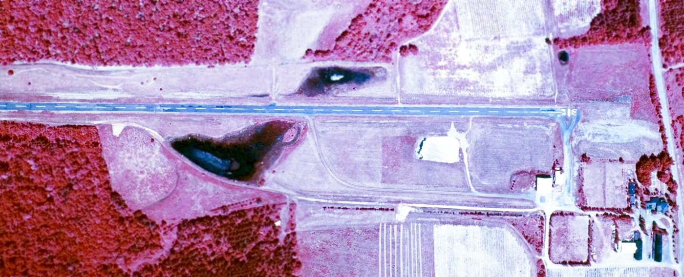
The last photo which has been located showing the Taylor-Van Gelder Airfield while it was in operation was a 6/22/77 USGS aerial view.
It showed Taylor-Van Gelder to have a single asphalt east/west runway, with a taxiway leading to 2 buildings (hangars?) on the southeast side.
There were no aircraft visible on the field.
An Aero Commander 500 had a fatal crash landing at Taylor Van Gelder on 9/11/78.
According to Dane Pederson, “The aircraft involved in the accident was owned by the Mercury Aircraft Company.
The registration number of the aircraft was N40MA... 'MA' for Mercury Aircraft.”
The last airport directory listing which has been located of Taylor-Van Gelder Airfield
was in the 1982 AOPA Airport Directory (courtesy of Ed Drury).
It was described as a private field with a single 3,195' asphalt Runway 10/28.
Taylor-Van Gelder Airport was evidently closed (for reasons unknown) at some point between 1982-91,
as it was depicted as an abandoned airfield on the 1991 World Aeronautical Chart (courtesy of Ed Drury).
According to Dane Pederson, “It could be possible that [the 1978] accident resulted in the closing of the airport shortly after its occurrence; perhaps due to insurance reasons or liability.”
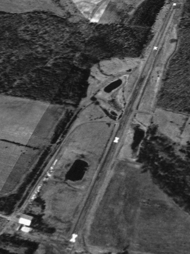
A 4/21/94 USGS aerial view looking southwest showed Taylor-Van Gelder's runway to be prominently painted with closed-runway "X" markings.
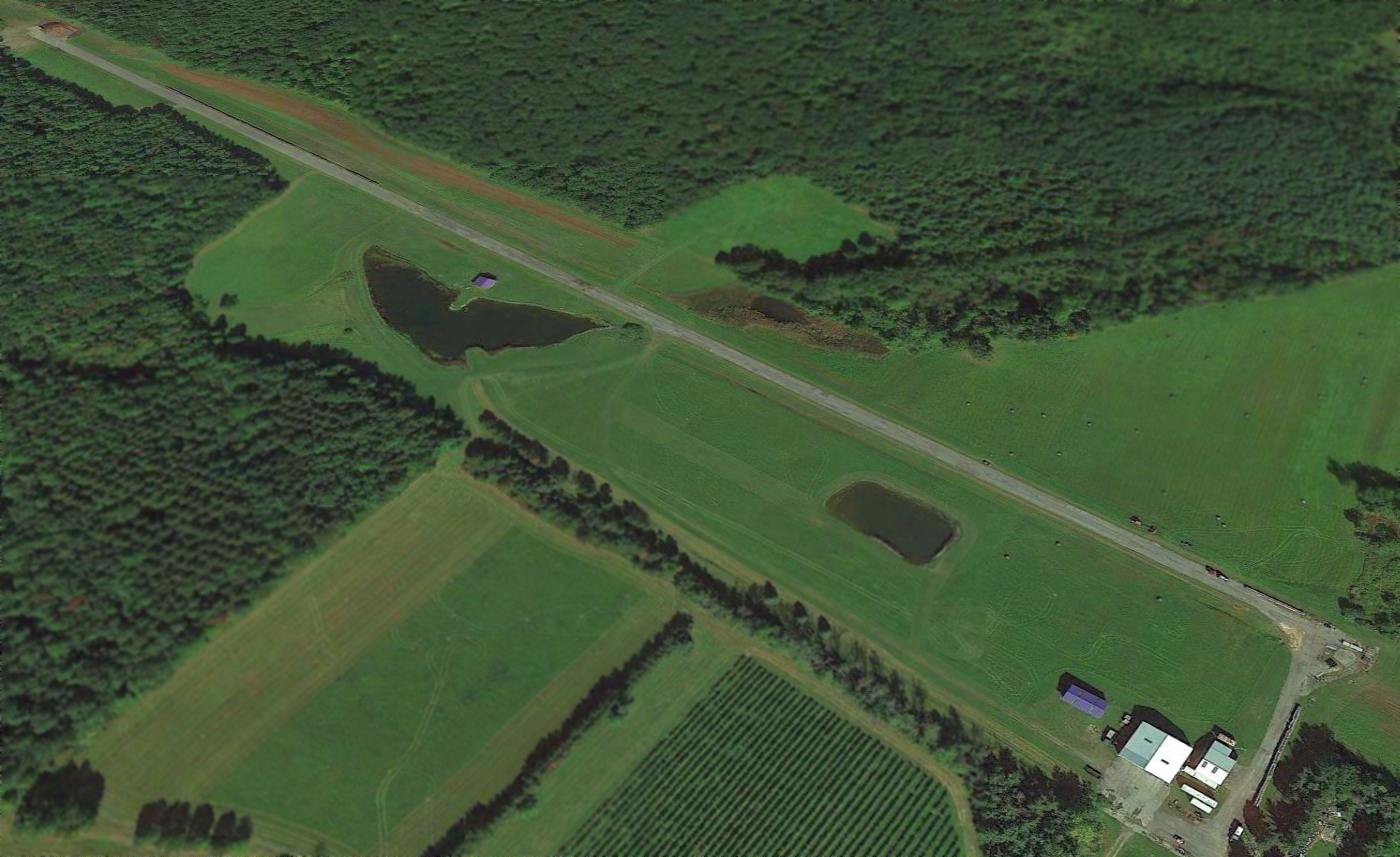
A 2013 aerial view looking northwest at Taylor-Van Gelder Airfield showed the airfield to remain completely intact,
though the runway was no longer marked with closed-runway “X” symbols.
Taylor-Van Gelder Airport is located northwest of the intersection of GH Taylor Memorial Drive & Stephanie G Taylor Memorial Drive.
____________________________________________________
Sampson Naval Training Center Airfield, Romulus, NY
42.7, -76.89 (Southwest of Syracuse, NY)
A 1945 aerial view (courtesy of Ron Plante) depicted the single grass runway adjacent to the Sampon Naval Hospital.
Ron Plante reported, “In 1942, the Navy built a training center south of Geneva, NY, directly west of the Army's Seneca Ordnance Depot.
The center included a 1,500-bed hospital south of main complex,
and next to this hospital was a 2,000' sod strip most likely used to transport medical patients.
The field was not listed in the 1944 Directory of Airfields,
and a 1944 USGS topo map & a 7/1/45 Navy map did not show it.”
Sampson Naval Training Station was turned over to the War Assets Administration as surplus in 1946.
According to Ron Plante, “The Navy base was reopened in 1951 as an Air Force basic training center.”
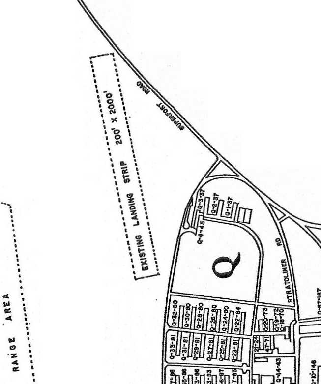
A 1//20/53 Air Force map (courtesy of Ron Plante) depicted an "existing landing strip 200' x 2000' " just northwest of the hospital complex.
According to Ron Plante, “There is no evidence the Air Force used this sod strip, and in 1953 they built a hard-surface runway across Highway 96A.”
A circa 1955 aerial view of the Sampson Naval Hospital Airfield (from the Sampson State Park Military Museum, courtesy of Ron Plante).
It shows the unpaved runway outline & some hospital buildings to the east.
The Air Force basic training center closed in 1958.
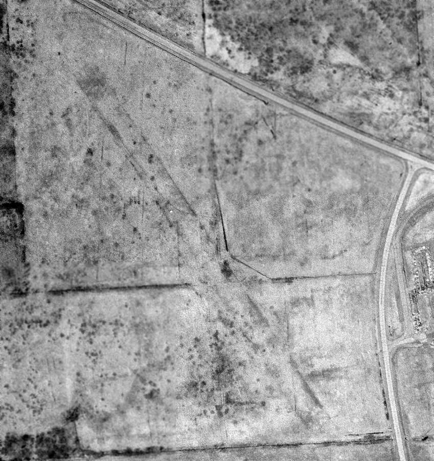
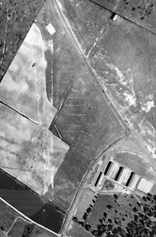
A 4/20/69 USGS aerial view still depicted the grass runway at Sampson.
The Sampson runway was removed at some point between 1969-94, as the 1994 USGS aerial photo showed the site consisted of open fields,
with no trace still recognizable of the former runway.
A 5/4/09 aerial view of the site of the Sampson Navy airfield did not depict any trace of the former runway.
Ron Plante reported in 2010, “Today, no trace remains in aerial photos. The sod strip is now farmland & open fields.”
See also:
http://www.rpadden.com/sampson.htm
____________________________________________________
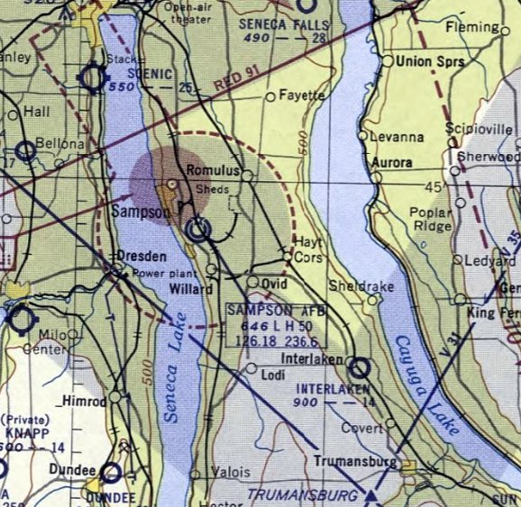
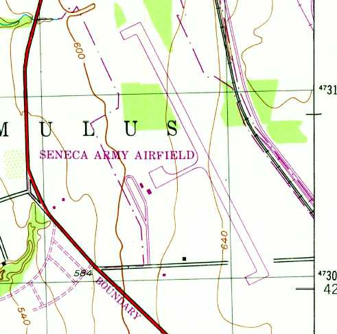
Sampson Air Force Base / North Star Seneca Airpark / Seneca Army Airfield (SSN), Romulus, NY
42.72, -76.88 (Southwest of Syracuse, NY)
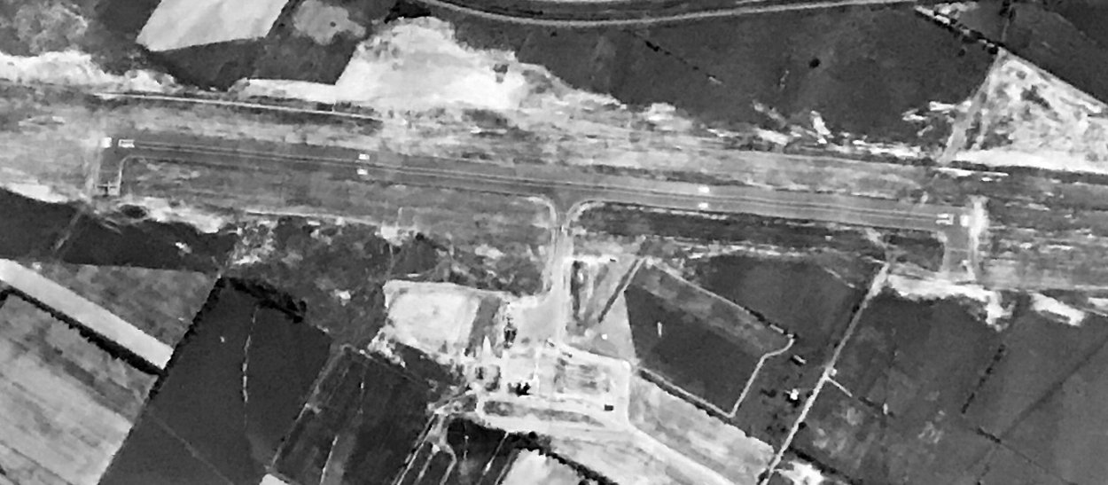
A 1953 aerial photo of the airfield at Sampson AFB.
This property was originally the location of the Sampson Naval Training Station,
which was built in 1942 to provide basic training for large numbers of naval personnel.
It was adjacent to the Army's Seneca Depot, which was built in the 1940s & covered about 30 square miles.
The Depot was used to store a wide variety of Army ammunition.
Sampson Naval Training Station was turned over to the War Assets Administration as surplus in 1946.
No airfield was yet depicted at Sampson on the July 1949 Albany Sectional Chart (courtesy of Chris Kennedy).
Custody of the most of the property of the training center was transferred to the Air Force in 1950.
The Air Force named the facility Sampson Air Force Base,
which was designated a permanent installation of the Air Force by the Air Training Command in 1952.
The Air Force, like the Navy before them, used Sampson as a major training center.
An aerial photo from 1952 did not yet depict a runway at Sampson Air Force Base.
At some point between 1952-53, the Air Force built a runway & other facilities to adapt the installation to their needs.
The earliest photo which has been located of the Sampson runway was a 1953 aerial view,
which showed a single paved northwest/southeast runway, and a ramp on the west side.
Ron Plante postulated, “From reading various articles about the runway, it appears it was planned for easier transport of graduating airmen & hospital patients.
The Korean War was still going on when they built it.
I'm sure DoD also told Congress they were about to build a special weapons area at the ammo depot,
and a runway would sure be useful for transporting those nukes.”
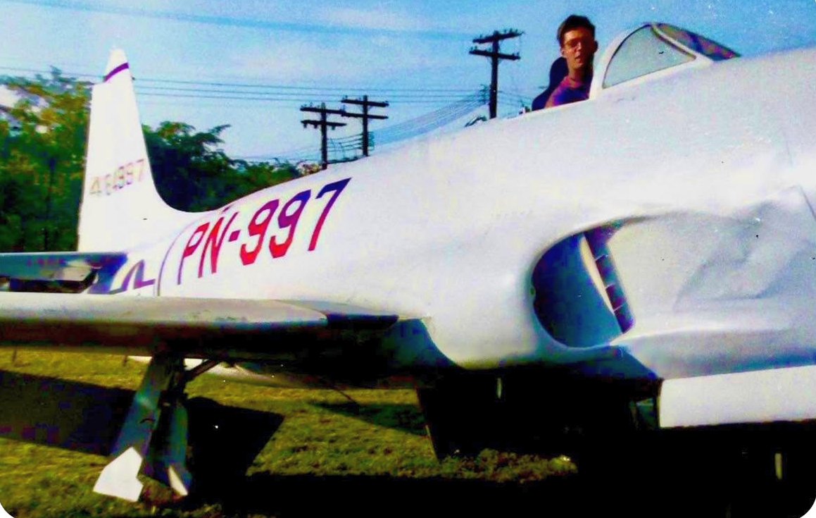
A circa early 1950s photo of Stanley Maciejewski sitting in early-model Lockheed P-80A 44-84897 at Sampson AFB (courtesy of his daughter, Sandee Weiner).
Sandee Weiner reported that her father Stanley Maciejewski was stationed at Sampson AFB in the early 1950s as a Drill Instructor.
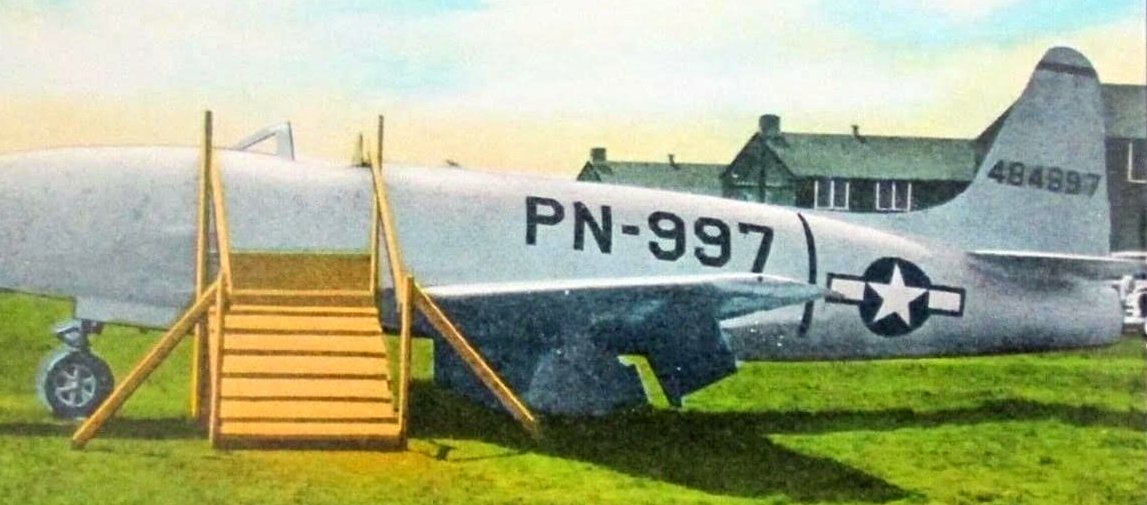
A circa early 1950s photo of Lockheed P-80A 44-84897 outside at Sampson AFB (courtesy Sandee Weiner).
The poor Shooting Star must've rusted away pretty quickly in Upstate NY weather if it sat too long outside without a canopy.
Dick Garfield recalled, "I went through basic at Sampson in November 1953 - January 1954.
On or about 1/22/54 I flew out of Sampson to Lowry AFB, Denver, CO.
I understand that we were one of the first to use the runway there."
Sampson's airfield was not yet depicted on the May 1954 Albany Sectional Chart.
The earliest aeronautical chart depiction which has been located of Sampson AFB was on the November 1954 Albany Sectional Chart.
It depicted Sampson AFB as having a 5,000' paved runway.
A circa 1955 aerial view looking east at Sampson AFB (from the Sampson State Park Military Museum, courtesy of Ron Plante).
It depicted Sampson as having an asphalt Runway 16/34 & a ramp on the west side.
There are at least 7 aircraft on the field, including 5 on the ramp, 1 preparing to enter the runway from the midfield taxiway, and 1 at each turnaround pad.
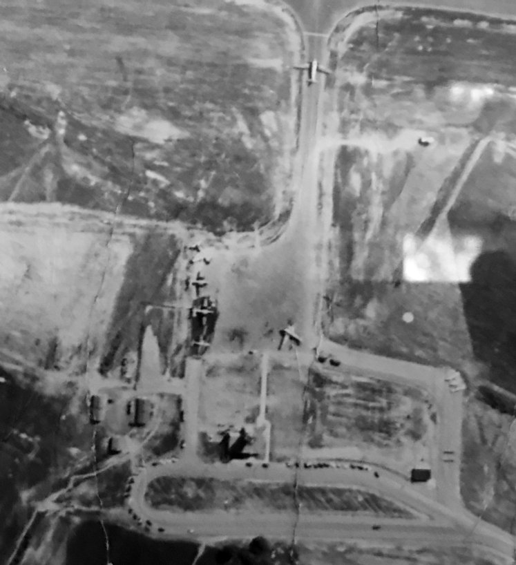
A closeup from the circa 1955 aerial view looking east showing 5 aircraft on Sampson AFB's west ramp (from the Sampson State Park Military Museum, courtesy of Ron Plante).
Ron Plante postulated, “I'm guessing there were some planes bringing in people for the hospital & there was a gradation from which they flew guys out.
There may have also been VIPs in town for the graduation.”
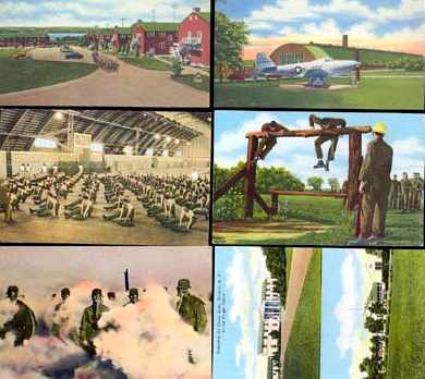
An undated postcard of Sampson AFB (courtesy of Rex Ricks), including a static display Bell P-39 Cobra or P-63 King Cobra.
The Air Force Training Center, however, did not last much longer than the Navy's.
The base officially closed in 1956 & reverted to caretaker status.
From 1958-1962, the Army acquired the airfield property (a total of 629 acres) from the Air Force.
The former Sampson AFB runway became known as Seneca Army Airfield,
and was used to operate flights in support of the depot.
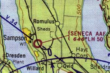
Seneca AAF, as depicted on the 1962 Albany Sectional Chart (courtesy of Mike Keefe).
It was still depicted as "Seneca AAF" on the 1963 Albany Sectional Chart (courtesy of Mike Keefe).
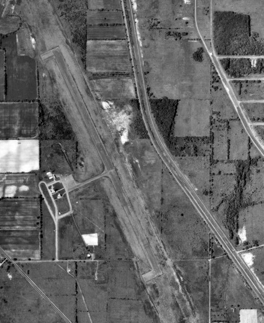
A 6/19/63 aerial view (courtesy of Ron Plante) depicted Seneca AAF as having a single paved 5,000' northwest/southeast runway, and a ramp on the west side.
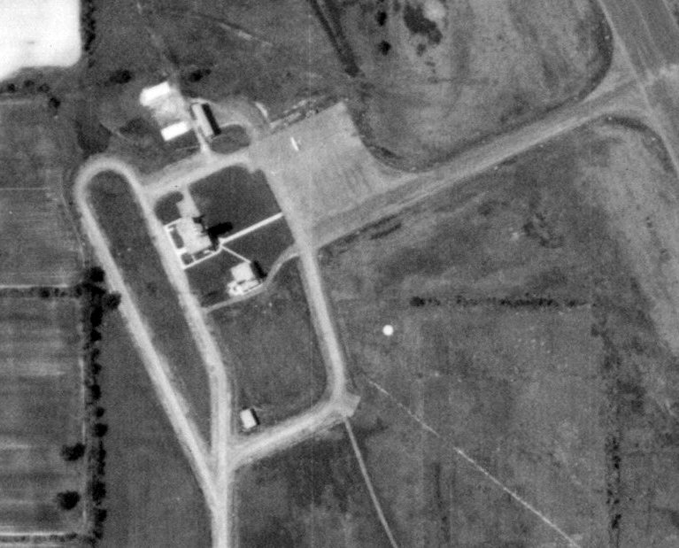
A closeup from the 6/19/63 aerial view (courtesy of Ron Plante) depicted the ramp, fire station,
control tower, and 1 light single-engine aircraft on the west side of Seneca AAF.
Dennis Sandow recalled, "I was stationed there (at the Ordnance Depot) in 1964-65.
At that time, the airfield looked abandoned was wide open to ground access (it was outside the Depot fence). Air access, too.
The routine security patrols reported anecdotally that they encountered small private aircraft stopped on the runway
with the passengers taking time out for a little undescribed 'recreation'.
Of course, if they saw the MPs coming, it was easy to make a clean getaway."
"But when an air movement was required, matters changed. MPs would seal up the field.
The base fire department would roll trucks to the airfield (all ammo depots have their own fire department).
A medical officer would show up. And the post Signal Officer (me) brought out a crew to fire up the radio (singular).
Yes, we used UNICOM to talk down the C-130s. Basically, we reported the wind & then it was pilot's discretion.
We operated from the ground. No one went up into the tower you have pictured. The flight plans were never discussed.
The planes came out of the sky & went back into the sky to undisclosed destinations."
At some point between 1965-66, a strange change of status occurred for this military airfield:
it was briefly reestablished as a civilian airfield, the "North Star Seneca Airpark".
Gardner Soule recalled, "The North Star Seneca, Seneca Army Depot, was open briefly in the mid 1960s.
I landed there several times, the first being in 1966. The concept was a camping airport."
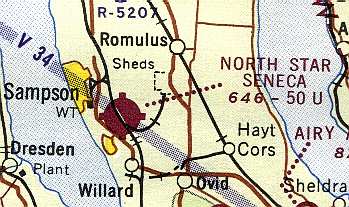
"North Star Seneca Airpark" was depicted on the 1967 Albany Sectional Chart (courtesy of Mike Keefe)
as a civilian airfield, having a 5,000' paved runway.
The duration of the civilian use of the Seneca airfield has not been determined, but it was evidently a brief period.
Gardner Soule recalled, "Apparently it never caught on or the airport reverted to military control possibly because of Viet Nam?"
David Brooks recalled, "I worked for Raytheon for a while at Lake Seneca.
The Navy has (had?) a test site there as Lake Seneca is the deepest lake in the US.
They tested nuclear subs' sonar systems there off barges at the deepest part (~650ft.).
The Navy would operate helicopters (S-61s & other types) & come out to the lake as we would be running tests.
They would record our 'pinging' & we would make special tests for them (anti-submarine).
During that time (1967-68) a number of Air Force cargo planes landed there.
I drove over there & noted it was a small field (minimum structures & one runway).
I guess that they would come in & bring or pickup munitions from the big munitions dump next too it."
The January 1970 Albany Sectional Chart reverted to labeling the airfield as "Seneca AAF".
The 1979 USGS topo map depicted Seneca Army Airfield
as having a a single paved northwest/southeast runway, and a ramp & 2 buildings on the west side.
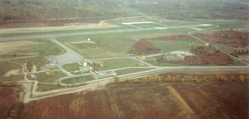
A 1983 aerial view looking east at Seneca AAF (courtesy of Ron Plante).
Ron Plante recalled, "I worked at the Seneca Army Depot from 1983-86 & spent some time at the airfield.
I'm certain the control tower was closed up, though the lower floors of the building may have been used as offices.
The former fire station bays were used as hangars for the Hueys supporting depot security.
A small office next to the bays was used for airfield operations,
and it had a radio & weather instruments to provide airport advisory for the occasional C-141.
To the best of my knowledge, the perimeter fence & gatehouse were added in 1983 or 1984."
The last photo which has been located showing Seneca AAF while still open was a 1994 USGS aerial view looking northeast.
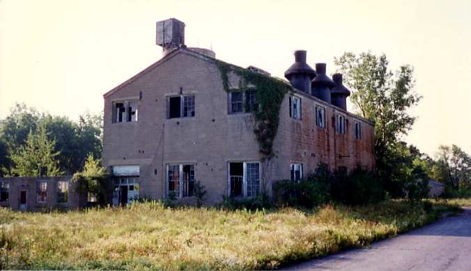
A 1995 photo by Scott Murdock of the former Sampson AFB base hospital's power station.
Scott reported, “I found lots of abandoned buildings out in the far reaches of the former base."
A 1995 photo by Scott Murdock of the abandoned guard shack at the main gate of the former Sampson AFB.
A 1995 photo by Scott Murdock of the view out of the abandoned guard shack at the main gate of the former Sampson AFB.
The Seneca Army Depot was identified for closure in 1995 as part of the BRAC process.
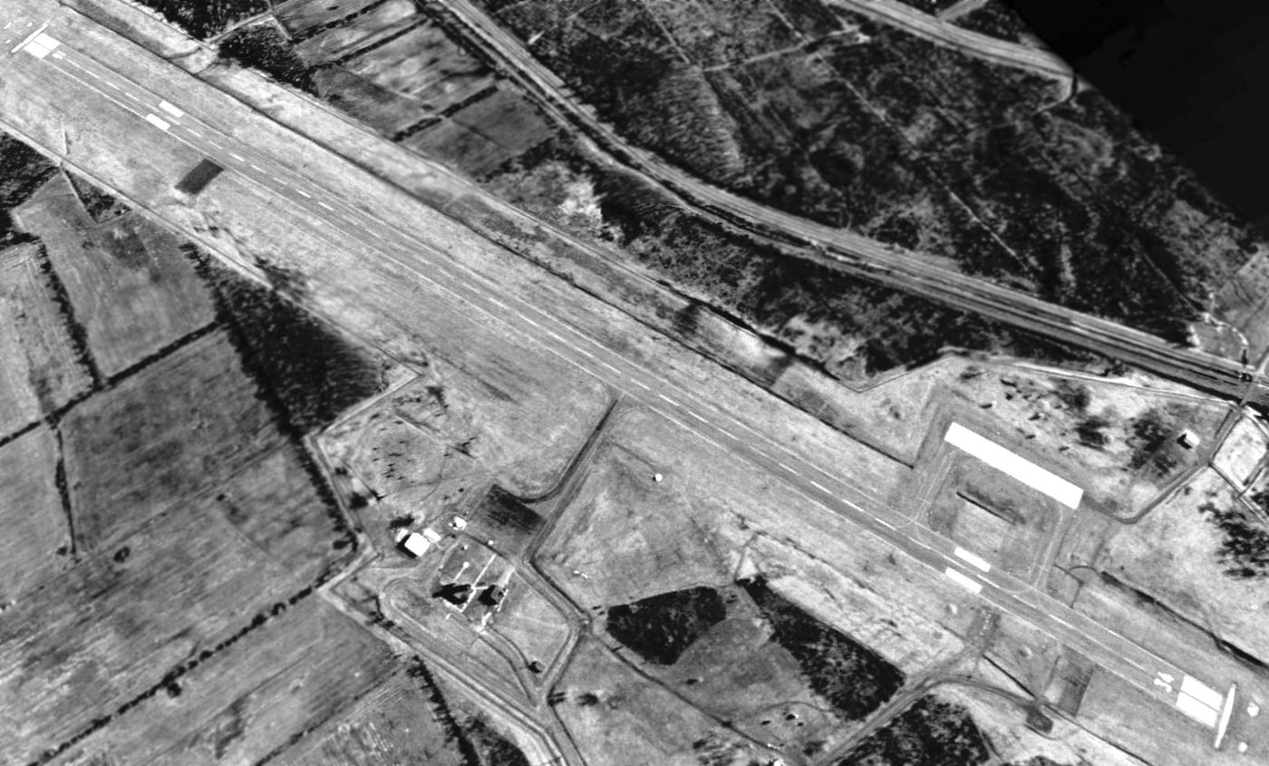
Seneca AAF was still depicted as an active airfield on the 1998 World Aeronautical Chart, but was closed by 2000.
At the point of its closure, the airfield consists of a single paved runway (16/34, 7,000' long), taxiways & a ramp.
The Seneca Army Depot was closed by 2001.
The property of the Seneca Army Depot is being converted to civilian reuse.
A 500 acre site (including the airfield) is being conveyed to the NY State Police for law enforcement training purposes.
Other portions are now a state park.
In 2003 Lockheed T-33 Shooting Star TR-604 was brought to the Sampson State Park Military Museum to be restored for static display.
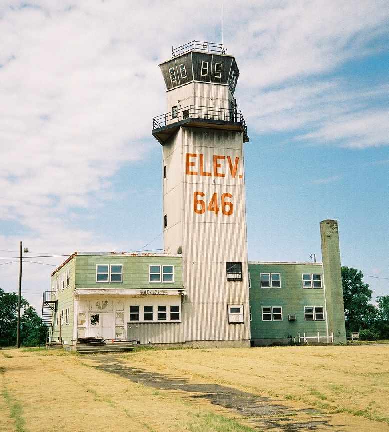
A 2003 photo by Ronald Plante of the abandoned control tower at Seneca AAF.
A 2003 photo by Ronald Plante of an abandoned runway at Seneca AAF.

A 2003 photo by Ronald Plante of the former fire station at Seneca AAF.
Ronald Plante reported in 2003, "Some of the airfield is being developed into an emergency services training site.
Just inside the gate is a brand new State Police barracks, and sharing the building is a police & fire training center.
A new fire training tower was built southeast of the control tower, and the 7,000' runway is used for high-speed police pursuit training.
The control tower & fire station are empty."
Gardner Soule recalled in 2004, "There is a fine state park adjacent to the airport which used to be part of the military complex there.
Our company did a fly-over there about a year ago to promote the airport to potential investors.
It is still abandoned, however."
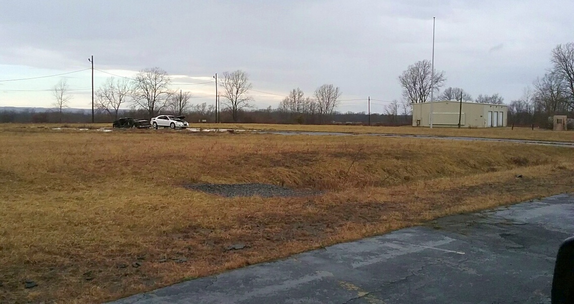
A circa 2006 aerial photo looking west at the abandoned former airfield fire station, former control tower,
and a newer-construction building at the former Seneca AAF.
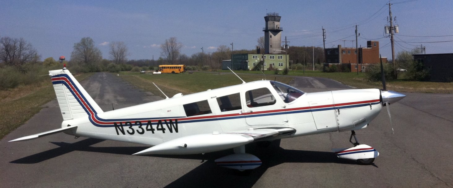
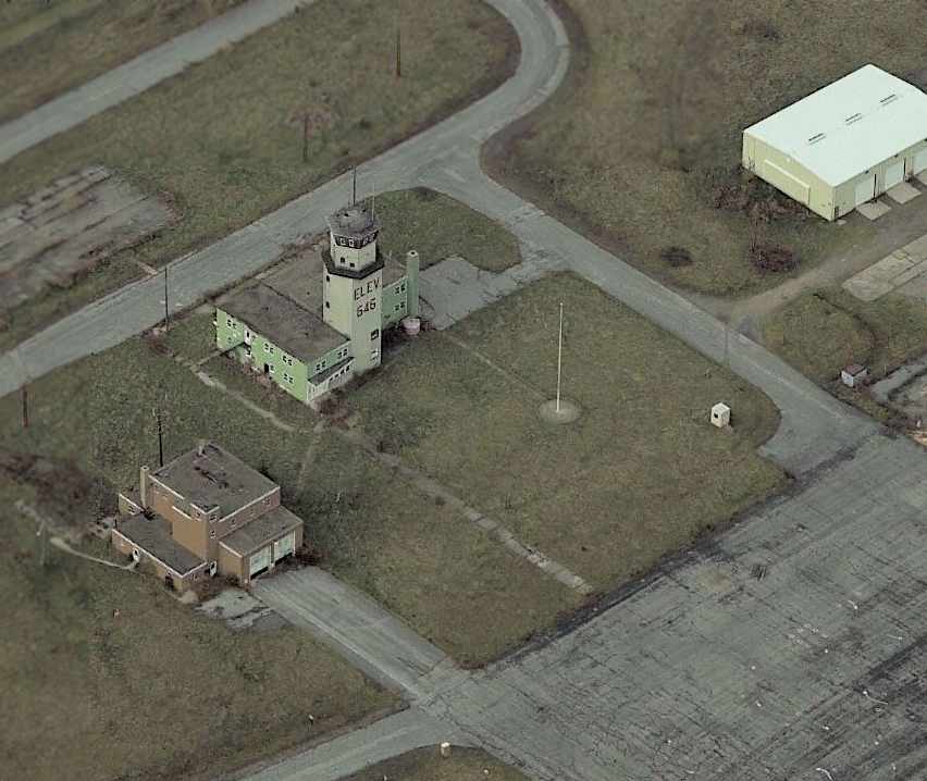
A 2012 photo by Frank Grossmann of his Piper PA-32-260 Cherokee Six in front of the Seneca Army Depot airfield control tower.
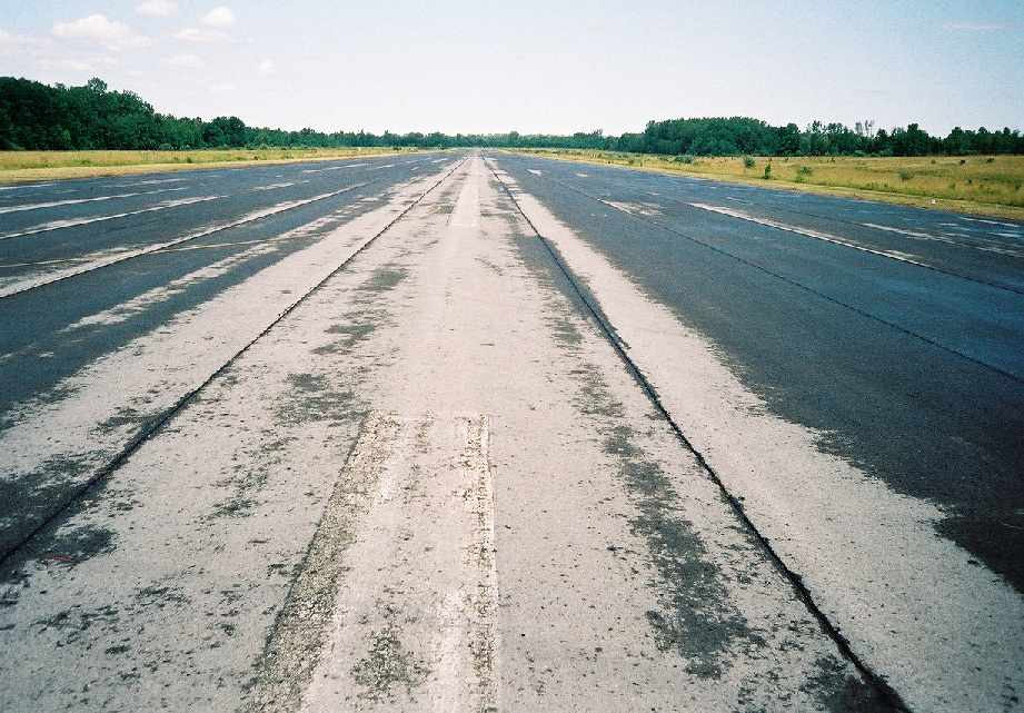
Frank reported, “The runway was in excellent shape considering how long it had sat abandoned with no maintenance.”
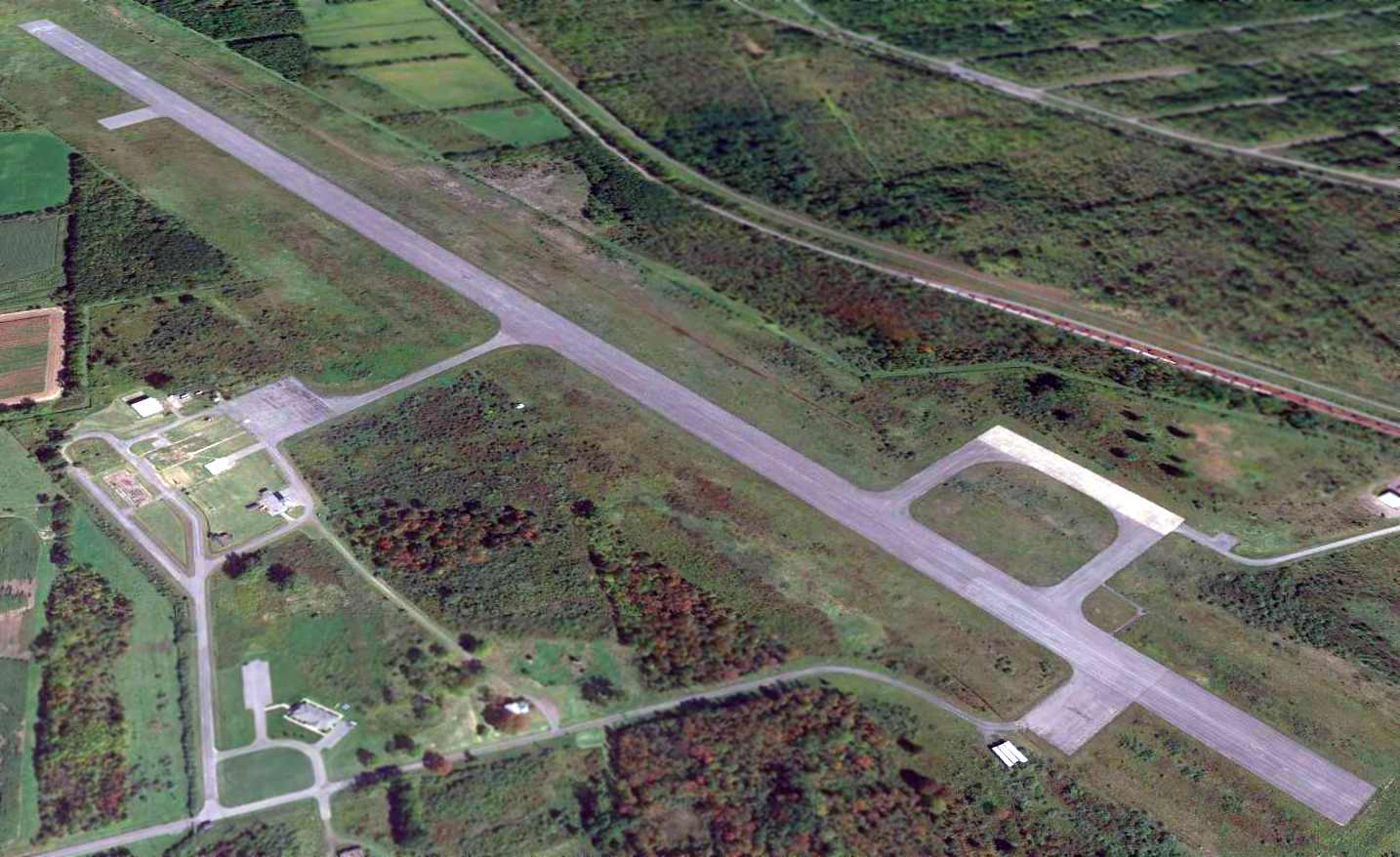
A 2013 aerial view looking northeast at Seneca AAF showed the control tower & fire station had been removed at some point between 2012-2013.
But the runway, taxiways, and ramps remained intact.
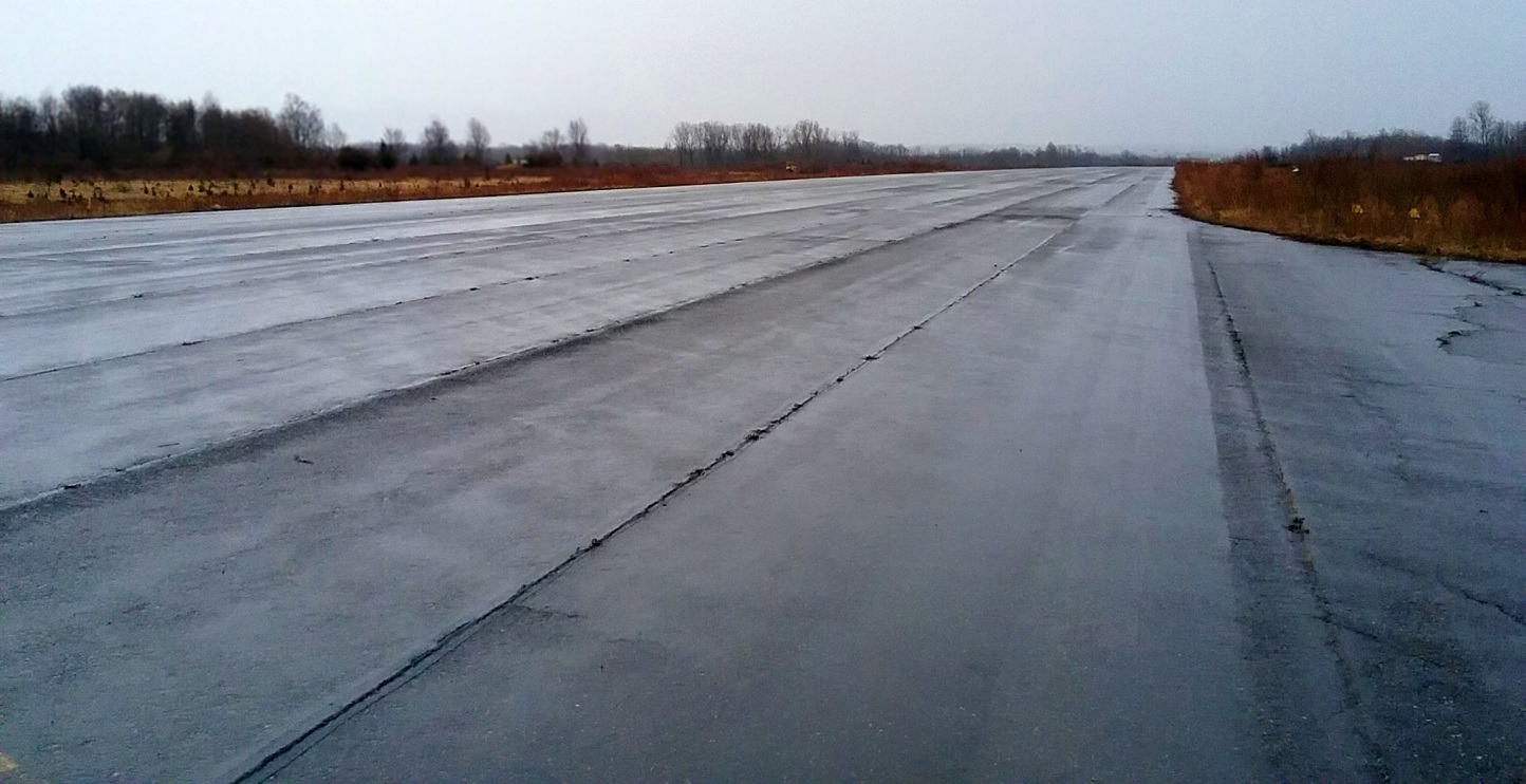
A 4/4/17 photo by Ron Plante of the former Seneca AAF runway.
Ron reported, “The ramp is in sorry shape, but the runway looks great with just a few weeds growing in the cracks.
I suspect it was well-made & well-maintained until the depot closed.
I heard a local businessman who owns a plane is in the process of buying the runway; maybe flying will return.”
A 4/4/17 photo by Ron Plante of the site of the Seneca AAF fire station & hangar.
Ron reported, “The fire station / Huey hangar is also gone; the flagpole remains.
There is a NY State Police barracks close to the entrance; further north where the tower once stood is a fire/police training site that uses the runway for high speed driving.”
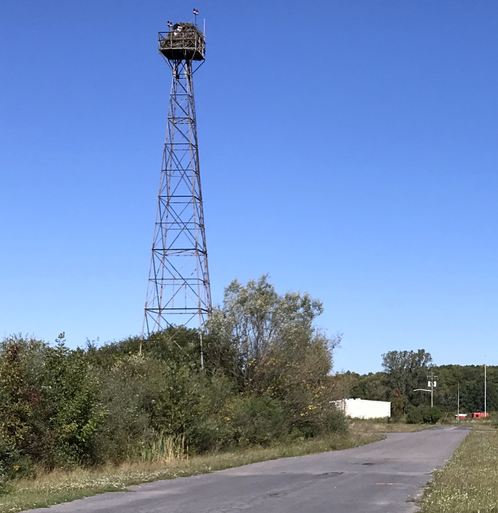
An October 2019 photo by Ron Plante of the former airfield beacon which remains at the entrance to Seneca AAF, with a large bird's nest on top.
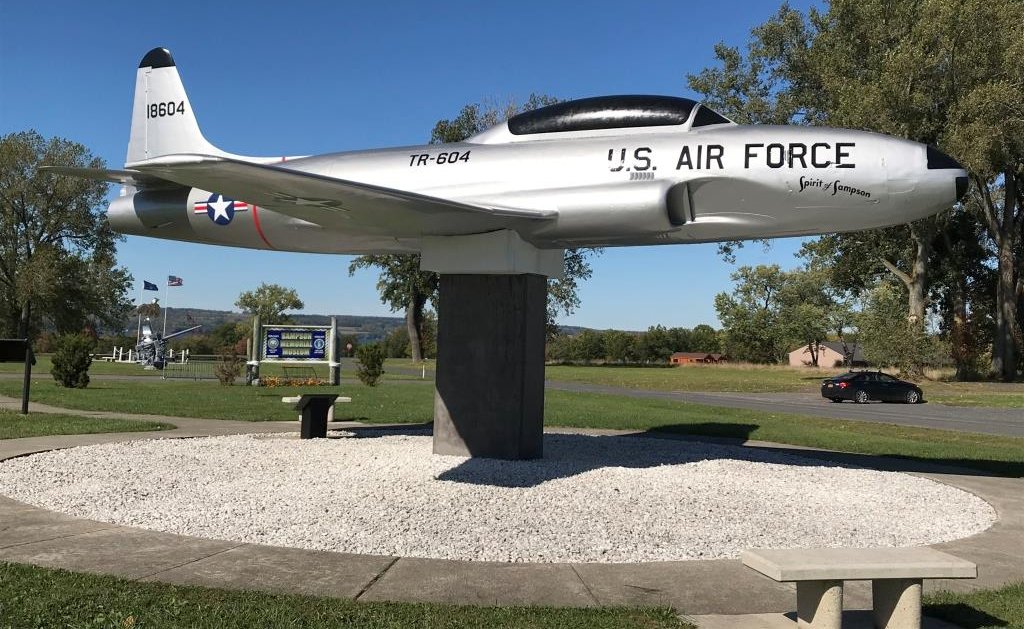
An October 2019 photo by Ron Plante of USAF Lockheed T-33 Shooting Star TR-604, beautifuly restored for static display at the Sampson State Park Military Museum.
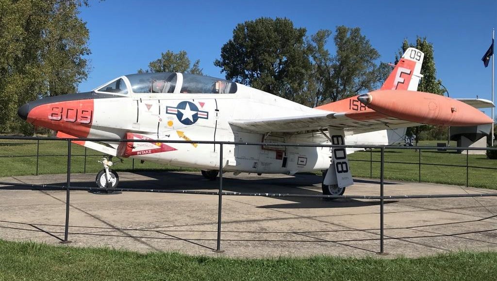
An October 2019 photo by Ron Plante of a Navy North American T-2C Buckeye trainer on static display at the Sampson State Park Military Museum.
An Army Corps of Engineers report gives more details about Sampson AFB (Seneca AAF).
See also: SampsonVets.
____________________________________________________
Or if you prefer to contact me directly concerning a contribution (for a mailing address to send a check),
please contact me at: paulandterryfreeman@gmail.com
If you enjoy this web site, please support it with a financial contribution.
____________________________________________________
This site covers airfields in all 50 states.