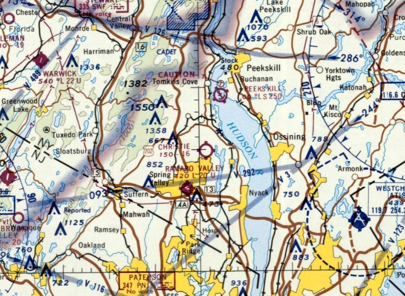
Abandoned & Little-Known Airfields:
New York State: Rockland County
© 2002, © 2025 by Paul Freeman. Revised 11/11/25.
This site covers airfields in all 50 states: Click here for the site's main menu.
____________________________________________________
Please consider a financial contribution to support the continued growth & operation of this site.
Christie Airport (revised 11/11/25) - Miller Airport (revised 6/20/19) - Orangeburg CAP Airport (revised 10/3/15)
Rockland Airport (revised 12/26/18) - Spring Valley Airport / County Airport / Ramapo Valley Airport (revised 10/11/25)
____________________________________________________
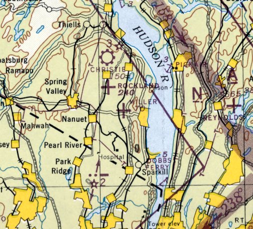
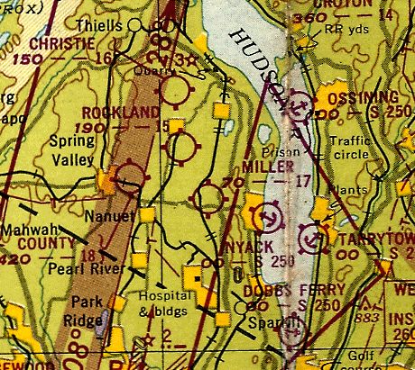
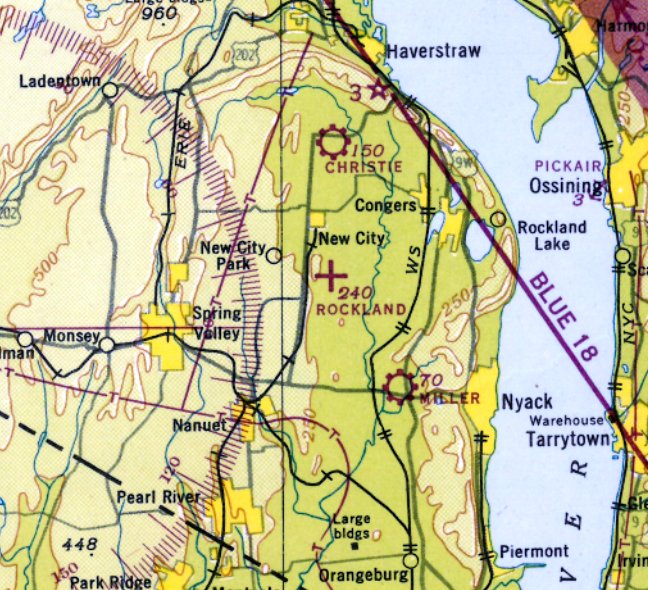
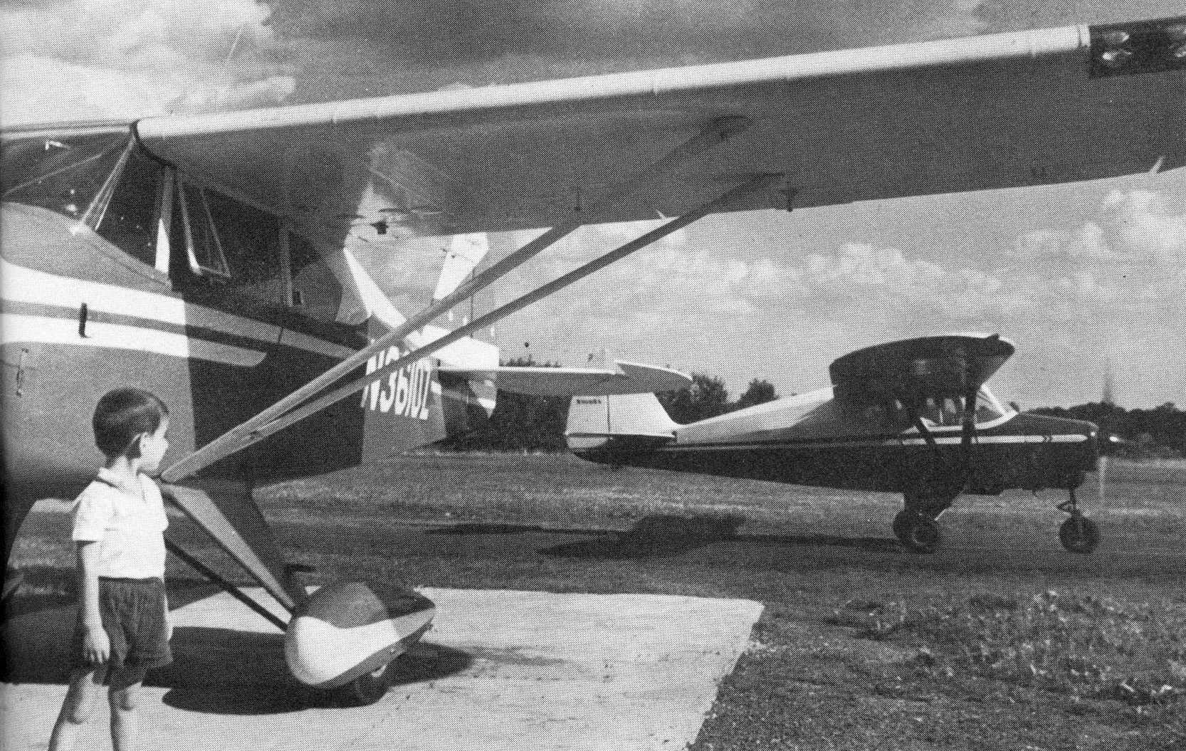
Miller Airport, West Nyack, NY
41.1, -73.95 (North of New York, NY)
Miller Airport, as depicted on the June 1945 NY Sectional Chart.
Adam Raines reported, “Miller Airport was opened in 1940 on the same land that the Miller family operated the well-known Miller Dairy Farm,
which dated back to the turn of the 20th century.
A larger portion of the land was owned & used by the Scheno Trucking Company of Nyack as a landfill.
Despite objection from their neighbors, the Millers purchased the rest of this land,
got the needed zoning permits, and the Miller Airport was born.
Gary Miller Jr. was responsible for opening the airfield on his father’s farm.
His father, Gary Miller Sr., learned to fly later on. The land was prone to flooding & as a result the airport was often flooded.
Gary Sr. had two boys, Gary Jr. & Howard, twins, who helped run the airport until it closed.
Gary Jr. was a Certified Flight Instructor (CFI) at Rockland Airport and then became a CFI at Millers.
He eventually became an FAA Designee.”
Miller Airport was not yet depicted on the 1943 USGS topo map or the May 1944 NY Sectional Chart,
nor listed among active airfields in the 1945 AAF Airfield Directory (courtesy of Scott Murdock).
The earliest depiction which has been located of Miller Airport was on the June 1945 NY Sectional Chart,
which depicted Miller as an auxiliary airfield.
The August 1946 NY Terminal Chart (courtesy of Tim Zukas) depicted Miller as a commercial/municipal airport.
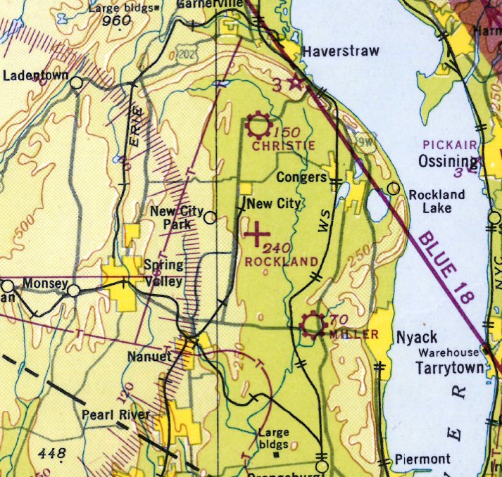
Miller Airport, as depicted on the 1947 USGS topo map.
Miller Airport was depicted in an unchanged fashion on the 1948 USGS topo map.
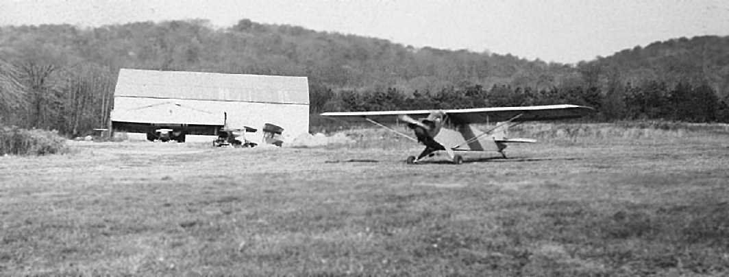
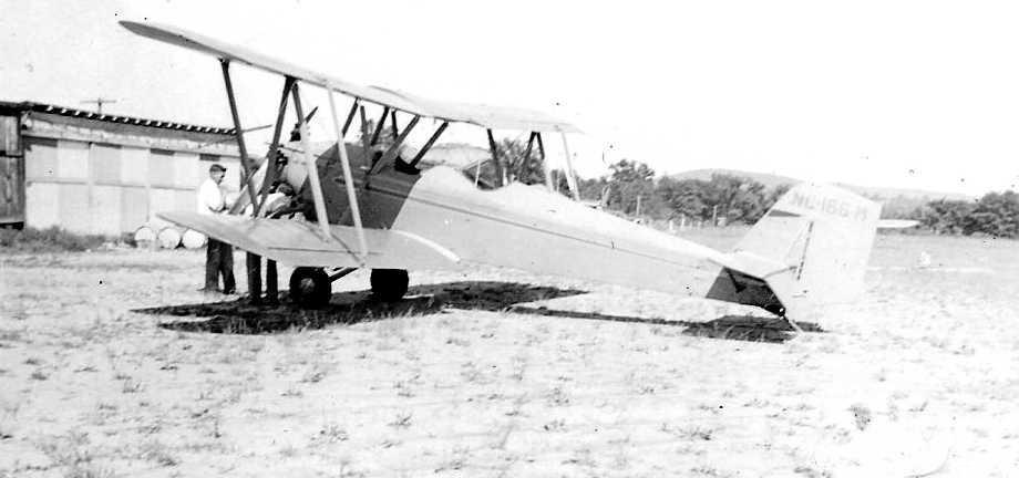
The earliest photo which has been located of Miller Airport
was a 1949 photo of 4 Piper Cubs in front of the Miller Airport hangar (courtesy of Adam Raines).
The last aeronautical chart depiction which has been located of Miller Airport was on the July 1949 NY Sectional Chart (courtesy of Ron Plante).
It depicted Miller as having a mere 1,700' unpaved runway.
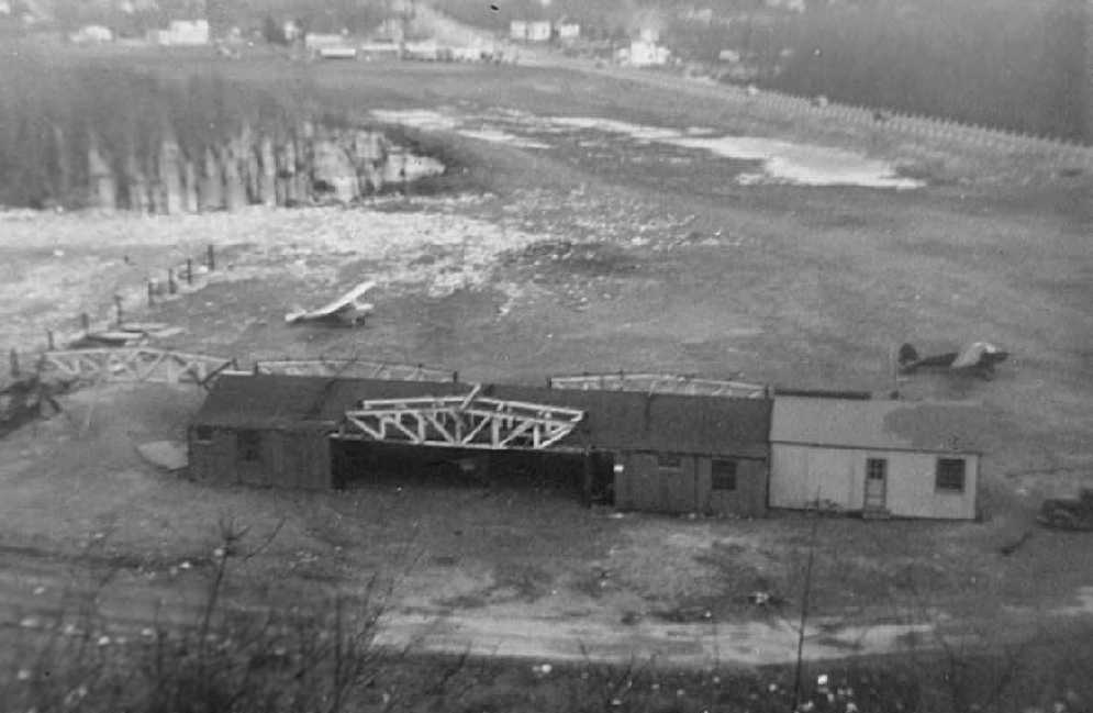
A 1950 photo of the Miller Airport hangar & 2 Piper Cubs (courtesy of Adam Raines).

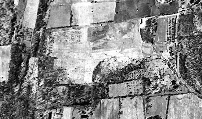
A 1950 aerial view (courtesy of Adam Raines) depicted Miller Airport as an irregularly-shaped grass field with several small buildings.
Adam Raines continued, “During its 12 years, the Miller Airport saw a good amount of action after the war due to the GI Bill.
However, in 1952 after much pressure from the town, it closed.
Rich MacVicar remembered one woman who lived on Greenbush Road would complain that oil would drip on to her wash from planes flying overhead.
A combination of the town pressure, and the beginning of the construction of the Tappan Zee Bridge & the NYS Thruway, led to the closure of the airport.
On 7/4/52, Al Morris & Rich MacVicar packed up once again, and flew the last plane out
and headed to their new airport – CAPROC (Civil Air Patrol Rockland County) in Orangeburg.
Mac flew the last airplane, a Taylorcraft, off the property & the field was closed forever.”
Miller Airport was no longer depicted on the 1952 NY Sectional Chart.
A 1953 aerial photo showed no obvious sign of an airfield, with several buildings having been constructed over various portions of the property.
What may have been several former hangars remained on along the south side.
Miller Airport was no longer depicted on the 1957 USGS topo map.
Several possible former airport buildings may have remained visible on a 1994 aerial photo.
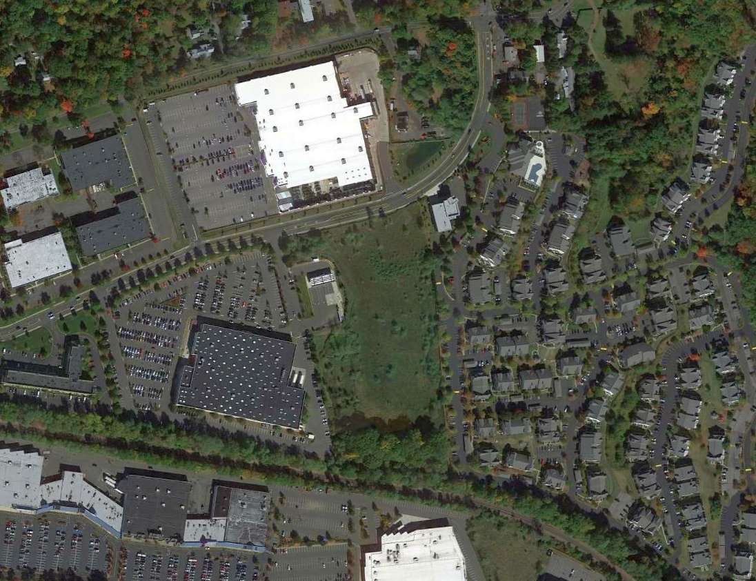
The Palisades Center Mall was planned for the airport site in 1985, and eventually opened in 1998, erasing any trace of Miller Airport.
A 2003 aerial photo depicted the Palisades Center Mall covering the site, with no remaining trace of Miller Airport.
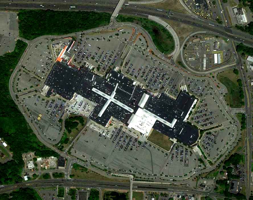
A 6/17/10 aerial view showed no trace remaining of Miller Airport.
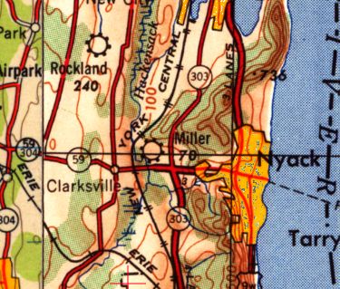
The site of Miller Airport is located northwest of the intersection of Route 59 & Route 303.
See also: https://www.basetofinal.com/ by Adam Raines & Rich MacVicar, which covers the history of 22 airfields in Rockland County.
____________________________________________________
Rockland Airport, New City, NY
41.13, -73.97 (North of New York, NY)
Rockland Airport, as depicted on a circa late-1920s map (courtesy of Adam Raines).
Adam Raines reported, “The first official airport in Rockland County was opened officially on Memorial Day in 1928.
Its founder was Dr. Pierre Bernard. Dr. Bernard was known throughout the county for his bringing Yoga to the states.
In addition to Yoga, he also had an obsession with aviation. He started The Rockland Aero Club, mostly WW1 aviators & people interested in aviation.
He found a tract of land that would lease him the space for the Airport.
The farm was owned by Frank Schomberg on Brewery Road between Parrott & Lauren Road.
On Memorial Day in 1928, the Airport was opened to a noisy fanfare. 2,500 people attended!
There were stunts, airplane rides, and parachute jumps.
Unfortunately, the day ended on a sad note when the rain started to come in and one of the parachutists had an accident which was fatal.
The accident was overshadowed by the day’s events but Bernard made sure that the body was recovered immediately & respect was paid to the family.
After that, the field flourished & a school was formed.
In October of 1928, Bernard made a deal with The Department of Commerce
and the field was now used as a way station & Emergency Field for the NY to Albany to Montreal to Buffalo mail route.
The government would maintain the field & spend $25,000 in improvements including an airport beacon.”
The earliest depiction which has been located of Rockland Airport was a circa late-1920s map (courtesy of Adam Raines),
which depicted Rockland as having a beacon.
Strangely, Rockland Airport was not depicted at all on USGS topo maps from the 1920s, 1930s, 1940s, or 1950s.
According to Adam Raines, “The Airport did well until 1931 when some local political problems formed him to dissolve the Aero club & activity at the field slowed down considerably.
Most of the 1930s flying was done at Christies Airport a few miles away. However, the field remained & there was flying there.”
The earliest photo which has been located of Rockland Airport was a 1937 photo of Jerry Carnegie’s New Standard biplane (courtesy of Adam Raines).
According to Adam Raines, “Jerry was a WW1 pilot & also owner of a very well-known Tavern in New City called Jerry’s Tavern.”
According to Adam Raines, Rockland Airport “closed temporarily in 1941 due to WW2 restrictions on all civil airports within 50 miles of the shore.”
Rockland Airport was not depicted on the November 1942 NY Sectional Chart (courtesy of Ron Plante)
nor listed among active airfields in the 1945 AAF Airfield Directory (courtesy of Scott Murdock).
According to Adam Raines, “It wasn’t until after WW2 that it became active again.
In 1945, conversations about reopening the airfield for civilian use began with a new airport manager, Albert Morris.
Al Morris succeeded in his mission & continued to operate the field for civilians & returning Gis.
He was instrumental in making the airport a popular place to learn to fly.
Other people that worked at the airfield included flight instructors William Beard & Charles Greggor.”
The earliest aeronautical chart depiction which has been located of Rockland Airport
was on the August 1946 NY Terminal Aeronautical Chart (courtesy of Tim Zukas).
It depicted Rockland as an auxiliary airfield.
A 1947 aerial view (courtesy of Adam Raines) depicted Rockland Airport as having several unpaved runways & 2 small buildings on the north & northeast sides.
Rockland Airport, as depicted on the 1947 USGS topo map.
Rockland Airport was depicted in an unchanged fashion on the 1948 USGS topo map.
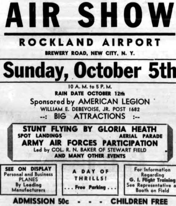
An advertisement for the 10/5/47 airshow at Rockland Airport (courtesy of Adam Raines).
Adam Raines reported, “On 10/5/47, the Rockland Airport put together an airshow for its community.
The newspaper advertisements got the towns excited about the event,
and it is said that several thousand people flocked to the small airport in New City to see stunt flying, landing contests, and aircraft manufacturers’ exhibits.
The event was sponsored by the American Legion (William E Debevoise Jr, Post 1682).
Admission was 50 cents for adults, with children admitted for free.
The airshow was a success & the Rockland Airport had made its mark in the community.”
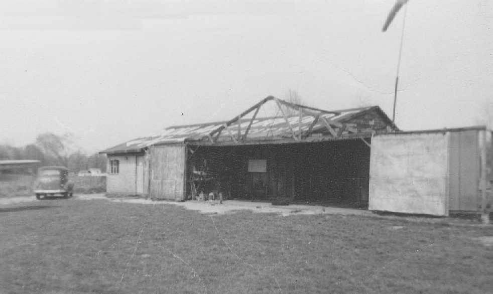
A 1947-48 photo (courtesy of Adam Raines) of a hangar at Rockland Airport with a wind sock on top.
According to Adam Raines, “In 1948, the airfield was looking for some help in aircraft maintenance,
and Al Morris hired a young 21 year old student pilot named Richard MacVicar.
Richard, who would become known as 'Mac', was very involved in the airport & eventually became the airport manager until the airport’s closing in 1949.”
The last aeronautical chart depiction which has been located of Rockland Airport was on the July 1949 NY Sectional Chart (courtesy of Ron Plante).
It depicted Rockland as having a mere 1,500' unpaved runway.
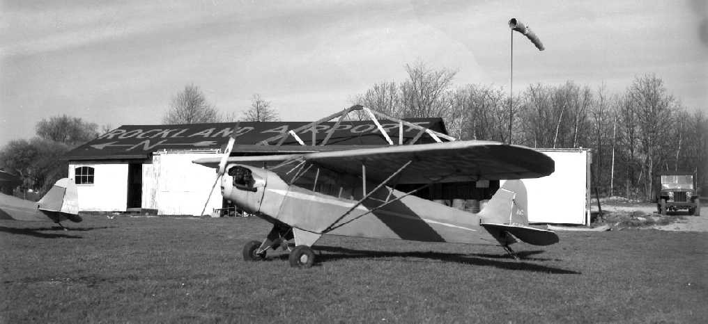
A 1949 photo (courtesy of Adam Raines) of a Piper Cub in front of a hangar at Rockland Airport, painted with the airport's name & an arrow pointing north.
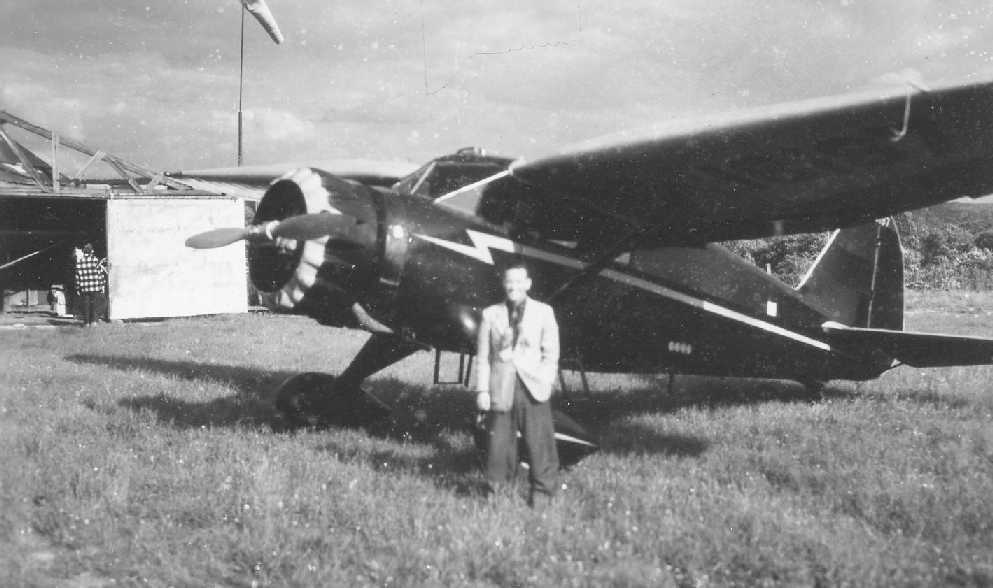
The last depiction which has been located of Rockland Airport was a 1949 photo (courtesy of Adam Raines) of Everett Gates in front of a Stinson & the Rockland hangar.
According to Adam Raines, “After the GI Bill ended, the popularity of General Aviation slowed down & the airport got quieter.
In 1949, there was much less activity on the airfield, and with 3 other airports active in the county, the future of the Rockland Airport was uncertain.
Mr. Calabrese had been in conversations with developers about potentially building bungalows on the grounds,
so he decided to close the airport at the end of the summer in 1949. The bungalows were never built.
Upon closing, Mac & Al Morris packed up everything, including the hangars, and trucked & flew everything over to the Miller Airport in West Nyack;
so ended the history of the first airport in Rockland County.”
Rockland Airport was no longer depicted on the July 1950 NY Sectional Chart (courtesy of Jim Stanton).
A 1953 aerial photo showed the field remained clear, with the hangars gone, but without any redevelopment.
Rockland Airport was no longer depicted on the 1955 USGS topo map.
A 1974 aerial photo showed the field remained clear, but without any redevelopment.
A 1994 aerial photo showed that houses had covered the site at some point between 1974-94,
erasing all traces of the first airport in Rockland County.
A 5/26/11 aerial view showed no trace remaining of Rockland Airport.
The site of Rockland Airport is located west of the intersection of Lafayette Drive & Brewery Road.
See also: https://www.basetofinal.com/ by Adam Raines & Rich MacVicar, which covers the history of 22 airfields in Rockland County.
____________________________________________________
Orangeburg Civil Air Patrol Airport, Orangeburg, NY
41.04, -73.99 (North of New York, NY)
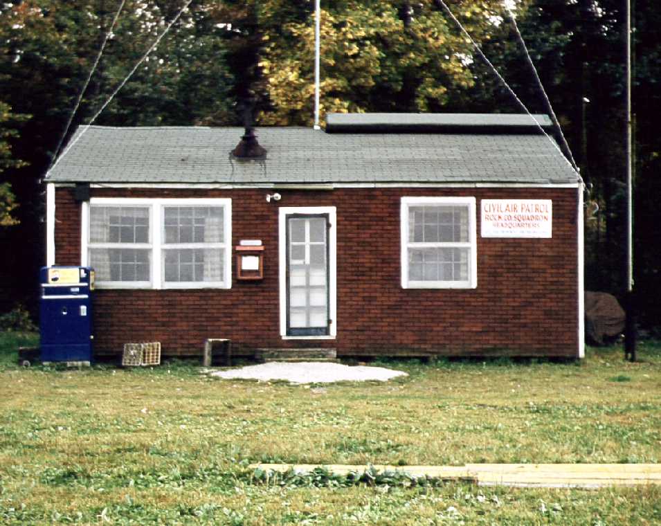
A 1955 photo of the Orangeburg Civil Air Patrol office building (courtesy of Adam Raines).
The Orangeburg Airport was not yet depicted on the 1952 USGS topo map.
Richard MacVicar recalled, “C.A.P. Rockland County... The first plane landed there on 7/4/52.
The second landed the next day. I flew both. This marked the closing of Miller Airport in West Nyack, NY.
Caprock got its zoning permission a week or so later. The land was leased from the Hackensack Water Company.
The runway was dead east/west, 1,858' long & 100' wide.”
Adam Raines reported, “When Millers Airport closed in 1952, the Civil Air Patrol needed a new home
and a lease was negotiated between the following people & the Hackensack Water Company:
Harold Lockwood, Al Morris, Katherine Couch, Eugene Levine, Richard MacVicar, George Zachgo, Michael Detroy, and Louis Heidleman.
Each person was instrumental in the formation of this small turf airstrip.
Other members of the C.A.P. [unit] were Robert Lapinski, Ray Eberling, and John Christie.
Mac was the first to fly an airplane in to this field from Miller Airport on 7/4/52.
The following day, Mac flew in another plane & was cited by the Police department for illegally operating an airport,
which was technically not open yet since they were still waiting for zoning approval.”
Adam continued, “CAPROC was a private field & in order to keep it private they put 2 large X’s at each end of the runway.
Ironically, some pilots would still land & ask what the X was for, so they eventually took them away.
The group had regular scheduled meetings, and the field consisted of base station for CAP & radio communications.
Over the years, there were several actual searches conducted, ranging from missing aircraft to missing persons.
They had a success story where they located a missing airplane on Storm King Mountain.”
The earliest depiction of the Orangeburg Civil Air Patrol Airport which has been located was a 1953 aerial photo.
It depicted a single unpaved southwest/northeast runway on the south side of Orangeburg Road,
with 2 small buildings on the northeast side, and possibly 2 light single-engine aircraft on the southeast side.
The Orangeburg Civil Air Patrol Airport was not depicted on the 1953 NY Terminal Aeronautical Chart (courtesy of Tim Zukas).
Gary Smith recalled, “The whole area was pretty rural in the 1950s.
This little strip was on the way to Pearl River, and I’d keep a sharp eye peeled for any activity there whenever we drove by.
My dad was an AAF pilot & was in the aviation business as an exec with Bendix in Teterboro, and I caught the aviation bug from his endless tales of flying.
I always bugged him to take me over there just to watch & hang around, but that was never in the cards.
I never even knew if the airfield had a name; my dad thought there was some Civil Air Patrol activity there so we referred to it as the 'CAP field'.”
The earliest depiction which has been located of the Orangeburg CAP Airport was a 1953 aerial photo.
It depicted a single unpaved northeast/southwest runway on the south side of the road.
There were no buildings or aircraft visible on the field.
Richard MacVicar recalled, “When the field opened there was no road;
Veterans Memorial Drive then was built several years later & it removed many too-tall trees on the approach.”
The Orangeburg Civil Air Patrol Airport was not depicted on the January 1955 NY Sectional Chart (or subsequent Sectional Charts).
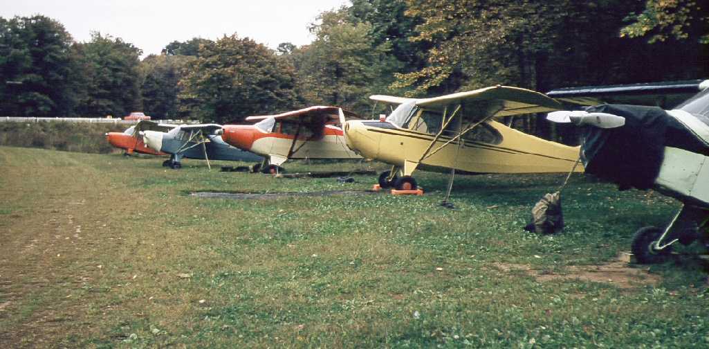
A 1956 photo of 5 Civil Air Patrol planes at Orangeburg (courtesy of Adam Raines).
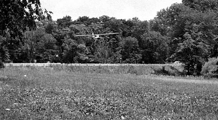
A 1956 photo of a Civil Air Patrol plane on final approach to Orangeburg (courtesy of Adam Raines).
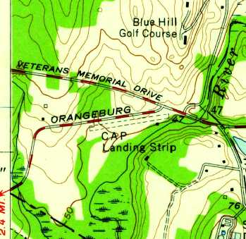
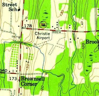
The 1957 USGS topo map depicted the Orangeburg “CAP Landing Strip” as having a single unpaved southwest/northeast runway,
with a single small building on the southeast side.
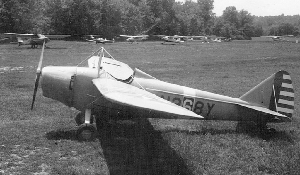
A circa 1963 photo by James Goebel (courtesy of Bill Goebel) of his 1931 Buhl LA-1 Bull Pup, N368Y, at the Orangeburg CAP Airport.
Bill recalled, “My Dad, Jim Goebel, flew out of CAP Rock in the early 1960s.
He owned a 1931 Buhl LA-1 Bull Pup, N368Y, which he restored. He reassembled it & flew it out of CAP Rock for a while.
He then sold it & based a V-77 Stinson for a short period there before moving that to Warwick.
The picture is of my Dad’s Bull Pup at the gas pump which was on the other side of the field from the operations shack, the northeast end.
There was a row of some sort of ramshackle T-hangars or something to the right (west) of the ops shack as you were looking at it.
And there was a soda machine inside the back corner of that structure.
The ops shack was generally an open room with some sofas in there to lounge in along with a restroom.”
Bill Goebel recalled, “I remember being there as a youngster during the dedication of the CAP post as either the Al Morris or A.L. Morris Post.
One of the stipulations was that if you kept your plane there you were a member of the CAP.
When the CAP was notified that there was a plane missing in the area CAP Rock could launch about the entire field to aid in the search.
I believe it may have also been one of the most non-regulation CAP outfits too.
I never saw any uniforms or marching going on. Most of the pilots had done their time in WWII or Korea & had their fill of the parade field.”
Bill Goebel recalled, “The runway had a dip in it & as you took off to the east it sort of catapulted you in to the air if you hit it right.
I was there one day during a fly-in & a couple of my Dad’s buddies came in with some National Guard L-19 Birddogs.
They were nice enough to take my brother Charlie & I for a ride. Two in the back seat of an L-19 so we were munchkins.
I was 5 & my brother 7-ish. It was a typical bumpy New England day.
I ended up barfing, as I usually did in the bumpy air, however I was clever enough to barf all over my brother (sorry Charlie…).
The National Guard guys drew straws to see who would fly the barf bird back home.”
The “CAP Landing Strip” was still depicted on the 1964 USGS topo map.
A 1964 aerial photo showed an amazing total of 19 single-engine aircraft parked in a dense group on the southeast edge of the Orangeburg CAP Airport.
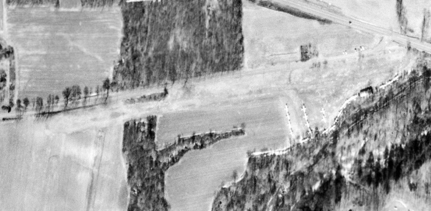
The last photo which has been located of Orangeburg CAP Airport was a 2/20/65 USGS aerial view.
The total number of aircraft parked on the southeast edge had increased to 27.
Richard MacVicar recalled, “Caprock never had any hangars - the last year or so someone donated a tin building to the field & it was added to the existing building.
It wasn't big enough for an aircraft, but was used to house the tractor & mowing equip.
The airport was on a year-to-year lease, it lasted 14 years, so no permanent or semi-permanent buildings were ever constructed.
The field closed in the fall of 1966 due to the construction of Lake Tappan.”
Adam Raines reported, “The land was on a year-to-year lease, but finally in 1966 when they started to construct the reservoir,
they were told that the lease was coming to an end.
They packed up their operations & moved to Spring Valley Airport & the Orangeburg Armory.”
A 1966 aerial photo showed a dramatic difference, with the end having come to this little airport -
the property had been scraped clean, presumably in preparation for the reservoir which would soon cover it.
A 1970 photo showed Lake Tappan had covered the site of the Orangeburg CAP Airport, erasing all traces of the little airfield.
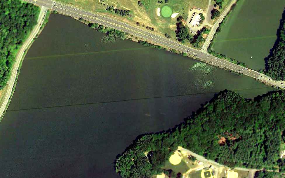
A 6/18/10 aerial view of the site of Orangeburg CAP Airport, now covered by Lake Tappan.
The site of Orangeburg Civil Air Patrol Airport is located west of the intersection of Veterans Memorial Drive & Old Orangeburg Road.
See also: https://www.basetofinal.com/ by Adam Raines & Rich MacVicar, which covers the history of 22 airfields in Rockland County.
____________________________________________________
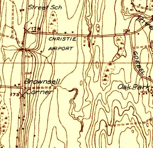
Christie Airport, New City, NY
41.17, -73.98 (North of New York, NY)
Christie Airport, as depicted on the November 1931 NYC-Albany Air Navigation Map.
According to Adraines, “Christie Airport... was created in 1929, converting the dairy farm into an airport.
In 1929, flights took passengers to see New York City & the World's Fair from the skies above.”
The earliest depiction of Christie Airport which has been located was on the November 1931 NYC-Albany Air Navigation Map.
Al Greene recalled, “I was re-reading Ernie Gann's autobiography and got to the part about where he learned to fly.
A small field near New City, NY which was operated by 3 brothers named Christie. He learned to fly in 1936.”
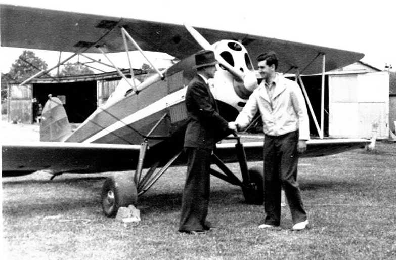
The earliest photo of Christie Airport which has been located
was a 5/15/37 photo (courtesy of Adam Raines & Rich MacVicar) of postmaster Edmund Lawler shaking hands with pilot Rizz Blauvelt
before the first Airmail flight from Christies.
The 1938 USGS topo map depicted Christie Airport as an open field with a few small buildings along the north side.
A circa 1930s photo of an Army biplane fighter (specific model unidentified) at Christie Airport.
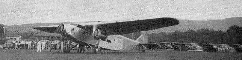
A circa mid/late-1930s photo of Captain O.I. Goodsell's Trimotor at Christie Airport (courtesy of Joe Guzzo).
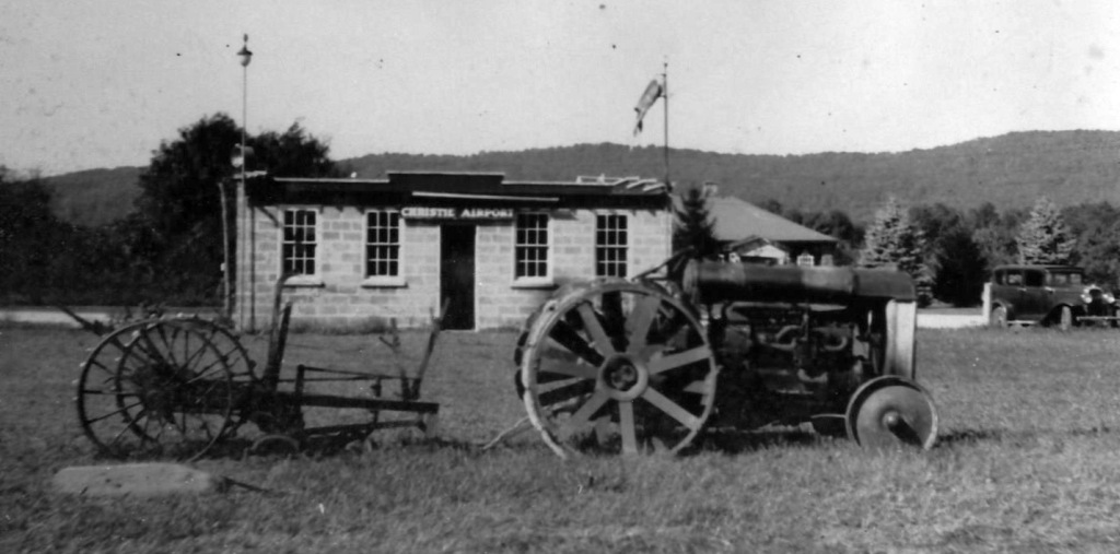
A circa 1930s photo of the cinderblock building with a sign proclaiming “Christie Airport” (courtesy of Bill Elsworth).

The 1938 Aviation Facilities in NY State (courtesy of Bob Parmerter) described Christie Airport as having 2 sod runways, measuring 1,800' east/west & 1,400' north/south, and 2 hangars.
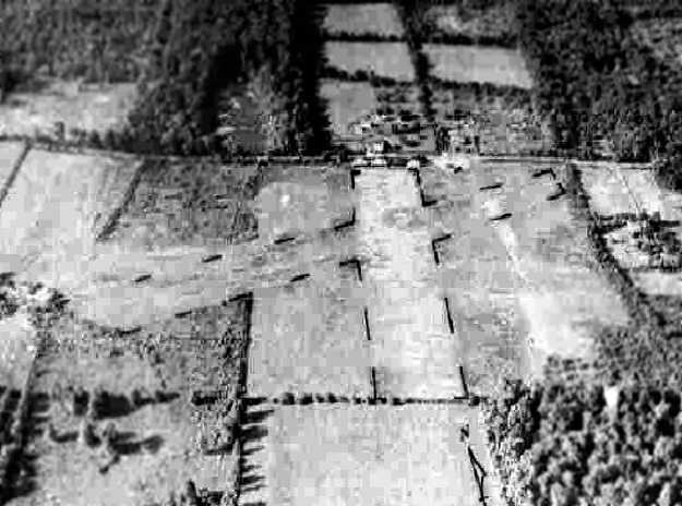
A 9/8/42 aerial view looking north at Christie Airport from the 1945 AAF Airfield Directory (courtesy of Scott Murdock)
depicted the field as having 2 grass runways with a few small buildings on the north side.
Christie Airport was depicted on the 1943 NY Sectional Chart (according to Al Greene).
The 1945 AAF Airfield Directory (courtesy of Scott Murdock) described Christie Airport
as a 60 acre rectangular property having 2 loam & sod runways, measuring 1,800' northeast/southwest & 1,400' north/south.
The field was said to have 3 hangars, the largest being a 43' x 40' wood & metal structure.
Christie Airport was described as being owned & operated by private interests.
The August 1946 NY Terminal Aeronautical Chart (courtesy of Tim Zukas) depicted Christie as a commercial/municipal airport.
The 1953 NY Terminal Aeronautical Chart (courtesy of Tim Zukas) depicted Christie Airport as having a mere 1,600' unpaved runway.
The 1953 NY Sectional Chart (according to Peter O'Brien) described Christie Airport as having 2 turf runways, the longest being 1,600'.
A 1953 aerial photo depicted Christie Airport as having 3 unpaved runways, with several small buildings & a single light plane on the north side.
According to Peter O'Brien, “Among others, Ernest Gann & Burgess Meredith flew out of Christie;
in fact Gann mentions the airport, John Kerr Christie & his brother Jim in one of his books.
I did not own a camera when I was flying out of there.
The rental rate on John's J-3, NC42344, was $8/hour & if John was instructing it was $10.
That price included fuel, coffee afterward, plus the time to absorb the experience, knowledge & charm of John Christie.
I remember John Christie as most interesting & generous man.”
Peter continued, “John had a Ryan Brougham airplane based at his airport that was made approximately 2 years after Lindbergh's flight.
The aircraft were VERY similar, with a Wright Whirlwind engine, and Firestone Silvertown tires.
It had a lavender velour interior & seats in the back with wicker seats for the pilot & co-pilot.
I many times sat in the aircraft, it was truly a time machine.
When the Spirit of St. Louis movie was made in the late 1950s or early 1960s an attempt was made to purchase the plane, but John would not sell it.
To my best knowledge the plane is currently in a aviation museum in San Diego.
I was told the airplane was originally based in Long Island, and John flew it to his airport immediately after WW II was declared
because he realized civilian flying would be stopped in areas so close so close to the Atlantic."
The 1955 USGS topo map depicted Christie Airport as having 3 unpaved runways, with several small building along the north side.
A 1965 aerial photo depicted Christie Airport in the same configuration as the 1953 aerial photo,
but there were no planes visible on the field.
According to Peter O'Brien, “Christie Airport... was active until about 1965 when John sold the property to a developer.”
Richard Keller recalled, “The airport I soloed at in the late 1960s... Christie's Airport.
It was a 1,600' grass strip & was owned by John Christie.
It had a Shell gas station which was John's real income, but he so loved to teach flying in his 1946 J-3 Cub.
There were several hangars & once John showed me an original Ford Tri-Motor in one of them.
It was in need of a lot of work & was probably priceless even then.”
The 1967 USGS topo map depicted Christie Airport in the same fashion as the 1955 topo map.
The last aeronautical chart depiction which has been located of Christie Airport was on the October 1969 NY Sectional Chart,
which depicted Christie as having a mere 1,600' unpaved runway.
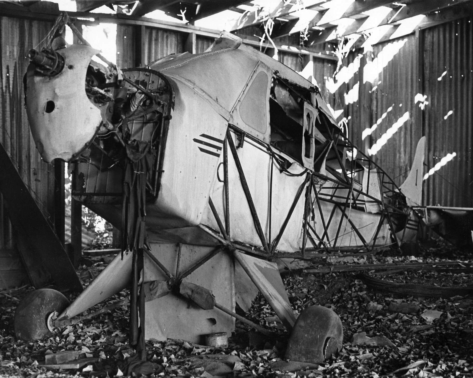
A circa 1960s/70s photo of the remains of Piper Cub J-2 NC17905 C/n 1505 inside a Christie Airport hangar (from Less Parker, via Bill Ellsworth).
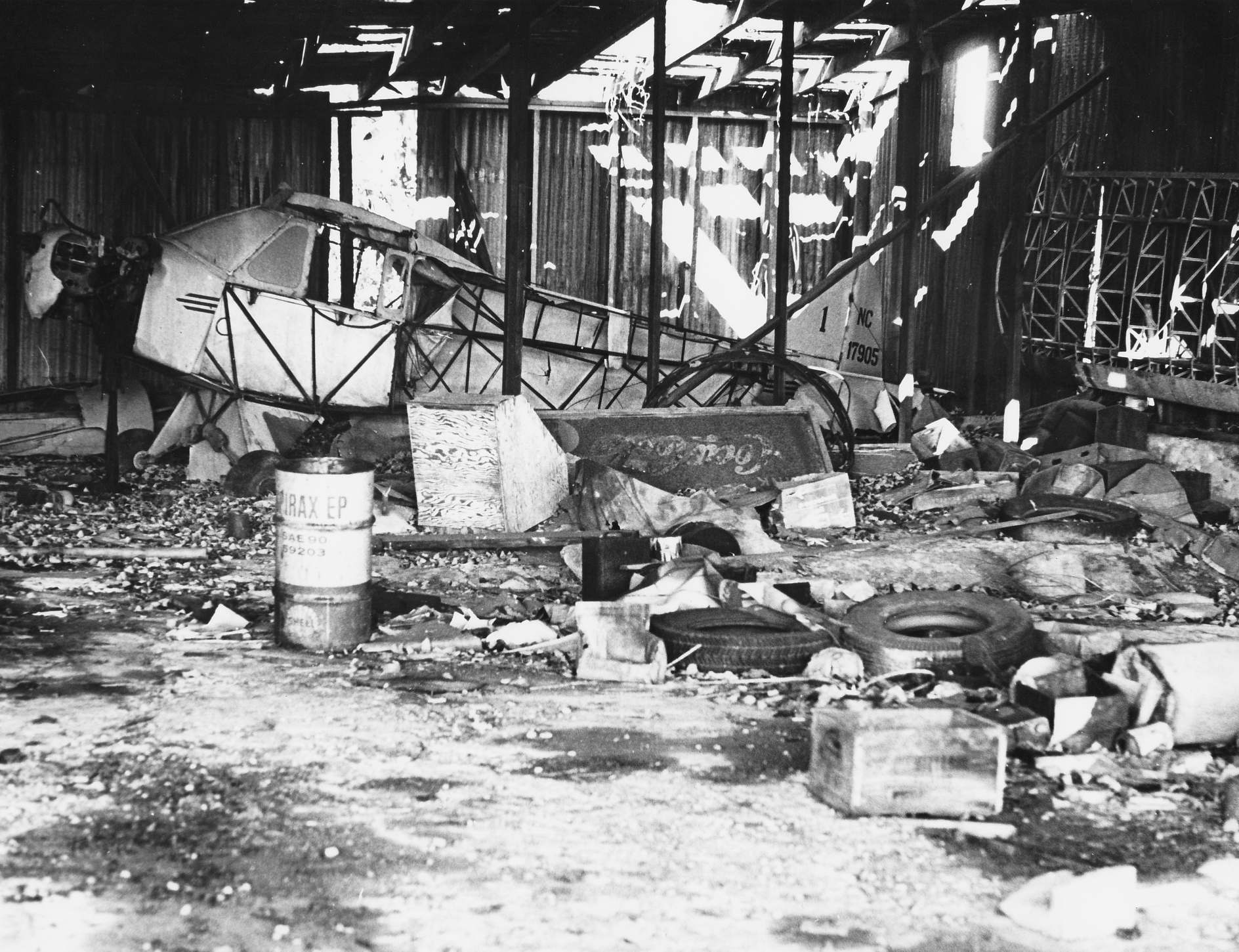
A circa 1960s/70s photo of the remains of Piper Cub J-2 NC17905 C/n 1505 inside a Christie Airport hangar (from Less Parker, via Bill Ellsworth).
According to Adraines, “In December 1969, the final flight out of the airport was taken.”
Christie Airport was evidently closed at some point between 1969-70,
as it was no longer depicted on the April 1970 NY Sectional Chart.
Bill Ellsworth recalled of Christie Airport, “I lived at the Buckley Stables in the early 1970s
and remember seeing the sistership to the Spirit of St. Louis sitting in one of the hangars.
I also saw a small plane landing there once.”
A 1974 aerial photo showed that houses had covered the majority of the former Christie Airport,
but the former Shell station building remained standing on the north side of the site.
The 1975 NY Sectional Chart (courtesy of Mike Keefe) no longer depicted Christie Airport.
The 1979 USGS topo map showed the property covered by several residential streets.
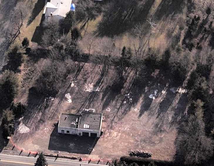
A circa 2007-2011 aerial view looking south at the former Shell gas station on the north side which is the sole remnant of Christie Airport.
A 2014 aerial view showed no recognizable trace remaining of Christie Airport.
The site of Christie Airport is located south of the intersection of Haverstraw Road & Christie Drive, appropriately enough.
See also: https://www.basetofinal.com/ by Adam Raines & Rich MacVicar, which covers the history of 22 airfields in Rockland County.
____________________________________________________
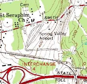
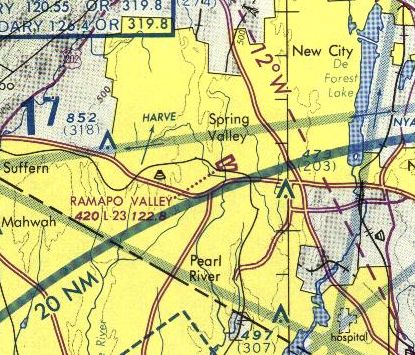
Spring Valley Airport / County Airpark / Ramapo Valley Airport (N24), Spring Valley, NY
41.11, -74.02 (Northwest of New York, NY)
An October 1946 photo by William Shutlz of an Aeronca 7AC (NC85193)
about to depart from Spring Valley for the first-ever ride for his son, William Schulz, Jr. (courtesy of William Schulz, Jr.).
Adam Raines reported, “Bill Beard (the 2nd owner of the airfield) & I had a long conversation about the airport
and he was nice enough to share his memoirs with me approximately 2 weeks before he passed away.
It is very likely that when anyone thinks of airports in Rockland County, they will recall the most active one located in Spring Valley.
It existed for 40 years & had gone through 3 ownership changes in that time.
The roots of this airfield go back to 1945 when all the GI’s were returning from the war.
The county was flourishing in aviation. The GI bill allowed many men to learn to fly at little or no cost.
Although the airport is depicted on a chart in 1945, it formally opened in 1946.”
Adam continued, “Bill Bohlke opened the airport with partners Ted Klink & Peter Erickson, who called it 'County Airpark'.
Bill was a very sharp businessman who had the vision for another successful Rockland Airport.
The airport first consisted of a small 1,390' turf runway.
For a while, the airfield had stone/dust runways, so when it rained, the runways would become very firm.”
Spring Valley Airport was not yet depicted on the August 1946 NY Terminal Aeronautical Chart (courtesy of Tim Zukas).
The earliest depiction of the Spring Valley Airport which has been located
was an October 1946 photo by William Shutlz (courtesy of William Schulz, Jr.) of an Aeronca 7AC (NC85193)
about to depart from Spring Valley for the first-ever ride for his son, William Schulz, Jr.
William Schulz, Jr. recalled in 2004, "The pilot was William Boehlke. Note the barn & shed at the northeast end of the runway.
The barn [still] appears in the chart excerpts [the topo map several paragraphs below], and, I believe, even in the 2000 aerial photo.
Also note grading stake, new grass, and 'potatoes.'
Recollections of sights, sounds, and other sensory inputs, particularly of take off -
that elm/oak at the southwest end - and landing - slipping in over the barn - remain to this date."
The earliest aeronautical chart depiction which has been located of County Airpark was on the January 1947 NY Sectional Chart.
It depicted “County Airpark” as a commercial/municipal airport.

A 1947 aerial view (courtesy of Bill Beard, via Adam Raines) looking north showing Spring Valley Airport to have 2 unpaved runways & several buildings on the north side.
Bill Bohlke taught flying to notables such as Burgess Meredith, Wally Cox, and Frank Blair (according to his obituary, courtesy of William Schulz, Jr.).
The 1949 NY Sectional Chart (courtesy of Chris Kennedy) depicted “County” Airpark as having a 2,000' unpaved runway.

A 4/17/52 USGS aerial photo depicted Spring Valley Airport as having 2 unpaved runways,
with several hangars & 2-dozen light aircraft on the north side of the field.
A circa early 1950s photo (courtesy of Bill Beard, via Adam Raines) of a large number of single-engine planes at Spring Valley Airport.
Jerry Scott recalled, “In the early 1950s my Dad [Gerald Scott] had several airplanes at Spring Valley. He LOVED it out there.
I THINK I see my dad standing near the line of planes: white outfit, legs crossed, white hat, tall, stocky.”
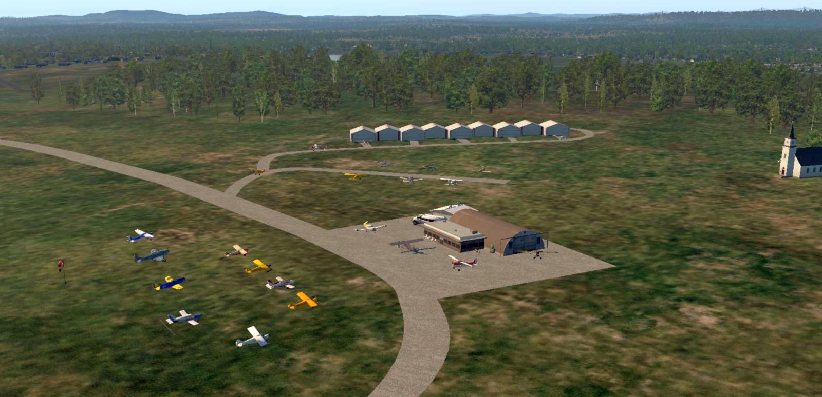
A 2022 X-Plane scenery depiction by Jerry Scott looking west at Spring Valley Airport.
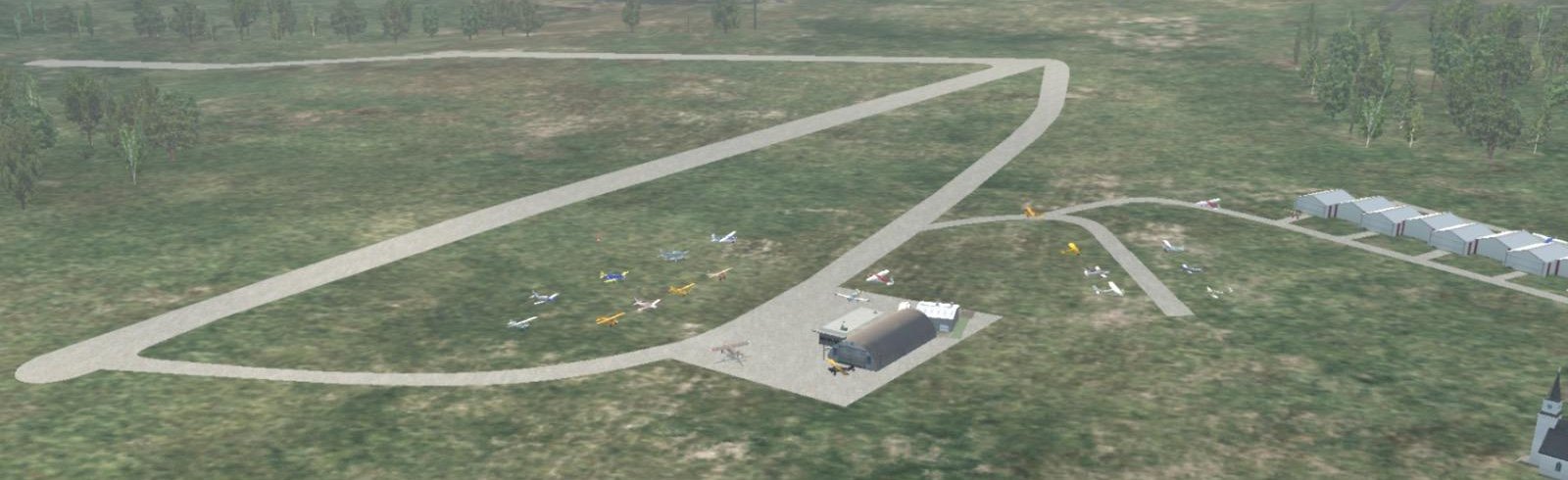
A 2022 X-Plane scenery depiction by Jerry Scott looking southwest at Spring Valley Airport.
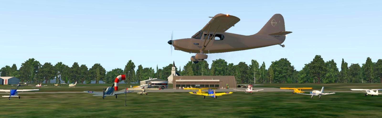
A 2022 X-Plane scenery depiction by Jerry Scott of his father's (Hugh Scott's) Stinson Voyager overflying Spring Valley Airport.
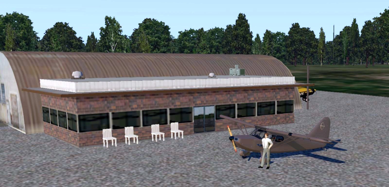
A 2022 X-Plane scenery depiction by Jerry Scott of his father's (Hugh Scott's) Stinson Voyager at the Spring Valley Airport office.
A circa 1952 photo (courtesy of Jerry Scott) of Gerald Scott standing by his Cessna 170 at Spring Valley.
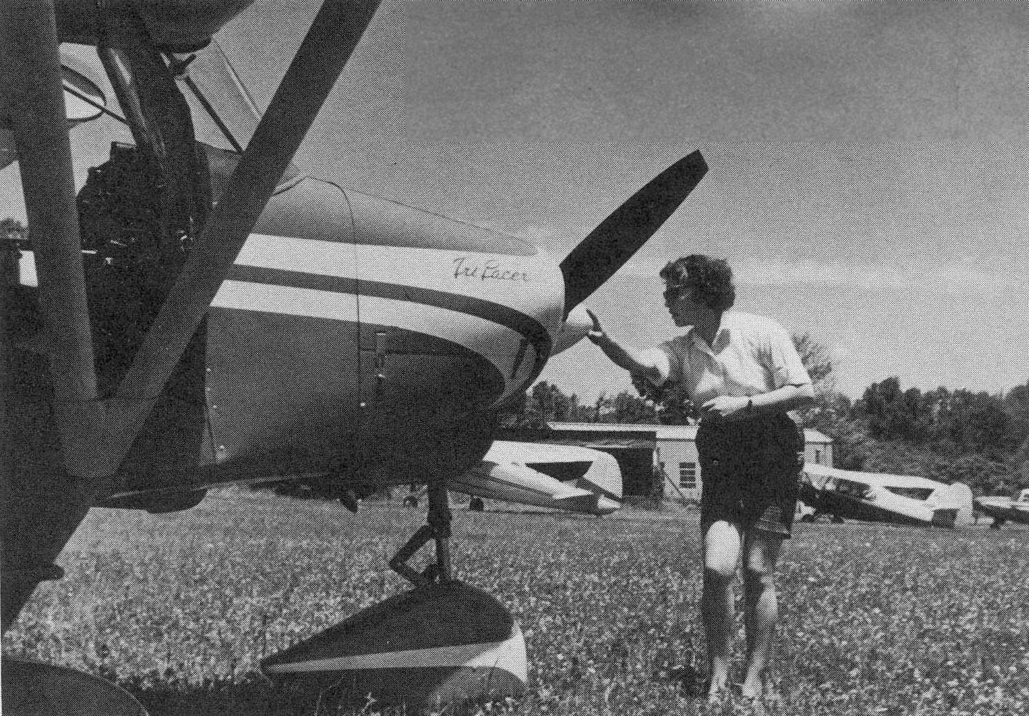
In the 1950s, Spring Valley's Bill Bohlke used a Piper Tri-Pacer to operate a NY-area air taxi business.
Kenneth Arnold recalled, “Bill Bohlke was owner of Ramapo Valley Airport.
It was a busy place with loads interesting people flying there & it became my home town airport. And I was one of his many friends.
In the early 1950s at Ramapo Valley Airport, someone there was working on an angle of attack indicator.
All it was, an airfoil mounted on leading edge of wing, connected to an indicator in instrument panel.”
A circa 1953 photo (courtesy of Jerry Scott) of Gerald Scott heading out on a business trip from Spring Valley.
A circa 1953 photo (courtesy of Jerry Scott) of Jerry Nelinson gassing up his Cessna 140 at Spring Valley.
Jerrt Scott recalled, “I flew in this airplane once to Mattituck Long Island on a 'breakfast flight'. Landing back at Spring Valley, he ground looped it!”
A circa 1953 photo of Jerry Scott in his uncle's Swift at Spring Valley.
The 1953 NY Terminal Aeronautical Chart (courtesy of Tim Zukas) depicted “County” Airport as having a 2,200' unpaved runway.
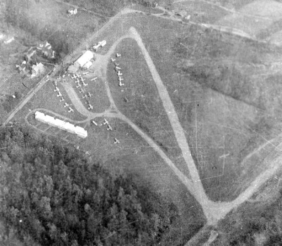
A 1953 aerial view (courtesy of Bill Beard, via Adam Raines) looking northeast depicted Spring Valley Airport
as having a single unpaved runway & over 30 light aircraft parked outside.
A row of T-hangars had been added to the northwest side at some point between 1947-53.
It was labeled Spring Valley Airport on the 1955 USGS topo map.
That map depicted the field as having two 1,400' runways,
with a curved taxiway next to the northeast/southwest runway.
Adam Raines reported, “Other runways were constructed & were eventually paved in the 1957.
Bill Bohlke Jr. recalls them having a 'Blacktop Party' that was financed by actor Burgess Meredith.
Mr. Bohlke promoted aircraft financing, which was very rare at the time.
He was selling a lot of Piper Tri-Pacers back then.
Bill was a very busy man & often worked from 5am until midnight running multiple jobs.
He had a crop dusting business that started at 5am.
He also ran a garage/auto body-repair/gas station business, and he was also the mayor of Spring Valley!”
The 1958 NY Sectional Chart (courtesy of Chris Kennedy) described “County” Airpark as having a 2,200' unpaved runway.
David Bergman recalled, “My father, Jules Bergman, who was ABC News’ Science Editor, spent many weekends at Ramapo Valley Airport.
He & my mother both learned to fly there & wrote a book about their experience of learning called 'Anyone Can Fly'.
His logbook with the first entry showing the flight to be from Spring Valley was in 1958.
As a child, I spent many of those weekend afternoons tagging along with my father while he schmoozed with others there,
and I remember the airport pretty clearly, including the stand-on-the-brakes short-field takeoffs.” ”
Billy Beard recalled, "My father owned the Ramapo Valley Airport.
I grew up going there pretty much every day, taking flying lessons,
and hearing tale after tale of the characters that inhabited that airport from the late 1950s until I left for college in 1971.
There are just so many stories involving this fascinating place."
The 1960 Jeppesen Airway Manual (courtesy of Chris Kennedy)
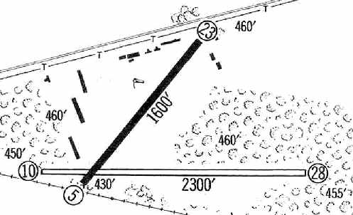
depicted the Spring Valley "County Airpark" as having a single 1,600' paved Runway 5/23, and a 2,300' unpaved Runway 10/28.
Several hangars were depicted along the northwest & northeast sides of the field, which was also said to be "surrounded by mountains."
Adam Raines reported, “During one of Bill's very needed vacations to the Caribbean, he fell in love with theisland of St. Croix,
and in early 1960, he decided to move his family & life down there & start a charter business that is still run by the Bohlke family today.
The Spring Valley airport had a changing of the guard to another man with the same first name & same initials.
After a long arduous task of securing financing to close the deal, on 7/1/60, Billy Beard would take over as owner of the airport.
Bill immediately changed the name of the airport to Ramapo Valley Airport
because he wanted to embrace the entire district & not have the field named after any one town.
He ran the airport well for 11 years, dealing with the politics & pressures of running an airport in a growing suburban community.”
Howard Schack recalled, “I took flying lessons at Ramapo Airport from Bill Bolkie flying in a smelly old crop-duster over Rockland County farms.”
A 1961 aerial view (courtesy of Bill Beard, via Adam Raines) looking west depicted Ramapo Valley Airport
as having 2 paved runways & over 20 light aircraft parked outside.
Three more rows of T-hangars had been added to the northwest side at some point between 1953-61.
The 1962 AOPA Airport Directory described Ramapo Valley Airport as having 2 bituminous runways: 2,000' Runway 10/28 & 1,600' Runway 5/23.
The operators were listed as Ramapo Valley Airport & Ramapo Valley Flight Service.
Robert Kittine recalled, “I flew out of N24 [Ramapo Valley Airport] from the 1960s.
I flew Burgess Meridith many times back & forth to Montauk when I was flying Part 135 for Tom O’Looney & taught for TAG Aviation at Ramapo, Lincoln Park, Princeton and Morristown.”
A circa 1962-63 photo by Jules Bergman (courtesy of David Bergman) of David Bergman in front of 2 Piper Tri-Pacers at Ramapo Valley Airport.
Originally captioned, “Ask a small boy why an airplane flies – he knows...”
A circa 1962-63 photo by Jules Bergman (courtesy of David Bergman) of Joanne Bergman preflighting a rented Piper Tri-Pacer at Ramapo Valley Airport.
A circa 1962-63 photo by Jules Bergman (courtesy of David Bergman) of Kaya Meredth dropping off her husband, actor-director Burgess Meredith, in a Piper at Ramapo Valley Airport.
Originally captioned, “'On the road' to them means 'In the air.'”
Jerry Scott recalled, “I remember meeting Kaya Meredith, Burgess' wife. I was at the airport one day & was watching when she landed a Cub.”
A circa 1962-63 photo by Jules Bergman (courtesy of David Bergman) of a Piper Tri-Pacer taxiing at a snow-covered Ramapo Valley Airport.
The 1963 NY Sectional Chart (courtesy of Chris Kennedy)
depicted Ramapo Valley Airport as having 2 paved runways, with the longest being 2,200'.
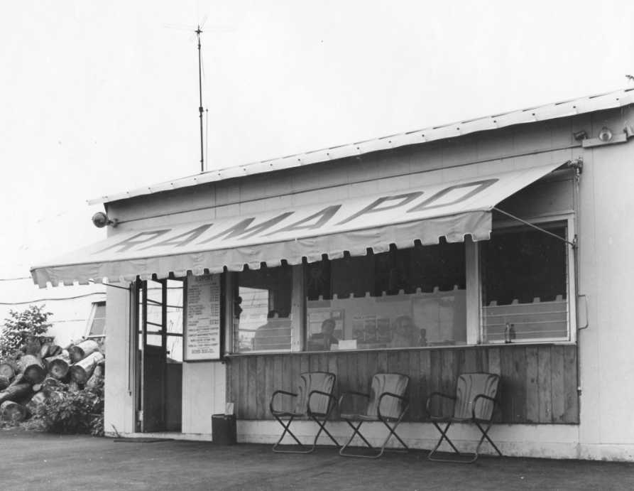
An undated photo (courtesy of Bill Beard, via Adam Raines) of the Ramapo Valley Airport office.
Jerry Scott recalled, “The chairs in front of the main building (there were 4 that I remember, were the ones that my Aunt & Uncle sat in when they met!
My Uncle later became Chief Pilot for Delta!”
Jim Conroy recalled, "I learned to fly at Ramapo in 1963 and remember it as a quirky little field. The runway was actually slightly uphill."
He took lessons in an Aeronca 7-AC at Ramapo.
David Bergman recalled from the mid-1960s, “The FBO at Teterboro didn’t allow renters to fly into Ramapo Valley because the short uphill runway was considered too dangerous.
It was the southern, east/west runway. I don’t recall the one that ran more northeast/southwest; it seems to me that that was just a taxiway at the time.
I remember being told that there were wrecks in the drop-off at the east, downhill end of the runway.
I assume they were planes that had run out of runway on their landing roll-out.”
A circa 1967 photo by Stanley Bell of an EAA P-2 biplane at Ramapo Valley Airport (courtesy of Martin Bell).
David Parsons recalled, “I took lessons at Spring Valley airport in the late 1960s / early 1970s.
I worked at Span Air, for Bill Spanger, nice guy though they wouldn't let me drive the jeep.
The uphill runways was great (as long as you knew it was uphill & flared out accordingly) since it seemed you came stop in 10 feet! Only did that once.
The airport was on a hill so when there was any kind of wind down the runway you'd get a downdraft on approach which took some getting used to.
Fun times but I'm not surprised it closed given the rather tricky nature of the place.”
An undated aerial view (courtesy of Bill Beard, via Adam Raines) looking west at at a very well-used Ramapo Valley Airport,
with dozens of light aircraft, including 2 helicopters on a helipad on the northeast side.
Scott Levy remarked of this photo, “It shows the original DECAIR hangar & the upholstery shop run by my uncle Ted & his partner Warren Berg.
There are a few people around the 206 Jet Ranger & the Bell 47 on the pad & may be my uncle & family.
I flew many times in both of those birds, I can remember always going up without the doors on the 47 so we could hang out of them.”
John Oberg recalled, “Ramapo/ Spring Valley Airport... My very protective parents took me up there in 1969
and bought me one of those 20 minute demo flights. Wonderful. The pilot let me do the takeoff. It was a Cessna 150.
Later, upon turning 17 I drove myself up & got a job driving the fuel truck on weekends.
I still think of it as the best job ever.
I was young, I had a truck full of 100 octane avgas, I was friends with the owners
(they had better be friendly, or find themselves on the low end of the gas queue).
I wonder of the legality of a minor driving a fuel truck, if it could have been considered dangerous, but it never came up.
Sometimes when things were slow, I would drive the truck flat out down the runway,
sometimes empty, sometimes not, to see how it would do as a dragster.
Not well. No chute, and brakes were dicey.”
John continued, “There were 3 FBOs operating. SPANair was the largest, and where I took lessons, It was in the middle of the field,
next to the coffee shop, and its planes were the first row you would see as you walked out onto the field.
There was RAMair over on the west side of the field.
It was a brand new operation at the time, new Cessnas, new building and, I bet lots of debt. I was told not to fill their planes.
And there was DECair, a helicopter company, where I worked.
It was run by a handfull of Vietnam pilots. The owner was Tony, and the last name (I forget) began with C.
It was a real operation with mechanics working on Jet Rangers & other aircraft.
The WOR traffic helicopter was often there.
I had a huge truck full of jet fuel for the turbine Jet Rangers. We were on the East side of the field.”
John continued, “I learned to fly in the SuperCub that Spanair owned. I paid $9/hour.
How much more fun is it possible to have than flying a Cub with the door folded open at low altitude?
It took a few tries to get the hang of flaring out properly in the taildragger,
and I still remember my instructor urging me to stick to the paved part of the runway,
and suggesting he could supplement his salary by selling tickets.
When I finally got my private license, it was Bill from Spanair that did the check flight
(we flew to Teteroboro, he got out & I flew home alone).
Sadly, during the entire 2 years I was at the airport, we never managed to take a single picture.”
Billy Beard, whose father owned the Ramapo Valley Airport, recalled,
"It, unfortunately, was sold in the 1970s due to mounting political pressure & my Dad retired."
Adam Raines reported, “During this time, Alan Yasskey & George Fiest,who were based at the airport,
had been keeping their eye on buying the field when the time was right.
Both of them were real estate developers as well as pilots. Billy Beard then sold the airport to them in 1971.
TAG Aviation, short for Tom O’Looney, Alan Yassky, and George Fiest, was the primary Fixed Base Operator.”
A circa 1970 photo by James Doyle of Theresa Bell in front of a Piper & other aircraft at Spring Valley Airport.
Theresa recalled, “My grandfather would bring me here every Sunday to see the planes & enjoy lunch & ice cream in the pilot’s lounge. As a mechanic he knew several of the pilots that would fly in & out of this airport.”
A circa 1970 photo by James Doyle of Theresa Bell at Spring Valley Airport.
A circa 1970 photo by James Doyle of Theresa Bell at Spring Valley Airport.
Scott Levy recalled, “A place very close to my heart, Spring Valley (Ramapo) Airport.
I am the nephew of Ted Dubolsky, one of the owners & operators of DECAIR Helicopters.
I have so many fond memories of Spring Valley that I do not know where to begin,
from my first flight in a helo, to flying with Smokey Bear & Santa, or having a candy drop from a Bell 47 on my 5th birthday in my back yard!
I can recall so many great times spent there fooling around on the tug in front of the old DECAIR hangar, to helping wheel in the choppers after flying.
My uncle had a Navion that he kept there, as well as a Bonanza & Piper Cub that he & my father would take up every now & then.
My father never held a license but loved to fly with my uncle.”
Scott continued, “I remember when they built the new hangar on the far side of the field & you had to drive around the end of the runway to get there.
That is where I did most of my flying from DECAIR when they moved over there in 1971 or 1972 I think.
They had two or three 206 Jet Rangers and three or four 47s & a white UH-1H that was the biggest chopper I had ever been in.
I remember them bringing back one of the 47s slung under it after a hard landing in the woods just east of the field.”
Scott continued, “Some of the historic moments that DECAIR were a part of:
They were the air service that was hired to do the stunt flying in the movie 'The Hot Rock'; they were the first to fly any type of aircraft under the GW Bridge.
I remember the hassle it was to get permits to do the stunt.
The other bit of history that DECAIR was a part of is Woodstock.
In the movie after the 'Rain Scene' they show a Bell 47 dropping dry clothes & food & flowers on the crowd;
that is my Uncle Ted & his daughter (my cousin Debby).”
A 1972 airport directory (courtesy of Chris Kennedy) depicted Ramapo Valley Airport as having a 2,000' paved Runway 8/26, and a closed Runway 10/28.
That airfield layout differs significantly from that depicted on the 1955 USGS topo map, curiously.
A total of 4 buildings (hangars?) were depicted along the northwest side of the airfield.
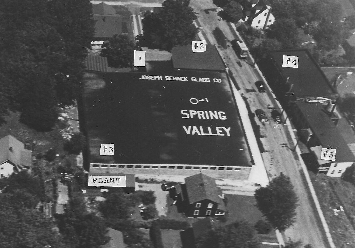
A circa 1970s aerial view (courtesy of Howard Schack) “of the 1 mile directional arrow on the top of the Schack Industries Building at 1-9 Roosevelt Avenue in Spring Valley pointing to the Ramapo Airport.
The sign had night nights. The FAA painted & maintained the sign until the airport was closed.”
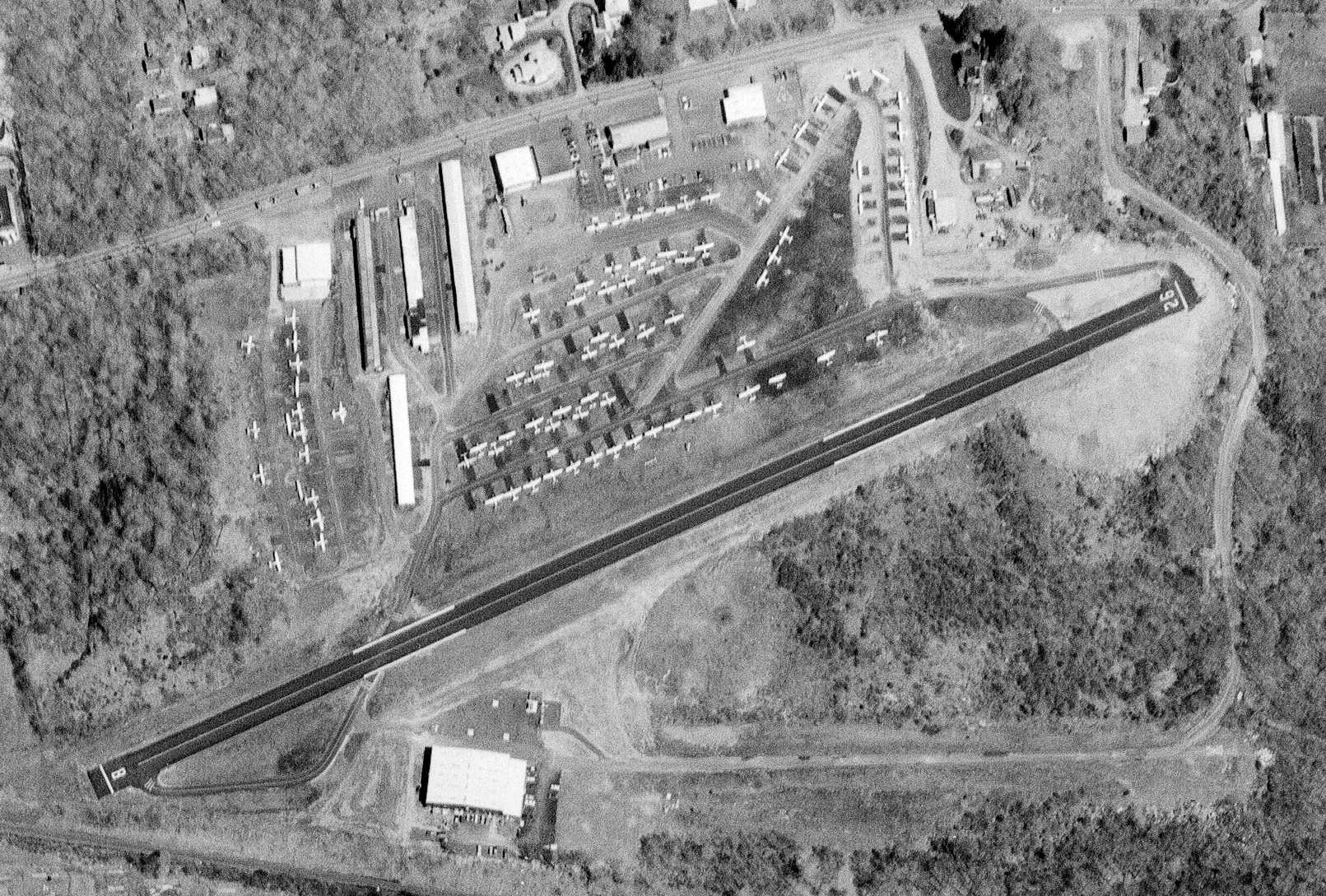
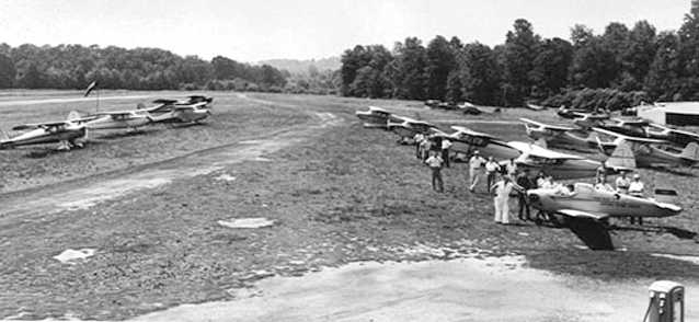
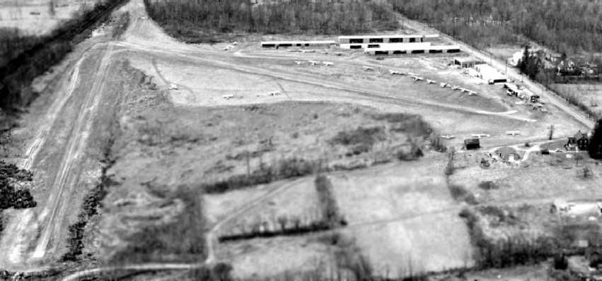
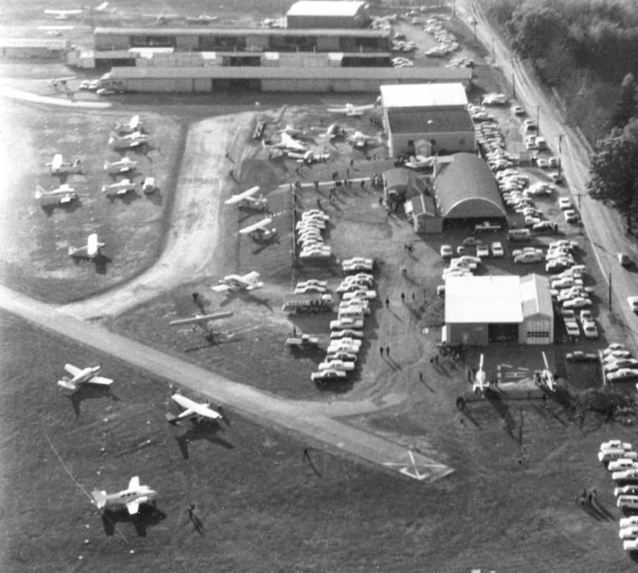
A 4/25/74 USGS aerial photo depicted no less than 75 aircraft visible parked outside at Ramapo Valley Airport.
A hangar had been built over the western end of the former east/west runway.
Tim Knowles recalled, “Spring Valley Airport... I started my career there working for Tom at TAG Aviation from 1975 up to the time it closed.
Those were fun times, started my sheet metal experience there with all the planes that either ran off the end of the runway or hit the light post by the gas pumps.”
Vinny Pinto recalled, "Ramapo Valley Airport & Tag Aviation… I learned to fly there in 1977
and flew regularly from there till about 1980.I
In those years while I was there, it sported simply a single 8/25 runway, over 2,000' long,
and was home to at least 50 parked planes, and also at least one maintenance facility,
as well as a bar, which was located next to Tag Aviation.
The airport runway, particularly the west end, was located extremely near the NY State Thruway
and the Spring Valley toll booths on the Thruway,
and my recollection is that more than one pilot taking off to the west crash-landed on the Thruway
near the toll booths due to engine problems or other problems over the years.
A few more crashed in a lightly wooded field nestled in an undeveloped (at the time) triangle of land south of the of the airport runway.
I was present at one such crash site in 1979 which was a fatality.
I had just landed [on Runway] 25 one afternoon in 1979 & the guy who took off behind me on [Runway] 25 lost engine power,
tried to make the Thruway by keeping his nose too high, and spun out into that aforementioned wooded area.
He had died (burning) by the time we reached him."
Vinny continued, "The main FBO at RVA was Tag Aviation,
and the main figure in Tag Aviation was Tom O'Looney, who also had some real estate interests.
There was also a small rotary-wing (copter) facility across the field,
just on the far side of the runway from all the other operators."

A 6/10/77 photo by Peter Nicholson of a Piper Aztec 250 at Ramapo Valley Airport.
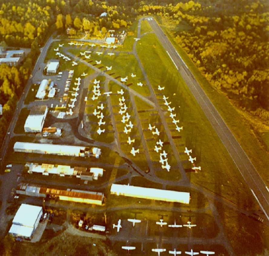
The last photo which has been located of Ramapo Valley Airport was a 1979 aerial view looking east by Tony Tarsia.
It showed a very well-used field, with dozens of light aircraft.
Tony recalled, “I learned to fly at Ramapo Valley in the late 1970s.”
The 1979 NY Terminal Area Chart depicted Ramapo Valley Airport as having 2 paved runways, with the longest being 2,300'.
The 1982 AOPA Airport Directory (courtesy of Ed Drury) described Ramapo Valley Airport as having a single 2,185' asphalt Runway 8/26.
The operators were listed as Clarkstown Valley Airport Inc., TAG Aviation Inc., Decair Helicopters Inc., Ramapo Aero & Helicopters Inc.
Spring Valley Airport was still depicted on the 1983 USGS topo map.
Adam Raines reported, “At its peak, Spring Valley Airport, was the home of over 150 airplanes, 6 hangars, 2 flight schools,
1 helicopter operation (Decair), and one restaurant & bar (Mason Jar).
It was by far the largest & most active airport in Rockland County until its closing in 1985,
due to mounting pressures from neighbors, low buzzing aircraft over populated areas, a lucrative offer from developers, and some unfortunate fatalities.
When the last aircraft was flown out of Spring Valley Airport in 1985, this marked the sad & unfortunate end of all civil aviation in Rockland County.”

The last aeronautical chart depiction which has been located of Ramapo Valley Airport was on the June 1985 NY Sectional Chart.
It depicted Ramapo Valley as having a single 2,200' paved northeast/southwest runway.
Pete Jennings recalled, “I remember camping out at the Ramapo Valley Airport the day after it closed!
We were on our way home from Oshkosh, and that must have been in August 1985.
It was weird that the place was so deserted in the middle of a big city, but no one challenged us.
We just set up the tent under the wing as usual & were off again at daybreak.”
Pete's father, Dave Jennings recalled of that trip, “All the airplanes were gone.
That airport had been the nearest uncontrolled airport to New York City.”
Dexter Ford recalled, “I have a story of my own about how valuable Ramapo Valley Airport was.
The place saved my butt the night of 7/23/86, apparently after the place had closed officially.
I may have been the last person to fly in & out - I never knew it was supposed to have been closed that night.
I was flying my Mooney M20C from Beverly, MA, heading for Morristown, NJ.
I was a strictly VFR-only pilot, and had been flying in vague haze, between the low hills & the slightly higher cloud deck, all the way from MA.
As darkness fell, I was just crossing the Hudson River, and the lights below helped me sense which way was down.
It was technically legal VFR weather conditions, but as I crossed the river the lights went out - I couldn’t tell the dark forest ahead from the dark sky ahead.
I quickly realized that without a visual horizon, or at least a reference of lights underneath me, it would not be long before my not-too-stable Mooney got away from me.
I did a quick 180 and, struggling to read my chart as I flew, in quickly deteriorating darkness & haze, I looked for the nearest functional runway.
Ramapo Valley was the closest - I still have the chart I used that night, and there was no indication that it was not an open, operating airport.”
Dexter continued, “I remember that the runway lights came on, as I expected, when I thumbed my mic switch on downwind.
My landing was awful - it felt like the runway had speed bumps, and I bounced it in, grateful that nobody was watching.
I got out & kissed the runway, found a pay phone, and called a cab to take me to the the local Best Western.
I got up in the morning, took off, and continued on to Linden, NJ, never knowing that the airport was supposed to be closed that night.”
Robert Kittine recalled, “Though the regular operations ended in 1985, we still had a few planes operating there until March 1986 when I flew N98772, my 1985 Cessna 172 out of the field.
I have a picture which was in the newspapers, showing my plane on climb-out & the heavy equipment at the end of the runway ready to rip it up.
My Cessna was the last plane off.”
Ramapo Valley Airport was no longer depicted on the December 1993 NY Sectional Chart (courtesy of Ron Plante).
By at least 1995, a road (Overlook Blvd.) had been built through the center of the Ramapo Valley Airport property,
along with several large buildings & parking lots.
John Oberg recalled, “Around 1995 my family drove up to Spring Valley to the new Costco. The store was located just off Route 59.
While we were up there we thought to see the site of the old airport. We drove around, and up the hill. There was the field.
The foundation, concrete slabs of the office of SpanAir & the coffee shop, the outlines of the major taxiways were still there.
I got out of the car, and reminding myself a little of the opening scene from '12 O'Clock High', walked to where the runway had been.
What I found after a hundred feet or so, was a steep embankment leading down to the parking lot of Costco.
They had traded the pastoral charm of a country airport for the noise & pollution of big-box retail.”
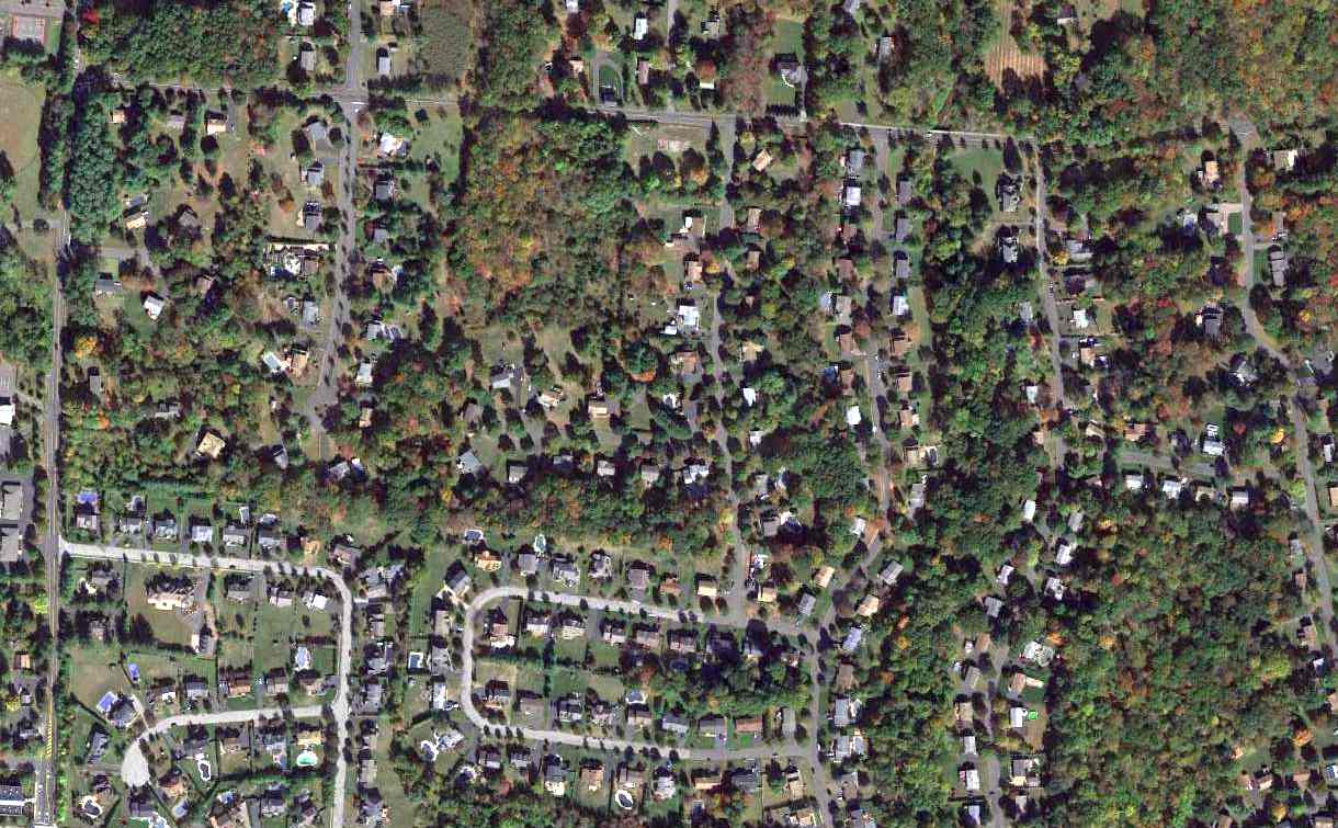
As seen in a 2014 aerial photo, not a trace remains at the site of Ramapo Valley Airport.
Tim Knowles reported in 2018, “The last time I drove on Smith Road, all I could recognize was the concrete slab that our maintenance hangar was on. What a sad sight.”
The Ramapo Valley Airport property was bounded on the west by New Clarkstown Road,
on the north by Smith Road, and on the south by the Conrail railroad tracks.
See also: https://www.basetofinal.com/ by Adam Raines & Rich MacVicar, which covers the history of 22 airfields in Rockland County.
____________________________________________________
Or if you prefer to contact me directly concerning a contribution (for a mailing address to send a check),
please contact me at: paulandterryfreeman@gmail.com
If you enjoy this web site, please support it with a financial contribution.
____________________________________________________
This site covers airfields in all 50 states.