
Abandoned & Little-Known Airfields:
Ohio: Akron area
© 2002, © 2025 by Paul Freeman. Revised 2/6/25.
This site covers airfields in all 50 states: Click here for the site's main menu.
____________________________________________________
Please consider a financial contribution to support the continued growth & operation of this site.
Orville Airport/ Blatter Airport (revised 2/6/25) - Magnolia Airport (revised 6/30/23) - Martin Airport / Canton City Airport (revised 6/24/22)
McKinley Airport (revised 6/30/23) – Hess-Argo Factory Airfield / Taylorcraft Factory Airfield (revised 9/21/22) - Massillon Airport / Noble Airport / Stark Airport (revised 11/6/22)
Miller Airport / Miller Field (revised 4/10/20) - Ravenna Arsenal Crash Test Runway (revised 4/30/21) - Ravenna Arsenal Test Support Runway (revised 5/4/21) - Wooster Airport (revised 12/9/17)
____________________________________________________
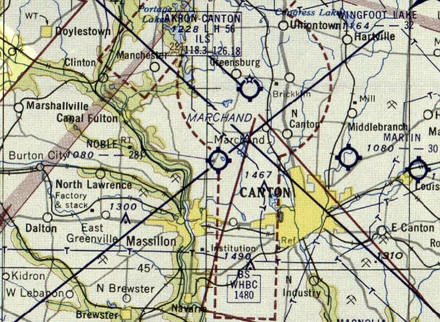
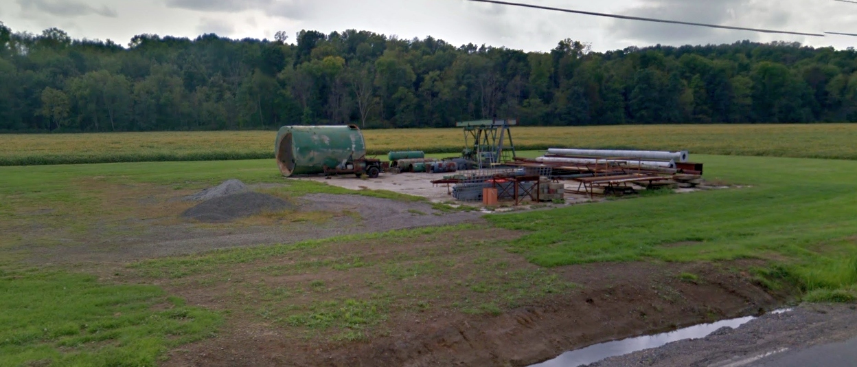
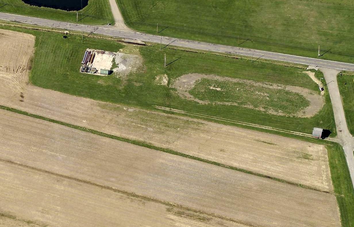
Massillon Airport / Noble Airport / Stark Airport, Massillon, OH
40.851, -81.488 (South of Cleveland, OH)
An advertisement for Massillon Airport from the 5/10/28 Evening Independent (courtesy of Dennis Thompson).
The date of establishment of this small general aviation airport has not been determined.
The earliest depiction which has been located of Massillon Airport was an advertisement in the 5/10/28 Evening Independent (courtesy of Dennis Thompson).
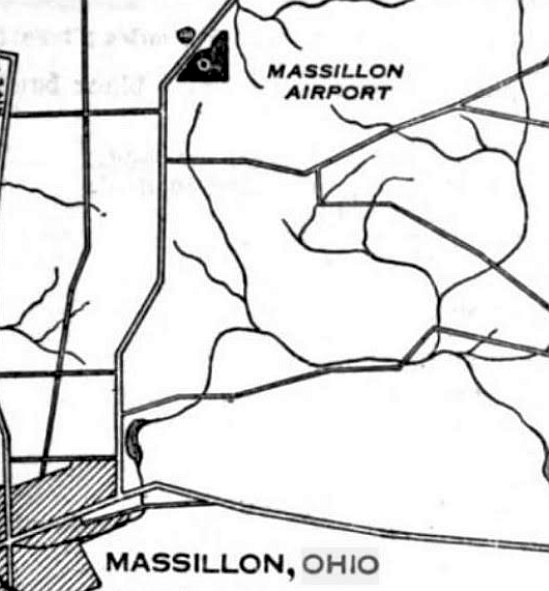
The location of Massillon Airport, as depicted on the 7/10/29 Commerce Department Airway Bulletin (courtesy of Mike Denja).
Massillon Airport was described in the 7/10/29 Commerce Department Airway Bulletin (courtesy of Mike Denja) as a commercial airport
owned & operated by The American Aircraft Corporation.
It was said to consist of a 50 acre triangular clay field, measuring 1,800' north/south.
A single small building was depicted on the south side.

The earliest aeronautical chart depiction which has been located of Massillon Airport was on the December 1932 Cleveland Sectional Chart,
which depicted Massillon as an auxiliary airfield.
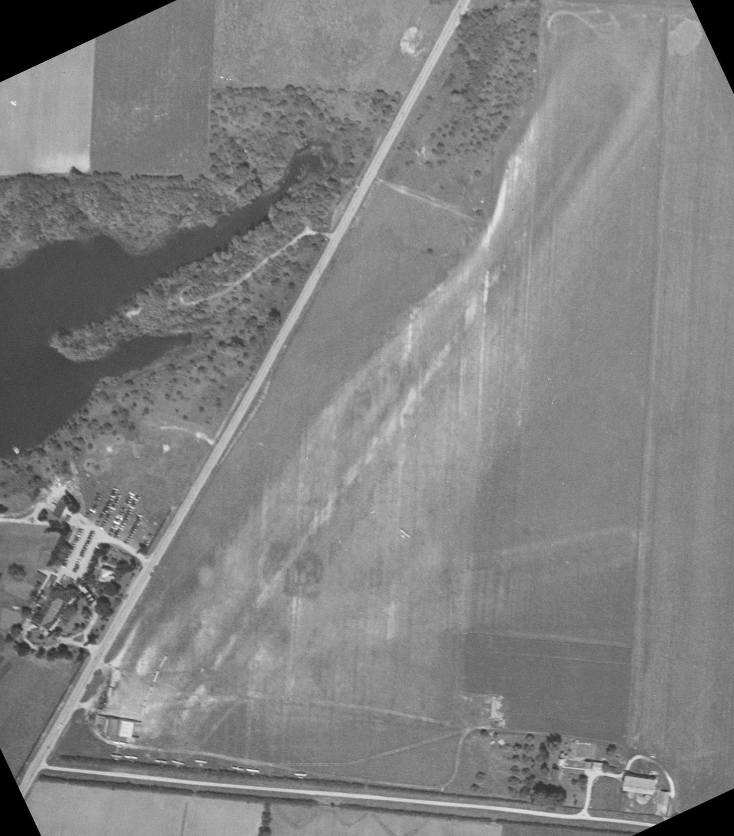
The earliest photo which has been located of Massillon Airport was a 1947 aerial view (courtesy of Dennis Thompson).
It depicted Massillon Airport as a grass airfield predominantly oriented northeast/southwest, with a hangar & 13 light aircraft on the southwest side.
Dennis Thompson reported, “It's listed in the 1949-51 rural directory as Stark Flying Service on Route 241.”
Massillon Airport was evidently renamed Noble Airport at some point between 1932-51,
as that is how it was labeled on the 1951 USGS topo map.
A 1952 aerial photo depicted Noble Airport perhaps at its zenith of popularity, with 20 light aircraft on the southwest side.
The last aeronautical chart depiction which has been located of Noble Airport was on the January 1954 Cleveland Sectional Chart,
which depicted Noble Airport as having a 2,800' unpaved runway.
Noble Airport was evidently closed (for reasons unknown) at some point between 1954-55,
as it was no longer depicted on the 1955 Cleveland Sectional Chart.
A 1957 aerial view showed Noble Airport after its closure.
The hangar remained standing, but all of the planes were gone, and the runway area appeared to have been plowed.
A 1960 aerial photo showed Noble Airport site in an unchanged status.
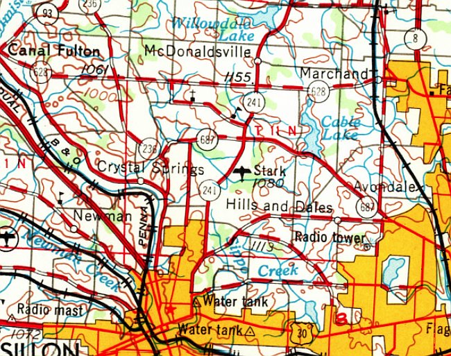
The 1962 USGS topo map depicted the airport under yet another name, “Stark”.
Dennis Thompson reported, “I found newspaper articles from 1962 using the name Massillon Airport so it was still there.
There are over 200 articles mentioning Massillon Airport in OH newspapers.”
A 1966 aerial photo showed the hangar had been removed at some point between 1960-66, with only the foundation remaining.
A 1982 aerial photo showed Noble Airport site in an unchanged status.
A 1994 aerial photo showed streets & houses had covered the Noble Airport site at some point between 1982-94.

A 2021 aerial view looking north showed no trace remains of Noble Airport.
Thanks to Dennis Thompson for pointing out this airfield.
____________________________________________________
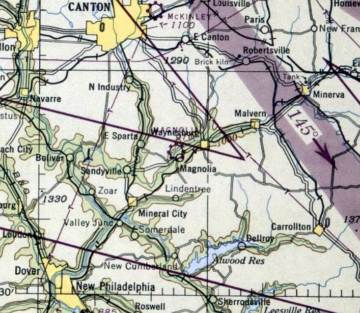
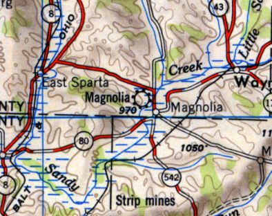
Magnolia Airport (OH04), Magnolia, OH
40.66, -81.3 (South of Akron, OH)
Magnolia Airport, as depicted on the January 1947 Cleveland Sectional Chart.
Magnolia Airport was evidently established at some point between 1945-47,
as it was not yet depicted on the March 1940 Cleveland Sectional Chart
nor listed among active airports in the 1945 AAF Airfield Directory (courtesy of Scott Murdock).
The earliest depiction which has been located of Magnolia Airport was on the January 1947 Cleveland Sectional Chart.
It depicted Magnolia Airport as a commercial/municipal airport.
Magnolia Airport, as depicted on the 1951 USGS topo map.
According to “Sid Stories” by Jason Wise (courtesy of Jim Hackman), “After college, Sid [Wise] told his parents he had a new assignment at work,
and he started leaving the house absurdly early. The truth was that he was sneaking off to take flight lessons with Mister Sickafoose, also known as Sicky.
Sid’s new hangout was a tiny airfield in Magnolia, Ohio. He learned to fly in Cessna 120s and 140s, all taildraggers.”
“It was an 80 acre clover field that we flew out of,” said Sid.
“And at the end was a huge big willow tree or something down there that really was a threat,
and you had to take off that way ninety percent of the time.”
After his dual instruction with Sicky, it was time to solo. In a 2-seat airplane, removing one person makes a big difference in how the plane handles.
When Sid soloed, the first challenge was learning to fly a lighter plane. The second challenge, waiting at the end of the runway, was the big tree.
“I can’t tell you how many times I brought in a little piece of that tree in the tailwheel,” Sid said.
At the other end of the field, a new neighbor decided to create some more obstacles.
“Some idiot came in & bought this flat piece of land at the end of the 80 acres this way,
and that was where you came in to land 90% of the time, ’cause you took off that way.
He decides that he doesn’t like those damned airplanes coming in all the time,
and he goes out & he plants poplar trees, ’cause they grow like topsy & get tall & thin,
and he picked out poplars, and he put one about every 5 feet across the end of the runway, obviously hoping they’ll grow like crazy & stop those damned airplanes.
On one occasion at least, he went out on a 6 foot stepladder & sat there, I think he had his shotgun, and sat out there on top of it.
And of course, the poor bastard, it’s a wonder he didn’t lose his head, ’cause you know, we had to come in.”
Sid had an idea. He got some well points, which are pointed pipes you can drive into the ground to create wells.
From the airport side of the property line, he drove the well points at a 45 degree angle toward the trees’ roots.
Then he used a big funnel to pour saltwater down the well points.
“Every weekend, we’d go out & pour more saltwater down ‘em,” Sid said.
Jim Hackman reported, “I have a good friend who kept his Luscombe at Magnolia Airport.”
A circa late 1950s / early 1960s photo of a Cessna 140 in front of the Magnolia Airport hangar (courtesy of Frank Balcar, via John McGraw).
John McGraw recalled, “Magnolia Airfield... My Grandfather [Frank Balcar] was real good friends with the owner Sicky.
Sicky was a character & always had us in stitches. My uncle got his license from Sicky in our family's [Cessna] 140.
My uncle told us the same story about the trees on the end. Always a huge pucker factor.”
A 4/22/60 USGS aerial view appeared to show Magnolia Airport as having a grass northwest/southeast runway & a paved northeast/southwest runway.
One light single-engine aircraft was visible next to a small hangar on the south side.
The 1961 USGS topo map depicted Magnolia Airport as having only a grass northwest/southeast runway,
with the paved northeast/southwest runway evidently having been reused as a drag strip.
The last aeronautical chart depiction which has been located of Magnolia Airport was on the May 1968 Cleveland Sectional Chart.
The Sectional Chart appeared to contradict the 1961 topo map,
in that it depicted Magnolia Airport as having a paved 3,300' northeast/southwest runway.
A 1994 aerial view showed the Magnolia Airport appearing abandoned but completely intact.
A 2004 aerial view showed that at some point between 1994-2004,
the former Magnolia Airport paved runway had been reused an an automobile drag strip.
A 2006 aerial view showed Magnolia Airport's hangar remained standing.
A 2009 aerial view showed that at some point between 2006-2009,
the former Magnolia Airport hangar had been removed, with the foundation used to store material.
A 2011 photo looking south at the foundation of the hangar on the north end of the Magnolia Airport site.
A 2012 aerial view looking west at the former Magnolia Airport, showing the paved runway reused as a drag strip.
A circa 2013 aerial view looking north at the foundation of the hangar on the north end of the Magnolia Airport site.
A circa 2013 aerial view looking south at the former Magnolia Airport paved runway, reused as a drag strip.
A 2013 photo looking west at the former Magnolia Airport, reused as a drag strip.
As of 2015, street maps label the site of Magnolia Airport's paved runway as Dragway of Magnolia.
The site of Magnolia Airport is located southwest of the intersection of Westbrook Street SE & Willowdale Avenue SE.
Thanks to Jim Hackman for pointing out this airfield.
____________________________________________________
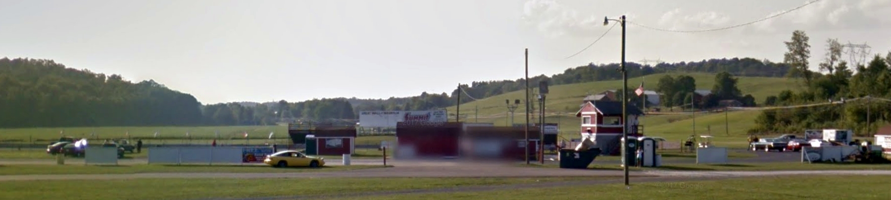
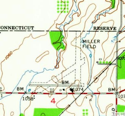
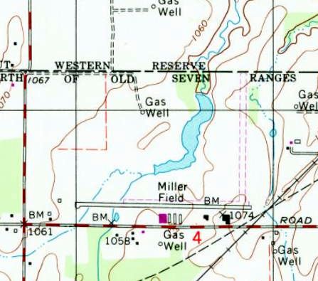
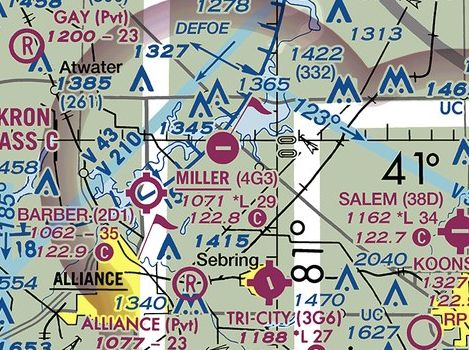
Miller Airport / Miller Field (4G3), North Benton, OH
40.98, -81.04 (Southeast of Cleveland, OH)
Miller Airport, as depicted on the March 1937 Cleveland Sectional Chart.
Miller Airport was evidently established at some point between 1936-37,
as it was not yet depicted on the October 1936 Cleveland Sectional Chart.
The earliest depiction which has been located of Miller Airport was on the March 1937 Cleveland Sectional Chart.
It depicted Miller as an auxiliary airfield.
The earliest photo which has been located of Miller Airport
was a 10/7/43 aerial view looking north from the 1945 AAF Airfield Directory (courtesy of Scott Murdock).
It depicted Miller as having 3 grass runways, with a few small buildings along the south side.
The 1943 Cleveland Sectional Chart (courtesy of Chris Kennedy) depicted Miller as a commercial/municipal airfield.
The 1945 AAF Airfield Directory (courtesy of Scott Murdock) described Miller Field as a 160 acre irregularly-shaped field having 4 sod runways,
the longest being the 2,800' north/south & northeast/southwest strips.
The field was said to have 2 metal hangars, the larger measuring 100' x 50',
and was described as being owned & operated by private interests.
Miller Field evidently gained a paved runway at some point between 1943-52,
as the 1952 USGS topo map depicted it as having a paved east/west runway, in addition to 2 unpaved runways.
Several small buildings were depicted along the south side.
Bob Kiggins recalled, “I took flying lessons at Miller Field in the late 1960s.
At that time, the Fixed-Base Operator was owned by a Toledo-based company which owned a couple of FBOs in the northern OH area.
I remember they had an executive set-up Grumman Mallard for fishing charters into Canada.
The Miller Field manager was a retired Navy commander who was restoring an N3N.
I was a member of the OH National Guard at the time & used my drill pay to take lessons, so it took me about 2 years to get my ticket [pilots license].
I will never forget that solo ride & how much higher the power lines were at the north end of the north/south grass strip in use that day.
And how much quicker that little Colt climbed out & how much slower it came down with just me aboard.”
Bob continued, “I belonged to the Taylorcraft Flying Club (TFC) & Sandy Slifkin was my instructor.
He was one of the last members of the pre-war Taylorcraft Flying Club.
I remember taking my check ride with Russ Miller (founder of Miller Field) and being sure that I would be the first Slifkin student to flunk my check ride.
But even after getting lost, I passed. Only because I was able to find & correct my mistake.
I think the member cost for an hour was $12 & that included Sandy's charge.
I was the OH Division of Wildlife State Game Protector assigned to Mahoning County
and used the TFC Piper Colts & 140 Cherokee for wildlife enforcement projects such as deer jack lighting & illegal hunting.
I flew my first jack lighting project the night after I got my ticket. You are immortal at that age. Dumb, but immortal.
The building just to the right (west) of the main hanger, was the office & a nice little hamburger diner.
The field was a destination for the Sunday morning fly-ins that were popular at that time.
I lived just a few miles south of North Benton & being an airport bum, spent a lot of non-flying hours at Miller Field.”
Richard Finley recalled, “Miller Airport... I got my Private [Pilot's] License there in 1969 from Russ Miller.
I did a lot of [parachute] jumping there & hauled a lot of jumpers there in 1975 & 1976.”
A 1994 aerial view looking northwest depicted 2 single-engine planes at Miller Field.
Miller Field evidently lost its 3rd runway at some point between 1952-94,
as the 1994 USGS topo map depicted it as having a paved east/west runway & an unpaved north/south runway.
Several small buildings were depicted along the south side.
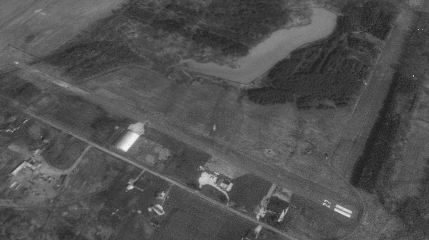
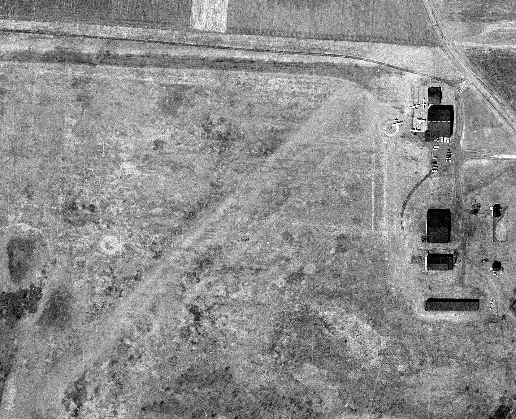
A circa 2005 aerial view looking south depicted 1 single-engine plane on a ramp in front of a Quonset-hut hangar at Miller Field.

The last photo which has been located showing aircraft at Miller Field was a 2006 aerial view looking northwest,
on which at least 5 single-engine planes were visible parked on the south side.
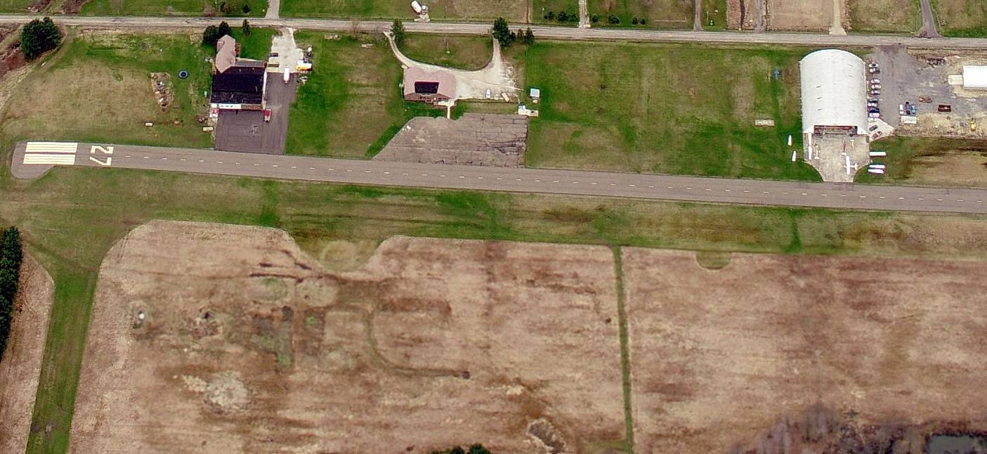
A 2010 aerial photo still showed Miller Field's Runway 9/27 as being marked as an active runway.
Miller Field was evidently closed (for reasons unknown) at some point between 2010-2011,
as a 2011 aerial photo (& several photos in the next few years) showed the runway marked with closed-runway “X” symbols,
and the field was devoid of aircraft.
Showing that you can't always trust aeronautical charts,
the 2015 Sectional Chart continued to depict Miller Field as an open airport,
even though the runway had been painted with closed-runway “X” smybols for 4 years by that point.
As of 2015, Miller Airport's FAA Airport/Facility Directory data described its status as “Closed indefinitely”.
Richard Finley observed in 2015, “Physically, it appears quite intact but I would be surprised to see it reopened in the current economic conditions.”
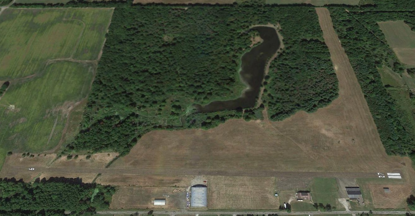
A 2015 aerial view looking north at Miller Field showed Runway 9/27 had newly-painted runway numbers.
As of 2020, Miller Airport's FAA status was still listed as “Airport closed indefinitely.”
Miller Airport is located northwest of the intersection of Johnson Road & Route 68.
Thanks to Richard Finley for pointing out this airfield.
____________________________________________________
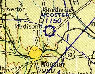
40.84, -81.91 (Southwest of Cleveland, OH)
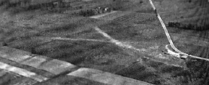
The Wooster Airport, as depicted on the 1929 Airway Map (courtesy of Chris Kennedy).
This general aviation airport dated back to before 1929.
The earliest depiction of the Wooster Airport which has been located was on the 1929 Airway Map (courtesy of Chris Kennedy).
The Airport Directory Company's 1933 Airports Directory (courtesy of Chris Kennedy)
described Wooster as a municipal airport consisting of a 1,968' x 1,291' rectangular sod field.
An aerial view looking northeast at the Wooster Airport from The Airport Directory Company's 1937 Airports Directory (courtesy of Bob Rambo).
The directory described Wooster as having 4 sod runways, with the longest being a 4,700' north/south strip.
The aerial photo in the directory depicted a single hangar at the southern edge of the field.
Wooster Airport, as depicted on the April 1943 Cleveland Sectional Chart (courtesy of Chris Kennedy).
A 10/6/43 aerial view looking north from the 1945 AAF Airfield Directory (courtesy of Scott Murdock)
depicted Wooster Municipal Airport as having several unpaved runways.
The 1945 AAF Airfield Directory (courtesy of Scott Murdock) described Wooster Municipal Airport
as a 115 acre irregularly-shaped property having 4 sod runways, the longest being the 3,200' north/south strip.
The field was said to have 3 hangars, the largest being a 135' x 50' metal structure.
Wooster Municipal was described as being owned by the City of Wooster, and operated by private interests.
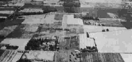
The last photo which has been located showing Wooster Airport still in operation was a 3/20/52 aerial photo, showing it to have 2 perpendicular grass runways,
and 9 light aircraft clustered around 2 small hangars on the southwest corner of the field.
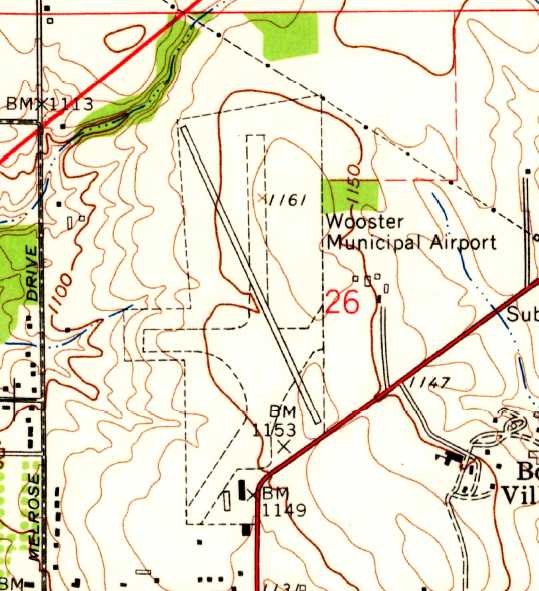
Wooster Municipal Airport apparently gained a paved runway at some point between 1952-61,
as the 1961 USGS topo map depicted the field as having a single paved northwest/southeast runway, along with 3 unpaved runways.
Two buildings were depicted on the south end of the field, along the road.
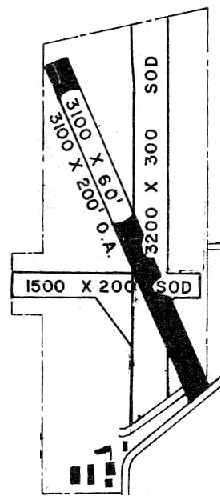
The 1966 OH Airport Directory (courtesy of Chris Kennedy) depicted Wooster Airport as having a single 3,100' paved northwest/southeast runway,
along with a 3,200' north/south sod runway & a 1,500' east/west sod runway.
A total of 5 buildings were depicted on the south end of the field, along the road.
The operator was listed as the Wooster Aviation Center, and the manager was listed as Marshall McDowell.
Wooster Airport was still depicted as an active airport on the November 1968 Cleveland Sectional Chart (courtesy of Richard Finley).
The Wooster Airport was apparently closed at some point between 1968-72,
as it was depicted as an abandoned airfield on the November 1972 Detroit Sectional Chart (courtesy of Richard Finley).
It had apparently been replaced by the new Wayne County Airport (3 miles to the northeast).
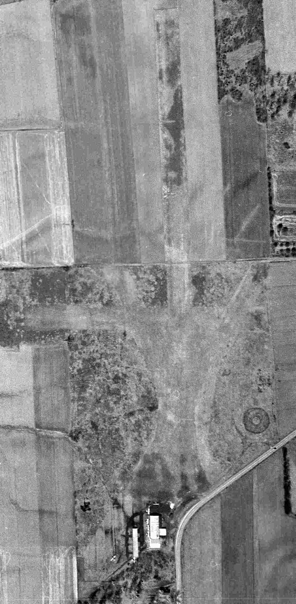
The 1985 USGS topo map still depicted the runway, but unlabeled, and with several new buildings around it.
A 1994 USGS aerial view showed the former airfield hangars at the southwest corner of the property had been removed.
A 2017 aerial view looking northeast at the site of Wooster Airport shows the paved runway remains intact, reused as a street (named Old Airport Road) for the industrial park which now occupies the site.
Industrial buildings have been constructed along both sides of the former runway.
The site of Wooster Airport is located north of the intersection of Route 585 & Old Airport Road (tricky, huh?).
____________________________________________________
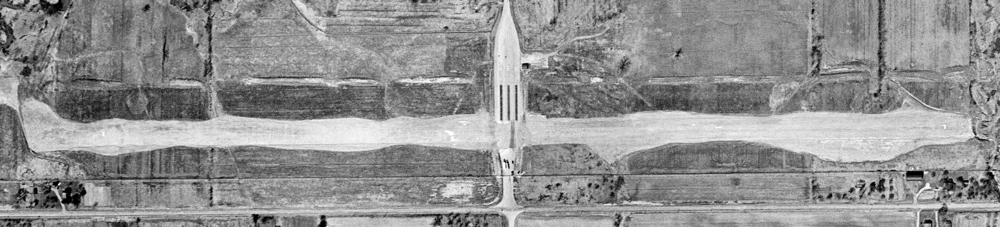
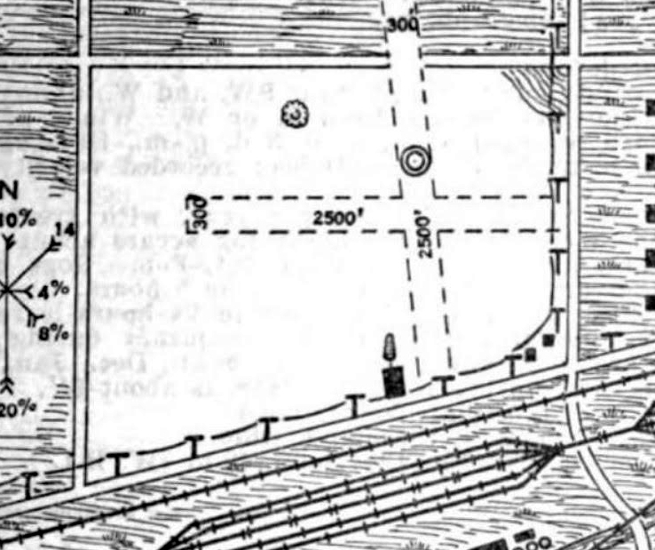
Ravenna Arsenal Crash Test Runway, Ravenna, OH
41.17, -81.13 (South of Cleveland, OH)
A 4/16/52 USGS aerial view of the Ravenna Arsenal Crash Test runway.
According to a 2001 Army Corps of Engineers report, the NACA Test Area “was in operation from 1947-53 & consists of an area of 69 acres.
The site was used to conduct experimental crash tests of excess military aircraft in order to develop explosion-proof fuel tanks and fuel for aircraft.
Excess airplanes were flown to RVAAP under their own power, taxied along installation roads, and staged at NTA.
The planes were fueled and then propelled under their own power on a guide monorail.
The planes were then crashed into a concrete barrier at speeds from 80 to 105 miles per hour.
During the tests, high-speed films were made to study fuel spillage, generation of ignition sources, flame front progression, and toxic gas generation, among other parameters.
Seventeen excess aircraft were used during NTA operations. Some were completely consumed by fire.
Those that were significantly damaged during testing were stripped of instrumentation & salvageable parts, and the majority were removed from the site.
However, some aircraft were bulldozed into an area at the northeast end & buried.”
According to a NASA report on the Lewis Laboratory, “In 1949, when Irving Pinkel inherited the icing program, he also assumed leadership of Lewis's Crash Fire Program.
The NACA obtained about 50 twin-engine cargo planes from the Air Force.
These planes had been used in the Berlin airlift and were so service weary that they were flown to Cleveland with their doors open so that the pilot could jump, if necessary.
The Army granted the NACA permission to use the grounds of one of its World War II arsenals in Ravenna, OH, as the site for the full-scale crash tests.
John Everett designed & supervised the construction of a 2,000' runway.”
The NASA report continued, “The crashes were carefully choreographed, They were to be survivable, assuming that a fire could be prevented.
A plane was sent down the runway at take-off & landing speeds by remote control.
It ran into a barrier that tore off the landing gear & damaged the propellers. The engine, however, had to remain attached to the main body of the aircraft.
The plane then slid through a set of poles to rip open the wing tanks before sliding into an open field.
The airplane was painted white & the fuel dyed red for ease of photography.”
The NASA report continued, “Each airplane carried various instruments to record temperatures, fire location,
distribution of combustible mixtures, and times at which various failures occurred.
These instruments converted the data into electric signals recorded on meters located in a fireproof, insulated box on the airplane.
Seven additional motion-picture camera stands were located at various points near the runway.
To correlate the exterior photographs with the data simultaneously photographed inside the box,
a timing light on the top of the fuselage flashed at intervals of one second or less.”
The NASA report continued, “The program's goal was to uncover the mechanism of the crash fire & the exact nature of the structural breakup of the airplane.
What was the rate, pattern, and area over which the liquid fuel spread? Did it form into a spray? What, if anything, could be done to prevent it?
One by one the old myths tumbled before the facts: the mistaken idea of pilots that turning off the ignition before a crash prevented fire;
the belief that fuels with low volatility were safer than conventional gasoline.”
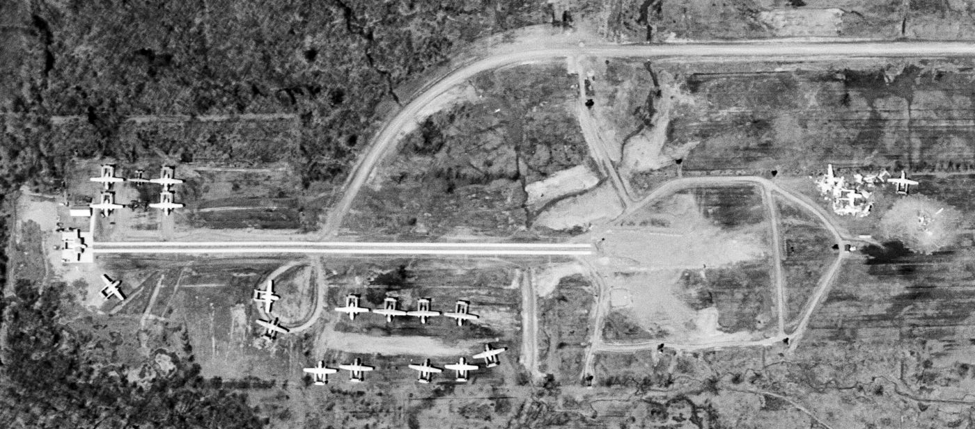
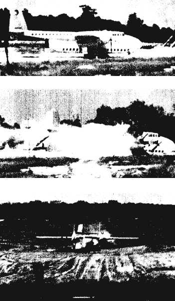
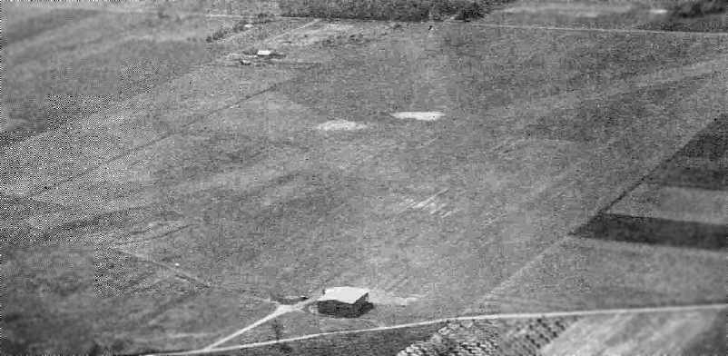
The earliest dated photo which has been located of the Ravenna crash test runway was a remarkable 1952 USGS aerial photo (courtesy of Ron Plante).
It showed no less than 17 intact C-82 Packets around the west end of the runway
(including one C-82 mounted on the west end of the test track), and one smaller twin-engine aircraft.
Another cluster at the east end of the runway included the mangled remains of 3 or more other C-82s,
presumably after they had been subjected to the crash tests.
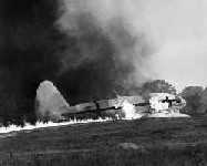
An undated (circa 1950s) photo of a Curtis C-46 Commando burning in the course of a Ravenna crash test.
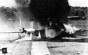
An undated (circa 1950s) photo looking along the Ravenna crash test runway, showing a Fairchild C-82 Packet burning in the course of a crash test.
A circa 1947-53 photo of a Fairchild C-82 Packet (from a 2001 Army Corps of Engineers report) being consumed by a post-crash fire at Ravenna.
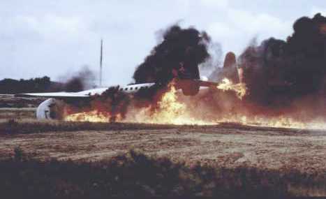
An undated series of photos from a 1955 magazine article showing a Fairchild C-82 Packet being subjected to a crash test at Ravenna.
The Ravenna crash test facilities were presumably abandoned at some point in the 1950s.
Neither the Ravenna runway nor any of the crash test facilities were depicted on the 1950 Cleveland Sectional Chart nor the 1960 USGS topo map.
By 1965, at least one of the Ravenna C-82s had been purchased by Walter Soplata & moved to his aviation collection in Newbury, Cleveland.
A 1970 aerial photo showed the remains of the Ravenna crash test runway, but all of the C-82 aircraft were gone.
A 1999 photo looking east along Ravenna's crash test runway (from a 2001 Army Corps of Engineers report).
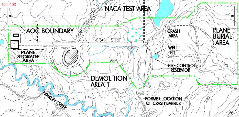
A map of the “NACA Test Area” from a 2001 Army Corps of Engineers report also depicted a “Plane Burial Area” to the east.
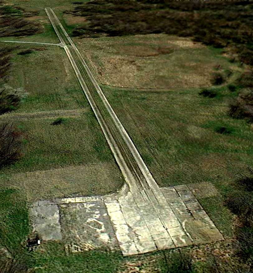
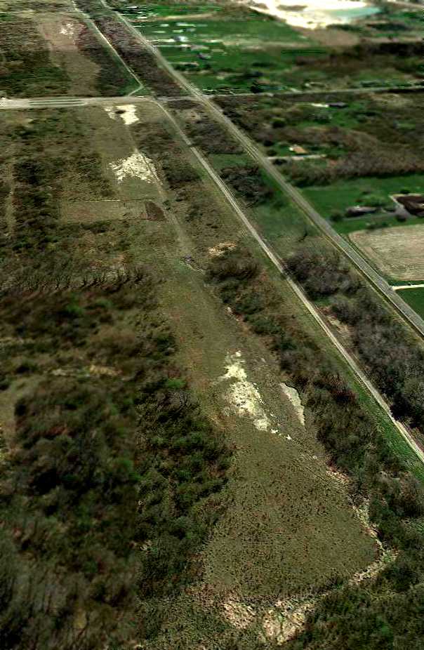
A 4/7/12 aerial view looking southeast at the remains of the Ravenna crash test runway.
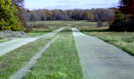
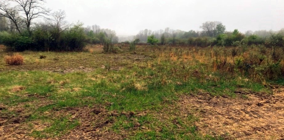
A 4/29/21 photo by Ron Plante looking along the lower half of Ravenna's crash test runway, “with the impact/explosion area at the end.
The area is not open to the public. Ravenna Arsenal is now an OH Army National Guard training center named Camp James Garfield.”
The Ravenna Arsenal Crash Test runway is located on the west side of Greenleaf Road one mile north of Newton Falls Road.
____________________________________________________
Ravenna Arsenal Test Support Runway, Ravenna, OH
41.16, -81.12 (South of Cleveland, OH)
A 4/16/52 USGS aerial view of the Ravenna Arsenal Test Support runway.
This unpaved runway was cleared to support NACA crash-test operations between 1947-52 at the Ravenna Arsenal.
Excess C-46 & C-82 transport aircraft were flown into this runway
and then taxied over roads to the crash-test site a mile north.
The Ravenna runway was not depicted on the 1950 Cleveland Sectional Chart nor subsequent aeronautical charts.
The earliest depiction which has been located of the Ravenna Arsenal Test Support Runway was a 4/16/52 USGS aerial photo,
which depicted a 4,100' unpaved east/west runway.
A small building was located to the north of the runway.
The Ravenna runway was not depicted on the 1960 USGS topo map nor subsequent topo maps.
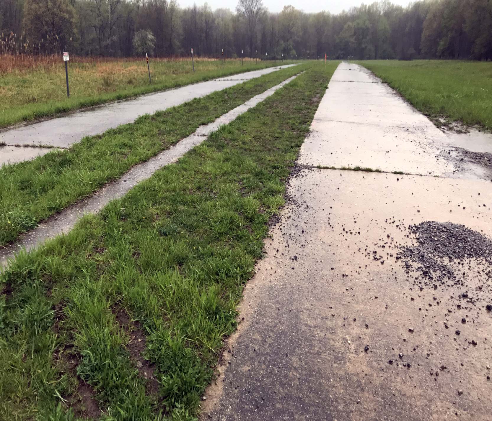
A 4/7/12 aerial view looking southeast along the remains of the runway built at Ravenna Arsenal in order to fly aircraft to be used in Ravenna's crash tests.
A 4/29/21 photo by Ron Plante looking west at the site of Ravenna's crash test support runway from the north/south road in the center of the runway.
The Ravenna Arsenal Test Support runway is located north of the intersection of Newton Falls Road & Greenleaf Road.
____________________________________________________
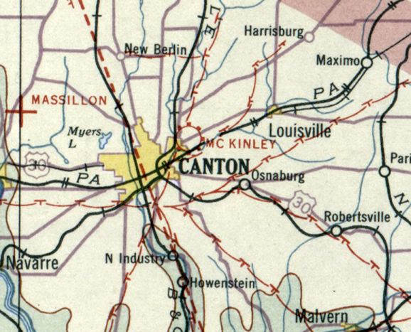
40.819, -81.335 (South of Cleveland, OH)
McKinley Airport, as depicted on the 9/4/28 Commerce Department Airway Bulletin (courtesy of Mike Denja).
The date of establishment of McKinley Airport has not been determined.
The earliest depiction which has been located of McKinley Airport was on the 9/4/28 Commerce Department Airway Bulletin (courtesy of Mike Denja).
It described McKinley as a commercial airport, owned by E.M. Pontius, and operated by Canton Aero Transportation Co.
It was said to consist of a 175 acre rectangular sandy loam field, having two 2,500' runways.
A single 45'x45' two-ship hangar was located along the south side.
According to Scott Howell, “My Great Grandfather Alfred Curtis was the owner & President of the McKinley Airport
in the mid to late 1920s through the early 1930s.”
Dean Watkins reported, “My mother worked as a waitress at the Airport Cafe [at the southeast corner of McKinley Airport] in the late 1920s.
The actual name was 'Malloy's gas station & restaurant'.
She was better known to the patrons as 'Pat' because she didn't want them to know her real name (Hazel).
Her younger brother Ed worked at the airport as a mechanic. He also had a pilot's license.
The center hangar [of 3 along the southeast side] had an area set aside for replacing & painting the cloth covering of aircraft.
It was a restricted area due to the highly flammable adhesives & paints that were in use then.
Of the 3 hangars at McKinley, one was always locked & I didn't know what was in it.”
According to the book "They Walked on Wings, a History of Early Stark County Aviation" by Robert Burwell,
that hangar was owned by the Timken Company & housed their 3 Ford Tri-motors.
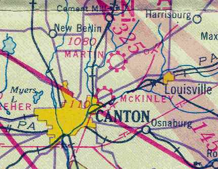
The earliest aeronautical chart depiction which has been located of McKinley Airport was on the December 1932 Cleveland Sectional Chart.
The Airport Directory Company's 1933 Airports Directory (courtesy of Chris Kennedy)
described McKinley as a commercial airport consisting of a rectangular sod field measuring 2,700' x 2,650'.
"Canton" was said to be painted on a building roof.
McKinley Air, Inc. was founded in 1934, according to a 6/12/03 news release from CAK Airport (according to Jim Bailey).
The Airport Directory Company's 1937 Airports Directory (courtesy of Bob Rambo)
described McKinley as a commercial airport consisting of a rectangular sod field measuring 2,700' x 2,650'.
"McKinley" was said to be painted on the hangar roof.
Dean Watkins recalled, “I lived a block east of the airport on Brownlee Avenue in the 1930s.”
It was located “in the northwest corner of Mahoning Road & Harmont Avenue Northeast.”
In 1940, McKinley Airport (144 acres in size at the time) was considered for expansion
by the Civil Aeronautics Administration as part of an expansion of national defense facilities,
but it was not chosen for this (the present-day Akron-Canton Regional Airport was constructed instead.
McKinley Airport was depicted as a commercial or municipal airport
on the February 1941 Cleveland Sectional Chart (courtesy of Chris Kennedy).
Starting in 1941, the manager of McKinley Airport has been George Swayze,
according to an article in the November 1945 issue of Airports Magazine (courtesy of George Swayze).
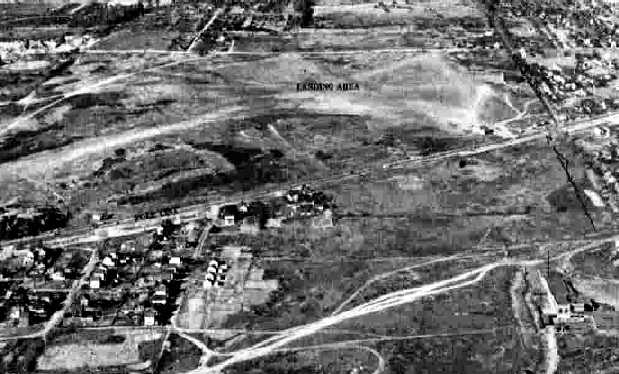
The earliest photo which has been located of McKinley Airport
was a 10/7/43 aerial view looking north from the 1945 AAF Airfield Directory (courtesy of Scott Murdock).
It depicted the field as being an open grass area.
The April 1944 US Army/Navy Directory of Airfields (courtesy of Ken Mercer) described McKinley Airport as having a 3,200' unpaved runway.
The 1945 AAF Airfield Directory (courtesy of Scott Murdock) described McKinley Airport
as a 144 acre rectangular field having 4 sod runways, the longest being a 3,200' northeast/southwest strip.
The field was said to have 2 hangars, the largest being a 100' square steel structure.
McKinley was was described as being owned & operated by private interests.
According to the recollection of Jim Bailey, "One runway most likely was where Long Ave Northeast now is.
That would have been 2,200', angled northwest/southeast, roughly parallel to nearby Millvale Avenue.
A possible second runway may have been the straight section of Cliftmont Avenue, 2,600' in length & closer to true north.
Several hangars were along Millvale Avenue."
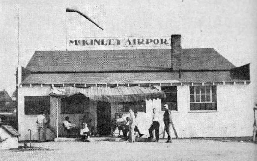
An undated photo of the McKinley Airport operations office, from the November 1945 issue of Airports Magazine (courtesy of George Swayze).
The Haire Publishing Company's 1945 Airport Directory (courtesy of Chris Kennedy)
described McKinley as a "class 2" airport, owned by Otis Clay & operated by McKinley Air Transport.
The airport manager was listed as George Swayze.
The field was said to have 4 sod runways, with the longest being the 3,200' northeast/southwest strip.
The field was said to have 2 hangars, and it was also said to offer repairs, storage, training, and fuel.
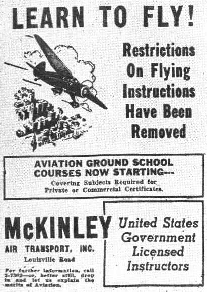
A advertisement for McKinley Air Transport Inc., from the November 1945 issue of Airports Magazine (courtesy of George Swayze).
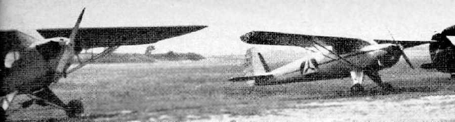
An undated photo of a Piper & a Cessna (in Civil Air Patrol markings) at McKinley Airport,
from the November 1945 issue of Airports Magazine (courtesy of George Swayze).
An article in the magazine noted that Swayze had 6 training planes, with 5 new planes on order, and that the airport consisted of 114 acres.
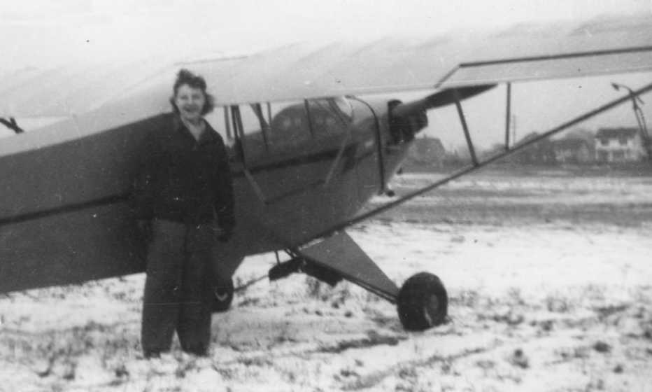
A 1946 photo of Jean Hill in front of a Piper Cub at McKinley Airport (courtesy of Brian Johnson).
Brian recalled, “McKinley Airport is where my Mother learned to fly after the war. Her instructor [was] Andy Little.”

A circa late 1940s photo by Harry Squire of N8Y, a “1910 Curtiss Military Aeroplane” (possibly a replica?)
in front of a McKinley Airport hangar (courtesy of Brian Squire).
The last aeronautical chart depiction which has been located of McKinley Airport was on the July 1947 Cleveland Sectional Chart.
McKinley Airport evidently was closed at some point between 1947-50,
as it was no longer depicted at all on the November 1950 Cleveland Sectional Chart.
A 1952 aerial view showed that a portion of the McKinley Airport site remained clear,
but houses had started to encroach around its periphery.
McKinley Airport was no longer depicted on the 1958 USGS topo map.
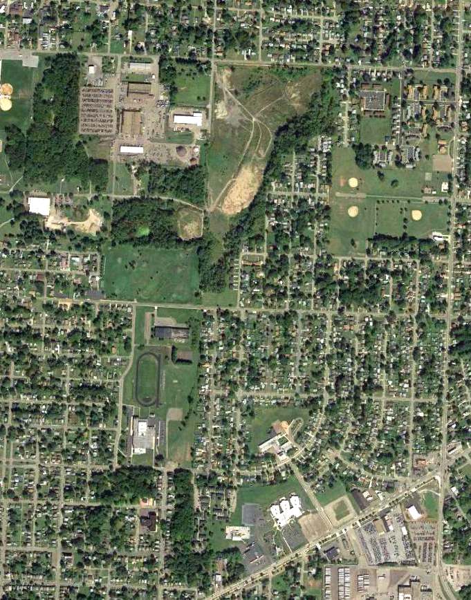
A 2015 aerial photo showed no trace remaining of McKinley Airport.
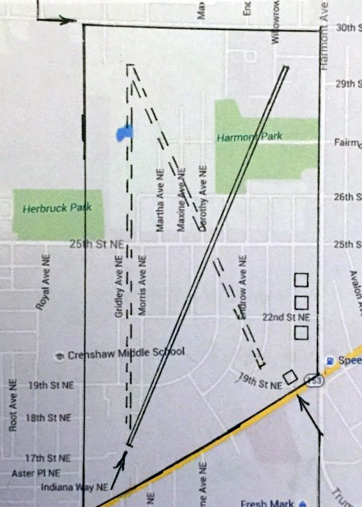
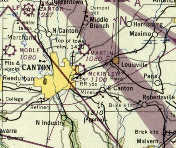
A 2016 street map annotated by Dean Watkins to show the layout of McKinley Airport.
The primary 3,200' sod northeast/southwest runway is shown as a solid line,
and the possible location of the 2 crosswind runways are shown as dashed lines.
The 3 hangars are depicted on the southeast end (at 22nd Street), and the Airport Cafe is shown at 19th street.
Dean Watkins reported in 2016, “The Airport Cafe [at the southeast corner of McKinley Airport] was torn down long ago.
A McDonalds restaurant took its place.”
The site of McKinley Airport is located northwest of the intersection of Mahoning Road & Midway Avenue Northeast.
____________________________________________________
Martin Airport / Canton City Airport (5D4), Canton, OH
40.85, -81.32 (South of Cleveland, OH)
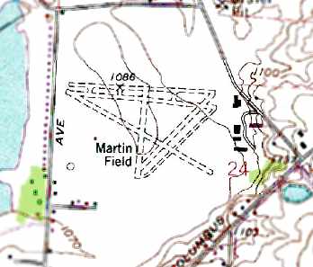
Martin Field, as depicted on the July 1938 Cleveland Sectional Chart.
Martin Field was evidently established at some point between 1937-38,
as it was not yet depicted on the September 1937 Cleveland Sectional Chart,
nor listed among active airfields in The Airport Directory Company's 1937 Airport Directory (courtesy of Bob Rambo).
The earliest depiction which has been located of Martin Field was on the July 1938 Cleveland Sectional Chart.
According to Howard Fauss, "Martin was built & operated by Roy Poorman who also had a home & factory on the field.
Later there were several operators including John Sickfoose."
The Airport Directory Company's 1938 Airport Directory (courtesy of Chris Kennedy)
described Martin as a commercial field, located 5 miles northeast of the center of Canton on Route 62.
The field was said to consist of a 4,000' x 2,500' rectangular sod field,
on which were located 4 runways, with the longest being a 3,700' east/west strip.
The earliest photo which has been located of Martin Field was an undated aerial view from The Airport Directory Company's 1941 Airport Directory (courtesy of Chris Kennedy).
The Airport Directory Company's 1941 Airport Directory (courtesy of Chris Kennedy) described Martin Field in the same fashion as the 1938 Directory.
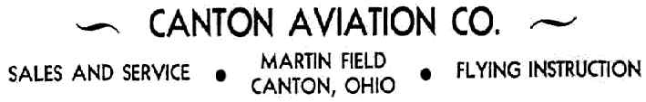
An advertisement for Martin Field's Canton Aviation Company,
from The Airport Directory Company's 1941 Airport Directory (courtesy of Chris Kennedy).
Martin Field was depicted as a commercial or municipal airport
on the February 1941 Cleveland Sectional Chart (courtesy of Chris Kennedy).
Bob Carll recalled of Martin Field, "That's where my father flew for the first time & logged 10 hour flying time while attending Mount Union College in Alliance OH.
He was in the Army Air Corps attending college prior to becoming an officer.
He was at this college in 1943 & flew his flights out of Canton at Martin Field.
My Dad wrote a book about all this training it took to become a pilot & he detailed his work while in college.
He mentions his flying instructor James Shrake & the Piper Cubs they flew.
He even mentions the manager of the airfield at the time as Othar Keil
and shows a picture of his Ryan Sportster Airplane & how he would take it up and give them a show."
Martin Field was described in the April 1944 US Army/Navy Directory of Airfields (courtesy of Ken Mercer) as having a 3,200' unpaved runway.
The Haire Publishing Company's 1945 Airport Directory (courtesy of Chris Kennedy)
described Martin Field as a "class 2" airport, owned by Harry Renkert.
It was said to be operated by Canton Aviation Company, and managed by Noah Sharpe.
It was said to consist of a total of 147 acres, and to have 4 sod runways, with the longest being a 3,000' northeast/southwest strip.
The field was said to offered charter, training, repairs, fuel, and 2 hangars.
Martin Airport was depicted as a commercial/municipal airport on the July 1947 Cleveland Sectional Chart.
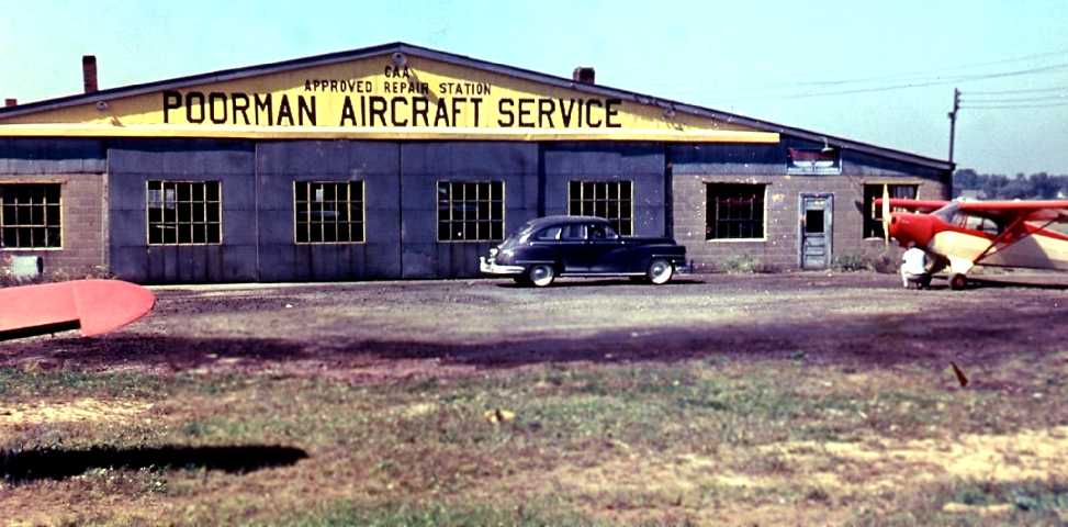
A circa early-1950s photo of a Piper Cub in front of the Poorman Aircraft Service hangar at Martin Airport (courtesy of Micheal Swann, grandson of Ray Poorman).
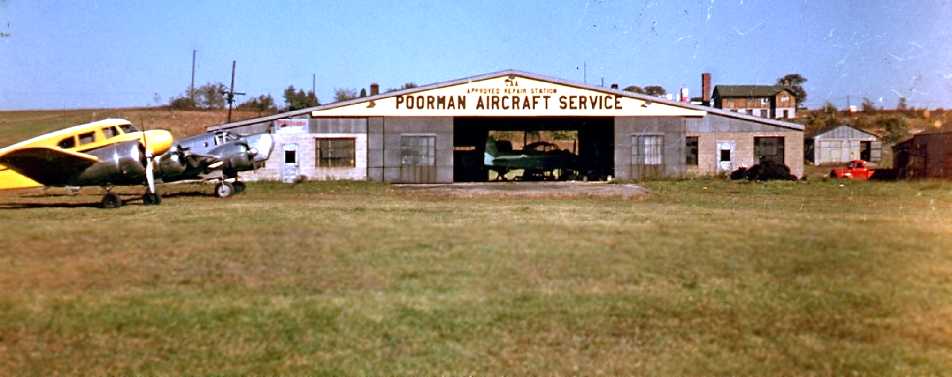
A circa early-1950s photo of a Cessna T-50 “Bamboo Bomber” & an unidentified twin with a bombardier nose
in front of the Poorman Aircraft Service hangar at Martin Airport (courtesy of Micheal Swann, grandson of Ray Poorman),
with a Navion visible inside the hangar.
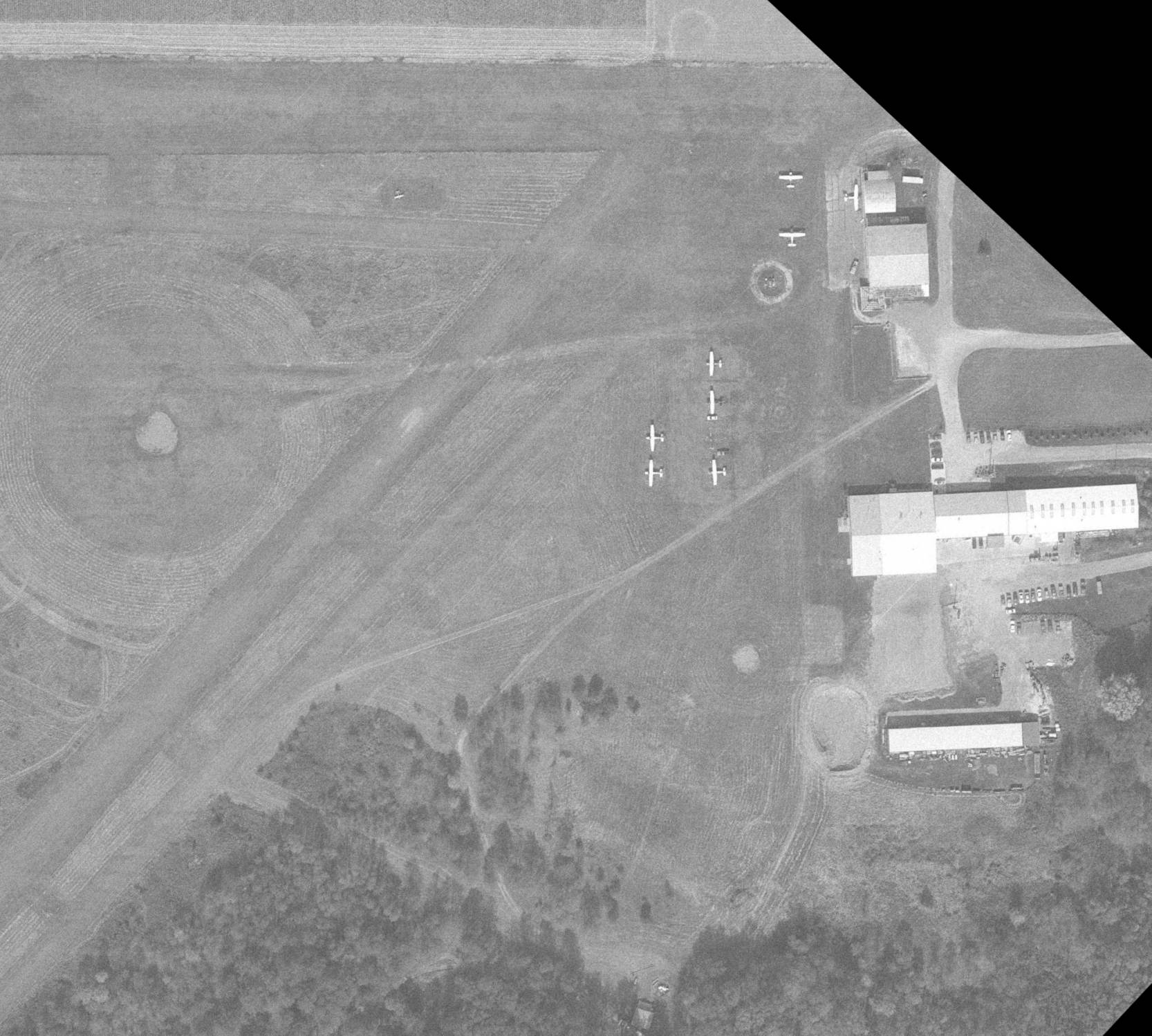
A 1952 aerial view depicted Martin Field as consisting of an open grass field with 5 hangars & 6 single-engine aircraft on the east side.
Martin Field was still depicted as an active airfield on the July 1956 Cleveland Sectional Chart (according to Chris Kennedy).
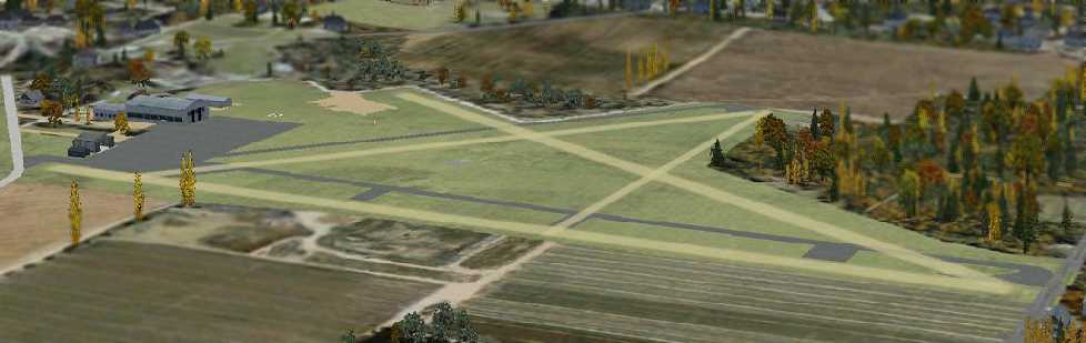
A flight simulation scenery depiction created by Richard Finley looking southeast at Martin Field.
The 1956 OH Airport Directory (courtesy of Chris Kennedy) depicted Martin Field as having four runways,
with the longest being the 3,000' northeast/southwest strip.
A total of six buildings (hangars?) were depicted along the east side of the field.
The manager was listed as S. Tucker, and the businesses on the field were the Poorman Aircraft Repair Service & Brutuc Aviation Company.
Martin Field was evidently closed at some point between 1956-57,
as it was no longer depicted at all on the January 1957 or January 1958 Cleveland Sectional Charts (according to Chris Kennedy).
The 1958 USGS topo map depicted 4 hangars on the east side of Martin Field, but did not depict the runways at all.
Keith Alves recalled, “In the summer of 1961, my instructor, Louis Melter (Owner Operator of Solon Airport)
wanted to go down to Martin Field to talk to Roy Poorman about an early Super Cub he had dismantled.
We took a J-3 down there, it was about 40 miles from Solon.
When we got over the field I couldn't find it...
BUT, it was because there was only a small east-west path from the hangar line to the dump at the west end of the field.
At that time there was a jump club operating out of Martin.
They had a beater [Cessna] 182 they hauled their jumpers with.”
Keith continued, “We went to the main hangar & found Roy.
The hangar itself was turned into a machine shop with all kinds of machines turning out hardware like screws & bolts and such.
Louie had known Roy for many years (2 old birds) & catch-up time went on for a while.
After a chat, Roy took us down the hangar line to another hangar that had a T-type hangar right behind it.
In those days, airport construction was a run-on affair with a building here - later being stretched or added on to there.
I will never forget walking into the large section of the hangar.
There in the rafters were 2 or 3 complete UC-78 Cessna Bobcats.
Roy told us that he thought there would be a good market for them right after the war & bought them.
As things turned out-the post war aviation boom blew out that scheme.”
Keith continued, “We then worked our way down through the T-sections (all adjoined).
Each section was full of Bobcat & Stearman parts – tails, engines, wings, and stuff.
Most impressive was a portion of the building that Roy had stacked with wooden props - like cordwood.
As things worked out, the Super Cub was in pretty sad shape for the money Roy wanted for it -
so we just said goodbye & went back to Solon.
Even though Martin Field was off the charts for a time -
there was always aircraft in & out of there hauling jumpers - or coming in for maintenance.”
Martin Field was still not depicted at all on the May 1963 Cleveland Sectional Chart (according to Chris Kennedy).
The airfield was evidently reopened at some point between 1963-64 as "Canton City",
as that is how is was labeled on the November 1964 Cleveland Sectional Chart (courtesy of Chris Kennedy).
It was depicted as having a 2,700' unpaved runway.
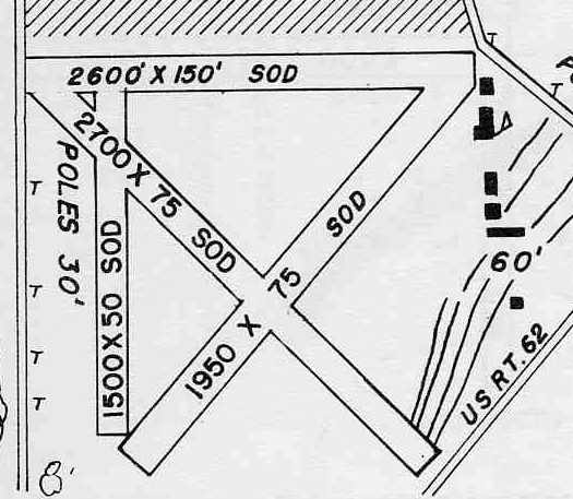
Martin Field / Canton City Airport was depicted on a 3/22/65 OdoT aerial view (courtesy of Dennis Thompson)
as having several hangars & 5 light single-engine planes on the east side of several unpaved runways.
Canton City Airport was evidently closed (again) at some point in 1965,
as it was not depicted at all on the May 1965 Cleveland Sectional Chart (according to Chris Kennedy).
The field evidently reopened within the next year once again under its original name of Martin Field,
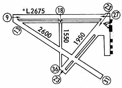
as that is how it was listed in the 1966 OH Airport Directory (courtesy of Chris Kennedy).
It described Martin as having 4 sod runways, with the longest being the 2,700' northwest/southeast strip.
Note that the north/south runway has evidently been relocated at some point between 1956-66,
as it was now depicted on the west side of the field.
A total of six buildings (hangars?) were depicted along the east side of the field.
The operator was listed as the Canton Aviation Center, and the managers were listed as J. Sickfoose & H. Baad.
Martin Airport, as depicted on the May 1968 Cleveland Local Aeronautical Chart (courtesy of Mike Keefe).
Brian Johnson recalled, “My father was a machinist at Poorman Aircraft at Martin Field in the late 1960s & early 1970s.
The Canton Aviation hangar is where my Dad worked.
The front half was a machine shop where they manufactured parts for older planes that were no longer serviced by the original manufacturer.”
The 1972 Flight Guide (courtesy of Chris Kennedy) showed that the 1,500' north/south runway
had been relocated, from the west side of the field, to the center of the field.
By the time of the 1985 Flight Guide (courtesy of Chris Kennedy),
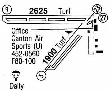
Martin Field's north/south & northwest/southeast runways had been abandoned, leaving the field with 2 active runways.
The operator was listed as Canton Air Sports, which was described as conducting parachute operations daily.
In a 10/19/95 OdoT aerial view (courtesy of Dennis Thompson) Martin Field was still open.
A total of 7 light single-engine aircraft were parked near the hangars on the northeast side.
The 1996 USGS topo map depicted Martin Field as having 4 unpaved runways, with several hangars on the east side of the field.
According to Howard Fauss, "Martin closed in about 1997 to become a corn field."
The reason for the airport's closure has not been determined.
A 2004 aerial view showed Martin Field's runways & hangars remained intact, but devoid of aircraft.
A circa 2006 aerial view looking east at the 2 former hangars which remain standing on the east side of the Martin Field site.
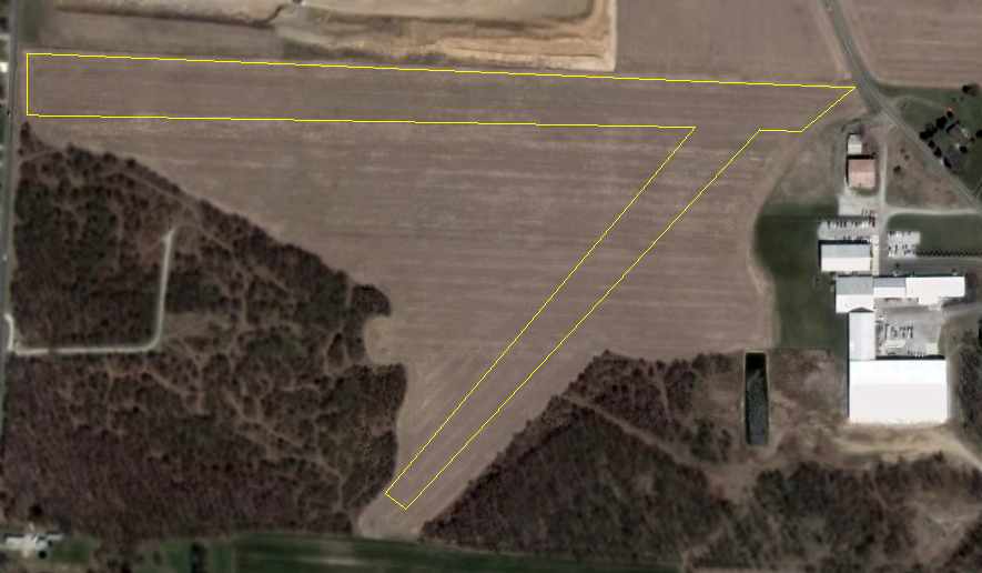
In a 2006 aerial view of the site of Martin Field, annotated by Chris Kennedy to show the former runways, which are no longer distinguishable.
The former hangars remain standing on the east side of the field.
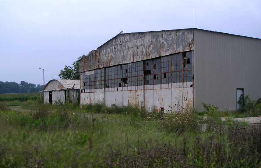
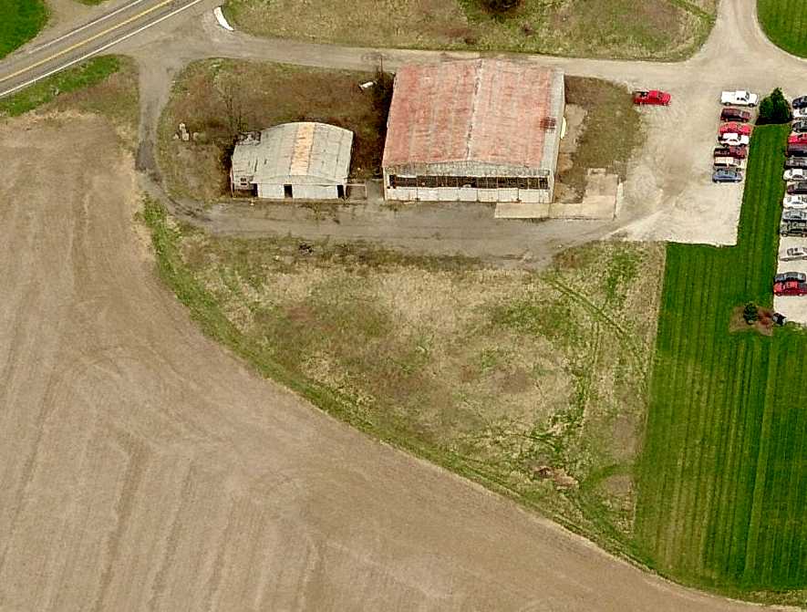
A 2007 photo by Tim Boger looking northeast at 2 former hangars at the site of Martin Airport.
The lettering on the larger hangar reads “Canton Aviation Company”, along with a second line that is not readable.
Tim reported, “A sad sight it is today. The 2 original hangars are still standing & abandoned.
Weeds are growing everywhere. The runways have corn growing in them.”
According to Brian Johnson, his father worked at Poorman Aircraft in the Canton Aviation hangar.
A 2007 photo by Tim Boger looking east at the former hangars at the site of Martin Airport.
A 2009 aerial view showed a portion of the middle of Martin Airport had been excavated, an expansion of the pits which were adjacent to the north side of the airport property.
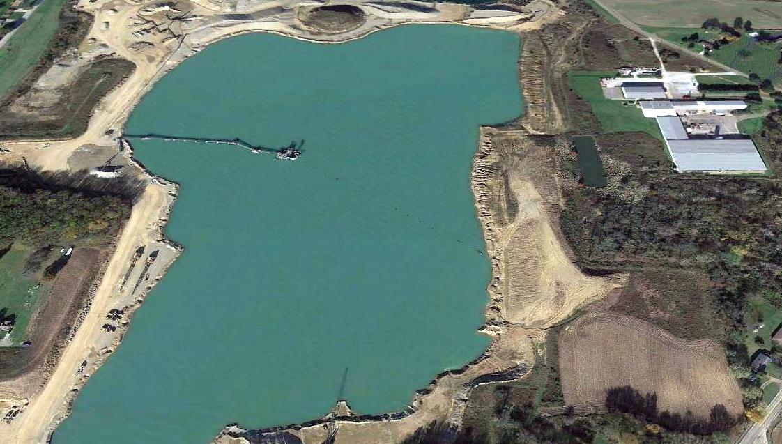
A 2021 aerial view shows the majority of the Martin Airport site is now underwater, having been excavated.
Dennis Thompson observed, “What an inglorious way for an air field to end up. Martin Field is now an industrial pond. Blurp.”
Martin Airport is located west of the intersection of East Columbus Road Northeast & East Center Drive Northeast.
____________________________________________________
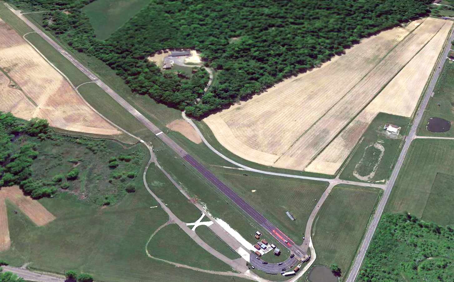
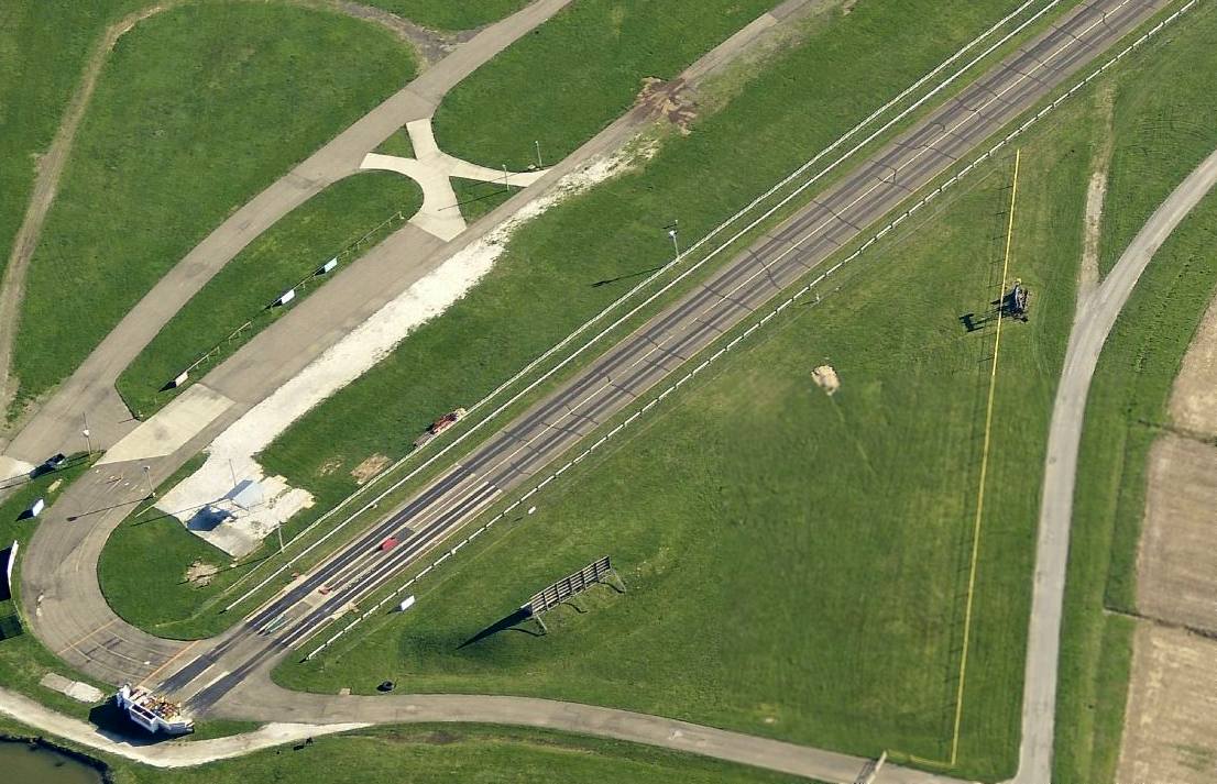
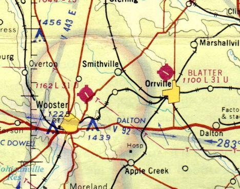
Orrville Airport / Blatter Airport (OH23), Orrville, OH
40.864, -81.79 (South of Cleveland, OH)
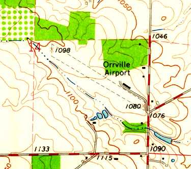
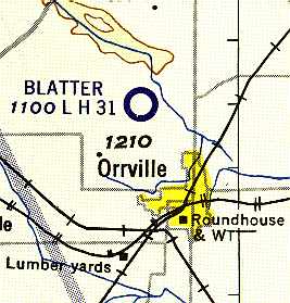
Orrville Airport, as depicted on the 1961 USGS topo map.
Photo of the airport while open has not been located.
According to the University of Akron's web site (via Blandon Ray),
Maynard Blatter purchased a farm on this property in 1947.
No airfield was yet evident at this location on a 1952 aerial photo.
Orrville Airport was not yet depicted on the February 1960 Cleveland Local Aeronautical Chart (courtesy of Mike Keefe).
At some point between 1952-61, Blatter created an airfield on his property.
The earliest depiction which has been located of Orrville Airport was on the 1961 USGS topo map,
which depicted Orrville as having a single unpaved northwest/southeast runway,
with one small building on the northeast side.
The airport was evidently renamed Blatter Airport at some point within the following year,
as the 1962 AOPA Airport Directory described Blatter Airport as having a single 3,000' sod Runway 12/30,
and listed the operator as Maynard Blatter.
The runway at Blatter was apparently paved within the next year, as the May 1963 Cleveland Local Aeronautical Chart (courtesy of Mike Keefe)
described Blatter Airport as having a 3,100' hard-surface runway.
Blatter's Field was at first used by local flying buffs,
and eventually became a municipal airport, operated by a local flying group.
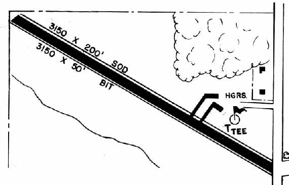
Blatter Airport was depicted in the 1966 OH Airport Directory (courtesy of Chris Kennedy)
as having a single 3,150' bituminous runway, with 2 hangars on the northeast side of the field.
Orville Air Service was said to conduct major repairs & provide flight instruction. The manager was listed as Maynard Blatter.
The November 1968 Cleveland Sectional Chart (courtesy of Richard Finley) depicted Blatter as having a single 3,100' paved northwest/southeast runway.
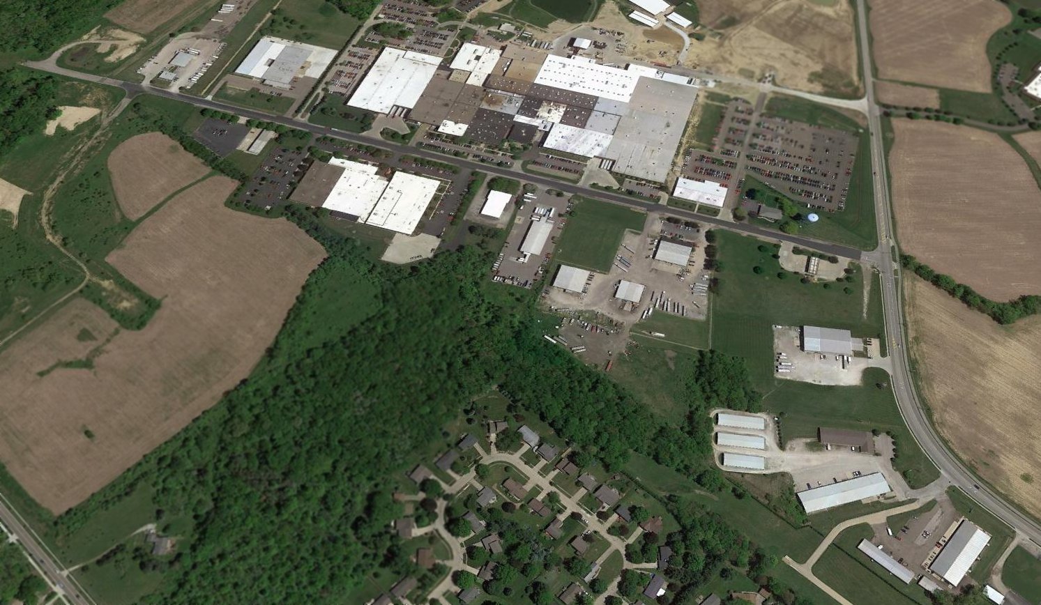
In 1970, a 157-acre property (including the airport) was purchased by The Orrville Branch University Foundation
and 4 days later given to The University of Akron, for the purpose of establishing a college campus in Orville.
This came to fruition in 1972, when Wayne College opened, but the airport continued to operate within the college property.

The last depiction which has been located of Blatter Airport as an active airfield was on the May 1981 Cleveland Sectional Chart (courtesy of Ron Plante).
It depicted Blatter as having a single 3,200' paved northwest/southeast runway.
The 1982 AOPA Airport Directory (courtesy of Ed Drury) described Blatter as having a single 3,100' asphalt Runway 12/30.
Blatter Airport was closed in 1986, "when it became too expensive to operate", according to Wayne College.
[Translation: this most likely meant that continuing to operate an airport had become an annoyance to the new college.]
Blatter Airport was depicted as an abandoned airfield on the 1993 Detroit Sectional Chart (according to Blandon Ray).
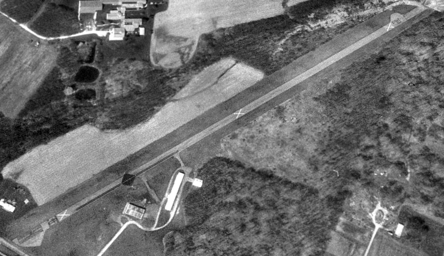
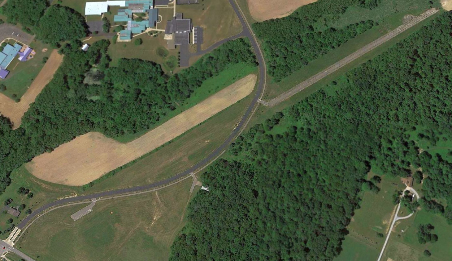
A 1994 USGS aerial view looking southwest at the closed Blatter Airport.
The airfield consisted of a single 2,700' paved runway, which was clearly marked with 3 "X" closed-runway symbols.
A total of 3 hangars were located north of the runway.
As of 1997, the University of Akron reportedly continued to use the runway for police training procedures,
and an airplane hangar was used in a training drill for the Environmental Health & Safety program.
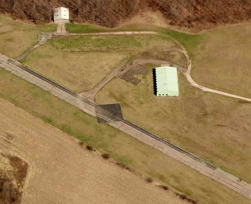
A circa 2006 aerial view looking north shows that the largest of the 3 hangars had been removed at some point between 1994-2006.

A 2011 photo looking northwest along the remains of the Blatter Airport runway, and the remaining hangar.
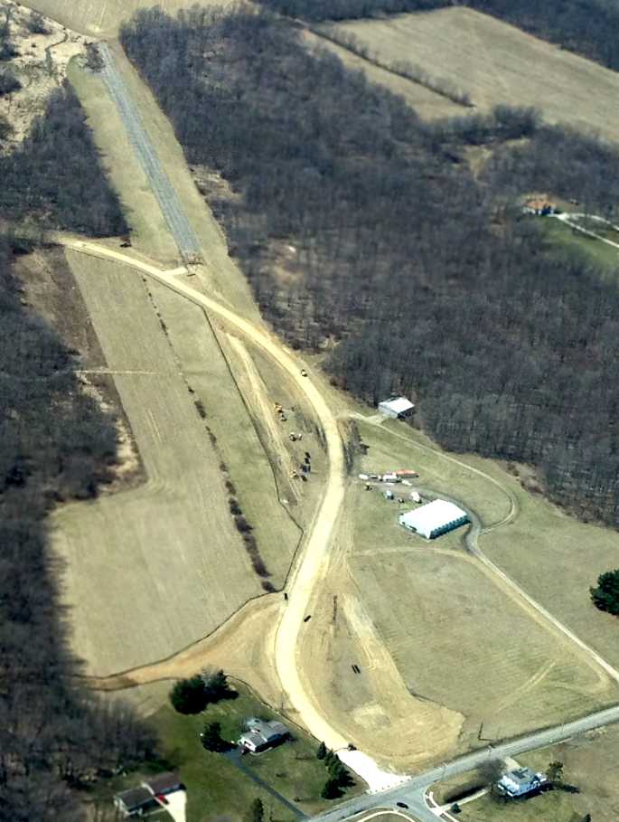
A 4/6/13 aerial view by Doug Deeken looking west along the remains of the Blatter runway.
Doug reported, “I recently heard there were bulldozers tearing up the old runway so I flew over & took this picture.
It looks like half the runway is now gone.”
DanEBoy reported in 2013, “The runway of the Orrville/Blatter Airport has been removed
and replaced with an entrance to the neighboring campus of the University of Akron - Wayne College.
All remaining buildings have been razed.”
A 2016 aerial view looking southwest shows the western portion of the Blatter Airport runway remained intact, and a road had been built over the eastern portion, and only 1 hangar remained.
The Blatter Airport site is located west of the intersection of North Crown Hill Road & Back Massillon Road.
Thanks to Blandon Ray for pointing out this airfield.
____________________________________________________
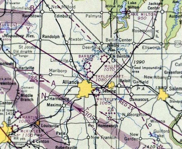
Hess-Argo Factory Airfield / Alliance Airfield / Taylorcraft Factory Airfield, Alliance, OH
40.947, -81.09 (Southeast of Cleveland, OH)
A May 1930 photo by Charles Findley of the sole example of the Warrior Aeronautical Corporation Power Glider at Alliance Municipal Airport (Argo Field).
Aubrey & Adrian Hess developed the Argo engine at the Morgan Engineering Company in 1928,
and they formed the Hess-Argo Company to build their first project, the Hess Warrior engine & the Argo aircraft.
In 1928 they developed a small plant & flying field north of North Benton Road.
The office was located where the Armour guard office is now located.
No runways were built - their planes took off & landed from an open field.
The first Hess-Argo aircraft was introduced in mid 1928 as the "Bluebird Sport" & later officially designated as the Hess Argo.
It was a 2-place, open cockpit biplane.
But the company was in operation only about a year. At the peak about 50 or 60 men were employed, and 28 biplanes were produced.
Adrian Hess was killed in piloting an Argo in a test flight.
The Alliance Aircraft Corporation was formed in 1928 by a reorganization of the Hess Aircraft Company.
The firm designed the A-1 Argo as a sturdy 2-seat open-cockpit biplane for operation by private pilot owners.
The Warrior seven-cylinder engine was designed & produced in the same factory at Alliance.
Because of the difficult economic climate then existing, only 20 A-1 Argos were completed,
and Alliance Aircraft went into bankruptcy in 1930.
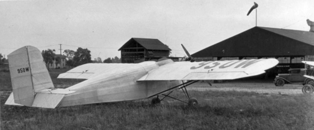
Alliance Aircraft was reformed briefly as the Warrior Aeronautical Corporation,
which built an aircraft known as the Power Glider after many tests & changes.
The Power Glider did not prove a success, with the sole prototype having the registration number of 950W.
Alliance Aircraft was discontinued after only a few months.
In the spring of 1930, J. E. Foster of Detroit took over the Hess assets & started the Foster Aircraft Company.
But the depression prevented the company from ever getting ahead.
Not more than 15 men were employed at the peak, and only 2 planes were produced.
The company only operated for a few weeks before folding up, and the flying field lay idle again.
The earliest aeronautical chart depiction which has been located of Alliance Airfield was on the December 1932 Cleveland Sectional Chart.
It depicted Alliance as a commercial/municipal airfield.
The next user of the Alliance site was Taylorcraft.
The story of Taylorcraft Corporation begins with the story of Gilbert Taylor,
who might have become the Henry Ford of the aviation industry in the production of small airplanes,
but fate decreed otherwise for both himself & his company.
In 1935, when Gilbert Taylor split from his partnership with Piper,
he was looking to relocate from his facilities in Bradford, PA.
Taylor learned of the idle airfield north of Alliance.
The Chamber of Commerce lined up the building & machinery of the former Hess-Argo Company,
secured a loan, and moved Taylor’s equipment to Alliance.
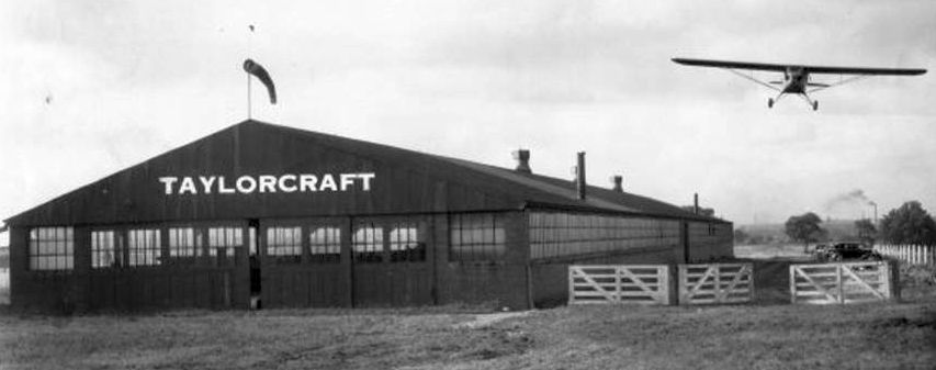
An 8/16/36 photo of the first Alliance-built Taylorcraft monoplane flying over the Taylorcraft Aviation Company factory building.
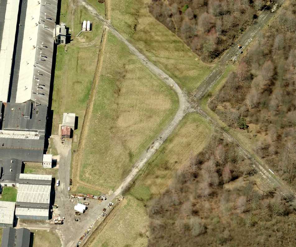
Several years later the Taylorcraft Aircraft Corporation built intersecting runways of approximately 1,000'.
These were extended to 2,500' by subsequent owners.
Taylorcraft started operations in Alliance producing a newly designed side-by-side Taylorcraft plane,
as contrasted with the tandem which he had designed at Bradford & which Piper had taken over.
Piper threatened suit against Taylor allegedly for infringing his rights,
but Taylor was within his rights in producing his newly-designed plane.
Under Taylor’s presidency Taylorcraft Corporation grew to a production of 8 planes / day & 750 employees,
one of the major industries of Alliance.
A fire occurred in the fall of 1939 or 1940 which burned numerous airplanes, but Taylor was not disturbed by the loss of the planes,
but was greatly upset by the death of a young man, C. Woods of Limaville,
who went back into a burning hangar to save a plane, and got so badly burned that he died.
The airfield was still depicted as Alliance Airfield on the March 1940 Cleveland Sectional Chart.
Taylor’s management was continuously beset by financial & organizational difficulties.
Men kept working into the organization who gave him trouble. Richard Depew was named Vice-President.
Depew’s name was handwriting on the wall as he was the protégé of Fairchild interests,
eastern financiers, who took over when C. G. Taylor withdrew in 1942.
By that time Taylor’s interest had dropped from 100% to 13%,
but the growth of the company was such that the 13% was larger than the original 100%.
Fairchild sold out its interest to a new group.
Management of the Taylorcraft Corporation changed hands 4 times during the 11 years of operation.
The last management was that of Nash Russ of Detroit.
The Nash management kept expanding at a terrific pace.
During WW2 the company built flaps & other aircraft parts for Douglas.
The earliest aeronautical chart depiction which has been located of Taylorcraft Field
was on the 1943 Cleveland Sectional Chart (courtesy of Chris Kennedy).
It depicted Taylorcraft as a commercial airfield.
The earliest photo which has been located of Taylorcraft Airport
was a 10/7/43 aerial view looking north from the 1945 AAF Airfield Directory (courtesy of Scott Murdock).
It depicted the field as having 4 grass runways, with the factory along the south side.
The 1945 AAF Airfield Directory (courtesy of Scott Murdock) described Taylorcraft Airport as a 140 acre rectangular field having 4 sod runways,
the longest being a 2,900' northwest/southeast strip (also containing a 2,000' macadam portion).
The field was said to have a single 100' x 80' metal hangar.
Taylorcraft Airport was was described as being owned & operated by private interests.
After WW2 there was a runaway market in light aircraft.
The industry built 34,000 planes in one year, and Taylorcraft was going like a house afire.
Production of airplanes got up to 30 / day, with 1,800 employed.
Wonderful new buildings were erected. The main building had total length of 1,717'.
Twenty-one buildings had 385,000 square feet of floor space, and the land area was 244 acres.
But the light aircraft industry had over-produced.
Suddenly the market dropped out from under the industry, and Taylorcraft found itself with 90 planes on the field & going begging with no buyers.
In 1946, 593 employees were dropped, following a bankruptcy filing. The filing of the petition automatically froze all available assets.
The petition for bankruptcy proceedings was denied, and the company's assets were liquidated.
Armour & Company secured the land & buildings.
L. P. Kulka of Alliance bought the Taylorcraft jigs, equipment, goodwill, and rights to manufacture the aircraft.
He was acting for a group of Taylorcraft distributors & dealers in purchasing the rights to manufacture,
which Kulka did to keep Taylor in Alliance (but they apparently operated at a location other than the former factory).
The last aeronautical chart depiction which has been located of Taylorcraft Field was on the January 1948 Cleveland Sectional Chart.
Taylorcraft Field was evidently closed in 1948, as it was no longer depicted on the June 1948 Cleveland Sectional Chart.
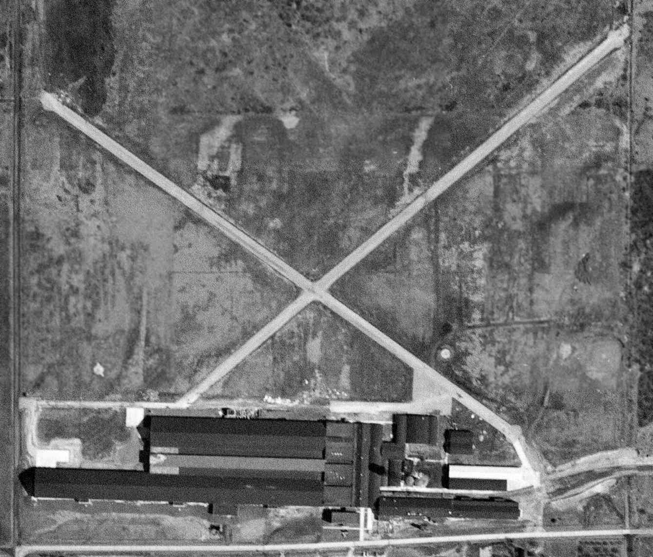
A 4/16/50 USGS aerial photo depicted the Taylorcraft Factory Airfield as having 2 paved runways. There were no aircraft on the field.
The 1952 USGS topo map depicted the Taylorcraft factory, but did not depict the runways at all.
A 1952 aerial photo depicted the showed a closed-runway “X” symbol had been painted at some point between 1950-52
on the runway intersection of the Taylorcraft Factory Airfield.
The runways at the Taylorcraft factory were not depicted at all on the 1957, 1982, or 1996 USGS topo maps.
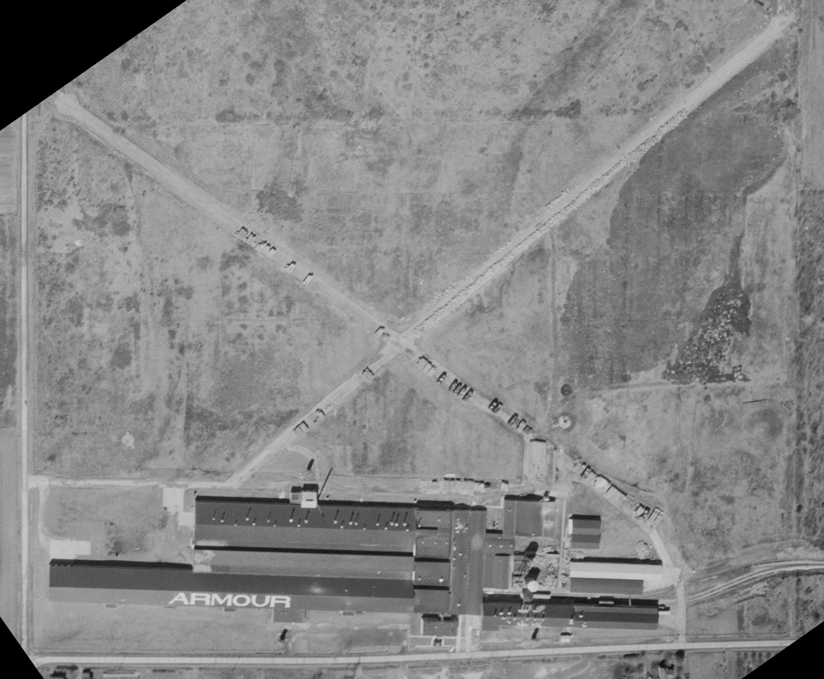
A 1968 aerial view (courtesy of Dennis Thompson) showed “Armour” had been painted on the roof of the former Taylorcraft Factory.
The 2 paved runways runways were being used for storage.
Ed Drury recalled landing a Cessna 172 at the Taylorcraft factory airstrip, "years after it was closed.
I had a project for my company in Alliance & arranged to meet a guy whose office was very close to the former airport.
He assured me there would be no problem landing there & there wasn't.
He met be on the field & I took off about 2 hours later without incident."
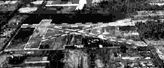
A 1977 aerial view looking northeast at the former Taylorcraft Factory (courtesy of Dennis Thompson), with the 2 runways visible in the background.
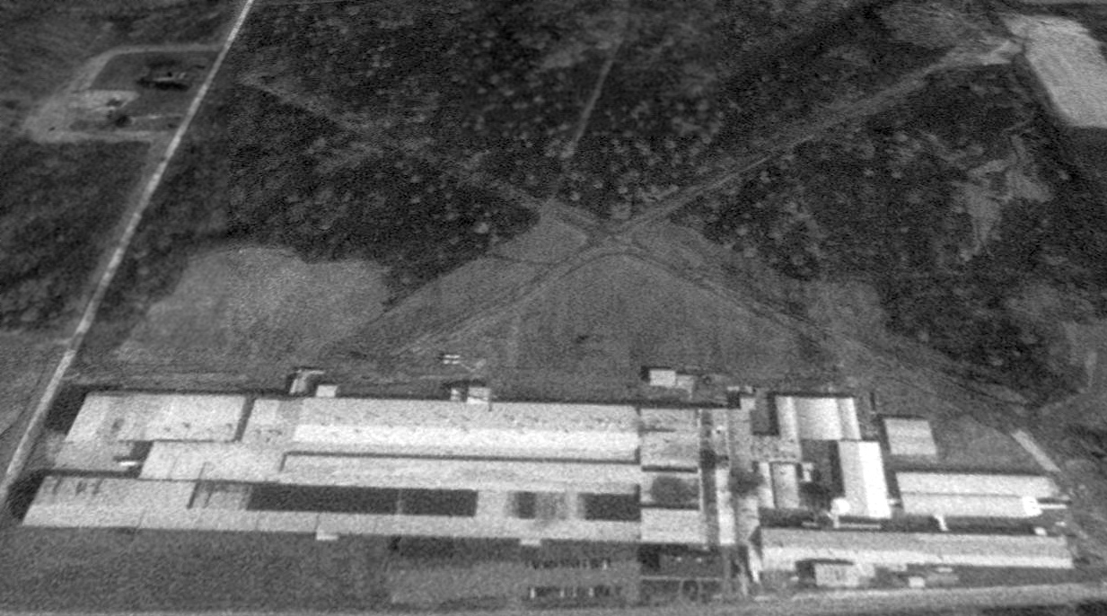
The former Taylorcraft runways were still clearly evident in a 1994 USGS aerial view looking north.
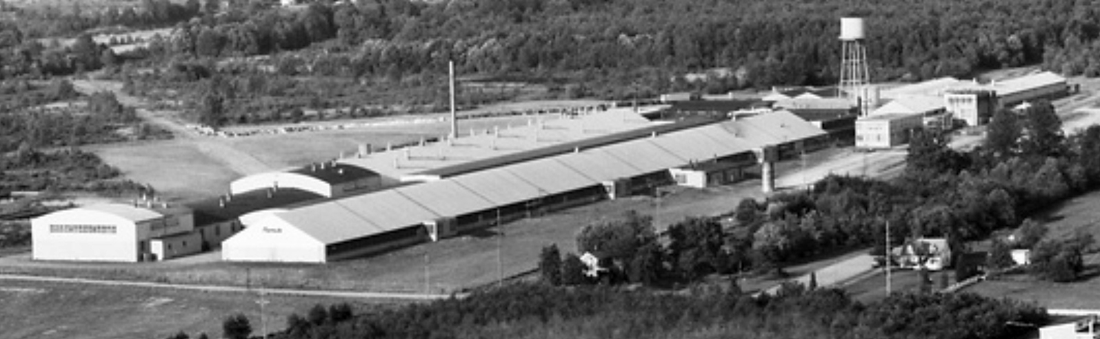
Armour continues to operate the former airplane factory today, using it to produce coated abrasives & cushioning products.
A circa 2007 aerial view looking west along the remains of the 2 paved runways of the former Taylorcraft factory airfield.
A circa 2007 aerial view looking north at the massive former Taylorcraft factory.
A September 2013 photo looking north at the former Taylorcraft factory.
The 2 paved runways behind the former Taylorcraft factory were still clearly evident in a 2015 aerial view looking north.
The former Taylorcraft factory is located on the north side of Armour Street NE, east of Webb Avenue NE.
Thanks to Jim Baker for information about the Taylorcraft airfield.
See also: http://www.taylorcraft.org/taylorcraft_wfah_1956.pdf
____________________________________________________
Or if you prefer to contact me directly concerning a contribution (for a mailing address to send a check),
please contact me at: paulandterryfreeman@gmail.com
If you enjoy this web site, please support it with a financial contribution.
____________________________________________________
This site covers airfields in all 50 states.