Abandoned & Little-Known Airfields:
Ohio: Southeastern Cleveland area
© 2002, © 2025 by Paul Freeman. Revised 9/10/25.
This site covers airfields in all 50 states: Click here for the site's main menu.
____________________________________________________
Please consider a financial contribution to support the continued growth & operation of this site.
Auburn Airport (revised 1/31/23) - Chagrin Falls Airport (revised 1/18/21) - Forepaugh Airport / Four Points Airport (revised 3/29/20)
Harper Ridge Airfield (revised 1/24/24) - Issoudun Airport / Mid-City Airport (added 7/14/21) - Miller Field (revised 1/31/23)
Sky Haven Airport (original location) / Welcome Airport / Northfield Airport (revised 9/10/25) - Sky Haven Airport (2nd location) (revised 2/10/16)
____________________________________________________
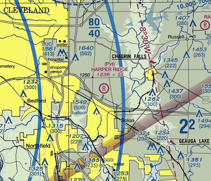
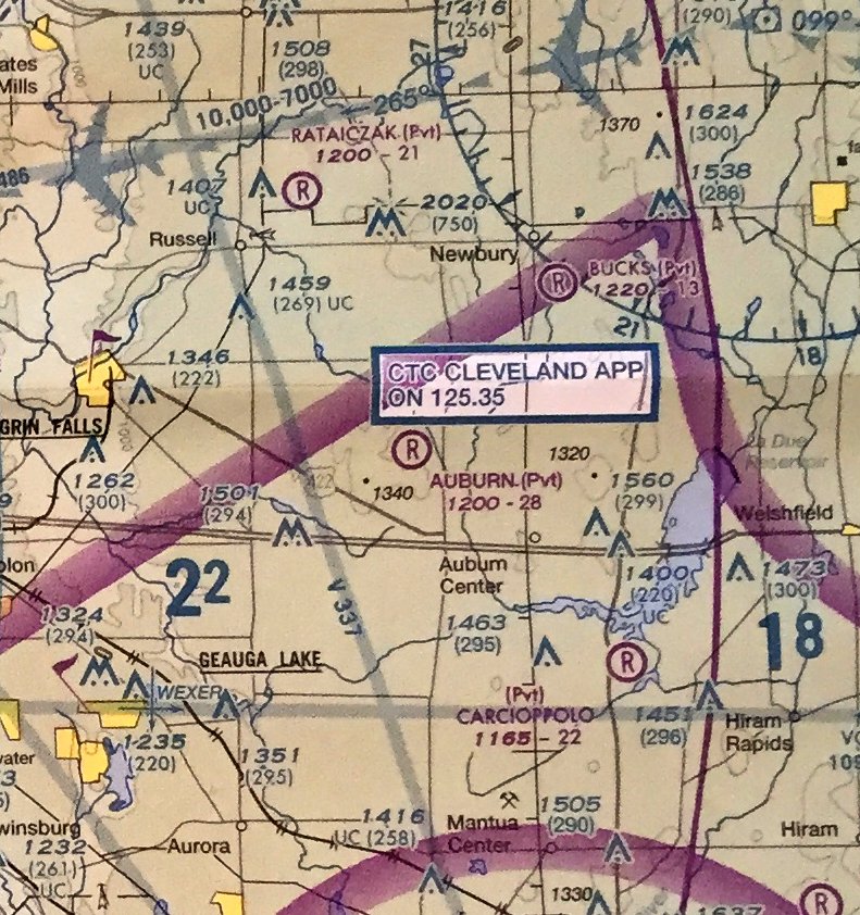
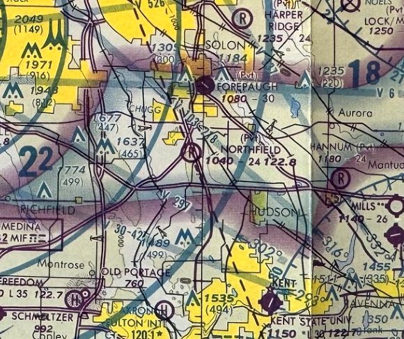
Harper Ridge Airfield (OH67), Solon, OH
41.413, -81.455 (Southeast of Cleveland, OH)
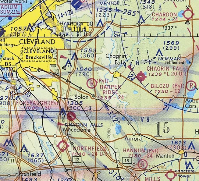
Harper Ridge Airfield, as depicted on the November 1972 Detroit Sectional Chart.
Photo of the airfield while in use has not been located.
This small private airfield on the southeast side of the Cleveland area was evidently constructed at some point between 1962-70,
as it was not yet depicted on a 1962 aerial photo.
The earliest depiction which has been located of Harper Ridge Airfield was a 1970 aerial photo.
It depicted a single unpaved east/west runway, with 2 small buildings on the southwest side.
There were no aircraft visible on the field.
Bruce Bream reported, “I talked with a daughter [of the Harper Ridge Airport owner]; 1970s is when she said he made the airport.
There were a few planes that he flew. One was a 2-place MBB Bo 209 Monsun. He used to fly with Monsun owners to Oshkosh.”
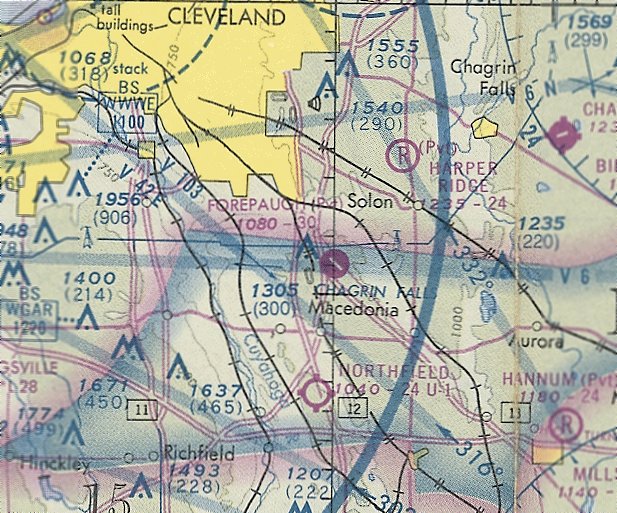
The earliest depiction which is available of Harper Ridge Airfield was on the November 1972 Detroit Sectional Chart.
It depicted Harper Ridge as a private airfield having a 2,400' unpaved runway.
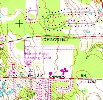
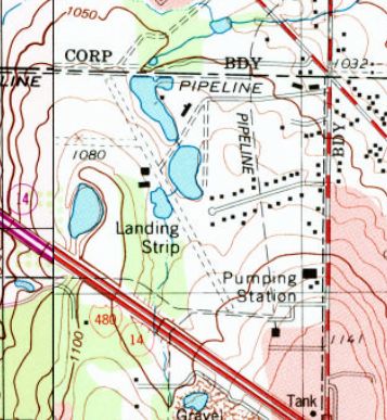
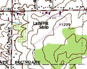
The earliest topo map depiction which has been located of the Harper Ridge Airfield was on the 1979 USGS topo map.
It depicted “Harper Ridge Landing Field” as having a single unpaved east/west runway, with a small building on the southwest side.
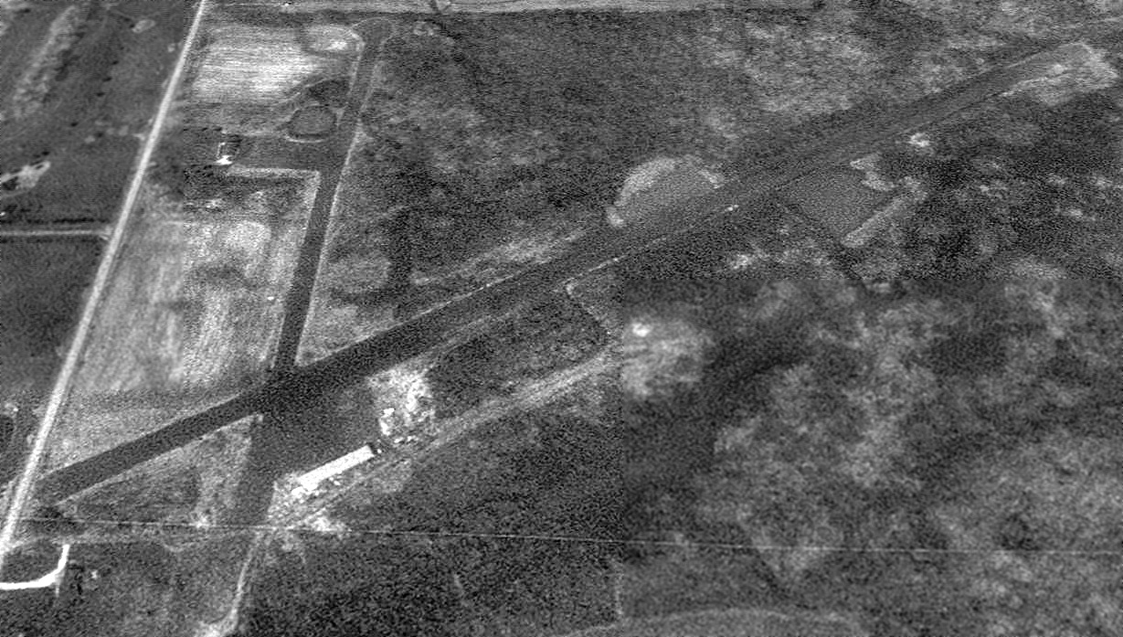
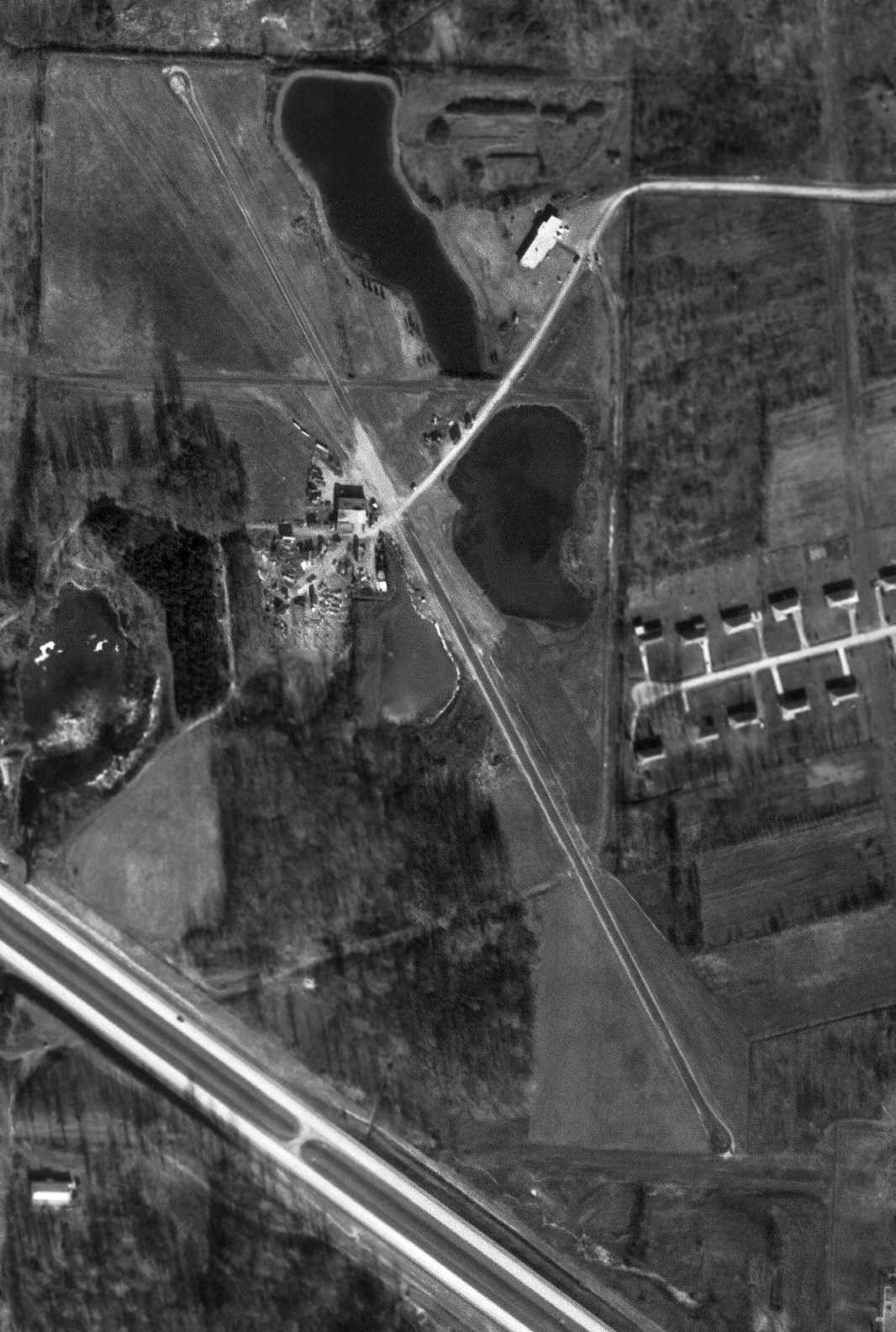
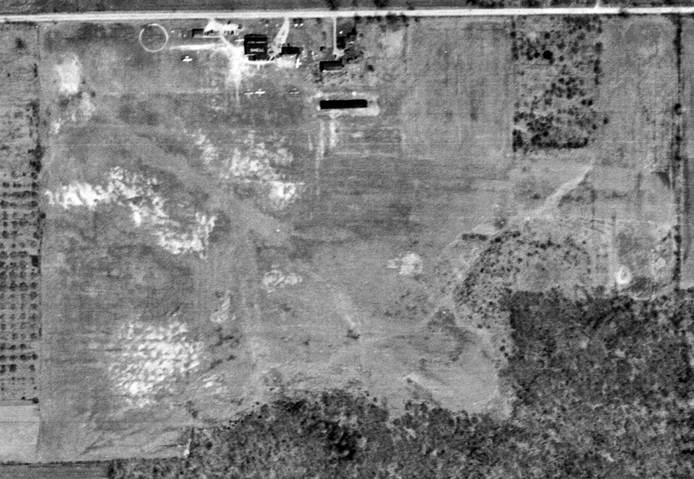
The earliest photo which is available of Harper Ridge Airfield was a 1994 aerial view looking northeast.
It depicted Harper Ridge as having a single unpaved east/west runway, with 2 small buildings on the southeast side.
There were no aircraft visible on the field.
The 1999 Cleveland Terminal Chart depicted Harper Ridge as a private airfield having a 2,400' unpaved runway.
According to Bruce Bream, “The owner passed away in 1999.”
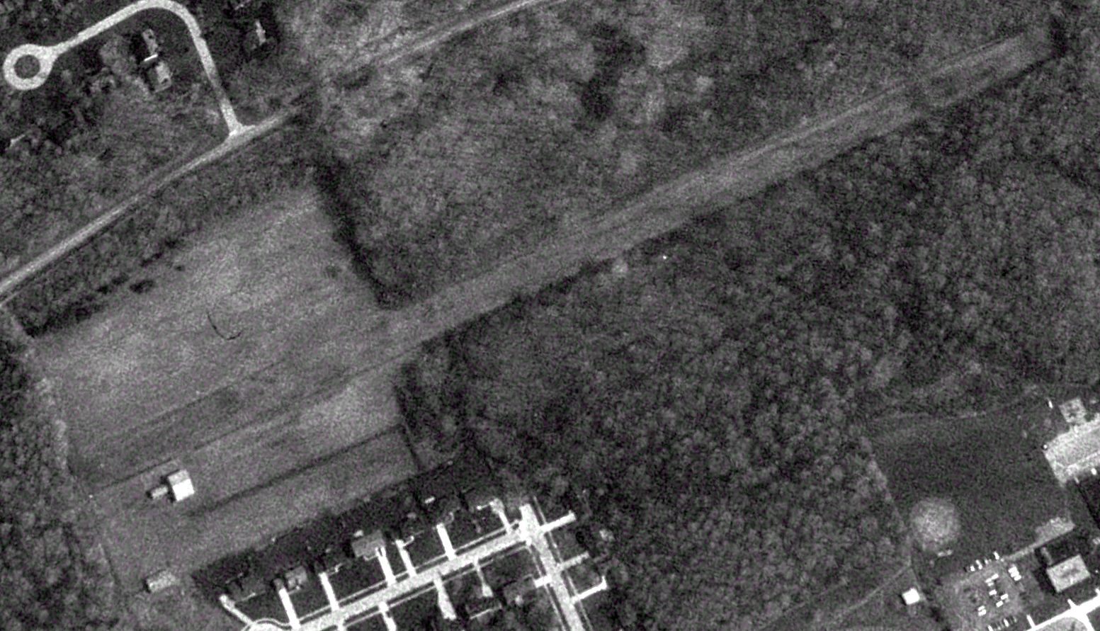
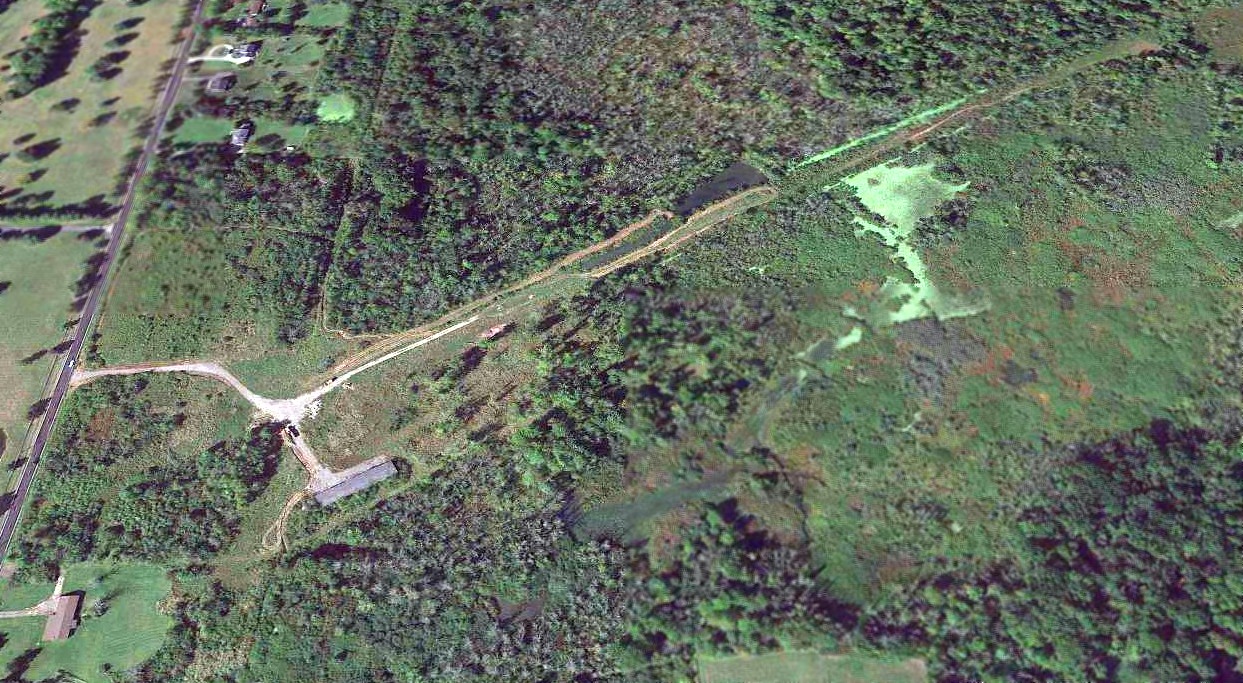
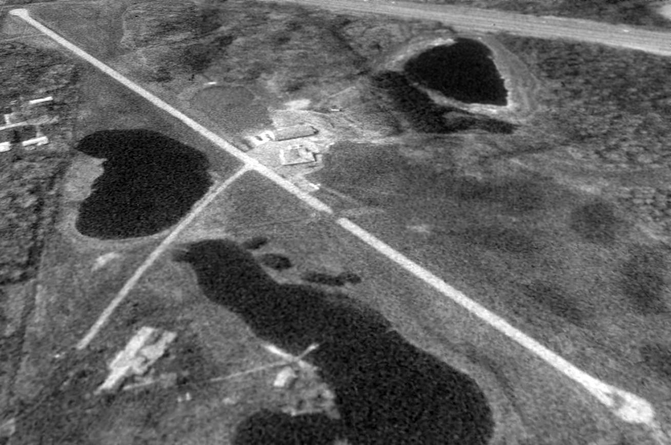
A 2003 aerial view by Bruce Bream looking east showed Harper Ridge Airfield to remain mostly intact, with the grass runway & square area to the west still being cleared, and with a red foundation & another small building on the southwest side.
A 2005 aerial view showed that both small buildings on the southwest side of Harper Ridge Airfield had been removed at some point in 2005.
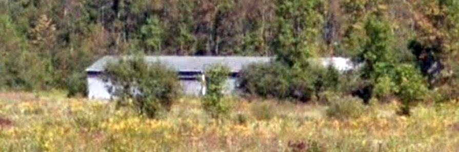
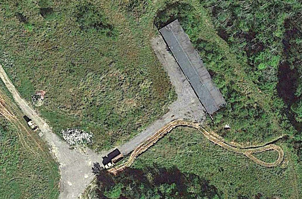
A 2007 photo by Bruce Bream of a hangar foundation on the southwest side of Harper Ridge Airfield.
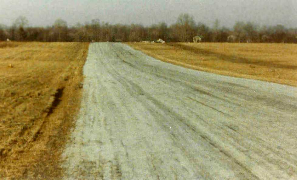
A 2007 photo by Bruce Bream looking east along the former Harper Ridge Airfield runway.
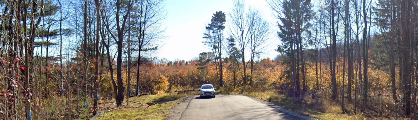
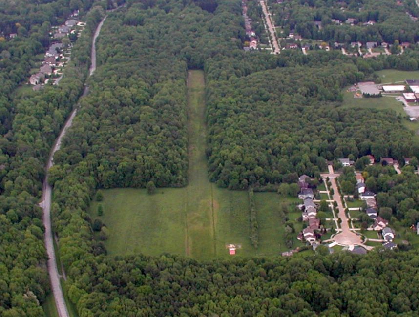
A 2020 photo looking south toward Harper Ridge Airfield.
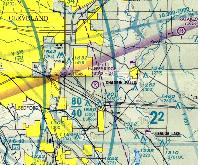
The last aeronautical chart depiction which has been located of Harper Ridge Airfield was on the 2021 Cleveland Terminal Chart.
It depicted Harper Ridge as a private airfield having a 2,400' unpaved runway.
Harper Ridge Airfield was no longer depicted on the March 2022 Cleveland Terminal Chart.
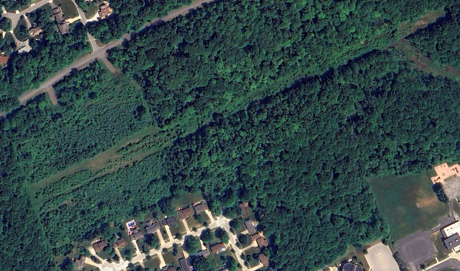
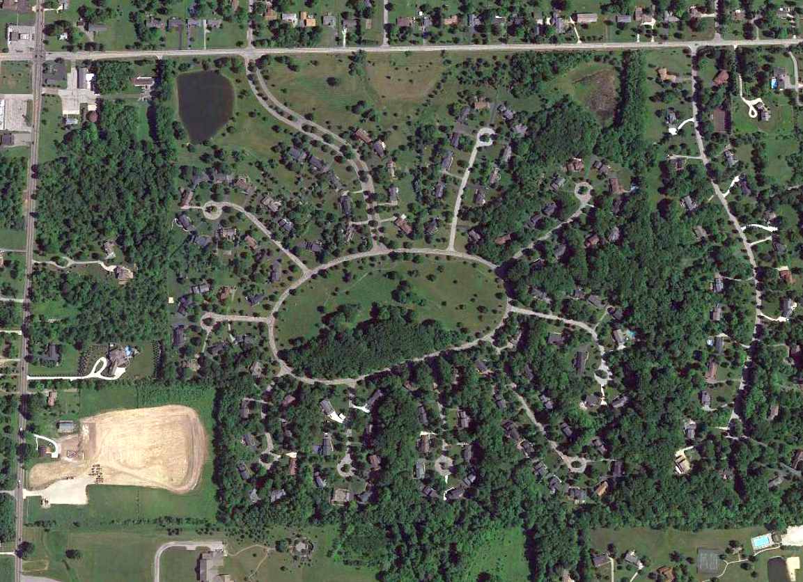
A 2023 aerial view looking northeast at Harper Ridge Airfield showed a dramatic difference compared to the 2003 photo, with the runway & clearing having been allowed to overgrow, and their outline only barely recognizable.
Both buildings had also been removed.
Bruce Bream reported in 2024, “Part of the property is owned by the Cleveland Metropolitan Park District.”
Thanks to Bruce Bream for pointing out this airfield.
____________________________________________________
Issoudun Airport / Mid-City Airport, Darrowville, OH
41.214, -81.437 (Southeast of Cleveland, OH)
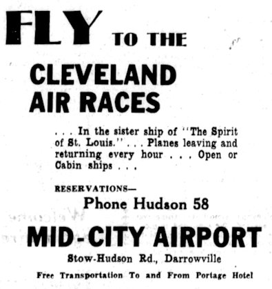
An advertisement for Mid-City Airport from the 8/24/29 Akron Beacon Journal (courtesy of Bill Grasha).
According to Summit Memory, “Major Thomas Lanphier & Colonel Henry Breckenridge founded the airport in the 1920s
and called it Issoudun Airport named after airfields in France used during World War I.”
According to a Kent State document, “Private investors leased the Darrowville property in 1929 for a commercial airport.
The business was initially called Issoudun Mid-City Airport, with 'Mid-City' referring to its location between Akron & Cleveland.
Flight instruction was a major focus. By 1929, the Akron & Mid-City airports competed with Stow Field for the area’s aviation business.”
An advertisement for Mid-City Airport from the 8/24/29 Akron Beacon Journal (courtesy of Bill Grasha) offered flights to the Cleveland Air Races.
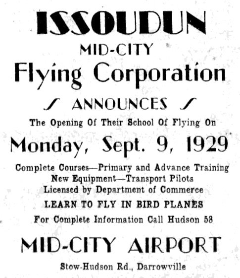
An advertisement for Mid-City Airport from the 9/7/29 Akron Beacon Journal (courtesy of Bill Grasha)
touted the opening of their School Of Flying.
According to Summit Memory, “A newspaper report claims that Charles Lindbergh & his wife stopped in the airport in December 1929 on their way to Columbus from NY.
The report said that Lindbergh & his wife drank coffee at the Issoudun Canteen.
Lindbergh was friends with the airport founders, which likely prompted the visit.”
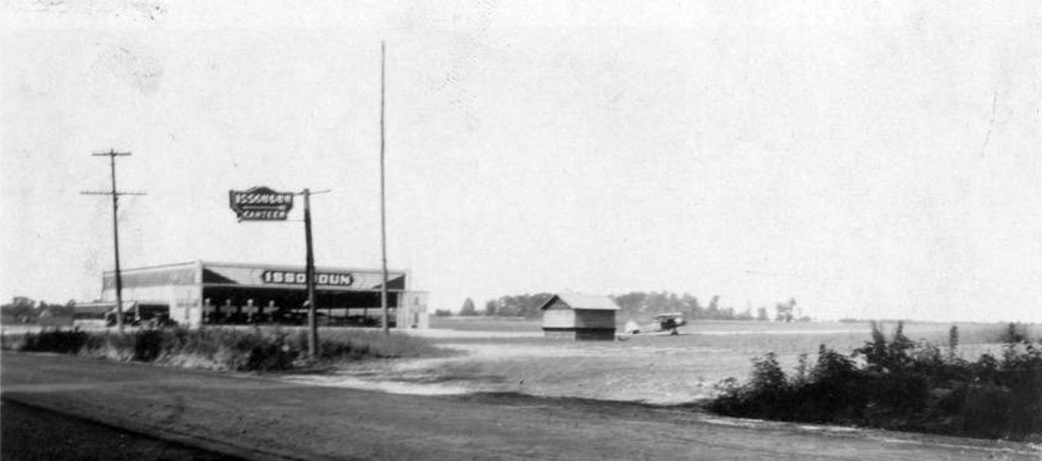
A circa 1930 photo of Mid-City Airport (courtesy of Bill Grasha) showed the Issoudon Canteen sign in front of the hangar labeled “Issoudon”, and one biplane on the field.
The earliest aeronautical chart depiction which has been located of Issoudon Airport was on the June 1933 Cleveland Sectional Chart.
The December 1933 Cleveland Sectional Chart depicted the airport as Mid-City Airport.
According to a Kent State document, “Mid-City Airport experienced hard times during the 1930s; the period was characterized by a series of management changes.
Stability was reached in 1939 when Van Devere leased this airfield.
He would be a major player in area aviation for the next decade.
Kent State’s first federal program - the Civilian Pilot Training Program - began in 1939.
Akron Airways provided the flight training using both Akron & Mid-City airports.”
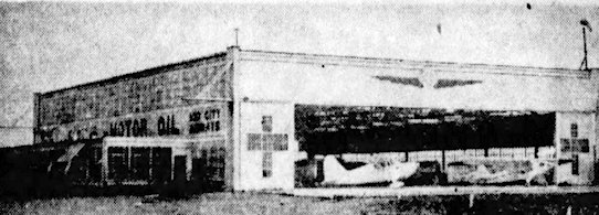
An undated photo of the Mid-City Airport hangar from the 4/13/41 Akron Beacon Journal Sun (courtesy of Bill Grasha).
According to a Kent State document, “In 1941, increased military traffic moved most flight training to Mid-City.”
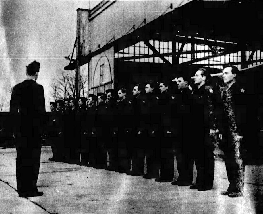
An undated photo of cadets in front of the Mid-City Airport hangar from the 2/28/43 Akron Beacon Journal Sun (courtesy of Bill Grasha).
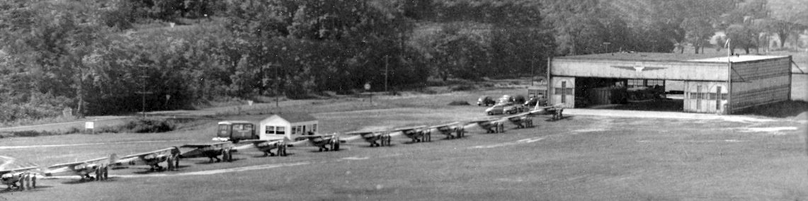
A 1943 aerial view of a line of a dozen Piper Cubs in front of the Mid-City Airport hangar (from the Van Devere Family Collection, courtesy of Bill Grasha).
According to a Kent State document, “In the 1940s, poor conditions at the newly acquired Kent State Airport necessitated that flying be done at Mid-City.
Beginning in 1946, Kent State flight training through the GI Bill was provided by Akron Airways at Mid-City Airport.
In the 1950s, lower flight fees drove most KSU students to Mid-City.”
The last photo which has been located of Mid-City Airport was a 1952 aerial photo.
It depicted Mid City Airport as having 3 unpaved runways & a hangar on the west side, but there were no aircraft visible on the field,
and no overt sign of recent aviation use.
The 1953 USGS topo map depicted Mid City Airport as having 3 unpaved runways & a hangar on the west side.
The last aeronautical chart depiction which has been located of Mid-City Airport was on the July 1956 Cleveland Sectional Chart.
It depicted Mid-City Airport as having a 3,100' unpaved runway.
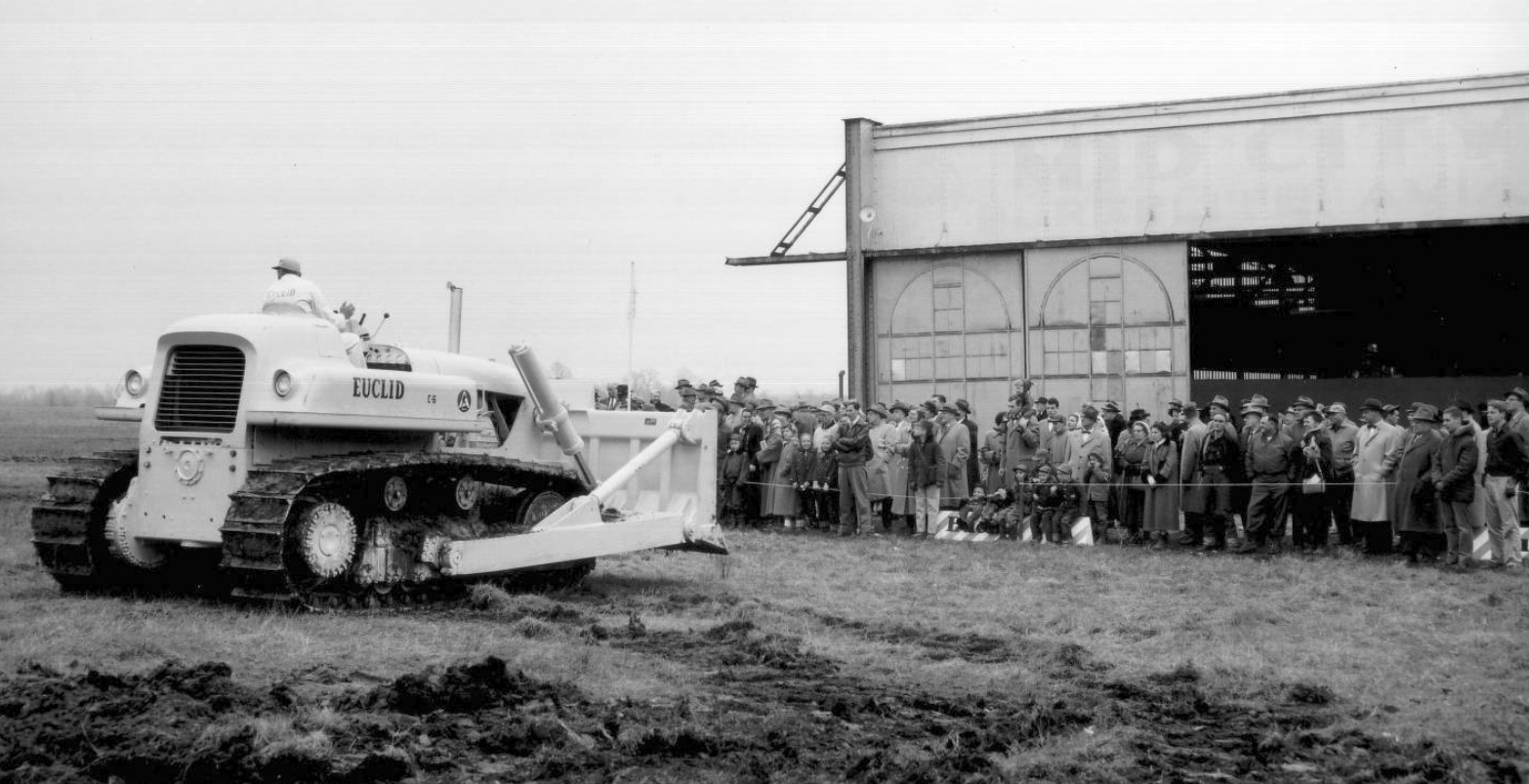
According to a Kent State document, “Mid City Airport came to an end in 1956 when General Motors purchased Mid-City for its Terex plant.”
Mid-City Airport was no longer depicted on the January 1957 Cleveland Sectional Chart.
The 660,000-square-foot Terex factory was completed in 1958.
The Terex & Euclid GM Divisions manufactured scrapers, pans, dozers, crawlers, loaders, and other earth-moving equipment between 1958 and the mid-1980s.
A 1958 aerial view showed the GM Terex factory occupying the site of Mid-City Airport.
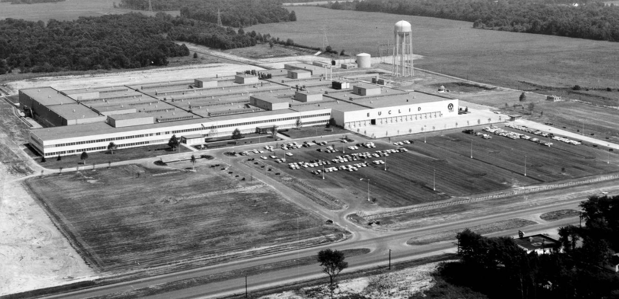
An addition in 1961 added 340,000 additional square feet to the Terex factory.
The Terex plant closed in the late 1980s.
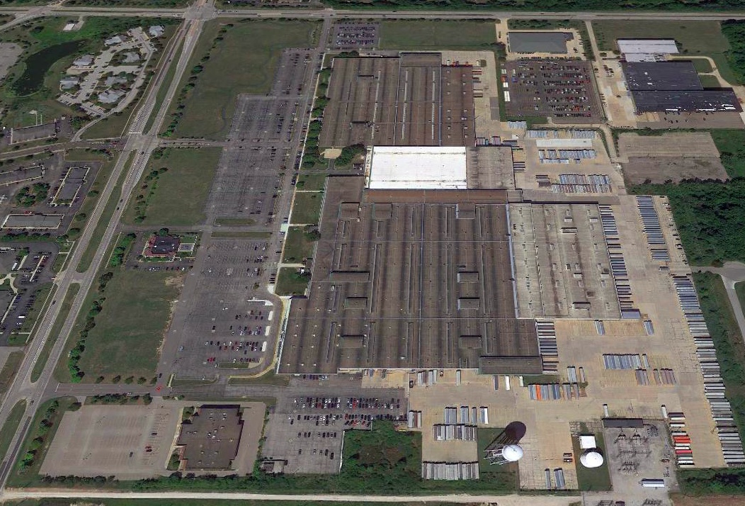
A 2020 aerial view looking northeast showed the former GM Euclid factory, with no trace remaining of the former Mid-City Airport.
As of 2021, street maps label the Mid City Airport property as the site of Joann Fabrics.
Thanks to Bill Grasha for pointing out this airfield.
____________________________________________________
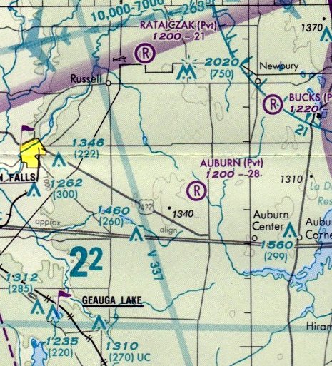
Auburn Airport (27O1), Auburn, OH
41.414, -81.285 (Southeast of Cleveland, OH)
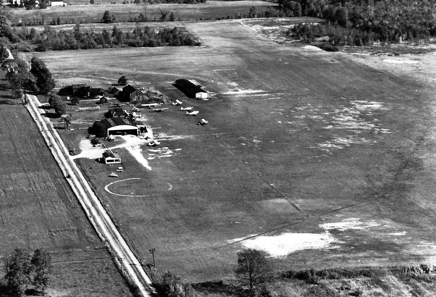
A 1994 USGS aerial view looking west at Auburn Airport.
This small airport was evidently established at some point between 1970-82,
as it was not yet depicted on a 1962 aerial photo, the 1964 USS topo map, or the 1970 Cleveland Sectional Chart.
The earliest depiction which has been located of Auburn Airport was a 1982 aerial photo.
It depicted a single grass east/west runway, on which was one single-engine light aircraft.
A longer northwest/southeast runway appeared to be in the process of being cleared.
Auburn Airport was not yet depicted on the October 1985 Detroit Sectional Chart.
The earliest depiction which is available of Auburn Airport was a 1994 USGS aerial photo.
The 2 runways had apparently been paved with asphalt at some point between 1982-94,
and a hangar had been added on the east side.
The earliest aeronautical chart depiction which has been located of Auburn Airport was on the April 1999 Cleveland Terminal Aeronautical Chart.
It depicted Auburn as a private field having a 2,800' unpaved runway.
The last aeronautical chart depiction which has been located of Auburn Airport was on the April 2009 Cleveland Terminal Aeronautical Chart.
It depicted Auburn as a private field having a 2,800' unpaved runway.
The 2013 USGS topo map depicted Auburn Airport as having 2 paved runways.
Kevin Kuhn noted that “Auburn Airport... had been listed as open for quite a while after it had looked abandoned on [aerial] images.”
A September 2013 photo looking northeast at a presumed hangar on the east side of Auburn Airport.
Auburn Airport was evidently closed (for reasons unknown) at some point between 2009-2018,
as it was no longer depicted on the 2018 Cleveland Terminal Aeronautical Chart.
A 2019 aerial view looking west showed the remains of Auburn Airport, with the 2 runways overgrown.
A 2019 aerial view of the presumed former hangar on the east side of the Auburn Airport site.
Thanks to Lee Corbin for pointing out this airfield.
____________________________________________________
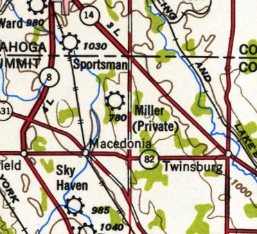
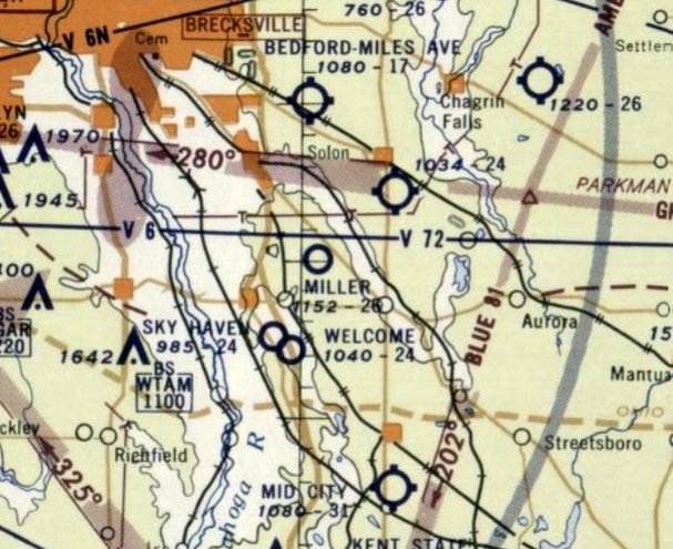
41.338, -81.492 (Southeast of Cleveland, OH)
Miller Field, as depicted on the November 1950 Cleveland Sectional Chart.
This small private airfield was evidently established at some point between 1947-50,
as it was not yet depicted on the July 1947 Cleveland Sectional Chart.
The earliest depiction which has been located of Miller Field was on the November 1950 Cleveland Sectional Chart.
It depicted Miller as a private airfield with a 3,000' unpaved runway.
Miller Field was depicted as a private airfield on the 1950 USGS topo map.
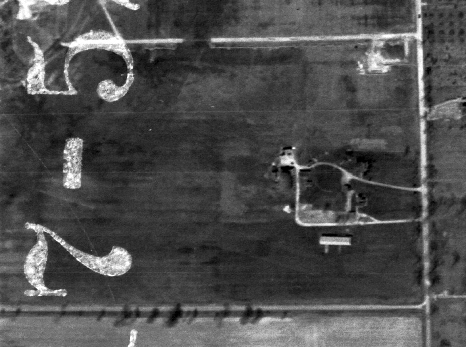
The only photo which has been located of Miller Field was a 4/17/52 USGS aerial view.
It depicted Miller as a rectangular property having a few small buildings on the east side,
but not aircraft were visible on the field.
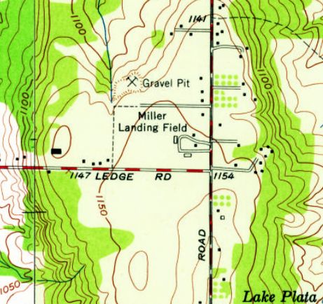
The last depiction which has been located of Miller Field was on the 1953 USGS topo map.
It depicted “Miller Landing Field” as a rectangular property having a few small buildings on the east side.
The last aeronautical chart depiction which has been located of Miller Field was on the July 1955 Cleveland Sectional Chart.
It depicted Miller as having a 2,800' unpaved runway.
Miller Field was evidently closed at some point in 1955,
as it was no longer depicted on the December 1955 Cleveland Sectional Chart.
Its closure may have been related to the constructed of Interstate 80 adjacent to the northeast side of the airfield property.
The airfield may also have been relocated to the north side of the Interstate, as Forepaugh Airfield was established in the 1960s.
Miller Field was no longer depicted on the 1963 USGS topo map.
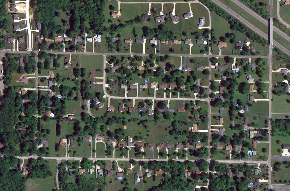
A 2014 aerial view showed no trace remaining of Miller Field.
As of 2015, street maps show that the housing development which covers the site of Miller Field
at least has street names which commemorate its previous life, such as Skyland Drive, Airlane Drive, and Cessna Drive.
____________________________________________________
Forepaugh Airport / Four Points Airport, Macedonia, OH
41.347, -81.495 (Southeast of Cleveland, OH)
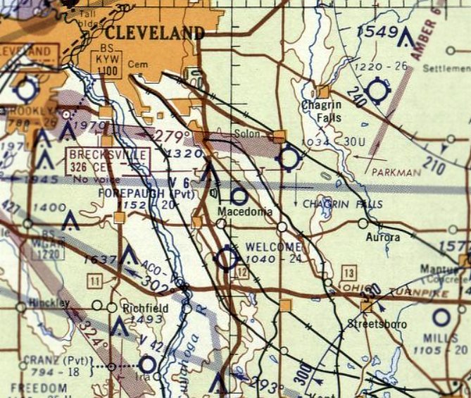
Forepaugh Airport, as depicted on the January 1961 Cleveland Sectional Chart.
This private airfield was evidently established at some point between 1960-62,
as it was not yet depicted on a 1952 aerial photo or the 1960 Cleveland Local Aeronautical Chart.
The earliest depiction which has been located of Forepaugh Airport was on the January 1961 Cleveland Sectional Chart.
It depicted Forepaugh as a private airfield having a 2,000' unpaved runway.
The earliest photo which has been located of Forepaugh Airport was a 1962 aerial photo.
It depicted 2 runways & a hangar south of the runway intersection.
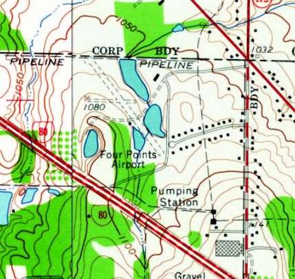
The 1963 USGS topo map depicted the airport under a different name: Four Points Airport.
It depicted it as having an unpaved northwest/southeast runway, and a much shorter & narrower unpaved east/west runway.
The earliest photo which is available of Forepaugh Airport was a 12/17/67 USGS aerial view.
It depicted 2 runways & a hangar south of the runway intersection.
The southeastern half of the primary runway had been paved at some point between 1962-67.
The last aeronautical chart depiction which has been located of Forepaugh Airport was on the November 1974 Cleveland Sectional Chart.
It depicted Forepaugh as a private airfield having a 3,000' paved northwest/southeast runway.
Forepaugh Airport was evidently closed (for reasons unknown) at some point between 1974-77,
as it was depicted as an abandoned airfield on the May 1977 Cleveland Sectional Chart.
The 1994 USGS topo map depicted 2 unpaved runways, but labeled simply as “Landing Strip”,
which may indicate the airfield was no longer in operation by that time.
The only photo which has been located showing an aircraft at Forepaugh Airport was a 1994 USGS aerial view looking southwest,
which showed one single-engine aircraft parked on the west side of the paved runways, near 2 small buildings.
A circa 2010 aerial view looking south showed the 2 buildings on the west side of the Forepaugh Airport runway.
A 2014 aerial view looking southwest showed the Forepaugh Airport runway remained in very good condition.
Lee Janotta reported in 2016, “Four Points Airport appears still fully intact but unused.
It's part of a retreat. I don't think that runway has ever been open to the public.”
Forepaugh Airport is located northwest of the intersection of Richmond Road & Interstate 480.
Thanks to Richard Finley for pointing out this airfield.
____________________________________________________
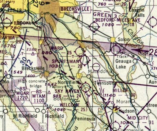
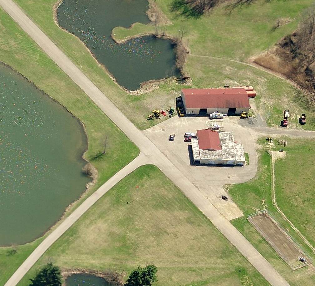
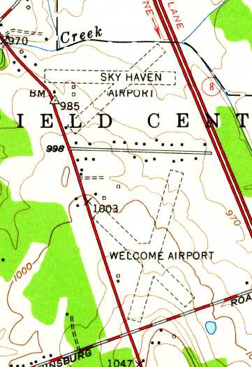
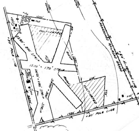
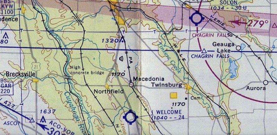
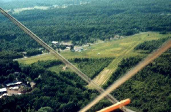
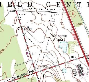
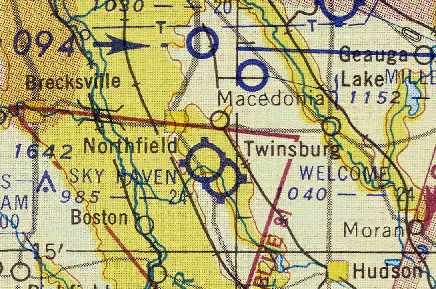
Sky Haven Airport (original location) / Welcome Airport / Northfield Airport, Northfield, OH
41.285, -81.515 (Southeast of Cleveland, OH)

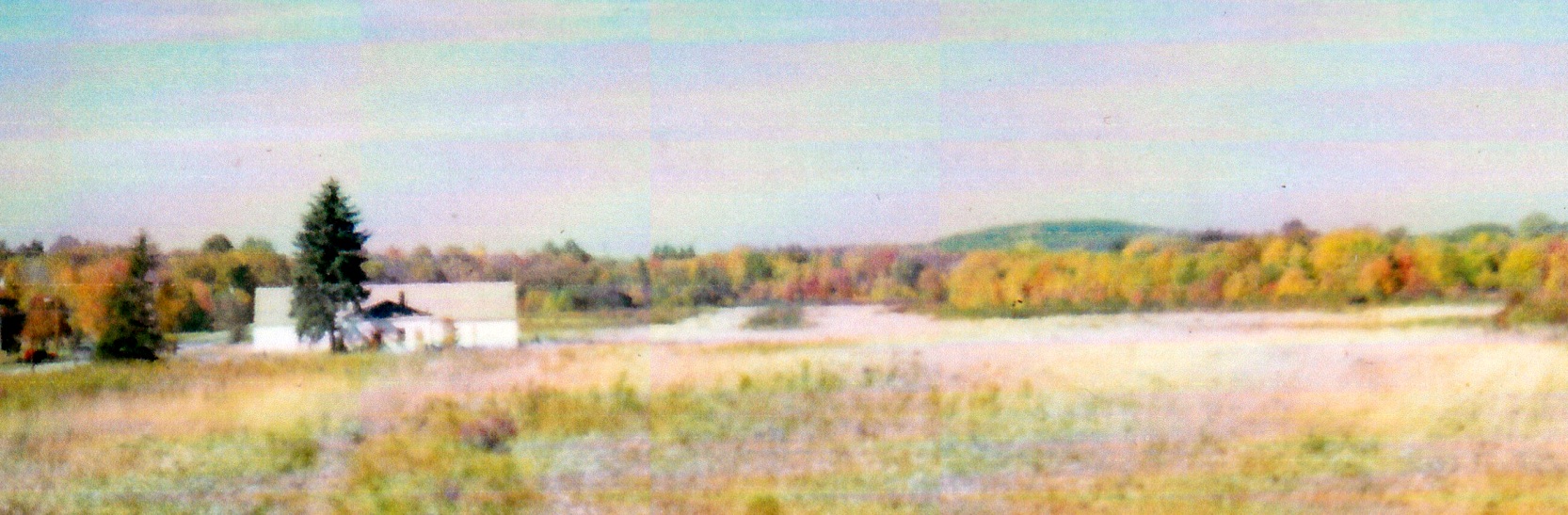
An aerial view looking east at Sky Haven Airport,
from The Airport Directory Company's 1938 Airports Directory (courtesy of Chris Kennedy).
The following information about Sky Haven / Welcome Airport was compiled by Jonathan Westerling:
"Welcome Airport remained open for some 50 years, serving local pilots with its nice turf runways.
The early history of the Welcome airport is best told by longtime pilot Russ Sholle,
who was intimately familiar with the airport."
Russ Sholle recalled, "Edward 'Slim' Honroth came to Northfield in 1933 and opened the Sky Haven Airport.
He came with a fellow pilot named Gail Mishler.
Slim had a 1927 WACO 9 Biplane & Gail had a Kinner Bird Biplane.
I tended to hang around the airport as often as possible [as a kid] since it was exactly one mile from our home.
When I was 14 years old I started doing odd jobs around the airport - greasing the valve rockers... etc.
As pay, Slim would give small bits of time in the air & I accumulated maybe 5 or 6 hours this way."
The 1934 Department of Commerce Airport Directory (according to Chris Kennedy)
described Sky Haven as having 3 sod runways.
The Airport Directory Company's 1938 Airports Directory (courtesy of Chris Kennedy)
described Sky Haven as having 3 sod runways, with the longest being a 2,300' northwest/southeast strip.
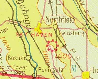
The earliest chart depiction of Sky Haven Airport which has been located
was on the February 1941 Cleveland Sectional Chart (courtesy of Chris Kennedy).
It depicted Sky Haven as a commercial airport.
Sky Haven was depicted as a commercial airfield
on the April 1943 Cleveland Sectional Chart (courtesy of Barnard Kemter).
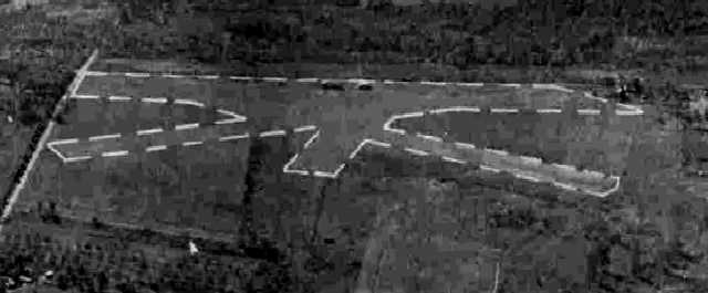
A 10/7/43 aerial view looking west from the 1945 AAF Airfield Directory (courtesy of Scott Murdock)
depicted Sky Haven Airport as having 3 unpaved runways.
Sky Haven was listed as an active airfield in the 1944 US Army/Navy Directory of Airfields (courtesy of Ken Mercer).
The June 1945 Cleveland Sectional Chart (according to Chris Kennedy)
depicted Sky Haven as an active airfield.
The 1945 AAF Airfield Directory (courtesy of Scott Murdock) described Sky Haven Airport
as a 100 acre irregularly-shaped property containing 4 clay, loam, and sod runways, with the longest being the 2,500' north/south strip.
The field was said to have 2 wooden hangars, the largest being a 64' x 48' structure.
Sky Haven was described as being owned & operated by private interests.
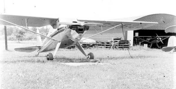
A 1946 photo by Russ Sholle (courtesy of Jonathan Westerling) of several taildraggers in front of a hangar at Sky Haven Airport.
Russ Sholle recalled, "I believe was late 1947 that Slim [Honroth]
lost his lease on his airport & we moved Sky Haven to its new location one mile north on Route 8.
A very interesting situation with 2 airports that close to each other having almost intermingling patterns."
The old Sky Haven airport location was bought by Mel Barron
and renamed Welcome Airport after Slim sued to give the name Sky Haven to his new airport.
However, strangely, there was no airport depicted at either location (Sky Haven or Welcome Airport)
on the 1949 Cleveland Sectional Chart (courtesy of Chris Kennedy).
The November 1950 Cleveland Sectional Chart depicted Welcome Airport as having a 2,500' unpaved runway.
A 4/1/52 USGS aerial photo depicted both the new Sky Haven Airport & the Welcome Airport.
Welcome Airport was depicted as having 4 unpaved runways, with 3 single-engine aircraft parked around a few small buildings on the west side.
The 1953 USGS topo map depicted both the new Sky Haven Airport & the Welcome Airport.
Welcome Airport was depicted as having 2 unpaved runways, with a few small buildings on the north & west sides.
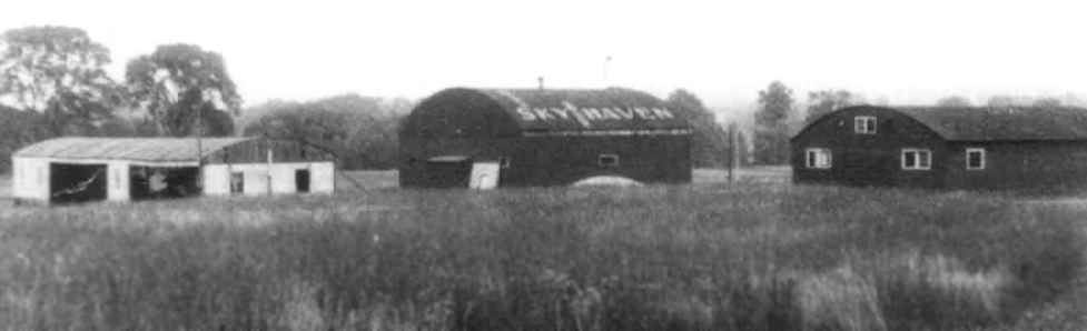
An undated photo (courtesy of Sam Ciocco) of 3 hangars at Sky Haven, one of which had the airport's name painted on the roof.
The 1955 Ohio Airport Directory (courtesy of Jonathan Westerling) described Welcome Airport
as having 3 grass runways: 2,400' north/south, 2,450 northwest/southeast, and 1,300' east/west.
The owner was listed as Welcome Aviation.
Both Welcome Airport & the 2nd location of Sky Haven Airport were depicted
on the January 1955 Cleveland Sectional Chart (courtesy of Chris Kennedy)
and the January 1958 Cleveland Sectional Chart (courtesy of Chris Kennedy).
Rich Peabody recalled, "I remember being perplexed about the proximity of these 2 airports when young.
It was even more confusing from the air... the patterns seemed to conflict in major ways.
Welcome had quite a few Swifts based there...
and the Swift can become fairly confusing in a hurry, what with hand cranked gear...
I recall that it became an almost annual event to learn that another Swift
had become captured by the trees that stood between the farm & Twinsburg Road...
especially hot, humid summer days, after rain, when the sod sucked the crafts to the ground a bit longer than expected."
By the time of the 1960 Cleveland Local Aeronautical Chart, only Welcome Airport was still depicted.
It was depicted as having a 2,400' unpaved runway.
A 1962 aerial view depicted a total of 11 light aircraft parked around a few small buildings on the southwest side of Welcome Airport.
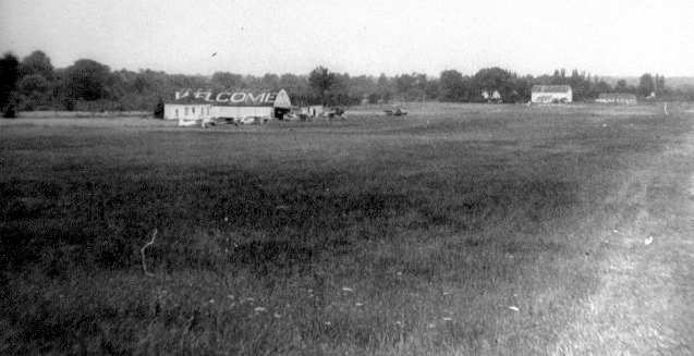
A 1964 photo of Welcome Airport showed 5 planes parked on the field (courtesy of the Historical Society of Olde Northfield, via Jonathan Westerling).
The 1964 Nordonia Hills directory of Community Organizations listed the Welcomaires as being based at the field.
"The Welcomaires was formed with the idea of promoting social & flying activities
among those who have an interest in flying, especially at Welcome Airport. The Club has 45 members.
There is a clubhouse to be used as a lounge & meeting place for the club members
where they can plan & carry out their social functions."
The 1967 AOPA Airports USA guide listed Welcome Airport as having 3 active runways:
2,400' sod Runway 2/20, 2,500' turf Runway 14/32, and 2,500' sod Runway 17/35.
R.J. Grega reported that his father had designed & built a homebuilt airplane (a GN-1 Aircamper) at Welcome Airport.
"His EAA club met out of old Welcome Airport, and he flew the airplane he designed out of that airport."
Susie Avant recalled, “Welcome Airport... John Coleman was the owner, manager, chief bottle washer in the late 1960s & 1970s.
There was also a lady by the name of Julie.”
The 1972 USGS topo map depicted the field as "Northfield" Airport.
Joseph Martanovic recalled, “The people in the 1970s at Northfield–Welcome were wonderful.
I was out of college & the Army & I wanted to learn to fly more than anything in my life... and I did, thanks to so many of them.
Later I got my instrument & commercial [pilot's license] and owned a Cessna 172 & the 'cherriest' 152 ever.
I did a lot of aerial photo work, since I was a business real estate broker. It legitimized my flying to my bosses, wife, and the IRS.
It was a magnificent part of my life. Much more than a hobby like golf or skiing. It was a way of life.”
Paul Shew recalled, “I lived next to Northfield Airport in the late 1970s & my father flew a Cessna from there regularly, to all sorts of locations in Ohio.
I have vivid memories of landing & taking off from the grass strip, and circling the airport.
I will never forget when our electrical system was out & we got help to hand-prop the plane to start it.”
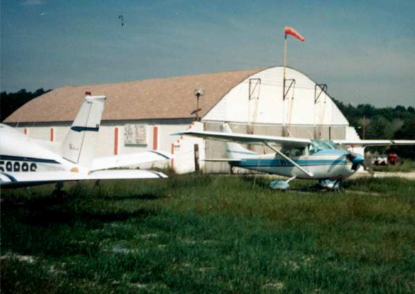
In 1981 the lease for Northfield Airport was transferred to the Northfield Pilots Association whose 82 members stored about 40 aircraft on the field.
The last aeronautical chart depiction which has been located of Northfield Airport was on the October 1985 Detroit Sectional Chart.
It depicted Northfield as a private airfield having a 2,400' unpaved runway.
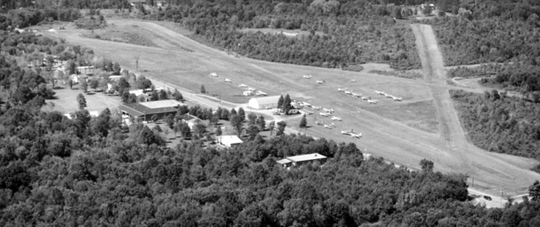
A 1986 aerial view looking northeast (courtesy of Dennis Thompson) depicted Welcome Airport perhaps at its zenith of popularity,
with over 20 light general aviation aircraft parked on the west side of the field.
In 1987, the Northfield Airport landowner, the DeBartolo Corp., offered the land to the association for $2 million.
Unable to pay that amount, the airport lease was revoked in favor of a "new project" on the site.
A 1987 photo by Ross Sholle (courtesy of Jonathan Westerling) of the main hangar at Welcome Airport, taken on the day of the airport's closure.
A 1987 aerial view of Welcome Airport taken by Ross Sholle (courtesy of Jonathan Westerling)
from his "Baby Lakes" biplane on the day of the airport's closure.
Ann Reville, who still lives across from the airport site, wrote on occasion of the airports closing,
"We moved our business out here because we liked the area & especially enjoyed the airport.
Many events have taken place [at the airport] including clambakes, parties, airshows, and more.
These events have brought people out to Northfield from Portage, Geauga, Cuyahoga and Lake counties.
We have been involved with the airport as long as we have lived here...
the closing is a shock to our family & other area pilots."
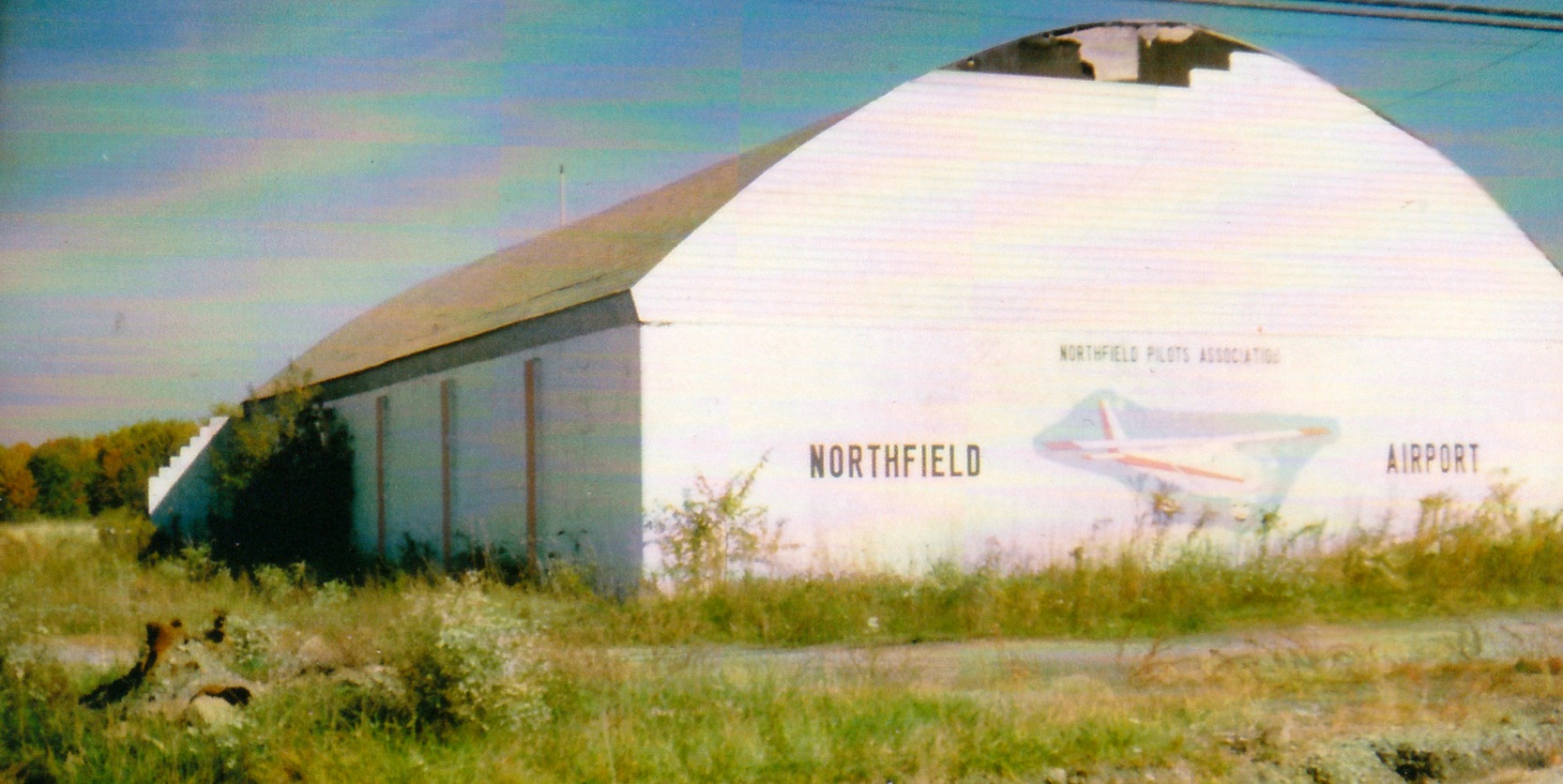
A 10/13/89 photo by Leon Cleaver of Welcome Airport's main hangar, painted with a mural by the Northfield Pilot's Association.
A 10/13/89 photo by Leon Cleaver looking north at the abandoned Welcome Airport.
The 1994 USGS topo map still depicted Welcome Airport, with 2 grass runways.
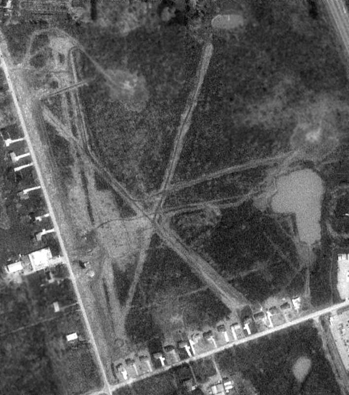
A 4/14/94 USGS aerial photo still showed 3 unpaved runways at Welcome Airport, although it appeared the hangars along the west side had been removed.
According to Jonathan Westerling, "In the mid-1990s a housing development was erected where the airport had been for decades.
I visited the site in 1996, and the rooftops of the 'Charter Lakes Estates' had recently been completed.
I couldn't see any remnants of the airfield,
though I believe the proprietor's quarters & clubhouse at the north end of the field are now a private residence."
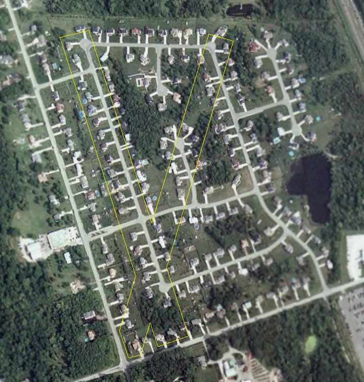
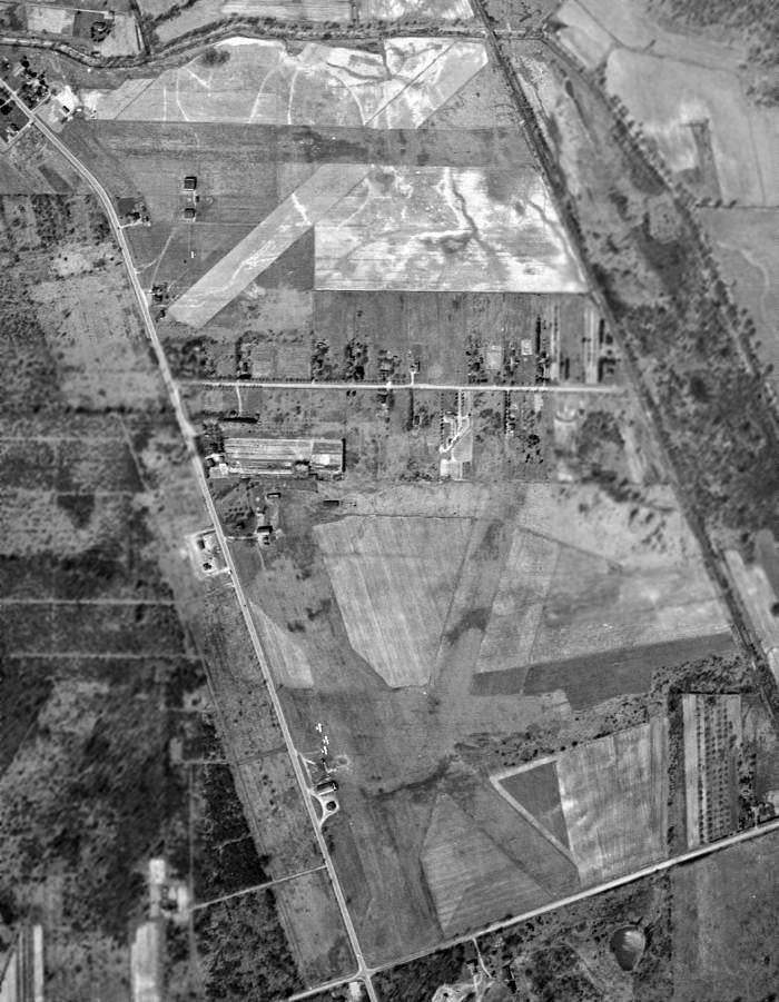
A 2006 aerial photo of the site of the Welcome Airport, annotated by Chris Kennedy to show the layout of the 2 former runways.
The site of Welcome Airport is located at the intersection of Olde 8 Road & Twinsburg Road.
____________________________________________________
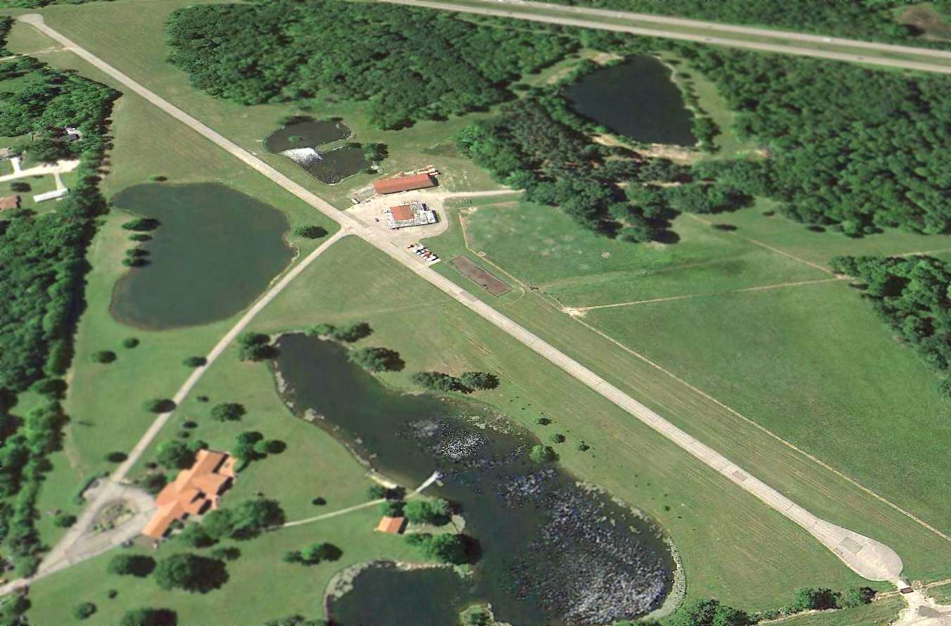
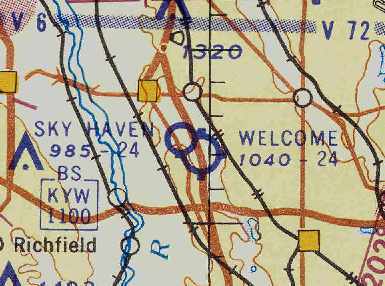
Sky Haven Airport (2nd location), Northfield, OH
41.293, -81.515 (Southeast of Cleveland, OH)
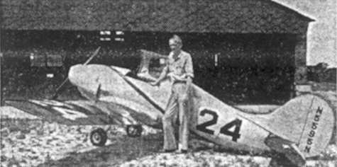
A 1949 photo (courtesy of Jonathan Westerling) of Slim Honroth, the founder of Sky Haven Airport,
pictured in front of an experimental midget racing plane he helped build, presumably at the 2nd location of Sky Haven Airport.
According to longtime pilot Russ Sholle, "I believe was late 1947
that Slim [Honroth] lost his lease on his airport [the original Sky Haven Airport]
and we moved Sky Haven to its new location one mile north on Route 8.
[It was] A very interesting situation with 2 airports that close to each other having almost intermingling patterns."
Inexplicably, there was no airport depicted at either location (Sky Haven or Welcome Airport)
on the 1949 Cleveland Sectional Chart (courtesy of Chris Kennedy).
Russ continued, "The name Sky Haven continued in our new location.
Unfortunately, Slim was killed 2 years later testing a midget Racer that he had refurbished at Akron airport.
His wife Lucille continued to operate the new Sky Haven
and I went back to help her with the Civil Air Patrol program."
The November 1950 Cleveland Sectional Chart depicted Sky Haven Airport as having a 2,400' unpaved runway.
The last photo which is available of the new Sky Haven Airport was a 4/1/52 USGS aerial photo, which also depicted the adjacent Welcome Airport to the south.
Sky Haven Airport was depicted as having 2 unpaved runways, with a few small buildings on the southwest side.
The 1953 USGS topo map depicted both the new Sky Haven Airport & the Welcome Airport.
Sky Haven Airport was depicted as having 2 unpaved runways, with a few small buildings on the southwest & south sides.
Both Welcome Airport & the 2nd location of Sky Haven Airport were depicted
on the January 1955 Cleveland Sectional Chart (courtesy of Chris Kennedy).
The "new" Sky Haven Airport was depicted as having a 2,400' unpaved runway.
The 1956 OH Airport Directory (courtesy of Chris Kennedy)
depicted Sky Haven as having 2 sod runways, with the longest being the 2,400' east/west strip.
Two small buildings were depicted just southwest of the runway intersection.
The field was said to offer fuel & storage,
and the manager was listed as Mrs. E. P. Honroth.
The field was depicted as being located on the northwest corner of Route 8 & Hazel Drive,
directly across Hazel Drive from Welcome Airport.
The last chart depiction of Sky Haven Airport as an active airport which has been located
was on the January 1958 Cleveland Sectional Chart (courtesy of Chris Kennedy).
Rich Peabody recalled, "I remember being perplexed about the proximity of these 2 airports when young.
It was even more confusing from the air... the patterns seemed to conflict in major ways.
Welcome prevailed... I remember there were rumors that Sky Haven was going to be a 'fly-in' community,
but upon aerial inspection, there were no runways."
According to Russ Sholle, "I don't know exactly when she [Lucille Honroth] closed the airport
but it became a housing development."
The 2nd location of Sky Haven Airport was closed at some point between 1958-60,
as it was no longer depicted on the 1960 Cleveland Local Aeronautical Chart.
A 1962 aerial view depicted houses covering the southwest portion of the 2nd location of Sky Haven Airport.
Sky Haven Airport was no longer depicted on the 1963 USGS topo map.
A 4/14/94 USGS aerial photo of the site of the 2nd location of Sky Haven Airport
did not show any trace of a former airport - the site was covered by housing & trees.
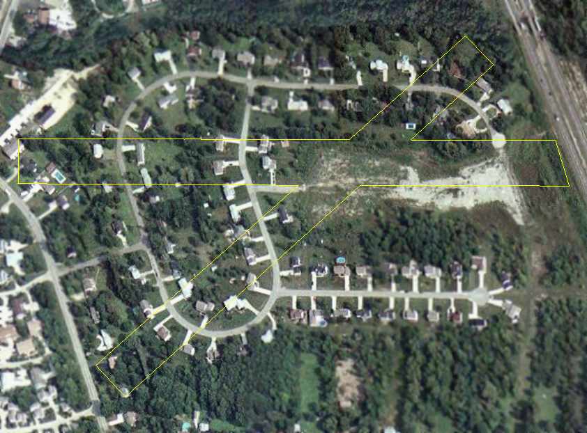
A 2006 aerial photo of the site of the 2nd location of Sky Haven Airport,
annotated by Chris Kennedy to show the layout of the 2 former runways.
The site of the 2nd location of Sky Haven Airport is located northwest of the intersection of Route 8 & Hazel Drive.
The former airport is commemorated by the names of one of the streets
in the residential development which occupies the site - Skyhaven Road.
____________________________________________________
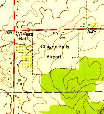
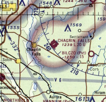
Chagrin Falls Airport (5G1), Chagrin Falls, OH
41.43, -81.333 (East of Cleveland, OH)
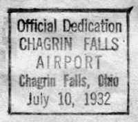
A postmark commemorating the 7/10/32 dedication of Chagrin Falls Airport.
The Chagrin Falls Airport was officially dedicated on 7/10/32, according to a commemorative postmark.
An article in the 7/14/32 issue of the "The Chagrin Falls Exponent" (courtesy of Phil Sasak)
was entitled "Thousands at Airport Sunday - Dedication & Air Show Attracts Crowds Beyond All Expectations".
It described the dedication of the Chagrin Falls Airport:
"Over 10,000 Estimated In Attendance - David Ingalls Delivers Dedication Address -
Roads Blocked For Miles While Stunts Were In Progress -
Many Famous Flyers Guests - 28 Ships in Attendance.
Chagrin Falls on Sunday was the aviation center of the country
when it had as its guests a majority of the most important flyers of the United States, at the dedication of its new airport."
The article continued, "David Ingalls, naval war ace, flew from his home in Hunting Valley to the airport & made the dedicatory speech.
He told the thousands that had gathered that, 'airports are the backlog of aeronautical development.
It is a great tribute to the progressiveness of Chagrin Falls that your citizens are taking up this most modern form of transportation.'
The dedication service was held in the new hangar
and the voices of F.J. Rowe, chairman of the arrangements,
Mayor J.C. Steel, and David S. Ingalls were carried over the loud speaker system on the field,
so the thousands that had flocked to the airport to see the imposing array of famous flyers
whose aerial demonstrations were part of the dedication, could hear the program."
The article continued, "The list of visiting pilots included Major 'Jimmy' Doolittle
(winner of the Bendix trophy race & holder of the west-east transcontinental record),
Major Alexander deSeversky (Russian war ace), and Eddie Rickenbacker.
Three planes of the 112th Observation Squadron of the OH National Guard
opened the program with an exhibition of formation flying.
Then, Major Seversky, flying a gold & white biplane,
gave an exhibition of stunt flying which included some of the most intricate maneuvers known to aviation."
The article continued, "A stiff wind aided James Ray, of Philadelphia, the country's leading autogyro pilot,
in taking off in his 'windmill' ship with practically no running start.
He climbed steeply & after hovering about the field for some minutes, came straight down to an easy landing.
At 4:00 Postmaster Howard Foster dispatched a special pouch of mail
containing 388 letters with a special dedication stamp.
This was the first mail from the airport.
D.C. Stem flew the plane carrying the postmaster & the mail to the Cleveland airport.
It was hard to estimate the exact size of the crowd as there was no way to check them,
but it is safe to say that over 10,000 people visited the airport on Sunday.
Some 28 different ships landed at the airport during Sunday, and the last of the flyers departed Monday afternoon.
No accidents occurred except for the Standard Oil ship nosing over in the strong wind during the morning.
The airport is on the Albert Warren farm 2 miles east of Chagrin Falls on Bell Road."
The earliest aeronautical chart depiction which has been located of Chagrin Falls Airport was on the December 1932 Cleveland Sectional Chart.
It depicted Chagrin Falls as a commercial/municipal airfield.
The Airport Directory Company's 1933 Airports Directory (courtesy of Chris Kennedy)
described Chagrin Falls as a commercial airport having 2 sod runways: 2,850' east/west & 2,650' north/south.
A hangar & other buildings were said to be located on the northeast side of the field.
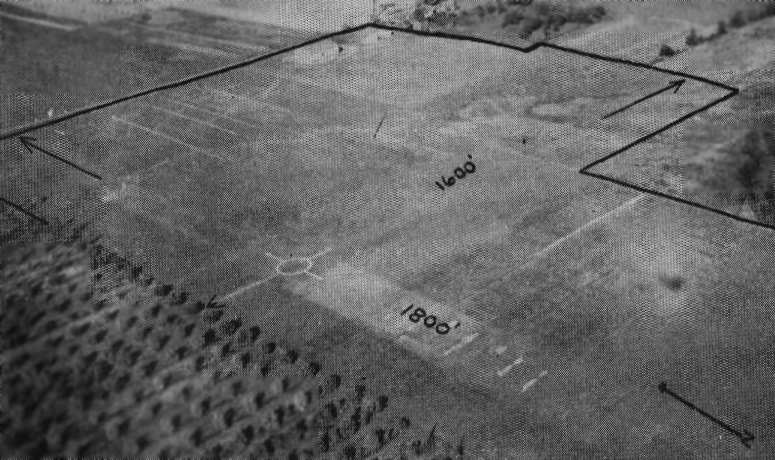
The earliest depiction which has been located of Chagrin Falls Airport was an undated aerial view looking northeast
from The Airport Directory Company's 1937 Airports Directory (courtesy of Bob Rambo).
The directory described Chagrin Falls as having 2 sod runways: an 1,800' north/south strip & a 1,600' east/west strip.
The hangar was described as having "Chagrin Falls" painted on the roof.
Bill Meyer recalled of Chagrin Falls Airport: “My father, also Bill Meyer, learned to fly there in 1937 & his logbooks show flights there up through 1941.
He flew Taylor Cubs, Piper Cubs, Taylorcrafts, Stinsons, Standards & some others including his Monocoupe.”
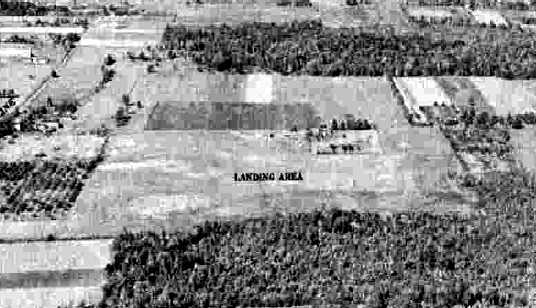
A 10/7/43 aerial view from the 1945 AAF Airfield Directory (courtesy of Scott Murdock)
depicted Chagrin Falls Airport as having an open grass landing area.
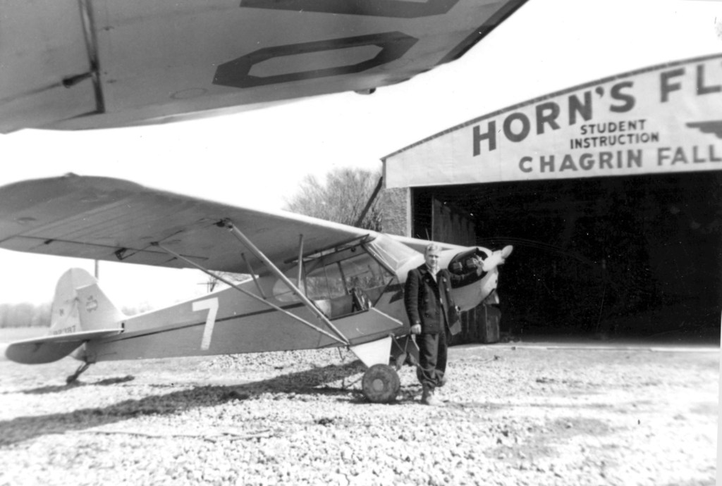
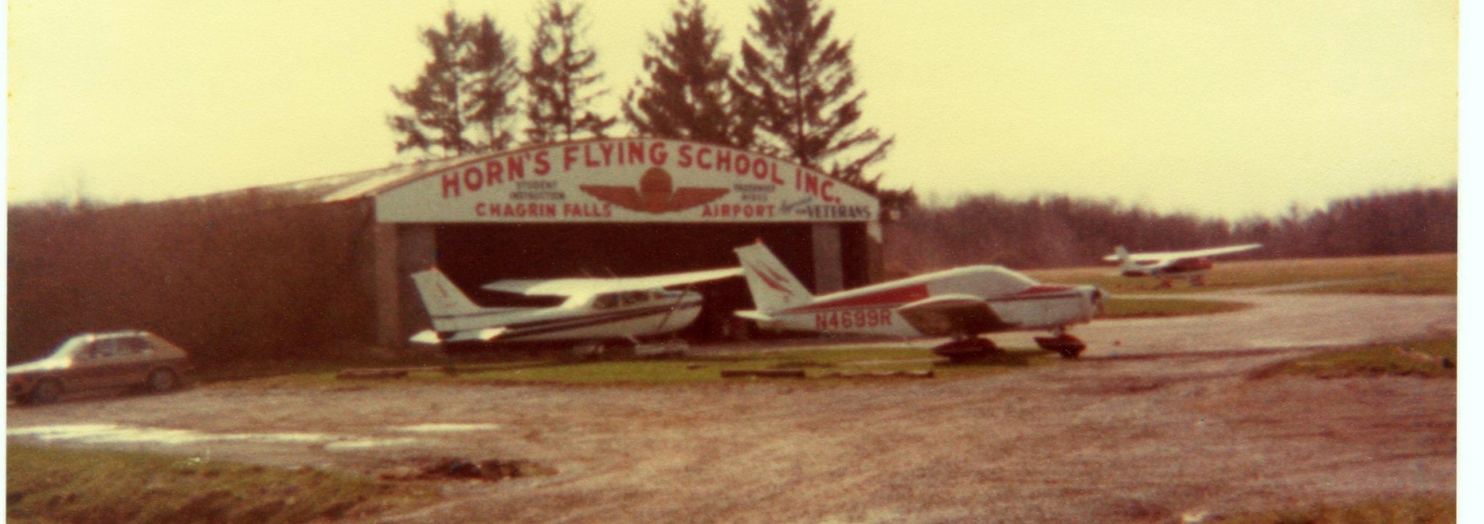
A Spring 1947 photo of a 20 year old Joe Hustosky in front of a Piper Cub & a Horn's Flying School hangar at Chagrin Falls (courtesy of Al Hustosky).
A Spring 1947 photo of 3 unidentified men in front of a Piper Cub & a Horn's Flying School hangar at Chagrin Falls (courtesy of Al Hustosky).
According to a history of the area, many famous Americans visited or flew into the airport
and hundreds of pilots trained there during & after WW2.
The 1945 AAF Airfield Directory (courtesy of Scott Murdock) described Chagrin Falls Airport
as a 90 acre irregularly-shaped property containing 4 clay & sod runways, with the longest being the 2,100' northeast/southwest strip.
The field was said to have 2 hangars, the largest being an 80' 60' steel & tile structure.
Chagrin Falls was described as being owned & operated by private interests.
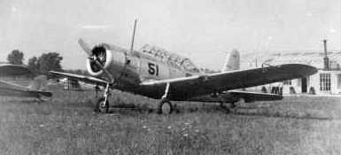
A circa 1940s photo of a Vultee BT-13 at Chagrin Falls (courtesy of Bob Wing).
Bob Wing recalled, “Chagrin Falls Airport... where my father & grandfather learned to fly.”
Steve Krieger recalled, “For many of my younger years, I lived directly across Bell Road from the old Chagrin airfield.
As a young child, I used to sit in my gravel driveway & drive my cast-metal planes through 'take off' & 'landing'
while watching the real thing occur across the street.
I used to walk across the street to the old hangar & poke around, looking at the planes that were in the hangar or parked (tied down) outside.
There was at that time a biplane or two based there - I was too young to know what type they were.
But I do remember seeing a yellow Piper Cub (remember the "teddy bear" on the tail!) at the time.”
Ruth Mc Ilrath Cavanagh reported, "My dad was David Mc Ilrath
who was the lead instructor at Horn's Flying School for a long time.
He grew up with that airport.
Don Hein did manage the place for Wilbur Horn.
He took less pay but made up for it in that he slowly became owner of the place over a long period of time.
Clifford Rentz… he & his brother Gene were custodians & flyers at the airport.
My dad part-owned a plane with the Rentz brothers in the late 1940s,
how they loved flying, but had no money to support the habit.
I am sure it is why my dad taught."
An October 1951 aerial view looking east at Chagrin Falls Airport (courtesy of Jim Weiss)
depicted 10 light single-engine aircraft parked among the hangars on the north side of the grass airfield.
A 4/17/52 USGS aerial view depicted Chagrin Falls Airport as an open grass field, with several buildings & 5 light single-engine aircraft along the north side.
The 1953 USGS topo map depicted Chagrin Falls Airport as an irregularly-shaped outline, with several buildings along the north side.
D.S. Braden recalled, “I learned to fly & soloed at the Chagrin Falls Airport in 1954 - as I recall it was a Piper J3.”
A still from a mid-1950s 16mm movie of Jim Weiss & an Aeronca 7AC at Chagrin Falls Airport.
Jim recalled, “My father drove me out to Chagrin Falls Airport for my first flying lesson in 1955, at age 13.
I was 2 years behind Herb Rosenthal in the Shaker Heights school system.
My first lesson was in a J-3 Cub, but I never felt like a pilot, sitting in the back seat. So, I switched to an Aeronca 7AC.
My instructor for almost all my lessons was Don Hein. He was like a second father to me.
In the late 1950s, I checked out in a Piper Tri-Pacer, which to me was like flying an airliner out of Chagrin Falls Airport.”
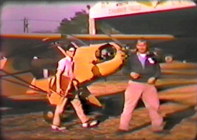
A still from a mid-1950s 16mm movie of Jim Weiss & Don Hein in front of a Piper J-3 Cub at Chagrin Falls Airport.
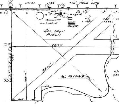
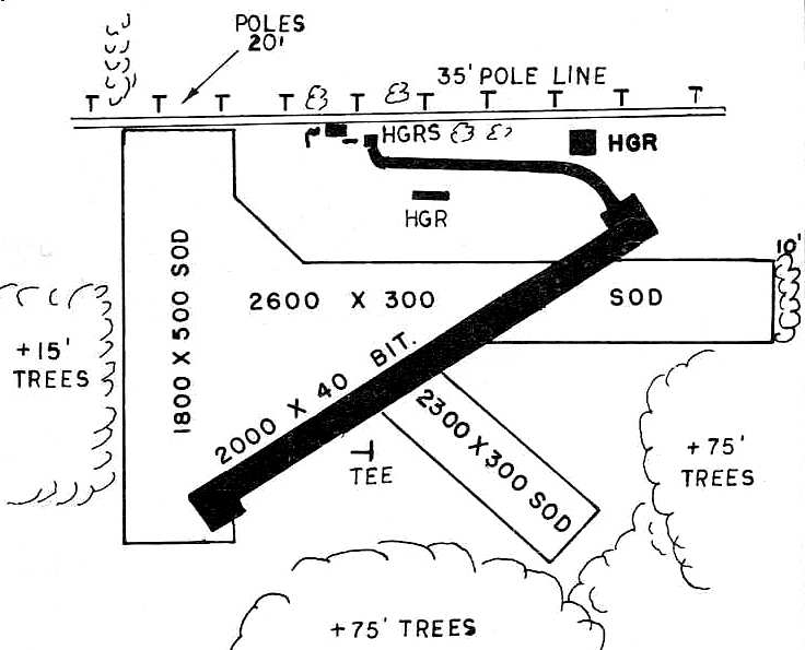
The 1955 OH Airport Directory (courtesy of Stephen Mahaley)
depicted Chagrin Falls as having an all-way landing area, measuring 2,600' x 1,500'.
Several small hangars were located along the north side of the field.
The operator was listed as Horns Flying School Inc.,
and the manager was listed as Don Hein.
Herbert Rosenthal recalled, “Chagrin Falls Airport... I learned to fly there in 1958-59 when I was in high school.
Piper Cubs. It had about 4 runways & eventually paved one of them.
After I moved to Washington, DC, from Cleveland, I would fly home to visit family
and Chagrin Falls was as good as any place to land as it was about 20 minutes from relatives.
David McIlrath was an instructor when I was there. He was the postmaster I believe in Chagrin Falls.
He gave me the night training I needed to remove the night restriction from my commercial certificate. We waited until September.
He put several battery or kerosene lanterns along the east/west runway
and on one or two nights, I completed whatever nighttime was needed to remove the restriction.
I think David Ingalls had his own private airstrip on his estate nearby.
Don Hein was a designated examiner. But in 1959 the FAA wanted to bring all the flight tests in-house to inspectors.
It was September of 1959 & I had spent many hours trying to get ready for my private check ride -
just finding decent weather for my long cross country took a long time.
My going to freshman year at college was fast approaching
and Don Hein inveigled the FAA GADO to allow him to give me my private pilot flight test as an examiner a day or two before I had to depart.”
The 1960 Cleveland Local Aeronautical Chart depicted Chagrin Falls Airport as having a 2,600' unpaved runway.
Herbert Rosenthal recalled, “In 1961 in the summer when after about 2 months, I earned my LFI,
Don was good & gave me students near completion so that I could have 5 recommendees pass their flight test & convert to a CFI.”
Roald Lutz recalled, “I grew up at Chagrin Falls Airport.
My Dad hangared his Stinson Voyager there from 1961 until it closed in 1979.
We had the corner T-hangar on the east/west taxiway facing south.
The ground would get soft in the spring thaws & keep us inside for a few weeks.
In the summer, we kids would gather the long grass mowed from the grass runways & make forts & nests.”
In the 1962 AOPA Airport Directory,
Chagrin Falls Airport was described as having a total of 4 sod runways, with the longest being 2,600'.
The operator was listed as Donald Hein.
A 1962 aerial view depicted Chagrin Falls as an open grass field,
with several buildings & 7 light aircraft along the north side.
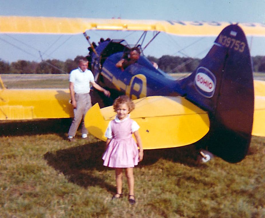
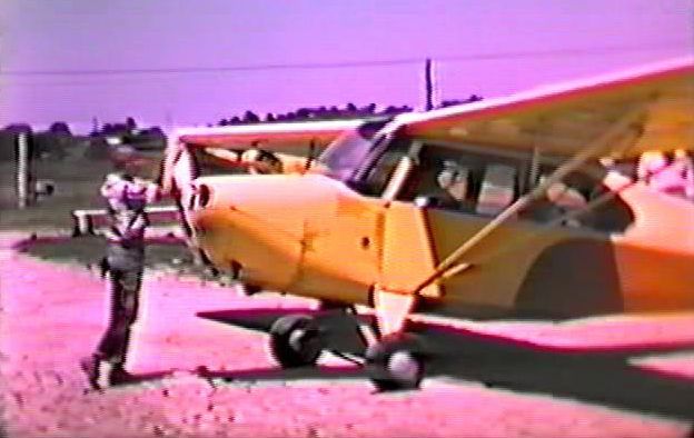
A summer 1964 photo of N39753, a 1942 Waco UPF-7, serial #5886, part of Barnhill's Air Circus at Chagrin Falls Airport.
Carl Denk recalled, “I started flying at Chagrin Falls Airport 7/22/65 in a J-3 with my first flight in N6013H.
Don Hein tested me for my Private [Pilot's License] 10/30/65 in PA-18 N1650P.
An interesting thing happened. The Omnigator between my knees quit working.
Don loosened his seat belt in the back seat & leaned over my shoulder to play with the radio.
Of course that big shift in center of gravity, caused a nose down condition, to which I responded correctly with a firm pull back on the stick.
Well, you know that plane as was typical, was setup with dual controls including a rear control stick, which met with Don's groin smartly!
Don sat back down, and announced that he had seen me navigate the VOR before, and I should proceed direct to the airport, where I received my Private. :)”
Carl continued, “The tree(s) at the Southwest end of the runway were planted there by the feuding owner.
In the middle of a night, the trees were cut down. I don't think anyone was every arrested for the deed.
Shortly after I landed a Navion there, a little low over the former tree site, added some power.
When I got to the office, there had been a phone call of a noisy airplane.”
The northeast/southwest runways at Chagrin Falls Airport was apparently paved at some point between 1962-66,
as the 1966 OH Airport Directory (courtesy of Chris Kennedy) depicted in as a 2,000' bituminous strip.
Don Hein was part owner & manager of Chagrin Falls Airport,
and was described as a stickler for all of the planes to be fully functional.
Bill Pine was the chief pilot at Chagrin Falls Airport.
Rick Boswell recalled, “I began flight instruction at Chagrin Falls / Horns Flying School in 1966 while a PhD graduate student at Case Western Reserve University.
Don Hein was the owner/manager, with Grace Parks handling scheduling & other office duties.
I flew with several instructors while working on my private certificate, with most of my dual with Richard (Dick) Molnar;
we started in a Piper Colt but soon switched to a Cessna 150 as I was thinking about eventually owning a Cessna 172.
An hour in the C150 went for $12 solo & $14 dual, with 80 octane avgas at 32 cents/gallon. Don Hein kept a close eye on things.
One day while mowing the grass, he noticed that I was not using flaps while in the pattern practicing landings,
as I had been advised by my instructor not to use flaps for crosswind landings.
He motioned to me to taxi in, jumped in the plane with me, and proceeded to chew me out royally (as Don could do with great proficiency)
and then proceeded to fly with me until he was happy with my landings.”
Rick continued, “In the early Spring of 1967 I was working in the pattern & had just landed on Runway 24
and turned around to back-taxi as there was no paved taxiway back to the opposite end.
Part way down the runway, I noticed another aircraft close in on approach to 24 & decided to taxi off the runway to allow this aircraft to land.
I didn’t count on the soft ground which resulted from recent Spring rains & promptly got stuck in the mud.
Don had to come out with his tractor to pull me out - a bit embarrassing, and my most serious 'incident' in 50 years (and counting) of flying.
One instructor at Horns’s taught me something I have never forgotten.
Talking about the C150 we were flying, he said, 'This thing will kill you if you let it.'
He was not trying to scare me but, rather, to motivate an appropriate aviation safety mindset. It worked!
Rick continued, “Horn’s was perhaps ahead of its time in that the school had a simulator on premises & used this for instrument training.
This sim appeared to be a classic 'Blue Box' Link Trainer, and while primitive by today’s standards, I found it helpful for instrument basics.
Chagrin Falls / Horn’s will always have a special place in my aviation memories.”
Bill Twyman recalled, “I had gotten my private [pilot's license] from Don Hein several years earlier & had been flying anything I could get my hands on.
I finally was able to finish up with getting my CFI [Certified Flight Instructor rating] and approached Don in late 1967 about an instructor slot at Chagrin.
He hired me & I worked part-time during school at Kent State University knowing that I was 1A & going in to the Navy as soon as I graduated, which was set for August 1969.
I had been flying with John Schofield who drove out from Shaker Heights. John was not just good, but a great student.
He had about 8 hours (like I had when I soloed) & I knew he was ready to solo, but that day 4/18/68, was crappy with low ceilings, drizzle & cool temperatures.
John had had a knee injury & had recently had a knee operation, so he would preflight the C-150 & get in, and I would set his crutches in the office & off we would go into the wild blue.”
Bill continued, “This particular day, I felt we could stay visual in the pattern so we just did touch & goes to keep him sharp.
On the last pass, I decided to test his mettle with a simulated forced landing, so I pulled out the carb heat & throttle while on crosswind just west of Chagrin Falls.
We were over a large, freshly plowed, soggy farm field. That field is still there with an electric sub-station on the edge of the field.
John circled down & was set up nicely for the field when I decided to take it for the go around.
Unfortunately, what you don't know can & often will bite you in the butt.
I had almost all my previous flying in Pipers & was new to Cessnas where you have to keep the exhaust manifold warm to keep heat to the Carb.
When I pushed in the throttle, there was no engine response.
As I had the plane, and we were approaching a tree, I elected to bank right to miss the tree & the right wing caught the ground, cartwheeling us.”
Bill continued, “John saw it coming & braced, so only got minor cuts on his face from plexiglass.
I had my hands on the control & throttle, so ate the instrument panel & took a nap for a while as John pulled me out the left door & to the end of the wing.
Fortunately, there was no fire, and we both recovered quickly. The airplane N2272J.
It wasn't until the next day that I got a copy of the Cleveland Plain Dealer with the story line,
'Son of prominent Schofield Family injured in plane crash!' OMG! I had no idea he was prominent anything. His dad owned the Schofield building at 9th & Euclid.
The best part of the story is that after I had been home for a couple of days, Don Hein called me at home.
I was not scared to talk to him, but I did expect to be told not to come back to work.
Instead, after he inquired about my condition, his ONLY question to me was, 'When are you coming back to work?'
What a guy! He could be very gruff, at times, but that told me he had a heart of Gold.
Actually, after that I did have a few dates with his daughter & have a huge respect for Don.”
Bill continued, “In October 1969 I left to go to the Navy Officer Candidate School in Pensacola & entered Navy Flight Training for jets.
I finished & received my Navy Wings in late 1970 & was offered a spot being a Navy jet Instructor as a plowback at NAS Kingsville, TX flying TA-4J Skyhawks.
In 1971 or 1972, my wife's father died in Cleveland, so I took a student on a cross country to see her at Columbus.
On Sunday, a clear & beautiful day, we left & I received permission from ATC to do a simulated approach to Chagrin Falls Airport, in a Navy TA-4J,
where I couldn't go slower than about 150 kts to keep from falling out of the sky, full flaps & gear down.
I asked ATC to call the office to inform those in the pattern I would be coming through.
As I left the VOR inbound, I was hoping everyone would be clear of the pattern, and they were.
At least I didn't see anyone nearby. As I crossed Bell Street, I shoved it to full throttle & pitched the nose up about 15 degrees to start climbing.
OMG! That 2,400' runway disappeared almost immediately & I found myself over the farmhouse where the trees had been planted, with a jet engine at full throttle.
CLE center had precleared me to unrestricted climb to 10,000', at which point I headed for Grissom AFB in Indiana for some fuel.
Probably not the smartest thing to do, but Don LOVED IT! I didn't let the wheels touch ground, but we were within 50'.
About a year later, I stopped in for a visit & he couldn't stop talking about the farmer with the trees calling him & accusing Chagrin of flying jets out of their little 2,400' strip.
That was my last time there before the field closed, and my last time to see Don, Bill Pyne, Lyle, and the others.”
Jim Weiss recalled, “I finished off my private ticket during my freshman year at the University of Wisconsin.
Then in 1969, I joined a partnership in an almost-new Piper Arrow. One of my first flights was over to Chagrin Falls Airport to show Don.
I got Don out of the little terminal building, and proudly announced, 'I want you to meet your new grandson!'
To my surprise, Don just scowled & said, 'Now what would you want to do that for?'
I sadly didn’t get to share my next 5 airplanes or my airline career with Don.
So I’ve come almost full circle. I now own a 1957 Piper Tri-Pacer, and Don is next to me, in spirit, on every flight.”
Bill Lipstreu recalled, "I was the Cessna salesman who frequented the airport, but actually, I learned to fly there in the 1960s.
Bill Pyne was my flight instructor, but I finished with Tina DeBlaey & Bill Pfarr in 1975, shortly after returning from college.
I then got a job with Cessna & based my factory demonstrator at Chagrin."
David Greenhut recalled, “The airport where I learned to fly... Chagrin Falls Airport (5G1).
I came to Chagrin Falls Airport because my Junior High School (Byron Junior High in Shaker Heights) had a flying club,
run by my mechanical drawing teacher, Richard Tappendon.
We met weekly to watch old WW II training films, and the highlight of our year was a Saturday field trip in June 1968 out to Chagrin Falls Airport
for our $5 'Introductory Flight' being offered at the time by Cessna.
The aircraft was a 100 hp Cessna 150 (N6967S), and the instructor was Dennis Churgovich, the CFI who soloed me later that summer.
Mr. Tappendon had a Luscombe 8A that he kept tied down there.
I took all my initial training in a J-3-C65 Piper Cub, N98029 (which was only $15/hour wet w/instructor!). I soloed on 8/28/68.
Most but not all of the operations that summer were from the paved runways (6/24),
but occasionally we operated from the sod runway to get crosswind practice.
That was always sporty since you could not see the paved runway until just before you crossed it because of a swale at the southwest end of the field.
Of course, with no electrical system (this was before the days of handheld radios), we had no way of knowing if someone was taking off or landing except 'see & avoid'.”
David continued, “After my solo I 'graduated' up to the Cessna 150 so I could learn to use radios for navigation & communication.
Some of the 150s around at the time were N6967S, N60369, N6968S, N50928 and N7109S.
I also flew with Bill Pyne, Dave Lindsey, Chuck Migyanko, Nina Para & Bill Twyman.
I also recall some kind of feud the airport had with a neighboring farmer,
who would not allow the airport to trim some cypress trees on his property which blocked the departure end of Runway 24.
I believe they finally went to court over it.”
David continued, “Don Hein was the airport owner & FBO, assisted by a woman named Grace (perhaps his wife?) who did scheduling & answered the phones.
By the summer of 1969 we had pilot-controlled lighting for the rare night flight, triggered on 122.8 Mhz.”
A circa 1961-79 photo by Roald Lutz “of the chief mechanic at Chagrin, Lyle Staffield, with his Dart.
He was always took very good care of all the planes at Chagrin.”
The last aeronautical chart depiction which has been located of Chagrin Falls Airport was on the May 1970 Cleveland Sectional Chart.
It depicted Chagrin Falls as having a 2,000' paved northeast/southwest runway.
James Akers recalled of Chagrin Falls Aiport, "I soloed there 6/16/70. One of my instructors was Bill Pyne.
The airport at the time had a concrete runway that was 2,400'. There were also one or 2 sod strips & a hangar/office.
Don Hein was an FAA examiner & a great pilot."
Herbert Rosenthal recalled, “To me, coming back say in 1973 or maybe even later, it was like going back in time.
It had been 10 years or so since I had spent a lot of time there teaching part-time.
But yet the same chief pilot (Donald Hein); the same mechanic (Lyle); and the same secretary/bookkeeper (Grace) were there.
It was like going back in time & nothing had changed.”
Richard Woodward recalled, “I learned to fly at Chagrin Falls Airport & got my Private Pilots License in 1974 there. It was a great place!”
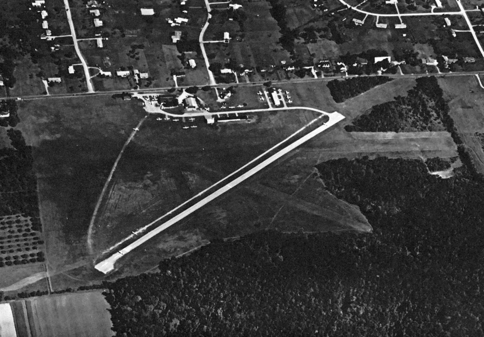
A 1976 aerial view looking north at Chagrin Falls Airport (courtesy of Jim Weiss)
depicted it as having a paved northeast/southwest runway & 2 grass crosswind runways.
The little airport appeared quite popular, with 2-dozen light aircraft visible, including 2 on the runway.
The last aerial photo which has been located of Chagrin Falls Airport was a 3/11/77 USGS aerial view.
It depicted Chagrin Falls as having a paved northeast/southwest runway, with several hangars on the north side.
John Blosser recalled, "As a youngster, I lived in Chagrin Falls & frequently visited the airport.
I began to visit the airport in 1977, when I was about 12 years old.
I completed a private pilot ground school there during that year.
The airport's operator was Horn's Flying School; its owner was Horn & Hein Realty.
Don Hein was the airport manager. The school had Cessna 150s & 172s as well as a 152 acquired in 1978.
One of the 150s was N19463, one of the Skyhawks was N19683.
I believe the 152 was N734RN or 737RN. They also owned a J3 Cub which was painted in a bicentennial paint scheme.
The airport had FAA identifier 5G1. It had an approximately 2,0000' paved Runway 6/24.
The runway was rather narrow & had some undulations in it. It was on Bell Road just east of Route 306,
at the site of the current Kensington Greens housing development in South Russell.
I recall that at night, Flight Service would contact the South Russell Police
to come & turn on the runway lights if you needed them.
There was a large hangar at the northwest corner of the property which had an office & pilot lounge/classroom attached to it.
There was a maintenance hangar a little east of it & I believe some t-hangars further east of that."
John continued, "There were some really fine people associated with the airport.
Besides Don Hein, I remember instructors Bill Pyne, Al Kovar & Christine DeBlaey.
They had an excellent mechanic named Lyle & a lineman named Andy Borsi who I believe became an aircraft & powerplant mechanic.
The local Cessna salesman was Bill Lipstreu. He frequented the airport.
There was Dennis Agin, a dentist who paid me to update his extremely overdue Jeppesen instrument approach charts,
and Bert Ragsdale, a very genteel man who owned a Cessna 172.
Reed Kinloch, a friend of my parents took me to the airport for the first time when he was a student pilot.
Harold & Bee Reiske were in my ground school class & usually gave me rides there.
Oakley Lawson owned a Cessna 182, N3360F. He was always willing to answer my questions & pose more.
He was one of the few pilots (besides Tina DeBlaey) who my parents trusted to take me flying.
I still have the copy of Instrument Flying by Taylor that Oak gave me.
Several of the Chagrin Falls Airport regulars autographed it for me.
The people there kindled a lifelong love for aviation in me
and helped teach me many important lessons about life in the process.
I have lost touch with most of them, but I hope they know how special they all were & are to me."
The last photo which has been located of Chagrin Falls Airport while it was still open was a 1979 photo (courtesy of Jim Weiss).
It depicted 2 Cessnas & a Piper in front of the Horn Flying School hangar.
Bill Lipstreu recalled, "Chagrin officially closed May of 1979. I was the last airplane out.
I was still working for Cessna at the time & ended up moving the company airplane down to KSU Airport."
According to Bill Meyer, "I made a precautionary landing there in March, 1981 due to icing.
It was closed then although all the facilities were in good shape.
There was a Quonset type hangar on the North side.
For many years Horn's Flying School operated there, under Bill Horn.
The name remained on the hangar until it was razed.
Don Hein operated the school until the airport closed, I believe.
I also recall one or possibly 2 rows of T hangars to the northeast of the big hangar.
Runway 6/24 was paved & at least 2,400' as I recall, not much more.
There was also a sod strip North/South which was used very little.
An observant pilot can still drive down Bell Street,
and looking behind the houses on the North side see the what-used-to-be orange balls on the power lines behind the houses.
The development on the site is called Kensington Greens.
Great little airport, many pilots trained there, including my father in the late 1930s."
A 1979 photo by Roald Lutz “of the field just after it had closed.
The planes were gone, but the structures were still there.”
David Greenhut recalled, “I was disappointed when I went away to college to not be able to keep up my flying,
and when I came back to the Cleveland area years later was disappointed to see the airport gone & a housing development in its place.”
Ruth Mc Ilrath Cavanagh recalled, "When the place was sold by Hein's to become Kensington Green, I was sick about it.
I took my Super 8 movie camera & took a 360 degree shot of the old place.
I spent very much good time their as a child."
According to Hans Friedebach, “When the Chagrin Falls Airport closed,
the old Horn's Flying Service hangar steel structure was acquired by a local volunteer aviation history group.
It was intended to be re-erected at Ravenna, OH airport as part of a planned aviation museum.
The museum plans stalled when its financial backing fell through,
but not until the foundation for the Chagrin Falls hangar had been poured next to the completed 10,000 sq ft museum hangar.
The hangar structural steel was acquired by a Florida man
to be re-erected at an airfield he was planning in Florida.
His airfield plans fell through over regulatory approval problems.
I don't know whatever happened to the hangar structure.”
According to Hans Friedebach, “Horn's J-3 Piper Cub with the bi-centennial paint job
eventually turned up in Fortuna, on the northern California coast near the Oregon border.
It has been restored to Cub Yellow & is owned by Charlie Jones, A&P & USFS Fire Bomber pilot
who gave me a ride in it during a visit there in the 1990s.”
Herbert Rosenthal recalled, “For many years an airway intersection was located right over the former airport
which one would use as a gate to get to Burke Lakefront or County Airport.”
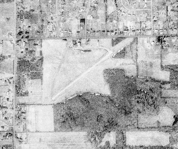
A 4/14/94 USGS aerial photo showed no trace remaining of Chagrin Falls Airport,
with homes of the Burlington Green housing development covering the site.
The 1996 USGS topo map still depicted the airfield, labeled simply "Landing Strip",
even though a photo from 2 years prior showed the site covered by a housing development.
It depicted a single 2,200' northeast/southwest runway, along with several buildings (hangars?) along the north side of the field.
Steve Krieger recalled, “I loved that old airfield, and it probably instilled in me the love that I still have for aviation.
I was sad that, when I revisited the area in about 1999 that the old place had been taken over by tract homes.
A large part of my childhood lies underneath those foundations!!”
A 2014 aerial photo showed no trace remaining of Chagrin Falls Airport.
The site of Chagrin Falls Airport is located southeast of the intersection of Route 306 & Bell Road.
Thanks to Bill Meyer (who flew out of Chagrin Falls Airport) for pointing it out.
____________________________________________________
Or if you prefer to contact me directly concerning a contribution (for a mailing address to send a check),
please contact me at: paulandterryfreeman@gmail.com
If you enjoy this web site, please support it with a financial contribution.
____________________________________________________
This site covers airfields in all 50 states.